
Oregon City City Zoning Code
CHAPTER 17
04 - DEFINITIONS
17.04.005 - Generally.
A.
As used in this title, words in the present tense include the future; the singular number includes the plural and the plural number includes the singular; unless the context clearly indicates the contrary, the word "shall" is mandatory and not discretionary; the word "may" is permissive; the masculine gender includes the feminine and neuter; and the term "this title" shall be deemed to include the text of this title and accompanying zoning maps and all amendments hereafter made thereto.
B.
Whenever the following words or terms and their derivatives are used in this title, they shall have the meaning herein ascribed to them, unless the context makes such meaning repugnant thereto.
(Ord. No. 18-1009, § 1(Exh. A), 7-3-2019)
17.04.006 - Reserved.
Editor's note— Ord. No. 22-1001, § 1(Exh. A), adopted June 1, 2022, repealed § 17.04.006, which pertained to the definition of 3—4 plex residential and derived from Ord. No. 18-1009, adopted July 3, 2019.
17.04.010 - Accessory building or accessory structure.
"Accessory building" or "accessory structure" means a detached building or structure subordinate in size and use, but located on the same lot as, a principal building.
(Ord. No. 18-1009, § 1(Exh. A), 7-3-2019)
17.04.015 - "Accessory dwelling unit" (ADU).
"Accessory dwelling unit" (ADU) means a residential dwelling unit located on the same lot as a single-family dwelling, that is not a recreational vehicle. The habitable living unit provides basic living requirements including permanent cooking and toilet facilities, and may be either attached to the same building as the single-family dwelling unit or in a detached building.
(Ord. No. 18-1009, § 1(Exh. A), 7-3-2019)
17.04.020 - Access control.
"Access control" means the regulation of public access rights to and from properties abutting public rights-of-way by the construction of physical barriers or conveyance to the city of a property interest (reserve strip) that prevents access to the public right-of-way.
(Ord. No. 18-1009, § 1(Exh. A), 7-3-2019)
17.04.025 - Accessway.
"Accessway" means any public or private way that is created to provide ingress or egress for persons to one or more lots, parcels, areas, or tracts of land. The term "accessway" includes highway, streets, roads, avenues, alleys, paths, sidewalks or similar designations.
(Ord. No. 18-1009, § 1(Exh. A), 7-3-2019; Ord. No. 21-1007, § 1(Exh. A), 4-21-2021)
17.04.030 - Accessway, pedestrian/bicycle.
"Accessway, pedestrian/bicycle" means any off-street path or way as described in OCMC 16.12, intended primarily for pedestrians or bicycles and which provides direct routes within and from new developments to residential areas, retail and office areas, transit streets and neighborhood activity centers.
(Ord. No. 18-1009, § 1(Exh. A), 7-3-2019; Ord. No. 21-1007, § 1(Exh. A), 4-21-2021)
17.04.035 - Access, vehicular.
"Vehicular access" means an improved roadway, either public or private, providing automobile entrance and/or exit from an approved public street.
(Ord. No. 18-1009, § 1(Exh. A), 7-3-2019)
17.04.037 - After-hours public parking.
"After-hours public parking" means utilization of parking, not within the right-of-way, by the public with or without charge when the associated primary use is not active.
(Ord. No. 18-1009, § 1(Exh. A), 7-3-2019)
17.04.040 - Alley.
"Alley" means a public or private way not more than twenty feet wide that provides access to a property or properties from a side other than the designated front of the property.
(Ord. No. 18-1009, § 1(Exh. A), 7-3-2019)
17.04.045 - Alteration.
"Alteration" means the addition to, removal of or from, or physical modification or repair of, any exterior part or portion of a landmark or structures in an historic or conservation district. In an historic district any physical change shall be considered a form of alteration and shall be treated as such, except repair and maintenance or change of copy.
(Ord. No. 18-1009, § 1(Exh. A), 7-3-2019)
17.04.050 - Amateur radio operator.
"Amateur radio operator" means a ham radio operator, as licensed by the United States Government.
(Ord. No. 18-1009, § 1(Exh. A), 7-3-2019)
17.04.055 - Anadromous fish-bearing stream.
"Anadromous fish-bearing stream" means a stream or portion of a stream which is identified by resolution of the city commission as spawning or rearing habitat for those species of fish which return to rivers from the sea for breeding.
(Ord. No. 18-1009, § 1(Exh. A), 7-3-2019)
17.04.060 - Antenna.
"Antenna" means any pole, panel, rod, reflection disc or similar device used for the transmission or reception of radio frequency signals, including, but not limited to omni-directional antenna (whip), directional antenna (panel), micro cell, and parabolic antenna (dish). The antenna does not include the support structure or tower.
(Ord. No. 18-1009, § 1(Exh. A), 7-3-2019)
17.04.070 - Applicant.
"Applicant" means the party or parties who submit an application seeking development approval through an administrative, quasi-judicial or legislative procedure under OCMC Title 16 or 17.
(Ord. No. 18-1009, § 1(Exh. A), 7-3-2019)
17.04.075 - Application.
"Application" means any request for approval of a permit or a legislative amendment to the city's land use regulations, comprehensive plan or related zoning maps.
(Ord. No. 18-1009, § 1(Exh. A), 7-3-2019)
17.04.080 - Approval criteria and approval standards.
"Approval criteria" and "approval standards" means all standards which must be met in order to approve an application. Depending upon the specific application, approval criteria include standards contained in this code, the Oregon City Comprehensive Plan and applicable state law.
(Ord. No. 18-1009, § 1(Exh. A), 7-3-2019)
17.04.081 - Aquifer.
"Aquifer" is a geologic formation, group of formations, or part of a formation that contains sufficient saturated permeable material to yield significant quantities of water to wells and springs.
(Ord. No. 18-1009, § 1(Exh. A), 7-3-2019)
17.04.082 - Arborist, certified.
"Certified Arborist" means a professional tree service provider whose certification is regulated and current and maintained with the International Society of Arboriculture (ISA). To use the term "Certified Arborist," an individual must have three years of experience and have passed an ISA certification exam that tests a variety of tree care knowledge.
(Ord. No. 18-1009, § 1(Exh. A), 7-3-2019)
17.04.083 - Arcade, pedestrian.
A covered area contiguous to a street or plaza that is open and unobstructed to a height of not less than ten feet and that provides public access to building entrances, retail space and/or public space. An arcade may include building columns, landscaping, statuary, pools, or fountains as part of the arcade for the purpose of computing area. The term "arcade" shall not include off-street loading areas, driveways, off-street parking areas, or open pedestrian walkways.
(Ord. No. 18-1009, § 1(Exh. A), 7-3-2019)
17.04.085 - Architect.
"Architect" means an architect licensed by the state of Oregon.
(Ord. No. 18-1009, § 1(Exh. A), 7-3-2019)
17.04.090 - Architectural significance.
"Architectural significance" for the purposes of OCMC 17.40 means that the structure or district:
1.
Portrays the environment of a group of people in an era of history characterized by a distinctive architectural style;
2.
Embodies those distinguishing characteristics of an architectural-type specimen;
3.
Is the work of an architect or master builder whose individual work has influenced the development of the city; or
4.
Contains elements of architectural design, detail, materials or craftsmanship which represents a significant innovation.
(Ord. No. 18-1009, § 1(Exh. A), 7-3-2019)
17.04.095 - Arterial.
"Arterial" means any street so designated in the city's transportation master plan.
(Ord. No. 18-1009, § 1(Exh. A), 7-3-2019)
17.04.100 - Attachment.
"Attachment" means for the purposes of OCMC 17.80, an antenna or other piece of related equipment affixed to a transmission tower, building, light, utility pole, or water tower.
(Ord. No. 18-1009, § 1(Exh. A), 7-3-2019)
17.04.105 - Area of special flood hazard.
"Area of special flood hazard" means the land in the floodplain within a community subject to a one percent or greater chance of flooding in any given year.
(Ord. No. 18-1009, § 1(Exh. A), 7-3-2019)
17.04.110 - Array.
"Array" means the combination of antennas mounted on a support structure or support tower.
(Ord. No. 18-1009, § 1(Exh. A), 7-3-2019)
17.04.115 - Assisted living facility.
"Assisted living facility" means a facility established for profit or nonprofit, which provides nursing care and related medical services on a twenty-four-hour-per-day basis to sixteen or more individuals because of illness, disease, or physical or mental infirmity. Provides care for those persons not in need of hospital care. Patients do not reside in self-contained dwelling units.
(Ord. No. 18-1009, § 1(Exh. A), 7-3-2019)
17.04.120 - Auxiliary support equipment.
"Auxiliary support equipment" means for the purposes of OCMC 17.80 all equipment necessary to provide wireless communication signals and data, including but not limited to, electronic processing devices, air conditioning units, and emergency generators. For the purpose of this chapter, auxiliary support equipment shall also include the shelter, cabinets, and other structural facilities used to house and shelter necessary equipment. Auxiliary support equipment does not include support towers or structures.
(Ord. No. 18-1009, § 1(Exh. A), 7-3-2019)
17.04.125 - Bankfull stage or bankfull flow.
"Bankfull stage" or "bankfull flow" means the stage or elevation of a stream at which water overflows the natural banks of streams or other waters of this state. The bankfull stage or flow may be approximated using either the two-year recurrence interval flood elevation or one foot measured vertically above the ordinary mean high water line.
(Ord. No. 18-1009, § 1(Exh. A), 7-3-2019)
17.04.130 - Base flood.
"Base flood" means the flood having a one percent chance of being equaled or exceeded in any given year. Also referred to as the one hundred-year flood.
(Ord. No. 18-1009, § 1(Exh. A), 7-3-2019)
17.04.135 - Basement.
"Basement" means a story partly underground. A basement shall be counted as a story in accordance with the accepted building division definitions.
For the purpose of OCMC 17.42 basement means any area of the building having its floor subgrade (below ground level) on all sides.
(Ord. No. 18-1009, § 1(Exh. A), 7-3-2019)
17.04.140 - Base flood elevation.
"Base flood elevation" means the elevation of the base flood or one hundred-year storm as defined in FEMA (Federal Emergency Management Agency) flood insurance studies, or the highest flood of record since the adoption of the flood insurance maps, or, in areas without FEMA floodplains, the elevation of the twenty-five-year storm, or the edge of mapped floodprone soils or similar methodologies whichever is higher.
(Ord. No. 18-1009, § 1(Exh. A), 7-3-2019)
17.04.143 - Beavercreek Road Concept Plan.
The Beavercreek Road Concept Plan was renamed the Thimble Creek Concept Plan in 2020. Any reference to the Beavercreek Road Concept Plan refers to the Thimble Creek Concept Plan.
(Ord. No. 21-1006, § 1(Exh. A), 7-1-2020)
Editor's note— Ord. No. 21-1006, § 1(Exh. A), adopted July 1, 2020, set out provisions intended for use as § 17.04.147. For purposes of classification, and at the editor's discretion, these provisions have been included as § 17.04.143.
17.04.145 - Bed and breakfast inns and boardinghouses.
"Bed and breakfast inns and boardinghouses" means building(s) which provides overnight accommodations to the public for fewer than thirty consecutive days.
(Ord. No. 18-1009, § 1(Exh. A), 7-3-2019)
17.04.150 - Beneficial uses or beneficial water uses.
"Beneficial uses" or "beneficial water uses" means, as defined by the Oregon Department of Water Resources, use of an in stream public use of water for the benefit of an appropriator for a purpose consistent with the laws and the economic and general welfare of the people of the state and includes, but is not limited to, domestic, fish life, industrial, irrigation, mining, municipal, pollution abatement, power development, recreation, stock water and wildlife uses.
(Ord. No. 18-1009, § 1(Exh. A), 7-3-2019)
17.04.153 - Board.
"Board" for the purposes of OCMC 17.40 means the historic review board.
(Ord. No. 18-1009, § 1(Exh. A), 7-3-2019)
17.04.154 - Building.
"Building" means structure.
(Ord. No. 18-1009, § 1(Exh. A), 7-3-2019)
17.04.155 - Building, compatible.
"Compatible building" means for the purposes of OCMC 17.40, buildings in the Canemah National Register Historic District, which date from 1910 to the 1950's.
(Ord. No. 18-1009, § 1(Exh. A), 7-3-2019)
17.04.160 - Building, historic.
"Historic building" means for the purposes of OCMC 17.40, any primary, secondary or compatible building in the Canemah National Register Historic District, or any locally designated structure elsewhere in the city.
(Ord. No. 18-1009, § 1(Exh. A), 7-3-2019)
17.04.165 - Building of primary historic significance.
"Building of primary historic significance" shall include buildings in the Canemah National Register Historic district shall include buildings dating from prior to 1880 which are primarily one and one-half or two-story frame structures built in the Gothic Revival and Classic Revival styles. These buildings are primarily single-family dwellings.
(Ord. No. 18-1009, § 1(Exh. A), 7-3-2019)
17.04.170 - Building of secondary historic significance.
"Building of secondary historic significance" shall include buildings in the Canemah National Register Historic District dating from 1880 to 1940 which are predominantly rural farm house style and bungalows. These buildings are primarily single-family dwellings.
(Ord. No. 18-1009, § 1(Exh. A), 7-3-2019)
17.04.175 - Camouflage.
"Camouflage" for the purposes of OCMC 17.80 means the design and construction of a wireless communications facility (WCF) to resemble an object that is not a wireless communication facility and which is typically present in the environment.
(Ord. No. 18-1009, § 1(Exh. A), 7-3-2019)
17.04.176 - Capital improvement project.
"Capital improvement project" is a project located within an existing or proposed right-of-way or easement including roads, water mains, sanitary sewers, storm sewers and their appurtenances where the project is solely or partially funded by city funds and is solely or partially administered by the city of Oregon City.
(Ord. No. 21-1007, § 1(Exh. A), 4-21-2021)
17.04.177 - Cargo container.
A standardized, reusable vessel that is or appears to be: (1) originally, specifically or formerly designed for or used in the packing, shipping, movement or transportation of freight, articles, goods or commodities, or (2) designed for being mounted or moved on a rail car, or (3) designed for or capable of being mounted on a chassis or bogie for movement by truck trailer or loaded on a ship.
(Ord. No. 18-1009, § 1(Exh. A), 7-3-2019)
17.04.178 - Carpool.
"Carpool" means a group of two or more commuters, including the driver, who share the ride to or from work, school or other destination.
(Ord. No. 18-1009, § 1(Exh. A), 7-3-2019)
17.04.180 - Certified engineering geologist.
"Certified engineering geologist" is any registered geologist who is certified in the specialty of engineering geology under provisions of ORS 672.505 to 672.705.
(Ord. No. 18-1009, § 1(Exh. A), 7-3-2019)
17.04.185 - Citizen involvement committee.
"Citizen involvement committee" means an officially recognized advisory body on citizen involvement with one representative from each neighborhood association.
(Ord. No. 18-1009, § 1(Exh. A), 7-3-2019)
17.04.190 - City.
"City" means the city of Oregon City.
(Ord. No. 18-1009, § 1(Exh. A), 7-3-2019)
17.04.195 - City engineer.
"City engineer" means the engineer manager for the city, their duly authorized representative(s), or the city's duly authorized representative(s) as designated by the city manager or public works director.
(Ord. No. 18-1009, § 1(Exh. A), 7-3-2019; Ord. No. 21-1007, § 1(Exh. A), 4-21-2021)
17.04.196 - City transportation engineer.
"City transportation engineer" means the transportation planning engineer for the city, their duly authorized representative(s), or the city's duly authorized representative(s) as designated by the city manager.
(Ord. No. 18-1009, § 1(Exh. A), 7-3-2019)
17.04.197 - Reserved.
Editor's note— Ord. No. 22-1001, § 1(Exh. A), adopted June 1, 2022, repealed § 17.04.197, which pertained to the definition of cluster housing and derived from Ord. No. 18-1009, adopted July 3, 2019.
17.04.200 - Code.
"Code" means the Oregon City Municipal Code.
(Ord. No. 18-1009, § 1(Exh. A), 7-3-2019)
17.04.205 - Commercial vehicles.
"Commercial vehicle" means a vehicle of over eight thousand pounds gross weight that is designed for or being used to transport merchandise, or a vehicle of less than eight thousand pounds gross weight.
(Ord. No. 18-1009, § 1(Exh. A), 7-3-2019)
17.04.210 - Collector.
"Collector" means any street so designated in the city's transportation master plan.
(Ord. No. 18-1009, § 1(Exh. A), 7-3-2019)
17.04.215 - Collocation or co-location.
"Collocation" or "co-location" means the use of a common wireless communications support structure or tower for two or more antenna arrays.
(Ord. No. 18-1009, § 1(Exh. A), 7-3-2019)
17.04.220 - Community development director.
"Community development director" means the manager of the planning division or the community development director's designee.
(Ord. No. 18-1009, § 1(Exh. A), 7-3-2019)
17.04.225 - Comprehensive plan.
"Comprehensive plan" means the city of Oregon City Comprehensive Plan.
(Ord. No. 18-1009, § 1(Exh. A), 7-3-2019)
17.04.227 - Concept plan area.
"Concept plan area" is a defined area for which there is an adopted concept plan, including the South End Concept Plan area, the Beavercreek Road Concept Plan area, and the Park Place Concept Plan area.
(Ord. No. 18-1009, § 1(Exh. A), 7-3-2019)
17.04.230 - Construction area.
Defined as right-of-way, public utility easements, and within the building footprint of a building site for any mixed-use, commercial or industrial development, or if a residential development, within the allowable building footprint permitted by the setback requirements of the zone district.
(Ord. No. 18-1009, § 1(Exh. A), 7-3-2019)
17.04.235 - Constructed wetlands.
"Constructed wetlands" means wetlands developed as a water quality or quantity facility, subject to change and maintenance as such. These areas must be clearly defined and separated from naturally occurring or created wetlands.
(Ord. No. 18-1009, § 1(Exh. A), 7-3-2019)
17.04.255 - Commercial vehicles.
"Commercial vehicle" means:
A.
A vehicle of over eight thousand pounds gross weight that is designed for or being used to transport merchandise, or a vehicle of less than eight thousand pounds gross weight with the business name of the user permanently exhibited on one or both of its sides that is designed and being used to transport merchandise;
B.
A station wagon or other vehicle with the business name of the user permanently exhibited on one or both of its sides, when used for transporting merchandise.
(Ord. No. 18-1009, § 1(Exh. A), 7-3-2019)
17.04.260 - Cottage cluster.
"Cottage cluster " means a grouping of no fewer than four detached dwelling units per acre with a footprint of less than nine hundred square feet each that includes a common courtyard.
(Ord. No. 22-1001, § 1(Exh. A), 6-1-2022)
Editor's note— Ord. No. 22-1001, § 1(Exh. A), adopted June 1, 2022, repealed the former § 17.04.260, and enacted a new § 17.04.260 as set out herein. The former § 17.04.260 pertained to the definition of corner duplexes and derived from Ord. No. 18-1009, July 3, 2019.
17.04.261 - Cottage cluster unit.
"Cottage cluster unit" means an individual dwelling unit with a footprint of less than nine hundred square feet within a cottage cluster.
(Ord. No. 22-1001, § 1(Exh. A), 6-1-2022)
17.04.265 - Created wetlands.
"Created wetlands" means wetlands developed in an area previously identified as a non-wetland to replace, or mitigate wetland destruction or displacement. A created wetland shall be regulated and managed the same as an existing wetland.
(Ord. No. 18-1009, § 1(Exh. A), 7-3-2019)
17.04.267 - Crest.
"Crest" of slope means the point of curvature where the ground surface descends from the top of a slope.
(Ord. No. 18-1009, § 1(Exh. A), 7-3-2019)
17.04.270 - Cul-de-sac.
"Cul-de-sac" means a street not more than three hundred fifty feet in length having one end open to traffic and being terminated by a vehicle turnaround. The cul-de-sac is measured from the edge of the right-of-way of the intersecting street to the edge of the pavement at the end of the cul-de-sac.
(Ord. No. 18-1009, § 1(Exh. A), 7-3-2019)
17.04.275 - Day care facility.
"Day care facility" means a facility that provides regular day care services to children under thirteen years of age, including a day nursery, nursery school group or similar unit operating under any name. A day care facility shall not include services provided by a physician or nurse, or facilities operated primarily for education or supervised training or instruction, or day care provided by a "babysitter" or "family day care provider" as defined in this chapter. A day care facility caring for ten or more children shall satisfy the certification requirements of the children's services division.
(Ord. No. 18-1009, § 1(Exh. A), 7-3-2019)
17.04.280 - Debris.
"Debris" means discarded man-made objects that would not occur in an undeveloped stream corridor or wetland. Debris includes, but is not limited to, tires, vehicles, litter, scrap metal, construction waste, lumber, plastic or styrofoam. Debris does not include objects necessary to a use allowed by this code, or ornamental and recreational structures. Debris does not include existing natural plant materials or natural plant materials which are left after flooding, downed or standing dead trees or trees which have fallen into protected water features.
(Ord. No. 18-1009, § 1(Exh. A), 7-3-2019)
17.04.285 - Decision-maker.
"Decision-maker" means the city entity rendering a decision on an application. For applications made under this title, the decision-maker will be either the city engineer, community development director, public works director, or their designee or the planning commission or the city commission or as designated by OCMC 17.50.
(Ord. No. 18-1009, § 1(Exh. A), 7-3-2019)
17.04.290 - Demolish.
"Demolish" means to raze, destroy, dismantle, deface or in any other manner cause partial or total ruin of the designated landmark or structure in an historic or conservation district.
(Ord. No. 18-1009, § 1(Exh. A), 7-3-2019)
17.04.295 - Design flood elevation.
"Design flood elevation" means an elevation that is a minimum of twelve inches greater than the base flood elevation as defined by FEMA (Federal Emergency Management Agency). It can also be referred to as the elevation of the highest flood (generally the base flood elevation including freeboard) that a retrofitting method is designed to protect against. It can also be referred to as the flood protection elevation.
(Ord. No. 18-1009, § 1(Exh. A), 7-3-2019; Ord. No. 22-1004, § 1(Exh. A), 8-17-2022)
17.04.300 - Development.
"Development" means an activity where a building or grading operation occurs, a material change in the use or appearance of a structure or land occurs, dividing land into two or more parcels, partitioning or subdividing of land as provided in ORS 92.010 to 92.285 or the creation or termination of an access right. Development does not refer to a capital improvement project or an activity within the right-of-way or public utility easement that is not associated with land or use changes occurring outside of a right-of-way or public utility easement, except where stated.
For the purpose of OCMC 17.26 and OCMC 17.40, "development" means any man-made change to improved or unimproved real estate, including but not limited to buildings, or other structures, mining, dredging, filling, grading, capital improvement projects, excavation or drilling operations.
For the purpose of OCMC 17.42 "development" means any man-made change to improved or unimproved real estate, including but not limited to buildings, or other structures, mining, dredging, filling, grading, paving, capital improvement projects, excavation or drilling operations.
For the purpose of OCMC 17.47, "development" means any man-made change to improved or unimproved real estate, including but not limited to the construction of buildings or other structures, sewers, streets or other structures or facilities, capital improvement projects, mining, dredging, paving, filling or grading in amounts greater than ten cubic yards on any lot or excavation. In addition, any other activity that results in the removal of more than ten percent of the existing vegetation in the water quality resource area on a lot is defined as "development."
"Development" does not include the following:
1.
Stream enhancement or restoration projects approved by the city;
2.
Farming practices as defined in ORS 30.930 and farm use as defined in ORS 215.203, except that buildings associated with farm practices and farm uses are subject to the requirements of this chapter; and
3.
Construction on lots in subdivisions meeting the criteria of ORS 92.040(2)(1995).
For the purpose of OCMC 17.49, "development" means any man-made change defined as the construction of buildings or other structures, capital improvement projects, mining, dredging, paving, filling, grading, or site clearing, and grubbing in amounts greater than ten cubic yards on any lot or excavation. In addition, any other activity that results in the removal of more than ten percent of the existing vegetation in the water quality resource area on a lot is defined as development. Development does not include the following:
1.
Stream enhancement or restoration projects approved by the city;
2.
Farming practices as defined in ORS 30.930 and farm use as defined in ORS 215.203, except that buildings associated with farm practices and farm uses are subject to the requirements of this chapter; and
3.
Construction on lots in subdivisions meeting the criteria of ORS 92.040(2) (1995).
(Ord. No. 18-1009, § 1(Exh. A), 7-3-2019; Ord. No. 21-1007, § 1(Exh. A), 4-21-2021)
17.04.305 - Development site.
"Development site" means any lot or lots on any part of which development is taking place. A capital improvement project or an activity within the right-of-way that is not associated with land or use changes occurring outside of right-of-way or public utility easement, does not occur within a "development site".
(Ord. No. 18-1009, § 1(Exh. A), 7-3-2019; Ord. No. 21-1007, § 1(Exh. A), 4-21-2021)
17.04.310 - Direct.
"Direct" when used in connection with pedestrian or bicycle access, means the shortest practicable connection or access between two points, which in no instance should involve out-of-direction travel more than fifty percent longer than the straight line distance between two points.
(Ord. No. 18-1009, § 1(Exh. A), 7-3-2019)
17.04.315 - Director.
"Director" means the director of community development, public works director, or designee.
(Ord. No. 18-1009, § 1(Exh. A), 7-3-2019; Ord. No. 21-1007, § 1(Exh. A), 4-21-2021)
17.04.320 - Disturb.
"Disturb" means man-made changes to the existing physical status of the land, which are made in connection with development. The following uses are excluded from the definition:
1.
Enhancement or restoration of the water quality resource area;
2.
Planting native cover identified in the Oregon City native plant list as adopted by Oregon City Commission resolution;
3.
Installation of erosion control measures pursuant to an approved erosion and sediment control plan under Chapter 17.47.
(Ord. No. 18-1009, § 1(Exh. A), 7-3-2019)
17.04.325 - District.
"District" means the area within a designated historic district, conservation district or historic corridor as provided by the zoning maps of the city.
(Ord. No. 18-1009, § 1(Exh. A), 7-3-2019)
17.04.330 - Dormer.
"Dormer" is a window vertical in a roof or the roofed structure containing such a window. A dormer is considered an alteration to a building, as it stays within the roof line and does not increase the floor area dimensions.
(Ord. No. 18-1009, § 1(Exh. A), 7-3-2019)
17.04.333 - Duplex.
"Duplex" means two attached dwelling units on a lot, or, where permitted, two detached dwelling units on a lot. A duplex does not include a primary dwelling and an accessory dwelling unit on a lot.
(Ord. No. 18-1009, § 1(Exh. A), 7-3-2019; Ord. No. 22-1001, 1(Exh. A), 6-1-2022)
17.04.335 - Dwelling unit.
"Dwelling unit" means a habitable living unit that provides basic living requirements including permanent cooking, and toilet facilities.
(Ord. No. 18-1009, § 1(Exh. A), 7-3-2019)
17.04.340 - Easement.
"Easement" means the space in, upon, above, along, across, over or under a private property for the constructing, reconstructing, operating, maintaining, inspecting, and repairing of a facility owned by someone other than the private property whereby the easement is located.
(Ord. No. 21-1007, § 1(Exh. A), 4-21-2021)
17.04.355 - Elevated building.
"Elevated building" for insurance purposes means a nonbasement building which has its lowest elevated floor raised above ground level by foundation walls, shear walls, post, piers, pilings, or columns.
(Ord. No. 18-1009, § 1(Exh. A), 7-3-2019)
17.04.360 - Emergency.
"Emergency" means any man-made or natural event or circumstance causing or threatening loss of life, injury to person or property, and includes, but is not limited to, fire, explosion, flood, severe weather, drought, earthquake, volcanic activity, spills or releases of oil or hazardous material, contamination, utility or transportation disruptions, and disease.
(Ord. No. 18-1009, § 1(Exh. A), 7-3-2019)
17.04.365 - Engineer.
"Engineer" means a registered professional engineer licensed by the state of Oregon (P.E.).
(Ord. No. 18-1009, § 1(Exh. A), 7-3-2019)
17.04.370 - Engineering geologist.
"Engineering geologist" means a registered professional engineering geologist licensed by the state of Oregon (CEG).
(Ord. No. 18-1009, § 1(Exh. A), 7-3-2019)
17.04.375 - Enhancement.
"Enhancement" means the process of improving upon the natural functions and/or values of an area or feature which has been degraded by human activity. Enhancement activities may or may not return the site to a pre-disturbance condition, but create/recreate processes and features that occur naturally.
(Ord. No. 18-1009, § 1(Exh. A), 7-3-2019)
17.04.380 - Entertainment centers and arcades.
"Entertainment centers and arcades" means a place open to minors where three or more mechanical or electronic amusement devices are located as either the primary or a secondary use.
(Ord. No. 18-1009, § 1(Exh. A), 7-3-2019)
17.04.385 - Erosion.
"Erosion" is the movement of soil, rocks, and other surface materials by wind, water, or mechanical means.
(Ord. No. 18-1009, § 1(Exh. A), 7-3-2019)
17.04.390 - Excavation.
"Excavation" is any act of development by which soil, earth, sand, gravel, rock or any similar material is cut into, dug, quarried, uncovered, removed, displaced, relocated, exposed or bulldozed, including the conditions resulting therefrom.
For the purpose of Chapter 17.47 "excavation" means: Any act of development by which soil or rock is cut into, dug, quarried, uncovered, removed, displaced, exposed or relocated.
(Ord. No. 18-1009, § 1(Exh. A), 7-3-2019)
17.04.395 - Expedited land division.
"Expedited land division" means a division of land as defined in ORS 197.360.
(Ord. No. 22-1001, § 1(Exh. A), 6-1-2022)
17.04.405 - Exterior.
"Exterior" for the purpose of Chapter 17.40 means any portion of the outside of a landmark building, structure, or site in a district or any addition thereto.
(Ord. No. 18-1009, § 1(Exh. A), 7-3-2019)
17.04.410 - Facade.
"Facade" means the exterior wall(s) or elevation(s) of a structure.
(Ord. No. 18-1009, § 1(Exh. A), 7-3-2019)
17.04.420 - Family day care provider.
"Family day care provider" means a day care provider who regularly provides day care to fewer than sixteen children, including the children of the provider, regardless of full-time or part-time status, in the provider's home in the family living quarters. Provisions of day care to sixteen or more children in the home of the provider shall constitute the operations of a "day care facility," as defined in this chapter, and shall be subject to the requirements of this title for day care facilities. A family day care provider shall satisfy the certification requirements of the office of child care.
(Ord. No. 18-1009, § 1(Exh. A), 7-3-2019)
17.04.425 - Federal Aviation Administration (FAA).
"Federal Aviation Administration (FAA)" means the federal regulatory agency responsible for the safety of the nation's air traffic control system, including airspace impacted by wireless communications support structures and towers.
(Ord. No. 18-1009, § 1(Exh. A), 7-3-2019)
17.04.430 - Federal Communications Commission (FCC).
"Federal Communications Commission (FCC)" means the federal regulatory agency charged with regulating interstate and international communications by radio, television, wire, satellite, and cable.
(Ord. No. 18-1009, § 1(Exh. A), 7-3-2019)
17.04.435 - Fill.
"Fill" means any material such as, but not limited to, sand, gravel, soil, rock or other natural or man-made material placed by artificial means.
(Ord. No. 18-1009, § 1(Exh. A), 7-3-2019)
17.04.440 - Final action and final decision.
"Final action" and "final decision" means the city's final decision on a permit application for which there is either no appeal to another decision-maker within the city, or, if there is the possibility of a local appeal, an appeal was not timely perfected in accordance with OCMC 17.50.190. A decision is deemed to be final on the date that written notice of the decision is mailed to those entitled to notice of the decision.
(Ord. No. 18-1009, § 1(Exh. A), 7-3-2019)
17.04.445 - Flag lot.
"Flag lot" means a lot or parcel that has a narrow frontage on a public right-of-way and a narrow accessway which serves the main body of the lot used for building.
(Ord. No. 18-1009, § 1(Exh. A), 7-3-2019)
17.04.450 - Flood or flooding.
"Flood" or "flooding" means a general and temporary condition of partial or complete inundation of normally dry land areas from:
1.
The overflow of inland or tidal waters; and/or
2.
The unusual and rapid accumulation of runoff of surface waters from any source.
(Ord. No. 18-1009, § 1(Exh. A), 7-3-2019)
17.04.455 - Flood insurance rate map.
"Flood insurance rate map" means the official map on which the Federal Insurance Administration has delineated both the areas of special flood hazard and the risk premium zones applicable to the community.
(Ord. No. 18-1009, § 1(Exh. A), 7-3-2019)
17.04.460 - Flood insurance study.
"Flood insurance study" means the official report provided by the Federal Insurance Administration that includes flood profiles, the flood boundary-floodway map, and the water surface elevation of the base flood.
(Ord. No. 18-1009, § 1(Exh. A), 7-3-2019)
17.04.465 - Flood management areas.
"Flood management areas" means all lands contained within the one hundred-year floodplain, flood area and floodway as shown on the Federal Emergency Management Agency Flood Insurance Rate Maps, floodway maps and the area of inundation for the February 1996 flood.
(Ord. No. 18-1009, § 1(Exh. A), 7-3-2019)
17.04.470 - Floodplain.
"Floodplain" means the land area identified and designated by the United States Army Corps of Engineers, the Oregon Division of State Lands, FEMA, or City of Oregon City that has been or may be covered temporarily by water as a result of a storm event of identified frequency. It is usually the flat area of land adjacent to a stream or river formed by floods.
(Ord. No. 18-1009, § 1(Exh. A), 7-3-2019)
17.04.475 - Floodway.
"Floodway" means the channel of a river or other watercourse and the adjacent land areas that must be reserved in order to discharge the base flood without cumulatively increasing the water surface elevation more than one foot.
(Ord. No. 18-1009, § 1(Exh. A), 7-3-2019)
17.04.480 - Floodway fringe.
"Floodway fringe" means the area of the floodplain, lying outside the floodway, which does not contribute appreciably to the passage of floodwater, but serves as a retention area.
(Ord. No. 18-1009, § 1(Exh. A), 7-3-2019)
17.04.481 - Food unit, mobile.
A vendor or seller of food and/or beverages from a motorized, non-motorized or towed vehicle including a wheeled trailer or cart capable of being towed or pushed by a vehicle or by hand not within a building. Mobile food units may require licensing from state and county health departments. Food units may be transitory or non-transitory.
(Ord. No. 18-1009, § 1(Exh. A), 7-3-2019; Ord. No. 19-1008, § 1(Exh. A), 12-18-2019)
17.04.482 - Footcandle.
A unit of measurement referring to illumination incident to a single point. One footcandle is equal to one lumen uniformly distributed over an area of one square foot.
(Ord. No. 18-1009, § 1(Exh. A), 7-3-2019)
17.04.483 - Footprint.
"Footprint" for the purposes of OCMC 17.54.010 means the horizontal area as seen in plan, measured from outside of all exterior walls and supporting columns. It includes dwellings, garages, carports, and accessory structures, but not trellises, patios, and areas of porch, deck, and balcony less than 30 inches from finished grade, or cantilevered covers, porches or projections which do not have a post touching the ground or ramps and stairways required for access.
(Ord. No. 18-1009, § 1(Exh. A), 7-3-2019)
17.04.485 - Front facade.
"Front facade" means the exterior wall/foundation of a building exposed to the front lot line. This shall be the most architecturally significant elevation of the building, commonly including a front door or main entrance. If the most architecturally significant elevation of the building is not exposed to the front lot line, the community development director shall determine the front facade.
(Ord. No. 18-1009, § 1(Exh. A), 7-3-2019)
17.04.490 - Front lot line.
"Front lot line" means a lot line abutting a street. For corner lots, the front lot line is that with the narrowest frontage. When the lot line abutting a street is curved, the front lot line follows the curve. For a flag lot, the front lot line is the shortest lot line adjoining the pole portion of the lot including the width of the pole. See figure 17.04.490.
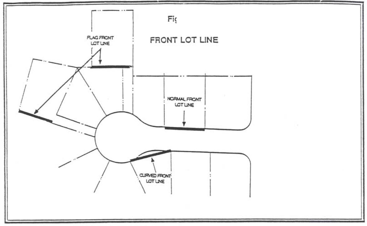
Figure 17.04.490
(Ord. No. 18-1009, § 1(Exh. A), 7-3-2019)
17.04.495 - Frontage.
"Frontage" means that portion of a parcel of property which abuts a dedicated public street or highway or an approved private way.
(Ord. No. 18-1009, § 1(Exh. A), 7-3-2019)
17.04.497 - Fully shielded or cut-off light fixture.
Any outdoor light fixture shielded in such a manner that all light emitted by the fixture is projected below the horizontal as determined by a photometric test or certified by the manufacturer. For purposes of this standard, "cut-off angle" is defined as the angle formed by a line drawn from the direction of light rays at the light source and a line perpendicular to the ground from the light source above from which no light is emitted.
(Ord. No. 18-1009, § 1(Exh. A), 7-3-2019)
17.04.500 - Garage.
"Garage" means an attached or detached structure(s), or portion thereof used or designed to be used for the parking or storage of vehicles, including carports. Garages do not include detached accessory dwelling units which are not part of a detached garage.
(Ord. No. 18-1009, § 1(Exh. A), 7-3-2019)
17.04.505 - Geological assessment.
"Geological assessment" is an assessment prepared and stamped by a certified engineering geologist, detailing the surface and subsurface conditions of the site and delineating the areas of a property that might be subject to specified geologic hazards.
(Ord. No. 18-1009, § 1(Exh. A), 7-3-2019)
17.04.510 - Geologic hazard areas.
"Geologic hazard areas" mean:
1.
Any area identified on the city's steep slope and landslide area map;
2.
Area within two hundred feet of the crest or toe of a slope that is twenty-five percent or greater;
3.
Areas with a slope of twenty-five percent or more;
4.
Geologic hazards areas identified by the state of Oregon Department of Geology and Mineral Industries (DOGAMI) in Bulletin 99, Geology and Geologic Hazards of Northwestern Clackamas County, Oregon (1979);
5.
Any other area that is identified by a suitably qualified geotechnical engineer or engineering geologist who is licensed in Oregon and derives his or her livelihood principally from that profession as being subject to soil instability, slumping or earth flow, high groundwater level, landslide, or seismic activity.
(Ord. No. 18-1009, § 1(Exh. A), 7-3-2019)
17.04.515 - Geologic hazards overlay zone.
"Geologic hazards overlay zone" means the zone mapped by the city of Oregon City that is subject to review pursuant to OCMC 17.44 as follows:
1.
The following areas identified on the city's slope and geology map which represents:
a.
Areas within fifty feet of the crest or toe of a slope that is twenty-five percent or greater, or within two hundred feet of the crest or toe of a landslide geologic units QIs and Qf identified by DOGAMI and derived from LIDAR IMS-29 and IMS-26 publications in 2009, whichever is greater;
b.
Areas with a slope of twenty-five percent or more;
c.
Geologic hazards areas identified by the state of Oregon Department of Geology and Mineral Industries (DOGAMI) as landslide or debris flow fan (QIs and Qf geologic units derived from LIDAR IMS-29 and IMS-26 publications in 2009); and
d.
Geologic hazards areas identified in Bulletin 99, Geology and Geologic Hazards of Northwestern Clackamas County, Oregon (1979).
2.
Any other area that is identified by a suitably qualified geotechnical engineer or engineering geologist who is licensed in Oregon and derives his or her livelihood principally from that profession as being subject to soil instability, slumping or earth flow, high groundwater level, and landslide.
(Ord. No. 18-1009, § 1(Exh. A), 7-3-2019)
17.04.520 - Geotechnical engineer.
"Geotechnical engineer" is a professional engineer, registered in the state of Oregon as provided by ORS 672.002 to 672.325, who by training, education and experience is qualified in the practice of geotechnical or soils engineering practices.
(Ord. No. 18-1009, § 1(Exh. A), 7-3-2019)
17.04.525 - Geotechnical remediation.
"Geotechnical remediation" means construction designed to increase the factor of safety against earth movement.
(Ord. No. 18-1009, § 1(Exh. A), 7-3-2019)
17.04.530 - Geotechnical report.
"Geotechnical report" is a report prepared and stamped by a geotechnical engineer, evaluating the site conditions and mitigation measures necessary to reduce the risks associated with development in geologically hazardous areas.
(Ord. No. 18-1009, § 1(Exh. A), 7-3-2019)
17.04.532 - Glare.
The reflection of harsh, bright light; and the physical effect resulting from high luminances or insufficiently shielded light sources in the field of view.
(Ord. No. 18-1009, § 1(Exh. A), 7-3-2019)
17.04.535 - Grading.
"Grading" is the act of excavating and filling as defined in OCMC 15.48.
(Ord. No. 18-1009, § 1(Exh. A), 7-3-2019; Ord. No. 21-1007, § 1(Exh. A), 4-21-2021)
17.04.540 - Gross floor area.
"Gross floor area" means the total enclosed floor area within buildings, measured in square feet, excluding basement areas used for storage or parking.
(Ord. No. 18-1009, § 1(Exh. A), 7-3-2019)
17.04.543 - Habitat.
"Habitat" means the location of natural resource areas that support fish and wildlife populations, including wetlands, riparian areas, natural areas, wooded areas, areas of significant trees or vegetation, and areas designated as being within the natural resource overlay district.
(Ord. No. 18-1009, § 1(Exh. A), 7-3-2019)
17.04.545 - Half street.
"Half street" means a portion of the width of a full street, usually along the edge of a subdivision.
(Ord. No. 18-1009, § 1(Exh. A), 7-3-2019)
17.04.550 - Height of building.
"Height of building" means a vertical distance measured from the average finished grade elevation on the street-facing elevation to:
1.
One-half the vertical distance between the eaves and the highest ridge for a gable, hip or gambrel roof,
2.
The top of the roof for flat roofs,
3.
The deck lines for mansard roofs, or
4.
The top of the parapet for buildings with parapets that completely surround the perimeter of a roof.
Roof structures needed to operate and maintain the building on which they are located such as chimneys, flues, stacks, fire escapes, gas holders, elevator enclosures, ventilators, skylights, solar panels, water towers and tanks, and similar are exempt from the building height measurement. Additional decorative and functional elements such as flag poles, partially enclosed parapets and building entry features, steeples and bell towers, carillons, monuments, cupolas, television aerials, broadcasting and microwave transmitting and relay towers, electric transmission line towers, and electric substation structures are also exempt from the building height measurement.
Except that, for buildings within the flood management overlay district subject to Chapter 17.42, height shall be measured from the design flood elevation or average finished grade at front of the structure, whichever is higher. For the purpose of Chapter 17.80, "height" shall mean the distance measured from the original grade at the base of the wireless communication facility to the highest point on the wireless communication facility, including the antenna(s) and lightning rod(s).
(Ord. No. 18-1009, § 1(Exh. A), 7-3-2019)
17.04.555 - Heritage tree.
"Heritage tree" is a tree or stand of trees that is of landmark importance to the city of Oregon City due to age, size, species, horticultural and ecological value or historical association.
(Ord. No. 18-1009, § 1(Exh. A), 7-3-2019)
17.04.560 - Heritage grove.
"Heritage grove" is at least two heritage trees separated by no more than twenty feet on a property or properties.
(Ord. No. 18-1009, § 1(Exh. A), 7-3-2019)
17.04.562 - Highly constrained residential lot.
A residential vacant lot of record that has less than thousand square feet of buildable area, with minimum dimensions of fifty feet by fifty feet, remaining outside the natural resource overlay district.
(Ord. No. 18-1009, § 1(Exh. A), 7-3-2019)
17.04.564 - Highly constrained commercial lot.
A commercial or industrially zoned lot of record that has more than seventy-five percent of its area covered by the natural resource overlay district.
(Ord. No. 18-1009, § 1(Exh. A), 7-3-2019)
17.04.565 - Historical significance.
"Historical significance" means that the structure of district:
1.
Has character, interest or value, as part of the development, heritage or cultural characteristics of the city, state or nation;
2.
Is the site of an historic event with an effect upon society;
3.
Is identified with a person or group of persons who had some influence on society; or
4.
Exemplifies the cultural, political, economic, social or historic heritage of the community.
(Ord. No. 18-1009, § 1(Exh. A), 7-3-2019)
17.04.570 - Historic corridor.
"Historic corridor" means that portion of a parcel of land that is a part of a designated linear historic feature such as the route of the Oregon Trail-Barlow Road.
(Ord. No. 18-1009, § 1(Exh. A), 7-3-2019)
17.04.575 - Historic site.
"Historic site" means the structure and the property surrounding a landmark, a structure in an historic district, or a designated structure in a conservation district.
(Ord. No. 18-1009, § 1(Exh. A), 7-3-2019)
17.04.580 - Home occupation.
"Home occupation" means an occupation carried on solely by the resident or residents of a dwelling unit as a secondary use in accordance with Section 17.54.120.
(Ord. No. 18-1009, § 1(Exh. A), 7-3-2019)
17.04.585 - Hotel.
"Hotel" means a building which is designed or used to offer lodging, with or without meals, for compensation, primarily for overnight lodging.
(Ord. No. 18-1009, § 1(Exh. A), 7-3-2019)
17.04.586 - Impervious surface.
Any nonvertical surface artificially covered or hardened so as to prevent or impede the percolation of stormwater water into the soil, including but not limited to roof tops excepting eaves, swimming pools, paved or graveled roads, and walkways or parking areas and excluding landscaping, surface water retention/detention facilities, access easements serving neighboring property, and driveways.
(Ord. No. 18-1009, § 1(Exh. A), 7-3-2019)
17.04.587 - Incandescent.
A common form of artificial light in which a filament is contained in a vacuum and heated to brightness by an electric current.
(Ord. No. 18-1009, § 1(Exh. A), 7-3-2019)
17.04.590 - Infrastructure provider.
"Infrastructure provider" for the purposes of Chapter 17.80 means an applicant whose proposal includes only the construction of new support towers or auxiliary structures to be subsequently utilized by service providers.
(Ord. No. 18-1009, § 1(Exh. A), 7-3-2019)
17.04.595 - Institutional development.
"Institutional development" includes all public, semi-public and private community facilities and uses, including government office and maintenance facilities, educational facilities, research institutions, correctional institutions, museums, libraries, stadiums, hospitals, residential care facilities, auditoriums and convention or meeting halls, churches, parks and public recreational facilities, automobile parking structures, and other similar facilities and uses.
(Ord. No. 18-1009, § 1(Exh. A), 7-3-2019)
17.04.600 - Interior parking lot landscaping.
"Interior parking lot landscaping" means landscaping located inside the surfaced area used for on-site parking and maneuvering.
(Ord. No. 18-1009, § 1(Exh. A), 7-3-2019)
17.04.603 - Reserved.
Editor's note— Ord. No. 22-1001, § 1(Exh. A), adopted June 1, 2022, repealed § 17.04.603, which pertained to the definition of internal conversion (for existing single-family detached residential units) and derived from Ord. No. 18-1009, adopted July 3, 2019.
17.04.605 - Invasive non-native, nuisance, prohibited or noxious vegetation.
"Invasive non-native," "nuisance," "prohibited" or "noxious vegetation" means plant species that have been introduced and, due to aggressive growth patterns and lack of natural enemies in the area where introduced, spread rapidly into native plant communities, or which are listed as invasive, nuisance, prohibited or noxious plants on the Oregon City Nuisance Plant List, or by the Oregon Department of Agriculture, Clackamas Soil and Water District, or Portland Plant List.
(Ord. No. 18-1009, § 1(Exh. A), 7-3-2019)
17.04.610 - Land division.
"Land division" means any partition or subdivision.
(Ord. No. 18-1009, § 1(Exh. A), 7-3-2019)
17.04.615 - Landscaping.
"Landscaping." Site improvements which include lawn, garden, groundcover, trees, plants and other natural and decorative features, including but not limited to, patios or plazas open to the public or open commonly to residents and street furniture and walkways which are contiguous and integrated with plant material landscaped areas. The verification of plant materials requiring specific characteristics can be achieved by any of the following methods:
1.
Description in Sunset Western Garden Book (Editor Sunset Books, 2012 or later edition);
2.
The Oregon City Native Plant List;
3.
City of Portland Native Plan List;
4.
Metro Native Plant List;
5.
By an appendix, definition, or other reference in the Zoning Code; or
6.
By specific certification by a licensed landscape architect.
(Ord. No. 18-1009, § 1(Exh. A), 7-3-2019)
17.04.620 - Landscape area.
"Landscape area" means land set aside and used for planting of grass, shrubs, trees or similar living plants.
(Ord. No. 18-1009, § 1(Exh. A), 7-3-2019)
17.04.625 - Landslide.
"Landslide" means the downslope movement of soil, rocks, or other surface matter on a site. Landslides may include, but are not limited to, slumps, mudflows, earthflows, debris flows, rockfalls and the source areas for above.
(Ord. No. 18-1009, § 1(Exh. A), 7-3-2019)
17.04.630 - Lattice tower.
"Lattice tower" is a support tower characterized by an open framework of lateral cross members that stabilize the tower.
(Ord. No. 18-1009, § 1(Exh. A), 7-3-2019)
17.04.635 - Legislative action.
"Legislative action" means any final decision of the city that approves or denies a request to amend the city's land use regulations, comprehensive plan or related maps and does not pertain to a particular property or small set of properties.
(Ord. No. 18-1009, § 1(Exh. A), 7-3-2019)
17.04.637 - Licensee representative.
"Licensee representative" means an owner, director, officer, manager, employee, agent or other representative of a licensee, to the extent that the person acts in a representative capacity.
(Ord. No. 18-1009, § 1(Exh. A), 7-3-2019)
17.04.640 - Limited land use application.
"Limited land use application" means an application for any use where the decision is based on discretionary standards designed to regulate the physical characteristics of a use permitted outright, including subdivision or site plan and design review or any other application which is processed pursuant to a Type II proceeding as provided in this chapter.
(Ord. No. 18-1009, § 1(Exh. A), 7-3-2019)
17.04.645 - Live/work dwelling.
"Live/work dwelling" a dwelling in which a business is designed to be operated on the ground floor. The ground floor commercial, personal service, or office space has visibility, signage and access from the primary street.
(Ord. No. 18-1009, § 1(Exh. A), 7-3-2019)
17.04.650 - Loading space.
"Loading space" means an off-street space, having a paved surface, within a building or on the same lot with a building, for the temporary parking of a commercial vehicle or truck while loading or unloading merchandise or materials and which has direct access to a street or alley.
(Ord. No. 18-1009, § 1(Exh. A), 7-3-2019)
17.04.655 - Local street.
"Local street" means any street so designated in the city's transportation system plan. Typically, a local street is a public street that serves abutting lands, is designed to carry a minimal amount and weight of traffic.
(Ord. No. 18-1009, § 1(Exh. A), 7-3-2019)
17.04.660 - Lot.
"Lot" and "legal lot" mean a single unit of land created by a subdivision which, at the time of creation, complied with all procedural and substantive requirements of any applicable local, state or federal law.
(Ord. No. 18-1009, § 1(Exh. A), 7-3-2019)
17.04.665 - Lot, corner.
"Corner lot" means a lot abutting upon two or more streets at their intersection.
(Ord. No. 18-1009, § 1(Exh. A), 7-3-2019)
17.04.670 - Lot coverage.
"Lot coverage" means the area of a lot covered by the footprint of all structures two hundred square feet or greater (excluding decks and porches), expressed as a percentage of the total lot area.
(Ord. No. 18-1009, § 1(Exh. A), 7-3-2019)
17.04.675 - Lot depth.
"Lot depth" means the distance measured from the mid-point of the front lot lines to the mid-point of the opposite, usually rear lot line and generally at approximately right angles to the lot width.
(Ord. No. 18-1009, § 1(Exh. A), 7-3-2019)
17.04.680 - Local floodplain administrator.
"Local floodplain administrator" means the city's building official.
(Ord. No. 18-1009, § 1(Exh. A), 7-3-2019)
17.04.685 - Lot, interior.
"Interior lot" means a lot other than a corner lot.
(Ord. No. 18-1009, § 1(Exh. A), 7-3-2019)
17.04.690 - Lot line adjustment.
"Lot line adjustment" means a relocation or elimination of all or a portion of the common property line between abutting properties that does not create an additional lot or parcel.
(Ord. No. 18-1009, § 1(Exh. A), 7-3-2019)
17.04.695 - Lot of record.
"Lot of record" means a lot or parcel which has been legally recorded in the office of the county recorder by deed or contract of sale prior to the enactment of an ordinance or regulation by reason of which the lot or parcel no longer meets the dimensional or area requirements of the city.
(Ord. No. 18-1009, § 1(Exh. A), 7-3-2019)
17.04.700 - Lot, width.
"Lot width" means the perpendicular distance measured between the midpoints of the two principal opposite side lot lines and generally at approximately right angles to the lot depth.
(Ord. No. 18-1009, § 1(Exh. A), 7-3-2019)
17.04.705 - Lowest floor.
"Lowest floor" means the lowest floor of the lowest enclosed area (including basement). An unfinished or flood-resistant enclosure, usable solely for parking of vehicles, building access or storage, in an area other than a basement area is not considered a building's lowest floor, provided that such enclosure is not built so as to render the structure in violation of the applicable nonelevation design requirements of this title found at OCMC 17.42.160.E.4 or 5.
(Ord. No. 18-1009, § 1(Exh. A), 7-3-2019)
17.04.707 - Low impact development standard.
Any construction technique approved by the city engineer that is designed to provide on-site capture, treatment and infiltration of stormwater as a means to improve water quality, reduce the amount of impervious surface, and/or provide habitat benefits on a development site.
(Ord. No. 18-1009, § 1(Exh. A), 7-3-2019)
17.04.709 - Machinery and equipment.
"Machinery and equipment" means electrical, heating, ventilation, plumbing, and air conditioning equipment and other service facilities.
(Ord. No. 22-1004, § 1(Exh. A), 8-17-2022)
17.04.710 - Major modification.
"Major modification" means any of the following changes from a previously approved permit, except for changes eligible for a Type I review, requiring the application to return through the same process as the original review:
1.
For subdivisions or planned unit developments, an increase in the total number of dwelling units by ten percent or more, an increase in the number of multiple-family dwellings by more than ten percent, or a reduction in the amount of landscaping, open space or land reserved for a protected feature of ten percent or more;
2.
For design review or conditional use permits for mixed-use or commercial developments, an increase in the area of commercial space by more than ten percent;
3.
For any site plan or design review approval, any change not eligible for a Type I Minor Site Plan and Design Review, including the relocation of buildings, streets, access points onto the existing public right-of-way, utility easements, parking lot expansions, or other site improvements away from the previously approved general location;
4.
For any prior approval, an increase in the amount of impervious surface on hillsides or unstable soils subject to regulation under city code Chapter 17.44 by ten percent or more; or
5.
Any change that renders the prior approved permit incompatible with surrounding lands or development in noncompliance with any of the conditions of approval or approval criteria.
(Ord. No. 18-1009, § 1(Exh. A), 7-3-2019)
17.04.712 - Major transit stop.
"Major transit stop" means transit centers, high capacity transit stations, major bus stops, inter-city bus passenger terminals, inter-city rail passenger terminals, and bike-transit facilities as shown in the regional transportation plan.
(Ord. No. 18-1009, § 1(Exh. A), 7-3-2019)
17.04.715 - Main building entrance.
"Main building entrance" means a primary entrance to a building, intended for use by residents, employees, customers, clients, visitors, messengers and members of the public.
(Ord. No. 18-1009, § 1(Exh. A), 7-3-2019)
17.04.720 - Major public improvements.
"Major public improvements" means the expenditure of public funds or the grant of permission by a public body to undertake change in the physical character of lands or the making of public improvements within a district, except for the repair or maintenance of public or private improvements within a district.
(Ord. No. 18-1009, § 1(Exh. A), 7-3-2019)
17.04.725 - Manager.
"Manager" means the city manager or the city manager's designated representative.
(Ord. No. 18-1009, § 1(Exh. A), 7-3-2019)
17.04.730 - Manufactured home.
"Manufactured home" means a structure constructed for movement on the public highways that has sleeping, cooking and plumbing facilities, that is intended for human occupancy, that is being used for a permanent residential purpose and that was constructed in accordance with federal manufactured housing construction and safety standards and regulations in effect at the time of construction. The term "manufactured home" does not include a "recreational vehicle."
(Ord. No. 18-1009, § 1(Exh. A), 7-3-2019)
17.04.735 - Manufactured home park or subdivision.
"Manufactured home park or subdivision" means a parcel (or contiguous parcels) of land divided into two or more manufactured home lots for rent or sale.
(Ord. No. 18-1009, § 1(Exh. A), 7-3-2019)
17.04.740 - Map.
"Map" means a final diagram, drawing or other graphical representation concerning a partition or subdivision.
(Ord. No. 18-1009, § 1(Exh. A), 7-3-2019)
17.04.741.010 - Marijuana.
"Marijuana" means the plant cannabis family cannabaceae, any part of the plant cannabis family cannabaceae and the seeds of the plant cannabis family cannabaceae. "Marijuana" does not include industrial hemp, as defined in state law.
(Ord. No. 18-1009, § 1(Exh. A), 7-3-2019)
17.04.741.020 - Marijuana business.
"Marijuana business" means:
1.
Any business licensed by the Oregon Liquor Control Commission to engage in the business of producing, processing, wholesaling, or selling marijuana or marijuana items, or
2.
Any business registered with the Oregon Health Authority for the growing, processing, or dispensing of marijuana or marijuana items.
(Ord. No. 18-1009, § 1(Exh. A), 7-3-2019)
17.04.741.030 - Marijuana items.
"Marijuana item" means marijuana, cannabinoid products, cannabinoid concentrates and cannabinoid extracts.
(Ord. No. 18-1009, § 1(Exh. A), 7-3-2019)
17.04.741.040 - Marijuana laboratory (laboratories).
"Marijuana laboratory (laboratories)" means an entity which tests or researches marijuana products for THC levels, pesticides, mold, etc. pursuant to applicable Oregon Administrative Rules.
(Ord. No. 18-1009, § 1(Exh. A), 7-3-2019)
17.04.741.050 - Marijuana licensee.
"Marijuana licensee" means a person who holds a business license issued by the city to engage in a marijuana business in accordance with this chapter.
(Ord. No. 18-1009, § 1(Exh. A), 7-3-2019)
17.04.741.060 - Marijuana processor (processing).
"Marijuana processor (processing)" means an entity licensed by the Oregon Liquor Control Commission or Oregon Health Authority to process marijuana. This includes the manufacture of concentrates, extracts, edibles and/or topicals.
(Ord. No. 18-1009, § 1(Exh. A), 7-3-2019)
17.04.741.070 - Marijuana producer (production).
"Marijuana producer (production)" means an entity licensed by the Oregon Liquor Control Commission or the Oregon Health Authority to manufacture, plant, cultivate, grow or harvest marijuana. This is the only license able to cultivate marijuana.
(Ord. No. 18-1009, § 1(Exh. A), 7-3-2019)
17.04.741.080 - Marijuana retailer.
"Marijuana retailer" means an entity licensed by the Oregon Liquor Control Commission or Oregon Health Authority to sell marijuana items to a consumer in this state.
(Ord. No. 18-1009, § 1(Exh. A), 7-3-2019)
17.04.741.090 - Marijuana wholesaler.
"Marijuana wholesaler" means an entity licensed by the Oregon Liquor Control Commission or Oregon Health Authority to purchase items in this state for resale to a person other than a consumer. This means an entity that buys and sells at wholesale.
(Ord. No. 18-1009, § 1(Exh. A), 7-3-2019)
17.04.742 - Medical marijuana dispensary.
"Medical marijuana dispensary" means an entity registered with the Oregon Liquor Control Commission or Oregon Health Authority to transfer marijuana.
(Ord. No. 18-1009, § 1(Exh. A), 7-3-2019)
17.04.743 - Membrane or fabric covered storage area.
An area used for storage covered by a tarp or fabric membrane or that is either attached to a rigid framework, natural feature or some other structure, or a metal-sided cargo container. It is not intended to include the weather proofing of a vehicle, boat or other individual item by a tarp or other type of covering as long as the covering is attached directly to and covers only the particular item.
(Ord. No. 18-1009, § 1(Exh. A), 7-3-2019)
17.04.745 - Metro.
"Metro" means the regional government of the Portland Metropolitan area and the elected Metro council as the policy-setting body of the government.
(Ord. No. 18-1009, § 1(Exh. A), 7-3-2019)
17.04.746 - Metro ESEE analysis.
"ESEE" means economic, social, environmental and Energy (ESEE) analysis and is the process by which Metro determined whether to allow, limit, or prohibit activities in the city's significant natural resource sites.
(Ord. No. 18-1009, § 1(Exh. A), 7-3-2019)
17.04.750 - Micro cell.
"Micro cell" for the purposes of Chapter 17.80 means a wireless communications facility consisting of an antenna that is either: (a) four feet in height and with an area of not more than five hundred eighty square inches; or (b) if a tubular antenna, no more than four inches in diameter and no more than six feet in length.
(Ord. No. 18-1009, § 1(Exh. A), 7-3-2019)
17.04.752 - Middle housing.
"Middle housing" means duplexes, triplexes, quadplexes, townhouses and cottage clusters.
(Ord. No. 22-1001, § 1(Exh. A), 6-1-2022)
17.04.753 - Middle housing land division.
"Middle housing land division" means a partition or subdivision of a lot or parcel on which the development of middle housing is allowed.
(Ord. No. 22-1001, § 1(Exh. A), 6-1-2022)
17.04.755 - Minor modification.
"Minor modification" means any changes from a previously approved permit which are less than a major modification.
(Ord. No. 18-1009, § 1(Exh. A), 7-3-2019)
17.04.760 - Mitigation.
"Mitigation" means the reduction of adverse effects of a proposed project by considering, in the following order:
1.
Avoiding the impact altogether by not taking a certain action or parts of an action;
2.
Minimizing impacts by limiting the degree or magnitude of the action and its implementation;
3.
Rectifying the impact by repairing, rehabilitating or restoring the affected environment;
4.
Reducing or eliminating the impact over time by preservation and maintenance operations during the life of the action by monitoring and taking appropriate measures; and
5.
Compensating for the impact by replacing or providing a comparable substitute.
(Ord. No. 18-1009, § 1(Exh. A), 7-3-2019)
17.04.765 - Mitigation measure.
"Mitigation measure" is an action designed to reduce project-induced geologically hazardous area impacts.
(Ord. No. 18-1009, § 1(Exh. A), 7-3-2019)
17.04.766 - Mobile vendor.
A provider, vendor or seller of merchandise and/or services, etc. from a motorized or towed vehicle including a wheeled trailer capable of being towed by a vehicle. For the exclusive mobile vending of food, see definition of "food units, mobile."
(Ord. No. 18-1009, § 1(Exh. A), 7-3-2019; Ord. No. 19-1008, § 1(Exh. A), 12-18-2019)
17.04.770 - Monopole.
"Monopole" means a support tower composed of a single upright pole, engineered to be self-supporting, and used to support one or more antenna(s) or array(s). A monopole does not include towers requiring guy wires or lattice cross supports.
(Ord. No. 18-1009, § 1(Exh. A), 7-3-2019)
17.04.775 - Motel.
"Motel" means a building or series of buildings in which lodging is offered for compensation primarily for overnight lodging which is distinguished from a hotel primarily by reason of providing direct independent access to and adjoining parking for each rental unit.
(Ord. No. 18-1009, § 1(Exh. A), 7-3-2019)
17.04.780 - Multi-family residential.
"Multi-family residential" is a structure or structures located on one lot and containing five or more total dwelling units in any vertical or horizontal arrangement. Individual units do not have to be structurally attached. Multi-family developments, known as apartments and condominiums, may include structures that are similar in form to townhouses, cottage clusters, duplexes, triplexes, quadplexes or single-family dwellings.
(Ord. No. 18-1009, § 1(Exh. A), 7-3-2019; Ord. No. 22-1001, 1(Exh. A), 6-1-2022)
17.04.785 - Native vegetation.
"Native vegetation" means any vegetation listed on the Oregon City native plant list as adopted by Oregon City Commission resolution.
(Ord. No. 18-1009, § 1(Exh. A), 7-3-2019)
17.04.790 - Natural location.
"Natural location" means the location of those channels, swales, and other non-man-made conveyance systems as defined by the first documented topographic contours existing for the subject property either from maps or photographs, or such other means as appropriate.
(Ord. No. 18-1009, § 1(Exh. A), 7-3-2019)
17.04.795 - Nearby.
"Nearby," when used in connection with pedestrian or bicycle access, means uses within one-quarter mile distance which can reasonably be expected to be used by pedestrians, and uses within two miles distance which can reasonably be expected to be used by bicyclists.
(Ord. No. 18-1009, § 1(Exh. A), 7-3-2019)
17.04.800 - Neighborhood activity center.
"Neighborhood activity center" refers to land uses which attract or are capable of attracting a substantial amount of pedestrian use. Neighborhood activity centers include, but are not limited to, parks, schools, retail store and service areas, shopping centers, recreational centers, meeting rooms, theaters, museums and other pedestrian oriented uses.
(Ord. No. 18-1009, § 1(Exh. A), 7-3-2019)
17.04.805 - Neighborhood association.
"Neighborhood association" means a group whose membership is recognized by the city, open to residents, property owners and owners of businesses located in the neighborhood. This group makes comments and recommendations on problems, policies and projects in the neighborhood.
(Ord. No. 18-1009, § 1(Exh. A), 7-3-2019)
17.04.808 - Net density.
"Net density" means the number of dwelling units divided by the net developable area, as measured in acres. The result of minimum net density calculations shall be rounded up to the nearest whole dwelling unit, and the result of maximum net density calculations shall be rounded down to the nearest whole dwelling unit. If rounding of minimum and maximum net densities results in conflicting numbers of dwelling units, the minimum net density shall be rounded down to nearest whole dwelling unit.
Gross site area: 4.84 acres
Net developable area: 4.84 acres X 0.8 = 3.87 acres (80% is developable, 20% is right-of-way, slopes, etc.)
Density (see density standards in OCMC Table 17.10.050):
Minimum net density = 7.0 du/acre X 3.87 acres = 27.09 du (round up) — 28 units
Maximum net density = 8.7 du/acre X 3.87 acres = 33.67 du (round down) — 33 units
(Ord. No. 18-1009, § 1(Exh. A), 7-3-2019; Ord. No. 19-1008, § 1(Exh. A), 12-18-2019)
17.04.810 - Net developable area.
"Net developable area" means the area of a parcel of land or the aggregate of contiguous parcels under the same ownership remaining after deducting any portion of the parcel or aggregate of parcels with one or more of the following characteristics:
1.
Elevation within the one hundred-year floodplain, as identified on the Federal Emergency Management Agency Flood Insurance Rate Maps;
2.
The area within an underlying natural resource overlay district (NROD) governed by OCMC 17.49 that is indicated on the adopted NROD map or which has been otherwise delineated pursuant to OCMC 17.49;
3.
Steep slopes exceeding thirty-five percent. Applicant may make a request for the community development director to determine whether to make further adjustments for slopes equal to or above twenty-five percent per OCMC 17.44.060.H;
4.
Open space;
5.
Public facilities and rights-of-way;
6.
Upon approval of the community development director, any lands where development of structures requiring a building permit is prohibited due to an easement and is similar in nature to items 1—5.
(Ord. No. 18-1009, § 1(Exh. A), 7-3-2019)
17.04.812 - Net leasable area.
Actual square-footage of a building or outdoor area that may be leased or rented to tenants, which excludes parking lots, common areas, shared hallways, elevator shafts, stairways, and space devoted to cooling, heating, or other equipment.
(Ord. No. 18-1009, § 1(Exh. A), 7-3-2019)
17.04.815 - New construction.
"New construction" means structure for which the "start of construction" commenced on or after the effective date of the ordinance codified in this title.
For the purposes of Chapter 17.40, "new construction" means a new building or structure separate from an existing building that is larger than two hundred square feet on any property located within a historic overlay district. Any building addition that is thirty percent or more in area (be it individual or cumulative) of the original structure shall also be considered "new construction."
(Ord. No. 18-1009, § 1(Exh. A), 7-3-2019; Ord. No. 19-1009, § 1(Exh. A), 10-16-2019)
17.04.820 - New manufactured home park or subdivision.
"New manufactured home park or subdivision" means a manufactured home park subdivision for which the construction of facilities for servicing the lots on which the manufactured homes are to be affixed (including at a minimum, the installation of utilities, the construction of streets, and either final site grading or the pouring of concrete pads) is completed on or after the effective date of the ordinance codified in this chapter.
(Ord. No. 18-1009, § 1(Exh. A), 7-3-2019)
17.04.825 - Nonconforming use.
"Nonconforming use" means a use which lawfully occupied a building or land at the time this title or subsequent amendments became effective and which does not conform with the use regulations of the district in which it is located.
(Ord. No. 18-1009, § 1(Exh. A), 7-3-2019)
17.04.830 - Non-final decision.
"Non-final decision" means any decision by the community development director, historic review board or planning commission which is not a final decision but is appealable to another decision maker within the city.
(Ord. No. 18-1009, § 1(Exh. A), 7-3-2019)
17.04.840 - Nursery, day or child care center.
"Nursery, day or child care center" means a commercial enterprise where more than five children are cared for during the day, including a kindergarten.
(Ord. No. 18-1009, § 1(Exh. A), 7-3-2019)
17.04.845 - Office.
"Office" means a place where a particular kind of business is transacted or a service is supplied.
(Ord. No. 18-1009, § 1(Exh. A), 7-3-2019)
17.04.850 - One hundred twenty-day period.
"One hundred twenty-day period" means the one hundred twenty-day period within which ORS 227.178 requires the city to take final action on a complete application.
(Ord. No. 18-1009, § 1(Exh. A), 7-3-2019)
17.04.855 - Open space.
"Open space" means land that is undeveloped and that is planned to remain so indefinitely. The term encompasses parks, forests and farmland. It may also refer only to land zoned as being available to the public, including playgrounds, watershed preserves and schools.
(Ord. No. 18-1009, § 1(Exh. A), 7-3-2019)
17.04.860 - Ordinary mean high water line.
"Ordinary mean high water line" means, as defined in OAR 141-82-005, the line on the bank or shore to which water ordinarily rises in season; synonymous with mean high water (ORS 274.005).
(Ord. No. 18-1009, § 1(Exh. A), 7-3-2019)
17.04.865 - Ordinary mean low water line.
"Ordinary mean low water line" means, as defined in OAR 141-82-005, the line on the bank or shore to which water ordinarily recedes in season; synonymous with mean low water (ORS 274.005).
(Ord. No. 18-1009, § 1(Exh. A), 7-3-2019)
17.04.870 - Owner or property owner.
"Owner or property owner" means the person who is the legal record owner of the land, or where there is a recorded land sale contract, the purchaser thereunder.
(Ord. No. 18-1009, § 1(Exh. A), 7-3-2019)
17.04.875 - Overlay district.
"Overlay district" means a special zoning district, the restrictions and conditions of which shall be in addition to such restrictions and conditions as may be imposed in the underlying zone.
(Ord. No. 18-1009, § 1(Exh. A), 7-3-2019)
17.04.880 - Parcel.
"Parcel" and "legal parcel" mean a single unit of land created by a partition or subdivision which, at the time of creation, complied with all procedural and substantive requirements of any applicable local, state or federal law.
(Ord. No. 18-1009, § 1(Exh. A), 7-3-2019)
17.04.885 - Parking area, public.
"Public parking area" means an open off-street area used for the temporary parking of more than three automobiles and available for public use, with or without charge or as an accommodation for clients or customers.
(Ord. No. 18-1009, § 1(Exh. A), 7-3-2019)
17.04.890 - Parking lot.
"Parking lot" means off-street parking spaces.
(Ord. No. 18-1009, § 1(Exh. A), 7-3-2019)
17.04.895 - Parking space.
"Parking space" means an unobstructed off-street area having an all-weather surface for the temporary parking or storage of one automobile.
(Ord. No. 18-1009, § 1(Exh. A), 7-3-2019)
17.04.900 - Partition/partition land.
"Partition" or to "partition land" means to divide an area or tract of land into two or three parcels within a calendar year when such area or tract of land exists as a unit or contiguous units of land under single ownership at the beginning of such year. "Partition land" does not include:
1.
A division of land resulting from a lien foreclosure, foreclosure of a recorded contract for the sale of real property or the creation of cemetery lots;
2.
An adjustment of a property line by the relocation of a common boundary where an additional unit of land is not created and where the existing unit of land reduced in size by the adjustment complies with any applicable zoning ordinance;
3.
The division of land resulting from the recording of a subdivision;
4.
A sale or grant by a person to a public agency or public body for state highway, county road, city street or other right-of-way purposes provided that such road or right-of-way complies with the Oregon City Comprehensive Plan, applicable state statutes, and does not create additional parcels.
(Ord. No. 18-1009, § 1(Exh. A), 7-3-2019)
17.04.905 - Partition plat.
"Partition plat" means and includes a final map and other writing containing all the descriptions, locations, specifications, provisions and information concerning a partition.
(Ord. No. 18-1009, § 1(Exh. A), 7-3-2019)
17.04.907 - Pedestrian scale lighting.
Lighting fixtures that are dimensionally smaller than those intended to accommodate automobile traffic flow and buffering and which are intended to provide adequate illumination of areas used by pedestrians or bicyclists for security, recreational or commercial purposes. In general pedestrian scale lighting is no higher than twelve feet tall.
(Ord. No. 18-1009, § 1(Exh. A), 7-3-2019)
17.04.910 - Pedestrian walkway.
"Pedestrian walkway" means a hard surfaced facility for pedestrians within a development or between developments, distinct from surfaces used for motor vehicles. A pedestrian walkway is distinguished from a sidewalk by its location on private property outside the public right-of-way and from a pedestrian/bicycle accessway by the function it serves.
(Ord. No. 18-1009, § 1(Exh. A), 7-3-2019)
17.04.915 - Perimeter parking lot landscaping.
"Perimeter parking lot landscaping" means the five-foot wide landscaped planter strip located on the perimeter of all parking lots located adjacent to the right-of-way and/or adjoining properties. Parking lots are defined as the surfaced area used for on-site automobile parking and maneuvering.
(Ord. No. 18-1009, § 1(Exh. A), 7-3-2019)
17.04.920 - Permit.
"Permit" means any form of quasi-judicial approval relating to the use of land rendered by the city under OCMC 16 or 17, including subdivisions, partitions, lot line adjustments and abandonments, zone changes, plan amendments, conditional use permits, land use and limited land use decisions, and expedited land divisions. Permit does not include any city decision relating to system development charges under Chapter 3.20.
(Ord. No. 18-1009, § 1(Exh. A), 7-3-2019)
17.04.923 - Pervious.
"Pervious" refers to any material or surface that permits full or partial absorption of stormwater into previously unimproved land.
(Ord. No. 18-1009, § 1(Exh. A), 7-3-2019)
17.04.925 - Planning division.
"Planning division" means the planning division of the city of Oregon City.
(Ord. No. 18-1009, § 1(Exh. A), 7-3-2019)
17.04.930 - Planter (or planting) strip.
"Planter (or planting) strip" means an area for landscaping and street trees within the public street right-of-way, usually located between the curb and sidewalk. Also known as a parking strip or tree lawn.
(Ord. No. 18-1009, § 1(Exh. A), 7-3-2019)
17.04.935 - Plat.
"Plat" means a map of the lots in a proposed partition or subdivision, drawn to scale and which includes all of the information required by the applicable provisions of OCMC 16 and 17.
(Ord. No. 18-1009, § 1(Exh. A), 7-3-2019)
17.04.937 - Pollutant.
"Pollutant" means the presence in the outdoor atmosphere, ground, or water of any substances, contaminants, noise, or man-made or man-induced alteration of the chemical, physical, biological, or radiological integrity of air or water, in quantities or at levels which are or may be potentially harmful or injurious to human health or welfare, animal, or plant life, or property, or unreasonably interfere with the enjoyment of life or property.
(Ord. No. 18-1009, § 1(Exh. A), 7-3-2019)
17.04.940 - Porch.
"Porch" means a roofed open unenclosed area, which may be screened, attached to or part of and with direct access to or from a building.
(Ord. No. 18-1009, § 1(Exh. A), 7-3-2019)
17.04.945 - Practicable.
"Practicable" means available and capable of being done after taking into consideration cost, existing technology, and logistics in light of overall project purpose.
(Ord. No. 18-1009, § 1(Exh. A), 7-3-2019)
17.04.950 - Preliminary plan or plat.
"Preliminary plan" or "plat" mean a preliminary subdivision plat or partition plat as appropriate.
(Ord. No. 18-1009, § 1(Exh. A), 7-3-2019)
17.04.955 - Principal dwelling unit.
"Principal dwelling unit" means the primary residence for a particular lot.
(Ord. No. 18-1009, § 1(Exh. A), 7-3-2019)
17.04.960 - Private street.
"Private street" means a privately owned and maintained street or accessway. The creation of private streets shall include emergency access and utility easements and reciprocal easements for all properties intended to use the accessway. Private streets shall be designed and constructed to the standards required by the city, but those standards may be different than would apply to public streets.
(Ord. No. 18-1009, § 1(Exh. A), 7-3-2019)
17.04.965 - Property line.
"Property line" means the division or boundary between two legal lots or parcels. The property line may sometimes be the same line as the right-of-way line even though right-of-way is not a lot or parcel.
(Ord. No. 18-1009, § 1(Exh. A), 7-3-2019; Ord. No. 21-1007, § 1(Exh. A), 4-21-2021)
17.04.970 - Protected water features.
"Protected water features" shall include:
1.
Title 3 wetlands;
2.
Rivers and perennial and intermittent streams;
3.
Springs which feed stream and wetlands and have year-round flow; and
4.
Natural lakes.
(Ord. No. 18-1009, § 1(Exh. A), 7-3-2019)
17.04.973 - Public garage.
"Public garage" means any automobile repairs and servicing when enclosed within the building.
(Ord. No. 18-1009, § 1(Exh. A), 7-3-2019)
17.04.975 - Public recycle drop/receiving center.
"Public recycle drop/receiving center" means a facility that receives and temporarily stores separated recyclable waste materials including glass, scrap paper, corrugated paper, newspaper, tin cans, aluminum, plastic and oil. Maximum storage for each type of separated recyclable waste shall not exceed six hundred cubic feet. Oil storage shall not exceed six hundred gallons. Preparation of separated materials shall be limited to nonmechanical methods such as baling and glass breaking.
(Ord. No. 18-1009, § 1(Exh. A), 7-3-2019)
17.04.980 - Public recycle warehouse.
"Public recycle warehouse" means a facility that receives and stores and prepares for transport separated recyclable waste material including glass, scrap paper, corrugated paper, newspaper, tin cans, aluminum, plastic and oil. Preparation of separated materials, including baling, compacting and glass breaking, may be part of this facility.
(Ord. No. 18-1009, § 1(Exh. A), 7-3-2019)
17.04.982 - Public street.
"Public street" means a publicly maintained street or accessway under the jurisdiction of a governmental entity.
(Ord. No. 21-1007, § 1(Exh. A), 4-21-2021)
17.04.985 - Public utilities and services.
"Public utilities and services" means facilities for providing electric power, communication, water, sewers and transportation.
(Ord. No. 18-1009, § 1(Exh. A), 7-3-2019)
17.04.986 - Public utility easement.
"Public utility easement" means an easement that allows a utility the right to use and access specific areas of another's property for constructing and maintaining gas, electric, telecommunication, fiberoptic, water, and sewer lines.
(Ord. No. 21-1007, § 1(Exh. A), 4-21-2021)
17.04.987 - Public works director.
"Public works director" means the director of the public works department for the city, their duly authorized representative(s), or the city's duly authorized representative(s) as designated by the city manager.
(Ord. No. 18-1009, § 1(Exh. A), 7-3-2019)
17.04.989 - Quadplex.
"Quadplex" means four attached dwelling units on a lot.
(Ord. No. 22-1001, § 1(Exh. A), 6-1-2022)
17.04.990 - Quasi-judicial.
"Quasi-judicial" means any final decision of the city that applies the provisions of OCMC 16 or 17, in response to an application, that pertains to a specific property or small set of properties and which is legally required to result in a decision by the city.
(Ord. No. 18-1009, § 1(Exh. A), 7-3-2019)
17.04.995 - Radio frequency (RF) energy.
"Radio frequency (RF) energy" means the energy used by cellular telephones, telecommunications facilities, and other wireless communications devices to transmit and receive voice, video, and other data information.
(Ord. No. 18-1009, § 1(Exh. A), 7-3-2019)
17.04.1000 - Rear lot line.
"Rear lot line" means a lot line that is opposite to and more distant from the front lot line. In the case of a corner lot, the community development director shall determine the rear lot line. In the case of an irregular or triangular shaped lot, an imaginary lot line ten feet in length shall be drawn within the lot parallel to and at the maximum distance from the front lot line. A lot line abutting an alley is a rear lot line.
(Ord. No. 18-1009, § 1(Exh. A), 7-3-2019)
17.04.1005 - Record.
"Record" means the public record compiled for each quasi-judicial and legislative action and includes the written minutes of all public hearings, audio tape recordings, if any, of the public meetings, the application and all materials duly submitted by the applicant, all documents, evidence, letters and other materials duly submitted by any party to the decision-making proceeding, staff reports, public notices, and all decisions rendered by city decision-makers.
(Ord. No. 18-1009, § 1(Exh. A), 7-3-2019)
17.04.1010 - Recreational vehicle.
"Recreational vehicle" means a vehicle which is:
1.
Built on a single chassis;
2.
Four hundred square feet or less when measured at the largest horizontal projection;
3.
Designed to be self-propelled or permanently towable by a light duty truck; and
4.
Designed primarily as temporary quarters for recreational, camping, travel or seasonal use and not for use as a dwelling.
(Ord. No. 18-1009, § 1(Exh. A), 7-3-2019)
17.04.1015 - Religious institution.
A church or place of worship or religious assembly with related facilities such as the following in any combination: Rectory or convent, private school, meeting hall, offices for administration of the institution, licensed child or adult daycare, playground or cemetery.
(Ord. No. 18-1009, § 1(Exh. A), 7-3-2019)
17.04.1016 - Remodel.
To change the structure or form of something. For the purposes of Chapter 17.48, remodeling shall exclude changes to building materials, façade changes, and changes to windows and doors that do not include additions or changes to building form.
(Ord. No. 19-1008, § 1(Exh. A), 12-18-2019)
17.04.1020 - Reserve strip.
"Reserve strip" means a parcel of land, usually one foot in width, running the length of a half-street parallel to the center line or running across the end of a street at right angles to the center line which, when deeded to the city, prevents the abutting property owner from using the street for access to the abutting property without first making the appropriate dedication from his/her land.
(Ord. No. 18-1009, § 1(Exh. A), 7-3-2019)
17.04.1021 - Residence.
A structure or part of a structure containing dwelling units or rooming units, including single-family detached and attached dwelling units, duplexes, townhomes or townhouses, triplexes, quadplexes, cottage clusters, accessory dwelling units, multi-family dwelling units, manufactured homes, and boarding or rooming houses. Residences do not include: Such transient accommodations as transient hotels, shelters, bed and breakfasts, motels, tourist cabins, or trailer courts; dormitories, fraternity or sorority houses; in a mixed-use structure, that part of the structure used for any nonresidential uses, except accessory to residential uses; or recreational vehicles.
(Ord. No. 18-1009, § 1(Exh. A), 7-3-2019; Ord. No. 22-1001, 1(Exh. A), 6-1-2022)
17.04.1025 - Residential facility.
"Residential facility" means a residential care, residential training or residential treatment facility licensed or registered by or under the authority of the state licensing agency, as defined in ORS 443.400, under ORS 443.400 to 443.460 or licensed by the State Office for Services to Children and Families under ORS 418.205 to 418.327 which provides residential care alone or in conjunction with treatment or training or a combination thereof for six to fifteen individuals who need not be related. Staff persons required to meet licensing requirements shall not be counted in the number of facility residents, and need not be related to each other or to any resident of the residential facility.
(Ord. No. 18-1009, § 1(Exh. A), 7-3-2019)
17.04.1030 - Residential home.
"Residential home" means a residential treatment or training or an adult foster home licensed by or under the authority of the state licensing agency, as defined in ORS 443.400, under ORS 443.400 to 443.825, a residential facility registered under ORS 443.480 to 443.500 or an adult foster home licensed under ORS 443.705 to 443.825 which provides residential care alone or in conjunction with treatment or training or a combination thereof for five or fewer individuals who need not be related. Staff persons required to meet licensing requirements shall not be counted in the number of facility residents, and need not be related to each other or to any resident of the residential home.
(Ord. No. 18-1009, § 1(Exh. A), 7-3-2019)
17.04.1035 - Residential zone.
"Residential zone" shall include any of the following zoning districts: R-10 single-family dwelling district, R-8 single-family dwelling district, R-6 single-family dwelling district, R-5 dwelling district, R-3.5 dwelling district and R-2 dwelling district.
(Ord. No. 18-1009, § 1(Exh. A), 7-3-2019)
17.04.1040 - Resource versus facility.
"Resource" versus "facility" means the distinction being made is between a "resource," a functioning natural system such as a wetland or stream; and a "facility" which refers to a created or constructed structure or drainage way that is designed, constructed and maintained to collect and filter, retain, or detain surface water runoff during and after a storm event for the purpose of water quality improvement.
(Ord. No. 18-1009, § 1(Exh. A), 7-3-2019)
17.04.1045 - Restoration.
"Restoration" for the purposes of OCMC 17.49 means the process of returning a disturbed or altered area or feature to a previously existing natural condition. Restoration activities reestablish the structure, function and/or diversity to that which occurred prior to impacts caused by human activity. Also see "revegetation" and "mitigation".
(Ord. No. 18-1009, § 1(Exh. A), 7-3-2019)
17.04.1047 - Restrictive covenant.
"Restrictive covenant" means a restriction on the use of a lot or parcel of land that is set forth in the deed and recorded with the county recorder. It is binding on subsequent owners and may be used to enforce the preservation of trees, wetlands or other natural resources on the property. Also known as "deed restriction."
(Ord. No. 18-1009, § 1(Exh. A), 7-3-2019)
17.04.1048 - Revegetation.
"Revegetation" means the re-establishment of vegetation on previously disturbed land, for the purpose of restoration and mitigation measures for a disturbed natural area or buffer zone. See also "restoration."
(Ord. No. 18-1009, § 1(Exh. A), 7-3-2019)
17.04.1050 - Retail store.
"Retail store" means a business establishment where goods are sold in small quantities to the ultimate consumer.
(Ord. No. 18-1009, § 1(Exh. A), 7-3-2019)
17.04.1055 - Right-of-way.
"Right-of-way" means the area between boundary lines of a public street, public alley or other public accessway. Right-of-way is not a parcel, lot, or considered real estate or real property.
(Ord. No. 18-1009, § 1(Exh. A), 7-3-2019; Ord. No. 21-1007, § 1(Exh. A), 4-21-2021)
17.04.1060 - Riparian.
"Riparian" means those areas associated with streams, lakes and wetlands where vegetation communities are predominately influenced by their association with water.
(Ord. No. 18-1009, § 1(Exh. A), 7-3-2019)
17.04.1065 - Routine repair and maintenance.
"Routine repair and maintenance" means activities directed at preserving an existing allowed use or facility, without expanding the development footprint or site use.
(Ord. No. 18-1009, § 1(Exh. A), 7-3-2019)
17.04.1070 - School, commercial.
"Commercial school" means a building where instruction is given to pupils in arts, crafts or trades, and operated as a commercial enterprise as distinguished from schools endowed and/or supported by taxation.
(Ord. No. 18-1009, § 1(Exh. A), 7-3-2019)
17.04.1075 - School, primary, elementary, junior high or high.
"School, primary, elementary, junior high or high" shall include public or private schools, but not nursery school, kindergarten or day care centers, except when operated in conjunction with a school.
(Ord. No. 18-1009, § 1(Exh. A), 7-3-2019)
17.04.1080 - School, private.
"Private school" means a school not supported by taxes.
(Ord. No. 18-1009, § 1(Exh. A), 7-3-2019)
17.04.1085 - School, public.
"Public school" means a primarily tax supported school controlled by a local governmental authority.
(Ord. No. 18-1009, § 1(Exh. A), 7-3-2019)
17.04.1090 - Screening.
"Screening" means for the purposes of OCMC 17.80 means to effectively obscure to a minimum height of six feet the view of the base of a wireless communication facility.
(Ord. No. 18-1009, § 1(Exh. A), 7-3-2019)
17.04.1093 - Security lighting.
Lighting intended to reduce the risk of personal attack, discourage intruders, vandals, or burglars, and to facilitate active surveillance of an area by designated surveillance personnel or by remote camera.
(Ord. No. 18-1009, § 1(Exh. A), 7-3-2019)
17.04.1095 - Sediment.
"Sediment" means any soil, sand, dirt, dust, mud, rock, gravel, refuse or any other organic or inorganic material that is in suspension, is transported, has been moved or is likely to be moved by erosion. Sedimentation is the process by which sediment is removed from its site of origin by soil erosion, suspension in water, and/or wind or water transport.
(Ord. No. 18-1009, § 1(Exh. A), 7-3-2019)
17.04.1100 - Self-supporting.
"Self-supporting" means the independent support of itself or its own weight.
(Ord. No. 18-1009, § 1(Exh. A), 7-3-2019)
17.04.1105 - Service station.
"Service station" means an establishment where bulk sales, fuels, oils or accessories for motor vehicles are dispensed, sold or offered for retail sale and where minor motor vehicle repair service is available.
(Ord. No. 18-1009, § 1(Exh. A), 7-3-2019)
17.04.1110 - Setback.
"Setback" means the minimum distance by which the footprint of all buildings or structures shall be separated from a lot line.
(Ord. No. 18-1009, § 1(Exh. A), 7-3-2019)
17.04.1115 - Shade.
"Shade" means a shadow cast by the shade point of a structure or vegetation when the sun is at an altitude of 21.3 degrees and an azimuth ranging from 22.7 degrees east and west of true south.
(Ord. No. 18-1009, § 1(Exh. A), 7-3-2019)
17.04.1117 - Shelter.
"Shelter" means a congregate facility designed to provide overnight sleeping or daytime accommodation to shelter families and individuals offered on a short-term basis. Shelters may offer meals, lodging and associated services on-site, aimed at helping people move towards self-sufficiency. Shelters may include day shelters, transitional shelters, temporary warming shelters and other temporary or permanent spaces made available for sheltering individuals or families. Shelters are not considered bed and breakfast inns/boardinghouses, hotels or motels.
(Ord. No. 19-1008, § 1(Exh. A), 12-18-2019)
17.04.1119 - Shelter, day.
"Day shelter" means a shelter utilized between the hours of seven a.m. and seven p.m. which does not contain sleeping facilities.
(Ord. No. 19-1008, § 1(Exh. A), 12-18-2019)
17.04.1121 - Shelter, emergency.
"Emergency shelter" means any facility, the primary purpose of which is to provide a temporary overnight shelter for the homeless in general or for specific populations of the homeless under specified circumstances and which does not require occupants to sign leases or occupancy agreements. Emergency shelters include temporary cooling or warming shelters and other temporary spaces made available for sheltering individuals or families in response to emergencies when an emergency has been declared by the city commission by resolution.
(Ord. No. 19-1008, § 1(Exh. A), 12-18-2019)
17.04.1123 - Shelter, temporary warming/cooling.
"Temporary warming shelter" means a shelter operating between the hours of seven p.m. and seven a.m. when the outside temperature is predicted to be thirty-three degrees or below, including wind chill factor, as measured by the National Oceanic and Atmospheric Administration.
"Temporary cooling shelter" means a shelter operating when the outside temperature is predicted to be ninety-five degrees or above, as measured by the National Oceanic and Atmospheric Administration.
(Ord. No. 19-1008, § 1(Exh. A), 12-18-2019)
17.04.1125 - Sidewalk, curb-tight (aka attached sidewalk).
"Curb-tight or attached sidewalk" refers to a sidewalk that is attached and not separated from the curb and gutter of a street by a planter strip, tree lawn or other landscaping.
(Ord. No. 18-1009, § 1(Exh. A), 7-3-2019)
17.04.1127 - Sidewalk, setback (aka detached sidewalk).
"Setback" or "Detached sidewalk" refers to a sidewalk that is separated from the curb and gutter of a street by a planter strip, tree lawn or other landscaping. Setback sidewalks may be placed fully or partially within easements on private property.
(Ord. No. 18-1009, § 1(Exh. A), 7-3-2019)
17.04.1130 - Significant negative impact.
"Significant negative impact" for the purpose of Chapter 17.49 means an impact that affects the natural environment, considered individually or cumulatively with other impacts on the water quality resource area, to the point where existing water quality functions and values are degraded.
(Ord. No. 18-1009, § 1(Exh. A), 7-3-2019)
17.04.1135 - Single-family attached residential units.
"Single-family attached residential units" means townhouse.
(Ord. No. 18-1009, § 1(Exh. A), 7-3-2019; Ord. No. 22-1001, 1(Exh. A), 6-1-2022)
17.04.1140 - Single-family detached residential units.
"Single-family detached residential units" means one principal or primary dwelling unit per lot that is freestanding and structurally separate from other dwelling units on the site, except accessory dwelling units. This includes manufactured homes.
(Ord. No. 18-1009, § 1(Exh. A), 7-3-2019)
17.04.1143 - Skyway or skybridge, pedestrian.
"Pedestrian skyway" or "sky bridge" is an elevated walkway exclusively for pedestrian or bicycle traffic, connecting two or more structures, that passes over a right-of-way or open areas such as alleys, plazas and other similar public amenity areas. Such structures may be enclosed or open to the elements.
(Ord. No. 18-1009, § 1(Exh. A), 7-3-2019)
17.04.1145 - Slope.
"Slope" is an inclined earth surface, the inclination of which is expressed denoting a given rise in elevation over a given run in distance. A forty percent slope, for example, refers to a forty-foot rise in elevation over a distance of one hundred feet. A one hundred percent slope equals a forty-five-degree angle. Slopes are measured across a horizontal rise and run calculation within any horizontal twenty-five-foot distance. "Slope" shall be calculated as follows:
1.
For lots or parcels individually or cumulatively greater than ten thousand square feet in size, between grade breaks, obtain the vertical distance, divide by the horizontal distance and multiply by one hundred. The horizontal distance to be used in determining the location of grade breaks shall be fifty feet;
2.
For lots or parcels ten thousand square feet or smaller in size, obtain the vertical distance across the lot or parcel, divide by the horizontal distance and multiply by one hundred;
The resulting number is the slope expressed as a percentage.
(Ord. No. 18-1009, § 1(Exh. A), 7-3-2019)
17.04.1150 - Solid waste processing facility.
"Solid waste processing facility" means a place or piece of equipment whereby mixed solid waste is altered in form, condition or content by methods or systems such as, but not limited to, shredding, milling or pulverizing.
(Ord. No. 18-1009, § 1(Exh. A), 7-3-2019)
17.04.1155 - Solid waste transfer facility.
"Solid waste transfer facility" means a waste collection and disposal system between the point of collection and a processing facility or a disposal site.
(Ord. No. 18-1009, § 1(Exh. A), 7-3-2019)
17.04.1160 - South or south facing.
"South" or "south facing" means true south, or twenty degrees east of magnetic south.
(Ord. No. 18-1009, § 1(Exh. A), 7-3-2019)
17.04.1165 - Stable, private.
"Private Stable" means a detached accessory building for the keeping of horses owned by occupants of the premises and which are not kept for remuneration or profit.
(Ord. No. 18-1009, § 1(Exh. A), 7-3-2019)
17.04.1170 - Start of construction.
"Start of construction" is meant to include substantial improvement, and means the date the building permit was issued, provided the actual start of construction, repair, reconstruction, placement or other improvement was within one hundred eighty days of the permit date. The actual start means either the first placement of permanent construction of a structure on a site, such as the pouring of slab or footings, the installation of piles, the construction of columns, or any work beyond the stage of excavation; or the placement of a manufactured home on a foundation. Permanent construction does not include land preparation, such as clearing, grading and filling; nor does it include the installation of streets and/or walkways; nor does it include excavation for a basement, footings, piers, or foundations or the erection of temporary forms; nor does it include the installation on the property of accessory buildings, such as garages or shed not occupied as dwelling units or not a part of the main structure.
(Ord. No. 18-1009, § 1(Exh. A), 7-3-2019)
17.04.1175 - Steep slopes.
"Steep slopes" means those slopes that are equal to or greater than twenty-five percent. Steep slopes have been removed from the "buildable lands" inventory and have not been used in calculations to determine the number of acres within the urban growth boundary which are available for development.
(Ord. No. 18-1009, § 1(Exh. A), 7-3-2019)
17.04.1180 - Stormwater.
"Stormwater" means the surface water runoff that results from all natural forms of precipitation.
(Ord. No. 18-1009, § 1(Exh. A), 7-3-2019)
17.04.1183 - Stormwater pre-treatment facility.
"Stormwater pre-treatment facility" means any structure or drainage way that is designed, constructed, and maintained to collect and filter, retain, or detain surface water run-off during and after a storm event for the purpose of water quality improvement.
(Ord. No. 18-1009, § 1(Exh. A), 7-3-2019)
17.04.1185 - Stormwater quantity control and quality control facilities.
"Stormwater quantity control and quality control facility" means a component of a man-made drainage feature, or features designed or constructed to perform a particular function or multiple functions, including, but not limited to, pipes, swales, ditches, culvert, street gutters, detention basins, retention basins, wet ponds, constructed wetlands, infiltration devices, catch basins, oil/water separators, and sediment basins. Stormwater facilities shall not include building gutters, downspouts and drains serving one single-family residence.
(Ord. No. 18-1009, § 1(Exh. A), 7-3-2019)
17.04.1190 - Stormwater pretreatment facility.
"Stormwater pretreatment facility" means any structure or drainage way that is designed, constructed and maintained to collect and filter, retain or detain surface water runoff during and after a storm event for the purpose of water quality improvement.
(Ord. No. 18-1009, § 1(Exh. A), 7-3-2019)
17.04.1195 - Story.
"Story" means that part of a building between the surface of any floor and the surface of the floor next above it or if there be no floor above it, then the space between the floor and the ceiling next above it. A basement shall count as a story if the finished floor level directly above an underfloor space is more than 6 feet above grade for more than 50 percent of the total perimeter or is more than 12 feet above grade at any point.
(Ord. No. 18-1009, § 1(Exh. A), 7-3-2019)
17.04.1200 - Story, half.
"Half story" means a story under a gable, hip, or gambrel roof of which the wall are not standard height.
(Ord. No. 18-1009, § 1(Exh. A), 7-3-2019)
17.04.1205 - Stream.
"Stream" means areas where surface water produces a defined channel or bed, including bedrock channels, gravel beds, sand and silt beds, and defined-channel swales. The channel or bed does not have to contain water year-round. This definition is not meant to include irrigation ditches, canals, storm or surface water runoff structures, or other artificial watercourses unless they are used to convey streams naturally occurring prior to construction of such watercourses. Streams are categorized into two classes: Perennial streams and intermittent streams. Perennial stream means a stream that flows year-round during years of normal precipitation. Intermittent stream means a stream that flows only part of the year, or seasonally, during years of normal precipitation.
(Ord. No. 18-1009, § 1(Exh. A), 7-3-2019)
17.04.1210 - Street or road.
"Street or road" means a public or private way that is created to provide the principal means of ingress or egress for persons to one or more lots, parcels, areas or tracts of land, excluding a private way that is created to provide ingress and egress to such land in conjunction with the use of such land for forestry, mining or agricultural purposes.
(Ord. No. 18-1009, § 1(Exh. A), 7-3-2019)
17.04.1215 - Structure.
"Structure" means anything constructed or erected that requires location on the ground or attached to something having location on the ground.
For OCMC 17.42 "structure" means a walled and roofed building including a gas or liquid storage tank that is principally aboveground.
Utility poles and transportation facilities or any items located within a public easement or right-of-way are not considered structures within this definition.
(Ord. No. 18-1009, § 1(Exh. A), 7-3-2019; Ord. No. 21-1007, § 1(Exh. A), 4-21-2021)
17.04.1220 - Structural alterations.
"Structural alterations" means any change in the supporting members of a building such as bearing walls, columns, beams or girders.
(Ord. No. 18-1009, § 1(Exh. A), 7-3-2019)
17.04.1225 - Subdivide land.
"Subdivide land" means to divide an area or tract of land into four or more lots within a calendar year when such area or tract of land exists as a unit or contiguous units of land under a single ownership at the beginning of such year. Subdivide land does not include:
1.
A division of land resulting from a lien foreclosure, foreclosure of a recorded contract for the sale of real property or the creation of cemetery lots;
2.
An adjustment of a property line by the relocation of a common boundary where an additional unit of land is not created and where the existing unit of land reduced in size by the adjustment complies with any applicable zoning ordinance;
3.
The division of land resulting from the recording of a partition;
4.
A sale or grant by a person to a public agency or public body for state highway, county road, city street or other right-of-way purposes provided that such road or right-of-way complies with the Oregon City Comprehensive Plan, applicable state statutes, and does not create additional parcels.
(Ord. No. 18-1009, § 1(Exh. A), 7-3-2019)
17.04.1230 - Subdivide.
"Subdivide" means to divide an area or tract of land into four or more lots within a calendar year when such area or tract of land exists as a unit or contiguous units of land under a single ownership at the beginning of such year.
(Ord. No. 18-1009, § 1(Exh. A), 7-3-2019)
17.04.1235 - Subdivider.
"Subdivider" means any person who undertakes the subdividing of a parcel of land, including changes in street or lot lines, for the purpose of transfer of ownership or development.
(Ord. No. 18-1009, § 1(Exh. A), 7-3-2019)
17.04.1240 - Subdivision.
"Subdivision" means an act of subdividing land.
(Ord. No. 18-1009, § 1(Exh. A), 7-3-2019)
17.04.1245 - Subdivision plat.
"Subdivision plat" means and includes a final map or other writing containing all the descriptions, locations, specifications, dedications, provisions and information concerning a subdivision.
(Ord. No. 18-1009, § 1(Exh. A), 7-3-2019)
17.04.1250 - Subject property.
"Subject property" means the land that is the subject of a permit application.
(Ord. No. 18-1009, § 1(Exh. A), 7-3-2019)
17.04.1255 - Substantial damage.
"Substantial damage" means damage of any origin sustained by a structure whereby the cost of restoring the structure to its before damaged condition would equal or exceed fifty percent of the assessed value of the structure before the damage occurred.
(Ord. No. 18-1009, § 1(Exh. A), 7-3-2019)
17.04.1260 - Substantial improvement.
"Substantial improvement" for the purpose of OCMC 17.40 means any repair, reconstruction or improvement of a structure, the cost of which equals or exceeds fifty percent of the market value of the structure either:
1.
Before the improvement or repair is started; or
2.
If the structure has been damaged and is being restored, before the damage occurred. For the purposes of this definition "substantial improvement" is considered to occur when the first alteration of any wall, ceiling, floor or other structural part of the building commences, whether or not that alteration affects the external dimensions of the structure.
The term does not, however, include either:
1.
Any project for improvement of a structure to correct existing violations of state or local health, sanitary or safety code specifications which has been identified by the local code enforcement official and that is the minimum necessary to assure safe living conditions; or
2.
Any alteration of a "historic structure," provided that the alteration will not preclude the structure's continued designation as a "historic structure."
(Ord. No. 18-1009, § 1(Exh. A), 7-3-2019)
17.04.1265 - Support structure.
"Support structure" means an existing building or other structure to which an antenna is or will be attached, including, but not limited to, buildings, steeples, water towers, and billboard signs. Support structures do not include support towers, buildings or structures used for residential purposes, utility poles, light standards, or light poles.
(Ord. No. 18-1009, § 1(Exh. A), 7-3-2019)
17.04.1270 - Support tower.
"Support tower" means a structure designed and constructed exclusively to support a wireless communication facility or an antenna array, including, but not limited to, monopoles, lattice towers, guyed towers, and self-supporting towers.
(Ord. No. 18-1009, § 1(Exh. A), 7-3-2019)
17.04.1271 - Temporary structure.
17.04.1275 - Temporary wireless communication facility (temporary WCF).
"Temporary wireless communication facility (temporary WCF)" means any wireless communication facility that is to be placed in use for not more than sixty days, is not deployed in a permanent manner, and does not have a permanent foundation.
(Ord. No. 18-1009, § 1(Exh. A), 7-3-2019)
17.04.1277 - Thimble Creek Concept Plan.
The Beavercreek Road Concept Plan was renamed the Thimble Creek Concept Plan in 2020. Any reference to the Beavercreek Road Concept Plan refers to the Thimble Creek Concept Plan.
(Ord. No. 21-1006, § 1(Exh. A), 7-1-2020)
17.04.1280 - Through lot.
"Through lot" means a lot having frontage on two streets that are not alleys.
(Ord. No. 18-1009, § 1(Exh. A), 7-3-2019)
17.04.1285 - Title 3.
"Title 3" means that part of the Metro urban growth management functional plan which requires local governments to comply with regional regulations. Title 3 is a part of those regional regulations.
(Ord. No. 18-1009, § 1(Exh. A), 7-3-2019)
17.04.1290 - Title 3 wetlands.
"Title 3 "wetlands" means wetlands of Metropolitan concern as shown on the Metro water quality and flood management area map and other wetlands added to city or county adopted water quality and flood management area maps consistent with the criteria in OCMC 17.49.090.D. Title 3 wetlands do not include artificially constructed and managed stormwater and water quality treatment facilities.
(Ord. No. 18-1009, § 1(Exh. A), 7-3-2019)
17.04.1295 - Toe.
"Toe" of slope means the point of curvature where the ground surface flattens from a descending slope.
(Ord. No. 18-1009, § 1(Exh. A), 7-3-2019)
17.04.1300 - Top of bank.
"Top of bank" means the same as "bankfull stage."
(Ord. No. 18-1009, § 1(Exh. A), 7-3-2019)
17.04.1301 - Townhouse or townhome.
"Townhouse" or "townhome" means a dwelling unit that is part of a row of two or more attached dwelling units, where each unit is located on an individual lot and shares at least one common wall with an adjacent dwelling unit.
(Ord. No. 18-1009, § 1(Exh. A), 7-3-2019; Ord. No. 22-1001, 1(Exh. A), 6-1-2022)
Editor's note— Ord. No. 22-1001, § 1(Exh. A), adopted June 1, 2022, renumbered the former § 17.04.1302 as § 17.04.1301.
17.04.1302 - Townhouse project.
"Townhouse project " means one or more townhouse structures constructed, or proposed to be constructed, together with the development site where the land has been divided, or is proposed to be divided, to reflect the townhouse property lines and any commonly owned property.
(Ord. No. 22-1001, § 1(Exh. A), 6-1-2022)
17.04.1303 - Tract.
"Tract" means a piece of land created and designated as part of a land division that is not a lot, lot of record, or a public right-of-way.
(Ord. No. 18-1009, § 1(Exh. A), 7-3-2019)
17.04.1305 - Transit stop.
"Transit stop" means any posted bus, light rail or other mass transit stop.
(Ord. No. 18-1009, § 1(Exh. A), 7-3-2019)
17.04.1310 - Transit street.
"Transit street" means any street identified as an existing or planned bus, rail or mass transit route by a transit agency or a street on which transit operates.
(Ord. No. 18-1009, § 1(Exh. A), 7-3-2019)
17.04.1312 - Transportation facilities.
"Transportation facilities" shall include construction, operation, and maintenance of travel lanes, bike lanes and facilities, curbs, gutters, drainage facilities, sidewalks, transit stops, landscaping, and related improvements located within rights-of-way controlled by a public agency, consistent with the city's transportation system plan.
(Ord. No. 18-1009, § 1(Exh. A), 7-3-2019)
17.04.1315 - Tree.
"Tree" means a living standing woody plant having a trunk six inches in diameter or nineteen inches in circumference or more at a point four and one-half feet above mean ground level at the base of the tree.
(Ord. No. 18-1009, § 1(Exh. A), 7-3-2019)
17.04.1320 - Tree, buffer.
"Buffer tree" means an evergreen or deciduous tree that has been approved as part of a buffering and/or screening plan.
(Ord. No. 18-1009, § 1(Exh. A), 7-3-2019)
17.04.1325 - Tree caliper.
"Tree caliper" means an ANSI (American National Standards Institute) standard for the measurement of nursery trees. For trees up to six inches in diameter, caliper is measured at six inches above the ground level. Trees that a seven to twelve-inch caliper are measured at twelve inches above the ground. For nursery stock above twelve inches in diameter, a DBH measurement is used (see Tree, Diameter at Breast Height).
(Ord. No. 18-1009, § 1(Exh. A), 7-3-2019)
17.04.1330 - Tree, clear cutting.
See "Clear cutting."
(Ord. No. 18-1009, § 1(Exh. A), 7-3-2019)
17.04.1335 - Tree, critical root zone.
"Tree, critical root zone" means the rooting area of a tree, within the tree's dripline, which if injured or otherwise disturbed is likely to affect a tree's chance for survival.
(Ord. No. 18-1009, § 1(Exh. A), 7-3-2019)
17.04.1340 - Tree, diameter at breast height (DBH).
"Tree, diameter at breast height (DBH)" means a measurement of the trunk or stem diameter of a mature tree at a height 4.5 feet above the ground level at the base of the tree. Trees growing on slopes are measured at the mid-point between the up-slope and down-slope sides (see trees, regulated).
(Ord. No. 18-1009, § 1(Exh. A), 7-3-2019)
17.04.1345 - Tree dripline.
"Tree dripline" means an imaginary line along the ground that reflects the perimeter of the crown of a tree extended vertically to the ground. The dripline radius is typically measured at approximately one foot away from the trunk of the tree for each inch of tree diameter.
(Ord. No. 18-1009, § 1(Exh. A), 7-3-2019)
17.04.1350 - Tree, established.
A public or street tree which has been properly planted and maintained in an approved location pursuant to accepted city standards, and which is not diseased, dying or hazardous.
(Ord. No. 18-1009, § 1(Exh. A), 7-3-2019)
17.04.1355 - Tree, grove/tree group.
"Tree, grove/tree group" means a stand of more than one tree separated by no more than twenty feet.
(Ord. No. 18-1009, § 1(Exh. A), 7-3-2019)
17.04.1360 - Tree, diseased.
"Diseased tree" means a tree that has a naturally occurring disease that is expected to kill the tree, or which harbors communicable diseases or insects of a type that could infest and cause the decline of adjacent or nearby trees as determined by a certified arborist, forester or horticulturist.
(Ord. No. 18-1009, § 1(Exh. A), 7-3-2019)
17.04.1363 - Tree, hazardous.
"Hazardous tree" means a tree that presents a significant risk to life or property as determined by a certified arborist, forester, or horticulturalist. An otherwise healthy tree that may become a hazard to a proposed future development shall not be considered a hazardous tree. Hazardous trees may include, but are not limited to dead, diseased, broken, split, cracked, leaning, and uprooted trees. A tree harboring communicable diseases or insects of a type that could infest and cause the decline of adjacent or nearby trees may also be identified as a hazardous tree.
(Ord. No. 18-1009, § 1(Exh. A), 7-3-2019)
17.04.1365 - Tree (or grove), heritage.
(Also commonly known as a "heritage tree" or "grove.")
"Heritage tree" or "grove" means a tree or group of trees that have been designated by the city as having unique importance, and subject to the heritage tree regulations of OCMC 12.08.050. Where a grouping of two or more heritage trees is separated by no more than twenty feet on a property or properties, the term heritage grove may be used.
(Ord. No. 18-1009, § 1(Exh. A), 7-3-2019)
17.04.1370 - Tree, imminent hazard.
"Imminent hazard tree" means a hazardous tree as defined in OCMC 12.32.020, all or more than thirty percent of which has already fallen or is estimated to fall within seventy-two hours into the public right-of-way or onto a target that cannot be protected, restricted, moved, or removed. (See also tree, hazard.) Determination of imminent hazard is made by the city of Oregon City Public Works or Emergency Personnel, a PGE forester, or a certified arborist.
(Ord. No. 18-1009, § 1(Exh. A), 7-3-2019)
17.04.1375 - Tree lawn.
See the definition of "planter strip".
(Ord. No. 18-1009, § 1(Exh. A), 7-3-2019)
17.04.1380 - Tree (or grove), native.
"Native tree" or "grove" refers to a regulated native tree or groves of trees that are found on the Oregon City Native Plant List. Significant native trees are those that contribute to the landscape character of the area and include Douglas fir, cedar, redwood, sequoia, oak, ash, birch, and maple. Significant native trees are typically suitable for retention next to streets and are not of a species that would likely create a public nuisance, hazard, or maintenance problem.
(Ord. No. 18-1009, § 1(Exh. A), 7-3-2019)
17.04.1385 - Tree, ornamental.
"Ornamental tree" means for purposes of tree removal, any tree (including shade trees) that originated as nursery stock as opposed to native trees that originated at the site prior to development.
(Ord. No. 18-1009, § 1(Exh. A), 7-3-2019)
17.04.1390 - Tree, parking lot.
"Parking lot tree" means a tree the location and variety of which was approved as part of a parking lot plan through the site plan and design review process.
(Ord. No. 18-1009, § 1(Exh. A), 7-3-2019)
17.04.1395 - Tree, perimeter.
"Tree, perimeter" means a tree located within five feet of an adjacent property line.
(Ord. No. 18-1009, § 1(Exh. A), 7-3-2019)
17.04.1400 - Tree protection plan.
"Tree protection plan" means a detailed description of how trees intended to remain after development will be protected and maintained.
(Ord. No. 18-1009, § 1(Exh. A), 7-3-2019)
17.04.1405 - Tree pruning.
"Tree pruning" means the prudent and judicious maintenance of trees through cutting out of branches, water sprouts, suckers, twigs, or branches. Major pruning entails the cutting out of branches three inches in diameter or greater. Major pruning also includes root pruning and cutting out branches and limbs constituting more than twenty percent of the trees foliage bearing area. Minor pruning includes removal of deadwood and pruning less than twenty percent of the tree's foliage bearing area.
(Ord. No. 18-1009, § 1(Exh. A), 7-3-2019)
17.04.1410 - Tree, public.
"Public tree" means a tree or trees within a public park, greenway, or other property owned by a governmental agency or dedicated to the public use. Street trees located in the public right-of-way are considered public trees.
(Ord. No. 18-1009, § 1(Exh. A), 7-3-2019)
17.04.1415 - Tree, (or grove) regulated.
"Regulated tree or grove" means trees and groves located on development properties undergoing land use review which are subject to the tree protection provisions of OCMC 17.41. Street trees, buffer trees, and parking lot trees of any size, as well as heritage trees and groves, may fall under the general category of "regulated" or protected trees.
(Ord. No. 18-1009, § 1(Exh. A), 7-3-2019)
17.04.1420 - Tree removal.
"Tree removal" means to cut down a tree or remove all or fifty percent or more of the crown, trunk, or root system of a tree; or to damage a tree so as to cause the tree to decline or die. "Removal" includes but is not limited to sever crown reduction (topping), damage inflicted upon a root system by application of toxic substances, operation of equipment and vehicles, storage of materials, change of natural grade due to unapproved excavation or filling, or unapproved alteration of natural physical conditions. "Removal" does not include normal and prudent trimming or pruning of trees.
(Ord. No. 18-1009, § 1(Exh. A), 7-3-2019)
17.04.1425 - Tree, street.
"Street tree" means any tree located in a public right-of-way, including streets and publicly dedicated alleys. For the purposes of this chapter, street right-of-way includes the area between the edge of pavement, edge of gravel or face of curb and the property line, depending on the circumstances.
(Ord. No. 18-1009, § 1(Exh. A), 7-3-2019)
17.04.1430 - Tree, severe crown reduction.
"Tree, severe crown reduction" means the specific reduction in the overall size of a tree and/or the severe internodal cutting back of branches or limbs to stubs within the tree's crown to such a degree as to remove the normal tree canopy and disfigure the tree. Severe crown reduction is not a form of pruning. (Also known as tree topping.)
(Ord. No. 18-1009, § 1(Exh. A), 7-3-2019)
17.04.1435 - Tree topping.
See "Severe Crown Reduction."
(Ord. No. 18-1009, § 1(Exh. A), 7-3-2019)
17.04.1437 - Tributary.
"Tributary" means a stream, regardless of size or water volume, that flows into or joins another stream. The point where two tributaries meet is called a confluence.
(Ord. No. 18-1009, § 1(Exh. A), 7-3-2019)
17.04.1438 - Triplex.
"Triplex " means three attached dwelling units on a lot, or, where permitted, three detached dwelling units on a lot.
(Ord. No. 22-1001, § 1(Exh. A), 6-1-2022)
17.04.1440 - Undevelopable area.
"Undevelopable area" means an area that cannot be used practicably for a habitable structure because of natural conditions, such as severe topographic relief, water bodies, or conditions that isolate one portion of a property from another portion so that access is not practicable to the unbuildable portion; or man-made conditions, such as existing development which isolates a portion of the site and prevents its further development; setbacks or development restrictions that prohibit development of a given area of a lot by law or private agreement; or existence or absence of easements or access rights that prevent development of a given area.
(Ord. No. 18-1009, § 1(Exh. A), 7-3-2019)
17.04.1445 - Use.
"Use" means the purpose that land, or a building or a structure now serves or for which is occupied, maintained, arranged or designed.
(Ord. No. 18-1009, § 1(Exh. A), 7-3-2019)
17.04.1450 - Utility facilities.
"Utility facilities" means buildings, features or any constructed portion of a system which provides for the production, transmission, conveyance, delivery or furnishing of services including, but not limited to, heat, light, water, power, natural gas, sanitary sewer, stormwater, telephone and cable television. Utility facilities do not include stormwater pretreatment facilities.
(Ord. No. 18-1009, § 1(Exh. A), 7-3-2019; Ord. No. 21-1007, § 1(Exh. A), 4-21-2021)
17.04.1455 - Utility pole placement/replacement.
"Utility pole placement/replacement" means placement of antennas or antenna arrays on existing or replaced features such as utility poles, light standards, and light poles for streets and parking lots.
(Ord. No. 18-1009, § 1(Exh. A), 7-3-2019; Ord. No. 21-1007, § 1(Exh. A), 4-21-2021)
17.04.1458 - Vanpool.
"Vanpool" means a group of five or more commuters, including the driver, who share the ride to and from work, school or other destination on a regularly scheduled basis.
(Ord. No. 18-1009, § 1(Exh. A), 7-3-2019)
17.04.1460 - Variance.
"Variance" means a grant of relief from the requirements of OCMC 16 or 17, which permit construction in a manner that would otherwise be prohibited.
(Ord. No. 18-1009, § 1(Exh. A), 7-3-2019)
17.04.1465 - Vegetated corridor.
"Vegetated corridor" means the area of setback between the top of bank of a protected water feature and the delineated edge of the water quality resource area as defined in OCMC Table 17.49-1 of this chapter.
(Ord. No. 18-1009, § 1(Exh. A), 7-3-2019)
17.04.1470 - Visible or measurable erosion.
"Visible or measurable erosion" includes, but is not limited to:
1.
Deposits of mud, dirt, sediment or similar material exceeding one-half cubic foot in volume on public or private streets, adjacent property, or onto the storm and surface water system, either by direct deposit, dropping discharge, or as a result of the action of erosion.
2.
Evidence of concentrated flows of water aver bare soils; turbid or sediment laden flows; or evidence of on-site erosion such as rivulets on bare soil slopes, where the flow of water is not filtered or captured on the site.
3.
Earth slides, mudflows, earth sloughing, or other earth movement that leaves the property.
(Ord. No. 18-1009, § 1(Exh. A), 7-3-2019)
17.04.1475 - Watercourse.
"Watercourse" means a channel in with a flow of water occurs, either continuously or intermittently, and if the latter, with some degree of regularity. Such flow must be in a definite direction.
(Ord. No. 18-1009, § 1(Exh. A), 7-3-2019)
17.04.1480 - Water dependent.
"Water dependent" means a structure for commerce or industry which cannot exist in any other location and is dependent on the water by reason of the intrinsic nature of its operations.
(Ord. No. 18-1009, § 1(Exh. A), 7-3-2019)
17.04.1485 - Water quality resource areas.
"Water quality resource areas" means vegetated corridors and the adjacent protected water feature as established by OCMC 17.49.
(Ord. No. 18-1009, § 1(Exh. A), 7-3-2019)
17.04.1490 - Watershed.
"Watershed" means a geographic unit defined by the flows of rainwater or snowmelt. All land in a watershed drains to a common outlet, such as a stream, lake or wetland.
(Ord. No. 18-1009, § 1(Exh. A), 7-3-2019)
17.04.1495 - Wetlands.
"Wetlands" means those areas that are inundated or saturated by surface water or groundwater at a frequency and duration sufficient to support and, under normal circumstances, do support a prevalence of vegetation typically adapted for life in saturated soil conditions. Wetlands generally include swamps, marshes, bogs and similar areas. Wetlands are those areas identified and delineated by a qualified wetland specialist as set forth in the 1987 Corps of Engineers Wetland Delineation Manual.
(Ord. No. 18-1009, § 1(Exh. A), 7-3-2019)
17.04.1500 - Wireless communications.
"Wireless communications" means any personal wireless services as defined by the Federal Telecommunications Act of 1996 as amended, including but not limited to cellular, personal communications services, specialized mobile radio, enhanced specialized mobile radio, paging, similar Federal Communications Commission-licensed commercial wireless telecommunications services, and wireless telecommunications services for public safety that currently exist or that may be developed in the future.
(Ord. No. 18-1009, § 1(Exh. A), 7-3-2019)
17.04.1505 - Wireless communications facility (WCF).
"Wireless communications facility (WCF)" means any un-staffed facility for the transmission and/or reception of radio frequency signals, which includes, but is not limited to, all auxiliary support equipment, any support tower or structure used to achieve the necessary elevation for the antenna, transmission and reception cabling and devices, and all antenna arrays.
(Ord. No. 18-1009, § 1(Exh. A), 7-3-2019)
17.04.1510 - Yard.
"Yard" means an open space other than a court on the same lot with a building unoccupied or unobstructed from the ground upward except for usual building projections as permitted by this title.
(Ord. No. 18-1009, § 1(Exh. A), 7-3-2019)
17.04.1515 - Yard, front.
"Front yard" means a yard extending the full width of the lot, the depth of which is the minimum distance from the front lot line to the main building.
(Ord. No. 18-1009, § 1(Exh. A), 7-3-2019)
17.04.1520 - Yard, rear.
"Rear yard" means a yard extending the full width of the lot, the depth of which is the minimum distance from the rear lot line to the main building.
(Ord. No. 18-1009, § 1(Exh. A), 7-3-2019)
17.04.1525 - Yard, side.
"Side yard" means a yard extending from the front yard to the rear yard along the side of the main building. The width of such yard is the minimum distance from the side lot line to the main building.
(Ord. No. 18-1009, § 1(Exh. A), 7-3-2019)
17.04.1530 - Yard, side, corner.
"Corner side yard" means a yard lot located on a corner which extends from the front yard to the rear yard along the side of the main building. The width of such yard is the minimum distance from the side lot line abutting the street to the main building.
(Ord. No. 18-1009, § 1(Exh. A), 7-3-2019)
17.04.1535 - Yard, side, interior.
"Interior side yard" means a yard extending from the front yard to the rear yard along the side of the main building. The width of such yard is the minimum distance from the side lot line not abutting the street to the main building.
(Ord. No. 18-1009, § 1(Exh. A), 7-3-2019)