
Paxton City Zoning Code
APPENDIX NP-8
- OLD SEAGROVE NEIGHBORHOOD PLAN
I.- Introduction.
The primary purpose of this Neighborhood Plan is to preserve the unique heritage of Old Seagrove, Florida one of Walton County's developed neighborhoods. The Neighborhood Planning Group aims to gather, preserve, and share accurate historical information about the community and to ensure the compatibility of future development with historical development patterns and design. In order to achieve this purpose, this Neighborhood Plan has established unique development standards.
(Ord. No. 2025-05, Att. A, 2-27-25)
II. - Historical Development Pattern.
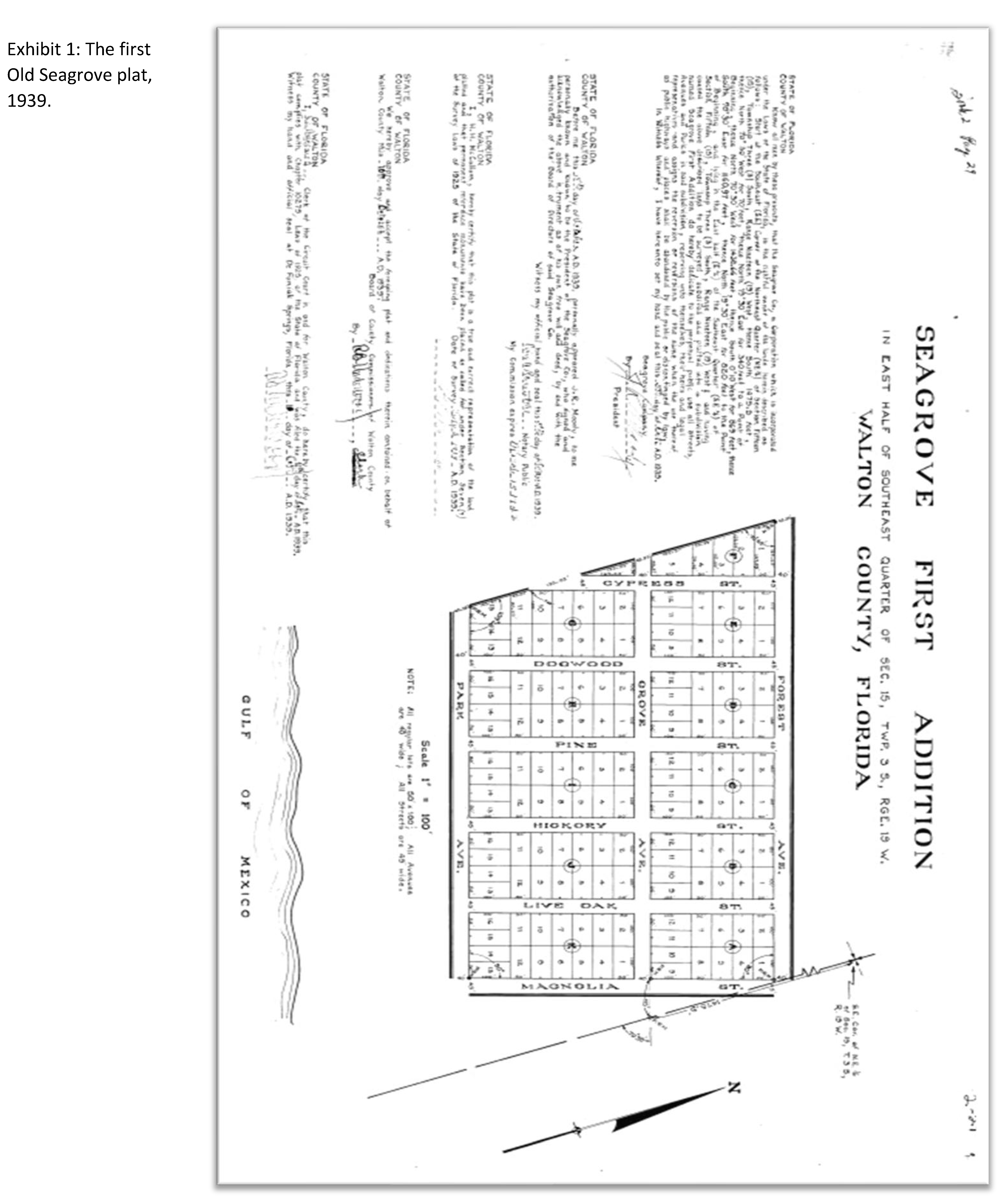
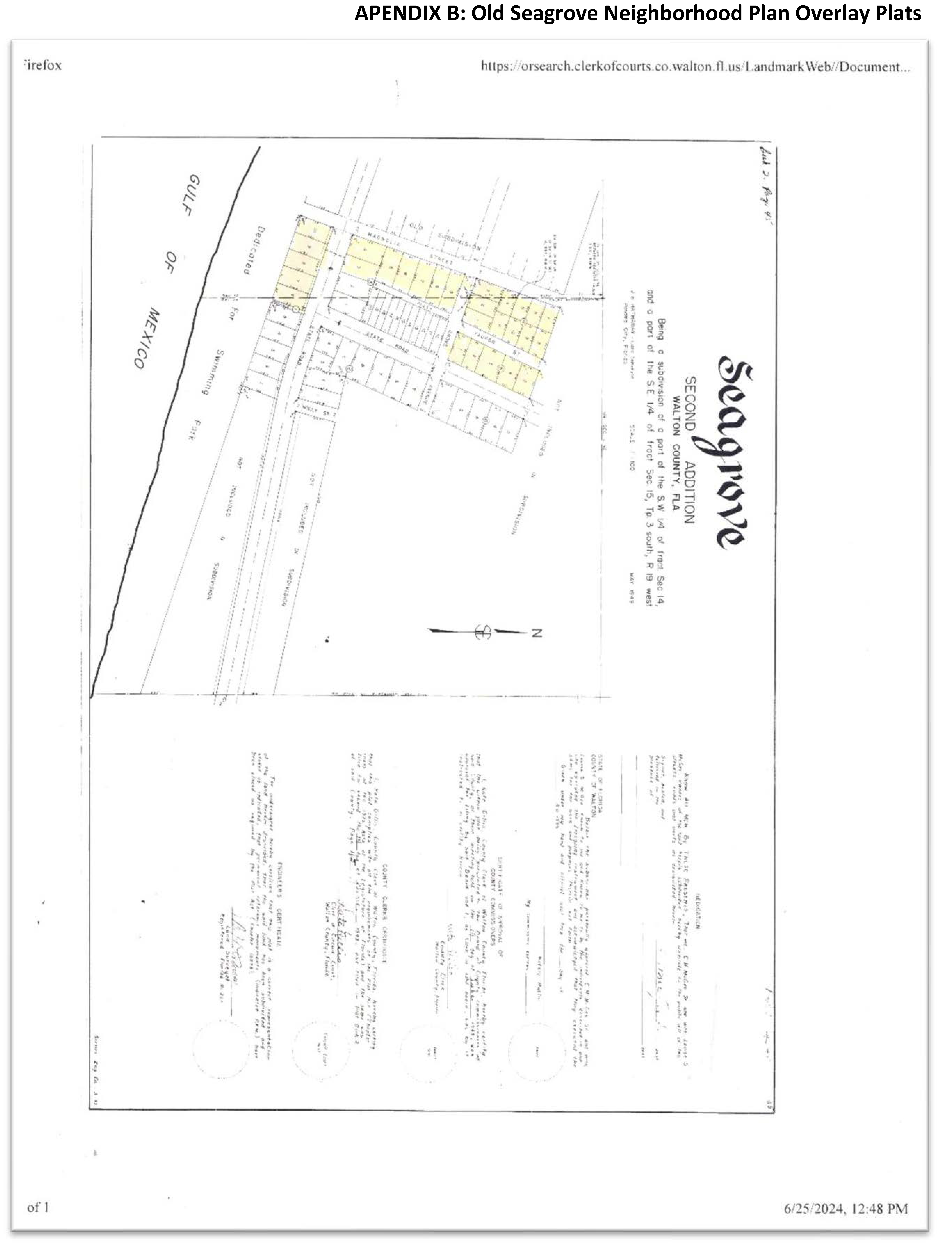
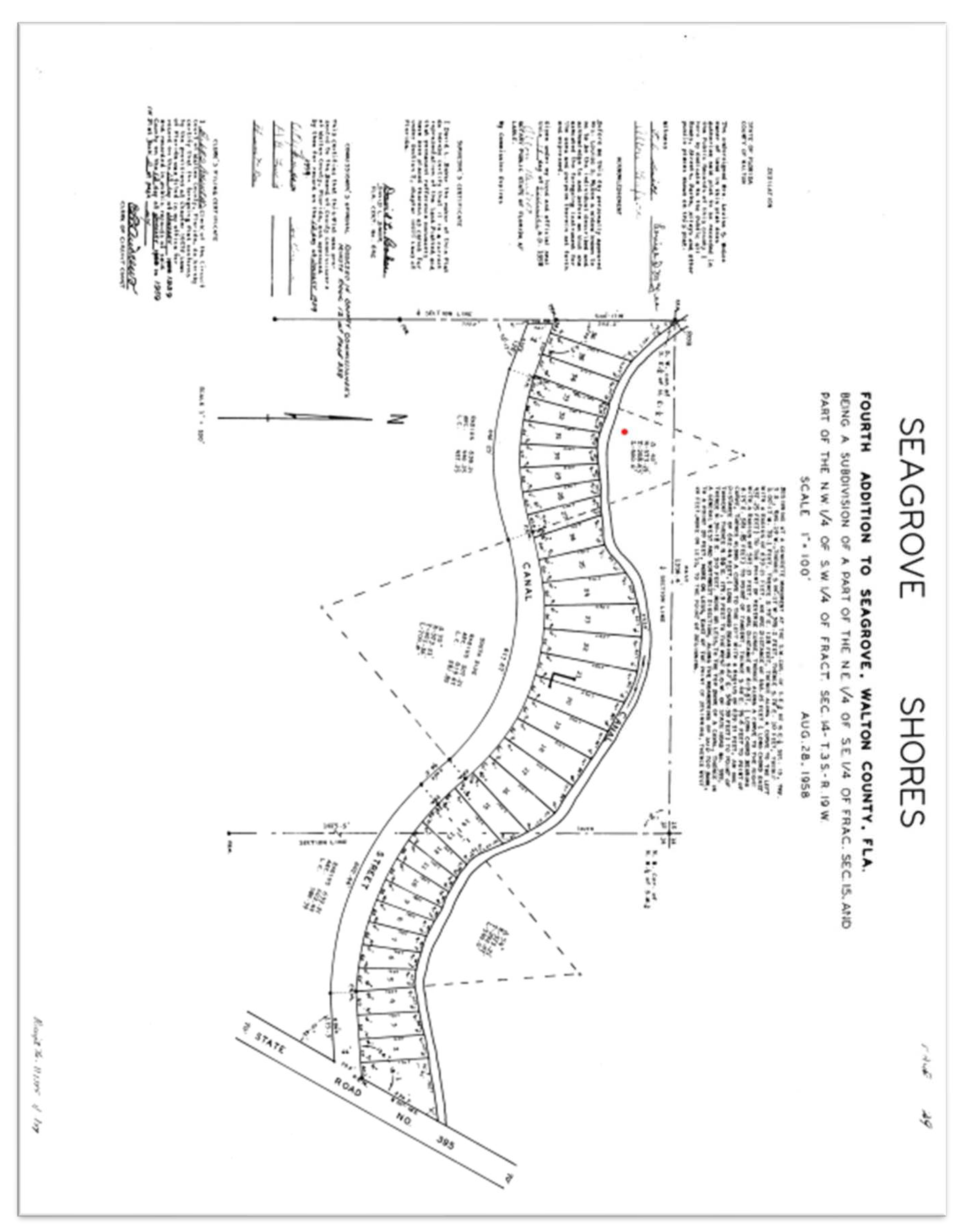
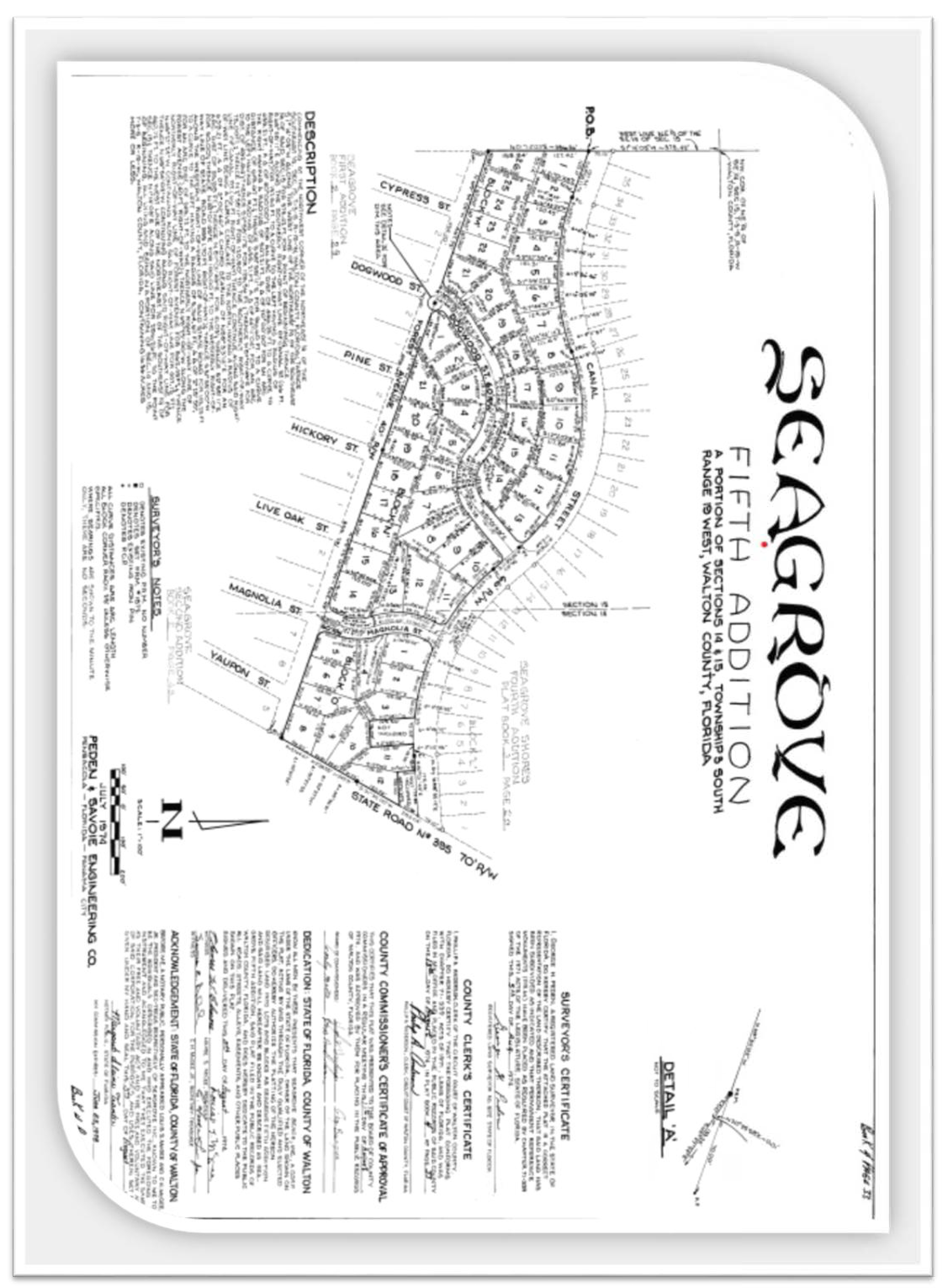
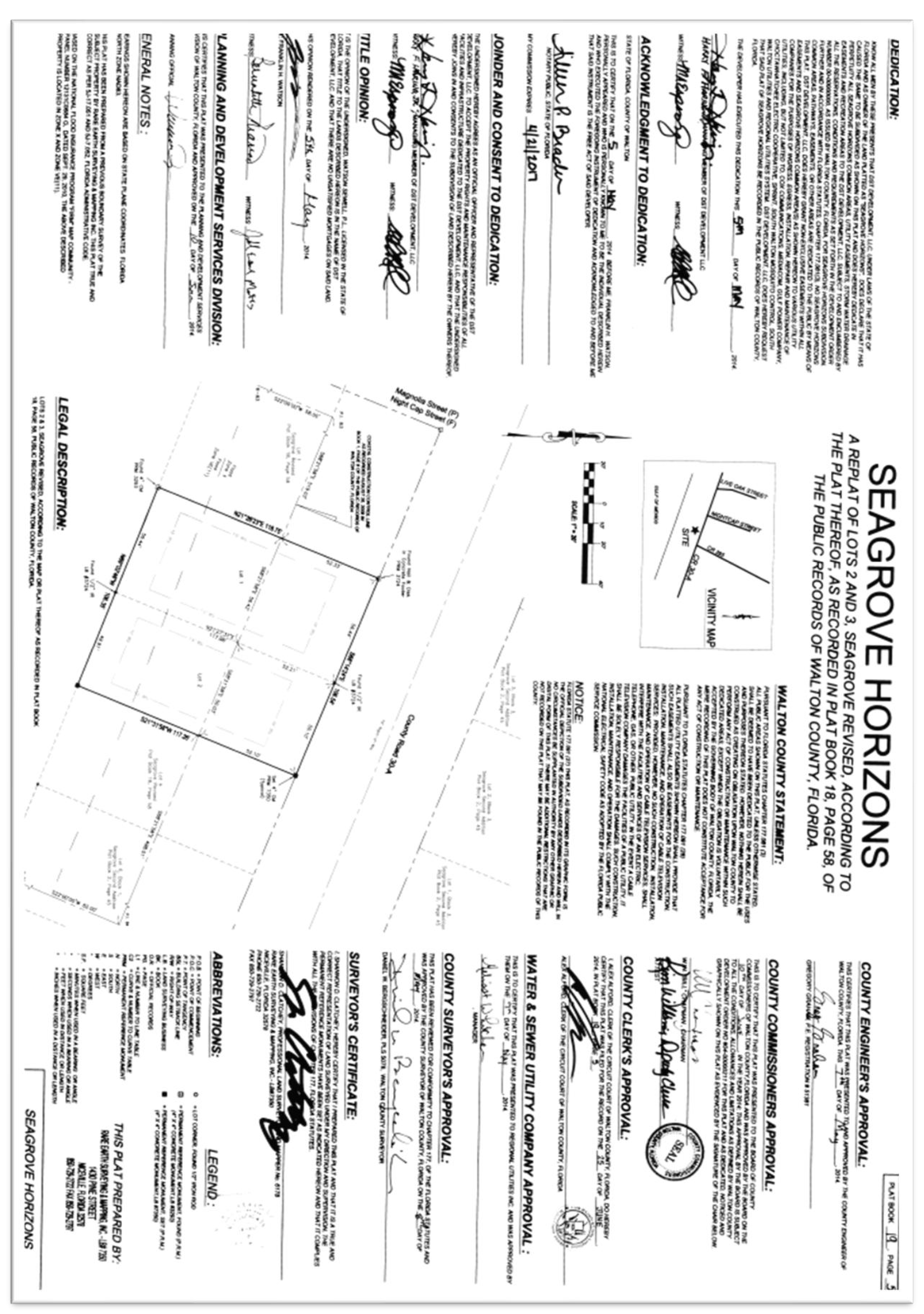
The history of Old Seagrove's development pattern begins in the early 1930s when Seagrove First Addition was first platted (Exhibit 1) in classic grid pattern with 40-45 feet street rights-of-way. These streets were aptly named after trees and included: Grove Ave; Forest Ave; Cypress Street; Dogwood Street; Pine Street; Hickory Street; and Live Oak Street. At this time, Country Road 30-A had not been constructed to its present state.
Beach Access was a hallmark of this original Seagrove development and permanent easements to beaches were legally recorded in 1953 as an amenity incentive for lot purchases.
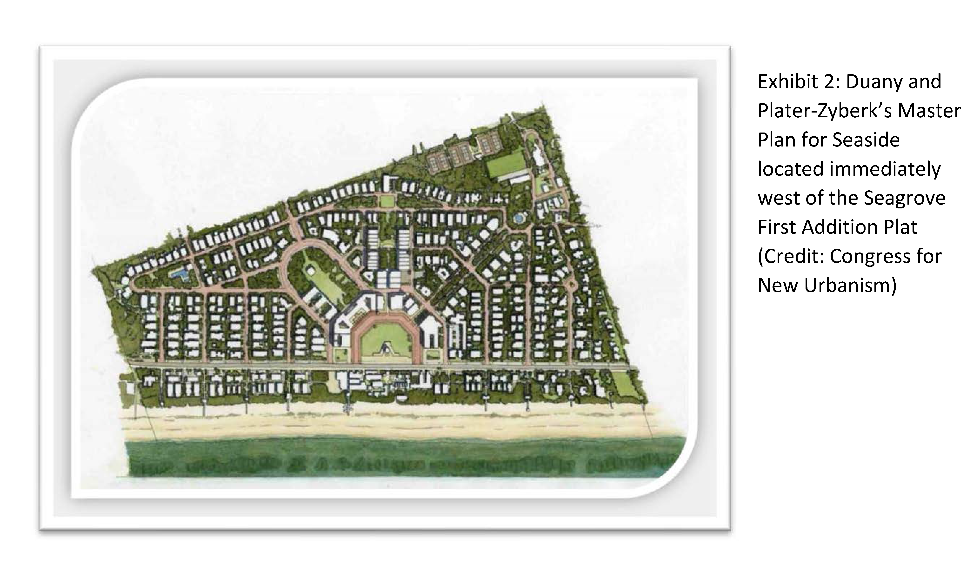
The Seagrove community, for the most part, also pre-dates the development of the adjacent Seaside community which was conceptualized in the late 1970s and master planned in the early 1980s. The first homes in Seaside were built in 1981. The Seaside development pattern, which has become one of the most well-known hallmarks of the New Urbanism movement, includes a town center from which other streets project on a radial plan (See Exhibit 2). Two main roads connect the Old Seagrove Neighborhood to Seaside, Forest Street and Grove Avenue.
Over the past three decades and continuing to the present day, the Old Seagrove neighborhood has experienced increased rates of building along with the continued overall growth and development of South Walton County. A substantial portion of this increased development has consisted of disproportionately sized short term vacation rental units which have significantly changed the character of the neighborhood. Originally platted smaller lots for beach cottage style homes have been constructed with increasingly large commercial homes.
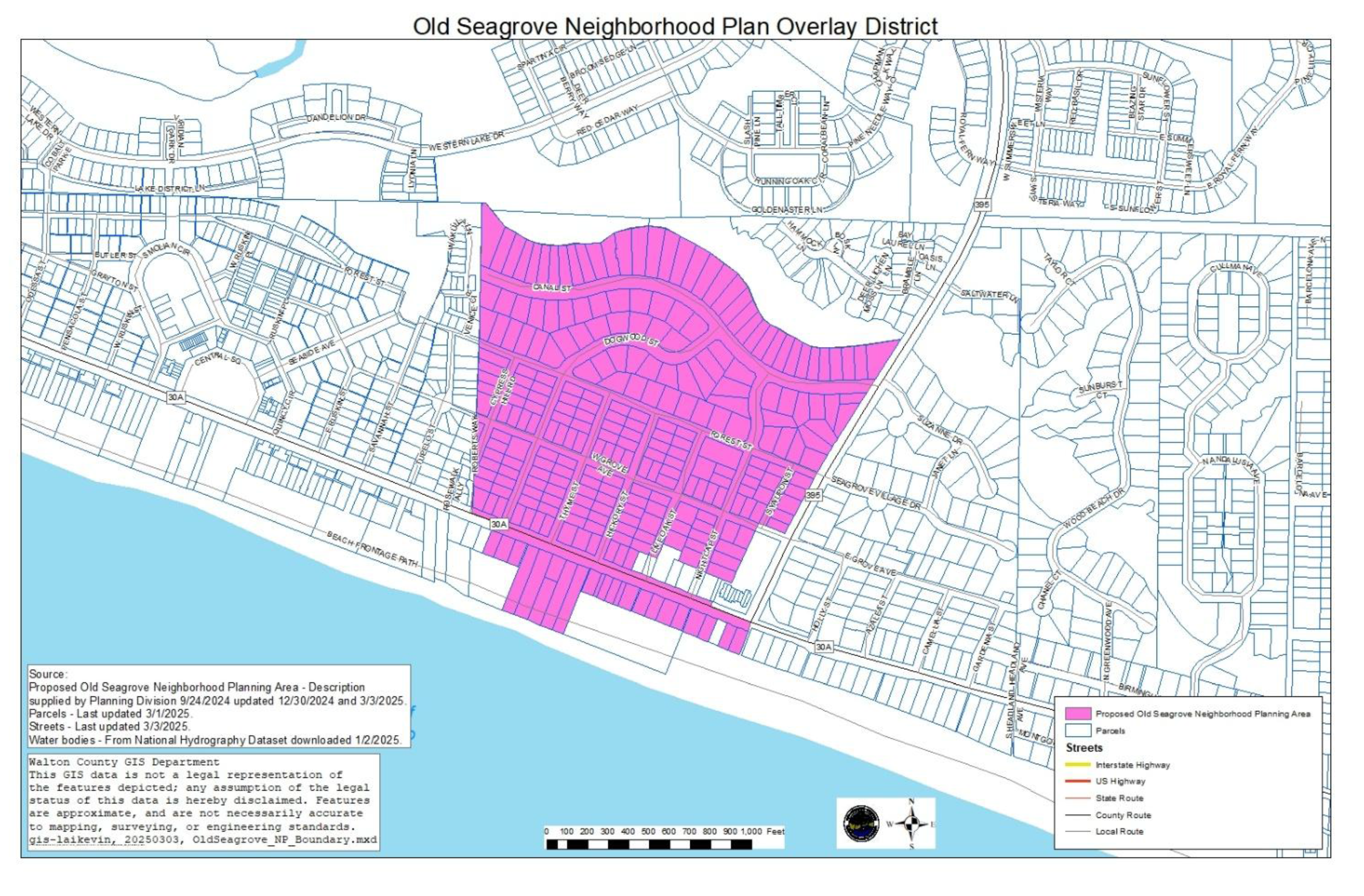
Old Seagrove is defined as all single-family residential properties bounded to the west by the Seaside community, to the east by County Road 395 including the 395 Beach Access, to the south by the Gulf of Mexico, and to the north by a Western Lake tributary. These features insulate the neighborhood to some extent but also make it a very desirable tourist destination.
(Ord. No. 2025-05, Att. A, 2-27-25)
III. - The Neighborhood Planning Process.
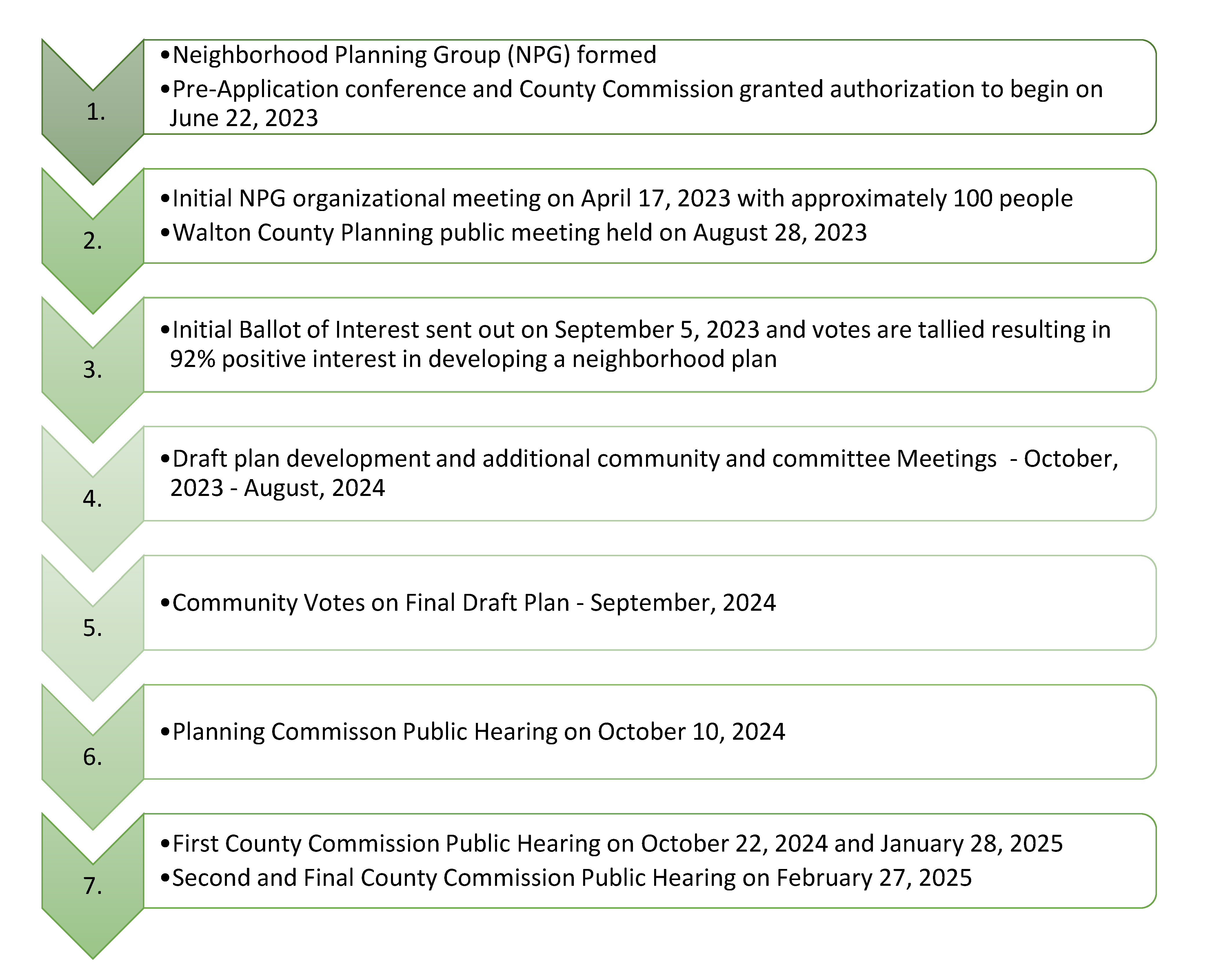
This Neighborhood Plan was developed in accordance with the Walton County Comprehensive Plan and Land Development Code (the CODE). Walton County encourages the preparation of Neighborhood Plans to guide development within the Residential Future Land Use Map Category. In 2008, Walton County adopted a Neighborhood Planning Ordinance to allow such plans to be adopted as overlay districts, thereby expediting the neighborhood plan approval process and promoting these citizen-based planning efforts. Walton County's requirements for neighborhood plans are contained in Chapter 8 of the Walton County Land Development Code. The following is a summary of key milestones and dates for the development of this Neighborhood Plan following the process outlined in the Walton County Land Development Code. This Plan is a result of these efforts and the collaboration of all those who participated and offered input.
(Ord. No. 2025-05, Att. A, 2-27-25)
IV. - Old Seagrove Neighborhood Plan Overlay District Established.
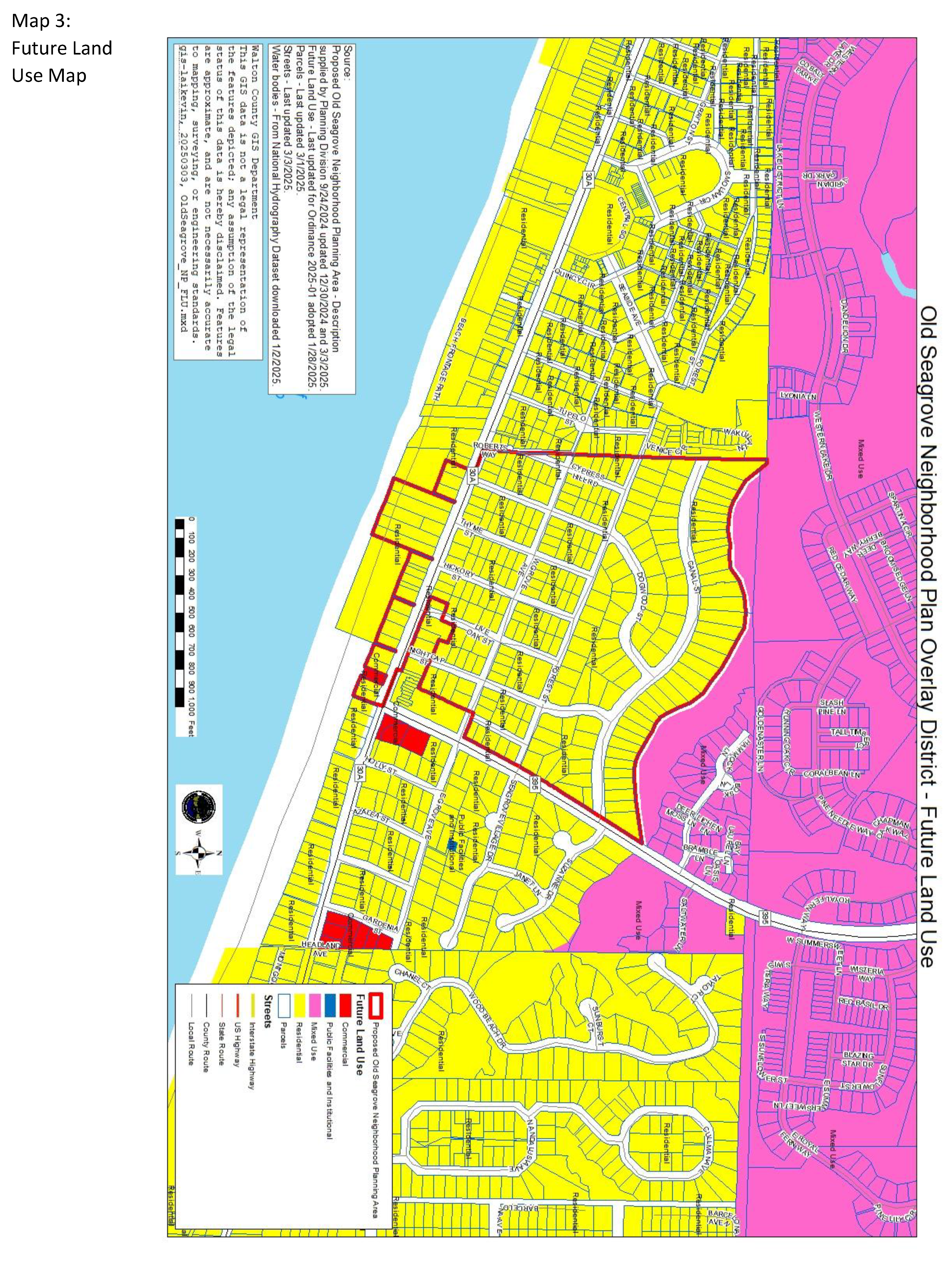
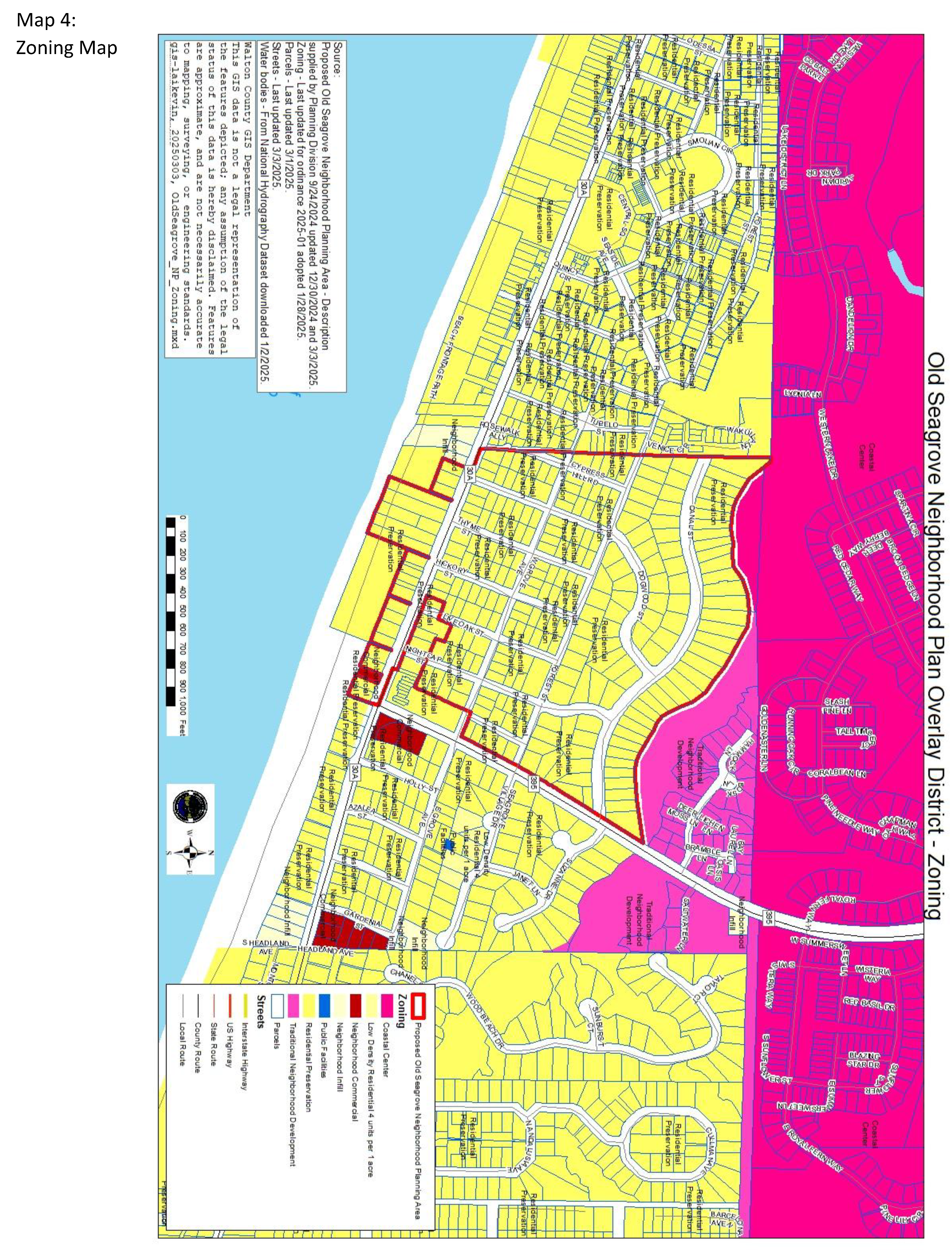
The Old Seagrove Neighborhood Plan shall serve as an overlay to the Official Zoning Map for the properties identified on the Neighborhood Plan Boundary Map included as Map 1. All development standards included within this document shall apply in addition to the development standards found elsewhere in the Land Development Code. Whenever a specific or conflicting standard is included within this neighborhood plan, the neighborhood plan standard shall supersede similar standards found elsewhere in the Land Development Code. Maps 3 and 4 provide the Future Land Use Map Designations and Zoning Map Districts in place at the time of adoption of this Plan.
Map 1: Old Seagrove Neighborhood Plan Boundary Map
(Ord. No. 2025-05, Att. A, 2-27-25)
V. - Streets and Beach Accesses.
A.
Streets.
1.
To retain the authentic "Old Florida" community character and existing tree canopy, the neighborhood requests the right to be notified by the County of any decisions concerning infrastructure development or changes, including paving or resurfacing of roads, and any other infrastructure improvement being done by the County or permitted by the County.
2.
Any street improvements or alterations within the subject area shall utilize the existing street footprint in place at the time of Neighborhood Plan adoption to the greatest extent possible.
3.
To the greatest extent possible and while also protecting the health, safety, and welfare of neighborhood residents and traveling public, the surface area of the streets (street footprint) shall not be expanded beyond what was existing at the time of the adoption of this Plan.
4.
Drainage ditches, swales, or excessive cutting of vegetation are to be discouraged along the roadsides. See Tree Protection VI.D. for further specifics and restrictions.
B.
Beach and Beach Access Areas.
1.
There are five pedestrian beach accesses leading to the Gulf of Mexico within the Old Seagrove Neighborhood. Four of these beach easements (b, c, d, and e) listed below were recorded in Deed Book 122, Page 531, by Ely Andrews, Clerk of Circuit Court, granting public ingress and egress over each of the following parcels and upon lands from C-30A to the beach sands. These beach accesses are to remain open to the public and pedestrian in nature:
a.
S County 395 Access - located between parcel 14-3S-19-25080-001-0050 and parcel 14-3S-19-25080-001-0060
b.
Nightcap Access - located between parcel 15-3S-19-25610-000-0010 and parcel 15-3S-19-25000-003-0010
c.
Live Oak Access - located between parcel 15-3S-19-25000-003-0060 and parcel 15-3S-19-25000-003-0070
d.
Hickory Access - located between parcel 15-3S-19-25000-003-0040 and parcel 15-35-19-25000-004-0000
e.
Dogwood / Thyme Access - located between parcel 15-3S-19-25000-007-0000 and parcel 15-3S-19-25000-008-0000
2.
The Old Seagrove Neighborhood beach is identified in the October 16, 1939 recorded Plat Book 2, Page 29, instrument no. 101082. A covenant and easement agreement were recorded in Deed Book 122, Page 530, by Ely Andrews, Clerk of Circuit Court, granting the public use of the beach sands from the bluff line to the mean high-water line: recorded plat for Seagrove First Addition on April 21, 1953, by Ely Andrews, Clerk of Circuit Court, Deed Book 122 page 530:
"...Commencing at the intersection of Magnolia Street [Nightcap Street], Seagrove 1st Addition according to Plat on file in office of Clerk of the Circuit Court of Walton County, Florida, on East side of said street, where same joins State Road No. 395 southerly 190 ft. to a point of beginning: Thence westerly 1063.31 ft thence south 174.86 ft thence easterly 1050.40 ft thence northerly 165 ft to a point of beginning..."
Additionally, the recorded plat grants the right to use approximately 1,060 ft of beach sands from the bluff line to the mean high-water line "for the general public to use said properties as a beach for those purposes for which beaches are usually used by the general public."
3.
No signs, barriers or restrictions shall be placed on beaches which dissuade, deter or interfere with permanent easements recognized by the neighborhood, into perpetuity, as recorded for Seagrove First Addition on April 21, 1953, by Ely Andrews, Clerk of Circuit Court, Deed Book 122 page 530:
"...do hereby grant unto the general public the right to use said property as a beach for those purposes for which beaches are usually used by the general public subject to, the following restrictions, to-wit:
a.
No buildings shall be erected thereon except sunshade huts in skeleton form without sides or walls.
b.
Said area shall never be used for living purposes or for camping purposes.
c.
Said area shall never be used for latrine purposes.
4.
There shall be no dumping of trash, garbage, debris or refuse or any kind within said area.
d.
No obstructions of any kind shall ever be placed within said area except such as those described in restriction #1 above,
And we covenant and agree that this grant shall continue so long as the general public uses said property as a beach and abides by the restrictions above listed."
(Ord. No. 2025-05, Att. A, 2-27-25)
VI. - Development Standards.
A.
Residential Land Use.
1.
The Old Seagrove Neighborhood Plan area shall maintain the Residential Preservation Zoning (RP) District with the exception of parcel 15-3S-19-25600-000-0020 which is zoned Neighborhood Commercial. The land use in place at the time of the adoption of this Plan is depicted on Maps 3 and 4. The following development standards apply to the RP Zoning district within the Old Seagrove Neighborhood Plan Overlay District:
a.
Primary Uses Allowed: Development within RP District is limited to the uses shown in the approved plats (single family residential) or development orders for the proposed development site.
b.
Accessory Uses and Structures Allowed: Accessory structures and uses in connection with any lawfully existing primary use.
c.
Conditional Uses Allowed: None.
d.
Residential Density Allowed: The maximum allowable residential density within an area designated Residential Preservation (RP) shall be one dwelling unit per platted lot.
e.
The reconfiguration of existing platted lots that results in additional dwelling units shall not be permitted. Lot line adjustments, as may be necessary for reasons other than the accommodation of additional dwelling units, may be permitted in accordance with applicable re-plat requirements found elsewhere in the Code.
f.
Short-Term Vacation Rental Units (single family residential type buildings) are allowable uses subject to the development standards included within this neighborhood plan and elsewhere in the Walton County Land Development Code. Newly constructed short term vacation rental uses shall not exceed six bedrooms.
B.
Non-Residential Land Use and Home-Based Businesses.
1.
No lot within the boundaries of this plan shall be used for commercial, multi-family, and/or non-residential uses including, but not limited to, civic uses and bed and breakfasts uses. This excludes the existing commercial businesses located at the northeast corner of Highway 30A and Highway 395.
2.
No commercial development(s) or entity or services, other than approved vendors authorized under the Walton County Beach Activities Ordinance, may use any lot to access the beaches or waters of the Gulf of Mexico, nor for the storage of beach supplies, tents, chairs, umbrellas, kayaks, fishing equipment, boats, or any other recreational equipment for sale or rent.
3.
Home occupations are allowed in accordance with the provisions of the Code in effect at the time of adoption of this plan.
a.
A home occupation shall be in a bona fide dwelling unit. The home occupation shall be clearly incidental and subordinate to its residential use, utilizing no more than 25 percent of the square footage of the dwelling.
b.
No signage larger than one foot square is allowed. No changes to the outside of the dwelling may be made to advertise or make known the nature of the home occupation taking place within the dwelling.
c.
No traffic shall be generated in greater volumes than would normally be expected in a residential neighborhood, and any need for parking generated by the home occupation shall be met off the street and on the premises.
d.
No equipment, tools, or processes shall be used in such a home occupation which creates interference to neighboring properties due to noise, vibration, glare, fumes, odors, or electrical interference.
C.
Development Performance Standards.
1.
Building Standards.
a.
Setbacks: In all cases, the following setback requirements shall apply to residential structures within the Old Seagrove Neighborhood Plan Area regardless of lot size:
i.
Front - twenty feet
ii.
Side - seven and five-tenths feet
iii.
Rear - fifteen feet
b.
Building Height: The maximum building height for the Old Seagrove Neighborhood Plan Overlay District shall be 40 feet. This maximum building height shall be applied utilizing the following methodology: Building or structure height is the vertical distance or measurement from the average elevation of the existing natural ground beneath the footprint of the building or structure to the highest point at the top of the building or structure or the highest point of the coping of a flat roof, the deck line of a mansard roof, or the mean height level between eaves and ridge for gable, hip, domed, curved, and gambrel roofs. Building or structure features such as chimney height as required by the Florida Building Code shall not be included in the methodology for measurement for building or structure height. Traditional roof pitches and multiple roof lines are encouraged.
c.
Fence and/or privacy wall heights shall be no greater than four feet in the front and ten feet on the side and rear of the property. Front fence cannot obstruct visibility of an intersection. Chain link fences are prohibited on all sides.
d.
Dwellings shall be oriented so that the front façade is facing the street.
e.
Garbage and Waste Receptacles: Trash cans stored at street should be kept in a corral that is maintained in good repair and free of loose trash. Corrals be located at the left or right streetside of the lot rather than the front center streetside of the lot. The number of cans per Short Term Rental (STR) should comply with the Walton County STR Code Ordinance in effect at the time of adoption of this Plan and no less restrictive. No trash, construction materials or storage of used or abandoned vehicles shall remain on empty lots.
f.
Coastal Dune Lake Protection Zone: All applicable development and redevelopment shall meet the requirements of Section 4.02.03 of the Code in place at the time of adoption of this Plan.
g.
Coastal Protection Zone (CPZ): All applicable coastal development and redevelopment shall meet the requirements of Section 4.02.02 of the Code in place at the time of adoption of this Plan.
h.
Scenic 30A Corridor Buffer: All applicable development and redevelopment shall meet the requirements of Section 6.10.00 of the Code in place at the time of adoption of this Plan.
i.
The maximum driveway connection width shall be no greater than 20 feet or a combination equal to 20 feet, maintained across the Street right-of-way and ten feet of the front building setback yard.
D.
Tree Protection.
1.
No one shall remove, destroy, or damage a protected tree located in the Old Seagrove Neighborhood Plan Overlay District without first obtaining a clearing permit from Walton County Planning and Development Services. A protected tree is any Live Oak (Quercus virginiana) or Hickory with a diameter at breast height (DBH or four and five-tenths feet) of eight inches or greater, and Southern Magnolia (Magnolia grandiflora) with a diameter of six inches or greater.
2.
Requirements.
a.
A Tree Survey and Plan is required to obtain a land clearing permit. The Tree Survey must include all trees with a diameter of six inches or more, the species of trees, and those proposed for removal.
b.
Property owners are encouraged to place driveway in such a way as to avoid removing protected trees that form a canopy over the neighborhood roads. For each canopy protected tree that is removed, a Protected Tree of three-inch caliper DBH or greater must be planted somewhere in the front or front/side setback, or right-of-way in such a manner as to restore any lost tree canopy over the road at the front of the property. If a tree is planted on the county right-of-way, approval of its location must be given by the Walton County Planning and Development Services.
c.
During the clearing and the construction process care should be taken to avoid encroachment of the critical root zone of protected trees with excess sand/soil, building materials, equipment, vehicles, etc.
d.
Disturbances of the front setback yard or side setback yard for corner lots and front or side right-of-way for corner lots not used for the 20-foot driveway allowance must be returned to a natural organic state. This includes planting materials and ground cover to prevent erosion. These remaining portions of the right-of-way shall not be covered with paving, gravel, rock, or other surface that can be used to access parking. Homeowners are strongly encouraged to maximize their landscaped area using trees, shrubs, and plants that are native to this area.
e.
Exemptions. Tree protection requirements shall not apply under the following circumstances and conditions:
i.
Single-Family Dwellings: The construction, location, or placement of single-family dwellings and customary accessory uses when protected trees are located within ten feet of the actual building or structure "footprint" and not within the first ten feet of the front yard setback.
ii.
Development: The intended allowable use of the site cannot be reasonably developed in accordance with the Land Development Code because protected trees are located within areas necessary for any structure or infrastructure purposes.
iii.
Utility Operations: Excavation, tree pruning and removals by duly constituted communication, water, sewer, electrical or other utility companies or federal, state, or county agencies, or engineers or surveyors working under a contract with such utility companies or agencies shall be exempt, provided the activity is limited to those areas necessary for maintenance of existing lines or facilities or for construction of new lines or facilities in furtherance of providing utility service to its customers, and provided further that the activity is conducted so as to avoid unnecessary removal. Specifically, for CHELCO overhead power lines, clearing from ground to sky, ten feet on either side of the pole line is required for maintenance of existing lines or facilities or for construction of new lines or facilities. All pruning and trimming shall be done in accordance with National Arborist Association Standards. Written notice of the areas where authorized work is anticipated shall be provided to Walton County Planning and Development Services prior to the work, except that when the work is needed to restore interrupted service under emergency conditions, no prior notice is required.
iv.
Nuisance Trees: All trees listed on the Florida Exotic Pest Plant Council's List of Invasive Species or the Florida Department of Agriculture and Consumer Services, "Noxious Weeds" rule in Section 5B-57, F.A.C.
v.
The tree is diseased, insect ridden, or weakened by age, abuse, storm, or fire and is likely to cause injury or damage to people, buildings, or other improvements.
f.
Reparations. Protected trees that are removed without obtaining a clearing permit or meeting the exemptions in subsection "c" above shall be replaced at the expense of the developer or property owner. Trees must be planted to receive a certificate of occupancy from Walton County.
g.
Neighborhood street trees required. Native trees shall be preserved in this area and in the street right-of-way to the greatest extent possible. In addition to Section b above related to driveways, new residential units shall plant replacement canopy trees (two per lot) of three-inch caliper DBH or greater within the County right-of-way or the first five feet of the front setback yard if canopy trees do not exist or have been damaged or removed during the construction processes. Canopy trees are defined as trees to reach a height of 40 feet or greater at maturity and produce significant shade (e.g. Live Oak and Magnolia). If a tree is planted within the county right-of-way, approval of its location must be given by the Walton County Planning and Development Services.
E.
Signage Standards.
1.
Short-Term Rental (STR) Vacation signs including those required in the CODE shall not exceed four square feet and be affixed to a fence or structure, i.e. garbage enclosure. If signs mounted in accordance with the above restrictions are not visible from the road, then one freestanding sign not to exceed four square feet can be used and securely mounted on a single post.
2.
For-Sale, Realty and Builder or Contractor Signs shall not exceed four square feet.
3.
Temporary Vendor Signs are prohibited.
F.
Parking Standards. Purpose - Parking standards are required to maintain open fire lanes, ensure access for emergency vehicles, and protect the integrity of the road shoulder and adjacent vegetation.
1.
All vehicles parked at a residence must be within designated parking spaces.
2.
Property owners may store Recreational Vehicles (RVs) and camper trailers onsite in designated parking areas provided all parking standards are met and shall not be used as a dwelling unit or accessory dwelling unit. RVs shall not be used by STR guests and may only be stored on individual lots for owner use.
3.
On-street parking is prohibited (as per Ordinance 2022-07 Chapter 20 Traffic and Motor Vehicles Section 20-11). No-parking street signs will be utilized to assist with communication to area visitors.
G.
Noise. Old Seagrove Neighborhood adopts a Neighborhood Quiet Hours Policy which begins at 10:00 p.m. and ends at 6:00 a.m. This is in accordance with the State of Florida Implied Quiet Enjoyment Statue, Florida's nuisance statute as codified at § 60.05, and Walton County's current Noise Ordinance (#2014-16).
(Ord. No. 2025-05, Att. A, 2-27-25)
Appendix A: Detailed History of Seagrove Beach.
Seagrove Beach's shoreline has a history that stretches back to the 1860s when Civil War sailors used the coastline as a navigation point and labeled it "Green Hill." This name came from the evident beauty of live oaks growing to the edge of the 45-foot bluff which could be seen from miles away at sea.
Old Seagrove's history of development begins in the early 1900s. It was a remote area with no power or paved roads and well water powered by a windmill driven pump. One of the earliest structures was the Seagrove Hotel which was already aged when J.J. Ward first leased it in 1925. This was the only place on the east side of Western Lake where you could get food and lodging. A sandy road led from the Old Ferry landing in Point Washington straight down (now Co Rd 395) to the hotel where it ended. There were no roads east or west of the hotel.
J. R. Moody, who owned the land, first platted the Seagrove 1st addition in an "unrecorded plat" on October 1, 1922, which showed a public use Gulf Park. He revised the 1922 unrecorded plat of Seagrove 1st addition and recorded it on July 19, 1939, which did not show the Gulf Park.
Cube McGee Sr., on a visit to the area, saw the beauty that nature displayed in Seagrove and in 1949, after an 18-month campaign to have J.R. Moody sell him the land, purchased the remaining lots in Seagrove 1st addition along with the surrounding 160 acres. McGee, just like the war sailors before him, saw the Seagrove bluffs as a virtual paradise. McGee began a letter campaign soon after, where he billed the area in the following way: "Combine the beauty of the world's most magnificent bathing beach with the beauty of high bluffs and trees leaning with the breeze ......look along this gorgeous panorama of earth, sea and sky and repeat our slogan (from your heart. 'Where Nature Did Its Best.'"
Cube McGee Sr. also understood what was happening to other coastal communities and began looking for ways to protect the Old Seagrove Neighborhood with recorded covenants and restrictions. On April 21, 1953 in Deed BK 122 Pg 530-531, the covenants he recorded provided for perpetual access easements to the sands of the beach and to set aside approximately 1,600 feet running along the top of the bluff line then down to the mean high water. This covenant stated: "to grant the general public the right to use said property as a beach for those purposes for which beaches are usually used by the general public."
Cube McGee Sr. wanted Seagrove to be a nice place to live and to bring families on vacation. In 1949 McGee Sr. built a store (later the Seagrove Village Market) to provide visitors with the barest necessities. Ice was brought in by Casey's Icehouse and kept in wooden boxes. The mail was delivered to one large community mailbox, and residents just sorted through it to find their own mail. McGee created a community spirit where neighbors enjoyed spending time on their porches as well as the beach, talking and trading stories with each other and lending a helping hand whenever needed. The community spirit of Old Seagrove epitomizes what New Urbanism has attempted to capture: neighbors enjoying their time with neighbors and living in unison with the majesty of live oaks, the sounds of wildlife and the sunsets on the gulf....all that nature has given us. That community spirit still exists today in Old Seagrove.
In this Neighborhood Plan, the community wants to preserve the vision of Cube McGee Sr. and protect our area from the destruction of the old trees and live oaks and to preserve our neighborhood's character as a place to live alongside nature and for families to enjoy vacation in one of the last natural habitats on 30A. "Where Nature Did Its Best."
Source: "The Way We Were, Reflections of South Walton Pioneers" Published by South Walton, Three Arts Alliance, C. 1996.
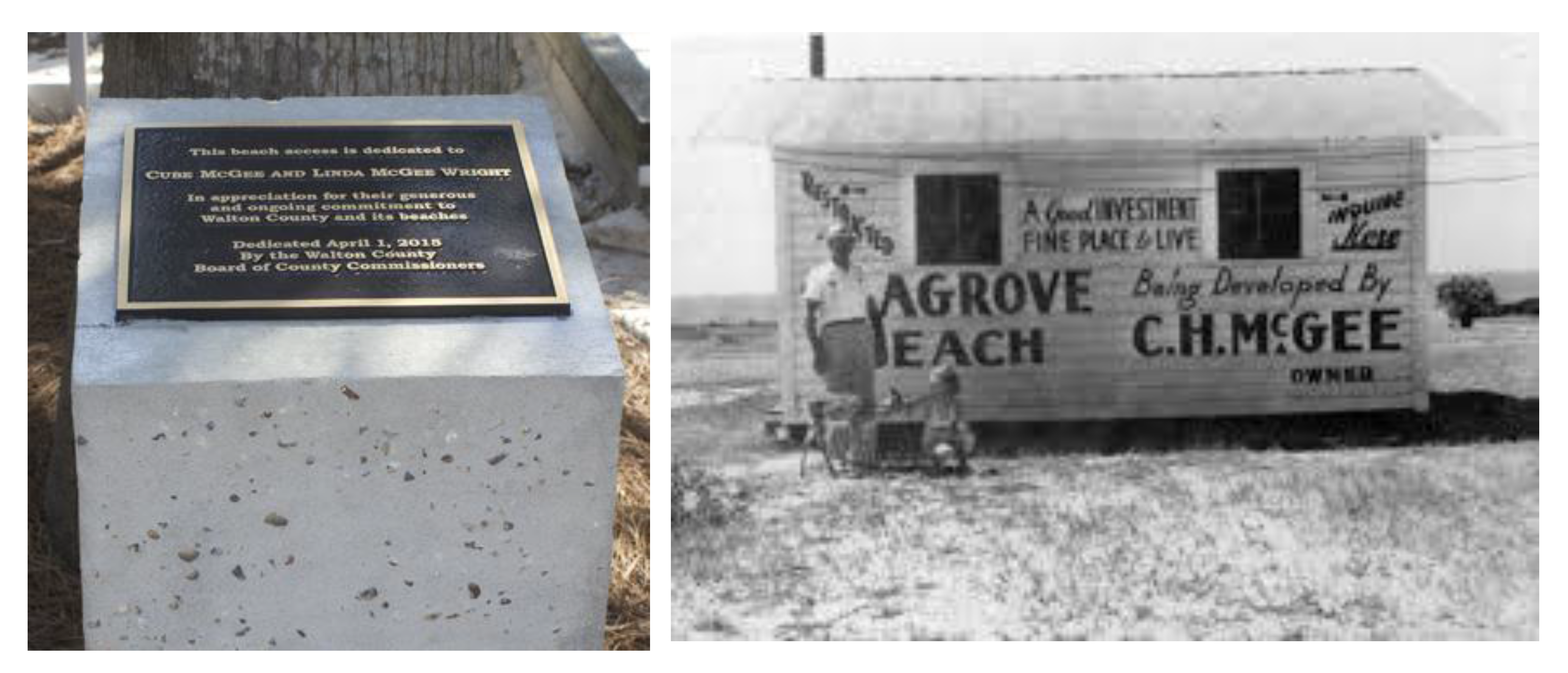
A plaque commemorates Linda McGee Wright and Cube McGee at the Live Oak beach access.
Photo Credit: https://waltonoutdoors.com/south-walton-pioneer-c-h-mcgee-known-as-mr-seagrove/
(Ord. No. 2025-05, Att. A, 2-27-25)
(Ord. No. 2025-05, Att. A, 2-27-25)