
Paxton City Zoning Code
CHAPTER V
- DEVELOPMENT DESIGN AND IMPROVEMENT STANDARDS6
Editor's note— Ord. No. 2019-06, § II(Att. A), adopted March 12, 2019, amended chapter V in its entirety to read as herein set out. Former chapter V, §§ 5.00.01—5.00.10, 5.01.01—5.01.04, 5.02.01—5.02.07, 5.03.01—5.03.05, 5.04.01—5.04.07, 5.05.01, 5.05.02, 5.06.01—5.06.03, 5.07.01—5.07.12, 5.08.00, 5.08.01, 5.09.01—5.09.14, 5.10.01—5.10.06, 5.11.01—5.11.04 pertained to similar subject matter. See Code Comparative Table for complete derivation.
5.06.00. - STORMWATER MANAGEMENT
This section shall govern the design, construction, or alteration of all stormwater management and drainage systems within the unincorporated portions of Walton County. All residential, commercial, and industrial projects shall incorporate sufficient erosion and sediment controls until final stabilization of the construction site. Erosion and sediment control Best Management Practices (BMPs) shall be used as necessary during construction to retain sediment on-site and assure that any discharges from the site do not cause or contribute to a violation of state water quality standards. Any construction site operating without sufficient erosion and sediment controls may be issued a notice of violation and subject to Code Enforcement procedures as outlined in Chapter 7 of the Land Development Code.
A National Pollutant Discharge Elimination System (NPDES) stormwater construction generic permit from the Florida Department of Environmental Protection (FDEP) is required for any construction activities that:
• Disturb one or more acres of land or disturb less than one acre of land but are part of a common plan of development or sale; and
• Discharge stormwater to surface waters of the state or to surface waters of the state through a municipal separate storm sewer system (MS4).
(Ord. No. 2023-16, Att. A, 7-27-23)
5.00.01. - Purpose and Intent.
The purpose of this chapter is to provide site design and improvement standards applicable to all development activity in the County. The provisions are intended to ensure functional and attractive development. The standards allow for flexibility in site design, while ensuring compatibility of neighboring uses through design features such as landscaped buffers.
(Ord. No. 2019-06, § II(Att. A), 3-12-19)
5.00.02. - Minimum Lot Area Requirements.
A.
Requirements for all Developments. All developments shall have a total land area sufficient to meet all development design standards in this Code including, but not limited to, land required to provide for all setbacks, buffers, stormwater management, off-street parking and circulation, utilities and infrastructure, protection of environmentally sensitive lands, landscaping, open space and any other provisions which may require land area to be set aside.
B.
Requirements for Residential Development with Central Water and Sewer Services. There is no minimum lot area for individual lots within a residential development that will be served by both a central water and central sewer system, provided that all of the following requirements are met:
1.
The land area for the total project is sufficient to meet standards of this Code as stated in paragraph (A) of this section.
2.
Residential density of the area shall not exceed the maximum densities specified in Chapter 2 (Zoning Districts) and those maximum densities found within the Walton County Comprehensive Plan.
3.
Land within the boundaries of a subdivision exclusive of individual lots to be conveyed in fee simple ownership, shall be owned and/or controlled and maintained through a condominium association, property owners' association, or other similar private legal entity, or may be conveyed to governmental or public not-for-profit organizations for the same purpose. Recordable instruments providing for these common-ownership lands shall be submitted for review with the application for development plan review.
C.
Requirements for Developments without Central Water and Sewer Services. All proposed development in areas that will not be served by central water and central sewer shall comply with the minimum lot sizes established by the Florida Department of Health Chapter 64E-6, F.A.C.
(Ord. No. 2019-06, § II(Att. A), 3-12-19; Ord. No. 2019-19, § II (Att. A), 9-10-19)
5.00.03. - Building Setback Requirements.
A.
Setback requirements shall apply to all structures erected on property situated in unincorporated areas of Walton County, Florida as specified in the Table 5-1 below:
Table 5-1: Building Setback Requirements
1.
Within the South Walton Planning Area, increase the abutting setback line(s) for single use non-residential uses and single use multi-family residential uses adjacent to existing single-family residential uses by an additional one-half foot for each one foot increase in building height above 36 feet. This provision shall not apply internally to mixed use developments having a common plan of design.
2.
Within the South Central, North Central, and North Walton Planning Areas, increase the abutting setback line(s) for single use non-residential uses and single use multi-family residential (greater than four units) uses adjacent to existing single-family residential uses by an additional one-half foot for each one foot increase in building height above 50 feet. This provision shall not apply internally to mixed use developments having a common plan of design.
3.
Where the landscaped buffer or scenic corridor requirements required by Subsections 5.01.02 and Chapter 6 of this Code the Land Development Code exceed the required setbacks established above, those requirements shall control. New residential lots abutting dedicated preservation areas such as wetlands or natural communities averaging at least ten feet in depth along the lot line may reduce side and rear yard building setbacks to five feet when abutting a wetland buffer and ten feet when abutting natural community preservation set aside areas, provided the preservation or wetland area is not included within the lot.
4.
All nonconforming, undeveloped residential lots less than or equal to 10,000 square feet in size, platted or un-platted prior to June 1975, may be developed with a minimum five-foot side setback if not otherwise indicated on the recorded plat.
5.
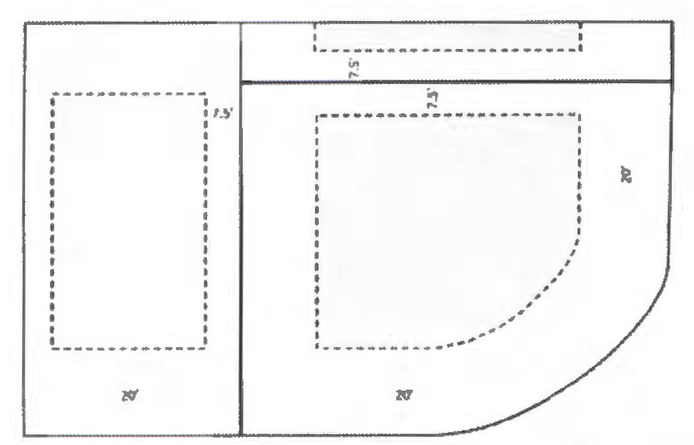
In all newly platted residential subdivisions, corner lot setbacks shall be increased to 20 feet on both street frontages in order to match the front setback of an abutting lot. (See Figure 5.1.)
B.
Methodology for Determination of Setback Requirements.
1.
All setbacks referred to in this Chapter and elsewhere in the Land Development Code will be measured from the nearest lot line to the closest vertical improvement on the subject parcel.
2.
Accessory structures and buildings as defined in Chapter 2 of the Land Development Code are subject to the same setback requirements the primary structure including, but not limited to, both in ground and above ground swimming pools, hot tubs and similar structures, and any decks or surrounding improvements associated with such accessory structures.
a.
Except that, non-elevated accessory structures such as walkways and at-grade patios or decking installed at a height of less than six inches from grade shall be allowed to encroach into the setback area.
b.
Except that, decks and patios less than two feet above finished grade on all sides may be placed within building setbacks provided they are not located within four feet of any property line.
3.
Architectural features and roof overhangs are also subject to setback requirements, except the feature or roof overhang may extend a maximum of 18 inches into the setback if they are at least eight feet above ground level.
4.
Mechanical equipment (HVAC condensers, pool pumps and filtration systems or water softeners) and stairs may encroach into side or rear setbacks only, provided they are not located within three feet of any property line.
5.
When a property is encumbered by an access easement, building setbacks shall be measured from the easement line, not the property line.
(Ord. No. 2019-06, § II(Att. A), 3-12-19; Ord. No. 2019-19, § II(Att. A), 9-10-19; Ord. No. 2022-13, § II, 8-25-22)
5.00.04. - Height Limitation, Exceptions, Exemptions, and Measurement Methodology for Building or Structure Height.
A.
Notwithstanding any other provisions of this Code, no man-made buildings or structures higher than heights established in the following height limitations for Walton County shall be permitted in unincorporated areas of Walton County unless otherwise provided for herein.
Height Limitations in the South Walton Planning Area.
1.
No buildings or structures higher than fifty (50) feet shall be permitted south of Choctawhatchee Bay and the Intracoastal Waterway unless further restricted as follows:
a.
No buildings or structures shall be permitted to exceed 40 feet in height within the Grayton Beach Neighborhood Plan Area.
b.
No buildings or structures shall be permitted to exceed thirty-two (32) feet in height within the Point Washington Neighborhood Plan Area (See Map 5-1 for Point Washington Neighborhood Plan Boundaries).
c.
The Inlet Beach Neighborhood Plan (Appendix NP-7) provides for limits on height by use.
B.
Height Limitations within the South Central, North Central and North Walton Planning Areas shall be as follows:
1.
Single-family attached and single-family detached residential uses may be permitted up to a maximum of fifty (50) feet in height.
2.
Multi-family residential uses may be permitted up to a maximum of seventy-five (75) feet in height except if further limited in Section C below within the Eglin Air Force Base Military Influence Area. Buildings or structures adjacent to or within ¼ mile radius of a municipal boundary must be compatible in scale and character to buildings or structures located in the municipality.
3.
Commercial or institutional uses may be permitted up to a maximum of seventy-five (75) feet in height except if further limited in Section C below within the Eglin Air Force Base Military Influence Area. Buildings or structures adjacent to or within ¼ mile radius of a municipal boundary must be compatible in scale and character to buildings or structures located in the municipality.
4.
Industrial uses may be permitted up to a maximum of one hundred (100) feet in height except if further limited in Section C below within the Eglin Air Force Base Military Influence Area. Buildings or structures adjacent to or within ¼ mile radius of a municipal boundary must be compatible in scale and character to buildings or structures located in the municipality.
C.
Height limitations within the Eglin Air Force Base Military Influence Overlay District MIOD) are as follows and shown on Map 5-2. Structures, facilities, and antennas within the Eglin Air Force Base MIOD shall be permitted up to the following maximum heights:
1.
Fifty (50) feet within the Impulse Area.
2.
Fifty (50) feet within the Critical Approach 1.
3.
Fifty (50) feet within the Critical Approach 2.
4.
Seventy-five (75) feet within MTR 1.
5.
One hundred fifty (150) feet within MTR 2.
Transmission facilities (poles and lines) and communication towers maintained and/or operated by an electric utility or by Walton County may exceed these height limitations based on compliance with the following:
1.
If the total height is less than 200 feet and is in compliance with Federal Aviation Administration requirements and regulations and Section 5.07.10 of the Land Development;
2.
Code;
3.
A determination of "No Hazard to Aviation" from the Federal Aviation Administration is obtained and submitted as part of the application for development approval or issuance of a permit for these facilities; and
4.
Development Plans are submitted to Eglin Air Force Base for review and comment prior to acquiring a building permit or other required approval from Walton County.
Amateur radio antennas that conform with Federal Communication regulations and are exempt from requirements of this Land Development Code regarding placement, screening, and height, pursuant to Florida Statutes Section 125.561.
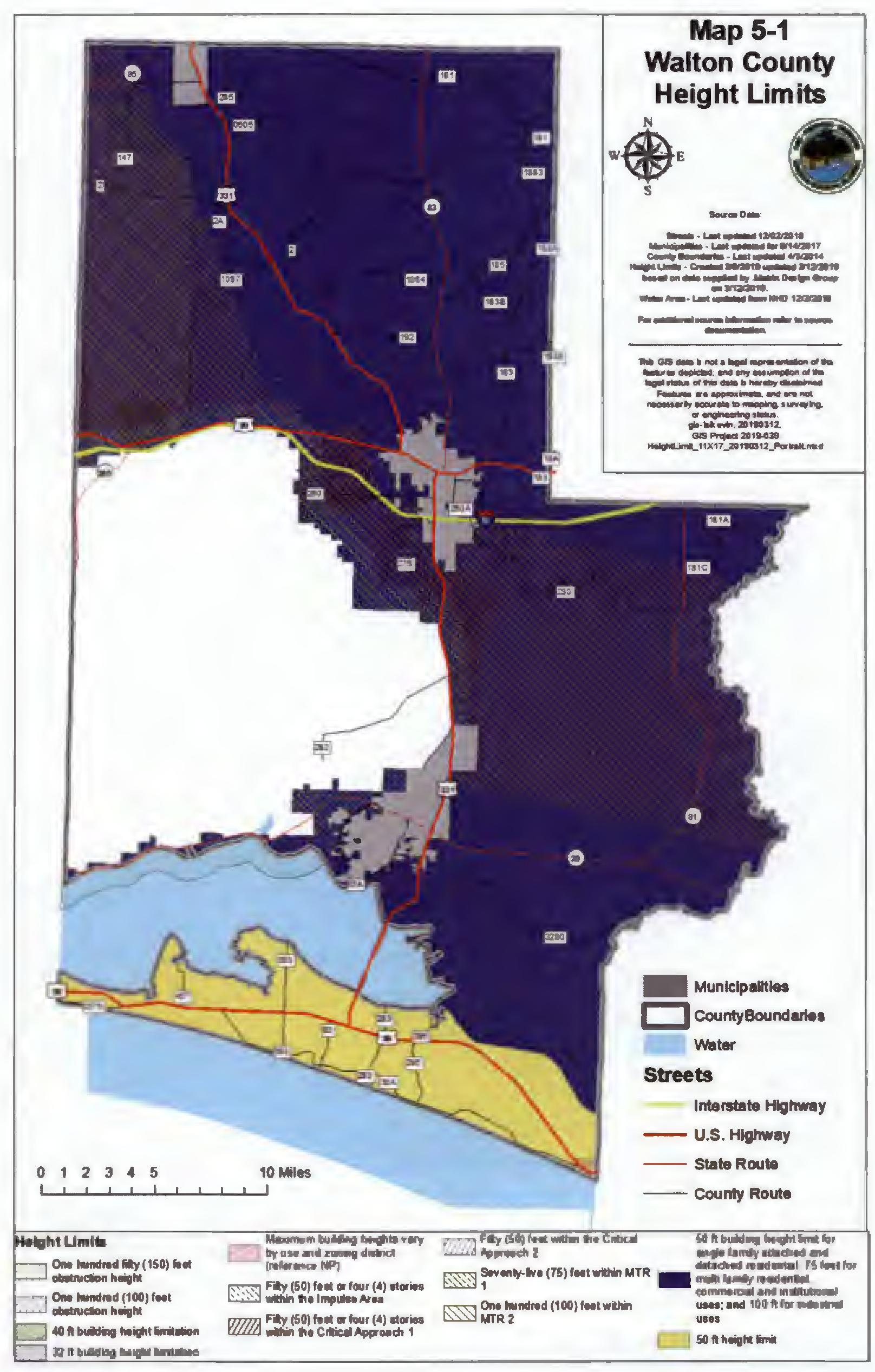
Figure 5-2: Eglin Air Force Base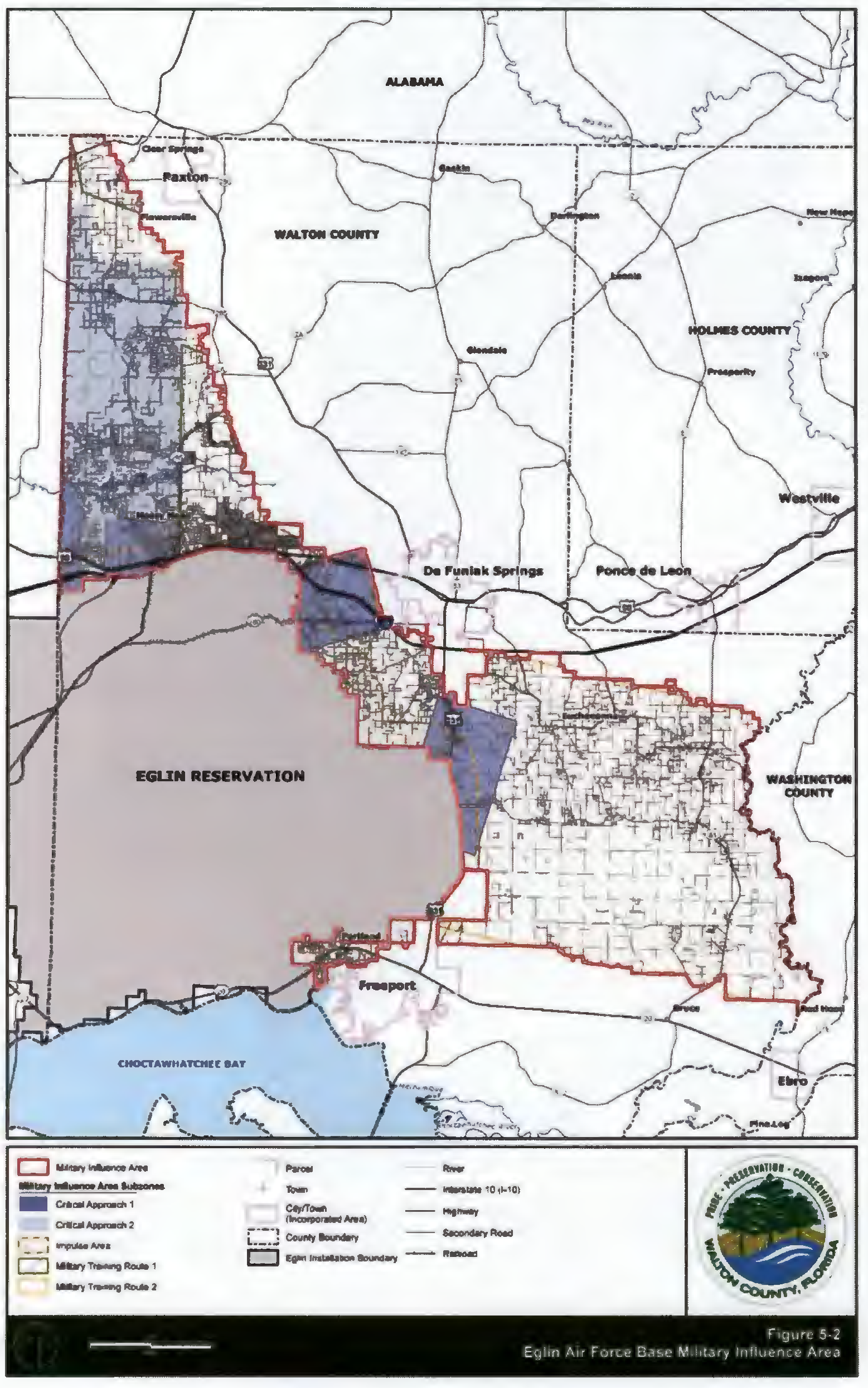
D.
Height Exceptions in Walton County. Height exceptions to the height limitations stipulated above, may apply to the following, contingent on review and approval, on a case by case basis, by the Board of County Commissioners. The case by case review and approval by the Board of County Commissioners for height exception is required for major or minor projects, and where applicable, review and approval by the Design Review Board:
1.
Church steeples and spires.
2.
Aircraft radio towers and navigational aids.
3.
Private solar energy facilities or windmills.
4.
Public and private utilities, civic uses, and public uses related to public safety and welfare.
5.
Commercial or industrial buildings or structures that are part of an economic development project located in north Walton County as recommended by the Economic Development Alliance.
6.
Height exceptions provided for in Section 6.11.06. Architecture, Height of Buildings for the U.S. 98 and U.S. 331 Scenic Corridors, provide that cupolas, towers, spires, etc. are allowed and may extend twenty (20) feet above roof lines or allowable height, but they shall be non-leasable and non-habitable.
7.
Height exemptions are exemptions provided for by state or federal laws and administrative codes. In instances where this Code may conflict with federal or state laws and codes; federal or state laws and codes shall govern. Examples of exemptions are: a) Bonafide agricultural non-residential farm buildings or structures on farms utilized for agricultural operations; b) Amateur radio antennas; c) Utility distribution, transmission and generation facilities; and d) Developments that area vested as to building heights.
E.
Methodology for Measurement for Building or Structure Height. Building or structure height is the vertical distance or measurement from the average elevation of the existing natural ground beneath the footprint of the building or structure to the highest point at the top of the building or structure or the highest point of the coping of a flat roof, the deck line of a mansard roof, or the mean height level between eaves and ridge for gable, hip, domed, curved, and gambrel roofs. Building or structure features such as chimney height as required by the Florida Building Code shall not be included in the methodology for measurement for building or structure height.
(Ord. No. 2019-06, § II(Att. A), 3-12-19; Ord. No. 2019-19, § II(Att. A), 9-10-19)
5.00.05. - General Clustering Policy in all Districts.
The clustering of development units is encouraged on any development parcel for the purposes of avoiding environmentally sensitive areas, creating open space and greenway areas, and encouraging efficient infrastructure design.
A.
The technique of clustering involves allowing development on the most suitable parts of a contiguous development site while avoiding environmentally sensitive areas of the site. In order for clustering to be allowed, the following criteria must be met:
1.
The resource to be protected must be clearly identified and delineated.
2.
Density shall be clustered on the upland or non-environmentally sensitive portion(s) of the proposed development site while avoiding the environmentally sensitive area.
3.
Limit the disturbance of the natural topography by requiring that structures and roads be designed to maintain the natural topography to the maximum extent feasible.
Figure: 5.1 Example of Clustering Residential Development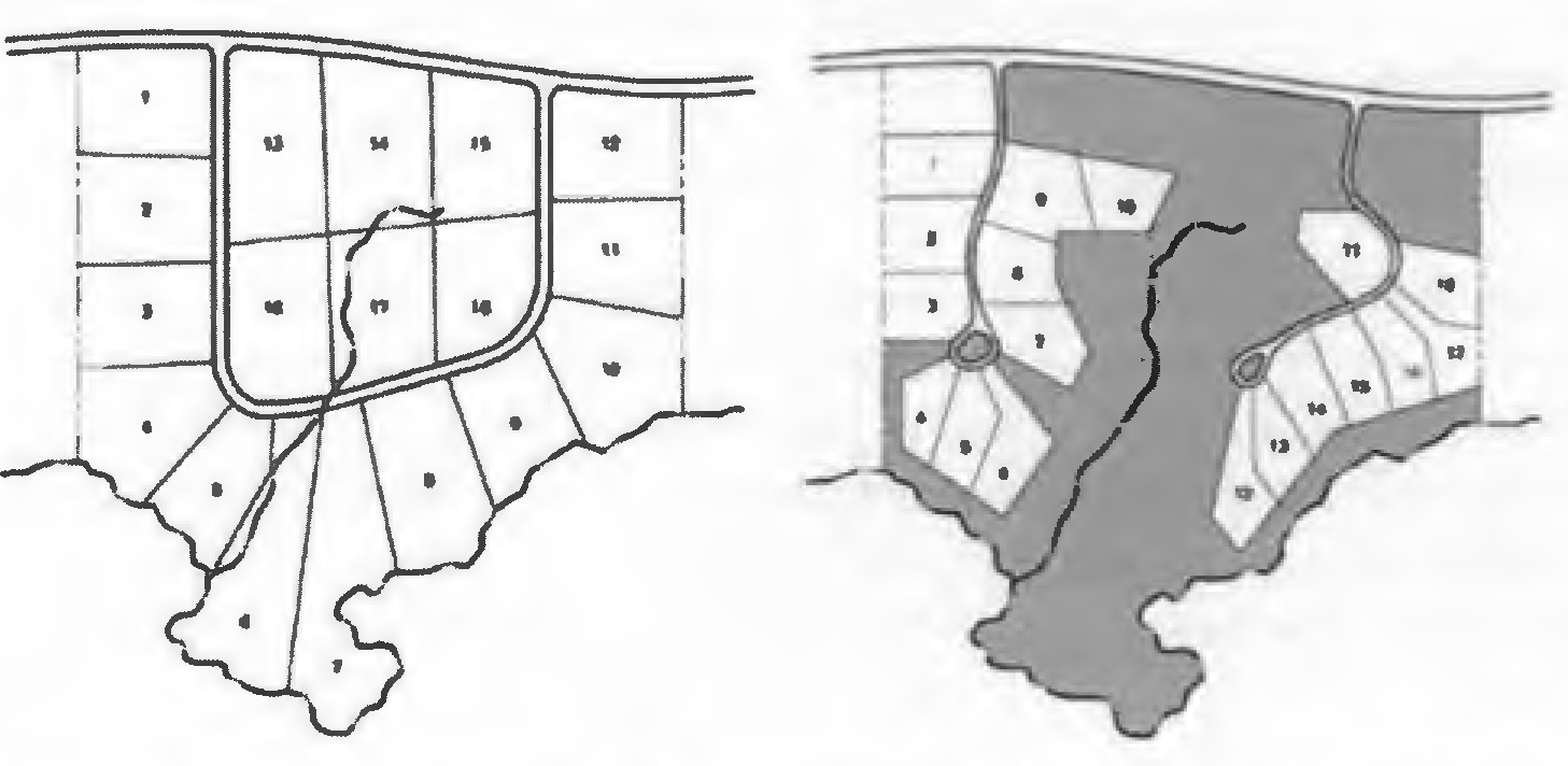
(Ord. No. 2019-06, § II(Att. A), 3-12-19)
5.00.06. - Methodology for Determination of Allowable Residential Density.
A.
The maximum allowable base residential density for any specific assembled contiguous development site or parcel of property shall be calculated by determining the gross acreage of the site and multiplying the amount of acreage category represented on the site by the maximum residential density provided in Chapter 2 for each zoning district.
B.
The specific flood protection or hazard Zones described in Chapter 4 of this Code may further limit allowable density and/or intensity Refer to the Chapter 4 and Section 5.00.07 below which creates these zones to determine what, if any density value may be transferred.
C.
The wetlands protection zones described in Section 4.01.00 of the Land Development Code may limit the allowable density and/or allow for certain density values to be transferred from the acreage contained in these zones to developable upland areas on the site. Refer to Chapter 4 of this the Land Development Code which creates the wetlands protection zones to determine what, if any density value may be transferred.
D.
Pursuant to Florida Statutes § 163.3179, property subdivided for the use of an immediate family member (grandparent, parent, stepparent, adopted parent, sibling, child, stepchild, adopted child, or grandchild of the person who conveyed the parcel to said individual) may be permitted as an exception to the density provisions contained in this Land Development Code with the exception of lots in platted subdivisions. Such family member may be permitted to develop a single-family residence on a smaller lot provided that any such development must be consistent with the other provisions of the Land Development Code, including concurrency requirements in Chapter 3. This exception shall apply only once to any such family member.
(Ord. No. 2019-06, § II(Att. A), 3-12-19)
5.00.07. - General Development in Flood Zones.
A.
Calculation of Flood Plain Density and Intensity. For the purpose of limiting new development within areas of special flood hazard concern, the following limitations within flood prone areas apply:
1.
Regardless of the density values established in Chapter 2 of the Land Development Code, and except as otherwise provided herein, development within lands that are designated by FEMA as with in a Coastal A Zone (CAZ), V or VE flood zone shall have a gross density of one (1) dwelling unit per twenty (20) acres, or one (1) unit per forty (40) acres for property designated within the Large Scale Agriculture (LSA) Zoning District.
2.
Residential density may be transferred from the regulated special flood hazard areas of the property to those areas on the property at the underlying land use density not within the regulated special flood hazard area.
3.
Gulf front properties designated V or VE and located seaward of the CCCL may develop at two (2) dwelling units per acre or at the underlying density if development is transferred out of the regulated special flood hazard area.
B.
Development of properties that contain FEMA designated flood zone A or AE may occur at the density of the land-use zoning district in which the property is located, provided, however, that the developer must:
1.
Cluster development, to the greatest extent practical, on the areas of the site not within the A or AE flood zone;
2.
Protect the areas of the A or AE zone that are not impacted by recording permanent development restrictions on the approved site plan or final plat, whichever is applicable;
3.
For development that does occur within the A or AE flood zone, the developer shall meet the established criteria for building within that flood zone, including the requirements of the Walton County Comprehensive Plan;
4.
Limit fill to facilitate the infrastructure requirements necessary for the development, including roadways, as necessary, not to exceed an average of one (1) foot (1') over the development site;
5.
Provide hydrologically equivalent storage volume at a ratio of 1 to 1 or greater for the fill volume proposed within the regulated special flood hazard area;
6.
Construct the foundations of all residences and associated accessory structures, with the exception of accessory structures less than 200 square feet and attached garages, utilizing one of the following methods:
a.
Open elevated foundations utilizing piers or pilings
b.
Stem wall foundations with crawl spaces with hydrostatic flood openings that meet the minimum requirements of FEMA and the Walton County flood protection regulations.
c.
Fill placed outside of the building footprint shall be comprised of well-draining soils that exhibit infiltration rates similar to or better than native soils. Fill that impacts flood attenuation is prohibited.
7.
Construct non-residential structures in accordance with FEMA construction guidelines and minimize fill to an average of one (1) foot (1') over the development site. The applicant shall submit a topographical survey and engineering calculations demonstrating that the development meets the fill limitation.
C.
In order to discourage filling in any A or AE flood zone, if a developer proposes to fill an A or AE flood zone (other than for infrastructure as provided in (B) 4. above) to remove it from the regulated area of special flood hazard through FEMA's conditional letter of map revision based on fill (CLOMR-F) process or the letter of map revision based on fill (LOMR-F), the allowable density for the filled portion shall be one (1) dwelling unit per 20 acres, fill shall be limited to an average of one foot (1') over the development site, and the developer must provide hydrologically equivalent storage volume at a ratio of 1 to 1 or greater for the fill proposed. Equivalent storage shall be available in addition to post development attenuation volumes associated with stormwater management facilities. To the extent the A or AE flood zones are avoided, other than for infrastructure as provided in paragraph (B) 4 above, the developer shall be entitled to receive the underlying density of the land-use district in which the property is located, which shall be clustered on the upland portions of the property.
(Ord. No. 2019-06, § II(Att. A), 3-12-19; Ord. No. 2023-16, Att. A, 7-27-23)
5.00.08 - Finish Floor Elevation (FFE) Requirements
A.
FFE approved by a Development Order (DO)
Once an FFE has been established within an approved Development Order, this shall be considered the minimum FFE required. However, approved construction may have an FFE that is higher provided that the approved grading and drainage plans are not altered and provided that the maximum building heights specified elsewhere in this Code are not exceeded. A margin of error during construction of +/- six inches will be tolerated for single family residential.
B.
The (FFE) approved by Building Permit Review (BPR) for plans requiring onsite stormwater plans per the requirement of Section 5.06.01 B. of this Code.
Once an FFE has been established within an approved plan, this shall be considered final and not subject to change. A margin of error during construction of +/- six inches will be tolerated.
C.
The FFE approved by Building Permit Review (BPR) for plans utilizing the BMPs found in Section 5.06.01 A. of this Code or projects that are located north of the Choctawhatchee Bay. A margin of error during construction of +/- six inches will be tolerated.
Residential structures shall be constructed with the lowest floor elevation (excluding non-habitable garages) not less than one foot above the average of the highest elevation of the street abutting the subject property. The following exemptions apply to this subsection:
1.
Residential structures located on lots that are one acre in size or greater are exempt from this requirement provided that:
a.
The proposed structure is setback at least 100-feet from the property line abutting the road; and
b.
The minimum proposed finished floor elevation is least one foot (1') above the highest adjacent existing ground elevation or any applicable established base flood elevation whichever is greater; and
c.
Positive drainage may be achieved without the potential for back up or flooding.
2.
Other exemptions to these requirements may occur only where an undue hardship due to the terrain of the land exists (manmade hardship, like design error, construction error, etc. does not qualify) and is supported by adequate technical data provided by a Florida licensed civil engineer and approved by the County Engineer or his designee, or stormwater management improvements are provided, and the improvements are approved by the County Engineer. Please request a submittal checklist prior to submitting this request. The following minimum criteria shall be used in granting an exemption by the County Engineer or designee:
a.
On lots north of the Choctawhatchee Bay there will be positive drainage from the lot without the potential for backup or flooding of the lot, adjacent lots, and structures. Buildings with an FFE less than one foot (1') above the highest adjacent existing ground elevation may be subject to additional requirements and will require additional engineering review and a pre-approval from the building department.
b.
On lots south of the Choctawhatchee Bay the building minimum proposed finished floor elevation is at least one foot (1') above the highest adjacent existing ground elevation and there will be positive drainage from the lot without the potential for backup or flooding of the lot, adjacent lots, and structures.
3.
Maximum building or structure height allowable shall be measured as follows: The vertical distance or measurement from the minimum finish floor elevation requirement per Section 5.00.08 C. to the highest point at the top of the building or structure or the highest point of the coping of a flat roof, the deck line of a mansard roof, or the mean height level between eaves and ridge for gable, hip, domed, curved, and gambrel roofs. Building or structure features such as chimney height as required by the Florida Building Code shall not be included in the methodology for measurement for building or structure height.
(Ord. No. 2019-06, § II(Att. A), 3-12-19; Ord. No. 2019-19, § II(Att. A), 9-10-19)
5.01.01. - General Provisions.
A.
Purpose. The purpose of this section is to protect the quality of water resources from future degradation by maintaining vegetative cover and controlling disturbances to vegetation, to encourage the selection of native plant species for vegetation, to reduce the impact of urban and suburban development on remaining stands of natural vegetation, to provide shade, to reduce heat and glare, to abate noise pollution, to provide habitat for living things, and to buffer incompatible uses.
B.
Exemptions. Lots or parcels of land on which a single-family home or duplex is used as a residence shall be exempt from the provisions of these landscaping regulations. This exemption shall not be construed to apply to residential subdivisions or other residential developments that require a development order.
C.
Landscape Material. Diversity of plantings should be strived for in all required landscape plantings, and in no case should one species constitute more than 50 percent of a landscape plan. Seventy-five percent of any plant material within a landscape plan shall be native plants. Palm trees must not exceed more than 25 percent of the landscape plan, with the exception of Saw Palmetto, Scrub Palmetto, and Cabbage Palm, which are native Walton County drought tolerant species.
D.
Prohibited Plants. The placement or use of non-native noxious, invasive plants is prohibited. Prohibited plants are defined as those prohibited exotic, invasive and noxious plants as identified by the Florida Exotic Pest Plant Council and published on their Invasive Plant Species List, or otherwise prohibited by UF/IFAS Center for Aquatic and Invasive Plants.
1.
All existing site environmental assessments shall identify prohibited plants, exotic species of plants and trees and landscape plans shall provide for the removal of these in landscaped areas when they exist prior to development of the site and throughout the development process.
E.
Any part of the development site which has been disturbed and is not required for natural areas preservation, buildings, structures, private residential yards, loading and vehicular access ways, streets, parking and utility areas, pedestrian walks and hard-surfaced activity areas shall be landscaped.
F.
All landscaped areas shall be finished with a natural topping material that may include, but is not limited to, the following: groundcover planting, hydroseed, or mulch (organic or inorganic) of at least two inches in depth.
G.
Minimum Size of Plant Materials. All newly planted landscape material to meet the requirements of this Land Development Code shall conform to the latest version of the American Standard Nursery Stock (ANSI Z60.1). Unless otherwise specified in the Land Development Code, the following minimum size requirements apply to all planted material:
1.
Canopy trees (Type 1 and Type 2 Shade Trees) shall be a minimum of three inches caliper.
2.
Evergreen canopy trees shall be a minimum height of eight feet.
3.
Under story trees shall be a minimum of #15 container class.
4.
All shrubs and accent plants shall be a minimum of #3 container class.
5.
All groundcover plants shall be a minimum of #1 container class.
H.
Understory trees or shrubs shall be substituted for canopy trees when conflicts with overhead utility lines occur.
I.
Earth berms shall have adequate plant material and groundcover treatment to prevent erosion.
J.
Street Frontages in South Walton County, South Central Walton County and North Central Walton County. All street frontages along streets classified as collector or higher and contiguous with the proposed development and/or; located within the interior of the proposed development and not used for street pavement, curbs, gutters, sidewalks, or driveways shall be landscaped as provided below:
1.
The installation of street trees (canopy unless prohibited by overhead utilities), shrubs, and vegetative ground cover shall be required for projects at a minimum of one tree preserved or planted for every 25 feet of street frontage, and vegetative ground cover or other landscape materials.
2.
The required plantings shall be located within the street frontage area and within a minimum ten foot wide planted area, and shall be designed and located to enhance the proposed development project and the streetscape.
3.
Such planting requirements shall be in addition to the landscape requirements found elsewhere in this Section. All additional plantings in excess of the requirement may be used to satisfy the on-site landscaping or buffering requirements.
4.
Trees and other landscaping required within the street frontage area shall be maintained to protect required sight triangles.
5.
Additional landscaping within the street rights-of-way may be required by the County.
(Ord. No. 2019-06, § II(Att. A), 3-12-19; Ord. No. 2022-13, § II, 8-25-22)
5.01.02. - Landscaping Requirements for Vehicular Use Areas.
A.
The requirements of this section shall apply to off street parking facilities and other vehicular use areas in North Walton Planning Area that have 40 or more parking spaces; or are designed to accommodate vehicles that are larger or smaller than automobiles and are over 20,000 square feet in area.
B.
The requirements of this section shall apply to off-street parking facilities and other vehicular use areas in the South Walton County, South Central Walton County and North Central Walton Planning Areas that have ten or more parking spaces.
1.
Surface Parking. A minimum of ten percent (10%) of parking lot areas, shall be landscaped. Interior planting areas are to be located within or adjacent to the parking area as tree islands, at the end of parking isles, inside seven foot wide or greater medians, or between rows of cars or as part of continuous street or transitional protective yards. Interior planting areas shall be located to most effectively accommodate stormwater runoff and provide shade in large expanses of paving and contribute to orderly circulation of vehicular and pedestrian traffic.
2.
Parking Space Islands.
a.
One (1) parking lot island with raised concrete curbing shall be provided for every ten (10) parking spaces. In addition, landscape islands shall be provided at the end of each parking row.
b.
Landscape islands shall be a minimum of seven (7) feet in width as measured from the back of curb and shall equal the length of the parking stall(s). The landscape island shall contain one (1) canopy tree and three (3) shrubs.
c.
Shrubs within a landscape island or median shall be maintained to a maximum height of three (3) feet, and all trees at maturity within such planters shall maintain a minimum clearance of six (6) feet from the lowest branch to the adjacent grade elevation.
3.
Parking Row Medians for Large Parking Areas over 200 Spaces.
a.
Every sixth row of parking spaces shall be separated by a landscaped median measuring a minimum of seven (7) feet wide (inside of curb to inside of curb) running the length of the parking row. Pedestrian walkways, four (4) feet in width, may be provided inside the curb, running the length of the parking row and meandering around the trees. Bioretention or other stormwater facilities are also permitted within this median.
b.
An alternative to the requirements of this Section may be approved by the Director of Planning provided the intent of the landscape median is satisfied.
4.
Multi-level Parking Structures.
a.
For projects that utilize multiple level parking structures, a minimum ten (10) foot wide landscape area shall be located around the perimeter of the structure. The landscape area provided at the perimeter of multiple level parking structures shall contain one (1) tree and three (3) shrubs for every 20 feet of the structure perimeter.
b.
For projects that utilize both surface and multi-level parking structures, the required parking area landscape shall be the combined requirements of this Section.
Figure 5-3 Sample Vehicular Use Landscape Area
(Ord. No. 2019-06, § II(Att. A), 3-12-19)
5.01.03. - Drainage Facilities Landscaping.
Drainage facilities shall be completely landscaped with plantings and ground surface materials. Such landscaping shall provide for erosion protection while allowing for the efficient utilization of the site.
(Ord. No. 2019-06, § II(Att. A), 3-12-19)
5.01.04. - Building Foundation Landscaping.
Single Use Non-residential and multi-family residential buildings shall include a landscape foundation planter with a minimum width of five (5) feet between the building and parking lot and along any facade fronting a public street.
A.
This foundation planter area shall comprise a minimum of fifty percent (50%) of the facade(s) length. A deviation or alternative to this requirement may be considered by the Director of Planning and Development Services.
B.
Building foundation planter areas shall include one (1) shrub for every five (5) linear feet. All plantings within building foundation planter areas may be used to satisfy the landscape requirements found elsewhere in this Section.
C.
A deviation or alternative to this requirement, including but not limited to, raised planters with seat walls, decorative planter boxes, potted trees/shrubs, may be considered by the Director of Planning and Development Services provided the intent of the building foundation planter is satisfied.
Figure 5-4: Sample Building foundation Landscape Area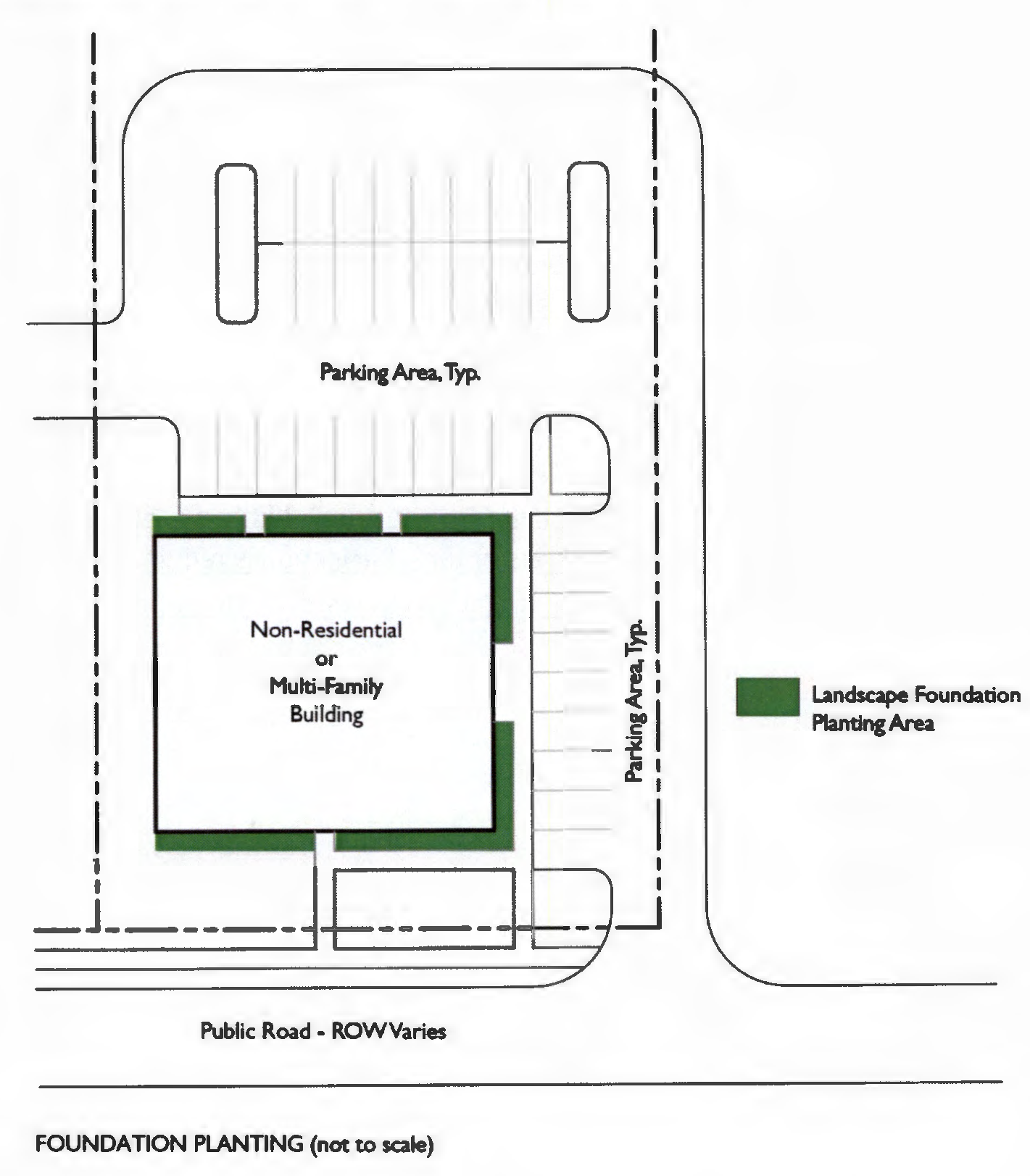
(Ord. No. 2019-06, § II(Att. A), 3-12-19)
5.01.05. - Drive-through services.
Drive-through windows and stacking lanes shall be screened from adjacent properties and public thoroughfares with a five (5) foot wide landscape island. Screening shall be a minimum of three (3) feet in height. The screen shall be located on the outside of the drive-through lane and shall screen queuing automobiles from any adjacent use.
(Ord. No. 2019-06, § II(Att. A), 3-12-19)
5.01.06. - Xeriscape.
In an effort to meet the water needs of Walton County in a manner that will ensure adequate and dependable supplies of water, it is the intent of this Section that Xeriscaping be an essential part of water conservation planning and regulation in Walton County and be an essential component of any approved landscape plan.
"Xeriscaping" means quality landscapes that conserve water, protect the environment, are adapted to local conditions, and utilize drought-tolerant appropriate plants. The principles of xeriscape include planning and design, appropriate choice of plants, soil analysis, which may include the use of solid waste compost, functional use of turf, efficient irrigation, re-use of water, appropriate use of mulches, and proper maintenance.
A.
Whenever a system utilizing reclaimed water is in place and available users must access and utilize that system.
B.
Plant material not listed on the Approved Plant List, but listed in Waterwise Florida Landscapes (current edition) may be submitted on a code minimum landscape plan, but must be notated as such on the landscape plan.
C.
Moisture-sensor and/or rain shut-off switch equipment shall be required on automatic irrigation systems to avoid irrigation during periods of sufficient rainfall. Said equipment shall consist of an automatic mechanical or electronic sensing device or switch that will override the irrigation cycle of the sprinkler system when adequate rainfall has occurred. The use of low volume emitters or target irrigation is required for trees, shrubs, and ground covers to minimize irrigation overthrow onto impervious surfaces.
(Ord. No. 2019-06, § II(Att. A), 3-12-19)
5.01.07. - Approved Tree and Plant List.
The materials listed below have been approved for inclusion in code minimum landscape plans and landscaped buffers submitted as part of a development order. Unless specified, all species include cultivars of that species. Cultivars shall meet the minimum size requirements for the designated category. Additional materials shall be accepted on a case-by-case basis.
1.
Canopy trees are expected to reach a height of 40 feet or greater at maturity and produce significant shade. Understory trees are small to medium sized trees that reach a height of 15 feet to 40 feet at maturity.
2.
Specific trees are allowed to be used as canopy trees adjacent to vehicular use areas and street trees. These trees have been identified with an asterisk (*).
3.
Plants identified with a plus sign (+) have demonstrated moderate salt tolerance and may be appropriate for locations at the back of dunes where salt spray is less frequent. Plants for sandy beach and dune planting should be both drought and salt tolerant.
TABLE 5-2: Permitted Plant Material
(Ord. No. 2019-06, § II(Att. A), 3-12-19)
5.01.08. - Uncomplimentary Land Use Landscaped Buffers.
A.
Purpose and Intent. The purpose of the landscape buffer requirement is to physically transition and visually minimize adjacent land uses, thereby reducing or mitigating the impact associated with a particular land use. This Section requires landscaped buffers to be provided and maintained to reduce the impact associated with a more intense use such as traffic, noise, glare, trash, vibration, and odor. Landscaped buffers are also required to conserve the values of land and buildings and to provide adequate light and air. The width of the buffer and the required plantings within the buffer vary depending upon the relative intensities of the abutting or adjacent uses.
B.
Exemptions.
1.
For projects that propose to retain 150-foot undisturbed area between the extent of the development and the property line, the Planning Director may grant an exemption from the buffering planting requirements of this section. This exemption does not apply to industrial, extractive, or outdoor recreation uses. Additionally, the site plan must show the undisturbed area labeled as undisturbed buffer area and the identified area must demonstrate an existing mixture of trees, shrubs, and other vegetation that would serve in the same capacity as the required buffer.
2.
Landscape buffer yards between districts are not required where the boundary line between the districts is a street.
3.
Landscaped buffer yards are not required for park and open space areas within a development.
4.
Mixed-use development. Landscaped buffer yards are not required between uses within vertically integrated mixed-use development or between land uses within a mixed use development having a common plan of development and design. Landscape buffer yards are required at the perimeter of the project and shall be based on the more intense or dense uses within the development.
C.
Perpetual maintenance. The property owner shall perpetually manage and maintain all required uncomplimentary land use buffer areas in a state to meet the criteria specified in this Section. Where the buffer area requirement is established prior to or at the time of site approval, platting, or replanting, such buffer areas and maintenance responsibility shall be specifically referenced in such approved development order and plat. Failure to maintain such landscaped buffers in an attractive and healthy state shall be considered a violation subject to enforcement in accordance with Chapter 7 of the Land Development Code.
D.
General Landscape Buffer Requirements. The existing use, or where vacant, the permitted use of the abutting property, will determine the type of landscape area required for the proposed development.
1.
Required landscape buffer yards shall be located on the perimeter of the development site and not within any portion of an existing or dedicated right-of-way.
2.
Existing Native Plant Material Encouraged. The use of existing native species of plant material is strongly encouraged in landscaped buffers. Existing natural ground cover should be retained where possible by avoiding scraping, grading and sodding within the landscaped buffer. Where the planting requirements require additional trees or shrubs to be installed in an existing natural area, it should be done in a manner which minimizes disturbances to native species.
3.
Nothing in the Land Development Code shall be interpreted to preclude the County from requiring buffers larger than the minimums established within this regulation, if such requirement is deemed necessary and appropriate to ensure the compatibility of adjacent land uses.
4.
Nothing in the Land Development Code is intended to prohibit cross access between abutting uses for automotive and pedestrian movement.
5.
When new development is proposed adjacent to existing residential development, the entire perimeter landscape buffer along common property lines shall be installed with the first phase of the new development.
a.
Landscape buffers required in new residential subdivisions shall be located within common areas only.
b.
Lots abutting vegetative natural buffers held in common areas, measuring at least ten feet in depth, may have reduced setbacks in keeping with Subsection 5.00.03(3).
6.
Landscaped buffers may be counted toward satisfying open space requirements, and may be used for passive recreation. They may contain pedestrian or bike trails, provided that the total width of the buffer yard is maintained and adequate screening is provided. In no event, however, shall the following uses be permitted in landscaped buffers: playfields, stables, swimming pools, tennis courts, mechanical equipment, accessory structures, parking lots and vehicular use areas, dumpsters, equipment storage, and other open storage, buildings or overhangs.
7.
Perimeter plantings required for parking lot landscaping pursuant to the Land Development Code may be counted toward satisfying buffer requirements if the parking lot abuts a required buffer.
8.
The Director of Planning and Zoning shall be authorized to allow stormwater retention/detention facilities to encroach into landscaped buffers a maximum of 40 percent of buffer width, where it is found that all planting requirements of this section are met and the visual screen provided by the landscaped buffer will be fully achieved.
9.
When abutting vacant land, landscape buffers shall be provided as specified in the following tables 5-3 and 5-4:
Table 5-3: Buffer Yard Required
Table 5-4: Buffer Yards "A" and "B
REQUIRED PLANTINGS FOR BUFFER YARD "A"
REQUIRED PLANTINGS FOR BUFFER YARD "B"
10.
When abutting existing development, landscape buffers shall be provided as follows:
a.
Between adjacent single family attached and detached residential land uses having different densities or average lot sizes, the buffer shall be at least ten feet in width. The ten foot buffer must contain the following per 100 linear feet at a minimum: three (3) canopy trees; eight (8) shrubs; and two (2) understory trees.
b.
Between existing single family residential and non-residential (excluding industrial) or multifamily residential land uses, the buffer shall be at least 20 feet in width. The 20 foot buffer must contain the following per 100 linear feet at a minimum: four (4) canopy trees; sixteen (16) shrubs; and three (3) understory trees.
c.
Between existing or proposed industrial land uses and any other existing land use, the buffer shall be at least 25 feet in width. The 25 foot buffer must contain the following, per 100 linear feet, at a minimum: five (5) canopy trees; twenty (20) shrubs; and four (4) understory trees.
(Ord. No. 2019-06, § II(Att. A), 3-12-19; Ord. No. 2022-13, § II, 8-25-22; Ord. No. 2023-16, Att. A, 7-27-23)
5.01.09. - Screening Wall Alternative.
Screening walls, unless prohibited within Chapter 6 of the Land Development Code, may be used as an alternative to landscape buffers or to reduce the amount of landscape buffer width required. Such screens must be designed to enhance buffering, improve compatibility, aesthetics and the visual quality of the community.
A.
When new development is adjacent to developed residential uses, the entire perimeter screening and landscaping along property lines common with the developed residential use shall be installed in the first phase of the new development if applicable.
B.
Screening devices shall be masonry, (or functionally similar material) construction to provide a minimum six-foot high screen. The screen shall create a complete visual barrier for its entire height and length.
C.
Where new nonresidential development is adjacent to residential uses, the perimeter screen must consist of a six-foot high (minimum) wall and canopy trees. Tree spacing shall provide for canopies at maturity to form a continuous visual screen.
D.
Solid walls greater than 40 feet in length shall be articulated or varied using at least two of the following techniques:
• Decorative features such as variation in pattern, texture and materials.
• Use of swales, berms and landscaping.
• Undulations or offset areas.
• Varied setbacks.
E.
All required screening devices shall be architecturally compatible with the materials and design of the buildings on the site.
F.
Vegetation shall be required and maintained on the external side of a screen wall to provide visual relief when viewed from the property being buffered. For residential development the wall shall be on the property line of the lots and all of the vegetation buffer shall be outside the wall in a common area.
G.
Breaks in screens may be required by the Planning Director to provide pedestrian and bicycle access between residential areas and commercial/service uses, particularly if these uses serve the adjoining neighborhood.
H.
The screening wall alternative may reduce the required buffer width to five feet allowing room for maintenance and landscaping.
(Ord. No. 2019-06, § II(Att. A), 3-12-19; Ord. No. 2022-13, § II, 8-25-22)
5.01.10. - Fences and Hedge Walls.
A.
Generally.
1)
In areas where the property abuts two roadways or is located in any other area construed to be a corner lot, no opaque fence or hedge exceeding two feet in height shall be located in the vision triangle described in Section 5.04.03(C).
2)
No fence or hedge shall be constructed or installed in such a manner as to interfere with drainage on the site.
3)
All fences in areas within Scenic Corridor Overlay District buffer areas must comply with the requirements of Chapter 6.
B.
Fence Regulations for Small Lots. The following fence regulations shall apply to all lots or parcels one-half (½) acre in size or less:
1)
All fences to be built shall comply with Building Code if applicable. The posts of each fence must be resistant to decay, corrosion, and termite infestation. The posts must also be decay resistant or pressure-treated for strength and endurance.
2)
Fences or hedges may be located in all front, side and rear yards. No fences or hedges shall exceed four (4) feet in height when placed in the front yard unless set back from the property a minimum of the required building setback.
3)
Any fence located adjacent to a public right-of-way or private road shall be placed with the finished side facing the right-of-way or private road.
4)
A fence required for safety and protection of hazard by another public agency may not be subject to the height limitations above. Approval to exceed maximum height standards may be given by the Director of Planning and Development Services upon receipt of satisfactory evidence of the need to exceed height standards.
Figure 5-5: Fence Placement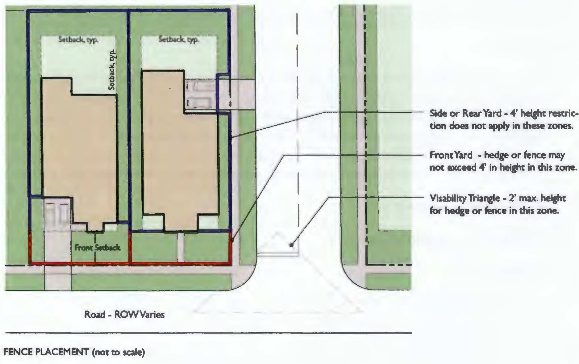
(Ord. No. 2019-06, § II(Att. A), 3-12-19)
5.02.01. - Generally.
A.
Purpose. The requirements of this section are intended to ensure that every building, structure, or use erected or instituted, except for agricultural uses and buildings, shall be provided with adequate offstreet parking facilities for the use of occupants, employees, visitors, and patrons, and that certain uses be provided with adequate offstreet loading facilities, thereby reducing congestion to the public streets and promoting the safety and welfare of the public.
B.
Existing Structures and Uses. Buildings or structures existing as of the effective date of this Code may be modernized, altered, or repaired without providing additional offstreet parking or loading facilities, provided there is no increase in floor area or capacity and no change of occupancy classification.
C.
Expansion of Structure. The proposed expansion in floor area, volume, capacity, or space occupied of any structure existing on or before the date of adoption of this Code, shall result in the compliance with all offstreet parking and loading requirements contained in this Code for both existing and new structures.
D.
Change in Use. If after the effective date of this code, a change in the use of a building or structure would result in a requirement for additional parking over that required under this Code for the existing use, then all offstreet parking and loading requirements contained in this code shall be complied with for the new use.
E.
Space requirements.
1.
The following number of offstreet parking spaces shall be required of the land uses specified below.
2.
The term "capacity" as used herein means the maximum number of persons that may be accommodated by the use as determined by its design or by fire code regulations, whichever is greater.
3.
The most recent version of "Parking Generation, An Informational Report of the Institute of Transportation Engineers" maybe be utilized when specific land uses are referenced in the table (Section 5.02.02) below.
(Ord. No. 2019-06, § II(Att. A), 3-12-19; Ord. No. 2019-19, § II(Att. A), 9-10-19)
5.02.02. - Offstreet Parking Requirements Chart.
(Ord. No. 2019-06, § II(Att. A), 3-12-19; Ord. No. 2019-19, § II(Att. A), 9-10-19; Ord. No. 2023-03, § II(Att. A), 1-24-23; Ord. No. 2023-16, Att. A, 7-27-23)
5.02.03. - Grayton Beach and Gulf Trace Neighborhood Plan Areas Off-street Parking Requirements Chart.
(Ord. No. 2019-06, § II(Att. A), 3-12-19)
5.02.04. - Compact Car Space Requirements.
A.
In South Walton County, parking for compact cars may be provided for up to 20 percent of the required parking provided that the parking meets the following standards:
1.
Compact car parking may be provided for only nonresidential land uses.
2.
If the total parking requirements of any use or structure is less than 15 spaces, no compact car spaces are permitted.
3.
Compact car parking must be designated for exclusive use of compact cars through the use of signs or pavement marking.
4.
The overall design must be reviewed and approved by the Planning Director.
5.
For each compact car space, an additional 6.5 square feet of landscaped open space shall be provided on the site.
B.
Golf Car Requirements—Bay Walton Sector Plan.
In the Bay-Walton Sector Plan, parking for golf cars may be provided for up to 40 percent of the required parking provided that the parking meets the following standards.
1.
Golf car parking may be provided for only nonresidential land uses.
2.
Golf car parking must be designated for exclusive use of golf cars through the use of signs or pavement parking and shall be designed in accordance with Section 5.02.06 B below.
3.
The overall design must be reviewed and approved by the Planning Director.
Golf car parking analysis shall be provided with the technical development order application for each project within an approved DSAP.
(Ord. No. 2019-06, § II(Att. A), 3-12-19; Ord. No. 2019-19, § II(Att. A), 9-10-19)
5.02.05. - Joint Use and Offsite Facilities.
A.
Unless otherwise established within an adopted Neighborhood Plan, parking spaces must be located and maintained within 300 feet of the building or use served.
B.
No parking spaces provided to meet the requirements of one building or use shall be counted as part of the spaces required for another building or use, unless the spaces are jointly provided by uses that are not normally open at the same time. If such a joint parking arrangement is proposed, the applicants must file a written agreement reflecting the terms of the joint parking arrangement with the application for a development permit.
C.
Prior to issuance of the Final Certificate of Occupancy, the permittee must record a written cross parking agreement, in a form acceptable to the County, which binds all affected parties to at least the minimum terms reflected in the initial agreement submitted to the County. The agreement must be recorded in the Public Records of Walton County.
D.
In the Bay-Walton Sector Plan, parking requirements may be calculated on a block-wide basis. A parking analysis shall be provided with the technical development order application for each project within an approved DSAP.
(Ord. No. 2019-06, § II(Att. A), 3-12-19; Ord. No. 2019-19, § II(Att. A), 9-10-19)
5.02.06. - Design Standards.
A.
Materials for Parking Spaces.
1.
Acceptable paving material for vehicular parking areas includes asphalt, crushed shells, gravel, dolomite, sand clay, graded aggregate and concrete.
2.
Access drives and aisles for all parking areas shall be paved, but up to 25 percent of the parking spaces may remain unpaved subject to the approval of the planning director. A place of worship, or other institutional use without daily parking needs may be allowed to leave 50 percent of all parking spaces unpaved. The applicant shall supply evidence that the unpaved parking area will not cause erosion, reduce water quality, or cause any other degradation of the natural or built environment.
3.
The unpaved parking area allowed under this subsection shall not be calculated as part of a minimum required landscaped buffer or open space for the subject development site.
B.
Parking Space Maneuverability Standards. The following standards shall generally be utilized, minor deviations may be considered by the county engineer or designee but such deviations shall only be considered if the requested deviation is in full compliance with the most recent edition of the "Traffic Engineering Handbook" as published by the Institute of Traffic Engineers (ITE).
PARKING SPACE STANDARDS
COMPACT CAR PARKING SPACE STANDARDS
GOLF CART PARKING SPACE STANDARDS
C.
Location of Parking Spaces on Single-Family Detached and Single-Family Attached Lots. Unless otherwise specified in a PUD master plan, neighborhood plan, or development order all parking spaces provided to meet minimum parking standards shall be located within the front or rear yards only.
D.
Drainage. All required off-street parking facilities shall conform to the stormwater management requirements of this Code and shall be drained so as not to cause any nuisance to adjacent private or public property.
E.
Access. All parking spaces shall have direct access to public streets only by way of aisles or driveways, constructed in accordance with the provisions of this Code.
F.
Handicapped Parking. Handicapped parking shall be designed in accordance with ADA standards and located on the shortest accessible route of travel to an accessible building entrance. The required number of spaces shall be provided as follows:
1.
One handicapped parking space for each 25 required parking spaces, up to 100 parking spaces
2.
One additional handicapped parking space for each 50 required parking spaces, for 101 parking spaces up to 300 parking spaces.
3.
One additional handicapped parking space for each 100 required parking spaces, for more than 300 parking spaces.
G.
Project Specific Waiver of General Requirements. Where the planning director determines, upon request of an applicant and review of supporting data provided by the applicant, that the number of spaces generally required by this section is excessive for a specific proposed project, the owner or agent may substitute landscaping in lieu of paving provided said areas are reserved and available for conversion to a parking area in the future should the county find those spaces are needed, and further provided:
1.
The owner of the land upon which such parking is being reserved shall enter into a written agreement with the county, ensuring that the reserved parking area shall never be encroached upon, used, sold, leased, or conveyed, for any purpose except in conjunction with the building or use which the reserved parking area serves so long as the off-street parking facilities are required. This agreement shall be in a form acceptable to the county and shall be recorded in the public records of Walton County at the expense of the benefiting owner.
(Ord. No. 2019-06, § II(Att. A), 3-12-19; Ord. No. 2019-19, § II(Att. A), 9-10-19; Ord. No. 2023-03, § II(Att. A), 1-24-23)
5.02.07. - Bicycle Parking Requirements.
A.
Number of spaces required. The bicycle parking requirements in this section are intended to encourage the use of bicycles as a means of transportation in Walton County. Bicycle parking spaces shall be required within South Walton County. The number of bicycle parking spaces required shall be as follows:
B.
Design of Bicycle Parking Spaces. Required bicycle parking facilities shall be designed and constructed in accordance with the following standards:
1.
Bicycle parking facilities shall include provision for the secure storage and locking of bicycles.
2.
Fixed objects that are intended to serve as bicycle parking facilities shall be clearly labeled as available for bicycle parking.
3.
Individual locker spaces or racks shall be designed so as to provide convenient access to users.
(Ord. No. 2019-06, § II(Att. A), 3-12-19; Ord. No. 2022-13, § II, 8-25-22)
5.02.08. - Offstreet Loading.
Any use with a gross floor area which requires deliveries or shipments must provide offstreet loading facilities in accordance with the following requirements:
A.
Minimum Area for Each Space. The minimum area for each offstreet loading space, excluding area for maneuvering, shall be 250 square feet.
B.
No Blocking Roadways. At no time shall any part of a truck or van be allowed to extend into the right-of-way of a public thoroughfare while the truck or van is being loaded or unloaded.
(Ord. No. 2019-06, § II(Att. A), 3-12-19)
5.03.01. - Purpose and Intent.
It is the intent of the County to establish a linked system that provides environmental protection, open space, recreation space and special ambience in South Walton and ensures that the natural environment is preserved, enhanced and made useable for the natural and man-made environment.
The purpose of this section is to provide land use regulatory mechanisms designed to accomplish, to the greatest extent possible, the interconnection of the Shoreline Protection Zones, the Floodplains, the Wetland Zones, the Coastal Protection Zones and the Habitat and Native Vegetation Zones both within development sites and between adjacent properties in a linked series of greenways. It is the County's intent that these corridors be of sufficient dimension and design to facilitate one or more of the following purposes.
1.
The movement of affected wildlife species.
2.
The provision of enhanced natural regional scale stormwater treatment capacity.
3.
The enhancement of public access to passive recreational enjoyment of these natural resources, and
4.
The enhancement of available routes for alternative modes of transportation.
It is the County's intent to ultimately provide for interconnection of these private greenways with all available public conservation and recreation land in South Walton as part of the overall linked system.
(Ord. No. 2019-06, § II(Att. A), 3-12-19)
5.03.02. - Location of Proposed Greenways System.
The location of the master greenways linked system shall be designed for all publicly owned lands within South Walton within a Greenways and Trails Mater Plan. Upon adoption of the master plan by the commission, it shall be included as part of this Code.
(Ord. No. 2019-06, § II(Att. A), 3-12-19)
5.03.03. - Land Uses Allowed Within the Greenways System.
The following uses shall be specifically permitted within the linked system, consistent with the other provisions of this Code and the Comprehensive Plan.
A.
Wetlands.
B.
Wetland Mitigation.
C.
Stormwater retention/detention.
D.
Recreation.
E.
Reclaimed water disposal.
F.
Vehicular and pedestrian access ways.
G.
Greenways.
H.
Wildlife corridors.
I.
Education trails and exhibits.
(Ord. No. 2019-06, § II(Att. A), 3-12-19)
5.03.04. - Site Design Requirements Related to Greenways System.
1.
All proposed development or re-development in South Walton shall connect to or create a linked open space system connecting the protection zones within the boundaries of the development site. These linked systems shall be incorporated into the site plan of a proposed development as specified herein:
A.
Where a proposed development project contains a total of ten or more acres which lie within the listed zones, these areas shall be preserved through site design as a part of the linked system.
B.
Where a proposed development project contains less than ten acres which lie within the listed zones, the applicant may elect to preserve these areas as a part of the linked system.
C.
These open spaces shall be designed to link these zones internally and to the greatest extent possible, externally.
D.
To the greatest extent possible, all linked systems shall be oriented towards any private greenway corridor or public lands, or, in areas with an adopted neighborhood plan, toward open space and greenways established in that plan.
E.
All connecting corridors between zones and conservation areas shall be designed to preserve existing canopy and ground cover within the corridor where it is essentially intact at the time of the submission of application for a development order. Restoration of natural canopy and ground cover is encouraged where corridors are proposed for cleared or significantly disturbed areas.
F.
Recreational facilities proposed with the development shall be located, if feasible, adjacent to the Wetlands and Floodplains.
G.
All corridors proposed for areas where specific wildlife impacts related to development are identified should be sized and designed to reduce overall species impacts by providing usable habitat and/or facilitating movement of species between linked areas.
H.
All private systems shall include continuous bikeway and/or pedestrian facilities which link recreational or conservation areas within the development site. All private greenway systems which link up with public lands beyond the boundaries of the development site and provide for continuous bikeway and/or pedestrian facilities are eligible for additional density bonus points as provided in the Density Bonus Point System for NPAs in the Walton County Comprehensive Plan. In order to qualify for density bonus points, these pedestrian and/or bikeway facilities shall be dedicated to the County for public use at the time of final development approval. There is to be an exemption to this facility requirement in areas where the impacts of such use on a corridor area would significantly impact a "listed species" or its habitat.
(Ord. No. 2019-06, § II(Att. A), 3-12-19)
5.03.05. - Greenway Corridors and Recreational Concurrency Requirements.
The Recreational Level of Service (LOS) standard of 6.25 acres per 1,000 people for a proposed development or redevelopment may be met in the following manner relating to the Greenway System:
A.
The entire amount of land area which must be dedicated to meet Recreational LOS concurrency requirements shall be satisfied by dedication of areas within the boundaries of the development which are to the greatest extent possible located in a linked corridor system which meets the requirements of this section; or
B.
At least 50 percent of the area which must be dedicated to meet Recreational LOS concurrency requirements shall be provided within the boundary of the specific development in a design which, to the greatest extent possible, locates these areas in a linked corridor system which meets the requirements of this section; and
C.
The remaining percentage of required dedication above the dedicated land area within the site shall be achieved by making a financial contribution for the acquisition and creation of community parks and linked open space systems to serve more than one neighborhood in the impact area surrounding the proposed development.
(Ord. No. 2019-06, § II(Att. A), 3-12-19)
5.04.01. - General Provisions.
A.
Purpose. This section establishes minimum requirements applicable to the development of the transportation system, including public and private streets, bikeways, pedestrian ways, and access control to and from public streets. The standards in this section are intended to minimize the traffic impacts of development, to assure that all developments adequately and safely provide for the storage and movement of vehicles consistent with good engineering and development design practices, to address internal pedestrian and bicycle circulation within projects as well as linkage to other projects and transportation modes, and to promote compact mixed use development to encourage on-auto travel for short trips.
B.
Required Planning. Review of development proposals and plans for all single-family subdivisions, multi-family residential, commercial, office or industrial uses shall include appropriate consideration of potential transportation impacts related to the development through the submission of a circulation, parking, and access plan as required in this Code.
(Ord. No. 2019-06, § II(Att. A), 3-12-19)
5.04.02. - Street Classification System.
A.
General.
1.
Streets in Walton County are classified and mapped according to function served in order to allow for regulation of access, road and right-of-way widths, circulation patterns, and design speed.
2.
Private streets and streets that are to be dedicated to the County are classified in a street hierarchy system with design tailored to function. The street hierarchy system shall be defined by road function and design speed.
3.
When a street continues an existing street that previously terminated outside the subdivision, or is a street that will be continued beyond the subdivision or development at some future time, the classification of the street will be based upon the street in its entirety, both within and outside of the subdivision or development.
4.
The following street hierarchy is established: local, collector and arterial. All development proposals containing new streets or taking access from existing streets shall conform to the standards and criteria contained in this section.
B.
Classification of Streets. In general classification of streets within Walton County shall follow the principles and characteristics of classification utilized by the U.S. Department of Transportation Federal Highway Administration and shall be part of the Walton County Roadway Characteristics database maintained by the Planning and Development Services Department.
1.
Local Streets. Local streets provide limited mobility and are primarily suited to providing direct access to residential development, but may give access to limited nonresidential uses. Alleys, which provide a secondary means of access to lots, are normally on the same level in the hierarchy as a local street. Each local street shall be classified and designed for its entire length to meet the minimum standards.
2.
Major and Minor Collector Roads. Collector roads provide access to nonresidential uses and connect lower-order streets to arterial streets. Urban major collectors typically serve both land access and traffic circulation in higher density residential and commercial/industrial/mixed use areas. Rural major collectors serve as the most important intra-County travel corridors balancing mobility with land access.
3.
Principal and Minor Arterial Roads. Principal Arterial roads provide links between communities or to limited-access expressways, limit direct access from abutting properties except for regionally significant uses, and shall be designed for posted speeds up to 55 miles per hour.
a.
Minor Arterial roads link community districts to regional or state highways. They may also give direct access to regionally significant land uses. These roads may take access from other arterials or freeways and may give access to any lower-order nonresidential street type and typically serve a smaller geographic area than principal arterials.
C.
Street Design Standards by Classification.
1.
Minimum Road Surface Width. All roadways constructed within the County shall provide for roadway surfaces which meet at least the minimum width requirements as provided below.
Minimum Road Surface and Right-of-Way Width:
a.
All private streets shall be dedicated as private on the plat and shall have sufficient right-of-way for the street and requisite storm water improvements. The developer may dedicate separate utility and drainage easements if desired. However the combined street, utility, and drainage easements shall be sufficient for the proposed development, as determined by the County Engineer or his designee.
b.
All streets to be dedicated to the County shall have a minimum 50 foot right-of-way.
c.
Existing County streets as of July 1, 2004, with lesser right-of-way or lane widths may be paved if it is determined by the County Engineer or his designee that there is adequate area for storm water treatment, utilities, and the geometric design considerations outlined in the latest edition of the Manual of Uniform Minimum Standards For Design, Construction, and Maintenance for Streets and Highways published by the Florida Department of Transportation are met.
d.
The driving surface of all collector and arterial streets shall be a minimum of 22 feet as measured from edge of paving to edge of paving, not including any curbing. Local streets shall be a minimum of 20 feet as measured from edge of driving surface to edge of driving surface and may include flat, header, or ribbon-type curbing not exceeding 12 inches in width. If there is any question about the classification of a street, the County Engineer or his designee shall determine the street classification. A one foot deviation, for lane width may be considered for private streets if it can be demonstrated to the County Engineer or his designee that interconnection of the streets is not a viable option and that the AADT for the street shall not exceed 400 vehicles per day and a minimum one foot curb is proposed.
(Ord. No. 2019-06, § II(Att. A), 3-12-19; Ord. No. 2022-13, § II, 8-25-22; Ord. No. 2023-16, Att. A, 7-27-23)
5.04.03. - Street Design Standards.
A.
General Design Standards.
1.
The street system of the proposed development shall be a network with variations as needed for topographic and environmental design considerations. Particular effort should be directed toward securing the flattest possible grade near intersections.
2.
In order to reduce traffic congestion on the arterial and collector roads surrounding the development and to promote a pedestrian environment within the development, streets shall be laid out to:
a.
Avoid environmentally sensitive areas;
b.
Secure the view to prominent natural vistas;
c.
Minimize the area devoted to motor vehicle traffic;
d.
Promote pedestrian movement so that it is generally more convenient and pleasant to walk short distances than to drive; and
e.
Promote the creation of vista terminations.
3.
The street layout in all new development shall be coordinated with and interconnected to the street system of the surrounding area.
4.
Streets in proposed subdivisions shall be connected to rights-of-way in adjacent areas to allow for proper inter-neighborhood traffic flow.
5.
Residential streets shall be designed to discourage through traffic between nearby local, collector and arterial roads while not preventing connectivity of developments.
6.
The street system of proposed development shall, to the greatest extent practicable, conform to the natural topography of the development site, preserving existing hydrological and vegetative patterns, and minimizing both erosion potential and the quantity and velocity of runoff generated.
B.
Stub Streets.
1.
Residential access and sub-collector stub streets may be permitted only within subsections of a phased development for which the proposed street in its entirety has received final site plan approval.
2.
Residential collector and higher-order stub streets shall be permitted or required by the County provided that the future extension of the street is deemed desirable by the County or conforms to the Transportation Element of the Walton County Comprehensive Plan.
3.
Temporary turnarounds shall be provided for all stub streets providing access to five or more lots or housing units. Where four or fewer units or lots are being served, a sign indicating a dead-end street shall be posted.
4.
A "T" or "Y" type turn around may be used in place of a cul-de-sac on streets of 300 feet or less in length upon approval of the Board of County Commissioners.
a.
The pavement width for a "T" or "Y" type turn around shall not be less than one-half the pavement width of the street it serves. This provision is not intended to permit a "T" or "Y" on streets requiring a cul-de-sac and streets that are not planned to connect to future streets outside the project limits
C.
Clear Visibility Triangle. In order to provide a clear view to motorists at the intersection of two or more rights-of-way and/or the intersections of an accessway and a right-of-way, the following standards shall be met:
A.
Generally. All lots shall maintain a clear visibility triangle at the intersection of two or more right-of-ways (refer to Figure 5-6: Clear Visibility Triangle) and/or the intersections of an accessway and a right-of-way (refer to Figure 5-6: Clear Visibility Triangle) for the purpose of traffic safety. The term "right-of-way" shall refer to all rights-of-way, both public and private. Nothing shall be erected, placed, parked, planted or allowed to grow in such a manner as to materially impede vision between a height of two feet and eight and a half feet above the grade, measured at the centerline of the intersection, except preserved and protected trees. Preserved or protected trees shall be allowed to remain in a clear visibility triangle provided all branches and foliage is removed between a height of two feet and eight and a half feet above the grade. Buildings and structures must observe setbacks, as set forth in Section 5.00.03, in addition to the clear visibility triangle standards. In the event of a conflict between the clear visibility triangle standards and building setback standards, the more stringent of the two shall apply.
B.
Maintenance of the clear visibility triangle. It is the responsibility of the owner or tenant of the property to maintain the clear vision triangle by trimming or removing the cause of any sight obstruction within said clear visibility triangle.
C.
Determination and implementation. The following two methods shall be used in determining/implementing the clear visibility triangle regulations:
1.
At the intersection of two or more rights-of-way, the clear visibility triangles shall be defined as the areas within the boundaries determined by measuring 15 feet along both sides of the right-of-way and 30 feet along the intersecting right-of-way in both directions and diagonally connecting the ends of the two lines of each to form two triangles.
Figure 5-6: Clear Visibility Triangle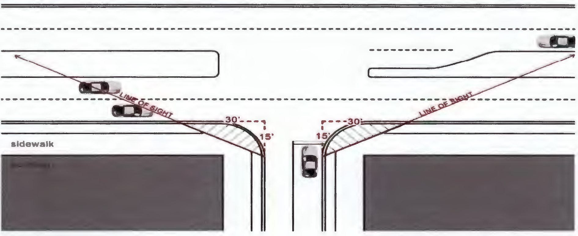
2.
At the intersections of an accessway and a right-of-way, the clear visibility triangles shall be defined as the areas within the boundaries determined by measuring 15 feet along both sides of the accessway and 30 feet along the side property line and diagonally connecting the ends of the two lines of each to form two triangles.
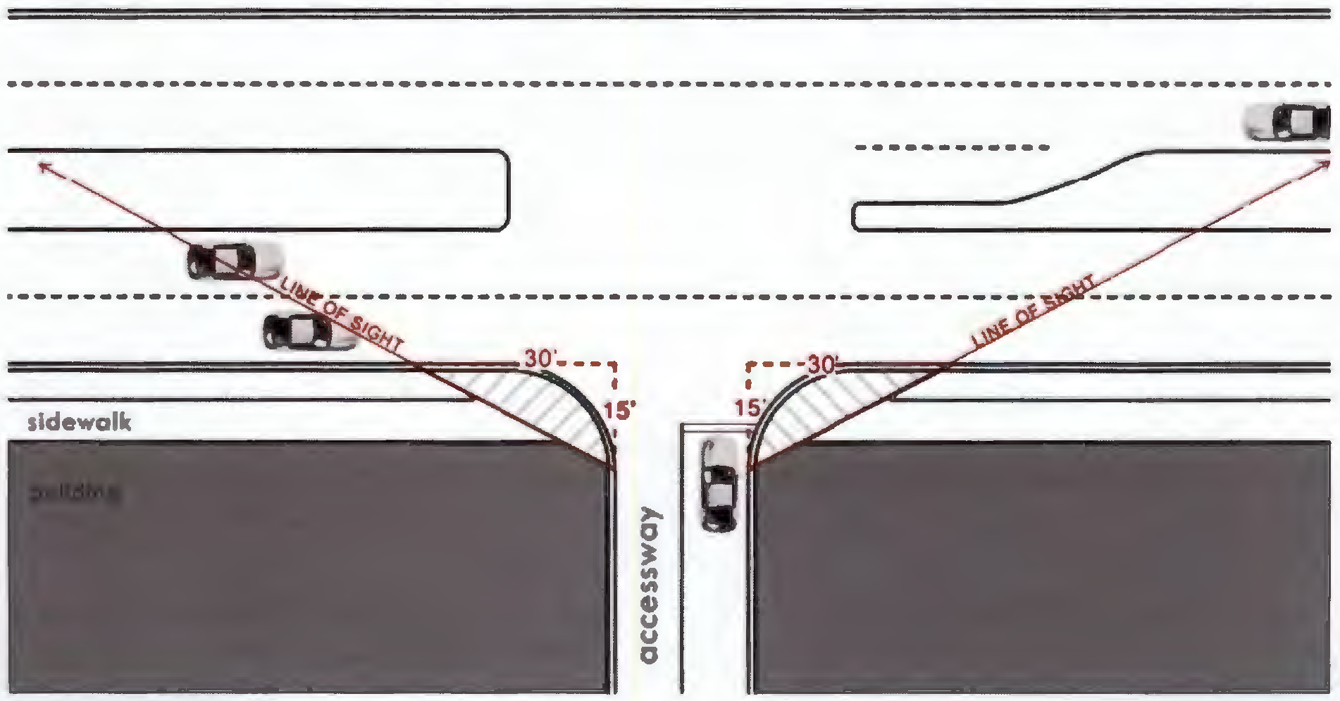
D.
Blocks.
1.
Where a tract of land is bounded by streets (excluding alleys) forming a block, said block shall have sufficient width to provide for two tiers of lots of appropriate depths.
2.
The lengths, widths, and shapes of blocks shall be consistent with adjacent areas. In no case shall block lengths in residential areas exceed 1,200 feet. For blocks exceeding 500 feet in length, the Planning Director may require one or more cross block connections for pedestrians to reduce the effective block length to 350 feet or less. Connections shall be located in public access easements measuring at least 15 feet in width and shall have paved walkways measuring at least 5 feet in width.
E.
Cul-de-sac.
1.
The terminus of every cul-de-sac shall have an unobstructed ten-foot-wide moving lane with a minimum outside turning radius of 40 feet and a minimum right-of-way of 50 feet.
F.
Intersections.
1.
Streets shall intersect as nearly as possible at right angles and in no case shall the angle of intersection be less than 75 degrees, with the exception of a "Y" intersection of two local streets.
2.
New intersections along one side on an existing street shall, where possible, coincide with existing intersections. Where an offset (jog) is necessary at an intersection, the distance between centerlines of the intersecting streets shall be no less than 150 feet.
3.
No two streets may intersect with any other street on the same side at a distance of less than 400 feet measured from centerline to centerline of the intersecting street. When the intersected street is an arterial, the distance between intersecting streets shall be no less than 1,000 feet.
4.
Intersections shall be designed to present the flattest possible grade in intersecting roadways near points of intersection.
5.
Intersections involving the junction of more than two streets are prohibited, except where they are found to be unavoidable by the County Engineer.
G.
Alleys.
1.
Alleys shall be at a minimum 10' wide.
H.
Sidewalks.
1.
New development or redevelopment projects abutting collector or arterial facilities shall provide sidewalks adjacent to these roadways unless a separate sidewalk or bike path already exists. Location of the sidewalks shall be consistent with planned roadway improvements, right-of-way restrictions, and scenic corridor guidelines where applicable.
2.
Sidewalks shall be provided on both sides of all residential streets in all new subdivisions or projects within areas with adopted Neighborhood Plans. Sidewalks shall be a minimum five feet in width and be constructed with a minimum 2,500 psi concrete. The Director of the Planning and Development Services Division may allow alternative sidewalk materials and/or designs, such as elevated boardwalks, where needed to protect wetlands or other environmentally sensitive areas. The Director may also approve the buy out of sidewalks on arterial, or collector roads adjacent to a project where a multi-use path is already under development or proposed for the affected road as provided for in the five year Capital Improvements Program (CIP).
3.
Residential or mixed use projects classified as Major Developments adjacent to, or within 1,500 feet of, an existing area containing either general commercial, neighborhood commercial, civic, public, or recreational uses shall facilitate the connection of pedestrian access between the above described areas unless infeasible.
4.
The County shall implement a sidewalk fund. The County Engineer or their designee shall annually update the linear foot cost of installed sidewalk to be used in calculating buyout of sidewalk by the developers. A residential subdivision developer may elect to buy out one side only by contributing to the sidewalk fund based upon the method and cost estimate developed by the County Engineer. Developers of non-residential projects may elect to buy out the required sidewalks, based upon the methodology and cost estimate by the County Engineer, by contributing to the sidewalk fund where (1) there are no pedestrian facilities in existence or planned within one-quarter (¼) mile of the proposed development and (2) the Director of Planning and Development Services Division and the County Engineer determines that the development area is in a low pedestrian traffic area at the time the development order is issued. In areas of high pedestrian traffic or areas of concerns for pedestrian traffic safety as determined by the County Engineer, the Director shall have the discretion to require perimeter and/or internal sidewalks to be constructed as a part of the Development Order approval.
5.
Where the proposed development is in a rural area, the Director may choose to grant an exemption to the sidewalk requirements. Such exemptions shall be considered on a site by site basis to determine whether regional area sidewalks are likely to be connected to the project sidewalks within the next fifteen year Capital Improvements Project (CIP) cycle. If no regional sidewalks or pedestrian facilities are in existence or planned within the next CIP cycle, the Director may grant an exemption to the sidewalk requirements and/or the required contribution to the sidewalk buyout fund.
I.
Gated Entrances.
For developments with gated entrances, the gates must be setback from the public right-of-way a minimum of 100 feet, or 75 feet if it is a residential development with less than ten single-family dwelling units.
(Ord. No. 2019-06, § II(Att. A), 3-12-19; Ord. No. 2019-19, § II(Att. A), 9-10-19)
5.04.04. - Access Management and Permitting.
A.
Access Standards and Permitting for County Maintained Facilities.
1.
Permit Required: A driveway connection permit shall be required for any connection to a County maintained facility. A Development Order, as described in Chapter 1, may serve as the required permit for projects located in unincorporated Walton County. A driveway connection permit issued by Walton County Public Works shall otherwise be required for:
a.
Single-family residential attached/detached projects and short term vacation rental units not subject to a Development Order proposing access to a County maintained facilities;
b.
Any development project proposing to access any County-maintained facility that is receiving a Development Order from any incorporated municipality within Walton County; and
c.
Any other proposed use not proposing access to a County maintained facility not subject to a Development Order within either the unincorporated or incorporated areas of the County such as agricultural uses, silvicultural uses or recreational uses.
2.
Permit Conditions: As a condition of a driveway connection permit a traffic impact analysis or traffic operational analysis may be required to determine if operational improvements are warranted for enhanced safety or traffic flow.
B.
General Standards. All proposed development or redevelopment projects within the County shall meet the following standards for vehicular access and circulation in relation to the development site. The following standards shall apply to all driveways or access points from a lot or parcel onto a public street:
1.
Access points from all local, collector and arterial streets into the site must be sized to accommodate all vehicles which are reasonably anticipated to use the site, including delivery vehicles. All access points shall either be exclusive one-lane, one-way drive or minimum two-lane, two-way drive. Vehicles must be able to enter a site without encroaching on the exit lane of a two-way drive-way.
2.
All access points must provide sufficient on-site lane storage to accommodate queued to park or exit without using any portion of the street right-of-way or interfering with street traffic flow.
3.
Number of Access Points.
a.
For non-residential and new larger scale residential developments accessing local, collector, or arterial roadways, a maximum of one access point shall be permitted to a particular site from each abutting street. When it is determined by the County Engineer to be in the best interest of good traffic circulation in the vicinity of a particular development site, one additional access point along a boundary with a continuous frontage of more than 300 feet or two additional access points along a boundary with a continuous frontage of more than 600 feet may be allowed. This section shall not apply to new small scale residential subdivisions accessing local or residential streets with an existing pattern of residential units accessing the street at the discretion of the County Engineer.
b.
For the purposes of this section, dual one-way access drives will be considered one access point, if they do not conflict with the distance requirements of an intersection or adjacent existing drives.
4.
Separation of Access Points.
a.
The separation between access points on state-maintained roads shall be in compliance with process and requirements of Chapters 14-96 and 14-97, F.A.C., as administered by the Florida Dept. of Transportation.
b.
On streets which are not maintained by the State, the separation between access points onto arterial and collector roadways, shall meet at least the minimum distances provided in the following table:
c.
Driveways shall be located as far as possible from the intersections of collector, arterial and/or major local roads. Corner clearance is measured from the closest edge of the driveway connection to the closest edge of the parallel roadway. A minimum corner clearance of 125 to 230 feet, depending on existing conditions, may be required by the County Engineer or designee.
d.
The distance between access points shall be measured from the centerline of the proposed driveway or roadway to the centerline of the nearest adjacent driveway or roadway.
5.
Driveway access to detached single-family residential uses or short term vacation rental uses in single family detached structures shall be from an adjacent public or private street. In the event the property abuts two streets, one point of access is permitted on the street of lower functional classification, as determined by the County Engineer. Single family residential driveways shall be limited to a maximum of 20 feet in width when connecting to a County maintained roadway. Dual one-way access is permitted provided the combined width of the connections do not exceed 20 feet.
6.
Service Roads, Joint Access, Shared Access.
a.
Joint use driveways and cross access easements shall be established for non-residential development along arterial and collector streets, unless there is an existing physical or other barrier preventing such cross access. Waivers to this requirement may be granted by the County Engineer or designee for these circumstances.
b.
A Unified Access and Circulation System plan between adjacent properties and/or internally for larger developments will be required for all new development and redevelopment projects which abut or load directly onto arterial streets. These plans shall include coordinated access facilities and shared parking areas wherever feasible and shall utilize service roads or internal cross access in their access and circulation plans to minimize the number of site access driveways and intersecting roads loading onto higher capacity roadways.
(Ord. No. 2019-06, § II(Att. A), 3-12-19; Ord. No. 2022-13, § II, 8-25-22; Ord. No. 2023-16, Att. A, 7-27-23; Ord. No. 2023-17, § II, 7-27-23)
Editor's note— Ord. No. 2023-17, § II, adopted July 27, 2023, amended § 2.04.04 and in doing so changed the title of said section from "Access Management" to "Access Management and Permitting," as set out herein.
5.04.05. - Standards for Private Streets.
New streets that connect to two or more existing collector or arterial roadways and that are expected to accommodate through traffic beyond what is associated with any particular development or local street network must be dedicated to the public and built to the appropriate standard. Private streets may be allowed within developments that will remain under common ownership, provided that they are constructed to the County's minimum standards and provided that the developer makes the following commitments at the time of receipt of a final development permit for any such project:
A.
Form a property owner's association that will be perpetually responsible for the maintenance of all streets, drainage infrastructure, sidewalks and bike paths and other common areas which are created through platting of the development.
B.
Record on the plat and each deed the following statement: "All roads and drainage within subdivision as recorded in plat book ___________ page ________ are not County maintained and are not eligible for maintenance by the County."
C.
Street signs shall incorporate the words "Private Street." These signs and lettering shall be of the same size and style as other County approved street signs except that the lettering shall be black and the background color shall be yellow.
D.
Individual lot surveys shall indicate that streets and drainage are private.
(Ord. No. 2019-06, § II(Att. A), 3-12-19; Ord. No. 2023-16, Att. A, 7-27-23)
5.04.06. - Right-of-Way Protection.
A.
Purpose. The purpose and intent of this section is to protect the public right-of-way needed for future transportation improvements and provide a minimum width or area to be protected when an easement or right-of-way may exist that is less than the minimum width or area required by this article.
B.
Right-of-Way Setback Requirement (Figure 5-7).
1.
Limitation on Structures. It shall be unlawful to construct, erect, or establish any building or other permanent structure in the protection zone, wherever a road right-of-way deficiency exists. A road right-of-way deficiency exists whenever the existing easement or right-of-way is less than the minimum specified in the table below. A functional classification map shall be maintained and on file within the supporting documentation for the Comprehensive Plan Transportation Element.
2.
Determination of Applicable Setback in Cases where a Right-of-Way Deficiency Exists. The minimum setback for a structure is specified in Section 5.00.03 and shall be measured from outside edge of the right-of-way protection area.
3.
Measurement of Setback. The half distance of the ROW protection area widths described in the table below and also including any required setback yard width shall be measured in a straight line from the centerline of any right-of-way to the foundation of any vertical structure on either edge of the right-of-way (see Figure 5-7). The required minimum ROW protection area width for each applicable street classification is provided below:
Figure 5-7: Measurement of Right-of-Way Protection Zone and Setback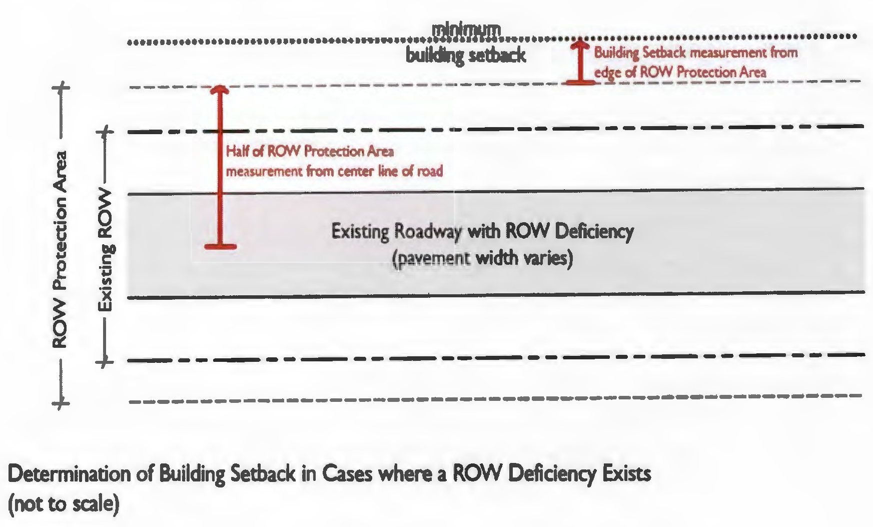
4.
Exceptions to Setback Requirements.
a.
Advertising Signs Permitted. The owner or occupant of any land or building affected by the setback specified above is hereby permitted to construct a sign advertising of such land or building by the owner or occupant, as temporary structure to be removed at the request of Walton County and at no expense to Walton County whenever the area provided in such setback is needed for transportation improvements.
b.
Fence permitted. The owner or occupant of any land affected by the setback specified above is hereby permitted to erect a fence three feet from the property line or ditch, whichever is greater, subject to Scenic Corridor guidelines from Chapter XIII and any other applicable code provision related to fences.
c.
Existing buildings. The provisions of this section shall not apply to any buildings or structures now constructed or standing upon such designated distances or areas as above set forth on the above-described roadways, in their present size and dimensions, and shall not apply to a second or subsequent story or any building or structure where the second story or subsequent story is erected as above set forth not less than ten feet above the roadway level of the above-described roadways. Any reconstruction shall meet Land Development Code requirements for setbacks.
d.
Existing design or cross section. In cases where more specific design or construction plans are available the required widths provided in the previous table may be varied in accordance with the existing roadway design or cross section.
e.
Where the adopted Long Range Transportation Plan (LRTP) identifies a lesser or greater design right-of-way width, the protection zone may align with the LRTP dimension instead of the protection area widths identified in this section.
5.
Right-of-Way Centerline Disagreement.
(i)
When the property owner affected by the right-of-way location disagrees with the established centerline, the property owner may conduct a realignment study with appropriate traffic analysis, roadway and property surveys, and cost estimates including, but not limited to, economic effects and traffic considerations of possible alternatives, and may present his findings to the County Engineer for review.
(ii)
The County Engineer shall submit his findings along with his recommendations to the Board of County Commissioners and the Board shall act upon the information presented and its findings shall be final.
6.
Right-of-Way Agreement.
(i)
A right-of-way agreement shall be required for any proposed structure, construction, landscaping, fence, or other appurtenance proposed in the County right-of-way, approved by the County Engineer and the Board of County Commissioners. If work is done in a County right-of-way, without an executed right-of-way agreement, the County may require the removal of materials at the expense of the persons doing the work in the County right-of-way. Materials placed in the right-of-way without a County executed right-of-way agreement may become the property of the County.
(Ord. No. 2019-06, § II(Att. A), 3-12-19; Ord. No. 2022-13, § II, 8-25-22)
5.04.07. - Construction Standards.
A.
Roadways.
1.
Paving. All streets (public and private) shall be paved in accordance with the requirements of this section, except for the following:
(a)
A subdivision may have one or more streets totaling up to 4,000 feet in length and serving no more than 20 lots that is not required to be paved. However, such unpaved streets cannot be extended outside the boundaries of the subdivision or into any other phases of the subdivision. Such streets must comply with the engineering requirements of this Section, except for the actual paved surface. Such streets must comply with the requirements of Section 5.04.05 A—C. Unpaved streets shall be platted as private streets and comply with Section 5.04.05 requirements.
(b)
Division of land divided so that no lot is less than four acres shall be exempt from paving, however, no unpaved roads may be dedicated to the County for maintenance.
(c)
No unpaved road shall be eligible for dedications to the County.
2.
Road Base.
(a)
Generally. The road base shall be constructed of sand-clay asphalt, hot mix, soil cement (at the option of the County Engineer for special applications), limerock, limerock stabilized base, or shell stabilized base according to the specifications shown below. Upon approval of construction plans by the County Engineer, construction may begin, with testing of a six-inch minimum thickness, for all bases except sand asphalt hot mix, which shall have a four-inch minimum thickness. All road base material shall be compacted to a minimum of 98 percent and subgrade material shall be stabilized a minimum of 12 inches and have a minimum LBR of 40. Additional stabilized subgrade, base and/or asphalt may be required by the County Engineer based on Geotechnical Report recommendations.
(b)
Tests. Tests for subgrade and base bearing capacity and compaction shall be made by a commercial testing lab at intervals of no more than 200 feet, staggered to the left, right, and on the centerline. Thickness of base shall be measured by the County Engineer at intervals of not less than 200 feet by means of holes drilled in the base, or at the time of test coring the surface course.
(c)
Sand Clay Base. The material and construction shall conform to the Florida DOT specifications as shown in sections 240 and 912 of "Standard Specifications for Road and Bridge Construction."
(d)
Sand Asphalt Hot Mix Base. The material and construction shall conform to Florida DOT specifications as shown in section 335 of "Standard Specifications for Road and Bridge Construction."
(e)
Soil Cement Base. The material and construction shall conform to Florida DOT specifications as shown in section 270 of "Standard Specifications for Road and Bridge Construction."
(f)
Compacted Limerock Base. The material and construction shall conform to Florida DOT specifications as shown in sections 200 and 911 of "Standard Specifications for Road and Bridge Construction."
(g)
Shell Stabilized Base. The material and construction shall conform to Florida DOT specifications as shown in sections 200 and 911 of "Standard Specifications for Road and Bridge Construction."
(h)
White Sand Protection Restrictions. The restriction shall apply to the area located south of U.S. Highway 98 eastward from the Okaloosa County line to County Road 30A, thence south of County Road 30A eastward to the juncture of U.S. Highway 98 and the Bay County line. The restricted area shall also include any lakes and adjoining land surrounding said lake, when said lake abuts County Road 30A.
In the restricted area, there shall be no use of construction material, which is subject to wind or water transport that permanently discolors the white beach sands. Such construction materials include, but are not limited to, red or yellow clay or sand. Any material prohibited above may be used if recommended by the County Engineer and approved by the Board of County Commissioners.
Violations of this restriction shall constitute a misdemeanor. Each day of violation shall constitute a separate and distinct offense and shall be subject to a fine of up to $500.00 per day. The building inspector shall be notified of any construction where said violation occurs and material in violation of this restriction is removed. Upon the violation all red clay or discoloring material in violation of this restriction shall be removed within ten days of the violation.
Should the County Engineer recommend use of prohibited materials and the Board of County Commissioners approves its use, and the use of prohibited material results in discoloring the white sand beaches, the contractor shall be considered in violation of this restriction. After the discoloring material in violation is removed as required by this restriction, the contractor shall restore the affected areas to their original condition in both topography and color.
After restoration of the affected area, the County Engineer shall inspect for compliance.
3.
Surface Course. Surface course for flexible pavements shall be an asphaltic concrete surface, with a minimum thickness of one and one-half inches. This asphaltic concrete surface shall be type SI. Alternative pavements may be utilized if approved by the County Engineer. Conditions may be required for alternative pavements. Testing of the surface course shall be conducted by a certified testing lab. Test cores shall be taken no more than 200 feet apart and staggered to the right, left, and centerline.
4.
Required Inspection.
(a)
Inspection of the following phases of street construction must be conducted by the County Engineer in addition to the testing procedures noted above:
(i)
Stabilized grade.
(ii)
Curb and concrete.
(iii)
Subgrade.
(iv)
Roadway base.
(v)
Surface course.
(vi)
Drainage system.
(b)
It is the developer's responsibility to notify the County Engineer to arrange for an inspection. The developer shall pay for the cost of all inspections provided by the County Engineer. Payment shall be made to the Board of County Commissioners before the final development order is approved. It is the developer's responsibility to notify the County Engineer 24 hours before any of the above-noted phases of construction are to be ready for inspection.
(Ord. No. 2019-06, § II(Att. A), 3-12-19)
5.05.01. - Requirements for all Developments.
A.
Generally. The following basic utilities are required for all developments subject to the criteria listed herein.
B.
Electricity. Every principal use and every lot within a subdivision shall have available to it a source of electric power adequate to accommodate the reasonable needs of such use and every lot within such subdivision.
C.
Telephone. Every principal use and every lot within a subdivision shall have available to it a telephone service cable adequate to accommodate the reasonable needs of such use and every lot within such subdivision.
D.
Central Sewer Lines. All sewer lines and treatment plants or treatment facilities shall have the approval of the applicable utility company, the health department, the Florida Department of Environmental Regulation, and the County Engineer. Developments located in the vicinity of operating sewer systems shall tie into that system if it has adequate capacity to handle the additional sewerage.
E.
Developments not Accessible to Operating Sewer Systems. For developments with any number of lots where a septic tank must be used such installation shall be in accordance with Florida law. Approval from the health department for installation of septic tanks on a lot-by-lot basis shall be provided to the planning department at the time of application.
F.
Central Water Lines. All water lines and plants or facilities shall have the approval of the health department, the Florida Department of Environmental Protection, and the County Engineer. Developments located in the vicinity of operating water systems shall tie into that system if it has adequate capacity to handle the additional water demand.
G.
Developments not Accessible to Operating Water Systems. For developments with any number of lots where a private well must be used such installation shall be in accordance with Florida law. Approval from the health department for installation of water wells on a lot-by-lot basis shall be provided to the planning department at the time of application.
H.
Placement of Utilities Underground. The developer is required to place all utilities underground, unless the Director of the Division of Planning and Development Services makes a discretionary finding that the development meets the following criteria for an exemption:
1.
The property is within the Large Scale Agriculture (LSA), General Agriculture (GA), or Estate Residential (ER) Zoning Districts;
2.
The proposed development consists of minimum one (1) acre or larger lots; and
3.
The developer provides a feasibility study by the local electric utility provider agreeing that underground electric power is not feasible for the proposed development. Feasibility shall be determined based on financial, engineering, and environmental considerations.
This exemption is intended to apply only in rural areas where underground utilities are truly not feasible. This exemption shall only apply to electric transmission lines, cable transmission lines, telephone lines, and the like.
(Ord. No. 2019-06, § II(Att. A), 3-12-19)
5.05.02. - Utility Easements.
When a developer installs or causes the installation of water, sewer, electrical power, telephone, or cable television facilities and intends that such facilities shall be owned, operated, or maintained by a public utility or any entity other than the developer, the developer shall transfer to such utility or entity the necessary ownership or easement rights to enable the utility or entity to operate and maintain such facilities.
(Ord. No. 2019-06, § II(Att. A), 3-12-19)
5.06.01. - Single-Family Residential Stormwater Management Requirements for Projects Located in Areas not having a County Approved Stormwater Plan.
These standards shall apply only to improvements on single-family lots that are not located within the boundaries of a previously approved stormwater management plan, south of the Choctawhatchee Bay. This section will not and is intended not to make existing residential structures non-conforming. All projects increasing impervious surface area are subject to inspections.
A.
Single-Family Residential Stormwater Management Exemptions. The following development activities are exempt from these stormwater management requirements, with the exception of erosion control and sedimentation management requirements per the Land Development Code:
1.
The construction or reconstruction of pile supported single family homes on individual lots except those located within the Coastal Dune Lake Protection Zone, as specified in Section 4.02.03 of the Land Development Code, that are not part of a previously approved stormwater management plan when the following conditions are met:
a.
Impervious Surface Ratio (ISR) of less than or equal to forty-five (45) percent of the total lot area.
b.
All structures shall be piling or pier supported. Such structure shall not alter the pre-development runoff patterns, and shall preserve the ground beneath the structure in a natural pre-development condition to the greatest extent possible.
c.
With the exception of the minimal amount necessary to construct a driveway and/or maximum 600 square foot (sq ft) garage/carport, grading that alters the existing runoff patterns including, but not limited to, the placement of fill, shall not be allowed.
d.
No gutter or downspout collection and piping is permitted.
e.
A signed and sealed certification form providing an evaluation of applicable offsite drainage conveyance must be submitted prior to the issuance of a certification of occupancy (CO).
2.
A backfilled stem wall foundation will be allowed if the following applies:
a.
ISR of less than or equal to forty (40) percent of the total lot area.
b.
The property is not located in a CDLPZ.
c.
Offsite drainage (historic flow) is allowed to enter and exit the property in a manner similar to the pre-development condition.
d.
Fill outside of the building foot-print is limited to the driveway and shall not consist of any other type of soils which may degrade water quality or inhibit infiltration.
e.
No gutter or downspout collection and piping is permitted.
f.
A signed and sealed certification form providing an evaluation of applicable offsite drainage conveyance must be submitted prior to the issuance of a certification of occupancy.
3.
Deminimis exemptions for individual single-family residential lots that are not part of a previously approved stormwater management plan:
a.
Site improvements creating new impervious surfaces cumulatively measuring 3% or less of the total lot area or a maximum of 250 square feet (whichever is larger) are not required to provide a stormwater management plan.
b.
Site improvements creating new impervious surfaces cumulatively measuring 5% or less of the total lot area are exempt from meeting flood attenuation requirements.
c.
Single family lots, discharging to a Coastal Dune Lake or other tidally influenced waterbody and/or hydraulically connected and protected jurisdictional wetlands are exempt from meeting flood attenuation requirements. This exemption only applies to water quantity (flood attenuation) requirements. A stormwater management plan meeting water quality (treatment) standards is required. Tidally influenced bodies of water are those that are subject to the ebb and flow of ordinary tides, whether navigable or not.
B.
Stormwater Management Requirements for Individual Single-Family Lots without a County Approved Stormwater Management Plan. All construction on individual single-family lots without a County approved stormwater management plan if not exempt per Section 5.06.01 A. shall provide the following:
1.
Projects that are not exempt per subsection A above, may hire a professional civil engineer licensed by the State of Florida who has competence in stormwater design and analysis. The design shall utilize the minimum design standards found in table 5.06.01. The customized stormwater system must be signed and sealed by the engineer of record (EOR). Alternatively, the applicant may meet the sizing, maintenance, and performance requirements provided in the Walton County Single Family Residential Stormwater Management Technical Manual.
a.
Except that, projects located within a designated ICPAL area, Coastal Dune Lake Protection Zone, non-visible underground engineered systems, or any area determined to be a closed basin, shall require a stormwater design prepared and sealed by a professional civil engineer licensed by the State of Florida who has competence in stormwater design an analysis.
2.
The maximum ISR for these lots is 65% (0.65).
3.
Table 5.06.01: Single Family Attenuation/Design Criteria for Projects Greater Than 45% but Less than or Equal to 65% ISR
* Up-to-date rainfall data must be utilized for the attenuation design storm. Rainfall data may be obtained online from the NOAA Precipitation Frequency Data Server. Designer should utilize the Partial Duration time series type with inputs for specific project address or Lat/Long coordinates. NOAA rainfall data sheet should be included in the storm calculations report.
4.
Projects located within a Coastal Dune Lake Protection Zone (CDLPZ), as defined in Section 4.02.03 of the Land Development Code, are required to prepare a stormwater management plan consistent with Section 4.02.03 and are required to meet 150% of the treatment volume required within the Walton County Single Family Stormwater Management Technical Manual
5.
For lots that are in a closed basin as identified on a Public Works maintained Initial County Problem Area List (ICPAL) or closed basins determined not to have positive outfall, additional performance standards may be applicable. Such performance standards may include increased attenuation/design storm criteria such as the 100 year storm, limitations on additional fill allowed beneath the base flood elevation, or requirements for pile or pier foundations.
6.
Fill placed outside of the building footprint must be comprised of well-draining soils. Clayey soils that inhibit infiltration rates or have the potential to degrade water quality are prohibited.
7.
A full evaluation of offsite drainage as part of the stormwater design and analysis must be provided. Pre- and Post-Basin maps with 1-foot (ft) contours shall be submitted within the report indicating drainage patterns and receiving water bodies, in addition to, existing drainage infrastructure.
8.
Stormwater designs proposing infiltration/exfiltration systems must provide geotechnical report with information associated with the area of interest. Bore sample to be taken from the proposed location of the system within two feet of its base. The Engineer of Record (EOR) is responsible to verify that the location of the system will not compromise the foundation of surrounding structures at any time.
9.
Retaining walls less than two (2) ft in vertical height must be setback a minimum distance of one (1) foot from the nearest property line, all other walls greater in vertical height must be setback from the property line at least two (2) feet from the nearest property line. Retaining walls greater than three (3) feet in vertical height must be designed by a Professional Engineer registered by the State of Florida.
a.
Retaining wall backfill drains shall be designed in such a way that stormwater runoff conveyance is not permitted to bypass stormwater management systems. The use of downspout collectors may be necessary to prevent nearby rooftop runoff from passing directly through wall drainage and onto neighboring properties.
b.
No impoundment of water on adjacent properties shall be allowed. The stormwater management system shall incorporate a diversion swale or equivalent which is capable of conveying the required design storm.
c.
These requirements shall also apply to masonry screen walls.
10.
If applicable, the stormwater plan may be required to demonstrate compliance with the following criteria:
a.
Offsite runoff conveyed to or through the development site.
i.
Design must include offsite runoff in sizing of the stormwater management facility (SWMF) or provide appropriate bypass to accept and discharge offsite runoff in a manner that is consistent with historic flow patterns through the property;
b.
Historic drainage patterns:
i.
Designs must not block historical drainage patterns;
c.
Historic basin storage:
i.
The County Engineer or designee shall determine if a basin study is warranted. The study is to be completed by an engineer licensed by the State of Florida. Design must not include new fill below the 100-year critical flood stage in a closed basin.
ii.
If the property is located in a 100-year flood stage of a closed basin, the property must be developed in a manner that provides no net fill below that flood stage and also accommodate flood waters. It will be at the discretion of the County Engineer or designated representative as to if a 100-year flood study is warranted.
d.
Receiving conveyance system:
i.
Applicant is required to demonstrate that natural conveyance or existing drainage infrastructure is available to receive discharge at the location proposed in the stormwater plan. If no form of downstream conveyance exists at the discharge location, then attenuation of the 100-year critical storm event will be required.
11.
All erosion control measures (BMPs) must be in place prior to site disturbance and the site shall be permanently stabilized with viable vegetation prior to issuing a Certificate of Occupancy (CO). Pine straw will not be accepted as a permanent stabilization technique unless accompanied by appropriately spaced ground covers, shrubs and canopy trees.
a.
Silt fencing shall encompass the construction limits during site disturbance.
b.
If dewatering activities are anticipated, the EOR must submit a dewatering plan for review. The plan shall highlight the approach to water quality treatment, settling basin location, and location of discharge. If water is discharged from the property after treatment it may not cause flooding, sedimentation, or washout of adjacent properties.
c.
Stabilized construction entrances and exits shall be established prior to any interior clearing of the property. Each ingress/egress shall meet the criteria established in the Florida Department of Environmental Protection (FDEP) Stormwater Erosion and Sediment Control Inspectors Manual. Residential projects shall maintain a minimum construction entrance of 12-foot wide by 20-foot length. This area shall be clearly identified in the civil plans.
12.
Maintenance and notification requirements:
a.
Maintenance of all of the approved stormwater systems is required in perpetuity unless otherwise permitted. Homeowner notification shall be certified and provided prior to the issuance of a Certificate of Occupancy. A maintenance plan shall be prepared and included in such notification. Notification of the onsite system and maintenance requirements must also be recorded on the deed for the property with the Clerk of the Courts and proof of recordation provided to the Walton County Planning Department.
b.
The property owner developing a lot of record that does not benefit from a regional SWMF must provide an acknowledgement form stating they understand that there is no regional system for stormwater management associated with their property. They must design a plan that manages the water on their property and develop in a manner that minimizes impact to adjacent properties. The County is not responsible for immediate improvements that may facilitate downstream conveyance or for modification to existing infrastructure that has historically drained to the property. The site design will need to accommodate existing conditions and address offsite drainage accordingly. The homeowner notification shall be certified and provided prior to the issuance of a Certificate of Occupancy.
13.
All improvements shall be in accordance with the approved stormwater plan and certified complete by the property owner. When the stormwater plan was prepared by a professional civil engineer who has competence in stormwater design, the construction of the improvements must be certified complete by the preparing engineer of record or another competent civil engineer familiar with the project design.
14.
As-built boundary and topographic surveys (using 0.5-foot contours) or final construction drawings indicating the location and disposition of all site improvements shall be required prior to issuance of a Certificate of Occupancy. The as-built survey or final construction drawings must provide verification that construction and grading has occurred in a manner that is in full compliance with all applicable regulations including the approved stormwater management plan for the development. All projects utilizing fully or partially underground systems should include installation photos within this submittal.
(Ord. No. 2019-06, § II(Att. A), 3-12-19; Ord. No. 2019-19, § II(Att. A), 9-10-19; Ord. No. 2022-13, § II, 8-25-22; Ord. No. 2023-16, Att. A, 7-27-23)
5.06.02. - Single-family Residential Stormwater Management Requirements for Improvements in Areas Having a Previously Approved Stormwater Management Plan.
The following standards shall apply only to proposed improvements on single-family lots to be constructed on lots that are located within the boundaries of a County approved stormwater management plan.
A.
All improvements shall be constructed in accordance with the approved stormwater plan and certified complete by the property owner a Professional Engineer licensed by the State of Florida.
B.
Pertaining to any lot containing onsite stormwater management or portions of a development-wide stormwater management system only, as-built boundary and topographic surveys (using 0.5 foot contours) or final construction drawings indicating the location and disposition of all site improvements shall be required prior to issuance of a Certificate of Occupancy. The as-built survey or final construction drawings must provide verification that construction and grading has occurred in a manner that is in full compliance with all applicable regulations including the approved stormwater management plan for the development.
C.
Maintenance and notification requirements pertaining to any lot containing onsite stormwater management or portions of a development-wide stormwater management system only: Homeowner notification shall be certified and provided prior to the Certificate of Occupancy. A maintenance plan shall be prepared and included in such notification. In addition, notification of the onsite system and maintenance requirements must be recorded with the Clerk of Courts with the deed for the property.
D.
If any deviation from the originally approved stormwater plan is proposed, then the following must be submitted to the County:
1.
Approval letter from the Home Owners Association (HOA).
2.
Approval or exemption letter from the Florida Department of Environmental Protection (FDEP).
3.
The property must provide an on-site stormwater management system for the additional impervious area that meets or exceeds the original stormwater management design approved with the development order or the current criteria, whichever is greater.
(Ord. No. 2019-06, § II(Att. A), 3-12-19; Ord. No. 2023-16, Att. A, 7-27-23)
5.06.03. - Stormwater Management Requirements for Other Development.
The following requirements are applicable to development activities other than single family residential development. In addition to meeting the requirements of the Land Development Code, the design and performance of all stormwater management systems shall comply with Chapter 62-330, F.A.C. and/or Chapter 14-86.004, F.A.C. if applicable. In all cases the strictest of the applicable Federal, State, and/or Local design and performance standards shall apply. For those development activities that occur in areas where there is an approved Regional General Permit and Ecosystem Management Agreement, the design and performance of all stormwater management systems shall comply with the specific conditions and criteria of those permits and agreements.
A.
Exemptions.
1.
Any development within a platted subdivision and only if each of the following conditions have been met:
a.
Stormwater management provisions for the subdivision were previously approved and remain valid as part of a final plat or development plan; and
b.
The development is conducted in accordance with the stormwater management provisions submitted with the final plat or development plan.
2.
Bona fide agricultural activity, including forestry, provided farming activities are conducted in accordance with the requirements set forth in an approved Soil Conservation Service conservation plan and forestry activities are conducted in accordance with the Silviculture Best Management Practices (BMP) Manual (1979) published by the Florida Division of Forestry. However, any new agricultural use that drains into a surface water, canal, or stream, or sinkhole shall first allow the runoff to enter a grassed swale designed to percolate 80 percent of the runoff from a three-year, one-hour design storm within 72 hours after a storm event.
3.
Maintenance activity that does not change or affect the quality, rate, volume or location of stormwater flows on the site or of stormwater runoff.
4.
Action taken under emergency conditions to prevent imminent harm or danger to persons, or to protect property from imminent fire, violent storms, hurricanes or other hazards. A report of the emergency action shall be made to the department as soon as practicable.
5.
Subdivisions in the agricultural Districts in North Walton County with all subdivided lots being at least four acres in sizes. The developer may only utilize this exemption if they submit a development plan which indicates the measures they will take during construction and long term maintenance periods to control sedimentation and erosion related to the unpaved road surface. The plan must be submitted to the Department of Planning and Zoning and must be reviewed and approved by the County Engineer. The costs of this review will be borne by the developer and paid prior to receipt of a notice of exemption from the County.
B.
Stormwater Management Performance Standards for All Other Developments.
1.
Performance Standards. All development must be designed, constructed and maintained to meet the following performance standards if not exempt per Section Table Walton County shall maintain a level of service standard for new and existing development based on the following stormwater quantity and quality criteria:
Table 5.06.03: Design Storm Frequency and Water Quality Treatment Volumes
2.
The design and construction of the proposed stormwater management system shall be certified as meeting the requirements of this code by a professional engineer registered in the State of Florida.
3.
No surface water may be channeled or directed into a sanitary sewer.
4.
The banks of detention and retention areas should be sloped to accommodate, and should be planted with, appropriate vegetation.
5.
Dredging, clearing of vegetation, deepening, widening, straightening, stabilizing or otherwise altering natural surface waters shall be minimized.
6.
Natural surface waters shall not be used as sediment traps during or after development.
7.
For aesthetic reasons and to increase shoreline habitat, the shorelines of detention and retention areas shall be sinuous rather than straight, where possible.
8.
Storm sewers.
a.
All materials proposed for storm sewers shall be approved by the County Engineer or designee and comply with the material trade industry's standard specifications and guidelines.
b.
The installation of manholes, inlets, curbs, and gutters shall conform to the standards shown in sections 425 and 520 of the Florida "Standards [and] Specifications for Road and Bridge Construction."
9.
To facilitate a timely review the County encourages use of ICPR stormwater modeling software for stormwater design. Stormwater design shall be submitted in a hard copy and digital format to the County Engineer or designee.
10.
All dry retention ponds that have less than 2 feet of separation from the bottom elevation of the pond to the seasonal high ground water table (SHGWT) shall be evaluated for unsaturated and saturated lateral flow to verify mounding will not prevent drawdown of the pond within the 72 hour required time frame.
11.
All stormwater designs shall be based on a geotechnical evaluation performed by an engineer registered in the State of Florida. The engineer shall recommend horizontal and vertical permeability rates through either a Double Ring Infiltrometer or a Falling Head permeability test. In addition the engineer shall establish the seasonal high groundwater table at the proposed pond location and provide site data maps that show the horizontal and vertical location of the testing. Soil Conservation Service (SCS) soils maps are not a substitute for the geotechnical testing that will need to be performed for each pond on a proposed development site.
12.
The design infiltration rates (Kh and Kv) shall utilize a factor of safety of 2.0 unless the Engineer of Record can demonstrate why a smaller factor of safety is appropriate.
13.
If the berms associated with a stormwater facility are higher than the existing grade of the adjacent property then a seepage analysis may be required if the County Engineer or designated representative determines it is warranted.
14.
The outfall structure of all stormwater facilities shall be capable of discharging the 100 Year Critical storm event without breaching the pond banks; this is not a pre versus post attenuation requirement. The design engineer shall model the outfall structure and demonstrate that the stormwater facility will not be overtopped during each of these storm events.
15.
It shall be demonstrated in the stormwater analysis that all historical off-site drainage coming to the development site is being properly conveyed and/or managed across the development site so as to not impact adjacent properties. Watershed map(s) will be required indicating all pre and post on-site and off-site drainage patterns.
16.
No stormwater management systems shall be designed or constructed for use under residential and/or commercial structures with the exception of existing lots of record which are not part of an approved stormwater management plan.
17.
Stormwater management systems shall be designed and constructed to be in common areas and not on or across proposed lots with the exception of existing lots of record which are not part of an approved stormwater management plan.
18.
An appropriate maintenance entity is required for maintenance of the stormwater management system.
19.
All developments anticipating dewatering activities shall submit a dewatering plan. The plan shall highlight the approach to water quality treatment, settling basin location, and location of discharge. If water is discharged from the property after treatment, it may not cause flooding, sedimentation, or washout of adjacent properties.
20.
All erosion control measures (BMPs) must be in place prior to site disturbance and the site shall be permanently stabilized with viable vegetation prior to issuing a Certificate of Occupancy (CO). Pine straw will not be accepted as a permanent stabilization technique.
21.
Stabilized construction entrances and exits shall be established prior to any interior clearing of the property. Each ingress/egress shall meet the criteria established in the FDEP Stormwater Erosion and Sediment Control Inspectors Manual. The minimum width and length shall be 12-foot by 50-foot for all major or minor developments.
22.
A minimum maintenance access must be maintained in accordance with Section 4.03.03 (25-feet for man-made water bodies) along mosquito control ditches (MCD).
23.
For new residential subdivisions, a reasonable buildable area for each lot shall be considered and accounted for in any approved stormwater management plan. The following minimum ISR ratios based on lot size are recommended:
(Ord. No. 2019-06, § II(Att. A), 3-12-19; Ord. No. 2019-19, § II(Att. A), 9-10-19; Ord. No. 2023-16, Att. A, 7-27-23)
5.07.01. - Generally.
Certain uses have unique characteristics that require the imposition of development standards in addition to those minimum standards set forth in other sections of this code. These uses are listed in this part together with the specific standards that apply to the specified use or activity. These standards shall be met in addition to all other standards of this Code, unless specifically exempted.
(Ord. No. 2019-06, § II(Att. A), 3-12-19)
5.07.02. - Institutional Residential Homes.
A.
Institutional residential homes shall be allowed in residential districts subject to the following conditions:
1.
When a site for an institutional residential home has been selected by a sponsoring agency in a residential land use district, the agency shall notify the County Supervisor and Director of Planning and Zoning in writing and include in the notice the specific address of the site, the residential licensing category, the number of residents, and the community support requirements of the program. Such notice shall also contain a statement from the district administrator of the department of health and rehabilitative services indicating the need for and the licensing status of the proposed institutional residential home and specifying how the home meets applicable licensing criteria for the safe care and supervision of clients in the home. The district administrator shall also provide to the County Supervisor the most recently published data compiled that identifies all institutional residential homes in the district in which the proposed site is to be located. The Director of Planning and Development Services shall review the notification of the sponsoring agency in accordance with applicable requirements of this code.
2.
Pursuant to such review, the Director of Planning and Development Services may:
a.
Determine that the siting of the institutional residential home is in accordance with applicable requirements and approve the siting. If the siting is approved, the sponsoring agency may establish the home at the site selected.
b.
Fail to respond within 60 days. If the Director of Planning and Development Services fails to respond within such time, the sponsoring agency may establish the home at the site selected.
c.
Deny the siting of the home.
3.
The Director of Planning and Development Services shall not deny the siting of an institutional residential home unless the Director of Planning and Zoning establishes that the siting of the home at the site selected:
a.
Does not otherwise conform to existing regulations applicable to other or institutional uses in the area.
b.
Does not meet applicable licensing criteria established by the Department of Health and Rehabilitative Services, including requirements that the home be located to assure the safe care and supervision of all clients in the home.
c.
Would result in such a concentration of institutional residential homes in the area in proximity to the site selected, such that the nature and character of the area would be substantially altered. A home that is located within a radius of 1,200 feet of another existing institutional residential home shall be an over concentration of such homes that substantially alters the nature and character of the area.
4.
All distance requirements shall be measured from the nearest point of the existing home to the nearest point of the proposed home via path of travel.
B.
Upon receipt of the written notice from the sponsoring agency provided for in [subsection] (1) above, the County Supervisor shall notify the Board of County Commissioners of the pending application. The Director of Planning and Development Services shall, within 20 days of the receipt of the application, review the application and provide the board and the applicant with a written decision outlining reasons for the decision. The applicant may appeal the decision of the Director of Planning and Development Services by notifying the County Supervisor within ten days from the date of the Director's decision. Appeals of the decision of the Director of Planning and Development Services shall be in accordance with Chapter 1.
(Ord. No. 2019-06, § II(Att. A), 3-12-19)
5.07.03. - Short-Term Vacation Rental Standards.
The following standards shall govern the use of any single family detached or attached short-term vacation rental as a permitted use:
A.
Minimum Life/Safety Requirements for Single-Family Detached and Two-Family Attached Units:
1.
Swimming Pool, Spa and Hot Tub Safety. A swimming pool, spa or hot tub shall comply with the current standards of the Residential Swimming Pool Safety Act, F.S. ch. 515.
2.
Sleeping Rooms. All sleeping rooms shall meet the single-family and two-family dwelling minimum requirements of the Florida Building Code.
3.
Automatic Smoke Detection Requirements. All short-term vacation rental units are required to meet the requirements of Chapter 69A-43, F.A.C.
4.
Fire Extinguisher. A portable, multi-purpose dry chemical 2A:10B:C fire extinguisher shall be installed, inspected and maintained in accordance with NFPA 10 on each floor/level of the unit. The extinguisher(s) shall be installed on the wall in an open common area or in an enclosed space with appropriate markings visibly showing the location.
5.
Battery-Powered Emergency Lighting of Primary Exit. Battery powered emergency lighting which provides illumination automatically in the event of any interruption of normal lighting shall be provided for a period of not less than one hour to illuminate the primary exit. For purposes of this requirement, short-term vacation rentals with short-term vacation rental certificates issued prior to the enactment of the ordinance providing for the codification of this standard shall have a period of six months to demonstrate compliance with the emergency lighting standard either through affidavit or inspection.
B.
On-Site Parking Standard for All Single-Family Attached and Detached New Construction and Existing Construction. For new construction and new conversions of single family attached and detached units, based on the maximum short-term transient occupancy permitted or other self-imposed limit through the certificate process, minimum off-street parking shall be provided as one space per six transient occupants. This is computed using 150 square feet gross floor area per person (one space per 900 square feet of gross floor area). This minimum parking standard shall not apply to any adopted neighborhood plan, development order, or area controlled by an active homeowner's association (HOA) or similar owners' association having other controlling mandatory parking requirements. In such cases, the development order, neighborhood plan, or HOA requirements shall govern.
1.
Garage spaces shall only count if the space is open and available, and the transient occupants are given vehicular access to the garage. Failure to keep garage areas usable for vehicular parking if counted towards meeting the requirement shall result in a Code violation.
2.
On-street parking shall not be permitted within public rights-of-way and may be limited on private rights-of-way per the maintaining entity.
3.
On-site parking shall not be permitted in areas not otherwise designated for on-site parking spaces.
4.
Golf carts, RVs, trailers etc. may not occupy any designated on-site parking spot with reliance on on-street parking for other vehicles. All spaces designated towards achieving the required on-site minimum must be available to registered motor vehicles only unless fewer registered motor vehicles are on site in exchange for golf carts, RVs, trailers etc. being parked on site.
5.
Existing short-term vacation rentals at the time of the ordinance from which this section is derived shall either limit occupancy based on available parking (six occupants per parking space), increase parking onsite through the applicable permitting process, or limit the number of vehicles that are on site at any given time through guest communication. In all cases, the maximum occupancy is limited to one person per 150 square feet.
C.
On-Site Sewage Treatment and Disposal System Limitations: For structures utilizing on-site sewage treatment and disposal systems (OSTDS), the maximum number of occupants allowed shall be restricted in accordance with any OSTDS permit and the assumed occupancy/conditions the permit was issued under by the Walton County Health Department.
D.
Maximum occupancy. The maximum occupancy load permitted for single family attached and single family detached short-term vacation rental units shall be computed at 150 square feet gross floor area per person or lesser as agreed upon during the certificate process.
E.
Solid Waste Handling and Containment. Based on the maximum transient occupancy permitted, 35 gallons or greater of fully enclosed container capacity shall be provided per four transient occupants or fraction thereof. Appropriate screening and storage requirements for trash storage containers shall apply per any development approval or local neighborhood standard, whichever is more restrictive, and be incorporated into the certificate. For purposes of this section, containers must have a lid that securely fastens to the container to prevent spills and animal access, with the container to be placed at curbside no earlier than 4:00 p.m. on the day before solid waste pickup and to be removed from curbside no later than sunset on the day of solid waste pick up unless otherwise controlled by an active homeowner's association (HOA) or similar owners' association having other controlling mandatory trash container and pick up requirements. Permanent structures for screening and storage of trash storage containers shall not be permitted within any designated scenic corridor overlay district. Private concierge service is highly encouraged, specifically on Saturday or high-volume change over days.
F.
Minimum Short-Term Vacation Rental/Lease Agreement Wording. The short-term vacation rental/lease agreement shall contain the minimum information as provided for in subsection 1.13.16 D.
G.
Minimum Short-Term Vacation Rental Information Required Postings. The short-term vacation rental shall be provided with material to be posted within the rental unit as required by the county as prescribed in subsection 1.13.16 D.
H.
Minimum Short-Term Vacation Rental Lessee Information. The short-term vacation rental lessee shall be provided with a copy of the information required in subsection 1.13.16 D.
I.
Responsible Local Party. Designation of a short-term vacation rental responsible party capable of meeting the duties provided in subsection and capable of addressing issues locally within a short response time is required.
J.
Advertising. Any advertising of the short-term vacation rental unit shall conform to information included in the short-term vacation rental certificate and the property's approval, particularly as this pertains to maximum occupancy and parking. All advertising shall include the short-term vacation rental certificate Number as well as the TDT Registration Number.
(Ord. No. 2023-03, § II(Att. A), 1-24-23)
5.07.04. - Mobile Home and Recreational Vehicle Parks.
Mobile Home and Recreational vehicle parks shall conform to the standards of the Florida Department of Health in accordance with F.S. Ch. 513.
(Ord. No. 2019-06, § II(Att. A), 3-12-19)
5.07.05. - Landing Strips and Heliports.
A.
The area proposed for landing strips and heliports (accessory hangars and sheds) shall be sufficient and the site otherwise adequate to meet the standards of the Federal Aviation Agency and the Aviation Bureau, Florida Department of Transportation, for the class airport proposed, in accordance with their published rules and regulations.
B.
Any proposed runway or landing strip shall be situated so that any structures, high-voltage power lines, towers, chimneys, and natural obstructions within the approach zones shall comply with height restrictions in airport approach zones of the Federal Aviation Agency and the Florida Department of Transportation, Aviation Bureau, or a municipal or other airport authority qualified by law to establish airport hazard zoning regulations.
C.
There shall be sufficient distance between the end of each usable landing strip and the airport boundary to satisfy the requirements of the Federal Aviation Agency. If air rights or easements have been acquired from the owners of abutting properties in which the approach zones fall, proof thereof shall be submitted with the application.
D.
No existing or planned approach areas shall be permitted over existing residential areas.
E.
All repair of airplanes and machinery shall be done inside hangars.
(Ord. No. 2019-06, § II(Att. A), 3-12-19)
5.07.06. - Commercial Stables.
A.
Lot Size. The minimum lot size for a commercial stable shall be 200,000 square feet.
1.
If any horses (including horses, ponies, mules, donkeys, and other animals used for riding) are kept outside of any building, the maximum number of horses permitted shall be one per 100,000 square feet of property.
2.
If all horses (and other riding animals) are kept inside a building, the maximum number of horses permitted shall be limited to the building capacity to house, show, and ride said horses. A stall shall be provided for each horse. The minimum dimension for each stall shall be ten feet by ten feet.
B.
Minimum Setbacks. The following minimum setbacks shall be provided:
1.
Stables, corral, and piles of manure, feed, and bedding shall be located 75 feet from any street or nonresidential lot line and 100 feet from any residential lot line, in order to minimize any odor and nuisance problems. Pasture may extend to the lot line; however, when all of the runoff from a corral or exercise area is controlled and directed over a 200-foot-long grass swale before reaching the property line, the corral or unvegetated exercise area may be located a minimum of 40 feet from any street or lot line.
2.
Manure piles shall be stored, removed, and/or applied in accordance with Walton County Health Department regulations; however, manure shall not be applied to land that is closer than 100 feet to a residential lot line.
3.
A 100-foot-wide area of vegetation cover, exclusive of pasture area, shall be maintained between any corral, unvegetated exercise area, manure pile, or application area and any surface water or well, in order to minimize runoff, prevent erosion, and promote quick nitrogen absorption.
4.
In the areas with a slope of five percent or less, corrals, unvegetated exercise areas, and manure piles shall be 150 feet from a well and 200 feet from any surface water, unless the water is upgraded or there is adequate diking to comply with the Walton County Health Department standards.
5.
Corrals, unvegetated exercise areas, manure piles and manure application are prohibited in areas with slopes greater than five percent, in ten-year floodplains, in waterways, and on soils classified as very poorly drained by the USDA Soil Conservation Service soil survey for Walton County, Florida.
(Ord. No. 2019-06, § II(Att. A), 3-12-19)
5.07.07. - Private Stables.
A.
Generally. Private stables shall not be permitted as an accessory use within residential subdivisions, unless the subdivision is specifically designed to accommodate equestrian activities and includes such facilities as riding trails and a common stable and pasture area. The following standards shall not apply to lands zoned either Large Scale Agriculture or General Agriculture on the Official Zoning Map but shall apply elsewhere.
B.
Pasture Standards. There shall be at least one acre of pasture for the one horse and at least two acres of pasture for two or more horses within private stables.
C.
Stall Standards. If horses are kept inside a building, one stall shall be provided for each horse. A tiedown stall shall be a minimum of four feet by eight feet; a box stall shall be a minimum often feet by ten feet.
D.
Minimum Setback. The following minimum setbacks shall be provided:
1.
Stables, corrals, and piles of manure, feed, and bedding shall be located 75 feet from any street or nonresidential lot line and 100 feet from any residential lot line, in order to minimize any odor and nuisance problems. Pasture may extend to the lot line; however, when all of the runoff from a corral or exercise area is controlled and directed over a 200-foot-long grass swale before reaching the property line, the corral or unvegetated exercise area may be located a minimum of 40 feet from any street or lot line.
2.
Manure piles shall be stored, removed, and/or applied in accordance with Walton County Health Department regulations; however, manure shall not be applied to land that is closer than 100 feet to a residential lot line.
3.
A 100-foot-wide area of vegetation cover, exclusive of pasture area, shall be maintained between any corral, unvegetated exercise area, manure pile, or application area and any surface water or well, in order to minimize runoff, prevent erosion, and promote quick nitrogen absorption.
(Ord. No. 2019-06, § II(Att. A), 3-12-19; Ord. No. 2019-19, § II(Att. A), 9-10-19)
5.07.08. - Salvage and Recycling Centers.
A.
Short Title. This section shall be known as the "Walton County Salvage and Recycling Center Ordinance".
B.
Jurisdiction. The area subject to the regulations set forth in this section shall be all of the area outside the incorporated municipalities of the County.
C.
Purpose and Intent. The purpose and intent of this section is to control the negative impact salvage and recycling centers may have on the values of adjacent properties.
D.
Definitions. For the purposes of this section:
1.
Fence means an enclosure which shall be at least six feet in height, which shall be kept in good repair at all times, and shall be constructed of plank board, corrugated iron or other material approved by the Planning and Development Services Department, so as to exclude the salvage and recycling center from view.
2.
Motor vehicle salvage and recycling center. Any establishment or place of business which is maintained, used or operated for storing, keeping, buying or selling wrecked, scrapped, ruined, dismantled or otherwise inoperable automobiles, motor vehicles or motor vehicle parts.
3.
Salvage. Old or scrapped copper, batteries, junked, dismantled, wrecked or otherwise inoperable motor vehicles or parts thereof, iron and steel.
4.
Salvage and recycling center. Any establishment or place of business which is maintained, operated or used for storing, keeping, buying or selling salvage, or for the maintenance or operation of a motor vehicle salvage and recycling center.
5.
Requirements for salvaging and recycling centers.
E.
Location. A salvage and recycling center shall be allowed only in a Heavy Industrial Zoning District. A salvage and recycling center may be allowed in a Large Scale Agriculture, General Agriculture, Rural Low Density, Rural Residential, Estate Residential or, Rural Village Zoning District after a public hearing is held and approval is granted by the Board of County Commissioners (Special Exception Use).
F.
Size. All salvage and recycling centers shall be located on sites with a minimum of five acres.
G.
Fence. All salvage and recycling centers shall be screened by a six foot high fence as defined in subsection D. above.
H.
Setback. There shall be a minimum of a six-foot setback from all property lines. This setback shall remain clear of all structures and storage of any materials.
I.
Permit. All salvage and recycling centers shall obtain a permit from the Board of County Commissioners. All existing salvage and recycling centers shall obtain a permit and be brought into compliance with this section within 12 months after its passage by the Board of County Commissioners. The cost of the permit shall not exceed $10.00 per year; renewable January 1st of each year.
J.
Duty of maintenance of private property. No person owning, leasing, occupying or having charge of premises shall maintain such premises in a manner causing substantial decrease in the value of the other property or is otherwise detrimental to the area in which such premises are located.
K.
Exterior storage of non-operating vehicles. No person in charge of or in control of a premises (except salvage and recycling centers permitted hereunder and licensed motor vehicle repair establishments) whether an owner, lessee, tenant, occupant or otherwise, shall allow partially dismantled, wrecked or junked, discarded or other non-operating or non-registered or unlicensed motor vehicles to remain on such property longer than 30 days. This subsection shall not apply with regard to any vehicle in an enclosed building, or shielded by a visual screen, or so located on a property as not to be readily visible from any public place or from any surrounding private property. This section shall not apply with regard to a vehicle in an appropriate storage place or depository maintained in a lawful place and manner by the County or any other public agency or entity.
L.
Enforcement. Enforcement of this section shall be accomplished pursuant to the provisions of Chapter 7 of this Code.
(Ord. No. 2019-06, § II(Att. A), 3-12-19)
5.07.09. - Outdoor Storage in Zoning Districts other than those Allowed within the Residential or Mixed Use Future Land Use Map Categories.
A.
Requirements for Storage. All junk shall be screened by a six-foot-high fence, or natural vegetation or foliage of equal height, provided that the requirements of Section 7.02.01 are met related to the appropriate zoning district.
B.
Duty of Maintenance of Private Property. No owner of any premises shall maintain or keep or allow any tenant, lessee, occupant, or other person to maintain or keep any nuisance thereon, nor shall any person keep or maintain such premises in a manner causing substantial decrease in the value of the other property in the same residential area in which such premises are located.
C.
Exterior Storage of Nonoperating Vehicles, Junk, or Debris. No owner of a premises shall allow partially dismantled, wrecked, junked, discarded, or otherwise nonoperating or nonregistered or unlicensed motor vehicles, or junk to remain on such property longer than 30 days. This section shall not apply with regard to any nuisance or junk in an enclosed building, or shielded by a visual screen or so located on a property as not to be readily visible from any public place or from any surrounding public property. This section shall not apply with regard to nuisance or junk in an appropriate storage place or depository maintained in a lawful place and manner by the County or any other public agency or entity.
D.
Exclusions. Specific exclusions to this section are:
1.
Businesses which emit odors during normal operation.
2.
Permitted salvage yards.
3.
Premises screened by a fence or natural vegetation as defined above.
4.
Exempted Farm uses in accordance with Chapter 1.
(Ord. No. 2019-06, § II(Att. A), 3-12-19; Ord. No. 2019-19, § II(Att. A), 9-10-19; Ord. No. 2022-13, § II, 8-25-22)
Editor's note— Ord. No. 2019-19, § II (Att. A), adopted September 10, 2019, changed the title of § 5.07.09, as set out herein.
5.07.10. - Tall Structures.
In zoning districts where towers are permitted, structures in excess of 100 feet will be required to obtain determination of "No Hazard to Aviation" from the Federal Aviation Administration. This determination documentation must be submitted as a part of the application for development approval for the tower.
A.
Commercial Towers. This section applies to communication towers that support any antennas designed to receive or transmit electromagnetic energy, such as, but not limited to, telephone, television, radio or microwave transmissions.
1.
A tower in excess of 100 feet above natural grade shall not be approved unless the applicant demonstrates that no existing or approved tower of equal or greater height within the effective radius can accommodate the applicant's proposed antenna and ancillary equipment. Towers owned or leased to any government are exempt from these shared use provisions.
2.
All new commercial towers shall be located a minimum distance of the tower height from all property lines, except where residential development on the adjacent property is prohibited for any reason other than adjacent road right-of-way. In this case, setbacks will adhere to Section 5.00.03.
3.
All new tower bases, outdoor equipment, accessory buildings and accessory structures erected for use in connection with commercial towers shall be required to be located within a commercial style chain-link or privacy fence at least six feet in height. The fence shall be visually screened by trees and/or large shrubs, and existing vegetation. The owner of the tower will be responsible for the maintenance of all required landscaping for the life of the tower. Guy anchors are required to be individually enclosed with a fence.
4.
Rooftop communication towers may be developed in accordance with Ordinance 99-1 Wireless Communication Facilities.
5.
Any proposed increase in height for an existing tower or new tower must comply with the review standards in accordance with Section 1.13.09 Minor Development Plans.
6.
Camouflage towers (i.e. flagpoles, bell/clock towers) and rooftop wireless communication facilities are allowed in all land use districts. Self-support, monopole, and guyed wire towers are allowed in agricultural, industrial, commercial, and rural land use categories. Applications for self-support, monopole, and guyed towers will be considered in other land use categories on a case-by-case basis.
7.
A map of existing towers with the number of available co-location heights of each tower, within a five mile radius will be required as a support document to the minor review process.
8.
The County shall grant or deny a properly completed development order application for the siting of a new wireless tower (ground build) within 90 business days after the date the properly completed development order application is initially submitted in accordance with the County's development order application procedures.
B.
Exemptions. Amateur Radio antennas shall conform to the Federal Communication regulations and are pre-exempted from requirements of this Code regarding placement, screening and height pursuant to Section 125.561, Florida Statutes.
(Ord. No. 2019-06, § II(Att. A), 3-12-19; Ord. No. 2019-19, § II(Att. A), 9-10-19; Ord. No. 2023-16, Att. A, 7-27-23)
5.07.11. - Rooftop Wireless Communication Facilities.
Commercial Communication Facilities Not Located on Communication Towers. This section applies to wireless communication facilities other than those addressed in Section 5.07.09 10 of the Walton County Land Development Code. The wireless communication facilities addressed in this section would be for commercial purposes, for facilities designed to receive or transmit electromagnetic energy, such as, but not limited to: telephone, television, radio, or microwave transmissions.
A.
Definitions.
Antenna Array. One or more whips (panels, discs, or similar devices used for the transmission or reception of radio frequency signals, which may include omnidirectional antenna (whip), directional antenna (panel) and parabolic antenna (disc)).
Attachment Structure. An existing or proposed building or structure, including, but not limited to, buildings, towers, utility poles, signs, and water towers. Notwithstanding the foregoing, an attachment structure shall not be a residential building if such building is less than 20 feet tall.
Attached WCF. A wireless communication facility that is attached on the top or side of an attachment structure.
Equipment Facility. Any structure used to contain ancillary equipment for a wireless communication facility that includes cabinets, shelters, a buildup of an existing structure, pedestals and other similar structures.
FAA. The Federal Aviation Administration of the United States of America.
FCC. The Federal Communications Commission of the United States of America.
Wireless Communications. Any personal wireless services as defined in the Federal Telecommunications Act of 1996 which includes FCC licensed commercial wireless telecommunications services including cellular, personal communications services (PCS), specialized mobile radio (SMR), enhanced special mobile radio (ESMR), paging, and similar services that currently exist or that may in the future be developed.
Wireless Communication Facility (WCF). Any unstaffed facility for the transmission and/or reception of wireless communication services, usually consisting of an antenna array, transmission cables, and an equipment facility.
B.
Development Standards and Permitting Process.
1.
WCFs shall be allowed in all land use districts.
2.
WCFs shall not exceed the height of 20 feet above the highest roofline of the attachment structure or 25 feet above the point of attachment to said attachment structure, whichever is more restrictive.
3.
The number of carriers on attachment structures less than or equal to 50 feet in height shall be limited to five. There shall be no limitation to the number of carriers on attachment structures greater than 50 feet in height.
4.
The antenna array shall not extend into the airspace above any public right-of-way, nor extend any closer than ten feet to the boundary of the lot on which the attachment structure is located.
5.
The equipment facility, when located on the ground, shall meet the setback requirements stated in the current Land Development Code.
6.
The attached WCF shall be placed to minimize its visibility from adjacent streets.
7.
The attached WCF shall not be located within the boundaries of a national register historic district.
8.
The antenna array shall be and will remain in compliance with current FAA/FCC standards concerning radio frequency emissions.
9.
The attachment structure shall be structurally capable of supporting the attached WCF.
10.
WCF shall not be artificially lighted except to assure human safety as required by FAA/FCC.
11.
WCFs not requiring FAA/FCC paintings/markings shall have either a galvanized finish or be painted a noncontrasting color to minimize its visual impact.
12.
The applicant shall provide evidence that the proposed WCF is in compliance with FAA/FCC regulations. When the WCF will not exceed the highest point of the existing attachment structure upon which it is to be mounted, such evidence is not required.
13.
All WCFs shall be required to meet the minimum wind load standards specified in the current adopted Building Code and shall be permanently affixed to the supporting attachment structure.
14.
Use of any portion of a WCF for signs or advertising purposes shall be prohibited. Markings by the manufacturer or owner to signify ownership are exempt if the markings are visible only from the roof and not to the public.
15.
[Reserved.]
16.
Collocated antennae (WCFs) that do not increase the height of the existing tower, structure, or building (to include roofline) shall be reviewed and approved as a building permit. The applicant will be required to provide approval from the property owner via written approval (notarized affidavit) or recorded agreements.
17.
New antennae and related equipment that are collocated and increases the height of the tower, structure, or building (including roofline) shall be submitted and reviewed in accordance with Section 1.13.09 Minor Development Plans, Land Development Code.
18.
All drawings, site plans, and construction plans submitted as part of a development order-application or building permit application shall be sealed by a professional engineer licensed in the State of Florida, certifying compliance to the applicable building codes.
19.
The County shall grant or deny a properly completed application for collocation within 45 business days after the properly completed application is initially submitted in accordance with the County's review procedures.
C.
Exemptions.
1.
Amateur radio antennas shall conform to the Federal Communication regulations and are pre-exempt from requirements of this Code regarding placement, screening, and height, pursuant to F.S. § 125.561.
2.
Residential: The requirements contained in this Code do not apply to radio/television antennas erected by a private property owner for their own personal use.
D.
Maintenance.
1.
Owners of the WCF shall at all times employ ordinary and reasonable care as follows:
a.
Owners shall install, maintain, and use nothing less than accepted industry methods and devices for preventing failures and accidents, which likely would cause damage, injuries, or nuisances to the public.
b.
Owners shall install and maintain WCFs in substantial compliance with the National Electric Safety Code and all FAA, FCC, state and local regulations.
c.
At all times, WCFs must be kept and maintained in good condition, order and repair so that same shall not menace or endanger life or property of any person.
d.
The owner of the WCF must provide to the County written notice of intent to discontinue use or cease operations, and date to be discontinued.
e.
The WCF will be deemed abandoned after discontinuance of use for 180 consecutive days. If there are two or more users of a single WCF, this provision shall not become effective until all users cease use the WCF. The WCF owner shall take one of the following actions within 90 days of the date the WCF is deemed abandoned:
i.
Reactivate the use of the WCF.
ii.
Transfer the WCF to another owner/operator who will actively use the WCF.
iii.
Dismantle/remove the WCF.
f.
Abandoned WCFs may be removed by the County at the owner's expense if the actions set forth in subsection e. are not carried out within the time limits specified.
2.
County officials/agents shall have the authority to enter onto property to inspect for purpose of determining whether the WCF complies with all applicable laws and regulations.
3.
The County reserves the right to conduct inspections at any time, upon reasonable notice to owner of the WCF. All expenses relating to such inspection shall be borne by the owner of the WCF.
4.
Violations of the development approval issued for a wireless communication facility and/or non-maintenance of a wireless communication facility shall be subject to notice of violation and corrective measures per the code enforcement requirements of the Land Development Code. Violations that continue more than 30 days shall be subject to corrective action as specified in the code enforcement requirements of the Land Development Code and may be subject to, but not limited to, revocation of the development order for the Wireless Communication Facility in violation.
(Ord. No. 2019-06, § II(Att. A), 3-12-19; Ord. No. 2022-13, § II, 8-25-22)
5.07.12. - Manufactured Home and Relocated Structures Standards.
A.
All manufactured homes and relocated structures intended to be used as homes in the unincorporated area of Walton County shall be inspected to ensure that they provide the basic minimum housing standards essential for safe and healthful living. No manufactured home shall be located, relocated, placed, deposited, installed or connected to utilities in the unincorporated areas of Walton County unless and until said manufactured home has been either inspected or exempted in accordance with the provisions of this section. The property owner on which a manufactured home is sited, the owner of the manufactured home if different from the property owner, and any person or corporation transporting, installing or connecting to utilities a manufactured home in violation of this section shall be subject to penalties in accordance with the provisions of law. The following standards apply to both new and used manufactured homes and relocated structures intended to be used as a home.
1.
A scaled site plan shall be provided to the Walton County Building Department before a permit shall be issued to place or relocate a manufactured home or to move a structure in Walton County. This site plan shall show the dimensions of the property, setback lines, proposed location of the manufactured home, and location of existing structures, trees, vegetation that will remain, and well and septic tank location. A Clearing Permit issued by the Walton County Planning Department is also required for all properties situated south of Choctawhatchee Bay.
2.
Each manufactured home must have a continuous wall underpinning/skirting of vinyl, pressure treated wood, masonry construction, or other suitable weather resistant material. Openings for ventilation and access must meet the requirements of Standard Building Code 1804.6.3.1 and 1804.6.3.2.
3.
Each manufactured home or relocated structure must be connected to its own individual septic tank, or to a public sewer system where available.
4.
It shall be unlawful for electrical services to be connected to any manufactured home until a mobile home permit as required herein has been issued by the Walton County Building Official or designee, and proper approvals have been obtained for the sewage disposal system and the potable water system.
5.
Manufactured homes lawfully placed and set up in the County under the laws applicable at the time of said unit's placement on the effective date of this section shall not be required to meet the requirements of this section, so long as the unit is not installed or transported to another location within the County after the effective date of this ordinance.
6.
The Building Official may grant limited waivers for the sole purpose of transporting a substandard manufactured home out of Walton County or to a permitted site within the County for demolition and disposal.
7.
Existing structures that are unoccupied or abandoned are governed by Section 5.07.09.B regarding duty of maintenance of private property. The inspection checklist provided within this section may be used by the Building Official or Code Enforcement Officer to make a determination that the condition of a particular manufactured home constitutes a nuisance.
8.
Occupied manufactured homes that become the subject of code enforcement complaints or referrals from the Walton County Housing Department, Public Health Unit, Florida Department of Children and Families or similar agencies with substandard housing concerns shall be subject to the provisions of this section. Such dwellings shall be jointly inspected by the Code Enforcement Officer, the Building Official, and a representative of the agency making the complaint using the "Inspection Report of Used Manufactured Home" form as the basis for determining habitability. Upon a determination of noncompliance, code enforcement action as described in Chapter 7 of this Code shall be initiated by the Code Enforcement Officer against the owner of the manufactured home and the owner of the property where the home is sited. This provision is not intended to diminish the personal responsibility of individuals for locating acceptable housing for themselves and their families, or to resolve landlord/tenant disputes; rather it shall be used by agencies having cognizance over health, safety and quality of life to help alleviate substandard housing conditions for Walton County families.
9.
A manufactured home may be used as a temporary residence or office incidental to construction on or development of property for a residential or commercial use. Such use shall be allowable only during the time in which construction or development is actively underway, and in no case for more than one year, subject to renewal. Such use is subject to the approval of the Building Official for residential use, and shall be permitted by the Planning Director as a Construction Trailer under Section 6.04.04 of this Code for commercial uses.
The requirements of this section shall be enforced by the Building Official or designee thereof, or the Code Enforcement Officer using the provisions established in Chapter 7 of this Code.
B.
New Manufactured Homes. All previously untitled and unoccupied manufactured homes built in compliance with the Federal Manufactured Home Construction and Safety Standards (HUD Code), F.S. Ch. 320, and provisions of the Florida Administrative Code pertaining thereto shall be presumed to comply with the minimum standards of this section.
C.
Used manufactured homes. The provisions contained herein apply to used manufactured homes and shall ensure safe and livable housing. The provisions contained herein shall not be construed to be more stringent than those standards required to be met in new manufactured homes.
1.
No mobile home permits for used manufactured homes will be issued until all required inspections have been completed and applicable standards have been met and certified in writing by the appropriate contractor or inspectors. Each used manufactured home is required to be inspected and certified for soundness and habitable living conditions based on the standards established by Walton County and contained within the "Inspection Report of Used Manufactured Home" form provided by the Walton County Building Department. Such standards shall include, but not be limited to structural adequacy, plumbing, heating, electrical systems, and fire and life safety.
2.
Used manufactured homes shall be inspected and noted as in compliance or not in compliance by either a state licensed manufactured home dealer, state certified contractor, or state registered contractor meeting the requirements of the Walton County Construction Industry Licensing Board; or a state licensed Building Inspector. All contractors or inspectors may only certify those categories in which they hold valid licenses or certifications. No mobile home permits for used manufactured homes will be issued until all categories have been inspected and signed by said contractors or inspectors.
3.
Each applicant for inspection must complete and submit to the Building Department an affidavit form, a copy of which is entitled "Manufactured Home Inspection Standards." Forms are available from the Walton County Building Department.
4.
The "Inspection Report of Used Manufactured Home" must accompany each request for a permit to place or relocate a used manufactured home in Walton County. Forms are available from the Walton County Building Department.
5.
Each application for inspection or any other inspections or permits pursuant to the provisions of this section shall be accompanied by the appropriate fee(s), as established by Walton County.
6.
If an inspection reveals deficiencies, but which are deemed repairable, a Remodel and Repair permit may be required. This determination will be addressed in the summary within the "Inspection Report of Used Manufactured Home." If a Remodel and Repair permit is required, the applicant shall be subject to all necessary inspections to assure code compliance and is required to obtain said permit prior to beginning the remodel/repair work. Remodeling and Repair permits shall be valid for no more than 90 days from date of issuance by the Building Official.
D.
Relocated structures other than manufactured homes intended for use as homes. Used structures may be relocated to sites within Walton County and restored or remodeled for use as homes. The following regulations are established to preclude adverse impact on property values within platted subdivisions:
1.
Any relocated structure, which is substandard, shall be brought up to applicable code standards within 12 months of its relocation.
2.
One six month extension may be granted by the Building Official upon evidence that progress is being made toward completion and due to an unforeseen circumstance beyond the owner's control, the restoration work could not be finished within the 12 month period.
3.
This provision is not intended to assume, usurp or diminish the responsibility of developers, homeowners' associations, or residents of platted subdivisions to maintain or enforce recorded deed restrictions or subdivision covenants that may pertain to a particular subdivision. This section is provided to ensure that relocated structures are promptly restored to habitable condition.
(Ord. No. 2019-06, § II(Att. A), 3-12-19; Ord. No. 2022-13, § II, 8-25-22)
5.09.01. - Light Measurement Technique.
Light level measurements shall be made at the property line of the property upon which the light to be measured is being generated. If measurement on private property is not possible or practical, light level measurements may be made at the boundary of the public street right-of-way that adjoins the property of the complainant or at any other location on the property of the complainant. Measurements shall be made at finished grade (ground level), with the light-registering portion of the meter held parallel to the ground pointing up. The meter shall have cosine and color correction and have an accuracy tolerance of no greater than plus or minus five percent. Measurements shall be taken with a light meter that has been calibrated within the year. Light levels are specified, calculated and measured in footcandles (FC). All FC values below are maintained footcandles.
(Ord. No. 2019-06, § II(Att. A), 3-12-19)
5.09.02. - General Standards for Lighting.
(1)
Unless otherwise specified below, the maximum light level shall be ten maintained footcandle at any property line in a residential use area, or on a lot occupied by a dwelling, congregate care or congregate living structure, and 15 maintained footcandles at any public street right-of-way.
(2)
No operation or activity producing glare in excess of the amounts permitted below:
A.
All commercial and manufacturing districts: Any operation or activity producing glare shall be conducted so that direct or indirect light from the source shall not cause illumination in excess often footcandles when measured in a residential use area.
(3)
All flood lights shall be installed so that the fixture shall be aimed down at least 45 degrees from vertical, or the front of the fixture is shielded so that no portion of the light bulb extends below the bottom edge of an external shield. Flood lights and display lights shall be positioned so that any such fixture located within 50 feet of a public street right-of-way is mounted and aimed perpendicular to the right-of-way, with a side-to-side horizontal aiming tolerance not to exceed 15 degrees from perpendicular to the right-of-way.
(4)
All flood lamps emitting 1,000 or more lumens shall be aimed at least 60 degrees down from horizontal, or shielded such that the main beam from the light source is not visible from adjacent properties or the public street right-of-way.
(5)
All wall pack fixtures shall be cutoff fixtures.
(6)
Within scenic corridor designated roadways all lighting fixtures shall be either semi-cutoff or full-cutoff fixtures.
(Ord. No. 2019-06, § II(Att. A), 3-12-19)
5.09.03. - Dock Lighting on Coastal Dune Lakes.
(1)
Dock lighting on coastal dune lakes shall be turned off after 10:00 p.m. or when not in active use.
(2)
Security lighting shall be placed on motion sensors. Security lighting is set to only go on when activated and to go off within five minutes after activation has ceased.
(3)
All dock lighting shall be full-cutoff or low pressure sodium or LED lights.
(Ord. No. 2019-06, § II(Att. A), 3-12-19)
5.09.04. - Lighting in Parking Lots and Outdoor Areas.
(1)
Other than flood lights and flood lamps, all outdoor area and parking lot lighting fixtures of more than 2,000 lumens shall be cutoff fixtures, or comply with at least one of the provisions in subsection (3) below.
(2)
The mounting height of all outdoor lighting, except outdoor sports field lighting and outdoor performance area lighting, shall not exceed 41 feet above finished grade.
(3)
Exceptions:
A.
Non-cutoff fixtures may be used when the maximum initial lumens generated by each fixture shall not exceed 9,500 initial lamp lumens per fixture.
B.
All metal halide, mercury vapor, fluorescent, induction, white high pressure sodium and color improved high pressure sodium lamps used in non-cutoff fixtures shall be coated with an internal white frosting inside the outer lamp envelope.
C.
All metal halide fixtures equipped with a medium base socket must utilize either an internal refractive lens or a wide-body refractive globe.
D.
All non-cutoff fixture open-bottom lights shall be equipped with full cutoff fixture shields that reduce glare and limit uplight.
(Ord. No. 2019-06, § II(Att. A), 3-12-19)
5.09.05. - Lighting for Vehicular Canopies.
(1)
Areas under a vehicular canopy shall have a maximum point of horizontal illuminance of 24 maintained footcandles (FC). Areas outside the vehicular canopy shall be regulated by the standards of subsection (d) above. Lighting under vehicular canopies shall be designed so as not to create glare off-site. Acceptable methods include one or more of the following:
A.
Recessed fixture incorporating a lens cover that is either recessed or flush with the bottom surface (ceiling) of the vehicular canopy.
B.
Light fixture incorporating shields, or shielded by the edge of the vehicular canopy itself, so that light is restrained to five degrees or more below the horizontal plane.
C.
Surface mounted fixture incorporating a flat glass that provides a cutoff fixture or shielded light distribution.
D.
Surface mounted fixture, typically measuring two feet by two feet, with a lens cover that contains at least two percent white fill diffusion material.
E.
Indirect lighting where light is beamed upward and then reflected down from the underside of the vehicular canopy. Such fixtures shall be shielded such that direct illumination is focused exclusively on the underside of the vehicular canopy.
(2)
For convenient stores located on a scenic corridor, see Chapter 13, Section 13.02.02 Site Development Standards of the Walton County Land Development Code.
(Ord. No. 2019-06, § II(Att. A), 3-12-19)
5.09.06. - Outdoor Sports Field/Outdoor Performance Area Lighting.
(1)
The mounting height of outdoor sports field and outdoor performance area lighting fixtures shall not exceed 80 feet from finished grade.
(2)
All outdoor sports field and outdoor performance area lighting fixtures shall be equipped with a glare control package (louvers, shields, or similar devices). The fixtures must be aimed so that their beams are directed and fall within the primary playing or performance area.
(3)
The hours of operation for the lighting system for any game or event shall not exceed one hour after the end of the event.
(Ord. No. 2019-06, § II(Att. A), 3-12-19)
5.09.07. - Lighting of Outdoor Display Areas.
(1)
Parking lot outdoor areas shall be illuminated in accordance with the requirements for Section 5.09.06, above. Outdoor display areas shall have a maximum point of illuminance of 24 maintained footcandles (FC).
(2)
All light fixtures shall meet the IESNA definition of cutoff fixtures. Forward throw fixtures (type IV light distribution, as defined by the IESNA) are required within 25 feet of any public street right-of-way. Alternatively, directional fixtures (such as flood lights) may be used provided they shall be aimed and shielded in accordance with this ordinance.
(3)
The mounting height of outdoor display area fixtures shall not exceed 41 feet above finished grade.
(Ord. No. 2019-06, § II(Att. A), 3-12-19)
5.09.08. - Sign Lighting.
See Chapter 6 Sign Illumination Standards, and the Route 30A Scenic Corridor, of the Walton County Land Development Code.
(Ord. No. 2019-06, § II(Att. A), 3-12-19)
5.09.09. - Lighting of Buildings and Landscaping.
Lighting fixtures shall be selected, located, aimed, and shielded so that direct illumination is focused exclusively on the building facade, plantings, and other intended site feature and away from adjoining properties and the public street right-of-way.
(Ord. No. 2019-06, § II(Att. A), 3-12-19)
5.09.10. - Permits.
The applicant for any permit required for work involving lighting shall submit documentation at time of site plan or plot plan approval that the proposed lighting plan complies with the provisions of this Code. The submission shall contain, but not be limited to the following, all or part of which may be part of or in addition to the information required elsewhere in this Code:
(1)
A point-by-point footcandle array in a printout format indicating the location and aiming of illuminating devices. The printout shall indicate compliance with the maximum maintained footcandles required by this Code.
(2)
Description of the illuminating devices, fixtures, lamps, supports, reflectors, poles, raised foundations and other devices (including but not limited to manufacturers or electric utility catalog specification sheets and/or drawings, and photometric report indicating fixture classification [cutoff fixture, wall pack, flood light, etc.]).
(Ord. No. 2019-06, § II(Att. A), 3-12-19)
5.09.11. - Nonconformities.
(1)
Following application of this regulation, the installation of lighting, replacement of lighting, and changes to existing light fixture wattage, type of fixture, mounting, or fixture location shall be made in strict compliance with this Code. Routine maintenance, including changing the lamp, ballast, starter, photo control, fixture housing, lens and other required components, is permitted for all existing fixtures not subject to subsection (2) below.
(2)
All lighting that fails to conform with this ordinance shall be discontinued, removed, or made to conform with this ordinance within five and one-half years from the effective date of this ordinance. All such lights which are made nonconforming by a subsequent amendment to this chapter or extension of areas in which this section is applicable shall be discontinued, removed, or made to conform within five and one-half years after the date of such amendment or extension.
(Ord. No. 2019-06, § II(Att. A), 3-12-19)
5.09.12. - Exemptions.
(1)
A detached single-family home shall be exempt from Section 5.09.10, which requires a photometric analysis and report be submitted for review and approval with the building permit.
(2)
Exemptions from the provisions of this ordinance are permitted when federal or state laws, rules and regulations take precedence over these provisions.
(3)
Public schools.
(4)
Properties currently receiving an agriculture classification for ad valorem tax purposes and being used for a bona fide agriculture use.
(Ord. No. 2019-06, § II(Att. A), 3-12-19)
5.09.13. - Enforcement and Penalties.
Enforcement shall be pursuant to Chapter 7 of the Walton County Land Development Code and Chapter 162 Florida Statutes.
(Ord. No. 2019-06, § II(Att. A), 3-12-19; Ord. No. 2019-19, § II(Att. A), 9-10-19)
5.09.14. - Diagrams.
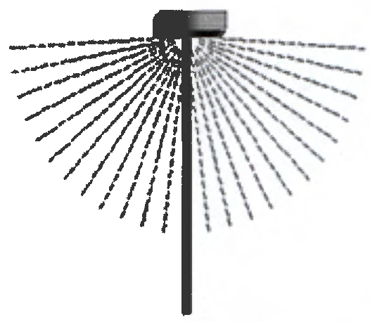
Full Cutoff Fixture: An outdoor light fixture shielded or constructed in such a manner that it emits no light above the horizontal plane of the fixture.
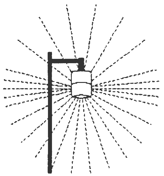
Semi-Cutoff Fixture: An outdoor light fixture shielded or constructed in such a manner that it emits no more than five percent of its light above the horizontal plane of the fixture, and no more than 20 percent of its light ten degrees below the horizontal plane of the fixture.
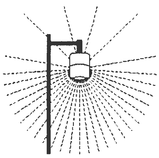
Cutoff Fixture: An outdoor light fixture shielded or constructed in such a manner that no more than two and one-half percent of the total light emitted by the fixture is projected above the horizontal plane of the fixture.
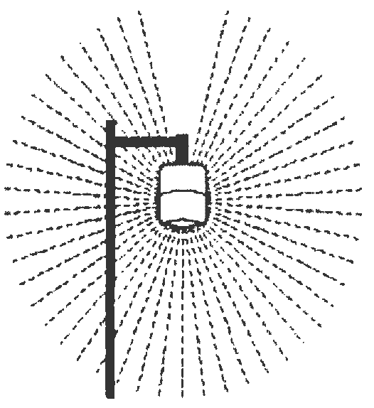
Non-Cutoff Fixture: An outdoor light fixture constructed in such a manner that it emits light in all directions.
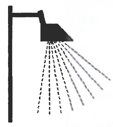
Flood Light: A form of lighting designed to direct its output in a diffuse, more or less specific direction, with reflecting or refracting elements located external to the lamp.
(Ord. No. 2019-06, § II(Att. A), 3-12-19)
5.10.01. - General Standards Wildlife Conservation Zone and Lighting.
All exterior artificial light sources used to illuminate buildings, grounds, structures, pools, fountains, landscape, roadways, signs, and other site amenities within the Wildlife Conservation Zone, including construction, security, and walkway lighting shall comply with the following standards:
(1)
The point source of light or any reflective surface of the light fixture shall not be directly visible from the beach; and
(2)
The light shall not directly or indirectly illuminate any portion of the beach or dune system seaward of the crest of the primary dune.
Lights mandated by Federal regulations (e.g. Federal Aviation Administration) for illuminating obstructions in navigable airspace and lights required by the U.S. Coast Guard for boat navigation are exempt from the provisions of this section provided such lights have been reviewed and approved in accordance with requirements of the Federal Endangered Species Act. Also exempted are traffic signals and traditional holiday lights used outside the sea turtle nesting season.
(Ord. No. 2019-06, § II(Att. A), 3-12-19)
5.10.02. - Standards for new construction activities.
In order to minimize the impacts of artificial lighting on nesting sea turtles and their hatchlings, and other coastal wildlife, the following standards shall apply to exterior artificial light sources on all new coastal construction (including redevelopment and substantial improvements) within the Wildlife Conservation Zone for which a building permit was issued on or after the date of adoption of this ordinance:
(1)
All exterior light sources shall be compliant with the general standards set forth in Section 5.10.00 of this ordinance.
(2)
Only Wildlife Lighting as defined in this ordinance, shall be used for all exterior applications, with the exception that long-wavelength lamps are only required in fixtures within line-of-sight of the beach.
(3)
Up-lighting by high intensity discharge lamps is prohibited. Up-lighting by sources other than HID lamps is permitted if the illuminated object is not visible from the beach.
(4)
Light kits on exterior ceiling fans are prohibited.
(5)
Lighting that does not conform to the definition of Wildlife Lighting (e.g. not fully shielded) may be used for interior open-air courtyards provided the light fixture is positioned under an eve, overhang, or other type of structure such that light is not permitted to escape directly skyward and uses an incandescent lamp 25 watts or less, a compact fluorescent lamp 11 watts or less, or a long wavelength light source.
(6)
Pole-mounted lights shall only be used for those applications where mounting the lights at lower elevations cannot practicably achieve the foot candles required to comply with the minimum light levels set forth in applicable State and/or Federal laws, rules and regulations designed to protect public health, safety or welfare. If required pole-mounted lights shall be the minimum height necessary for their intended application and shall comply in all respects with the general standards set forth in Section 5.10.00. Pole-mounted lights shall not be used for pathway lighting.
(7)
Lighting of dune walkovers and elevated crossovers to the beach landward of the crest of the primary dune shall be fully compliant with the general standards set forth in Section 5.10.00 of this ordinance. Unless otherwise prohibited by State rules, regulations, or permits, lighting of dune walkovers and elevated crossovers seaward of the crest of the primary dune shall consist of recessed, embedded, or fully shielded Wildlife Lighting with long-wavelength lamps. This lighting shall not directly illuminate the beach. Indirect illumination of the beach is permissible if it is effectively controlled by an activation device(s) such that the lights only come on when a person enters the walkover and are automatically deactivated upon exit. In addition, this lighting is only allowed on commercial properties and walkovers providing common beach access for residential neighborhoods.
(8)
Temporary lighting of construction sites, if not otherwise prohibited under FAC 62B-33.0015(1)(m) shall be restricted to the minimal number of lights necessary to conform to State and/or Federal safety regulations (e.g., OSHA). These lights shall comply with all of the general standards listed in Section 5.10.00.
(9)
Interior stairwells, elevators and enclosed parking garages that allow light to escape through windows or other openings within line-of-sight of the beach shall comply with all of the general standards listed in Section 5.10.00 of this ordinance.
(10)
Signs shall be sited on the landward side of structures, when possible. Signs that must be placed on the seaward side of structures shall be positioned when possible such that they are not in line-of-sight of the beach and shall be mounted perpendicular to the beach. All signs shall be externally illuminated from above (downward) with full cut-off luminaires. If placement of signs within line-of-site of the beach is unavoidable, long-wavelength lighting, such as amber or red LED lamps shall be required.
(11)
Tinted glass shall be installed on all windows and glass doors.
(12)
Roadway lighting within line-of-sight of the beach shall use low-pressure sodium lights (LPS) 55 watts or less and full cut-off fixtures mounted no higher than 20 feet above the ground. Additional shielding shall be installed if the light sources can be observed from the beach. High-intensity lighting applications not within line-of-sight of the beach shall use either full cut-off LPS 55 watts or less or full cut-off high pressure sodium (HPS) lights 150 watts or less mounted no higher than 25 feet above the ground.
(13)
Utility leased lighting including "yard" or security lights, shall comply in all respects with the standards imposed for roadway lighting in Section 5.10.01(12) above.
(14)
Outdoor light fixtures producing light directly by the combustion of fossil fuels (such as kerosene lanterns, gas lamps, etc.) shall be allowed provided such fixtures are not within line-of-sight of the beach, are top shielded, are not open torches, not mantle based, and use only a single gas jet.
(15)
Before granting any building permit the Walton County Building Department shall ensure that the County Planning and Development Division has reviewed the project lighting plans and has determined that all proposed construction complies in all respects with the standards imposed in this section. Detailed project lighting plans shall be submitted to the Division showing the location of all exterior light sources relative to adjacent nesting habitat. The plans must identify the location, number and type of lighting to be used for all fixtures. Each building permit shall include a condition that the exterior lighting actually installed under such plans must comply with the standards imposed in this section before a Certificate of Occupancy may be issued. Applicants providing evidence that proposed lighting has been approved by the Florida Department of Environmental Protection as part of a permit for construction seaward of the CCCL shall be exempt from this provision. However, this exemption shall only apply to those lights reviewed under the CCCL program. All exterior lights landward of the CCCL within the Wildlife Conservation Zone must be reviewed and approved by the County as set forth herein.
(16)
Lights installed in conformance with approved lighting plans as specified in Section 5.10.01(15) shall be considered compliant with all provisions of this ordinance.
(17)
Should the light fixtures permitted by this section fail to practically provide sufficient light to comply with the minimum light levels required by applicable State and/or Federal laws, rules or regulations applicable to public swimming pools designed to protect public health, safety and welfare, the developer, owner or owners' association may apply for variances from the standards set forth in this section, in accordance with Section 5.10.06 below.
(Ord. No. 2019-06, § II(Att. A), 3-12-19)
5.10.03. - Standards for existing lighting.
In order to minimize the impacts of artificial lighting on nesting sea turtles, their hatchlings, and other wildlife, all existing exterior artificial light sources, including utility leased lighting, within the Wildlife Conservation Zone shall be brought into compliance with the provisions of this ordinance as follows:
(1)
All exterior light sources shall be compliant with the general standards set forth in Section 5.10.00 of this ordinance.
(2)
All exterior signs within line-of-sight of the beach shall be externally illuminated from above (downward) with full cut-off luminaires.
(3)
Up-lighting by high intensity discharge lamps is prohibited. Up-lighting by sources other than HID lamps is permitted if the illuminated object is not visible from the beach.
(4)
Documented disorientation of nesting or hatchling sea turtles caused by interior lighting may be a violation of the U.S. Endangered Species Act and/or the Florida Marine Turtle Protection Act. Consequently, voluntary application of one or more of the following measures, as applicable, are encouraged to reduce or eliminate the negative effects of interior light emanating from doors and windows within line-of-sight of the beach:
A.
Install tinted glass or apply window tinting;
B.
Rearrange lamps and other moveable light fixtures away windows;
C.
Use opaque window treatments (shades. curtains, blinds, etc.) at night to shield interior lights from the beach;
D.
Turn off unnecessary lights.
(5)
Lighting of dune walkovers and elevated crossovers to the beach landward of the crest of the primary dune shall be fully compliant with the general standards set forth in Section 5.10.00 of this ordinance. Unless otherwise prohibited by State rules, regulations or permits, lighting of dune walkovers and elevated crossovers seaward of the crest of the primary dune shall consist of recessed, embedded, or fully shielded Wildlife Lighting with long-wavelength lamps. This lighting shall not directly illuminate the beach. Indirect illumination of the beach is permissible if it is effectively controlled by an activation device(s) such that the lights only come on when a person enters the walkover and are automatically deactivated upon exit. In addition, this lighting is only allowed on commercial properties and walkovers providing common beach access for residential neighborhoods.
(6)
Roadway lighting within line-of-sight of the beach shall use low-pressure sodium lights (LPS) 55 watts or less and full cut-off fixtures mounted no higher than 20 feet above the ground. Additional shielding shall be installed if the light sources can be observed from the beach. High-intensity lighting applications not within line-of-sight of the beach shall use either full cut-off LPS 55 watts or less or full cut-off high pressure sodium (HPS) lights 150 watts or less mounted no higher than 25 feet above the ground.
(7)
All existing artificial light sources must comply with the standards set forth in Section 5.10.02 in accordance with the following schedules:
A.
All single-family residences and multi-family residences with four (4) or fewer units, including rental properties: May 1, 2010.
B.
All commercial property: December 1, 2010.
(8)
Fixtures which cannot be brought into compliance with the standards set forth in this section shall be removed or disabled. However, if the removal or disabling of such fixtures will cause a property to become out of compliance with the minimum light levels required by applicable State and/or Federal laws, rules or regulations designed to protect public health, safety and welfare, the developer, owner or owners' association may apply for variances from the standards set forth in this section, in accordance with Section 5.10.06 below.
(Ord. No. 2019-06, § II(Att. A), 3-12-19)
5.10.04. - Special Events.
Special events requiring temporary lighting on or near the beach are allowed if the event organizer obtains a Special Event Permit from the Florida Department of Environmental Protection and conducts the activity in accordance with all permits conditions.
(Ord. No. 2019-06, § II(Att. A), 3-12-19)
5.10.05. - Public Notice.
Property owners that remit Tourist Development Council Bed Taxes within the Wildlife Conservation Zone must post standardized signs at conspicuous locations within common areas of their property and provide printed information notifying renters of this ordinance and it provisions. These materials will be developed by Walton County and provided at cost to affected property owners.
(Ord. No. 2019-06, § II(Att. A), 3-12-19)
5.10.06. - Enforcement and Penalties.
(1)
Property owners who do not bring exterior artificial light sources on their properties into compliance with the standards of this ordinance within the times specified in Section 5.10.02(7) hereof, or who themselves or through their tenants commit acts prohibited herein shall be guilty of a violation of this ordinance.
(2)
Enforcement procedures and penalties under this ordinance shall be those set forth in Sections 162.06 through 162.13. Florida Statutes, as may be amended from time to time.
(3)
Fines imposed for violations shall not exceed the amounts set forth in Section 162.09(2)(a), Florida Statutes.
(4)
The intent of Walton County is to enforce only the terms of this ordinance and not any state or federal laws.
(Ord. No. 2019-06, § II(Att. A), 3-12-19)
5.10.07. - Conflicts of Laws and Variances.
Requests for variances shall be limited to lighting associated with existing development and public swimming pools built under new construction.
In those cases where the lighting standards set forth in Sections 5.10.01(17) and 5.10.02. above cannot be practically achieved without conflict with applicable state and federal laws, statutes, codes, rules and regulations designed to protect the health, safety and welfare of the public, or if there has been a demonstrated good faith attempt to achieve compliance with this ordinance but minimal indirect illumination of the beach remains, a developer, property owner, owners' association or similar entity may apply to Walton County for a variance from the County's lighting standards. Variance applications shall be made as follows:
(1)
Applications shall be submitted in writing to the Walton County Planning and Development Division (Planning) and shall include documentation by a lighting professional who has successfully completed the Official Marine Turtle Exterior Lighting Course given by FWCIFWS. Each shall contain a brief explanation of: (a) the conflict of laws; and (b) the practical reasons the applicant cannot comply with Walton County's standards. Each shall also contain an alternative lighting plan that will utilize the best available lighting technology and light management practices to minimize light trespass seaward of the crest of the primary dune. The alternative lighting plan shall bring lighting on a property as close as reasonably possible to the County's standards.
(2)
Planning shall: (a) review each application; (b) make such inspections and inquiries as are necessary; (c) request additional data or meet with the applicant to clarify whether the alternative lighting plan will use only the minimum lighting necessary to meet State and Federal health, safety and welfare requirements and the best available technology to minimize light trespass; and (d) consult with the Office of the County Attorney as appropriate.
(3)
After review by the appropriate departments, including an assessment of the impact of the requested variance on environmental and conservation programs within the County, the County Environmental Manager shall make the final administrative determination to approve the variance application, approve it with conditions, or deny it.
(4)
An applicant may appeal the Environmental Manager's administrative decision to the Walton County Board of Adjustments, in accordance with the Board of Adjustment provisions of the Walton County Land Development Code. Third parties may not. On appeal, the Board may consider whether or not the conflicts of laws, with the threat of potential fines or tort liability, constitutes the "unique circumstances" and "unnecessary hardship" elements of a variance.
(5)
Lights installed in conformance with the alternative lighting plans approved through the variance process described above shall be considered compliant with all provisions of this ordinance for a period of five years. At that time the applicant will be required to re-apply. If it is determined that new technology is available that would correct the deficiency, and that said technology can be practically applied, the applicant will be required to retrofit with the new technology.
(Ord. No. 2019-06, § II(Att. A), 3-12-19)
5.10.08. - Eglin Air Force Base Compatible Lighting.
The purpose of this Section is to establish regulations for outdoor lighting in order to restrict light spillage onto areas within the Eglin Reservation and glare that may affect military operations in the Small Area Study Area. The location of the MIOD boundary in Walton County, is depicted on Exhibit 5-2, MIOD Boundary and Subzones.
A.
Applicability/General Provisions. The regulations within this Section shall apply to:
(1)
All public and private outdoor lighting installed in the Military Influence Overlay District (MIOD) after the effective date of this regulation (March 12, 2019).
(2)
Where a conflict exists between any of the regulations or limitations in this Section, and any other regulations applicable to the same area, the more stringent limitation or requirement shall govern and prevail.
B.
Exemptions. The following outdoor lighting is exempt from this Section:
(1)
Any existing luminaires which were lawfully in place according to all applicable Ordinances at the time, but which do not now comply with all applicable regulations as of the effective date of this regulation.
(2)
Outdoor lighting that produces its luminance directly through the combustion of fossil fuels.
(3)
Outdoor lighting used during law enforcement, fire, and emergency medical activities and for meteorological data gathering purposes undertaken with approval from Walton County.
(4)
Temporary outdoor lighting affixed during emergency or night-time repairs of roads and utilities.
(5)
Lighting required by law to be installed on motor vehicles.
(6)
Lighting required in compliance with Federal Aviation Administration (FAA) requirements.
(7)
Outdoor lighting installed on Federal and State facilities; however, voluntary compliance is encouraged.
(8)
Holiday lighting for a period of two consecutive months commencing on November 15.
(9)
Temporary Exemptions: Any individual may submit an application to the Walton County Planning and Development Services Division for nonexempt lighting on a temporary basis and obtain a temporary electrical permit. The permit may grant temporary lighting for a period not to exceed thirty (30) days, with at least thirty (30) days passing before another temporary electrical permit may be issued. The application for temporary lighting must contain the following information in addition to information required to obtain a temporary electrical permit:
(a)
Proposed use and location of the outdoor lighting requested.
(b)
Type of lamp(s) to be used, including manufacturer's part number and initial lumens.
(c)
Type of light fixture used, including manufacturer's model number and specification (cut) sheets indicating photometric distribution data stated in International Standards Organization (ISO) footcandle diagrams.
(d)
Starting and ending dates for temporary lighting use.
(e)
Contact information including name of applicant, affiliation (if applicable), address, telephone number and email address.
(f)
Such other information Walton County may require.
C.
Prohibited Lights and Sources of Glare. The following outdoor lighting and sources of glare are prohibited anywhere in the MIOD:
(1)
Any luminaire in a new development that is pointed or focused which causes light to be directed toward the Eglin Reservation. Such luminaire must be redirected or its light output controlled to eliminate such conditions.
(2)
When projected above a horizontal plane, beacons, laser source lights, strobe lights, or any similar high intensity light used for promotional or entertainment purposes.
(3)
Laser light shows.
(4)
Search lights.
(5)
Public outdoor display of fireworks or pyrotechnics.
(6)
Other outdoor lighting or glare that can cause distraction, flash blindness, vision impairment, or visual interference while piloting or navigating an aircraft or using night vision devices, including, but not limited to:
(a)
Series, lines, rows, or patterns of lights, whether supported by cables or other physical means, or laid upon a ground or building, that may resemble navigational or flight safety aids, landing pads, or lighting common to general or military aviation.
(b)
Lighting designed for the creation of sky glow to attract attention, in excess of the lighting used to provide safety, security, and utility.
(c)
Outdoor floodlighting by wide-angle projection above the horizontal plane.
(d)
Lighting fixtures and architectural detailing that use luminous tube lighting (neon, argon, or krypton) on a building exterior or roof.
(e)
Internally illuminated awnings.
(f)
External illumination for signs.
D.
General Lighting Standards. These general lighting standards do not apply to street lights maintained and/or operated by an electric utility or municipal entity.
(1)
The use of low-pressure sodium (LPS) lighting for outdoor, unroofed areas shall be required for all new development.
(2)
Within the MIOD Impulse Area Subzone, all outdoor lighting shall be fully screened from the Eglin Reservation, including lights from vehicles on streets, driveways and parking areas in adjacent development. Methods of screening may include, but are not limited to, fencing, structures and landscaping.
E.
Residential Lighting Standards.
(1)
Trespass lighting within residential areas may not exceed one and one-half (1½) foot-candles at the property line, with the exception of intermittent lighting, which can be up to two (2) foot-candles.
(2)
All lighting within residential areas must comply with any standards in Subsection F, Non-Residential Lighting Standards that are more restrictive, if applicable.
F.
Non-Residential Lighting Standards—General. These standards do not apply to street lights maintained and or operated by an electric utility or governmental entity.
(1)
All outdoor lighting installed on any non-residential property and which includes or exceeds two (2) foot-candles shall be full cutoff fixtures (no light output emitted above 90 degrees at any lateral angle around the fixture). See "Examples of Acceptable/Unacceptable Lighting Fixtures" on Exhibit 5-8 below. The manufactures specifications, that demonstrate full cutoff status of all outdoor lighting, is required to be approved by the Walton County Planning and Development Services Department prior to the issuance of a construction permit.
Exhibit 5-8: Sample Fixtures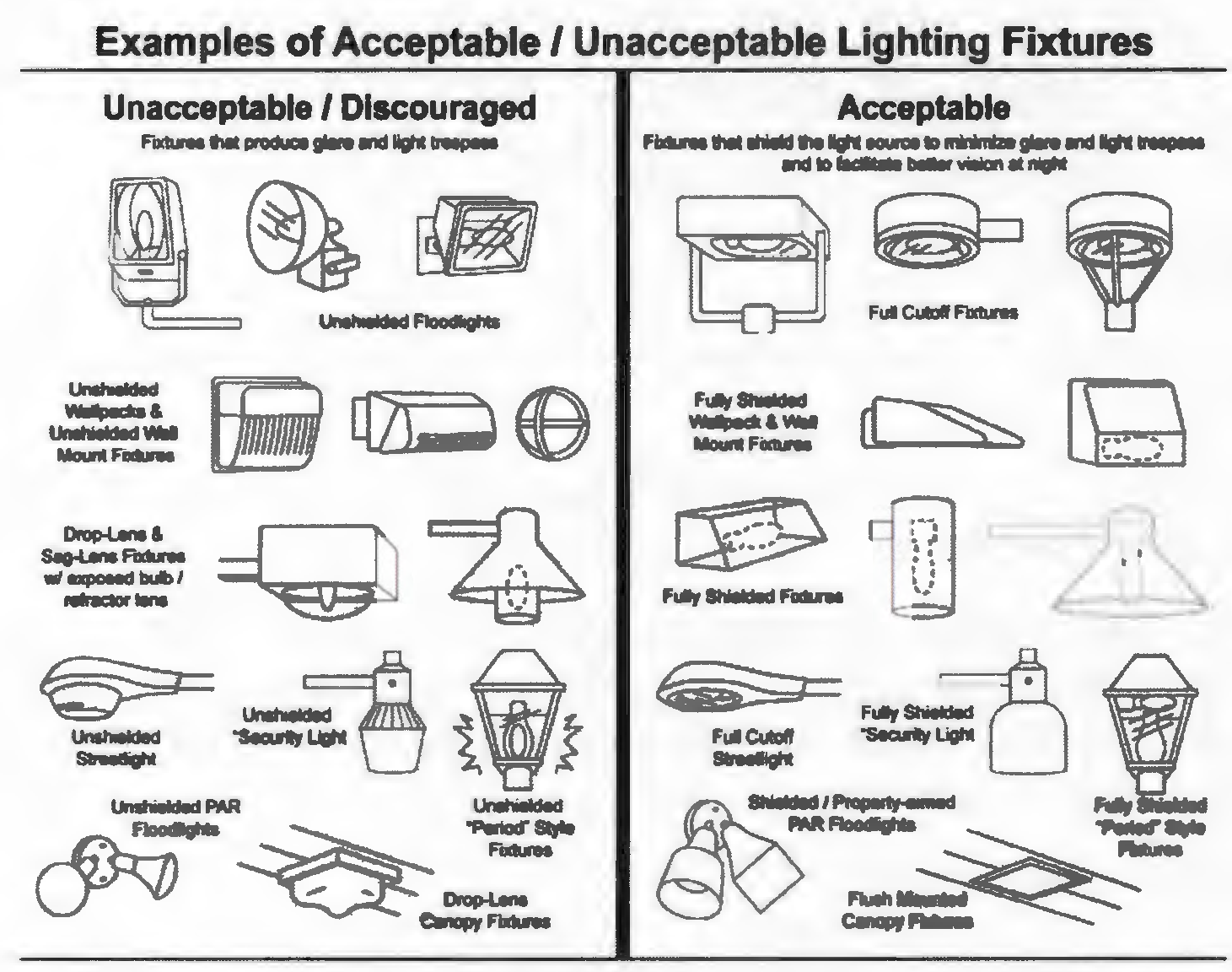
(2)
For Lighting horizontal elements such as roadways, sidewalks, entrances and parking area, fixtures must meet "full cutoff" criteria (no light output emitted above 90 degrees at any lateral angle around the fixture).
(3)
Intermittent lighting must be of the "motion sensor" type that stays on for a period of time not to exceed five (5) minutes and has a sensitivity setting that allows the luminaire to be activated only when a motion is detected on the site.
(4)
All trespass lighting shall not exceed two and one-half (2½) foot-candles measured at the property line, except that residential trespass lighting is regulated in Subsection E.
(5)
Floodlight fixtures must be aimed so as to prevent direct radiation of light into the open sky at any angle above the horizontal plane, as shown in the Exhibit 5-9 and verified using a tool such as shown in Exhibit 5-10 below:
Exhibit 5-9: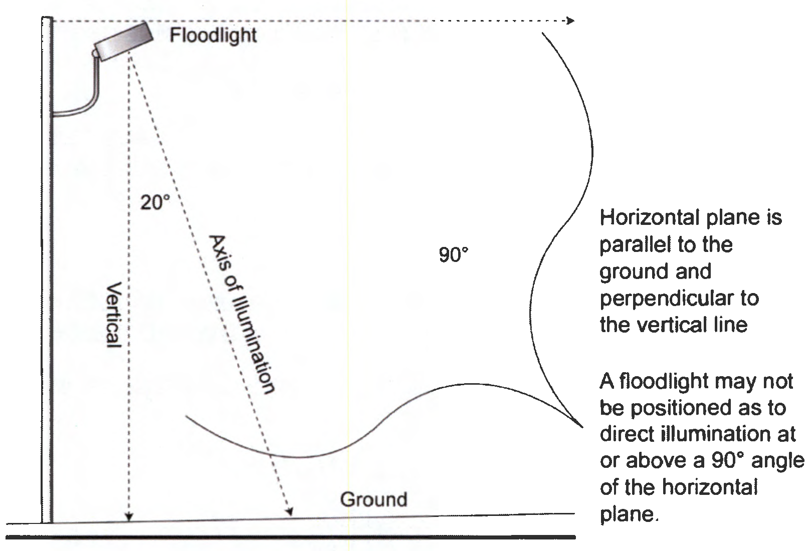
Exhibit 5-10:
(6)
With the exception of lighting which is required for security and safety such as parking lot illumination, businesses must turn off outdoor lights emitting illumination levels exceeding 2 foot-candles (fc) after 11:00 p.m.
(7)
Lighting installed to illuminate construction sites in order to secure; or
(8)
Protect equipment at night shall meet the requirements of Subsection F(1).
G.
Gasoline Stations, Outdoor Sales, Automobile Canopy Standards.
(1)
These general lighting standards do not apply to street lights maintained and/or operated by an electric utility or municipal entity. Outdoor sales areas must utilize luminaires that are fully shielded. No wall mounted lighting will be allowed.
(2)
Gasoline station canopies and vehicle canopies for other non-residential uses must utilize canopy lights that are fully recessed into the canopy or are fully shielded by the canopy.
(3)
The following average maintained illumination levels for gasoline stations must not be exceeded:
H.
Parking Lot/Parking Structure Standards.
(1)
Parking lot lights and poles shall not exceed twenty-four (24) feet above adjacent finished grade.
(2)
All outdoor parking lot lighting shall be fully-shielded and illuminated with low pressure sodium light fixtures.
(3)
In order to allow minimize reflectivity and allow for a variety of surface material options:
(a)
Surface parking lots shall be designed, coated or constructed so that illumination levels are no more than what is reflected from asphalt at an average of twenty (20) foot-candles.
(b)
Top decks of parking structures shall be designed, coated or constructed so that illumination levels are no more than what is reflected from asphalt at an average of fifteen (15) foot-candles.
(4)
One hour after closing, businesses must turn off at least fifty percent (50%) of lighting luminaires in surface parking lots and on top decks of parking structures; however, those luminaires turned off may be set to function utilizing a motion detector system or dimmer.
I.
Outdoor Sign Lighting Standards.
(1)
All signs located within five miles of Eglin Air Force Base shall be positioned in such a manner and contain "dark sky" approved shielding devices so as to significantly reduce spillover light affecting the military installation and operations. In no instance shall signs be positioned to face parallel to the adjacent boundaries of Eglin Air Force Base or its runways.
(2)
On-premise signs may remain illuminated during regular business hours, but may not be illuminated later than one-half (½) hour after the business is no longer open to the public, nor prior to the daily opening of the business to the public.
(3)
Single-tenant on-premise signs shall be illuminated at a level no greater than seven (7) foot-candles measured at five (5) feet from the light source. Multi-tenant on-premise signs shall be illuminated at a level no greater than twelve (12) foot-candles measured at five (5) feet from the light sources.
(4)
Exterior means of illumination utilized for on-premise signs shall be positioned in a "top down" manner as depicted in Exhibit 5-9. Bottom mounted fixtures shall not be used for on-premise signs.
(5)
Conventional non-digital off-premise signs shall employ an illumination system utilizing no more than two (2) luminaires to illuminate each sign message area (face). Each luminaire shall employ a refractor and hood that focuses the light onto the sign face and each luminaire may not exceed 400 watts.
(6)
All on-premise and off-premise digital signs shall be illuminated at a level no greater than 0.3 foot-candles over ambient light levels for the location and time and shall employ light cutoff devices, such as louvers, to minimize light escaping above the horizontal plane.
(7)
Nothing in this section is interpreted to authorize signs that are prohibited in other areas throughout Walton County.
J.
Street Lighting Standards.
(1)
This subsection regulates the illumination levels for street lights that are installed on any street operated and/or maintained by an electric utility or governmental entity. Such lighted shall be designed to follow the American National Standard Practice for Roadway Lighting under IESNA.
(2)
Street light illumination must follow the guidelines on Item 4 of this Subsection, unless a licensed professional engineer, trained and experienced in the science of illumination engineering, deems other illumination levels based on IESNA standards more appropriate for existing conditions and staff concurs with this assessment.
(3)
All new standards street lights within Critical Approach 1 or 2 subzones shall utilize full cutoff type luminaires that are installed level to the ground in two intersecting perpendicular planes see exhibit below, and should be horizontally level in all directions.
(4)
New ornamental street lights must be classified as either IES "Full Cutoff" or IES "Cutoff" as determined by a valid photometric report. This report must be generated for the specified model by a qualified testing lab (testing to IES Standards) and must include a full vertical evaluation through 180 degrees, otherwise that fixture will be unacceptable.
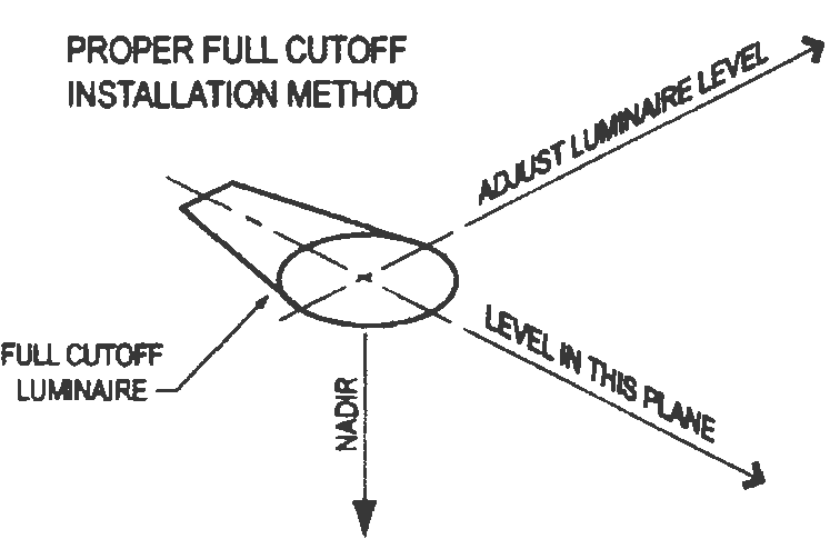
K.
LEED Standards. Leadership in Energy and Environmental Design (LEED) certified lighting that meets the minimum standards of this Section may be substituted for the standards in this Section, if approved by the Walton County Planning and Development Services Division Director during the permitting process.
L.
Tower and Structure Lighting Standards. Any tower and structure lighting shall conform with current Federal Communications Commission (FCC) or Federal Aviation Administration (FAA) regulations.
M.
Automated Teller Machine Lighting Standards. Unmanned automated teller machines (ATM) shall utilize fully shielded or full cutoff luminairies.
N.
Outdoor Lighting Plan Required. All development shall submit an outdoor lighting plan at the time of a site plan, subdivision or building permit application to determine compliance with the requirements of this Section. The outdoor lighting plan shall be prepared by a professional engineer or other highly qualified lighting specialist acceptable to Walton County.
O.
Maintenance of Nonconforming Luminaires.
(1)
All luminaires lawfully in place prior to the effective date(s) of this regulation (March 12, 2019) shall have legal nonconforming status.
(2)
Minor repair and maintenance of legal nonconforming luminaires up to 50% of the replacement value is allowed, however any alteration in excess of 50% of the replacement value shall terminate the nonconforming status of that fixture/use and at that time, all standards of this regulation must be met.
(Ord. No. 2019-06, § II(Att. A), 3-12-19)
5.11.01. - Definitions.
Environmentally Sensitive Areas means areas that include but not limited to environmentally significant wetlands and isolated wetlands over one acre in size.
Environmentally Significant Wetlands means those wetlands located within 300 feet of the mean high water line of the following water bodies and their tributaries:
Choctawhatchee Bay Shoal River
Choctawhatchee River Intracoastal Waterway
Bruce Creek Seven Runs Creek
Lafayette Creek Morrison Springs
All Outstanding Florida Waters Alaqua Creek
Black Creek Natural Bridge Creek
Environmentally Significant Water Bodies means those rivers, creeks, streams, Choctawhatchee Bay and other bodies of water associated with Environmentally Significant Wetlands.
Isolated Wetlands means any area that is determined to be a wetland in accordance with Chapter 62-340, F.A.C., but that does not have any connection via wetlands or other surface waters to the waters as defined in Rule 62-312.030, F.A.C.
Jurisdictional Wetlands means any area that is determined to be a wetland and is connected via wetlands or other surface waters to the waters defined in Rule 62-312.030, F.A.C.
New Mining Operations means mines established after August 14, 2007.
(Ord. No. 2019-06, § II(Att. A), 3-12-19)
5.11.02. - Development Standards.
The development standards for new mining operations shall be in accordance with the following (Note: These standards replace the Interim "Best Management Practices" for Borrow Pits which were approved on July 22, 2008):
A.
Buffers:
1.
A 50' buffer of existing vegetation shall be preserved around the perimeter of the site.
2.
A 150' buffer zone of existing vegetation shall be preserved landward from the upland edge of an environmentally significant wetland.
3.
A 100' buffer zone of existing vegetation shall be preserved landward from the upland edge of an isolated wetland or jurisdictional wetland which is not considered an environmentally significant wetland.
4.
A 150' buffer zone of existing vegetation shall be preserved landward from the mean or ordinary high water line of an environmentally significant waterbody.
5.
A 100' buffer of existing vegetation shall be preserved landward from the mean or ordinary high water line of any creek, river, stream or other water body which contains running water and is not an environmentally significant waterbody.
6.
If the County deems that the existing vegetation is insufficient to protect the environmentally sensitive area from the adverse impacts of the mining activity, or if the existing vegetation has been disturbed or removed from the property before application for a development order is made, the County may require the planting of supplemental natural vegetation in the required buffer. The applicant shall prepare and submit a replanting plan or a supplemental planting plan to the County for approval. The supplemental plantings shall be of sufficient size and quantity that the functions of the natural buffer will be maintained.
B.
Setbacks:
1.
A 100' setback of any public or private right-of-way.
2.
A 25' setback of the side or rear property line of abutting property with a land use of Heavy Industrial or Commercial.
3.
A 100' setback of any side or rear property line of abutting property located in any land use that allows residential development if the parcel does not contain a residential structure at the time of the proposed mining operation.
4.
A 1,000' setback from the closest portion of a residential or institutional structure.
5.
The County may reduce setbacks provided the applicant has provided competent and substantial evidence that a lesser requirement will not adversely affect the public health, safety, or welfare.
6.
The County may require increased setbacks to protect wellheads, environmental resources and/or adjacent properties from adverse impacts.
C.
Security/Fencing:
1.
The mining operation shall be enclosed with a security fence and gate as specified in the approved development order. This requirement may be waived or partially waived only where natural geographic features of the site serve to sufficiently restrict site access such that the safety and welfare of the public are protected.
2.
Warning signs of at least 6 (six) square feet shall be permanently posted 10 (ten) feet within the perimeter fence lines of the mining operation. These signs shall be placed at each corner of the fence line and also not more than 100 yards apart along any part of the fence line that is accessible to the public. The sign shall be printed in letters not less than 5 (five) inches in height and shall state "No Trespassing" (or another approved appropriate warning), the name of the mining operation, and a telephone number at which the mining operation may be contacted in case of an emergency. The signs shall be positioned to be clearly visible from outside the fence line.
D.
Dust prevention/Air quality: The mining operation shall be operated to minimize dust emissions.
E.
Operating hours: Excavation activity shall be conducted Monday through Friday, between the hours of 7:00 a.m. and 6:00 p.m., unless otherwise approved by the County.
F.
Protection of easements: No excavation, except for ditches permitted by the NWFWMD, is permitted within 25' of the boundary line of a drainage or utility easement. A waiver may be granted with the consent of the easement holder.
G.
Water impacts: Mining operations shall not have an adverse impact on the quality or quantity of groundwater or surface water of surrounding properties and must meet all the standards of the health department and the NWFWMD. Mining operations are prohibited within designated Wellhead Protection Zones as defined by Section 4.04.02 and Aquifer Recharge Areas as defined by Section 4.04.01.
H.
Required slope: The standard slope for the side of an excavation shall be no steeper than one foot vertical drop for each four feet of horizontal distance measured from the edge of the excavation at existing grade unless an engineer or geologist certifies, to the satisfaction of the County, that an angle of repose exceeding this ratio will prohibit any potential erosion or slumping.
I.
Burning: Burning or incineration associated with an excavation will require permits in accordance with the County, State, and Federal laws.
J.
Storage of materials/Dumping of solid waste: No litter, solid materials, inorganic materials, or solid or hazardous waste may be placed within any excavation area or stored on the mining site if the site has not been previously permitted as a solid waste disposal site by FDEP and the County. This prohibition shall also include brick, glass, ceramics, and concrete. Solid waste activities may only be permitted if the property has the proper future land use that allows such activity. Sand, topsoil, tree remnants, and other vegetative debris cleared from the mining site may be placed in or stored on an excavation site provided the storage is pursuant to a valid reclamation plan approved by the County and the materials are free of invasive species or other contaminants.
K.
Stormwater control: Stormwater may be discharged into a previously excavated area if it is included in a stormwater plan submitted by the applicant and approved by the County, and all appropriate federal, state and local permits have been obtained.
L.
Erosion control and sedimentation: Soils exposed during site alteration must be stabilized, and runoff and siltation directed toward areas approved in the mining site plan or permit to prevent off-site impacts.
M.
Noise control: Increases to ambient noise resulting from mining shall not cause a public nuisance as measured at the mining operation's property lines; nor shall mining activities generate noise in excess of that allowed by any local, regional, state, or federal laws, ordinances, rules, or regulations.
N.
Screening requirements: Where mining operations are proposed adjacent to existing residential uses, the County shall require the applicant to utilize aesthetic features to screen the site, such as fences, landscaped screening buffers, or earthen berms.
O.
Location of ingress/egress: External vehicle access shall be located to minimize danger to traffic and nuisance to surrounding properties. All external vehicle access shall be clearly marked pursuant to applicable County, state, and federal requirements.
P.
Lighting: All lighting must meet the criteria of Section 5.09.00 of the Walton County Land Development Code.
Q.
Blasting: No blasting or other use of explosives shall be conducted without proper permits from the governmental entities with jurisdiction, including the state fire marshal. Blasting shall be conducted only from Monday through Friday and during daylight hours. All mining activities must be performed in a manner that prevents vibrations of the soil from reaching a magnitude sufficient to cause damage to persons or property outside the mining operation's property.
R.
Floodplain requirements: No mining activity, with the exception of approved peat and muck mining, shall be conducted in a special flood hazard area, a waterway, lake, or stream where such mining would have an adverse effect on the special flood hazard area.
S.
Wildlife protection: Threatened and endangered species as listed by the Florida Fish and Wildlife Conservation Commission or the U.S. Fish and Wildlife Service shall be protected to the maximum extent possible in accordance with state and federal regulations. The applicant shall submit documentation of their coordination with these agencies, where required by law.
T.
Archaeological/Historical protection: Archaeological and historical sites, cemeteries, and burial grounds shall be preserved in accordance with applicable federal, state, regional, and local laws, ordinances, rules, and regulations. The State Division of Archives, History and Records Management shall be consulted to determine what resources may be located on a mining site. Any archaeological artifacts found during excavation shall be subject to the archaeological provisions of the Walton County Comprehensive Plan.
(Ord. No. 2019-06, § II(Att. A), 3-12-19)
5.11.03. - Reclamation.
A reclamation plan shall be submitted as part of the application. Walton County reclamation plan requirements (in addition to those required by FDEP) are as follows:
A.
Reclamation must commence within six months after cessation of mining activities and be completed within two years.
B.
The Reclamation Plan must provide for the removal of any invasive species in the area to be reclaimed.
C.
All upland areas must have established ground cover within one year after planting, over 80% of the reclaimed upland area, excluding roads, groves, or row crops. Bare areas shall not exceed one-quarter (¼) acre.
D.
Upland forested areas shall be established to resemble pre-mining conditions when practical and consistent with proposed land uses. At a minimum, 10% of the upland area will be re-vegetated as upland forested areas with a variety of indigenous tree species. Upland forested areas shall be protected from grazing, mowing, or other adverse land uses to allow establishment. An area will be considered to be reforested if a stand density of 200 trees/acre is achieved at the end of one year after planting.
E.
The County may require reclamation in phases. The County shall determine the stages or intervals at which the various stages of reclamation must be commenced and completed.
F.
All debris, litter, junk, worn-out or unusable equipment or materials shall be removed from the mining site.
G.
All temporary buildings, pipelines, and other man-made structures shall be removed with the exception of those that are of sound construction with potential use in connection with the reclamation goals.
H.
Slopes of any reclaimed land area shall be no steeper than four (4) feet horizontal to one (1) foot vertical to enhance slope stabilization and provide for the safety of the general public. For long continuous slopes, mulching, contouring, or other suitable techniques shall be used to enhance stabilization. Should washes or rills develop after revegetation and before final release of the area, the permittee shall repair the eroded areas and stabilize the slopes to eliminate any further erosion.
I.
Clean gravel, sand, topsoil, tree and other vegetation remnants may be used as fill as part of the reclamation plan provided they are free of invasive species or contaminants. Any such spoil piles not used in connection with reclamation must be removed from the mining site.
J.
The reclamation plan must contain the following information and be drawn to a reasonable scale depending upon the size of the project as specified by the Environmental Division of Public Works Department.
1.
Show existing natural and manmade features, including watercourses, water bodies, wetlands, general vegetative communities and concentrations, streets, utility lines, wells, septic tanks, drain fields, chemical/fuel storage tanks (surface and subsurface), easements and similar physical characteristics of the site.
2.
Show all areas to be reclaimed by depicting and/or describing what manmade and natural features will exist when the reclamation plan is completed. This requirement includes the depiction of mitigation or preservation areas established for wildlife species.
3.
Depict at least two (2) typical cross sections with elevations, generally oriented north to south and east to west, reshaped. Water elevations shall also be shown.
4.
Depict any area to become a lake.
5.
Depict any required fences, walls, or vegetative buffers, including at least one cross-section.
6.
Document the type and location of vegetation to be preserved or planted including, but not limited to, grass(es), tree(s) and shrubs, and document the methods to be used to control erosion.
7.
Provide any additional information requested by the County in order to depict the intended reclamation plan.
8.
In the event that reclamation is not completed in accordance with the approved plan and within the required time periods, the County may, in its sole discretion, provide a reasonable extension of time to the permittee or draw upon the reclamation performance assurance.
(Ord. No. 2019-06, § II(Att. A), 3-12-19)