
Paxton City Zoning Code
APPENDIX PDO-2
- KAIYA CONCEPTUAL PUD OVERLAY DISTRICT PDO-2
A.
Overlay District Legal Description: The boundary of the overlay district includes current tax ID parcels — 27-38-18-16000-002-0000, 27-38-18-16000002-0030, 27-38-18-16000-027-0020, and 27-38-18-16000-027-0000 as described in the following legal description:
LEGAL DESCRIPTION (AS WRITTEN)
Commencing at the northwest corner of the east half of the southeast quarter of Section 21, Township 3 South, Range 18 West, Walton County, Florida; thence south 88 degrees 46 minutes 29 seconds east along the north line of said section a distance of 11.17 feet to a point; thence departing the north line of said section south 01 degrees 23 minutes 38 seconds west a distance of 1397.80 feet to a point on the southern right of way of County Road 30A, said point being the point of beginning; thence departing said southern right of way south 02 degrees 03 minutes 31 seconds west along a line that is 93.54 feet east of and parallel to the west line of said east half of the southeast quarter a distance of 1032 feet, more or less, to a point on the waters edge of the Gulf of Mexico; thence meander northwesterly along said waters edge a distance of 98 feet, more or less, to a point; thence departing said waters edge north 02 degrees 03 minutes 31 seconds east a distance of 1039 feet, more or less, to a point on the southern right of way of County Road 30A; thence south 66 degrees 13 minutes 42 seconds east along said southern right of way a distance of 100.68 feet to a point, said point being the point of beginning; and
LEGAL DESCRIPTION (AS WRITTEN)
Commence at the northwest corner of the east half of the southeast quarter of Section 27, Township 3 South, Range 18 West, Walton County, Florida; thence proceed south 89 degrees 33 minutes 20 seconds east, along the northerly boundary line of the southeast quarter of said section, a distance of 83.51 feet; thence departing said northerly boundary line, proceed south 01 degrees 16 minutes 43 seconds west, a distance of 1123.78 feet; thence proceed north 67 degrees 12 minutes 23 seconds west, a distance of 74.88; thence proceed south 01 degrees 18 minutes 36 seconds west, a distance of 160.20 feet to a point on the curved northerly right of way line of Walton County Road C-30A (100' R/W) thence proceed along the arc of said curve through a central angle of 19 degrees 17 minutes 21 seconds, an arc distance of 985.54 feet, a chord bearing of north 76 degrees 46 minutes 07 seconds west, and a chord distance of 980.89 feet; thence departing said northerly right of way line, proceed north 01 degrees 13 minutes 54 seconds east, a distance of 1038.37 feet to the aforesaid northerly boundary line of the southeast quarter of Section 27; thence proceed south 89 degrees 33 minutes 20 seconds east, along said northerly boundary line, a distance of 946.82 feet to the point of beginning.
B.
Permitted Uses: The property covered by this overlay district contains more than one land use designation (TND, SN and NI). As allowed by Comprehensive Plan Policy L-I.12.1, the PUD overlay district may include all of the uses allowed in those categories but may not exceed the total allowable densities and intensities for each of those uses. The allowable uses approved for this overlay district more specifically described in the Final Order and Staff Report referred to in Section C below.
C.
Regulatory Conditions Pertaining to the Development Plan are as specifically described in the:
a.
Walton County Board of County Commissioners Final Order for the Kaiya Conceptual PUD and Master Plan as approved on May 10, 2016 and filed on May 11, 2016; and
b.
Walton County Planning and Development Services Division Staff Report prepared by Mac Carpenter, AICP, dated May 10, 2016; and
c.
Walton County Comprehensive Plan and Land Development Code for development standards not otherwise specifically covered in the above described documents.
D.
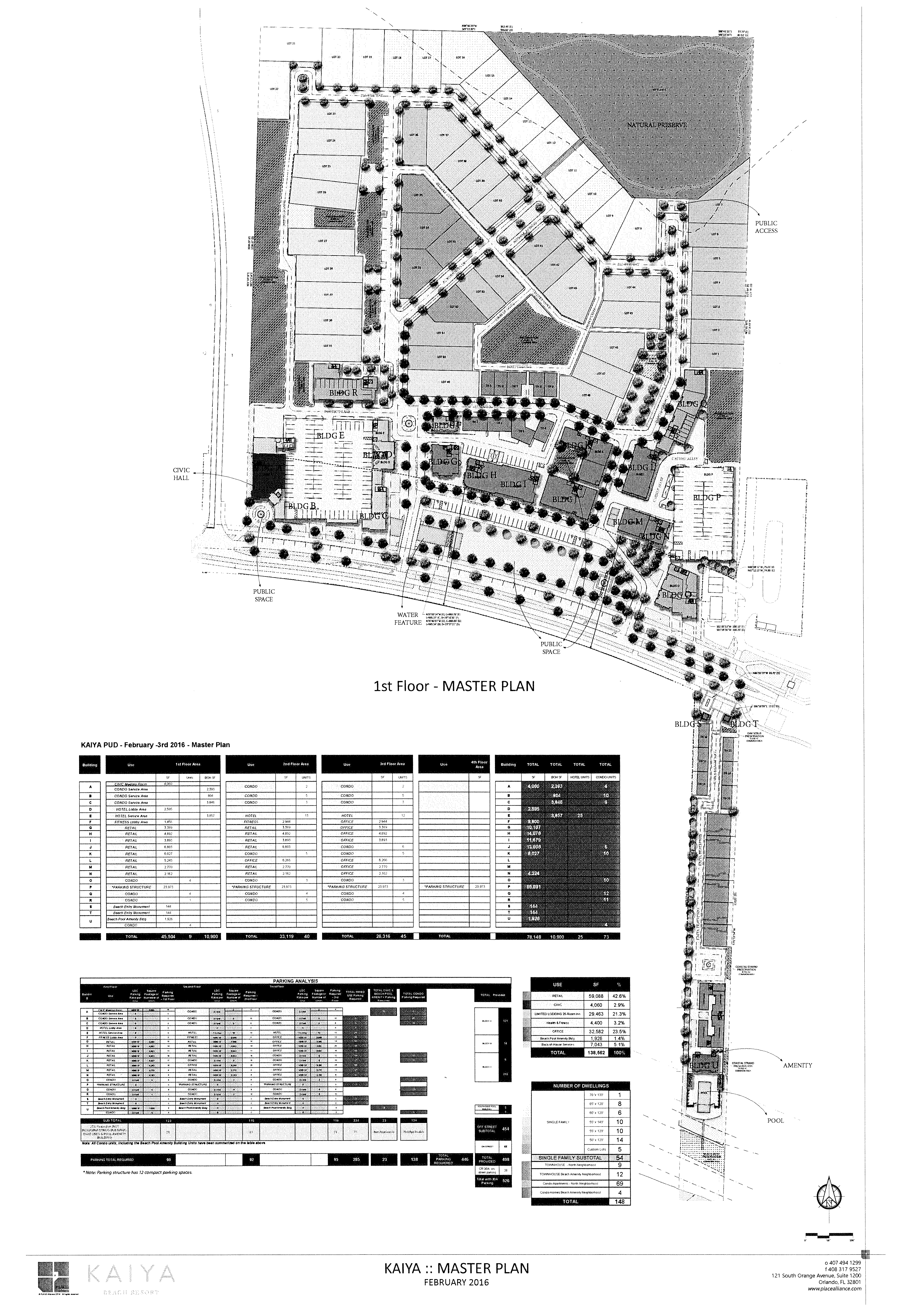
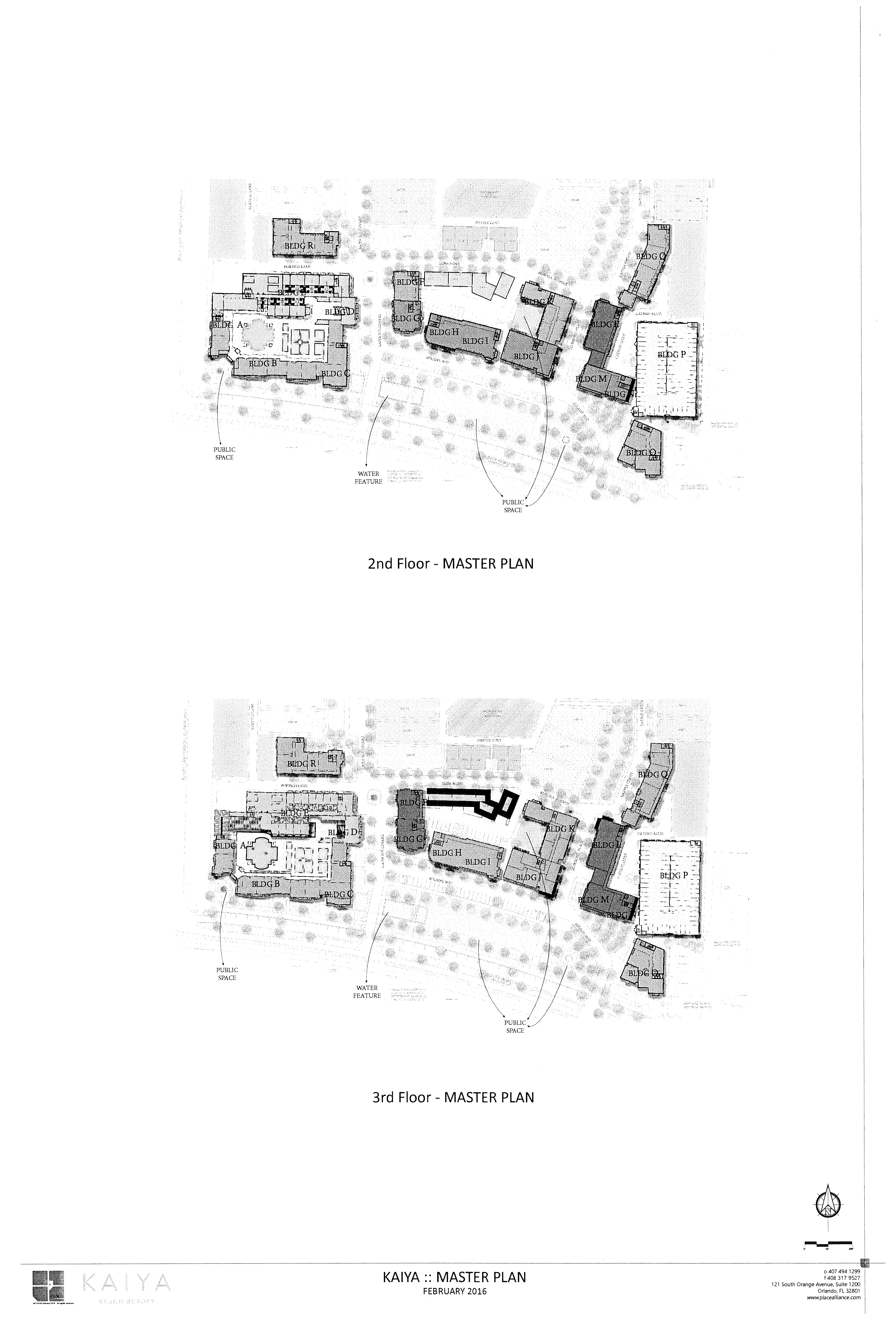
Kaiya Conceptual PUD Master Plan Map:
(Ord. No. 2016-18, § 2, 6-27-16)