
Peoria County Unincorporated
City Zoning Code
City Zoning Code
ARTICLE 3
- DEVELOPMENT REVIEW PROCEDURES
Sec. 3.1 - General Procedures
3.1.1
Intent.
1.
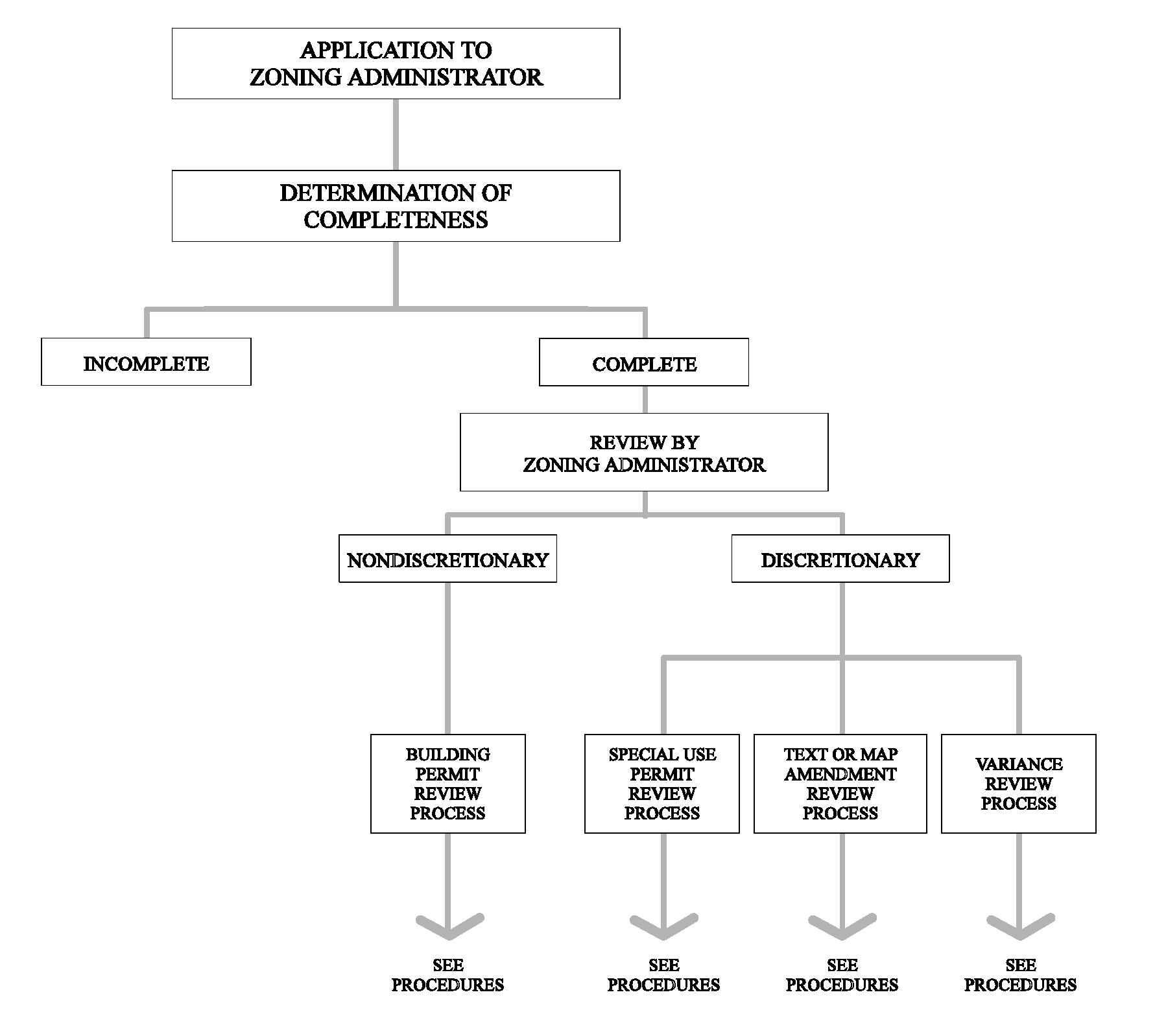
The intent of this section is to ensure that the County is diligent in processing applications for development approval. As this section denotes, the County's development review procedures diverge, depending on whether the type of requested approval is discretionary or ministerial in nature. If discretionary (i.e., special use, variance, or text amendment), an application for development approval shall be subject to additional levels of scrutiny by the ZBA and possibly the County Board. If ministerial, the Zoning Administrator shall conduct all aspects of the application review and shall approve and issue appropriate permits.
2.
Except as otherwise specified, this section is also intended to contain all of the County's development review procedures and includes relevant time frames for County action. In addition, except as otherwise specified, this section contains the notice and conduct provisions that are applicable to all public hearings by the ZBA required by any section of these regulations.
3.1.2
Pre-Application Conference.
1.
Request and Scheduling. An applicant for any type of development approval may at his option request an informal conference with the Zoning Administrator prior to filing an application.
2.
Purpose of Conference. The pre-application conference shall be informal and its purpose shall be to discuss the proposals, views, and concerns of the applicant and the Department of Planning and Zoning to determine whether any of the application requirements should be waived or whether any additional information will be required.
3.
Letter of Understanding. Within ten (10) days after a pre-application conference, the Zoning Administrator shall transmit a Letter of Understanding to the applicant setting forth the substance of the pre-application conference. No representation of the Zoning Administrator or any other County official or employee at the pre-application conference or at any other time shall be binding on the County with respect to any application subsequently submitted if such representation is found to be in error or contrary to the policy of the Department of Planning and Zoning or these regulations.
3.1.3
Application Submission Requirements. All applications for development approval shall be submitted to the Zoning Administrator in a form specified by the Zoning Administrator, accompanied by the payment of a fee as set forth in Appendix A. Applicants for development approval may be required to submit additional information which the Zoning Administrator or the decision making body may deem necessary to review the proposed development.
3.1.4
Determination of Completeness of Application.
1.
Determination of Completeness. Within fifteen (15) days after receipt of an application for development approval, the Zoning Administrator shall determine whether the application is complete. If the Zoning Administrator determines that the application is complete, he shall notify the applicant in writing that the application has been accepted for filing. If he determines that the application is not complete, he shall notify the applicant, specifying the deficiencies of the application, including any additional information which must be supplied. No further action shall be taken by the County on the application until the deficiencies are corrected.
2.
Remedy of Deficiencies. If the applicant fails to correct the specified deficiencies within thirty (30) days of the notification of deficiency, the application for development approval shall be deemed withdrawn unless the time frame is extended by mutual agreement of the applicant and the Zoning Administrator.
3.
Effect of Determination. The time limits for completion of review set out in these regulations shall commence on the date that the application is determined complete.
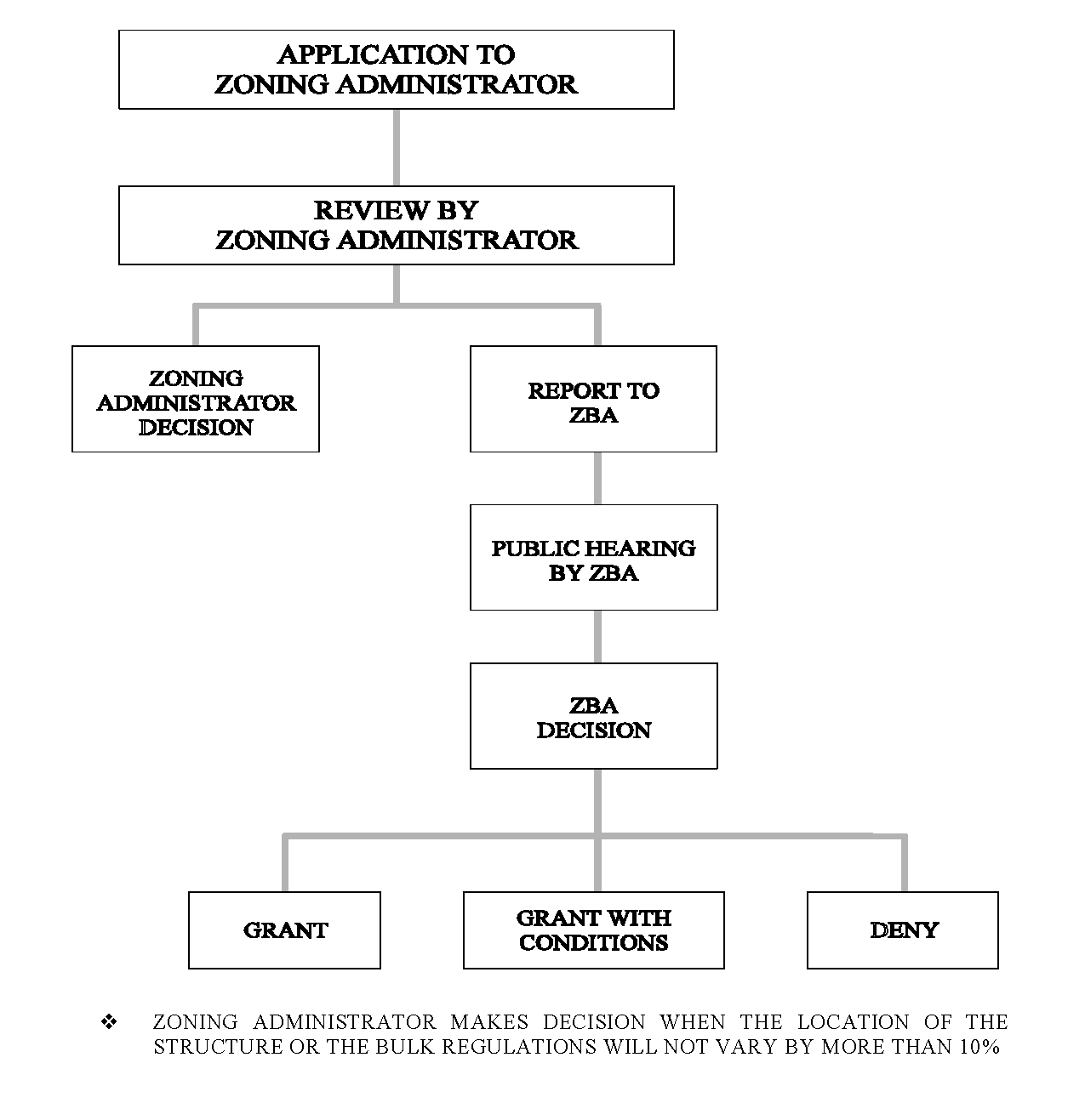
3.1.5
Review by Zoning Administrator. The Zoning Administrator shall review the complete application for development approval in accordance with Section 3.4 ("Development Permitted as of Right") if the development is permitted as of right, Section 3.5 ("Special Use Permits") if the development requires a special use permit, Section 3.6 ("Text and Map Amendments") if the development requires an amendment to the text of these regulations or the Zoning District Map, Section 3.7 ("Variances"), if a variance is requested, and if necessary Section 3.9 ("Telecommunications Carrier Facilities Variances"), if a variance is requested by a telecommunications carrier facility.
3.1.6
Waiver of Time Limits.
1.
By Agreement. Any time limit imposed by these regulations (except for time limits in Section 3.9 ("Telecommunications Carrier Facilities Variances") and except for appeals to the ZBA) may be waived or extended by agreement of the applicant and either the Zoning Administrator, the ZBA, or the County Board, depending on the stage of development approval.
2.
Automatic Waiver. Any applicant who requests a continuance of a public hearing at which his application is being considered, or who requests an extension of any time limit imposed on him by statute or these regulations, shall be deemed to have agreed to an extension of that time limit.
3.1.7
Examination and Copying of Application. Subject to Illinois state law, any person may examine any application for development approval and other material submitted in regard to that application, and may obtain copies of the application and other materials upon reasonable request and payment of a fee to cover the actual cost of such copies.
3.1.8
Successive Applications. Whenever any application for development approval for a variance, special use permit or an amendment to the Zoning District Map is denied, an application involving the same property shall not be accepted for filing within six (6) months from the date of denial, unless the subsequent application involves a development proposal which is materially different from prior proposals, in the opinion of the Zoning Administrator, or is responsive, in the opinion of the Zoning Administrator, to negative findings set forth in the denial of the prior application.
PEORIA COUNTY
GENERAL REVIEW PROCEDURES
Sec. 3.2 - Building Permit
3.2.1
General Requirement. No building or structure shall be constructed, erected, enlarged, structurally altered, converted, or relocated unless a building permit has first been issued by the Zoning Administrator. The conversion of a recreational vehicle, mobile home, semi-trailer container, or enclosed box trailer into an accessory structure shall be prohibited.
3.2.2
Basis for Issuance. A building permit shall only be issued after the Zoning Administrator determines that the proposed development is in compliance with all requirements of these regulations and all other applicable regulations of the County, including but not limited to the Illinois Environmental Barriers Act (410 ILCS 25/1 et seq., now in effect or as hereafter amended) its building and property maintenance code, swimming pool, subdivision, erosion control, and floodplain regulations.
In addition, a building permit shall only be issued for subsections 3.2.3-1, 3, 4, 5, 6, 8, 9, and 10, after the Zoning Administrator determines that the parcel of land involved was divided in compliance with the Illinois Plat Act, 765 ILCS 205/0.01 et seq., now in effect or as hereafter amended.
3.2.3
When Permit Required. A building permit shall be obtained from the Zoning Administrator before any of the following activities are commenced:
1.
The construction, erection, or development of any building or structure, either by itself or in addition to another use, including buildings or structures to be used for agricultural purposes;
2.
The expansion, change or re-establishment of any nonconforming use, including the change from one use to another;
3.
The construction or alteration of a swimming pool;
4.
The reconstruction or structural alteration of any building or structure or part thereof;
5.
The movement or relocation of any building or structure or part thereof;
6.
The erection of any communication tower that is thirty-five (35) feet or taller;
7.
The demolition of any building or structure, including buildings or structures used for agricultural purposes;
8.
The alteration of the interior of any institutional, commercial, industrial, residential, or multifamily structure;
9.
The interior alteration of any structure located in the floodplain;
10.
The construction of a fence, other than ornamental (as defined in Section 7.4 ("Fences")) or agricultural fences;
11.
Installation of new electrical service or equipment, and repairs to or replacement of existing electrical systems;
12.
Installation or alteration of any heating, ventilating, air conditioning or other mechanical system;
13.
Installation or alteration of any plumbing system.
14.
The construction, patching or repair of any asphalt pavement parking area or driveway.
3.2.4
Exemptions. No building permit shall be required for the following:
1.
Routine maintenance or repair of buildings, structures, or equipment, such as siding, veneering, repainting or re-roofing;
2.
An accessory use or structure that does not have to meet front, side or rear setback requirements provided for in Section 5.13 ("Accessory Structures and Uses");
3.
The erection of a portable swimming pool if the capacity of such pool is under twenty-four (24) inches in depth or has a surface area less than one hundred twenty-five (125) square feet;
4.
Any accessory structure that is less than twenty-five (25) square feet. All such structures are required to meet the setback requirements for the district in which they are located, unless otherwise exempted by these regulations;
5.
Signs allowed without a permit as listed in Section 7.5.10, Signs Allowed Without a Permit;
6.
Fences used for agricultural purposes and operations;
7.
Ornamental fencing consisting of decorative posts, lattices, arbors, trellises;
8.
Fences comprising less than one hundred (100) feet of total lineal distance;
9.
The provisions of Section 7.15 ("Swimming Pools") shall apply only to owners of private swimming pools where such owner's property is in a platted subdivision or located within six hundred (600) feet measured from the swimming pool to the nearest property line from another private residential property on which a dwelling is located.
10.
One-story detached accessory structures used as tool and storage sheds, playhouses and similar uses, provided the floor area does not exceed two hundred (200) square feet.
3.2.5
Procedure.
1.
Application. An application for a building permit shall be filed in a form prescribed by the Zoning Administrator, along with the fees and charges for building permits, plan review and inspections prescribed by Section 1.6 ("Review Fees") of these regulations. The application shall indicate and contain the following:
a.
The address of the property subject to permit, the name and address of the owner, the name and address of the applicant, if different than the owner, and the name and address of the contractor, and the estimated costs;
b.
A description of the uses to be established or expanded;
c.
A site plan in duplicate, or duplicate prints thereof, drawn to scale, showing:
1.
Actual dimensions of the lot to be built upon;
2.
Size, shape and location of the building or structure to be erected;
3.
Size, shape and locations of any existing buildings;
4.
Lot areas to be used;
5.
Auto parking areas;
6.
Type and location of water supply and sewage disposal facilities;
7.
If the permit is for a telecommunications carrier facility located in a nonresidential zoning district, the distance between the facility's supporting structure and the nearest principal residential building; and
8.
If the permit is for a multifamily, commercial, industrial or institutional development, the following must also be shown on the site plan:
a.
Ingress and egress;
b.
Off-street loading;
c.
Landscaping and bufferyards;
d.
Exterior lighting; and
e.
Location of signage.
d.
If the permit is for a single-family or two-family dwelling, or for a residential accessory structure, three (3) full sets of building plans and specifications, with square footage listed.
e.
In the case of a dispute regarding the exact location of a parcel boundary/property line, the owner shall be required to have the property surveyed to determine the boundary's exact location.
f.
Such other information as may be required by the Zoning Administrator to enforce the provisions of these regulations.
2.
Submission and Approval by Zoning Administrator. For all proposed multifamily, commercial and industrial developments, three (3) full sets of architecturally sealed building plans and specifications shall be submitted to and approved by the Zoning Administrator prior to the issuance of a building permit.
3.
Submission and Approval by Fire Protection District. All plans for proposed multifamily, commercial, industrial and institutional developments shall be submitted to and approved in writing by the appropriate fire protection district prior to the issuance of a building permit in all fire protection districts that have adopted a fire protection code and that have advised the Zoning Administrator that a plan review is required.
4.
Swimming Pools. Each application for a building permit to construct and/or install a swimming pool shall contain such information and drawings as shall be required by the Zoning Administrator for a proper understanding of the proposed work and shall comply with the provisions of Section 7.15 ("Swimming Pools") of the County Code.
5.
Telecommunications Carrier Facilities.
a.
The Zoning Administrator's review of a building permit application for a telecommunications carrier facility shall be simultaneous with the process leading to the County Board's decision under Section 3.9 ("Telecommunications Carrier Facilities Variances").
b.
If a building permit for a telecommunications carrier facility is not subject to review under Section 3.9 ("Telecommunications Carrier Facilities Variances"), the Zoning Administrator's review of the application shall be completed within thirty (30) days.
3.2.6
Issuance of Building Permit. If the Zoning Administrator determines that the proposed building or structure is in compliance with these regulations, that all required approvals have been obtained, and that all relevant fees have been paid, he shall issue a building permit.
3.2.7
Denial of Permit. The Zoning Administrator shall deny the application for a building permit if the proposed construction of the building or structure does not meet the applicable provisions required by these regulations. In addition, the Zoning Administrator shall deny the permit if the proposed principal dwelling contains less than six hundred (600) square feet of floor area; or contains less than six hundred (600) square feet of floor area above grade, in which case the permit may be processed as a special use pursuant to Section 3.5 ("Special Use Permits");
3.2.8
Fees. The applicant shall pay all costs associated with administering the building permit as set forth in Chapter 12 of the Peoria County Code, Appendix A. The fee shall be paid to the Zoning Administrator at the time of filing the application.
3.2.9
Conspicuous Posting. The building permit issued by the Zoning Administrator shall be conspicuously posted by the applicant on the property for which it was obtained in the manner prescribed by the Zoning Administrator. The building permit shall remain so posted until the applicant has obtained a permanent certificate of occupancy from the Zoning Administrator pursuant to Section 3.3 ("Certificate of Occupancy") of these regulations.
3.2.10
Changes to Approved Permits.
1.
After a building permit has been issued, no changes or deviations from the terms of the permit or the application and accompanying plans and specifications shall be made without the specific written approval of such changes or deviations by the Zoning Administrator.
2.
An amendment to a building permit which requires the payment of an additional fee, either because of an increase in the size of the buildings, a change in the scope of the work, change of contractor, or an increase in the estimated cost of the proposed work, shall not be approved until the applicant has paid the additional fees and the amendment has been properly reviewed and approved for conformance with the County's regulations.
3.2.11
Expiration of Permit.
1.
Any building permit with the exception of a demolition permit, issued by the Zoning Administrator shall expire and become null and void within one hundred eighty (180) days after the date of issuance, as shown on the building permit, unless the work approved by the permit has commenced, or unless an extension has been obtained in writing by the Zoning Administrator. The building permit shall immediately expire if the work is not completed within a period of: two (2) years for a new principal structure or substantial improvement to a principal structure, six (6) months for a swimming pool, or one year for all other work authorized by the permit. The Zoning Administrator may grant only one extension for an additional ninety-day period of time. No work authorized by any permit that has expired shall thereafter be performed until a new permit has been issued.
2.
Demolition Permits.
a.
Building permits for the purpose of the demolition of single-family residential principal or accessory structures shall become null and void within five (5) days after the date of issuance, as shown on the building permit, unless the work approved by the permit has commenced, or unless an extension has been obtained in writing by the Zoning Administrator. The Zoning Administrator may grant only one extension for an additional five-day period of time. The permit shall immediately expire if the work is not completed within thirty (30) days, unless an extension has been obtained in writing from the Zoning Administrator. The Administrator may grant only one extension for an additional thirty-day period of time. No work authorized by any permit that has expired shall thereafter be performed until a new permit has been issued.
b.
Building permits for the purpose of demolition of principal and accessory commercial, multifamily residential, industrial or agriculture structures shall become null and void within ten (10) days after the date of issuance, as shown on the building permit, unless the work approved by the permit has commenced, or unless an extension has been obtained in writing by the Zoning Administrator. The Zoning Administrator may grant only one extension for an additional ten-day period of time. The permit shall immediately expire if the work is not completed within ninety (90) days, unless an extension has been obtained in writing from the Zoning Administrator. The Administrator may grant only one extension for an additional ninety-day period of time. No work authorized by any permit that has expired shall thereafter be performed until a new permit has been issued.
3.2.12
Revocation of Permit. The Zoning Administrator has the authority to revoke and require the return of any building permit by notifying the permit holder in writing, stating the reason for such revocation.
1.
The Zoning Administrator shall revoke permits for any of the following reasons:
a.
Any material departure from the approved application, plans, or specifications;
b.
Refusal or failure to comply with the requirements of these regulations or any other applicable County regulations, including, but not limited to, subdivision, erosion control, and floodplain regulations; or
c.
False statements or misrepresentations made in securing such permit.
2.
The Zoning Administrator may revoke permits for any of the following reasons:
a.
Refusal of failure to comply with other applicable state or federal laws.
3.2.13
Violations. The Zoning Administrator shall have the authority to issue a Stop Work Order in the event of a violation of this section. The Zoning Administrator shall assess a fee for the Stop Work Order as set forth in Chapter 12 of the Peoria County Code, Appendix A.
3.2.14
Multiple Permits for the Same Construction Project. There shall be a maximum of two (2) permits issued for the same construction project for a single structure. Construction not completed by the expiration of the second permit shall be considered a violation of this section.
(Res. of 7-12-12; Ord. of 9-12-19)
Sec. 3.3 - Certificate of Occupancy
3.3.1
General Requirement. The following provisions shall apply to residential and nonresidential principal and accessory structures. No building or structure shall be occupied or used until a certificate of occupancy is issued by the Zoning Administrator after a determination that the building or structure has been constructed in accordance with the provisions of any special use permit, plat approval, or building permit. A temporary certificate of occupancy may be issued in accordance with the provisions of this section.
3.3.2
When Certificate Required. A certificate of occupancy shall be issued by the Zoning Administrator for either of the following after compliance with all provisions of these regulations has been determined:
1.
Occupancy and use of a building hereafter erected, reconstructed, enlarged, or moved; and
2.
Occupancy and use of vacant land.
3.3.3
Procedure.
1.
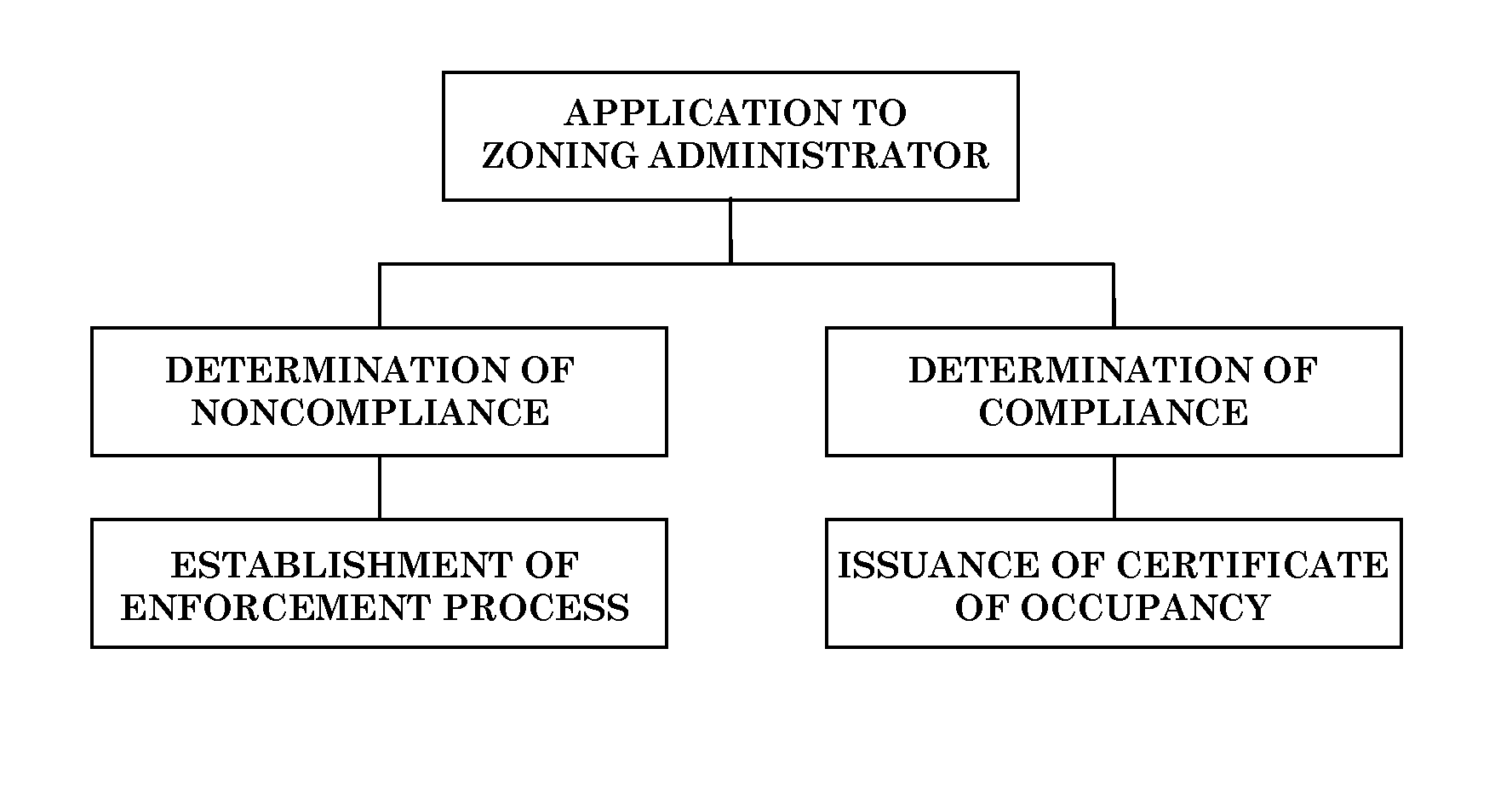
Inspection. The Zoning Administrator shall inspect the property that is the subject of a building permit, a certificate of occupancy, or a temporary certificate of occupancy to determine whether the use of the property and the structures comply in all respects with the pertinent provisions of these regulations, applicable sections of the County Code, any Standard Construction Specifications approved by the County Board, the Illinois State Environmental Barriers Act (if applicable), and the Illinois Department of Public Health Plumbing Code (if applicable).
2.
Determination of Noncompliance. If the Zoning Administrator determines, after inspection, that the structure is not in compliance with the applicable standards set forth in this section, he shall initiate an established enforcement process within ten (10) working days after the inspection to bring the petitioner into compliance.
3.
Determination of Compliance. If the Zoning Administrator determines, after inspection, that the structure is in compliance with the applicable standards set forth in this section, and if all relevant fees have been paid, he shall issue a certificate of occupancy within ten (10) working days after the final inspection.
4.
Issuance of Temporary Certificate of Occupancy. The Zoning Administrator may issue a temporary certificate of occupancy for a building or structure, or part thereof, prior to the completion of the entire building or structure.
3.3.4
Temporary Certificate of Occupancy. A temporary certificate of occupancy may be issued by the Zoning Administrator which states the nature of the incomplete work and the time period within which the work must be completed, provided that:
1.
The applicant for such a temporary certificate of occupancy demonstrates that the construction which remains to be completed relates solely to conditions of the development which are not directly related to the safety of the premises; and
2.
The applicant demonstrates that such completion is impractical at the time the temporary certificate of occupancy is sought due to weather or other conditions acceptable to the Zoning Administrator.
3.3.5
Time Frame for Temporary Certificate. A temporary certificate of occupancy shall be issued for a period of sixty (60) days, at which time the Zoning Administrator shall conduct an inspection of the building or structure to determine completeness and/or the need for an extension of the temporary certificate of occupancy.
3.3.6
Compliance for New Construction. The construction authorized by a permit for new construction including additions or alterations of existing structures shall be in compliance when construction is complete and all building supplies and materials have been removed from the property. Failure to remove all materials left-over from the building's construction shall be considered a violation of Chapter 12 of the Peoria County Code.
3.3.7
Compliance for Demolition. A demolition authorized by a permit for the demolition of a building or structure shall be in compliance when all remnants of the building or structure have been removed from the property. The use of the building's materials to fill in the excavated area is strictly prohibited. Failure to remove all remnants of the building or structure within the life of the permit shall be considered a violation of Chapter 12 of the Peoria County Code.
PEORIA COUNTY
CERTIFICATE OF OCCUPANCY REVIEW PROCEDURES
(Ord. of 3-13-14(1))
Sec. 3.4 - Development Permitted as of Right
3.4.1
Purpose. Development permitted as of right is that development which permits uses which are compatible with other land uses in a zoning district provided they are developed in conformity with these regulations.
3.4.2
Application. An applicant for approval of development permitted as of right shall submit an application for a building permit to the Zoning Administrator.
3.4.3
Action on the Application. If the Zoning Administrator determines that the proposed development is in compliance with all requirements of these regulations and all other applicable regulations of the County, then a building permit shall be issued with or without conditions.
Sec. 3.5 - Special Use Permits
3.5.1
Purpose and Authority.
1.
The purpose of special use permits is to enable the County to approve those uses which are generally compatible with other land uses permitted in a zoning district, but which require individual review of their location, design, and configuration and which may require the imposition of conditions in order to ensure the appropriateness of the use at a particular location.
2.
The ZBA may, in accordance with the procedures and standards of this section, recommend approval of special use permits to the County Board, or may recommend approval of a special use subject to conditions, or may recommend denial of a special use permit.
3.5.2
Authorization.
1.
Only those uses which are authorized in Article 5, Use Regulations, those requesting variations from standards in Section 7.3 ("Home Occupations"), those nonconforming uses and nonconforming structures requesting termination of status as nonconforming under the provisions of Section 9.1.5, Nonconformities, may be approved as special uses.
2.
The designation of a use in a zoning district does not constitute an authorization or an assurance that such use will be approved. Rather, each proposed special use shall be evaluated by the Zoning Administrator, the ZBA, and the County Board for compliance with the standards and conditions set forth in this section and for each zoning district.
3.5.3
Application.
1.
Initiation. An application for a special use permit may be submitted by the owner, an agent authorized in writing to act on the owner's behalf, or other person having a written contractual interest in the parcel of land proposed for development under a special use permit.
2.
Provision. The Zoning Administrator shall provide the petitioner with a sample of a special use petition form and a copy of the County's special use procedures.
3.
Minimum Submittal Requirements. Applications for a special use permit shall be filed with the Zoning Administrator and shall include, but shall not be limited to the following information:
a.
The legal description, parcel identification number (PIN), and address (if available) of parcel(s) that are the subject of the request;
b.
Such other information as may be designated by particular special use requirements;
b1.
A written description of the proposed use that includes information concerning proposed hours of operation, expected traffic impacts, and any other pertinent details concerning the proposed use, including a description of how the request satisfies the review standards found in Section 3.5.4, Approval Standards, below;
c.
The present and proposed land use;
d.
The surrounding zoning classifications;
e.
An explanation of the need for the special use at the petitioned site;
f.
The names and addresses of owners of petitioned property;
g.
The following statements:
1.
Whether the applicant is a corporation, and if a corporation, disclose the correct names and addresses of all officers and directors and of all stockholders or shareholders owning any interest in excess of twenty (20) percent of all outstanding stock or shares of such corporation.
2.
Whether the applicant, or his principal if other than the applicant, is a business or an entity doing business under an assumed name, and if so, the name and residence of all true and actual owners of such business or entity.
3.
Whether the applicant or his principal if other than the applicant is a partnership, a joint venture, a syndicate, or an unincorporated voluntary association, and if so, include the names and addresses of all partners, or members of the partnership, joint venture, syndicate, or unincorporated voluntary association.
4.
Whether the applicant is acting for himself or in the capacity of an agent, an alter ego, or a representative of a principal. The applicant shall include the name and address of the true principal.
5.
Applicants must provide a signed statement with their special use application certifying that the applicant is responsible for the costs and fees associated with their Special Use Application, including, but not limited to, attorneys fees, engineer studies, costs of expert retention, costs associated with any appeal, and any and all costs incurred by the County as a result of the applicants request or appeal.
a.
Any subsequent costs incurred by the County as a result of the Special Use shall be at the applicant, owner, developer, or operator's expense, including but not limited to the cost of initial and periodic engineering review of the Decommissioning Plan and/or Decommissioning Agreement for a Wind Energy Generation Facility or Commercial Solar Energy Facility.
h.
A site plan which contains, at a minimum, the following:
1.
A layout map of all existing and proposed buildings and structures on the site;
2.
The traffic circulation pattern;
3.
The parking and loading areas and individual berths;
4.
The proposed sewerage and water systems;
5.
The placement of exterior lighting; and
6.
Landscaping.
i.
A copy of such site plan at a reproducible size not to exceed 11" x 17";
j.
Except as provided in subsection 3.5.3-3.j.6 below for special uses which involve a proposed land split which will not be served by public water, the following shall be submitted:
1.
Documentation regarding proximity to existing water supply, both current and planned expansion by the appropriate water authority.
2.
Detailed and documented cost comparison of the projected costs of public water, community water, and individual wells.
3.
Documentation shall be provided to demonstrate that an adequate quantity and quality of water will be available for all lots proposed. Such documentation may be provided by the Illinois State Geological Survey or the Illinois State Water Survey.
4.
Documentation from an existing well in the immediate vicinity documenting the production of water at a minimum rate of three (3) gallons per minute (gpm).
5.
The developer shall provide data from a test boring(s) completed by a well driller denoting the availability of water at this location. Location of the test well(s) shall be identified by the Illinois State Water Survey, the Peoria City/County Health Department and a licensed well driller. Results of such boring shall indicate a minimum three (3) gallons per minute (gpm) produced.
6.
In the case of agricultural related land splits, the requirements of subsection 3.5.3-3.j.1 through 3.5.3-3.j.5 shall not be required for commercial ag-related businesses, grain bins, and/or seed storage provided the use does not require, nor utilize, an office and/or restrooms.
k.
Except as provided in subsection 3.5.3-3.k.2 below, for special uses which involve a proposed land split which will not be served by public sewer, the following shall be submitted:
1.
Soil profiles in locations specified by the Peoria City/County Health Department.
2.
In the case of agricultural related land splits, documentation in the form of soil profiles shall not be required for commercial ag-related businesses, grain bins, and/or seed storage, provided the use does not require, nor utilize, an office and/or restrooms.
4.
Review by the Zoning Administrator.
a.
The Zoning Administrator shall send a copy of the applications to the appropriate road official and to the Peoria City/County Health Department for comment.
b.
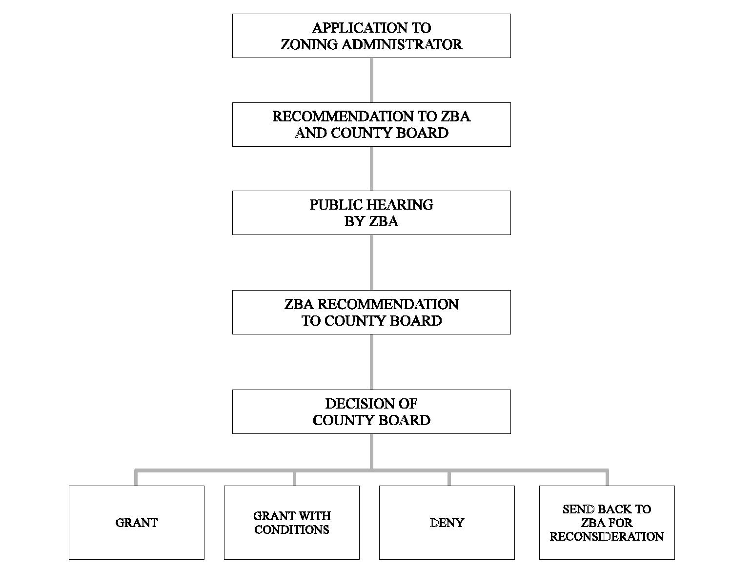
After receipt of a complete application for a special use permit, the Zoning Administrator shall complete the review of the application and shall send a written recommendation to the ZBA and the County Board, with a copy to the applicant. The recommendation shall set forth whether the special use application should be granted or denied, and shall state the grounds for any such recommendations as they relate to the standards set forth in Section 3.5.4, Approval Standards, below. Such recommendation shall be submitted to the ZBA and to the County Board prior to the required public hearing before the ZBA.
3.5.4
Review Standards. When considering an application for a special use permit, the following factors shall be considered as a balancing test, not one of which shall be controlling:
1.
The establishment, maintenance or operation of the proposed use will not be detrimental to or endanger the public health, safety, morals, comfort or general welfare;
2.
The proposed use will not be injurious to the uses and enjoyment of other property in the immediate vicinity for the purposes already permitted;
3.
The proposed use will not substantially diminish or impair property values of surrounding properties;
4.
The establishment of the proposed use will not impede the normal and orderly development and improvement of the surrounding properties;
5.
Adequate public utilities, access roads, drainage and/or necessary facilities have been or will be provided;
6.
Adequate measures have been or will be taken to provide ingress and egress so designed as to minimize traffic congestion in the public streets;
7.
The length of time the property has been vacant as zoned, considered in the context of land development in the area in the vicinity of the subject property;
8.
The community need for the proposed use; and
9.
Whether the proposed use would be contrary to any officially adopted County plan.
3.5.5
Conditions. The County Board may attach and the Zoning Administrator and the ZBA may recommend the attachment of such conditions to a special use permit.
3.5.6
Action by Zoning Board of Appeals.
1.
The ZBA shall conduct a public hearing to consider the special use proposal in accordance with the provisions of subsection 2.2.6-5.
2.
The ZBA shall review the special use application, the recommendation of the Zoning Administrator, and the testimony at the public hearing, and shall send its findings of fact and recommendation to the County Board recommending approval, approval with conditions, or denial of the special use permit.
3.5.7
Action by County Board. The County Board shall review the proposed special use, the report of the ZBA, and the recommendation of the Zoning Administrator, and shall grant or deny the application for a special use permit by a majority vote of the members present constituting a quorum. The County Board may also refer the petition back to the ZBA for further consideration.
1.
Recording of Notice of Restrictions. A notice of restrictions shall be recorded with the Recorder of Deeds of Peoria County that includes the terms and conditions upon which the special use approval is granted. The cost of such recording shall be paid for by the petitioner.
2.
Effect of Issuance of a Special Use Permit. Issuance of a permit for a special use shall be deemed to authorize only the particular use for which it is issued.
3.5.8
Post-Approval Process.
1.
Development of an Approved Special Use. Development of the use shall not be carried out until the applicant has secured all other permits and approvals required by these regulations, the County, or State and federal agencies and until the approved special use is recorded in accordance with subsection 3.5.7-1, above.
2.
Inspection During Development Under a Special Use Permit.
a.
Following the issuance of a special use permit and from time to time as deemed appropriate until the completion of the development, the Zoning Administrator shall compare the actual development with approved plans and permits for development and the approved development schedule, if any.
b.
If at any time during the construction of the development approved by the special use permit, the Zoning Administrator determines that development is not proceeding in accordance with the special use permit as approved, then the Zoning Administrator may issue a stop work order and collect a stop work order fee from the developer.
3.
Inspections after Development.
a.
Following the completion of the development of a special use, the Zoning Administrator shall review the development for compliance with the use as approved. If it is determined that the special use has been developed in accordance with approval, then a certificate of occupancy shall be issued in accordance with Section 3.3, ("Certificate of Occupancy").
b.
If the Zoning Administrator finds that the development, as completed, fails in any respect to comply with the use as approved, he shall immediately notify the applicant of such fact. The Zoning Administrator shall not issue a certificate of occupancy pursuant to Section 3.3 ("Certificate of Occupancy") until the development has been brought into compliance.
c.
The Zoning Administrator shall inspect the special use on an annual basis to determine whether the conditions of the special use continue to be met. If the Zoning Administrator finds that any of the conditions have been violated, he shall take appropriate enforcement action and may revoke the special use permit.
3.5.9
Termination of Special Use Permits. A special use permit may be terminated by the Zoning Administrator in accordance with the restrictions contained in the permit.
3.5.10
Special Use to Run with the Land Unless Otherwise Indicated. All special uses granted by the County Board, both before and after the effective date of this Section 3.5.10, Special Use to Run with the Land unless Otherwise Indicated, shall run with the parcel which is the subject of the special use unless:
1.
The conditions attached to the special use by the County Board restrict it to a particular person(s) or period of time, in which case the special use shall terminate as provided in said conditions, or
2.
The special use is subsequently revoked by the County Board or the Zoning Administrator.
PEORIA COUNTY
SPECIAL USE PERMIT REVIEW PROCEDURES
(Ord. of 7-9-20; Ord. of 2-11-21; Ord. of 2-10-22; Ord. of 4-13-23(23); Ord. of 3-14-24(3))
Sec. 3.6 - Text and Map Amendments
3.6.1
Authority and Purpose. The County Board is hereby authorized to amend the text of these regulations or the Zoning District Map in light of changing conditions and in light of changes to the Peoria County Comprehensive Land Use Plan. The provisions of this section are not intended to relieve particular hardships nor to confer special privileges.
3.6.2
Amendment Types.
1.
Text Amendments. Amendments to the text of these regulations (which affect the entire county) may be initiated by the County Board, the ZBA, the Zoning Administrator, any resident of the County, or any developer of property located within the County.
2.
Map Amendments. Amendments to the Zoning District Map (which affect individual parcel(s) of land) may be initiated by the owner of property involved, a non-owner with the written permission of such property owner, the County Board, the ZBA, or the Zoning Administrator. Any map amendment initiated by a property owner which involves a single parcel of land shall require the submission of an application to the Zoning Administrator in accordance with the provisions of Section 3.1, ("General Procedures").
3.6.3
Application.
1.
Provision. The Zoning Administrator shall provide the petitioner with a sample of a text amendment or map amendment petition form and a copy of the County's amendment procedures.
2.
Minimum Submittal Requirements.
a.
Applications for Text Amendments shall be filed with the Zoning Administrator and shall include, but shall not be limited to, the following information:
1.
Name of petitioner and, if other than the County Board, ZBA and Zoning Administrator, address of petitioner.
2.
Section(s) of the Ordinance to be amended, along with proposed changes to text of regulation.
b.
Applications for Map Amendments (rezoning) shall be filed with the Zoning Administrator and shall include, but shall not be limited to, the following information:
1.
The legal description, parcel identification number (PIN), and address (if available) of the parcel(s) that are subject of the request.
2.
The current and proposed zoning classifications of the parcel(s) that are the subject of the request.
3.
The current and proposed use of the parcels(s) that are the subject of the request.
4.
The zoning classifications of the surrounding parcels.
5.
The name and address of the property owner(s) of the parcel(s) that are the subject of the request.
6.
A written description of the proposed use that includes information concerning proposed hours of operation, expected traffic impacts, and any other pertinent details concerning the proposed use, including a description of how the request satisfies the review standards found in Section 3.6.4, Approval Standards, below;
7.
A site plan which contains, at a minimum, the following:
a.
A layout map of all existing and proposed buildings and structures on the site;
b.
The traffic circulation pattern;
c.
The parking and loading areas and individual berths;
d.
The proposed sewerage and water systems;
e.
The placement of exterior lighting; and
f.
Landscaping.
8.
A copy of such site plan at a reproducible size not to exceed 11" x 17";
9.
If the proposed Rezoning will not be served by public water, the following shall be submitted.
a.
Documentation regarding proximity to existing water supply, both current and planned expansion by the appropriate water authority.
b.
Detailed and documented cost comparison of the projected costs of public water, community water, and individual wells.
c.
Documentation shall be provided to demonstrate that an adequate quantity and quality of water will be available for all lots proposed. Such documentation may be provided by the Illinois State Geological Survey or the Illinois State Water Survey.
d.
Documentation from an existing well in the immediate vicinity documenting the production of water at a minimum rate of three (3) gallons per minute (gpm).
e.
The developer shall provide data from a test boring(s) completed by a well driller denoting the availability of water at this location. Location of test well(s) shall be identified by the Illinois State Water Survey, the Peoria City/County Health Department and a licensed well driller. Results of such boring shall indicate a minimum three (3) gallons per minute (gpm) produced.
10.
If the proposed Rezoning will not be served by public sewer, soil profiles in locations specified by the Peoria City/County Health Department shall be submitted.
3.
Review by the Zoning Administrator.
a.
The Zoning Administrator shall send a copy of the application to the appropriate road official and to the Peoria City/County Health Department for comment.
b.
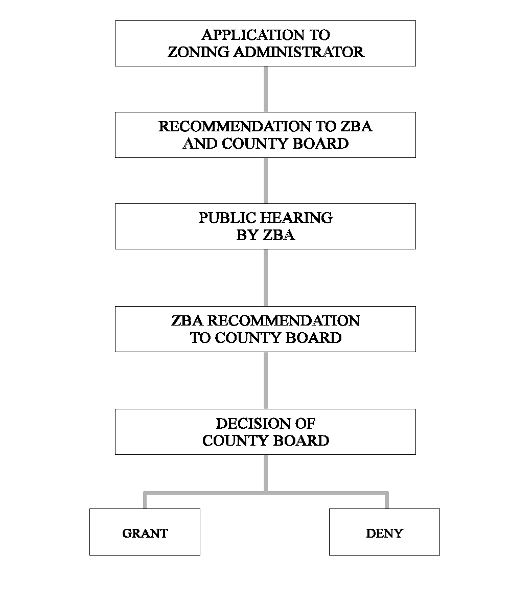
After receipt of a complete application for a text or map amendment, the Zoning Administrator shall complete the review of the application and shall send a written recommendation to the ZBA and the County Board, with a copy to the applicant. The recommendation shall set forth whether the amendment application should be granted or denied, shall suggest a zoning district classification, if any, and shall state the grounds for any such recommendations as they relate to the standards and the purposes of the zoning district classifications of the County, the standards in Section 3.6.4, Approval Standards, below and any officially adopted County plan.
3.6.4
Approval Standards.
1.
In evaluating a proposed text amendment, the following factors shall be considered, not one of which shall be controlling:
a.
The proposed amendment corrects an error or inconsistency or meets the challenge of some changing condition;
b.
The proposed amendment is consistent with the purpose and intent of this ordinance;
c.
The proposed amendment will not adversely affect health, safety, morals and general welfare of the public;
d.
The proposed amendment is required because of a change in State or Federal law.
2.
In evaluating a proposed map amendment, the following factors shall be considered, not one of which shall be controlling;
a.
The existing uses and zoning of nearby property;
b.
The extent to which property values are diminished by the particular zoning restriction;
c.
The extent to which the destruction of property values of the applicant promotes the health, safety, morals or general welfare of the public;
d.
The relative gain to the public as compared to the hardship imposed upon the individual property owner;
e.
The suitability of the subject property for the zoned purposes;
f.
The length of time the property has been vacant as zoned, considered in the context of land development in the area in the vicinity of the subject property; and
g.
The community need for the proposed use; and
h.
Whether the proposed change would be contrary to any officially adopted County plan.
3.6.5
Action by the Zoning Board of Appeals.
1.
The ZBA shall conduct a public hearing to consider any amendment to the text of these regulations or the Zoning District Map in accordance with the provisions of subsection 2.2.6-5.
2.
The ZBA shall review the proposed amendment, the recommendation of the Zoning Administrator, and the testimony at the public hearing, and shall send its findings of fact and recommendation to the County Board recommending approval or denial of the amendment.
3.6.6
Action by the County Board. The County Board shall review the proposed amendment, the report of the ZBA, and the recommendation of the Zoning Administrator. Except as provided below, the County Board shall grant or deny the text or map amendment by a majority vote of the members of the County Board.
1.
Extra-Majority Vote by County Board for Contested Text Amendments. A favorable vote of at least three-fourths (¾) of the members of the County Board shall be required for the approval of text amendments if written protests against the proposed text amendment have been signed by five (5) percent of the land owners of the County.
2.
Extra-Majority Vote by County Board for Contested Map Amendments. A favorable vote of at least three-fourths (¾) of the members of the County Board shall be required for the approval of map amendments in the following circumstances:
a.
If a written protest against the proposed amendment is filed with the County Clerk at least seventy-two (72) hours before the County Board makes its final determination, and is either:
1.
Signed by the owner or owners of at least twenty (20) percent of the land to be rezoned; or
2.
Signed by the owner or owners of land immediately touching, or immediately across a street, alley, or public right-of-way from, at least twenty (20) percent of the perimeter of the land to be rezoned.
b.
If the land affected by the proposed amendment lies within one and one-half (1½) miles of the limits of a zoned municipality and a written protest against the proposed amendment is passed by the city council or the president and board of trustees of the zoned municipality with limits nearest adjacent and filed with the County Clerk at least seventy-two (72) hours before the County Board makes its final determination.
PEORIA COUNTY
TEXT AND MAP AMENDMENTS REVIEW PROCEDURES
Sec. 3.7 - Variances
3.7.1
Authority and Purposes.
1.
Except for telecommunications carrier facilities, the ZBA, and in certain cases described in paragraph 2, below, the Zoning Administrator, are hereby authorized to grant such variances from the literal terms of these regulations where there are practical difficulties or undue hardships that may result from strict compliance with these regulations so that the spirit of these regulations shall be observed, public safety and welfare secured, and substantial justice done.
2.
Except for telecommunications carrier facilities, the Zoning Administrator is hereby authorized to grant variances from the literal terms of these regulations where the variation sought would not vary either the location of a structure or the bulk regulations contained in this Ordinance by more than ten (10) percent.
3.7.2
Application.
1.
Initiation. An application for a variance may be submitted by the owner, an agent authorized in writing to act on the owner's behalf, or other person having a written contractual interest in the parcel of land proposed for development. An application for a variance shall be submitted to the Zoning Administrator and reviewed in accordance with the provisions of Section 3.1 ("General Procedures").
2.
Provision. The Zoning Administrator shall provide the petitioner with a sample of a variance petition form and a copy of the County's variance procedures.
3.
Minimum Submittal Requirements. Proposals for variances shall be filed with the Zoning Administrator and shall include, but shall not be limited to, the following information:
a.
The legal description, parcel identification number (PIN), and address (if available) of parcel(s) that are the subject of the request;
b.
The variance sought;
c.
A written description of the need for the variance that includes information concerning how the request satisfies the review standards found in Section 3.7.3, Approval Standards, below;
d.
The present and proposed land use;
e.
Zoning of the parcel(s) and surrounding zoning classification(s);
f.
The names and addresses of owners of petitioned property;
g.
The following statements:
1.
Whether the applicant is a corporation, and if a corporation, disclose the correct names and addresses of all officers and directors and of all stockholders or shareholders owning any interest in excess of twenty (20) percent of all outstanding stock or shares of such corporation.
2.
Whether the applicant, or his principal if other than the applicant, is a business or an entity doing business under an assumed name, and if so, the name and residence of all true and actual owners of such business or entity.
3.
Whether the applicant or his principal if other than the applicant is a partnership, a joint venture, a syndicate, or an unincorporated voluntary association, and if so, include the names and addresses of all partners, of members or the partnership, joint venture, syndicate, or unincorporated voluntary association.
4.
Whether the applicant is acting for himself or in the capacity of an agent, an alter ego, or a representative of a principal. The applicant shall include the name and address of the true principal.
h.
A site plan, which contains, at a minimum, the following:
1.
A layout map of all components of the request;
2.
Pertinent natural features that may be the cause of the request;
3.
All improvements (structures, septic systems, etc.) that may be the cause of the request.
i.
A copy of such site plan at a reproducible size not to exceed 11" x 17".
3.7.3
Approval Standards. The findings of the ZBA or the Zoning Administrator shall be based on data submitted pertaining to each standard in this subsection as it relates to the development. A variance shall be granted only if the applicant demonstrates:
1.
That the plight of the owner is due to unique circumstances;
2.
That the variation, if granted, will not alter the essential character of the locality;
3.
That because of the particular physical surroundings, shape, or topographical conditions of the specific property involved, a particular hardship to the owner would result, as distinguished from a mere inconvenience, if the strict letter of these regulations were carried out;
4.
That the conditions upon which the petition for a variation are based are unique to the property for which the variance is sought and are not applicable, generally, to other property;
5.
That the granting of the variation will not be detrimental to the public health, safety, comfort, morals and welfare, or injurious to other property or improvements in the neighborhood in which the property is located, or otherwise be inconsistent with any officially adopted County plan or these regulations;
6.
That the proposed variation will not impair an adequate supply of light and air to adjacent property, or substantially increase the congestion in the public streets, or increase the danger of fire, or endanger the public safety, or substantially diminish or impair property values within the neighborhood;
7.
That the variance granted is the minimum adjustment necessary for the reasonable use of the land; and
8.
That aforesaid circumstances or conditions are such that the strict application of the provisions of this section would deprive the applicant of reasonable use of his or her land. Mere loss in value shall not justify a variance.
3.7.4
Conditions. Issuance of a variance may be made subject to such conditions as are necessary to carry out the purposes of these regulations and to prevent or minimize adverse effects upon other property in the neighborhood, including, but not limited to, limitations on size and location, hours of operation, requirements for landscaping, lighting, and ingress and egress.
3.7.5
Action.
1.
Zoning Administrator.
a.
If the variance will be considered by the ZBA, after receipt of a complete application the Zoning Administrator shall forward the application to the ZBA, with or without recommendation.
b.
If the variance will be decided by the Zoning Administrator, the Zoning Administrator shall consider the extent to which the applicant has demonstrated compliance with the standards set forth in Section 3.7.3, Approval Standards, above, and shall grant the variance, subject to conditions, or deny the variance. The action of the Zoning Administrator in granting or denying the variance shall contain or be accompanied by a finding of fact specifying the reason for his decision.
c.
Before any such variance may be granted, however, the Zoning Administrator shall send a notice by certified mail to all adjoining landowners of his intent to grant such variance. If any adjoining landowner files a written objection with the Zoning Administrator within fifteen (15) days of receipt of such notice, the variance shall be considered by the ZBA in accordance with the provisions of Section 3.7.3, Approval Standards, above.
2.
Zoning Board of Appeals.
a.
The ZBA shall conduct a public hearing to consider any variation from the terms of these regulations in accordance with the requirements of subsection 2.2.6-5.
b.
The ZBA shall review the application, the recommendation of the Zoning Administrator, and the testimony at the public hearing and shall grant the variance, grant the variance requested subject to specified conditions, or deny the variance.
c.
The action of the ZBA in granting or denying a variance shall contain or be accompanied by a finding of fact specifying the reason for its decision in accordance with the provisions of subsection 2.2.6-6.b.
3.
Any variance of any setback requirements for a Wind Energy Conversion System shall be recorded with the Peoria County Recorder of Deeds.
3.7.6
Special Use Procedures. If an application cannot comply with these variance regulations and the use would be otherwise permitted in the zoning district in which the property is located, the applicant may elect to follow the procedures for a special use permit set forth in Section 3.5 ("Special Use Permits") and thereby obtain some modification of these regulations. Any election to follow special use procedures must take place before a decision on the variance application is made by the ZBA.
PEORIA COUNTY
VARIANCE REVIEW PROCEDURES
(Res. of 7-12-12)
Sec. 3.8 - Appeals of Administrative Decisions
3.8.1
Authority and Purpose. The ZBA is hereby authorized to hear and decide appeals where it is alleged that there is error in any order, requirement, decision, or determination made by the Zoning Administrator or other administrative official in the enforcement of Article 2 Decision Making and Administrative Bodies, Sections 2.1 ("County Board"), 2.2 ("Zoning Board of Appeals"), 2.3 ("Zoning Administrator"); Article 3 Development Review Procedures, Sections 3.1 ("General Procedures") through 3.9 ("Telecommunications Carrier Facilities Variances"); Article 4 Zoning District; Article 5 Use Regulations; Article 6 Bulk Regulations, Density, and Dimensional Standards; Article 7 General Development Standards, Sections 7.1 ("Telecommunications Carrier Facilities") through 7.12 ("Mineral Extraction Facilities"), 7.14 ("Floodplain Regulations"), 7.15 ("Swimming Pools"); Article 9 Nonconformities; Article 10 Violations, Penalties, and Enforcement; and Article 11 Definitions. An appeal may be initiated by any person aggrieved by any decision of the Zoning Administrator.
3.8.2
Notice of Appeal. A notice of appeal authorized under the provisions of this section shall be filed with the Zoning Administrator and the ZBA within thirty-five (35) days from the date of the challenged administrative action. The Zoning Administrator shall transmit to the ZBA a complete file constituting the record on appeal.
3.8.3
Stay. When an appeal is filed, all proceedings in furtherance of the action appealed from shall be stayed, unless the Zoning Administrator certifies to the ZBA that by reason of facts stated in the certificate, a stay would cause imminent peril to life or property. In such case, proceedings shall not be stayed other than by a restraining order granted by the ZBA or by a court of record on application, on notice to the Zoning Administrator, and on due cause shown.
3.8.4
Review and Public Hearing. The ZBA shall review the notice of appeal and shall give notice and conduct a public hearing on the appeal in accordance with the requirements of Section 2.2.6, Hearing Procedures, of these regulations.
3.8.5
Standard and Decision by Zoning Board of Appeals. In evaluating the merits of the appeal, the ZBA shall consider factors that may include: the consistency with the terms of these regulations, the implications of setting any precedent, and the availability of other alternatives for the appellant. The ZBA shall, in whole or in part, grant the appeal, grant the appeal subject to specified conditions, or deny the appeal, and to that end, shall have all the powers of the Zoning Administrator.
3.8.6
Fees. The applicant who files a notice of appeal shall pay all required publication costs associated with the request as well as fees levied by the County pursuant to Section 1.6 ("Review Fees") to partially defray its expense of investigating and considering the appeal. The fee shall be paid at the time of filing and publication fees shall be paid to the Zoning Administrator prior to any final disposition of the request by the ZBA.
3.8.7
Appeals to Court. An appeal of a decision of the ZBA shall be made to a court of competent jurisdiction pursuant to the provisions of the Administrative Review Act, 735 ILCS 5/3-101 et seq. The appealing party shall bear the cost of preparing the record on appeal. Copies of any orders or proceedings ordered by the appellant shall be furnished to him at his own cost.
Sec. 3.9 - Telecommunications Carrier Facilities Variances
3.9.1
Authority and Purpose. The County Board may, in certain instances described below, grant variations from the regulations, conditions and restrictions of Section 7.1 ("Telecommunications Carrier Facilities").
3.9.2
Initiation and Review of Application. An application for a variance may be submitted by the owner, and agent authorized in writing to act on the owner's behalf, or other person having a written contractual interest in the parcel of land proposed for development.
3.9.3
Filing and Content of Application. Proposals for variances shall be filed with the Zoning Administrator and shall include, but shall not be limited to, the following information:
1.
The legal description and address (if available) of the premises;
2.
The variance sought;
3.
The present and proposed land use;
4.
The present zoning classifications;
5.
The surrounding zoning classifications;
6.
The names and addresses of owners of petitioned property;
7.
An explanation of the need for the variance;
8.
A site plan of 1" = 20' which shows all existing and proposed buildings and structures on the site;
9.
A copy of such site plan at reproducible size not to exceed 11" x 17".
3.9.4
Approval Standards. In making their findings, the ZBA and the County Board shall consider the following and no other matters:
1.
Whether, but for the granting of a variance, the service that the telecommunication carrier seeks to enhance or provide with the proposed facility will be less available, impaired or diminished in quality, quantity, or scope of coverage;
2.
Whether the conditions upon which the application for the variance is based are unique in some respect or, if not, whether the strict application of the regulations would result in a hardship on the telecommunications carrier;
3.
Whether a substantial adverse effect on public safety will result from some aspect of the facility's design or proposed construction, but only if that aspect of design or construction is modifiable by the applicant;
4.
Whether there are benefits to be derived by the users of the services to be provided or enhanced by the facility and whether public safety and emergency response capabilities would benefit by the establishment of the facility; and
5.
The extent to which the design of the proposed facility reflects compliance with the following:
a.
No building or tower that is part of a facility should encroach onto any recorded easement prohibiting the encroachment unless the grantees of the easement have given their approval.
b.
Lighting should be installed for security and safety purposes only. Except with respect to lighting required by the FCC or FAA, all lighting should be shielded so that no glare extends substantially beyond the boundaries of a facility.
c.
No facility should encroach onto an existing septic field.
d.
Any facility located in a special flood hazard area or wetland should meet the legal requirements for those lands.
e.
Existing trees more than three (3) inches in diameter should be preserved if reasonably feasible during construction. If any tree more than three (3) inches in diameter is removed during construction a tree three (3) inches or more in diameter of the same or a similar species shall be planted as a replacement if reasonably feasible. Tree diameter shall be measured at a point three (3) feet above ground level.
f.
If any elevation of a facility faces an existing, adjoining residential use within a residential zoning district, low maintenance landscaping should be provided on or near the facility lot to provide at least partial screening of a facility. The quantity and type of that landscaping should be in accordance with Section 7.6 ("Landscaping and Bufferyards"), Table 7-2 except that paragraph (e) of this subsection 3.9.4-5 shall control over any tree-related regulations imposing a greater burden.
g.
Fencing should be installed around a facility. The height and materials of the fencing should be in accordance with Section 7.4 ("Fences").
h.
Any building that is part of a facility located adjacent to a residentially zoned lot should be designed with exterior materials and colors that are reasonably compatible with the residential character of the area.
3.9.5
Review of Application. After receipt of a complete application for a variance, the Zoning Administrator shall complete review of the application and shall send a report to the ZBA, with a copy to the applicant.
3.9.6
Publication. Regardless of any other provision in these regulations to the contrary, notice of the hearing is only required to be published in a newspaper of general circulation published in the county.
3.9.7
Action by Zoning Board of Appeals.
1.
The ZBA shall conduct no more than one public hearing to consider the application in accordance with the provisions of subsection 2.2.6-5.
2.
The ZBA shall review the application, the report of the Zoning Administrator, and the testimony at the public hearing, and shall send its findings of fact and recommendation to the County Board recommending approval or denial of the variance.
3.9.8
Action by the County Board.
1.
The County Board shall review the record before the ZBA and the ZBA's recommendation and findings and shall grant or deny the variance by a vote of a majority of the members present.
2.
The County Board must make its final decision no later than seventy-five (75) days after submission of a complete application. If the County Board fails to act on the application within seventy-five (75) days after submission of a complete application, the application shall be deemed to have been approved.
3.
All decisions by the County Board shall be supported by written findings of fact.
(Res. of 7-12-12)
Sec. 3.10 - Floodplain Development Permit
Floodplain Development Review Procedures are located in Section 7.14, ("Floodplain Regulations").
Sec. 3.11 - Swimming Pool Permits
3.11.1
Permits.
1.
Prior to the commencement of the construction of a private swimming pool or any alteration, addition, remodeling or improvement to a private swimming pool, the owner of the proposed pool or existing pool or his representative or agent shall submit an application for a permit to the Zoning Department. The application shall include three (3) copies of the plans and specifications. No construction shall begin until the Zoning Department has granted approval of the proposed plans and specifications. The issuance of a written permit by the Zoning Department to the applicant shall be evidence of approval of the proposed plans and specifications.
2.
The owner shall obtain a written permit from the Zoning Department prior to obtaining any other permit. In addition to a permit issued by the Zoning Department, the owner of a proposed private swimming pool shall be responsible for obtaining all other permits required by other agencies. The applicant shall not commence construction until all the required permits are issued.
3.
The owner of a private swimming pool shall notify the Zoning Department upon completion of the construction, addition, alteration and prior to filling the pool and upon completion of the construction of a fence. The owner shall not fill the pool until the pool and fence are inspected by the Zoning Department and found to be in compliance with the terms of this article.
3.11.2
Plans. The plans and specifications required by Section 3.11.1, Permits, shall include the following information plus such other data as may be reasonably requested by the Zoning Department:
1.
A site plan drawn to scale which indicates the location of the proposed pool in relation to the following items, and which meets or exceeds the established minimum setbacks:
a.
Property lines, building items, fences, walls, landscaping elements or structures, trees and other appurtenances;
b.
Electric service lines;
c.
Principle or accessory structures, excluding decks;
d.
Location and dimensions of fence and gates.
2.
The site plan shall also include a diagram of the fence drawn to scale that includes a cross section of the proposed fence indicating:
a.
Type of materials to be used in the fence construction;
b.
Dimensions of members and other structural elements, including spaces between members and other structural information;
c.
Type and location of gate and latches, including the vertical distance from grade to the location of handles and other latch components.
3.11.3
Fees. The applicant for a permit required by Sections 3.11.1, Permits, and 7.15, ("Swimming Pools"), shall accompany the permit application with payment of the applicable fees set forth in Chapter 12 of the Peoria County Code, Appendix A.
Sec. 3.12 - General Erosion and Sediment Control Permits
Before commencing any project involving construction of any new single-family or two-family dwelling or commencing any project with an area of five thousand (5,000) square feet or greater, the owner of the land, or his representative, shall be required to file an application for a General Erosion and Sediment Control Permit, as either a Standard Plan or a Site Specific plan, except as otherwise provided in Section 7.13.1, Applicability of Article, and Section 3.16 ("Plat Approval").
3.12.1
Application. The applicant shall file the application with the Department on forms provided by the Department. The fee shall be set forth in Appendix A for Standard and Site Specific plan applications. However, no fee shall be required for any project the purpose of which is agricultural, or initiated by a local unit of government. There shall be no refund of any fees paid and no application shall be accepted for filing unless the fee has been paid in full.
3.12.2
Application Review. Review of a General Erosion and Sediment Control Permit application shall be limited to verifying that the required information and permit fee have been provided and that it meets the standards. The Erosion Control Administrator shall issue or deny an application by: a) approving the permit for a standard plan within two (2) working days of the filing of a complete application; or b) initiate the review process for a site-specific plan and approve the same within five (5) working days of the filing of a complete application. If the permit is denied, it shall be returned to the applicant with a written explanation of its denial. The application shall be deemed approved if no response is made within the time frames provided above.
3.12.3
Duration. The General Erosion and Sediment Control permit shall be issued for a period not exceeding two (2) years.
3.12.4
Content of General Erosion and Sediment Control Permit. The General Erosion and Sediment Control permit shall contain at a minimum the following general conditions:
1.
That written approval be obtained from the Erosion Control Administrator prior to making any modification to the erosion and sediment control plan as set forth in the application;
2.
That all control measures identified in the application shall be installed;
3.
That all control measures shall be maintained during construction; and
4.
Such other conditions as the Erosion Control Administrator deems appropriate to ensure compliance with the specific requirements and intent of this article.
3.12.5
Permanent Ground Surface Cover. Under all circumstances, temporary control measures shall be maintained in accordance with Section 7.13.3, Maintenance of Control Measures. Without exception, all disturbed areas must have permanent ground cover within six (6) months of project completion, or within six (6) months of occupancy, whichever comes first.
Sec. 3.13 - Erosion, Sediment, and Stormwater Control Permits
Before commencing any commercial, institutional, multifamily or industrial project with an area of more than one-half (½) acre; or a project requiring subdivision approval by a unit of local government with an area of more than one-half (½) acre, the owner of the land, or his representative, shall be required to file an application for an Erosion, Sediment, and Stormwater Control Permit.
3.13.1
Application. The applicant shall file the application with the Department on forms provided by the Department. The applicant shall supply the number of copies of application documents as provided in the application. Each application shall be accompanied by the following information:
1.
Existing site conditions map. A map of existing site conditions on a scale, of at least one inch equals one hundred (100) feet, showing the project area and immediately adjacent areas and the locations of the following site information:
a.
Site boundaries and adjacent lands which accurately identify site location;
b.
Lakes, streams, wetlands, channels, ditches, and other watercourses on and immediately adjacent to the site;
c.
Floodways and/or Zone A of the Floodplain as determined on the Flood Insurance Rate Map (FIRM), and indicating the map panel number;
d.
All off-site drainage onto or through the project site;
e.
Location and dimensions of stormwater management components on or adjacent to site;
f.
Locations and dimensions of structures, roads, highways, easements and paved areas; and
g.
Site topography: show contours at vertical intervals as follows:
1.
Slope of six (6) percent or less, two-foot interval.
2.
Slope of over six (6) percent but less than fifteen (15) percent, five-foot interval.
3.
Slope of over fifteen (15) percent, ten-foot or twenty-foot intervals.
2.
Plan of final site conditions. A plan of final site conditions drawn to the same scale as the existing site map submitted pursuant to subsection 3.13.1-1, and which includes information to accurately depict post-construction appearance of site, e.g., paved areas, building, landscaping, and other changes to the site, along with other predominate site features, e.g., open areas, bodies of water.
3.
Sediment and Erosion control practices. A site construction plan including:
a.
Locations and dimensions of all proposed land disturbing activities;
b.
Locations and dimensions of all temporary soil and aggregate stockpiles;
c.
Location, dimension and construction details of all construction site management control measures necessary to meet the requirements of this article and including proposed revegetation of disturbed areas;
d.
Statement regarding provisions for maintenance and maintenance requirements of the construction site management control measures during construction.
4.
Stormwater management plans and controls. Design calculations and information related to the permanent stormwater management system for any project with a net increase of impervious area greater than one-half (½) of an acre. For the purposes of this section, the net increase is the cumulative change since April 1, 1996. For example, in year one, a commercial site increases the parking lot by twenty thousand (20,000) square feet. In year two (2), the same commercial site adds a building with an area of 20,000 square feet. In year one, no permanent stormwater control measures (or calculations) are required by the ordinance. In year two (2), stormwater calculations shall be submitted and shall be based on the total increase of forty thousand (40,000) square feet of impervious area. The following information shall also be provided by the applicant:
a.
A map showing the drainage area boundaries, including off-site drainage areas that drain into or onto the site;
b.
Location and identification of soil types for all drainage areas;
c.
Location and identification of vegetative cover for all drainage areas;
d.
Run-off curve number calculations for both pre- and post-project conditions for each drainage area;
e.
Time of concentration calculations for both pre- and post-project conditions for each drainage area, and include a map showing hydraulic flow lengths used;
f.
Peak flow-rate calculations for two-year and twenty-five-year storms for both pre-and post-project conditions;
g.
Design calculations for detention basin outlets for both two-year and twenty-five-year storms, include stage-storage table and discharge rating curve data or outflow calculations (refer to optional form in Appendix D);
h.
Location dimensions and construction details of proposed detention basins and outlets;
i.
Detention volume calculations;
j.
Summary of peak flow-rates for pre-, post- and proposed conditions with detention showing that the requirements of the ordinance are met (refer to optional form in Appendix D).
5.
Schedule or sequence of development or installation of the elements of the site management control measures proposed above.
6.
A detailed estimate of quantities and estimated costs, prepared by a registered professional engineer, of all control measures required under this section.
7.
A plan of the continued management and maintenance of such permanent control measures.
8.
Application fee. The fee, as set forth in Appendix A, shall be submitted at the time of application and made payable to the Department of Planning and Zoning. However, no fee shall be required for any project the purpose of which is agricultural.
A fractional acre shall be rounded to the nearest whole acre. There shall be no refund of any fees paid and no application shall be accepted for filing unless the fee has been paid in full.
3.13.2
Application Review. Within five (5) working days of submittal of the application, the Erosion Control Administrator shall respond in writing to the sediment and erosion control practices portion. Within twenty (20) working days of submittal of the application, the Erosion Control Administrator shall respond to the stormwater management plans and control portion of the application by either issuing a permit, issuing a request for additional information, or issuing a statement denying the permit with an explanation of cause. The application shall be deemed approved if no response is made within the time frames stipulated above.
3.13.3
Financial Security Agreement. Before any Erosion, Sediment and Stormwater Control Permit is issued, the applicant shall deliver to the Erosion Control Administrator a surety bond, irrevocable letter of credit or executed escrow agreement in the name of Peoria County for one hundred (100) percent of the applicant's engineer's estimated cost for all control measures required under this section. If the control measures are necessitated by construction which is also subject to Sections 3.14 ("Subdivision"), 3.16 ("Plat Approval"), and Article 8, Subdivisions, of this chapter, the applicant may submit one surety bond, irrevocable letter of credit or executed escrow agreement to cover one hundred (100) percent of both the Control Measures required pursuant to this section and the improvements governed by Article 8, Subdivisions. A signed contractor's bid that meets the specifications of the engineer's estimate for the work can be used to establish the amount of security required, if such estimate is accepted by the Erosion Control Administrator.
3.13.4
Duration. The Erosion, Sediment and Stormwater Control Permit shall be issued for a period not exceeding two (2) years.
3.13.5
Permit Conditions. The Erosion, Sediment and Stormwater Control Permit shall contain at a minimum the following general conditions:
1.
That written approval be obtained from the Erosion Control Administrator prior to making any modification to the approved erosion and sediment control plan as set forth in the permit;
2.
That all control measures required in the permit shall be installed;
3.
That all control measures shall be maintained during construction;
4.
Such other conditions as the Erosion Control Administrator deems appropriate.
3.13.6
Permanent Ground Surface Cover. Without exception, all disturbed areas must have permanent ground cover within six (6) months of project completion, or within six (6) months of occupancy, whichever comes first.
3.13.7
Final Inspection; Notice of Permanent Stormwater Control Measures. Within fourteen (14) days after completion of construction, the applicant shall notify the Erosion Control Administrator that the permanent stormwater control measures are ready for final inspection. If the inspection shows that the control measures and maintenance plan comply with the Standards in Appendix D of this article, the Erosion Control Administrator shall issue a Notice of Permanent Stormwater Control Measures. The owner shall record the Notice with the Peoria County Recorder of Deeds within fifteen (15) days after the Notice is issued.
3.13.8
Maintenance of Permanent Stormwater Control. Anyone owning property with a permanent stormwater control measure existing thereon and installed pursuant to this ordinance shall maintain the control measure so that it functions in compliance with the Standards.
Sec. 3.14 - Subdivision
3.14.1
Subdivision Types. Before any division of land or creation of a public right-of-way may occur, the owner of the property, or his designated agent, shall apply for and secure approval of the proposed development in accordance with the following procedures for tract survey, minor, moderate or major subdivision. No matter the type of development, all shall be prepared by either an Illinois Registered Land Surveyor or Illinois Professional Engineer. In general, the following procedures will be followed:
1.
Tract Survey: Two (2) steps:
a.
Pre-application Conference
b.
Tract Survey Plat
2.
Minor Subdivision: Three (3) steps:
a.
Pre-application Conference
b.
Preliminary Plat
c.
Final Plat
3.
Moderate Subdivision: Five (5) steps:
a.
Pre-application Conference
b.
Preliminary Plat
c.
Construction and Erosion, Sediment, Stormwater Plans for public improvements
d.
Posting of Financial Security
e.
Final Plat
4.
Major Subdivision: Five (5) steps:
a.
Pre-application Conference
b.
Preliminary Plat
c.
Construction and Erosion, Sediment, Stormwater Plans for public improvements
d.
Posting of Financial Security
e.
Final Plat
3.14.2
Suitability of Land for Subdivision Development. Land unsuitable for development due to draining, flood hazard area, topography, or other conditions constituting a danger to health, life or property shall not be approved for development unless the developer presents evidence or data satisfactory to the Plat Officer, establishing methods proposed to meet any such conditions are adequate to avoid any danger to health, life, or property.
Sec. 3.15 - Subdivision Waivers and Appeals
This section provides for a procedure to relieve practical difficulties or unnecessary hardships which would result from strict compliance with the regulations of Section 3.16 ("Plat Approval") and Article 8, Subdivisions. The waiver process shall not be available for any regulation which states that it cannot be waived.
3.15.1
Approval. For the purposes of these regulations a waiver shall be considered a waiver from a specific required element of these regulations. A waiver request may be granted by the County Board under the following conditions:
1.
When the developer has demonstrated that strict adherence to these regulations would impose an unnecessary or undue hardship;
2.
When the developer has demonstrated that topographical or other conditions peculiar to the site prevail, which justify a waiver to the regulations provided that such waiver will not be contrary to the intent or purpose of these regulations, and will be in the general public interest;
3.
When the developer has demonstrated that his proposed solution will not have a negative impact on the health, safety, and general welfare of the community; and
4.
The developer complies with all specific waiver conditions required elsewhere in Section 3.15 ("Subdivision Waivers and Appeals") or Section 3.16 ("Plat Approval") and Article 8, Subdivisions.
3.15.2
Process. The waiver process shall be as follows:
1.
Pre-Application Meeting
2.
Application
3.
Department Review and Recommendation
4.
Land Use and Transportation Committee Meeting and Recommendation
5.
County Board Action
3.15.3
Application. Only a complete application will be accepted upon filing. A complete application shall include at a minimum the following:
1.
Name, address, phone number of the property owner, and developer (if different).
2.
Location and other specifics of the property to be developed, including: parcel address (if assigned), parcel identification number, township in which the parcel is located, and parcel size.
3.
Brief description of proposed development, including type of development (i.e. planned development, tract survey, minor subdivision, moderate subdivision or major subdivision), number of lots to be created, list of lot sizes to be created, public improvements to be made.
4.
Section of Section 3.16 ("Plat Approval") or Article 8, Subdivisions for which a waiver is being requested.
5.
Description of reason for waiver.
6.
Responses to review criteria.
7.
Any additional information deemed necessary by the Plat Officer.
8.
Site Plan that is readable and reproducible, drawn to scale, on a sheet of paper 8.5" x 11", and includes the following:
a.
North Arrow.
b.
All existing and proposed public improvements.
c.
All existing parcel boundaries, and proposed lot lines.
d.
Development Name, if applicable.
3.15.4
Review Criteria. The County Board may consider the following general criteria when rendering a decision on a waiver request:
1.
That the request is consistent with the Peoria County Comprehensive Land Use Plan, Future Land Use Form Map, their respective intents, and any amendments thereto.
2.
If applicable, that the request is consistent with any adopted municipal land use plan.
3.
That the request is consistent with the character of the surrounding area.
4.
That the property is suitable for the proposed development.
5.
That a genuine hardship exists for the developer. Mere loss in property value shall not be considered.
6.
That the adjacent transportation system is capable of handling the traffic that could be generated by the proposed development.
7.
That the local groundwater supply will not be negatively impacted by the proposed development.
8.
That the request is consistent with the zoning regulations of this chapter.
9.
That the request will not have a negative impact on the health, safety, morals, and general welfare of the County.
3.15.5
Appeals. An appeal of the Plat Officer's determination shall be made to the County Board through the Land Use and Transportation Committee, or any other duly appointed committee of the County Board within thirty-five (35) days of the developer receiving a written notice of the Plat Officer's determination.
Sec. 3.16 - Plat Approval
3.16.1
Intent. In order to allow for accurate, consistent and efficient review of development proposals, information must be provided that adheres to minimum standards for the form, submission and review of planned development, subdivision and tract survey requests within the jurisdiction of Peoria County.
3.16.2
Procedures for Tract Survey Approval.
1.
Purpose and Reference to Plat Act.
a.
A tract survey shall be required:
1.
When any parcel is split into two (2) or more new parcels, all of which are greater than five (5) acres in size but any of which cannot be described without using a metes and bounds description; or
2.
When any parcel is split into two (2) or more new parcels, any of which is less then five (5) acres in size and qualify under exemptions 2, 3, 8, or 9 of the Plat Act (765 ILCS 205/1(b)), cannot be described without using a metes and bounds description.
a.
Exemption 2: 765 ILCS 205/1(b)2. The division of lots or blocks of less than one (1) acre in any recorded subdivision which does not involve any new streets or easements of access.
b.
Exemption 3: 765 ILCS 205/1(b)3. The sale or exchange of parcels of land between owners of adjoining and contiguous land.
c.
Exemption 8: 765 ILCS 205/1(b)8. The sale or exchange of parcels or tracts of land following the division into no more than two (2) parts of a particular parcel or tract of land existing on July 17, 1959 and not involving any new streets or easements of access.
d.
Exemption 9: 765 ILCS 205/1(b)9. The sale of a single lot less than five (5) acres from a larger tract when a survey is made by an Illinois Registered Land Surveyor; provided, that this exemption shall not apply to the sale of any subsequent lots from the same larger tract of land, as determined by the dimensions and configuration of the larger tract on October 1, 1973, and provided also that this exemption does not invalidate any local requirements applicable to the subdivision of land.
3.
Subsections (1) and (2) notwithstanding, if a new street or easement of access is necessary for access to any parcel then the parcel(s) must be subdivided pursuant to the other procedures and standards of this article.
2.
Pre-Application Conference Purpose. The Department is aware and appreciates the investment of resources incurred by developers. The pre-application conference will provide an opportunity for the developer and staff to meet informally; openly discuss a proposal; and allow the staff to provide comment prior to the developer having to make a great investment of resources into a project. The developer shall initiate contact with the Department, and may request a time to meet to discuss a proposal.
3.
Submission Requirements. In order to ensure consistency in form and data, and to provide minimum design criteria, clearly delineated standards are established and required, as follows:
a.
Form and Data for Survey Plats. For final review and eventual recording, the original mylar tracing of the proposed tract survey together with nine (9) copies are required to be prepared with the following information:
1.
Land Reference shall conform with the Plat Act, to which all dimensions, angles, bearing and similar data on the tract survey shall have accurate dimensions, bearing or deflection angles, and radii arcs, and central angle of all curves, and shall include at a minimum:
a.
Tract boundary lines;
b.
Right-of-way lines of streets and those street names;
c.
Easements and other right-of-ways, including their location and dimensions;
d.
The existing parcel identification number;
e.
The metes and bounds description of the parcel to be created;
f.
All existing structures on the existing parcel;
g.
Titles, scale, north arrow and date;
h.
Minimum setback lines on all lots; and
i.
Lot sizes of the tract to be created (to the hundredth of an acre).
2.
Certificates. Required language of certificates are found in Section 8.5 ("Certificates and Notations") of this chapter. All shall be sealed or notarized as noted.
a.
Certification by Illinois Registered Land Surveyor as to accuracy of survey with the Surveyor's signature and seal affixed;
b.
County Clerk's Certificate, signed and sealed, stating that all taxes are paid to date;
c.
Certificate of all appropriate road officials, which may be the Township Road Commissioner, County Engineer, and/or IDOT District Engineer, stating that the survey has been approved by that road authority with respect to access and then signed;
d.
Certificate of current ownership of parcel being split, stating that the person(s) signing are the owners of the parcel being split and have caused said tract survey to be prepared, and that to the best of their knowledge the school district(s) in which the parcel is located. Said certificate shall be signed and then notarized by a Notary Public; and
e.
Certificate of Plat Officer, signed and sealed, stating conformance with the Peoria County Comprehensive Land Use Plan, the applicable provisions of Sections 3.14 ("Subdivision"), 3.15 ("Subdivision Waivers and Appeals") and 3.16 ("Subdivisions"), and the appropriate sections of Article 8, Subdivisions.
f.
Municipal Certificates of Approval. For those municipalities exercising extraterritorial subdivision control, the certificate required in that municipality's subdivision ordinance shall be affixed to the tract survey.
3.
Required Notations. The following shall be required on all tract surveys or only as noted.
a.
Health Department Note. This shall be noted on every tract survey. "This tract survey does not provide for, nor imply, assurance of the compatibility for future construction utilizing a private sewage disposal system. A permit shall be obtained from the Peoria City/County Health Department prior to start of construction."
b.
Water Note. If the parcel is served by a public water provider or water district, then "Water for this parcel is provided by ___________. Notice of hook-up is required prior to start of construction." shall appear on the tract survey. If the parcel is not served by any water provider, and an individual well is needed, then "There is no public water provider to this parcel. Development of the parcel requires a well permit from the Peoria City/County Health Department before the start of construction." shall appear on the tract survey.
c.
Long Driveways. For any parcel being created by tract survey that extends greater than five hundred (500) feet from the adjacent right-of-way and street, the following shall appear on the tract survey: "NOTICE TO THE PUBLIC: The creation of long private driveways may result in increased response time or inaccessibility by emergency service vehicles."
d.
Zoning. Every tract survey shall note the zoning of the parcel on the day of recording with the following note, "On (date) , this parcel is known to be zoned ________."
e.
Floodplain. The surveyor shall determine if the parcel is located within any regulatory floodplain or floodway. If it is so located, it shall be noted graphically on the tract survey, and textually with the following language, "This parcel is located in a special flood hazard area. Zone ___, Community Panel ___. Improvements to this parcel may require special approval."
f.
Waivers. The surveyor shall include as a textual note all waivers that were approved by the County Board, including the section of this article from which the waiver was sought.
b.
Minimum Standards. In addition to the requirements of the appropriate Zoning District, as found in Article 4, Zoning Districts, Article 5, Use Regulations, and Article 6, Bulk Regulations, Density, and Dimensional Standards, in which the parcel being split is located, the following shall apply to all tract surveys:
1.
Land Use Plan. All tract surveys shall comply with the Peoria County Comprehensive Land Use Plan, Future Land Use Form Map, and any subsequent amendments thereto. An approved Special Use or Variance pursuant to Sections 3.5 ("Special Use Permits") and 3.7 ("Variances") of Chapter 20 of the County Code shall serve as compliance.
2.
Frontage. All tract surveys shall have frontage on a public right-of-way and street. As noted below, the amount of frontage shall be dependent upon the size of the parcel to be created. It shall also be applied to the "remaining parcel."
a.
For parcels being created less than ten (10) acres in size, a minimum of thirty (30) feet of frontage shall be provided to that tract.
b.
For parcels being created ten (10) or more acres in size, a minimum of sixty (60) feet of frontage shall be provided to that tract.
c.
Parcels with an access only to existing private streets or easements shall be permitted only in unusual circumstances, and with the approval of a waiver. If such waiver is granted, the private street or easement shall comply with subsections 8.3.3-2.d and 8.3.3-2.e in regard to street names and street signs.
3.
Layout of Tract Survey.
a.
All tract surveys shall be submitted on sheets of mylar and paper, respectively, that are sixteen inches by twenty-two inches (16" x 22") or greater in increments of six (6) inches.
b.
All information on the tract survey shall be readable.
c.
All datum and legal descriptions shall be organized and listed together.
d.
All certificates shall be located no more than one inch from any edge of the survey.
e.
There shall be a one-inch margin around the entire tract survey.
f.
All signature blocks shall be flush with the required one-inch margin.
g.
All notes shall be organized and listed together on the tract survey.
h.
An area three inches by three inches (3" x 3") in the lower left corner of the tract survey shall be bordered and left blank for the Recorder of Deeds recording stamp and information.
4.
Recording. The developer shall have the responsibility and bear the cost of recording the tract survey in the Peoria County Recorder of Deeds Office after it has been approved by the Plat Officer and all appropriate signatures have been obtained.
3.16.3
Procedures for Minor Subdivision Approval.
1.
Minor Subdivisions, Defined. As noted in Article 11, Definitions, of this chapter, a Minor Subdivision is any subdivision containing not more than seven (7) lots fronting on an existing street, not involving any new street or road, and not adversely affecting the remainder of the parcel or adjoining property, and not in conflict with any provision or portion of the Peoria County Comprehensive Land Use Plan and Map, or these regulations.
2.
Minimum Standards. In addition to the requirements of the appropriate Zoning District, as found in Article 4, Zoning Districts, Article 5, Use Regulations, and Article 6, Bulk Regulations, Density, and Dimensional Standards, in which the parcel being split is located, the following shall apply to all minor subdivisions.
a.
Land Use Plan. All minor subdivisions shall comply with the Peoria County Comprehensive Land Use Plan, Future Land Use Form Map, and any subsequent amendments thereto. An approved Special Use or Variance pursuant to Sections 3.5 ("Special Use Permits") and 3.7 ("Variances") of Chapter 20 of the County Code shall serve as compliance.
b.
Frontage. All lots being created shall have frontage on a public right-of-way and street. As noted, below, the amount of frontage shall be dependent upon the size of the parcel to be created. It shall also be applied to the "remaining parcel."
1.
For parcels being created less than ten (10) acres in size, a minimum of thirty (30) feet of frontage shall be provided to that tract.
2.
For parcels being created ten (10) or more acres in size, a minimum of sixty (60) feet of frontage shall be provided to that tract.
3.
Parcels with an access only to existing private streets or easements shall be permitted only in circumstances in which an extraordinary hardship exists, and with the approval of a waiver. If such waiver is granted, the private street or easement shall comply with subsections 8.3.3-2.d and 8.3.3-2.e in regard to street names and street signs.
c.
Clustering. When only a portion of a parcel is to be developed, the developer shall cluster the lots being created in both the least productive portion of the existing parcel as it relates to row crop production, and in the least intrusive portion of the existing parcel as it relates to impact on any environmental corridor that may exist. The lots created shall share one access point on the adjacent improved right-of-way, unless granted additional access points by the appropriate road official.
3.
Pre-Application Conference, Purpose. The Department is aware and appreciates the investment of resources incurred by developers. The pre-application conference will provide an opportunity for the developer and staff to meet informally; openly discuss a proposal; and allow the staff to provide comment prior to the developer having to make a great investment of resources into a project. The developer shall initiate contact with the Department, and may request a time to meet to discuss a proposal.
4.
Preliminary Plat.
a.
Purpose. In order to allow for a fair and thorough review of proposals, information must be provided in a manner that is accurate, descriptive, and consistent.
b.
Submittals. The developer shall submit a preliminary plat together with a completed plat review application, completed Health Department review application, statement of preliminary plat information, and the appropriate filing fees. The preliminary plat shall include information categorized as general, existing site and proposed site conditions.
1.
Copies required: Nine (9).
2.
General Information: A preliminary plat shall be accurately drawn to a scale of one inch equals one hundred (100) feet and include:
a.
County parcel identification number(s) (PIN);
b.
Legal description of parcel(s) to be divided;
c.
North arrow;
d.
Zoning of parcel(s) and surrounding parcels;
e.
Subdivision name;
f.
Name, address, and phone number of all owners and developers;
g.
Acreage of parcel(s) to be divided;
h.
Scale;
i.
Benchmarks;
j.
Certification of registered land surveyor and date of survey;
k.
If within the area of jurisdiction of a city or village exercising its extraterritorial authority, a signature block for the municipal Plat Officer, with signature line not more than one inch from a side or bottom edge; and
l.
Signature block for County Plat Officer, with signature line not more than one inch from a side or bottom edge.
3.
Existing Site Conditions. It is important to understand existing site conditions as they will aid in determining the suitability of the site for the proposed development, and at a minimum shall include:
a.
Subdivision boundary and existing lot lines of parcel(s);
b.
All existing subdivisions adjacent to the parcel(s);
c.
All easements on, and adjacent to, the parcel(s);
d.
Streets:
1.
Name;
2.
Right-of-way width;
3.
Location;
4.
Width, type and elevation of surfacing; and
5.
Location of any curb, gutter, culverts and sidewalks.
e.
Utilities:
1.
Type;
2.
Location of transmission lines and support structures;
3.
Size and flow direction of water and sewer mains; and
4.
If none available, then statement indicating direction and distance to nearest service location.
f.
Natural Conditions:
1.
Watercourses and ponds;
2.
Wooded areas; and
3.
Other significant features.
g.
Other Improvements:
1.
Structures, and indicate use and/or type;
2.
Wells and septic fields; and
3.
Other significant features.
h.
Ground elevations, based on U.S.G.S. datum, show contours at vertical intervals as follows:
1.
Slope less than fifteen (15) percent, not required.
2.
Slope greater than or equal to fifteen (15) percent, show contours at ten-foot intervals.
i.
Proposed methods of water supply and sewage disposal with data as specified in Section 8.3.4, Utilities.
4.
Proposed Site Conditions. Information regarding the proposed design of the subdivision shall be imposed upon the existing site information, and at a minimum shall include:
a.
Existing parcel(s) boundaries;
b.
Lots:
1.
Lot lines;
2.
Sequential lot numbers; and
3.
Lot sizes (to the hundredth of an acre).
c.
Building setback lines:
1.
Front/street;
2.
Side yard; and
3.
Rear yard.
d.
Other improvements:
1.
Location of proposed onsite wastewater treatment system.
c.
Preliminary Plat Review and Response:
1.
Purpose. The subdivision and development of land is an occurrence that will have a long-term impact upon both the site and adjacent properties, regardless of size or scope of the development proposal. The approval process needs to recognize this impact, and also recognize the legitimate interests of various parties, including the developer, adjacent property owners, tenants and the community as a whole. The Department will strive to provide a thorough review of submissions in a timely manner. Review standards will be consistently administered by Department staff, and the staff will strive to maintain a professional relationship with all applicants.
2.
Other Agencies and Review. Nine (9) copies of the plat shall be submitted by the developer to be distributed to the following agencies. Written notice of the subdivision shall be sent to the school district in which the subdivision is located.
a.
County Clerk;
b.
County Engineer;
c.
Township Road Commissioner (if necessary);
d.
Illinois Department of Transportation (if necessary);
e.
City/County Health Department;
f.
Soil and Water Conservation District;
g.
Municipality, if within one and one-half (1.5) mile review authority; and
h.
Fire Protection District.
3.
Review Process.
a.
The agencies receiving a copy of the preliminary plat shall comment within twenty-five (25) days so that the Department can send a coordinated response to the developer.
b.
The Department shall review the preliminary plat, checking the content against the items listed herein.
c.
The Department shall send to the developer a coordinated response no more than thirty (30) working days after receipt of a preliminary plat. Situations when the thirty (30) days shall be extended are as follows:
1.
Filing of an incomplete submittal in which the thirty (30) days shall commence the day on which a complete preliminary plat is submitted;
2.
Need for filing of subdivision waiver, in which the thirty (30) days shall commence the day the County Board approves or denies any required waiver; or
3.
A municipality with mile-and-a-half jurisdiction has an approval process greater than thirty (30) days. The Department's thirty-day review period shall commence upon receipt of any required approval from said municipality.
4.
Action by the Plat Officer. Following the review of a preliminary plat and any additional information submitted with the preliminary plat, the Plat Officer shall take one of the following actions.
a.
Approval. The Plat Officer may approve a preliminary plat conditionally or unconditionally.
b.
Rejection. The Plat Officer may reject a preliminary plat when deficiencies require a resubmittal. The Plat Officer, in such a case, shall identify in writing the deficiencies.
c.
The preliminary plat shall be deemed approved if the thirty-day review period, as extended if applicable, expires with no action by the Plat Officer.
5.
Term of Approval. The Department's approval of a preliminary plat shall be valid for one year from the date of approval, or a longer period of time specified, in writing, by the Plat Officer.
5.
Final Plat.
a.
Submittal: After approval of the preliminary plat, the developer shall submit the executed original mylar tracing of the intended final plat, together with at least ten (10) copies, all with original signatures.
b.
Approval: Within fifteen (15) working days after receipt of the final plat and any additional information submitted with the final plat, the Plat Officer shall approve the final plat if it meets the requirements of this article or any applicable provisions of Article 8, Subdivisions. If the plat does not meet the requirements of this article or of Article 8, Subdivisions, the Plat Officer shall identify in writing the deficiencies.
c.
Form and Data: The final plat of a minor subdivision shall include all of the area of the approved preliminary plat.
1.
Land Reference shall conform with the Plat Act, to which all dimensions, angles, bearing and similar data on the final plat shall have accurate dimensions, bearing or deflection angles, and radii arcs, and central angle of all curves, and shall include at a minimum:
a.
Subdivision boundary and individual lot lines;
b.
Titles, scale, north arrow and date;
c.
Right-of-way lines of adjacent streets and those street names;
d.
Easements and other right-of-ways, including their location and dimensions;
e.
Minimum setback lines on all lots pursuant to the applicable setback requirements in Article 6, Bulk Regulations, Density, and Dimensional Standards, of this chapter;
f.
Location and description of monuments, according to the Plat Act;
g.
Reference to recorded subdivision plats of adjoining lands; and
h.
If not for residential use, stated purpose for which sites are dedicated or reserved.
2.
Certificates. Required verbiage of certificates are found in Section 8.5 ("Certificates and Notations") of this chapter. All shall be sealed or notarized as noted.
a.
Illinois Registered Land Surveyor.
1.
A statement as to accuracy of survey and plat with the Surveyor's signature and seal affixed; and
2.
A statement that the land being subdivided does or does not lie within one and one-half (1½) miles of the corporate limits of any municipality exercising extraterritorial subdivision control.
b.
Statement by the developer reserving any and all easements and any sites for public uses;
c.
County Clerk's Certificate, signed and sealed, stating that all taxes are paid to date;
d.
Health Department's Certificate, signed, stating compliance with all Health Department regulations;
e.
Certificate of all appropriate road officials, which may be the Township Road Commissioner, County Engineer, and/or IDOT District Engineer, stating that the subdivision has been approved by that road authority with respect to access and then signed;
f.
Certificate of current ownership of parcel(s) being split, stating that the person(s) signing the plat are the owners of parcel(s) being split and have caused said minor subdivision to be prepared, and to the best of their knowledge the school district(s) in which the parcel is located. Said certificate shall be signed by all owners and then notarized by a Notary Public;
g.
If the subdivision is within the area of jurisdiction of a municipality exercising its extraterritorial subdivision approval, it shall have endorsed and signed thereon the requisite municipal approvals;
h.
Certificate of Plat Officer, signed and sealed, stating conformance with the Peoria County Comprehensive Land Use Plan and the provisions of the appropriate sections of this article; and
i.
Protective covenants in form of recording.
3.
Required Notations. The following shall be required on all minor subdivisions as noted;
a.
Water Note. If the parcel is served by a public water provider or water district, then "Water for this parcel is provided by ___________. Notice of hook-up is required prior to start of construction." shall appear on the minor subdivision final plat. If the parcel is not served by any water provider, and an individual well would be needed, then "There is no public water provider to this parcel. Development of the parcel requires a well permit from the Peoria City/County Health Department before the start of construction." shall appear on the final plat.
b.
Long Driveways. For any parcel being created by minor subdivision that extends greater than five hundred (500) feet from the adjacent right-of-way and street, the following shall appear on the minor subdivision: "NOTICE TO THE PUBLIC: The creation of long private driveways may result in increased response time or inaccessibility by emergency service vehicles."
c.
Zoning. Every minor subdivision shall note the zoning of the parcel on the day of recording with the following note, "On (date) , this parcel is known to be zoned ________."
d.
Floodplain. The surveyor shall determine if the parcel is located within any regulatory floodplain or floodway. If so, it shall be noted graphically on the final plat, and textually with the following language, "This parcel is located in a special flood hazard area. Zone ___, Community Panel ___. Improvements to this parcel may require special approval."
e.
Waivers. The surveyor shall include as a textual note all waivers that were approved by the County Board, including the Section of the County Code from which the waiver was sought.
d.
Layout of the Final Plat.
1.
All final plats shall be submitted on sheets of mylar (one original) and paper (minimum of ten (10) copies), that are sixteen inches by twenty-two inches (16" x 22") or greater in increments of six (6) inches.
2.
All information on the final plat shall be readable.
3.
All datum and legal descriptions shall be organized and listed together.
4.
All certificates shall be located no more than one inch from any edge of the plat.
5.
There shall be a one-inch margin around the entire final plat.
6.
All signature blocks shall be flush with the required one-inch margin.
7.
All notes shall be organized and listed together on the plat.
8.
An area three inches by three inches (3" x 3") in the lower left corner of the final plat shall be bordered and left blank for the Recorder of Deeds recording stamp and information.
6.
Recording. The developer shall have the responsibility and bear the cost of recording the final plat in the Peoria County Recorder of Deeds Office after it has been approved by the Plat Officer and all appropriate signatures obtained.
3.16.4
Procedures for Moderate Subdivision Approval.
1.
Moderate Subdivisions, Defined. As noted in Article 11, Definitions, of this chapter, a Moderate Subdivision is any subdivision of eight (8) to twenty (20) lots or any subdivision of one to twenty (20) lots requiring any new street or extension of the local government facilities or the creation of any public improvements.
2.
Minimum Standards. In addition to the requirements of the appropriate Zoning District, as found in Article 4, Zoning Districts, Article 5, Use Regulations, and Article 6, Bulk Regulations, Density, and Dimensional Standards, in which the parcel being split is located, the following shall apply to all moderate subdivisions.
a.
Land Use Plan. All subdivisions shall comply with the Peoria County Comprehensive Land Use Plan, Future Land Use Form Map, and any subsequent amendments thereto. An approved Special Use or Variance shall serve as compliance.
b.
Frontage. All lots being created shall have frontage on a public right-of-way and street. As noted below, the amount of frontage shall be dependent upon the size of the parcel to be created. It shall also be applied to the "remaining parcel."
1.
For parcels being created less than ten (10) acres in size, a minimum of thirty (30) feet of frontage shall be provided to that tract.
2.
For parcels being created ten (10) or more acres in size, a minimum of sixty (60) feet of frontage shall be provided to that tract.
3.
Parcels with an access only to existing private streets or easements shall be permitted only in circumstances in which an extraordinary hardship exists, and with the approval of a waiver. If such waiver is granted, the private street or easement shall comply with subsections 8.3.3-2.d and 8.3.3-2.e in regard to street names and street signs.
c.
Clustering. When only a portion of a parcel is to be developed, the developer shall cluster the lots being created in both the least productive portion of the existing parcel as it relates to row crop production, and in the least intrusive portion of the existing parcel as it relates to impact on any environmental corridor that may exist.
3.
Pre-Application Conference. The pre-application conference will provide an opportunity for the developer and staff to meet informally; openly discuss a proposal; and allow the staff to provide comment prior to the developer having to make a great investment of resources into a project. The developer shall initiate contact with the Department, and may request a time to meet to discuss a proposal.
4.
Preliminary Plat.
a.
Purpose. In order to allow for a fair and thorough review of proposals, information must be provided in a manner that is accurate, descriptive, and consistent.
b.
Submittals. The developer shall submit a preliminary plat together with a completed plat review application, statement of preliminary plat information, and the appropriate filing fee. The preliminary plat shall include information categorized as general, existing site and proposed site conditions.
1.
Copies required: Eleven (11).
2.
General Information: A preliminary plat shall be accurately drawn to a scale of one inch equals one hundred (100) feet and include:
a.
County parcel identification number(s) (PIN);
b.
Legal description of parcel(s) to be divided;
c.
North arrow;
d.
Zoning of parcel(s) and surrounding parcels;
e.
Subdivision name;
f.
Name, address, and phone number of all owners and developers, if not the same;
g.
Acreage of parcel(s) to be divided;
h.
Scale;
i.
Benchmarks;
j.
Certification of registered land surveyor and date of survey;
k.
If within the area of jurisdiction of a city or village exercising its extraterritorial authority, a signature block for the municipal Plat Officer, with signature line not more than one inch from a side or bottom edge; and
l.
Signature block for plat officer, with signature line not more than one inch from a side or bottom edge.
3.
Existing Site Conditions: It is important to understand existing site conditions as they will aid in determining the suitability of the site for the proposed development, and at a minimum shall include:
a.
Subdivision boundary and existing lot lines of parcel;
b.
All easements on, and adjacent to the parcel;
c.
Streets:
1.
Name;
2.
Right-of-way width;
3.
Location;
4.
Type or classification;
5.
Width, type and elevation of surfacing; and
6.
Location or existence of curb, gutter, culverts and sidewalks.
d.
Utilities:
1.
Type;
2.
Location, including transmission lines and support structures;
3.
Size and flow direction of water and sewer mains; and
4.
If none available, then statement indicating direction and distance to nearest service location.
e.
Natural Conditions:
1.
Watercourses and ponds;
2.
Wooded areas; and
3.
Other significant features.
f.
Other Improvements:
1.
Structures, and indicate use and/or type;
2.
Wells and septic fields; and
3.
Other significant features.
g.
Ground elevations, based on U.S.G.S. datum, show contours at vertical intervals as follows:
1.
Slope of six (6) percent or less: Two-foot intervals;
2.
Slope of over six (6) percent but less than fifteen (15) percent: Five-foot intervals;
3.
Slope of over fifteen (15) percent: Ten-foot intervals.
4.
Proposed Site Conditions: Information regarding the proposed design of the subdivision shall be imposed upon the existing site information, and at a minimum shall include:
a.
Lots:
1.
Lot lines;
2.
Sequential numbers; and
3.
Lot sizes (to hundredth of an acre).
b.
Building setback lines:
1.
Front/street;
2.
Side yard; and
3.
Rear yard.
c.
Streets:
1.
Names. All new street names, for both public streets and private streets, shall be reviewed and approved by the Transportation Committee of the County Board or other committee as deemed appropriate by the County Board;
2.
Right-of-way widths; and
3.
Approximate grade.
d.
Sites for either public or non-public uses.
e.
Proposed methods of water supply and sewage disposal with data as specified in Section 8.3.4, Utilities.
c.
Preliminary Plat Review and Response.
1.
Purpose. The subdivision and development of land is an occurrence that will have a long-term impact upon both the site and adjacent properties, regardless of size or scope of the development proposal. The approval process needs to recognize this impact, and also recognize the legitimate, vested interest of various parties, including the developer, adjacent property owners, tenants and the community as a whole. The Department will strive to provide a thorough review of submissions in a timely manner.
2.
Other Agencies and Review. Eleven (11) copies of the plat shall be submitted by the developer to be distributed to:
a.
County Clerk;
b.
County Engineer;
c.
Township Road Commissioner;
d.
Illinois Department of Transportation (if necessary);
e.
City/County Health Department;
f.
Soil and Water Conservation District;
g.
School district parcel is located within;
h.
Municipality, if within one and one-half (1½) mile review authority;
i.
Park District (if applicable); and
j.
Fire Protection District.
3.
Review Process.
a.
The agencies receiving a copy of the preliminary plat shall comment within twenty-five (25) days so that the Department can send a coordinated response to the developer.
b.
The Department shall review the preliminary plat, checking the content against the items listed herein.
c.
The Department shall send to the developer a coordinated response no more than thirty (30) working days after receipt of a preliminary plat. Situations when the thirty (30) days shall be extended are as follows:
1.
Filing of an incomplete submittal, in which case the thirty (30) days shall commence the day on which a complete preliminary plat is submitted;
2.
Need for filing of subdivision waiver, in which the thirty (30) days shall commence the day the County Board approves or denies any required waiver; or
3.
A municipality with mile-and-a-half jurisdiction has an approval process greater than thirty (30) days. The Department's thirty-day review period shall commence upon receipt of any required approval from said municipality.
4.
Action by the Plat Officer. Following the review of a preliminary plat and any additional information submitted with the preliminary plat, the Plat Officer shall take one of the following actions:
a.
Approval. The Plat Officer may approve a preliminary plat conditionally or unconditionally.
b.
Rejection. The Plat Officer may reject a preliminary plat when deficiencies require a resubmittal. The Plat Officer, in such a case, shall identify in writing the deficiencies.
c.
The preliminary plat shall be deemed approved if the thirty-day review period, as extended if applicable, expires with no action by the Plat Officer.
5.
Term of Approval. The Department's approval of a preliminary plat shall be valid for one year from the date of approval, or a longer period of time specified, in writing, by the Plat Officer.
5.
Construction Plans for Public Improvements.
a.
Submittal: Within one year of the approval of the preliminary plat, or such other time as the Plat Officer may allow in writing, the developer shall submit three (3) complete sets of construction plans for public improvements that are under the jurisdiction of the County.
b.
Form and Data: The construction plans shall be prepared by the developer's registered professional engineer, and shall include, at a minimum, the following information:
1.
Streets.
a.
Plans and Specifications for the construction of any and all streets, pursuant to Article 8, Subdivisions, of this chapter.
b.
Cost and Quantity Estimates.
2.
Erosion and Stormwater Control.
a.
Plans and Specifications pursuant to Sections 3.13 ("Erosion, Sediment, and Stormwater Control Permits") and 7.13 ("Erosion, Sediment, and Stormwater Control") of this chapter.
b.
Cost and Quantity Estimates pursuant to Sections 3.13 ("Erosion, Sediment, and Stormwater Control Permits") and 7.13 ("Erosion, Sediment, and Stormwater Control") of this chapter.
c.
Review and Comment.
1.
The plans shall be distributed by this department to the following review agencies:
a.
Planning and Zoning Department;
b.
County Highway Department; and
c.
Erosion, Sediment and Stormwater Control Review Consultant.
2.
Period of Review.
a.
Streets. The County Engineer shall submit to the Plat Officer any comments in a timely manner so that the Plat Officer can send a coordinated response to the developer within forty-five (45) days of receipt of the Construction Plans. If the Plat Officer does not notify the developer of any comments within the specified forty-five (45) days, then the Construction Plans shall be approved as submitted.
b.
Erosion and Stormwater Control. The Erosion, Sediment and Stormwater Control Review Consultant shall follow the procedures set forth in Sections 3.12 ("General Erosion and Sediment Control Permits"), 3.13 ("Erosion, Sediment, and Stormwater Control Permits"), and 7.13 ("Erosion, Sediment, and Stormwater Control") of the County Code for review and comment. If the Plat Officer does not notify the developer of any comments within the specified forty-five (45) days, then the Construction Plans shall be approved as submitted.
d.
Approval.
1.
Streets. Construction Plans for the streets shall be approved when the submitted plans have met or exceeded all of the Specifications for street construction as noted in Section 8.3.3, Streets, as determined by the County Engineer.
2.
Erosion and Stormwater Control. Construction Plans for erosion and stormwater control shall be approved when the submitted plans meet or exceed all of the specifications for erosion and stormwater control as noted in Sections 3.12 ("General Erosion and Sediment Control Permits"), 3.13 ("Erosion, Sediment, and Stormwater Control Permits"), and 7.13 ("Erosion, Sediment, and Stormwater Control") of this chapter as determined by the Erosion Control Administrator.
6.
Financial Security. Appropriate means of financial security shall be required when improvements are proposed as part of the development. The security shall be for one hundred (100) percent of the estimated cost of construction of the streets and erosion and stormwater control systems in moderate subdivisions. Financial security shall be maintained by the developer until said improvements have been completed and approved.
a.
Security may be in the form of one of the following:
1.
Irrevocable Letter of Credit.
2.
Surety Bond.
3.
Cash Escrow Account.
b.
Inspection of Improvements. The Plat Officer shall coordinate inspections of improvements with the County Highway Department and the developer's licensed engineer for street construction and the County's Erosion, Sediment and Stormwater Control Review Consultant for erosion and stormwater control.
1.
Streets. Inspections of the proposed streets shall conform with the requirements in subsection 8.3.3-4.b of this chapter.
2.
Erosion and stormwater control. The Erosion, Sediment and Stormwater Control Review Consultant shall conduct as many inspections as needed throughout the construction of the improvements, including a final inspection for final compliance and release of financial security to the developer.
c.
Maintenance Before Release. The developer shall be responsible for the maintenance of all improvements until the release of the financial security. Where a subdivision has been platted in phases, the developer shall be responsible for the improvements of the respective phase, and those improvements applicable to the entire subdivision. The developer shall also be responsible for the following:
1.
Snow Removal. The developer shall be required to provide snow removal on all streets until the required financial security has been released as per subsection 3.16.4-6.d.
2.
Erosion Control. All exposed earth surfaces and areas prone to erosion caused by the construction of required improvements shall be properly protected in accordance with Sections 3.12 ("General Erosion and Sediment Control Permits"), 3.13 ("Erosion, Sediment, and Stormwater Control Permits"), and 7.13 ("Erosion, Sediment, and Stormwater Control") of this chapter.
3.
Debris Removal. The developer shall clean and maintain or cause to be cleaned and maintained, all improvements until the final acceptance of said improvements. The improvements shall be kept free from debris, sediment deposits, trash and other extraneous material prior to acceptance and at such other times during construction as the County may deem necessary to prevent the creation of a public nuisance. Failure to do so shall result in violation of this Ordinance and Chapter 12 of the County Code (Building and Property Maintenance Code).
d.
Release of Financial Security. The Plat Officer shall not release the financial security until the completed improvements have been approved, as determined below:
1.
The developer's engineer shall submit to the Plat Officer documentation that has been certified. Said documentation shall include at a minimum, the following:
a.
A statement that the construction of the proposed improvements is complete, and the proposed improvements have been built to the approved construction plans.
b.
A request for a final inspection of the improvements.
c.
As-built plans certifying the actual location of all improvements and containing at a minimum the following:
1.
The location of all improvements as shown on the construction plans approved by the Plat Officer, Erosion Control Administrator, and County Engineer;
2.
The location of all improvements as built in the field; and
3.
Certification by the engineer as regard to the accuracy of these plans
2.
The County Engineer, Township Road Commissioner, County Erosion Control Consultant, developer, and developer's engineer shall visit the site and inspect the improvements. If the streets are in compliance, the County Engineer shall notify the Township Road Commissioner and Plat Officer in writing of compliance. If the erosion and stormwater control improvements are in compliance with the Erosion, Sediment and Stormwater Control Permit, the County Erosion Control Consultant shall notify the Plat Officer in writing of compliance.
3.
After notification from the County Engineer as to the compliance of all street improvements, and the County Erosion Control Consultant as to the compliance of all erosion control and stormwater improvements, the Plat Officer may release the financial security. The developer shall have the option of having a partial amount of the financial security for the street improvements released as outlined below:
a.
After notification from the County Engineer as to the compliance of the requirements of subsection 8.3.3-4.b.1, the Plat Officer may release 25% of the financial security. The developer must submit revised financial security acceptable to the Plat Officer which covers the adjusted amount of financial security.
b.
After notification from the County Engineer as to the compliance of the requirements of subsection 8.3.3-4.b.2, the Plat Officer may release an additional 25% of the financial security. The developer must submit revised financial security acceptable to the Plat Officer which covers the adjusted amount of financial security.
7.
Final Plat.
a.
Submittal: After the filing of financial security, the developer shall submit the executed original mylar tracing of the intended final plat, together with at least ten (10) copies, all with original signatures.
b.
Approval: Within fifteen (15) working days after receipt of the final plat and any additional information submitted with the final plat, the Plat Officer shall approve the final plat if it meets the requirements of this article and Article 8, Subdivisions. If the plat does not meet the requirements of this article and Article 8, Subdivisions, the Plat Officer shall identify in writing the deficiencies.
c.
Form and Data: The final plat of a moderate subdivision shall include all of the area of the approved preliminary plat.
1.
Land Reference shall comply with the Plat Act, to which all dimensions, angles, bearing and similar data on the final plat shall have accurate dimensions, bearing or deflection angles, and radii arcs, and central angle of all curves, and include:
a.
Subdivision boundary and individual lot lines;
b.
Titles, scale, north arrow and date;
c.
Right-of-way lines of adjacent streets and those street names;
d.
Easements and other rights-of-way, including their location and dimensions;
e.
Minimum setback lines on all lots;
f.
Location and description of monuments, according to the Plat Act;
g.
Reference to recorded subdivision plats of adjoining platted lands; and
h.
If not for residential use, stated purpose for which sites are dedicated or reserved.
2.
Certificates. Required verbiage of certificates are found in Section 8.5 ("Certificates and Notations") of this chapter. All certificates shall be sealed or notarized as noted.
a.
Illinois Registered Land Surveyor.
1.
A statement as to accuracy of survey and plat with the Surveyor's signature and seal affixed;
2.
A statement that the land being subdivided does or does not lie within one and one-half (1½) miles of the corporate limits of any municipality exercising extraterritorial subdivision control.
3.
A statement that to the best of their knowledge and belief the drainage of surface waters will not be changed by the construction of such subdivision or any part thereof, or, that if such surface water drainage will be changed, reasonable provision has been made for collection and diversion of such surface waters into public areas, or drains which the developer has a right to use, and that such surface waters will be planned for in accordance with generally accepted engineering practices so as to reduce the likelihood of damage to the adjoining property because of the construction of the subdivision.
b.
Statement by the developer reserving any and all easements and any sites for public uses;
c.
County Clerk's Certificate, signed and sealed, stating that all taxes are paid to date;
d.
Health Department's Certificate, signed, stating compliance with all Health Department regulations;
e.
Certificate of all appropriate road officials, which may be the Township Road Commissioner, County Engineer, and/or IDOT District Engineer, stating that the subdivision has been approved by that road authority with respect to access and then signed;
f.
Certificate of current ownership of parcel being split, stating that the person(s) signing the plats are owners of parcel being split and have caused said moderate subdivision to be prepared, and to the best of their knowledge the school district(s) in which the parcel is located. Said certificate shall be signed by all the owners and then notarized by a Notary Public;
g.
If the subdivision is within the area of jurisdiction of a city or village exercising extraterritorial subdivision approval, it shall have endorsed and signed thereon the requisite municipal approvals;
h.
Certificate of Plat Officer, signed and sealed, stating that conformance with the Peoria County Comprehensive Land Use Plan and the provisions of the appropriate sections of this article and all other applicable Articles of the County Code, and that the developer has posted a good and sufficient financial security with the County Clerk in the penal sum sufficient to cover the estimate by a qualified engineer of the probable expenditures necessary to enable the developer to conform with the standards of street and erosion and stormwater control construction established pursuant to the provisions of this article. The financial security shall be conditioned upon faithful adherence to the rules and regulations contained in this article; and
i.
Any Protective covenants in form of recording.
3.
Required Notations. The following shall be required on all moderate subdivision as noted.
a.
Water Note. If the parcel shall be served by a public water provider or water district or by a community water supply system, then: "Water for this parcel is provided by ___________. Notice of hook-up is required prior to start of construction." shall appear on the moderate subdivision final plat. If the parcel is not served by any water provider, and an individual well would be needed, then "There is no public water provider to this parcel. Development of the parcel requires a well permit from the Peoria City/County Health Department before the start of construction." shall appear on the final plat.
b.
Long Driveways. For any parcel being created by moderate subdivision that extends greater than five hundred (500) feet from the adjacent right-of-way and street, the following shall appear on the final plat: "NOTICE TO THE PUBLIC: The creation of long private driveways may result in increased response time or inaccessibility by emergency service vehicles."
c.
Zoning. Every moderate subdivision shall note the zoning of the parcel on the day of recording with the following note, "On (date) , this parcel is known to be zoned ________."
d.
Floodplain. The surveyor shall determine if the parcel is located within any regulatory floodplain or floodway. If so, it shall be noted graphically on the final plat, and textually with the following language, "This parcel is located in a special flood hazard area. Zone ___, Community Panel ___. Improvements to this parcel may require special approval."
e.
Waivers. The surveyor shall include as a textual note all waivers that were approved by the County Board, including the Section of the County Code from which the waiver was sought.
4.
Layout of the Final Plat.
a.
All final plats shall be submitted on sheets of mylar and paper, respectively, that are sixteen inches by twenty-two inches (16" x 22".)
b.
All information on the final plat shall be legible.
c.
All datum and legal descriptions shall be organized and listed together.
d.
All certificates shall be located no more than one inch from any edge of the plat.
e.
There shall be a one-inch margin around the entire final plat.
f.
All signature blocks shall be flush with the required one-inch margin.
g.
All notes shall be organized and listed together on the plat.
h.
An area three inches by three inches (3" x 3") in the lower left corner of the final plat shall be bordered and left blank for the Recorder of Deeds recording stamp and information.
8.
Recording. The developer shall have the responsibility and bear the cost of recording the final plat in the Peoria County Recorder of Deeds Office after it has been approved by the Plat Officer and all appropriate signatures obtained.
3.16.5
Procedures for Major Subdivision Approval.
1.
Major Subdivisions, Defined. As noted in Article 11, Definitions, of this chapter, a Major Subdivision is any subdivision not classified as a minor subdivision or moderate subdivision, including but not limited to subdivisions of twenty-one (21) or more lots or any subdivision of twenty-one (21) or more lots requiring any new street or extension of the local government facilities or the creation of any public improvements.
2.
Minimum Standards. In addition to the requirements of the appropriate Zoning District, as found in Article 4, Zoning Districts, Article 5, Use Regulations, and Article 6, Bulk Regulations, Density and Dimensional Standards, in which the parcel being split is located, the following shall apply to all major subdivisions.
a.
Land Use Plan. All subdivisions shall comply with the Peoria County Comprehensive Land Use Plan, Future Land Use Form Map, and any subsequent amendments thereto. An approved Special Use or Variance shall serve as compliance.
b.
Frontage. All lots being created shall have frontage on a public right-of-way and street. As noted, below, the amount of frontage shall be dependent upon the size of the parcel to be created. It shall also be applied to the "remaining parcel."
1.
For parcels being created less than ten (10) acres in size, a minimum of thirty (30) feet of frontage shall be provided to that tract.
2.
For parcels being created ten (10) or more acres in size, a minimum of sixty (60) feet of frontage shall be provided to that tract.
3.
Parcels with an access only to existing private streets or easements shall be permitted only in circumstances in which an extraordinary hardship exists, and with the approval of a waiver. If such waiver is granted, the private street or easement shall comply with subsections 8.3.3-2.d and 8.3.3-2.e in regard to street names and street signs.
c.
Clustering. When only a portion of a parcel is to be developed, the developer shall cluster the lots being created in both the least productive portion of the existing parcel as it relates to row crop production, and in the least intrusive portion of the existing parcel as it relates to impact on any environmental corridor that may exist.
3.
Pre-Application Conference. The pre-application conference will provide an opportunity for the developer and staff to meet informally; openly discuss a proposal; and allow the staff to provide comment prior to the developer having to make a great investment of resources into a project. The developer shall initiate contact with the Department, and may request a time to meet to discuss a proposal.
4.
Preliminary Plat.
a.
Purpose. In order to allow for a fair and thorough review of proposals, information must be provided in a manner that is accurate, descriptive, and consistent.
b.
Submittals. The developer shall submit a preliminary plat together with a completed plat review application, statement of preliminary plat information, and the appropriate filing fee. The preliminary plat shall include information categorized as general, existing site and proposed site conditions.
1.
Copies required: Eleven (11).
2.
General Information: A preliminary plat shall be accurately drawn to a scale of one inch equals one hundred (100) feet and include:
a.
County parcel identification number(s) (PIN);
b.
Legal description of parcel(s) to be divided;
c.
North arrow;
d.
Zoning of parcel(s) and surrounding parcels;
e.
Subdivision name;
f.
Name, address, and phone number of all owners and developers, if not the same;
g.
Acreage of parcel(s) to be divided;
h.
Scale;
i.
Benchmarks;
j.
Certification of registered land surveyor and date of survey;
k.
If within the area of jurisdiction of a city or village exercising its extraterritorial authority, a signature block for the municipal Plat Officer, with signature line not more than one (1) inch from a side or bottom edge; and
l.
Signature block for plat officer, with signature line not more than one (1) inch from a side or bottom edge.
3.
Existing Site Conditions: It is important to understand existing site conditions as they will aid in determining the suitability of the site for the proposed development, and at a minimum shall include:
a.
Subdivision boundary and existing lot lines of parcel;
b.
All easements on, and adjacent, to the parcel;
c.
Streets:
1.
Name;
2.
Right-of-way width;
3.
Location;
4.
Type or classification;
5.
Width, type and elevation of surfacing; and
6.
Location or existence of curb, gutter, culverts and sidewalks.
d.
Utilities:
1.
Type;
2.
Location, including transmission lines and support structures;
3.
Size and flow direction of water and sewer mains; and
4.
If none available, then statement indicating direction and distance to nearest service location.
e.
Natural Conditions:
1.
Watercourses and ponds;
2.
Wooded areas; and
3.
Other significant features.
f.
Other Improvements:
1.
Structures, and indicate use and/or type;
2.
Wells and septic fields; and
3.
Other significant features.
g.
Ground elevations, based on U.S.G.S. datum, show contours at vertical intervals as follows:
1.
Slope of six (6) percent or less: Two-foot intervals;
2.
Slope of over six (6) percent but less than fifteen (15) percent: Five-foot intervals;
3.
Slope of over fifteen (15) percent: Ten-foot intervals.
4.
Proposed Site Conditions: Information regarding the proposed design of the subdivision shall be imposed upon the existing site information, and at a minimum shall include:
a.
Lots:
1.
Lot lines;
2.
Sequential numbers; and
3.
Lot sizes (to hundredth of an acre).
b.
Building setback lines:
1.
Front/street;
2.
Side yard; and
3.
Rear yard.
c.
Streets:
1.
Names. All new street names, for both public streets and private streets, shall be reviewed and approved by the Transportation Committee of the County Board or other committee as deemed appropriate by the County Board;
2.
Right-of-way widths; and
3.
Approximate grade.
d.
Sites for either public or non-public uses.
e.
Proposed methods of water supply and sewage disposal with data as specified in Section 8.3.4, Utilities.
c.
Preliminary Plat Review and Response.
1.
Purpose. The subdivision and development of land is an occurrence that will have a long-term impact upon both the site and adjacent properties, regardless of size or scope of the development proposal. The approval process needs to recognize this impact, and also recognize the legitimate interests of various parties, including the developer, adjacent property owners, tenants and the community as a whole. The Department will strive to provide a thorough review of submissions in a timely manner.
2.
Other Agencies and Review. Eleven (11) copies of the plat shall be submitted by the developer to be distributed to:
a.
County Clerk;
b.
County Engineer;
c.
Township Road Commissioner;
d.
Illinois Department of Transportation (if necessary);
e.
City/County Health Department;
f.
Soil and Water Conservation District;
g.
School district parcel is located within;
h.
Municipality, if within one and one-half (1½) mile review authority;
i.
Park District (if applicable); and
j.
Fire Protection District.
3.
Review Process.
a.
The agencies receiving a copy of the preliminary plat shall comment within twenty-five (25) days so that the Department can send a coordinated response to the developer.
b.
The Department shall review the preliminary plat, checking the content against the items listed herein.
c.
The Department shall send to the developer a coordinated response no more than thirty (30) working days after receipt of a preliminary plat. Situations when the thirty (30) days shall be extended are as follows:
1.
Filing of an incomplete submittal, in which case the thirty (30) days shall commence the day on which a complete preliminary plat is submitted;
2.
Need for filing of subdivision waiver, in which the thirty (30) days shall commence the day the County Board approves or denies any required waiver; or
3.
A municipality with mile-and-a-half jurisdiction has an approval process greater than thirty (30) days. The Department's thirty (30) day review period shall commence upon receipt of any required approval from said municipality.
4.
Action by the Plat Officer. Following the review of a preliminary plat and any additional information submitted with the preliminary plat, the Plat Officer shall take one of the following actions.
a.
Approval. The Plat Officer may approve a preliminary plat conditionally or unconditionally.
b.
Rejection. The Plat Officer may reject a preliminary plat when deficiencies require a resubmittal. The Plat Officer, in such a case, shall identify in writing the deficiencies.
c.
The preliminary plat shall be deemed approved if the thirty-day review period, as extended if applicable, expires with no action by the Plat Officer.
5.
Term of Approval. The Department's approval of a preliminary plat shall be valid for one year from the date of approval, or a longer period of time specified, in writing, by the Plat Officer.
5.
Construction Plans for Public Improvements.
a.
Submittal. Within one year of the approval of the preliminary plat, or such other time as the Plat Officer may allow in writing, the developer shall submit three (3) complete sets of construction plans for public improvements that are under the jurisdiction of the County.
b.
Form and Data. The construction plans shall be prepared by the developer's registered professional engineer, and shall include, at a minimum, the following information:
1.
Streets.
a.
Plans and Specifications for the construction of any and all streets, pursuant to Article 8, Subdivisions, of this chapter.
b.
Cost and Quantity Estimates.
2.
Erosion and Stormwater Control.
a.
Plans and Specifications pursuant to Sections 3.12 ("General Erosion and Sediment Control Permits"), 3.13 ("Erosion, Sediment and Stormwater Control Permits"), and 7.13 ("Erosion, Sediment, and Stormwater Control") of this chapter.
b.
Cost and Quantity Estimates pursuant to Sections 3.12 ("General Erosion and Sediment Control Permits"), 3.13 ("Erosion, Sediment, and Stormwater Control Permits"), and 7.13 ("Erosion, Sediment, and Stormwater Control") of this chapter.
c.
Review and Comment.
1.
The plans shall be distributed by this department to the following review agencies:
a.
Planning and Zoning Department;
b.
County Highway Department; and
c.
Erosion, Sediment and Stormwater Control Review Consultant.
2.
Period of Review.
a.
Streets. The County Engineer shall submit to the Plat Officer any comments in a timely manner so that the Plat Officer can send a coordinated response to the developer within forty-five (45) days of receipt of the Construction Plans. If the Plat Officer does not notify the developer of any comments within the specified forty-five (45) days, then the Construction Plans shall be approved as submitted.
b.
Erosion and Stormwater Control. The Erosion, Sediment and Stormwater Control Review Consultant shall follow the procedures set forth in Sections 3.12 ("General Erosion and Sediment Control Permits"), 3.13 ("Erosion, Sediment, and Stormwater Control Permits"), and 7.13 ("Erosion, Sediment, and Stormwater Control") of this chapter for review and comment. If the Plat Officer does not notify the developer of any comments within the specified forty-five (45) days, then the Construction Plans shall be approved as submitted.
d.
Approval.
1.
Streets. Construction Plans for the streets shall be approved when the submitted plans have met or exceeded all of the Specifications for street construction as noted in Section 8.3.3 Streets, as determined by the County Engineer.
2.
Erosion and Stormwater Control. Construction Plans for erosion and stormwater control shall be approved when the submitted plans meet or exceed all of the specifications for erosion and stormwater control as noted in Sections 3.12 ("General Erosion and Sediment Control Permits"), 3.13 ("Erosion, Sediment, and Stormwater Control Permits"), and 7.13 ("Erosion, Sediment, and Stormwater") of this chapter as determined by the Erosion Control Administrator.
6.
Financial Security. Appropriate means of financial security shall be required when improvements are proposed as part of the development. The security shall be for one hundred (100) percent of the estimated cost of construction of the streets and erosion and stormwater control systems in major subdivisions. Financial security shall be maintained by the developer until said improvements have been completed and approved.
a.
Security may be in the form of one of the following:
1.
Irrevocable Letter of Credit.
2.
Surety Bond.
3.
Cash Escrow Account.
b.
Inspection of Improvements. The Plat Officer shall coordinate inspections of improvements with the County Highway Department and the developer's licensed engineer for street construction and the County's Erosion, Sediment and Stormwater Control Review Consultant for erosion and stormwater control.
1.
Streets. Inspections of the proposed streets shall conform with the requirements in subsection 8.3.3-4.b of this article.
2.
Erosion and stormwater control. The Erosion, Sediment and Stormwater Control Review Consultant shall conduct as many inspections as needed throughout the construction of the improvements, including a final inspection for final compliance and release of financial security to the developer.
c.
Maintenance Before Release. The developer shall be responsible for the maintenance of all improvements until the release of the financial security. Where a subdivision has been platted in phases, the developer shall be responsible for the improvements of the respective phase, and those improvements applicable to the entire subdivision. The developer shall also be responsible for the following:
1.
Snow Removal. The developer shall be required to provide snow removal on all streets until the required financial security has been released as per subsection 3.16.4-6.d.
2.
Erosion Control. All exposed earth surfaces and areas prone to erosion caused by the construction of required improvements shall be properly protected in accordance with Sections 3.12 ("General Erosion and Sediment Control Permits"), 3.13 ("Erosion, Sediment, and Stormwater Control Permits"), and 7.13 ("Erosion, Sediment, and Stormwater Control") of this chapter.
3.
Debris Removal. The developer shall clean and maintain or cause to be cleaned and maintained, all improvements until the final acceptance of said improvements. The improvements shall be kept free from debris, sediment deposits, trash and other extraneous material prior to acceptance and at such other times during construction as the County may deem necessary to prevent the creation of a public nuisance. Failure to do so shall result in violation of this Ordinance and Chapter 12 of the County Code (Building and Property Maintenance Code).
d.
Release of Financial Security. The Plat Officer shall not release the financial security until the completed improvements have been approved, as determined below:
1.
The developer's engineer shall submit to the Plat Officer documentation that has been certified and contains at a minimum the following:
a.
A statement that the construction of the proposed improvements are complete, and the proposed improvement have been built to the approved construction plans.
b.
A request for a final inspection of the improvements; and
c.
As-built plans certifying the actual location of all improvements and containing at a minimum the following:
1.
The location of all improvements as shown on the construction plans approved by the Plat Officer, Erosion Control Administrator, and County Engineer;
2.
The location of all improvements as built in the field; and
3.
Certification by the engineer as regard to the accuracy of these plans.
2.
The County Engineer, Township Road Commissioner, County Erosion Control Consultant, developer, and developer's engineer shall visit the site and inspect the improvements. If the streets are in compliance, the County Engineer shall notify the Township Road Commissioner and Plat Officer in writing of compliance. If the erosion and stormwater control improvements are in compliance with the Erosion, Sediment and Stormwater Control Permit, the County Erosion Control Consultant shall notify the Plat Officer in writing of compliance.
3.
After notification from the County Engineer as to the compliance of all street improvements, and the County Erosion Control Consultant as to the compliance of all erosion control and stormwater improvements, the Plat Officer may release the financial security. The developer shall have the option of having a partial amount of the financial security for the street improvements released as outlined below.
a.
After notification from the County Engineer as to the compliance of the requirements of subsection 8.3.3-4.b.1, the Plat Officer may release twenty-five (25) percent of the financial security. The developer must submit revised financial security acceptable to the Plat Officer which covers the adjusted amount of financial security.
b.
After notification from the County Engineer as to the compliance of the requirements of subsection 8.3.3-4.b.2, the Plat Officer may release an additional twenty-five (25) percent of the financial security. The developer must submit revised financial security acceptable to the Plat Officer which covers the adjusted amount of financial security.
7.
Final Plat.
a.
Submittal: After the filing of financial security, the developer shall submit the executed original mylar tracing of the intended final plat, together with at least ten (10) copies, all with original signatures.
b.
Approval: Within fifteen (15) working days after receipt of the final plat and any additional information submitted with the final plat, the Plat Officer shall approve the final plat if it meets the requirements of this article and Article 8, Subdivisions. If the plat does not meet the requirements of this article and Article 8, Subdivisions, the Plat Officer shall identify in writing the deficiencies.
c.
Form and Data: The final plat of a major subdivision shall include all of the area of the approved preliminary plat.
1.
Land Reference shall comply with the Plat Act, to which all dimensions, angles, bearing and similar data on the final plat shall have accurate dimensions, bearing or deflection angles, and radii arcs, and central angle of all curves, and include:
a.
Subdivision boundary and individual lot lines;
b.
Titles, scale, north arrow and date;
c.
Right-of-way lines of adjacent streets and those street names;
d.
Easements and other rights-of-way, including their location and dimensions;
e.
Minimum setback lines on all lots;
f.
Location and description of monuments, according to the Plat Act;
g.
Reference to recorded subdivision plats of adjoining platted lands; and
h.
If not for residential use, stated purpose for which sites are dedicated or reserved.
2.
Certificates. Required verbiage of certificates are found in Section 8.5 ("Certificates and Notifications") of this chapter. All certificates shall be sealed or notarized as noted.
a.
Illinois Registered Land Surveyor.
1.
A statement as to accuracy of survey and plat with the Surveyor's signature and seal affixed;
2.
A statement that the land being subdivided does or does not lie within one and one-half (1½) miles of the corporate limits of any municipality exercising extraterritorial subdivision control.
3.
A statement that to the best of their knowledge and belief the drainage of surface waters will not be changed by the construction of such subdivision or any part thereof, or, that if such surface water drainage will be changed, reasonable provision has been made for collection and diversion of such surface waters into public areas, or drains which the developer has a right to use, and that such surface waters will be planned for in accordance with generally accepted engineering practices so as to reduce the likelihood of damage to the adjoining property because of the construction of the subdivision.
b.
Statement by the developer reserving any and all easements and any sites for public uses;
c.
County Clerk's Certificate, signed and sealed, stating that all taxes are paid to date;
d.
Health Department's Certificate, signed, stating compliance with all Health Department regulations;
e.
Certificate of all appropriate road officials, which may be the Township Road Commissioner, County Engineer, and/or IDOT District Engineer, stating that the subdivision has been approved by that road authority with respect to access and then signed;
f.
Certificate of current ownership of parcel being split, stating that the person(s) signing the plats are owners of parcel being split and have caused said major subdivision to be prepared, and to the best of their knowledge the school district(s) in which the parcel is located. Said certificate shall be signed by all the owners and then notarized by a Notary Public;
g.
If the subdivision is within the area of jurisdiction of a city or village exercising extraterritorial subdivision approval, it shall have endorsed and signed thereon the requisite municipal approvals;
h.
Certificate of Plat Officer, signed and sealed, stating that conformance with the Peoria County Comprehensive Land Use Plan and the provisions of the appropriate sections of this article and all other applicable Sections of the County Code, and that the developer has posted a good and sufficient financial security with the County Clerk in the penal sum sufficient to cover the estimate by a qualified engineer of the probable expenditures necessary to enable the developer to conform with the standards of street and erosion and stormwater control construction established pursuant to the provisions of this article. The financial security shall be conditioned upon faithful adherence to the rules and regulations contained in this article; and
i.
Any Protective covenants in form of recording.
3.
Required Notations. The following shall be required on all major subdivision as noted.
a.
Water Note. The parcel shall be served by a public water provider or water district or by a community water supply system, therefore: "Water for this parcel is provided by ___________. Notice of hook-up is required prior to start of construction." shall appear on the major subdivision final plat.
b.
Long Driveways. For any parcel being created by major subdivision that extends greater than five hundred (500) feet from the adjacent right-of-way and street, the following shall appear on the final plat: "NOTICE TO THE PUBLIC: The creation of long private driveways may result in increased response time or inaccessibility by emergency service vehicles."
c.
Zoning. Every major subdivision shall note the zoning of the parcel on the day of recording with the following note, "On (date) , this parcel is known to be zoned ________."
d.
Floodplain. The surveyor shall determine if the parcel is located within any regulatory floodplain or floodway. If so, it shall be noted graphically on the final plat, and textually with the following language, "This parcel is located in a special flood hazard area. Zone ___, Community Panel ___. Improvements to this parcel may require special approval."
e.
Waivers. The surveyor shall include as a textual note all waivers that were approved by the County Board, including the Section of this Code from which the waiver was sought.
4.
Layout of the Final Plat.
a.
All final plats shall be submitted on sheets of mylar and paper, respectively, that are sixteen inches by twenty-two inches (16" x 22").
b.
All information on the final plat shall be legible.
c.
All datum and legal descriptions shall be organized and listed together.
d.
All certificates shall be located no more than one inch from any edge of the plat.
e.
There shall be a one-inch margin around the entire final plat.
f.
All signature blocks shall be flush with the required one-inch margin.
g.
All notes shall be organized and listed together on the plat.
h.
An area three inches by three inches (3" x 3") in the lower left corner of the final plat shall be bordered and left blank for the Recorder of Deeds recording stamp and information.
8.
Recording. The developer shall have the responsibility and bear the cost of recording the final plat in the Peoria County Recorder of Deeds Office after it has been approved by the Plat Officer and all appropriate signatures obtained.
(Res. of 7-12-12; Ord. of 3-13-14)