
Peoria County Unincorporated
City Zoning Code
City Zoning Code
ARTICLE 8
- SUBDIVISIONS
Sec. 8.1 - General
8.1.1
Jurisdiction. This article, in conjunction with Sections 3.14 ("Subdivision"), 3.15 ("Subdivision Waivers and Appeals"), and 3.16 ("Plat Approval"), shall apply to any division of land made, creation of public right-of-way, or tract survey required within the borders of Peoria County which does not fall within any incorporated municipality, as provided by the Illinois Compiled Statutes.
8.1.2
Compliance Required. This article requires compliance to ensure that land is developed according to proper procedures and standards.
1.
No land, after the effective date of this chapter, shall be subdivided or divided by tract survey, the survey, plat or plats thereof filed for record, nor any street laid out, nor any improvements made to such divided land, until the plat or plats of the subdivision or tract survey have been certified to and approved by action as specified herein.
2.
The layout of the subdivision or tract survey shall be in conformity with the Peoria County Comprehensive Land Use Plan. Approval of a Variance or Special Use pursuant to the regulations in Chapter 20 of the County Code shall be deemed in compliance with the Peoria County Comprehensive Land Use Plan.
3.
No land shall be divided for any use unless access to the land over public streets exists or will be provided by the developer.
4.
No land unsuitable for development due to drainage, flood hazard area, topography, or other conditions constituting a danger to health, life or property shall be approved for development unless the developer presents evidence or data satisfactory to the County, establishing that the methods proposed to meet any such conditions are adequate to avoid any danger to health, life or property.
8.1.3
Interpretation. In interpreting and applying the provisions of this ordinance, the provisions shall be held to be the minimum requirements for the promotion and effectuation of the purposes set forth herein. Nothing in this ordinance shall preclude the developer from exceeding any such minimum requirement.
Sec. 8.2 - General Procedures
8.2.1
Enforcement.
1.
Enforcement.
a.
It shall be the duty of the Plat Officer to enforce these regulations. He shall make or cause to be made, investigations of violations of this article and shall cause any violations to be corrected. Whenever it shall come to the knowledge of any officer of the County that any of the provisions of this article or Sections 3.14 ("Subdivision"), 3.15 ("Subdivision Waivers and Appeals"), 3.16 ("Plat Approval") have been violated, he shall file a complaint with the Plat Officer against the person or parties in violation.
8.2.2
Fees and Applicability of Fees. Fees shall follow fee schedule set forth in Appendix A, as may be amended from time to time by the County Board.
8.2.3
Outside Consultants. During the construction plan review process and during the installation and acceptance of the required improvements, the Plat Officer may engage professional assistance other than the staff (which includes the County Engineer), in area (s) where staff does not have sufficient expertise to properly review or observe the improvement proposed by the applicant. The applicant shall be notified in writing that such professional assistance will be engaged. Prior to such review or observation, the applicant may meet with the Plat Officer in order to discuss the activity. In addition, the applicant and the County shall enter into an agreement whereby the applicant shall reimburse the County for reasonable costs associated with such professional review assistance.
Sec. 8.3 - Required Improvements
8.3.1
General.
1.
Intent. It is the intent of this section to establish clear standards for the design and layout of a subdivision, and the improvements that may or may not be required with the development of a subdivision.
2.
General.
a.
The construction of improvements required by this ordinance, shall conform to, and materials used shall conform to the methods and materials required in the appropriate section of the latest editions and any amendments thereto to the following:
1.
"Standard Specifications for Road and Bridge Construction," IDOT
2.
"Design Manual," IDOT
3.
"Highway Standards," IDOT
4.
"Culvert Manual," IDOT
5.
"Manual on Uniform Traffic Control Devices," United States Department of Transportation and the IDOT supplement
b.
Municipal Jurisdiction.
1.
In all cases where a subdivision or tract survey lies within the extra-territorial area of an incorporated municipality that has an adopted land use plan and therefore enforces its extra-territorial authority up to one and one-half (1½) miles, the entire subdivision or tract survey, including those portions outside the extra-territorial area, shall also conform to all applicable sections of said municipality's land use plan and Municipal Code.
2.
In all cases where a regulation of Sections 3.14 ("Subdivision"), 3.15 ("Subdivision Waivers and Appeals"), 3.16 ("Plat Approval"), or Article 8, Subdivisions, conflicts or is less stringent than that of said municipality, the municipality's regulations shall control.
3.
Subdivisions in multiple municipal extra-territorial areas. Pursuant to the Municipal Code of Illinois (65 ILCS 5/11-12-9), any proposed subdivision or tract survey covered by two (2) or more municipal extra-territorial areas shall either:
a.
Submit and be held to the standards of approval for the controlling municipality if the municipalities have entered into an agreement to delineate jurisdiction within the overlapping area; or
b.
If no agreement exists between the municipalities, then each municipality's authority shall extend to the median of the overlapping area. In this case, the subdivision or tract survey shall be held to the standards of the controlling municipality, based on the exact location of the subdivision or tract survey within the overlapping area.
4.
Plats straddling municipal boundaries. Whenever access to a subdivision or tract survey is required across land within an incorporated municipality, the developer shall submit written approval from the municipality that the access is legally established.
c.
Monuments. Pursuant to the Plat Act, permanent stone or concrete monuments shall be placed at a minimum of two (2) exterior corners of the subdivision. Additionally, all lot corners, points of intersection of all curves, and/or points of tangency on streets shall also be required to be marked. Markings shall be as follows:
1.
Stone or Concrete Monuments. A stone or concrete monument to be set shall measure at least four inches by four inches (4" x 4") and have a minimum depth of thirty (30) inches. In the center of said monument shall be cast an iron pin at least five-eighths (⅝) of an inch in diameter with a depth equal to the stone or concrete. It shall be set in a manner so as not to be moved by frost.
2.
Non-Monumented Markings. In all locations listed above, an iron pin shall be set. Said pin shall measure exactly one-half (½) inch in diameter with a minimum depth of twenty-four (24) inches. Each of these pins shall be driven flush into the ground.
3.
Subdivision Classifications. For the purposes of this section, all major and moderate subdivisions shall be classified as one of the three (3) sub-classifications, below:
a.
Residential. As noted in the tables in this article, all subdivisions that are exclusively developed for single-family detached or single-family attached housing types shall be classified and subject to the standards of a residential classification.
b.
Nonresidential. As noted in the tables in this article, all nonresidential and multiple family subdivisions shall be classified and subject to the standards of a nonresidential classification.
c.
Mixed-Use. As noted in the tables in this article, and pursuant to Section 6.14 ("Planned Developments") of this chapter, all mixed-use subdivisions shall conform as follows:
1.
Residential Component. The residential component of a mixed-use development shall be subject to the standards of a residential classification.
2.
Nonresidential Component. The nonresidential component of a mixed-use development shall be subject to the standards of a nonresidential classification.
4.
Natural Resources.
a.
Floodplain. All subdivisions located in whole or in part in a designated flood hazard area shall provide that:
1.
They are designed so that each proposed lot contains a building envelope which is located entirely outside of the flood hazard area.
2.
They are designed to minimize flood damage to the proposed subdivision or development site as well as to other properties.
3.
All public utilities and facilities, such as sewer, gas, electrical, and water systems shall be located, elevated and constructed to minimize or eliminate flood damage in accordance with the standards and intent of Sections 3.10 ("Floodplain Development Permit") and 7.14 ("Floodplain Regulations") of this chapter.
4.
Adequate drainage shall be provided so as to reduce exposure to flood hazards.
5.
For any proposed subdivision or new development greater than fifty (50) lots or five (5) acres in total area whichever is less, the applicant shall show the base flood elevation data for each lot or platted parcel located in a Special Flood Hazard Area.
b.
Erosion and Stormwater Control. To ensure erosion control and stormwater practices that will reduce the amount of sediment and other pollutants leaving development sites, both during and after construction, to reduce the impact of development on erosion in receiving streams, and to promote design and construction practices that minimize ground disturbances and that maintain natural drainage and stormwater storage features whenever possible, all subdivisions subject to this code shall comply with the provisions of Sections 3.12 ("General Erosion and Sediment Control Permits"), 3.13 ("Erosion, Sediment, and Stormwater Control Permits"), and 7.13 (" Erosion, Sediment and Stormwater Control") of this chapter.
c.
Drainage and Watercourses.
1.
Intent. It is the intent of the Peoria County Board to ensure that natural drainage flows and watercourses are maintained so that no adverse impact is caused to other properties within the watershed.
2.
Relocation. Prior to any alteration or relocation of a watercourse, as part of the development of a subdivision, the developer shall secure any necessary permits or clearances from:
a.
Illinois Department of Transportation;
b.
Illinois Department of Natural Resources;
c.
Illinois Environmental Protection Agency;
d.
U.S. Army Corps of Engineers; and
e.
Any other such agencies as may be required by law.
3.
Flood-Carrying Capacity. The flood-carrying capacity within any altered or relocated watercourse shall be maintained.
8.3.2
Lots, Blocks, and Design.
1.
Lots.
a.
Lot Arrangement. The lot arrangement shall be such that there will be no foreseeable difficulties, for reasons of topography, soils, flooding, or other conditions, in securing permits to build on all lots in compliance with Article 6, Bulk Regulations, Density, and Dimensional Standards, of this chapter. Subdivisions shall contain no left-over pieces, corners, or remnants of land. Outlots may be designated for the purpose of achieving stormwater requirements as may be required in Sections 3.12 ("General Erosion and Sediment Control Permits"), 3.13 ("Erosion, Sediment, and Stormwater Control Permits"), and 7.13 ("Erosion, Sediment, and Stormwater Control") of this chapter, or other provisions of this article (including, but not limited to, open space requirements).
b.
Lot Lines and Dimensions.
1.
All lots shall meet the minimum width and area requirements of the underlying zoning district in Article 6, Bulk Regulations, Density, and Dimensional Standards.
2.
Depth and Width of lots proposed for nonresidential uses shall be adequate to provide for the off-street service and parking facilities required by Section 7.7 ("Parking and Loading Requirements").
3.
Excessive depth in relation to width shall be avoided. A proportion of two and one-half to one (2.5:1) shall normally be considered as a desirable maximum for lot widths greater than one hundred (100) feet. Side lot lines shall be substantially at right angles or radial to street lines. Lots at right angles to each other should be avoided wherever possible.
4.
Corner lots shall have, at a minimum, an additional twenty (20) feet of extra lot width for the purpose of achieving both of the required front yard setbacks as required by Article 6, Bulk Regulations, Density, and Dimensional Standards.
c.
Lot Drainage. Lots shall be laid out so as to provide positive drainage away from all building sites and individual lot drainage shall be coordinated with the general storm drainage pattern for the subdivision. Drainage shall be designed so as to avoid concentration of stormwater flowing from each lot to adjacent lots.
d.
Lot Access and Double Frontage.
1.
Every lot shall front or abut on a dedicated public right-of-way or an approved private street. Lots with an access only to existing private streets or easements shall be permitted only in circumstances in which an extraordinary hardship exists, and with the approval of a waiver, as provided in Section 3.15 ("Subdivision Waivers and Appeals") of this chapter. If such waiver is granted, the private street or easement shall comply with subsections 8.3.3-2.d and 8.3.3-2.e in regard to street names and street signs. The fronting of residential lots onto State and County Primary Highways shall be prohibited in major and moderate subdivisions.
2.
Double frontage and reversed frontage lots shall be avoided except where necessary to overcome specific disadvantages of topography and orientation and where limited access highway, railroad right-of-way, State or County Highway, or similar situation exists.
2.
Blocks.
a.
The length, width, and shape of blocks shall be appropriate for the type of development.
b.
Block Length. The length of blocks in residential subdivisions shall have a minimum and maximum length, as follows:
1.
Minimum length: Four hundred fifty (450) feet.
2.
Maximum length: Two thousand (2,000) feet.
3.
Design.
a.
Intent. It is the County Board's intent to create subdivisions that are functional, achieve the goals and objectives of the Peoria County Comprehensive Land Use Plan, yet are capable of meeting the market's demand for development.
b.
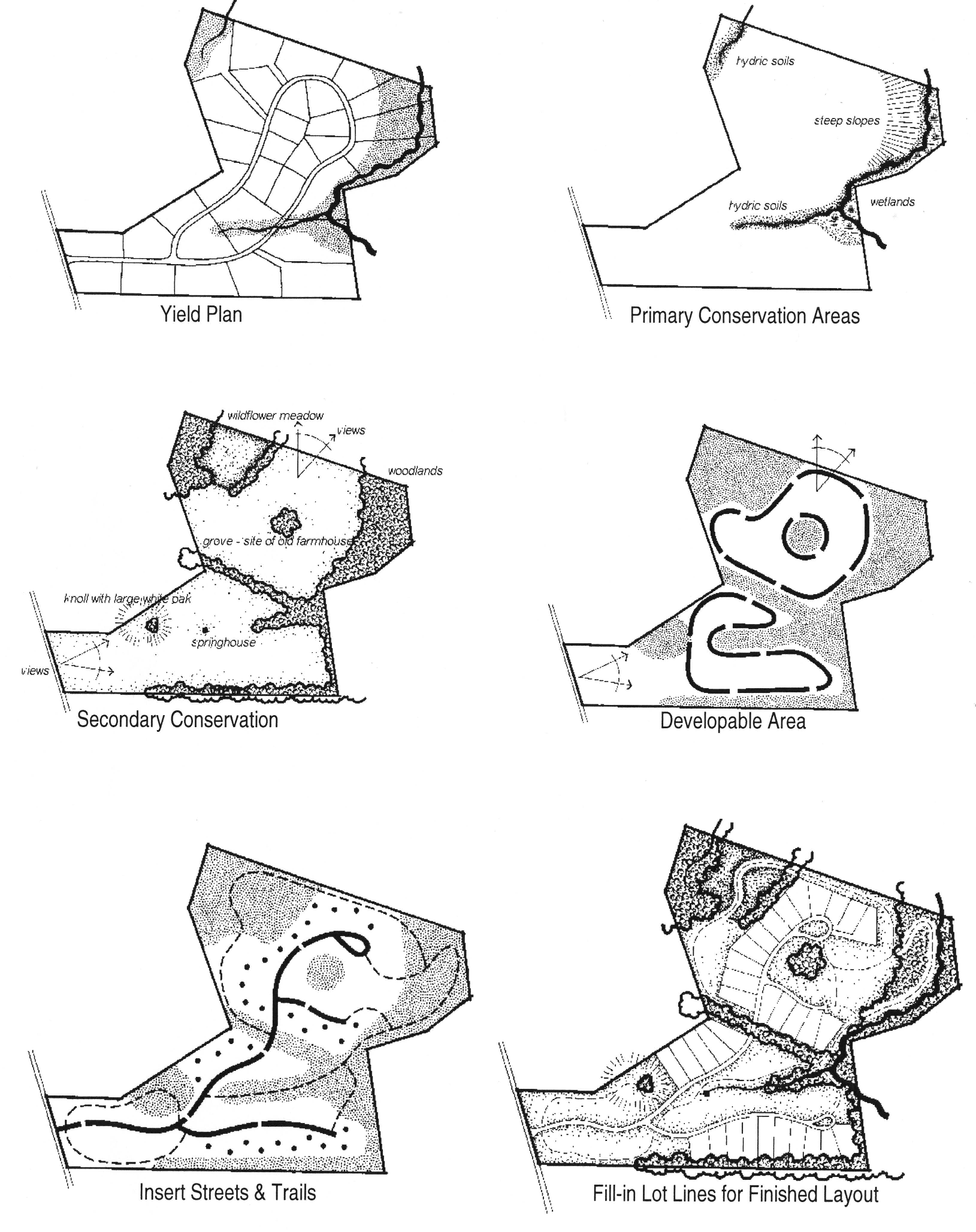
Process. The following process is encouraged, but not required, when designing the layout of a subdivision. It is taken from the concepts expressed in Conservation Subdivision Design by Randall Arendt.
1.
Density. Calculate the maximum allowable density pursuant to the underlying zoning district. This shall be considered the "yield plan."
2.
Conservation Areas.
a.
Primary. Identify those areas on the parcel to be developed that are considered Primary Conservation Areas. For the purposes of this chapter, a Primary Conservation Area shall be any of the following:
1.
Slopes greater than twenty-five (25) percent or 4.00:1.
2.
As identified on the Federal Insurance Rate Maps (FIRM), any designated flood hazard area, including floodplains and floodways.
3.
As identified on the National Wetland Inventory (NWI), any designated wetland.
4.
As identified by the Illinois Department of Natural Resources (IDNR), any habitat of a threatened or endangered plant or animal species.
5.
Any pond, lake, creek, stream, or river.
b.
Secondary. Identify those areas on the parcel to be developed that are considered Secondary Conservation Areas. For the purposes of this chapter, a Secondary Conservation Area shall be any of the following:
1.
Any prairie.
2.
Farmland.
3.
Historic, Archaeological, and Cultural Features.
4.
Groundwater recharge areas.
5.
Scenic views.
6.
Woodlands.
7.
Slopes between fifteen (15) and twenty-five (25) percent.
8.
Wet or hydric soils that are unbuildable.
9.
Soils with an agland score of eighty (80) or greater on the County LESA.
3.
Layout.
a.
Building Sites. Using the same maximum number of lots as permitted under the maximum density of the underlying zoning district, and as shown on the yield plan, lay out possible building sites in areas not considered a primary or secondary conservation area.
b.
Streets and Trails. With building sites identified, determine the location of the proposed streets and trails.
c.
Lots. Complete the process by laying-out lot lines around the proposed building sites.
c.
Example. Diagram 8-1 is an example taken from Conservation Subdivision Design.
Diagram 8-1
8.3.3
Streets.
1.
Intent. It is in the best interest of the public, the developer, and the future property owners that all streets in a subdivision be conceived, designed and built in accordance with good design practices and adequate minimum standards. Consequently, these regulations are adopted for the following purposes:
a.
Street planning should relate to overall community planning;
b.
Traffic in residential areas should be kept to a minimum to reduce noise, congestion, and hazards to pedestrians;
c.
The street is an important component of overall residential community design. Properly scaled and designed streets can create more attractive communities and can contribute to a clearly defined sense of place;
d.
Street design standards should permit flexibility in community design. They should allow street alignments to follow natural contours and preserve natural features or to respond to other design objectives such as the creation of more intimate urban-, village-, or rural-scaled streetscapes;
e.
Whenever possible, street layouts should be planned to avoid excessive stormwater runoff and the need for storm sewers;
f.
The amount of paved area should be kept to a minimum to reduce construction and maintenance costs, stormwater runoff, and heat buildup;
g.
In the interest of keeping housing affordable, street costs should be minimized;
h.
Overdesign of streets should be avoided. Excessive widths or an undue concern with geometry more appropriate for highways encourages greater vehicle speeds;
i.
Different streets have different functions and need to be designed accordingly. Blanket standards are inappropriate;
j.
Paved access should be provided to all developed parcels;
k.
Street system design should discourage through traffic on local residential streets;
l.
The layout of a local street system should not create excessive travel lengths;
m.
Local circulation systems and land development patterns should not detract from the efficiency of adjacent major streets; and
n.
The local circulation system should not have to rely on extensive traffic regulations or control devices to function efficiently and safely.
2.
General Standards and Applicability.
a.
All street improvements shall conform to the applicable standards of IDOT and the Peoria County Highway Department, unless specified differently herein. The standards of this section shall apply to all proposed streets, public and private.
b.
Classification. All new streets shall be classified so as to determine a level of service for the unit government maintaining the street. As defined in Article 11, Definitions, new streets shall be classified as one of the following:
1.
Arterials. Arterials have as their primary function inter-community and intra-metro area traffic movement. The secondary function of this roadway is to provide access to land. There are two (2) types of arterials.
a.
State. Any street maintained by the Illinois Department of Transportation, including but not limited to the Eisenhower Interstate System (ex. I-74), United States Routes (ex. US Rte 150), and State Highways (ex. IL Rte 116).
b.
County Primary. A system of streets maintained by Peoria County as identified as County Primary Arterials on the Comprehensive Land Use Plan Form Map (ex. Co. Hwy. R40).
2.
Collectors. Collectors have as their primary function to collect and distribute traffic between local streets and the arterial system. The secondary function of this roadway is to provide access to land. The tertiary function of this roadway is to provide traffic movement between neighborhoods. There are two (2) types of collectors.
a.
County, Nonprimary. A system of streets maintained by Peoria County that does not include those County Highways identified as County Primary Arterial on the Comprehensive Land Use Plan Form Map (ex. Co. Hwy. D25).
b.
Township Collector. A system of streets maintained by a Township form of government that are not considered local streets (ex. Hickory Grove Rd, Medina Twp.).
3.
Local Streets. Local streets have three (3) primary functions, which include, distribution of traffic to the collector and arterial systems; providing direct access to land; and providing traffic movement within neighborhoods. There are four (4) types of local streets.
a.
Township, Local. A street maintained by a Township form of government that provides access to land and move traffic within neighborhoods (ex. Littlefield Dr, Limestone Twp.).
b.
Cul-de-Sac. A local street maintained by a Township form of government with only one outlet that terminates in a vehicular turnaround and having an appropriate terminal for the safe and convenient reversal of traffic movement. It provides access to land (ex. Lamplighter Ln, Kickapoo Twp.).
c.
Alley. A local street maintained by a Township form of government that is intended to act as a secondary access to land.
d.
Street, Private. A local street that has not been accepted for maintenance by a local unit of government that is designed for the internal circulation of vehicles within a planned unit, multiple family development, or subdivision.
4.
Street, Frontage. A service street, usually parallel to a limited access highway, designed to reduce the number of access points that intersect the limited access highway. These streets can be either arterial or collector.
c.
The developer's engineer shall prepare and submit improvements plans pursuant to the standards established below and those found in subsection 3.16.4-4 of this chapter.
d.
Street Names. The names of streets in a proposed subdivision shall be approved by the Transportation Committee or other duly appointed committee by the County Board. When approving the street name of a proposed street, the Committee shall consider the following standards.
1.
The continuation of an existing street shall have the same name; and
2.
The name of a new street shall not duplicate or bear the same name of an existing street located in the County.
e.
Street Signs.
1.
The developer shall acquire, pay for and install all signage at all intersections within the subdivision, including traffic signalization and street name signs. The design and placement of all such signs are subject to the County Engineer's approval.
2.
The developer shall acquire, pay for and install all signage at locations where a proposed street intersects with an existing street, including traffic signalization and street name signs. This subsection shall not be waiverable. Once accepted for maintenance that street authority shall have the responsibility of maintaining the installed signage. The design and placement of all such signs are subject to the County Engineer's approval.
3.
Prohibition of Signs. Only signs authorized by the County Engineer shall be permitted to be placed, displayed, or maintained within the right-of-way of any proposed street.
f.
Frontage on Improved Streets. No subdivision shall be approved unless the parcel(s) being subdivided has access to any of the following:
1.
An existing public right-of-way;
2.
A private street approved by the Highway Department; or
3.
A public street shown upon a plat recorded in the Recorder of Deeds office.
g.
Limitation of Access. Where a proposed subdivision borders on or contains an existing or proposed arterial or collector street, all requirements of the maintaining agency shall be met. In addition, access shall be limited by one of the following means:
1.
All access to lots shall be from local streets within the subdivision;
2.
A frontage street may be built which is separated from the collector or arterial by a vegetative buffer and provides access thereto at suitable points; or
3.
The number of local streets entering a collector or arterial shall be no more than one per one thousand (1,000) feet wherever possible.
h.
Streets Along Boundary Lines. Streets may be laid out on the boundary of the subdivision, provided the new street does not create a nonconforming lot or structure on any adjacent properties. If necessary, the developer may apply for a variance from the requirements of this chapter, and subject to the requirements in Section 3.7 ("Variances") of this chapter.
i.
Commercial and Industrial Streets. Streets in commercial and industrial developments shall be designed and constructed as a Collector street, except as specified. The streets and other access ways shall be planned in connection with the grouping of buildings, location of rail facilities, and the provision of alleys, truck loading and maneuvering areas, walks and parking areas so as to minimize conflict of movement between the various types of traffic, including pedestrian.
3.
Design Standards.
a.
Purpose. In order to provide for roads of suitable location, width, and improvement to accommodate prospective traffic and afford satisfactory access to police, fire fighting, snow removal, sanitation, and road maintenance equipment, and to coordinate roads so as to compose a convenient system and avoid undue hardships to adjoining properties, the following design standards for new road construction shall be required. The standards as noted below shall apply to all new streets, except as specified.
b.
Street Extension.
1.
Where adjoining areas are not subdivided, the layout of new streets in subdivisions shall make provisions for proper extension of dedicated streets to the boundaries of the tract proposed to be subdivided.
2.
Temporary Turnarounds. Where the dedicated right-of-way ends at the boundary of the subdivision, a temporary turnaround shall be provided that meets the following minimum design standards:
a.
The final plat shall show the area of the temporary turnaround as a temporary easement to accommodate the installation and use of said turnaround until such time as the street extension is completed and accepted by the appropriate road authority. At such time the temporary easement shall be released.
b.
The temporary turnaround shall be described and recorded with the final plat.
c.
The temporary turnaround shall be in the shape of a "T" or "Y"
d.
The temporary turnaround shall measure sixty (60) feet by twenty-four (24) feet.
c.
Alignment. The arrangement of proposed roads in subdivisions shall make provisions for the continuance of the existing roads in adjoining areas. If the existing streets are dedicated, the new streets in subdivisions shall be dedicated if a continuance of development beyond the new subdivisions or development is feasible. The rigid grid road pattern shall not be required. The use of curvilinear streets and three-way "T" intersections shall be encouraged and used where such will result in a more desirable lay-out.
d.
Topography. Roads shall be related appropriately to the existing topography, soils, and drainage. They shall be arranged so as to obtain as many building sites as possible at or above the grades of the roads. A combination of steep grades and curves shall be prohibited.
e.
Grades. Grades shall be shown on the construction plans at a minimum of every one hundred (100) feet.
1.
Arterial Streets. Gradients for Arterial Streets shall be determined by IDOT or the County Engineer.
2.
Collector Streets. Gradients for Collector Streets shall not exceed six (6) percent. The minimum gradient shall be no less than fifty one-hundredths (0.50) of a percent.
3.
Local Streets. Gradients for Local Streets shall not exceed eight (8) percent. The minimum gradient shall be no less than fifty one-hundredths (0.50) of a percent.
f.
Cross Section. The crown of the pavement shall be from the centerline and shall be one-quarter-inch per foot (0.25"/1') of pavement width. On streets when open drainage ditches are to be provided for stormwater run-off, the maximum slope of the ditch wall shall be no more than four to one (4:1). The minimum slope of the ditch wall shall be one percent.
g.
Geometrics. Road geometrics shall conform to standards established by IDOT, the County Highway Department, or those listed herein, whichever is the most strict.
1.
Design Speed. Streets shall be designed for speeds as follows:
a.
Arterial Streets: As determined by IDOT.
b.
Collector and Frontage Streets: Forty (40) miles per hour.
c.
Local Streets, Excluding Private Streets: Twenty-five (25) miles per hour.
2.
Horizontal Curvature. Angles on the centerlines of streets shall not be permitted except at intersections. Centerline radii shall be as follows:
a.
Arterial, Collector, and Frontage Streets: Centerline radii for Arterial, Collector and Frontage Streets shall conform to standards established by IDOT or the County Engineer, whichever is more strict.
b.
Local Streets: One hundred fifty (150) feet.
3.
Reverse Curves.
a.
Arterial and Frontage Streets: The tangent shall be determined by IDOT or the County Engineer.
b.
Collector Streets: There shall be a tangent at least three hundred (300) feet between reverse curves.
c.
Local Streets: There shall be a tangent at least one hundred (100) feet between reverse curves.
4.
Vertical Curvature. No vertical curve shall be less than one hundred fifty (150) feet in length, except at intersections. In no case shall a vertical curve at an intersection be less than fifty (50) feet.
5.
Intersections.
a.
Intersection Spacing. Intersections shall be designed to best facilitate the safe flow of traffic. Distances between intersections shall be as follows:
1.
Local Street intersecting with an arterial street: No more than one intersection per quarter (1:¼) mile, unless topography and site conditions require a lesser distance.
2.
Local Street intersecting with a collector street: No more than one intersection per four hundred (400) feet.
3.
Local Street intersecting with another local street: A minimum separation distance of one hundred twenty-five (125) feet.
4.
Arterial or Collector Street intersecting with another arterial or collector street: As determined by IDOT or the County Engineer, whichever is more strict.
b.
Intersection Angle. All intersections shall be at right angles (ninety (90) degrees) unless topography or physical conditions require a lesser angle. In no case shall intersections be less than sixty (60) degrees.
c.
Vertical Alignment. The gradient of an intersection approach shall not exceed two (2) percent, unless topography or physical conditions require a steeper grade. In no case shall the gradient of an intersection approach be greater than five (5) percent. This required grade shall be maintained a minimum of one hundred (100) feet from the intersection.
d.
Sight Distance. The minimum sight distance shall be set forth by the County Engineer.
e.
Traffic Circles. Traffic circles may be used when two (2) local streets intersect. If used, the minimum inside radius of the traffic circle shall be at least forty (40) feet.
f.
Intersection Radii. Intersection radii shall be as follows in Table 8-1:
TABLE 8-1
INTERSECTION RADII
All measurements in feet
h.
Rights-of-Way.
1.
Every right-of-way established for subdivision purposes is to be separate and distinct from the lots or parcels adjoining said right-of-way. It shall be excluded from the dimensions or areas of said adjacent lots or parcels. All rights-of-way shall be dedicated to the public by the developer. The minimum right-of-way width shall be established by IDOT or County Highway Department, whichever is applicable, and these regulations as noted in Table 8-2, below.
2.
Arterial Streets shall be developed to the Standards of IDOT and the County Highway Department.
3.
Alleys. When alleys are part of the subdivision, curb and gutter shall be prohibited for the alley. Instead, alleys shall be a two-inch invert in the cross-section of the alley pavement. Any closed storm sewer inlet shall be located in the center of the pavement of the alley.
TABLE 8-2
RIGHT-OF-WAY WIDTHS
All measurements in feet
* Required easement width
i.
Cul-de-Sacs.
1.
General. A cul-de-sac shall be provided at the end of a permanent dead end road. The length of such a road shall be measured from the center line of the road of origin to the center of the terminus.
2.
Minimum Standards. The minimum design standards for a cul-de-sac shall be as noted in Table 8-3, below, unless limitation of the site by reason of topography or existing development makes development impractical except with a longer length, as determined by approval of the Peoria County Highway Department and the Department of Planning and Zoning.
TABLE 8-3
CUL-DE-SAC STANDARDS
All measurements in feet
4.
Construction Standards.
a.
Purpose. In order to provide for streets built properly with suitable materials to the proper depth and width; to accommodate prospective traffic and afford satisfactory access to police, fire fighting, snow removal, sanitation, and road maintenance equipment; and to coordinate streets so as to compose a convenient system and avoid undue hardships to adjoining properties, the following construction standards for new street construction shall be required. The standards as noted below shall apply to all new streets, except as specified.
b.
Inspection Procedures. All major and moderate subdivisions shall be subject to the inspection procedure identified below. There shall be no waiver from this process. The developer shall be responsible for making arrangements to schedule each required inspection with a licensed civil engineer. The Township Road Commissioner shall be notified at least seventy-two (72) hours prior to each inspection in order that he may be present at each inspection. Documentation shall be submitted to the Planning and Zoning Department in the form of an affidavit signed and sealed by the engineer within five (5) working days of completion of each inspection. If a deficiency or violation is identified during an inspection, then said violation shall be corrected and re-inspected prior to proceeding with the next phase of construction. If the developer proceeds without an inspection or when in violation, he shall be subject to the stop work order fees as identified in Appendix A of this chapter. If the sole violation is of Section 7.13 ("Erosion, Sediment, and Stormwater Control") of this chapter, a stop work order fee from either Section 3.16 ("Plat Approval") or Article 8, Subdivisions, or Sections 3.12 ("General Erosion and Sediment Control Permits"), 3.13 ("Erosion, Sediment, and Stormwater Control Permits"), and 7.13 ("Erosion, Sediment, and Stormwater Control") shall be assessed, but not a stop work order fee from both chapters.
1.
First Inspection. The first inspection shall occur when all earthwork has been completed and prior to the installation of the base material. The items to be checked include at a minimum:
a.
Compliance with Sections 3.12 ("General Erosion and Sediment Control Permits"), 3.13 ("Erosion, Sediment, and Stormwater Control Permits"), and 7.13 ("Erosion, Sediment, and Stormwater Control") of this chapter.
b.
Compliance with the appropriate Geometrics requirements as identified in subsection 8.3.3-3, above.
c.
Proper compaction of the sub-base.
2.
Second Inspection. The second inspection shall occur upon the complete installation of the base material and prior to the installation of the surface material. The items to be checked include at a minimum:
a.
Continued compliance with Sections 3.12 ("General Erosion and Sediment Control Permits"), 3.13 ("Erosion, Sediment, and Stormwater Control Permits"), and 7.13 ("Erosion, Sediment, and Stormwater Control") of this chapter.
b.
Continued compliance with the appropriate Geometrics requirements as identified in subsection 8.3.3-3, above.
c.
Compliance with the requirements of subsection 8.3.3-4.c.1, below.
3.
Third Inspection. The third inspection shall occur during the installation of the surface material. The items to be checked include at a minimum:
a.
Bituminous Surfaces.
1.
Continued compliance with Sections 3.12 ("General Erosion and Sediment Control Permits"), 3.13 (Erosion, Sediment, and Stormwater Control Permits"), and 7.13 ("Erosion, Sediment, and Stormwater Control") of this chapter.
2.
Continued compliance with the appropriate Geometrics requirements as identified in subsection 8.3.3-3, above.
3.
Compliance with the requirements of subsection 8.3.3-4.c.2, below.
4.
Compliance with the State of Illinois specifications for bituminous plant mix materials.
b.
Portland Concrete Cement Surfaces. This inspection would also include sidewalks (if required), and curb and gutter.
1.
Continued compliance with Sections 3.12 ("General Erosion and Sediment Control Permits"), 3.13 ("Erosion, Sediment, and Stormwater Control Permits"), and 7.13 ("Erosion, Sediment, and Stormwater Control") of this chapter.
2.
Continued compliance with the appropriate Geometrics requirements as identified in subsection 8.3.3-3, above.
3.
Compliance with the requirements of subsection 8.3.3-4.c.2, below.
4.
Compliance with the State of Illinois specifications for Portland concrete cement materials.
4.
Fourth Inspection. The fourth inspection shall be the final inspection with the intent of inspection approval meaning the street is ready for the release of financial security and acceptance for maintenance by the appropriate road authority. The township road commissioner shall be notified and included in this final inspection of the road improvements. The items to be checked include at a minimum:
a.
Final compliance with Sections 3.12 ("General Erosion and Sediment Control Permits"), 3.13 ("Erosion, Sediment, and Stormwater Control Permits") and 7.13 ("Erosion, Sediment, and Stormwater Control") of this chapter (Erosion, Sediment, and Stormwater Control Ordinance).
b.
Final compliance with the appropriate Geometrics requirements as identified in subsection 8.3.3-3, above.
c.
Final compliance with the requirements of subsection 8.3.3-4.c.2, below.
c.
Streets.
1.
Base. The base of all proposed streets shall meet or exceed all of the standards in this subsection, the requirements identified in Tables 8-4 and 8-5.
a.
Material. The base of all proposed streets shall be either CA-6 or CA-10 aggregate. All materials shall be from State approved suppliers.
b.
Width. The width of the base of all proposed streets shall conform to Table 8-4 ("Street Base Widths").
c.
Depth. The depth of the base of all proposed streets shall conform to Table 8-5 ("Street Base Depths"). This depth shall be the depth after compaction.
d.
Installation. The base of all proposed streets shall be applied to the sub-base using a mechanical spreader or spreader box. The base shall also be rolled with a pneumatic-tired roller to the compacted depth as required in Table 8-5, below. A compaction rate of ninety (90) percent shall be achieved prior to the installation of the surface.
TABLE 8-4
STREET BASE WIDTHS
All measurements in feet
TABLE 8-5
STREET BASE DEPTHS
All measurements in inches
2.
Surface. The surface of all proposed streets shall meet or exceed all of the standards in this subsection, the information identified in Tables 8-6 and 8-7. A3 surfacing ("tar and chip") shall be strictly prohibited.
a.
Material. The surface of all proposed streets shall be a bituminous plant mix conforming to State of Illinois specifications Portland Concrete Cement (PCC) may be substituted with the written approval of the County Engineer.
b.
Width. The width of the surface of all proposed streets shall conform to Table 8-6 ("Street Surface Widths").
c.
Depth. The depth of the surface of all proposed streets shall conform to Table 8-7 ("Street Surface Depths").
d.
Installation. The bituminous plant mix surface shall be applied in two (2) courses or lifts, a binder course and a surface course.
1.
Binder Course. The binder course shall be two-thirds (⅔) of the total depth of the required surface depth. The binder course shall be allowed to settle for one winter and spring season prior to the application of the surface course. Any settling requiring patching shall be patched prior to the application of the surface course. The settling requirement may be waived by the County Engineer, provided proper compaction tests meeting ninety-five (95) percent of optimum density has been submitted to the County Engineer.
2.
Surface Course. The surface course shall be one-third (⅓) of the total depth of the required surface depth. The surface course shall be applied after the binder course has settled for at least one winter season and any required patching has been completed.
TABLE 8-6
STREET SURFACE WIDTHS
All measurements in feet
TABLE 8-7
STREET SURFACE DEPTHS
All measurements in inches
[d.
Reserved.]
e.
Curb and Gutter.
1.
Residential. Curb and gutter shall be required for residential streets when required by a municipality exercising its extra-territorial authority, or where an underground or closed stormwater systems are either required or proposed. When required all curb and gutter shall be barrier type with depressed entrances for driveways. The depressed entrance shall be a minimum of eighteen (18) feet.
2.
Nonresidential. Curb and gutter shall be required for nonresidential streets when required by a municipality exercising its extra-territorial authority, or where an underground or closed stormwater systems are either required or proposed. When required all curb and gutter shall be barrier type with depressed entrances for driveways. The depressed entrance shall be a minimum of twenty-five (25) feet.
f.
Pedestrian Ways.
1.
Sidewalks.
a.
Sidewalks shall be required on both sides of all streets in a residential subdivision containing lots having an area of one-quarter (¼) acre or less.
b.
Sidewalks shall be required on only one side of every street in a residential subdivision containing lots having an area between one-quarter (¼) and one acre.
c.
Sidewalks are not required in a residential subdivision containing lots having an area of one acre or greater. However, if provided, the sidewalks shall meet or exceed the minimum specification requirements.
d.
Specifications. Sidewalks shall be located a minimum of one foot inside the right-of-way line, a minimum of four (4) feet in width, and a minimum of three and one-half (3½) inches in thickness of Portland concrete cement that meets or exceeds the IDOT materials specifications for Portland concrete cement sidewalks.
2.
Trails. Trails may be installed as a substitute for sidewalks when they are required, if approval is granted by the County Highway Department and the Township Road Commissioner. Should the subdivision include trails, they shall meet or exceed the minimum standards below.
a.
All trails shall be constructed within an easement or a public right-of-way. Said easement shall be described and shown on the preliminary plat, construction plans, and final plat.
b.
Trails shall be a minimum of fifty (50) feet from any principal structure.
c.
Trails shall be a minimum of five (5) feet from any property line.
d.
Trails shall have a minimum gravel base of eight (8) inches. The base material shall be CA6 or better.
e.
The trail surface shall be a minimum four (4) inches of limestone screenings or two (2) inches of asphalt, Class I-11 or I-11 modified.
f.
Trails shall be a minimum of eight (8) feet wide.
g.
Maintenance of trails:
1.
If a trail is located in a public right-of-way, the road authority who accepts the right-of-way for maintenance shall be responsible for maintenance of the trail unless a notation has been made on the final plat for maintenance by another entity, such as the homeowners' association.
2.
If a trail is located in an easement or dedicated open space, the owners of the lots in the subdivision shall be responsible for maintenance of the trail.
3.
Accessibility Requirements. All sidewalks and trails shall conform to the minimum requirements of the American's with Disabilities Act and the State of Illinois' Environmental Barriers Act.
g.
Public Safety.
1.
Signalization. The developer, at his expense, shall provide all required signalization including but not limited to street name signage, and traffic control devices.
a.
Street Name Signs. Street Name Signs shall be installed at the northeast corner of every intersection within the subdivision, and the intersection of any existing exterior streets. The street name sign shall indicate the street names as shown on the final plat. The street name signs shall be approved by the appropriate road authority.
b.
Traffic Control Devices. Proper traffic control shall be provided at every intersection with the subdivision. At a minimum a stop sign shall be installed at every exit of the subdivision. As may be required by IDOT or the County Engineer, traffic lights shall be installed by the developer.
2.
Guard Rails. Guard rails or warning posts may be required in situations identified by IDOT. If required by the County Engineer, said guard rails or warning posts shall be installed pursuant to IDOT standards for placement and materials.
5.
Approval of Right-of-Way and Pavement Deficiencies.
a.
The right-of-way width in areas where the right-of-way has been platted but the road has not been built or accepted for maintenance, may be approved at the existing right-of-way width.
b.
Right-of-way widths, street widths and cross-sections in a proposed subdivision which deviate from the standards in this article may be considered for approval at deficient dimensions provided that:
1.
The proposed street is an extension of a deficient street.
2.
The proposed street intersects the deficient street.
c.
In no case shall the right-of-way be less than fifty (50) feet in width.
8.3.4
Utilities. The proper design, location, installation and maintenance of utilities is in the long term interest of the residents of Peoria County in that it promotes general health and safety. Extension of utilities should be encouraged in such a manner that it promotes a compact form of development.
1.
Water Supply.
a.
Purpose. The intent of these regulations is to ensure that County residents have an adequate and safe water supply, and to further the intent of the comprehensive plan by promoting compact growth with adequate public utilities.
b.
Water System Required. The following shall be required:
1.
Tract Surveys. If an existing public water supply is within a reasonable distance of the parcels created by tract survey, the developer, at his expense, shall extend the public water supply to all parcels created as part of the tract survey and extension of the existing water supply shall not be waived by the County Board. A reasonable distance shall be deemed to be not greater than three hundred (300) feet for a single-family residence and not greater than one thousand (1,000) feet for a commercial establishment or multifamily dwelling. If an existing public water supply is not within a reasonable distance, parcels created by tract survey may be served by private well, provided they have obtained the appropriate permits from the Health Department. A waiver from the County Board shall not be required.
2.
Minor Subdivisions.
a.
If an existing public water supply is within a reasonable distance of the subdivision, the developer, at his expense, shall extend the public water supply to all parcels created as part of the minor subdivision and extension of the existing water supply shall not be waived by the County Board. This shall be done during the construction of the other improvements in the development, and designed to accommodate the demand to be generated by the subdivision and in accordance with Distribution System Requirements, below. At the time of construction, the owner of each lot created shall be required to hook-up to the public water supply. A reasonable distance shall be deemed to be not greater than three hundred (300) feet for a single-family residence and not greater than one thousand (1,000) feet for a commercial establishment or multifamily dwelling.
b.
If a public water supply does not exist within a reasonable distance of the subdivision, the developer shall be required to obtain a waiver from the County Board in accordance with subsection 8.3.4-1.d.
3.
Moderate Subdivisions.
a.
If an existing public water supply is within a reasonable distance of the subdivision, the developer, at his expense, shall extend the public water supply to all parcels created as part of the moderate subdivision and extension of the existing water supply shall not be waived by the County Board. This shall be done during the construction of the other improvements in the development, and designed to accommodate the demand to be generated by the subdivision and in accordance with Distribution System Requirements, below. At the time of construction, the owner of each lot created shall be required to hook-up to the public water supply. A reasonable distance shall be deemed to be not greater than three hundred (300) feet for a single-family residence and not greater than one thousand (1,000) feet for a commercial establishment or multifamily dwelling.
b.
If a public water supply does not exist within a reasonable distance of the subdivision, the developer shall be required to obtain a waiver from the County Board in accordance with subsection 8.3.4-1.d.
4.
Major Subdivisions. All major subdivisions shall be developed using a public water supply or community water supply system. The use of individual wells for each lot platted shall be strictly prohibited and shall not be waived by the County Board.
a.
Public Water Supply. If a public water supply exists within a reasonable distance of the subdivision, the developer, at his expense, shall extend the public water supply to all parcels created as part of the major subdivision. This shall be done during the construction of the other improvements in the subdivision, and designed to accommodate the demand to be generated by the subdivision and in accordance with Distribution System Requirements, below. At the time of construction, the owner of each lot created shall be required to hook-up to the public water supply. A reasonable distance shall be deemed to be not greater than three hundred (300) feet for a single-family residence and not greater than one thousand (1,000) feet for a commercial establishment or multifamily dwelling.
b.
If a public water supply does not exist within a reasonable distance of the subdivision, the developer shall, at his expense, install a community water supply system. The developer shall obtain the appropriate permits from the Illinois Environmental Protection Agency, and provide said documentation to the Plat Officer as part of the approval of the construction plans. The developer, at his expense, may extend public water to the subdivision in lieu of a community water supply system.
c.
Distribution System Requirements.
1.
A complete water main supply system to be connected to an existing public water supply or a community water supply shall be approved by the Illinois Environmental Protection Agency.
2.
The developer shall be responsible for the proper installation of the entire distribution system, including, but not limited to, all water mains, stubs from the water mains to every platted lot, fire hydrants, and any other part of the system to adequately meet the minimum standards set forth below.
3.
Such distribution system shall consist of adequately sized mains, not less than eight (8) inches in diameter.
4.
Fire Hydrants. Fire Hydrants shall be required as a part of any distribution system. There shall be at least one hydrant per distribution system. They shall be placed on a water main no less than eight (8) inches in diameter. They shall be spaced a maximum of five hundred (500) feet apart. Any hydrant placed in a public right-of-way shall be approved as part of the construction plan approval process.
5.
The system shall be so designed as to supply a minimum of three (3) gallons per minute per person, based on the expected total population, at a minimum pressure of thirty (30) pounds per square inch.
d.
Waiver. Requirements stated in this section may be waived in accordance with Section 3.15 ("Subdivision Waivers and Appeals") of this chapter only in those areas not served by a public water supply unless the regulation specified above states that it cannot be waived. The County Board may waive the requirement for a public water supply in a minor or moderate subdivision and allow the subdivision to be served by individual wells for each lot, provided the developer submits satisfactory documentation to support this request. Such documentation shall include, but not be limited to:
1.
Documentation regarding proximity to existing water supply, both current and planned expansion by the appropriate water authority.
2.
Detailed and documented cost comparison of the projected costs of public water, community water, and individual wells.
3.
Documentation shall be provided to demonstrate that an adequate quantity and quality of water will be available for all lots proposed. Such documentation may be provided by the Illinois State Geological Survey or the Illinois State Water Survey.
4.
Documentation from an existing well in the immediate vicinity documenting the production of water at a minimum rate of three (3) gallons per minute (gpm.)
5.
The developer shall provide data from a test boring(s) completed by a well driller denoting the availability of water at this location. Location of the test well(s) shall be identified by the Illinois State Water Survey, the Peoria City/County Health Department and a licensed well driller. Results of such boring shall indicate a minimum three (3) gallons per minute (gpm) produced.
2.
Sanitary Sewers.
a.
Purpose. To protect the health and safety of county residents by providing for the safe and sanitary disposal of domestic sewage.
b.
Sanitary Sewers Required. The following shall be required:
1.
Tract Surveys. Parcels created by tract survey shall be required to connect to an existing sanitary sewer that has capacity and is down stream from the parcels to be created when said parcels are within a reasonable distance. A reasonable distance shall be deemed to be not greater than three hundred (300) feet of the property boundary for a single-family residence and not greater than one thousand (1,000) feet of the property boundary for a commercial establishment or multifamily dwelling. When a sanitary sewer exists within a reasonable distance but is not capable of serving the parcels to be created, or if no sanitary sewer exists within a reasonable distance of the parcels to be created, an onsite wastewater treatment system may be used for each parcel to be created. The installation of such system shall be the responsibility of the owner obtaining a permit for construction of the principal structure on the parcel. A parcel created by tract survey with an existing principal structure and an existing onsite wastewater treatment system, may be allowed to continue using said system.
2.
Minor Subdivisions. Lots created by minor subdivision shall be required to connect to an existing sanitary sewer that has capacity and is down stream from the lots to be created when said parcels are within a reasonable distance. A reasonable distance shall be deemed to be two thousand five hundred (2,500) feet from the nearest approved public sewer system to the nearest portion or point of the proposed subdivision. When a sanitary sewer exists within a reasonable distance but is not capable of serving the lots to be created, or if no sanitary sewer exists within a reasonable distance of the lots to be created, an individual sewage disposal system may be used for each parcel to be created, if approved by the Peoria City/County Health Department. A waiver from the County Board shall not be required. The installation of such system shall be the responsibility of the owner obtaining a permit for construction of the principal structure on the lot(s). A lot created by minor subdivision with an existing principal structure and an existing individual sewage disposal system, may be allowed to continue using said system.
3.
Moderate Subdivisions. Lots created by moderate subdivision shall be required to meet or exceed the following:
a.
All moderate subdivisions shall be designed and built with a sanitary sewer collection system connected to an existing system for waste water treatment and disposition with sufficient capacity and acceptable degree of treatment to accommodate the subdivision. Where any part of an existing system is located within a reasonable distance, the developer shall at his expense connect to said system. A reasonable distance shall be deemed to be two thousand five hundred (2,500) feet from the nearest approved public sewer system to the nearest portion or point of the proposed subdivision. If the existing system to which a subdivision would be connected to has insufficient capacity or degree of treatment, the developer shall provide at his expense the means to increase the capacity or degree of treatment to accommodate the subdivision.
4.
Major Subdivisions. Lots created by major subdivision shall be required to meet or exceed the following:
a.
All major subdivisions shall be designed and built with a sanitary sewer collection system connected to an existing system for waste water treatment and disposition with sufficient capacity and acceptable degree of treatment to accommodate the subdivision. Where any part of an existing system is located within a reasonable distance, the developer shall at his expense connect to said system. A reasonable distance shall be deemed to be two thousand five hundred (2,500) feet from the nearest approved public sewer system to the nearest portion or point of the proposed subdivision. If the existing system to which a subdivision would be connected to has insufficient capacity or degree of treatment, the developer shall provide at his expense the means to increase the capacity or degree of treatment to accommodate the subdivision.
c.
Waiver. Requirements stated in subsection 8.3.4-2 may be waived in accordance with Section 3.15 ("Subdivision Waivers and Appeals") of this chapter. The following additional criteria shall be met in order to obtain a waiver for the utilization of individual septic systems.
1.
Where there is no existing system to which the subdivision can be reasonably connected, either by reason of distance or insufficient capacity which cannot be reasonably increased, then the developer shall provide a means for waste water treatment and disposition as may be approved by the Peoria City/County Health Department.
2.
Soil profiles shall be required by the Peoria City/County Health Department. No soil profiles shall be taken in areas where the natural topography is to be cut or filled; it being the intention of this requirement that such tests show soil conditions in which the individual sewage disposal systems will be installed and will be expected to function.
3.
If approved surface private sewage disposal systems are required to dispose of effluent, the outfall shall be constructed in accordance with the design standards set forth in Chapter 19 of the County Code. When necessary, easements shall be provided for such outfalls, and such easements shall be clearly marked on the final subdivision plat. No effluent shall be discharged to any roadside ditch. No such outfall pipe shall be laid under any public street, unless plans and installation are approved in writing by the health department and the appropriate highway official.
3.
Storm Sewers.
a.
The developer shall provide a stormwater control system to adequately serve the subdivision which conforms to the minimum requirements of Sections 3.12 ("General Erosion and Sediment Control Permits"), 3.13 ("Erosion, Sediment, and Stormwater Control Permits"), and 7.13 ("Erosion, Sediment, and Stormwater Control") of this chapter.
b.
In addition to the requirements of Sections 3.12 ("General Erosion and Sediment Control Permits"), 3.13 ("Erosion, Sediment, and Stormwater Control Permits"), and 7.13 ("Erosion, Sediment, and Stormwater Control"), the design of the stormwater control system shall also consider and show in the designs the following:
1.
The watershed area of which the subdivision is a part.
2.
The use of existing drainage courses wherever possible.
3.
A plan of swales or a closed system to prevent flooding and ponding of streets within and adjacent to the subdivision.
c.
Culverts. In subdivisions with an open stormwater control design, the proper installation of culverts shall be required at the access point to each lot platted. The exact location, type, and sizing of culverts shall be determined by the road authority to which the property is gaining access from. However, culverts shall have the following minimum requirements:
1.
Residential. Culverts that access lots used for residential purposes shall be at a minimum:
a.
A corrugated metal or better design.
b.
Have a minimum diameter of eighteen (18) inches or as approved by the appropriate road authority.
c.
Have a minimum subgrade cover of six (6) inches.
d.
Have a minimum length of thirty (30) feet.
2.
Nonresidential. Culverts that access lots used for nonresidential purposes shall be at a minimum:
a.
A corrugated metal or better design.
b.
Have a minimum diameter of twenty-four (24) inches or as approved by the appropriate road authority.
c.
Have a minimum subgrade cover of ten (10) inches.
d.
Have a minimum length of thirty (30) feet.
d.
Ditches and Swales. Ditches and swales shall meet the following minimum requirements:
1.
With grades of four (4) percent or less, ditches and swales shall be seeded and covered with mulch or erosion (excelsior) blanket.
2.
With grades between four (4) and eight (8) percent, ditches and swales shall have sod channels and ditch checks. Ditches may be required to be lined with rock rip-rap. Said rip-rap shall be at least six (6) inches, but no more than eighteen (18) inches.
3.
With grades eight (8) percent or greater, ditches and swales shall be lined with rock rip-rap. Said rip-rap shall be at least six (6) inches, but no more than eighteen (18) inches.
4.
Other Utilities.
a.
Other utilities shall be considered as natural gas, electrical services, telephone, cable televisions (CATV), and other similar services distributed by pipe, wire or cable.
b.
The developer shall make arrangements for all utilities to be installed entirely underground throughout the entire subdivision. The developer shall provide easements along common property lines that are wide enough to accommodate the cable or conduit which provides said utilities. The easements shall be shown on the preliminary plat, any required construction plans, and the final plat. All utility lines shall be placed either within a public right-of-way or within the platted utility easement. If placed within the public right-of-way, the utility shall be located within five (5) feet of the outer edge of the right-of-way and along the back slope of the ditch, unless curb and gutter is provided.
c.
If alleys are part of the development, all utilities shall be located in said alleys and other public right-of-way, and shall access each lot from the alley.
d.
All utility lines placed within a public rights-of-way or easements shall be planned so as not to conflict with other underground utilities.
e.
Electrical transformers and telephone junction boxes shall not be placed in any portion of a designated stormwater improvement.
(Ord. of 3-13-14)
Sec. 8.4 - Open Space Recommendations
8.4.1
Intent. To further the goals and objectives of the Peoria County Comprehensive Land Use Plan, and the intent of this chapter as identified in Section 1.3.3, Subdivision Purpose, open space regulations shall be encouraged pursuant to this article for the following purposes:
1.
To protect the land, air, natural resources of the State of Illinois, pursuant to 50 ILCS 805/1 et seq.;
2.
To better integrate development into and minimize the impact on the natural environment;
3.
To allow for recreational opportunities of the subdivision's residents, which improves the community;
4.
To improve the health of the subdivision's occupants;
5.
To protect the important natural resources found specifically in Peoria County.
8.4.2
Applicability and Standards.
1.
Tracts Surveys. Tract surveys shall be exempt from the standards of this article.
2.
Minor Subdivisions. Minor subdivisions shall be exempt from the standards of this article.
3.
Major and Moderate Subdivisions. Major and moderate subdivisions are encouraged, but not required, to adhere to the following standards. Open Space recommendations shall be on a sliding scale based on the size of the subdivision as shown in Table 8-8, Open Space Recommendations. Open space shall be either common or public open space, as defined in Article 11, Definitions.
TABLE 8-8
OPEN SPACE RECOMMENDATIONS
4.
Additional Open Space. Any open space dedicated by the developer beyond the minimum required shall also be held to the requirements of this section.
5.
Open Space Components. Items or features that may be considered as part of the subdivision's open space shall include, but not be limited to:
a.
Natural features such as lakes, streams, wetlands, forests, prairies, flood hazard areas, areas of steep slope and highly erodible soils, and areas which provide important and valuable functions, such as floodwater storage, groundwater recharge, soil stabilization, water quality enhancement, temperature modulation, and wildlife habitat.
b.
Scenic, recreational, and/or historic amenities.
6.
Access to Open Space. The dedicated open space shall be incorporated into the development such that it shall be accessible to all property owners and residents in the development and its minimum dimensions are functionally useable.
8.4.3
Ownership and Maintenance.
1.
Ownership. The developer shall choose one of the following selections for long-term ownership of the dedicated open space. For all selections, the owner shall be responsible for permanent maintenance of the dedicated open space, and property tax that may be levied by a local unit of government.
a.
Developer. The developer maintains ownership of the dedicated open space.
b.
Property Owners' or Residents' Association. As part of the platting process, the developer creates the association. Purchase of a lot requires membership in the association. Dues are charged annually to cover the cost of maintenance and/or tax that may be required.
c.
Local Unit of Government. The developer may enter into an agreement with a local unit of government for the purpose of transferring ownership to said unit of government.
d.
Land Trust. The developer may transfer ownership of the dedicated open space to a land trust whose mission involves proper stewardship of the land. Said trust shall have a 501(c)(3) not-for-profit status, and such transfer shall be subject to the approval of the Plat Officer.
Sec. 8.5 - Certificates and Notations
8.5.1
Intent. In order to allow for accurate, consistent and efficient review of development proposals, the following language shall be required for all certificates and notations. As stated in Section 3.16 ("Plat Approval") of this chapter, all certificates are required to be no more than one inch from any edge of the survey.
8.5.2
Tract Surveys.
1.
Certificates. The following certificates shall be required on all tract surveys.
a.
County Clerk's Certificate. The certificate for the County Clerk shall be as follows.
I hereby certify that I find no delinquent taxes, unpaid current taxes, delinquent special assessments or unpaid current special assessments against any of the real estate embraced in the attached Plat of Survey and Description.
Given under my hand and Seal this ___ day of ________, 20___.
b.
Certificate of Current Ownership. The certificate for the property owner shall be as follows.
I/We, ___________, the Owner(s) of Record of the land shown in the attached Plat, do hereby authorize and acknowledge the Survey of the land as described in the accompanying Legal Description. Also, to the best of my knowledge the described parcel is located in ___________ school district.
Given under my hand and Seal this ___ day of ________, 20___.
Owner of Record Owner of Record
Owner of Record Owner of Record
Subscribed and Sworn to before me this ___ day of ________, 20___.
Notary Public
c.
Appropriate Road Official.
1.
District Engineer for the Illinois Department of Transportation. The certificate for the State of Illinois when the tract survey fronts on a state highway shall be as follows.
This plat has been approved by the Illinois Department of Transportation with respect to roadway access pursuant to Chapter 765 Illinois Compiled Statutes, Act 205, Section 2. However, a permit for access is required by the owner of the property. A plan that meets requirements contained in the Department's "policy on permits for access driveways to State Highways" will be required by the Department. This ___ day of ________, 20___.
Director of Highways,
Region Three Engineer
2.
County Highway Official's Certificate. The certificate for the County Engineer shall be as follows.
This plat has been approved by the Peoria County Highway Department with respect to roadway access pursuant to 765 ILCS 205/2 and Section 3.14 ("Subdivision"), 3.15 ("Subdivision Waivers and Appeals"), 3.16 ("Plat Approval"), and Article 8, Subdivisions, of this Chapter 20 of the Peoria County Code. However, a highway permit for access may be required by the property owner. Access will be allowed by the County in accordance with the policy on permits for access driveways to county roadways. This ___ day of ________, 20___.
County Engineer
3.
Township Road Commissioner's Certificate. The certificate for the Township Road Commissioner shall be as follows.
This plat of survey has been reviewed by the Township Road Commissioner with respect to roadway access, and the plat of survey meets the safety and access control standards in ___________ Township. This ___ day of ________, 20___.
Township Road Commissioner
d.
Surveyor's Certificate. The certificate for the Surveyor shall be as follows.
This is to certify that I, ___________, an Illinois Professional Land Surveyor, No. ___, have surveyed and subdivided the property as described and shown by the attached plat, which is a correct representation of said survey and subdivision. All distances are shown in feet and decimals thereof.
Given under my hand and Seal this ___ day of ________, 20___.
Professional Land Surveyor (SEAL)
e.
Plat Officer's Certificate. The certificate for the Plat Officer shall be as follows.
This tract survey is hereby is approved in accordance with the provisions of the Plat Act of Illinois (55 ILCS 5/5-1041) and Sections 3.14 ("Subdivision"), 3.15 ("Subdivision Waivers and Appeals"), 3.16 ("Plat Approval"), and Article 8, Subdivisions, of this Chapter 20 of the Peoria County Code. It is in conformance with the goals and objectives of the County's Comprehensive Land Use Plan.
Given under my hand and Seal this ___ day of ________, 20___.
Peoria County Plat Officer (SEAL)
2.
Required Notations. The following shall be required on all tract surveys or only as noted.
a.
Health Department Note. This shall be noted on every tract survey: "This tract survey does not provide for, nor imply, assurance of the compatibility for future construction utilizing a private sewage disposal system. A permit shall be obtained from the Peoria City/County Health Department prior to start of construction."
b.
Water Note. If the parcel is served by a public water provider or water district, then "Water for this parcel is provided by ___________. Notice of hook-up is required prior to start of construction." shall appear on the tract survey. If the parcel is not served by any water provider, and an individual well would be needed, then "There is no public water provider to this parcel. Development of the parcel requires a well permit from the Peoria City/County Health Department before the start of construction." shall appear on the tract survey.
c.
Long Driveways. For any parcel being created by tract survey that extends greater than five hundred (500) feet from the adjacent right-of-way and street, the following shall appear on the tract survey: "NOTICE TO THE PUBLIC: The creation of long private driveways may result in increased response time or inaccessibility by emergency service vehicles."
d.
Zoning. Every tract survey shall note the zoning of the parcel on the day of recording with the following note, "On (date) , this parcel is known to be zoned ________."
e.
Floodplain. The surveyor shall determine if the parcel is located within any regulatory floodplain or floodway. If so, it shall be noted graphically on the tract survey, and textually with the following language, "This parcel is located in a special flood hazard area. Zone ___, Community Panel ___. Improvements to this parcel may require special approval."
8.5.3
Preliminary Plats Certificates. The following certificates shall be required on all preliminary plats.
1.
Surveyor's Certificate. The certificate for the Surveyor shall be as follows:
This is to certify that I, ___________, an Illinois Professional Land Surveyor, have surveyed and subdivided the property as described and shown by the attached plat, which is a correct representation of said survey and subdivision. All distances are given in feet and decimal parts thereof. I further certify that part of the property covered by this subdivision (is/is not) within one and one-half (1½) miles of the corporate limits of an incorporated city, town, or village exercising extraterritorial subdivision control; and that the tract (is/is not) within five hundred (500) feet of any drainage course draining six hundred forty (640) acres or more.
Given under my hand and Seal this ___ day of ________, 20___.
2.
Municipal Certificates of Approval. For those municipalities exercising extraterritorial subdivision control, the certificate required in that municipality's subdivision ordinance shall be affixed to the preliminary plat.
3.
County Plat Officer Certificate of Approval. The certificate for the County Plat Officer shall be as follows.
This preliminary plat is hereby is approved in accordance with the provisions of the Plat Act of Illinois (55 ILCS 5/5-1041) and Sections 3.14 ("Subdivision"), 3.15 ("Subdivision Waivers and Appeals"), 3.16 ("Plat Approval"), and Article 8, Subdivisions, of this Chapter 20 of the Peoria County Code. It is in conformance with the goals and objectives of the County's Comprehensive Land Use Plan.
Given under my hand and Seal this ___ day of ________, 20___.
Peoria County Plat Officer (SEAL)
8.5.4
Final Plats.
1.
Certificates. The following certificates shall be required on all final plats:
a.
County Clerk's Certificate. The certificate for the County Clerk shall be as follows:
I hereby certify that I find no delinquent taxes, unpaid current taxes, delinquent special assessments or unpaid current special assessments against any of the real estate embraced in the attached Plat of Survey and Description.
Given under my hand and Seal this ___ day of ________, 20___.
b.
Certificate of Current Ownership. The certificate for the property owner shall be as follows. In addition, if the development includes the construction of roads or placement of easements, then a statement shall be included by the developer dedicating streets, or rights-of-way, and reserving easements and any sites for public uses.
I/We, ___________, the Owner(s) of Record of the land shown in the attached Plat, do hereby authorize and acknowledge the Subdivision of the land as described in the accompanying Legal Description. Also, to the best of my knowledge the described parcel is located in ___________ school district.
Given under my hand and Seal this ___ day of ________, 20___.
Owner of Record
Subscribed and Sworn to before me this ___ day of ________, 20___.
Notary Public (SEAL)
c.
Appropriate Road Official.
1.
District Engineer for the Illinois Department of Transportation. The certificate for the State of Illinois when the subdivision fronts on a state highway shall be as follows.
This plat has been approved by the Illinois Department of Transportation with respect to roadway access pursuant to Chapter 765 Illinois Compiled Statutes, Act 205, Section 2. However, a Permit for access for ___________ is required by the owner of the property. A plan that meets requirements contained in the Department's "Policy on Permits for Access Driveways to State Highways" will be required by the Department. This ___ day of ________, 20___.
Director of Highways,
Region Three Engineer
2.
County Highway Official's Certificate. The certificate for the County Engineer shall be as follows.
This plat has been approved by the Peoria County Highway Department with respect to roadway access pursuant to 765 ILCS 205/2 and Sections 3.14 ("Subdivision"), 3.15 ("Subdivision Waivers and Appeals"), 3.16 ("Plat Approval") and Article 8, Subdivisions, of this Chapter 20 of the Peoria County Code. However, a highway permit for access may be required by the owner of the property. Access will be allowed by the County in accordance with the policy on permits for access driveways to county roadways. This ___ day of ________, 20___.
County Engineer
3.
Township Road Commissioner's Certificate. The certificate for the Township Road Commissioner shall be as follows.
This plat has been reviewed by the Township Road Commissioner with respect to roadway access, and the subdivision meets the safety and access control standards in ___________ Township. This ___ day of ________, 20___.
Township Road Commissioner
d.
Health Department Certificate. The certificate for the Peoria City/County Health Department shall be as follows.
This is to certify that this plat has been reviewed by the Peoria City/County Health Department regarding compliance with all applicable County Ordinances related to the disposal of sewage, and it is hereby approved by the Peoria City/County Health Department provided that the requirements of Chapter 19 of the Peoria County Code are met in the installation of individual sewage disposal systems on each lot.
This ___ day of ________, 20___.
Peoria City/County Health Department
Representative of Health Authority
e.
Municipal Certificates of Approval. For those municipalities exercising extraterritorial subdivision control, the certificate required in that municipality's subdivision ordinance shall be affixed, signed, and sealed to the final plat.
f.
Surveyor's Certificate. The certificate for the Surveyor shall be as follows:
This is to certify that I, ___________, an Illinois Professional Land Surveyor, have surveyed and subdivided the property as described and shown by the attached final plat, to be known as ___________, which is a correct representation of said survey and subdivision. All distances are given in feet and decimal parts thereof. I further certify that part of the property covered by this subdivision (is/is not) within one and one-half (1½) miles of the corporate limits of an incorporated city, town, or village exercising extraterritorial subdivision control; and that the tract (is/is not) within five hundred (500) feet of any drainage course draining six hundred forty (640) acres or more.
Given under my hand and Seal this ___ day of ________, 20___.
g.
Plat Officer's Certificate. The certificate for the Plat Officer shall be as follows:
This final plat is hereby is approved in accordance with the provisions of the Plat Act of Illinois (55 ILCS 5/5-1041) and Sections 3.14 ("Subdivisions"), 3.15 ("Subdivision Waivers and Appeals"), 3.16 ("Plat Approval"), and Article 8, Subdivisions, of this Chapter 20 of the Peoria County Code. It is in conformance with the goals and objectives of the County's Comprehensive Land Use Plan. Good and sufficient security has been posted with the Peoria County Clerk in the penal sum sufficient to cover estimated and probable expenditures necessary to conform with submitted construction plans.
Given under my hand and Seal this ___ day of ________, 20___.
Peoria County Plat Officer (SEAL)
2.
Required Notations. The following shall be required on all final plats or only as noted.
a.
Water Note. If the lots being created by the subdivision are served by a public water provider or water district, then "Water for these lots is provided by ___________. Notice of hook-up is required prior to start of construction on each lot." shall appear on the final plat. If the lots being created by the subdivision are not served by any water provider, and individual wells will be needed, then "There is no public water provider to these lots. Development of each lot requires a well permit from the Peoria City/County Health Department before the start of construction." shall appear on the final plat.
b.
Zoning. Every final plat shall note the zoning of the parcel on the day of recording with the following note, "On (date) , this parcel is known to be zoned ________."
c.
Floodplain. The surveyor shall determine if the parcel being subdivided is located within any regulatory floodplain or floodway. If so, it shall be noted graphically on the final plat, and textually with the following language, "(All or Part) of the lots in this subdivision are located in a special flood hazard area. Zone ___, Community Panel ________. Improvements to these lots may require special approval."
(Ord. of 3-13-14)