
Phenix City City Zoning Code
ARTICLE 6
- SPECIAL PURPOSE DISTRICTS
§6.01.- A-1 Low Density Residential and General Agricultural District.
6.01.01.
The purpose of the District is in part to preserve land for urban use at some point in the future when the demand for land for development and the availability of services warrant such development and property can be rezoned to a more intensive use. Until such time, agricultural and low-density residential uses will be permitted.
6.01.02.
General Regulations.
a.
Dimensional requirements are shown in Table 6-1.
b.
The uses allowed by right and under specified conditions are shown in Table 6-2.
Table 6-1: Dimensional Regulations for Agricultural District
Table 6-2: Use Regulations—Agricultural District
§6.02. - INST Institutional District.
6.02.01.
The purpose of this district is to provide locations for public and semi-public institutional uses, particularly those of larger scale and intensity than would be appropriate in residential areas.
6.02.02.
Any new freestanding INST District created by rezoning must be at least three acres in area.
6.02.03.
Dimensional Requirements. Refer to Table 6-3.
6.02.04.
Use Regulations. Refer to Table 6-4.
Table 6-3: Dimensional Regulations for Institutional District
Table 6-4: Use Regulations—Institutional District
§6.03. - Planned Development District.
6.03.01.
Generally.
a.
Purpose. The Planned Development (PD) District offers flexibility in density, use and design not available in other zoning districts to enable and encourage innovation, imaginative solutions to environmental design problems and characteristics of development meeting community objectives. Areas so established must be planned, designed and developed in accordance with a unified building and site development program providing for coordinated open space and architectural treatment.
b.
Community objectives. Planned developments are afforded more flexibility than provided through conventional zoning regulations to:
1.
Enable choice in housing type, lot size and neighborhood design;
2.
Encourage provision of amenities in neighborhoods and mixed-use areas;
3.
Promote walkable development patterns;
4.
Preserve trees, slopes, wetlands, flood prone areas and natural drainage patterns and limit disruption of natural features; and
5.
Promote efficient development patterns that result in economically designed infrastructure.
6.03.02.
Applicability.
a.
All properties in an approved PD District are bound by the standards in its Master Plan, even if subsequently sold, until the Master Plan is voided by the City. In the case of multiple ownership, the approved Master Plan is binding on all owners. No use of the property, nor construction, modification or alteration of any use or structure is permitted in conflict with the approved Master Plan.
b.
No amendment of this Section affects a Planned Development approved prior to such amendment. The approved Master Plan may continue in accordance with the Zoning Ordinance in effect at the time of such prior approval. Should the Master Plan approval expire or be voided, any newly submitted Master Plan must conform to the regulations in effect at the time of the new submittal.
c.
The BOZA may not grant variances that would have the effect of amending an approved Master Plan.
d.
All provisions of the Zoning Ordinance and Subdivision Regulations apply except where specifically addressed in this Section and within the approved Master Plan. During review of any subdivision plats related to an approved PD development, the Planning Commission ("Commission") may modify or waive requirements of the Subdivision Regulations, as necessary to implementation of the approved Master Plan.
6.03.03.
General requirements.
a.
Minimum area. The PD District is permitted only in areas where public water and sewer are available. Each planned development must contain at least ten acres of contiguous land. A smaller tract may be permitted provided evidence that:
1.
The project is consistent with the developmental goals of the Comprehensive Plan for the particular location;
2.
The minimum acreage requirement is impractical due to ownership, existing development patterns and similar constraints;
3.
The design concept fully integrates the development into the surrounding neighborhood or business area;
4.
The arrangement of uses, buildings, streets, parking, open spaces and amenities could not be reproduced on the site under conventional zoning regulations.
b.
Community benefits. The applicant must demonstrate that, in exchange for the flexibility conferred by PD designation, the development will feature three or more of the following benefits:
1.
All buildings will feature quality, durable materials.
2.
Sensitive natural areas, such as floodplains, steep slopes and densely forested areas, will be conserved.
3.
The street network will feature a high level of connectivity internally and with adjoining development.
4.
Driveways, garages and parking areas will not dominate public views along streets. Parking garages along residential blocks will be varied, set back behind the front building line and/or oriented away from street view.
5.
Residential developments will feature a range of housing types and sizes appropriate to different stages in life.
6.
Residents will be able to safely walk or bicycle within the development and to adjoining neighborhoods, neighborhood-serving businesses and community destinations.
7.
Usable open spaces will be provided in accessible locations throughout the development. A greater amount of common open space will be provided in more intensively developed portions of the development.
c.
Common property. Provisions must be made for the ownership and perpetual maintenance of common open spaces and facilities in accordance with §3.08 Common Open Spaces and Facilities.
6.03.04.
Development Standards.
a.
Planned Developments may be composed of residential subdistricts, mixed-use subdistricts or a combination of these.
b.
Uses. Uses in residential and mixed-use subdistricts must be in accordance with Table 6-5 and are contingent on approval of the Master Plan. Uses similar in character or impact to those in Table 6-5 may be considered. If any such use is not specifically approved by the Council with the PD zoning, it may only be approved by the Council as an amendment to the PD Master Plan.
c.
Density, building height and setbacks must conform to the standards in Table 6-6. The area and dimensional requirements for uses in Article 7 Use-specific Regulations apply unless other standards are approved with the PD zoning.
d.
Open Space Standards. Common Open Space must be provided in each subdistrict as shown in Table 6-6. No designated common open space may be subdivided in the future, nor may it be reduced in area or used for any other purpose unless approved through an amendment to the Master Plan. The following are excluded from calculation of required common open space:
1.
Open spaces that may only be accessed by way of individual residential lots;
2.
Land encumbered by any substantial structure, enclosure or parking facility;
3.
Narrow, remnant strips of land except those provided for pedestrian or bicycle trails, which must be in common properties or rights-of-way dedicated for such purposes; and
4.
Land to be used as or be in any required drainage area or easement unless such area is designed and maintained for recreational use.
e.
Landscaping.
1.
For detached single-family and other residential buildings that are set back 15 or more feet from front lot lines, at least one three-inch caliper tree per 40 feet of lot frontage must be planted in the front setback.
2.
Buffers between uses within a Planned Development are generally not required and are at the discretion of the developer unless the Council finds that buffering is required to mitigate impacts of proposed nonresidential uses on residential portions of the PD. However, buffers must be provided in accordance with §10.02 Buffers whenever uses within the Planned Development will adjoin lesser intensity uses outside of the PD development.
f.
Signage. Off-premises signs are prohibited. Otherwise, the sign regulations in Article 9 apply unless other standards proposed by the applicant are approved with the PD zoning.
g.
Street signs, mailboxes and street lighting must be uniform in design throughout a Planned Development. If a street sign or street light standard other than that of the City is used, the developer or property owners' association will be responsible for maintenance.
Table 6-5: PD Permitted Uses
Table 6-6: PD District Standards
6.03.05.
Procedure. The procedure to be followed in the creation of PD Districts is subject to §12.01 Amendments and the following:
a.
Application. Application for PD zoning must be accompanied by a Preliminary Master Plan. See Appendix A-4 for submittal requirements.
b.
Commission, Council Action
1.
Within 30 days after holding a public hearing on a PD rezoning request and approval of the Preliminary Master Plan, the Commission will make a recommendation for approval, approval with changes, or denial to the Council; or, with consent of the applicant, table its recommendation to allow time for further review or for the applicant to make requested changes. The Commission's written recommendation will be in accordance with the following considerations:
i.
That the value and character of properties adjacent to the PD tract will not be adversely affected.
ii.
That the proposed development is consistent with the intent and purpose of the Comprehensive Plan and of this Ordinance to promote public health, safety and the general welfare.
iii.
That the proposed development features community benefits in accordance with §6.03.03.
2.
Upon receipt of the Commission recommendation, the Council will conduct a public hearing on the rezoning request. Zoning approval by the Council establishes the maximum density, maximum number of dwelling units and the land use composition in each subdistrict and phase.
3.
After PD zoning has been established, no building permit may be issued, and no grading, clearing, excavation or filling may take place, until the Commission has approved the Master Plan (refer to Appendix A-4 for submittal requirements). The applicant has 180 days from zoning approval to submit the Master Plan to the Commission. Upon the applicant's request, the Building Official may extend this time period by 60 days. If not submitted within this period, the Council may take action to void the PD zoning.
4.
The proposed Master Plan must conform to the density and uses approved with the PD rezoning and must incorporate any modifications recommended or required as conditions by the Council. How such conditions are to be addressed must be clearly indicated in the proposed Master Plan.
5.
For PDs requiring subdivision approval, the Preliminary Plat of all or a portion of the development may be considered at the same Commission meeting as that of the Master Plan.
6.
Within 30 days after holding a public hearing on the Master Plan, the Commission will approve, approve with changes, or disapprove the Master Plan; or, with consent of the applicant, table its recommendation to allow time for further review or for the applicant to make requested changes. If disapproved by the Commission, the applicant may appeal the decision to the Council.
c.
If, within 365 days from the effective date of the amendment, the Building Official has not received an application for a building permit, the City may, by appropriate action, repeal the amendment establishing the PD District. Once a building permit is issued, the improvements set forth in the approved Master Plan must be completed within ten years from date of issuance; otherwise, the Council may repeal the amendment establishing the PD District.
d.
The Building Official may not issue a building permit unless the proposed improvements are substantially as shown in the approved Master Plan.
e.
Changes and Amendments.
1.
The Building Official and Commission may approve changes as provided in Table 6-7. Changes by the Commission do not require a public hearing. All other changes require an amendment by the Council, which may only be approved after a public hearing.
2.
Any deviation from the Master Plan in conflict with the above limits constitutes a violation of this Ordinance.
Table 6-7: PD Changes and Amendments
§6.04. - Corridor Overlay District.
6.04.01.
Purpose. Recognizing the special nature of certain thoroughfares and the impacts of the appearance of these roadways and their importance to the local economy, this Section sets forth regulations that will help ensure that new development and redevelopment in these critical areas is visually pleasing and economically viable.
6.04.02.
Applicability.
a.
These regulations apply to all land in the corridor, regardless of the underlying zoning district. Where there is any conflict between these regulations and those of the underlying district, the more restrictive apply. The following requirements apply to all developments and redevelopments, including changes to existing buildings involving structural modifications, any work exceeding 50 percent of the fair market value of the structure (as determined by County Tax Assessor), and any change in area or height. This does not include work limited to the interior of a structure.
b.
These regulations apply to all lots, parcels and tracts with frontage on the following rights-of-way:
1.
Martin Luther King Jr. Parkway from Colin Powell Parkway/Broad Street Extension to U.S. Highway 280/431.
2.
Broad Street from South Railroad Street to Martin Luther King Jr. Parkway/Colin Powell Parkway/Broad Street Extension intersection.
3.
U.S. Highway 431 South from U.S. Highway 280/431 to the City Limits.
4.
Colin Powell Parkway/Broad Street Extension from the Martin Luther King Jr. Parkway/Broad Street intersection to U.S. Highway 280/431.
5.
U.S. Highway 280/431 from the Alabama State Line to the City Limits.
6.
13th Street/14th Street/Crawford Road from the Alabama State Line to U.S. Highway 280/431.
7.
U.S. Highway 80 West from U.S. Highway 280/431 to the City Limits.
8.
14th Street from Whitewater Avenue to the 13th Street intersection.
9.
Riverchase Drive from Airport Road to Summerville Road.
10.
Opelika Road from U.S. Highway 280/431 to Crawford Road.
6.04.03.
Building Materials. See §3.09 Building Materials Standards.
6.04.04.
Landscaping.
a.
Vehicular areas along street frontages must be landscaped in accordance with Table [6-8].
1.
Required trees and shrubs must be spaced as evenly as practicable. Trees that are used for interior landscaping and that are within 12 feet of the frontage landscaping strip may be counted toward frontage tree requirements in Table [6-8]. See Figure 6-1.
2.
Required shrubs must be evergreen.
b.
All other vehicular area landscaping, screening and buffers must be provided as required in Article 10 Landscaping.
c.
Fences and Walls. No type of wire fabric fencing material may be used forward of the front building line. Fences and freestanding walls in required front yards may not exceed four feet in height.
Table [6-8]: Street Frontage Landscaping Requirements
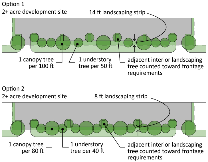
Figure 6-1: Street Frontage Landscaping