
Plainfield City Zoning Code
ARTICLE V
- RESIDENTIAL DISTRICTS
Sec. 9-51.- General.
The residential districts ("R districts") are primarily for residential land uses and for other selected uses that are deemed compatible with residential environments. The various residential districts are intended to maintain and promote a variety of housing types within the village.
Sec. 9-52. - Purposes of the R districts.
(1)
R-E Residential District. This district is intended to provide areas for relatively large single-family detached homes on lot sizes of approximately one acre. Because of the intended estate character of the housing, non-residential and non-recreational land uses are not permitted as of right in this district. This zoning district corresponds to the Countryside Residential land use category in the village's Comprehensive Plan. Residential density is intended to be approximately 0—1 dwelling units per acre.
(2)
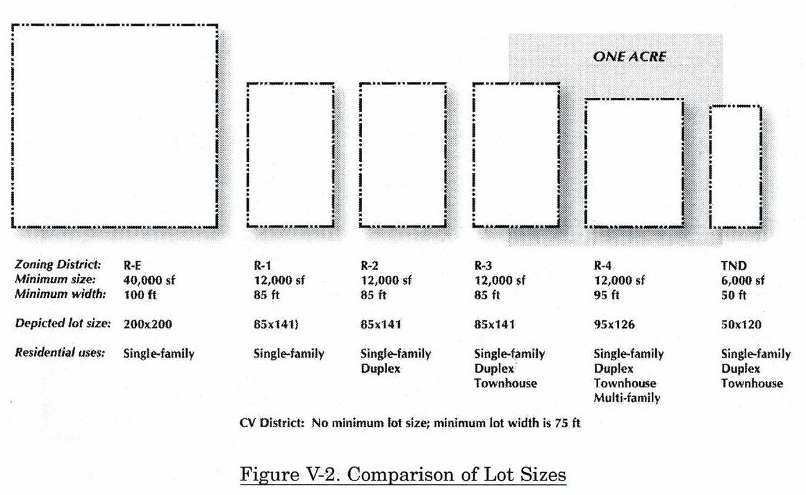
R-1 Low Density Single-Family Residential District. This district is intended to provide areas for low density, single-family detached housing on lot sizes with a minimum of twelve thousand (12,000) square feet. Compatible government, religious, educational, and recreational uses may be permitted within the district. This zoning district corresponds, approximately, to the Low Density Residential land use category in the village's Comprehensive Plan. Residential density is intended to be a maximum of 2.1 dwelling units per acre if a part of a PD.
(3)
R-1 Overlay District. This overlay district is established to address the unique issues within the residential areas of the village's historic core area. This area is illustrated on Map X-1 on page 90.
(4)
R-2 Single-Family and Two-Family Residential District. This district is intended to provide areas for a mix of single-family detached housing and two-family attached housing on lot sizes with a minimum of twelve thousand (12,000) square feet. A limit of two (2) dwelling units per lot shall be maintained. Compatible government, religious, education, and recreational land uses may be permitted within the district. This zoning district corresponds, approximately, to the Medium Density Residential land use category in the village's Comprehensive Plan. Residential density is intended to be a maximum of 3.15 dwelling units per acre as a part of a PD.
(5)
R-3 Townhouse Residential District. This district is intended to provide areas for a variety of housing types at medium densities. Compatible government, religious, education, and recreational uses may be permitted within the district. This zoning district corresponds to the density, but not necessarily location, of the village Residential land use category in the village's Comprehensive Plan. Residential density is intended to be a maximum of six (6) dwelling unit per acre if a part of a PD.
(6)
R-4 Multiple-Family Residential District. This district is intended to provide areas for all forms of attached multi-family housing, including duplexes, townhouses, condominiums and apartments. This zoning district corresponds to the Multiple Family Residential land use category in the village's Comprehensive Plan. Residential density is much higher than in the other districts, and is intended to be a maximum of fifteen (15) dwelling unit per acre within a planned development. The maximum height of a building is limited to forty-eight (48) feet.
(7)
CV Conservation District. This district, with a residential density of approximately 1-3 dwelling units per acre, is intended to foster the creation of clustered residential areas that preserve natural and cultural resources. The goal of this district is to retain the rural character of the site by minimizing the destruction of existing vegetation, maintaining environmental corridors, creating common open space, conserving the natural topography, and designing around, thereby preserving, sites of significant historic, archaeological, or architectural value. See section 9-56 for specific standards and additional goals of the CV district.
(8)
TN Traditional Neighborhood District. This district is intended to regulate new development with more traditional forms of neighborhood layout. It allows various housing types: single-family, duplex, and townhouse. Residential density is intended to be approximately 5—6 dwelling units per acre. Although it is similar to the R-3 district, it differs from the R-3 in allowing limited commercial uses, permitting alleys and smaller lot dimensions, and it has unique site design standards. One of the overall goals of the TN district is to stimulate non-motorized travel modes such as walking and biking. See section 9-55 for specific standards for the TN district. This district is not appropriate within the village core area designated as the R-1 Overlay district.
(9)
HD Historic District. This district is intended to identify the designated historic district(s) as approved by the village board. There may be more than one designated district, but each district will have its own regulations to maintain its individual character as described in section 9-57.
Sec. 9-53. - Permitted and special uses in the R districts.
Uses are allowed in the R districts in accordance with section 9-13 and Table II-1.
Sec. 9-54. - General standards for the R districts.
Specific minimum and maximum standards for lots and buildings in the "R" districts include:
(1)
Table V.1—Bulk, density, and lot coverage standards for R districts. The standards and accompanying notes define such items as lot size and bulk of buildings for all R districts.
(2)
Table V.2—Minimum setback requirements for R districts. The standards and accompanying notes define the minimum yard requirements for all R districts.
(3)
Minimal architectural standards. These standards will apply to all homes built within Plainfield. No bonus will be provided for achieving these minimum standards.
a.
Exterior siding materials shall consist of any of the following: brick, stone, cultured stone, E.I.F.S., stucco, cedar shake or siding, fiber-cement, board or architectural grade vinyl. Non-architectural grade vinyl siding shall not be permitted.
b.
Single-family homes shall incorporate an eave line on all four (4) facades with a minimum width of six (6) inches.
c.
All corner and through lot, elevations shall incorporate a minimum amount of architectural articulation that may include at least one of the following architectural elements: masonry wainscot, French patio doors, traditional window fenestration with shutters, masonry chimney chase, bay projections or gables over second floor windows.
(4)
Driveways.
a.
That the maximum width of a driveway shall be twenty (20) feet at the right-of-way; and
b.
That all driveways shall maintain a minimum five- foot setback from any property line, except, side-loaded garage driveways may encroach within the five-foot setback subject to maintaining a minimum of five (5) feet of green space between adjacent driveways; and
c.
A maximum of one (1) driveway is permitted per residential lot. One (1) additional driveway may be permitted for lots where the length at the curb of a public street exceeds ninety (90) feet in length, provided that the additional driveway connects to a garage and does not affect the safe use of the roadways. An additional driveway shall not be permitted on lots with frontage on two different streets such that one driveway would be located on each public street.
(5)
Minimum open space standards. The following standards apply to all residential lots except those located within the TN District and R-1 Overlay.
a.
A minimum of fifty (50) percent of the area of a residential lot must be maintained as open space.
b.
Open space is defined as the area of a lot that is maintained as green space including lawns, gardens, woods, or other natural landscape areas and is free of buildings, structures, and other improvements, such as a patio (whether pervious or impervious).
c.
Areas not maintained as open space must comply with the maximum building coverage and maximum impervious area coverage requirements in Table V-1.
d.
However, nonconforming lots already improved with a residence and having met, reached, or exceeded the maximum impervious area coverage allowed are permitted to install up to two hundred (200) square feet of outdoor patio or deck space.
(Ord. No. 2615, § V, 2-5-07; Ord. No. 2823, § II, 1-5-09; Ord. No. 3511, § V(exh.E), 4-19-21; Ord. No. 3532, § IV(exh. D), 10-18-21)
Note 1: There shall be a minimum floor area of: seven hundred fifty (750) square feet for one-bedroom dwelling units; nine hundred fifty (950) square feet for two-bedroom dwelling units; one thousand one hundred fifty (1,150) square feet for dwelling units with three (3) or more bedrooms.
Note 2: Minimum lot width is seventy-five (75) feet, but can be reduced to seventy (70) feet if certain open space requirements are met. See section 9-56.
Note 3: Varies depending on specifics of conservation design plan.
Note 4: Impervious surface area may be limited in instances where existing drainage issues are known, at the discretion of the village engineer, or designated agent.
Figure V-1. Regulating Bulk and Density—R1 Lot
Minimum Lot Area: 12,000 square feet.
Minimum Lot Width: 85 feet.
Minimum Setbacks:
- Front: 30 feet.
- Rear: 30 feet.
- Side: 7 feet, total of 20 feet.
Maximum Area Coverage: 30 percent (or 3,600 square feet).
Maximum Impervious Area Coverage: 40 percent (or 4,800 square feet).
Maximum Building Height: 35 feet.
Minimum Floor Area: 1,300 (1 story).
Minimum Floor Area: 1,700 (2 stories).
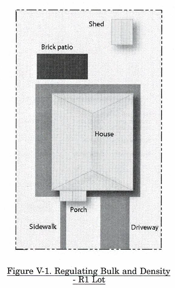
Note 1: There shall be a minimum side setback of seven (7) feet and the total of both side yards shall equal at least twenty (20) feet.
Note 2: There shall be a minimum side setback of fifteen (15) feet on each side of the building plus an additional one (1) foot for foot for each two (2) feet by which the building height exceeds twenty-eight (28) feet.
Note 3: There shall be a minimum side setback of fifteen (15) feet on each side of the building plus an additional one (1) foot for each two (2) feet by which the building height exceeds twenty-eight (28) feet and when the adjacent property is in an R1 district there shall be a minimum side setback of thirty (30) feet on the side of the building adjacent to the R1 property.
Note 4: There shall be a minimum rear setback of thirty (30) feet plus an additional one (1) foot for each two (2) feet by which the building height exceeds twenty-eight (28) feet.
Note 5: Thirty (30) feet or the setback established by adjoining principal uses within one hundred (100) feet, whichever is less.
Sec. 9-55. - TN district standards.
(1)
Intent. The Traditional Neighborhood district is intended to regulate new development consistent with historical building patterns featuring smaller lots, alleys, and grid-like street patterns. Such development would generally be appropriate in areas planned for village Residential Use on the Comprehensive Plan. This zoning category is not appropriate in the existing downtown area.
(2)
Permitted and special uses. One of the goals of the TN district is to promote the creation of compact neighborhoods where daily destinations—such as a school or grocery store—can be reached with ease on foot. Therefore, the TN district permits a limited range of commercial activities that citizens normally frequent on a daily or weekly basis. Such commercial activities are typically situated on corner locations.
(3)
Design standards. The TN district has unique design standards. These standards are in addition to any standards or requirements found elsewhere in this ordinance or in other applicable ordinances. In case of any conflict or discrepancy between a standard found in this section of the ordinance and standards found elsewhere in this ordinance or found in the village subdivision ordinance, the standard found in this section shall have precedence.
_____
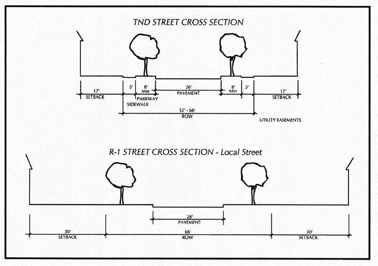
Figure V-3. Comparison of TN District and R-1 Street Cross Sections
The parkways in the TN District can vary between eight (8) and fifteen (15) feet. The illustration above shows the minimum of eight (8) feet.
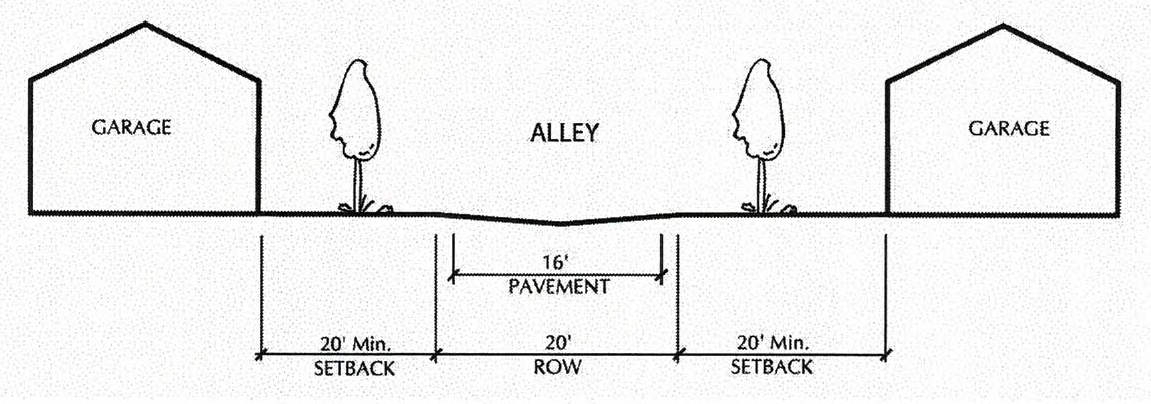
Figure V-4. Alley Cross Section Minimum Distances in the TN District
_____
a.
Block size. Street layout shall provide for blocks that have a maximum length of eight hundred (800) feet. The minimum width or length of a block shall be two hundred (200) feet.
b.
Alleys. Alleys are encouraged and permitted, but shall be limited to a maximum right-of-way width of twenty (20) feet and a maximum pavement width of sixteen (16) feet. Dead-end alleys are prohibited. Alley intersections and sharp changes in alley alignment should be avoided.
c.
Culs-de-sac. Culs-de-sac are permitted, but shall be limited to a maximum length of two hundred (200) feet.
d.
Street width. The maximum street width within TN districts shall be thirty-six (36) feet, and the minimum street width shall be twenty-six (26) feet. Streets that form a border between the TN district and another zoning district may be wider, as appropriate for the amount of traffic carried. Specifically, minimum street widths within TN districts are shall be:
i.
Twenty-six (26) feet for local streets; and
ii.
Twenty-eight (28) feet for minor collector streets.
e.
Traffic calming. The use of traffic calming techniques such as raised platforms and chokers is encouraged in all subdivisions.
f.
Sidewalks and parkways. All lots shall have a sidewalk that extends the width of the lot and connects with sidewalks on adjacent properties. The sidewalk should be separated from the street by a parkway. Sidewalks shall be a minimum of five (5) feet wide. Parkways shall be a maximum of fifteen (15) feet and a minimum of eight (8) feet wide. Parkway width and setback depth on both sides of a single block should remain relatively constant. However, a variation in parkway widths throughout a subdivision is encouraged. See Figure V-3 (Comparison of Street Cross Sections in the TN and R-1 Districts).
g.
Crosswalks. Intersections of sidewalks with streets shall be designed with clearly defined edges. Crosswalks shall be well illuminated and marked with contrasting paving materials at the edges or with striping.
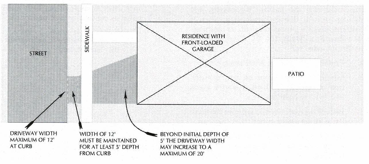
Figure V-5. Driveway Restrictions in the TN District
_____
h.
Driveway width. Maximum driveway width at curb or street shall be twelve (12) feet. This maximum width shall be maintained for minimum of five (5) feet from the curb. Thereafter, the width of the driveway may increase to twenty (20) feet, providing all other provisions, e.g., setback and impervious area coverage, are met.
i.
Landscaping requirements. The following shall apply to all residential lots, and are in addition to any parkway planting requirements:
(i)
Single-family homes: A minimum of two (2) trees, either canopy or evergreen, each with three-inch caliper;
(ii)
Other residential uses: A minimum of one tree, either evergreen or canopy, per dwelling unit, each with three-inch caliper.
(Ord. No. 2823, § II, 1-5-09; Ord. No. 3532, § IV(exh. D), 10-18-21)
Sec. 9-56. - CV district design standards.
(1)
Intent. The provisions of this section are intended to foster the creation of clustered residential areas that preserve natural and cultural resources. The goal of this district is to retain the rural character of the site by minimizing the destruction of existing vegetation, maintaining environmental corridors, creation common open space, conserving the natural topography, and designing around, thereby preserving, sites of significant historic, archaeological, or architectural value. Specifically, the CV district regulations are intended to:
a.
Protect and enhance biodiversity;
b.
Minimize development on and destruction of sensitive natural resource areas and wildlife habitats;
c.
Reduce the quantity and improve the quality of storm water runoff;
d.
Provide a wider range of feasible sites for storm water Best Management Practices (BMPs);
e.
Reduce soil erosion;
f.
Reduce the capital costs of development;
g.
Preserve significant cultural resources.
(2)
Requirements. All of the following shall apply:
a.
Minimum district size. The minimum size of a CV district shall be forty (40) acres;
b.
Restrictions on future use. Permanent common open space, not to be further subdivided, and restricted from further subdivision through a direct dedication or through a recorded permanent conservation easement held (at the village's option) by the village or a recognized land trust or conservancy;
c.
Minimum acreage. A minimum of thirty (30) percent of the total acreage of the development shall be used for common open spaces, and a bonus in the permitted density is offered when at least forty (40) percent of the total acreage is used for common open space (see paragraph five (5) of this section);
d.
Park dedication. The common open space requirement shall be in addition to any requirements for the dedication of land for public parks.
e.
Minimum width. The minimum width of any open space shall be fifty (50) feet;
f.
Division of space. Wherever practical, the open space areas shall generally be designated as contiguous and undivided so as to:
i.
Facilitate easement monitoring and enforcement; and
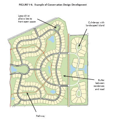
Figure V-6. Example of Conservation Design Development
General Features:
• Open space is generally contiguous and has not been divided into small chunks.
• Adequate access points to other subdivisions and roads.
• Numerous water features throughout site—storm water management practices.
• Extensive pathway system.
• All residential lots abut open space.
_____
ii.
Promote appropriate management by a single entity according to approved land management standards; and
iii.
Provide adequate habitat areas for wildlife and native vegetation.
g.
Access to open space. Undivided open space shall be directly accessible to the largest practical number of residential lots within the development so that:
i.
The majority of residential lots abut undivided open space in order to provide direct views and access; and
ii.
Safe and convenient access to all lots not adjoining the open space shall be provided.
h.
Paths. A pedestrian circulation system designed to assure that residents can walk safely and easily on the site, between properties and activities or special features within the neighborhood open space system shall be provided. All roadside footpaths should connect with off-road trails, which in turn should link with potential open space on adjoining undeveloped parcels (or with existing open space on adjoining developed parcels).
i.
Culs-de-sac. Culs-de-sac are permitted. The following apply:
i.
Maximum length shall be one thousand two hundred (1,200) feet;
ii.
The cul-de-sac shall terminate with a planting island that has a minimum diameter of twenty (20) feet.
iii.
The planting island shall be landscaped with low ground cover and a minimum of two (2) trees, each with three-inch calipers. Evergreens and/or deciduous plants may be used.
j.
Drainage. If public sanitary sector is not available the required open space may be used for underground drainage fields for individual or community septic systems, and for "spray fields" or spray irrigation purposes in a "land treatment" sewage disposal system. However, "mound" systems protruding above grade and aerated sewage treatment ponds or "spray fields" shall be limited to no more than ten (10) percent of the required minimum open space.
k.
Landscaping. Common areas, cul-de-sac islands, and buffer areas shall be landscaped with native specie shade trees and flowering shrubs with high wildlife conservation value.
l.
Other. Storm water management ponds or basins may be included as part of the minimum required open space, as may land within the rights-of-way for underground utilities. However, land within the rights-of-way of over-head high tension power lines shall not be included as comprising part of the minimum required open space.
(3)
Design guidelines. In addition to the requirements in paragraph (2) of this section, the design of the conservation development should, to the greatest extent possible, accomplish the following:
a.
Protect floodplains, wetlands and steep slopes from clearing, grading, filing or construction;
b.
Preserve and maintain mature woodlands, meadows and orchards and create sufficient buffer areas to minimize conflicts between residential and agricultural uses;
c.
Separate development from existing public roads, either by distance, or some form of buffering such as a planting screen primarily consisting of indigenous trees, shrubs and wildflowers and grasses.
d.
Maintain or create an upland buffer of native species vegetation of approximately fifty (50) feet in depth adjacent to wetlands and surface waters;
e.
Preserve existing hedgerows and treelines between fields or meadows and minimizes impacts on large woodlands (greater than one acre), especially those containing many mature trees or a significant wildlife habitat, or those not degraded by invasive plants;
f.
The use of swales vegetated with native materials is encouraged as a method of storm water conveyance to decrease runoff velocity, allow for biofiltration, allow suspended sediment particles to settle, and remove pollutants;
g.
Protect wildlife habitat areas and ravines;
h.
Leave scenic views and vistas unblocked or uninterrupted, particularly as seen from public thoroughfares;
i.
Avoid siting new construction on prominent hilltops or ridges, by taking advantage of lower topographical features;
j.
Design around and preserve sites of historic, archaeological value, or vernacular architecture reminiscent of the area's agricultural heritage;
k.
Protect roadside rural character and improve public safety and vehicular carrying capacity by avoiding development fronting directly onto existing roads.
(4)
Ownership and management of open space. For the ownership and management of open space in a conservation development, the provisions of section 9-44 of this ordinance shall apply.
(5)
Calculation of density.
a.
For residential development, density generally refers to the number of dwelling units per acre. Residential densities as meant in this section of the ordinance do not refer to the gross area of a site, but to the gross "buildable" area of a site. This approach acknowledges that some portions of a site, such as flood plains and wetlands, are not appropriate for development, and that preservation of these features can also provide amenities to the community.
b.
Minimum lot size and minimum lot width. Minimum lot size and minimum lot width shall be based upon the amount of common open space, as required in paragraph (2) of this section that is maintained and/or created.
(6)
Approval for reduced lot dimensions. The approval for the reduced lot dimensions shall follow be the same as the procedures for approval of a planned development as specified in Article IV of this zoning ordinance.
Sec. 9-57. - Historic district.
This district is intended to identify the designated historic district(s) as approved by the village board. Once a district receives a recommendation for designation by the historic preservation commission (HPC), a set of regulations will be established by the HPC to maintain the character of that district for any future renovation, rehabilitation, and new construction projects. The regulations will be included as part of the ordinance that declares the district as historic, subject to board approval. Regulations may include the following:
• Permitted and special uses;
• Accessory Buildings and uses of land;
• Design standards;
• Bulk, density and lot coverage standards;
• Setback requirements;
• Fences;
• Signs.
These new regulations will supersede the bulk zoning regulations for the area defined within the district. All significant changes to the exterior of any building or structures within the designated district must apply for a certificate of appropriateness (COA) or a certificate of economic hardship (COEH) before commencing any renovation, rehabilitation or new construction projects to ensure the proposed work meets the regulations for the district. Refer to article XV for additional information.