
Richmond City Zoning Code
SERIES 100
GENERAL PROVISIONS
15.04.101.010 - Title and Authority.
Chapter 15.04 of Article XV of the Municipal Code shall be known and cited as the "Zoning and Subdivision Regulations," "Regulations," or the "Zoning Article." (The two main parts also may be referred to as the "Zoning Ordinance" and the "Subdivision Ordinance.")
The Zoning and Subdivision Regulations are adopted pursuant to the authority contained in Section 65850 of the California Government Code and The Subdivision Map Act (Title 7, Division 2, of the California Government Code, as amended).
15.04.101.020 - Purpose.
The purpose of the Zoning and Subdivision Regulations is to implement the City's General Plan. More specifically, these Regulations are adopted to achieve the following objectives:
A.
To provide a precise guide for the physical development of the City in a manner as to progressively achieve the arrangement of land uses depicted in the Richmond General Plan, consistent with the goals and policies of the General Plan.
B.
To foster harmonious, convenient and workable relationships between land uses and ensure compatible infill development, consistent with the General Plan.
C.
To support economic development and job creation and provide for the housing needs of all economic segments of the community.
D.
To promote high quality architecture, landscape architecture and urban design, consistent with the General Plan.
E.
To promote the stability of existing land uses that conform to the General Plan, protecting them from inharmonious influences and harmful intrusions, and protect and enhance real property values.
F.
To facilitate the appropriate location of community facilities, institutions, parks, and recreational areas.
15.04.101.030 - Structure of Zoning and Subdivision Regulations.
A.
Organization of Regulations. The Zoning and Subdivision Regulations consist of eight series:
100 Series — Introductory Provisions
200 Series — Base Zoning Districts
300 Series — Overlay Zoning Districts
400 Series — Form-Based Code Zoning Districts (reserved for Council-adopted code)
500 Series — Specific Plans (general authority for specific plans; individual plans such as the Richmond Bay Specific Plan will be published in a separate volume)
600 Series — General Standards
700 Series — Land Divisions, Dedications and Improvements
800 Series — Administration and Permits
B.
Types of Regulations. The Zoning and Subdivision Regulations include four types of regulations that control the use and development of property:
1.
Land Use Regulations. These regulations specify the land uses permitted, conditionally permitted, and prohibited in each zoning district. These regulations also provide any special requirements that are applicable to specific uses. Land use regulations for base zoning districts and for overlay districts are located in the 200 and 300 Series. Additional land use regulations that apply citywide or to only some of the zoning districts, such as those pertaining to nonconforming uses and specific uses (e.g., alcoholic beverage sales, emergency shelters, live-work, residential care facilities, and accessory dwelling units), are located in the 600 Series. Performance standards that govern special uses are also located in the 600 Series.
2.
Development Regulations. These regulations control the height, bulk, density/intensity, location and appearance of structures on development sites. Development regulations for base zoning districts and for overlay districts are located in the 200 and 300 Series. Design standards for public improvements for subdivisions are located in the 700 Series. Regulations for Form-based Zoning Districts are located in the 400 Series. Development regulations, applicable to some or all zoning districts, are located in the 600 Series; these include regulations for accessory structures, fences, landscaping, lighting, nonconforming uses and structures, off-street parking and loading, signs, and wireless communications facilities. Design standards for public improvements in subdivisions are in the 700 Series.
3.
Administrative Regulations. These regulations contain detailed procedures for the administration of these regulations and include common procedures, processes and standards for discretionary entitlement applications and other permits. Specific procedures for processing maps related to subdivisions, approving improvement agreements, and other approvals related to land divisions are located in the 700 Series. Authority for adopting and implementing Specific Plans is located in the 500 Series. Administrative regulations are located in 800 Series.
4.
General Terms and Use Classifications. The 100 Series provides a list of terms and definitions of the terms used in the Zoning and Subdivision Regulations.
(Ord. No. 30-18 N.S., § I(Exh. A), 12-18-2018; Ord. No. 04-23 N.S., § I(Exh. A), 4-18-2023)
15.04.101.040 - Applicability.
A.
General Rules for Applicability.
1.
Applicability to Property. The Zoning and Subdivision Regulations apply, to the extent permitted by law, to all property within the corporate limits of the City and to property for which applications for annexation and/or subdivisions have been submitted to the City, including all uses, structures and land owned by any private person, firm, corporation or organization, or the City or other local, State or federal agencies. Any governmental agency is exempt from these Regulations only to the extent that such property may not be lawfully regulated by the City. Parcels which lie across jurisdictional boundaries shall be subject to the entitlement process of the jurisdiction in which it has the most land acreage. The other jurisdiction will remain a responsible agency and projects may be subject to additional design review.
2.
Compliance with Regulations. Land must be used, and structures must be constructed, occupied, enlarged, altered, demolished and moved in accordance with the provisions of the Regulations.
B.
Relation to Other Regulations.
1.
General. The Zoning and Subdivision Regulations and the requirements or conditions imposed by them do not supersede any other regulations or requirements adopted or imposed by the City Council, the State of California, or any federal agency that has jurisdiction over uses and development authorized by these Regulations. All uses and development authorized by these Regulations shall comply with all other such regulations and requirements. Where conflict occurs between the provisions of these Regulations and any other provision of the Municipal Code, City ordinance, resolution, guideline or regulation, the more restrictive provisions control, unless otherwise specified.
2.
Permit Streamlining Act. It is the intent of the Zoning and Subdivision Regulations that all solely adjudicatory actions taken by the decision-making body pursuant to these Regulations be within a time frame consistent with the provisions of Government Code Section 65920 et seq. (California Permit Streamlining Act). These Regulations may not be interpreted as imposing time limits on a decision-making body's legislative actions or quasi-legislative judgments.
3.
Relation to Private Agreements. The Zoning and Subdivision Regulations shall not interfere with or annul any recorded easement, covenant, or other agreement now in effect, provided that where these Regulations impose a greater restriction than imposed by an easement, covenant, or agreement, these Regulations control.
4.
Application During Local Emergency. The City Council may authorize a deviation from a provision of the Zoning and Subdivision Regulations during a local emergency that has been proclaimed and ratified under the Municipal Code. The City Council may authorize a deviation by resolution without notice or public hearing.
C.
Consistency with the General Plan. Any permit, license or approval issued pursuant to these Regulations must be consistent with the General Plan and all applicable specific plans. Where there is a conflict between the Zoning and Subdivision Regulations and the General Plan, the General Plan prevails.
D.
Effect on Previously Approved Projects and Projects in Progress. Any building, structure or use of land for which conditional use permits, variances, or design approval have been granted must be completed in accordance with the zoning, plans, specifications and permits on which these approval were granted within two years of such granting, except if a later expiration date is stated in the approval. Any building, structure, or use of land for which a Building Permit or its functional equivalent has been issued and where substantial work has been performed and substantial liabilities incurred in good faith reliance thereon, may be completed and used in accordance with the plans, specifications and permits on which these permits or approvals were granted. No extensions of time, except as provided for in the Building Code, shall be granted for commencement of construction, unless the applicant has secured a permit extension from the Department of Planning and Building Services. This provision does not apply to projects with an approved vesting tentative map or development agreement.
(Ord. No. 30-18 N.S., § I(Exh. A), 12-18-2018; Ord. No. 04-23 N.S., § I(Exh. A), 4-18-2023)
15.04.101.050 - Interpretation—No Civil Liability.
None of the provisions in these Zoning and Subdivision Regulations or in any other ordinance or resolution of the City or in any rule or regulation promulgated pursuant thereto, whether pre-existing, existing or in the future, are intended to create or to be construed to create an imposition of civil liability on the City, its Council, commissioners, officers or employees while acting in accordance with such provisions.
15.04.101.060 - Zoning Districts Established.
The City is divided into zoning districts, which are also referred to as zoning districts or districts. The designation and regulation of zoning districts are set forth in these Regulations and as follows.
A.
Base Zoning Districts. Base zoning districts into which the City is divided and their corresponding General Plan land use designations are shown in Table 15.04.101.060-A, Base Zoning Districts.
B.
Overlay Zoning Districts. Overlay zoning districts, one or more of which may be combined with a base district, are established as shown in Table 15.04.101.060-B, Overlay Zoning Districts.
C.
Form-Based Zoning Districts. Form-Based Zoning Districts are established as shown in Table 15.04.101.060-C, Form-Based Zoning Districts.
D.
References to Classes of Base Zoning Districts. Throughout the Zoning and Subdivision Regulations, the following references apply:
1.
"RL district" or "Residential-Single Family district" means one or more of the following districts: Single Family, Very Low Density Residential (RL1); and Single Family Low Density Residential (RL2).
2.
"RM district" or "Multifamily Residential district" means one or both of the following districts: Multifamily Residential (RM1) and Multifamily High Density Residential (RM2).
3.
"R district" or "Residential district" means one or more of the following districts: Hillside Residential (HR); Single Family, Very Low Density Residential (RL1); Single Family Low Density Residential (RL2); Multifamily Residential (RM1); and Multifamily High Density Residential (RM2).
4.
"Non-residential district" means any base zoning district that is not a Residential district.
5.
"CM district" or "Commercial Mixed-Use district" means one or more of the following districts: Commercial Mixed-Use, Residential (CM-1); Commercial Mixed-Use, Neighborhood (CM-2); Commercial Mixed-Use, Commercial Emphasis (CM-3); Commercial Mixed-Use, Gateway/Node (CM-4); and Commercial Mixed-Use, Activity Center (CM-5); and Live-Work (LW).
6.
"C district" or "Commercial district" means one or more of the following districts: General Commercial (CG); Regional Commercial (CR); and Coastal Commercial (CC).
7.
"I district" or "Industrial district" means one or more of the following: Industrial, Business (IB); Industrial, Limited Light (ILL); Industrial, Light (IL); Industrial, General (IG); and Industrial, Water-Related (IW).
8.
"OS district" means the Open Space (OS) district, and "AG district" means the Agricultural district.
9.
"P district" means one or both of the following: Public, Cultural, and Institutional (PCI) and Parks and Recreation (PR).
(Ord. No. 04-23 N.S., § I(Exh. A), 4-18-2023)
15.04.101.070 - Official Zoning Map and District Boundaries.
The boundaries of the zoning districts established by these are shown on the Official Zoning Map maintained by the City Clerk. The Official Zoning Map, together with all legends, symbols, notations, references, zoning district boundaries, map symbols, and other information on the maps, have been adopted by the Council and are hereby incorporated into the Zoning and Subdivision Regulations by reference, together with any amendments previously or hereafter adopted, as though they were fully included here.
A.
Application of Pre-Annexation Zoning. The City may apply pre-annexation zoning to unincorporated property located within the Planning Area Boundary shown in the General Plan. The pre-annexation zoning process shall comply with the Pre-zoning and Annexation Procedures in the 800 Series. The zoning provisions and requirements so established shall become applicable at the same time that the annexation of such territory becomes effective.
B.
Uncertainty of Boundaries. If in the context of a development application, permit revocation, or enforcement action, an uncertainty exists as to the boundaries of any district shown on the Official Zoning Map, the following rules shall apply:
1.
Boundaries indicated as approximately following the centerlines of alleys, lanes, streets, highways, streams or railroads shall be construed to follow such centerlines.
2.
Boundaries indicated as approximately following lot lines, city limits, or extraterritorial boundary lines shall be construed as following such lines, limits or boundaries.
3.
In the case of unsubdivided property or where a district boundary divides a lot and no dimensions are indicated, the following shall apply.
a.
Lots Greater than One Acre. The location of such boundary shall be determined by the use of the scale appearing on the Official Zoning Map.
b.
Lots Less than One Acre. The lot shall be deemed to be included within the more restrictive zoning district.
4.
In the case of any remaining uncertainty, the Director shall determine the location of boundaries and shall notify the property owners of his/her determination. The Director's determination may be appealed under the provisions of Section 15.04.803.130.
5.
Where any public street or alley is officially vacated or abandoned, the regulations applicable to each parcel of abutting property shall apply to that portion of such street or alley added to the parcel by virtue of the street or alley being vacated or abandoned.
6.
Where any private right-of-way or easement of any railroad, railway, transportation, or public utility company is vacated or abandoned, pursuant to federal or state law, if that property is not shown with a zoning designation on the Zoning Map, then that property shall be automatically classified as being in the Public, Cultural, and Institutional (PCI) District.
15.04.102.010 - Purpose.
The purpose of this article is to provide precision in the interpretation of the Zoning and Subdivision Regulations. The meaning and construction of words and phrases defined in this article apply throughout the Zoning and Subdivision Regulations, except where the context indicates a different meaning.
15.04.102.020 - Rules for Construction of Language.
In interpreting the various provisions of the Zoning and Subdivision Regulations, the following rules of construction apply:
A.
The ordinary meaning of terms applies.
B.
In case of conflict between the text and a diagram or graphic, the text controls.
C.
All references to public officials are to those of the City, and include designated deputies of such officials, unless otherwise indicated.
D.
All references to days are to calendar days, unless otherwise indicated. If a deadline falls on a weekend or holiday, or a day when City offices are closed, the deadline will be extended to the next working day. The end of a time period is the close of business on the last day of the time period.
E.
The words "shall," "will," "must," "has to," "is required to," and "is to" are always mandatory and not discretionary. The words "should" or "may" are permissive.
15.04.102.030 - Rules of Interpretation.
The Director will interpret any definition not expressly identified in these Regulations and provide clarification and determinations, which shall be compiled, made available at City offices and the library, and be posted on the City's website for easy public access.
15.04.103.010 - Purpose.
The purpose of this article is to explain how various measurements referred to in these Regulations are to be calculated.
15.04.103.020 - General Provisions.
For all calculations, the applicant is responsible for supplying drawings illustrating the measurements that apply to a project. These drawings must be drawn to scale and of sufficient detail to allow easy verification upon inspection by the Zoning Administrator.
15.04.103.030 - Fractions.
Whenever the Zoning and Subdivision Regulations requires consideration of distances, parking spaces, dwelling units or other aspects of development or the physical environment expressed in numerical quantities, and the result of a calculation contains a fraction of a whole number, the results will be rounded as follows:
A.
General Rounding. Fractions of one-half (0.5) or greater must be rounded up to the nearest whole number, and fractions of less than one-half (0.5) must be rounded down to the nearest whole number, except as otherwise provided.
B.
Exception for State Affordable Housing Density Bonus. The calculation of fractions related to permitted bonus density units for projects eligible for bonus density pursuant to Government Code Section 65915 or any successor statute shall be done as provided by state law.
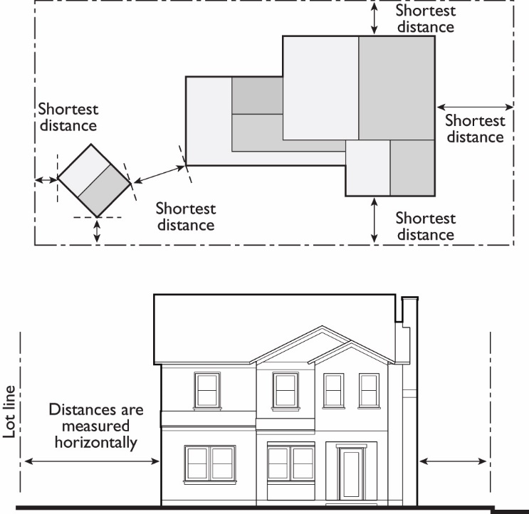
15.04.103.040 - Measuring Distances.
A.
Measurements are Shortest Distance. When measuring a required distance, such as the minimum distance between a structure and a lot line, the measurement is made at the closest or shortest distance between the two objects.
B.
Distances are Measured Horizontally. When determining distances for setbacks and structure dimensions, all distances are measured along a horizontal plane from the appropriate line, edge of building, structure, storage area, parking area, or other object. These distances are not measured by following the topography or slope of the land.
C.
Measurements Involving a Structure. Measurements involving a structure are made to the closest support element of the structure. Structures or portions of structures that are entirely underground are not included in measuring required distances.
D.
Measurement of Vehicle Stacking or Travel Areas. Measurement of a minimum travel distance for vehicles, such as garage entrance setbacks and stacking lane distances, are measured down the center of the vehicle travel area. For example, curving driveways and travel lanes are measured along the center arc of the driveway or traffic lane.
E.
Measuring a Buffer or Radius. When a specified land use is required to be located a minimum distance from another land use, the minimum distance is measured in a straight line from all points along the lot line of the subject project, in all directions.
Figure 15.04.103.040: Measuring Distances
15.04.103.050 - Measuring Height.
A.
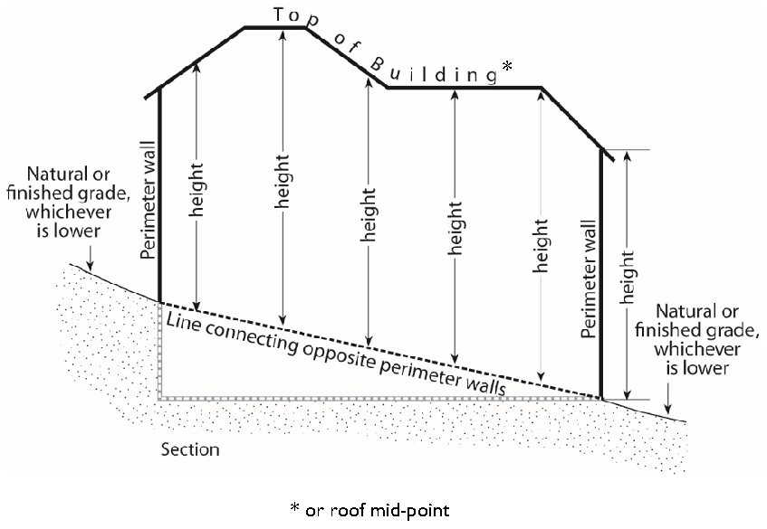
Measuring Building Height. Building height shall be defined as the distance from finished grade to the highest point of the coping of a flat roof or to the deck line of a mansard roof or to the highest point of the highest gable of a pitched or hipped roof. The height of a stepped or terraced building is the maximum height of any segment of the building along the finished grade directly below. For structures projecting over water, height will be measured from highest grade at front (landward) property line. On lots with a grade change of 10 percent or more between the front and rear property lines, building height is measured from the "grade plane" as determined in the following subsection, and height shall be measured from the measure point at the top of the building, as determined above, to the grade plane.
Figure 15.04.103.050-A(1): Measuring Building Height
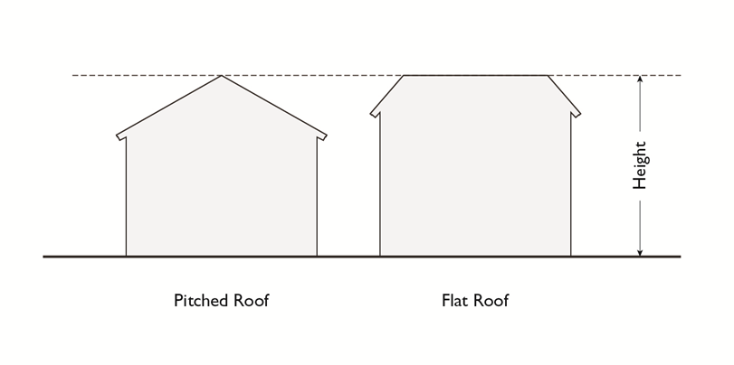
Figure 15.04.103.050-A(2): Measuring Building Height of a Terraced or Stepped Building
1.
Measuring Building Height on Sloped Lots. On lots with a grade change of 10 percent or more between the front and rear lot lines, or between the front lot line and its most distant point when there is no rear lot line, building height is measured from the adjacent natural or finished grade, whichever is lower, to the coping of a flat roof or to the deck line of a mansard roof or to the average height of the highest gable of a pitched or hipped roof.
2.
Exceptions. Antennas, belfries, chimneys, cooling towers, cupolas, domes, elevator bulkheads, flagpoles, ornamental towers, penthouses, solar collectors, spires and standpipes and necessary mechanical equipment may exceed the height limits pursuant to Section 15.04.601.050 (Exceptions to Height Limits).
B.
Measuring the Number of Stories in a Building. In measuring the height of a building in stories, the following measurement rules apply:
1.
A balcony or mezzanine shall be counted as a full story if its floor area exceeds one-third of the total area of the nearest full floor directly below it or if it is enclosed on more than two sides.
2.
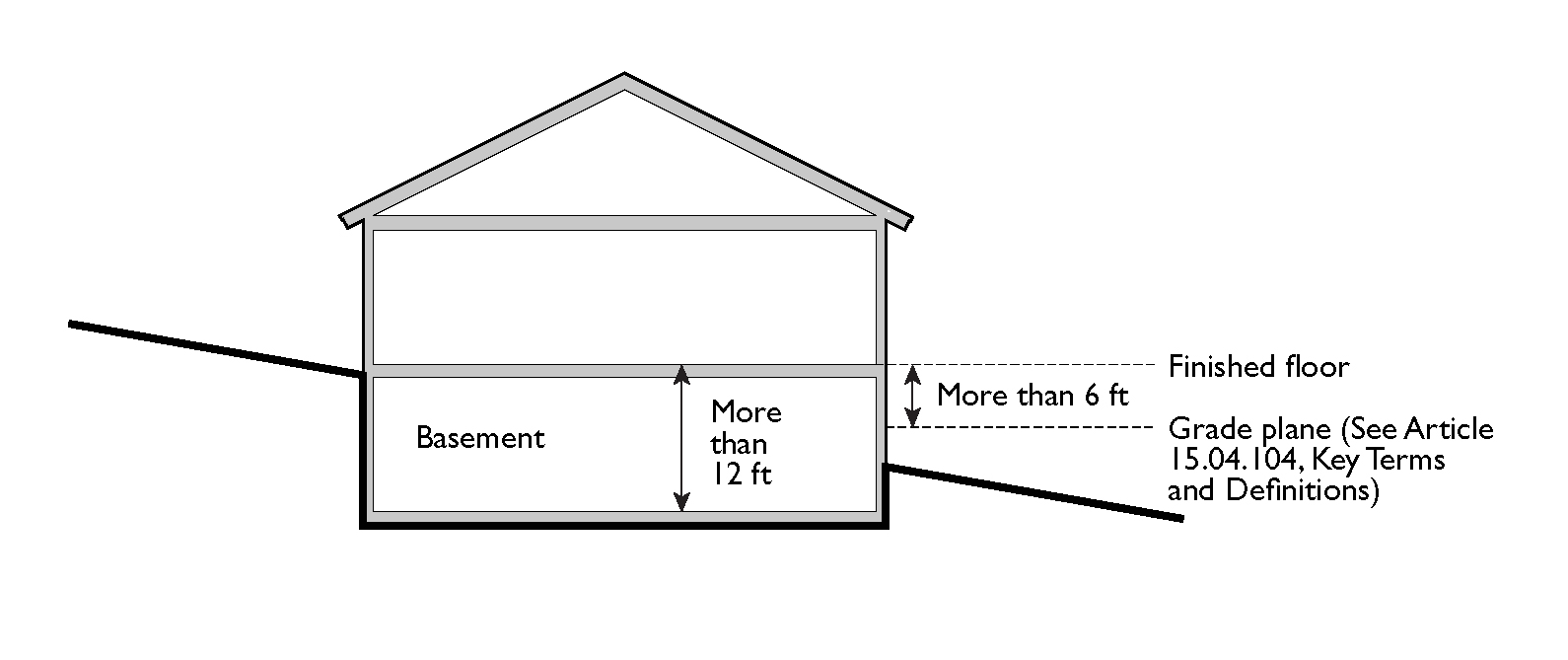
A basement shall be counted as a full story if the finished surface of the floor above the basement is:
a.
More than six feet above grade plane; or
b.
More than 12 feet above the finished grade at any point.
Figure 15.04.103.050-B: Determining if a Basement is a Story
3.
A story may not exceed 25 feet in height from the upper surface of the floor to the ceiling above.
C.
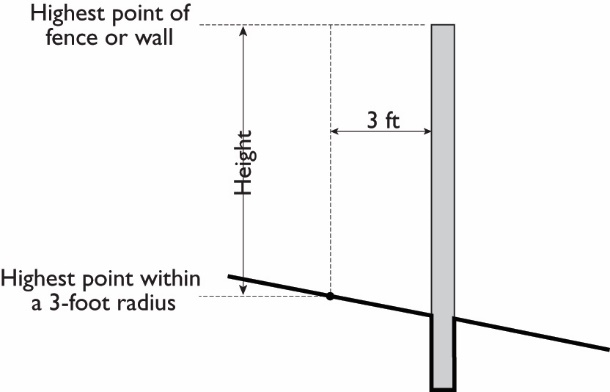
Measuring Height of Fences or Walls. The height of any fence or wall shall be determined by measuring the vertical distance from the highest finished grade within a three-foot radius of any point on the fence or wall to the highest point of any portion of the fence or wall. In the case of fences or walls between the setback line and lot line, height shall be measured from highest finished grade adjacent to the fence or wall to the top of the fence or wall.
1.
Measuring Height of Fences on Retaining Walls. The height of a fence that is on top of a retaining wall is measured from the highest finished grade point within a three-foot radius of any point on such fence to the highest point of the fence on the highest side of the wall. Any fence or railing required to comply with minimum height in applicable Building Code requirements is permitted.
Figure 15.04.103.050-C: Measuring Height of Fences and Walls
D.
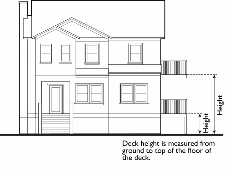
Measuring the Height of Decks. Deck height is the vertical distance from finished grade directly below the deck to the top of the floor of the deck.
Figure 15.04.103.050-D: Measuring Height of Decks
(Ord. No. 30-18 N.S., § I(Exh. A), 12-18-2018)
15.04.103.060 - Determining Grade.
A.
Determining Grade. Grade is the location of the ground surface. For purposes of this article, the grade of a building used to determine building height shall be determined by one or more of the following:
1.
Average Grade. A horizontal line approximating the ground elevation through each building on a site used for calculating the exterior volume of a building. Average grade is calculated separately for each building.
2.
Existing Grade. The existing elevation of the ground at any point on a lot. Existing grade also may be referred to as natural grade.
3.
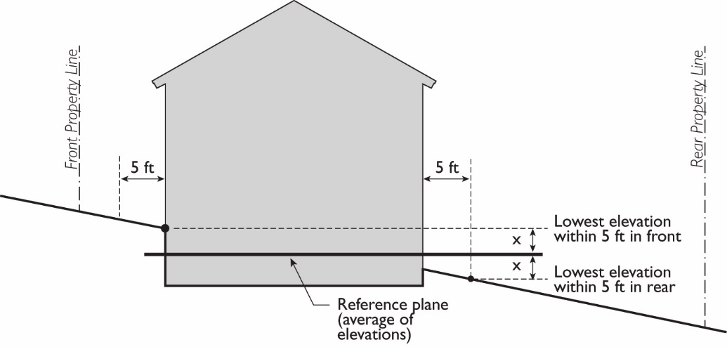
Finished Grade. The lowest point of elevation of the finished surface of the ground, paving, or sidewalk within the area between the building and the lot line, or when the lot line is more than five feet from the building, between the building and a line five feet from the building.
4.
Grade Plane. A reference plane representing the average of finished ground level adjoining the building at exterior walls. Where the finished ground level slopes away from the exterior walls, the reference plane shall be established by the lowest points within the area between the building and the lot line or, where the lot line is more than five feet from the building, between the building and a point five feet from the building.
Figure 15.04.103.060-B: Grade Plane
15.04.103.070 - Measuring Lot Width and Depth.
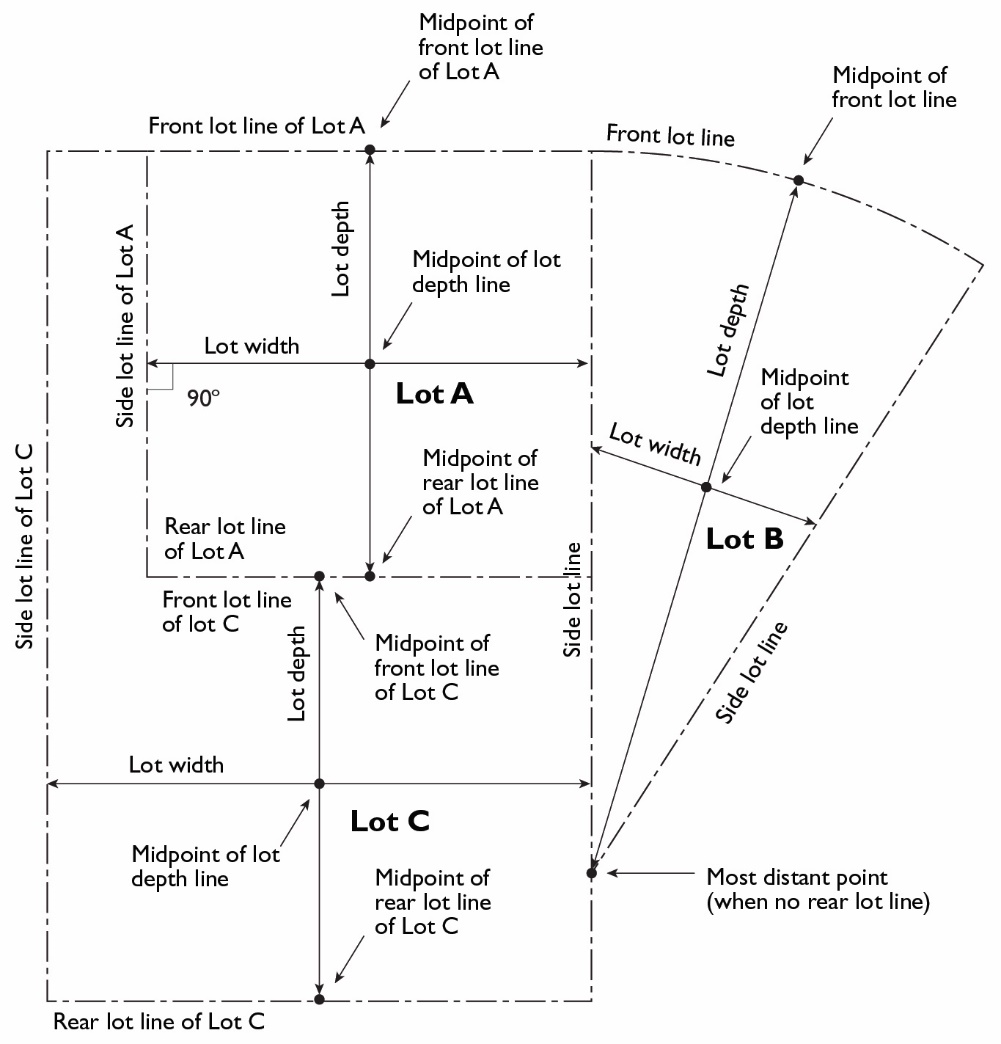
A.
Lot Width. Lot width is the horizontal distance between the side lot lines, measured at right angles to the lot depth at a point midway between the front and rear lot lines.
B.
Lot Depth. Lot depth is measured along a straight line drawn from the midpoint of the front lot line to the midpoint of the rear lot line or to the most distant point on any other lot line where there is no rear lot line.
Figure 15.04.103.070: Measuring Lot Width and Depth
15.04.103.080 - Determining Average Slope.
The average slope of a parcel is calculated using the following formula: S = 100(I)(L)/A, where:
S = Average slope (in percent)
I = Contour interval (in feet)
L = Total length of all contour lines on the parcel (in feet)
A = Area of subject parcel (in square feet)
15.04.103.090 - Determining Floor Area.
The floor area of a building is the sum of the gross horizontal areas of all floors of a building or other enclosed structure, measured from the outside perimeter of the exterior walls and/or the centerline of interior walls.
A.
Included in Floor Area. Floor area includes, but is not limited to, all habitable space (as defined in the Building Code) that is below the roof and within the outer surface of the main walls of principal or accessory buildings, the centerlines of party walls separating such buildings or portions thereof, or lines drawn parallel to and two feet within the roof line of any building without walls. In the case of a multi-story building that has covered or enclosed stairways, stairwells, or elevator shafts, the horizontal area of such features shall be counted only once at the floor level of their greatest area of horizontal extent. The area of mezzanines and sleeping lofts shall not be counted if the space is between two floors.
B.
Excluded from Floor Area. Floor area does not include the following: mechanical, electrical, and communication equipment rooms that do not exceed two percent of the building's gross floor area; bay windows or other architectural projections where the vertical distance between the lowest surface of the projection and the finished floor is 30 inches or greater; areas that qualify as usable open space; and, in non-residential buildings, areas used for off-street parking spaces or loading spaces, driveways, ramps between floors of a multi-level parking garage, and maneuvering aisles that are located below the finish grade of the property.
C.
Non-Residential Uses. For non-residential uses, gross floor area includes interior walkways interior courtyards, walkways, paseos, and corridors covered by a roof or skylight. Non-residential gross floor area does not include arcades, porticoes, and similar open areas that are located at or near street level and are accessible to the general public but are not designed or used as sales, display, storage, service, or production areas.
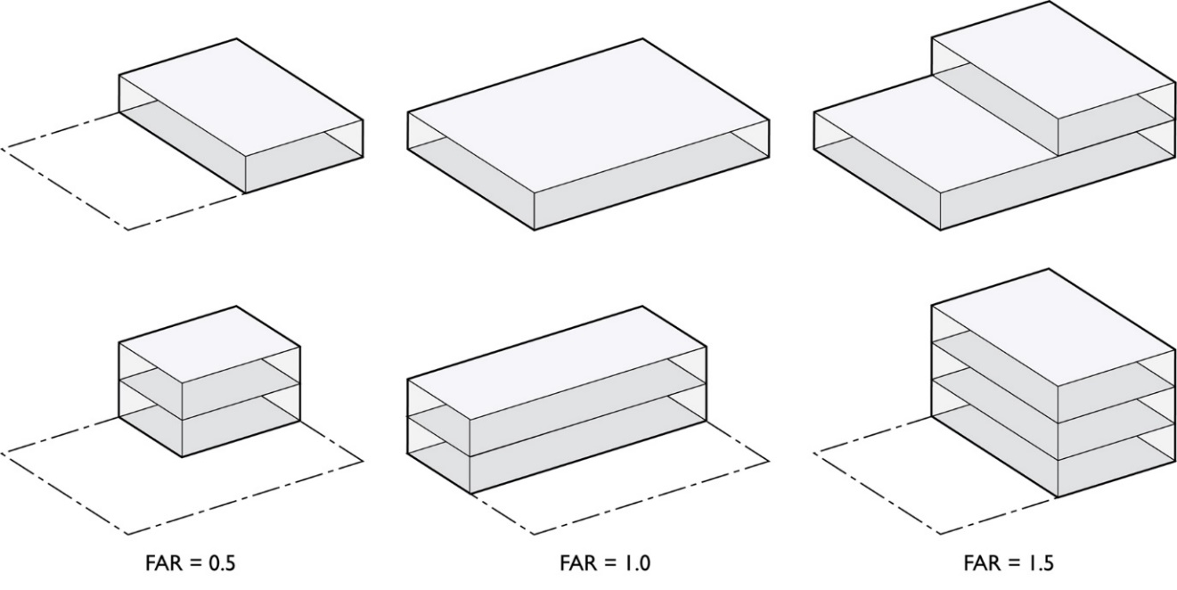
15.04.103.100 - Determining Floor Area Ratio.
The floor area ratio (FAR) is the ratio of the floor area, excluding the areas described below, of all principal and accessory buildings on a site to the site area. To calculate the FAR, floor area is divided by site area, and typically expressed as a decimal. For example, if the floor area of all buildings on a site totals 20,000 square feet, and the site area is 10,000 square feet, the FAR is expressed as 2.0. In single family homes and duplexes, any portion of a floor with a ceiling height greater than 12 feet is counted twice for purposes of calculating compliance with the maximum residential floor area allowed under subsection 15.04.201.030(G).
A.
Excluded from Floor Area in Calculating FAR. The following are excluded from the floor area when calculating FAR.
1.
Underground Areas. Floor area located below finished grade.
2.
Parking. Parking areas located below finished grade or finished floor of habitable space where the vertical distance between finished grade and finished floor is five feet or less. Structured parking areas located above finished grade where the vertical distance between finished grade and the floor of the parking level is five feet or less.
3.
Sideloaded or Detached Garages. Sideloaded or detached garages not exceeding 400 square feet, located to the rear of residential structures, a minimum of 40 feet away from the front lot line, and accessed by a driveway.
Figure 15.04.103.100: Determining Floor Area Ratio
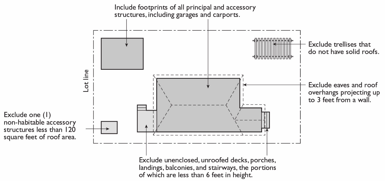
15.04.103.110 - Determining Lot Coverage.
Lot coverage is the ratio of the total footprint area of all structures on a lot to the net lot area, typically expressed as a percentage. The footprints of all principal and accessory structures, including garages, carports, covered patios, and roofed porches, shall be summed in order to calculate lot coverage. The following structures shall be excluded from the calculation:
A.
Unenclosed and unroofed decks, uncovered patio slabs, porches, landings, balconies, and stairways less than 18 inches in height at surface of deck (and less than six feet above grade including railings);
B.
Eaves and roof overhangs projecting up to two feet from a wall;
C.
Trellises and similar structures that have roofs that are at least 50 percent open to the sky with uniformly distributed openings;
D.
Swimming pools and hot tubs that are not enclosed in roofed structures or decks; and
E.
One small, non-habitable accessory structure under 120 square feet. If there is more than one such structure on the lot, only one structure shall be excluded in the calculation of lot coverage.
Figure 15.04.103.110: Determining Lot Coverage
15.04.103.120 - Determining Lot Frontage.
A.
Corner Lot. The front of a lot is the narrowest dimension of the lot with street frontage.
B.
Through Lot. The front yard of a through lot abuts the street that adjoining lots use to provide primary access into the dwelling.
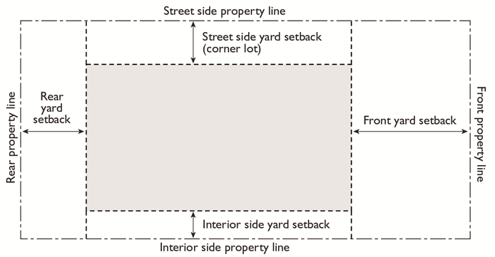
15.04.103.130 - Determining Setbacks.
A setback line defining a required yard is parallel to and at the specified distance from the corresponding front, side, or rear lot line. The following regulations for determining yards apply when a lot abuts a proposed street or alley.
A.
Yards Abutting Planned Street Expansions. If a property abuts an existing or proposed street for which the existing right-of-way is narrower than the right-of-way ultimately required for the street, the required setback shall be established from the future right-of-way rather than the property line.
B.
Yards on Alleys.
1.
If a side lot line abuts an alley, the yard shall be considered an interior side yard rather than a corner side yard.
2.
In computing the minimum yard for any lot where such yard abuts an alley, no part of the width of the alley may be considered as part of the required yard.
C.
Measuring Setbacks. Setbacks shall be measured as the distance between the nearest lot line and the closest point on the exterior of a building or structure along a line at right angles to the lot line. Setbacks shall be unobstructed from the ground to the sky except where allowed pursuant to Section 15.04.601.020 (Building Projections into Yards), subject to compliance with the Building Code.
Figure 15.04.103.130: Determining Setbacks (Yards)
15.04.103.140 - Measuring Signs.
The calculations of measurements related to signs are described in Article 15.04.609 (Signs).
15.04.103.150 - Measuring Parking Lot Landscaping.
For the purpose of calculating required parking lot landscaping, parking lot areas are deemed to include parking and loading spaces as well as aisles, vehicle entry and exit areas, and any adjacent paved areas. Parking lot area does not include enclosed vehicle storage areas.
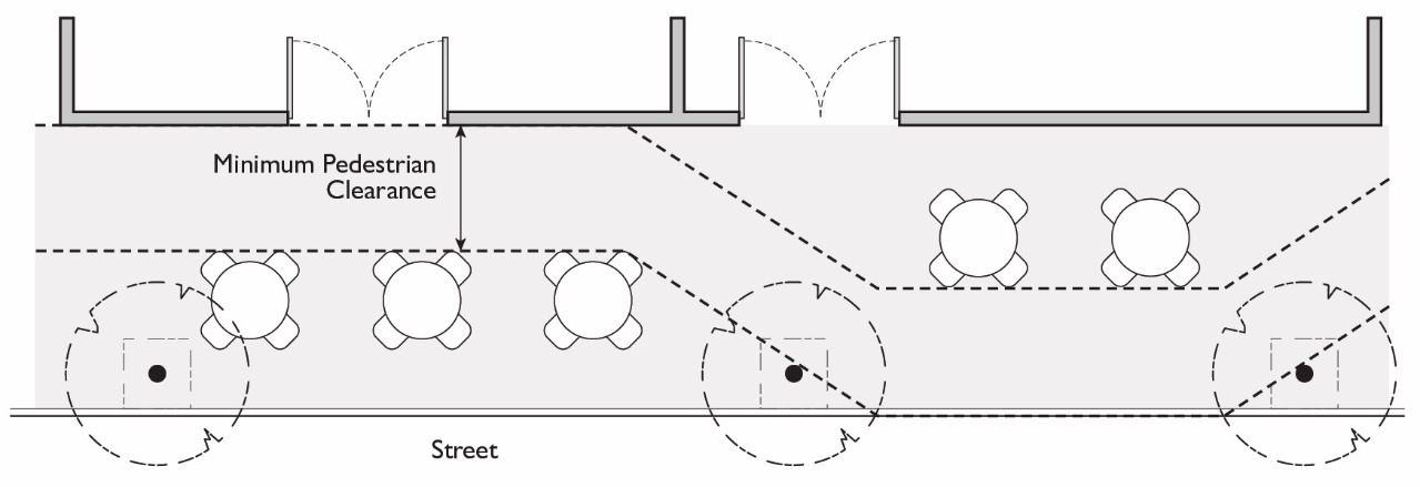
15.04.103.160 - Measuring Pedestrian Clearance.
The minimum distance shall be measured from the edge of any table, chair, bench, planter, or other appurtenance used as part of an outdoor dining area to any obstruction within the sidewalk area.
Figure 15.04.103.160: Measuring Pedestrian Clearance
15.04.104.010 - Key Terms.
Abutting or Adjoining
Access
Accessory Dwelling Unit
Active Play Area
ADA
Adjacent
Administrative Review
Adult Businesses
Affordable-Housing Related Terms
Accessible
Affordable Housing Units
Affordable Housing Cost
Density Bonus
Housing Unit
Inclusionary Unit
Initial Subsidy
In-lieu Fee
Proportionate Share of Appreciation
Resale Control
Senior Citizen
Senior Citizen Housing Development
Agent
Agricultural Production and Services
Alley
Allowed Use
Alteration
Amendment
Animals, Domestic (Household Pets)
Animal Husbandry
Animal Keeping
Animal Sales and Services
Boarding Kennel
Clinic/Hospital
Grooming
Retail Sales (Pet Shops)
Riding Schools and Stables
Veterinary Services
Applicant
Approval Authority
Area
Architectural Feature
Arterial Street
Artisan/Small-Scale Manufacturing
Artist's Studio
Studio-Light
Studio-Heavy
Auto/Vehicle Sales and Services
Alternative Fuels and Recharging Facility
Automobile Rental
Automobile Storage Parcel
Automobile/Vehicle Sales and Leasing, New and Used
Automobile/Vehicle Repair, Major
Automobile/Vehicle Service and Repair, Minor
Automobile/Vehicle Washing
Large Vehicle and Equipment Sales, Service and Rental
Service Station
Towing and Impound
Awning
Balcony
Banks and Financial Institutions
Bank and Savings and Loan
Nontraditional Financial Institutions
Basement
Bathroom
Bay Window
Bedroom
Bicycle-Parking Related Terms
Abandoned Bicycle
Bicycle
Bicycle Locker
Bicycle Parking Space
Bicycle Path
Class 1 Bicycle Parking Space(s)
Class 2 Bicycle Parking Space(s)
Fixed
Long-Term Bicycle Parking
Publicly Accessible
Rack Element
Secured Bicycle Parking
Short-Term Bicycle Parking
Tandem
Bikeway
Bikeway Classes
Class I Bikeway (Bike Path)
Class II Bikeway (Bike Lane)
Class III Bikeway (Bike Route)
Class IV Bikeway (separated bikeway)
Block
Block Face
Bluff
Breweries
Brewery, Production
Brewery, Brew-On Premises
Micro-brewery
Buffer
Build-to Line
Building
Building, Accessory
Building, Principal
Building Code
Building Face
Building Site
Business Services
Canopy
Carport
Catering Service
CDHP
Cemetery
Centerline of Street
Change of Use
Civil Code
College and Trade School
Commercial Entertainment and Recreation
Cinema
Theater
Large-scale Facility
Small-scale Facility
Commercial Kitchen
Commissary
Communications Facilities
Antennas and Transmission Towers
Equipment within Buildings
Community Assembly
Community Garden
Condition of Approval
Conditional Use
Condominium Related Terms
Association
Common Area
Community Apartment
Community Apartment Project
Condominium
Consumer Price Index, Rental Component
Conversion
Cooperative, Stock
Developer
Open Space—Common
Open Space—Private
Open Space—Recreational
Owner
Residential Condominium
Tenant
Unit
Construction
Construction and Material Yard
CPUC; PUC
Creek-Related Terms
Brush Layering
Brush Matting
Creek
Cribwalls
Culverted
Daylighting
Fascines
Gabions
Restoration
Retention Basins
Riprap
Cul De Sac
Cultural Facility
Day Care
Days
De novo
Decision-making Body
Deck
Demolition
Density
Design
Design Review Board
Design Site
Detached Structure
Development
Development Agreement
Director
Drive-Through Facilities
Driveway
Drug Paraphernalia
Duplex
Dwelling Unit
Easement
Eating and Drinking Establishments
Bars/Night Clubs/Lounges
Brewpub
Restaurant, Full Service
Restaurant, Limited Service
Restaurant with Drive Through
Effective Date
Efficiency Unit
Elderly and Long-Term Care
Electric Vehicle (EV)
Electric Vehicle Supply Equipment
Emergency
Emergency Shelter
Environmental Impact Report (EIR)
Environmental Review
Erect
Et seq.
EV Capable
EV Ready
Exterior Storage
FAA
Façade
Family
Family Day Care
Small
Large
Farmers Market
FCC
Feasible
FEMA
Fence-Related Terms
Fence
Opacity
Final Map
Finance, Insurance and Real Estate Services
Fire Chief
Floor Area
Food and Beverage Sales
Convenience Market
Farmers Market
General Market
Liquor Store
Food Membership Distribution Site
Footprint
Freight/Truck Terminal and Warehouse
Frontage, Street
Funeral and Interment Service
Garage
Glare
Government Code
Government Buildings
Grade
Adjacent Grade
Average Grade
Existing Grade
Finished Grade
Group Residential
Congregate Housing
Senior Group Residential
Habitable Room
Hazardous Waste Terms
Hazardous Materials
Hazardous Waste Facility
Health and Safety Code
Heat
Height
Home Occupation
Hospitals and Clinics
Hospital
Clinic
Skilled Nursing Facility
Hours of Operation
Household
Household Income Types
Extremely Low Income Household
Low Income Household
Moderate Income Household
Very Low Income Household
Household Pets
Housing Authority
Illegal use
Improvement
Improvement Agreement
Improvement Plan
Indoor Agriculture
Industrial, General
Industrial Limited
Instructional Services
Intensity of Use
Intersection, Street
ITE
Junior Accessory Dwelling Unit
Kitchen
Land Use
Landscape-Related Terms
Applied Water
Automatic Irrigation Controller
Backflow Prevention Device
Certified Irrigation Designer
Check Valve or Anti-Drain Valve
Compost
Drip Irrigation
Effective Precipitation or "Usable Rainfall" (Eppt)
Emitter
Established Landscape
Establishment Period
Estimated Total Water Use (ETWU)
ET Adjustment Factor
Evapotranspiration Rate
Flow Rate
Flow Sensor
Graywater
Hydrozone
Infiltration Rate
Invasive Plant Species
Irrigation Efficiency
Irrigation Survey
Irrigation Water Use Analysis
Landscape Area
Landscape Contractor
Landscape Water Meter
Landscaping
Lateral Line
Low Volume Irrigation
Maximum Applied Water Allowance
Microclimate
Mulch
Operating Pressure
Overhead Sprinkler Irrigation Systems
Pervious
Plant Factor or "Plant Water Use Factor"
Precipitation Rate
Rain Sensor
Recycled Water
Reference Evapotranspiration (ETo)
Runoff
Soil Moisture Sensing Device
Special Landscape Area
Sprinkler Head
Station
Swing Joint A
Turf
Valve
Water Conserving Plant Species
Water Feature
Watering Window
WUCOLS
Ldn
Light Fleet-Based Service
Lighting-Related Terms
Color Rendition
http://www.businessdictionary.com/definition/ability.html
http://www.businessdictionary.com/definition/business-source-document.html
http://www.businessdictionary.com/definition/color.html
Display Lot or Area
Flood Lamp
Fully Shielded Light Fixture
Glare
Illuminance
Light Trespass
Lumen
Luminaire
Lux
Opaque
Outdoor Light Fixture
Searchlight
Spot Lamp
Live-Work
Living Accommodations
Living Room
Lot
Abutting Lot
Corner Lot
Flag Lot
Interior Lot
Through Lot
Lot Area
Lot Area, Net
Lot Coverage
Lot Line
Lot Line Adjustment
Lot Line Types
Front Lot Line
Front Lot Line, Corner Lot
Interior Lot Line
Rear Lot Line
Side Lot Line
Street Side Lot Line
Maintenance and Repair
Maintenance and Repair Service
Major Subdivision
Major Transit Stop
Mansard
Marijuana-Related Terms
Attending Physician
Bureau of Medical Marijuana Regulations
Cannabis
Collective
Commercial Cannabis Activity
Cultivation
Delivery
Dispensary
Distributor
Edible Marijuana Product
Management Member
Manufacturer
Marijuana
Marijuana Cultivation Facility
Marijuana Product Manufacturer
Medical Marijuana
Medical Marijuana Business
Medical Marijuana Regulation and Safety Act (MMRSA)
Person
Primary Caregiver
Qualified Patient
Testing Laboratory
Transporter
Marinas
Media Production
Master Fee Schedule
Merger
Mezzanine
Mixed-Use Building
Mixed-Use Development
Mobile Vending Unit
Monument Works
Multi-Use Path
Multiple-Unit Dwelling
Municipal Code
Neighborhood Council
Noise-Related Terms
Ambient Noise Level
Cumulative Period
Decibel (dB)
Noise Level
Nonconforming Lot
Nonconforming Structure
Nonconforming Use
Nursery and Garden Center
NPDES
Off-Site Use
Offices
Medical and Dental
Walk-In Clientele
On-Site Use
Open Space Types
Open Space, Common
Open Space, Private
Open Space, Useable
Opposite
Ordinary Maintenance
OSHA
Outdoor Agriculture
Outdoor Vendor
Overlay District
Owner
Parapet Wall
Parcel
Parcel Map
Park and Recreation Facility
Parking Area
Parking Facilities, Commercial
Path
Peak Hour
Pedestrian Way
Permit
Permitted Use
Person
Personal Services
General Personal Services
Massage Establishment
Health/Fitness Facility
Tattoo or Body Modification Parlor
Persons with Disabilities
Petroleum Refining
Planned Development
Planned Residential Group
Planning Division
Planting Strip
Pre-existing
Principal Structure
Printing and Publishing
Project
Property Line
Public Resources Code
Public Safety Facility
Qualified Applicant
Reasonable Accommodation
Research and Development
Residential Facility
Residential Care, General
Residential Care, Limited
Residential Care, Senior
Hospice, General
Hospice, Limited
Retail Sales
Building Materials and Services
General Retail Sales, Small-Scale
General Retail Sales, Large-Scale
Pawn Shop; Secondhand Store
With Drive-Through
Reversion to Acreage Map
Right-of-Way
Salvage and Wrecking
Sanitary Waste and Recycling Facilities
Composting and Waste Disposal
Conversion Technology Facilities (Waste/Biomass to Energy)
Recycling Collection Facilities
Recycling Processing Facilities
Waste Hauling and Transfer Facilities
School
Screening
Seaport
Second Dwelling Unit
Setback
Front Setback
Side Setback
Side Street Setback
Rear Setback
Shoreline
Sidewalk
Sight Distance Triangle
Sight Triangle
Single Unit Dwelling, Attached
Single Unit Dwelling, Detached
Site
Social Service Center
Solar Reflective Index
Specific Plan
Story
Street
First Story
Half Story
Street Line
Structural Alterations
Structure
Structure, Accessory
Structure, Primary (Structure, Main)
Structure, Temporary
Subdivider
Subdivision
Subdivision Map Act
Supportive Housing
Swimming Pool
TDM
Tenant
Tentative Map
Tentative Parcel Map
TMA
Transient Lodging
Bed and Breakfast
Hotel and Motel
Transitional Housing
Transportation Passenger Terminals
Urban Agriculture
Use
Accessory Use
Incidental Use
Primary Use
Use Classification
Use Permit
Use Type
Utilities
Utilities, Major
Utilities, Minor
Variance
Vehicle
Vesting Tentative Map
Visible
Wall
Warehousing, Storage, and Distribution
Chemical, Mineral, and Explosives Storage
Indoor Warehousing and Storage
Outdoor Storage
Mini-Storage
Wineries
Winery, Large
Winery, Small
Wireless Communications-Related Terms
Accessory Equipment
Antenna
Antenna, Amateur Radio
Antenna, Ground-Mounted
Antenna, Panel
Antenna, Satellite Earth Station
Antenna Array
Antenna Structure
Antenna Structure, Freestanding
Approved Radio Frequency Expert
Base Station
Camouflaged Facility
Co-Location
Eligible Support Structure
Equipment Shelter
FAA
FCC
Feasible
Mast
Microcell Facility
Monopole
PUC
Readily Visible
Radio Frequency
Related Equipment
Satellite Dish
Service Provider
Shot Clock
Substantial Change
Tolling
Tower
Wireless Communications Facility
Yard
Front Yard
Interior Side Yard
Rear Yard
Street Side Yard
Zoning Administrator
Zoning Map
Zoning Ordinance; Zoning Regulations
(Ord. No. 30-18 N.S., § I(Exh. A), 12-18-2018; Ord. No. 04-23 N.S., § I(Exh. A), 4-18-2023)
15.04.104.020 - Definitions.
Abutting or Adjoining. Having a common boundary.
Access. The place or way through which pedestrians and/or vehicles must have safe, adequate, and usable ingress and egress to a property or use.
Accessory Dwelling Unit. An attached or detached residential dwelling that provides complete independent living facilities for one or more persons, including living, sleeping, eating, cooking, and sanitation facilities, on the same lot as a proposed or existing single-family dwelling or existing multifamily dwelling. An accessory dwelling unit may be within the same structure as the primary dwelling, in an attached structure, or in a separate detached structure on the same lot. An accessory dwelling unit also includes the following: (i) an efficiency unit, as defined in Section 17958.1 of the Health and Safety Code; and (ii) a manufactured home as defined in Section 18007 of the Health and Safety Code. This use is distinguished from a duplex. See also Junior Accessory Dwelling Unit.
Active Play Area. An indoor or outdoor space in a school that is designed or adapted to active recreational activity and student play during recess. Excluded from this definition are areas for "mental games" such as a computer lab or library reading room.
ADA. Americans with Disabilities Act.
Adjacent. Directly abutting, having a boundary or lot property line(s) in common or bordering directly, or contiguous to.
Administrative Review. The process for permit/project review and design approval or disapproval by the Director or Zoning Administrator.
Adult Businesses. Any commercial activity, whether conducted intermittently or full time, which primarily involves the sale, display, exhibition or viewing of books, magazines, films, videos, photographs or other materials, distinguished or characterized by an emphasis on matter depicting, describing or relating to human sex acts, or by an emphasis on male or female genitals, buttocks or female breasts. Such activity includes adult book stores, adult arcades, adult movie theaters, sexual encounter establishments, adult cabarets, massage parlors (excluding those in compliance with Chapter 9.38 of the Municipal Code), and adult theaters, which exclude minors by virtue of age.
Affordable-Housing Related Terms
Accessible. Usable by persons with disabilities and compliant with the building standards published in the California Building Standards Code relating to access for persons with disabilities and the other regulations adopted pursuant to Government Code Section 4450 that are in effect on the date of application for a building permit.
Affordable Housing Cost. Affordable rent or affordable sales price, as defined in this section.
Affordable Housing Units. Dwelling units affordable to moderate, low, very low, or extremely low income persons.
Affordable Housing Fund. A fund or account designated by the City to maintain and account for all monies received pursuant to Article 15.04.603.
Affordable Rent. The maximum monthly rent, including an allowance for tenant paid utilities, calculated at the specified income level in accordance with the Health and Safety Code Section 50053.
Affordable Sales Price. The maximum purchase price that will be affordable to the specified household at the specified income level, calculated in accordance with California Health and Safety Code Section 50052.5. The affordable sales price shall include a reasonable down payment, and monthly housing payments (including interest, principal, mortgage insurance, property taxes, homeowner's insurance, homeowner's association dues, and a reasonable allowance for property maintenance, repairs, and utilities), all as determined by the City.
Common Ownership or Control. Property owned or controlled by the same person, persons, or entity, or by separate entities in which any shareholder, partner, member, or family member of an investor of the entity owns ten percent or more of the interest in the property.
Contiguous Property. Any parcel of land that is (1) touching another parcel at any point; (2) separated from another parcel at any point only by a public right-of-way, private street or way, or public or private utility, service, or access easement; or (3) separated from another parcel only by other real property which is in common ownership or control of the applicant which is not subject to the requirements of Article 15.04.603 at the time of a project application by a developer.
Density Bonus. A density increase over the otherwise maximum allowable density permitted by the City of Richmond pursuant to California Government Code Section 65915 and Article 15.04.602.
Density Bonus Units. Dwelling units approved in a residential development project or mixed-use development project pursuant to California Government Code Section 65915 and Article 15.04.602 that are in excess of the maximum allowable residential density otherwise permitted by the City of Richmond.
Housing Unit. A dwelling unit.
Inclusionary Housing Agreement. An agreement in conformance with Section 15.04.603.110 between the City and a developer, governing how the developer shall comply with Article 15.04.603.
Inclusionary Unit. A dwelling unit intended for sale or rental, required by Article 15.04.603 to be affordable to very low, low, or moderate-income households.
Initial Subsidy. An amount equal to the fair market value of a dwelling unit at the time of initial sale minus the initial sale price, plus the amount of any down payment assistance or mortgage assistance.
Low Income Household. Households whose income does not exceed the low-income limits applicable to Contra Costa County as defined in California Health and Safety Code Section 50079.5 and published annually pursuant to Title 25 of the California Code of Regulations, Section 6932 (or its successor provision) by the California Department of Housing and Community Development.
Market Rate Unit. A new dwelling unit in a residential development project that is not an inclusionary unit.
Mixed-Use Development Project. Any development that includes both a non-residential development project and a residential development project.
Moderate Income Household. Households whose income does not exceed the moderate-income limits applicable to Contra Costa County as defined in California Health and Safety Code Section 50093 and published annually pursuant to Title 25 of the California Code of Regulations, Section 6932 (or its successor provision) by the California Department of Housing and Community Development.
Non-Residential Development Project. Any development for which a discretionary approval for non-residential development or building permit is required that includes the creation of net new floor area for non-residential purposes. For purposes of Article 15.04.603, a live-work unit is not a non-residential purpose.
Ownership Residential Development. Any residential development that includes the creation of one or more additional dwelling units that may be sold individually. A residential ownership development also includes the conversion of a residential rental development to a residential ownership development.
Proportionate Share of Appreciation. An amount equal to the ratio of the initial subsidy to the fair market value of a dwelling unit at the time of initial sale.
Rental Residential Development. Any residential development that creates one or more additional dwelling units that cannot be lawfully sold individually in conformance with the Subdivision Map Act.
Resale Control. A recorded document applied to an affordable housing unit or an inclusionary unit that, for a specified term, requires sale of the unit to a very low, low, or moderate-income household at an affordable sales price.
Residential Development Project. Any development for which a discretionary approval for residential development or a building permit is required that includes the creation of one or more additional dwelling units, conversion of nonresidential uses to dwelling units, or the conversion of a use from a residential rental development to a residential ownership development. For purposes of Article 15.04.603, a live-work unit is counted as a residential dwelling unit.
Senior Citizen. A person 62 years of age or older, or 55 years of age or older in a senior citizen housing development.
Senior Citizen Housing Development. A senior citizen housing development as defined in California Civil Code Sections 51.3 and 51.12, that is developed, substantially rehabilitated, or substantially renovated for senior citizens. A senior citizen housing development must include at least 35 dwelling units
Very Low Income Household. Households whose income does not exceed the very low-income limits applicable to Contra Costa County as defined in California Health and Safety Code Section 50105 and published annually pursuant to Title 25 of the California Code of Regulations, Section 6932 (or its successor provision) by the California Department of Housing and Community Development.
Agent. A person who has been given written authorization by the property owner to represent and act for a property owner in contacts with the City.
Agricultural Production and Services. Any establishment primarily engaged in either the keeping, grazing, feeding of livestock and for sale of livestock or livestock products; production of crops, plants, vines, and trees (excluding forestry operations); or performing services; crop services; veterinary services; other animal services; and landscape and horticultural services; for another on a contract or fee basis.
Alley. A public way permanently reserved primarily for secondary vehicular service access to the rear or side of properties otherwise abutting on a street.
Allowed Use. A use of land as a permitted or conditional use that may be established with zoning compliance review (for an "as-of-right" or permitted use) or a use permit for a conditionally permitted use and, where applicable, design review and/or building permit approval, subject to compliance with all applicable provisions of Article XV and the Municipal Code.
Alteration. Any change, addition, or modification that changes the exterior architectural appearance or materials of a structure or object. Alteration includes changes in exterior surfaces, changes in materials, additions, remodels, demolitions, and relocation of buildings or structures, but excludes ordinary maintenance and repairs.
Amendment. A change in the wording, context or substance of the zoning ordinance, or a change in the district boundaries on the Zoning Map.
Animals, Domestic (Household Pets). Small pets such as cats, dogs, and birds. This definition excludes large animals, such as horses, goats, swine and similar size animals, and farm animals, such as chickens, ducks, and rabbits.
Animal Husbandry. Breeding and raising of animals for sale, or in order to use or sell products such as meat, honey, milk, eggs, and fibers. This use classification includes day-to-day care, selective breeding, and the raising of commercial livestock.
Animal Keeping. The keeping of animals, such as household pets, for personal use and enjoyment.
Animal Sales and Services. Sales and service activities related to the care and treatment of domestic animals.
Boarding Kennel. An establishment licensed to operate a facility providing shelter and care for domestic animals (e.g., cats and dogs) on a commercial basis for a period in excess of 48 hours. This classification includes activities such as feeding, exercising, grooming, and incidental medical care for domestic animals.
Clinic/Hospital. Establishments where domestic animals receive medical and surgical treatment. This classification includes only facilities that are enclosed, soundproofed, and air-conditioned. Grooming and temporary (up to 30 days) boarding of domestic animals is included if incidental to the hospital use.
Grooming. Provision of bathing and trimming services for domestic animals on a commercial basis. This classification includes boarding of domestic animals for a maximum period of 48 hours.
Retail Sales (Pet Shops). Retail sales and boarding of domestic animals, provided such activities take place within an entirely enclosed building. This classification includes grooming if incidental to the retail use.
Riding Schools and Stables. A stable is a place where horses are kept in individual box stalls or in groups in large rooms. The interior of a stable usually consists of two rows of box stalls, tie stalls, and large rooms along the outer walls and a central passage running lengthwise. A horse stable may also contain other facilities, such as a riding school, a feed room, a dressing room, a harness room, a staff area, watering place, and a room for animal care services. A riding school generally operates on the basis of hiring out horses or ponies on a pay per hour basis. Typically students go out together on a ride accompanied by a member of staff, and range from small establishments in converted farm buildings, to much larger premises with purpose-built stables, indoor or outdoor schools and, sometimes, cross-country courses.
Veterinary Services. Medical and health services for animals. Typical uses include veterinary offices, pet clinics and animal hospitals. This use type excludes kennels.
Applicant. Any entity or person who applies for a discretionary permit, certificate, zoning approval or other entitlement.
Approval Authority. The decision-making body or official responsible for approving, approving with conditions or denying application. As an illustration, the Planning Commission is the Approval Authority over an application for a conditional use permit, and the Zoning Administrator is the Approval Authority over an application for an administrative use permit.
Area. Any geographical area, for example a portion of a block, a block, or a larger district.
Architectural Feature. An exterior building feature, including a roof, walls, windows, doors, porches, posts, pillars, recesses or projections, and exterior articulation or walls, and other building surfaces.
Arterial Street. A street classified as a Major Arterial or Minor Arterial in the Transportation Element of the General Plan.
Artisan/Small-Scale Manufacturing.The artisan/small-scale manufacturing use type refers to establishments primarily engaged in on-site production of goods by hand manufacturing or artistic endeavor, which involves only the use of hands tools or domestic mechanical equipment not exceeding five horsepower or kilns not exceeding 25 kilowatts, and the incidental direct sale to consumers of only those goods produced on site. Typical uses include ceramic studios, candle making shops, and custom jewelry manufacturers.
Artist's Studio. Work space for an artist or artisan, including individuals practicing one of the fine arts or performing arts, or an applied art or craft. This use may include incidental display and retail sales of items produced on the premises and instructional space for small groups of students. It does not include joint living and working units (see Live-Work).
Studio-Light. Small-scale art production that is generally of a low impact. Typical uses include painting, photography, jewelry, glass, textile, and pottery studios.
Studio-Heavy. Art production on a medium or large scale generally using heavy equipment. Typical uses include large-scale metal and woodworking studios.
Auto/Vehicle Sales and Services. Retail or wholesale businesses that sell, rent, and/or repair automobiles, boats, recreational vehicles, trucks, vans, trailers, and motorcycles, including the following:
Alternative Fuels and Recharging Facility. A facility offering motor vehicle fuels not customarily offered by commercial refueling stations (e.g., LPG) as well as equipment to recharge electric-powered vehicles.
Automobile Rental. Rental of automobiles. Typical uses include car rental agencies.
Automobile Storage Parcel. Any property used for short- or long-term parking of vehicles for sale or lease at an automobile dealership or rental agency on a separate parcel from such agency or dealership.
Automobile/Vehicle Sales and Leasing. Sale or lease, retail or wholesale, of new or used automobiles, light trucks, motorcycles, motor homes, and trailers, together with associated minor repair services and parts sales for vehicles sold or leased by the dealership. This classification includes on-site facilities for maintaining an inventory of vehicles for sale or lease but excludes buildings and property on a separate site that are used for storing vehicles.
•
New. Sales and leasing of new cars, recreational vehicles, and trucks by new car dealers, including sales of previously-owned automobiles and trucks, and sales of parts and accessories, storage, and incidental maintenance and repair.
•
Used. Sales and leasing of previously owned automobiles, recreational vehicles and trucks by car dealers not affiliated with a new car manufacturer.
Automobile/Vehicle Repair, Major. Repair of automobiles, trucks, motorcycles, motor homes, boats and recreational vehicles, including the incidental sale, installation, and servicing of related equipment and parts. This classification includes auto repair shops, body and fender shops, transmission shops, wheel and brake shops, auto glass services, vehicle painting, tire sales and installation, and installation of car alarms, sound, telecommunications, and navigation systems, but excludes vehicle dismantling or salvaging and tire retreading or recapping.
Automobile/Vehicle Service and Repair, Minor. The service and repair of automobiles, light-duty trucks, boats, and motorcycles, including the incidental sale, installation, and servicing of related equipment and parts. This classification includes the replacement of small automotive parts and liquids as an accessory use to a gasoline sales station or automotive accessories and supply store, as well as smog check quick-service oil, tune-up and brake and muffler shops where repairs are made or service provided in enclosed bays and no vehicles are stored overnight.
Automobile/Vehicle Washing. Washing, waxing, or cleaning of automobiles or similar light vehicles, including self-serve washing facilities that are the principal use of a building, structure, or site.
Large Vehicle and Equipment Sales, Service and Rental. Sales, servicing, rental, fueling, and washing of large trucks, trailers, tractors, and other equipment used for construction, moving, agricultural, or landscape gardening activities. Includes large vehicle operation training facilities.
Service Station. Establishments primarily engaged in retailing automotive fuels or retailing these fuels in combination with activities, such as providing minor automobile/vehicle repair services; conducting state inspections (e.g. "smog checks"), selling automotive oils, replacement parts, and accessories; and/or providing incidental food and retail services.
Towing and Impound. Establishments primarily engaged in towing light or heavy motor vehicles, both local and long distance. These establishments may provide incidental services, such as vehicle storage and emergency road repair services.
Awning. An architectural projection that provides weather protection, identity, or decoration, and is wholly supported by the building to which it is attached. An awning is typically constructed of non-rigid materials on a supporting framework which projects from and is supported by the exterior wall of a building. The awning may be fixed in place or retractable.
Balcony. A platform that projects from the wall of a building 30 inches or more above grade that is accessible from the building's interior, is not accessible from the ground, and is not enclosed by walls on more than two sides (see also Deck).
Banks and Financial Institutions.
Bank and Savings and Loan. A financial institution, including a credit union office, that provides retail banking services to individuals and businesses. This classification includes only those institutions engaged in the on-site circulation of cash money.
Nontraditional Financial Institutions. Establishments engaged in short-term lending and buy-back activities in which customers typically take part in one-time or infrequent transactions and do not open long-term accounts or deposit funds. Typical uses include check cashing services, pay day lenders (also known as deferred deposit originators), pawnbrokers, cash for gold dealers, and similar activities.
Basement. A non-habitable space beneath the first or ground floor of a building, the ceiling of which does not extend more than four feet above finished grade. When used as a dwelling or portion thereof, the basement shall not be counted as a story for the purposes of height measurement based on allowed number of stories.
Bathroom. A room containing toilet, sink, and bathing facilities.
Bay Window. An architectural projection from the building cantilevered from the facade, consisting of one or more stories in height, containing at least 60 percent glass area.
Bedroom. Any room having the potential of being a bedroom and meeting the standards of the Building Code as a sleeping room.
Bicycle-Parking Related Terms.
Abandoned Bicycle. A bicycle that has been parked continuously in one place for at least two weeks in short-term parking or at least one month in long-term parking, excluding seasonal bicycle storage as agreed upon between the property owner and the bicycle owner.
Bicycle. A device propelled by human power upon which a person may ride, having two wheels one behind the other, at least one wheel being at least 13 inches in diameter.
Bicycle Locker. An enclosure that can be locked for the safe keeping of a bicycle, made of theft-resistant material, with a lockable door that opens the full width and height of the locker, with no exposed fittings or connectors.
Bicycle Parking Space. A paved, level, drained, lighted area for the parking of one bicycle.
Bicycle Path. A way designed for primary use by bicycles and excluding motorized vehicles.
Class 1 Bicycle Parking Space(s). Spaces in secure, weather protected facilities intended for use as long-term, overnight, and work-day bicycle storage by dwelling unit residents, non-residential occupants, and employees.
Class 2 Bicycle Parking Space(s). Bicycle racks located in a publicly-accessible, highly visible location intended for transient or short-term use by visitors, guests, and patrons to the building or use.
Fixed. Mounted so the rack element cannot be stolen; anchored in the pavement or a structure with vandal-resistant fasteners such as, but not limited to, embedded mounting in poured-in-place concrete, recessed bolt heads or grouted-in anchoring.
Long-Term Bicycle Parking. Bicycle parking intended for the primary use of residents, employees and others who park bicycles for four hours or more.
Publicly Accessible. In an area that is visible from a right-of-way and open to the general public.
Rack Element. A fixed object that supports one or two bicycles upright by their frames in a stable position and enables the frame and at least one wheel to be locked.
Secured Bicycle Parking. An enclosed, covered, locked area, surrounded by a fence or wall, restricted to bicycle parking users.
Short-Term Bicycle Parking. Bicycle parking intended for the primary use of customers, messengers, guests and others who park bicycles for less than four hours.
Tandem. Arranged so a bicycle must be removed to access another bicycle parking space.
Bikeway. A right-of-way either on or off a street that is used as a travel route for bicycles either independently or jointly with other means of transportation, and as identified in the City's Bicycle Master Plan.
Bikeway Classes.
Class I Bikeway (Bike Path). Provides a completely separated right-of-way for the exclusive use of bicycles and pedestrians with crossflow by motorists minimized.
Class II Bikeway (Bike Lane). Provides a striped lane for one-way bike travel on a street or highway.
Class III Bikeway (Bike Route). Provide a right-of-way designated by signs or pavement markings for shared use with pedestrians or motor vehicles. While a basic Class III route may simply have signs and markings, a Bicycle Boulevard is a special type of shared route that optimizes bicycle travel. Bike boulevards can have a variety of traffic calming elements to improve safety and comfort for bicyclists.
Class IV Bikeway (separated bikeway). On-street bikeway for the exclusive use of bicycles and includes a separation required between the separated bikeway and the through vehicular traffic. The separation may include, but is not limited to, grade separation, flexible.
Biosafety Level. A defined set of biocontainment precautions required to isolate dangerous biological agents in an enclosed laboratory facility. The levels are designated in ascending order, by degree of protection provided to personnel, the environment, and the community. Standard microbiological practices are common to all laboratories. Special microbiological practices enhance worker safety, environmental protection, and address the risk of handling agents requiring increasing levels of containment. These levels range from the lowest biosafety level 1 (BSL-1) to the highest at level 4 (BSL-4). They are specified by, the Centers for Disease Control and Prevention (CDC).
Block. Property bounded on all sides by a public right-of-way.
Block Face. All property between two intersections that fronts upon a street or abuts a public right-of-way.
Bluff. A scarp or steep face of rock, decomposed rock, sediment, or soil resulting from erosion, folding, or excavation of the land mass, having a vertical relief of 10 or more feet measured from the top edge to the toe of the steep face, and located along or adjacent to the ocean. The bluff may be a simple planar or curved surface, or it may be step-like in section.
Breweries. Facilities that produce beer and similar beverage onsite.
Brewery, Production. An establishment that produces annually 15,000 barrels or more of ales, beers, meads, hard ciders and/or similar beverages onsite. Production breweries may also serve beverages onsite, and sell beverages for offsite consumption pursuant to the regulations of the California Department of Alcohol Beverage Control and the federal Bureau of Alcohol, Tobacco, and Firearms.
Brewery, Brew-on-Premises. A do-it-yourself brewery where customers produce craft style beer or wine on the premises of a brewery or microbrewery. Customers also may purchase the ingredients, rent the equipment, time and space, and be provided assistance by an on-site brewmasters.
Micro-brewery. An establishment that produces annually less than 15,000 barrels of ales, beers, meads, hard ciders and/or similar beverages onsite. Micro-breweries may also serve beverages onsite and sell beverages for offsite consumption pursuant to the regulations of the California Department of Alcohol Beverage Control and the federal Bureau of Alcohol, Tobacco, and Firearms.
Buffer. An open area or barrier used to separate potentially incompatible activities and/or development features; for example, a required setback to separate an area of development from environmentally sensitive habitat, to reduce or eliminate the effects of the development on the habitat.
Build-to Line. A line parallel to the lot line where the façade of the building is required to be located.
Building. Any structure having a roof supported by columns or walls and intended for the shelter, housing or enclosure of any individual, animal, process, equipment, goods or materials.
Building, Accessory. A detached building located on the same parcel as the principal building, which is incidental and subordinate to the principal building in terms of both size and use. A building will be considered part of the principal building if connected to it by common roof line or fully enclosed space.
Building, Principal. A building in which the principal use of the parcel on which it is located is conducted.
Building Code. Any regulations of the City governing the type and method of construction of buildings and structures, including sign structures.
Building Face. The general outer surface of the structure or walls of a building. Where bay windows or pillars project beyond the walls, the outer surface of the windows or pillars is considered to be the face of the building. For areas where transect zones have been applied as part of a form-based code (Series 400) pillars and bay windows shall be considered architectural elements which may encroach into the setback per transect zone standards.
Building Site. A lot or parcel of land occupied or to be occupied by a main building and accessory buildings together with such open spaces as are required by the terms of this title and having its principal frontage on a street, road, highway, or waterway.
Business Services.The business services use type refers to establishments primarily engaged in the provisions of services of a clerical, employment, protective or minor processing nature to firms, rather than individuals, and where the storage of goods other than samples is prohibited. Typical uses include secretarial services, quick-printing services, and blueprint services.
Canopy. A roofed shelter projecting over a sidewalk, driveway, entry, window, or similar area that may be wholly supported by a building or may be wholly or partially supported by columns, poles, or braces extending from the ground.
Carport. An accessible and usable covered space enclosed on not more than two sides, designed, constructed, and maintained for the parking or storage of one or more motor vehicles.
Catering Service.A business that prepares food for consumption on the premises of a client or at any other location separate from where the food was prepared.
CDHP. California Department of Public Health.
Cemetery. Establishments primarily engaged in operating sites or structures reserved for the internment of human or animal remains and/or cremating the dead. This classification includes mausoleums, crematory, columbarium, burial places, and memorial gardens.
Centerline of Street. The geographic center of a public or private road right-of-way.
Change of Use. The replacement of an existing use on a site, or any portion of a site, by a new use, or a change in the type of an existing use; does not include a change of ownership, tenancy, or management associated with a use for which the previous type of use will remain substantially unchanged.
Civil Code. The Civil Code of the State of California.
College and Trade School. Institutions of higher education providing curricula of a general, religious or professional nature, typically granting recognized degrees, including conference centers and academic retreats associated with such institutions. This classification includes junior colleges, business and computer schools, management training, technical and trade schools, but excludes personal instructional services such as music lessons.
Commercial Entertainment and Recreation. Provision of participant or spectator entertainment to the general public. This classification may include restaurants, snack bars, and other incidental food and beverage services to patrons.
Cinema. Facilities for indoor display of films and motion pictures.
Large-scale Facility. This classification includes large outdoor facilities such as amusement and theme parks, sports stadiums and arenas, racetracks, amphitheaters, drive-in theaters, driving ranges, golf courses. It also includes indoor and/or facilities with more than 5,000 square feet in building area such as fitness centers, gymnasiums, handball, racquetball, or large tennis club facilities; ice or roller skating rinks; swimming or wave pools; miniature golf courses; bowling alleys; archery or indoor shooting ranges; and riding stables.
Small-scale Facility. This classification includes small, generally indoor facilities that occupy less than 5,000 square feet of building area, such as billiard parlors, card rooms, game arcades, dance halls, poolrooms, and amusement arcades.
Theater. Facilities designed and used for entertainment, including plays, comedy, and music, which typically contain a stage upon which movable scenery and theatrical appliances or musical instruments and equipment are used.
Commercial Kitchen. Kitchens used for the preparation of food to be delivered and consumed off-site. Typical uses include catering facilities. This classification does not include businesses involved in the processing or manufacturing of wholesale food products (see Industry, Limited).
Commissary. A food establishment in which food, containers, equipment, or supplies are stored or handled for use in mobile food facilities, mobile food preparation units, stationary mobile food preparation units, or vending machines.
Communications Facilities. Broadcasting and other information relay services.
Antennas and Transmission Towers. Broadcasting and other communication services accomplished through electronic or telephonic mechanisms, as well as structures designed to support reception or transmission systems. Typical uses include wireless telecommunication towers and facilities, radio towers, television towers, telephone exchange/microwave relay towers, and cellular telephone transmission/personal communications systems towers.
Equipment within Buildings. Indoor facilities containing primarily communication equipment and storage devices such as computer servers.
Community Assembly. A facility for public or private meetings, including community centers, banquet centers, youth centers, senior centers, religious assembly facilities, civic and private auditoriums, union halls, meeting halls for clubs, and other membership organizations. This classification includes functionally related facilities for the use of members and attendees such as kitchens, multi-purpose rooms, classrooms and storage. It does not include gymnasiums or other sports facilities uses that represent more than 20 percent of overall square footage, convention centers, or facilities, such as day care centers and schools that are separately classified and regulated.
Community Garden. An area of land managed and maintained by a public or non-profit organization or a group of individuals to grow and harvest food or medicinal crops, excluding marijuana, and/or ornamental crops, such as flowers, for personal or group use, consumption, or donation. Community gardens may be divided into separate plots for cultivation by one or more individuals or may be farmed collectively by members of the group and may include common areas maintained and used by group members. This use type includes the accessory sale of goods produced on-site, but excludes marijuana cultivation.
Condition of Approval. A performance standard, required change in a project, environmental mitigation measure, or other requirement imposed by the decision-making body to alter or modify a project in any manner from the description in the application originally submitted for City approval.
Conditional Use. A use that is generally compatible with other uses permitted in a zoning district, but that requires individual review of its location, design, configuration, and intensity and density of use and structures, and may require the imposition of conditions pertinent thereto to ensure the appropriateness of the use at that particular location.
Condominium-related Terms. The following terms are related to residential condominium conversions and new condominium construction.
Association. An organization composed of persons who own a condominium unit(s) or right of exclusive occupancy in a community apartment, and who are organized to operate and maintain common areas for condominiums.
Common Area. The area that is available to the common use of unit owners in an entire project, excepting the individual units therein.
Community Apartment. One residential unit within a community apartment project. For the purposes of this Ordinance, "community apartment" shall mean the same thing and shall be treated in the same manner as a "unit," as defined herein.
Community Apartment Project. A development of real property in which an undivided interest in the land is coupled with the right of exclusive occupancy of a designated residential unit located thereon or therein as defined in Section 4105 of the Civil Code. For the purposes of this Ordinance, "community apartment project" shall mean the same thing and shall be treated in the same way as a residential condominium.
Condominium. An estate in real property consisting of an undivided interest in common in a portion of a parcel of real property, together with a separate interest in space in a residential building such as an apartment. A condominium may include, in addition, a separate interest in other portions of such real property. For purposes of this Ordinance, the term "condominium" shall be deemed to include a "stock cooperative" or "planned development."
Consumer Price Index, Rental Component. A statistical measure of change over time in the price of residential rent, as reported periodically by the U.S. Department of Labor. For purposes of this Ordinance, the index for the San Francisco-Oakland area, for the 12-month period most recently reported, shall be applicable.
Conversion. A change in the type of ownership of a parcel or parcels of real property, together with the existing attached structures, to that defined as a condominium project or a community apartment project, regardless of the present or prior use of such land and structures and whether substantial improvements have been made or are to be made to such structures.
Cooperative, Stock. A corporation holding title to improved real property in which shareholders receive rights to exclusive occupancy of portions of the real property, which rights of occupancy are transferable concurrently with transfer of the shares. The term "stock cooperative" does not include a limited equity housing cooperative.
Developer. The applicant, owner or subdivider of real property with a controlling proprietary interest in the proposed condominium conversion project.
Open Space—Common. Landscaped area within the project that is designed for leisure use by all residents. Accessory structures within Common Open Space may include but are not limited to benches, tables and BBQ structures.
Open Space—Private. Area within the project that is available only for use by an individual homeowner, and is separate and distinct from common open space. Private open space may include but not necessarily be limited to decks, balconies, porches, patios and enclosed yards.
Open Space—Recreational. Area within the project that is designed for active use by all residents, and may include but is not limited to game courts, recreational rooms, swimming pools, garden roofs, sauna baths, putting greens, and play lots.
Owner. The person(s) named on a Deed of Trust of a residential condominium unit.
Residential Condominium. A condominium for residential purposes.
Tenant. The person(s) in actual possession, or entitled to immediate possession, of the unit pursuant to a written or oral rental agreement, lease, or sublease. A person who sublets a unit to another, who does not live in the unit himself, is not a tenant.
Unit. The element of a residential condominium project which is not owned in common with the owners of other condominiums in the project or is an apartment in a community apartment project to which an owner of an undivided interest in common in a community apartment project has a right of exclusive occupancy.
Construction. Construction, erection, enlargement, alteration, conversion, or movement of any building, structures, or land, together with any scientific surveys associated therewith.
Construction and Material Yard. Storage of construction materials or equipment on a site other than a construction site.
Corner Build Area. A triangular area within a specified distance of a street corner where certain development standards for a zoning district may apply.
CPUC or PUC. California Public Utilities Commission.
Creek-Related Terms.
Brush Layering. The use of live branches or cuttings which are inserted into the streambanks perpendicular to the slope so that the rooting occurs back into the slope.
Brush Matting. The use of dead or live cuttings from riparian vegetation stacked and secured against streambanks to check erosion and revegetate banks.
Creek. A watercourse that carries water from either a permanent or natural source, either intermittently or continuously, in a defined channel, continuous swale or depression, or in a culvert that was placed in the general historic location and the water either merges with a larger watercourse or body of water or is diverted into an engineered structure that does not follow the general historic course of a creek. A "creek" does not include any part of an engineered structure developed for collection of storm or flood waters (e.g., a storm drainpipe) that does not follow the general historic course of a creek.
Cribwalls. A rectangular framework of logs which is filled with soil and/or rocks and planted with cuttings.
Culverted. The placement or construction of a pipe or box-shaped conduit in a creek bed allowing water to be conducted.
Daylighting. The unearthing of a culverted creek or natural watercourse and the design of a new open channel to re-create the original stream channel and environment.
Fascines. Bundles of cuttings from riparian plants used to revegetate banks; also known as "wattles".
Gabions. Wire baskets filled with rocks and soil and planted with seeds, cuttings and rooted plants. Gabions can be used to rebuild streambanks.
Restoration. The rehabilitation and improvement of a culverted or engineered creek to re-create a natural system by the use of erosion control technology, revegetation, vegetation management, and/or selective channel clearing.
Retention Basins. Open spaces that hold overbank stream flows and can be used as parks and other open space uses in drier seasons.
Riprap. Cobbles, rock, concrete pieces, or other non-vegetative debris used to protect streambanks from erosion.
Cul De Sac. A street or system of streets that connects to other streets only at one end. A means for turning around is generally provided at each dead end.
Cultural Facility. Facilities engaged in activities to serve and promote aesthetic and educational interest in the community that are open to the public on a regular basis. This classification includes performing arts centers for theater, music, dance, and events; spaces for display or preservation of objects of interest in the arts or sciences; libraries; museums; historical sites; aquariums; art galleries; and zoos and botanical gardens. It does not include schools or institutions of higher education providing curricula of a general nature.
Day Care Center. Establishments providing non-medical care for persons on a less-than-24-hour basis other than Family Day Care (Small and Large). This classification includes commercial and nonprofit nursery schools, preschools, day care facilities for children or adults, and any other day care facility licensed by the State of California.
Days. Calendar days, unless indicated otherwise.
De novo. A legal term meaning starting over, as in an appeal hearing that is de novo and can consider the whole project application and all relevant materials, not just the specific issue appealed. The appeal body is hearing the matter again, de novo.
Decision-making Body.See Approval Authority.
Deck. A platform, either freestanding or attached to a building that is supported by pillars or posts. See also Balcony.
Demolition. The intentional destruction and removal of 50 percent or more of the enclosing exterior walls and 50 percent of the roof of any structure.
Density. The number of dwelling units per acre of land.
Design. Design means:
1.
Street alignments, grades and widths;
2.
Drainage and sanitary facilities and utilities, including alignments and grades thereof;
3.
Location and size of all required easements and rights-of-way;
4.
Fire roads and firebreaks;
5.
Lot size and configuration;
6.
Traffic access;
7.
Grading;
8.
Land to be dedicated for park and recreational purposes; and
9.
Such other specific physical requirements in the plan and configuration of the entire subdivision as may be necessary to ensure consistency with, or implementation of, the General Plan or any applicable specific plan.
Design Review Board. The Design Review Board of the City of Richmond.
Design Site. A portion of land delineated from others to accommodate no more than one building type. The main purpose of a design site is to allow a parcel large enough to contain more than one building type to contain multiple building types while not requiring the legal subdivision of the parcel into additional parcels.
Detached Structure. A structure, no part of which is attached by any means to any other structure.
Development. The placement or erection of any solid material or structure on land, in, or under water; discharge or disposal of any materials; grading, removing, dredging, mining, or extraction of any materials; change in the density or intensity of use of land, including, without limitation, subdivision pursuant to the Government Code 66410, and any other division of land, including lot splits, except where the land division is brought about in connection with the purchase of such land by a public agency for public recreation use; and change in the intensity of use of water, or of access thereto; construction, reconstruction, demolition, or alteration of the size of any structure, including any facility of any private, public, or municipal utility; and the removal or harvesting of major vegetation.
Development Agreement. An agreement between the City and any person having a legal or equitable interest in real property for the development of such property and which complies with the applicable provisions of the Government Code for such development agreements.
Director. The Director of Planning and Building Services of the City of Richmond or his/her designee.
Drive-Through Facilities. Facilities designed to enable persons to receive a service or purchase or consume goods while remaining within a motor vehicle, typically associated with banks, eating and drinking establishments, pharmacies, and other commercial uses.
Driveway. An accessway that provides vehicular access between a street and the parking or loading facilities located on an adjacent property.
Drug Paraphernalia. All equipment, products and materials of any kind that are used, intended for use, or designed for use, in planting, propagating, cultivating, growing, harvesting, manufacturing, compounding, converting, producing, processing, preparing, testing, analyzing, packaging, repackaging, storing, containing, concealing, injecting, ingesting, inhaling, or otherwise introducing into the human body a controlled substance in violation of the California Uniform Controlled Substances Act (commencing with California Health and Safety Code Section 11000).
Duplex. A single building that contains two dwelling units or two single unit dwellings on a single parcel. This use is distinguished from a Second Dwelling Unit, which is an accessory residential unit as defined by State law.
Dwelling Unit. One or more rooms designed, occupied, or intended for occupancy as separate living quarters, with or without full cooking, sleeping, and bathroom facilities for the exclusive use of a single household.
Easement. A portion of land created by grant or agreement for specific purpose; an easement is the right, privilege, or interest which one party has in the land of another.
Eating and Drinking Establishments. Businesses primarily engaged in serving prepared food and/or beverages for consumption on or off the premises.
Bars/Night Clubs/Lounges. Businesses serving beverages for consumption on the premises as a primary use and including on-sale service of alcohol including beer, wine, and mixed drinks. This use includes karaoke bars and micro-breweries where alcoholic beverages are sold and consumed on site and any food service is subordinate to the sale of alcoholic beverages.
Brewpub. A full-service or limited-service restaurant with a micro-brewery as an accessory use. A brewpub may sell other supplier's beer, including other hand-crafted or micro-brewed beers as well as wine to patrons for consumption on its premises.
Restaurant, Full Service. Restaurants providing food and beverage services to patrons who order and are served while seated and pay after eating. Take-out service may also be provided.
Restaurant, Limited Service. Establishments where food and beverages are consumed on the premises, taken out, or delivered, but where limited table service is provided. This classification includes cafes, cafeterias, coffee shops, delicatessens, fast-food restaurants, sandwich shops, limited-service pizza parlors, self-service restaurants, and snack bars with indoor or outdoor seating for customers. This classification includes bakeries that have tables for on-site consumption of products.
Restaurant with Drive Through. A restaurant where food or coffee-type beverages are purchased by motorists who remain in their vehicles during the sales transaction.
Effective Date. The date on which a permit or other approval becomes enforceable or otherwise takes effect, rather than the date it was signed or circulated.
Efficiency Unit. A dwelling unit in a multi-family building with less than 500 square feet of space, meeting all Building Code requirements for such units.
Elderly and Long-Term Care. Establishments that provide 24-hour medical, convalescent or chronic care to individuals who, by reason of advanced age, chronic illness or infirmity, are unable to care for themselves, and is licensed as a skilled nursing facility by the State of California, including but not limited to, rest homes, nursing homes, and convalescent hospitals, but not Residential Care, Hospitals, or Clinics.
Electric Vehicle (EV). A State-licensed motor vehicle that operates either partially or exclusively on electrical energy from the grid, or an off-board source, where the energy is stored on-board. Electric vehicle includes a battery electric vehicle, a plug-in hybrid electric vehicle, and an electric motorcycle. Off-road, self-propelled vehicles, such as industrial trucks, hoists, and golf carts, are not included.
Electric Vehicle Supply Equipment. The conductors, including the ungrounded, grounded, and equipment grounding conductors and the electric vehicle connectors, attachment plugs, and other fitting, devices, power outlets, or apparatus installed specifically for the purposes of transferring energy between the premises wiring and the electric vehicle.
Emergency. A sudden unexpected occurrence demanding immediate action to prevent or mitigate loss or damage to life, health, property, or essential public services.
Emergency Shelter. A temporary, short-term residence providing housing with minimal supportive services for homeless families or individual persons where occupancy is limited to six months or less, as defined in Section 50801 of the California Health and Safety Code. Medical assistance, counseling, and meals may be provided.
Environmental Impact Report (EIR). An Environmental Impact Report is a report that may be required under the California Environmental Quality Act.
Environmental Review. An evaluation process conducted pursuant to the California Environmental Quality Act to determine whether a proposed project may have a significant impact on the environment.
Erect. To build, construct, attach, hang, place, suspend or affix to or upon any surface. Such term shall also include the painting of wall signs.
Et seq. An abbreviation for the Latin phrase et sequences, meaning "and the following."
EV Capable. An EV Capable space refers to a parking space with conduit installed and allocated 208/240-volt 40-amp electric panel capacity for future EV charging stations.
EV Ready. An EV Ready space has easily accessible electric vehicle supply equipment needed for charging an electric vehicle, 208/240-volt 40-amp panel capacity, conduit, wiring, and overprotection devices.
EV Space. A parking space intended for future installation of an electric vehicle charging equipment. An EV Space does not need to be reserved for electric vehicle charging prior to the installation of the electric vehicle charging equipment.
Exterior Storage. The outdoor placement or keeping of materials in an area not fully enclosed by a storage structure.
FAA. Federal Aviation Administration.
Façade. The exterior wall of a building exposed to public view or that wall viewed by persons not within the building. The portion of any exterior elevation of a building extending vertically from the grade to the top of a parapet wall or eave, and horizontally across the entire width of the building elevation.
Family. One or more persons, related or unrelated, living together as a single housekeeping unit.
Family Day Care. A day-care facility licensed by the State of California that is located in a dwelling unit where a resident of the dwelling provides care and supervision for children under the age of 18 for periods of less than 24 hours a day.
Small. A facility that provides care for up to six children or eight children including children who reside at the home and are under the age of 10.
Large. A facility that provides care for seven to 14 children, including children who reside at the home and are under the age of 10.
Farmers Market. An event that occurs on a regular basis in the same location and the majority of vendors are farmers, ranchers and other agricultural producers selling food, plants, flowers, and added-value products.
FCC. Federal Communications Commission.
Feasible. Capable of being accomplished in a successful manner within a reasonable period of time, taking into account economic, environmental, social, and technological factors.
FEMA. Federal Emergency Management Agency.
Fence-Related Terms.
Fence. A horizontal or vertical barrier that functions as a means of protection or confinement or obscures sight to provide privacy, including a wall, hedge, or structure made of metal, wood or similar material.
Opacity. The proportion of a fence construction that is opaque, including pilasters and pickets.
Final Map. A map showing a subdivision for which a tentative and final map are required by the Subdivision Map Act or this Ordinance, prepared in accordance with the provisions of this Ordinance and the Subdivision Map Act and designed to be recorded in the Contra Costa County Clerk-Recorder's Office, County Recorder Division.
Finance, Insurance and Real Estate Services. The finance, insurance and real estate service use type refers to establishments primarily engaged in the provision of financial, insurance, real estate or securities brokerage services. Typical uses include banks, insurance agencies or real estate firms.
Fire Chief. The Fire Chief of the City of Richmond.
Floor Area. The total horizontal enclosed area of all the floors below the roof and within the outer surface of the walls of a building or structure, including basements, mezzanines, interior balconies, and upper stories or levels in a multistory building unless otherwise stipulated.
Food and Beverage Sales. Retail sales of food and beverages for off-site preparation and consumption. Typical uses include food markets, groceries, and liquor stores.
Convenience Market. Retail establishments that sell a limited line of groceries, prepackaged food items, tobacco, magazines, and other household goods, primarily for off-premises consumption. These establishments typically have long or late hours of operation and occupy a relatively small building. This classification includes small retail stores located on the same parcel as or operated in conjunction with a Service Station but does not include delicatessens or specialty food shops.
Farmers Market. A location where the primary activity is the sale of agricultural products by produces and certified producers. Sales of ancillary products may occur at the location. An open air farmers market may only be operated by a local government agency.
General Market. Retail food markets of food and grocery items primarily for offsite preparation and consumption. Typical uses include supermarkets and specialty food stores such as retail bakeries; commissaries, candy, nuts and confectionary stores; meat or produce markets; vitamin and health food stores; cheese stores; and delicatessens. This classification may include small-scale specialty food production with retail sales.
Liquor Store. Establishments primarily engaged in selling packaged alcoholic beverages for off-site consumption.
Food Membership Distribution Site. A site where pre-ordered food is delivered and picked up as part of a food buying club or community supported agriculture organization.
Footprint. The horizontal area, as seen in plan view, of a building or structure, measured from the outside of exterior walls and supporting columns, and excluding eaves.
Freight/Truck Terminal and Warehouse. Facilities for freight, courier, and postal services by truck or rail. This classification does not include local messenger and local delivery services (see Light Fleet-Based Services).
Frontage, Street. (Synonym: Private Frontage)That portion of a lot or parcel of land that borders a public street. "Street frontage" will be measured along the common lot line separating said lot or parcel of land from the public street, highway, or parkway.
Funeral and Interment Service. Establishment primarily engaged in providing services involving the care during preparation for burial of human remains other than in a cemetery. Typical uses include a funeral home or mortuary.
Garage. A building or portion thereof, containing accessible and usable enclosed space designed, constructed, and maintained for the parking or storage of one or more motor vehicles.
Glare. The effect produced by a light source within the visual field that is sufficiently brighter than the level to which the eyes are adapted, such as to cause annoyance, discomfort, or loss of visual performance and ability.
Government Buildings. Administrative, clerical, or public contact offices of a government agency, including postal facilities and courts, together with incidental storage and maintenance of vehicles. This classification excludes corporation yards, equipment service centers, and similar facilities that primarily provide maintenance and repair services and storage facilities for vehicles and equipment (see Utilities, Major).
Government Code. The Government Code of the State of California.
Grade. The location of the ground surface.
Adjacent Grade. The lowest elevation of ground surface within five feet of the building exterior wall.
Average Grade. A horizontal line approximating the ground elevation through each building on a site used for calculating the exterior volume of a building. Average grade is calculated separately for each building.
Existing Grade. On vacant parcels before any land development activities are undertaken, the elevation of the ground at any point on a lot as shown on the required survey submitted in conjunction with an application for a building permit or grading permit. Existing grade also may be referred to as natural grade.
Finished Grade. The lowest point of elevation of the finished surface of the ground, paving, or sidewalk within the area between the building and the lot line, or when the lot line is more than five feet from the building, between the building and a line five feet from the building.
Group Residential. Shared living quarters without separate kitchen or bathroom facilities for each room or unit, offered for rent for permanent or semi-transient residents on a weekly or longer basis. This classification includes rooming and boarding houses, dormitories, fraternities, convents, monasteries, and other types of organizational housing, and private residential clubs, but excludes extended stay hotels intended for long-term occupancy (see Hotel and Motel) and Residential Facilities.
Congregate Housing. A residential facility with shared kitchen facilities, deed-restricted or restricted by an agreement approved by the City for occupancy by low- or moderate-income households, designed for occupancy for periods of six months or longer, providing services that may include meals, housekeeping and personal care assistance as well as common areas for residents of the facility.
Senior Group Residential. A residential facility that provides residence for a group of senior citizens (persons 62 years of age or older) with a central kitchen and dining facilities and a separate bedroom or private living quarters.
Habitable Room. A space intended for living, sleeping, eating, or cooking, including living rooms, dining rooms, bedrooms, kitchens, dens, family rooms, recreation rooms, and enclosed porches suitable for year-round use. Specifically excluded are balconies, bathrooms, foyers, garages, hallways, laundries, open porches, pantries, storage closets, utility rooms, unfinished attics and basements, other unfinished spaces used for storage, and water closets.
Hazardous Waste Terms.
Hazardous Materials. Any material, including any substance, waste, or combination thereof, which because of its quantity, concentration, or physical, chemical, or infectious characteristics may cause, or significantly contribute to, a substantial present or potential hazard to human health, safety, property, or the environment when improperly treated, stored, transported, disposed of, or otherwise managed.
Hazardous Waste Facility. All contiguous land and structures, other appurtenances, and improvements on the land used for the treatment, transfer, storage, resource recovery, disposal, or recycling of hazardous waste. A hazardous waste facility may consist of one or more treatment, transfer, storage, resource recovery, disposal, or recycling hazardous waste recycling management units, or combinations of these units.
Health and Safety Code. The Health and Safety Code of the State of California.
Heat. Thermal energy of a radioactive, conductive, or convective nature.
Height. The vertical distance from a point on the ground below a structure to a point directly above.
Home Occupation. A business enterprise conducted in a dwelling unit, garage or accessory building in a residential district that is incidental to the principal residential use and which is consistent with the criteria below.
Hospitals and Clinics. State-licensed public, private, and non-profit facilities providing medical, surgical, mental health, or emergency medical services. This classification includes facilities for inpatient or outpatient treatment, including substance-abuse programs, as well as training, research, and administrative services for patients and employees. This classification excludes veterinaries and animal hospitals (see Animal Care, Sales, and Services).
Hospital. A facility providing medical, surgical, mental health, or services primarily on an in-patient basis, and including ancillary facilities for outpatient and emergency treatment, diagnostic services, training, research, administration, and services to patients, employees, or visitors.
Clinic. A facility providing medical, mental health, or surgical services exclusively on an out-patient basis, including emergency treatment, diagnostic services, administration, and related services to patients who are not lodged overnight. Services may be available without a prior appointment. This classification includes licensed facilities offering substance abuse treatment, blood banks, plasma, dialysis centers, and emergency medical services offered exclusively on an out-patient basis. This classification does not include private medical and dental offices that typically require appointments and are usually smaller scale.
Skilled Nursing Facility. A facility or a distinct part of a hospital that provides continuous skilled nursing care and supportive care to patients whose primary need is for the availability of skilled nursing care on an extended basis. It provides 24-hour inpatient care and, as a minimum, includes physician, nursing, dietary, pharmaceutical services and an activity program. Intermediate care programs that provide skilled nursing and supportive care for patients on a less-than-continuous basis are classified as skilled nursing facilities.
Hours of Operation. Refers to the time from when a business opens and serves customers or patrons to the time when it closes and the last customer or patron departs.
Household. See Family.
Household Income Types.
Extremely Low Income Household. A household of extremely low income as defined in Section 50106 of the Health and Safety Code.
Low Income Household. Households of lower income as defined in Section 50079.5 of the Health and Safety Code.
Moderate Income Household. Households of moderate income as defined in Section 50093 of the Health and Safety Code.
Very Low Income Household. Households of very low income as defined in Section 50105 of the Health and Safety Code.
Household Pets. Animals that are customarily kept within a dwelling or a yard for the personal use or enjoyment of the residents.
Housing Authority. The Housing Authority of the City of Richmond.
Illegal use. Any use of land or building that does not have the currently required permits, and was originally constructed and/or established without permits or approvals required for the use at the time it was brought into existence.
Improvement. Improvement refers to:
1.
Any street work and utilities to be installed, or agreed to be installed, by the subdivider on the land to be used for public or private streets, highways, ways and easements, as are necessary for the general use of the lot owners in the subdivision and local neighborhood traffic and drainage needs as a condition precedent to the approval and acceptance of the final map; and
2.
Any other specific infrastructure, such as streets and sidewalks, trails, drainage, utilizes, or other types of physical improvements, the installation of which, either by the subdivider, public agencies, private utilities, any other entity approved by the City, or a combination thereof, is necessary to ensure consistency with or implementation of the General Plan or any applicable specific plan.
Improvement Agreement. A legal document defining responsibilities for installation and maintenance of improvements in a subdivision and guaranteeing construction of these improvements.
Improvement Plan. One or more city standard engineered drawings, done according to the city's standard, that show in detail the improvements that are to be installed in any particular development, including but not limited to plan and profile views of streets, sewers, storm drains, and associated facilities.
Indoor Agriculture. Indoor areas used for the cultivation of plants, excluding marijuana. This use type includes the accessory sale of goods produced on-site, but excludes marijuana cultivation.
Industrial, General. The general industrial use type refers to industrial plants primarily engaged in the manufacturing, compounding, processing, assembling, packaging, treatment or fabrication of materials and products. This classification includes operations such as agriculture processing; biomass energy conversion; production apparel manufacturing; photographic processing plants; leather and allied product manufacturing; wood product manufacturing; paper manufacturing; chemical manufacturing; plastics and rubber products manufacturing; nonmetallic mineral product manufacturing; primary metal manufacturing; fabricated metal product manufacturing; and automotive and heavy equipment manufacturing.
Industrial, Limited. Establishments engaged in light industrial activities taking place primarily within enclosed buildings and producing minimal impacts on nearby properties. This classification includes the manufacturing of finished parts or products primarily from previously prepared materials; commercial laundries and dry cleaning plants; monument works; printing, engraving, and publishing; sign painting shops; machine and electrical shops; computer and electronic product manufacturing; furniture and related product manufacturing; perishable commodity services and handling with cold storage; and industrial services. It also includes the preparation, manufacturing, and/or packaging of food for off-site consumption. Typical food manufacturing uses include canners, roasters, production breweries, wholesale bakeries, and frozen food manufacturers.
Instructional Services. Services for the purpose of personal enrichment. Typical uses include classes or instruction in music, health, athletics, art, or academics. Instructional Services includes rehearsal studios as an accessory use.
Intensity of Use. The extent to which a particular use or the use in combination with other uses affects the natural and built environment in which it is located, the demand for services, and persons who live, work, and visit the area. Measures of intensity include but are not limited to requirements for water, gas, electricity, or public services; number of automobile trips generated by a use; parking demand; number of employees on a site; hours of operation; the amount of noise, light or glare generated; the number of persons attracted to the site, or, in eating establishments, the number of seats.
Intersection, Street. The area common to two or more intersecting streets.
ITE. Institute of Transportation Engineers.
Junior Accessory Dwelling Unit. An accessory dwelling unit that is no more than 500 square feet in size, includes an efficiency kitchen consistent with building code standards, and is contained entirely within a proposed or existing single-family dwelling. A junior accessory dwelling unit may include separate sanitation facilities or may share sanitation facilities that are within the existing structure.
Kitchen. Any room or space within a building intended to be used for the cooking or preparation of food.
Land Use. The purpose for which land or a structure is designed, arranged, intended, occupied, or maintained, including residential, commercial, industrial, etc.
Landscape-Related Terms.
Applied Water. The portion of water supplied by the irrigation system to the landscape.
Automatic Irrigation Controller. An automatic timing device used to remotely control valves that operate an irrigation system. Automatic irrigation controllers schedule irrigation events using either evapotranspiration (weather-based) or soil moisture data.
Backflow Prevention Device. A safety device used to prevent pollution or contamination of the water supply due to the reverse flow of water from the irrigation system.
Certified Irrigation Designer. A person certified to design irrigation systems by an accredited academic institution, a professional trade organization, or other certification program.
Check Valve or Anti-Drain Valve. A valve located under a sprinkler head, or other location in the irrigation system, to hold water in the system to prevent drainage from sprinkler heads when the sprinkler is off.
Compost. The safe and stable product of controlled biologic decomposition of organic materials that is beneficial to plant growth.
Drip Irrigation. Any non-spray low volume irrigation system utilizing emission devices with a flow rate measured in gallons per hour. Drip irrigation systems are specifically designed to apply small volumes of water slowly at or near the root zone of plants.
Effective Precipitation or "Usable Rainfall" (Eppt). The portion of total precipitation which becomes available for plant growth.
Emitter. A drip irrigation emission device that delivers water slowly from the system to the soil.
Established Landscape. The point at which plants in the landscape have developed significant root growth into the soil. Typically, most plants are established after one or two years of growth.
Establishment Period. The first year after installing the plant in the landscape or the first two years if irrigation will be terminated after establishment.
Estimated Total Water Use (ETWU). The total water used for the landscape.
ET Adjustment Factor. A factor of 0.55 for residential areas and 0.45 for non-residential areas, that, when applied to reference evapotranspiration, adjusts for plant factors and irrigation efficiency, two major influences upon the amount of water that needs to be applied to the landscape.
Evapotranspiration Rate. The quantity of water evaporated from adjacent soil and other surfaces and transpired by plants during a specified time.
Flow Rate. The rate at which water flows through pipes, valves and emission devices, measured in gallons per minute, gallons per hour, or cubic feet per second.
Flow Sensor. An inline device installed at the supply point of the irrigation system that produces a repeatable signal proportional to flow rate.
Graywater. Untreated wastewater that has not been contaminated by any toilet discharge, has not been affected by infectious, contaminated, or unhealthy bodily wastes, and does not present a threat from contamination by unhealthful processing, manufacturing, or operating wasters. "Graywater" includes, but is not limited to, wastewater from bathtubs, showers, bathroom washbasins, clothes washing machines, and laundry tubs, but does not include wastewater from kitchen sinks or dishwashers.
Hydrozone. A portion of the landscaped area having plants with similar water needs. A hydrozone may be irrigated or non-irrigated.
Infiltration Rate. The rate of water entry into the soil expressed as a depth of water per unit of time (e.g., inches per hour).
Invasive Plant Species. Species of plants not historically found in California that spread outside cultivated areas and can damage environmental or economic resources.
Irrigation Efficiency. The measurement of the amount of water beneficially used divided by the amount of water applied.
Irrigation Survey. An evaluation of an irrigation system that is less detailed than an irrigation audit. An irrigation survey includes, but is not limited to: inspection, system test, and written recommendations to improve performance of the irrigation system.
Irrigation Water Use Analysis. An analysis of water use data based on meter readings and billing data.
Landscape Area. All the planting areas, turf areas, and water features in a landscape design plan. The landscape area does not include footprints of buildings or structures, sidewalks, driveways, parking lots, decks, patios, gravel or stone walks, other pervious or non-pervious hardscapes, and other non-irrigated areas designated for non-development (e.g., open spaces and existing native vegetation).
Landscape Contractor. A person licensed by the State of California to construct, maintain, repair, install, or subcontract the development of landscape systems.
Landscape Water Meter. An inline device installed at the irrigation supply point that measures the flow of water into the irrigation system and is connected to a totalizer to record water use.
Landscaping. The planting, configuration and maintenance of trees, ground cover, shrubbery and other plant material, decorative natural and structural features (walls, fences and hedges), earth patterning and bedding materials, and other like site improvements, for an aesthetic or functional purpose.
Lateral Line. The water delivery pipeline that supplies water to the emitters or sprinklers from the valve.
Low Volume Irrigation. The application of irrigation water at low pressure through a system of tubing or lateral lines and low-volume emitters such as drip, drip lines, and bubblers.
Maximum Applied Water Allowance. The upper limit of annual applied water for the established landscaped area.
Microclimate. The climate of a small, specific area that may contrast with the climate of the overall landscape area due to factors such as wind, sun exposure, plant density, or proximity to reflective surfaces.
Mulch. Any organic material such as leaves, bark, straw, compost, or inorganic mineral materials such as rocks, gravel, and decomposed granite left loose and applied to the soil surface for the beneficial purposes of reducing evaporation, suppressing weeds, moderating soil temperature, and preventing soil erosion.
Operating Pressure. The pressure at which the parts of an irrigation system are designed by the manufacturer to operate.
Overhead Sprinkler Irrigation Systems. Systems that deliver water through the air (e.g., spray heads and rotors).
Pervious. Any surface or material that allows the passage of water through the material and into the underlying soil.
Plant Factor or "Plant Water Use Factor". A factor that estimates the amount of water needed by plants. Plant factors are derived from the University of California publication "Water Use Classification of Landscape Species" known as (WUCOLS). Plant factors may also be obtained from horticultural researchers from academic institutions or professional associations.
Precipitation Rate. The rate of application of water measured in inches per hour.
Rain Sensor. A component of an irrigation system that automatically suspends an irrigation event when it rains.
Recycled Water. Treated or recycled waste water of a quality suitable for nonpotable uses such as landscape irrigation and water features.
Reference Evapotranspiration (ETo). A standard measurement of environmental parameters that affect the water use of plants. ETo is expressed in inches per day, month, or year, and is an estimate of the evapotranspiration of a large field of four- to seven-inch tall, cool-season grass that is well watered.
Runoff. Water which is not absorbed by the soil or landscape to which it is applied and flows from the landscape area. For example, runoff may result from water that is applied at too great a rate (application rate exceeds infiltration rate) or when there is a slope.
Soil Moisture Sensing Device. A device that measures the amount of water in the soil. The device may also suspend or initiate an irrigation event.
Special Landscape Area. An area of the landscape dedicated solely to edible plants, recreational areas, areas irrigated with recycled water, or water features using recycled water.
Sprinkler Head. A device that delivers water through a nozzle.
Station. An area served by one valve or by a set of valves that operate simultaneously.
Swing Joint. An irrigation component that provides a flexible, leak-free connection between the emission device and lateral pipeline to allow movement in any direction and to prevent equipment damage.
Turf. A ground cover surface of mowed grass.
Valve. A device used to control the flow of water in the irrigation system.
Water Conserving Plant Species. A plant species identified as having a very low or low plant factor.
Water Feature. A design element where open water performs an aesthetic or recreational function. Water features include ponds, fountains, artificial streams, spas, and swimming pools (where water is artificially supplied). Constructed wetlands used for on-site wastewater treatment or stormwater retention that are not irrigated are not water features.
Watering Window. The time of day irrigation is allowed.
WUCOLS. The Water Use Classification of Landscape Species published by the University of California Cooperative Extension, the Department of Water Resources and the Bureau of Reclamation, 2000.
Ldn. The day-night average sound level (also referred to as DNL) is the average noise level over a 24-hour period. The noise between the hours of 10 p.m. and 7 a.m. is artificially increased by 10 dB to take into account the decrease in community background noise of 10 dB during this time period.
Light Fleet-Based Service. Passenger transportation services, local delivery services, medical transport, and other businesses that rely on fleets of three or more vehicles with rated capacities less than 10,000 lbs. This classification includes parking, dispatching, and offices for taxicab and limousine operations, ambulance services, non-emergency medical transport, local messenger and document delivery services, home cleaning services, and similar businesses. This classification does not include towing operations (see Automobile/Vehicle Sales and Service, Towing and Impound) or taxi or delivery services with two or fewer fleet vehicles on-site.
Lighting-Related Terms.
Color Rendition. Ability of a light source to show true colors as seen outdoors in sunlight.
Display Lot or Area. Outdoor areas where active nighttime sales activity occurs and where accurate color perception of merchandise by customers is required. Includes display areas for automobile sales, boat sales, tractor sales, building supply sales, gardening or nursery sales, and swap meets.
Flood Lamp. A specific form of lamp designed to direct its output in a specific direction (a beam) with a reflector formed from the glass envelope of the lamp itself, and with a diffusing glass envelope.
Fully Shielded Light Fixture. A lighting fixture constructed in such a manner that all light emitted by the fixture, either directly from the lamp or a diffusing element, or indirectly by reflection or refraction from any part of the luminaire, is projected below the horizontal.
Glare. The sensation produced by a bright source within the visual field that is sufficiently brighter than the level to which the eyes are adapted to cause annoyance, discomfort, or loss in visual performance and visibility; blinding light.
Illuminance. The amount of light falling onto a unit area of surface - measured in lumens per square foot (footcandles).
Light Trespass. Light falling where it is not wanted or needed, typically across property boundaries.
Lumen. Unit used to measure the amount of light emitted by lamps.
Luminaire. The complete lighting assembly (including the lamp, housing, reflectors, lenses and shields), less the support assembly (pole or mounting bracket); a light fixture.
Lux. A unit of illuminance. One lux equals approximately 0.1 footcandles.
Opaque. Opaque means that a material does not transmit light from an internal illumination source.
Outdoor Light Fixture. An outdoor illuminating device, outdoor lighting or reflective surface, luminous tube, lamp or similar device, permanently installed or portable, used for illumination, decoration, or advertisement.
Searchlight. A lighting assembly designed to direct the output of a contained lamp in a specific tightly focused direction (a beam) with a reflector located external to the lamp, and with a swiveled or gimbaled mount to allow the assembly to be easily redirected.
Spot Lamp. A specific form of lamp designed to direct its output in a specific direction (a beam) with a reflector formed from the glass envelope of the lamp itself, and with a clear or nearly clear glass envelope.
Live-Work. A unit that combines a work space and incidental residential occupancy occupied and used by a single household in a structure that has been constructed for such use or converted from commercial or industrial use and structurally modified to accommodate residential occupancy and work activity in compliance with the Building Code. The working space is reserved for and regularly used by one or more occupants of the unit.
Living Accommodations. Shared living quarters with or without separate kitchen or bathroom facilities for each room or unit.
Living Room. The principal room in a dwelling unit designed for general living purposes rather than for sleeping.
Lot. A parcel, tract, or area of land whose boundaries have been established by a legal instrument, such as a deed or map recorded with Contra Costa County, and is recognized as a separate legal entity for purposes of transfer of title, except public easements or rights-of-way. Lot types include the following:
Abutting Lot. A lot having a common property line or separated by a public path or lane, private street, or easement to the subject lot.
Corner Lot. A lot or parcel bounded on two or more sides by street lines that have an angle intersection that is not more than 135 degrees.
Flag Lot. A lot so shaped that the main portion of the lot area does not have access to a street other than by means of a corridor having less than 20 feet of width. Also called a "panhandle" lot.
Interior Lot. A lot bounded on one side by a street line and on all other sides by lot lines between adjacent lots, or that is bounded by more than one street with an intersection greater than 135 degrees.
Through Lot. A lot having frontage on two parallel or approximately parallel streets.
Figure 15.04.104.020: Lot and Yard Types
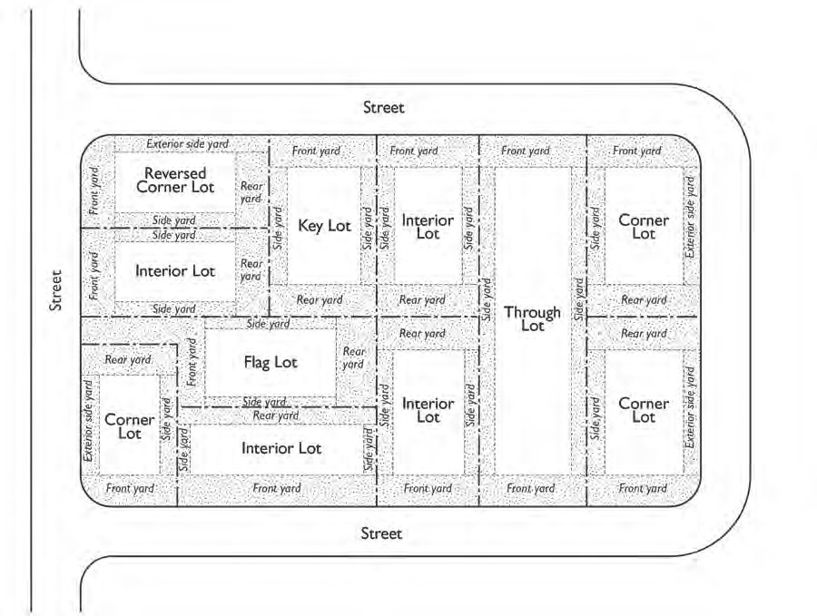
Lot Area. The area of a lot measured horizontally between bounding lot lines.
Lot Area, Net. The lot area minus any public rights-of-way, public easements, floodplains, environmentally sensitive areas, and areas with archaeological or cultural resources.
Lot Coverage. The portion of a lot that is covered by structures, including principal and accessory buildings, garages, carports, patios with covers that are 50 percent or less open to the sky, and roofed porches, but not including unenclosed and unroofed decks, landings, or balconies.
Lot Line. The boundary between a lot and other property or the public right-of-way.
Lot Line Adjustment. A shift or rotation of an existing lot line of four or fewer existing, adjoining parcels, where the land is taken from one parcel and added to an adjoining parcel, and where a greater number of parcels than originally existed is not created.
Lot Line Types.
Front Lot Line. (Synonym: Front Design Site Line) On an interior lot, that portion abutting a public or private street. On a flag or panhandle lot, the interior lot line most parallel to and nearest the street or lane from which access is obtained.
Front Lot Line, Corner Lot. (Synonym: Front Site Line, Corner Lot) The narrowest lot line abutting a public or private street or lane.
Interior Lot Line. (Synonym: Interior Design Site Line) Any lot line that is not adjacent to a street.
Rear Lot Line. (Synonym: Rear Design Site Line) The lot line that is opposite and most distant from the front lot line. Where no lot line is within 45 degrees of being parallel to the front lot line, a line 10 feet in length within the lot, parallel to and at the maximum possible distance from the front lot line, will be deemed the rear lot line for the purpose of establishing the minimum rear yard.
Side Lot Line. Any lot line that is not a front or rear lot line.
Street Side Lot Line. A side lot line of a corner lot that is adjacent to a street.
Maintenance and Repair. The repair or replacement of nonbearing walls, fixtures, wiring, roof, or plumbing that restores the character, scope, size, or design of a structure to its previously existing, authorized, and undamaged condition.
Maintenance and Repair Service. Establishments engaged in the maintenance or repair of office machines, household appliances, furniture, and similar items. This classification excludes maintenance and repair of motor vehicles or boats (see Automotive/Vehicle Sales and Services) and personal apparel (see Personal Services).
Major Subdivision. A subdivision of five or more parcels, five or more condominiums as defined in Section 783 of the State Civil Code, or a community apartment project containing five or more parcels. Also, the conversion of a dwelling to a stock cooperative containing five or more dwelling units.
Major Transit Stop. A site containing an existing rail transit station, a ferry terminal served by either a bus or rail transit service, or the intersection of two or more major bus routes with a frequency of service interval of 15 minutes or less during the morning and afternoon peak commute periods.
Mansard. A wall which has a slope equal to or greater than two vertical feet for each horizontal foot and has been designed to look like a roof.
Marijuana-Related Terms.
Attending Physician. An individual who possesses a license in good standing to practice medicine or osteopathy issued by the Medical Board of California or the Osteopathic Medical Board of California and who has taken responsibility for an aspect of the medical care, treatment, diagnosis, counseling, or referral of a patient and who has conducted a medical examination of that patient before recording in the patient's medical record the physician's assessment of whether the patient has a serious medical condition and whether the medical use of cannabis is appropriate.
Bureau of Medical Marijuana Regulations. The bureau with the California Department of Consumer Affairs created to develop, administer and enforce comprehensive rules for the marijuana industry in California, from licensing marijuana growers to crafting environmental protections.
Cannabis. See Marijuana.
Collective. See Dispensary.
Commercial Cannabis Activity. Includes cultivation, possession, manufacture, processing, storing, laboratory testing, labeling, transporting, distribution, delivery, or sale of medical cannabis or a medical cannabis product, except as set forth in Section 19319 of the Business and Professions Code, related to qualifying patients and primary caregivers.
Cultivation. Any activity involving the planting, growing, harvesting, drying, curing, grading, or trimming of medical cannabis.
Delivery. The commercial transfer of medical marijuana or medical marijuana products from a dispensary, up to an amount determined by the Bureau to a primary caregiver or qualified patient as defined in Section 11362.7 of the California Health and Safety Code. Delivery also includes the use by a dispensary or any technology platform owned by and controlled by a dispensary or independently licensed under State law whereby qualified patients or primary caregivers arrange for or facilitate the commercial transfer by a licensed dispensary of medical cannabis or medical cannabis products.
Dispensary. A premises where medical cannabis, medical cannabis products, edible cannabis products, or devices for the use of medical cannabis or medical cannabis products are offered, either individually or in any combination, for retail sale, including an establishment that delivers, pursuant to Section 19340 of the California Business and Professions Code, medical cannabis and medical cannabis products as part of a retail sale.
Distributor. A person licensed by the City to engage in the business of purchasing medical cannabis from a licensed cultivator, or medical cannabis products from a licensed manufacturer, for sale to a licensed dispensary.
Edible Marijuana Product. Manufactured cannabis that is intended to be used, in whole or in part, for human consumption, including, but not limited to, chewing gum, but excluding products set forth in Division 15 (commencing with Section 32501) of the California Food and Agricultural Code.
Management Member. A person with responsibility for the establishment, organization, registration, supervision, or oversight of the operation of a medical marijuana business, including but not limited to persons who perform the functions of president, vice president, director, operating officer, financial officer, secretary, treasurer, or manager of the business. Any person or entity having a financial interest in the medical marijuana business.
Manufacturer. A person that conducts the production, preparation, propagation, or compounding of manufactured medical cannabis, or medical cannabis products either directly or indirectly or by extraction methods, or independently by means of chemical synthesis at a fixed location that packages or repackages medical cannabis or medical cannabis products or labels or relabels its container.
Marijuana. All parts of the plant Cannabis sativa Linnaeus, Cannabis indica, or Cannabis ruderalis, whether growing or not; the seeds thereof; the crude or purified resin extracted from any part of the plant; and every compound, manufacture, salt, derivative, mixture, or preparation of the plant, its seeds or resin. It does not include the mature stalks of the plant, fiber produced from the stalks, oil or cake made from the seeds of the plant, any other compound, manufacture, salt, derivative, mixture, or preparation of the mature stalks (except the resin extracted therefrom), fiber, oil, or cake, or the sterilized seed of the plant which is incapable of germination. See also "marijuana."
Marijuana Cultivation Facility. Any building in which medical cannabis is planted, grown, harvested, dried, cured, graded, or trimmed, or that does all or any combination of these activities using artificial lighting in whole or in part.
Marijuana Product Manufacturer. A manufacturer of a medical marijuana product.
Medical Marijuana. A product containing cannabis, including, but not limited to, concentrates and extractions, intended to be sold for use by medical cannabis patients in California pursuant to the Compassionate Use Act of 1996 (Proposition 215), found at Section 11362.5 of the California Health and Safety Code. For the purposes of these zoning regulations, "medical cannabis" does not include "industrial hemp" as defined by Section 81000 of the California Food and Agricultural Code or Section 11018.5 of the California Health and Safety Code.
Medical Marijuana Business. Establishments, properties, parcels, and/or structures involved in any commercial cannabis activity.
Medical Marijuana Regulation and Safety Act(MMRSA). Article 6 (commencing with Section 19331) Chapter 3.5 of Division 8 of the California Business and Professions Code, as amended.
Person. An individual, firm, partnership, joint venture, association, corporation, limited liability company, estate, trust, business trust, receiver, syndicate, or any other group or combination acting as a unit and includes the plural as well as the singular number.
Primary Caregiver. The individual, designated by a qualified patient or by a person with an identification card issued pursuant to California Health and Safety Code Section 11362.7, who has consistently assumed responsibility for the housing, health, or safety of that patient or person. The primary caregiver may be a licensed clinic, residential care facility, hospice, or home health agency.
Qualified Patient. A person who is entitled to the protections of California Health and Safety Code Section 11362.5 for patients who obtain and use cannabis for medical purposes upon the recommendation of an attending physician, whether or not that person applied for and received a valid identification card issued pursuant to State Law.
Testing Laboratory. The premises where tests are performed on medical cannabis or medical cannabis products and that holds a valid certificate of accreditation.
Transporter. A person who holds a license by the Bureau to transport medical cannabis or medical cannabis products in an amount above a threshold determined by the Bureau between licensees that have been issued a license pursuant to the MMRSA.
Marinas. Facilities for the docking of boats and related accessory uses, including boat rentals, boat repairs, boat fueling facilities, retail sales and rentals of marine supplies and equipment, and a harbor masters office.
Master Fee Schedule. The schedule of fees and service charges established by the City manager pursuant to Section 2.34.040 to recover a portion or all of the costs reasonably necessary to provide the listed regulation, products or services.
Media Production.Facilities for motion picture, television, video, sound, computer, and other communications media production.
Merger. The joining of two or more contiguous parcels of land under one ownership and into one parcel.
Mezzanine. An intermediate floor within a building interior without complete enclosing interior walls or partitions that is not separated from the floor or level below by a wall, and has a floor area that is no greater than one third of the total floor area of the floor below.
Mixed-Use Building. A building with multiple uses, such as retail, office, and residential.
Mixed-Use Development. A development that combines both residential and non-residential uses on the same lot.
Mobile Vending Unit. A vehicle (e.g., truck, trailer, wagon) or structure not permanently fixed to a permanent foundation that may be moved under its own power, moved by hand, towed by a motor vehicle or carried upon or in a motor vehicle or trailer. A mobile vending unit does not include news racks or vending machines but does include mobile vending food preparation units and vehicles, such as "taco trucks".
Monument Works. An establishment that makes gravestones, headstones, tomb monuments, obelisks, statuary, or other markers to commemorate an individual or event, typically for use in cemeteries and public places.
Multi-Use Path. A completely separated right-of-way for exclusive non-motorized use with cross flow minimized to the extent possible.
Multiple-Unit Dwelling. Three or more dwelling units within a single building or within two or more buildings on a site or parcel. Types of multiple-unit dwellings include garden apartments, senior housing developments, and multi-story apartment buildings. This classification includes transitional housing in a multiple-unit format and Single-Room Occupancy (SRO) housing units that may have kitchen and/or bathroom facilities and are guest rooms or efficiency apartments as defined by the State Health and Safety Code. The classification is distinguished from Group Residential.
Municipal Code. The City of Richmond Municipal Code.
Neighborhood Council. A neighborhood organization identified by the City Council, which represents the interests of local residents.
Noise-Related Terms.
Ambient Noise Level. The all-encompassing noise level associated with a given environment, being a composite of sounds from all sources, excluding the alleged offensive noise, at the location and approximate time at which a comparison with the alleged offensive noise is to be made.
Cumulative Period. An additive period of time composed of individual time segments which may be continuous or interrupted.
Decibel (dB). A unit of noise measurement indicating the loudness of sound, based on logarithmic (base 10) scale.
Noise Level. The "A" weighted sound pressure level in decibels obtained by using a sound level meter. The "A" weighted discriminates against the lower and higher frequencies according to a relationship with the sensitivity of the human ear. The unit of measurement is designated as dB(A).
Nonconforming Lot. A legally created parcel of land having less area, frontage, or dimensions than the zoning regulations require for the zoning district in which it is located.
Nonconforming Structure. A nonconforming structure is a structure that complied with zoning and development regulations at the time it was built but which, because of subsequent changes to the Zoning Regulations, no longer conforms to the specific regulations applicable to the zoning district where the structure is located.
Nonconforming Use. The use of a building, structure, or site, or portion thereof, that was lawfully established and maintained, but, because of subsequent changes in the Zoning Regulations, no longer conforms to the specific regulations applicable to the zoning district where the use is located.
Nursery and Garden Center. Establishments primarily engaged in retailing nursery and garden products—such as trees, shrubs, plants, seeds, bulbs, and sod—that are predominantly grown elsewhere. Fertilizer and soil products are stored and sold in packaged form only.
NPDES. The National Pollutant Discharge Elimination System created by the 1972 Federal Clean Water Act.
Off-Site Use. An activity or accessory use that is related to a specific primary use, but is not located on the same lot as the primary use.
Offices. Offices of firms, organizations, or public agencies providing professional, executive, management, administrative or design services, such as accounting, architectural, computer software design, engineering, graphic design, interior design, investment, insurance, and legal offices, excluding banks and savings and loan associations with retail banking services (see Banks and Financial Institutions). This classification also includes offices where medical and dental services are provided by physicians, dentists, chiropractors, acupuncturists, optometrists, and similar medical professionals, including medical/dental laboratories within medical office buildings, but excludes clinics or independent research laboratory facilities (see Research and Development) and hospitals.
Medical and Dental. Offices providing consultation, diagnosis, therapeutic, preventive, or corrective personal-treatment services by doctors and dentists; medical and dental laboratories that see patients; and similar practitioners of medical and healing arts for humans licensed for such practice by the State of California. Incidental medical and/or dental research within the office is considered part of the office use.
Walk-In Clientele. Offices providing direct services to patrons or clients without prior appointments. This use classification includes employment agencies, insurance agent offices, real estate offices, travel agencies, utility company offices, and offices for elected officials. It does not include banks or check-cashing facilities, which are separately classified and regulated (see Banks and Financial Institutions).
On-Site Use. An activity or accessory use that is related to a specific primary use which is located on the same lot as the primary use.
Open Space Types.
Open Space, Common. Areas for outdoor living and recreation that are intended for the use of residents and guests of more than one dwelling unit. Common areas typically consist of landscaped areas, walks, patios, swimming pools, playgrounds, turf, or other such improvements as are appropriate to enhance the outdoor environment of the development.
Open Space, Private. Open areas for outdoor living and recreation that are adjacent and directly accessible to a single dwelling unit, reserved for the exclusive use of residents of the dwelling unit and their guests. Private areas typically consist of courtyards, balconies, decks, patios, fenced yards, and other similar areas.
Open Space, Useable. Outdoor areas that provide for outdoor living and/or recreation for the use of residents.
Opposite. Across from or across the street from.
Ordinary Maintenance. Repair and maintenance activities that are periodic and that do not involve a change to the architectural or historic value, style or general design of the building, structure, or object. In-kind replacement or repair is included in this definition of ordinary maintenance.
Outdoor Agriculture. Outdoor areas used for the cultivation of plants, excluding marijuana. This use type includes the accessory sale of goods produced on-site, but excludes marijuana cultivation.
Outdoor Vendor. A person who sells or displays for sale any type of goods or services on private property, but not within a structure constructed on a permanent foundation. Persons engaged in a business conducted from a structure constructed on a permanent foundation that involves outdoor display, sale, or storage of the same type of goods sold as part of the primary business activity on those premises shall not be considered outdoor vendors.
Overlay District. A zoning designation specifically delineated on the Zoning Map establishing land use requirements that govern in addition to the standards set forth in the underlying base district.
Owner. A person or persons holding single or unified beneficial title to the property, including but not limited to the settlor of a grantor trust, a general partner, firm or corporation.
Parapet Wall. That part of a wall that extends above the roof line.
Parcel. A legally subdivided plot of land shown on a map of record. Also referred to as "lot."
Parcel Map. A map showing a division of land of four or fewer parcels as required by this Ordinance, prepared in accordance with the provisions of this Ordinance and the Subdivision Map Act.
Park and Recreation Facility. Parks, playgrounds, recreation facilities, trails, wildlife preserves, and related open spaces, which are open to the general public. This classification also includes playing fields, courts, gymnasiums, swimming pools, picnic facilities, tennis courts, and golf courses, botanical gardens, as well as related food concessions or community centers within the facilities and restrooms within a primary structure or in an accessory structure on the same site.
Parking Area. An area of a lot, structure, or any other area, including driveways, which is designed for and the primary purpose of which is to provide for the temporary storage of operable motor vehicles.
Parking Facilities, Commercial. Surface lots and structures offering paring to the public for a fee when such use is not incidental to another activity. These facilities may be publicly or privately-owned.
Path. A way designed for use by pedestrians, animals, and bicyclists and that is not for use by motor vehicles.
Peak Hour. The hour when the greatest daily traffic volume occurs; this generally occurs during morning and afternoon commute times. Traffic counts are obtained during AM and PM peak periods, and the volume from the heaviest hour of AM or PM traffic is used to define the peak hour for those time periods.
Pedestrian Way. A right-of-way designed for use by pedestrians and bicyclists that is not designed for or used by automotive vehicles and is not located within a street right-of-way.
Permit. Any Zoning Clearance, conditional use permit, administrative use permit, temporary use permit, Building Permit, license, certificate, approval, or other entitlement for development and/or use of property as required by any public agency.
Permitted Use. Any use or structure that is allowed in a zoning district without a requirement for approval of a use permit, but subject to any restrictions applicable to that zoning district.
Person. Any individual, firm, association, organization, partnership, business trust, company, or corporation.
Personal Services.
General Personal Services. Provision of recurrently needed services of a personal nature. This classification includes barber shops and beauty salons, seamstresses, tailors, dry cleaning agents (excluding large-scale bulk cleaning plants), shoe repair shops, self-service laundries, video rental stores, photocopying and photo finishing services, and travel agencies mainly intended for the consumer. It does not include gyms, exercise clubs, or studios offering performing arts, martial arts, physical exercise, or yoga training and similar types of instruction.
Massage Establishment. Any establishment having a fixed place of business where any individual, firm, association, partnership, corporation, joint venture or combination of individuals conducts, carries on or permits to be engaged in, conducted or carried on, for consideration or compensation, massages, baths or health treatments involving therapeutic massages or baths as regular functions. Exempted from this definition are massage therapists operating in conjunction with and on the same premises as a physician, surgeon, chiropractor, osteopath, nurse or any physical therapist (State-licensed professions or vocations) who are duly State-licensed to practice their respective professions in the State of California.
Health/Fitness Facility. A fitness center, gym, exercise club, health and athletic club, or studio offering martial arts, physical exercise, yoga training and similar types of instruction to classes and groups of more than five persons. The facility may include exercise machines, weight training equipment, group exercise rooms, sauna, spa or hot tub facilities, indoor tennis, handball, racquetball, and other indoor sports activities, indoor or outdoor pools.
Tattoo or Body Modification Parlor. An establishment whose principal business activity is one or more of the following: 1) using ink or other substances that result in the permanent coloration of the skin through the use of needles or other instruments designed to contact or puncture the skin; or 2) piercing of the body of a person for the purpose of inserting jewelry or other decoration.
Persons with Disabilities. Persons who have a medical, physical, or mental condition, disorder or disability as defined in Government Code Section 12926 or the Americans With Disabilities Act, that limits one or more major life activities.
Petroleum Refining. An industrial use facility that refines crude oil into petroleum products, such as diesel, gasoline and heating oils. This uses includes the accessory facilities need for management, testing, transport and storage Petroleum refineries (oil refineries) essentially serve as the second stage in the production process following the actual extraction by oil rigs.
Planned Development. A development that has common areas owned by an association or owners and has the power to enforce obligations of owners by imposing assessments as more particularly defined in Civil Code Section 4175.
Planned Residential Group. Two or more grouped dwellings that may deviate from standard area, yard, height, parking or fencing requirements whose design and site layout have been approved through a conditional use permit process by the Planning Commission under pursuant to the Zoning Ordinance.
Planning Division. The Planning Division of the Planning and Building Services Department of the City of Richmond.
Planting Strip. The area between the curb, or in the case where there is no curb the edge of the roadway, and the abutting property line, that is not improved by surfacing intended for the use of pedestrians, is designed to separate the sidewalk from the roadway or to prevent access to abutting properties, and is intended to be planted with trees or otherwise landscaped. Grates or other coverings of said areas shall not be considered as surfacing intended for the use of pedestrians.
Pre-existing. In existence before the effective date of the ordinance updating Article XV.
Principal Structure. A structure in which the principal use of its lot is conducted. In any residential or agricultural zoning district, a dwelling is deemed to be the principal structure on the lot on which it is situated.
Printing and Publishing. An establishment engaged in printing by letterpress, lithography, gravure, screen, offset, or electrostatic (xerographic) copying; and other establishments serving the printing trade such as bookbinding, typesetting, engraving, photoengraving and electrotyping. This use also includes establishments that publish newspapers, books and periodicals; establishments manufacturing business forms and binding devices. Quick printing services are included in the Business Services use type.
Project. Any proposal for a new or changed use or for new construction, alteration, or enlargement of any structure, that is subject to the provisions of this ordinance. This term includes, but is not limited to, any action that qualifies as a "project" as defined by the California Environmental Quality Act.
Property Line. The recorded boundary of a lot or parcel of land.
Public Resources Code. The Public Resources Code of the State of California.
Public Safety Facility. Facilities providing public-safety and emergency services, including police and fire protection and emergency medical services, with incidental storage, training and maintenance facilities.
Qualified Applicant. The property owner, the owner's agent, or any person, corporation, partnership or other legal entity that has a legal or equitable title to land that is the subject of a development proposal or is the holder of an option or contract to purchase such land or otherwise has an enforceable proprietary interest in such land.
Reasonable Accommodation. Any deviation requested and/or granted from the strict application of the City's zoning and land use laws, rules, policies, practices and/or procedures under provisions of federal or California law to make housing or other facilities readily accessible to and usable by persons with disabilities and thus enjoy equal employment or housing opportunities or other benefits guaranteed by law.
Research and Development. The research and development use type refers to establishments primarily engaged in the research, development, and controlled production of high-technology electronic, industrial or scientific products or commodities for sale, but excludes uses which in the opinion of the planning commission, may be objectionable by reason of production of offensive odor, dust, noise, bright lights, vibration or the storage of hazardous material or products, or uses which in the opinion of the commission threaten public safety. Typical uses include biotechnology firms.
Residential Facility. Facilities that provide permanent living accommodations and 24-hour primarily non-medical care and supervision for persons in need of personal services, supervision, protection, or assistance for sustaining the activities of daily living. Living accommodations are shared living quarters with or without separate kitchen or bathroom facilities for each room or unit. This classification includes facilities that are operated for profit as well as those operated by public or not-for-profit institutions, including group homes for minors, persons with disabilities, people in recovery from alcohol or drug additions, and hospice facilities.
Residential Care, General. A Residential Facility licensed by the State of California and providing care for more than six persons.
Residential Care, Limited. A Residential Facility licensed by the State of California providing care for six or fewer persons.
Residential Care, Senior. A housing arrangement chosen voluntarily by the resident, the resident's guardian, conservator or other responsible person, where residents are 60 years of age or older and where varying levels of care and supervision are provided as agreed to at the time of admission or as determined necessary at subsequent times of reappraisal. This classification includes continuing care retirement communities and life care communities licensed for residential care by the State of California.
Hospice, General. A facility that provides residential living quarters for more than six terminally ill persons.
Hospice, Limited. A facility that provides residential living quarters for up to six terminally ill persons.
Retail Sales.
Building Materials and Services. Retail sales or rental of building supplies or equipment. This classification includes lumberyards, tool and equipment sales or rental establishments, and includes establishments devoted principally to taxable retail sales to individuals for their own use. This definition does not include Construction and Material Yards, hardware stores less than 10,000 square feet or establishments engaged in the business of selling, leasing, or otherwise transferring any firearm or ammunitions.
General Retail Sales, Small-Scale. The retail sale or rental of merchandise not specifically listed under another use classification. This classification includes retail establishments with 25,000 square feet or less of sales area; including department stores, clothing stores, furniture stores, pet supply stores, small hardware and garden supply/nurseries stores (with 10,000 square feet or less of floor area), and businesses retailing goods including, but not limited to, the following: toys, hobby materials, handcrafted items, jewelry, cameras, photographic supplies and services (including portraiture and retail photo processing), medical supplies and equipment, pharmacies, electronic equipment, sporting goods, kitchen utensils, hardware, appliances, antiques, art galleries, art supplies and services, paint and wallpaper, carpeting and floor covering, office supplies, bicycles, video rental, and new automotive parts and accessories (excluding vehicle service and installation). Retail sales may be combined with other services such as office machine, computer, electronics, and similar small-item repairs.
General Retail Sales, Large-Scale. Retail establishments with over 25,000 square feet of sales area that sell merchandise and bulk goods for individual consumption, including membership warehouse clubs, where sales of grocery items do not occupy more than 25 percent of the floor area.
Pawn Shop; Secondhand Store. Establishments engaged in the buying, selling, trading, accepting for consignment, accepting for auctioning, or auctioning of new or secondhand merchandise and offering loans in exchange for personal property. This classification includes stores that buy and sell second hand articles, as defined and regulated in Chapter 7.60 of the Municipal Code, but excludes close-out sales as defined and regulated by Chapter 7.34 of the Municipal Code. It also does not include any business owned and operated by a charitable, nonprofit entity.
With Drive-Through. A retail establishment with drive-through facilities
Reversion to Acreage Map. A map filed for the purpose of reverting to acreage land previously placed on record with the County Recorder by means of a subdivision or parcel map.
Right-of-Way. A strip of land acquired by reservation, dedication, prescription, or condemnation, and intended to be occupied or occupied by a road, railroad, electric transmission lines, oil or gas pipeline, water line, sanitary storm sewer, or other similar use.
Salvage and Wrecking. Storage, dismantling and recycling of vehicles, equipment, metals, tires, or other used materials for sale as parts or raw materials, including but not limited to, the collection, storage, exchange or sale of goods, used building materials, used containers or drums, and similar articles or property.
Sanitary Waste and Recycling Facilities. Collection or processing of waste or recyclable materials or items.
Recycling Collection Facilities. A drop-off/collection and sorting point for recyclable materials such as paper, metal, plastic, and glass.
Recycling Processing Facilities. An industrial facility where recycled materials are processed into new materials or products, which may include composting of garden waste or similar green materials. Conversion technology facilities (e.g., waste/biomass to energy) are classified as Major Utilities.
Waste Hauling and Transfer Facilities. Facilities operated by private companies doing waste hauling and transfer, including storing, sorting and/or processing of solid and liquid waste and recyclable materials.
School. Facilities for primary or secondary education, including public schools, charter schools, and private and parochial schools.
Screening. Screening refers to a wall, fence, hedge, informal planting, or berm, provided for the purpose of buffering a building or activity from neighboring areas or from the street.
Seaport. Facilities for freight service and operations by ship. This classification includes piers, marine terminals, container and break-bulk storage areas, related inter-modal facilities, and support services such as port and harbor operations and navigational services.
Setback. The area between a property line and a building, structure, or parking area that must be kept clear or open.
Front Setback. An area extending across the full width of the lot or design site between the front design site line and the primary structure or parking area.
Side Setback. An area between a side lot line or design site line and the primary structure or a parking area, extending between the front and rear setback.
Side Street Setback. On corner lots, the area between a lot line adjacent to a side street or a design site line adjacent to a side street and the principal structure or a parking area, extending between the front and rear setback.
Rear Setback. An area extending the full width of the lot or design site between a rear design site line and the primary structure or a parking area.
Shoreline. In open water areas, the shoreline is the mean high tide line (often called the mean high water line), and in marshes, the shoreline is the higher of the mean high tide line or a line five feet above mean sea level.
Sidewalk. A paved, surfaced, or leveled area, paralleling and usually separated from the street, used as a pedestrian walkway.
Sight Distance Triangle. A minimum area of unobstructed view that occurs at street intersections.
Sight Triangle. The area enclosed by a triangle formed by the intersecting property lines of a corner lot at a street intersection for a distance of 25 feet or by an alley intersecting a street for a distance of 15 feet that defines a driver's view of approaching, merging or intersecting traffic.
Single Unit Dwelling, Attached. A dwelling unit that is designed for occupancy by one household located on a single parcel that does not contain any other unit (except a second dwelling unit, where permitted), and is attached through common vertical walls to one or more dwellings on abutting parcel. An attached single-unit dwelling is sometimes called a "townhouse" or "zero-parcel line" development.
Single Unit Dwelling, Detached. A dwelling unit that is designed for occupancy by one household, located on a single parcel that does not contain any other dwelling unit (except a second dwelling unit, where permitted), and not attached to another dwelling unit on an abutting parcel. This classification includes individual manufactured housing units installed on a foundation system pursuant to Section 18551 of the California Health and Safety Code.
Site. A lot, or group of contiguous lots, that is proposed for development and is in a single ownership or under unified control.
Social Service Center. Facilities providing a variety of supportive services for disabled and homeless individuals and other targeted groups on a less-than-24-hour basis. Examples of services provided are counseling, meal programs, personal storage lockers, showers, instructional programs, television rooms, and meeting spaces. This classification is distinguished from licensed day care centers (see Day Care Center), clinics (see Clinic), and emergency shelters providing 24-hour or overnight care (see Emergency Shelter).
Solar Reflective Index. A measure of a surface's ability to reflect solar heat, combining reflectance and emittance into one number. It is defined so that a standard black (reflectance 0.05, emittance 0.90) is zero and a standard white (reflectance 0.80, emittance 0.90) is one hundred.
Specific Plan. A plan for all or part of the area covered by the General Plan that is prepared to be consistent with and to implement the General Plan pursuant to the provisions of Government Code, Section 65450 et seq.
Story. That portion of a building included between the upper surface of any floor and the upper surface of the floor next above, except that the topmost story is that portion of a building included between the upper surface of the topmost floor and the upper surface of the roof above.
Street. A public or private thoroughfare, which affords the principal means of access to a block and to abutting property. "Street" includes avenue, court, circle, crescent, place, way, drive, boulevard, highway, road, and any other thoroughfare, except an alley or walkway.
Street Line. The boundary between a street and a lot or parcel of land.
Structural Alterations. Any physical change to or the removal of the supporting members of a structure or building, such as bearing walls, columns, beams, or girders, including the creation, enlargement, or removal of doors or windows and changes to a roofline or roof shape.
Structure. Anything constructed or erected, the use of which requires location on the ground or attachment to something having location on the ground.
Structure, Accessory. A detached subordinate structure, used only as incidental to the main structure on the same lot.
Structure, Primary (Structure, Main). A structure housing the principal use of a site or functioning as the principal use.
Structure, Temporary. A structure without any foundation or footings, and which is intended to be removed when the designated time period, activity, or use for which the temporary structure was erected has ceased.
Subdivider. A person, firm, corporation, partnership or association who proposes to divide, divides, or causes to be divided real property into a subdivision for himself or herself or for others, except that employees and consultants of such persons or entities, acting in such capacity, are not "subdividers."
Subdivision. The division by any subdivider of any unit or units of improved or unimproved land, or any portion thereof, shown on the latest equalized county assessment roll as a unit or contiguous units, for the purpose of sale, lease or financing, whether immediate or future, except for leases of agricultural land for agricultural purposes. Property shall be considered as contiguous units, even if it is separated by roads, streets, utility easement, or railroad rights-of-way. Subdivision includes a condominium project, as defined in Section 4125 of the Civil Code, a community apartment project, as defined in Section 4105 of the Civil Code, or the conversion of five or more existing dwelling units to a stock cooperative, as defined in of Section 4190 or 6566 of the Civil Code.
Subdivision Map Act. Title 7, Division 2 of the Government Code of the State of California, as amended.
Supportive Housing. Dwelling units with no limit on length of stay that are occupied by the target population as defined in subdivision (d) of Section 53260 of the California Health and Safety Code or individuals eligible for services provided pursuant to the Lanterman Development Disabilities Act (Division 45 of the Welfare and Institutions Code), and that are linked to onsite or offsite services that assist supportive housing residents in retaining the housing, improving their health status, and maximizing their ability to live and, where possible, work in the community and where no onsite medical care is provided. Supportive housing as defined by Subdivision (b) of Section 50675.14 may be provided in a multiple-unit structure or group residential facility. Facilities may operate as licensed or unlicensed facilities subject to applicable State requirements.
Swimming Pool. A pool, pond, lake, or open tank capable of containing water to a depth greater than 1.5 feet at any point.
TDM. Transportation Demand Management.
Tenant. A person renting or leasing a housing unit or non-residential space.
Tentative Map. A map made for the purpose of showing the design and improvement of a proposed subdivision and the existing conditions in and around it, which need not be based upon an accurate or detailed final survey of the property.
Tentative Parcel Map. A map made for the purpose of showing the design and improvements of a proposed division of land into four or fewer parcels and the existing conditions in and around it.
TMA. Transportation Management Association.
Transient Lodging. Transient lodging refers to establishments primarily engaged in the provision of lodging services with incidental food, drink and other sales and services intended for the convenience of guests. Lodging services involve the provision of room and/or board. Typical uses include hotels and motels.
Bed and Breakfast. A residential structure that is in residential use by the property owner or manager and within which up to four bedrooms are rented for overnight lodging and where meals may be provided.
Hotel and Motel. An establishment providing temporary lodging to transient patrons. These establishments may provide additional services, such as conference and meeting rooms, restaurants, bars, or recreation facilities available to guests or to the general public. This use classification includes motor lodges, motels, apartment hotels, extended stay hotels, hostels and tourist courts, but does not include rooming houses, boarding houses, or private residential clubs, single-room occupancy housing, or bed and breakfast establishments within a single-unit residence.
Transitional Housing. Dwelling units configured as rental housing but operated under program requirements that require the termination of assistance and recirculating of the assisted unit to another eligible program recipient at a predetermined future point in time, that shall be not less than six months from the beginning of assistance. Transitional housing may be designated for homeless or recently homeless individuals or families transitioning to permanent housing as defined in subdivision (h) of Section 50675.2 of the California Health and Safety Code. Facilities may be linked to onsite or offsite supportive services designed to help residents gain skills needed to live independently. Transitional housing may be provided in a variety of rental housing types (e.g., multiple-unit dwelling, single-room occupancy, group residential, single unit dwelling). This classification includes domestic violence shelters.
Transportation Passenger Terminals. Facilities for passenger transportation operations. This classification includes rail stations, bus terminals, ferry terminals, and scenic and sightseeing facilities.
Urban Agriculture. The growing of crops, plants (excluding marijuana), and fruits; beekeeping; and raising of animals within an urban context.
Use. The purpose for which land or the premises of a building, structure, or facility thereon is designed, arranged, or intended, or for which it is or may be occupied or maintained.
Accessory Use. A use that is customarily associated with, and is incidental and subordinate to, the primary use and located on the same lot as the primary use and occupies no more than 30 percent of the gross floor area.
Incidental Use. A secondary use of a lot and/or building that is located on the same lot but is not customarily associated with the primary use.
Primary Use. A primary, principal or dominant use established, or proposed to be established, on a lot and occupies at least 70 percent of the gross floor area of the tenant space or building.
Use Classification. A system of classifying uses into a limited number of use types on the basis of common functional, product, or compatibility characteristics. All use types are grouped into the following categories: residential, retail, commercial and office; institutional and community facilities, industrial, and transportation, communication, and utilities.
Use Permit. A discretionary permit, such as an administrative use permit or a conditional use permit, that provide for the accommodation of land uses with special site or design requirements, operating characteristics, or potential adverse effects on surroundings, that are not permitted as of right but may be approved upon completion of a review process and, where necessary, the imposition of conditions of approval.
Use Type. A category that classifies similar uses based on common functional, product, or compatibility characteristics.
Utilities. Equipment and associated features related to the mechanical functions of a building(s) and services such as water, electrical, telecommunications, and waste.
Utilities, Major. Generating plants, electric substations, and solid waste collection, including transfer stations and materials recovery facilities, solid waste treatment and disposal, water or wastewater treatment plants, biomass and waste to energy conversion facilities, and similar facilities of private companies, public agencies or public utilities.
Utilities, Minor. Facilities necessary to support established uses involving only minor structures, such as electrical distribution lines, and underground water and sewer lines.
Variance. A discretionary permit allowing a departure from specific provisions of a zoning ordinance such as setbacks, side yards, frontage requirements, and lot size, but not involving the actual use or structure, thus relieving a property owner from strict adherence to development standards when some special circumstances exist which deprive the property owner from developing the property in a manner enjoyed by similar properties.
Vehicle. Any vehicle, as vehicle is defined by the California Vehicle Code, including any automobile, camper, camp trailer, trailer, trailer coach, motorcycle, house car, boat, or similar conveyance.
Vesting Tentative Map. A tentative map for a residential subdivision that shall have printed conspicuously on its face the words "Vesting Tentative Map" at the time it is filed and is processed, in accordance with the provisions of this Ordinance for Vesting Tentative Maps.
Visible. Capable of being seen (whether or not legible) by a person of normal height and visual acuity walking or driving on a public road or in a public place.
Wall. Any vertical exterior surface of building or any part thereof, including windows.
Warehousing, Storage, and Distribution. Storage and distribution facilities without sales to the public on-site or direct public access except for public storage in small individual space exclusively and directly accessible to a specific tenant.
Chemical, Mineral, and Explosives Storage. Storage and handling of hazardous materials including but not limited to: bottled gas, chemicals, minerals and ores, petroleum or petroleum-based fuels, fireworks, and explosives. Notwithstanding the foregoing sentence, the storage and handling of coal and petroleum coke is prohibited in accordance with Article 15.04.615 to the Richmond Municipal Code, except as expressly provided therein.
Indoor Warehousing and Storage. Storage within an enclosed building of commercial goods prior to their distribution to wholesale and retail outlets and the storage of industrial equipment, products and materials. This classification also includes cold storage, draying or freight, moving and storage, and warehouses. It excludes the storage of hazardous chemical, mineral, and explosive materials.
Outdoor Storage. The keeping, in an unroofed area, of any goods, junk, material, merchandise, or vehicles in the same place for more than 24 hours, except for the keeping of building materials reasonably required for the completion of a project currently under construction.
Mini-Storage. A storage facility that is characterized by individual separate spaces which are accessible by customers for the storing and retrieval of personal effects and household goods. In no case shall storage spaces be used for manufacturing, retail or wholesale selling, office or other business services, or human habitation.
Wineries.
Winery, Large. An establishment that produces more than 10,000 cases of wine annually, comprising building or buildings used to convert fruit juices (all of part of which are produced on the property) to wine, and to age, bottle, store, distribute and sell said wine. A winery for the purposes of this section includes crushing, fermenting and refermenting, bottling, blending, bulk and bottle storage, aging, shipping, receiving, laboratory equipment and maintenance facilities, sales and administrative office functions. A winery may include on-sale and off-sale wine consumption pursuant to the California Department of Alcohol Beverage Control license for winegrowers.
Winery, Small. An establishment that produces less than 10,000 cases of wine annually, and may include on-sale and off-sale wine consumption pursuant to the California Department of Alcohol Beverage Control license for winegrowers.
Wireless Communications-Related Terms.
Accessory Equipment. Any equipment installed, mounted, operated or maintained in close proximity to a personal wireless telecommunication facility to provide power to the personal wireless telecommunication facility or to receive, transmit or store signals or information received by or sent from a personal wireless communication facility.
Antenna. Any system of poles, panels, rods, reflecting discs, wires or similar devices used for the transmission or reception of electromagnetic signals, including, but not limited to radio waves and microwaves. An antenna does not include the support structure the antenna(s) is mounted upon.
Antenna, Amateur Radio. An antenna operated by a federally licensed amateur radio operator.
Antenna, Ground-Mounted. An antenna that is not mounted on a pole, a structure, or the roof or wall of a building.
Antenna, Panel. An antenna shaped like a panel that is usually one-directional and is attached to a mounting bracket, which may then be affixed to a building or other structure such as a pole.
Antenna, Satellite Earth Station. An antenna designed and used to receive and/or transmit radio frequency signals directly to and/or from orbiting communications satellites.
Antenna Array. A group of antennas with dimensions, spacing, and illumination sequence arranged and interconnected so that the fields for the individual elements combine to produce a maximum intensity in a particular direction and minimum field intensities in other directions.
Antenna Structure. An antenna array and its associated support structure, such as a pole, mast, or tower, but not including a suspended wire antenna.
Antenna Structure, Freestanding. An antenna structure or mast that is not attached to any part of a building, fence, or other such structure. Freestanding antenna structures include communications towers, utility poles, and concrete and steel monopoles.
Approved Radio Frequency Expert. A person or firm specializing in radio frequency wireless telecommunications technology, including wireless site design.
Base Station. A structure or equipment at a fixed location that enables FCC-licensed or authorized wireless communications between user equipment and a communications network. A base station includes, without limitation:
1.
Equipment associated with wireless communications services such as private, broadcast, and public safety services, as well as unlicensed wireless services and fixed wireless services such as microwave backhaul.
2.
Radio transceivers, antennas, coaxial or fiber-optic cable, regular and backup power supplies, and comparable equipment.
3.
Any structure other than a tower that supports or houses communication equipment.
Camouflaged Facility. A wireless communications facility located and designed so as to be of minimal visibility, such as being incorporated within an architectural feature such as a steeple or parapet, or in the open but disguised as a tree or other natural feature so that the antenna and supporting antenna equipment are either not readily visible beyond the property on which they are located, or, if visible, appear to be part of the existing landscape or environment rather than identifiable as a wireless communication facility.
Co-Location. The mounting or installation of transmission equipment on an eligible support structure for the purpose of transmitting and/or receiving radio frequency signals for communications purposes, including the location of two or more wireless communications facilities on a single support structure or otherwise sharing a common location. Co-location also includes the location of wireless communications facilities with other facilities such as buildings, water tanks, light standards, and other utility facilities and structures.
Eligible Support Structure. Any tower or base station that it is existing at the time an application is filed with the City.
Equipment Shelter. A cabinet or structure designed to enclose equipment used in connection with a wireless communications facility.
Feasible. Feasible means in light of technical feasibility, radio signal transmitting and receiving requirements, aesthetics, electromagnetic fields, costs, landowner permission, facility owner permission, and all necessary approvals, as well as the common meaning of the term.
Mast. A pole of wood or metal or a tower fabricated of metal that is used to support an antenna and maintain it at the proper elevation.
Microcell Facility. A wireless communication facility serving a single carrier and consisting of a small antenna or a networked set of antennas connected with each other and to a wireless service source.
Monopole. An antenna structure, often tubular in shape, usually made of metal, reinforced concrete, or wood. A monopole may also be an alternative antenna structure designed to replicate a tree or other natural feature.
Readily Visible. An object that can be identified as a wireless telecommunications facility when viewed with the naked eye from a public right-of-way or neighboring property.
Radio Frequency. Electromagnetic emission in the frequency range of 300 kHz—300 gigahertz.
Related Equipment. All equipment ancillary to the transmission and reception of voice and data via radio frequencies. Such equipment may include, but is not limited to, cable, conduit, and connectors.
Satellite Dish. Any device incorporating a reflective surface that is solid, open or mesh or bar configured and is in the shape of a shallow dish, cone, horn cornucopia or flat plate used to receive or transmit radio or electromagnetic waves. This term includes satellite earth stations, satellite receivers, satellite discs, direct broadcast systems, television reception only systems and satellite microwave antennas.
Service Provider. Any authorized provider of wireless communications services.
Shot Clock. The time period in which the city must approve or deny a proposed wireless telecommunications facility.
Substantial Change. A modification that substantially changes the physical dimensions of an eligible support structure.
Tolling. Pausing the shot clock, or adding a time period that does not contribute to the finite shot clock.
Tower. Any structure that is designed or constructed primarily for the purpose of supporting one or more antennas. The term includes radio and television transmission towers, microwave towers, common-carrier towers, cellular telephone towers, alternative tower structures and the like.
Wireless Communications Facility. Personal wireless service facilities that transmit and/or receive electromagnetic signals for cellular radio telephone service, personal communications services, enhanced specialized mobile services, paging systems, and related technologies. Such facilities include antennas, microwave dishes, parabolic antennas, and equipment used in the transmission or reception of such signals; telecommunication towers; associated equipment cabinets; and accessory structures used for provision of personal wireless services.
Yard. An open space on a lot, other than a court on a lot, that is unoccupied and unobstructed from the ground upward.
Front Yard. A yard extending across the front of a lot for the full width of the lot between the side lot lines. The depth of a front yard is a distance specified for the zoning district in which it is located and measured inward from the front lot line.
Interior Side Yard. A yard extending along an interior side of a lot from the front yard line to the rear yard line, and to a depth specified for the zoning district in which it is located and measured inward from the interior side lot line.
Street Side Yard. A yard extending along the street side of a corner lot from the front yard line to the rear yard line, and to a depth specified for the zoning district in which it is located and measured inward from the street side lot line.
Rear Yard. A yard extending across the rear of a lot for its full width between side lot lines, and to a depth specified for the zoning district in which it is located. If a lot has no rear lot line, a line 10 feet in length within the lot, parallel to and at the maximum possible distance from the front lot line, will be deemed the rear lot line for the purpose of establishing the minimum rear yard.
Zoning Administrator. The Director of Planning and Building of the City of Richmond, or the person designated by him or her to be the Zoning Administrator.
Zoning Map. A map or maps that are a part of the zoning ordinance and delineate the boundaries of zoning district districts.
Zoning Ordinance; Zoning Regulations. The administrative regulations established under the authority of the Government Code that divide the city into districts and establish a set of standards governing the use, placement, spacing and size of land and buildings and related development controls to implement the General Plan.
(Ord. No. 30-18 N.S., § I(Exh. A), 12-18-2018; Ord. No. 01-19 N.S., § II(Exh. A), 1-15-2019; Ord. No. 05-20 N.S., § II(Exh. A), 2-4-2020; Ord. No. 24-20 N.S., § 1, 11-10-2020; Ord. No. 27-20 N.S., § 1, 11-10-2020; Ord. No. 04-23 N.S., § I(Exh. A), 4-18-2023)