
Richmond City Zoning Code
SERIES 200
BASE ZONING DISTRICT REGULATIONS2
Editor's note— Ord. No. 30-18 N.S., § I(Exh. A), adopted Dec. 18, 2018, changed the title of Series 200 from "Base District Regulations" to read as set out herein.
15.04.201.010 - Purpose.
The specific purposes of the Residential Districts are to:
A.
Preserve, protect, and enhance the character of the City's residential neighborhoods.
B.
Ensure adequate light, air, and open space for each dwelling.
C.
Ensure that the scale and design of new development and alterations to existing structures are compatible with surrounding homes and appropriate to the physical characteristics of the site and the area where the project is proposed.
D.
Promote opportunities for housing for all income groups and for those with special housing needs.
E.
Provide sites for public and semi-public land uses, such as day care centers, parks, community facilities, schools, and public safety facilities that will serve City residents.
The following districts implement General Plan classifications of "Hillside Residential", "Low Density Residential", and "Medium Density Residential".
RH Single Family Hillside Residential. This district is intended for residential development comprised of single-family housing on developable portions of hillside lots below the 400-foot elevation. Development in this district must address key environmental challenges and constraints, such as steep slopes and soil erosion, and standards will ensure that development is compatible with hillside conditions and a rural environment. Minimum lot size for this designation is 11,000 square feet, which may be reduced with clustered development.
RL1 Single Family Very Low Density Residential. This district is intended to create, preserve, and enhance areas for very low density single-family housing in outlying, undeveloped hillside areas. Standards will ensure that development is compatible with hillside conditions and promote clustered development to preserve open space. Minimum lot size for this designation is 6,000 square feet, which may be reduced with clustered development.
RL2 Single Family Low Density Residential. This district is intended for low density residential development with attached and detached single-family homes in level to moderately sloped areas. Dwelling types also may include small lot single unit development, duplexes, townhomes, cottages, bungalows, and second units. Density in this zoning district is a maximum of 15 dwelling units per acre. In addition to single-unit homes, this district provides for compatible, supportive uses, such as small family day care, park and recreation facilities, civic and institutional uses, including schools and places for community assembly that may be appropriate in a single-family residential neighborhood, and community gardens. Neighborhood mixed-use development is allowed at neighborhood nodes identified by the Planning Commission. Existing multi-family residential structures may remain and may be improved without increasing densities, or may revert to single-family residential uses.
RM-1 Medium Density Multi-Family Residential. This district is intended for single and multi-family housing types such as one to three-story garden apartments, historic bungalows and cottages on small lots, townhouses and stacked flats. A maximum density of 26 dwelling units per acre is permitted, and minimum density of 10 dwelling units per acre is required. In addition to residential uses, this district allows for a limited number of public and semi-public uses such as day care centers, public safety facilities, and residential care facilities that are appropriate in a medium density multi-family residential environment. Neighborhood mixed-use development is allowed at neighborhood nodes identified by the Planning Commission. Small lot single unit and bungalow court development is allowed in the RM-1 District where it would be compatible with the surrounding neighborhood.
RM-2 Medium-High Density Multi-Family Residential. This district is intended for multi-family housing types including apartments, condominiums, townhouses, and group housing. A maximum density of 40 dwelling units per acre is permitted, and a minimum density of 15 dwelling units per acre is required. In addition to residential uses, this district allows for compatible public and semi-public uses, including day care centers, public safety facilities, community assembly, residential care facilities, and transitional and supportive housing that are appropriate in a medium-high density residential environment. Neighborhood mixed-use development is allowed at neighborhood nodes identified by the Planning Commission.
(Ord. No. 30-18 N.S., § I(Exh. A), 12-18-2018)
15.04.201.020 - Land Use Regulations.
Table 15.04.201.020 prescribes the land use regulations for the Residential Districts. The regulations for each district are established by letter designations as follows:
"P" designates permitted uses.
"A" designates use classifications that are permitted after review and approval of an administrative use permit by the Zoning Administrator.
"C" designates use classifications that are permitted after review and approval of a conditional use permit by the Planning Commission.
"L#" designates numbered limitations listed at the end of the table.
"x" designates uses that are not permitted.
Use classifications are defined in Article 15.04.104 (Key Terms and Definitions). In cases where a specific land use or activity is not defined, the Zoning Administrator shall assign the land use or activity to a classification that is substantially similar in character. Use classifications and subclassifications not listed in the table or not found to be substantially similar to the uses below are prohibited. Section numbers in the right hand column refer to other sections of this article.
A.
Limitations on Commercial Development. Commercial-only development is not allowed. The area devoted to commercial uses cannot exceed 30 percent of the total building floor area.
(Ord. No. 30-18 N.S., § I(Exh. A), 12-18-2018; Ord. No. 25-20 N.S., § I(Exh. A), 11-10-2020; Ord. No. 27-20 N.S., § 2, 11-10-2020)
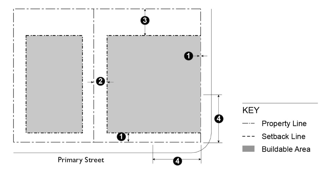
15.04.201.030 - Development Standards—RH, RL1 and RL2 Districts.
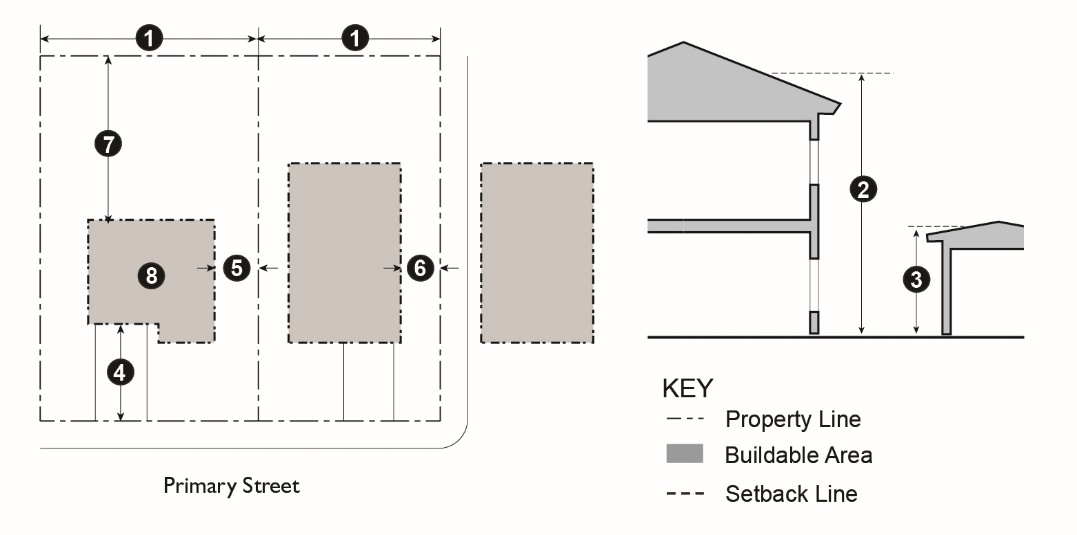
Table 15.04.201.030 prescribes the development standards for the RH, RL1 and RL2 districts. Additional regulations are denoted in a right hand column. Section numbers in this column refer to other sections of this article, while individual letters refer to subsections that directly follow the table. The numbers in each illustration below refer to corresponding regulations in the "#" column in the associated table.
TABLE 15.04.201.030: DEVELOPMENT STANDARDS—RH, RL1 AND RL2 DISTRICTS
Additional Development Standards for RH and RL Districts
A.
Accessory Building Height. The 14-foot height limit applies to accessory buildings or structures, except that the height may be increased to 16 feet for an accessory dwelling unit.
B.
Ground Floor Front Setback. Where the adjoining lots on the same block face have been improved with buildings, the minimum ground floor front setback requirement shall be the average of the actual front setback of these abutting improved lots on such block face or 20 feet, whichever is less. When the lot slope is 20 percent or more, the front setback may be reduced to 10 feet provided the garage door is setback 18 feet from the edge of the pavement.
C.
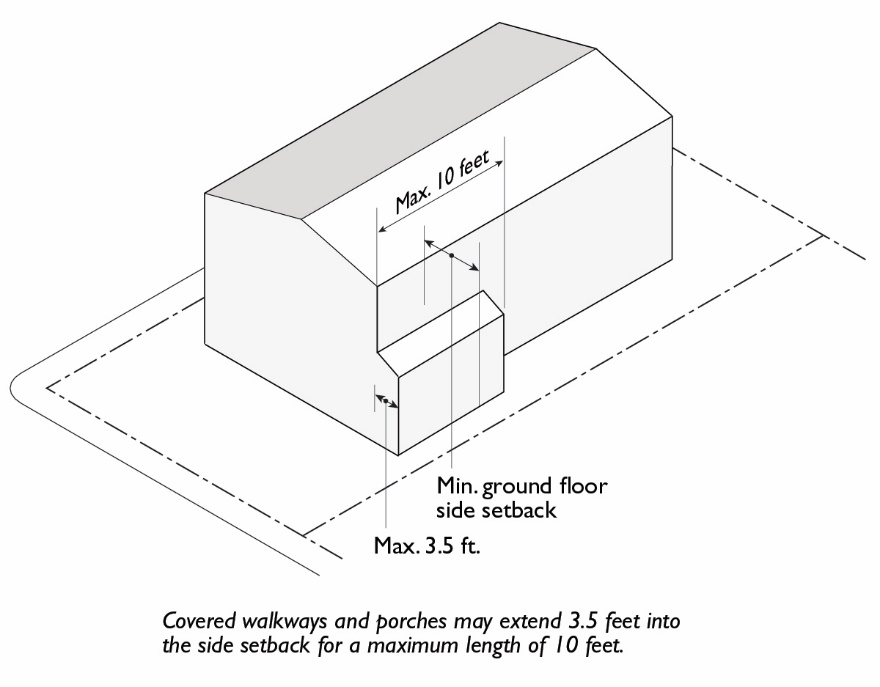
Side Setback Projection. Covered walkways, porches, and verandas may project up to 3.5 feet into the required side setback for a maximum length of 10 feet.
Figure 15.04.201.030-C: Porches within Side Setback
D.
Side Setback for Narrow Lots.
1.
Minimum. The minimum side setback for lots with an average width of 45 feet or less shall be a minimum of 10 percent of the lot width, or three feet, whichever is greater.
2.
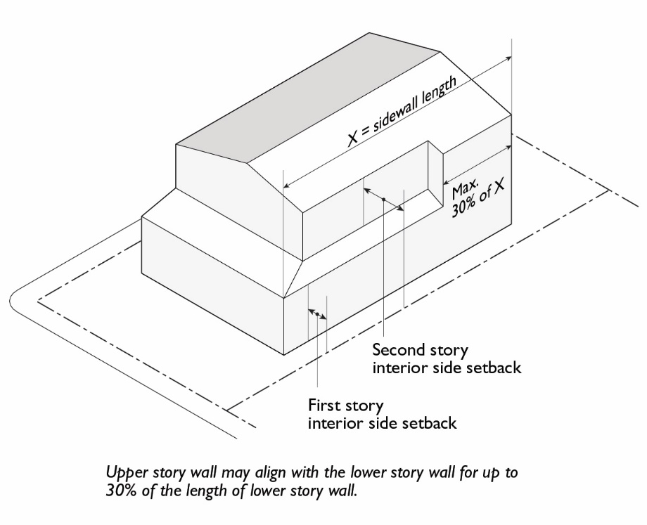
Second Story Projection. On lots less than 45 feet in width, the upper story wall may project a maximum of four feet into the required second story setback for up to 30 percent of the length of the lower story wall.
Figure 15.04.201.030-D: Second Story Projection on Narrow Lots
E.
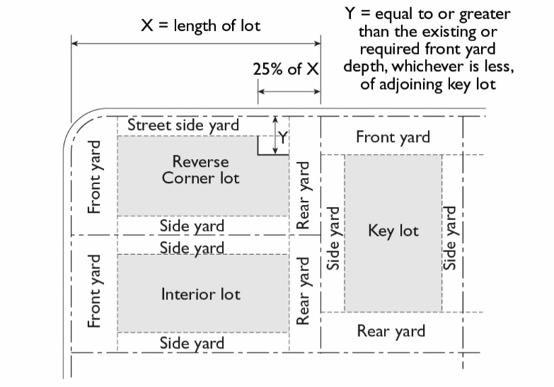
Street Side Yards on Lots with Reversed Frontage. The rear one-quarter of the exterior side yard shall not be less than the front yard required or existing on the lot adjoining such exterior side yard.
Figure 15.04.201.030-E: Street Side Setback on Lots with Reversed Frontage
F.
Rear Setback. In the RL2 and RL1 districts the rear setback may be reduced to 10 feet if the combined front and rear setback is at least 40 feet.
G.
Maximum Residential Floor Area and FAR. The maximum gross residential floor area allowed on a lot shall not exceed the maximum FAR applicable to a lot size range, as shown in Table 15.04.201.030-G.
H.
Maximum Non-Residential Floor Area. The maximum non-residential floor area ratio (FAR) is 0.65 in RH, RL1 and RL2 Districts.
I.
Determining FAR. When determining FAR in RH, RL1 and RL2 Districts, side-loaded or detached garages located to the rear of residential structures, a minimum of 40 feet away from the front property line and accessed by a driveway less than 12 feet in width are excluded from the floor area calculation.
(Ord. No. 30-18 N.S., § I(Exh. A), 12-18-2018; Ord. No. 27-20 N.S., § 3, 11-10-2020)
15.04.201.040 - Design Standards for Single Family Housing.
A.
Design of Building Additions. Rooflines, exterior materials, windows, railings, porches, and other design elements shall be designed in a manner that is compatible with the design elements of the existing buildings and surrounding neighborhood.
B.
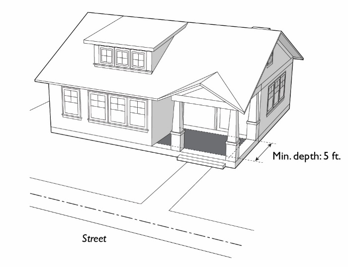
Building Entrances. The principal entry shall be located in a visible location facing the street and shall incorporate a projection (e.g., porch) or recess, with a minimum depth of five feet. Alternative designs that create a welcoming entry feature facing the street, such as a trellis or landscaped courtyard entry, may be approved through the administrative design review process.
Figure 15.04.201.040-B: Building Entrances
C.
Architectural Articulation. Buildings shall include adequate design features to create visual variety and avoid a large-scale and bulky appearance.
1.
No street-facing façade shall run in a continuous plane of more than 25 feet without a window or a projection, offset, or recess of the building wall at least one foot in depth. Building entrances and front porches, and projections into required front or street side yards such as stoops, bays, overhangs, fireplaces, and trellises count towards this requirement.
2.
Building elevations abutting street side yards shall be designed to provide at least one horizontal plane break of at least three feet, and one vertical break. Alternative designs to accommodate a complete architectural style may be approved through administrative design review process when the Zoning Administrator finds that adequate design features have been incorporated to create visual variety and avoid a bulky or monolithic appearance.
D.
Materials. All materials shall be high quality to allow for long-term durability and appearance. The exterior use of plywood or unfinished aluminum as siding materials is prohibited unless approved through design review.
E.
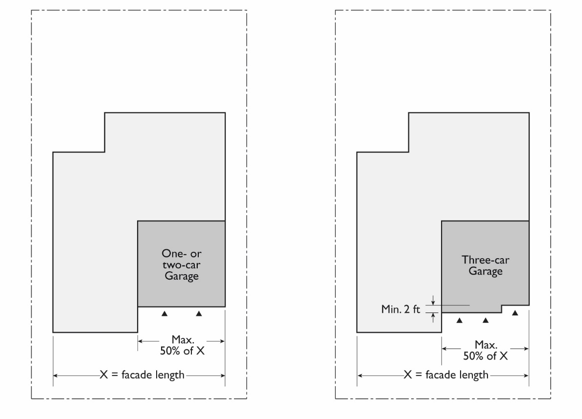
Garage Frontage.
1.
Where an attached garage is located on the front half of the lot and garage doors face a street, garage width shall not exceed 50 percent of the width of the front façade of the building (40 percent on lots wider than 100 feet).
2.
On front facades with both a two car garage and a separate single car garage, the facades of the two garages must be offset a minimum of two feet.
Figure 15.04.201.040-E: Garage Frontage
F.
Paving. The maximum amount of paving (impervious surface) in street-facing yards is 50 percent of the required yard.
G.
Driveways. Curb cuts and driveways shall be minimized.
1.
Driveway approaches (curb cuts) shall be permitted only to provide access to approved garages, carports and parking spaces.
2.
A maximum of one driveway up to 20 feet wide is permitted to serve a single unit. Driveways serving two or more units shall be the minimum width required by Article 15.04.607.
3.
All driveways must have minimum one-foot wide planted area along a side or rear lot line.
H.
Alley Access. A detached garage or carport is permitted to have access to the alley if:
1.
The garage or carport entrance is setback a minimum of four feet from the rear property line;
2.
A 45-degree visibility triangle is provided on either side of the garage or carport;
3.
The garage door does not cross the property line when opened or closed;
4.
The alley is paved; and
5.
The Zoning Administrator finds that such access will not adversely affect vehicle or pedestrian use of the street or alley.
15.04.201.050 - Development Standards—RM Districts.
Table 15.04.201.050 prescribes the development standards for the RM Districts. Additional regulations are denoted in a right hand column. Section numbers in this column refer to other sections of this article, while individual letters refer to subsections that directly follow the table. The numbers in each illustration below refer to corresponding regulations in the "#" column in the associated table.
TABLE 15.04.201.050: DEVELOPMENT STANDARDS—RESIDENTIAL
MULTI-FAMILY DISTRICTS
Additional Development Standards—RM Districts
A.
Transitional Standards. Where an RM District adjoins an RH or RL District, the following standards apply:
1.
The building setback from an RH or RL District boundary shall be 10 feet for interior side yards and 20 feet for rear yards.
2.
A landscaped planting area, a minimum of five feet in width, shall be provided along all RH or RL District boundaries. A tree screen shall be planted in this area with trees planted at a maximum interval of 15 feet.
B.
Accessory Building Height. If a peak roof is used, the height limit may be increased to 14 feet, except that the height may be increased to 16 feet for an accessory dwelling unit.
C.
Upper Story Stepback. The fourth story street facing building frontage shall be stepped back a minimum of 10 feet from the stories below. Exceptions may be granted by the Zoning Administrator, provided that an entry courtyard with a minimum depth of 25 feet, landscaping, and seating amenities are provided on the ground level at grade; or other comparable public amenities are provided.
D.
Front Setback. Where 75 percent or more of the lots in a block, on both sides of the street, have been improved with buildings, the minimum front setback required for the entry element (stoop or projected porch) shall be the average of those on the improved lots or 10 feet, whichever is less.
E.
Street Side Yards on Lots with Reversed Frontage. The rear one-quarter of the exterior side yard shall not be less than the front yard required or existing on the lot adjoining such exterior side yard.
F.
Parking Setback. Parking may be located within 40 feet of the street facing property line in accordance with the following standards.
1.
Underground and Partially Submerged Parking. Parking completely or partially underground may match the setbacks of the main structure. The maximum height of a parking podium visible from a street is five feet from finished grade.
2.
Surface Parking. Above ground parking may be located within 40 feet of a street facing property line with the approval of an administrative use permit when at least one of the following findings can be made:
a.
The design incorporates habitable space built close to the public sidewalk to the maximum extent feasible;
b.
The parking area is well screened with a wall, hedge, trellis, and/or landscaping; or
c.
The site is small and constrained such that underground, partially submerged, or surface parking located more than 40 feet from the street frontage is not feasible.
G.
Open Space. Private and common areas shall be provided in accordance with this section. Private areas typically consist of balconies, decks, patios, fenced yards, and other similar areas outside the residence. Common areas typically consist of landscaped areas, walks, patios, swimming pools, barbeque areas, playgrounds, turf, or other such improvements as are appropriate to enhance the outdoor environment of the development. Landscaped courtyard entries that are oriented towards the public street which create a welcoming entry feature are also considered common areas. All areas not improved with buildings, parking, vehicular accessways, trash enclosures, and similar items shall be developed as common areas with the types of attributes described above.
1.
Minimum Dimensions.
a.
Private Open Space. Private open space located on the ground level (e.g., yards, decks, patios) shall have no dimension less than 10 feet. Private open space located above ground level (e.g., balconies) shall have no dimension less than six feet.
b.
Common Open Space. Minimum dimension of 15 feet.
2.
Usability. A surface shall be provided that allows convenient use for outdoor living and/or recreation. Such surface may be any practicable combination of lawn, garden, flagstone, wood planking, concrete, or other serviceable, dust-free surfacing. Slope shall not exceed 10 percent.
3.
Accessibility.
a.
Private Open Space. The space shall be accessible to only one living unit by a doorway or doorways to a habitable room or hallway.
b.
Common Open Space. The space shall be accessible to the living units on the lot. It shall be served by any stairway or other accessway qualifying as an egress facility from a habitable room.
(Ord. No. 30-18 N.S., § I(Exh. A), 12-18-2018; Ord. No. 27-20 N.S., § 4, 11-10-2020)
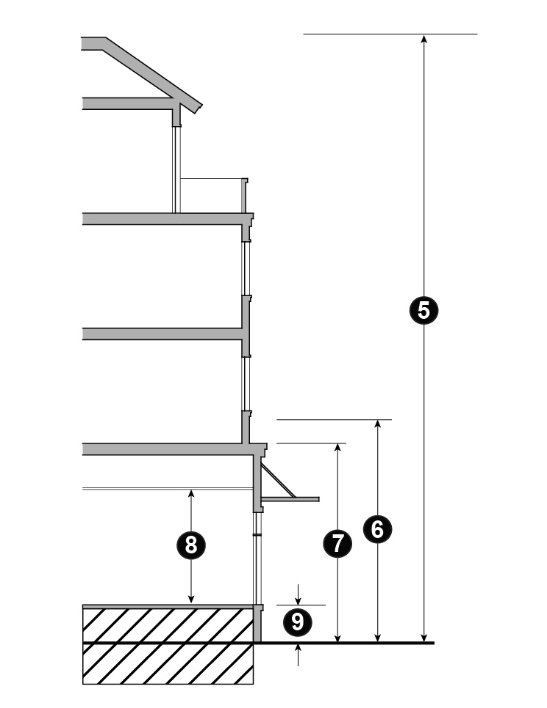
15.04.201.060 - Height Regulations for Sloped Lots.
A.
All lots with a building footprint slope of 20 percent or more are subject to the height regulations established in Table 15.04.201.060.
TABLE 15.04.201.060: HEIGHT REGULATIONS FOR ALL LOTS WITH
A FOOTPRINT SLOPE OF ≥20%
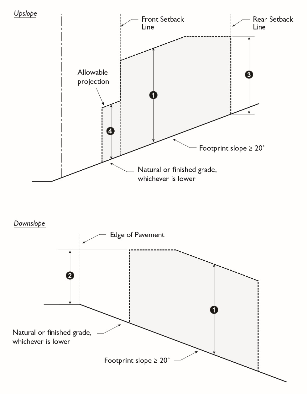
Additional Regulations for Table 15.04.201.060
1.
See Section 15.04.201.060 for allowed projections above height limits.
2.
On a downslope lot greater than 40 percent footprint slope, the rear wall of an attached garage or carport may exceed the wall height and roof height by five feet, but may not exceed 18 feet above ground elevation at edge of pavement, if the garage or carport conforms with all of the following criteria:
a.
Maximum width is 22 feet and maximum depth is 20 feet; and
b.
Garage or carport floor is at the same level as the edge of the street pavement resulting from the project at the center point of the driveway entrance or is at a lower level; and
c.
Maximum height above the garage or carport floor is ten feet for walls to the top of the plate or flat roof and 12 feet for pitched roofs.
15.04.201.070 - Design Standards for Multi-Family Housing.
A.
Building Entrances.
1.
Orientation. All units located along public rights-of-way must have the primary entrance facing this right-of-way. Exceptions to this requirement may be approved for projects where multiple-family housing is located on four-lane streets carrying high traffic volumes and/or streets that do not allow on-street parking. In such cases, the project may be oriented around courtyards.
2.
Projection or Recess. Building entrances must have a roofed projection (such as a porch) or recess with a minimum depth of at least five feet and a minimum horizontal area of 80 square feet. Alternative designs that create a welcoming entry feature facing the street, such as trellis or landscaped courtyard entry, may be approved by the Design Review Board.
3.
Dwelling Unit Access. Exterior entrances to units shall be in a form of individual or shared entrances at the ground floor of the building. Unit entrances above the ground floor are also permitted; however, no exterior access corridor located above the ground floor may provide access to five or more units.
B.
Building Design. Buildings shall include adequate design features to create visual variety and avoid a large-scale and bulky appearance.
1.
Building Length. The maximum dimension of any single building shall not exceed 125 feet.
2.
Roof Line. The roof line shall demonstrate an offset of at least 18 inches, a change of pitch, or a gable every 60 linear feet.
3.
Windows. All windows and window frames shall be inset a minimum of two inches from the face of the building to enhance a shadow line around the opening.
4.
Façade Articulation. All street-facing facades shall have at least one horizontal or vertical projection or recess at least four feet in depth, or two projections or recesses at least two and one-half feet in depth, for every twenty-five horizontal feet of wall. If located on a building with two or more stories, the articulated elements must be greater than one story in height, and may be grouped rather than evenly spaced in twenty-five foot modules. Building entrances and front porches and projections into required yards such as stoops, bays, overhangs, fireplaces, and trellises may count towards meeting this requirement.
5.
Façade Detailing and Materials. All visible building façades shall incorporate details, such as window and door trim, window recesses, cornices, changes in materials or other design elements, in an integrated composition. Each side of a building that is visible from a public right-of-way shall be designed with a complementary level of detailing and quality of materials.
6.
Building Materials. All materials shall be high quality to allow for long-term durability and appearance.
7.
Transition Areas. Where new multi-family developments are built adjacent to existing lower-scaled residential development, the façade facing the existing lower-scaled residential development shall be designed to provide architectural relief and interest, while also respecting the scale of adjacent neighbors.
a.
Height. Full-height recesses, a minimum of 10 feet deep, shall be provided along the facade to break the building into smaller discrete masses.
b.
Privacy. Offset windows to avoid direct sight lines into and from neighboring properties. Position balconies and other private open space so they minimize views into neighboring properties.
8.
Exceptions. Exceptions to the multi-family building design standards may be granted by the Design Review Board based on the finding that adequate design features have been incorporated to create visual variety and avoid a large-scale, bulky, or monolithic appearance.
C.
Private Storage Space. Each unit shall have at least 200 cubic feet of enclosed, weather-proofed, and lockable private storage space with a minimum horizontal dimension of four feet.
D.
Paving. Differentiated paving materials shall be used for garage aprons, entries, and pedestrian walkways. This may include, but not be limited to, textures or colors, concrete pavers, brick, or stamped concrete. The use of permeable materials to reduce runoff is strongly encouraged.
E.
Pedestrian Access. On-site pedestrian circulation and access must be provided according to the following standards.
1.
Internal Connections. A system of pedestrian walkways shall connect all buildings on a site to each other, to on-site automobile and bicycle parking areas, and to any on-site open space areas or pedestrian amenities.
2.
To Circulation Network. Regular connections between on-site walkways and the public sidewalk and other planned or existing pedestrian routes shall be provided. An on-site walkway shall connect the primary building entry or entries to a public sidewalk on each street frontage.
3.
To Neighbors. Direct and convenient access shall be provided to adjoining residential and commercial areas to the maximum extent feasible while still providing for safety and security.
4.
To Transit. Safe and convenient pedestrian connections shall be provided from transit stops and BART stations to building entrances.
5.
Pedestrian Walkway Design.
a.
Walkways shall be a minimum of six feet wide, shall be hard-surfaced, and paved with concrete, stone, tile, brick, or comparable material.
b.
Where a required walkway crosses driveways, parking areas, or loading areas, it must be clearly identifiable through the use of a raised crosswalk, a different paving material, or similar method.
c.
Where a required walkway is parallel and adjacent to an auto travel lane, it must be raised or separated from the auto travel lane by a raised curb at least four inches high, bollards, or other physical barrier.
15.04.201.080 - Residential Development Types.
This section illustrate development types allowed within the Residential Districts and provides supplemental standards for small lot single unit, bungalow court, and townhouse development types.
A.
Single Unit Dwellings.
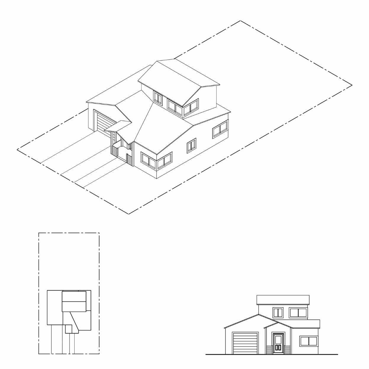
Figure 15.04.201.080-A: Residential Development Type Illustration:
Single Unit Dwelling
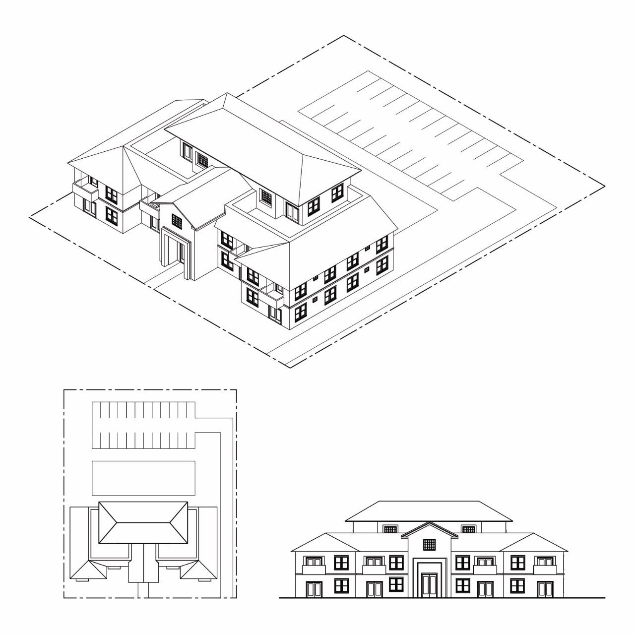
B.
Multi-Unit Residential Development.
Figure 15.04.201.080-B: Residential Development Type Illustration:
Multi-Unit Residential
C.
Small Lot Single Unit, Bungalow Court, and Townhouse Development Types. Small lot single unit, bungalow court, and townhouse development types are subject to the development standards and supplemental regulations of the base district unless modified by Table 15.04.201.080.
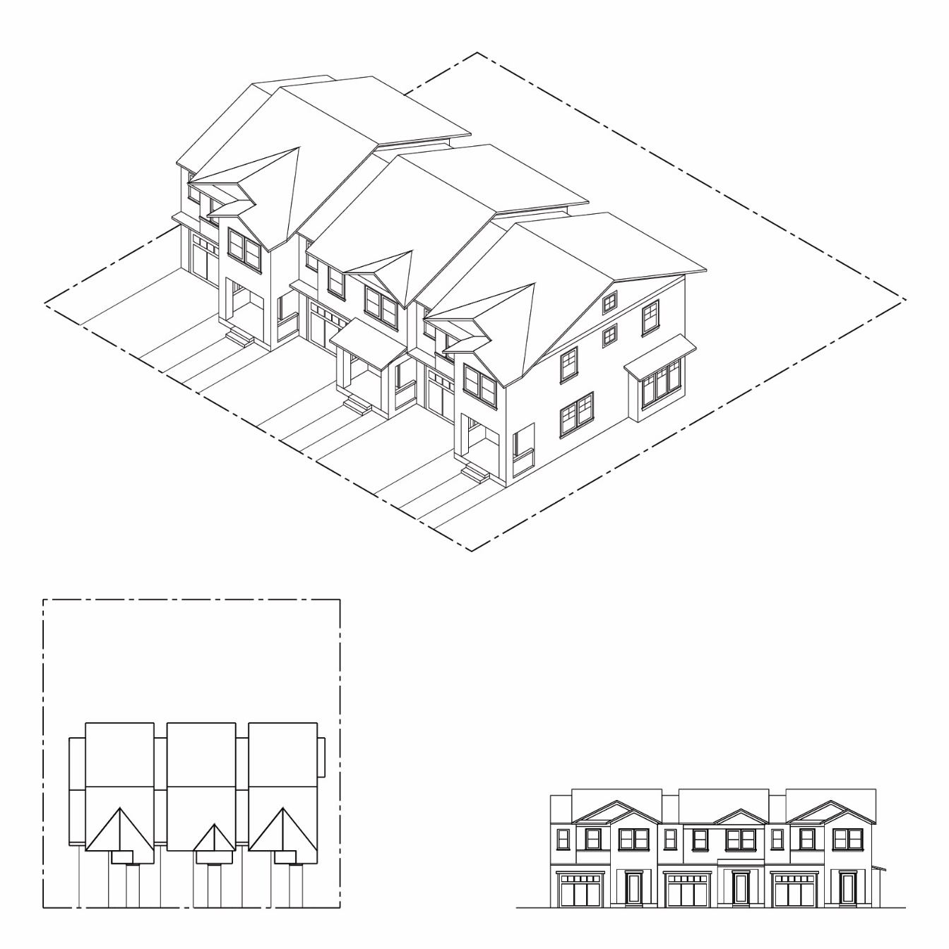
Figure 15.04.201.080-D(1): Residential Development Type Illustration:
Small Lot Single Unit
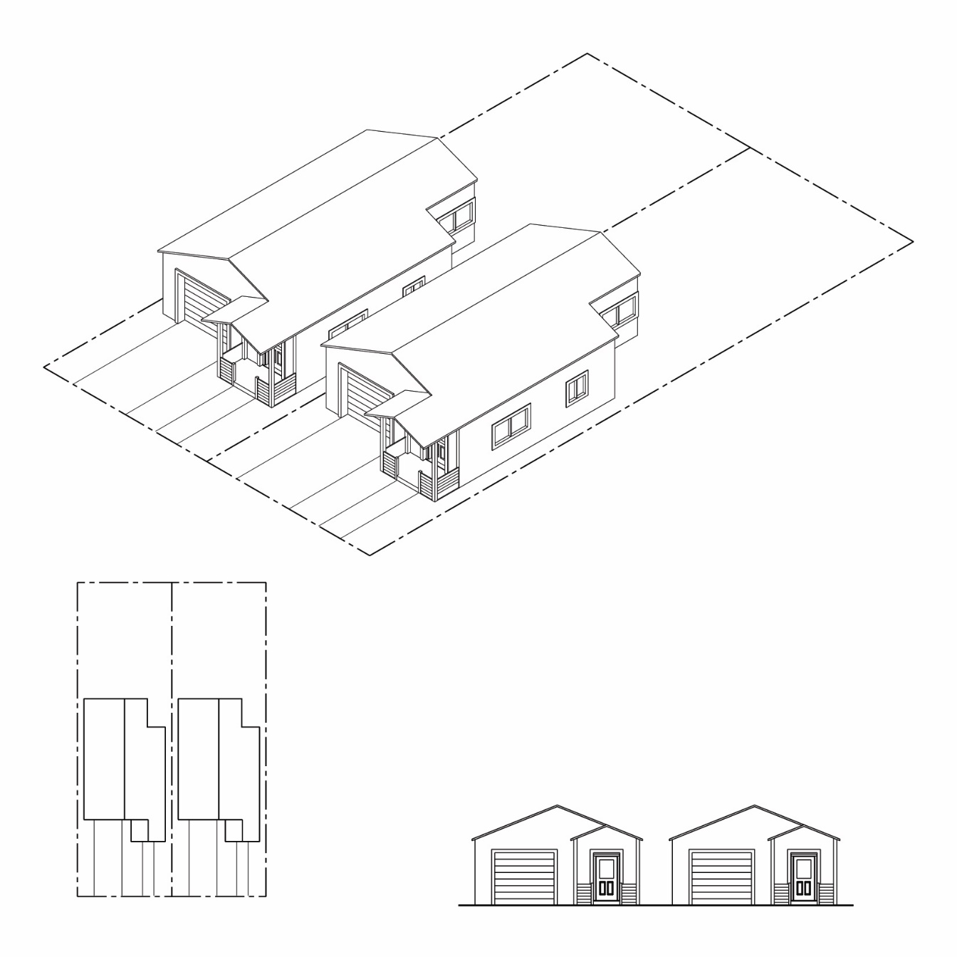
Figure 15.04.201.080-D(2): Residential Development Type Illustration:
Bungalow Court
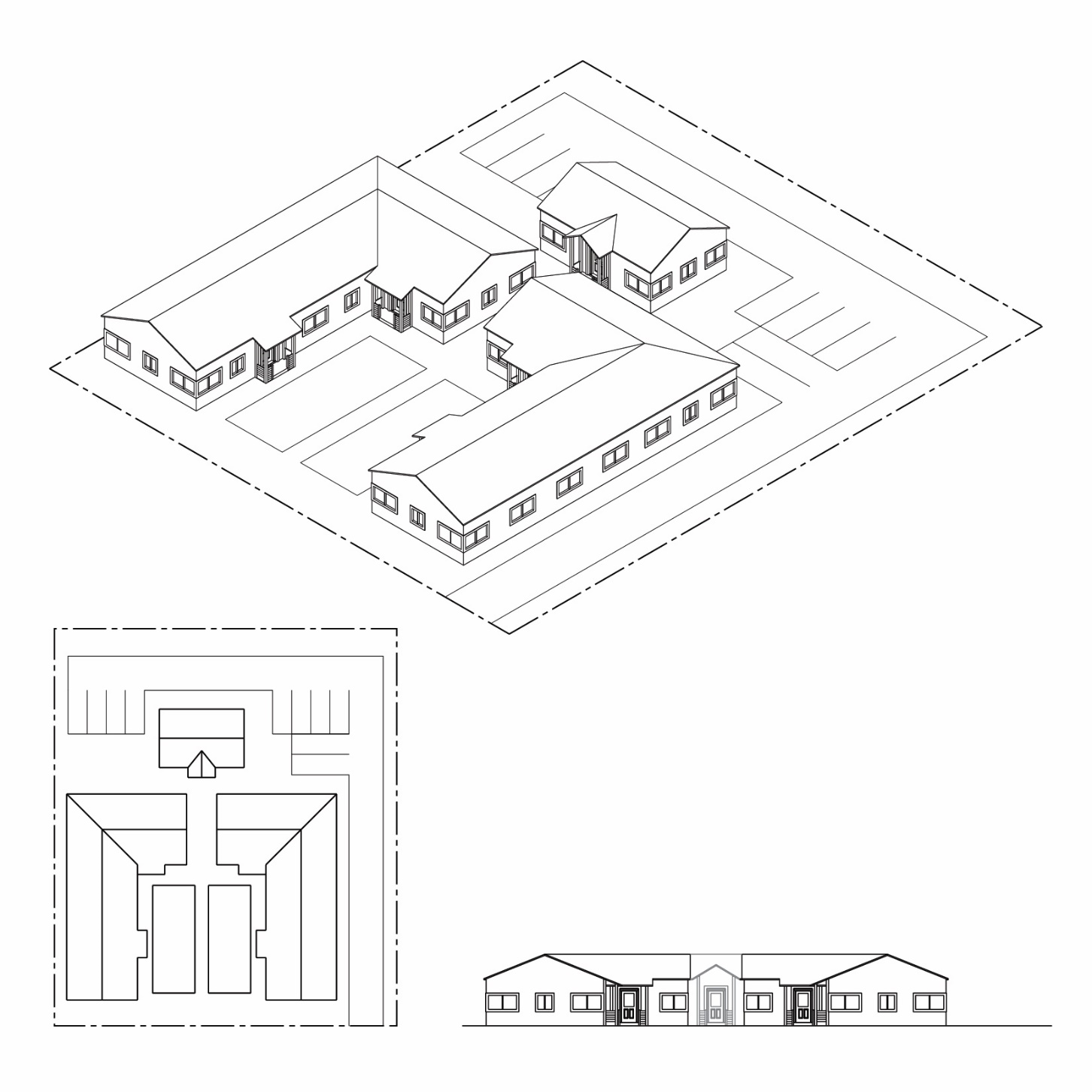
Figure 15.04.201.070-D(3): Residential Development Type Illustration:
Townhouse Development
15.04.201.090 - Small Lot Subdivisions.
A.
Purpose. The purpose of this section is to provide opportunities to increase the supply of smaller dwelling units and rental housing units in the City by allowing the creation of subdivisions with smaller lots and dwellings. It also is intended to establish design and development standards for these projects to ensure that they are compatible with the surrounding neighborhood.
B.
Location. A small lot subdivision may be proposed and approved on any site within the RL2 District where such development would be compatible with adjacent uses and the character of the area, and the density will not exceed the General Plan maximum. A small lot subdivision shall not be allowed where the Planning Commission determines that such compatibility will not occur, public utilities and services are inadequate, or the landform is inappropriate for such development because of grading or impacts on views from adjacent lots.
C.
Development Types. Small lot subdivisions may be proposed and approved for small lot single unit, bungalow court, and townhouse development developed according to Section 15.04.201.070, Residential Development Types.
D.
Lot Standards. The Planning Commission may approve smaller lots than required for the base district, but no less than 2,000 square feet in area and 30 feet in width, upon finding that the development will be compatible with neighboring uses and will contribute to underserved segments of the City's housing market.
15.04.201.100 - Hillside Subdivisions.
A.
Purpose. The purpose of this section is to establish development standards for hillside subdivisions to preserve the hills and ridges and their natural features and to maintain a harmonious visual and functional relationship between the existing natural environment and future development, consistent with the General Plan. More specifically, these standards are intended to:
1.
Maintain an environmental equilibrium, consistent with existing topography, vegetation, soils, and drainage patterns and minimize grading and cut and fill operations to retain, whenever possible, the natural character of the hill areas;
2.
Avoid development that would result in unacceptable fire, flood, landslide or other safety hazard or impose high maintenance costs for streets and public facilities;
3.
Provide a mechanism for flexible design of hillside residential development that is sensitive to existing terrain, and significant natural landforms and features; and
4.
Minimize water runoff and soil erosion problems incurred in adjusting to the terrain to meet on-site and off-site development needs.
B.
Applicability. These standards apply to any land division on sites and lots or portions of undeveloped land greater than one acre in area with an average slope of 15 percent or greater over any horizontal distance of 25 feet or more, except mineral resource extraction and quarrying.
1.
The Zoning Administrator may require a survey and slope analysis to determine whether the provisions of this section apply to a specific site or subdivision.
2.
In the event of a conflict between the provisions of this section and any underlying base zoning district, the most restrictive provisions shall apply.
C.
Conditional Use Permit Required. All hillside subdivisions must obtain approval of a conditional use permit. Before approving a conditional use permit, the Planning Commission, must consider:
1.
Responsiveness to the Site Context. How the proposed development responds to the site's physical constraints, natural features, special features, visual character and the neighboring environment.
2.
Proposed Density. The maximum number of dwelling units allowed shall be controlled by the density limits of the base zoning district. However, the Planning Commission may reduce the maximum number of dwelling units as necessary to achieve any of the following:
a.
To minimize the need for grading and/or significant alteration of the natural topography of the site;
b.
To preserve public vistas;
c.
To minimize the construction of unnecessary roadways;
d.
To reduce hazards to adjacent property; or
e.
To preserve environmental resources.
3.
Site Design. Whether the proposed development:
a.
Reflects the City's design goals and policies as expressed in the General Plan;
b.
Preserves or protects unique or special natural features of the site, such as land forms, rock outcroppings, mature trees and vegetation, drainage courses, hilltops and ridge lines;
c.
Is compatible with the natural features, building location, and existing open spaces of neighboring properties;
d.
Preserves or minimizes impacts on privacy and access to light and safety of neighboring properties;
e.
Avoids the unstable or hazardous portions of the site; and
4.
Circulation and Parking. Whether the proposed development:
a.
Provides a clearly organized circulation plan for automobiles, bicycles, pedestrians, and service vehicles;
b.
Locates and landscapes roads and streets so as to minimize grading and avoid impacts to existing vegetation; and
c.
Provides access to any parks and publicly-owned open space abutting the site.
5.
Required Findings. In addition to the findings in Article 15.04.806, the Planning Commission shall approve or conditionally approve a conditional use permit only upon finding that:
a.
The project is consistent with the development regulations and design criteria established in this article;
b.
Proposed grading takes into account existing natural features of the property, including mature trees, significant or unique vegetation groupings, prominent geological features, and natural drainage courses; and
c.
Adequate wildland fire safety measures have been incorporated into the design of the project.
D.
Hillside Grading and Drainage. Changes to the existing natural terrain through grading must be kept to a minimum in order to preserve the inherent characteristics of sloping hillsides.
1.
Grading. In addition to meeting the standards in Municipal Code Chapter 12.44 (Excavation, Grading and Earthwork Construction), all proposed hillside development shall:
a.
Minimize grading in areas with greater than 26 percent slope except that required exclusively for foundations. All grading shall conform to the following standards, based upon the percent of the natural slope:
i.
0-15 percent. Redistribution of earth over large areas may be permitted;
ii.
15-26 percent. Some grading may occur, but landforms should retain their natural character. Padded building sites may be allowed, but custom foundations, split level designs, stacking and clustering are expected to mitigate the need for large padded building areas;
iii.
26-30 percent. Limited grading may occur; however, major topographic features shall retain their natural land forms; or
iv.
Over 30 percent. Development and limited grading can only occur if necessary to avoid hazards or reduce environmental and visual impacts.
b.
Avoid creating graded areas where there is a 30 feet or greater difference in height between terraces or benches; if the difference is more than 30 feet, then benches with concrete drainage channels shall be placed every 20 feet. If approved, terracing must be designed with small incremental steps, avoiding wide step terracing and large areas of flat pads.
c.
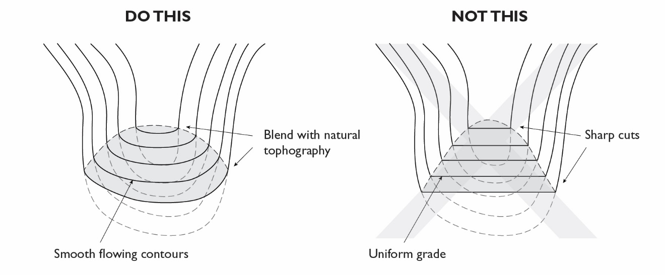
Grade new building sites such that they appear to emerge from the slope.
d.
Avoid a manufactured appearance by creating smooth flowing contours of varying gradients. Slopes created by grading of the site shall not exceed 50 percent, without a soils report and stabilization study justifying it. Avoid sharp cuts and fills and long linear slopes that have uniform grade; sculpture grading to blend slopes and benches with natural topography.
Figure 15.04.201.100-D(1)(d): Grading Contour
e.
Minimize pad size to accommodate the structure and a reasonable amount of open space. Pads for tennis courts, swimming pools and lawns must be minimized.
f.
Use split level building terraces to reduce pad size.
g.
Avoid grading on hazardous or unstable portions of the site.
h.
Minimize grading within 20 feet of all perimeter property lines, unless the grading is similar to the existing adjacent slopes or to the planned grading of the adjacent slopes.
i.
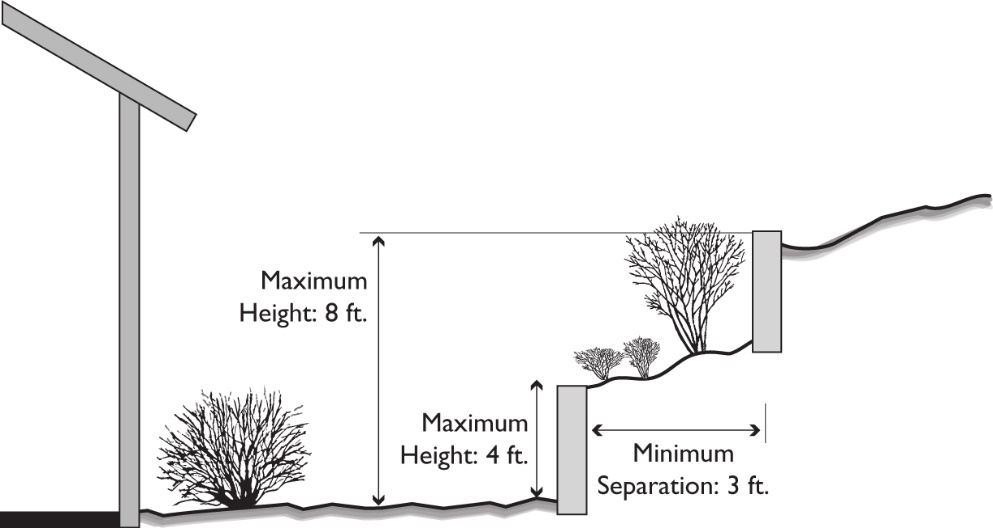
Minimize the height of retaining walls visible from off site. Use stone or earth-colored materials. Design retaining walls associated with lots as follows:
i.
Upslope (from the structure) walls not to exceed four feet in height unless greater height is approved by the Planning Commission. Terraced retaining structures may be utilized if separated by a minimum of three feet and landscaped. Overall combined height of walls shall not exceed eight feet in height unless greater height is approved by the Planning Commission.
Figure 15.04.201.100-D(1)(i): Retaining Wall Height
ii.
Downslope (from the structure) walls not to exceed a combined total of 42 inches in height unless greater height is approved.
iii.
Sloping. One retaining wall on each side of the lot not exceeding 42 inches in height.
iv.
Retaining walls shall be designed with smooth, continuous lines that conform to the topography. Maximum wall height at the base of slopes along roadways shall not exceed 4 feet in order to avoid a contained, channel-like effect.
v.
Retaining walls to accommodate a patio or terrace shall conform to the natural hillside profile.
2.
Drainage. In addition to meeting the standards in the Subdivision and Grading Ordinances, all proposed hillside development shall:
a.
Collect and convey storm water to off-site systems in a manner that will avoid erosion and damage to on-site and adjacent properties.
b.
Design necessary storm drainage improvements to create a natural rather than a manufactured appearance.
c.
Minimize on-site areas of impervious surfaces to reduce runoff.
d.
Provide adequate drainage control devices to prevent flooding of below grade floor slabs and subterranean water from seeping into structures.
e.
Place drainage devices, such as terrace drains, benches and down drains, in locations of least visibility on slopes. Avoid visible concrete drains; but if required, they should be color tinted and screened with planting to be less obtrusive.
f.
Provide for bulked-flow and subsoil runoff to a safe point of discharge, such as a street, channel or debris basin, so that damage to improvements or slopes will not result. Do not flatten natural stream gradients.
g.
Design lots and proposed improvements to accommodate debris from potential land slippage and/or erosion without damage to improvements or downslope property. Provide access to a street for cleanup and removal, where warranted.
h.
Provide emergency routes for flood and debris flows that exceeds the design capacity of planned drainage, flood control and debris collection facilities. Direct overflows away from slopes and improvements and toward safe points of discharge.
3.
Erosion Control. In addition to meeting the standards in the Subdivision and Grading Ordinances, all proposed hillside development shall:
a.
Include erosion control and revegetation programs in grading plans, when necessary to prevent erosion;
b.
Control the timing of grading and construction to avoid failure during construction; and
c.
When detention basins and other storm and erosion control facilities are required, minimize any negative visual impacts to the natural hillside character with planting and revegetation.
4.
Geologic Hazards. Geotechnical review is required on all sites to identify hazardous areas, including potential debris flows.
a.
Areas determined through the geotechnical review process to be too hazardous for development shall not be developed.
b.
The following methods for mitigating geologic hazards are not acceptable:
i.
Exposure of slopes that cannot be suitably re-vegetated; and
ii.
Removal of large areas of existing mature vegetation that substantially contribute to the natural character of a site.
c.
Existing geologic hazards shall be corrected when they pose a threat to on or off-site development or properties.
d.
In all subdivisions, for 10 years following granting of a final occupancy permit, the applicant shall warrant and be solely responsible for slope maintenance and stabilization. In addition, the applicant shall deposit a bond with the City, or provide equivalent assurance as approved by the City Engineer, in an amount as determined by the City Engineer to ensure compliance with this condition. Following the expiration of the warranty period, impacts due to soils failure are the sole responsibility of the property owners' association.
Slope monitoring by a California-certified engineering geologist shall be conducted every other month for the first two years and annually thereafter and written reports of findings provided to the City Engineer.
Provisions for maintenance of slopes and retaining walls with instruction for recognizing conditions that require professional evaluation and potential mitigation shall be incorporated in the codes and covenants of the property owners' association. A copy of such codes, covenants and instructions shall be submitted to the Director and City Engineer for approval prior to issuance of building permits.
E.
Lot Size and Configuration, Building Setbacks, and Location. The layout of lots in all hillside residential development must be adapted to existing topography and natural features and avoid unnecessary alteration of land forms. The Planning Commission may approve lots that are less than the minimum size and dimensions in a cluster development provided the overall density does not exceed the General Plan maximum.
1.
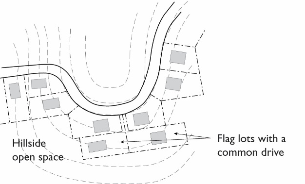
Lot Configurations. All proposed hillside development shall:
a.
Use lot patterns that offer a variety of lot shapes.
b.
Place lot lines at the top of major slope areas to ensure that the slope maintenance and planting will not be neglected by an uphill owner and to minimize drainage crossing lot lines.
c.
Use flag lots with parking located adjacent to roadways to minimize roadway cut and fill.
Figure 15.04.201.100-E(1): Flag Lots
2.
Building Setbacks. Use variable front building setbacks to preserve natural hillside character.
F.
Trees.
1.
Preserving Trees During Construction.
a.
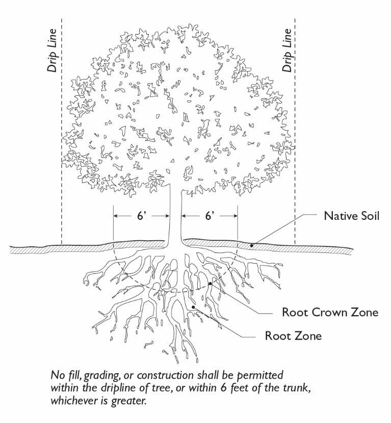
No fill, grading, or construction shall be permitted within the drip line of any tree (or within six feet of the trunk, whichever is greater) designated for preservation except as may be recommended by an arborist or forester.
b.
Trenching shall be prohibited within the tree drip line, and any required utility line within the tree drip line shall be installed by boring or drilling through the soil.
c.
Where necessary for access in the vicinity of trees designated for preservation, paving within the drip line shall use porous materials such as gravel, loose boulders, cobbles, wood chips, or bark mulch.
Figure 15.04.201.100-F(1): Tree Preservation
2.
Criteria for Tree Removal. In assessing the number of trees and specific trees that may be removed, the Planning Commission shall consider the following criteria as identified in an arborist report submitted by the applicant:
a.
Whether the tree is in poor health and cannot be saved;
b.
Whether the tree is a public nuisance, causing damage to public utilities or streets and sidewalks that cannot be mitigated by some other means (such as root barriers etc.);
c.
Whether the tree is in danger of falling and cannot be saved by some other means (such as pruning);
d.
Whether the tree is damaging existing private improvements on the lot (e.g., building foundation, wall, patio, deck, roof, retaining wall, etc.);
e.
Whether the tree species is known to be highly combustible and is determined to be a fire hazard;
f.
Whether reasonable development of the property would require the alteration or removal of the tree and could not be reasonably accommodated elsewhere on the lot; and
g.
Whether the tree species is known to develop weaknesses that affect its health or the safety of people and property (e.g., short-lived, weak-wooded and subject to limb breakage, shallow-rooted and subject to toppling).
3.
Whenever Significant Trees Are Removed.
a.
Trees shall be replaced at a ratio of at least 3 new trees for every tree removed. Replacement trees shall be planted in the following order of priority: (i) on the project site; (ii) on adjacent private or public land, or along public streets, or (iii) within five miles of the site of the removal.
b.
The minimum tree size shall be 15 gallons. Exception to this requirement may be allowed by the Planning Commission when site conditions warrant.
c.
To protect trees during construction one or both of the following measures shall be taken: (i) construct fencing around the drip line of each tree or group of trees to be retained; and (ii) establish an incentive program in the construction contract to encourage workers, particularly bulldozer drivers, to maximize caution when working near trees (such as a fine for each damaged tree or subtract the fine from a bonus to be divided among all construction workers at the end of the project).
G.
Building Locations. All proposed hillside development shall:
1.
Not locate buildings near visually prominent ridgelines when a choice of building location is available. Building rooflines must be located below the ridgeline so that views to the hillside from public roadways see the natural ridgeline.
2.
Minimize front yard setback on downslope lots to reduce building mass hanging over the slope. Step building bulk down with the slope.
H.
Street Layout, Driveway, and Parking Design. In addition to adherence to the standards in the Subdivision Ordinance, new development must align street, drives, parking and emergency vehicle access to conform closely to existing grades and minimize the need for the grading of slopes. Subdividers shall retain natural land forms by introducing gentle horizontal and vertical curves in road alignments.
1.
Street Layout. All proposed hillside development shall:
a.
Use narrower street widths to reduce grading impact, where acceptable to the City Engineer and the Fire Department, when the topography of the small number of lots served and the probable future traffic development justifies it, and when safety will not be compromised.
b.
Reduce the visual and safety impacts of hillside street design by use of terraced retaining walls and landscaping.
c.
Use split roadways to increase the amount and appearance of landscaping and use the median to handle drainage.
2.
Driveways and Guest Parking. All proposed hillside development shall:
a.
Limit driveway grades to 15 percent or less. The finished grade of driveways shall conform to the finished grade of the lot. Concrete driveway approaches shall be engineered and reinforced, as appropriate. All hillside driveway plans must be reviewed and approved by the Fire Department.
b.
Provide two guest parking spaces conveniently placed relative to the dwelling unit unless the Planning Commission waives this requirement to minimize excessive grading or avoid tree removal.
c.
Driveway and parking designs that force vehicles to back out into substandard roadway widths are prohibited.
d.
Common drives in hillside residential development may be approved if grading is reduced. Maintenance agreements are required for common driveways.
e.
On-street parking for guest space may be provided in parking bays in lieu of off-street parking where topography allows.
I.
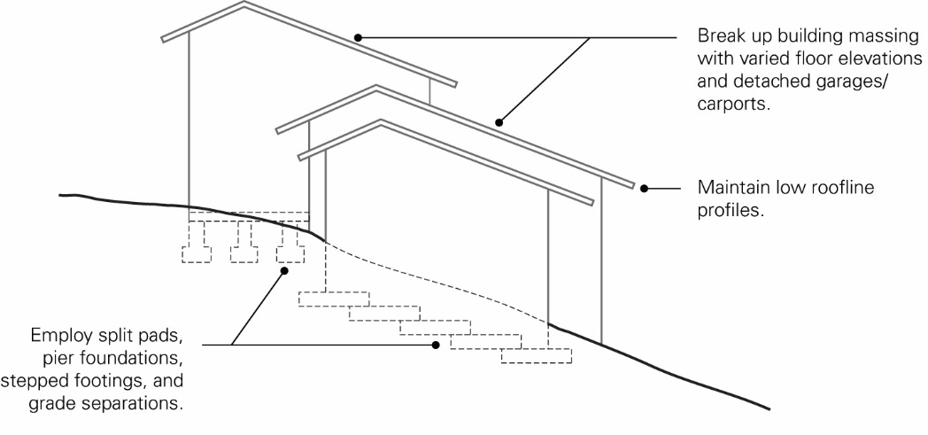
Reduction of Building Bulk in Multi-Building Projects. All proposed hillside development shall:
1.
Use split pads, pier foundations, stepped footings, and grade separations to permit dwellings to step down or up the natural slope.
Figure 15.04.201.090-I(1): Stepped Footing
2.
Site buildings with different floor elevations to achieve height variation.
3.
Site buildings that are located near the top of hillsides in a staggered arrangement and screen with planting to minimize wall effect.
4.
Avoid long or tall, continuous building masses that create a wall or tower effect.
5.
Articulate facades to produce shadows through wall setbacks, recessed openings, porches, verandas, moderate overhangs, projecting windows.
6.
Avoid extended horizontal rooflines.
J.
Landscaping. All proposed hillside development shall:
1.
Use planting designs that buffer existing neighborhoods from the impacts of new hillside development.
2.
Revegetate scarred or graded areas.
3.
On slopes of 2:1 or greater, select plant materials with deep rooting characteristics that will minimize erosion and reduce surface runoff. Subdividers also shall use a series of low retaining walls, with sub-drain lines, to increase planting areas, where feasible. This will also reduce runoff and potential erosion.
4.
Use irregular planting spacing to achieve a natural appearance on graded slopes. Plant trees along contour lines in undulating groups to create grove effects which blur the distinctive line of the graded slopes, and plant shrubs of varying height between tree strands. Ground covers of native and introduced species are appropriate for slope erosion control.
15.04.202.010 - Purpose.
The specific purposes of the Mixed-Use Districts are to:
A.
Provide for the orderly, well-planned, and balanced growth of mixed-use districts.
B.
Encourage a mix of uses that promotes convenience, economic vitality, fiscal stability, and a pleasant quality of life.
C.
Promote pedestrian- and transit-oriented, mixed-use commercial centers at appropriate locations.
D.
Establish design standards that improve the visual quality of development and create a unified, distinctive, and attractive character along mixed-use streets.
E.
Provide appropriate buffers and transition standards between commercial and residential uses to preserve both commercial and mixed-use feasibility and residential quality.
The following Mixed-Use Districts implement General Plan classifications of "Neighborhood Mixed-Use", "Medium Density Mixed-Use (Residential Emphasis)", "Medium Intensity Mixed-Use (Commercial Emphasis)", "High Intensity Mixed-Use (Major Activity Center)", "Regional Commercial Mixed-Use", and "Live-Work".
CM-1 Commercial Mixed-Use, Residential. This district is intended for mixed-use development with commercial uses at street-level along corridors. Residential-only development also is allowed and may include condominiums, townhouses or apartments. Commercial-only development is not allowed. Projects with commercial components must also include a residential component. New development is required to have a pedestrian-oriented building design with minimal front and street-side setbacks and parking located to the sides or rear of buildings.
CM-2 Commercial Mixed-Use, Neighborhood. This district is intended for residential and neighborhood-serving retail uses, such as small stores, markets, professional offices, boutiques, barbershops, beauty salons, and restaurants. Residential development above ground floor commercial is preferred, but not required. Standards will ensure that development at neighborhood nodes is appropriately scaled, so that the physical form relates to and does not overwhelm adjacent single-family residential neighborhoods.
CM-3 Commercial Mixed-Use, Commercial. This district is intended for mixed-use development with commercial or office/light industrial uses at street-level along corridors. This classification is distinguished from the CM-1 Commercial Mixed-Use, Residential, in that it allows residential-only or commercial-only development. Allowable residential uses include condominiums, townhouses or apartments, and commercial uses may include small to large-scale retail, business and personal services and, at street-level, offices serving a walk-in clientele. New development must have a pedestrian-oriented building design with minimal front and street-side setbacks and parking located to the sides or rear of buildings preferred.
CM-4 Commercial Mixed-Use, Gateway/Node. This district is intended for mid-rise mixed-use development at key community nodes and gateways with commercial uses at street-level and offices or residential uses on upper floors. Commercial development must have a pedestrian-oriented building design with setbacks allowing for public amenities and parking located behind buildings.
CM-5 Commercial Mixed-Use, Activity Center. This district is intended for mid and high-rise mixed-use development at major activity centers to serve the community and residents and businesses in the San Francisco Bay Area. Office, retail, entertainment and residential uses are allowed. Standards for physical form will create an urban character as envisioned in the General Plan with streets with minimal setbacks, wide sidewalks and public spaces that cater to pedestrians and transit riders.
LW Live-Work. This district is intended for joint living and working quarters, with residential space connected to small-scale artisan or production spaces as well as office and storefront retail. It includes loft and apartments type development. This district is appropriate for transitional areas identified in the General Plan where it can be demonstrated that the live-work use would not conflict with adjacent uses. A maximum density of 50 dwelling units per acre is permitted, and the non-residential FAR shall not exceed 0.4. Civic and institutional uses also are permitted, but the zoning district is not intended to create a purely residential environment.
15.04.202.020 - Land Use Regulations.
Table 15.05.202.020 prescribes the land use regulations for all CM Districts and for the Live-Work District. The regulations for each district are established by letter designations as follows:
"P" designates permitted uses.
"A" designates use classifications that are permitted after review and approval of an administrative use permit by the Zoning Administrator.
"C" designates use classifications that are permitted after review and approval of a conditional use permit by the Planning Commission.
"L#" designates numbered limitations listed at the end of the table.
"x" designates uses that are not permitted.
Use classifications are defined in Article 15.04.104 (Key Terms and Definitions). In cases where a specific land use or activity is not defined, the Zoning Administrator shall assign the land use or activity to a classification that is substantially similar in character. Use classifications and subclassifications not listed in the table or not found to be substantially similar to the uses below are prohibited. Section numbers in the right hand column refer to other sections of this Ordinance.
1 Schools with conditional use permits that are nonconforming can seek modifications to existing conditions of approval pursuant to Section 15.04.606.040(C), Expansion of nonconfirming uses.
(Ord. No. 27-18 N.S., § I(Exh. A), 11-20-2018; Ord. No. 30-18 N.S., § I(Exh. A), 12-18-2018; Ord. No. 27-20 N.S., § 5, 11-10-2020)
15.04.202.030 - Development Standards.
Tables 15.04.202.030(1) through 15.04.202.030(5) prescribe the development standards for Mixed-Use Districts. Additional regulations are denoted in the right hand column. Section numbers in this column refer to other sections of this article, while individual letters refer to subsections that directly follow the table. The numbers in each illustration below refer to corresponding regulations in the "#" column in the associated table.
TABLE 15.04.202.030(1): LOT, DENSITY, FAR, AND BUILDING PLACEMENT STANDARDS—MIXED-USE DISTRICTS
1 The increase in density, made by Ordinance 06-21, on April 20, 2021, is intended to conform to the requirements of the Housing Crisis Act of 2019 by ensuring that there is no net loss in residential capacity in the City as a result of the Richmond Hills Initiative and the implementing rezoning also made in this Ordinance which reduced the residential development capacity in the Richmond Hills Initiative area by 864 units. This density increase is allowed by the General Plan, which states on page 3.10 that the maximum number of allowable units in a land use designation may be exceeded to accommodate a density transfer or development rights transfer.
A.
Build-to Line. Buildings shall be constructed at the street frontage or required setback line (the "build-to" line) for at least 60 percent of the building frontage. At least two-thirds of the area between the building and lot line shall be paved so that it functions as a wider public sidewalk. This requirement may be modified or waived by the Zoning Administrator or the Design Review Board, whichever has approval authority, upon finding that:
1.
Substantial landscaping will be located between the build-to line and ground floor residential units to soften visual impact of buildings;
2.
Entry courtyards, plazas, entries, or outdoor eating and display areas will be located between the build-to line and building, provided that the buildings will be built to the edge of the courtyard, plaza, or outdoor dining area; or
3.
The building will incorporate an alternative entrance design that will create a welcoming entry feature facing the street.
B.
Required Side and Rear Yards for Residential Uses. In order to provide light and air for residential units, the following minimum setbacks apply to any building wall containing windows for residential units and facing an interior side or rear yard.
1.
For any wall containing windows, a setback of at least 5 feet shall be provided.
2.
For any wall containing bedroom windows, a setback of at least 10 feet shall be provided.
3.
For any wall containing living room or other primary room windows, a setback of at least 15 feet shall be provided.
4.
The required setbacks apply to that portion of the building wall containing a window and extending three feet on either side of the window.
TABLE 15.04.202.030(2): HEIGHT STANDARDS—MIXED-USE DISTRICTS
C.
Height Limitations and Exceptions.
1.
Architectural Features. A parapet wall, cornice or sloping roof or solar energy system may project up to four feet above the height limit.
2.
CM-3 District. For the CM-3 District along San Pablo Avenue, the maximum allowable height shall not exceed 35 feet when abutting a single family residential zone.
3.
Towers. If the project site is greater than 15,000 square feet, a tower or other projecting architectural elements may extend up to 12 feet above the top of a pitched roof, provided that the square footage of the element(s) do not total more than 15 percent of the building footprint. The area above the uppermost permitted floor of the element(s) shall not be habitable space.
a.
The composition of the tower element shall be balanced, where the width of the tower has a proportional relationship to the height of the tower.
b.
The tower element shall be proportional to the rest of the building.
c.
The tower element shall not be stepped back at any point.
d.
The maximum horizontal dimension of the tower element shall not exceed 100 feet.
e.
Fenestration at the base of the tower shall be greater than the top.
f.
The roof shall include architectural detailing, such as a cornice or eave.
D.
Upper Story Limitations. For the CM-3 District along San Pablo Avenue, the maximum allowable number of stories shall not exceed three when abutting a single family residential zone. The top story of all four-story buildings in the CM-1 and CM-2 districts shall contain only residential uses and shall be stepped back a minimum of 10 feet from the story below.
TABLE 15.04.202.030(3): BUILDING FORM STANDARDS—MIXED-USE DISTRICTS
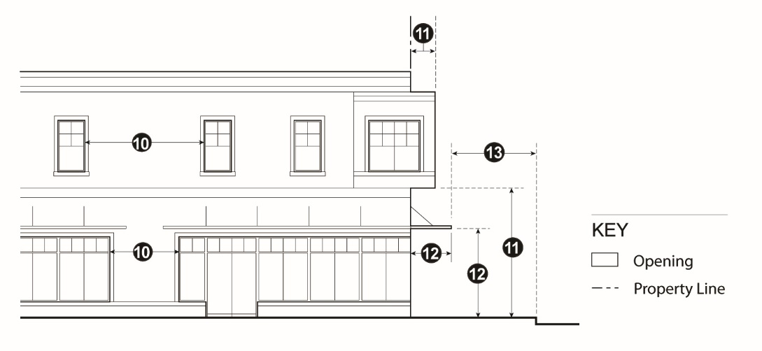
TABLE 15.04.202.030(4): PARKING AND LOADING STANDARDS—MIXED-USE
DISTRICTS
E.
Wide Buildings. Any building over 50 feet wide shall be broken down to read as a series of buildings no wider than 50 feet each or 30 feet in the CM-1 and CM-2 Districts. Increases in the maximum building width and length may be approved through design review if recesses, offsets, or other architectural articulation modulate a "box-like" appearance.
F.
Maximum Length of Blank Walls. This limitation does not apply to buildings with unique design requirements, such as gyms and auditoriums.
G.
Building Projections. The maximum width of any projection, including bay windows, is 10 feet, and the total of all projections along a building face may not be more than 10 feet wide or 25 percent of the building frontage, whichever is greater.
H.
Limitations on Location of Parking. Parking may be located within 40 feet of the street facing property line in accordance with the following standards.
1.
Underground and Partially Submerged Parking. Parking completely or partially underground, may match the setbacks of the main structure. The maximum height of a parking podium visible from a street is five feet from finished grade.
2.
Surface Parking. Above ground surface parking may be located within 40 feet of a street facing property line with the approval of an administrative use permit when the Zoning Administrator makes the following findings:
a.
Buildings are built close to the public sidewalk to the maximum extent feasible;
b.
The parking area is screened along the public right-of-way with a wall, hedge, trellis, and/or landscaping; and
c.
The site is small and constrained such that underground, partially submerged, or surface parking located more than 40 feet from the street frontage is not feasible.
I.
Residential Open Space. Residential open space may be provided as common or private open space. Private areas consist of balconies, decks, patios, or fenced yards directly accessible from the residence. Common areas consist of landscaped areas, walks, patios, swimming pools, barbeque areas, playgrounds, turf, rooftop areas, or other such improvements as are appropriate to enhance the outdoor living environment of the development. Landscaped courtyard entries that are oriented towards the public street which create a welcoming entry feature are also considered common areas. All areas not improved with buildings, parking, vehicular accessways, trash enclosures, and similar items or devoted to perimeter landscaping shall be developed as common areas with the types of attributes described above.
1.
Minimum Dimensions.
a.
Private Open Space. Private open space located on the ground level (e.g., yards, decks, patios) shall have no horizontal dimension less than 10 feet. Private open space located above ground level (e.g., balconies) shall have no horizontal dimension less than six feet.
b.
Common Open Space. Minimum horizontal dimension of 20 feet.
2.
Usability. A surface shall be provided that allows convenient use for outdoor living and/or recreation. Such surface may be any practicable combination of lawn, garden, flagstone, wood planking, concrete, or other serviceable, dust-free surfacing. The maximum slope shall not exceed 10 percent.
3.
Accessibility.
a.
Private Open Space. The space shall be accessible to only one living unit by a doorway to a habitable room or hallway.
b.
Common Open Space. The space shall be accessible to the living units on the lot. It shall be served by any stairway or other accessway qualifying as an egress facility from a habitable room.
(Ord. No. 06-21 N.S., § II(Exh. A), 4-20-2021)
15.04.202.040 - Supplemental Regulations.
A.
Residential Density. Additional residential density may be approved when density bonuses are granted for affordable housing. The minimum density does not mean that residential use is required; however, where it is proposed, it must meet the minimum in Table 15.04.202.030(1).
B.
Street Preservation. Existing public right-of-way shall be preserved. Public right-of-way shall not be eliminated or abandoned, unless substantial public benefits are provided, such as a new park, a community garden or a trail.
C.
Street Frontage Improvements. New development shall provide street frontage improvements in accordance with the following:
1.
Between the Property Line and Curb.
a.
Sidewalks. Sidewalks shall be provided if none exist or if the existing sidewalks are in poor condition.
b.
Street Furniture. Trash receptacles, benches, bike racks, and other street furniture shall be provided.
c.
Street Lights. Pedestrian-scaled street lights, including attachments from which banners may be hung, shall be provided.
d.
Street Trees. Shade trees shall be planted no more than 30 feet on center. Tree guards shall be provided. Trees shall be a minimum of 15 gallons in size, and at least 10 percent of the required trees shall be 24-inch box size or larger.
2.
Interior from Property Line. Except where occupied by a building or necessary for parking access, the street frontage, for a depth of 10 feet from the property line, shall be utilized for pedestrian circulation or active outdoor uses, including, but not limited to outdoor dining; paved for public uses so that it functions as part of a wider public sidewalk; or improved with landscaping, public art, and/or pedestrian amenities, such as outdoor seating.
D.
Building Orientation and Entrances.
1.
Buildings shall be oriented to face public streets.
2.
Building frontages shall be generally parallel to streets, and the primary building entrances shall be located on or within 20 feet of a public sidewalk.
3.
At least one entrance shall be provided per 100 linear feet of building frontage unless the building has unique security needs.
4.
Entrances located at corners shall generally be located at a 45-degree angle to the corner and shall have a distinct architectural treatment to animate the intersection and facilitate pedestrian flow around the corner. Different treatments may include angled or rounded corners, arches, and other architectural elements.
5.
Entrances to residential units shall be physically separated from the entrance to the permitted commercial uses and clearly marked with a physical feature incorporated into the building or an appropriately scaled element applied to the facade.
E.
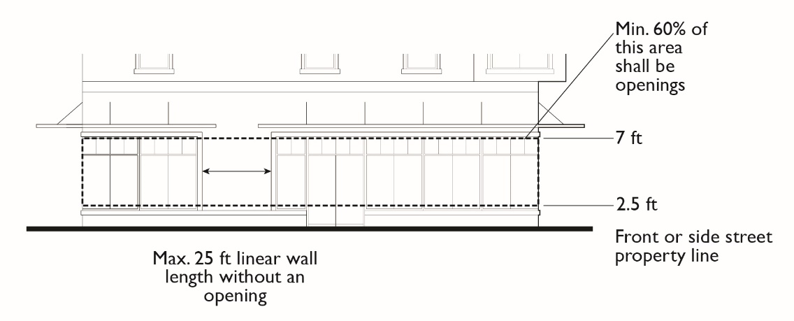
Building Transparency; Required Openings for Non-Residential Uses. Exterior walls facing and within 20 feet of a front or street side property line shall include windows, glass doors, or other openings for at least 60 percent of the building wall area located between 2.5 and seven feet above the level of the sidewalk. No wall may run in a continuous plane for more than 25 feet without a window or other opening.
Figure 15.04.202.040-D: Required Openings for Non-Residential Uses
1.
Design of Required Openings. Openings fulfilling this requirement shall have transparent glazing and provide views into work areas, display areas, sales areas, lobbies, or similar active spaces, or into window displays that are at least three feet deep.
2.
Exceptions for Parking Garages. Multi-level garages are not required to meet the building transparency requirement of this subsection. Instead, they must be screened and treated, consistent with the requirements of Article 15.04.607 (Parking and Loading Standards).
3.
Alternatives through Design Review. Alternatives to the building transparency requirement may be approved if the Zoning Administrator or the Design Review Board, whichever has approval authority, finds that:
a.
The proposed use has unique operational characteristics with which providing the required windows and openings is incompatible, such as in the case of a cinema or theater; and
b.
Street-facing building walls will exhibit architectural relief and detail, and will be enhanced with landscaping in such a way as to create visual interest at the pedestrian level.
F.
Building Design and Articulation. Buildings shall provide adequate architectural articulation and detail to avoid a bulky and "box-like" appearance. Building design shall reflect and complement the architectural style of significant historic buildings within the City. This may be accomplished through the incorporation of architectural style, colors, and materials similar to those used for historic buildings in Richmond. The following standards apply to commercial and mixed-use development in them Mixed-Use Districts. Residential-only development is subject to the building design standards for the RM2 District.
1.
Massing. Building massing shall align with the street grid of adjacent blocks.
2.
Relation to Existing Buildings. Buildings shall be designed to appear integrated with existing buildings in the district.
3.
Vertical Relationship. Buildings shall be designed to have a distinctive base (ground floor level), middle (intermediate upper floor levels), and top (either top floor or roof level). Cornices, balconies, roof terraces, and other architectural elements should be used, as appropriate, to terminate rooflines and accentuate setbacks between stories.
4.
Windows.
a.
Window frames shall be inset at least two inches from the face of the building to enhance shadow-line around opening.
b.
Snap-in vinyl mullions between double pane glass is prohibited. If a divided light appearance is desired, mullions must be made of dimensional material projecting in front of the panes on both the inside and outside of the window.
c.
Exceptions may be granted through the design review process to accommodate alternative window design complementary to the architectural style of the structure.
5.
Exterior Building Materials and Colors.
a.
A unified palette of materials shall be used on all sides of buildings.
b.
Exterior building materials shall be stone, brick, stucco, concrete block, painted wood clap-board, painted metal clapboard or other quality, durable materials approved through the design review process.
c.
A wainscoting of quality materials on the bottom of the ground floor façade is required.
d.
Colors shall be used to help delineate windows and other architectural features to increase architectural interest.
6.
Building Details.
a.
Building facades shall include building projections or recesses, doorway and window trim, and other details that provide architectural articulation and design interest.
b.
All applied surface ornamentation or decorative detailing shall be consistent with the architectural style of the building.
c.
All balconies that do not meet the minimum size required for private open space shall have a minimum horizontal dimension of two feet.
d.
Each side of the building that is visible from a public right-of-way shall be designed with a complementary level of detailing.
G.
Height on San Pablo Avenue. For the CM-3 Zone, the maximum allowable height shall not exceed 35 feet when abutting a single family residential zoning district.
H.
Pedestrian Access.
1.
Internal Connections. A system of pedestrian walkways shall connect all buildings on a site to each other, to on-site automobile and bicycle parking areas, and to any on-site open space areas or pedestrian amenities.
2.
To Circulation Network. Regular connections between on-site walkways and the public sidewalk and other planned or existing pedestrian routes and trails shall be provided. An on-site walkway shall connect the primary building entry or entries to a public sidewalk on each street frontage.
3.
To Neighbors. Direct and convenient access shall be provided from commercial and mixed-use projects to adjoining residential and commercial areas to the maximum extent feasible, while still providing for safety and security.
4.
To Transit. Safe and convenient pedestrian connections shall be provided from transit stops to building entrances.
5.
Interior Pedestrian Walkway Design.
a.
Walkways shall have a minimum clear, unobstructed width of six feet, where feasible, but at least four feet, shall be hard-surfaced, and paved with concrete, stone, tile, brick, or comparable material.
b.
Where a required walkway crosses driveways, parking areas, or loading areas, it must be clearly identifiable through the use of a raised crosswalk, a different paving material, or similar method.
c.
Where a required walkway is parallel and adjacent to an auto travel lane, it must be raised or separated from the auto travel lane by a raised curb at least four inches high, bollards, or other physical barrier.
6.
CM-3 and CM-4 Districts. Commercial development is permitted only if the Design Review Board determines that the site plan and building design is pedestrian-oriented with minimal building setbacks along primary street frontage. Where setbacks are proposed, they shall include public amenities, such as outdoor seating, shade structures and canopy trees.
I.
Residential Notification. The building owner shall inform residents of mixed-use development of potential noise from refuse collection and other activities typically associated with ground-floor commercial activity.
15.04.203.010 - Purpose and Applicability.
The specific purposes of the Commercial Districts are to:
A.
Designate adequate land for general commercial uses that are not compatible with mixed use development, including auto service uses.
B.
Maintain and strengthen the City's economic and fiscal resources and provide employment opportunities for residents of the City and surrounding communities;
C.
Establish appropriate development, design standards, and buffering requirements to protect adjacent uses and ensure land use compatibility; and
D.
Minimize the impacts of commercial development on adjacent residential uses.
The following Commercial Districts implement General Plan classifications of "Regional Commercial Mixed-Use" and "Marine and Waterfront Commercial".
CG General Commercial. This district is intended to accommodate retail, service, office, research and development, and limited industrial uses that are not compatible with mixed use development. This district offers maximum flexibility to allow the market to determine the mixture of non-residential uses. No residential uses are allowed.
CR Regional Commercial. This district is intended for mid-rise mixed-use development and regional shopping centers (e.g. Hilltop, Pacific East Mall, and Target) characterized by intensive development of retail space in compact and pedestrian-friendly environments. Office, retail and residential uses are allowed in mid-rise buildings.
CC Coastal Commercial. This district is intended to provide areas for waterfront-related retail and service uses in building forms appropriately scaled to the Bayfront. Shoreline access for the public must be provided. No residential uses are allowed.
The City Council may find, on case-by-case basis, that one or more of these commercial districts are conditionally consistent with certain General Plan "Mixed-Use" designations because mixed use development is not viable in the near- to mid-term and applying these districts to specific geographic areas would not impede implementation of the General Plan over the long-term.
15.04.203.020 - Land Use Regulations.
Table 15.04.203.020 prescribes the land use regulations for "Commercial" Districts. The regulations for each district are established by letter designations as follows:
"P" designates permitted uses.
"A" designates use classifications that are permitted after review and approval of an administrative use permit by the Zoning Administrator.
"C" designates use classifications that are permitted after review and approval of a conditional use permit by the Planning Commission.
"L#" designates numbered limitations listed at the end of the table.
"x" designates uses that are not permitted.
Use classifications are defined in Article 15.04.104 (Key Terms and Definitions). In cases where a specific land use or activity is not defined, the Zoning Administrator shall assign the land use or activity to a classification that is substantially similar in character. Use classifications and subclassifications not listed in the table or not found to be substantially similar to the uses below are prohibited. Section numbers in the right hand column refer to other sections of this Ordinance.
1 Schools with conditional use permits that are nonconforming can seek modifications to existing conditions of approval pursuant to Section 15.04.606.040(C), Expansion of nonconfirming uses.
(Ord. No. 27-18 N.S., § I(Exh. A), 11-20-2018; Ord. No. 30-18 N.S., § I(Exh. A), 12-18-2018)
15.04.203.030 - Development Standards.
Table 15.04.203.030 prescribes the development standards for Commercial Districts. Additional regulations are denoted in the right hand column. Section numbers in this column refer to other sections of this article, while individual letters refer to subsections that directly follow the table. The numbers in each illustration below refer to corresponding regulations in the "#" column in the associated table.
TABLE 15.04.203.030: DEVELOPMENT STANDARDS—COMMERCIAL DISTRICTS
Additional Development Standards—Commercial Districts
A.
Additional Development Standards. All development in the Commercial Districts is subject to the following standards.
1.
Landscaping. A minimum of 15 percent of the site must be landscaping, which may be reduced to 5 percent if buildings are located on front and street size lot lines. Additional landscaping may be required for parking areas.
2.
Public Improvements.
a.
Sidewalks. Sidewalks shall be provided if none already exist or if the existing sidewalks are in poor condition.
b.
Street Furniture. Trash receptacles, benches, bike racks, and other street furniture shall be provided.
c.
Street Lights. Pedestrian-scale street lights shall be provided.
d.
Street Trees. Shade trees shall be planted no more than 30 feet on center. Tree guards shall be provided. Trees shall be a minimum 15 gallons in size, and at least 10 percent of the required trees shall be 24-inch box size or larger.
3.
Orientation of Primary Building Entrance. The primary building entrance shall face or be oriented to within 45 degrees of or parallel to the street frontage. This entrance(s) must allow pedestrians to both enter and exit the building and must remain unlocked during business hours. Where a site is located on two public streets, a primary entrance shall be oriented toward the street with the higher classification. If a site fronts two public streets of equal classification, the applicant may choose which frontage on which street to meet the requirement.
4.
Building Transparency/Required Openings. Exterior walls facing and within 20 feet of a front or street side lot line shall include windows, doors, or other openings for at least 40 percent of the building wall area located between 2.5 and seven feet above the level of the sidewalk.
a.
Design of Required Openings. Openings fulfilling this requirement shall have transparent glazing and provide views into work areas, display areas, sales areas, lobbies, or similar active spaces, or into window displays that are at least three feet deep.
b.
Exceptions for Parking Garages. Multi-level garages are not required to meet the ground-floor transparency requirement. Instead, they must be screened and treated, consistent with the requirements of Article 15.04.607 (Parking and Loading Standards).
c.
Reductions through Design Review. The building transparency requirement may be reduced or waived if it is found that:
i.
The proposed use has unique operational characteristics with which providing the required windows and openings is incompatible, such as in the case of a cinema or theater; and
ii.
Street-facing building walls will exhibit architectural relief and detail, and will be enhanced with landscaping in such a way as to create visual interest at the pedestrian level.
5.
Building Articulation.
a.
Any building over 75 feet wide shall be broken down to read as a series of buildings no wider than 75 feet each.
b.
Buildings shall be designed to have a distinctive base (ground floor level), middle (intermediate upper floor levels), and top (either top floor or roof level).
c.
Building facades shall include building projections or recesses, doorway and window trim, and other details that provide architectural articulation and design interest.
6.
Exterior Building Materials.
a.
A unified palette of materials shall be used on all sides of buildings.
b.
Exterior building materials shall be stone, brick, stucco, concrete block, painted wood clap-board, painted metal clapboard or other quality, durable materials approved by the Zoning Administrator or Design Review Board, whichever has approval authority.
7.
Pedestrian Access. On-site pedestrian circulation and access must be provided according to the following standards.
a.
Internal Connections. A system of pedestrian walkways shall connect all buildings on a site to each other, to on-site automobile and bicycle parking areas, and to any on-site open space areas or pedestrian amenities.
b.
To Circulation Network. Regular connections between on-site walkways and the public sidewalk shall be provided. An on-site walkway shall connect the primary building entry or entries to a public sidewalk on each street frontage. Such walkway shall be the shortest practical distance between the main entry and sidewalk, generally no more than 125 percent of the straight line distance.
c.
To Neighbors. Direct and convenient access shall be provided from commercial and mixed-use projects to adjoining residential and commercial areas to the maximum extent feasible while still providing for safety and security.
d.
To Transit. Safe and convenient pedestrian connections shall be provided from transit stops to building entrances. Sidewalk "bulb-outs" or bus "pull-outs" may be required at bus stops serving commercial centers (building floor area over 25,000 square feet) to provide waiting areas for transit users and safety for passing motorists.
e.
Interior Pedestrian Walkway Design.
i.
Walkways shall have a minimum unobstructed width of six feet and shall be hard-surfaced.
ii.
Where a required walkway crosses driveways, parking areas, or loading areas, it must be clearly identifiable through the use of a raised crosswalk, a different paving material, or similar method.
iii.
Where a required walkway is parallel and adjacent to an auto travel lane, it must be raised or separated from the auto travel lane by a raised curb at least four inches high, bollards, or other physical barrier.
8.
Truck Docks, Loading, and Service Areas. Truck docks, loading areas, and service areas must be screened so as not to be visible from public streets. Drop-off areas may be located at the primary building entry.
B.
Shopping Centers. Shopping centers containing 25,000 square feet or more of floor area are subject to the following standards and criteria for approval.
1.
Entry Plazas/Passenger Loading Areas. A plaza shall be provided at the entry to each anchor tenant that provides for pedestrian circulation and loading and unloading. Entry plazas and passenger loading areas shall include unique, decorative paving materials, adequate seating areas, provision of adequate shade from the summer sun, and attractive landscaping including trees or raised planters. Entry plazas with features described under paragraph 2 below may be counted toward the public plaza requirements.
2.
On-Site Public Plazas. Outdoor plazas for the use of customers and visitors shall be provided at a rate of five square feet per 1,000 square feet of floor area, up to 1,500 square feet of outdoor plaza.
a.
Location. Public plazas shall be visible from a public street, or from on-site areas normally frequented by customers, and shall be accessible during business hours.
b.
Amenities. On-site public space shall include benches or other seating, and the ground surface shall be landscaped or surfaced with high-quality paving materials. Amenities shall be provided that enhance the comfort, aesthetics, or usability of the space, such as shade trees and other landscaping, shade structures, drinking fountains, water features, public art, and performance areas.
3.
Design Criteria. In order to receive design approval for a shopping center, the Design Review Board shall find that all of the following criteria have been met.
a.
Integrated Theme. Buildings and structures exhibit an integrated architectural theme that includes similar or complementary materials, colors, and design details.
b.
Site Entrance. The driveway entrance provides an organizing element to the site design with features such as a landscaped entry corridor or a divided median drive separated by a landscaped center dividing island. Buildings are located within 30 feet of the corner of the driveway and public right-of-way and building elements with greater vertical emphasis are used at these corners.
c.
Building Entrances. Building entrances to anchor tenants and other large stores are prominent and inviting. The architectural details of building entrances are integrated with the overall building design in terms of materials, scale, proportion, and design elements.
d.
Vehicular Circulation. Safe, convenient vehicular circulation is provided within the development through an appropriate system of internal vehicular circulation routes based on a hierarchy of drive aisles and cross routes. Vehicular and pedestrian conflicts are minimized. Where pedestrian circulation routes cross vehicular traffic aisles and driveways within a development, there are clearly delineated crosswalks that include clear sight lines, adequate warning signage, adequate lighting, and protective barrier posts or similar features at walkway entrances.
e.
Cart Corrals. Adequate, convenient cart corrals are provided near building entrances and throughout the parking areas.
f.
Transit Facilities. Transit facilities, where included, have effective shading from the summer sun and comfortable seating.
g.
Lighting. A combination of attractively designed and located lighting fixtures, including low pole lights, ground-mounted fixtures, light bollards, and architectural lighting provides interesting compositions for outdoor lighting, as well as a safe, secure environment.
h.
Shade Areas. Pedestrian areas, such as walkways, building entrances, and gathering areas, are adequately shaded from the summer sun through such techniques as the careful placement of trees and landscaping, trellis structures, projecting canopies, covered walkways, arcades, porticos, building orientation, and similar techniques.
15.04.204.010 - Purpose.
The specific purposes of the Industrial Districts are to:
A.
Designate adequate land for businesses, manufacturing and industrial operations, oil and gas facilities, and related storage, distribution and services supporting industrial growth and Port operations;
B.
Maintain and strengthen the City's economic and fiscal resources and provide employment opportunities for residents of the City and surrounding communities.
C.
Establish appropriate development and design standards and buffering requirements to protect adjacent uses and ensure land use compatibility; and
D.
Minimize the impacts of industrial development on adjacent residents.
The following Industrial District implement the General Plan classification of "Business/Light Industrial" and "Industrial".
IB Industrial, Business. This district is intended to accommodate a diverse range of business and light industrial uses, including office, general service, research and development, biotechnology, small-scale wholesale and warehousing facilities, and service commercial uses. It includes flex space, and industrial buildings for single or multiple users, limited personal services such as health and fitness studios, and other related uses. Small-scale retail and certain institutional uses are also permitted.
ILL Limited Industrial, Light. This district is intended to accommodate a diverse range of light industrial uses, including general service, research and development, biotechnology, warehousing, and service commercial uses. Small-scale retail and ancillary office uses are also permitted.
IL Industrial, Light. This district is intended to accommodate a diverse range of light industrial uses, including general service, research and development, warehousing, and service commercial uses. It includes industrial complexes, flex space, and industrial buildings for single or multiple users, warehouses, mini-storage, wholesale, commercial recreation, and other related uses. This district permits a higher development intensity than the ILL district. Small-scale retail and ancillary office uses are also permitted.
IG General Industrial. This district is intended to accommodate the broadest range of industrial uses. It includes industrial buildings and complexes, oil and gas refining and distribution, marine services, flex space, warehouses, manufacturing and assembly, and other uses that require large, warehouse-style buildings with flexible floorplans or space for outdoor facilities. Ancillary office uses are also permitted.
IW Water-Related Industrial. This district is intended for waterfront-related industrial development that includes manufacturing, warehousing and distribution, marine services, supporting office uses and other large-scale uses that support the Port of Richmond. Permitted uses include incubator-research facilities for marine-related activities, prototype manufacturing, testing, repairing, packaging, and storage as well as offices and support facilities. Accessory or secondary small-scale retail uses that serve local employees, Port users and visitors are also permitted.
15.04.204.020 - Land Use Regulations.
Table 15.04.204.020 prescribes the land use regulations for Industrial Districts. The regulations for each district are established by letter designations as follows:
"P" designates permitted uses.
"A" designates use classifications that are permitted after review and approval of an administrative use permit by the Zoning Administrator.
"C" designates use classifications that are permitted after review and approval of a conditional use permit by the Planning Commission.
"L#" designates numbered limitations listed at the end of the table.
"x" designates uses that are not permitted.
Use classifications are defined in Article 15.04.104 (Key Terms and Definitions). In cases where a specific land use or activity is not defined, the Zoning Administrator shall assign the land use or activity to a classification that is substantially similar in character. Use classifications and subclassifications not listed in the table or not found to be substantially similar to the uses below are prohibited. Section numbers in the right hand column refer to other sections of this Ordinance.
1 Schools with conditional use permits that are nonconforming can seek modifications to existing conditions of approval pursuant to Section 15.04.606.040(C), Expansion of nonconfirming uses.
(Ord. No. 27-18 N.S., § I(Exh. A), 11-20-2018; Ord. No. 30-18 N.S., § I(Exh. A), 12-18-2018; Ord. No. 25-20 N.S., § I(Exh. A), 11-10-2020)
15.04.204.030 - Development Standards.
Table 15.04.204.030 prescribes the development standards for Industrial Districts. Additional regulations are denoted in a right hand column. Section numbers in this column refer to other sections of this article, while individual letters refer to subsections that directly follow the table. The numbers in each illustration below refer to corresponding regulations in the "#" column in the associated table.
TABLE 15.04.204.030: DEVELOPMENT STANDARDS—INDUSTRIAL DISTRICTS
Additional Development Standards—Industrial Districts
A.
Transitional Standards. Where an Industrial District adjoins a Residential District, the following standards apply:
1.
The maximum height is (1) 35 feet within 40 feet of an RH or RL District; (2) 40 feet within 50 feet of an RH, RL or RM1 District; and (3) 50 feet within 100 feet of any Residential District.
2.
The building setback from a Residential District boundary shall be 15 feet for side and rear yards.
3.
A landscaped planting area, a minimum of 10 feet in width, shall be provided along all Residential District boundaries. A tree screen shall be planted in this area with trees planted at a minimum interval of 15 feet.
B.
Perimeter Landscaping. A perimeter planting strip shall be provided along all arterial streets and street frontages that are opposite Mixed-Use and Residential zoning districts.
C.
Additional Height Exceptions—IG and IW Districts. Processing equipment associated with port activities and with oil and gas refining may exceed the height limits.
(Ord. No. 30-18 N.S., § I(Exh. A), 12-18-2018)
15.04.204.040 - Supplemental Regulations.
A.
Building Design Near Interstate Highways 580 and 80. For any site that is fully or partially located within 200 feet of the right-of-way line of an Interstate Highway, buildings shall be designed with four-sided architecture where each exterior wall is designed equivalent to the primary façade in the extent of building articulation and quality of exterior materials, and consistent with the color scheme of the primary façade.
B.
Sidewalks. Sidewalks shall be provided if none already exist or if the existing sidewalks are in poor condition.
C.
Drive-In and Drive Through Facilities. Drive-in and drive-through facilities are not permitted in IG and IW districts and require a Conditional Use Permit in ILL and IB districts.
D.
Parking Location. Parking shall be located at the side or rear of buildings wherever possible.
1.
Customer parking should be located near the office area.
2.
Where parking is located between a building and a street, a landscaped setback at least 10 feet wide must be provided between the parking area and adjacent right-of-way.
E.
Limitations on Curb Cuts. Wherever possible, parking and loading entrances shall share curb cuts in order to minimize the overall number of curb cuts. On corner lots, curb cuts shall be located on the street frontage with the least pedestrian activity wherever feasible.
F.
Truck Docks, Loading, and Service Areas. The outermost point of the truck docks, loading, and service areas are not permitted within 20 feet of the boundary of a Residential District.
15.04.205.010 - Purpose.
The specific purposes of the Public, Cultural, and Institutional District and the Parks and Recreation Districts are to:
A.
Provide land for development of public, cultural and institutional uses that provide services to the community;
B.
Provide land for parks and recreation facilities; and
C.
Ensure design compatibility between public uses and adjacent residential neighborhoods.
The following districts implement General Plan classifications of "Public, Cultural, and Institutional" and "Parks and Recreation".
PCI Public, Cultural, and Institutional. This district is intended for city facilities, utilities, schools, and other public and quasi-public uses.
PR Parks and Recreation. This district is intended for active and passive public parks, including outdoor and indoor recreation such as playing fields, playgrounds, community centers, and other appropriate recreational uses. This district includes publicly owned local and regional parks as well as privately owned recreational facilities such as golf courses.
15.04.205.020 - Land Use Regulations.
Table 15.04.205.020 below prescribes the land use regulations for Public and Semi-Public Districts, and Table 15.04.205.030 prescribes the land use regulations for Open Space and Agricultural Districts. The regulations for each district are established by letter designations as follows:
"P" designates permitted uses.
"A" designates use classifications that are permitted after review and approval of an administrative use permit by the Zoning Administrator.
"C" designates use classifications that are permitted after review and approval of a conditional use permit by the Planning Commission.
"L#" designates numbered limitations listed at the end of the table.
"x" designates uses that are not permitted.
Use classifications are defined in Article 15.04.104 (Key Terms and Definitions). In cases where a specific land use or activity is not defined, the Zoning Administrator shall assign the land use or activity to a classification that is substantially similar in character. Use classifications and subclassifications not listed in the table or not found to be substantially similar to the uses below are prohibited. Section numbers in the right hand column refer to other sections of this Ordinance.
(Ord. No. 30-18 N.S., § I(Exh. A), 12-18-2018)
15.04.205.030 - Development Standards.
Table 15.04.205.030 prescribes the development standards for Public and Semi-Public, Open Space and Agricultural Districts. Additional regulations are denoted in a right hand column. Section numbers in this column refer to other sections of this article. The numbers in each illustration below refer to corresponding regulations in the "#" column in the associated table.
TABLE 15.04.205.030: DEVELOPMENT STANDARDS—PUBLIC AND
SEMI-PUBLIC DISTRICTS

(Ord. No. 30-18 N.S., § I(Exh. A), 12-18-2018)
15.04.205.040 - Supplemental Regulations.
A.
Landscaping. A minimum of 20 percent of the site must be landscaping.
B.
School Sites. In the event of closure of a school, the primary planned use of these sites remains for education and associated recreation purposes unless a General Plan amendment changes the land use designation.
C.
Truck Docks, Loading and Service Areas. Truck docks, loading areas, and service areas must be located at the rear or interior sides of buildings and screened so as not to be visible from public streets or residential properties.
15.04.206.010 - Purpose and Applicability.
The purpose of the Open Space and Shoreline Conservation districts is to protect open space and conserve natural resources and, more specifically, to implement the General Plan classifications of "Open Space" and "Shoreline Conservation."
OS Open Space District. The purpose of the OS Open Space District is to provide land for development of open, space uses, consistent with the General Plan. More specifically, this zoning district is intended for undeveloped publicly owned lands, visually significant open lands, water areas, and wildlife habitat. These areas are set aside as permanent open space preserves and may include trails, trail heads, agricultural uses (such as 4H), and other facilities for low-impact public recreational uses. This zoning district includes wetlands, mudflats, creek corridors and other natural preservation areas, as well as private lands deed-restricted for open space preservation.
OS-H Hillside Open Space. The purpose of the OS-H Hillside Open Space District is to protect undeveloped rural hillside land in El Sobrante Valley designated for open space in the General Plan where any substantial additional development in this area would be harmful and would displace agriculture and outdoor recreation, destroy scenic resources, impact stream flows, exacerbate erosion and pollution, reduce wildlife habitat, and substantially increase traffic in existing residential neighborhoods and along San Pablo Dam Road. Limitations on permissible uses and restrictions on development are established to implement the General Plan. A transfer of development credits program established under Article 15.04.611 will allow property owners in the OS-H District to transfer housing development potential to other parts of the City.
SC Shoreline Conservation District. The SC Shoreline Conservation District provides land for activities that at relate to the shoreline and the natural environment, ensures reasonable economic returns for landowners, and is compatible with shoreline resources and development constraints, including flood and seismic hazards, future sea level rise, and risks associated with extreme tides. More specifically, this districts provides for a mix of public and private open space, parks and recreational uses and associated concessions, agricultural uses, outside resource conservation/buffer areas, including cannabis cultivation and processing, and appropriate low-intensity/low-impact public, cultural, and institutional uses, including utilities, subject to standards to ensure resource protection and conservation of open space. Buildings and facilities must be temporary in nature, built for no more than a 20-year horizon. Small-scale take-out food service and bike (rentals located adjacent to the Bay Trail are conditionally allowed uses.
(Ord. No. 30-18 N.S., § I(Exh. A), 12-18-2018; Ord. No. 01-19 N.S., § II(Exh. A), 1-15-2019; Ord. No. 06-21 N.S., § II(Exh. A), 4-20-2021)
15.04.206.020 - Land Use Regulations.
Table 15.04.206.020 below prescribes the land use regulations for the OS Open Space District and SC Shoreline Conservation. These regulations are established by letter designations as follows:
"P" designates permitted uses.
"A" designates use classifications that are permitted after review and approval of an administrative use permit by the Zoning Administrator.
"C" designates use classifications that are permitted after review and approval of a conditional use permit by the Planning Commission.
"L#" designates numbered limitations listed at the end of the table
"x" designates uses that are not permitted.
Use classifications are defined in Article 15.04.104, Key Terms and Definitions. In cases where a specific land use or activity is not defined, the Zoning Administrator shall assign the land use or activity to a classification that is substantially similar in character. Use classifications and subclassifications not listed in the table or not found to be substantially similar to the uses below are prohibited. Section numbers in the right-hand column refer to other sections of this Ordinance. L1, L2
(Ord. No. 01-19 N.S., § II(Exh. A), 1-15-2019; Ord. No. 06-21 N.S., § II(Exh. A), 4-20-2021)
15.04.206.030 - Additional Use Regulations—OS-H District.
A.
If a reasonable use exception is requested pursuant to Section 15.04.206.070 and it is determined that a reasonable accommodation must be provided to enable an economically beneficial use, then:
1.
One single family dwelling unit may be built on each parcel or each 20 acres of a parcel, with normal and appropriate residential accessory uses and structures, including accessory dwelling units as required by state law;
2.
The maximum residential floor area for the principal dwelling unit shall not exceed the amount permitted by Section 15.04.201.030(G) or 4,000 square feet, whichever is less, with additional floor area allowed for accessory dwelling units and accessory structures for home occupations and offices; and
3.
Home occupations and offices are permitted, if they are secondary to residential uses and do not add more than 25 percent to the living area of the dwelling unit, and the occupations are conducted primarily by residents of the home and will not increase materially traffic in the OS-H District or on adjacent streets. The floor area for home occupations and offices shall be counted as part of the residential floor area for purposes of determining compliance with the maximum residential floor area allowed by paragraph (A)(2), above.
4.
Houses built under this subsection shall be designed and constructed as near as reasonably practicable to have substantially the same exterior form and use similar exterior materials as are used for existing houses and public utilities adjacent to the OS-H District, consistent with the General Plan. Exceptions to this requirement may be approved by the Zoning Administrator in order to reduce fire hazards or make reasonable accommodations for individual household's living requirements.
B.
If a parcel is transferred to another person, a residence may not be built on the parcel unless all of the transferable development credits provided for by the OS-H District for the parcel and its acreage are transferred to the parcel transferee. If one or more of the credits are used or transferred to any person, other than a transferee of the parcel, a residence may not be built on the parcel.
(Ord. No. 06-21 N.S., § II(Exh. A), 4-20-2021)
15.04.206.040 - Development Standards.
Table 15.04.206.040 prescribes the development standards for the Open Space Districts. Additional regulations are denoted in a right hand column. Section numbers in this column refer to other sections of the Ordinance. The numbers in each illustration below refer to corresponding regulations in the "#" column in the associated table.
TABLE 15.04.206.040: DEVELOPMENT STANDARDS—OPEN SPACE DISTRICTS

(Ord. No. 01-19 N.S., § II(Exh. A), 1-15-2019; Ord. No. 06-21 N.S., § II(Exh. A), 4-20-2021)
15.04.206.050 - Additional development standards—OS-H District.
A.
Minimum Parcel Size. If a legally created parcel smaller than 20 acres (a "subsize" parcel) is contiguous to another subsize parcel or parcels, or if a subsize parcel is linked to another subsize parcel or parcels by an intervening parcel or parcels, whether subsize or not, the parcels shall be treated pursuant to the General Plan as though they are a single parcel for purposes determining the number of allowable dwelling units, the development envelope, the maximum floor area, the maximum sign area, visibility protection, the award of development credits, and the application of visibility.
B.
Maximum Floor Area. The maximum aggregate floor area for all floors in all buildings on a parcel, except basement and cellar floors, shall not exceed 10,000 square feet. If residences and residential accessory buildings are permitted, they shall not exceed 5,000 square feet of the 10,000 maximum.
1.
With approval of a conditional use permit, the Planning Commission may increase the maximum floor area up to an additional 10,000 square feet, in aggregate, if necessary for agricultural use, processing, packaging, storage, or sale of produce, rearing, boarding, care and use of animals, or recreational facilities including camps and, separately, up to 20,000 square feet for covered riding arenas.
2.
With a conditional use permit, the permissible floor area of a parcel may be transferred to one or more other parcels within the OS-H district if there is no building on the transferor parcel. A transfer of floor area does not increase the 5,000-square foot limit for residences and residential accessory buildings on the transferee parcel. No more than 30,000 square feet of floor area in aggregate may be transferred to a parcel from one or more other parcels. If any floor area is transferred, then no building is permitted on the parcel from which the floor area is transferred, and a development restriction establishing this limitation shall be recorded in the Office of the County Recorder.
C.
Development Envelope. All buildings on a parcel must be located within a contiguous area, as compact as reasonably practicable, not to exceed two acres, except for buildings that the Planning Commission finds necessarily must be located outside that area for agricultural use, processing, packaging, storage or sale of agricultural produce, rearing, care, training or use of animals, government or public utility use, or to protect residents of other parcels from substantial noise, odor or vermin. All of the required findings in Article 15.04.805 also must be made.
D.
Development Easements. Before any building permit is granted, or a development credit or credits based on the parcel used or transferred, other than transferred to a grantee of the parcel, the Zoning Administrator must receive written evidence that an easement, running with the land, has been recorded on the parcel that bars development or use not permitted under the OS-H District. The easement shall be conveyed to the City and, if available, jointly to an independent land trust acceptable to the Zoning Administrator. The easement shall convey no possessory interest or liability to the City or the independent land trust, nor confer any right of public access.
E.
Signs. The following specific standards for signs apply in the OS-H District in addition to the standards in Article 15.04.609, Signs. They are intended to ensure that signs are no more numerous, larger, or more noticeable than necessary to provide directions and information about permissible uses.
1.
The total sign area for all permanent, freestanding non-exempt signs shall not exceed ten square feet for each parcel of 20 acres or more and for "subsize" parcels that are not required to be treated as a single parcel pursuant to subsection (A), above.
2.
No individual freestanding sign shall exceed six feet in height.
3.
One wall sign is permitted for each principal non-residential building, excluding accessory buildings and structures, not exceeding six square feet in area and not projecting more than six inches from the building wall. The Planning Commission may approve additional wall signs as part of a Master Sign Program pursuant to Section 15.04.609.170 upon finding that the visual charter of the area is not significantly changed, the additional signs are in harmony with other signs on the sign, and such additional signs are the minimum necessary to identify buildings and uses.
4.
No banners, feather banners, or pennants are allowed as temporary signate in an OS-H District.
F.
Areas of Special Environmental Concern. The following restrictions apply within the OS-H District. In each case, the Zoning Administrator shall make this determination as part of environmental review, pursuant to Section 15.04.803.060. The Zoning Administrator may impose reasonable conditions of approval related to impacts on these areas of special environmental concern in order to achieve the specific purposes of the OS-H district, the general purposes of Article XV, and consistency with the General Plan.
1.
Wetlands: Development on wetlands or use of wetlands for development is not permitted if by itself or in conjunction with other development or use such an action would reduce appreciably the quantity or biological quality of wetlands.
2.
Stream Corridors: Development or use is not permitted if by itself or in conjunction with other development or use it would impair appreciably the quantity or quality of water or of native vegetation in a stream corridor, except for otherwise permissible flood control to protect human safety, or preservation of special status species.
3.
Wildlife: No development or use is permitted that would reduce appreciably the number, prevent the recovery in number, or impair the genetic variability of one or more special status species.
4.
Steep Slopes: No building shall be located, in whole or in part, on a slope of 15 percent or more. No building shall be located on a site that cumulatively has access for more than 25 feet over a slope of 15 percent or more, unless there is no other development site on a parcel. Cultivated agriculture shall not be conducted on a slope of 20 percent or more. No grading shall take place on a slope of 15 percent or more unless necessary to maintain fire roads.
5.
Elevation: No building is permitted above 400-feet elevation unless the parcel involved is entirely above 400 feet.
G.
Visual Safeguards. Structures shall not be located on ridgelines or hilltops, or where they will project into the view of a ridgeline or hilltop from public streets and other publicly-owned land, unless there is no less obtrusive site on the parcel or on a contiguous parcel in legal or de facto common ownership. To the extent practicable, structures shall be located on that part of a parcel that minimizes visibility from roads, trails, and other publicly-owned land. Roads shall be located, to the maximum extent feasible, where they are least visible from publicly-owned land. New utilities shall be installed underground.
H.
Design Standards and Design Review Criteria. All development is subject to design review pursuant to Article 15.04.805. The following criteria shall apply in addition to the design review established in Section 15.04.805.040.
1.
Development shall be subordinate to and blend harmoniously with the natural and open space qualities of the surrounding area where it is located. The alteration of natural topography, vegetation, and other characteristics by grading, excavating, filling or other development activity shall be minimized, and successive padding or terracing of building sites shall be avoided. In all cases, appropriate landscaping, preservation of vegetation, design, and building materials shall be required by the City to reduce as much as practicable the visibility of development.
2.
Signs shall not be more numerous, larger or more noticeable than is necessary to provide directions and information about permissible uses.
3.
Visibility of development from roads, parks and other development shall be subordinate to and blend harmoniously with the natural and open space qualities of the area where located.
I.
Transfer of Development Credits. Under the provisions of Article 15.04.611, Transfer of Development Rights and consistent with the General Plan, the City Council has established a transferable development credit (TDC) program for OS-H District as a "Sending Zone." "Receiving Zones" are listed in Table 15.04.611.040 in Article 15.04.611. This program shall grant one credit to the owner or owners of each parcel, and one credit for each five acres of a parcel more than five acres, unless all remaining permissible residential development has previously been transferred from the parcel. Credits shall not be granted for parcels or acres above 400 feet elevation. Each credit may be used to build one residence in a receiving area, with the consent of the parcel owner there.
1.
TDC-based residences shall be similar in type and size to the residences that exist or otherwise may be built in the zoning district where they are located. Consistent with that similarity and with public health and safety, they do not have to comply with density limitations or other land-use regulations to the extent those regulations would bar or make impracticable their construction. No more than two TDC-based residences may be built on a parcel except as authorized by a specific plan or in a Planned Area District.
2.
Development credits may be sold or otherwise transferred to any person, regardless whether they own property in the OS-H District or the receiving area, including to and by the City and nonprofit entities. If, however, a residence is built on a parcel in the OS-H District, or the right to build vested, the credits based on the parcel or its acreage established by this subsection are then void and shall not be available to be transferred or used.
(Ord. No. 06-21 N.S., § II(Exh. A), 4-20-2021)
15.04.206.060 - Supplemental Regulations.
A.
Truck Docks, Loading and Service Areas. Truck docks, loading areas, and service areas must be located at the rear or interior sides of buildings and screened so as not to be visible from public streets or residential properties.
B.
Abutting Residential Districts. When a lot abuts a residential zoning district, the setbacks of the abutting district apply.
(Ord. No. 06-21 N.S., § II(Exh. A), 4-20-2021)
15.04.206.070 - Reasonable Use Exceptions.
A.
This section establishes the procedure for approval or disapproval of Reasonable Use Exceptions for proposed development in the OS-H Hillside Open Space District. Nothing in this section regarding the OS-H Hillside Open Space District is intended to preclude reasonable economic use of property as set forth in Section 15.04.206.030. If the requirements of Section 15.04.206.030 as applied to a specific lot in the OS-H Hillside Open Space District would deny all reasonable economic use of the lot, then development shall be permitted as set forth below if the applicant demonstrates to the satisfaction of the Planning Commission that all of the requirements of this section have been satisfied.
1.
Review Authority. The Planning Commission has the authority under this Article XV to approve, conditionally approve, or deny applications for reasonable use exceptions based on consideration of the requirements of this section.
B.
Application Requirements. Applications for reasonable use exceptions must be filed with the Planning Division on the prescribed application forms in accordance with the procedures in Article 15.04.803 (Common Procedures). An application for a reasonable use exception must include, but is not limited to, the following:
1.
Data or other evidence that conforms to the required findings set forth in Section 15.04.206.070(D) below (Required Findings);
2.
A calculation of the maximum floor area allowed by Section 15.04.206.050(B);
3.
A map showing the location, size, and areas of the parcel that are areas of special environmental concern, as identified Section 15.04.206.050(F);
4.
A map showing the location and areas of the parcel subject to the visual safeguards in Section 15.04.206.050(G);
5.
An analysis of the minimum development necessary to achieve reasonable economic use of the parcel, including a narrative of the factual basis for this determination;
6.
An analysis of whether any other reasonable use than that described in subsection 5 with less impact on the areas of special environmental concern is feasible, meaning capable of being accomplished in a successful manner within a reasonable period of time, taking into account economic, environmental, social and technological factors. This must also include an analysis of whether there is any practicable on-site alternative to the proposed development with less impact, including reduction in density, revision of lot layout and/or related site planning considerations that would allow a reasonable economic use with less adverse impacts to the open space and related buffers and the areas of special environmental concern;
7.
A design of the proposal so that the amount of development proposed as a reasonable economic use will have the least impact practicable on the areas of special environmental concern;
8.
An analysis of the modifications needed to the standards of Sections 15.04.206.040 and 15.04.206.050 to accommodate the proposed development;
9.
A calculation of the number of Development Credits attributable to the subject parcel under Section 15.04.206.050(I), and a description of the efforts the applicant has made to sell, transfer or otherwise utilize such Development Credits pursuant to the provisions in Article 15.04.611; and
10.
Such other information as the Zoning Administrator determines is reasonably necessary for the Planning Commission to evaluate the issue of reasonable economic use as it relates to the proposed development.
C.
Public Notice and Hearings. An application for a reasonable use exception requires public notice and hearing before the Planning Commission in accordance with Article 15.04.803 (Common Procedures).
D.
Required Findings. The Planning Commission may approve an application for a reasonable use exception as it was applied for, or in a modified form as required by conditions of approval, if, on the basis of the application, plans, materials and testimony submitted, the Planning Commission finds that:
1.
There is no other reasonable economic use or feasible alternative to the proposed development with less impact on the open space;
2.
The proposed development does not pose a threat to the public health, safety and welfare on or off the subject parcel;
3.
The alterations that would be permitted to the development standards in Sections 15.04.206.040 and 15.04.206.050 are the minimum necessary to allow for a reasonable use of the property and do to exceed the limitations established in Section 15.04.206.030(A); and
4.
The inability of the applicant to derive reasonable economic use of the property is not the result of actions by the applicant in subdividing the property or adjusting a boundary line, thereby creating the undevelopable condition after the effective date of the ordinance codifying this chapter.
E.
Conditions of Approval. When approving a reasonable use exception, the Planning Commission may impose reasonable conditions related to environmental impacts caused by the project application in order to:
1.
Achieve the specific purposes of the zoning district in which the project is to be located, the general purposes of Article XV, and consistency with the General Plan;
2.
Protect the public health, safety, and welfare of the citizens of the City of Richmond;
3.
Mitigate potential environmental impacts; and
4.
Ensure that the design of the proposed project will be compatible with the surrounding area where it will be located.
5.
No condition of approval can impose further discretionary review of the project by the Planning Commission.
F.
Decision; Appeals.
1.
Expiration, Extensions and Modifications. A reasonable use exception is effective and may only be extended or modified as provided for in Article 15.04.803 (Common Procedures).
2.
Appeals. The Planning Commission's decision may be appealed to the City Council in accord with Section 15.04.803.140 (Appeals).
(Ord. No. 06-21 N.S., § II(Exh. A), 4-20-2021)
15.04.207.010 - Purpose.
The purpose of the Agricultural Districts is to provide land for agricultural uses and maintain a character appropriate to the natural setting that promotes environmental stewardship. Two Agricultural Districts implement the General Plan classifications of "Agriculture" and "Industrial Agriculture".
AG Agricultural. The Agricultural District is intended to create, preserve, and enhance agricultural uses and activities in areas which are capable of and generally used for livestock and/or the production of food, fiber, and plant materials.
IA Industrial Agriculture. The Industrial Agriculture District is intended for agricultural uses, such as grazing and crop production, hydroponics and aquaculture, agricultural research and development, artisanal manufacturing, and limited industrial and manufacturing facilities related to agricultural activities, accessory business services and offices for agricultural uses and related activities, cannabis cultivation within greenhouses, on-site cannabis processing and ancillary uses, micro-breweries, small-scale health/fitness facilities for employees, communication facilities, and utilities. Buildings and facilities must be small-scale and low-impact, with a greater intensity only allowed for structures that are temporary in nature and generally built for no more than a 20-year horizon, such as greenhouses, nurseries, and other temporary facilities for agricultural production and industrial processing of agricultural products grown on-site. Small-scale eating facilities with take-out food service and bike rentals located adjacent to the San Francisco Bay Trail also are conditionally allowed.
(Ord. No. 01-19 N.S., § II(Exh. A), 1-15-2019)
15.04.207.020 - Land Use Regulations.
Table 15.04.207.020 below prescribes the land use regulations for the Agricultural District. The regulations are established by letter designations as follows:
"P" designates permitted uses.
"A" designates use classifications that are permitted after review and approval of an administrative use permit by the Zoning Administrator.
"C" designates use classifications that are permitted after review and approval of a conditional use permit by the Planning Commission.
"L#" designates numbered limitations listed at the end of the table.
"x" designates uses that are not permitted.
Use classifications are defined in Article 15.04.104 (Key Terms and Definitions). In cases where a specific land use or activity is not defined, the Zoning Administrator shall assign the land use or activity to a classification that is substantially similar in character. Use classifications and subclassifications not listed in the table or not found to be substantially similar to the uses below are prohibited. Section numbers in the right hand column refer to other sections of this Ordinance.
(Ord. No. 01-19 N.S., § II(Exh. A), 1-15-2019)
15.04.207.030 - Development Standards.
Table 15.04.207.030 prescribes the development standards for Agricultural Districts. Additional regulations are denoted in a right hand column. Section numbers in this column refer to other sections of the Ordinance. The numbers in each illustration below refer to corresponding regulations in the "#" column in the associated table.
TABLE 15.04.207.030: DEVELOPMENT STANDARDS—AGRICULTURAL DISTRICT
(Ord. No. 30-18 N.S., § I(Exh. A), 12-18-2018; Ord. No. 01-19 N.S., § II(Exh. A), 1-15-2019)
15.04.207.040 - Supplemental Regulations.
A.
Truck Docks, Loading and Service Areas. Truck docks, loading areas, and service areas must be located at the rear or interior sides of buildings and screened so as not to be visible from public streets or residential properties.
B.
Abutting Residential Districts. When a lot abuts a Residential zoning district, the setback standards of the abutting district apply. Barns, greenhouses, solar panels, and animal enclosures shall be at least 50 feet from a Residential district.
(Ord. No. 30-18 N.S., § I(Exh. A), 12-18-2018)