
Richmond City Zoning Code
SERIES 300
OVERLAY DISTRICT REGULATIONS
15.04.301.010 - Purpose and Applicability.
Overlay districts are zoning districts established by the City to carry out specific purposes. They are governed by a set of regulations, that address specific subjects, such as creek protection and historic districts, or impose requirements for neighborhood conservation plans that may be applicable in a variety of geographic areas within the City. Overlay districts may be initially established by adding a specific section to the 300 Series, Overlay District Regulations, without being actually delineate on the Zoning Map. At a later time, when an opportunity arises to carry out the intended purposes for one or more sites that meet the criteria for designation, the City Council may adopt an ordinance amending the Zoning Map to delineate the boundaries of the overlay district. The provisions of the overlay district then will be combined with the provisions of the base zoning district for that site or sites to which the overlay district applies and the more restrictive provisions will govern.
15.04.301.020 - Initiation.
The Planning Commission and the City Council may initiate an amendment to the zoning ordinance to establish an overlay district pursuant to the procedures established in Article 15.04.814 (Amendments to the Zoning Map and Text).
15.04.301.030 - Review and Approval.
The Planning Commission may recommend and the City Council may adopt ordinances enacting overlay district provisions pursuant to the requirements and criteria of Article 15.04.814 after duly noticed public hearings.
15.04.302.010 - Purpose and Applicability.
The purpose of the -CP Creek Protection Overlay District is to establish regulations and standards to preserve and enhance the City's creeks and riparian corridors as an important public asset that provides environmental, recreational and aesthetic value. More specifically, this Overlay district is intended to:
A.
Enhance creek corridors and riparian areas to extend the City's green infrastructure by restoring riparian habitat with appropriate vegetation and channel design; removing culverts and hardened channels where appropriate; improving creek access; avoiding future culverting or channelization of creeks; and ensuring appropriate and ongoing maintenance.
B.
Promote restoration of urban creeks and coordinate with property owners and local interest groups in restoration efforts.
C.
Require daylighting of creeks that are currently in culverts or hardened channels, where feasible, in redevelopment projects.
D.
Establish standards that allow public access in the floodplain and buffers along creek corridors without compromising the integrity of sensitive habitats.
E.
Secure land adjacent to creeks as permanent public open space through dedication or easements, wherever feasible and desirable; and
F.
Increase access to creeks for maintenance purposes; and
G.
Establish best management construction and maintenance practices for creek corridors that will ensure their long-term viability.
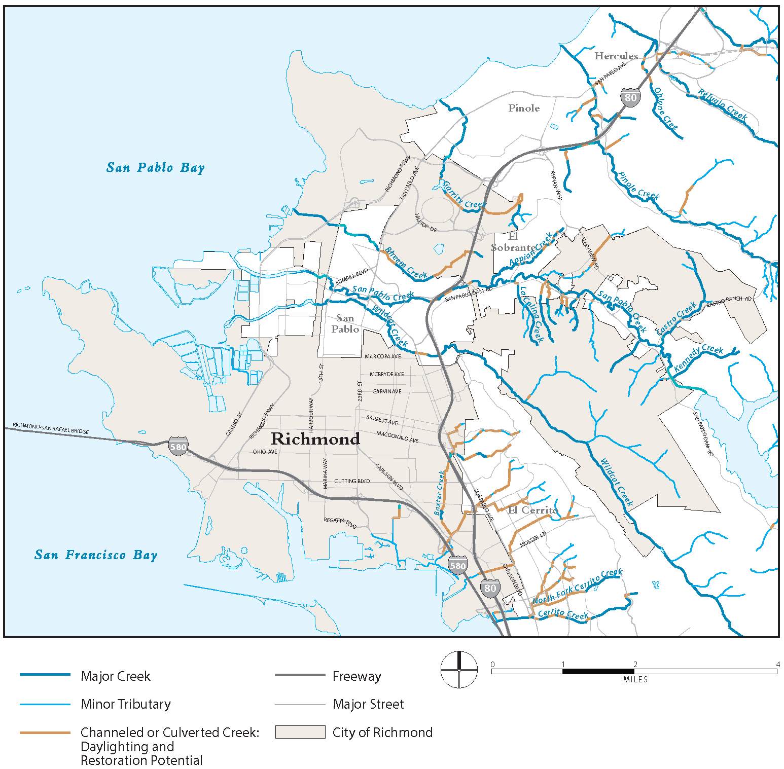
The regulations apply to all creeks and riparian systems as defined in the General Plan and shown in Figure 15.04.302.030, including culverted creeks that the Council may determine as having potential for future daylighting.
15.04.302.020 - Creek Determinations and Creek Mapping.
The general location of creeks subject to the regulations of this article shall be shown on the Zoning Map. In the event that a site-specific determination is required as to whether a creek exists on a property and the location of such creek, the City Engineer, in consultation with the Zoning Administrator, shall make such a determination, in consultation with the State Department of Fish and Wildlife, based on all application materials submitted and subject to the following provisions:
A.
Determination Criteria. A creek is a watercourse that carries water, whether identified or unidentified, from either a permanent or natural source, either intermittently or continuously and runs in a defined natural or engineered channel or continuous swale or depression. This definition excludes any part of an engineered system developed by a public agency for collection of storm or flood waters, provided, however, that such part does not follow the original course of a creek. Determinations of the existence of a creek and its location shall be based on the following factors:
1.
Micro-topography such as a "U" or "V" shape channel typically located at the low point of a macro-topographic feature.
2.
Macro-topography consisting of bowl, "U", or "V" shaped topography with high points draining to a valley or ravine as part of a large drainage network leading to larger creeks or the San Francisco Bay and San Pablo Bay.
3.
Flatland topography may consist of creeks in a shallow bowl or "U" shaped topography. Generally, these creeks flow from the hills toward the San Francisco Bay and San Pablo Bay following the slope of the land.
B.
Indicator Features. Determinations of the existence of a creek may also be based on whether any or all of the following features are present:
1.
A riparian corridor, meaning a corridor of relatively denser vegetation roughly parallel to the creek channel, or soil conditions that would support native riparian vegetation.
2.
A creekbed with material that differs from the surrounding geologic material (i.e., more rocky, or gravelly, little or no vegetation, sorted by size).
15.04.302.030 - Alterations to Streambed and Riparian Vegetation.
A.
General Prohibition. It shall be unlawful for any person, organization, institution, corporation or the City to fill, or cause to be filled, to obliterate or cause to be obliterated, to obstruct or cause to be obstructed, to place riprap or any debris in the channel or on the banks of, any creek, to construct a building bridging a creek or cause such building to be constructed, or in any manner to interfere with or cause to be interfered with, any creek in the City.
Figure 15.04.302.030: Creeks and Drainages
B.
Exceptions. Grading, alteration to the natural contours of the land, cutting or alteration, or removal of creek bank vegetation within the creek or creek setback area shall be permitted only in the following instances:
1.
Protection Projects. Projects necessary to protect adjacent land and structures from imminent flooding, erosion or landslide hazards, or maintenance or capital improvement.
2.
Creek Restoration and Enhancement. Creek restoration projects, subject to a conditional use permit and, if required, the approval of the California Department of Fish and Game, the U.S. Army Corps of Engineers, and the California State Water Resources Control Board. All creek restoration and enhancement projects must:
a.
Provides equal or better habitat and creek protection as compared to existing conditions;
b.
Not impair the functional capacity of the habitat;
c.
Not cause significant creek bank erosion;
d.
Not have a detrimental effect on water quality or quantity; and
e.
Be conducted or overseen by a certified professional with expertise in stream restoration and fluvial geomorphology processes.
3.
Low Intensity Passive Recreation. Construction of pedestrian and bicycle paths or greenbelts, foot bridges, nature study areas or conservation uses that do not significantly alter the natural contours of the land or compromise the integrity of sensitive habitats.
4.
Approved Structures. Structures required for the construction of a structure approved under Sections 15.04.302.050 and 15.04.302.060 and where the building permit for such structure has been issued.
15.04.302.040 - Construction near Creek Culverts and Channelized Creeks.
Any non-exempt construction within 30 feet of the centerline of a culverted or channelized creek that either expands the mass or footprint of an existing building, or builds a new structure whether or not subject to the securing of a building permit, requires approval of a conditional use permit for a roofed structure or an administrative use permit for other non-exempt structure and shall comply with the requirements of this section.
A.
The following structures shall be exempt from the requirements of this section:
1.
Any fence, arbor, trellis, pergola, gazebo, play structure or other similar unenclosed accessory structure not within the creek setback.
2.
Retaining walls less than three feet in height.
3.
Flag and light poles.
4.
Solar energy equipment.
5.
Prefabricated or other moveable one-story detached accessory buildings that are not permanently attached to a foundation.
B.
When daylighting is feasible, the application for a conditional use permit must include engineering and construction details for daylighting and restoring the creek to a natural condition using best practices for preservation and management of urban creeks, which must be approved by the City Engineer prior to the Planning Commission's action on the permit. The City Engineer may retain, at the applicant's expense, the services of an expert in creek restoration and hydrology to advise the City.
C.
The Planning Commission may approve reasonable increases in density and reductions in setbacks and parking requirements as mitigation for the development constraints and costs associated with daylighting and creek restoration.
D.
If the City Engineer determines that daylighting is infeasible, the applicant shall submit a report from a structural engineer, contemporaneously, with the application for a building permit, that establishes to the satisfaction of the City Engineer, each of the following:
1.
The structural integrity of the culvert under existing conditions is acceptable to the City Engineer and will not be compromised by the proposed construction;
2.
The proposed construction will not impede access for the responsible party to repair and maintain the culver; and
3.
The flow of the creek will not be impeded nor its water quality impaired.
15.04.302.050 - Creek Setback.
A.
Setbacks Required. All new structures, additions to existing structures, and new impervious surfaces, including driveways and patios, in the vicinity of an open creek or a culverted creek designated by the City Council for future daylighting shall be set back as follows:
1.
A minimum of 20 feet from the top of a creek bank, provided the bank or edge of riparian vegetation can be clearly determined; or
2.
A minimum of 30 feet from the centerline of the creek if the bank or edge of riparian vegetation cannot be clearly determined.
3.
The Zoning Administrator, in consultation with the City Engineer, may establish a different setback based on the results of a creek assessment report as required by subsection 15.04.302.060(E) and on flooding potential with a 100-year storm as determined from FEMA Flood Insurance Study maps.
B.
Separation of Public and Private Areas. Fencing may be required within creek setback areas to separate public or private use areas from the creek corridor and prevent encroachment in habitat areas. Fencing shall be designed to permit emergency and maintenance access and not obstruct wildlife migration corridors by allowing for passage of small mammals and other species.
15.04.302.060 - Permitted Uses and Limits on Uses Within Creek Setbacks.
Table 15.04.302.060 lists permitted uses for all development within creek setbacks. The "Additional Regulations" column indicates more detailed explanations in sections that follow the table (Section codes noted) or that are located elsewhere in this Zoning Ordinance.
"P" — Permitted as-of-right if in compliance with all standards.
"A" — Requites an administrative use permit granted by the Zoning Administrator.
"C" — Requires a conditional use permit granted by the Planning Commission.
A.
Allowed Uses Within Setback. Permitted uses within a creek setback are limited to:
1.
Passive recreational, educational, and existing non-structural uses, including private open space and public open space with pedestrian or bicycle paths, in accordance with best management practices.
a.
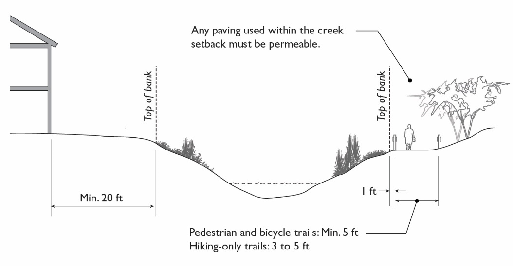
Any trail or greenbelt within the creek setback must be a minimum of five feet from the top of the creek bank, unless an engineered slope justifies a reduced buffer, which shall be no less than one foot.
b.
Pedestrian and bicycle trails and greenbelts within the creek setback shall be a minimum five feet in width, and hiking-only trails may be a three to five feet in width.
c.
Any paving within a creek setback must be permeable.
Figure 15.04.302.060-A: Standards within Creek Setback
2.
Utility lines, pipelines, drainage and flood control facilities. All turf areas, irrigation and drainage shall be designed to drain away from creek corridors to avoid impacts of irrigation and chemical use of pesticides and herbicides.
3.
Public bridges and public road approaches to bridges to cross a creek.
B.
Conditionally Permitted Uses Within Setback. Parking associated with permitted uses allowed on abutting property and bridges and road approaches to bridges to cross a creek may be permitted with the approval of a conditional use permit, provided the Planning Commission determines that:
1.
Alternative locations for parking and vehicle access are physically infeasible or more environmentally damaging; and
2.
An NPDES permit has been obtained for any parking areas located within the setback and all conditions of the NPDES permit are met.
C.
Minor Unroofed Structures Within Setback. Minor unroofed structures such as fences, walls, decks, or benches may be allowed within the creek setback with an administrative use permit, provided the Zoning Administrator determines that:
1.
The structure does not add any new impervious surface except for vertical structural elements such as posts or columns;
2.
No alterations to drainage will intensify or channelize water drainage into the creek;
3.
Construction of the structure will not remove or alter riparian vegetation;
4.
Best management practices are used to prevent erosion during construction; and
5.
No structural elements are located closer than 15 feet from the top of the creek bank.
Exceptions may be granted with a conditional use permit.
D.
Roofed Structures Within Setback. Structures having a roof supported by columns or walls, including dwellings, garages, other accessory buildings and commercial buildings, are not permitted within the creek setback. Exceptions may be granted with a conditional use permit, provided that the Planning Commission determines:
1.
Alternative locations outside the setback area or within the existing building footprint have been studied and found to be physically infeasible or more environmentally damaging;
2.
Adverse environmental effects are mitigated to the maximum extent feasible, and all feasible measures for creek protection are incorporated as conditions of project approval, including measures to protect riparian vegetation and wildlife and prevent erosion;
3.
The exception is necessary to allow a reasonable use of the site, similar to that on similarly zoning districts land in the vicinity; and
4.
No structure is closer than 15 feet from the top of the creek bank.
E.
Required Submittals for Roofed Structures. An application for an exception to creek setback requirements for roofed structures shall include all of the following:
1.
A creek assessment report that delineates the location of the creek centerline, the top of the creekbank and the creek setback area, describes the needs and purposes of the proposed project, and includes a site plan of the proposed development that shows all pervious and impervious areas and percentages. The report shall describe the existing site conditions, the extent of riparian vegetation including trees, and other existing conditions that allow assessment of the impacts of the construction on the creek. The report shall be prepared by a licensed surveyor, civil engineer, or other licensed professional registered by the State of California, and approved by the Zoning Administrator.
2.
Justification for seeking the exception, including why other alternative locations are infeasible, and how the setback encroachment will be minimized to the greatest extent possible.
3.
Any reports such as soil reports, surveys, hydrology study, or civil engineering drawings, as required by the Zoning Administrator, to determine whether the proposed project will have an adverse impact on the creek and to propose revisions or conditions of approval that mitigate the impact to the maximum extent feasible.
4.
A creek protection and riparian habitat plan that meets all of the following requirements shall be prepared by a landscape architect, hydrologist, biologist, environmental review professional, or other professional approved by the Zoning Administrator:
a.
The site development plan minimizes impervious surfaces and vegetation loss and site disturbance to the maximum extent feasible;
b.
The volume and velocity of storm water runoff to creeks or storm drains is not increased by the project. Storm water detention and treatment facilities are incorporated, such as permeable products porous pavement, modular pavers and decks instead of asphalt or concrete; installation of vegetation and vegetated swales; cistern or other detention/retention structure; infiltration trench; storm drain energy dissipaters; and runoff routed to landscaped areas.
c.
Erosion control and slope stability measures are incorporated, such as additional native tree and vegetation planting; erosion control fabric such as jute netting; terracing or berms; and crib walls with slope stabilization native vegetation planting.
d.
Best management practices are employed to assure that construction activity will not adversely impact the creek bank, riparian corridor, water flow, or water quality and include locating debris and construction materials away from the creek; protecting tree crowns and root zones; erosion control devices around construction areas; dust control; litter control; and prohibition of use of hazardous materials.
e.
Restoration and enhancement vegetation is proposed for all riparian habitat affected by the development.
F.
Exceptions to Required Submittals. The Zoning Administrator may grant exceptions to submittal requirements for projects that will not disturb the land or where on-site conditions clearly demonstrate that the site has no riparian vegetation. An applicant requesting a waiver of submittal requirements shall submit sufficient information to substantiate the waiver.
G.
Conditions of Use Permit Approval for Roofed Structures Within a Creek Setback. Approval of any roofed structure within the creek setback area is subject to the following requirements:
1.
All measures specified in the creek and riparian habitat protection plan shall become conditions of approval for the project. In addition, all such measures shall be carried out prior to completion of construction or concurrently with the installation of site improvements in the case of a subdivision map.
2.
All required permits from the California Department of Fish and Game, the U.S. Army Corps of Engineers, the California State Water Resources Control Board, or other applicable agency shall be obtained prior to, or concurrently with the approval of any city permits.
3.
A construction management plan shall be submitted, reviewed, and approved with all building permit applications that demonstrates how creek and riparian habitat protection measures will be implemented throughout construction.
15.04.302.070 - Culverts, Walls, and Other Structures within Creeks.
A.
When Allowed. Culverting and riprapping shall be prohibited unless an applicant presents compelling evidence that there is no other reasonable means to prevent the erosion of adjacent supports, foundations, or property. An administrative use permit shall be required to construct or cause to be constructed any wall, culvert, drain, bulkhead or other structure in any creek or to place riprap or any debris in the channel or on the banks of a creek.
B.
Determination of No Feasible Alternatives. A permit to construct any wall, culvert, drain, bulkhead or other structure pursuant to this section shall not be granted if the Zoning Administrator determines that that applicant has a reasonable alternative that will serve the same purpose, such as:
1.
Excavating to restore a natural meander, stream geometry and channel roughness.
2.
Clearing debris.
3.
Flood proofing through a minor redesign of buildings, relocation of porches or other minor structures, sheds, garages, raising of such structures, or raising the grade of adjacent land.
4.
Removing structures.
5.
Stabilizing the bank using vegetation or soil bio-engineering that does not degrade the existing natural environment. This may include the use of vegetated and dirt filled gabions, vegetated wood crib walls, live and dead brush matting, fascines, brush layering and cuttings, and other similar strategies based on employing plants as the long-term stabilizing materials.
6.
Vegetation management that can include selective clearing that retains a riparian canopy and root structure to preserve riparian habitat, control unwanted undergrowth and stabilize banks.
7.
Changes in site design, including but not limited to removal of impervious surface area.
C.
Coordination with Other Permit Requirements. All required permits from the California Department of Fish and Game, the U.S. Army Corps of Engineers, and the California State Water Resources Control Board shall be obtained prior to, or concurrently with, the approval of the administrative use permit.
15.04.302.080 - Construction Monitoring, Inspection and Maintenance Programs.
As a condition of approval for any project subject to the requirements of this article, provision for construction monitoring, inspection and maintenance shall be established along with a funding mechanism. Monitoring, inspection and maintenance programs shall include annual inspections and provisions to maintain hydraulic capacity of the stream channel, as well as protect, restore and enhance aquatic and riparian habitat. The following construction practices must be used to reduce erosion potential:
A.
Prevention of run-off during construction, which may include debris and sediment removal, clearing of brush and other vegetation that trap sediment;
B.
Vegetation management;
C.
Bank stabilization;
D.
Temporary water diversions;
E.
Construction scheduled for the dry season; and
F.
High flow bypass until the system is stabilized.
The City may allow dedication to the City or other appropriate public or private entity of a conservation easement or fee interest for long-term management of the creek area as determined necessary for flood control or protection of water quality and wildlife habitat.
15.04.303.010 - Specific Purposes.
The purposes of the -H Historic Districts and -L Landmarks Overlay Districts and the regulations in this article are to serve as the City's Historic Preservation Ordinance and implement the General Plan. More specifically, this article is intended to:
A.
Promote the general welfare by providing for the identification, protection, enhancement, perpetuation, and use of improvements, buildings, structures, signs, features, sites, places, and districts within the City that reflect important elements of the City's historical, architectural, archaeological, cultural, or aesthetic heritage for the following reasons:
1.
Encourage public knowledge, understanding, appreciation, and use of the City's past;
2.
Foster civic pride in the beauty and personality of the City and in the accomplishments of its past;
3.
Enhance the visual character of the City by encouraging new design and construction that complement the City's historical buildings;
4.
Increase the economic benefits of historic preservation to the City and its inhabitants;
5.
Protect property values within the City;
6.
Identify as early as possible and resolve conflicts between the preservation of historical resources and alternative land uses;
7.
Conserve valuable material and energy resources by encouraging continued or adaptive re-use and maintenance of the existing built environment;
8.
Provide a procedure for detailed application of the California Environmental Quality Act (CEQA) as it pertains to historic resources as defined in Section 21084.1 of the California Environmental Quality Act;
9.
Maintain designation as a Certified Local Government under 36 CFR Part 61 and satisfactorily perform responsibilities delegated by the State of California;
10.
Facilitate application of and compliance with federal legislation affecting historic properties, including Section 106 of the National Historic Preservation Act of 1966 (as amended);
11.
Identify properties and maintain a system for the survey and inventory of historic properties;
12.
Provide for adequate public participation in the application of public policy in historic preservation, including the process of recommending properties for nomination to the National Register of Historic Places, the California Register of Historical Resources, or the Richmond Historic Register;
13.
Provide owners of historic properties reasonable economic uses and inform them of available economic incentives for historic preservation;
14.
Provide a constitutional right of owners for due process for restrictions or proposed restrictions on the use of historic properties;
15.
Provide for zoning flexibility, preservation easements, and use of the State Historic Building Code;
16.
Deter demolition, destruction, alteration, misuse, or neglect of historically or architecturally significant districts, sites, buildings, structures and objects that are important to the city's past;
17.
Foster development tailored to the character and significance of each historic district through a historic district conservation plan that includes design standards; and
B.
Enable the use of the Mills Act to provide an economic incentive for the restoration and preservation of qualified historic properties by private property owners through reduced property taxes.
15.04.303.020 - Terminology.
For purposes of this article, certain terms and words are defined in this section. If any of these definitions are in conflict with the provisions of Title 24, Part 2, of the California Code of Regulations, entitled the California Building Code, then the requirements of Title 24 shall govern.
Alteration. Any external change in the character, composition, or structure of a potential historical resource or historical resource.
Archaeological Resource. Any material remains of past human life or activities which are of archaeological interest, as determined under uniform regulations promulgated pursuant to the Archaeological Resources Protection Act of 1979.
Building. Any structure used or intended for supporting or sheltering any use or occupancy. As used in this article and consistent with the California Health and Safety Code Section 18908(d) - State Building Standards, "building" does not include machinery, equipment, or appliances installed for manufacture or process purposes only, or any construction installations which are not part of a building or any goods movement equipment and facilities.
California Register of Historical Resources. The official listing of California's historical resources, including those of local, state, and national significance as defined in Section 5020.1(a) of the California Public Resources Code.
Certified Local Government. A city or town that has met specific standards enabling its participation in certain National Historic Preservation Act programs administered by the National Park Service and the State Office of Historic Preservation.
Character Defining Feature. The architectural, street and landscape features of a building, structure, object, or historic preservation district which help to convey historical significance.
Construction Installations. Materials installed temporarily to facilitate the construction of permanent structures and includes but is not limited to scaffolding, shoring, caissons, cribbing, diversion dams and formwork with an intended period of use, not exceeding three years.
Contributing Structure. A structure in an historic district that by its age, historical integrity, or historical significance is an essential part of the historic fabric of the district, or would reduce the integrity of the district by its inappropriate alteration or removal.
1.
A building contributing to the historic significance of a district is one that by location, design, setting, materials, workmanship, feeling and association adds to the district's sense of time and place and historical development.
2.
A building not contributing to the historic significance of a district is one that does not add to the district's sense of time and place and historical development; or one where the location, design, setting, materials, workmanship, feeling and association have been so altered or have so deteriorated that the overall integrity of the building has been irretrievably lost.
3.
Ordinarily, buildings that have been built within the past 50 years shall not be considered to contribute to the significance of a district unless a strong justification concerning their historical or architectural merit is given or the historical attributes of the district are considered to be less than 50 years old.
Dangerous Building. As defined in Section 302 of the Uniform Code for the Abatement of Dangerous Buildings, or by 2013 California Building Code, Title 24, Part 10.
Demolition. Any act or failure to act that destroys, destructs, or removes in whole or in part any element of a potential historical resource, an eligible historical resource, or designated historical resource such that its character, historical significance and/or integrity is materially altered.
Demolition by Neglect. The act of willingly allowing a structure or its components to deteriorate to a state that it becomes economically or functionally impractical to rehabilitate due to damage to structural components or those that define the essential historic characteristics (also see Chapter 9.22 of the Richmond Municipal Code, entitled Public Nuisances).
Exempt Alteration(s). Activities that do not require a City building permit and/or work that requires a building permit but that does not have potential to impair the historic significance of the historical resource, including plumbing, electrical, and mechanical improvements or repairs, and interior improvements (unless such improvements are contributing elements of the historic resource's historic significance).
Expert Professional. A person who meets the Secretary of the Interior's professional qualification standards contained within 36 CFR Part 61. The professional qualifications define the minimum education and experience required to perform identification, evaluation, registration, and treatment activities. If the City deems necessary, the City shall have the discretion to require additional areas or levels of expertise depending on the complexity of the task and the nature of the historical resource involved.
Expert Technical Analysis. A written report by an expert professional that evaluates the potential historical and architectural significance of a resource or contributing resource based upon accepted criteria and findings of fact. The expert technical analysis may also identify potential impacts to a resource and activities or actions that would reduce those impacts to below a level of significance.
Exterior Architectural Feature. The architectural elements embodying style, design, general arrangement, and components of all of the outer surfaces of an improvement, including but not limited to, the kind, color, and texture of the building materials and the type and style of all windows, doors, lights, signs, and other fixtures appurtenant to such improvement.
Goods Movement Equipment and Facilities means equipment and facilities used to move, handle, and store raw and finished materials in solid, liquid, and gaseous forms and includes but is not limited to conveyors, cranes, hoppers, chutes, pipes, ducts, channels, flumes, pumps, tanks and their supporting structures.
Historic District. A geographically definable area within the City possessing a significant concentration, linkage, or continuity of sites, buildings, structures, or objects united by past events or aesthetically by plan or physical development. A district may also comprise individual elements separated geographically but linked by association or history (36 CFR 60.3). Buildings, structures, objects and sites within a historic district are normally divided into two categories, contributing and non-contributing. Included in this designation are all districts listed, at the time of or subsequent to adoption of the ordinance codified in this article, on the National Register of Historic Places or the California Register, including but not limited to:
1.
Point Richmond Historic District.
2.
Winehaven Historic District.
3.
Richmond Shipyards Historic District.
4.
Civic Center Historic District.
Historic Preservation Commission. The City of Richmond Historic Preservation Commission.
Historic Property. A district, site, building, structure or object significant in American history, architecture, engineering, archeology or culture at the national, state, or local level (National Park Service, Preservation Terminology).
Historic Resource. Any building, structure, sign, feature, site, place, area, or other improvement of scientific, aesthetic, educational, cultural, archaeological, architectural, or historical value to citizens of the City and designated as such by the Council pursuant to the provisions of this article, including Richmond historic landmarks, and contributing structures in historic districts. The fact that a resource is not listed in, or determined to be eligible for listing in, the California Register of Historical Resources shall not preclude the City from determining whether the resource may be an historical resource for purposes of this article. "Historic resource" is synonymous with "historic property".
HPC. Historic Preservation Commission.
Integrity. The authenticity of a property's historic identity, evidenced by the survival of physical characteristics that existed during the property's historic period.
Major Alteration. Those alterations that are not exempt or do not qualify as minor alterations, which include, but may not be limited to: a) demolition; b) installation or alteration of windows, doors, or other historic features where the original opening is proposed to be enlarged, reduced or altered; c) additions to a structure or site that exceed 499 square feet; d) new construction within a historic district; e) additions that exceed 499 square feet within a historic district; f) relocation; and g) reconstruction.
Minor Alteration. Alterations that require a building permit but do not affect the historic significance of the historic resource because they meet the Secretary of the Interior's Standards for Treatment of Historic Properties. Minor alterations include: a) the installation of exterior features such as awnings and garage doors; b) installation or alteration of windows, doors or other historic features where the original opening will not be enlarged, reduced or altered; and c) additions that are less than 499 square feet.
National Register of Historic Places. The official listing of the United States' historic resources maintained by the Secretary of the Interior under the authority of the Historic Sites Act of 1935 and the National Historic Preservation Act of 1966.
Object. A construction that is primarily artistic in nature of relatively small scale and simple construction. Although it may be, by nature or design, movable, an object is typically associated with a specific setting or environment, such as a boundary marker, fountain, milepost, sculpture, or statuary.
Ordinary Maintenance and Repair. Any work, for which a building permit is not required by law, where the purpose and effect of such work is to correct any deterioration of or damage to a structure or any part thereof and to restore the same, as nearly as may be practicable, to its condition prior to its deterioration or damage.
Potential Historical Resource. Any resource 50 years or older that may, in the opinion of the Zoning Administrator, meet the findings of fact and criteria established in this article.
Preservation. The act or process of applying measures necessary to sustain the existing form, integrity, and materials of an historic property. Work, including preliminary measures to protect and stabilize the property, generally focuses upon the ongoing maintenance and repair of historic materials and features rather than extensive replacement and new construction. New exterior additions are not within the scope of this treatment; however, the limited and sensitive upgrading of mechanical, electrical, and plumbing systems and other code-required work to make properties functional is appropriate within a preservation project.
Process Equipment. Equipment used in the research, development or production of manufactured products and includes but is not limited to heaters, furnaces, reactors, incinerators, vaporizers, steam generators, boilers, pipes, ducts, pumps, pressure vessels, heat exchangers, compressors, and boilers.
Proposed Designation. Buildings, structures or areas nominated as Richmond historic landmarks, historic resources or historic districts by the Historic Preservation Commission.
Reconstruction. In accordance with the Secretary of the Interior's Standards for the Treatment of Historic Properties, the act or process of depicting, by means of new construction, the form, features, and detailing of a non-surviving site, landscape, building, structure, or object for the purpose of replicating its appearance at a specific period of time and in its historic location.
Rehabilitation. In accordance with the Secretary of the Interior's Standards for the Treatment of Historic Properties, the act or process of making possible a compatible use for a property through repair, alterations, and additions while preserving those portions or features which convey its historical, cultural, or architectural values.
Restoration. In accordance with the Secretary of the Interior's Standards for the Treatment of Historic Properties, the act or process of accurately depicting the form, features, and character of a property as it appeared at a particular period of time by means of the removal of features from other periods in its history and reconstruction of missing features from the restoration period. The limited and sensitive upgrading of mechanical, electrical, and plumbing systems and other code-required work to make properties functional is appropriate within a restoration project.
Richmond Historic Landmark. One or more Richmond historic resources having significant scientific, aesthetic, educational, cultural, archaeological, architectural, or historical value to the citizens of the City and designated as such by the City Council. A Richmond historic landmark is deemed to be so important to the historical and architectural fabric of the City that its loss would be a major loss to the City. Included in this designation are all individual resources that at the time of adoption of the ordinance codified in this article, or subsequently, are listed in or eligible for the National Register of Historic Places or the California Register or listed as Registered California State Historic Landmarks, including but not limited to:
1.
Alvarado Park, East Bay Regional Park District;
2.
Carquinez Hotel;
3.
East Brother Light Station, U.S. Coast Guard;
4.
Ellis Landing Site;
5.
Ellis Landing Shellmound Site;
6.
Ferry Point Pier, East Bay Regional Park District;
7.
Ford Motor Company Assembly Plant;
8.
Giant Powder Works, East Bay Regional Park District;
9.
Lower San Pablo Creek Archaeological District;
10.
Richmond Museum of History (4th and Nevin);
11.
Stege Mounds Archaeological District.
Secretary of the Interior's Standards for the Treatment of Historic Properties. The latest edition of the standards and guidelines provided by the National Park Service for preservation, rehabilitation, restoration, and reconstruction of historic properties.
Structure. That which is built or constructed. (Section 202 of Title 24, Vol. 1 of the 2013 California Building Code.) As used in this article, "structure" does not include machinery, equipment, or appliances installed for manufacture or process purposes only, any construction installations that are not part of a building, or any goods movement equipment and facilities.
Substantial Deterioration or Decay. Those conditions of the structure or property that are not so serious as to constitute demolition by neglect but nevertheless threaten the structural or historical integrity of the resource (also see Chapter 9.22 of this Code).
15.04.303.030 - Applicability.
This overlay district shall be applied to identified historic resources, potentially historic resources, and other land property located within a historic district. Buildings, structures, or objects that have been designated a historic resource by the City Council (CC) or that are located within a historic district shall continue to be subject to all zoning regulations of this Article XV and State and federal laws and regulations that would apply to such buildings, structures, or objects if they were not so designated or located. By designating historic resources and historic districts, the Council shall not be construed to be repealing or waiving any other portion of the Municipal Code as it applied to the designated property.
(Ord. No. 30-18 N.S., § I(Exh. A), 12-18-2018)
15.04.303.040 - Establishment of -H Historic Overlay Districts and -L Landmark Designations; Zoning Map Designators.
A.
An -H Historic Overlay District designation may be applied to any significant area or historic district, and an -L Landmark designation may be applied to any significant building on the Richmond Historic Register. These overlay designations may be combined with any base zoning district.
B.
Each -H Historic District or -L Landmark designation shall be shown on the zoning map by adding an -H or an -L designator, respectively, to the base zoning district designation followed by the number of the Historic District or Landmark designation, based on its order of adoption with reference to the enacting ordinance.
15.04.303.050 - Initiation.
A.
An application for an amendment to the zoning map for an -H Historic District designation or -L Landmark designation may be initiated by the City Council, the Planning Commission, the HPC, or by any resident of the City.
B.
Upon initiation, notice shall be provided in accordance with the provisions of Article 15.04.803 (Common Procedures). The Zoning Administrator shall post a Public Notice at the Richmond Civic Center and on the City's website and inform by mail all property owners that would be subject to the designation of the restrictions and incentives that will be placed on their property as a result of such designation, the language of this article, and how to avail themselves of a Mills Act contract and other incentives.
C.
If the designation is initiated by a property owner, the application must be accompanied by such historical and architectural information as is required by the HPC to make an informed recommendation concerning the application, together with the required fee.
15.04.303.060 - -H and -L Overlay District Designation Criteria.
A.
Upon the recommendation of the HPC and the approval of the City Council, a building, structure, object, site, or area not already designated as a historic or archaeological resource may be subject to a -H or -L overlay designation if it is found to meet any of the following criteria:
1.
It exemplifies or reflects valued elements of the City's cultural, social, economic, political, aesthetic, engineering, archaeological, or architectural history;
2.
It is identified with persons or events important in local, state, or national history;
3.
It reflects significant geographical patterns, including those associated with different eras of settlement and growth, particular transportation modes, or distinctive examples of park or community planning;
4.
It embodies distinguishing characteristics of an architectural style, type, period, or method of construction, or is a valuable example of the use of indigenous materials or craftsmanship; or
5.
It is representative of the notable work of a builder, designer, or architect whose style influenced the City's architectural development.
6.
A structure, site, or other improvement which meets any of the above criteria at the highest level, and whose loss would be a major loss to the City, may be designated a Richmond Historic Landmark.
15.04.303.070 - Procedure for Designating Property.
Any geographic area of the city, a site, and/or a building structure, or object may be designated with the -H or -L overlay in compliance with the following requirements.
A.
Eligibility for Designation of Historic Districts. A geographic area within the City that is included in the Richmond Historic Register may be designated with the -H or -L overlay if one or more of the designation criteria in Section 15.04.303.050 are met, as rigorously applied and supported by findings of historical or architectural significance.
B.
Optional District Historic Conservation Plan. Prior to filing an application for rezoning to apply an -H overlay, the applicant may prepare an optional Historic District Conservation Plan with the assistance of the Planning Department. Each Conservation Plan shall contain:
1.
A map and a detailed description of the proposed district, including boundaries; number of contributing elements and non-contributing elements, the age, setting, and character of the contributing elements; a map or list of addresses of each contributing and non-contributing elements; an informative historic context of the district and any associations under which the district appears eligible for listing, urban design elements and streetscapes; major public improvements; and proposed objectives to be achieved;
2.
A statement of the architectural or historical significance of the proposed district;
3.
A list of specific alterations (such as the replacement of windows, remodeling of an entryway, addition of dormers to the roof, or construction of a deck or staircase) that shall be subject to design review in order to protect the architectural or historical character of the proposed district; and
4.
A set of specific development guidelines for new construction and alterations necessary to preserve the character of the proposed district. The guidelines must include but are not limited to the following topics: architectural design, construction materials, height, setbacks, landscaping, roof details, and entry and window design.
C.
Application Requirements.
1.
Eligibility for Filing. An application for rezoning to apply an -H overlay zoning district or -L landmark designation may be initiated by the HPC, City Council, Planning Commission, or the property owner.
2.
Fee A fee as established in the City's Master Fee Schedule.
3.
Application Contents. The application shall include basic information on the proposed designation and the reasons justifying it and, in the case of an -H designation, the optional Historic Conservation Plan containing the information in paragraph B, above, and the application shall include evidence of the consent of the owner or authorized agent to the proposed designation. For purposes of this section, each condominium owners' association shall be deemed the property owner of common areas.
4.
Additional Information May Be Requested. Prior to accepting the application as complete, the Zoning Administrator may request additional information, plans or materials deemed necessary to support the application.
D.
Review and Approval.
1.
Preliminary Review. The HPC shall consider the proposed designation and make a preliminary determination based on the documentation provided whether to proceed with the designation process.
2.
Technical Assistance. The Zoning Administrator or Historic Preservation Commission may require and request the evaluation and analysis of a qualified preservation architect, archaeologist, architectural historian, or preservation landscape architect retained by the City. Such individual shall be appropriately licensed by the state in the profession pertinent to the type of project under consideration and shall have extensive experience in historic preservation, including the evaluation, nomination, qualification and rehabilitation of properties listed on the National Register of Historic Places. When applications are made by parties other than the Commission, the cost of technical assistance may be required by the Commission to be paid by the applicant.
3.
Study Session. If the HPC determines that the process of designating a Historic District or Landmark should proceed, it shall conduct at a minimum, one noticed study session to explain the proposal and the amendment process to neighborhood residents and, in the case of an -H overlay designation, to present the proposed Historic Conservation Plan if one has been prepared. After taking public testimony at the study session, the HPC shall decide whether to recommend the -H or -L designation to the Planning Commission.
4.
Public Hearing. If the HPC determines that an -H or -L designation may be appropriate and complies with the criteria of Section 15.04.303.050, the proposed district shall then be the subject of a public hearing before the City Council, noticed in accordance with RMC Section 15.04.970. In the case of a proposed historic district, notice of the date, place, time, and purpose of the hearing shall be made to owners of all properties within the proposed district, and to all property owners within three hundred feet of the proposed district boundary.
5.
Required Findings. In addition to the findings for the approval of a rezoning, a rezoning to apply the -H or -L designation shall require that the HPC, the Planning Commission, and Council shall also find that the proposed district or landmark has a significant architectural historical or cultural character that can be preserved and enhanced through appropriate controls on new development and alterations to existing buildings, structures, objects.
6.
City Council. Within thirty days of the close of the public hearing, the Historic Preservation Commission shall recommend approval in whole or in part or disapproval of the application for designation in writing to the Council, setting forth those findings that constitute the basis for the decision. The Council, within sixty days of receipt of the Historic Preservation Commission's recommendations concerning proposed designations, shall by resolution approve the recommendations in whole or in part, or shall by motion disapprove them in their entirety. Notice of the Council's decision shall be sent to all parties noticed of the Commission's hearing in accordance with [subsection] (b) above and any other interested or affected parties. Notice shall also be sent to the Building Official and to the Director of Planning and Building Services. Failure to Send Notice. Failure to send any notice by mail to any property owner where the address of such owner is not a matter of public record shall not invalidate any proceedings in connection with the proposed designation. The Historic Preservation Commission and Council shall also give other notice as they may deem desirable and practicable and as they may deem reasonable and necessary to ensure notice to all affected and interested parties.
7.
Adoption of Historic Conservation Plan (Optional). An ordinance establishing an -H district may be accompanied by a resolution approving a Historic District Conservation Plan, in the form submitted or as revised by the HPC, the Planning Commission, or the City Council.
a.
The development guidelines included within the Historic Conservation Plan may modify the development regulations of the base zoning district, but shall not change the maximum density or intensity standards of the base zoning district, nor alter the dimensional development standards by more than ten percent. When establishing modification to development regulations, special consideration shall be given to:
i.
Transitional height, setbacks, and upper-story stepbacks for non-contributory buildings adjacent to contributory buildings, when height is a character defining feature of a district; and
ii.
Parking requirements when a historic resource does not include on-site parking, and the zone has parking requirements.
b.
A guideline shall be found to be a significant alteration of base zoning district regulations if it substantially prevents property from being used in compliance with the provisions of the base zoning district, or creates a substantial number of nonconforming uses or structures.
8.
Amendment of Landmark Conservation Plan. An adopted Historic Conservation Plan may be amended by the HPC after holding a duly-noticed public hearing. Major amendments affecting land use and development regulations require approval of the Planning Commission at a duly-noticed public hearing.
E.
Post Adoption Actions to Preserve a Site. Following an eligibility determination, in addition to the process described above, the HPC may take action within the scope of its powers and duties as it determines are necessary for the preservation of a designated site. Such actions may include, but shall not be limited to, consultation with the property owner, civic groups, public agencies, and interested citizens; recommendations for acquisition of property by public or private bodies or agencies; and exploration of the possibility of moving one or more structures or features.
F.
Amendment or Rescission. The subject property owner, Historic Preservation Commission, or Council may initiate, amend or rescind any designation of an historical resource or historic district in the same manner and procedure as are followed for designation, if the resource no longer meets the designation criteria found to apply due to the subsequent discovery of information on the significance of the resource or the destruction of the resource by a catastrophic event.
15.04.303.080 - Permit or Work Moratorium.
While the HPC's public hearing on a proposed designation or the Council's decision on the Commission's recommendation is pending, the Council, upon the Commission's recommendation, may declare a permit or work moratorium on any project that would be affected by the proposed designation. Such moratorium shall be extended by the Council at the first regular Council meeting occurring after the Commission's public hearing, or the moratorium shall be automatically terminated. During the moratorium, any work that would require discretionary review by the Zoning Administrator or Planning Commission if the improvement were already designated an historical resource or if it were already located in an historic district shall not be carried out or granted a permit. The work or permit moratorium shall end at the time of the Council's decision to designate or not to designate an -H overlay or an -L designation on the project site, or earlier if the Commission so declares, but shall not exceed 180 calendar days in any event. A moratorium shall not be placed on work for which a permit has been issued unless the Council determines that the permit was issued in error based on false or misleading information provided by the applicant.
15.04.303.090 - Richmond Historic Register.
A.
Recording of Historic Resources. Designations of historic resources (buildings, structures, objects or sites) pursuant to this article shall be recorded in the Richmond Historic Register. The Richmond Historic Register shall be maintained on file with the City Clerk, the Director of Planning and Building Services, the Building Official, the Richmond Museum Association, the Richmond Library, the State Office of Historic Preservation, the Contra Costa County Historical Society, and the Northwest Information Center at Sonoma State University.
B.
Deletion of a Listed Structure Due to Demolition. When a listed structure has been demolished pursuant to any provisions of this Code, the City Clerk, upon notice thereof, shall cause such listed structure to be deleted from the Richmond Historic Register. Upon such deletion, the provisions of this title shall not be deemed to encumber or otherwise restrict the use of the subject remaining property.
15.04.303.100 - Land Use and Property Development Regulations.
A.
General Requirements. Proposed development and new land uses within an -H or -L overlay zoning district shall comply with all applicable requirements of the base zoning district, except:
1.
Where modified by another overlay zoning district;
2.
Where the Planning Commission grants an exception to the land use regulations of the base district zoning through a conditional use permit approval after determining that the exception is necessary to permit the preservation or restoration of a historic or architecturally significant building, structure, object or site; or
3.
In the event of a conflict between the requirements of the base zoning district or another overlay zoning district and the Historic Conservation Plan, the Historic Conservation Plan shall supersede.
B.
Ordinary Maintenance and Repair; Repair for Public Safety. Nothing in this section is intended to prohibit ordinary maintenance or repair of any exterior or interior architectural features in or on any property subject to an -H or -L overlay district designation that does not involve a change in design, material or external appearance thereof. Nor is this section intended to prohibit the construction, reconstruction, alteration, restoration, demolition or removal of any such architectural feature when the Zoning Administrator certifies to the HPC that such action is required for the public safety, due to an imminent unsafe or imminent dangerous condition, which cannot be otherwise rectified or restricted until corrections can be made. If the condition of an unsafe or dangerous historical resource does not pose an immediate threat to life or safety, the City official exercising authority for correcting such a condition shall consult with the Historic Preservation Commission before carrying out corrective measures.
C.
Preservation Easements. Preservation easements on the facades of buildings designated as a landmark may be acquired by the City or nonprofit group through purchase or donation pursuant to Civil Code Section 815.
D.
State Historic Building Code. The California State Historic Building Code provides alternative building regulations for the rehabilitation, preservation, restoration or relocation of structures designated as cultural resources. Such work on designated landmarks and historic/architecturally significant buildings with an -H overlay district shall be subject to the provisions of the California State Historic Building Code rather than the Uniform Building Code.
15.04.303.110 - Historic Building Code.
To the extent allowable under state law, the Building Official shall apply the State Historic Building Code (CCR Title 24, Part 8) for alterations and additions to structures on the Richmond Historic Register, California Register of Historical Places, and National Register of Historic Places.
15.04.303.120 - Certificates of Appropriateness.
A certificate of appropriateness shall be required prior to development, exterior alteration, restoration, rehabilitation, or relocation of any structure in an -H district or subject to an -L designation.
A.
Authority. The HPC shall have the authority to review and approve, approve with conditions, or reject a certificate of appropriateness pursuant to the procedures and criteria in this section.
B.
Exemptions. No certificate of appropriateness is required for ordinary maintenance; interior modifications; work pre-approved in a Mills Act contract; and any development, alteration, restoration, rehabilitation, or relocation that is not specifically described in an application for Historic District designation or Landmark designation or in a Mills Act contract application as having historical or architectural value. However, Zoning Administrator review is required to confirm whether an exemption is warranted.
C.
Criteria. To approve an application for a certificate of appropriateness, the HPC or the Zoning Administrator in the case of minor alterations and additions shall find that the proposed work conforms to the Secretary of the Interior's Standards for the Treatment of Historic Properties and more specifically:
1.
Whether the proposed construction, reconstruction, or relocation is appropriate and consistent with this section and, if applicable, the Historic Conservation Plan for the historic district.
2.
Whether the applicant has demonstrated that every reasonable effort will be made to minimize alteration of any contributory structure or designated landmark and preserve its integrity.
3.
With regard to any property located within an historic district but which is not a contributing structure, the proposed work does not adversely affect the character and integrity of the district.
4.
Whether the distinguishing original qualities or character of a contributory building, structure, or object, or site and its environment will not be destroyed, and the removal or alteration of any historic material or distinctive architectural feature will be avoided, to the greatest extent reasonably practical.
5.
Whether changes which may have taken place in the course of time are evidence of the history and development of a contributory structure or site and its environment and that such changes which may have acquired significance in their own right, will be recognized and respected.
6.
Whether distinctive stylistic features or examples of skilled craftsmanship which characterize a structure or site will be retained, to the extent reasonably possible.
7.
Whether any proposed project will have a minimal impact on any significant historical, architectural, or cultural material, and will be compatible with the size, scale, color, material, and character of the property, neighborhood, or environment.
8.
Whether additions or alterations to contributory buildings, structures, objects or sites or designated landmarks will be done in a manner that, if such additions or alterations were to be removed in the future, the essential form and integrity of the building, structure, object, or site would be unimpaired.
D.
Conditions. The Zoning Administrator may recommend, and the HPC may impose, all reasonable conditions to ensure compliance with the Historic Conservation Plan or maintain the integrity of the Landmark.
E.
Amendment to Certificate of Appropriateness. A certificate of appropriateness may be amended, extended, or modified at any time over the life of the building, only in accord with the procedures and criteria established for its original approval.
(Ord. No. 30-18 N.S., § I(Exh. A), 12-18-2018)
15.04.303.130 - Demolition Permits.
A demolition permit is required for any structure subject to an -H or -L overlay district designation, listed in the Richmond Historic Register, or Federal, State register and any building, structure, or object more than 45 years old or older. The decision to issue a permit to demolish a building, structure, or object or alter a site subject to an -H or -L overlay district or listed in the Richmond Register is discretionary, subject to review under CEQA.
A.
Application for a Demolition Permit. An application for a permit to demolish a building, structure, or object not listed in the Richmond Historic Register but is 50 years old or older shall include an eligibility evaluation on DPR523 series forms, as necessary, provided by the California Office of Historic Preservation (OHP), and prepared according to "Instructions for Recording Historic Resources" provided by the California Office of Historic Preservation. Based on an initial review of the form, the Zoning Administrator shall render an opinion within 30 days on whether the structure is eligible for listing as a historic resource.
B.
Referral to HPC. If a structure is eligible for listing as a historic resource, the Zoning Administrator shall refer the matter to the HPC. The HPC shall review the completed DPR523 series form, and the Zoning Administrator's opinion, and determine whether the structure is eligible for individual listing or as a contributing element to a -H Historic Overlay District on the National Register of Historic Places, the California Register of Historic Resources or Richmond Historic Register. If the HPC's determination conflicts with the opinion of the Zoning Administrator, the City Council shall resolve the conflict and determine the final opinion.
1.
If the determination is negative, no other action is required by the applicant.
2.
If the opinion is positive, then the applicant shall submit a DPR523 series form completed and signed by an individual meeting the U.S. Secretary of the Interior's professional qualification standards for history or architectural history and the Director of Planning and Building Services, or his or her designee, shall refer the matter to Historic Preservation Commission. The Commission shall review the completed DPR523 series form and determine if the structure is eligible for listing individually or as a contributing structure in a historic district on the National Register of Historic Places, the California Register of Historic Resources or Richmond Historic Register.
3.
If the building, structure, or object is determined to be eligible for listing either individually or as a contributing element, a Certificate of Appropriateness shall be required.
4.
An eligibility determination for listing in the Richmond Historic Register may be appealed to the City Council. An eligibility determination for listing in the National Register of Historic Places or the California Register of Historic Resources may be appealed only to the State Historic Preservation Office.
C.
Exceptions.
1.
A demolition permit for any property within the area covered by the Project PRISM Historic Resource Survey Report shall not be discretionary or require a Certificate of Appropriateness unless the property is listed in the Project PRISM Historic Resource Survey Report as a potential historic resource on the National, California or Richmond Register.
2.
Unless exempt from permit requirements by other laws or codes, a demolition permit shall be ministerial for the demolition of process equipment, goods movement equipment and facilities, and construction installations, as these are defined in this chapter.
15.04.303.140 - Maintenance and Upkeep.
A.
Duty to Maintain. All property owners in -H Historic Overlay Districts and all property owners of buildings, structures, or objects assigned an -L Landmark designation shall have the obligation to maintain structures and premises in good repair, and no owner shall permit the building, structure, or object to fall into a serious state of disrepair so as to result in deterioration of any architectural feature that would, in the judgment of the HPC, produce a detrimental effect upon the character of the Historic District or the life and character of a Landmark. Structures and premises shall be considered in good repair if they do not present material evidence of disrepair or material variance in condition from surrounding structures that are in compliance with the provisions of this ordinance.
B.
Ordinary Maintenance and Repair. Nothing in this article shall be construed to prevent the ordinary maintenance or repair of any exterior feature of any property covered by this article, so long as such maintenance or repair does not involve a change in exterior design, material, or appearance, or a technique that is contrary to the Secretary of the Interior's Standards for Treatment of Historic Properties. A change in existing paint color is not construed as a change in appearance or design unless the paint color was reviewed and approved as part of a previous discretionary review.
C.
Standards of Review. The standards of review for "good repair" and "disrepair" are as follows:
1.
Good Repair. Includes and is defined as the level of maintenance that ensures the continued availability of the structure and premises for a lawfully permitted use, and prevents unreasonable deterioration, dilapidation, and decay of the exterior portions of the structure and premises, including exterior character-defining features.
2.
Disrepair. Includes but is not limited to unreasonable deterioration of exterior walls, plaster, mortar or vertical or horizontal supports; deterioration of roofs and exterior chimneys; ineffective waterproofing, including broken windows or doors; or the deterioration of any other exterior feature that would create a hazardous or unsafe condition.
D.
Notice to Comply. If the Zoning Administrator determines that a historic resource or any other property in an -H District or any designated Landmark is being neglected and subject to damage from weather or vandalism, the Zoning Administrator shall meet with the owner or other person having legal custody and control of the historic resource or Landmark to discuss with them ways to improve the condition of the property. If no attempt or insufficient effort is made to correct any noted conditions thereafter, the Zoning Administrator may issue a Notice to Comply requiring the owner or other person having legal custody and control of the historic resource or Landmark to take action to require corrections of defects in the subject property in order that such historic resource or Landmark may be preserved in accordance with this section, except if the property owner can present clear and convincing evidence to the Zoning Administrator that his/her ability to improve the condition of the property is constrained by limited financial resources of other immediate and substantial hardship. If a financial or other hardship is found to exist, the Zoning Administrator shall make a written finding to that effect which specifies the facts relied upon in making such a finding and withdraw the order to comply until such time that the work needed can be accomplished.
E.
Prevention of Demolition by Neglect.
1.
General Obligation. The owner, lessees and any other person in actual charge or possession of an historical resource shall prevent demolition by neglect.
2.
Approval of Demolition with Showing of Extreme Hardship. If the applicant for an alteration or demolition permit presents facts clearly demonstrating to the satisfaction of the HPC that failure to approve an application will cause an immediate extreme hardship because of conditions peculiar to the particular structure or other feature involved, the Commission may approve or conditionally approve such application even though it does not meet the standards set forth in this article. In determining whether extreme hardship exists, the Commission shall consider evidence which demonstrates that:
a.
Denial of the application will diminish the value of the subject structure or property so as to leave substantially no value.
b.
Sale or rental of the property is impractical, infeasible, or uneconomic, when compared to the cost of holding such property for uses permitted in this zone.
c.
Improvement of the property in a manner which would preserve its character defining features is impractical, infeasible, or uneconomic.
15.04.303.150 - Enforcement and Penalties.
A.
Any person who violates a requirement of this article or fails to obey an order or permit issued pursuant thereto shall be guilty of a misdemeanor.
B.
Any person who constructs, alters, removes or demolishes a historic resource or Landmark in violation of this article shall be required to restore the building, object, site or structure to its appearance or setting prior to the violation to the extent such restoration is physically possible. Any action to enforce this provision may be brought by the City or any other interested party. This civil remedy shall be in addition to, and not in lieu of, any criminal prosecution and the penalty or other remedy provided by law.
15.04.303.160 - Mills Act Contracts.
A.
Purpose and Authority. Under the provisions of the Government Code (Section 50280 et seq., known at the Mills Act), the City may contract with the owner of any property listed on the National Register of Historic Places, California Register of Historic Resources or the Richmond Historic Register that are within an -H or -L overlay. The primary purpose for offering Mills Act contracts is to assist in the rehabilitation or restoration and long-term maintenance of historic resources in the City. Upon execution of the contract, the property owner will henceforth benefit from a potential reduction in property taxes, and the City will be assured via a regularly scheduled inspection of the exterior by the City for conformity, that the historic building is rehabilitated, maintained and preserved as necessary in a manner in compliance with the requirements of the State Office of Historic Preservation of the California Department of Parks and Recreation, the appropriate treatment approach outlined and described in the Secretary of the Interior's Standards for the Treatment of Historic Properties, and the State Historic Building Code.
B.
Program Applicability. All properties listed on the City's Historic Register and within an -H overlay or designated as a Landmark with an -L designation are eligible for Mills Act contracts. Potential historic properties are encouraged to seek designation in order to qualify for a Mill Act Contract.
C.
Term of Contract.
1.
All Mills Act contracts shall have a term of ten years and one year shall be added to this term annually upon each anniversary date of the contract unless one or both parties have taken action to terminate the contract. The City Manager shall be authorized to initiate contract termination on behalf of the City based on recommendations of the HPC. The contract rights and obligations are binding upon all successive owner of the property during the life of the contract.
2.
If the property owner or the City desires in any year not to renew the contract, that party must serve written notice of nonrenewal of the contract on the other party in advance of the annual renewal date of the contract. Unless the notice is served by the owner at least 90 days prior to the renewal date or by the City Manager at least 60 days prior to the renewal date, one year shall automatically be added to the term of the contract.
3.
Upon receipt by the owner of a notice from the City of nonrenewal, the owner may make a written protest of the notice of nonrenewal. The City may, at any time prior to the renewal date, withdraw the notice of renewal.
4.
If the City or the owner serves notice of intent in any year not to renew the contract, the existing contract shall remain in effect for the balance of the period remaining since the original execution or the last renewal of the contract, as the case may be.
D.
Application.
1.
Any person may file an application with the HPC to enter into a Mills Act contract. An application must be accompanied by the applicable application fee, which shall be non-refundable.
2.
An application shall contain the following information:
a.
Name and address of the applicant and of all owners of the subject property;
b.
Evidence that the applicant is the sole owner of the subject property or has the written permission of all owners to make such application and the grant deed;
c.
The location and legal description of the subject property;
d.
Photos of the property demonstrating its historic significance;
e.
A County Assessor's Parcel map;
f.
The most recent property tax bill;
g.
Evidence that the subject property is a qualified historic property (meaning a site/area/building subject to an -H or -L designation);
h.
A proposed plan for the preservation and, when necessary, the restoration and/or rehabilitation of the subject property, including a schedule and cost estimates prepared by licensed businesses, for all construction and maintenance work proposed to be performed;
i.
Evidence satisfactory to the HPC that execution of the Mills Act contract will result in the preservation and, when necessary, the restoration and/or rehabilitation of a qualified historic property; and
j.
Such other information as the HPC may require.
E.
Inspection of the Property. After the HPC determines that an application to participate in the City's Mill Act Program is complete, the Zoning Administrator shall cause to be conducted, and the owner or owners shall allow, one inspection of the exterior and interior of the subject property and whichever features of the property are needed to substantiate the information and evidence contained in the application as determined by the Zoning Administrator, and to determine whether any proposed work is necessary for and will result in the preservation and, when necessary, the restoration and/or rehabilitation of the subject property. If after the inspection the Zoning Administrator identifies that work is needed for restoration and/or rehabilitations of the subject property, the Zoning Administrator shall provide written findings to the property owner with a list and explanation of the recommended restoration and/or rehabilitation.
F.
Grant or Denial of the Application.
1.
Grant of Application. The HPC may recommend that the City Council authorize the City Manager to grant an application if, after the inspection required, the HPC determines that the information and evidence contained in the application has been substantiated, and that the work proposed is necessary for and will result in the preservation and, when necessary, the restoration and/or rehabilitation of the subject property. Upon receiving Council approval to grant the application, the City Manager and all owners of the subject property shall execute a Mills Act contract containing all of the provisions required and including any required improvement plan as an exhibit, incorporating its provisions into the contract. An historical property contract shall not be effective for any purpose unless all owners of the subject property execute the subject contract and pay the applicable nonrefundable, contract execution fee. Within 20 calendar days after execution of the contract and prior to recording, the owner or owners shall pay all required inspection, recording, and other fees set forth in the contract.
2.
Denial of Application. The HPC shall deny the application if it fails to contain the information and evidence required by applicable provision of the Government Code, or if the HPC determines that such evidence and/or information has not been satisfactorily substantiated following inspection of the subject property. The HPC shall also deny the application if he/she determines that granting the application would be inconsistent with any provisions of the Mills Act. At any time prior to denying an application, the HPC may suggest modifications or changes to the application that, if adopted by the applicant, would cause the application to conform to the requirements of this part.
3.
No Administrative Appeal. The decision of the HPC to deny the application shall be final and shall not be subject to administrative appeal.
G.
Exemption from Disqualification. Where a qualified historical property is ineligible to participate in the Program because of any provisions of this article or the Mills Act, the owner or other person authorized by the owner may file a request with the Zoning Administrator for an exemption from the disqualifying provisions pursuant to this section.
1.
Requirements for Exemption Request. A request for an exemption shall be accompanied by the applicable application fee and the applicable exemption request fee. The exemption request shall include evidence that, notwithstanding the disqualifying provisions, the subject property is deserving of a Mills Act contract due to its exceptional nature, or because it is subject to special circumstances not generally applicable to other qualified historical properties. After the Zoning Administrator determines that the exemption request application is complete, the Zoning Administrator shall inspect the property and evaluate whether the exemption is warranted due to the exceptional nature of the subject property or because the subject property is subject to special circumstances not generally applicable to other qualified historical properties.
2.
Zoning Administrator's Recommendation. Upon completion of his/her review of the exemption request and inspection of the subject property, the Zoning Administrator shall make a recommendation to the HPC to approve or deny the request based on the criteria set forth in in this article and the Administrator's evaluation of the evidence submitted to show that the subject property has an exceptional nature or is subject to special circumstances not generally applicable to other qualified historical properties that warrant the exemption.
3.
HPC Decision. The HPC shall be presented with information regarding the application for a Mills Act contract in a Staff report. The HPC may grant the exemption request if it finds that the applicant has substantiated the information and evidence required, and that the work proposed as part of a plan is necessary for and will result in the preservation and, when necessary, the restoration and/or rehabilitation of the subject property. If the HPC grants the exemption request, the decision of the Zoning Administrator shall be considered overruled and the City Manager and all owners shall execute a Mills Act contract.
F.
Required Provisions for Mills Act Contract. A Mills Act contract must contain all of the provisions required by sections 50280, 50281, and 50282 of the Government Code, including provisions that require:
1.
That the preservation, and any restoration and/or rehabilitation of the qualified historical property, conform to any rules and regulations established or adopted by the City regarding the preservation, restoration, and/or rehabilitation of qualified historical properties.
2.
An inspection of the interior and exterior of the premises by the Department every five years, or on any more frequent basis as the Zoning Administrator deems necessary, to determine the owner's or owners' compliance with the contract and a full report with images from HPC review is prepared.
3.
The owner or owners to provide all information requested by the Zoning Administrator and/or the HPC, for purposes of determining the owner's or owners' compliance with the contract.
4.
Such other terms and provisions as the Zoning determines are necessary.
G.
Recordation of a Mills Act Contract. Not later than 20 calendar days after the execution of property Mills Act contract, the Zoning Administrator shall cause to be recorded with the County Recorder a copy of the contract, which contract must adequately describe the subject property. The Zoning Administrator shall provide all owners with a copy of the recorded contract.
H.
Cancellation of a Mills Act Contract. A Mills Act contract shall be cancelled under the circumstances and pursuant to the procedures described in State law.
15.04.304.010 - Specific Purpose and Applicability.
In addition to the general purposes listed in Article 15.04.101, the specific purpose of the -IS Interim Study Overlay District is to allow discretionary review of development proposals in areas where changes in zoning regulations are contemplated or under study.
15.04.304.020 - Zoning Map Designator.
An IS district may be initiated as prescribed by Article 15.04.814 or established in an ordinance amending Chapter XV. Prior to approving an amendment reclassifying land to a future IS district, the Planning Commission and City Council shall approve a study plan that identifies regulatory problems and states land use and development issues to be resolved for the area proposed for reclassification. The IS district may be combined with any base district. Each IS district shall be shown on the zoning map with an "-IS" designator, numbered and identified sequentially by order of enactment and reference to the enacting ordinance.
15.04.304.030 - Study Districts Established.
Three IS overlay districts are established by Ordinance 16-16, carrying forward designations in prior Interim Zoning Regulations. These include lands where the pre-existing zoning district has been deemed inappropriate under the General Plan and assignment of a new classification and new zoning awaits completion and Council adoption of a specific plan or other planning and zoning study.
A.
IS-1 includes the Form-Based Code study area which includes Downtown Richmond and adjacent mixed use corridors;
B.
IS-2 includes the Richmond Bay Specific Plan study area; and
C.
IS-3 includes the Point Molate study area, where the City Council has initiated a review of appropriate zoning, development standards and related open space for General Plan implementation in the context of the Point Molate Reuse Plan.
These IS designations will expire no later than December 30, 2019, unless extended by action of the City Council, or rescinded early with Council action on the specific plan or other planning and zoning study.
(Ord. No. 30-18 N.S., § I(Exh. A), 12-18-2018)
15.04.304.040 - Land Use Regulations.
A.
Use Permit Required. Approval of a conditional use permit or, in the case of the IS-1 and IS-2 overlay districts, an administrative use permit shall be required for establishment of a new use or expanded use adding more than 10 percent to the existing floor area in a building in an IS district, and may be approved for any use classification permitted or conditionally permitted in the base district with which the IS district is combined. In addition, within IS-2, limited industrial development is permitted in an existing building, consistent with the base zoning. Minor additions to such buildings of up to 10 percent of existing floor area are allowed without discretionary review beyond that required for a building permit or design review. Repairs and maintenance also is allowed as may be necessary to comply with existing City codes and ordinances or to strengthen or restore to a safe condition any building, structure, or part thereof declared to be unsafe by the Director of Planning and Building Services or any other City official charged with the responsibility of protection of public health, safety and welfare. It is not the intent of this provision to hamper economic development and job creation, so uses permitted under the Planning Commission recommended Richmond Bay Specific Plan only require zoning compliance review in the IS-2 overlay district, not a use permit.
B.
Required Findings. In addition to the findings required for use permits by Article 15.04.806 and additional findings that may be required for specific use classifications, approval of a conditional use permit in the IS district shall require a finding that the proposed use will not conflict with the land use and development policies established for the area in the General Plan and being considered in proposed specific plans or other planning and zoning studies.
15.04.304.050 - Development Regulations.
Development regulations for the IS district shall be specified by a use permit or shall be those of the base district with which the IS district is combined.
15.04.304.060 - Expiration of IS District Ordinance—Renewal.
An ordinance establishing an IS district shall contain a provision terminating the IS designation one or two years from its effective date. An ordinance establishing an IS district may be amended, reenacted, or superseded by a zoning map amendment adopted as prescribed by Article 15.04.814.
15.04.304.070 - Resubmittal of Development Proposals.
Notwithstanding the provisions of Article 15.04.806, a conditional use permit application that has been denied, or approved subject to conditions unacceptable to the applicant, may be resubmitted on or after the effective date of zoning map or regulation amendments superseding an IS district designation.
15.04.305.010 - Purpose and Applicability.
The purpose of the -NC Neighborhood Conservation Overlay District is to provide the revitalization or conservation of older residential areas or districts possessing distinctive features, identity, or character worthy of retention and enhancement. The -NC Overlay District takes effect through adoption of a Zoning Map amendment and a Neighborhood Conservation Plan and a set of guidelines that will be used during development review and design approval to facilitate maintenance and protection of the neighborhood character and the development of vacant or underused lots.
15.04.305.020 - Minimum Area; Eligibility for Designation.
Each -NC Overlay District shall include a minimum contiguous area of 15 acres, including intervening streets and alleys, and shall contain at least 25 separate lots.
A.
Residential development in the proposed district must have begun at least 25 years prior to date the Neighborhood Conservation Overlay District is proposed.
B.
At least 75 percent of the land within the proposed boundaries for the district must be developed.
C.
The area must possess unifying distinctive elements of a built environment that create an identifiable setting, character and association.
15.04.305.030 - Establishment of -NC Neighborhood Conservation Overlay District; Zoning Map Designators.
An -NC Neighborhood Conservation Overlay District designation may be applied to any area of the City eligible for designation and combined with any base zoning district. Each -NC designation shall be shown on the Zoning Map by adding an -NC designator to the base zoning district designation followed by the number of the Overlay District designation, based on its order of adoption with reference to the enacting ordinance.
15.04.305.040 - Initiation; Neighborhood Council Consultation.
If initiated by residents, an application shall be submitted pursuant to Article 15.04.814 (Amendments to Zoning Map and Text). Prior consultation with the Neighborhood Council is encouraged so their comments can be incorporated into a proposed Neighborhood Conservation Plan.
15.04.305.050 - Neighborhood Conservation Plan Contents.
Each Neighborhood Conservation Plan shall contain:
A.
A map and description of the proposed district, including boundaries; the age, setting, and character of housing; distinctive elements of neighborhood and streetscapes; and proposed objectives to be achieved through the plan;
B.
A statement of the unique character of the proposed -NC Neighborhood Conservation Overlay District and the reasons why the land use regulations and development standards of the base zoning district(s) will not conserve that character;
C.
A list of specific modifications to base district land use regulations and development standards and any additional design standards that are necessary protect the unique neighborhood character of the proposed district; and
D.
A set of specific development and design guidelines for new construction and alterations necessary to enhance the district's identity and preserve the character of the proposed district.
15.04.305.060 - Adoption Procedure.
Adoption of an -NC Overlay District shall be by amendment to the Zoning Map pursuant to Article 15.04.814 (Amendments to Zoning Map and Text), and shall include concurrent approval of a Neighborhood Conservation Plan, which shall be approved by the City Council by resolution at the same time as the Zoning Map amendment is adopted. The plan shall establish standards and conditions for development consistent with the purposes of the plan and may include the following changes in land use regulations and development standards established by the underlying base district(s).
A.
Preliminary Review; Study Session and Neighborhood Workshop. The Planning Commission shall consider the proposed -NC Overlay District designation, at a study session, and determine whether to proceed with a neighborhood review process. If the Planning Commission directs City Staff to initiate a neighborhood review process, City staff shall conduct a neighborhood workshop on the proposed district to explain the proposal and the amendment process to neighborhood residents and to solicit community input.
B.
Public Hearing. After the neighborhood workshop, the proposed -NC Neighborhood Conservation Overlay District and Neighborhood Conservation Plan shall be the subject of a public hearing before the Planning Commission and, after the Commission acts, the City Council.
C.
Required Findings. In addition to the findings for the approval of a rezoning, a rezoning to apply the -NC Neighborhood Conservation Overlay District designation shall require that the Planning Commission and City Council shall also find that the proposed district has a significant neighborhood character that can only be conserved and enhanced through appropriate controls on new development and alterations to existing buildings and landscapes as contained in the proposed Neighborhood Conservation Plan.
15.04.305.070 - Land Use Regulations.
All permitted and conditional uses that are allowed in the underlying base district are allowed in the Neighborhood Conservation Overlay District unless specific limitations or prohibitions are imposed in a Neighborhood Conservation Plan to protect neighborhood character.
15.04.305.080 - Development Standards.
A.
Maximum Residential Density.
1.
The maximum residential density shall be specified in the Neighborhood Conservation Plan. This density may be less than the maximum set in the General Plan if a lower density is needed to ensure land use compatibility and minimize adverse impacts associated with infill development.
2.
In the event of conflicts with an underlying base zoning district, the maximum density in Neighborhood Conservation Plan shall control.
B.
Setbacks for Yards. Subject to any other applicable overlay district, the minimum setbacks shall be those specified in the Neighborhood Conservation Plan. If the minimum setbacks in the underlying base zoning district conflicts with the minimum setbacks in the Neighborhood Conservation Plan, the Neighborhood Conservation Plan shall control. Whenever a Neighborhood Conservation Plan fails to specify a setback, the setback standards of the underlying base zoning district shall be applied.
C.
Height. Subject to any other applicable overlay district, the maximum heights shall be those specified in the Neighborhood Conservation Plan. This maximum height may be less than the maximum set in the General Plan if a lower height is needed to ensure land use compatibility and minimize adverse impacts associated with infill development. If the maximum heights in the underlying base zoning district conflicts with the maximum heights in the Neighborhood Conservation Plan, the Neighborhood Conservation Plan shall control. Whenever a Neighborhood Conservation Plan fails to specify a height, the height standards of the underlying base zoning district shall be applied.
15.04.305.090 - Existing Lots and Structures.
All lots and structures existing at the time that the Neighborhood Conservation Overlay District is adopted shall not be deemed a zoning nonconformity solely because of this Overlay District. For example, replacement of existing structures with like structures that otherwise conform to the requirements of the underlying zoning district are allowed. All additions, changes, expansions, and alterations to such existing structures must comply with the regulations of the Neighborhood Conservation Plan unless the Planning Commission approves a modification to the proposed addition, change, expansion or alteration under Article 15.04.809 (Waivers).
15.04.306.010 - Purpose.
The purpose of the -S Shoreline Overlay District is to implement General Plan policies on shoreline protection and public access. More specifically, this overlay district is intended to ensure that any allowable development of the shoreline and tideland areas will protect water quality, wildlife habitats, and native or naturalized vegetation and, where appropriate, provide public access to and enjoyment of the shoreline.
15.04.306.020 - Applicability.
This overlay district applies to all land within 100 feet of the San Francisco Bay and San Pablo Bay shorelines and to tideland areas, excluding lands that are precluded from public access requirements because of federal regulations on homeland security. It also applies to a public access zone, which extends from the ordinary high water mark on the shoreline to the nearest public highway or arterial street in order to ensure that public access to the shoreline is provided and the San Francisco Bay Trail is completed, as envisioned by the General Plan. These regulations shall be combined with the base zoning district and, in the case of conflicts, the more restrictive provisions apply.
(Ord. No. 30-18 N.S., § I(Exh. A), 12-18-2018)
15.04.306.030 - Permit Requirements.
All uses and developments subject to an -S Shoreline Overlay District shall obtain a conditional use permit pursuant to Article 15.04.806 (Use Permits).
15.04.306.040 - Development Regulations.
A.
Habitat Protection. Development shall avoid encroachments into sensitive wildlife habitats to the extent feasible and shall not limit create barriers to wildlife movement which cut off access to food, water or shelter, or cause damage to fisheries or fish habitats. Access to environmentally sensitive marshland and adjacent upland habitat shall be restricted during spawning and nesting seasons, as appropriate.
1.
Buffers. Buffer areas shall be provided between developments and identified as potential wetland areas based on the following criteria: biological (habitat) significance; sensitivity of habitats or particular species; presence of threatened or endangered species; susceptibility of adjacent site to erosion; topography and configuration of wetland areas; and type and scale of development proposed.
a.
Built features (e.g., roads and dikes) may be considered as buffers, depending upon the constraints analysis and criteria noted above.
b.
Buffers between tidal areas and developed uses, except for access and recreation uses, shall be a minimum width of 100 feet from mean highest high water.
2.
Vegetation Removal. Proposed development shall not involve the unnecessary removal of vegetation that stabilizes soils, increases recharge and provides wildlife habitats. Any cleared area shall be revegetated with indigenous species of plants where the Planning Commission determines that revegetation is environmentally desirable.
3.
Freshwater Habitats. Freshwater habitats in the shoreline areas associated with freshwater streams, and seasonal wetlands shall be preserved and/or replaced and expanded such that the habitat values and functions are maintained.
B.
Protection from Hazards. Proposed development shall avoid areas subject to hazards, including differential settlement, slope instability, liquefaction, ground shaking and rupture and other ground failures, and flooding.
C.
Mitigation for Environmental Impacts. The Planning Commission may impose reasonable mitigation measures as conditions of approval of a conditional use permit, based on environmental review and the Zoning Administrator's recommendations after his/her consultation with state, federal, and regional agencies, to eliminate or reduce the adverse environmental impacts of proposed development.
1.
Wetland Protection. Wetland impacts shall be mitigated to maintain habitat values and functions with on-site or off-site restoration.
2.
Filling. Filling of the San Francisco Bay and San Pablo Bay and any areas subject to tidal action shall be permitted only if all of the following conditions are satisfied:
a.
The fill is the minimum necessary to achieve the purpose of the project and no alternative upland location is available for such purpose;
b.
The fill consists of small amounts of earth used solely to improve shoreline appearance or provide new public access to the bay;
c.
Fill content and placement is consistent with recommendations of a soils report prepared by a California-licensed soils engineer stating that no greater risk to persons or property would occur than on inland, stable sites; and
d.
The fill is approved by the Bay Conservation and Development Commission.
3.
Dredging. Dredging of the bottom of San Francisco Bay and San Pablo Bay, including mud flats, tidelands, marshes, and all wetland areas subject to tidal action, shall be permitted only if all of the following conditions are satisfied, as appropriate:
a.
New water surface or marsh is created by removal of bay fill;
b.
Existing navigation channels, basins or areas are maintained;
c.
Drainage or an outfall pipe or similar structure is provided;
d.
The location and depth of dredging minimizes shoaling and the need for maintenance dredging;
e.
An approved plan exists for the disposal of dredge spoils and all subsequent maintenance dredging for the life of the project; and
f.
The dredging is approved by the Bay Conservation and Development Commission.
D.
Site Planning and Structure Design.
1.
Site Planning.
a.
Development shall be sited, designed and undertaken so that it is harmonious with the character of the site and the surrounding environmental setting to the maximum extent feasible. This includes minimizing the area used for vehicle access, providing setbacks from non-disturbance buffers established for habitat protection, providing maximum feasible public access to the shoreline, where appropriate, and completing the San Francisco Bay Trail.
b.
No use, development or alteration shall create uniform and/or terraced building sites that substantially change existing watercourses and mature trees, native shrub or coastal shrub, marshes or primary wildlife habitats.
2.
Structure Design. Buildings, structures, parking lots, and landscaping in shoreline areas shall be oriented and located such that they preserve public views of the Bay from public rights-of-way, parks and other public spaces.
a.
Through design review, building heights may be limited to maintain a low profile. The maximum height of buildings in shoreline areas within 100 feet of the San Francisco Bay and San Pablo Bay shoreline, where the Bay Conservation and Development Commission has permit authority, may be reduced from the maximum set in the base zoning district if the Planning Commission determines that a different maximum height will protect public views from public rights-of-way, parks, and other public space while also allowing for reasonable use of the land.
b.
Visual access to the Bay and scenic vistas of water and distinct shorelines shall be protected, and the Planning Commission may impose reasonable conditions of approval to ensure that this object is met.
c.
To the maximum extent feasible, buildings shall be clustered to allow bay views from streets, trails, pathways, and enable continuous animal movement from uplands to marshes.
E.
Signage. Signage indicating access to public shoreline areas shall conform to San Francisco Bay Conservation and Development Commission Shoreline Signs Public Access Signage Guidelines and the requirements of Article 15.04.609 (Signs).
F.
Allowable Structures. No non-water-related structures are permitted outright within the 100-foot tidal buffer. Water-dependent uses, such as marinas, docking and seaport distribution facilities, boat repair, and other marine services and public facilities, such as paths, benches, picnic tables, and interpretive exhibits, may be allowed with an administrative use permit if the Zoning Administrator determines that the use will not adversely affect public views and it will not cause degradation to water quality or water-related habitat. Underground utilities shall be required for these uses unless such underground installation would have a substantial adverse impact on the environment.
G.
Maintenance of Undeveloped Land. All land that is not developed or altered shall be maintained in a manner that protects, conserves and enhances the natural resources of the site.
(Ord. No. 30-18 N.S., § I(Exh. A), 12-18-2018)
15.04.306.050 - Guarantees of Public Access.
Approval of conditional use permits for development within the -S Overlay District, including a public access zone as defined in Section 15.04.306.020, shall require guarantees of public access as prescribed by this section, unless access is restricted by Title 6, Chapter 1, Part 27, Sections 27.100 to 27.410 of the Code of Federal Regulations which require implementation of a security program to address homeland security. Nothing in this section shall constitute a waiver of possible historic rights to public use at the site of an access guarantee.
A.
Access Requirements. Prior to any discretionary approval for the following developments, the access provisions required by this section shall be found legally sufficient:
1.
Development on or adjacent to any land shown on the General Plan, the City of Richmond Bicycle Master Plan, South Richmond Transportation Connectivity Study, or a specific plan where a pathway, an accessway, or a trail segment is proposed;
2.
Development on a site on which a lateral accessway extending 25 feet inland from the San Francisco Bay and San Pablo Bay shoreline or to the toe of the bluff would be reachable or potentially reachable by a required vertical or lateral accessway, as determined by the Zoning Administrator. Lateral accessways shall be required where they would be accessible from a vertical accessway on a site that is developed or would be developed with visitor-serving commercial facilities;
3.
A subdivision between the first public road and San Francisco Bay and San Pablo Bay;
4.
A visitor-serving commercial facility between the first public road and San Francisco Bay and San Pablo Bay.
B.
Design of Public Access. Where public access is required pursuant to subsection (A) above, it shall meet the following standards:
1.
Access to and along the shoreline shall be provided by walkways, trails, or other appropriate means and connect to the nearest public thoroughfare where convenient parking or public transportation may be available. Shoreline trails shall be a minimum five feet in width. Multi-use paths and bicycle paths shall meet Class I bikeway standards as established by the Director of Engineering and Capital Improvement Projects.
2.
The distance between public shoreline access points shall be no more than 250 feet wherever feasible. Access points include tidal stairs, ramps, piers, floating docks, beach access, waterfront parks, and paths to marsh or tidal flats.
3.
Public shoreline access trails and paths shall be set back a minimum of 10 feet from any structure.
4.
Where the San Francisco Bay Trail is present or planned, existing or planned Bay Trail location shall be the primary design element of shoreline access, and the Bay Trail shall be constructed following the San Francisco Bay Trail Design Guidelines and Toolkit and the Public Access Design Guidelines for the San Francisco Bay and San Pablo Bay, published by the Bay Conservation and Development Commission.
5.
Where appropriate, raised boardwalks and meandering paths may be required to minimize or prevent adverse effects on wildlife, including habitat fragmentation and vegetation trampling.
Figure 15.04.306.050-B: Public Access to Shoreline
C.
Design of Staging Areas.
1.
Public access staging areas shall incorporate the following design features, as appropriate:
a.
Site furnishings, including restrooms, drinking fountains, benches, low walls or balustrades, trash receptacles, and low-level lighting.
b.
Signage with interpretive historical, cultural, and natural information.
c.
Enhanced crosswalks on public rights-of-way that lead directly to public shoreline access.
2.
Fences, planting, grade changes, and signage may be used to separate public areas from private development.
D.
Legal Instruments Required. Prior to approval of a final subdivision map or issuance of an administrative use permit or a conditional use permit, the applicant for development on a site on which access is required shall record one or a combination of the following documents as specified in the conditions of approval or shall pay an in-lieu fee.
1.
Offer of Dedication. The applicant shall submit a preliminary title report and shall record an irrevocable offer to improve and to dedicate the required accessway to the City as an easement or fee interest free of prior liens and encumbrances. The offer shall be valid for 20 years. Institutions or individuals holding an encumbrance on the property shall execute agreements subordinating their claims to the offer. Title insurance may be required when deemed necessary by the Zoning Administrator to ensure that the offer is an enforceable option.
2.
Outright Grant of Fee Interest or Easement. If the City is willing to accept the offer made in paragraph (D)(1) of this section, a grant of an easement or fee title shall be required.
3.
Deed Restrictions. Deed restrictions specifying accessway maintenance, improvements, and conditions of public use may be recorded in lieu of an offer of dedication.
4.
Offer to Sell at Appraised Value. Where a designated accessway on a single parcel requires parking or other land area in addition to land required for vertical and lateral accessways and the excess land required consists of more than two percent of the total remaining parcel area between the first public road and the bay, only the land required for vertical and lateral accessways shall be required to be improved and offered for dedication without financial consideration. The designated remaining land area shall be offered at the appraised value as of the date of approval of the permit with the offer to remain open for 20 years, at interest equal to the prevailing mortgage rate for similarly situated land.
5.
In-Lieu Fee Payments Required. As a condition of approval of a final subdivision map, zoning compliance certificate or use permit on a parcel between the first public road and the Bay, or in a subdivision containing lots between the first public road and the Bay where no access is feasible, an in-lieu fee shall be paid. The amount to be paid shall be determined by a schedule adopted by the City Council by resolution. In-lieu fees shall be paid to a Richmond Coastal Access Fund to be used for a specific public project identified in a Richmond Shoreline Access Program, should such a program be adopted by City Council subsequent to the passage of the ordinance codified in Article XV establishing this provision. Fees collected shall be committed within five years after payment thereof.