
Richmond City Zoning Code
SERIES 700
LAND DIVISIONS, DEDICATIONS AND IMPROVEMENTS
15.04.701.010 - Title, Citation, Authority and Incorporation by Reference.
The 700 Series will be known and cited as the "Subdivision Ordinance of the City of Richmond" or the "Subdivision Ordinance." The Subdivision Map Act (Title 7, Division 2, of the California Government Code, as amended) is hereby adopted by reference and made a part of this Ordinance as though it was fully set forth herein. The provisions of this Series are supplemental to the Subdivision Map Act.
15.04.701.020 - Purpose.
The purpose of this Ordinance is to regulate and control the division of land within the City of Richmond. These provisions implement and supplement the requirements of the Subdivision Map Act concerning the design, improvement and survey data of subdivisions, the form and content of all maps provided for by the Subdivision Map Act and the procedure to be followed in securing the official approval of the Zoning Administrator, Planning Commission, Director of Engineering and Capital Improvement Projects, and City Council regarding the maps.
To accomplish this purpose, the regulations in this Ordinance are determined to be necessary for the preservation of the public health, safety and general welfare, to promote orderly growth and development and to promote open space, conservation, protection and proper use of land, and to ensure provision for adequate traffic circulation, utilities and services. It is also the purpose of this Ordinance to ensure that the design and improvements of subdivisions is consistent with and promotes the goals and policies of the General Plan.
15.04.701.030 - Application.
The regulations set forth in this Ordinance shall apply to all parts of subdivisions within the City of Richmond and to the preparation of subdivision maps and to other maps provided for in the Subdivision Map Act. All subdivisions and parts of subdivisions lying within the City shall be made, and all subdivision maps shall be prepared and presented for approval, as provided for and required by this Ordinance. This Ordinance shall not apply to, affect, or modify any subdivision or part of a subdivision, lawfully created and recorded prior to the effective date of this Ordinance, or to any approval or conditions of approval of any map approved prior to the effective date of this Ordinance. This Ordinance is also inapplicable to actions that the Subdivision Map Act specifically excludes from its provisions including, but not limited to, the following:
A.
Financing or Leasing of Buildings. The financing or leasing of apartments, offices, stores, or similar space within apartment buildings, industrial buildings, commercial buildings, mobile home parks, or trailer parks.
B.
Other Leases. Mineral, oil, or gas leases.
C.
Cemeteries. Land dedicated for cemetery purposes under the California Health and Safety Code.
D.
Lot Line Adjustments. Lot line adjustments between four or fewer existing, adjoining parcels, provided:
1.
No additional parcels are created;
2.
The lot line adjustment is approved by the Director and the Public Works Director or by the Planning Commission on appeal based on a determination of conformance with the General Plan and Article XV, Planning and Zoning.
E.
Secondary Residences. The construction, financing, or leasing of secondary residences on a residential lot.
15.04.702.010 - Responsibilities.
A.
City Attorney. The City Attorney shall be responsible for approving as to form all subdivision Improvement Agreements and improvement securities.
B.
City Council. The City Council shall have final jurisdiction in the approval of final maps and subdivision improvement agreements and the acceptance by the City of lands and/or improvements as may be proposed for dedication to the City for Major Subdivisions. The City Council shall act as the final appeal board for hearing appeals of the approval, conditional approval or denial of tentative subdivision maps for Major and Minor Subdivisions.
C.
Director of Engineering and Capital Improvement Projects. The Director of Engineering and Capital Improvement Projects shall be responsible for:
1.
Establishing design and construction details, standards, and specifications;
2.
Determining if proposed subdivision improvements comply with the provisions of this Ordinance and the Subdivision Map Act and for reporting the findings together with any recommendations for approval or conditional approval of the tentative map for Major Subdivisions and Minor Subdivisions to the Zoning Administrator.
3.
Processing of final maps, reversion to acreage maps, and amended maps;
4.
Processing and approval of subdivision improvement plans;
5.
Examining and determining that final maps are in substantial conformance with the approved tentative map.
6.
Inspecting and approving subdivision improvements.
7.
Accepting dedications and improvements for Minor Subdivisions and offsite dedications lying outside a subdivision boundary that require a separate grant deed.
8.
Recording a notice of completion of private subdivision improvements when not to be maintained by the City.
9.
Collecting all required deposits and fees.
D.
Zoning Administrator. The Zoning Administrator shall be responsible for the processing of tentative maps and parcel maps, lot line adjustments, mergers, and certificates of compliance; and for the collection of application fees. The Zoning Administrator shall also be responsible for investigating proposed subdivisions for conformity to the General Plan, specific plans, and the Zoning Ordinance of the City.
E.
Planning Commission. The Planning Commission shall be the body responsible for approving, conditionally approving, or denying tentative maps for Major Subdivisions and appeals of Parcel Maps.
F.
Zoning Administrator. The Zoning Administrator shall be responsible for the approval, conditional approval or denial of Parcel Maps.
15.04.702.020 - Coordination with Zoning Approval.
Subdivision review may be carried out concurrently with the review of any applications for zoning approval.
15.04.702.030 - Notification Procedures for Public Hearings.
Notification for public hearings shall be provided according to the provisions for notification of public hearings in the Zoning Ordinance.
15.04.702.040 - Exceptions.
Following a public hearing, the Planning Commission may authorize exceptions to any of the requirements and regulations set forth in this Ordinance. A request for an exception shall be made by the subdivider and filed with the application for a tentative or parcel map. In order to approve an exception, the Commission shall make all of the following findings:
A.
There are special circumstances or conditions affecting the property that make it impractical to conform to all of the provisions prescribed by this Ordinance provided, however, that no exceptions may be granted to any requirements imposed by the Subdivision Map Act or any other applicable provision of State law;
B.
The exception is necessary to preserve the subdivider's substantial property rights;
C.
Granting the exception will not be detrimental to the public welfare or other property in the area where the subject property is located;
D.
Granting the exception will be consistent with the General Plan and any applicable specific plan.
15.04.702.050 - Appeals.
Decisions that are subject to appeal under the Subdivision Map Act or the Subdivision Ordinance shall be filed and processed in accordance with to the procedures for appeals provided in the Zoning Ordinance (see Section 15.04.803.130) and the procedures provided below.
A.
Appeals to the Planning Commission. A decision by the Zoning Administrator, the Director, or the Public Works Director may be appealed to the Planning Commission within 10 days of the issuance of the Notice of Action by filing a written appeal with the Planning Department. The appeal shall identify the decision being appealed, clearly and concisely state the reason for the appeal, and be accompanied by the fee specified in the City's Master Fee Schedule.
B.
Appeals to the City Council. A decision by the Planning Commission may be appealed to the City Council within 10 days of the issuance of the Notice of Action by filing a written appeal with the City Clerk. The appeal shall identify the decision being appealed, clearly and concisely state the reason for the appeal, and be accompanied by the fee specified in the City's adopted Master Fee Schedule.
C.
Procedures. The Director or the City Clerk, in the case of appeals to the City Council, shall schedule the appeal for consideration by the authorized hearing body within 30 days of the date the appeal was filed and shall provide written notice to the appellant, the subdivider, and all other parties known to have interest in the matter as required by the Zoning Ordinance and the Subdivision Map Act. The hearing body may sustain, modify, or reject the decision that is the subject of the appeal.
D.
Appeal Stays All Proceedings. The timely filing of an appeal shall stay all proceedings in the matter appealed.
15.04.702.060 - Fees and Deposits.
All persons submitting maps and other documents required by the Subdivision Ordinance shall pay all fees and/or deposits as provided by the City's Master Fee Schedule.
Fees shall be established by the City pursuant to Section 66451.2 of the Subdivision Map Act and the Mitigation Fee Act (Sections 66000 to 66025 of the Government Code).
15.04.702.070 - Initiation Procedures.
A.
Initial Application. Prior to or accompanying the submittal of a preliminary plan, the subdivider must complete an application on a form supplied by the Planning Division. This form must officially identify the subdivider as that person or entity responsible for the requirements set forth in the Subdivision Ordinance.
B.
Preliminary Plan and Accompanying Data. Prior to a Subdivision Conference, if requested (see subsection (C) below), the subdivider or the subdivider's representative must submit to the Planning Division a preliminary plan of the proposed subdivision, which may be in rough sketch form, together with general information of existing conditions of the site and the proposed development, including the following information:
1.
Intended Land Use, such as residential, industrial or other purposes;
2.
Location Map showing the relationship of the proposed subdivision to existing community facilities and other developments that serve or influence it;
3.
Sketch Plan, which may be a freehand pencil sketch made directly on a print of a topographic survey, and must delineate in simple form the proposed layout of streets, lots and other features in relationship to existing conditions;
4.
Map Details including the development name, if any, and location; main traffic arteries; proposed bicycle and pedestrian circulation and accommodation of transit; shopping centers; schools; parks and playgrounds; other community features such as carports, hospitals and churches, unusual features of terrain such as rock outcrops, tree masses, and watercourses on and adjacent to the proposed subdivision; scale; north arrow; date; perimeter boundary line of proposed subdivision; existing public utility facilities and easements therefor; sanitary sewer facilities and railroads, if any; and
5.
Photographs, such as site photographs to supplement the sketch plan (not mandatory).
C.
Optional Subdivision Conference. After the submittal of the preliminary plan and accompanying data, and prior to the submittal of a tentative map or tentative parcel map, the subdivider or his or her representative may request a Subdivision Conference. At the Subdivision Conference, the subdivider will be advised if areas for park, playground, schools, fire stations, libraries, bicycle paths, transit facilities, and other public and semipublic uses are required, and suitable locations may be suggested for them. Measures that will help produce excellence of design will also be suggested to the subdivider or the subdivider's representatives. The subdivider or the subdivider's representatives will be fully informed of applicable General Plan and specific plan policies and any other adopted policies, standards and regulations affecting development in the area.
D.
Written Copy of Comments and Recommendations Provided. A written copy of the comments and recommendations resulting from the Subdivision Conference shall be furnished to the subdivider.
15.04.702.080 - Maps Required.
The provisions for when tentative maps, tentative parcel maps, final maps, and parcel maps are required are as follows:
A.
A tentative map and final map are required for all divisions of land creating five or more parcels, five or more condominiums as defined by the Civil Code, a community apartment project containing five or more parcels, or for the conversion of a dwelling to a stock cooperative containing five or more dwelling units, except where any one of the following occurs:
1.
The land before division contains less than five acres, each parcel created by the division abuts upon a maintained public street or highway, and no dedications are required by the legislative body;
2.
Each parcel created by the division has a gross area of 20 acres or more and has an approved access to a maintained public street or highway;
3.
The land consists of a parcel or parcels of land having approved access to a public street or highway which comprises part of a tract of land zoned for industrial or commercial development, and which has the approval of the governing body as to street alignments and widths; or
4.
Each parcel created by the division has a gross area of not less than 40 acres or is not less than a quarter of a quarter section.
B.
A tentative parcel map and parcel map are required for all divisions of land into four or fewer parcels, and for those divisions of land described above in paragraphs (A)(1)-(4).
C.
A tentative parcel map or parcel map shall not be required for the following divisions of land:
1.
Subdivisions of a portion of the operating right-of-way of a railroad corporation, defined by Section 230 of the Public Utilities Code, which are created by short-term leases terminable by either party on not more than 30 days' notice in writing; or
2.
Land conveyed to or from a governmental agency, public entity, public utility, or for land conveyed to a subsidiary of a public utility for conveyance to that public utility for rights-of-way, unless a showing is made in individual cases, upon substantial evidence, that public policy necessitates a parcel map. For purposes of this subdivision, land conveyed to or from a governmental agency shall include a fee interest, a leasehold interest, an easement, or a license.
D.
Whenever a provision of the Subdivision Map Act or this Ordinance requires the filing of a tentative map, a vesting tentative map may be filed instead in accordance with the provisions of this Ordinance.
15.04.702.090 - Parcel Map—Waiver of Requirement.
A.
Applicability. In the following cases, the subdivider or his or her representative may submit an "application for waiver of parcel map" to the Zoning Administrator:
1.
A division of real property or interests therein created by probate, eminent domain procedures, partition, or other civil judgments or decrees; or
2.
A division of property resulting from the conveyance of land, or interest therein, to a public agency for a public purpose, such as school sites, public building sites, or rights-of-way for streets, sewers, utilities, drainage, etc.
B.
Procedure. This waiver shall only be granted by the Zoning Administrator upon a finding that the proposed division of land complies with the requirements of this Ordinance or the Subdivision Map Act as to area, improvement and design, floodwater drainage control, appropriate improved public roads, sanitary disposal facilities, water supply availability, environmental protection, and other requirements of this Subdivision Ordinance, and upon a finding that the Subdivision Map Act does not prohibit such a waiver.
C.
Tentative Parcel Map Required. Where the requirement for a parcel map is waived, a tentative parcel map shall be required.
15.04.702.100 - Required Findings.
A tentative or vesting tentative map or parcel map may not be approved unless the decision-making body makes all of the following findings:
A.
Consistency. The proposed subdivision, together with the provisions for its design and improvement, is consistent with the General Plan, any applicable specific plan, the Zoning Ordinance, and other applicable provisions of the City's Municipal Code.
B.
Physically Suitable. The site is physically suitable for the type of development and the proposed density of the development.
C.
No Environmental Damage. The proposed subdivision, together with the provisions for its design and improvement, are not likely to cause substantial environmental damage or substantially and avoidably injure fish or wildlife or their habitat, unless an Environmental Impact Report (EIR) was prepared and a finding was made that specific economic, social, or other considerations make the mitigation measures or project alternatives infeasible, pursuant to Section 21081(a)(3) of the Public Resources Code.
D.
Public Health Problems. The proposed subdivision, together with the provisions for its design and improvement, is not likely to cause serious public health problems.
E.
No Conflict with Easements. The proposed subdivision, together with the provisions for its design and improvement, will not conflict with easements acquired by the public at large for access through or use of property within the proposed subdivision. The City may approve a map if it finds that alternate easements for access or for use will be provided and that these easements will be substantially equivalent to ones previously acquired by the public.
F.
Availability of Water. Water will be available and sufficient to serve a proposed subdivision with more than 500 dwelling units in accordance with Section 66473.7 of the Subdivision Map Act.
15.04.703.010 - Purpose.
The purpose of this article is to establish the form, contents, submittal, and procedures for approval of all tentative maps, including tentative maps for divisions of land into five or more parcels and preliminary parcel maps for divisions of land into four or fewer parcels or where a tentative map is not required.
15.04.703.020 - Application for Vesting Tentative Map.
A vesting tentative map may be prepared and filed in place of a tentative map, pursuant to Article 15.04.704.
15.04.703.030 - Optional Preliminary Conference.
Prior to the submittal of any map, the subdivider may request a consultation with Department staff for technical advice and procedural instructions. Preliminary sketches of the subdivision may be submitted and discussed. Preliminary sketches must be to scale and in sufficient detail to indicate the essential characteristics of the subdivision, including the number, size, and design of the lots, the location and width of streets; the location of significant reservations of lands or easements; the relation of the subdivision to surrounding properties; and any other details necessary to enable a preliminary review. The Zoning Administrator shall schedule a conference with the subdivider to discuss the preliminary map and make recommendations concerning the submittal of a tentative or vesting tentative map. Such recommendations are not binding on the City or the applicant.
15.04.703.040 - Tentative Subdivision Maps and Parcel Maps: Filing, Form and Content, and Fee.
A subdivider shall file an application for a tentative map or preliminary parcel map with the Planning Department in a form determined by the Zoning Administrator. The application shall be accompanied by the materials specified below and any additional materials that the Zoning Administrator determines necessary to fulfill the requirements of this Ordinance and the Subdivision Map Act and the required fee.
A.
The tentative map shall be prepared by a by a California-registered civil engineer or California-licensed land surveyor and must contain the following information, unless waived by the Director of Engineering and Capital Improvement Projects:
1.
The subdivision name or number, date, north arrow, scale, and reference to the Richmond city datum with a sufficient legal description to define boundaries of the proposed subdivision and a vicinity map showing the location of the subdivision and City boundaries.
2.
The name and address of the record owner, the subdivider, and the civil engineer or land surveyor under whose direction the map was prepared, including the registration number of the engineer or surveyor.
3.
Topography, using contour intervals of one foot or less where ground slope is five percent or less, and contour intervals of five feet or less where ground slope is greater than five percent. Contours of adjacent land must also be shown whenever the surface features of such land affect the design and/or improvement of the proposed subdivision. The tentative map must contain a statement by the person preparing the map stating the source of contours shown on the map.
4.
The location and outline to scale of each structure on the property proposed for division. Each structure that is to be retained must be so noted.
5.
Approximate boundaries of areas subject to inundation or stormwater overflow, and the location, width and direction of flow of all watercourses.
6.
Approximate location of all trees and tree masses, 12 feet or more in height, standing within the boundaries of the subdivision.
7.
The locations, widths, grades and names of all existing or proposed streets, alleys, pedestrian ways, bicycle paths, transit facilities, railroad rights-of-way and grade crossing, and other rights-of-way within and adjacent to the subdivision, and the radius of each centerline curve. All streets and alleys intended to be private must be clearly so designated.
8.
The location and dimension of all known existing easements and reserves and all proposed public easements.
9.
The location of existing utilities, sewers, drainage ditches and other drainage facilities located in, or adjacent to, the proposed subdivision.
10.
The approximate lot layout and the approximate dimensions of each lot and of each building site, the approximate finished grading of each lot, the preliminary design of all grading, the elevation of proposed building pads, and the top and toe of cut and fill slopes to scale.
11.
Proposed plan and easements for drainage and for handling stormwater.
12.
Statement of the present use, zoning district(s), and the proposed use(s), including areas to be reserved for public or semi-public use.
13.
Source of water supply and proposed plans and easements for sewerage and provision for sewage disposal.
B.
The following information, data and reports shall be submitted with, but not on, the tentative map or tentative parcel map:
1.
A grading and drainage plan.
a.
The grading plan shall show:
i.
Existing and proposed contour lines;
ii.
Topographic information on any adjoining properties within 100 feet of the boundary lines of the proposed tentative map; and
iii.
The location, size and species of all trees.
b.
Tentative maps within a hillside area shall include topographic information based on a field survey or an aerial survey.
2.
A preliminary soils report.
3.
Preliminary geologic and seismic safety reports for tentative maps that are within geologic or seismic hazard areas or in hillside areas.
4.
A preliminary archaeological survey for tentative maps within an area of cultural significance, including but not limited to, prehistoric or historic archaeological sites, buildings, structures, objects, and unique cultural resources.
5.
An acoustical analysis may be required by the Zoning Administrator to demonstrate compliance with the standards of the General Plan.
6.
The characteristics of all proposed parks, open spaces and school facilities, including the methods of land acquisition, improvement and maintenance.
C.
The Zoning Administrator may waive the submittal of any of the reports required by subsection B upon determining that adequate information exists in City records regarding the area involved and that no additional analysis is necessary.
D.
The Zoning Administrator may require additional development-related applications be filed concurrently with the submittal of a tentative map application.
E.
The Director shall forward copies of the tentative map and pertinent information to affected public agencies, including the local school districts, and utility companies for comments and recommendations.
15.04.703.050 - Department Review and Referral.
A.
Determination of Complete Application. The Zoning Administrator shall determine whether the application for approval of a tentative map or tentative parcel map is complete within 30 days from receipt of the application. The tentative map shall be accepted for filing only when the Zoning Administrator determines that:
1.
All maps and information required by this Ordinance and the Subdivision Map Act have been submitted, checked and accepted as complete;
2.
All information required to conduct environmental review in compliance with the California Environmental Quality Act and the City's environmental review regulations has been submitted; and
3.
The required fees and deposits have been paid.
B.
Department Referral. The Zoning Administrator shall forward copies of the proposed map to all affected public agencies, including the Director of Engineering and Capital Improvement Projects. The affected public agencies may, in turn, forward to the Zoning Administrator their findings and recommendations.
15.04.703.060 - Public Hearing on Tentative Map.
Upon receipt of an application for a tentative map or tentative parcel map that is accepted as complete, the Zoning Administrator shall schedule the proposed map for review and public hearing by the Planning Commission and shall provide notice of the public hearing according to the following requirements:
A.
Timing and Contents. At least 10 calendar days before the public hearing, a notice shall be given of the time, date and place of the hearing, including a general explanation of the proposed division of land to be considered and a general description of the area affected, and the street address, if any, of the property involved.
B.
Method. Notice shall be given by publication once in a newspaper of general circulation, published and circulated by the City, and by posting in City Hall, and on the City's website, with copies to any interested agencies, organizations, or individuals.
C.
Parties. Copies of the notice shall be sent to the following parties:
1.
The subdivider.
2.
Each owner of property, as shown on the last equalized assessment roll, as owning real property within 300 feet of the subdivision boundaries, and to each resident in the subdivision.
3.
Each local agency expected to provide water, sewage, streets, schools, or other essential facilities or services to the subdivision.
4.
In the event that the proposed application has been submitted by a person other than the property owner shown on the last equalized assessment roll, the owner of the property as shown on the last equalized assessment roll.
5.
Any person who has filed a written request with the Department. The City may impose a reasonable fee on persons requesting notice for the purpose of recovering mailing costs.
15.04.703.070 - Commission Action on a Tentative Map.
A.
Factors to be Considered. In making a decision on a proposed tentative map, the Planning Commission shall consider the effect of that decision on the housing needs of the region and balance these needs against the public service needs of its residents and available fiscal and environmental resources.
B.
Approval by the Planning Commission. After the conclusion of the public hearing, the Planning Commission shall approve, conditionally approve, or deny the tentative map or tentative parcel map in accordance with the required findings in Section 15.04.702.090, and within 50 days after the map has been accepted for filing, an Environmental Impact Report (EIR) has been certified, a negative declaration has been adopted, or the City has determined that the project is exempt from the requirements of the California Environmental Quality Act,, whichever is latest.
C.
Reporting of Decision. The Planning Commission shall report its action to the subdivider and transmit a copy of the tentative or parcel map and a memorandum setting forth its decision to the Director of Engineering and Capital Improvement Projects.
15.04.703.080 - Shoreline Access Considerations.
A.
The Planning Commission shall not approve a tentative map or parcel map of any subdivision fronting upon the shoreline when the subdivision does not provide or have available maximum feasible public access by fee or easement from public highways to land below the ordinary high-water mark on any San Francisco Bay and San Pablo Bay shoreline within or at a reasonable distance from the subdivision. Any public access route or routes provided by the subdivider shall be expressly designated on the tentative or final map, and such map shall expressly designate the governmental entity to which such route or routes are dedicated.
B.
Maximum feasible public access, as used in subsection A, shall be determined by the Planning Commission in the context of applicable General Plan policies.
C.
In making the determination of what shall be maximum feasible public access, the Planning Commission shall consider:
1.
That access may be by highway, foot trail, bike trail, or any other means of travel.
2.
The size of the subdivision.
3.
The type of shoreline and the various appropriate recreational, educational and scientific uses, including, but not limited to, diving, sunbathing, surfing, walking, swimming, fishing, beachcombing, taking of shellfish and scientific exploration.
4.
The likelihood of trespass on private property and reasonable means of avoiding such trespasses.
D.
Nothing in this section shall require the Planning Commission to disapprove either a tentative or final map solely on the basis that the public access otherwise required by this section is not provided through or across the subdivisions itself, if the Planning Commission makes a finding that reasonable public access is otherwise available within a reasonable distance from the subdivision and that completion of the San Francisco Bay and San Pablo Bay Trail will not be impeded.
Any such finding shall be set forth on the face of the tentative or final map.
E.
The provisions of this section shall not apply to the final map of any subdivision the tentative map of which has been approved by the Planning Commission prior to the effective date of this section.
F.
The provisions of this section shall not apply to the final or tentative map of any subdivision which is in compliance with the plan of any planned development or any planned community approved by the Planning Commission or the City Council prior to December 31, 1968. The exclusion provided by this subsection shall be in addition to the exclusion provided by subsection E.
G.
Nothing in this section shall be construed as requiring the subdivider to improve any access route or routes that are primarily for the benefit of nonresidents of the subdivision area except to the extent that such access routes are required for public access to the shoreline or for completion of the San Francisco Bay and San Pablo Bay Trail.
H.
Any access route or routes provided by the subdivider pursuant to this section may be conveyed or transferred to any state or local agency by the governmental entity to which such route or routes have been dedicated, at any future time, by mutual consent of such governmental entity and the particular state or local agency. Such conveyance or transfer shall be recorded by the recipient state or local agency in the Contra Costa County Clerk-Recorder's Office, County Recorder Division.
15.04.703.090 - Parcel Maps: Action by the Zoning Administrator.
The Zoning Administrator shall approve, approve with modifications, or deny a tentative map application with the required findings in Section 15.04.702.090, within 50 days after the map has been accepted for filing, or the Environmental Impact Report (EIR) has been certified, a negative declaration has been adopted, or the City has determined that the project is exempt from the requirements of the California Environmental Quality Act, whichever is latest. The Zoning Administrator may modify or delete any of the conditions of approval recommended by the affected public agencies, except conditions required by the Richmond Municipal Code, other City Ordinances, or Standard Specifications approved by the City Council.
15.04.703.100 - Expiration and Extensions.
A.
Expiration. The approval or conditional approval of a tentative map or tentative parcel map shall be valid for 24 months from the date of its approval within which time the final map may be presented to the City Council for acceptance and recordation unless an extension is granted as provided in this section or is allowed pursuant to the Subdivision Map Act.
B.
Effect of Expiration. The expiration of the approved or conditionally approved tentative map or tentative parcel map shall terminate all proceedings and no final map of all or any portion of the real property included within the map shall be filed without first processing a new tentative map. Approval, processing and recording of the tentative map may occur after the expiration date if the signed final map and Improvement Agreement (if required) are submitted to the Director of Engineering and Capital Improvement Projects Director prior to the expiration date.
C.
Extensions.
1.
Request for Extension. Prior to the expiration of the tentative map or tentative parcel map, the subdivider may request in writing to the Zoning Administrator an extension of the map's expiration date. The map shall automatically be extended for 60 days or until the application for extension is approved, conditionally approved, or denied, whichever occurs first.
2.
Zoning Administrator Action. The Zoning Administrator shall review the request for extension and shall approve, conditionally approve, or deny the request within 30 days of the request. The Zoning Administrator may extend the expiration date pursuant to this section for a period(s) of time not to exceed the requirements of the Subdivision Map Act.
15.04.704.010 - Purpose.
The purpose of this article is to establish the form, contents, submittal requirements, and approval process for vesting tentative maps pursuant to the authority granted by Chapter 4.5 of the Subdivision Map Act.
15.04.704.020 - Applicability.
Whenever a provision of the Subdivision Map Act or this Ordinance requires the filing of a tentative map, a vesting tentative map may be filed instead in accordance with the provisions of this Ordinance. If a subdivider does not choose to seek the rights conferred by this Ordinance, the filing of a vesting tentative map shall not be a prerequisite to any approval for any proposed subdivision, permit for construction, or work preparatory to construction.
15.04.704.030 - Filing and Processing.
A vesting tentative map shall be filed in the same form and have the same contents, accompanying data and reports, and shall be processed in the same manner as a tentative map, except as hereinafter provided:
A.
Title. At the time a vesting tentative map is filed it shall have printed conspicuously on its face the words "Vesting Tentative Map."
B.
Required Information. The following information shall be submitted at the time a vesting tentative map is filed:
1.
Consistency with Zoning. A statement that the vesting tentative map shows a subdivision whose development is consistent with the Zoning Ordinance, or that an application has been filed for rezoning or prezoning the land that will be processed prior to, or concurrently with, the vesting tentative map.
2.
Tentative Utility and Improvement Plan. A tentative utility and improvement plan indicating the location of all public utilities and facilities including, but not limited to, facilities for water, sewer, electric, gas, cable TV, internet, streets, storm drains, and street lighting to be installed to serve the subdivision and any facilities that currently exist within the boundary of the subdivision.
3.
Building Information. The height, size, location, architectural plans, and use of all buildings to be constructed within the subdivision.
4.
Grading Plans. Proposed grading plans based on field surveys.
5.
Approval Letters. Required approval letters from other agencies where applicable.
6.
Landscaping Plans. Landscaping plans proposed for the subdivision.
7.
Other Studies. Any other studies required because of the peculiarities of the subdivision and as required by the City.
15.04.704.040 - Fees.
The subdivider shall pay all required fees and/or deposits for checking and processing maps, plans, and reports, as set forth in the Master Fee Schedule established by the City. The amount of all other fees required for the subdivision may be determined at the time an application for the building permit is made.
15.04.704.050 - Rights of a Vesting Tentative Map.
A.
Vested Rights. The approval or conditional approval of a vesting tentative map shall confer a vested right to proceed with development in substantial compliance with the ordinances, policies, and standards described in Government Code Section 66474.2. However, if Section 66474.2 of the Government Code is repealed, the approval or conditional approval of a Vesting Tentative Map shall confer a vested right to proceed with development in substantial compliance with the ordinances, policies, and standards in effect at the time the vesting tentative map is approved or conditionally approved.
B.
Condition or Denial. Notwithstanding subsection (A), a permit, approval, extension, or entitlement may be made conditional or denied if any of the following are determined:
1.
A failure to do so would place the residents of the subdivision or the immediate community, or both, in a condition dangerous to their health or safety, or both.
2.
The condition or denial is required in order to comply with state or federal law.
C.
Expiration of Rights. Vested rights allowed under this section shall expire if a final map is not approved prior to the expiration of the vesting tentative map. If the final map is approved, these rights shall last for the following periods of time:
1.
Initially. An initial period of one year after recording of the final map. Where several final maps are recorded on various phases of a project covered by a single vesting tentative map, this initial period shall begin for each phase when the final map for that phase is recorded.
2.
Automatic Extension. The initial time period set forth in subsection (C)(1) shall be automatically extended for any time used to process a complete application for a grading permit or for design review, if such processing exceeds 30 days from the date a complete application is filed.
3.
Requested Extension. A subdivider may apply for a one-year extension at any time before the expiration of the initial time period set forth in subsection (C)(1). The request for extension shall be submitted in writing to the Planning Commission. The Commission's decision may be appealed to the City Council within 10 days. If the subdivider submits a complete application for a building permit during this time, the rights referred to herein shall continue until the expiration of that permit.
15.04.704.060 - Expiration and Extension.
The approval or conditional approval of a vesting tentative map shall expire at the end of the same time period, and shall be subject to the same extensions, as a tentative map.
15.04.704.070 - Amendments.
Amendments to vesting tentative maps may be made in accordance with Section 15.04.705.050 (Correction and Amendment of Maps).
15.04.705.010 - General.
The form, contents, accompanying data and filing of the final map shall be governed by the provisions of this article.
15.04.705.020 - Preparation and Form.
The final map shall be prepared by, or under the direction of, a registered civil engineer or licensed land surveyor and shall be based upon a survey.
A.
Size and Material. The final map shall be in digital form (in a CAD file format approved by the City) or legibly drawn, printed or reproduced by a process guaranteeing a permanent record in black on tracing cloth or polyester base film. Certificates, affidavits and acknowledgments may be legibly stamped or printed upon the map with opaque ink. If ink is used on polyester base film, the ink surface shall be coated with a suitable substance to assure permanent legibility.
The sheet size shall be as specified by the Zoning Administrator; each sheet shall be numbered and the total number of sheets comprising the map shall be stated on each of the sheets, and its relation to each adjoining sheet shall be clearly shown.
All printing or lettering on the final map shall be of one-eighth-inch minimum height and of such shape and weight as to be readily legible on reproductions and reductions made from the original map.
B.
Title of Map. The title of each final map shall consist of a subdivision number as secured from the county Planning Division conspicuously placed at the top of the sheet, followed by the words "in the City of Richmond," or "partly in the City of Richmond," or "partly in the City of Richmond and partly in the City of …" as the case may be. If three or more sheets are used, a key diagram shall be included on the title sheet, showing what part of the map appears on each sheet. The height of lettering of the subdivision number shall be not less than one-half inch. If the subdivision is also given a name, it shall have smaller lettering than the subdivision number and shall appear below the subdivision number. The title of the map shall appear on each sheet of the map.
C.
Description. Below the title shall appear a subtitle consisting of a description of all the property to be subdivided by reference to such map or maps of the property to be subdivided as shall have been last previously recorded or filed in the Contra Costa County Clerk-Recorder's Office, County Recorder Division. Each reference to a recorded map shall be spelled out and worded identically with said recorded map and must show the book and page of the county records where the map is filed.
D.
Vicinity Map. A small vicinity map shall appear on the title sheet showing the location of the subdivision in relation to major arteries and landmarks.
E.
Name of Surveyor and Date of Survey. On the title sheet, below the title and subtitle shall appear the name of the registered civil engineer or licensed land surveyor and the date of the survey.
F.
Certificates and Acknowledgments. The following certificates and acknowledgments shall appear on the title sheet of the final map:
1.
Owner's Certificate. A certificate, signed and acknowledged by all parties having any record title interest in the real property subdivided, consenting to the preparation and recordation of the final map, as required by Section 66436 of the Subdivision Map Act. Dedications of or offers to dedicate interests in real property for specified public purposes shall be made in this certificate. An offer to dedicate real property for street or public utility easement purposes shall only be deemed to include any public utility facilities located on or under such real property if and only to the extent that an intent to dedicate such facilities is expressly stated in the certificate.
2.
City Clerk's Certificate. A certificate for execution by the city clerk stating that the City Council approved the map and accepted, subject to improvement, or rejected, on behalf of the public, any real property offered for dedication for public use.
3.
Engineer's Certificate. A certificate by the engineer or surveyor responsible for the survey and final map giving the date of the survey, stating that the survey and final map were made by him/her or under his/her direction, and that the survey is true and complete as shown. The certificate shall also state that the monuments that have not already been set will be set in the positions indicated on or before a specified later date, and that they will be sufficient to enable the survey to be retraced. The certificate shall also state that the map is based on the California Plane Coordinate System, Zone 3, and shall indicate the area of the subdivision in acres. The certificate shall be signed and sealed by the registered civil engineer or licensed land surveyor.
4.
Director of Engineering and Capital Improvement Projects' Certificate. A certificate by the Director of Engineering and Capital Improvement Projects stating that he/she has examined the map, the subdivision as shown is substantially the same as it appeared on the tentative map and any approved alterations thereof, all provisions of state laws and local ordinances applicable at the time of approval of the tentative map have been complied with, and he/she is satisfied that the map is technically correct.
5.
Soils Report Statement. A statement giving the date of the soils report and the name and registration number of the engineer making the report. This statement is only necessary if a soils report was prepared.
6.
Planning Director's Certificate. A certificate by the Director stating that the Planning Commission or the City Council after an appeal, has approved the tentative map upon which the final map was based;
7.
County Recorder's Certificate. A certificate by the County Recorder stating that the map is accepted for recordation, the company issuing the title report and the date of the report, that the map complies with state laws and local ordinances, and the recording data of the map.
G.
Other Certificates. The Director of Engineering and Capital Improvement Projects may require additional certificates and acknowledgments to appear on the title sheet of the final map when appropriate. For example:
1.
If the subdivision lies partly in another jurisdiction, a certificate by the clerk of the legislative body approving the map and a certificate by the engineer of the jurisdiction shall be required.
2.
If the subdivision does not lie entirely within the Richmond Municipal Sanitary District No. 1, a certificate of the appropriate sanitary district shall be required.
H.
Form of Map. The final map shall show all survey and mathematical information and data necessary to locate all monuments and to locate and retrace any and all interior and exterior boundary lines appearing thereon, including bearings and distances of straight lines, and radii, central angle and arc length for all curves, and such information as may be necessary to determine the location of the center of curves and ties to existing monuments used to establish the subdivision boundaries. The final map shall also conform to the following conditions:
1.
Scale. The scale of the map shall be 20 feet, 30 feet, 40 feet or 50 feet to one inch, or as approved by the Director of Engineering and Capital Improvement Projects. The scale shall appear on each map sheet.
2.
North Point, Basis of Bearing, and Sheet Numbers. The north point, basis of bearing, the number of the sheet and the total number of sheets shall appear on each map sheet. The number of the sheet and the total number of sheets shall also appear on the title sheet. The basis of bearing shall be the California Plane Coordinate System, Zone 3. Each north point shall indicate the equation of grid north to true north at an indicated point within the subdivision.
3.
Boundary Line. The boundary of the subdivision shall be designated, and all lines shown on the map that do not constitute a part of the subdivision itself shall be clearly distinguishable from those lines that are part of the subdivision, and any area enclosed by such lines shall be labeled "not a part of this subdivision."
4.
Adjoining Subdivisions and Owners. All adjoining subdivisions shall be identified by the subdivision number or name if no number has been assigned, and reference shall be made to the book and page of the final map thereof. If no subdivision is adjacent, then the name of the last recorded owner and the book and page of the recorded deed shall be indicated.
5.
Linear, Angular, and Radial Data. All dimensions shall be given in feet and hundredths of a foot. Sufficient data shall be shown to determine the bearings and lengths of the boundary lines of the subdivision and every lot, parcel, roadway and easement within the subdivision. Radial bearings shall be given for all non-tangent curves and at all points of compound curvature and reverse curvature. Radial bearings shall also be given on curves where lot lines, easement lines, etc., intersect. Arc lengths and central angles shall be given for all portions of curves shown in addition to total radius, arc length and central angle for all curves.
6.
Lot and Block Numbering. All lots shall be numbered consecutively, without omission or duplications, throughout each block, starting with the number "1." If blocks are not numbered, the lots shall be numbered consecutively without omissions or duplications, throughout the entire subdivision, starting with the number "1." Parcels offered for dedication other than for streets or easements shall be designated by letters. If blocks are to be numbered, they shall be numbered consecutively, without omissions or duplications, throughout the entire subdivision, starting with the number "1." All lots and blocks shall be shown in their entirety on one sheet wherever possible.
7.
Streets and Easements. The name, if any, and the total width of all streets, alleys, pedestrian ways, equestrian and hiking trails and bikeways shall be shown, in addition to the width on each side of any monument line. The width of all easements and other rights-of-way shall be shown where practical. If irregular configurations occur, the bearings and lengths of all sides shall be indicated. Each easement shall be clearly labeled and identified as to its nature and purpose. The recording data of any existing easement shall be given. Easements shall be denoted by fine dashed lines.
8.
Access Limits. All limitations on rights of access to and from streets and lots and other parcels of land shall be clearly designated.
9.
Adjoining Streets and Easements. The location, width and name of any street, and the location and width of any alley, pedestrian way, equestrian or hiking trail, bicycle path, railroad right-of-way or other right-of-way adjacent to the subdivision shall be shown.
10.
City Boundary. City boundaries that cross or adjoin the subdivision shall be clearly designated and located in relation to adjacent lot or block lines.
11.
Existing Monuments. Any stakes, monuments or other evidence found on the ground and used to determine the boundaries of the subdivision shall be fully and clearly shown. Any stakes or monuments found tagged shall be indicated on the map with the number of the registered civil engineer or licensed land surveyor.
12.
New Monuments. The location of monuments set and to be set shall be shown. California Plane Coordinates shall be indicated for all boundary monuments and street line monuments.
13.
Inundation. The high-water line of any stream, channel or other body of water in or adjacent to the subdivision shall be shown.
15.04.705.030 - Accompanying Data.
The final map shall be accompanied by the following:
A.
Survey Field Notes. All exterior boundary monuments shall be set prior to recordation of the final map unless extensive grading operations or improvement work makes it impractical to set such monuments. In the event any or all of the exterior boundary monuments are to be set after recordation of the final map, the engineer or surveyor making the survey shall compile field notes showing the boundary survey and the reference of the proposed monuments to a sufficient number of adjacent reference points to enable each boundary monument to be accurately set at a later date.
B.
Traverse and Calculations. A traverse of the exterior boundary of the subdivision shall be computed from field measurements of the ground. Computer calculations must be made for all lots, blocks, streets, monument lines and easements.
C.
California Coordinate System Ties. Field notes and calculations shall be made showing ties to the California Plane Coordinate System, Zone 3.
D.
Improvement Plans and Specifications. Complete plans, profiles, cross-sections and specifications shall be prepared and applicable permits shall be obtained for the construction and installation of improvements. However, such improvement plans and specifications for final maps on projects devoted exclusively to condominium or cooperative association ownership may, at the discretion of the Director of Engineering and Capital Improvement Projects, be temporarily waived so long as they are provided for in the improvement agreement. A grading permit and a watercourse permit may be required in conjunction with the improvement plans. However, on projects devoted exclusively to condominium or cooperative association ownership, where such improvement plans and specifications have been temporarily waived, approval of such permits may, at the discretion of the Director of Engineering and Capital Improvement Projects, be withheld until such time as said improvement plans and specification have been approved by the Director of Engineering and Capital Improvement Projects.
E.
Development Plan. If the building of dwelling units for sale or lease is a part of the subdivision operation, a development plan shall be submitted, in accordance with Article 15.04.707.
F.
Maintenance of Private Improvements. Documents relating to the maintenance of private improvements in the subdivision shall be prepared in the form in which they will be recorded after approval of the Director of Engineering and Capital Improvement Projects.
G.
Improvement Security. Improvement security shall be obtained as required by this Ordinance.
H.
Improvement Agreement. An agreement guaranteeing construction of improvements shall be entered into as required by this Ordinance.
I.
Final Map Checking Fee. The required fee shall accompany the final map when it is submitted for checking.
J.
Miscellaneous Data. Any other data as required by the Director of Engineering and Capital Improvement Projects or as a condition of approval of the tentative map shall be submitted.
15.04.705.040 - Review and Action.
A.
Sequential Filing. The subdivider must have the approval of the Planning Commission to file a final map with the City Council that covers only a portion of the subdivision shown on the approved or conditionally approved tentative map. The subdivider must also have the approval of the Planning Commission to file with the City Council a final map in a different sequence or with a different boundary than that shown on the approved or conditionally approved tentative map.
If the Planning Commission finds that the portion of the subdivision proposed for filing does not conform to the previously approved or conditionally approved tentative map, then the Planning Commission may recommend to the City Council that it disapprove the final map.
B.
Preliminary Submittal to Director of Engineering and Capital Improvement Projects. The subdivider or his representative shall submit two sets of prints of the final map, two copies of the accompanying data required, and the final map checking fee to the Director of Engineering and Capital Improvement Projects for checking.
C.
Action by Director of Engineering and Capital Improvement Projects. The Director of Engineering and Capital Improvement Projects shall check the final map and accompanying data for correctness of surveying data, conformity with the improvement plans and specifications, conformity with the approved or conditionally approved tentative map and all amendments, conditions, modifications, and provisions made or required by the city, and compliance with the requirements of this Ordinance.
After completing the check, the Director of Engineering and Capital Improvement Projects shall return one set of the final map prints and data with the required corrections noted thereon. The maps and data shall be corrected and resubmitted to the Director of Engineering and Capital Improvement Projects. The checking, correcting and resubmitting shall continue until the Director of Engineering and Capital Improvement Projects returns an approved set to the subdivider or his/her representative.
D.
Final Submittal to Director of Engineering and Capital Improvement Projects. The subdivider shall cause all certificates to be executed, and acknowledged where appropriate, except those to be executed by the city clerk, the Director of Engineering and Capital Improvement Projects, the county clerk, and the county recorder. The subdivider shall then submit the original final map and six copies, the required electronic file in digital format, as specified by the City, and one transparency of the map to the Director of Engineering and Capital Improvement Projects, along with three copies of the accompanying data.
If the final map and the accompanying data are found to be correct, the Director of Engineering and Capital Improvement Projects shall execute the Director of Engineering and Capital Improvement Projects' certificate within 20 days from the time the final map is submitted to him or her, and shall file the map and accompanying material with the City Clerk for action by the City Council.
E.
Council Actions on the Final Map.
1.
Time for Action. The City Council shall within a period of ten days after the filing of the final map for approval or at its next regular meeting after the meeting at which it receives the map, whichever is later, approve the map if it conforms to all the requirements of the Subdivision Map Act and this Ordinance applicable at the time of approval or conditional approval of the tentative map and any rulings made thereunder or, if it does not so conform, disapprove the map, provided, that said requirements for approval shall be waived when the failure of the final map to conform to said requirements is the result of a technical and inadvertent error which, in the determination of the City Council, does not materially affect the validity of the final map.
2.
Map Deemed Approved. If the City Council does not approve or disapprove the map within the prescribed time, or any authorized extension thereof, and the map conforms to all said requirements and rulings, it shall be deemed approved, and the city clerk shall certify its approval thereon.
3.
Public Improvements. If, at the time of approval of the final map by the City Council, any public improvements required by the City pursuant to the provisions of the Subdivision Map Act or this Ordinance have not been completed and accepted in accordance with standards established in this Ordinance applicable at the time of the approval or conditional approval of the tentative map, the City Council, as a condition precedent to the approval of the final map, shall require the subdivider to enter into one of the following agreements specified by the city:
a.
An agreement with the City upon mutually agreeable terms to thereafter complete such improvements at the subdivider's expense;
b.
An agreement with the City to thereafter:
i.
Initiate and consummate proceedings under an appropriate special assessment act for the financing and completion of all such improvements; or
ii.
If not completed under such special assessment act, to complete such improvements at the subdivider's expense.
4.
Dedications. At the time the City Council approves a final map, it shall also accept, accept subject to improvement, or reject any offer of dedication of real property within the subdivision for streets, alleys, including access rights and abutter's rights, drainage, public utility easements and other public easements. The City Clerk shall certify on the map the action by the City Council. Any rejected offers of dedication shall remain open in accordance with the terms of Section 66477.2 of the Subdivision Map Act or shall be terminated or abandoned in accordance with the terms of Section 66477.2 of the Subdivision Map Act.
F.
Recordation. After the approval by the City of a final map of a subdivision, the City Clerk shall transmit the map to the Clerk of the County Board of Supervisors for ultimate transmittal to the County Recorder, and the subdivider or his representative shall contact the County Clerk and the County Recorder to determine the documents necessary to record the final map.
15.04.705.050 - Correction and Amendment of Maps.
After a final map is filed in the office of the County Recorder, such final map may be corrected or amended as provided in the Subdivision Map Act.
15.04.706.010 - General.
This article establishes procedures for final submission of parcel maps. Unless otherwise specified below, the form and content of parcel maps shall be as specified in Article 15.04.703.
15.04.706.020 - Review of Parcel Maps; Final Submittal and Recordation.
A.
Review by Zoning Administrator. The Zoning Administrator shall check the parcel map and accompanying data for correctness of surveying data, conformity with the improvement plans and specifications, conformity with the approved or conditionally approved tentative parcel map, and all amendments, conditions, modifications and provisions made or required by the City, and compliance with the requirements of this Ordinance. After completing the check, the Zoning Administrator shall return one set of the parcel map prints and data with the required corrections noted thereon. The maps and data then shall be corrected and resubmitted to the Zoning Administrator for approval.
B.
Final Submittal. The subdivider shall cause all certificates to be executed, and acknowledged where appropriate, except those to be executed by the Director of Engineering and Capital Improvement Projects and the County Recorder. The subdivider shall then submit paper and electronic copies of the map to the Zoning Administrator, along with three copies of the accompanying data. If the parcel map is found to be correct, the Director of Engineering and Capital Improvement Projects shall execute the Director of Engineering and Capital Improvement Projects' certificate within 20 days from the time the parcel map is submitted to him. The execution of the Director of Engineering and Capital Improvement Projects' certificate shall constitute approval of the parcel map.
C.
Recordation. After the approval by the City of a parcel map, the City Clerk shall transmit the map to the Clerk of the Contra Costa County Board of Supervisors for ultimate transmittal to the County Recorder, and the subdivider or his/her representative shall contact the County Clerk and the County Recorder to determine the documents necessary to record the parcel map.
15.04.707.010 - When Required.
When the building of dwelling units for sale or lease is a part of the subdivision operation, a development plan shall be required. After the approval or conditional approval of the tentative map or tentative parcel map and prior to the approval of the final map or parcel map, the subdivider shall submit a development plan to the Planning Division for approval.
15.04.707.020 - Form and Content.
The development plan shall be legibly drawn to an engineering scale large enough to show clearly all details, but not less than one inch equals 40 feet (1" = 40'). If necessary, more than one sheet may be used. Each sheet shall be the same size, but not more than 42 inches in width and 60 inches in length. A key map may be required, showing the entire area, including streets, and showing the area covered by each sheet of the development plan.
The development plan shall contain the following information:
A.
Title. The title, which shall contain the subdivision number assigned by the County or the parcel map number assigned by the City, and may contain such name or unit number as may be selected by the subdivider.
B.
Layout. Lot lines and location of houses and driveways; dimensions of front and side yard setbacks.
C.
Circulation. The circulation system within the subdivision and its connection with the system outside of the subdivision. The circulation system includes any bicycle paths and pedestrian paths.
D.
Landscaping. Location of street trees and landscaping of any common areas or paths.
E.
Elevations of the following:
1.
Lot corners.
2.
Building pads.
3.
Finished floors.
4.
Parking areas.
5.
Centerline of driveway curb cuts.
6.
Storm drain or sanitary sewer structures not shown on the improvement plans.
F.
Drainage. Drainage details for privately maintained systems.
G.
Parking. Proposed parking layout when more than three cars are to be parked on a lot. It may be required that parking layouts be detailed at a scale of 1" = 10' or 1/8" = 1' for the checking of maneuverability.
H.
Driveways. When any portion of a driveway exceeds ten percent slope, or when required by the Director of Engineering and Capital Improvement Projects, a separate profile at a scale of 1" = 2' shall be plotted for each such driveway. The Director of Engineering and Capital Improvement Projects shall determine whether the driveway design is acceptable.
15.04.707.030 - Review and Approval.
A.
Initial Filing. The subdivider shall submit to the Zoning Administrator paper and electronic copies of the plan. A development plan shall be considered as having been filed when the Zoning Administrator notifies the subdivider or his representative in writing that the development plan submittal is complete.
B.
Department Recommendations. Within a period of 30 days after the filing of a development plan, each City officer, department or agency to which the Zoning Administrator has transmitted a copy may file with the Planning Division a report and recommendation on the action to be taken. The report shall recommend approval, conditional approval or disapproval, or shall indicate no comment. If conditional approval is recommended, the report shall identify the conditions. If disapproval is recommended, the report shall indicate the reasons for such disapproval.
C.
Staff Report. The Planning Division shall compile the recommendations of any and all City officers, departments, and agencies into a Staff Report. The Planning Division shall send a copy of its report to the subdivider or his representative at least three days prior to the consideration of such report by the development review committee.
D.
Action by Zoning Administrator. The Zoning Administrator shall approve, conditionally approve, or disapprove the development plan within 50 days after the filing thereof with the Planning Division.
15.04.707.040 - Development Plan Revisions.
Minor changes in an approved development plan may be approved by the Zoning Administrator provided no buildings are added and such changes are consistent with the intent and spirit of the approved plan. Major changes that would alter the content of an approved development plan to a significant degree, as determined by the Zoning Administrator, shall require submittal of a revised development plan. Any such revised development plan shall be processed in conformance with the requirements for a new development plan in effect at the time such revised development plan is filed.
15.04.708.010 - Purpose.
The purpose of this article is to establish the reservations and dedications the City may impose on a subdivider as a condition for approval of a tentative map or a parcel map.
15.04.708.020 - Reservations.
A.
General. As a condition of approval of a map, the subdivider shall reserve sites, appropriate in area and location, for parks, recreational facilities, fire stations, libraries, or other public uses according to the standards and formula contained in this section.
B.
Standards and Formula for Reservation of Land. Where a park, recreational facility, fire station, library or other public use is shown in the General Plan or any applicable specific plan, the subdivider may be required by the Planning Commission to reserve sites as so determined by the Planning Commission in accordance with the standards contained in the General Plan or specific plan. The reserved area must be of such size and shape as to permit the balance of the property within which the reservation is located to develop in an orderly and efficient manner. The amount of land to be reserved shall not make development of the remaining land held by the subdivider economically unfeasible. The reserved area shall conform to the General Plan or any specific plan and shall be in such multiples of streets and parcels as to permit an efficient division of the reserved area in the event that it is not acquired within the prescribed period.
C.
Procedure. The public agency for whose benefit an area has been reserved shall, at the time of approval of the final map or parcel map, enter into a binding agreement, consistent with Government Code Section 66480, to acquire such reserved area within two years after the completion and acceptance of all improvements, unless such period of time is extended by mutual agreement.
D.
Payment. The purchase price shall be the market value thereof at the time of the filing of the tentative map plus the taxes against such reserved area from the date of the reservation and any other costs incurred by the subdivider in the maintenance of such reserved area, including interest costs incurred on any loan covering such reserved area.
E.
Termination. If the public agency for whose benefit an area has been reserved does not enter into such a binding agreement, the reservation of such area shall automatically terminate.
15.04.708.030 - Park and Recreation Dedication and Fees.
A.
Purpose. This section is enacted pursuant to the authority granted by Section 66477 of the Subdivision Map Act. The park and recreational facilities for which dedication of land and/or payment of a fee is required by this section are in accordance with the policies and standards of the General Plan. The following formula is used to determine the required acres of parkland based on population size:
Formula 15.04.708.030 (A)
Average number of persons per dwelling unit × 3 acres / 1,000 population = Acres required
The following table of population density shall be used:
B.
Requirements. As a condition of approval of a final map or parcel map, the subdivider shall dedicate land, pay a fee in lieu thereof, or both, at the option of the City, for park or recreational purposes at the time and according to the standards and formula contained in this section.
C.
General Standard. It is hereby found and determined that the public interest, convenience, health, welfare and safety require that three acres of property for each one thousand persons residing within the City be devoted to neighborhood and community parks ("local parks") and recreational purposes. For purposes of this Ordinance, park and recreation purposes shall include land and facilities for the activity of "recreational community gardening," which activity consists of the cultivation by persons other than, or in addition to, the owner of the land, of plant material not for sale.
D.
Standards and Formula for Dedication of Land. Where a park or recreational facility has been designated in the General Plan, and is to be located in whole or in part within the proposed subdivision to serve the immediate and future needs of the residents of the subdivision, the subdivider shall dedicate land for a local park sufficient in size and topography to serve the residents of the subdivision. The amount of land to be provided shall be determined pursuant to the following standards and formula:
1.
Formula for Determining Amount of Acreage. The formula for determining acreage to be dedicated per dwelling unit shall be as set out in subsection 15.04.707.030(A).
2.
Parcels—Including Dwelling Unit Construction. On parcels where dwelling units are to be constructed as part of the subdivision operation, the actual type of dwelling unit to be constructed shall be used in the computation of the acreage of park land to be dedicated.
3.
Parcels—Not Including Dwelling Unit Construction. On parcels where the construction of dwelling units is not a part of the subdivision operation, the acreage of park land to be dedicated shall be computed on the basis of the maximum allowable density of dwelling units combined with the type of dwelling unit yielding the maximum acreage. If fees are paid in lieu of land dedication, and if dwelling units are constructed on parcels within ten years after the date the final or parcel map was recorded which result in a lesser fee when computed pursuant to the provisions of this section, then the subdivider may request a refund of the excess fee previously paid.
4.
Resubdivision of Parcels. Whenever a parcel of land is resubdivided, full credit shall be given for the acreage of land dedicated or the amount of in-lieu fee paid at the time the parcel was originally subdivided.
E.
Formula for Fees in Lieu of Land Dedication.
1.
General Formula. If there is no park or recreation facility designated in the General Plan to be located in whole or in part within the proposed subdivision to serve the immediate and future needs of the residents of the subdivision, the subdivider shall, in lieu of dedicating land, pay a fee equal to the value of the land prescribed for dedication in this section and in an amount determined in accordance with the provisions of subsection A above, such fee to be used for a local park that will serve the residents of the area being subdivided.
2.
Fees in Lieu of Land—Fifty or Fewer Parcels. If the proposed subdivision contains fifty or fewer parcels, the subdivider shall pay a fee equal to the land value of the portion of the local park required to serve the needs of the residents of the proposed subdivision as prescribed in subsection A of this section and in an amount determined in accordance with the provisions of subsection D.
a.
Use of Money. The money collected hereunder shall be used only for the purpose of providing park or recreational facilities reasonably related to serving the subdivision by way of the purchase of necessary land or, if the Planning Commission deems that there is sufficient land available for the subdivision, for improving of such land for park and recreational purposes. The money collected may be used for the purpose of developing new or rehabilitating existing park or recreational facilities in a neighborhood other than the neighborhood in which the subdivision for which fees were paid as a condition to the approval of a tentative map or parcel map is located, if all of the following requirements are met:
i.
The neighborhood in which the subdivision for which the fees were paid has a park area that meets or exceeds three acres per 1,000 persons.
ii.
The City Council holds a public hearing before using the fees pursuant to this subparagraph.
iii.
The City Council makes a finding supported by substantial evidence that it is reasonably foreseeable that future inhabitants of the subdivision for which the fee is imposed will use the proposed park and recreational facilities in the neighborhood where the fees are used.
iv.
The fees are used within a specified radius that complies with this Ordinance and are consistent with the General Plan and any applicable specific plan. For purposes of this clause, "specified radius" includes a planning area, zone of influence, or other geographic region designated by the City, that otherwise meets the requirements of this section.
b.
Time Limits. Any fees collected under this Ordinance shall be committed within five years after the payment of the fees or the issuance of building permits on one-half of the lots created by the subdivision, whichever occurs later. If the fees are not committed, they, without any deductions, shall be distributed and paid to the then record owners of the subdivision in the same proportion that the size of their lot bears to the total area of all lots within the subdivision.
F.
Criteria for Requiring Both Dedication and Fee. In subdivisions of more than fifty lots, the subdivider shall both dedicate land and pay a fee in lieu thereof in accordance with the following formula:
1.
Where only a portion of the land to be subdivided is proposed in the General Plan as the site for a local park, such portion shall be dedicated for local park purposes and a fee computed pursuant to the provisions of subsection E of this section shall be paid for any additional land that would have been required to be dedicated pursuant to subsection D.
2.
When a major part of the local park or recreational site has already been acquired by the city and only a small portion of land is needed from the subdivision to complete the site, such remaining portion shall be dedicated and a fee computed pursuant to the provisions of subsection E of this section shall be paid in an amount equal to the value of the land which would otherwise have been required to be dedicated pursuant to subsection D, such fees to be used for the improvement of the existing park and recreational facility or for the improvement of other local parks and recreational facilities in the area serving the subdivision.
G.
Amount of Fee in Lieu of Park Land Dedication. Where a fee is required to be paid in lieu of park land dedication, the amount of fee shall be the price of the land which would otherwise be required to be dedicated pursuant to subsection E of this section at the rate of $40,000 per acre or such other amount as the City Council may set.
H.
Determination of Land or Fee. Whether the City accepts land dedication or elects to require payment of a fee in lieu thereof, or a combination of both, shall be determined by the Director in consultation with the Director of Publix Works, in consideration of the following:
1.
Recreational element or other applicable portions of the General Plan.
2.
Topography, geology, access and location of land in the subdivision available for dedication.
3.
Size and shape of the subdivision and land available for dedication.
4.
The feasibility of dedication.
5.
Compatibility of dedication with the General Plan.
6.
Availability of previously acquired park property.
Only the payment of fees may be required in subdivisions containing 50 or fewer parcels, except that when a condominium project, stock cooperative, or community apartment project, as those terms are defined in Sections 4105, 4125, and 4190 of the Civil Code, exceeds 50 dwelling units, dedication of land may be required notwithstanding that the number of parcels may be fewer than 50. The determination of the Director as to whether land shall be dedicated, or whether a fee shall be charged, or a combination thereof, shall be final and conclusive.
I.
Credit for Private Open Space. Where private open space for park and recreational purposes is provided in a proposed subdivision and such space is to be privately owned and maintained by the future residents of the subdivision, partial credit, not to exceed 50 percent, shall be given against the requirement of land dedication or payment of fees in lieu thereof provided that all the following standards are met:
1.
Yards, court areas, setbacks and other open areas required by the Zoning Ordinance are not be included in computation of such private open space.
2.
Continued maintenance of the private open space is adequately provided for by recorded written agreement, conveyance, or restrictions.
3.
Use of the private open space is restricted for park and recreational purposes by a recorded covenant.
4.
The private open space for which credit is given is a minimum of three acres and provides a minimum of five of the local basic park elements listed below, or a combination of such and other recreational improvements that will meet the specific recreation and park needs of the future residents of the area:
a.
Children's play apparatus area — 0.50 to 0.75 acres,
b.
Landscape, park-like and quiet areas — 0.50 to 1.00 acres,
c.
Family picnic area — 0.25 to 0.75 acres,
d.
Game court area — 0.25 to 0.50 acres,
e.
Turf play field — 1.00 to 3.00 acres,
f.
Swim pool — 0.25 to 0.50 acres,
g.
Recreation center building — 0.15 to 0.25 acres;
Before credit is given, the Director shall make written findings that the above standards are met.
J.
Joint or Shared Use Agreements. The City may enter into a joint or shared use agreement with one or more other public districts in the jurisdiction, including, but not limited to, a school district or community college district, in order to provide access to park or recreational facilities to residents of subdivisions with fewer than three acres of park area per 1,000 members of the population.
K.
Procedure. At the time of approval of the tentative map or tentative parcel map, the Director shall determine the land to be dedicated and/or fees to be paid by the subdivider. At the time of the filing of the final map or parcel map, the subdivider shall by separate instrument dedicate the land and/or pay the fees as previously determined by the Director. Such land, fees or combination thereof shall be used only for the purpose of providing park or recreational facilities to serve the subdivision. Open-space covenants for private park or recreational facilities shall be submitted to the city prior to approval of the final map or parcel map and shall be recorded contemporaneously with the final map or parcel map.
L.
Commencement of Development. At the time of approval of the final map, the City Council shall specify when development of the park or recreational facilities shall be commenced.
M.
Exemptions. The provisions of this section shall not apply to subdivisions containing fewer than five parcels and not used for residential purposes; provided, however, that a condition may be placed on the approval of such parcel map that if a building permit is requested for construction of a residential structure or structures on one or more of the parcels within four years, the fee may be required to be paid by the owner of each such parcel as a condition to the issuance of such permit.
The provisions of this section also shall not apply to industrial subdivisions; nor to condominium projects that consist of the subdivision of air space in an existing apartment building that is more than five years old when no new dwelling units are added to the building; nor to parcel maps for a subdivision containing fewer than five parcels or for a shopping center containing more than 300,000 square feet of gross leasable area and no residential development or uses.
15.04.708.040 - Public Right-of-Way and Easement Dedication.
A.
Dedication Requirement. As a condition of approval of a final map or parcel map, the subdivider shall dedicate or make an irrevocable offer of dedication of all parcels of land within the subdivision that are needed for streets, alleys, including access rights and abutter's rights, drainage, scenic easements, public utility easements, and other public easements as determined by the Director of Engineering and Capital Improvement Projects. In addition, the following dedications may be required by the Director of Engineering and Capital Improvement Projects as appropriate:
1.
Bicycle Paths. Whenever a subdivider is required to dedicate roadways to the public, he may also be required to dedicate such additional land as may be necessary and feasible to provide bicycle or multi-use paths for the use and safety of the public and residents of the subdivision.
2.
Transit Facilities. The subdivider may be required to dedicate or make an irrevocable offer of dedication of land within the subdivision for local transit facilities, such as bus turnouts, benches, shelters, landing pads and similar items that directly benefit the residents of a subdivision if the City Council finds that transit services are or will within a reasonable time period be made available to such subdivision.
B.
Waiver of Direct Street Access. As a condition of approval of a final map or parcel map, the subdivider may be required by the Director of Engineering and Capital Improvement Projects to waive direct access rights to proposed or existing streets from any property within the subdivision abutting thereon. The area where the access rights are to be waived shall be shown on the final map or parcel map.
15.04.709.010 - Purpose.
The purpose of this article is to establish the required types, procedures, and processes for improvements that may be imposed as a condition for approval of a subdivision.
15.04.709.020 - General Requirements.
The subdivider shall construct all required improvements, both on-site and off-site, according to standards approved by the City.
15.04.709.030 - Improvements Required.
A.
General. All improvements as may be required as conditions of approval of a tentative map or City ordinance, together with, but not limited to the following shall be required of all subdivisions.
1.
Requirements for construction of on-site and off-site improvements for subdivisions of four or fewer parcels shall be noted on the parcel map, or waiver of parcel map or the subdivision improvement agreement recorded prior to or concurrent with the parcel map.
2.
As a condition of approval of a tentative map, there may be imposed a requirement that improvements installed by the subdivider for the benefit of the subdivision contain supplemental size, capacity, number or length for the benefit of property not within the subdivision and that those improvements be dedicated to the public, subject to the provisions of Sections 66485-66489 of the Subdivision Map Act.
3.
The improvements shall be constructed to the satisfaction of the Director of Engineering and Capital Improvement Projects in accordance with the approved improvement plans and specifications and at the expense of the subdivider. Construction of improvements shall not begin until the final map or parcel map has been filed with the County Recorder; however, work under grading permits or watercourse permits may be initiated prior to such filing at the discretion of the Director of Engineering and Capital Improvement Projects.
B.
Frontage Improvements. The frontage of each lot shall be improved to its ultimate adopted geometric section, including street structural section, curbs, sidewalks, driveway approaches and transitions.
C.
Pedestrian Ways.
1.
Pedestrian ways 10 feet or more in width may be required:
a.
Through the middle of blocks that are more than 1,000 feet in length;
b.
To connect cul-de-sac;
c.
To provide access to playgrounds, parks, schools, shopping centers, or similar community facilities; and/or
d.
To provide access to bikeways or trails shown on the General Plan, the City of Richmond Bicycle Master Plan, any adopted specific plan, and City of Richmond Pedestrian Plan.
2.
The subdivider shall install paving, landscaping, and fences as, approved by the Planning Commission unless otherwise waived.
D.
Bikeways.
1.
Bikeways shall be required as may be required by the Director of Engineering and Capital Improvement Projects and Zoning Administrator in all locations shown on the General Plan and any adopted specific plan and the City of Richmond Bicycle Master Plan, or as approved by the Planning Commission and City Council.
2.
Widths shall be as established by the City of Richmond Bicycle Master Plan and are subject to approval by the Director of Engineering and Capital Improvement Projects and Zoning Administrator.
3.
Appropriate signs as may be required by the Director of Engineering and Capital Improvement Projects shall be furnished and installed by the subdivider.
E.
Trails.
1.
Trail improvements shall be provided and graded out as may be required by the Director of Engineering and Capital Improvement Projects and Zoning Administrator in all locations shown in the General Plan and any adopted specific plan, or as approved by the Planning Commission and City Council.
2.
Improvements (e.g., fencing, signs, etc.) shall be provided as necessary for the public health, safety, and general welfare.
F.
Street Trees.
1.
The subdivider shall be required to plant street trees at 30 feet on center along all public and private streets within and/or bordering a residential subdivision and 50 feet on center within a commercial, mixed-use or industrial subdivision. The minimum caliper shall be 1½ inches or a minimum 15-gallon size.
2.
The trees shall be of a species and size that are approved by the Director of Engineering and Capital Improvement Projects in accordance with the General Plan, any applicable specific plan, the Zoning Ordinance and applicable Design Guidelines for each particular street.
3.
The exact location, species, and size of trees approved to be installed shall be shown on the improvement and landscape plans.
G.
Storm Drainage. Storm water runoff from the subdivision shall be managed on-site or collected and conveyed by an approved storm drain system. The storm drain system shall be designed for ultimate development of the watershed. The storm drain system shall provide for the protection of abutting and off-site properties that would be adversely affected by any increase in runoff attributed to the development. Off-site storm drain improvements may be required to satisfy this requirement.
H.
Sanitary Sewers. Each unit or lot within the subdivision shall be served by the City's sewer collection system as required by the Municipal Code, unless an individual system is permitted thereunder.
I.
Water Supply. Each unit or lot within the subdivision shall be served by an approved domestic water system.
J.
Utilities. Each unit or lot within the subdivision shall be served by gas (if required), electric, telephone/internet, and cable television facilities. All utility distribution facilities (including but not limited to electric, video service, communication, and cable television lines) installed in and for the purpose of supplying service to any subdivision shall be placed underground in accordance with the utility's rules and regulations on file with the California Public Utilities Commission and also pursuant to the Municipal Code. Equipment appurtenant to underground facilities, such as transformers, streetlight poles, pedestal-mounted terminal boxes, and meter cabinets and concealed ducts, may be installed above the surface of the ground.
K.
Fire Hydrants.
1.
Subdividers shall install fire hydrants, gated connections, and appurtenances as required by the Richmond Fire Chief. Such hydrants, connections, and appurtenances shall be shown on the improvement plans.
2.
The plans shall be reviewed and approved by the Fire Department.
3.
The inspection and approval of fire hydrants, gated connections, and appurtenances, as herein required, shall be by the Richmond Fire Chief.
L.
Walls and Fences. Along any street where lots front on one street, but back up to another street, or where no vehicular access is allowed, a decorative masonry wall at least six feet in height, as measured from the adjacent finished grade, shall be provided. The design and material of said wall shall be reviewed and approved by the Design Review Board. The setback of such fencing from the right-of-way line may be varied, but shall average of five feet, except that a lesser average setback may be allowed by the Design Review Board where a monolithic sidewalk is to be developed. All unpaved areas shall be landscaped, and a funding mechanism, such as a homeowners' association, shall be created, and recordation of an agreement with the City will be required, to ensure maintenance of all landscaping and fencing.
M.
Off-Site Improvements. If the subdivider is required to construct off-site improvements on land in which neither the City or the subdivider have sufficient title or interest to allow construction, the City shall, within 120 days of recording the final map, acquire by negotiation or commence condemnation of the land. If the City fails to meet the 120-day time limit for these actions, the condition for the construction shall be waived. Prior to approval of the final map, the City may require the subdivider to enter into an agreement to complete the off-site improvements at the time the City acquires title or interest in the land. The subdivider shall pay the cost of acquiring off-site land or an interest in the land required to construct the off-site improvements.
(Ord. No. 30-18 N.S., § I(Exh. A), 12-18-2018)
15.04.709.040 - Improvement Plans—Form.
Improvement plans shall be prepared under the direction of a California-registered civil engineer licensed by the State of California and conform to City requirements. The plans shall be submitted to the Director of Engineering and Capital Improvement Projects for approval and must be approved before a final map or a parcel map may be filed.
15.04.709.050 - Improvement Plans—Content.
Improvement plans shall contain the following information:
A.
Each sheet shall have a title, which shall consist of the subdivision number and a statement of what is shown on the sheet.
B.
On the title sheet shall appear the title, a vicinity map showing the location of the subdivision in relation to major arteries and landmarks, an index of sheets, a key diagram showing what streets and sewers are shown on the various sheets, and a block for the signature of the Director of Engineering and Capital Improvement Projects. In addition, the registered civil engineer preparing the plans shall certify that the plans have been prepared in conformance with the soils report. A certificate of approval by a sanitary district of any of the improvements of concern to said district shall appear on the title sheet. A certificate of approval by the Richmond Fire Chief and the fire chief of any fire district concerned with the improvements shall appear on the title sheet.
C.
Each sheet shall be dated, shall be signed and stamped by a registered civil engineer in the State of California, shall have the appropriate scales prominently displayed, shall refer to the elevation datum used, and shall have north arrows where appropriate.
D.
The particular number of each sheet and the total number of sheets comprising the plans shall be stated on each sheet.
E.
The plans shall show the plans, profiles and details for all street work, drainage channels and structures, and sewer facilities.
F.
The plans shall show the plans and profiles of all public utility main-line installations, including but not limited to water mains, electric, telephone and television conduits, and gas mains. The location of all utility boxes, manholes and related facilities must be shown.
G.
The plans shall show the location of electroliers and the location and depth of all street lighting conduit, the location of all fire hydrants, and the location of all street trees.
H.
The plans shall show the plans and profiles of all other public-related improvements required to be installed as directed by the Director of Engineering and Capital Improvement Projects.
I.
The plans shall show the plan and profile of all existing improvements to remain in the subdivision.
15.04.709.060 - Accompanying Data Required.
Improvement plans shall be accompanied by the following:
A.
Grading Permit. A grading permit must be obtained pursuant to Ordinance 12.44 of the Municipal Code for all grading in the subdivision.
B.
Watercourse Permit. A watercourse permit must be obtained when required under Ordinance 12.08 of the Municipal Code.
C.
Drainage Calculations. The subdivider or his representative shall submit any data, including profiles, contours, design calculations, or other information required by the Director of Engineering and Capital Improvement Projects to ensure the design standards for drainage facilities are complied with.
D.
Specifications. The subdivider or his representative shall submit specifications for all work shown on the improvement plans. Improvement work shall be constructed in conformance with the publication of the Southern California Ordinance of the American Public Works Association, et al., known as "Standard Specifications for Public Works Construction," as amended, and with any supplemental special conditions to be approved by the Director of Engineering and Capital Improvement Projects.
E.
Improvement Plan Checking Fee. The required fee shall accompany the improvement plans when they are submitted for checking.
F.
Improvement Estimate. The subdivider or his representative shall submit an estimate of cost of improvements within public rights-of-way, easements, and common areas.
G.
Other Data. The subdivider or his representative shall submit any other data that may be required by the Director of Engineering and Capital Improvement Projects to support the design of improvements shown on the improvement plans.
15.04.709.070 - Surveys and Monuments.
A.
Traverse. Exterior boundary traverses, based upon field measurements of the ground, must close within a limit of one foot to 10,000 feet of perimeter.
B.
Computer Calculations. Computer calculations must be submitted showing that all linear, angular and radial data for lines shown on maps close and are mathematically compatible.
C.
Bearing Ties. Ties to the California Coordinate System, Zone 3, shall be to second-order accuracy using primary horizontal control monuments approved by the Director of Engineering and Capital Improvement Projects. Ties to other bases of bearings must have the approval of the Director of Engineering and Capital Improvement Projects.
D.
Boundary Monuments. Monuments shall be set on the exterior boundary of the subdivision at all corners, angle points, points of tangency, and at intervals not to exceed 500 feet along the subdivision boundary. The monuments shall be galvanized iron pipes of at least one inch inside diameter and not less than 30 inches long. They shall be filled with cement mortar and shall be marked with a metal tag giving the license number of the engineer or surveyor setting the monuments.
E.
Street Monuments. Monuments shall be set on all street centerlines or approved monument lines at angle points, points of tangency, street centerline or monument-line intersections, and at intersections with the subdivision boundary. The monument shall consist of a bronze pin set in concrete below a cast-iron frame and cover. Monuments shall conform to the details shown on city standard plans on file in the Department of Public Works.
F.
Bench Marks. Accurate elevations shall be established for each street monument set based upon the National Geodetic Vertical Datum of 1929.
G.
Lot Corner Hubs. Corners and points of tangency in lot lines of all lots in a subdivision shall be marked by a tack in a two-inch by two-inch redwood hub. Cross marks on the sidewalk or curb may be substituted for front line hubs.
15.04.709.080 - Improvement Agreement.
A.
When Required. If at the time of approval of the final map by the City Council or the parcel map by the Director of Engineering and Capital Improvement Projects any public improvements required by the City pursuant to the Subdivision Map Act or this Ordinance have not been completed and accepted in accordance with the applicable standards established by this Ordinance, the subdivider shall be required to enter into one of the following Improvement Agreements:
1.
An agreement with the City upon mutually agreeable terms to thereafter complete such improvements at the subdivider's expense; or
2.
An agreement with the City to:
a.
Initiate and consummate proceedings under an appropriate special assessment act for the financing and completion of all such improvements, or
b.
If not completed under such special assessment act, to complete such improvements at the subdivider's expense.
B.
Contents. The Improvement Agreement shall be approved as to form by the City Attorney. The Improvement Agreement shall contain as a minimum the following provisions, where applicable:
1.
The subdivider or his representative shall construct all required improvements at the subdivider's expense in accordance with the approved improvement plans and specifications therefor.
2.
The subdivider or his representative shall complete construction of required improvements within a period of two years from the date of the agreement.
3.
If the subdivider or his representative fails to complete the work within two years or any extension of time granted by the City Council, the City Council may, at its option, complete the required improvements and the subdivider and/or his surety shall be firmly bound under a continuing obligation for payment of the full cost and expense incurred or expended by the City in completing the work.
4.
The subdivider or his representative shall reimburse the City for engineering and inspection services. Fees for engineering and inspection services shall be as established by resolution of the City Council.
5.
The subdivider or his representative shall submit one set of acceptable reproducible "as-built" drawings, certified as such by the subdivider's engineer.
6.
The subdivider or his representative shall submit a letter signed by the subdivider's soils engineer stating that the improvements were constructed in conformance with the approved improvement plans, grading plans and soils report.
7.
The subdivider or his representative shall set all required monuments and corner stakes. A street monument list shall be submitted after the monuments have been installed and shall include the elevation and coordinates of each monument.
8.
If required by the City, the subdivider shall arrange for the maintenance of all improvements not to be maintained by the City.
9.
The subdivider shall furnish the City with the required improvement security.
10.
The subdivider shall furnish the City with the required security for guaranteeing the improvement work.
C.
Extension. If the subdivider wishes to extend the time of construction, he shall apply in writing to the Director of Engineering and Capital Improvement Projects. Any extension of time shall be for a maximum of one year and shall be approved by the City Council.
D.
Action. After approval by the City Attorney, the improvement agreement shall be signed and acknowledged by the subdivider. The agreement shall be considered by the City Council at the same time as the final map or prior to the approval of the parcel map by the Director of Engineering and Capital Improvement Projects.
15.04.709.090 - Improvement Security.
A.
Required. The subdivider shall secure any acts agreed to be performed in the Improvement Agreement in accordance with Section 66499 of the Subdivision Map Act.
B.
Form of Security. The form of security shall be one or the combination of the following at the option and subject to the approval of the City:
1.
Bond or bonds by one or more duly authorized corporate sureties. The form of the bond or bonds shall be in accordance with Section 66499.1 and 66499.2 of the Subdivision Map Act.
2.
A deposit, either with the city or a responsible escrow agent or trust company, at the option of the city, of money or negotiable bonds of the kind approved for securing deposits of public moneys.
3.
An instrument of credit from one or more financial institutions subject to regulation by the state or federal government and pledging that the funds necessary to carry out the act or agreement are on deposit and guaranteed for payment.
C.
Amount of Security. A performance bond or security in the amount of one hundred percent of the estimated cost of the performance of the acts set forth in the improvement agreement shall be required. In addition, a payment bond for the security of laborers and materialmen or security in the amount of 50 percent of the estimated cost of the performance of the acts set forth in the improvement agreement shall be required. The estimated cost referred to in this subsection shall be approved by the Director of Engineering and Capital Improvement Projects and shall include ten percent of the total cost for contingencies.
D.
Special Assessment Proceedings. If the required subdivision improvements are financed and installed pursuant to special assessment proceedings, the City at its option may, upon the furnishing by the contractor of the faithful performance and labor and material bonds required by the special assessment act being used, reduce the improvement security of the subdivider by an amount corresponding to the amount of such bonds so furnished by the contractor.
E.
Guarantee. Security shall be required in the amount of 15 percent of the estimated cost of the secured improvements or $500, whichever is greater, for the guarantee and warranty of the work for a period of one year following the completion and final acceptance thereof against any defective work or labor done, or defective materials furnished.
F.
Release.
1.
Performance Security. Security given for faithful performance of any act or agreement may be released upon the performance of the act or final completion and acceptance of the required work by the Director of Engineering and Capital Improvement Projects. The Director of Engineering and Capital Improvement Projects may authorize in writing the release of a portion of the security in conjunction with the acceptance of the satisfactory completion of a part of the improvements as the work progresses upon application by the subdivider.
2.
Payment Security. Security securing the payment to the contractor, his subcontractors and to persons furnishing labor, materials or equipment may, six months after the performance of the act or the completion and acceptance of the work, be reduced to an amount not less than the total of all claims on which an action has been filed and notice thereof given in writing to the City Council, and if no such actions have been filed, the security may be released in full.
Such release shall not apply to any required guarantee and warranty period nor to the amount of the security deemed necessary by the City for such guarantee and warranty period, nor to costs and reasonable expenses and fees, including reasonable attorneys' fees.
3.
Guarantee Security. The guarantee security shall be released upon satisfactory completion of the guarantee period, provided all deficiencies appearing on the final deficiency list for the subdivision have been corrected.
15.04.709.100 - Construction and Inspection.
The construction methods and materials for all improvements shall conform to the Standard Improvement Specifications established by the Director of Engineering and Capital Improvement Projects. Construction shall not commence until required improvement plans have been approved by the Director of Engineering and Capital Improvement Projects.
15.04.709.110 - Completion of Improvements.
The subdivider shall complete the subdivision improvements within 12 months, or at a time approved by the Director of Engineering and Capital Improvement Projects Director, not to exceed 24 months, from the recording of the final map, unless an extension is granted by the City Council. If the subdivider fails to complete the improvements within the specified time, the City may, by resolution of the Council and at its option, cause any or all uncompleted improvements to be completed and the parties executing the surety or sureties shall be firmly bound for the payment of all necessary costs.
15.04.709.120 - Acceptance of Improvements.
A.
Procedure. Upon completion of the improvements required by the provisions of this article, the subdivider or his authorized agent shall file a complete set of "as built" improvement plans with the Director of Engineering and Capital Improvement Projects. Such "as built" plans shall be drawn on copies of the original tracings and be certified as to accuracy and completeness by the subdivider's licensed contractor or engineer. Upon the receipt and acceptance of such "as built" plans, the Director of Engineering and Capital Improvement Projects shall recommend to the City Council the formal acceptance of the improvements by the City.
B.
Recordation of Acceptance. If the subdivision has been accepted by the City and public improvements have been dedicated on the final map, the City Clerk shall file an Acceptance of Public Improvements with the County Recorder. The Director of Engineering and Capital Improvement Projects shall file the acceptance of dedications on maps for four of fewer lots with the County Recorder. Acceptance of the improvements shall imply only that the improvements have been completed satisfactorily and that public improvements have been accepted for public use.
C.
Acceptance of a Portion of the Improvements. When requested by the subdivider in writing, the City may consider acceptance of a portion of the improvements as recommended by the Director of Engineering and Capital Improvement Projects. The improvements will be accepted by the City only if it finds that it is in the public interest and such improvements are for the use of the general public. Acceptance of a portion of the improvements shall not relieve the subdivider from any other requirements imposed by this section.
15.04.709.130 - Maintenance of Private Improvements.
In the case of improvements that the City does not accept for maintenance, the subdivider may be required to arrange for the maintenance, control and management of such improvements in a manner acceptable to the Director of Engineering and Capital Improvement Projects. If the maintenance, control, and management of such improvements is to be accomplished by a homeowner's association, the following apply:
A.
A homeowner's association must be established as a nonprofit association governed by a declaration of protective restrictions, conditions, covenants and charges made by the subdivider. One of the purposes of the homeowner's association must be to provide reasonable rules and regulations to enforce the covenants and restrictions and to keep, control, and maintain the common properties within the subdivision. The association also must provide for an assessment procedure to assure the necessary funds for the implementation of its purposes. The homeowner's association shall enter into an agreement with the City respecting the maintenance of the common properties.
B.
If a subdivision is to be developed in units, each unit shall be required to belong to the same homeowner's association. If adjacent areas are subdivided by the same subdivider, the subdivisions shall belong to the same homeowner's association. The creation of new homeowner's associations shall be avoided where it is feasible to annex to an existing association.
15.04.710.010 - General.
To ensure that proposed subdivisions reflect the best interest of the City, the design of all subdivisions and associated improvements shall conform to the standards of subdivision design of this article.
A.
The size, design, character, grade, location, orientation and configuration of lots and improvements within a proposed subdivision shall be consistent with the density and uses authorized for the area by the General Plan and any applicable specific plan.
B.
The density, timing or sequence of development may be restricted by considerations of safety, traffic access or circulation, the slope of the natural terrain, the physical suitability of the site, the nature or extent of existing development, the availability of public utilities, or other consideration as determined by the Director of Engineering and Capital Improvement Projects.
15.04.710.020 - Lots and Blocks.
A.
Building Lots. Lots created as the result of a subdivision shall be usable and buildable. No subdivision shall create lots which are impractical for improvement or use due to steepness or configuration of terrain, size, inadequate frontage, inadequate buildable area, inadequate access or other physical condition, unless such lots are approved as an exception on the tentative map or tentative parcel map, including provision for maintenance of said lots.
B.
Block Width. Blocks shall ordinarily be of sufficient width to allow for two tiers of lots.
C.
Block Size. Blocks shall be of sufficient size to allow adequate development for the type of use proposed. Block size shall allow for adequate parking, convenient pedestrian and vehicle circulation, and access to property.
D.
Lot Area. Residential lots shall have a minimum area in accordance with the Zoning Ordinance.
E.
Lot Frontage. All residential lots shall have frontage on a street. Residential lots abutting a major thoroughfare shall have frontages on a minor street or a collector street.
F.
Flag Lots. Flag lots shall be approved only where there is no alternative design for the development of land due to topographic conditions or excessively deep parcels.
G.
Lot Lines. Side lot lines shall be substantially normal or radial to street lines. Where slopes occur between building sites, the slope shall be made a part of the downhill lot.
H.
Building Pads. Where building pads are being graded for the construction of buildings, the pads shall have a minimum slope of two percent toward the street. The pads shall be graded so that no water flows onto adjacent property.
15.04.710.030 - Streets—Generally.
All streets, whether public or private, shall be designed in accordance with the provisions of this Ordinance and the City of Richmond Standard Plans as approved or modified by the Director of Engineering and Capital Improvement Projects.
A.
General Plan. The street pattern of each proposed subdivision shall reflect the General Plan.
B.
Street Access at Subdivision Boundary. Where street or other public rights-of-way abut a subdivision boundary, strips of land to control access to these rights-of-way may be required.
C.
Access to Thoroughfares. Direct access rights to a thoroughfare from abutting properties shall be waived if required by the Director of Engineering and Capital Improvement Projects. Distances between points of street access to major thoroughfares shall be as approved by the Director of Engineering and Capital Improvement Projects.
D.
Access for Unsubdivided Land. Where a subdivision adjoins unsubdivided land, streets in the subdivision shall ordinarily be extended to the adjacent unsubdivided land as prescribed by the Planning Commission to provide access to the unsubdivided land in the event said land is developed.
E.
Property Line Return Radius. At street or alley intersections in residential subdivisions, the property lines shall have a 15-foot radius. In industrial subdivisions, the property lines shall have a 25-foot radius.
F.
Curvature and Alignment. Curvature, alignment and sight distances shall conform to the current edition of the State of California, Department of Transportation "Highway Design Manual."
G.
Intersections. All streets shall intersect as nearly as possible to right angles. The angle of intersection between two intersecting streets shall be at least 70 degrees and not more than 110 degrees. Streets at their intersection shall be straight or shall have a radius greater than 400 feet for a distance of 100 feet from their intersection. Collector or major streets at their intersection shall be straight or shall have a radius greater than 600 feet for a distance of 100 feet from their intersection.
H.
Intersection Grades. At intersections, no part of the centerline of one street within 50 feet of the near curbline of the other street shall have a slope above the intersection in excess of six percent or below the intersection in excess of eight percent. The maximum grade of either street within an intersection shall be four percent.
I.
Street Names. No street name shall be used which duplicates or may be confused with the name of any street existing in the City of Richmond, the cities of Albany, Berkeley, El Cerrito, San Pablo, or any place in Contra Costa County within five miles of the Richmond city limits.
J.
Cul-De-Sac Streets. The length of a cul-de-sac street in a residential subdivision shall not exceed 1,000 feet nor have frontage of more than 20 lots, excluding corner lots. Secondary access for emergency vehicles only shall be provided if required by the Director of Engineering and Capital Improvement Projects and the Fire Chief.
K.
Street Grades. Street grades shall be one percent or greater, but not greater than fifteen percent for minor streets and ten percent for collector streets.
L.
Cut and Fill Slopes. Excessive cut and fill slopes where necessary shall be included within the street right-of-way when required by the Director of Engineering and Capital Improvement Projects.
15.04.710.040 - Streets—Physical Section.
A.
Curbs and Gutters. Curbs and gutters shall be concrete, in the configuration shown on the City's Standard Plans. Curbs shall be the same elevation at points on each side of the centerline on a line at right angles to the centerline.
B.
Sidewalks. Sidewalks shall be at least four and one-half feet in width (four feet in industrial areas) and shall conform to the City's Standard Plans.
C.
Driveways. All driveways shall be concrete depressed monolithic sections extending from the face of the curb to the property line as shown on the City's Standard Plans. Entrances to private streets shall be by standard driveway openings. A single residential driveway shall be 12 feet wide at the curb and a double residential driveway shall be 20 feet wide at the curb.
D.
Pavement. The structural design of the roadbed shall be based on the traffic index (TI) as determined by the Director of Engineering and Capital Improvement Projects, and the resistance value (R-value) as determined by the soils engineer. In no case shall the thickness of the untreated base be less than six inches and in no case shall the thickness of the asphalt concrete surfacing be less than one and one-half inches.
15.04.710.050 - Streets—Cross-Section.
A.
Street Classification. To implement the General Plan's Place-based Circulation System and create a well-connected, multi-modal transportation system, new development will use one or more of the following types of streets to serve current and future travel needs of residents, businesses and visitors.
1.
Auto Arterial. Auto Arterials are two- or four-lane roadways that serve high volumes of regional motor vehicle traffic including automobiles and trucks. These roadways prioritize vehicles; bicycle and pedestrian movements are secondary. Auto Arterials have limited intersections and curb cuts, and they serve as primary connections between destinations both within and outside of the City. Transit riders are served on these roadways. All Auto Arterials provide bicycle access; however, the higher design volumes on these roadways also require bike signage and painted arrows. On-street parking is generally not provided along Auto Arterials. Sidewalks are required on at least one side of the roadway.
2.
Urban Arterial. Urban Arterials are similar in function to Auto Arterials, but different in character. They are two- or four-lane roadways that serve high volumes of regional motor vehicle traffic. However, they also provide access to adjacent neighborhoods and pedestrian-intensive commercial areas, and they better accommodate bicycle and pedestrian traffic. They provide primary connections within the City, and have frequent intersection and points of access. The roadways may include a bike lane. Urban Arterials support a pedestrian environment: they have continuous sidewalks on both sides with a minimum width of eight feet; a continuous row of street trees, and well-delineated sidewalks.
3.
Mixed Use Boulevard. These roadways are located along the City's mixed use corridors and accommodate moderate to high volumes of through-traffic within and beyond the City. They provide access to retail, commercial, and moderate- to high-intensity residential land uses while facilitating traffic to the freeway network and through the City. They are also key transit corridors. Signal preemption for transit vehicles, bus stops/shelters, and, where appropriate, bus lanes, are provided. Other travel modes, including automobiles and bicycles, are accommodated in the roadway, but if there are conflicts, transit has priority. Continuous bike lanes are required. Pedestrians in general have priority on these roadways, and particularly around major retail commercial nodes. Pedestrians are accommodated with minimum eight-foot sidewalks on both sides of the street, and amenities around bus stops (e.g., shelters, benches, lighting, etc.). There are continuous street trees and pedestrian-scale lighting, as well as well-delineated crosswalks, curb ramps, pedestrian refuges and actuated pedestrian signals where appropriate.
4.
Avenue. Avenues function as collector streets, connecting Local Streets to Auto and Urban Arterials and Mixed Use Boulevards. Avenues have moderate to high volumes of vehicular traffic, and accommodate equally automobiles, bicycles, and pedestrians within the right-of-way. Transit use, if any, is incidental, and pedestrians are provided with continuous sidewalks five to seven feet wide on both sides of the street. On-street parking is allowed.
5.
Local Street. Automobiles, bicycles, and pedestrians are accommodated equally in the right-of-way. Local streets accommodate low volumes of local traffic and primarily provide access to abutting property. On-street parking is provided, and through-traffic is discouraged.
B.
Correspondence with General Plan Circulation System Classifications. The following table shows how the street classifications used for the street design standards in this Ordinance correspond to the General Plan Circulation System Classifications.
C.
Street Cross-Sections and Dimensional Standards. Street design standards, illustrated in Figure 15.04.710.050(D)(1)-(5), establish typical street sections for each street type. Details include sidewalks, bike lanes, travel lanes, medians/left turn lanes (LTL), two-way left turn lanes (TWLTL), and parking areas. These street sections are intended to:
1.
Provide guidance for a system of complete streets that will implement General Plan policies, the City of Richmond Bicycle Master Plan, the South Richmond Transportation Connectivity Plan, and the City of Richmond Pedestrian Plan.
2.
Ensure that streets have appropriate facilities and dimensions to fulfill their intended function, consistent with the General Plan, the City of Richmond Bicycle Master Plan, the South Richmond Transportation Connectivity Plan, and the Pedestrian Plan, and to support multiple modes of travel.
3.
Ensure that streets have adequate capacity, while minimizing width to create strong neighborhood character and supportive pedestrian environments.
4.
Create a system of sidewalks and bikeways that promote safe walking and bicycle riding for transportation and recreation.
D.
Modification of the Standards for Specific Plans. The street design standards may be modified by specific plans adopted by the City. In these instances, the cross-sections of the adopted specific plans shall apply to new subdivisions in the area subject to the specific plan.
Figure 15.04.710.050-D(1): Street Sections—Auto Arterial
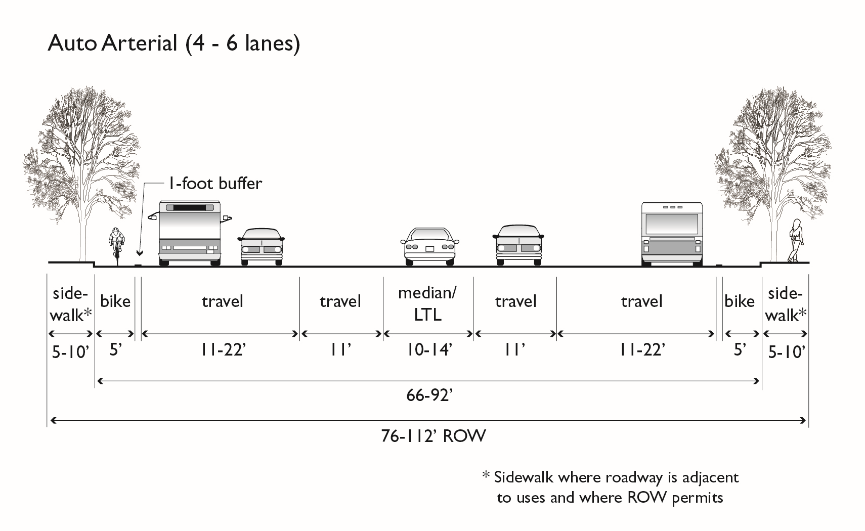
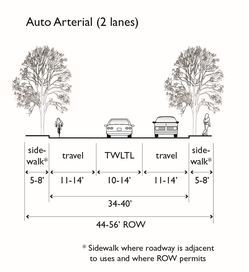
Figure 15.04.710.050-D(2): Street Sections—Urban Arterial
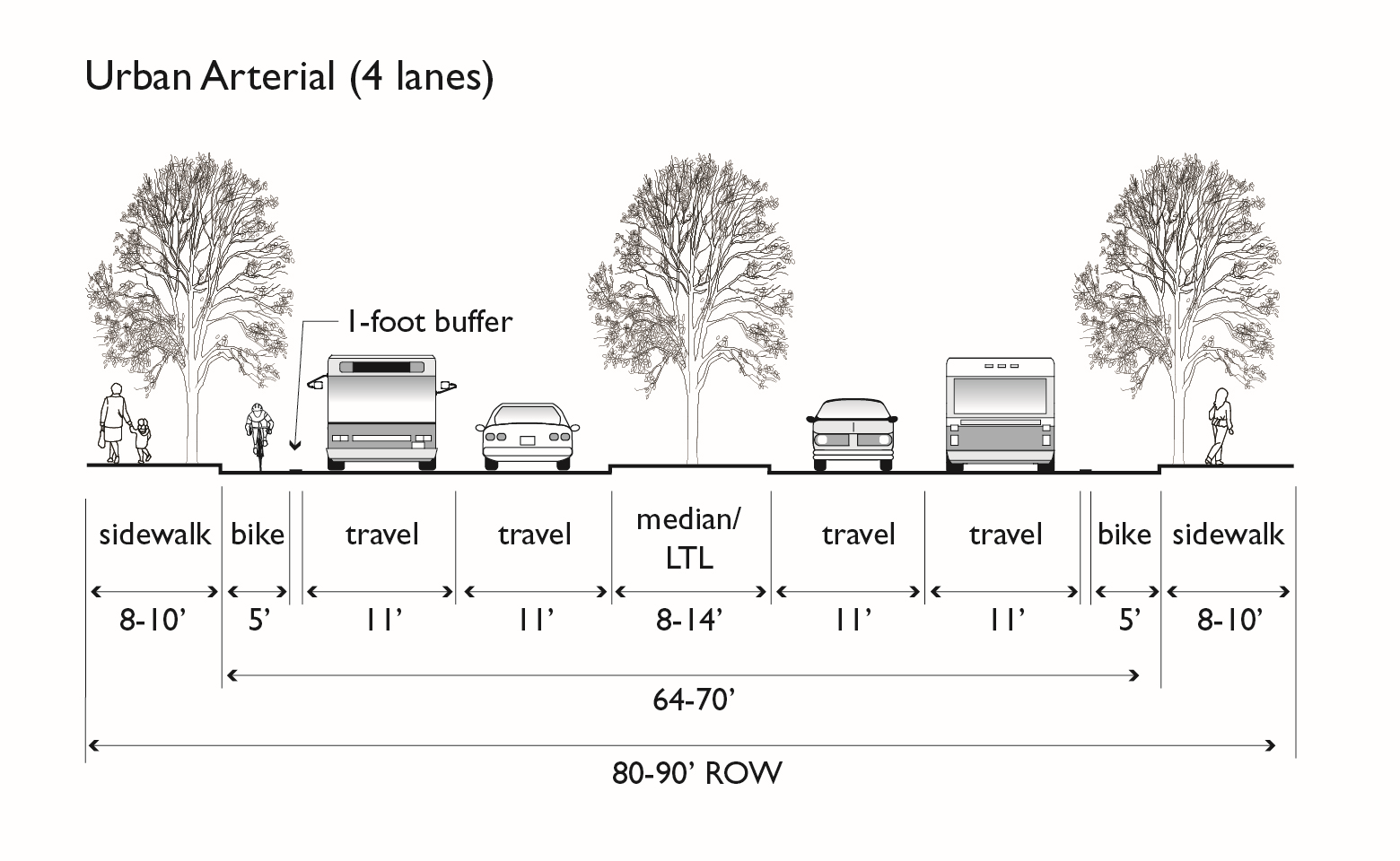
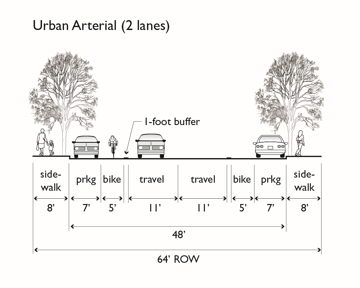
Figure 15.04.710.050-D(3): Street Sections—Mixed-Use Boulevard
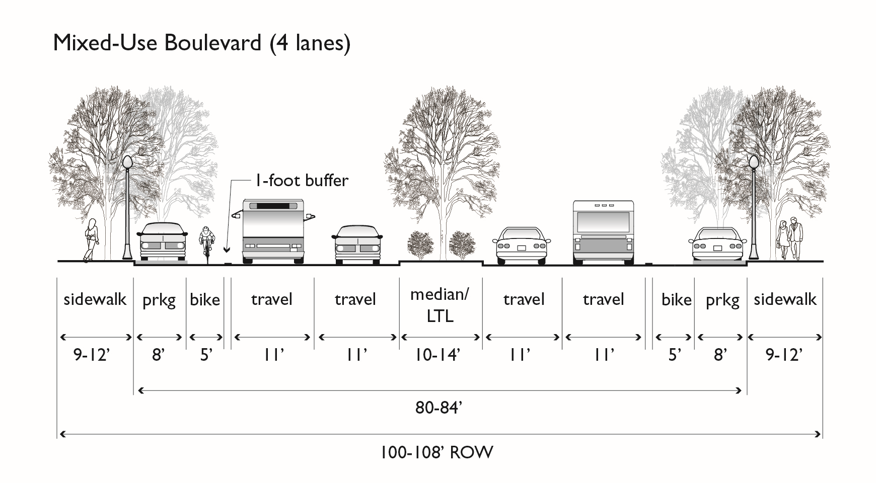
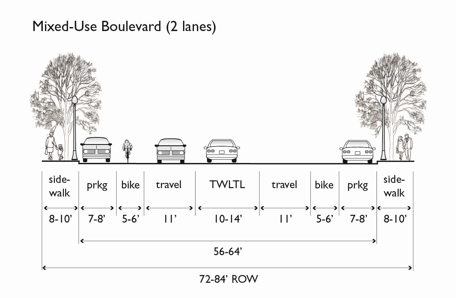
Figure 15.04.710.050-D(4): Street Sections—Avenue
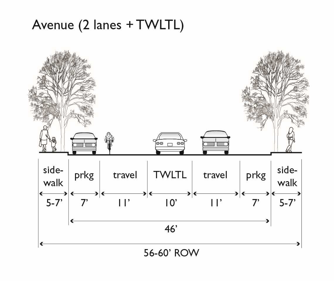
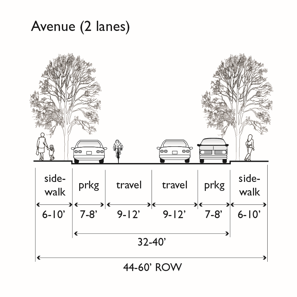
Figure 15.04.710.050-D(5): Street Sections—Local
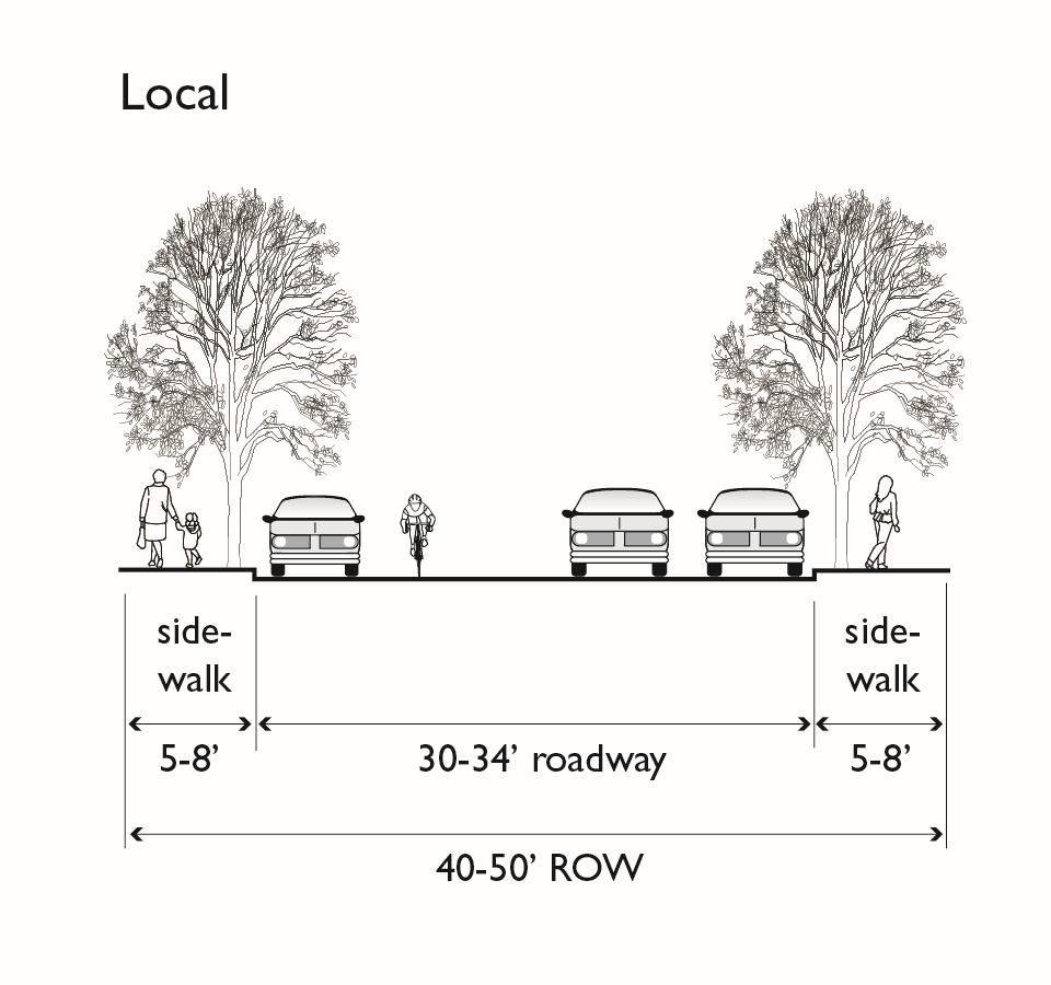
E.
Modifications of the Standard Streets for In-Fill Developments. It is recognized that standard streets may not be directly applicable to infill development. In these instances, the Director of Engineering and Capital Improvement Projects may approve modifications to the street standards when applied to in-fill projects to fit a particular situation. Examples of reasons for modification of the standards include the need to match existing improvements, to promote high residential density in the medium- and high-density and intensity zones, to ensure a safe and appropriate design and/or to accommodate physical design constraints. When determining whether a standard or non-standard street design is appropriate for an in-fill project, a case-by-case evaluation of each location will be used to determine the appropriate street design. In all cases, proper engineering judgment and practices must be applied to the design of the street.
1.
Determination of the appropriate street improvements for a particular project shall be made by the Director of Engineering and Capital Improvement Projects;
2.
In general, the modified street standards will be applied to projects with more than 200 feet of street frontage and where street frontage improvements are required;
3.
If the site has less than 200 feet of street frontage, required street improvements should match existing improvements on the roadway; and
4.
The 200 foot length requirement may be modified if the site is on a corner, the site is on a block that does not have any other frontage improvements, there is an opportunity to adequately transition street improvements to other existing improvements, or some other similar limitations exist. If necessary to separate the sidewalk from the curb, the use of pedestrian access easement(s) outside the right-of-way or other similar modification may be used.
F.
Industrial Streets. Industrial streets shall be used in industrial subdivisions and shall have the following minimum dimensions, unless modified by an adopted specific plan:
1.
Minor Streets.
a.
Right-of-way width: 60 feet
b.
Curb-to-curb width: 44 feet
c.
Planting strip width: 4 feet
d.
Sidewalk width: 4 feet
2.
Collector Streets.
a.
Right-of-way width: 96 feet
b.
Curb-to-curb width: 80 feet
c.
Planting strip width: 4 feet
d.
Sidewalk width: 4 feet
15.04.710.060 - Paths.
A.
Pedestrian Paths. Pedestrian paths shall be provided when required by the City for public convenience or access to public facilities. Pedestrian paths shall have a hard surface as approved by the Director of Engineering and Capital Improvement Projects of a minimum width of five feet within a minimum right-of-way width of sixteen feet. Concrete paths shall conform to the City's Standard Plan for sidewalks.
B.
Stairways. Where the grade of a pedestrian path exceeds 15 percent, groups of concrete steps shall be placed at appropriate locations in the path. The portion of a path above steps shall slope away from the steps for a minimum distance of 20 feet. A handrail shall be provided for lengths of five or more steps.
C.
Bicycle Paths. Bicycle paths shall consist of asphalt or concrete surfacing with a minimum width of ten feet and a minimum thickness of one and one-half inches within a minimum right-of-way of 16 feet. The maximum grade of a bicycle path shall be ten percent. Design of bicycle paths shall be approved by the Director of Engineering and Capital Improvement Projects.
D.
Multi-use Paths. Multi-use paths shall consist of asphalt concrete or concrete surfacing with a minimum paved width of 12 feet with three-foot wide decomposed granite shoulders on each side for a minimum total width of 18 feet. These paths should be designed to satisfy ADA requirements, have a paved surface thickness adequate to withstand maintenance vehicle traffic and be subject to approval by the Director of Engineering and Capital Improvement Projects. Construction of the Bay Trail shall be required as part of the approval process for any project located on or adjacent to the planned route for the San Francisco Bay and San Pablo Bay Trail, except for construction or renovation of single-family homes and duplexes on existing lots, which are exempt from this requirement.
15.04.710.070 - Design Standards—Private Streets.
A.
When Allowed. Private streets may be allowed upon approval of the Director of Engineering and Capital Improvement Projects. Private streets serving more than six dwelling units may not be allowed in single-family residential areas. Driveways serving two or more properties shall be considered private streets.
B.
Design. Private streets shall be designed to the same standards as public streets. Private streets serving three or fewer dwelling units shall be designed in accordance with the requirements of the Director of Engineering and Capital Improvement Projects. Entrances to private streets shall be by standard driveway openings.
C.
Maintenance. The subdivider shall arrange for permanent maintenance of private streets in accordance with this Ordinance.
15.04.710.080 - Storm Drains.
A.
Runoff Design. Stormwater runoff from the subdivision shall be managed on-site or collected and conveyed by a storm drain system approved by the Director of Engineering and Capital Improvement Projects. Maximum runoff shall be computed using the rational method. The rainfall intensity duration curve, contained in the Richmond Storm Drainage Report of 1954, as updated or supplemented by more recent information, and "C" values approved by the Director of Engineering and Capital Improvement Projects shall be used in the computation. Runoff design shall accommodate the full and anticipated future development within the drainage area. In cases where the drainage areas are undeveloped, fully improved conditions shall be determined by the designation of the area on the General Plan and the zoning of the area. The storm drain system shall provide for the protection of abutting properties that would be adversely affected by any increase in runoff attributed to the development, for which off-site storm drain improvements may be required.
B.
Capacity of Channels and Conduits. Drainage channels and conduits shall have the following minimum capacities:
1.
Major Drainage Channels. Major drainage channels and conduits shall have sufficient capacity to contain a fifty-year frequency of occurrence runoff.
2.
Secondary Drainage Channels. Secondary drainage channels and conduits shall have sufficient capacity to contain a twenty-five-year frequency of occurrence runoff.
3.
Minor Drainage Channels. Minor drainage channels, conduits and appurtenant facilities shall have sufficient capacity to contain a ten-year frequency of occurrence runoff.
C.
Closed Conduit System. Stormwater shall be placed in conduits when the gutter now comes within an inch of the top of the curb or when the flow encroaches on the travelled portion of the street. Open flow shall not be allowed across a street. Stormwater in natural or artificial drainage channels shall be placed in closed conduits where the quantity does not exceed eighty cubic feet per second, except that the Zoning Administrator may recommend that an existing natural watercourse, endowed with significant natural beauty in the form of trees, shrubs or scenic attraction, may be utilized for an open drainage facility with such drainage improvements as may be designated by the Director of Engineering and Capital Improvement Projects when such areas are dedicated for public use.
D.
Conduit. The minimum conduit size shall be 12 inches. In general, all storm drain conduit shall be standard strength reinforced concrete pipe. All storm sewers shall have a minimum invert grade not less than that which will provide a minimum velocity of two and one-half feet per second for the design flow. Radii of curves in conduit must be approved by the Director of Engineering and Capital Improvement Projects and shall not be less than those recommended by the pipe manufacturer.
E.
Manholes. A standard manhole shall be constructed at all changes in horizontal or vertical alignment and at least one manhole shall be constructed every eight hundred feet on straight runs of pipe. A standard manhole shall be constructed at all pipe intersections.
F.
Inlet Structures. Standard inlet structures shall be constructed at each pickup point in the system. Inlets shall be as shown on the city standard plans and as directed by the Director of Engineering and Capital Improvement Projects. No more than two inlets shall be on any one lateral line. The maximum difference between gutter inlet elevation and pipe outlet flow-line elevation shall be five feet.
G.
V-Ditches. Standard v-ditches shall intercept runoff from slopes. The city shall not accept maintenance of v-ditches. Design flow in v-ditches shall be at least one inch below the top of the ditch. Pickup points in v-ditches shall be at locations approved by the Director of Engineering and Capital Improvement Projects.
H.
Tidal Action. Drainage structures shall account for tidal action, where applicable, and drainage shall be accomplished by gravity without surcharge in catchbasins or manholes except by design.
I.
Minimum Curb Elevation. The minimum top of curb elevation shall be 7.83 feet.
15.04.710.090 - Sanitary Sewers.
The City's Sewer Standards apply and are hereby incorporated by reference. All sanitary sewer design shall conform to the standards of the California Plumbing Code, the American Society for Testing and Materials (ASTM), American Water Works Association, California Department of Health Services, and the City and/or Sewer District Standard Specifications. In the event of a conflict among the criteria in these documents, the City Manager shall determine which document governs.
A.
Sewer Districts. All sewers shall be in accordance with the provisions of this section and the regulations of the sewer district within which the sewer is located. In case of conflict between these provisions and the sewer district regulations, the more stringent regulation shall govern.
B.
Sewer Service. Each building site within the subdivision shall be provided with sewer service from an approved sewer system.
C.
Pipe Size. All sanitary sewer mains shall be at least eight inches in diameter and all sewer laterals shall be at least four inches in diameter.
D.
Slope. All sanitary sewer mains shall have a minimum invert grade not less than that which will provide a minimum velocity of two feet per second at the design flow.
E.
Cover. All sanitary sewer mains shall have a minimum cover of three feet measured from the surface of the pavement.
15.04.710.100 - Planting.
A.
Roadway Planting. Planting bordering public ways shall be as directed by the Director of Engineering and Capital Improvement Projects.
B.
Existing Trees. Existing trees shall be preserved whenever such trees are suitably located, healthy, and of a desirable variety. The Director of Engineering and Capital Improvement Projects shall make an inspection of existing trees to determine the health and desirability of species; his/her determination shall be final.
C.
Slope Planting. All cut and fill slopes shall be planted as directed by the Director of Engineering and Capital Improvement Projects and the Director of Engineering and Capital Improvement Projects.
D.
Landscaping. Landscaping of public and private land shall be as directed by the Director of Engineering and Capital Improvement Projects.
15.04.710.110 - Signs.
A.
Street Name Signs. Street name signs shall be installed by the subdivider or his representative at all intersections of streets and named paths, and shall be conspicuous to pedestrian and vehicular traffic in all directions. The post shall be installed two feet from the curb face or at such other location that will not block pedestrian use of the sidewalk. Street name signs shall conform to the City Standard Plans. Private street signs may be of a different type if approved by the Director of Engineering and Capital Improvement Projects. A "Private Street" sign shall be placed on each private street.
B.
Warning and Regulatory Signs. The subdivider or his representative shall install all necessary traffic and warning signs as determined by the Director of Engineering and Capital Improvement Projects at locations specified by the Director of Engineering and Capital Improvement Projects. Such signs shall conform to the current Sign Chart of the State of California, Department of Transportation. All signs shall be installed at the expense of the subdivider.
C.
Pavement Markings. The subdivider or his representative shall install all necessary pavement markings as determined by the Director of Engineering and Capital Improvement Projects. Pavement markers shall be installed on all collector streets and arterials as specified by the Director of Engineering and Capital Improvement Projects.
15.04.710.120 - Street Lighting.
A.
Lighting Required. Adequate lighting shall be provided in all subdivisions along all streets, paths, bicycle ways, private streets, and other pedestrian or vehicular ways.
B.
Materials. Street lighting standards shall be as shown on the city Standard Plans. Path lighting standards shall be as approved by the Director of Engineering and Capital Improvement Projects. Either a pull box or a street lighting standard with a handhole shall be placed at all sharp bends in the conduit or every 200 feet on straight runs of conduit.
C.
Illumination Intensity. Spacing of street lighting standards shall be approved by the Director of Engineering and Capital Improvement Projects. Size of luminaires and length of mast arms shall be as shown on the city standard plans. The minimum average illumination as determined by the Director of Engineering and Capital Improvement Projects shall be 1.0 foot-candle for major arterials, 0.6 foot-candle for collector streets, 0.4 foot-candle for minor streets, and 0.2 foot-candle for paths.
15.04.710.130 - Utilities.
A.
Service to Lot Line. Services from public utilities and sanitary sewers shall be made available for each lot in such manner that the street pavement, curb and gutter will not have to be disturbed when service connections are made.
B.
Underground Electrical Service. Communication and electric facilities installed in and for the purpose of serving the subdivision shall be placed underground in streets, alleys, highways, or in easements provided by the subdividers, as determined by the Director of Engineering and Capital Improvement Projects. At the time of the filing of the final map or parcel map, the subdivision shall automatically become an underground utility district and shall conform to the requirements of Chapter 12.48 of the Richmond Municipal Code. Equipment appurtenant to underground facilities, such as surface-mounted transformers, pedestal-mounted terminal boxes and meter cabinets and concealed ducts, may be installed aboveground. The subdivider shall be responsible for compliance with this requirement, shall make the necessary arrangements with the utility companies, and shall submit satisfactory evidence thereof prior to the approval of the improvement plans.
C.
Electrical Utilities in Industrial Subdivisions. In subdivisions which are zoned for general industrial use communication and electrical facilities may be installed overhead. Such overhead facilities and their associated poles and appurtenances shall be placed upon easements at the rear of lots or along lot lines, and shall not be permitted in the street right-of-way nor in front of lots abutting the street right-of-way.
D.
Water Distribution System. Subdivisions shall be provided with a water system with mains of sufficient size and having a sufficient number of outlets to furnish an adequate water supply to each lot of the subdivision in accordance with the standards of the utility serving the area and with sufficient fire hydrants, gated connections and appurtenances to provide adequate fire protection in accordance with the standards of the fire department of the City and of the fire district in which the subdivision is located.
15.04.710.140 - Energy Conservation and Solar Access.
A.
A subdivision for which a tentative map is required shall provide, to the extent feasible, for future passive or natural heating or cooling opportunities in the subdivision. Examples of passive or natural heating opportunities in subdivision design include design of lot size and configuration to permit orientation of a structure in an east-west alignment for southern exposure.
B.
Examples of passive or natural cooling opportunities include design of lot size and configuration to permit orientation of a structure to take advantage of shade or prevailing breezes.
C.
Consideration shall be given to local climate, to contour, to configuration of the parcel to be divided, and to other design and improvement requirements, and such provision shall not result in reducing allowable densities or the percentage of a lot which may be occupied by a building or structure.
D.
The requirements of this section do not apply to condominium projects that consist of the subdivision of airspace in an existing building when no new structures are added.
E.
For the purposes of this section, "feasible" means capable of being accomplished in a successful manner within a reasonable period of time, taking into account economic, environmental, social and technological factors.
15.04.710.150 - Design Standards—Hillside Subdivisions.
A.
Designation as a Hillside Subdivision. Any hill area which is proposed to be developed in substantial compliance with the policies set out in Resolution No. 8620, adopted by the City Council on April 19, 1965, and any amendments thereto, may be designated a hillside subdivision by the Director. Hillside subdivisions shall be designed in accordance with the standards of this section; said standards shall take precedence over conflicting standards elsewhere in this Ordinance. The standards and requirements of this section are enacted for the purpose of preserving, enhancing and promoting the existing and future appearance and resources of hill areas, and for protecting the public safety in the development of hill areas.
B.
Grading. A preliminary grading plan, signed by the registered civil engineer who prepared the soil investigation and geological reconnaissance report, shall be submitted as a part of all tentative maps and tentative parcel maps. All grading shall be shaped to complement the natural land forms. The successive padding or terracing of building sites in the hills shall be avoided.
C.
Erosion Control. All manufactured slopes, other than those constructed in rock, shall be planted or otherwise protected from erosion and shall be benched or terraced as necessary to provide for adequate stability. Irrigation facilities shall be required where necessary to provide for proper maintenance of planted areas. Irrigation facilities and erosion control planting as recommended by the soils engineer and approved by the Director of Engineering and Capital Improvement Projects shall be installed as soon as possible after grading. Manufactured slopes in rock shall be provided with soil pockets to contain landscaping where appropriate.
D.
Slope Maintenance. The city will not accept maintenance of slopes except those within a public street right-of-way.
E.
Street Intersections. The angle of intersection of two streets shall be at least sixty degrees and not more than one hundred twenty degrees.
F.
Street Grades. Collector streets may have a maximum grade of 15 percent for short distances, subject to the approval of the Director of Engineering and Capital Improvement Projects. Minor streets may have a maximum grade of 20 percent for short distances, subject to the approval of the Director of Engineering and Capital Improvement Projects. All lots having vehicular access exclusively on streets with grades greater than 15 percent shall be subject to the approval of the Director of Engineering and Capital Improvement Projects and the Fire Chief.
G.
Sidewalks. Sidewalks may be omitted from one side of minor or collector streets if approved by the Director of Engineering and Capital Improvement Projects. Where sidewalks are omitted, there shall be a minimum of five feet from the curb face to the property line, and the right-of-way widths may be reduced accordingly.
H.
Parking. Parking may be eliminated on one or both sides of a street, subject to the approval of the Director of Engineering and Capital Improvement Projects, where existing topography renders development adjacent to the street impractical, where the street serves solely as an access road, or where an adequate number of off-street parking spaces are provided on each lot adjacent to the street. One-lane one-way streets or two-lane two-way streets without parking lanes shall be provided with emergency parking stalls adequate for at least two vehicles. Emergency parking stalls shall be provided for every 500 feet of roadway without parking lanes, and the stalls shall be a maximum of 600 feet apart.
I.
Driveways. Driveways on streets with a grade greater than 15 percent or on streets with no parking lanes shall be subject to the approval of the Director of Engineering and Capital Improvement Projects.
15.04.711.010 - Standards for New Residential Condominiums.
A.
Purpose. The purpose of this section is to establish development and design standards, procedures and required findings for new condominiums, stock cooperatives, community apartments, or any other subdivision of community owned property to prevent problems inherent in community ownership that might be detrimental to the health, safety, and welfare of residents of such projects and the community at large. More specifically, the purposes of this section are to:
1.
Ensure that new condominiums meet sound construction criteria required under state and local regulations, that reasonable amenities are provided to condominium residents, and that the character of condominium projects is compatible with nearby structures;
2.
Promote the creation of condominium projects to provide a reasonable balance of rental and ownership housing in Richmond and meet the variety of housing needs for all income groups in the city; and
3.
Protect the interest of condominium homeowners under the special conditions created by condominiums by ensuring adequate provision for long-term management.
B.
Development Standards. In addition to the development standards established in the Zoning Ordinance, the following development standards apply to common interest developments:
1.
Laundry Facilities. All units shall be equipped with space and outlets for washers and dryers.
2.
Open Space. Total usable open space in a common interest development having three or more dwelling units shall be at least 200 square feet per dwelling unit. This requirement shall be met by providing Private Open Space, Common Open Space, or a combination of the two.
3.
Private Open Space. Private Open Space must be located within the project, directly accessible from one unit, and separate and distinct from Common Open Space.
a.
Qualifying Facilities. Private Open Space may include but not necessarily be limited to decks, balconies, porches, patios and enclosed yards.
b.
Standards. Private Open Space must have minimum dimensions no less than six feet when a horizontal rectangle is inscribed within it; have at least two weatherproofed electrical outlets; and be at approximately the same level as, and immediately accessible from, a room within the unit.
4.
Common Open Space. Common Open Space must be located within the project, and accessible to all dwelling units that it is designed to serve. Common Open Space may not include driveways and parking areas. It must be located at least 15 feet from any door or window of any dwelling unit.
a.
Permitted Accessory Structures. Accessory structures within Common Open Space may include but are not limited to benches, tables and BBQ structures.
b.
Standards. Common Open Space must be designed for the leisure use by all residents; have minimum dimensions of no less than 10 feet when a horizontal rectangle is inscribed within it; and be open to the sky.
5.
Recreational Open Space.
a.
Requirement. In addition to the Private and Common Open Space requirements above, a project of 25 units or more shall provide at least one element of Recreational Open Space. For projects of 100 or more units, a multi-purpose or recreation room shall be provided.
b.
Location and Access. Recreational Open Space must be located within the project, and accessible to all units of the project. Any Recreational Open Space element must be located at least 15 feet from any door or window of a dwelling unit.
c.
Qualifying Facilities. Recreational Open Space must be designed for active use by all residents, and may include but is not limited to game courts, recreational rooms, swimming pools, garden roofs, sauna baths, putting greens, or play lots.
6.
Modification of Open Space Requirement. The Open Space requirements above may be modified by the Planning Commission, based on findings that a project site is physically constrained, or that the quality of life accommodated by the project will not be compromised, or that the residents will benefit from other amenities that are located in close proximity to the project site.
7.
Guest Parking. A minimum of one on-site visitor parking space shall be provided for every three units in low density residential neighborhoods, as designated in the General Plan. The Planning Commission may waive up to five percent of the resident and guest parking ratio requirement, based upon a finding of unique circumstances of the site, location or occupancy of the project. In no case shall requirements established in the Zoning Ordinance for assigned resident spaces be waived.
8.
Storage Space. Each unit shall have a minimum of 200 cubic feet of Storage Space that is enclosed, weatherproofed and lockable, with no less than a horizontal surface area of 25 square feet, and an interior dimension of 3½ feet. If the space is a reach-in type, it shall have an opening of 3½ feet by six feet. If the space is a walk-in type, it shall have a minimum clear access opening of 2½ feet by 6⅔ feet. This Storage Space shall be in addition to guest, linen, food pantry, and clothes closets that are customarily provided in each unit. In addition, Storage Space:
a.
May be provided in any location that is safe, convenient, and unobtrusive, but shall not be divided into two or more locations; and
b.
If located within a Common Area, the Condominium Owners' Association shall be responsible for the care and maintenance of the exterior surface of the space.
9.
Trash and Recycling Collection Areas. Trash and recycling collection areas shall be provided within 250 feet of the units they are designed to serve, and shall comply with the Central Contra Costa Sanitary District's specifications for trash enclosures.
10.
Utilities. All utility meters and other utility apparatus shall be concealed from public view.
11.
Budget for Maintenance. Copy of the approved proposed budget for maintenance and operation of common facilities, plus reserves, including the estimated monthly costs to the owner of each unit, projected over a five-year period. Such budget shall be reviewed or prepared by a professional management firm familiar with costs of similar properties, or by other qualified professional, and that firm or person shall provide a statement of recommendations on the budget, together with a statement of professional qualifications.
12.
Warranties. The developer shall provide to the Condominium Owners' Association the following minimum warranties from the date of Final or Parcel Map approval, unless otherwise specified:
a.
Roof and Exterior Finish. A five-year warranty that all roofs and exterior finishes have been repaired as is necessary to ensure weatherproof conditions.
b.
Moisture Barriers. A five-year warranty that moisture barriers are sufficient to prevent collection of moisture on the ground under the buildings.
c.
Paved Areas. A five-year warranty of a useful life for all paved areas within the project.
d.
Swimming Pools. A five-year warranty of structural soundness.
e.
Appliances. A one-year warranty at the close of escrow on any fixed appliances appurtenant to each unit.
f.
Condition of Equipment Owned in Common. A one-year warranty at such time as escrow has closed on the sale of 51 percent of the units that all appliances and mechanical equipment to be owned in common are in operable working condition. The developer shall be responsible to maintain any appliances and mechanical equipment prior to the time that 51 percent of the units are sold.
g.
Reserves. The developer shall establish the following minimum reserves prior to issuance of the first certificate of occupancy. One fund in the name of the Association shall be earmarked for long-term reserves for capital maintenance replacement, and shall be equal to two times the estimated monthly assessment for each dwelling unit. A second fund, established through cash deposit or bond, equal to $500 for each dwelling unit in the project, shall provide minimum security for the various warranties required by this subsection. Such fund shall be maintained for the maximum period of the warranties.
C.
Contents of the Covenants, Conditions, and Restrictions (CC&Rs). Project covenants, codes, and restrictions (CC&Rs) shall be developed, and shall be reviewed and approved by the City Attorney and Zoning Administrator prior to approval of the Final or Parcel Map. In addition to the following provisions, the CC&Rs shall reference by incorporation the approved Conditions of Approval, and shall be recorded in conjunction with the Final or Parcel Map.
1.
Conveyance of Private Open Space. The surface area and appurtenant air space of Private Open Space areas, including but not limited to the patio, deck, balcony, solarium, or atrium and any integral portion of that space that may exceed the minimum area requirements, shall be described and conveyed in the grant deed as an integral part of the unit.
2.
Conveyance of Storage Space. The surface and appurtenant air space of Storage Space areas shall be described and conveyed in the declaration as an integral part of the unit.
3.
Assignment and Use of Required Parking Spaces. Required parking spaces shall be permanently and irrevocably specifically assigned to particular units within the project. To the maximum practicable extent, the spaces assigned to each unit shall be contiguous. In no case shall the private storage area of one unit overhang or take its access from the required parking space of another unit. All units shall be assigned at least one parking space and may rent additional spaces from the Association. All parking spaces shall be used solely for the purpose of parking motor vehicles as defined by the California Vehicle Code, and shall not be used for trailers, unmounted campers, boats, or similar recreational vehicles.
4.
Right of Public Entry to Common Area. Officers, agents, and employees of the city, the county, the state, and the United States Government, and any department, bureau, or agency thereof, shall have the right of immediate access to all Common Areas at all times for the purpose of preserving the public health, safety, and welfare, except in those instances where a Common Area is accessible only through a private unit.
5.
Maintenance of Common Area. Provision shall be made both for annual assessments of the owners for maintenance and special assessments for capital improvements. The amount of the regular annual assessment and the procedure for its change shall be specified. The manner in which special assessments may be levied for the purpose of defraying, in whole or in part, the cost of any construction, reconstruction, repair, or replacement of a capital improvement upon the Common Area shall be specified. Both annual and special assessments may be collected on a monthly basis. The remedies that the Association may bring for the nonpayment of assessments shall be specified and may include penalties for late payment. Assignment of the maintenance responsibilities of all improvements and utility systems for each unit shall be specified.
6.
Sharing of Water Costs. When separate water meters are not provided for each unit, the CC&Rs shall make provisions for the equitable sharing of water costs.
7.
Utility Easements over Private Streets and Other Areas. Required public utility easements shall be referenced and any required access routes necessary to assure that firefighting equipment can reach and operate efficiently in all areas shall be provided.
8.
Access for Construction, Maintenance, or Repairs. Each Owner of a Condominium Unit and the Condominium Owners' Association shall have an easement for entry upon any privately owned unit, where necessary, in connection with construction, maintenance, or repair for the benefit of the Common Area or the owners of the units in common.
9.
Right to Terminate Management and Maintenance Contracts. Unless otherwise prohibited by law, or any local, state, or federal regulation, reference shall be made to the Association's right to terminate the contract of any person or organization engaged by the developer to perform management or maintenance duties three months after the Association assumes control of the project, or at that time renegotiate any such contracts.
10.
CC&R Amendments. A statement that the CC&Rs shall not be amended, modified, or changed without first obtaining the written consent of the City.
15.04.711.020 - Condominium, Community Apartment, and Stock Cooperative Conversion Regulations.
A.
Purpose. The purpose of this section is as follows:
1.
To regulate and control the conversion of residential rental property to condominiums and other community housing;
2.
To implement the goals and policies of the General Plan;
3.
To implement and supplement the provisions of the state Subdivision Map Act;
4.
To prohibit the conversion of residential rental property to condominiums and other community housing when, after conversion, the project will consist of fewer than five units.
B.
Conversion Defined. "Conversion" means a proposed change in the type of ownership of a parcel or parcels of land, together with the existing attached structures, from residential rental property to a condominium project or community apartment project containing five or more units, regardless of whether substantial improvements have been made to such structures.
C.
Tenant Notifications—By Subdivider.
1.
The subdivider shall give written notice of intention to convert at least 60 days prior to the filing of a tentative map to each tenant of the property to be converted.
2.
The subdivider shall give written notice, commencing at a date not less than 60 days prior to the filing of a tentative map, to each person applying after such date for rental of a unit of the property to be converted immediately prior to the acceptance of any rent or deposit from the prospective tenant by the subdivider.
3.
The subdivider, if a public report is required by the California Department of Real Estate, shall give written notice to each tenant of the property to be converted, at least ten days prior to final city action on the related final map, that an application for a public report will be or has been submitted to the California Department of Real Estate, and that such report will be available on request.
4.
The subdivider shall give written notice to each tenant within ten days of approval of a final map for the proposed conversion.
5.
The subdivider shall give at least 180 days' written notice to each tenant of subdivider's intention to convert prior to termination of tenancy due to the proposed conversion.
6.
The subdivider shall give each tenant written notice of an exclusive right to contract for the purchase of his or her respective unit upon the same terms and conditions that such unit will be initially offered to the general public or terms more favorable to the tenant. The right shall run for a period of not less than ninety days from the date of issuance of the subdivision public report pursuant to Section 11018.2 of the Business and Professions Code, or for a similar period following final city approval of the related map, unless the tenant gives prior written notice of his or her intention not to exercise the right.
7.
The written notices referred to above shall be deemed satisfied if they comply with the legal requirements of service by mail.
8.
Immediately following the giving of the above notices, subdivider shall furnish the Director with evidence sufficient to demonstrate that the required notices have been properly and timely given.
D.
Tenant Notification—By City.
1.
The City shall give at least ten days' written notice to each tenant of the date, time, and place of any public hearing held by the Planning Commission on the tentative map or tentative parcel map.
2.
The City shall serve a copy of any report or recommendation on a tentative map by the Planning Division staff on the subdivider and on each tenant of the subject property at least three days prior to any hearing or action on such map by the Planning Commission or City Council.
3.
The City shall mail notice to each tenant of the subject property at least three days prior to any hearing upon an appeal filed on Planning Commission action with respect to a tentative map regarding conversion.
4.
The written notices referred to above shall be deemed satisfied if they comply with the legal requirements of service by mail.
E.
Tentative Map and Tentative Parcel Map Requirements. In addition to other information required by this Ordinance, and the information and notices required by this section, the tentative map or tentative parcel map application shall be accompanied with the following information:
1.
A current list of the names, ages and addresses of all tenants of the property proposed to be converted. This list must be kept current and accurate at all times during the conversion process;
2.
A report prepared and signed by both a California licensed general contractor and a registered civil engineer on the physical condition of the structure, or structures to be converted containing the following:
a.
Describe the condition and useful life of the roof and foundations, and the mechanical, electrical, plumbing and structural elements of all existing structures on the property,
b.
Describe and rate existing condition of insulation surrounding each unit for fire safety and noise ratings, and
c.
Estimate future property maintenance costs;
3.
A structural pest report prepared and signed by a licensed pest control operator, conforming to California Business and Professions Code Section 8516;
4.
Five copies of accurately drawn floor plans and plot plans showing what the project will be like after conversion;
5.
Any additional information which the Director of Planning and Building Services or Director of Engineering and Capital Improvement Projects may require to determine whether the project is consistent with the goals and policies of the General Plan and this Ordinance.
F.
Action on Tentative Maps and Tentative Parcel Maps. No tentative map or tentative parcel map shall be approved and no building permit shall be issued unless the appropriate approving body makes the following findings:
1.
Each unit shall be provided with private open space or shall have access to common area open space areas meeting the requirements of the zoning district in which the project is located.
2.
Each dwelling unit shall be separately metered for gas and electricity.
3.
Each dwelling unit in a structure to be converted will, after conversion, conform to the minimum requirements of the building code of the City of Richmond and all applicable state codes in effect at the time of filing a complete application for conversion.
4.
Each unit shall have at least 200 cubic feet of enclosed weatherproofed and lockable private storage space in addition to guest, linen, pantry and clothes closets customarily provided. Such space may be provided in any location approved by the Planning Division, but shall not be divided into more than two locations.
5.
Either a laundry area in each unit or common laundry areas shall be provided; provided such facilities shall consist of not less than one automatic washer and dryer for each five units or fraction thereof.
6.
A landscape plan, including an irrigation system, has been submitted to and approved by the city's department of recreation and parks.
7.
Permanent on-site parking will be provided which meets the minimum requirements of the zoning district within which the project is located.
8.
Approval of the conversion will not be inconsistent with the goals and policies of the General Plan.
9.
After conversion, no access from one unit to another unit in the attic area above units will be possible.
G.
Conversion Application Form and Fees. The Director of Planning and Building Services may develop a conversion application form to assist with the implementation and administration of this section and shall charge all applicants fees therefor as set forth in a resolution adopted by the City Council.
H.
Moving Expenses and Rental Payments.
1.
Failure of the subdivider to give the required notice shall not be grounds to deny a conversion. However, if such notice is not given, the subdivider shall pay to each prospective tenant who becomes a tenant and who was entitled to such notice, and who does not purchase his or her unit pursuant to this section, an amount equal to the sum of the following:
a.
Actual moving expenses incurred when moving from the subject property, and
b.
The first month's rent on the tenant's new rental unit, if any, immediately after moving from the subject property, but not to exceed two times the tenant's monthly rental rate immediately prior to moving.
2.
The subdivider shall provide moving expense assistance to displaced rental housing tenants who are residents at the time of delivery of the notice of intent to convert, the amount of which shall not be less than two times the monthly rental rate of the unit in effect at the time of vacation of said unit.
I.
No Sales Before Project Conversion Completed. No unit in a project may be sold until after the entire project covered by the final map has been converted and all requirements of this article implemented or bonded in compliance with all requirements of this section and the Director of Engineering and Capital Improvement Projects so certifies.
J.
Condominium Owner's Association and Restrictions.
1.
The subdividers shall form a condominium owner's association prior to assumption of project management by the association.
2.
The covenants, conditions and restrictions (CC&Rs) for the conversion project shall provide for ownership and maintenance of all project and common area improvements.
3.
The subdivider must contract with a professional management firm for a period of at least one year from the date that the owners comprise the majority of the board of directors of the Association to manage the project and advise the Association.
4.
Prior to approval of the final map, the subdivider shall provide the Director of Planning and Building Services with evidence of establishment of a fund in the name of the Association. Such fund shall be earmarked for long-term revenues for replacement of common area improvements and shall be equal to not less than 100 dollars for each dwelling unit or whatever higher amount may be required by the California Department of Real Estate.
5.
The CC&Rs shall state that discrimination against families with children is prohibited unless the entire project is exclusively established and maintained for persons sixty-two years of age and older.
K.
Warranty to Purchasers/Condominium Owner's Association. A warranty granting to each purchaser a one-year warranty on all appliances installed in his or her unit, and further granting to the Association and to all purchasers of individual units a five-year warranty on all structures in the project and on all electrical, heating, air conditioning, plumbing, ventilation equipment, roofing, elevators and exterior covering.
L.
Rent Increase Limitation. Upon filing an application for conversion with the City, a tenant's residential rent shall not be raised by more than the amount of 100 percent of the change in the Consumer Price Index—rental component for the San Francisco-Oakland SMSA for the previous twelve-month period prior to filing. The rental increase limitation is cumulative within each successive twelve-month period and shall apply to subleased units.
M.
Temporary Relocation. In the event that any tenant or renter of a unit enters into a written agreement with the subdivider to purchase their unit once it has been converted and is thereafter required to temporarily vacate or is temporarily displaced from said unit because the subdivider is renovating or effecting certain structural modifications to comply with the subdivider's plans or the City's requirements, the subdivider shall be responsible for:
1.
Finding suitable temporary replacement housing for such tenant and, if the monthly rent is higher for the replacement housing than for the unit vacated, pay the difference in such monthly rent; and
2.
Paying such tenant's actual moving expenses in temporarily moving from said unit and moving back into the unit when the renovation or structural modifications have been completed and approved by the city.
N.
Right to Cancel Purchase Agreement. The subdivider shall provide a written statement granting to each purchaser of a unit the right to cancel their purchase of such unit, without cost or liability, provided they give written notice of cancellation to the subdivider within five days after they sign a purchase agreement.
15.04.712.010 - Purpose.
The purpose of this article is to establish procedures and standards, consistent with the requirements of the Subdivision Map Act, for the reversion of previously subdivided property to acreage.
15.04.712.020 - Initiation of Proceedings.
Proceedings to revert subdivided property to acreage may be initiated by the City Council or by petition of all of the owners of record of the property. The petition shall be in a form prescribed by the Zoning Administrator and shall contain information deemed necessary to comply with the requirements of the Subdivision Map Act.
15.04.712.030 - Contents of Petition.
The petition shall contain all of the following:
A.
Evidence of title to the real property within the subdivision;
B.
Evidence of the consent of all of the owners with an interest in the property;
C.
Evidence that none of the improvements required to be made have been made within two years from the date the final or parcel map was filed for record, or within the time allowed by agreement for completion of the improvements, whichever is later;
D.
Evidence that no lots shown on the final or parcel map have been sold within five years from the date such final or parcel map was filed for record;
E.
A tentative map in the form required by this Ordinance, and, if applicable, a final or parcel map in the form required by this Ordinance, which delineates dedications that will not be vacated and dedications required as a condition to reversion. Final or parcel maps shall be conspicuously designated with the title, "The Purpose of this Map is a Reversion to Acreage";
F.
The required fees; and
G.
Any other information the Zoning Administrator may require.
15.04.712.040 - Submittal of Petition to Zoning Administrator.
The final or parcel map for the reversion together with all other data as required by this article shall be submitted to the Zoning Administrator for review. Upon finding that the petition meets all the requirements of this Ordinance and the Subdivision Map Act, the Director of Engineering and Capital Improvement Projects shall submit the final or parcel map, together with a report and recommendations of approval or conditional approval of the reversion to acreage, to the City Council for its consideration.
15.04.712.050 - City Council Approval.
A public hearing shall be held by the City Council on all petitions for initiations for reversions to acreage. Notice of the public hearing shall be given as required by the Zoning Ordinance. The Zoning Administrator may give other notice that he or she deems necessary or advisable.
15.04.712.060 - Required Findings.
The City Council may approve a reversion to acreage only if it finds that any outstanding dedications or offers of dedication to be vacated or abandoned by the reversion to acreage are unnecessary for present or prospective public purposes and that:
A.
All owners of an interest in the real property within the subdivision have consented to reversion; or
B.
None of the improvements required to be made have been made within two years from the date the final or parcel map was filed for recording, or within the time allowed by agreement for completion of the improvements, whichever is later; or
C.
No lots shown on the final or parcel map were sold within five years from the date such map was filed for recording.
15.04.712.070 - Conditions.
The City Council shall require as conditions of the reversion that:
A.
The owners dedicate or offer to dedicate streets, public rights-of-way or easements; and
B.
The retention of all or a portion of previously paid subdivision fees, deposits or improvement securities, if necessary to accomplish any of the provisions of this Ordinance.
15.04.712.080 - Filing with County Recorder.
Upon approval of the reversion to acreage by the City Council, the City Clerk shall transmit the final or parcel map, together with the City Council resolution approving the reversion, to the County Recorder for recordation. Reversions shall be effective when the final or parcel map is filed with the County Recorder.
15.04.713.010 - Purpose.
The purpose of this article is to establish the procedures and standards for the merger of contiguous parcels of land that were created under the provisions of the Subdivision Map Act or any prior State law regulating the division of land.
15.04.713.020 - Required Mergers.
Pursuant to the Subdivision Map Act and the requirements of this Ordinance, the City may initiate the merger of two or more contiguous parcels or units held by the same owner if any one of the contiguous parcels or units does not conform to the standards for minimum parcel or lot size established by the Zoning Ordinance, and if all the following requirements are satisfied:
A.
At least one of the affected parcels is undeveloped or is developed only with an accessory structure or accessory structures, or is developed with a single structure, other than an accessory structure, that is also partially sited on a contiguous parcel or unit.
B.
With respect to any affected parcel, one or more of the following conditions exists:
1.
The parcel comprises less than 5,000 square feet in area at the time of the determination of merger.
2.
The parcel was not created in compliance with applicable laws and ordinances in effect at the time of its creation.
3.
The parcel does not meet current standards for sewage disposal and domestic water supply.
4.
The parcel does not meet slope stability standards.
5.
The parcel has no legal access that is adequate for vehicular and safety equipment access and maneuverability.
6.
Development would create health or safety hazards.
15.04.713.030 - Mergers Initiated by the City.
A.
Notice of Intention to Determine Merger Status. The Planning Division shall mail, by certified mail, a notice of intention to determine the potential merger status to the current record owner of the property. The notice shall state that the affected parcels may be merged, and the owner may request a hearing on the determination of status before the Planning Commission to present evidence that the property does not meet the criteria for merger. The notice of intention to determine status shall be filed for record at the office of the Contra Costa County Recorder on the same day that the notice is mailed to the property owner.
B.
Hearing on Determination of Status. The owner of the affected property may file a written request for a hearing with the Zoning Administrator within 30 days after the recording of the notice of intention to determine status. Upon receipt of the request, the Planning Division shall set a time, date and place for a hearing and notify the owner by certified mail. The hearing shall be conducted not more than 60 days following the receipt of the owner's request, or may be postponed or continued by mutual consent of the Zoning Administrator and the property owner. At the hearing, the property owner shall be given the opportunity to present any evidence that the affected property does not meet the requirements of this Ordinance.
C.
Determination of Merger. At the conclusion of the hearing, the Planning Commission shall determine whether the affected parcels shall be merged or not and shall prepare a notice of merger and notify the owner of the determination.
1.
If the Planning Commission makes a determination that the parcels are to be merged, the Director of Engineering and Capital Improvement Projects shall record a determination of merger within 30 days of the Commission's determination unless the owner files an appeal.
2.
The determination of merger shall specify the name of the record owners and a description of the property.
3.
If the City determines that the parcels shall not be merged, the Director of Engineering and Capital Improvement Projects shall record a release of the notice of intention to determine status and shall mail a clearance letter to the owner of record.
15.04.713.040 - Mergers Initiated by Property Owner.
A.
Request for Determination. Upon written application by the owner to the Director of Engineering and Capital Improvement Projects, and payment of required fees, the Zoning Administrator and Director of Engineering and Capital Improvement Projects shall determine whether the affected parcels shall be merged and shall notify the owner of the determination. If the Zoning Administrator and Director of Engineering and Capital Improvement Projects determine that the parcels shall not be merged, the owner may file a written request for a hearing with the Planning Commission pursuant to the requirements of this article. If the Planning Commission determines that the parcels shall be merged, a determination of merger shall be recorded.
B.
Waiver of Right to Hearing. If the merger of contiguous parcels or units is initiated by the record owner(s), the owner(s) may waive the right to a hearing before the Zoning Administrator and to all notices required by this article. Upon receipt of the waiver, the Director of Engineering and Capital Improvement Projects shall record a notice of intention to determine status, a waiver of right of hearing and notice, and a notice of merger simultaneously.
15.04.713.050 - Unmerged Parcels.
A property owner may apply to the City for a determination that any parcels or units of land for which a notice of merger had not been recorded on or before January 1, 1984 are deemed not to have been merged under Section 66451.30 of the Subdivision Map Act. If the Zoning Administrator determines that the parcels meet the standards specified in Section 66451.30, the City shall issue the owner, and record with the County Recorder, a notice of the status of the parcels and a declaration that the parcels are not merged.
15.04.714.010 - Purpose.
The purpose of this article is to establish the procedures and standards for changing the boundary or boundaries between four or fewer existing adjoining parcels as provided for in the Subdivision Map Act to ensure that such adjustments are consistent with the General Plan and applicable zoning and building requirements.
A.
A lot line adjustment is an administrative approval to adjust the location of a lot line between two or more existing adjacent lots, where land taken from one lot is added to an adjacent lot, and where a greater number of lots than originally existing is not thereby created.
B.
It is the intent of this article to allow lot line adjustments that conform to the General Plan and this Ordinance, the Zoning Ordinance, and applicable building ordinance in order to overcome practical difficulties between neighboring parcels, such as minor improvements encroachments, misaligned fences, etc., and to allow infill development that would not otherwise occur.
15.04.714.020 - Permitted Lot Line Adjustments.
A lot line adjustment is permitted, provided that all of the following conditions are met:
A.
The adjustment is between four or fewer parcels;
B.
No additional parcels are created;
C.
The resulting parcels comply with the provisions of this Ordinance, the Subdivision Map Act, the General Plan, any applicable specific plan, and the Zoning Ordinance, including minimum lot dimensions and minimum area;
D.
The resulting parcels do not interfere with existing utilities, infrastructure or easements;
E.
Real property taxes have been paid; and
F.
The Director of Engineering and Capital Improvement Projects and the Zoning Administrator approve the adjustment.
15.04.714.030 - Zoning Administrator's Responsibility.
The Zoning Administrator shall approve or disapprove an application for a lot line adjustment based on whether or not it conforms to this Ordinance and the Zoning Ordinance. The Zoning Administrator shall impose conditions on the approval of a lot line adjustment if needed to facilitate the relocation of existing utilities, infrastructure, or easements or to achieve compliance with this Ordinance or any other applicable requirements of the Municipal Code.
15.04.714.040 - Required Plans and Materials.
The following plans and materials shall be submitted with an application for a lot line adjustment, provided that the Zoning Administrator may waive submission of items deemed unnecessary to determine compliance with applicable requirements of this article.
A.
Eleven copies of a fully dimensioned drawing, prepared by registered civil engineer or licensed land surveyor, and accurately drawn to a convenient architect's or engineer's scale, showing:
1.
Scale of plan, north arrow, and date;
2.
The engineer or surveyor's name, address, and telephone number;
3.
Title: "Lot Line Adjustment Map";
4.
All existing lot lines, their dimension, and bearing;
5.
Proposed lot line, its dimension, and bearing—dash the lot line to be adjusted, draw solid the lot line in its proposed new location, and indicate the distance between them;
6.
Legal description for all involved lots;
7.
Footprints of all existing structures on the involved properties, including setback information and standards in the Zoning Ordinance, where relevant;
8.
Location of all driveway and parking areas;
9.
All other improvements, drainage facilities, utilities, dedications, rights-of-way, and easements;
10.
Location of major trees near the affected lot line;
11.
Area calculations, in square feet, of affected lots before and after the lot line adjustment.
B.
A preliminary or final title report no older than three months, with legal description, verifying ownership and mortgages/trust deed holders of record.
C.
Legal description of the area to be traded, or new legal descriptions of each lot and closure calculations verifying new legal descriptions.
D.
A written statement of the reasons for the lot line adjustment.
15.04.714.050 - Procedures.
An application for a lot line adjustment shall be made to the Planning Division, accompanied by the required plans and materials, a filing fee in accordance with the City's Master Fee Schedule, and a map to be retained in the City files. If required by Section 8762 of the Business and Professions Code, a record of survey shall also be submitted. Within 30 days of the receipt of an application, the Zoning Administrator may require additional information as deemed necessary to determine whether the proposed adjustments meet the requirements of this section.
A.
Action by Zoning Administrator. Within 30 days of the receipt of a complete application, the Zoning Administrator, in consultation with the Director of Engineering and Capital Improvement Projects, shall approve, conditionally approve, or deny the application for lot line adjustment and shall notify the owner of the determination.
B.
Required Findings. The Zoning Administrator shall approve a lot line adjustment application if on the basis of the application, plans, and materials the Zoning Administrator finds the adjustment conforms to Section 15.04.714.020 and:
1.
That the proposed lot line adjustment is in conformance with the base zoning district and any overlay zoning districts or specific plans that apply to the site;
2.
That said lot line adjustment is consistent with the General Plan; and
3.
That the lot line adjustment is exempt from the subdivision requirements of the Subdivision Map Act.
C.
Limitations on Conditions. The Zoning Administrator shall not impose any conditions on the approval of a lot line adjustment except to comply with the requirements of this Ordinance on permitted lot line adjustments. Any improvements that are required to be installed or constructed shall be installed or constructed pursuant to the requirements of this Ordinance.
15.04.714.060 - Determination, Notice and Appeal.
A.
The Zoning Administrator shall render the determination within 45 days of receipt of a complete application submittal.
B.
Notice of the determination and information about the appeal period and procedures shall be mailed to the applicant, the owner of record of all involved lots, and adjacent property owners on the date of the decision.
C.
The determination of the Zoning Administrator shall become final 15 days after the determination is rendered, unless appealed to the Planning Commission in accordance with the provisions for such appeals in this Ordinance.
15.04.714.070 - Post-Approval Actions.
A.
When the decision becomes final, the Zoning Administrator will prepare a notice of lot line adjustment if the lot line adjustment was approved or in the case of conditional approval, the notice of lot line adjustment will be prepared when applicable approval conditions have been satisfied; the notice of lot line adjustment will be mailed to the applicant.
B.
The resulting changes in ownership of the affected land must be conveyed by legal document by the involved owners within one year of the Zoning Administrator's determination, or the notice of lot line adjustment will expire.
15.04.714.080 - Recording with County Recorder.
The lot line adjustment shall be reflected in a deed and shall be filed for record in the Contra Costa County Clerk-Recorder's Office, County Recorder Division.
15.04.715.010 - Approval and Acceptance of Improvements.
A.
Approval. When the required improvements in a subdivision have been completed, the subdivider shall request that the Director of Engineering and Capital Improvement Projects approve the construction of the improvements. Prior to such approval by the Director of Engineering and Capital Improvement Projects, the subdivider shall conform to the following regulations:
1.
"As-built" Plans. The subdivider or his representative shall submit one complete set of improvement plans, grading plans, watercourse permit plans, and any other plans showing all improvements as finally constructed in paper and electronic format (e.g., computer-aided design or CAD files) as specified by the Director of Engineering and Capital Improvement Projects. All changes from the original approved plans shall be noted. The subdivider's civil engineer and soils engineer shall certify on the plans that they are "as-built" plans.
2.
Letter of Certification. The subdivider's soils engineer and civil engineer shall certify that the improvements have been constructed in conformance with the approved plans, including any changes authorized by the City and the soils report, if a report was prepared.
3.
Monument List. The subdivider or his/her representative shall submit a street monument list showing the location, elevation and coordinates of each monument as set forth in this Ordinance.
4.
Maintenance of Private Improvements. The subdivider or his/her representative shall submit documentation, if required, satisfactory to the Director of Engineering and Capital Improvement Projects, that maintenance of private improvements is assured by one of the methods set forth in this Ordinance.
5.
Guarantee. The subdivider shall submit a bond or cash deposit to guarantee the work as required in this Ordinance.
B.
Acceptance. Following the approval of the construction of the improvements, the Director of Engineering and Capital Improvement Projects may recommend that certain improvements be accepted for maintenance by the City. The City Council shall accept said improvements for maintenance by resolution.
15.04.715.020 - Exceptions.
A.
Tentative Subdivision or Parcel Map. Whenever, in the opinion of the Planning Commission, the subdivision involved is of such size or shape, subject to such title limitations of record, affected by such topographic conditions, or to be devoted to such use that it is physically impossible or impractical in a particular case for the subdivider to conform fully to the regulations contained in this Ordinance, the Planning Commission may in approving a tentative map or tentative parcel map approve such exceptions from the requirements and regulations of this Ordinance as in its opinion are reasonable, necessary and in conformity with the spirit and purpose of the Subdivision Map Act, the Richmond General Plan, and of this Ordinance.
Any proposals for exceptions may be referred by the Planning Commission for a period of at least one week to the official, department, division or agency under whose particular jurisdiction the regulations fall, and to any other interested officials, departments, divisions or agencies for their review and written recommendations.
The subdivider shall, at the time of the tentative map or tentative parcel map submittal, also state in writing the grounds for the requested exceptions and the facts relied upon. If necessary for adequate consideration, the subdivider shall grant additional time to said commission for consideration of the tentative map or tentative parcel map.
B.
Improvement Plans, Development Plans, and Design Standards. Exceptions to detailed requirements on improvement and development plans and minor exceptions to design standard requirements may be granted by the Director of Engineering and Capital Improvement Projects in the case of improvement plans and design standards and the Zoning Administrator in the case of development plans.
15.04.716.010 - Purpose.
This article establishes procedures that the City will use to enforce the requirements of the Subdivision Ordinance, including compliance with any conditions of approval imposed to protect public health, safety, and welfare and promote development in accordance with the General Plan.
15.04.716.020 - Prohibition.
A.
No person shall offer to sell or lease, to contract to sell or lease, or sell or lease, or to finance any parcel or parcels of real property or to commence construction of any building for sale, lease or financing thereon, except for model homes, or to allow occupancy thereof, for which a final map is required by the Subdivision Map Act or this Ordinance, until such map thereof in full compliance with the provisions of the Subdivision Map Act and this Ordinance has been filed for record by the recorder of the county in which any portion of the subdivision is located.
B.
No person shall sell, lease or finance any parcel or parcels of real property or commence construction of any building for sale, lease or financing thereon, except for model homes, or allow occupancy thereof, for which a parcel map is required by the Subdivision Map Act or this Ordinance, until such map thereof in full compliance with the provisions of the Subdivision Map Act and this Ordinance has been filed for record by the recorder of the county in which any portion of the subdivision is located.
C.
Conveyances of any part of a division of real property for which a final map or parcel map is required by the Subdivision Map Act or this Ordinance shall not be made by parcel or block number, initial or other designation, unless and until such map has been filed for record by the recorder of the county in which any portion of the subdivision is located.
D.
This section does not apply to any parcel or parcels of a subdivision offered for sale or lease, contracted for sale or lease, or sold or leased in compliance with or exempt from any law, regulating the design and improvement of subdivisions in effect at the time the subdivision was established.
15.04.716.030 - Penalty for Violation.
A violation of this Ordinance by a person who is the subdivider or an owner of record, at the time of the violation, of property involved in the violation is punishable by imprisonment in the county jail not exceeding one year or in the state prison, by a fine not exceeding $10,000, or by both fine and imprisonment. Every other violation of this Ordinance is a misdemeanor.
15.04.716.040 - Remedies.
A.
Any deed of conveyance, sale or contract to sell real property that has been divided, or that has resulted from a division, in violation of the provisions of the Subdivision Map Act, or of the provisions of this Ordinance, is voidable at the sole option of the grantee, buyer or person contracting to purchase, his/her heirs, personal representative, or trustee in insolvency or bankruptcy within one year after the date of discovery of the violation of the provisions of the Subdivision Map Act or this Ordinance, but the deed of conveyance, sale or contract to sell is binding upon any successor in interest of the grantee, buyer or person contracting to purchase, other than those above enumerated, and upon the grantor, vendor or person contracting to sell, or his assignee, heir or devisee.
B.
Any grantee, or his successor in interest, of real property which has been divided, or which has resulted from a division, in violation of the provisions of the Subdivision Map Act or this Ordinance, may, within one year of the date of discovery of such violation, bring an action in the superior court to recover any damages he/she has suffered by reason of such division of property. The action may be brought against the person who divided the property in violation of the provisions of the Subdivision Map Act or of this Ordinance and against any successors in interest who have actual or constructive knowledge of such division of property.
C.
The provisions of this subsection shall not apply to the conveyance of any parcel of real property identified in a certificate of compliance or identified in a recorded final map or parcel map, from and after the date of recording.
D.
The provisions of this subsection shall not limit or affect in any way the rights of a grantee or his/her successor in interest under any other provision of law.
E.
The Subdivision Map Act and this Ordinance do not bar any legal, equitable or summary remedy to which any aggrieved local agency or other public agency, or any person, firm or corporation may otherwise be entitled, and any such local agency or other public agency, or such person, firm or corporation may file a suit in the superior court of the county in which any real property attempted to be subdivided or sold, leased or financed in violation of the Subdivision Map Act is located, to restrain or enjoin any attempted or proposed subdivision or sale, lease or financing in violation of the Subdivision Map Act.
F.
The City shall not issue any permit or grant any approval necessary to develop any real property that has been divided, or that has resulted from a division, in violation of the provisions of the Subdivision Map Act or this Ordinance, if the City finds that development of such real property is contrary to the public health or the public safety. The authority to deny such a permit or such approval shall apply whether the applicant therefor was the owner of record at the time of such violation or whether the applicant therefor is either the current owner of record or a vendee of the current owner of record pursuant to a contract of sale of the real property with, or without, actual or constructive knowledge of the violation at the time of the acquisition of his/her interest in such real property.
G.
If the City issues a permit or grants approval for the development of any such real property, the City may impose those conditions that would have been applicable to the division of the property at the time the applicant acquired his/her interest in such real property, and which has been established at such time by the Subdivision Map Act or this Ordinance, except that if a conditional certificate of compliance has been filed for record, only such conditions stipulated in that certificate shall be applicable.
15.04.716.050 - Building Permits.
A.
Building Permit. No building permit or similar entitlement of use shall be issued for the development of any lot within a subdivision until all required improvements are substantially completed to the satisfaction of the Director of Engineering and Capital Improvement Projects, except as permitted in this section.
B.
Model Homes. Not more than seven lots (or seven structures in a planned development) in a subdivision may be designated as model home sites. If such sites are approved by the Director of Engineering and Capital Improvement Projects as capable of being developed without conflicting with the work or construction of required subdivision improvements, then building permits and entitlements may be issued therefor. Each site shall be easily accessible from existing improved streets. No model home shall be located more than 300 feet from an approved source of water for firefighting purposes.
C.
Condominium Developments in Planned Area Districts. Building permits may be issued subsequent to the approval or conditional approval of the tentative map, but before the filing of the parcel map or final map, for buildings in condominium developments in planned area districts, provided that a final development plan has been approved, as defined in the Zoning Ordinance.
15.04.716.060 - Certificate of Compliance.
A.
Any person owning real property or a vendee of such person pursuant to a contract of sale of such real property may request, and the Director of Engineering and Capital Improvement Projects shall determine, whether such real property complies with the provisions of the Subdivision Map Act and this Ordinance.
B.
Upon making such a determination, the Director of Engineering and Capital Improvement Projects shall cause a certificate of compliance to be filed for record with the county recorder. The certificate of compliance shall identify the real property and shall state that the division thereof complies with applicable provisions of the Subdivision Map Act and this Ordinance. A fee in a sum set by resolution of the City Council shall be imposed to cover the cost of issuing and recording the certificate of compliance.
C.
If the Director of Engineering and Capital Improvement Projects determines that such real property does not comply with the provisions of the Subdivision Map Act or this Ordinance, he/she may, as a condition to granting a certificate of compliance, impose such conditions as would have been applicable to the division of the property at the time the applicant acquired his/her interest therein, and which had been established at such time by the Subdivision Map Act or this Ordinance. Upon making such a determination and establishing such conditions, the Director of Engineering and Capital Improvement Projects shall cause a conditional certificate of compliance to be filed for record with the County Recorder. Such certificate shall serve as notice to the property owner or vendee who has applied for the certificate pursuant to this subsection, a grantee of the property owner, or any subsequent transferee or assignee of the property, that the fulfillment and implementation of such conditions shall be required prior to subsequent issuance of a permit or other grant of approval for development of the property.
D.
Compliance with such conditions shall not be required until such time as a permit or other grant of approval for development of such property is issued by the City.
E.
A certificate of compliance shall be issued for any real property that has been approved for development pursuant to this Ordinance.
F.
A recorded final map or parcel map shall constitute a certificate of compliance with respect to the parcels of real property described therein.
15.04.716.070 - Notice of Violation.
A.
Whenever the Director of Engineering and Capital Improvement Projects has knowledge that real property has been divided in violation of the provisions of the Subdivision Map Act or this Ordinance, he/she shall cause to be filed for record with the County Recorder a notice of intention to record a notice of violation, describing the real property in detail, naming the owners thereof, and describing the violation, and stating that an opportunity will be given to the owner to present evidence.
B.
Upon recording a notice of intention to record a notice of violation, the Director of Engineering and Capital Improvement Projects shall mail a copy of such notice to the owner of such real property. The notice shall specify a time, date and place at which the owner may present evidence to the Planning Commission why such notice should not be recorded.
C.
If, after the owner has presented evidence, it is determined that there has been no violation, then the Director of Engineering and Capital Improvement Projects shall record a release of the notice of intention to record a notice of violation with the County Recorder.
D.
If, however, after the owner has presented evidence, the Planning Commission determines that the property has been illegally divided, or if within 60 days of receipt of such copy the owner of such real property fails to inform the Director of Engineering and Capital Improvement Projects of his/her objection to recording the notice of violation, the Planning Commission shall record the notice of violation with the County Recorder.
E.
The notice of intention to record a notice of violation and the notice of violation, when recorded, shall be deemed to be constructive notice of the violation to all successors in interest in such property.
15.04.716.080 - Judicial Review.
An action or proceeding to attack, review, set aside, void or annul a decision of the City under this Ordinance must be commenced and served on the City within 90 days after the date of the decision. After 90 days, all persons are barred from any such action.