
Rockford City Zoning Code
CHAPTER 5
OVERLAY DISTRICTS
Sec. 5.1 - Purpose.
A.
Mixed-Use Overlay District. The purpose of the Mixed-Use District is to encourage a combination of uses within a single compact development that promotes walkability, reduces reliance on vehicular travel, and creates a more vibrant and interactive urban environment than traditional single-purpose developments. This district should be relatively small scale and compatible with surrounding residential neighborhoods. A variety of housing types is required at varying densities, along with nonresidential uses (office, retail, and/or personal services) that are in harmony with the predominantly residential character of the district. Size limits are imposed to ensure that nonresidential uses remain appropriate to the district intent.
B.
Ten-Mile Overlay District. Ten-Mile Road serves as a major road connecting the City of Rockford with US 131 and is the boundary between Algoma and Plainfield Townships. As such, 10-Mile Road is a gateway to all three communities. The City of Rockford and Algoma and Plainfield Townships, therefore, share a common interest in the future development of the corridor. The future use of the land abutting this roadway, particularly at the US 131 interchange, and the volume of traffic carried by 10-Mile Road affect all three communities. In order to create a positive future, cooperation among all three communities is essential. The intent of the 10-Mile Road Overlay District is to provide a set of zoning regulations to support the following purposes:
1.
Maximize the capacity of the road by limiting and controlling the number and location of driveways and requiring alternate means of access through shared driveways, service drives, and access from side streets.
2.
Ensure sufficient right-of-way for future widening of 10-Mile Road as properties develop and re-develop.
3.
Provide non-motorized pathways along 10-Mile Road.
4.
Facilitate high-quality development and redevelopment of commercial and office uses through quality architecture, efficient site design, and landscaping.
5.
Require low level signs to minimize motorist distraction, avoid blight and clutter, promote aesthetics, and unify signage with the overall character desired in the corridor while providing property owners and businesses with an appropriate mechanism with which to identify their location and business.
6.
Require landscaping on sites along the corridor as they develop and redevelop to attain the desired green space, buffering between uses, and the high quality appearance of the corridor.
7.
Preserve important existing natural features which contribute to the character of the corridor.
C.
Waterfront Overlay District. This overlay district is enacted to protect the water quality of the Rogue River, Rum Creek, and Shaw Creek; prevent soil erosion and sedimentation into those waters; to preserve their natural attributes and recreational values; to promote their scenic character; to preserve wildlife habitat; and to protect the property values of the parcels bordering those waters.
Sec. 5.2 - Applicability.
A.
Mixed Use District. This district is established as an overlay district within specific locations in the city. Specifically, the Mixed-Use Overlay is attached to those areas designated as "Potential Development Areas" on the Master Plan's future land use map. Unlike other overlay districts, the Mixed-Use District is offered as an optional district rather than a set of added requirements superimposed on the underlying zoning district. If the Mixed-Use option is utilized, the provisions of this district supersede those of the underlying district(s).
B.
Ten-Mile Overlay District. The regulations of this overlay district apply to all lands with frontage along 10-Mile Road between the west city limits and Childsdale Avenue to a depth of 500 feet from the existing or future right-of-way line of 10-Mile Road. Permitted and special land uses within the overlay zone shall be as regulated in the underlying zoning district and shall meet all the applicable requirements for that district except that the regulations of 10-Mile Overlay District shall supersede any conflicting regulation of the underlying zoning districts.
C.
Waterfront Overlay District. This district encompasses all land within the floodplain or flood hazard area (as defined in the National Flood Insurance Act of 1968 as amended) of the Rogue River, Shaw Creek, and Rum Creek or within 300 feet of the ordinary high water mark (OHWM), whichever is greater.
Sec. 5.3 - District Regulations.
A.
Mixed-Use District.
1.
Allowed uses.
a.
Uses allowed in the Mixed-Use District, listed in Table 5-3, are subject to Planning Commission approval during the project review process. Requirements, if any, related to a specific use are cited in the "Additional Requirements" column. Any use not specifically listed shall be prohibited unless the use is determined to be a similar use in accordance with Section 2.5. The requirements in footnotes are an integral part of these requirements and shall apply in all instances.
b.
The following abbreviations apply to the Table of Uses:
i.
"P": Permitted Use, this use is authorized by-right, subject to all other applicable provisions of this ordinance and may be subject to additional requirements where indicated.
ii.
"S": Special Land Use, this use is subject to review and approval in accordance with all applicable requirements of Chapter 8.
iii.
"P/S": Permitted or Special Land Use, this designation will depend on whether the principal use or similar land use is a permitted or special use.
2.
Spatial Requirements. Unless specified elsewhere in this ordinance, all uses, structures, and buildings on all lots or parcels shall conform to the requirements specified in Table 5-3a and accompanying footnotes.
3.
Parking requirements.
a.
Parking lots shall not be located within the front yard.
b.
Parking lots exceeding 100 spaces shall be landscaped and screened in accordance with the requirements of SubSec. 5.b. of this section.
4.
Building requirements.
a.
Materials.
i.
All exterior walls shall be clad in durable and maintainable materials. Any side of a building facing a public or private street, alleys, and waterways shall be comprised of at least 30 percent of one or more of the following materials:
(a)
Brick;
(b)
Decorative concrete block;
(c)
Cut stone;
(d)
Horizontal clapboard siding; or
(e)
Commercial grade horizontal vinyl siding (at least 0.44 gauge)
ii.
The Planning Commission may, in its sole discretion, deviate from the minimum percentages in the above material standards where the building design incorporates patterns and materials that provide visual interest through changes in color, material, or relief, such as the inclusion of beltlines, pilasters, recesses, and pop-outs.
b.
Transparency.
i.
For all nonresidential buildings, at least 40 percent of the building façade facing a public or private street must consist of windows and doors on the ground floor and at least 25 percent on all other floors.
ii.
All buildings must have at least one useable door facing the front lot line. For corner lots, the door shall be on the street providing access to the site.
c.
Articulation.
i.
Blank walls longer than 20 feet without windows shall not face a street.
ii.
Building facades shall have massing changes such as recesses, columns, or varied color or material to provide visual interest and texture to avoid monotonous one-dimensional facades.
iii.
Architectural design elements shall be incorporated into the building to add variety and interest. They may include, but are not limited to strong cornice lines, material texture, prominent corner features, strong and simplified building entries, window sills, lintels, overhangs, canopies or porticos, arcades, recesses and projections, arches, outdoor patios, and integral planters.
d.
Projections. Except for eaves, awnings, balconies, bay windows, stoops, and ADA compliant ramps, as specified in Table 7-16, no part of a building may encroach into the required setback.
5.
Landscaping/screening.
a.
Generally. Native vegetation, (indigenous trees, shrubs, wildflowers, grasses, and other plants) and low maintenance turf grasses shall be used.
b.
Parking lots.
i.
One canopy tree (minimum three inch caliper) and three understory shrubs shall be provided for every 10 parking spaces, or portion thereof. Parking lot landscaping shall be located within islands or within 20 feet of the edge of the parking lot.
ii.
An opaque hedge or solid masonry wall at least 36 inches high shall be installed along the length of that side of any parking lot abutting a public or private street.
c.
Streetscape.
i.
A landscaped greenbelt at least 15 feet wide shall be provided along any perimeter street bordering the mixed-use development and shall, at a minimum, contain:
(a)
One deciduous tree for every 30 feet of frontage along the street.
(b)
One ornamental tree for every 50 feet of frontage along the street.
(c)
One evergreen tree for every 50 feet of frontage along the street.
ii.
Required streetscape plantings may be clustered for effect to create a more natural appearance and stronger visual impact.
d.
Screening.
i.
Dumpsters, utilities, and service areas shall be located within a side or rear yard and shall be screened from view from any street or residential uses.
ii.
Mechanical and electrical equipment, whether on a roof or next to a building, shall be screened from view.
6.
Lighting.
a.
Light fixtures shall be no taller than 25 feet and must be provided with full cut-off fixtures that direct light downward and prevent light spill beyond the property.
b.
Additional lighting requirements of Chapter 13 shall be met.
7.
Pedestrian connectivity. A sidewalk or pathway meeting city standards shall be constructed along both sides of all interior streets and any perimeter street bordering the mixed-use development. Additional connections may be required by the Planning Commission to facilitate convenient access to parks, schools, public activity areas, and similar frequented destinations or attractions.
B.
Ten-Mile Road Overlay District.
1.
Right-of-way preservation and setbacks. All front setbacks required by this overlay district or by the underlying zoning district shall be measured from a point 60 feet from the centerline of 10-Mile Road.
a.
The required front setback for buildings and structures shall be a minimum of 100 feet, except single-family detached dwellings shall be set back a minimum of 50 feet. The Planning Commission shall have the authority to reduce the required front setback to not less than 50 feet; provided, such modification would result in preservation of or less alteration to natural site features such as vegetation, wetlands, or steep slopes.
b.
Existing buildings which have a front setback of less than 100 feet may be expanded along the front of the building; provided, the expansion does not encroach further into the established front setback.
c.
The required front setback for off-street parking lots for uses other than single- and two-family dwellings shall be a minimum of 25 feet. Off-street parking lots for multiple-family dwellings shall be set back a minimum of 50 feet.
2.
Vehicular access standards.
a.
General requirements.
i.
Each parcel may be permitted to have one driveway provided the spacing requirements of this section can be achieved. Additional driveways may be permitted by the Planning Commission for any site, providing the spacing and alignment criteria listed below are met, and a traffic impact study is completed which justifies an additional driveway.
ii.
The Planning Commission may permit two one-way driveways rather than a single dual movement driveway where safer, more efficient circulation and function for the drives can be demonstrated.
iii.
The applicant shall submit evidence indicating that the sight distance requirements of the Kent County Road Commission are met.
iv.
Driveways shall be located to minimize interference with the free movement of traffic, to provide adequate sight distance, and to provide the most favorable driveway grade.
v.
For any driveway directly accessing 10-Mile-Road, there shall be enough on-site vehicle storage to accommodate at least five queued vehicles waiting to park or exit in order to minimize the possibility of waiting vehicles creating a conflict with street traffic movement.
vi.
Provisions for circulation between adjacent parcels should be provided through connected and/or joint parking systems or other methods.
vii.
Driveway entrances must be designed to accommodate all vehicle types having occasion to enter the site, including delivery vehicles.
viii.
Driveway placement should be such that loading and unloading activities will not hinder vehicle ingress or egress.
ix.
For high traffic generators or for commercial driveways along 10-Mile Road, the Planning Commission may require two driveway egress lanes.
x.
A boulevard entrance must comply with the design requirements of the Kent County Road Commission.
b.
Driveway spacing (not including single- and two-family dwellings).
i.
Minimum spacing between two driveways along 10-Mile Road shall be 230 feet measured from centerline to centerline.
ii.
Minimum spacing requirements between a proposed driveway and a side street intersection either adjacent or on the opposite side of the street shall be at least 230 feet. Such distance may be reduced to 125 feet where a channelized driveway restricting left turns from the site is proposed. Spacing shall be measured from the near edge of the proposed driveway to the nearest lane edge of the intersecting street or pavement edge for uncurbed sections.
iii.
To reduce left-turn conflicts, new driveways shall be aligned with those across the roadway where possible. If alignment is not possible, driveways shall be offset a minimum of 230 feet along 10-Mile Road, measured centerline to centerline. Greater offsets may be required depending on the expected inbound left-turn volumes of the driveways.
iv.
For sites with insufficient street frontage to maintain the above spacing requirements, the Planning Commission may require construction of the driveway along a side street, a shared driveway with an adjacent property, construction of a driveway along the property line farthest from the intersection, or a service road. If these design options cannot be achieved, the Planning Commission may modify the driveway spacing standards to allow reasonable access provided such driveway does not create an unsafe traffic condition.
c.
Shared driveways, frontage roads, and service roads.
i.
A shared driveway should be located so the midpoint of the driveway is on the property line. Owners of the properties shall execute and record a document to provide for joint use and maintenance.
ii.
Service roads shall generally be parallel or perpendicular to the front property line and may be located either along the side or behind principal buildings. Where site constraints prohibit the development of a rear service road, the Planning Commission may permit a front service road. In considering the most appropriate alignment for a service road, the Planning Commission shall consider the setbacks of existing buildings, anticipated traffic flow for the site, and the 10-Mile Road Corridor Plan.
iii.
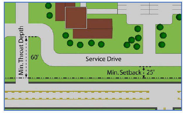
The service road shall be within an access easement at least 40 feet wide permitting traffic circulation between properties.
iv.
The service road easement shall be set back a minimum of 25 feet from the required right-of-way to allow for snow storage and landscaping.
v.
Where a service road driveway intersects 10-Mile Road, the edge of the service road parallel to 10-Mile Road shall be setback a minimum of 60 feet from the edge of the 10-Mile Road pavement to allow for vehicle stacking.
vi.
Service roads shall have a base, pavement, and curb with gutter in accordance with Kent County Road Commission standards for public streets, except the width of the service road shall have a minimum pavement width of 22 feet.
vii.
The service road is intended to be used exclusively for circulation, not as a parking or maneuvering aisle. The Planning Commission may require the posting of "no parking" signs along the service road.
viii.
The Planning Commission may approve temporary driveways where a continuous service road or shared driveway is not yet available. A performance bond or escrow shall be required to ensure elimination of temporary access when the service road or shared driveway is provided. At such time as the permanent service road or shared driveway is completed, the site shall be connected to the service road or shared driveway and the temporary drive shall be closed.
ix.
Each property owner shall be responsible for maintenance of the easement and service road.
3.
Non-motorized accessibility.
a.
South side of 10-Mile Road.
i.
A non-motorized pathway shall be required along the 10-Mile Road frontage for any activity requiring site plan, site condominium, or subdivision plat approval.
ii.
All pathways shall be 10 feet wide asphalt and constructed in accordance with the specifications of the American Association of State Highway and Transportation Officials (AASHTO).
iii.
Pathways shall be installed by the applicant within the road right-of-way, or within an easement acceptable to the Planning Commission.
iv.
An inclined approach shall be required where pathways intersect curbs for barrier free access.
b.
North side of 10-Mile Road.
i.
A sidewalk shall be provided along the 10-Mile Road frontage for any development requiring site plan, site condominium, or subdivision plat approval.
ii.
The sidewalk shall conform to the sidewalk requirements of the Kent County Road Commission and shall be installed concurrent with construction of the project.
iii.
Paved walkways shall be provided on site for access to adjacent parks, shopping areas, anticipated walkways or trails, and institutional uses such as schools or churches. Pedestrian movement shall be safely accommodated across parking lots. Walkways shall be separated from motor vehicle travel lanes and parking spaces.
4.
Lighting.
a.
A lighting plan shall be submitted with the site plan showing light fixture locations and additional lighting specifications as may be required by this ordinance or by the Planning Commission to demonstrate compliance with ordinance requirements.
b.
All lighting shall conform to the requirements of Chapter 13 of this ordinance.
c.
The Planning Commission may modify the requirements of this section if it determines that such modification will not impair the intent of the ordinance.
5.
Landscaping and preservation of natural features.
a.
Landscape plan. A landscape plan shall be submitted as part of the site plan for property regulated by this chapter. The landscape plan shall be drawn to minimum scale of one inch equals 50 feet and shall include, but not necessarily be limited to, the following:
i.
Location, general type, and quality of existing vegetation, including specimen trees.
ii.
Existing vegetation to be saved.
iii.
Methods and details for protecting existing vegetation during construction.
iv.
Location, size, and labels for all proposed plants.
v.
Typical cross-section including slope, height, and width of berms and the type of ground cover to be placed on them.
vi.
Plant list(s) showing the required and proposed quantities.
vii.
Description of landscape maintenance program, including statement that all diseased, damaged or dead materials shall be replaced in accordance with the standards of this ordinance.
b.
Front yard landscaping. Landscaping as required by this section shall be provided adjacent to the 10-Mile Road right-of-way in accordance with the following:
i.
For non-residential uses the width of the landscape area shall be a minimum of 25 feet measured from the required right-of-way.
ii.
For residential uses, including multi-family, the width of the landscape area shall be a minimum of 50 feet measured from the required right-of-way.
iii.
The required front yard landscape area shall be planted with plants native to Michigan. A balance of evergreen trees, deciduous trees, and shrubs shall be planted within the required landscaped area. At a minimum, the following shall be required:
(a)
One deciduous tree for every 30 feet of frontage along the street.
(b)
One ornamental tree for every 50 feet of frontage along the street.
(c)
One evergreen tree for every 50 feet of frontage along the street.
iv.
The Planning Commission may give credit toward the required landscaping for existing trees or other vegetation preserved as part of site development.
v.
The following trees shall not be planted or credited as part of the front yard landscaping: box elders, poplars, elms, willows, red and silver maples, Russian olive, mulberry, catalpa, Honey locust (with thorns), Horse Chestnut (nut bearing), black locust, tree of heaven, and Bradford pear.
vi.
Trees may be clustered in groups or planted in rows.
vii.
Evergreen trees shall be spaced at least 20 feet on-center.
viii.
Deciduous trees shall be spaced at least 25 feet on-center.
ix.
Trees and shrubs should be clustered in locations that are most effective in screening undesirable views.
x.
Earthen berms are encouraged to be provided.
c.
Parking area landscaping. For all parking areas containing 10 or more spaces, the following standards apply.
i.
Landscaped islands and shade trees shall be located throughout the parking lot to shade expanses of parking and contribute to the orderly circulation of motor vehicle and pedestrian traffic. Landscaped islands must be a minimum of 160 square feet and a minimum of nine feet wide. Each island must contain at least one deciduous tree. Trees shall be planted at least three feet from the edge of the island.
ii.
One landscape island per every 10 parking spaces will be provided and planted with a deciduous tree. As an alternative required islands may be combined so there are fewer but larger islands; provided, the Planning Commission determines that this alternative will provide an equivalent amount of landscape area and will meet the intent of this section. Landscape islands may be covered with stone, wood chips or other similar material to prevent weed growth.
d.
Minimum requirements.
e.
Maintenance of plants.
i.
All landscaping plants shall be hardy when planted and maintained in accordance with their natural growth patterns. Withered, diseased or dead plants shall be replaced within a reasonable amount of time, but no longer than one growing season.
ii.
Plants must be controlled by pruning, trimming, or other suitable methods so that they do not interfere with public utilities, restrict pedestrian or vehicular access, or constitute a traffic hazard.
f.
Protection of natural features. Wetlands and the required buffers for wetlands and streams shall be delineated on final plats and site plans with a clear notation of use restrictions.
g.
Necessary disturbance of wetlands, streams, and steep slopes. Grading or removal of vegetative cover on wetlands, streams, wetland buffers or steep slopes (20 percent slope or greater) is not permitted unless the Planning Commission determines that it is necessary for road or utility construction, trails, pathways, or storm water management facilities, and there is no other reasonable alternative. If permitted, the grading or removal of vegetative cover shall only be to the extent necessary to accommodate the proposed development. In these cases, the Planning Commission may require planting in areas where grading or removal of vegetative cover has taken place.
h.
Grading plan. The applicant shall submit a grading plan illustrating existing and proposed contours at two foot intervals. In preparing a grading plan, the applicant shall be guided by the following standards:
i.
Cut and fill slopes shall be minimized.
ii.
Proper grading and elevation relationships to adjacent properties shall be maintained.
iii.
The most significant slopes and ridgelines shall be maintained in their natural state by clustering development.
iv.
Mass grading of large pads and excessive terracing shall be minimized.
v.
Unstable slopes or slopes subject to erosion shall be protected. Storm water alteration of drainage patterns that could result from major changes in topography shall be minimized.
vi.
Slopes of 20 percent or greater shall be re-vegetated.
vii.
Essential grading will be shaped to complement natural landforms.
viii.
Large tracts will be graded in workable units following a scheduled timeline so that construction does not result in large areas left bare and exposed to winter/spring runoff.
6.
Nonresidential building design. All new buildings and structures for commercial, office, and institutional uses shall be designed to incorporate the following architectural features:
a.
Height and scale. The scale and mass of a building shall be reasonably compatible with adjacent and nearby buildings.
b.
Structure facade. At least 80 percent of that portion of a structure or building, be it a front, side, or rear, which faces a public street shall be finished with face brick, wood, glass, stone, or fluted cement block, or stucco-like material. In recognition of developing technologies in building materials, the Planning Commission may approve other materials provided they are compatible with surrounding properties, and further provided that such materials meet appropriate architectural, aesthetic, and safety concerns as may be provided for in any duly adopted ordinances and/or building and fire code.
7.
Signs.
a.
General provisions. Unless otherwise stated in this section, the provisions of Chapter 11 of this ordinance shall govern.
i.
Prohibited signs. Moving, flashing or blinking signs; off-premise signs; portable signs; roof signs; banners, pennants, streamers and flag signs; and inflatable signs are prohibited.
ii.
Exempt signs. Governmental signs and signs for essential services shall be exempt.
iii.
Permits. No signs shall be erected prior to approval of a permit, as required by Section 11.8 of this ordinance.
iv.
Directional signage. Directional signs shall not exceed three feet in height and three square feet in size, except that such dimensions may be exceeded if approved during site plan review.
b.
Signs in residential districts.
i.
One ground sign identifying a residential community is allowed at each entrance to the development, except that not more than two such identification signs shall be allowed per development and shall be at least 300 feet apart. Such sign shall be a maximum of 32 square feet.
ii.
Non-residential uses may have one ground sign not to exceed 48 square feet and one wall sign not to exceed five percent of the area of the wall to which it is attached or a maximum of 100 square feet, whichever is less.
iii.
Ground signs which are less than 20 feet from the 10-Mile Road right-of-way shall not be more than four feet in height including the mounting structure. A sign which is 20 feet or more from the 10-Mile Road right-of-way shall not be more than six feet in height including the mounting structure.
c.
Signs for office uses.
i.
One ground sign not to exceed 32 square feet is permitted per parcel. Such sign shall not exceed six feet in height including the mounting structure.
ii.
One ground sign identifying a multiple office building development or office park is permitted at each entrance to the development, except that not more than two such identification signs shall be allowed per development and shall be at least 300 feet apart. The sign and any mounting structure shall not exceed six feet in height and shall be a maximum of 60 square feet.
iii.
For individual office buildings which are part of a multiple office building development, one ground sign for each building is permitted at the entrance to a public or private road right-of-way or other access easement serving that building. Such sign and any mounting structure shall not exceed six feet in height and shall be a maximum of 32 square feet in size.
iv.
Ground signs shall be set back a minimum of 20 feet from a public or private road right-of-way, 20 feet from side lot lines and shall not otherwise obstruct the vision of drivers.
v.
One wall sign is permitted per building. The size of a wall sign shall not exceed 10 percent of the area of the wall to which it is attached but shall be no more than 100 square feet in size, whichever is less.
d.
Signs for commercial uses other than offices.
i.
One ground sign or pole sign not-to-exceed 64 square feet is permitted per parcel. For a ground sign, the sign and any mounting structure shall not exceed six feet in height. Pole signs shall not exceed 25 feet in height.
ii.
For a lot or parcel with more than one commercial establishment, one ground sign or pole sign is allowed at each entrance, except that not more than two such signs shall be allowed per lot or parcel and they shall be at least 300 feet apart. The sign and any mounting structure shall not exceed six feet in height for a ground sign or 25 feet in height for a pole sign. The sign shall not exceed 75 square feet.
iii.
Ground signs shall be set back a minimum of 20 feet from a public or private road right-of-way, 20 feet from side lot lines and shall not otherwise obstruct the vision of drivers.
iv.
Each commercial establishment is permitted to have one wall sign per street frontage. For purposes of this section, street frontage is defined as a public street or a private road, as defined by this ordinance. An access drive is not a street. The size of a wall sign shall not exceed 10 percent of the area of the wall to which it is attached, but shall be no more than 100 square feet in size, whichever is less.
C.
Waterfront Overlay District.
1.
Setbacks. No building or structure shall be erected or placed within any designated floodplain or flood hazard area of the Rogue River, Shaw Creek, or Rum Creek. Where no floodplain or flood hazard area has been designated, no building or structure shall be erected or placed within 150 feet of the Rogue River or 40 feet from Shaw Creek or Rum Creek, measured from the ordinary high water mark (OHWM); provided, if more than 50 percent of the lots abutting the water and within 400 feet on each side of the subject property are developed, the average setback of the principal building on those lots from the OHWM shall apply. Steps meeting the side yard setback for the underlying district are not subject to this regulation.
2.
Hard surfaces. The use of asphalt, concrete, stone, aggregate, or pavement of any sort including pervious paving blocks or materials, wood, or other similar surfaces within the required setback area shall be limited to a single walkway no more than six feet in width or stairs necessary for water access. Handrails along stairs are permitted.
3.
Natural vegetation strip. A natural vegetation strip not less than 25 feet in width, measured perpendicular to the OHWM, shall be maintained along and parallel to the river or creek.
a.
This vegetation strip shall be left in its natural state and shall consist of native trees, shrubs, and vegetation which shall not be killed, destroyed, removed, or moved; provided, however, that dead, diseased, unsafe, or fallen trees, and poisonous plants may be removed. Additional trees, shrubs, and vegetation may be planted within the vegetation strip.
b.
The limitations imposed by Subparagraph 3.a. shall not preclude the selective trimming or pruning of vegetation for the purpose of providing a filtered view of the river. However, clear-cutting in any area shall not be permitted and a root system must remain intact to provide for stream bank stabilization, erosion control, and to serve as an aid to filtration of surface runoff. In all cases, sufficient natural vegetation shall be retained to provide cover to shade the water and maintain the vegetation strip essentially in its natural condition.
c.
Mowing is prohibited in the natural vegetation strip.
d.
The use of pesticides, herbicides and fertilizers is prohibited in the natural vegetation strip, except for the allowed limited use of herbicides for the eradication of poison ivy, poison sumac, and poison oak or if the herbicide is specifically approved for riparian use. Fertilizer used within 50 feet of the OHWM shall be zero phosphorus fertilizer.
e.
Neither septic tanks nor septic system filtration fields may be located within the required vegetation strip.
f.
The natural vegetation strip shall be shown on any plot plan or site plan submitted for approval during the process of developing a water frontage lot.
Sec. 5.4 - Site Development Requirements.
All permitted and special land uses are subject to the following Site Development Requirements:
A.
General provisions of this ordinance as specified in Chapter 7 shall apply.
B.
All special land uses shall comply with the procedures of Chapter 8.
C.
Additional requirements applicable to specific uses are found in Chapter 9.
D.
Parking is required in accordance with Chapter 10.
E.
Signs are permitted in accordance with the requirements of Chapter 11.
F.
Landscaping and screening are required in accordance with Chapter 12.
G.
Lighting shall conform to the requirements of Chapter 13.
H.
Site Plan Review is required in accordance with Chapter 14.