
Rogers City Zoning Code
ARTICLE 3
LAND DEVELOPMENT STANDARDS
Section 3.1 Purpose and Intent
This article requires the creation of a built environment that:
- Respects and celebrates the natural environment; and
- Creates places of meaning and lasting value; and
- Provides streets and public spaces designed for all users and abilities; and
- Creates a coherent network of interconnected streets to reduce congestion by dispersing traffic; and
- Establishes a network of off-street bicycle and pedestrian facilities accessible to walkers and riders of all abilities; and
- Honors the time-tested pattern of urban development in creating a city of blocks, incrementally over time as sites develop and redevelop.
Section 3.4 The Block and the Street
Blocks are areas of land surrounded by a street or shared-use path.
Section 3.6 Programmed Open Space
3.2.1 New Development
- The provisions of this entire article apply in full when:
- Public improvements are required or are proposed; or
- Subdivision of land is required or proposed; or
- Preliminary plat approval is required or proposed.
- The provisions of 3.4.5 Street Typologies, 3.4.6 Street Design, and 3.4.9 Public Street Improvements apply whenever site development plan approval is required.
3.2.2 Redevelopment and Infill Development
Whenever a Master Plan is required on sites with existing development the plat shall depict streets, blocks, utility corridors, and programmed open spaces in a manner consistent with this UDC to the maximum extent possible. The Director is authorized to grant administrative adjustments from the strict application of the standards of this Article where strict application is impossible due to the presence of existing development proposed to remain.
(Ord 25-35, 7-8-2025)
3.3.1 Floodplains and Floodways
Any new development or substantial redevelopment of land in flood hazard areas requires a disturbance permit per 2.15 which functions as the floodplain development permit pursuant to Chapter 22.
3.3.2 Cave Springs Area
All development in the Cave Springs Area Karst Resource Conservation boundary is subject to Article 7 of this UDC.
3.3.3 Wetlands
- When Rogers GIS indicates there may be wetlands on the subject property or when the City Engineer has reason to believe wetlands are present on the subject property an assessment must be prepared by a qualified environmental consultant certifying the presence or absence of wetlands.
- If wetlands are determined to exist, the boundary must be depicted on all plans and a United States Army Corps of Engineers (USACE) jurisdictional determination must be requested. If the wetlands are impacted by the development, a USACE permit will be required before issuance of the Land Disturbance Permit.
3.3.4 Steep Grades
Grades above 20% are considered unbuildable and must be set aside within open space or where included within new lots. Lots with grades above 20% must have sufficient lot area outside of steep grades to construct a habitable structure compliant with other applicable provisions of this UDC.
3.4.1 Applicability
The standards of this section apply to all contiguous property under common ownership with the subject property in all zones except T2, I-1, and I-2. For the purposes of this section, the subject property is the specific site proposed for development.
3.4.2 Block Standards
- Blocks consist of land bound by streets or shared-use paths.
- The perimeter of a block shall not exceed 2,000 ft as measured at property lines along streets or shared use paths or as measured at future property lines along streets or shared use paths. For the purposes of this subsection, future property lines shall be interpreted as future right-of-way or tract boundaries that will include the street or shared-use path which themselves must be based upon any right-of-way widths required by Subsection 3.4.5 Street Typologies.
- Where the perimeter of a block exceeds 1,500 ft as measured at the property lines along streets or shared-use paths, a mid-block pedestrian way must be provided per Subsection 3.4.6.4 Pedestrian Ways.
- Blocks serving predominantly residential building types should generally be rectangular whereas blocks consisting of mixed uses or commercial uses may be square.
- Where streets and shared-use paths on adjacent properties terminate at site boundaries they must be extended into the subject property forming blocks per this subsection.
3.4.5 Street Typologies
Street typologies function as the bridge between street classifications such as arterial, collector, and minor streets, development form, and placemaking. All streets consist of the right-of-way and frontages between buildings on both sides. The purpose of this subsection is to regulate how streets and abutting frontages are designed and utilized so that the overall form of the street achieves the place intended according to the Future Land Use Map.
3.4.8 Use of Rights-of-Way
- Use of the public right-of-way requires a right-of-way utilization permit, including use of on-street parking spaces, the planting strip, and the sidewalk.
- Placement of A-frame signs within the planting strip does not require a permit.
- Any use of the public right-of-way is subject to the following:
- A 5-foot clear pedestrian path must be maintained at all times, along the trajectory of the sidewalk; and
- All retail furnishings must be stored inside between 12 AM and 6 AM.
3.5.1 Purpose
To standardize utility locations to avoid future utility conflicts and restrictions that may impact the occupation of front yards or the ability to redevelop properties.
3.5.2 Applicability
The standards of this section apply as follows:
3.6.1 Purpose and Interpretation
To promote the well-being of residents, employees, and visitors of developments approved under the regulations of this UDC by ensuring such developments provide meaningful places to recreate, socialize, and gather.
3.6.2 Applicability
The provisions of this section apply to any site when a Master Plan or site development plan is proposed or required by this UDC unless expressly exempted.
(Ord 25-35, 7-8-2025)
3.6.3 Exemptions
- Sites less than 5 acres; or
- Sites zoned entirely I-1, I-2, and T2.
(Ord 25-35, 7-8-2025)
3.6.4 Space Size and Distribution
- Programmed open space must be provided on any Master Plan or site development plan exceeding five acres as follows:
- Sites between 5 and 30 acres must provide at least one programmed open space and the cumulative area of the space provided must be at least 4% of the site area; or
- Sites between 30 and 60 acres must provide at least one programmed open space and the cumulative area of the space(s) provided must be at least 6% of the site area; and
- Sites over 60 acres must provide at least two separate programmed open spaces for every 60 acres or fraction thereof and the cumulative area of such spaces must be at least 6% of the site area.
- Additional open spaces that do not meet the standards of this section are permitted but do not count towards the requirements.
- All programmed open spaces must be privately owned and maintained. Where sites are subdivided programmed open spaces must be provided within a privately owned and maintained tract.
- When multiple spaces are required, they must be distributed throughout the site to ensure each lot is within 2,640 feet walking distance of such a space.
(Ord 25-35, 7-8-2025)
3.6.6 Administrative Adjustments
The Director is authorized to grant an administrative adjustment to allow stormwater in programmed open spaces when such spaces are designed to function in a manner that achieves the requirements of this section and the City's stormwater regulations.
3.7.1 General Standards
- Areas intended for rights-of-way, tracts for stormwater, programmed open space or utilities, and blocks for future development, must be depicted on Master Plans. Individual lot lines are not required at this stage where subsequent site development plan or final plat approval is required.
- Where site development plan approval is not required areas within the boundaries of each block shall be divided into lots and tracts in compliance with this UDC.
- Lots and tracts must be of sufficient dimension for the allowed and anticipated development.
- Each lot must be provided with power, telecom, public water, and sewer service, collectively termed utilities, sized for the anticipated future use. The Director is authorized to grant an administrative adjustment to these requirements for properties within the extraterritorial jurisdiction.
(Ord 25-35, 7-8-2025)
3.7.2 Lot Frontages
The purpose of this section is to ensure that all lots within the city’s jurisdiction can be served by utilities as required by this UDC and are legally and physically accessible to their owner and emergency services.
Any lot not abutting a street must abut a mews.
In T5 and T6, lots must abut a street and an alley or mews where:
Located in a center placetype; or
In any placetype where they have any dimension less than 150 feet.
In T3 and T4, lots narrower than 60 feet must abut both an alley and a street or a mews and street alternative.
Lots without street access located more than 150 feet from a street must be served a mews.
Lots shall be platted to accommodate development facing toward an abutting street or street alternative.
(Ord 25-35, 7-8-2025)
3.7.3 Tract Frontages
All tracts shall have frontage on a street or alley sufficient for maintenance and emergency access as determined by the City Engineer and Fire.
(Ord 25-35, 7-8-2025)
3.7.4 Subdivision of Individual Buildings
Individual buildings may be subdivided so as to convey only the building (as opposed to the building and surrounding yards). Such a subdivision requires approval of an administrative adjustment to reduce the setback from the lot lines to 0 feet and approval of a final plat from the Director. The Director is authorized to grant such an adjustment and approve the subdivision when:
- The land area outside the building is platted as a tract to be perpetually owned and maintained by a property owner's association and such tract provides legal and physical access to each building from the public right-of-way; and
- The units are constructed in compliance with applicable building codes; and
- The actual side and rear setbacks provided shall be measured between each building and the distance between each building shall be the sum of the minimum required side and rear setback for each building. For example, where Table 5.2.2.A requires a 5-foot side yard setback between a building and the side lot line, the actual setback provided shall be measured between the buildings (rather than between buildings and a lot line) and shall be a minimum of 10 feet.
(Ord 25-35, 7-8-2025)
3.7.5 Subdivision of Units Within Buildings
Individual units within buildings containing two or more units may be subdivided for the purposes of conveyance. Such a subdivision may require approval of an administrative adjustment reducing the setback from the shared lot lines to 0 feet and approval of a final plat from the Director. The Director is authorized to grant such an adjustment and approve the subdivision when:
- The land area outside the building is platted as a tract to be perpetually owned and maintained by a property owner's association and such tract provides legal and physical access to each unit from the public right-of-way; and
- The units are constructed in compliance with applicable building codes that allow subdivision of the units.
(Ord 25-35, 7-8-2025)
3.3.5.1 Purpose and Intent
To promote the public health, safety, and welfare of Rogers by:
- Incentivizing the preservation of individual trees and existing tree cover; and
- Equitably distributing the benefits of an urban forest canopy; and
- Mitigating the impacts of tree loss due to development activity; and
- Promoting tree health through cultural practices and by establishing tree protection measures during development.
3.3.5.2 Applicability
The provisions of this subsection apply to any site where eight or more individual priority trees are proposed to be removed or where approval of a Master Plan, public improvement plan, or site development plan is proposed for any site containing:
- 10,000 square feet of contiguous canopy cover; or
- Any area of canopy cover onsite that is contiguous with canopy cover on an abutting site that when combined exceeds 10,000 square feet of contiguous canopy cover.
(Ord 25-35, 7-8-2025)
3.3.5.3 Review and Approval
Wherever the provisions of Subsection 3.3.5.2 apply, a tree preservation plan shall be provided, reviewed, and approved. Where a Master Plan or, in the absence of a Master Plan, public improvement plan, or a site development plan is required a tree preservation plan shall be submitted with such application. Where a Master Plan, public improvement plan, or site development plan is not required but the provisions of 3.3.5.2 apply, a tree preservation plan shall be submitted under the development permit procedures of 2.14.
(Ord 25-35, 7-8-2025)
3.3.5.4 Individual Priority Trees
All trees of a species native to Northwest Arkansas and exceeding four inches in diameter at breast height but not forming a contiguous canopy with three or more other trees must be preserved as individual priority trees where such trees are located outside the footprint of any proposed building(s).
3.3.5.5 Contiguous Canopy Coverage
All trees forming a contiguous canopy exceeding 10,000 square feet must be preserved where such trees are located outside the footprint of any proposed building(s).
3.3.5.6 Administrative Adjustments
- The Director is authorized to grant an administrative adjustment allowing removal and assessing mitigation for removal of individual priority trees at the following ratios:
- At a rate of 2 trees for every 1 tree between 4 and 8 inches in diameter breast height.
- At a rate of 4 trees for every 1 tree between 8 and 12 inches in diameter breast height.
- At a rate of 8 trees for every 1 tree exceeding 12 inches in diameter breast height.
- The Director is authorized to grant an administrative adjustment allowing removal and assessing mitigation for removal of contiguous canopy coverage at the following ratios:
- At a rate of 8 trees for every 10,000 square feet of canopy coverage.
- At a rate of 12 trees for every 10,000 square feet of canopy coverage onsite that is contiguous with at least 10,000 square feet of contiguous coverage offsite.
- Instead of (A) or (B) above, the developer may, at their election, submit a tree survey prepared by a licensed tree professional. The survey must document the size and species of each tree onsite and those proposed to be removed. The survey must be accompanied by an invoice or estimate from a nursery denoting the costs of replacing each tree on a per-caliper-inch basis. Upon acceptance of the survey and cost estimate, the Director may grant the adjustment allowing the developer at their election to mitigate onsite or to pay the amount quoted in the estimate into the Rogers Tree Fund.
(Ord 25-35, 7-8-2025)
3.3.5.7 Protection of Preserved Trees
- Trees identified for preservation on the tree preservation plan must be protected during development by establishing a tree protection zone.
- The tree protection zone must:
- Be identified on the plan; and
- Tree protection measures such as fencing shall be installed onsite before the commencement of development activity, including grading, grubbing, tree removal, or land disturbance; and
- There must be at least 1 1-foot radius around the tree for every 1 inch in diameter of the preserved tree's trunk at 4.5 feet above grade.
- Within the tree protection zone, the following activities are prohibited:
- Construction activity; and
- Storage of construction materials or vehicles; and
- Filling or cutting of soil.
- Contractors shall inspect all trees to be preserved each week and report to the City Engineer on the state of the tree. Any trees with a decline in health or killed during construction are subject to penalties as allowed by this UDC. The responsible party shall be liable for all fines levied or remedial action required under this article. Each qualifying tree illegally removed, including trees marked for preservation, or improperly preserved or any other activity proscribed by this division shall be a separate violation. In addition to any other criminal penalties that may be prescribed by state law, any violation of this section shall be subject to the penalty provisions as outlined in Rogers City Code Section 1-5 and the replacement of removed trees according to the ratios shown in 3.3.5.6 above. Each violation shall be considered a separate offense.
(Ord 25-35, 7-8-2025)
3.4.1.1 New Development
When all contiguous property under common ownership are either undeveloped or are developed and proposed to be redeveloped in their entirety the standards of this section apply in full.
3.4.1.2 Incremental Development
When some but not all of the contiguous property under common ownership with the subject property is developed the standards of this section apply as follows:
- All contiguous property under common ownership with the subject property must be divided into future blocks by streets or where streets are not possible by shared-use paths as required by this section by:
- Identifying existing streets, driveways, and drive-aisles throughout the entire contiguous property under common ownership which can evolve into a public street network as required by this section over time as adjacent sites develop or redevelop; and
- Identifying corridors where streets, driveways, and drive-aisles do not exist throughout the entire contiguous property under common ownership which will be constructed as adjacent sites develop or redevelop; and
- Identifying the location of shared-use paths, where future streets are not possible, to form blocks as required by this section.
3.4.2.1 Administrative Relief from Block Standards
In the course of reviewing a Master Plan, the Director is expressly authorized to grant administrative relief as follows.
- The Director may grant an administrative waiver of the maximum block perimeter required of Subsection 3.4.2 Block Standards when the Director finds that:
- The presence of slopes greater than 10%, an interstate highway, a railroad, a floodway, or a waterway preclude the ability to create a conforming block; or
- Connections cannot be made now or in the future to abutting properties due to the nature of existing development on the abutting property and the lack of such connection precludes the ability to create a conforming block.
- The Director may grant administrative adjustment to the maximum block perimeter required of 3.4.2 when the Director finds that the block is proposed to contain any of the following developments and its perimeter is not increased by more than 150% above the maximum otherwise permitted:
- structured parking lined by buildings; or
- civic spaces as defined by this UDC; or
- hospitals; or
- large format economic development projects; or
- retail or cultural uses unique to the region.
(Ord 25-35, 7-8-2025)
3.4.3.1 Internal Connectivity
- All streets must intersect with other streets, creating a connected network.
- Street spacing and frequency is controlled by block size requirements, specified in Section 3.4.2 Block Standards and as follows:
- Offset streets, internal streets, and commercial driveways not in alignment must be at least 150 feet offset, centerline-to-centerline, unless otherwise approved by the City Engineer; and
- Streets must intersect with another street or a shared use path frequently and the maximum dimension between such intersections shall not exceed 660 feet; and
- Intersecting streets must meet within 15 degrees of perpendicular.
3.4.3.2 External Connectivity
- Street stubs that terminate at site boundaries must be extended into the subject property.
- Streets on adjacent sites (across other streets) must be extended into the subject property, except where the City Engineer determines that the connection is not needed or is not safe.
- New street stubs must be provided to abutting properties as specified in Figure 3.4.3.2.A External Street Connections, except where restricted by natural features or where the City Engineer determines that the connection is unsafe.
- Where the Master Street Plandepicts a street through the site, that street must be provided as follows:
- The right-of-way must be dedicated and infrastructure and street improvements provided as part of the development application.
- The trajectory may differ from the Master Street Plan within the site, provided that it connects to adjacent sites as specified, subject to approval by the City Engineer;
- The street must meet the cross-section requirements in the Master Street Plan, Section 3.4.5 Street Typologies, and Section 3.4.6 Street Design.
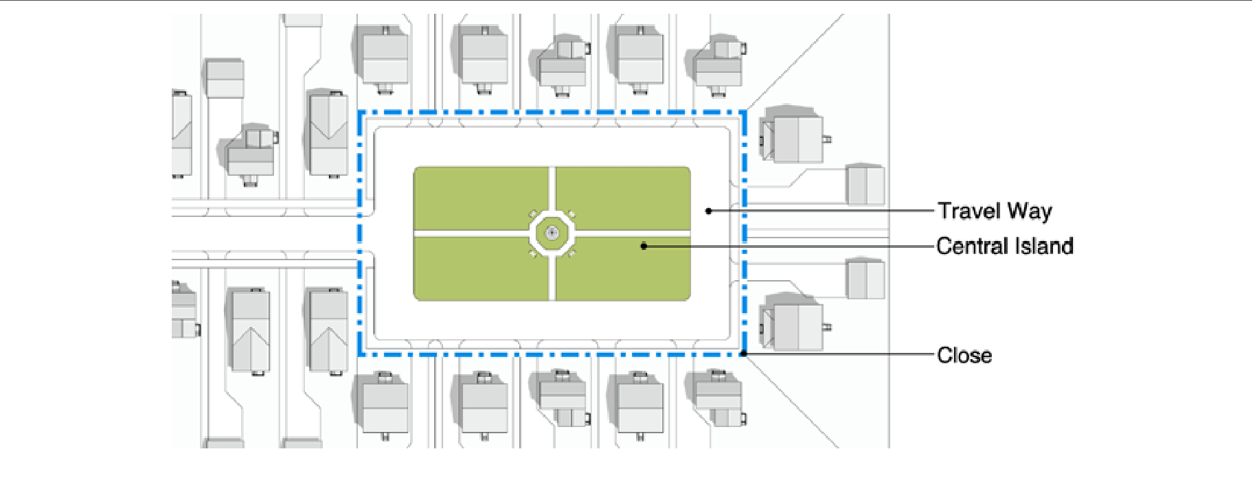
3.4.3.3 Culs-de-sac
- Culs-de-sac are prohibited except by Administrative Adjustment when the following conditions limit the ability to terminate on other streets or provide street stubs:
- Natural constraints; or
- The site is narrow, restricting the ability to connect to other streets within the site, and adjacent sites are already developed and unable to receive a street stub; or
- Connections to an existing road are limited by ARDOT requirements.
- Culs-de-sac must be designed in the manner of a “close”, as generally illustrated in Figure 3.4.3.3.A Culs-de-Sac, and according to the following requirements:
- The minimum dimension is 80 feet between property lines, in any dimension; and
- The street border must continue around the cul-de-sac; and
- A landscaped central island is required, including trees, seating, walkways, and other elements to provide an amenity for surrounding lots; and
- A pedestrian walkway must be provided, continuing the pedestrian network to adjacent properties, streets, and trails, wherever possible.
3.4.3.4 Administrative Relief from Street Network Standards
The Director may grant administrative relief to the street network requirements of 3.4.3 Street Network when the Director finds that:
- The connection required would violate another requirement of this UDC; or
- Connections cannot be made now or in the future to abutting properties due to the nature of existing development on the abutting property; or
- The strict application of the requirements creates an unsafe condition.
Table 3.4.5.A Allowed Typologies by Placetype and Street Class
| Suburban Neighborhood | Neighborhood Fabric | Downtown Neighborhood | Urban Neighborhood | City Corridor | Regional Corridor | Uptown & NW Regional Center | Highway Corridor | PG Regional Center | IAT | |
|---|---|---|---|---|---|---|---|---|---|---|
| Major Arterial | Avenues | Avenues | Avenues | Boulevards Avenues | Boulevards Avenues | Boulevards Avenues | Boulevards Avenues | Boulevards Avenues | Avenues | Avenues |
| Minor Arterial | Neighborhood Avenue Avenues | Neighborhood Avenue Avenues | Neighborhood Avenue Avenues | Neighborhood Avenue Avenues | Avenues Boulevards | Avenues Boulevards | Avenues Boulevards | Avenues | Avenues | Avenues |
| Collector | Neighborhood Avenue | Neighborhood Avenue | Neighborhood Avenue | Neighborhood Avenue | Mixed Use Street Neighborhood Avenue | Mixed Use Street Neighborhood Avenue | Mixed Use Street Neighborhood Avenue | Service Collector | Service Collector | Service Collector |
| Minor | Neighborhood Street Neighborhood Drive | Neighborhood Street Neighborhood Drive | Neighborhood Street Neighborhood Drive | Neighborhood Street Neighborhood Drive | Mixed Use Drive Neighborhood Street Neighborhood Drive | Mixed Use Drive Neighborhood Street Neighborhood Drive | Mixed Use Drive Neighborhood Street Neighborhood Drive | Service Minor | Service Minor | Service Minor |
3.4.5.1 Selection of Typologies
Street typologies must be identified for all streets depicted on a Master Plan, whether existing or proposed, and whether within or on the perimeter of the plat. In the absence of a Master Plan, the same shall be depicted on the site development plan. In all cases, the typologies selected shall conform to Table 3.4.5.A Preferred Typologies by Placetype and Street Class and Table 3.4.5.1.B Street Typology Subtypes and are subject to the approval of the Director. Within a given placetype, the typology assigned to a street should generally remain the same, but where multiple sub-types are provided in Table 3.4.5.1.B Street Typology Subtypes, multiple subtypes may be selected but in no case shall a sub-type change mid-block.
3.4.6.1 Purpose and Intent
- To ensure that streets are designed in consideration of and for the safety of all user modes; and
- To ensure consistency of design and minimum standards across placetypes; and
- To reduce traffic congestion by requiring that streets be connected and the Master Street Plan carried out by both public and private interests; and
- Any vehicular way identified on a Master Plan as a street to meet a requirement of this UDC, even if not intended to be dedicated as a public street, is constructed per the same standards for dedicated public streets.
(Ord 25-35, 7-8-2025)
3.4.6.2 General Standards
- Streets must be designed following Complete Street principles, providing access for pedestrians, bicyclists, cars, transit, and freight where appropriate.
- Streets depicted on the Master Street Plan must meet the standards specified in that plan.
- Streets must be designed consistent with an allowed typology under Table 3.4.5.1(B) Street Typology Subtypes and as approved Master Plan or site development plan, where applicable. Where specific details of design within the right-of-way conflict with the standards of this subsection the standards of this subsection apply.
- Existing streets within the site and along site boundaries must be modified to meet the requirements of this section or per National Association of City Transportation Officials (NACTO) guidelines, as specified by the City Engineer.
- Street design elements must change in coordination with zoning along the street, specifically the width of sidewalks, planting strip design, and lighting. Where zoning boundaries change mid-block, the standards applicable to the more intense of the districts shall apply to the entire block instead of abrupt design changes mid-block.
- Street design must provide adequate transitions from existing streets to new or modified streets, as specified by the City Engineer.
- Intersecting streets must meet within 15 degrees of perpendicular.
(Ord 25-35, 7-8-2025)
3.4.6.3 Lanes and Movement
- Vehicular travel lanes are limited in width as specified in Table 3.4.6.A Roadway Dimensions.
- On-street parking must be provided on at least one side of each street except for boulevard typologies or service road typologies, subject to the following:
- Where on-street parking is provided it must be parallel except on mixed-use street and mixed-use drive typologies where parking must be 45-degree angled parking. The City Engineer is authorized to permit 45-degree angled parking in T4 where it is warranted due to proposed development and where it is desirable to limit off-street parking.
- Parking lanes must be dimensioned as specified in Table 3.4.6.A Roadway Dimensions.
- 90-degree parking is prohibited on streets.
3.4.6.4 Pedestrian Ways
- A continuous and direct network of pedestrian ways must be provided, consisting of sidewalks along streets, shared-space streets, storefront sidewalks, shared-use paths, and pedestrian walkways.
- The pedestrian network must connect building entrances with the remainder of the pedestrian network along all adjacent streets, sidewalks, shared-use paths, pedestrian walkways, and transit stops.
- Crosswalks must be provided at each intersection quadrant. Where streets are offset less than 200ft, intersection quadrants may be combined between streets.
- Curb extensions must be provided at intersections and all mid-block pedestrian crossings, except where they would conflict with a bike lane.
- Where the distance between intersections exceeds 500 feet, a mid-block pedestrian crosswalk must be provided. Mid-block pedestrian crosswalks should align with mid-block pedestrian walkways where required by Subsection 3.4.2.C Block Standards.
- Shared-use paths must be paved and a minimum of 10ft wide. Pervious pavement is encouraged.
- Sidewalks and pedestrian walkways must meet the following minimum widths:
- T6: 12ft. Minimum;
- T5 and HC: 8ft. Minimum;
- T4 and I-1: 6ft. Minimum;
- T3, T2, and I-2: 5ft. Minimum.
- Pedestrian-oriented lighting must be provided along the pedestrian network as specified in Subsection 3.4.6.6 Lighting.
- In HC, cross-block pedestrian ways may be within parking lots. In all other zones on sites subject to 3.2.2 the requirements of 5.6.5.2 may be utilized to satisfy this requirement; and
- All other cross-block pedestrian ways must:
- Divide the block along its longer dimension;
- Be located in a tract that is at least 20 feet wide;
- Provide a sidewalk, at least 5 feet wide in T3 and T4, 10 feet in T5, and 16 feet in T6; and
- Provide trees per Section 5.6.3 Path Trees.
3.4.6.5 Street Furnishings
3.4.6.6 Lighting
- Lighting must be provided at the following frequency, or more frequently at the discretion of the applicant:
- T3: at intersections and bends in the street greater than 30 degrees;
- T4, HC, I-1, I-2: 150ft. between lights along the length of the street, alternating on each side of the street; and
- T5, T6: 60ft. between lights along the length of the street, on both sides of the street.
- Light poles are limited to 14ft. max. in T3 and T4, and 16ft. max. elsewhere;
- The light source must be LED and shielded from direct view by diffusion;
- The light source must be shielded to prevent uplighting; and
- The light source must be between 3,000 and 3,600 kelvin.
- Alternative materials may be approved by Administrative Adjustment due to a lack of available materials meeting the above specifications.
3.4.6.7 Planting strips
- Street trees in planting strips must meet the requirements of Subsection 5.6.2 Street Trees.
- The planting strip must be configured as specified in Table 3.4.6.7.A Planting Strip Requirements and as provided in Table 3.4.6.7.A.
- Where street trees are prohibited within rights-of-way, including instances of utility conflicts, they must be provided in a recreation easement on private property, abutting the right-of-way unless the maximum exterior yard requirements of 4.5 preclude the ability to do so.
3.4.6.8 Curb return radius
- At intersections with local streets, curb return radius is measured as the effective radius along the inside edge of vehicle tracking, accounting for the width of bicycle lanes and parallel parking that may position the turning vehicle away from the actual curb, as follows:
- Where on-street parking or bike facilities are not provided, the effective curb return radius is measured along the trajectory of the curb where curbs are present or along the edge of pavement where curbs are not present;
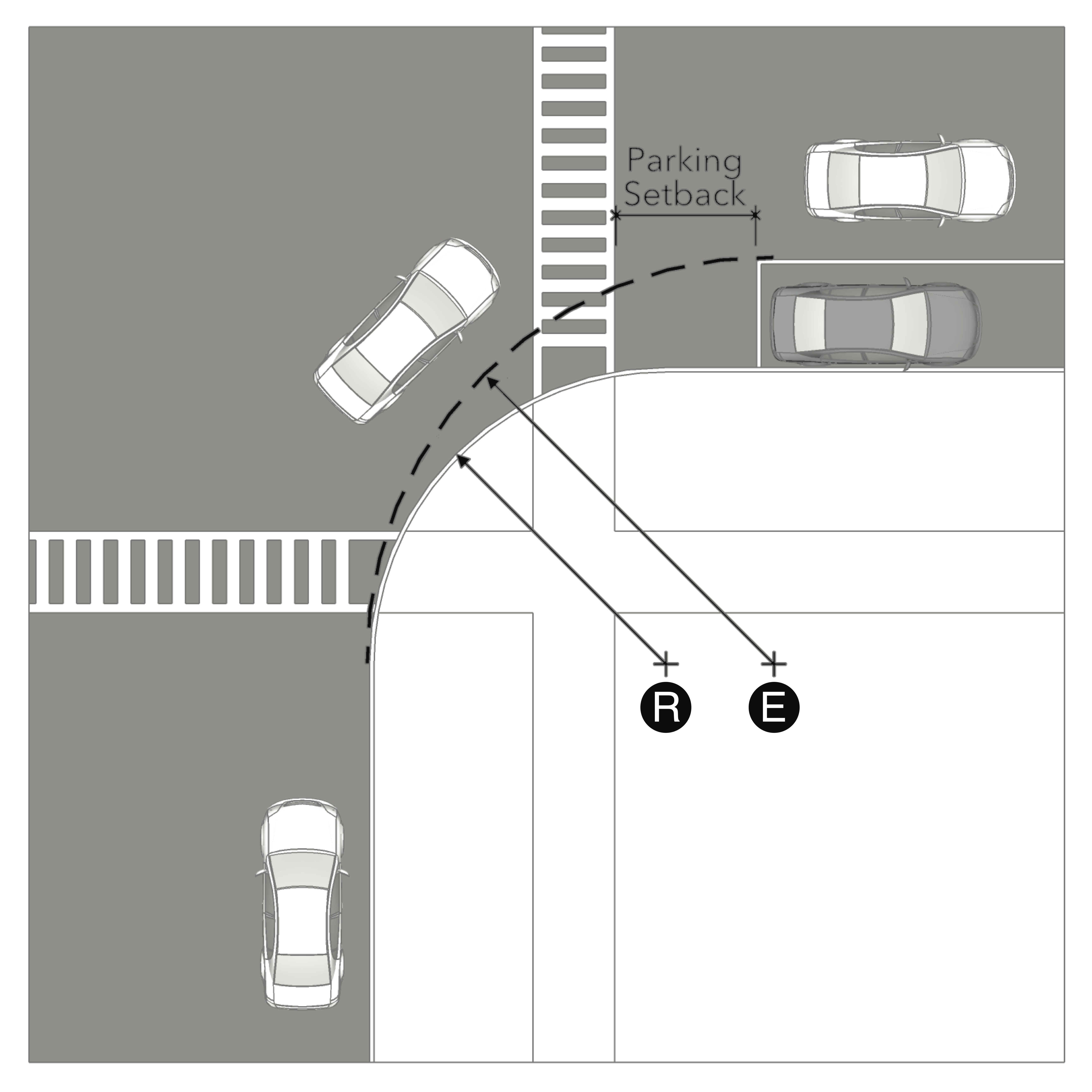
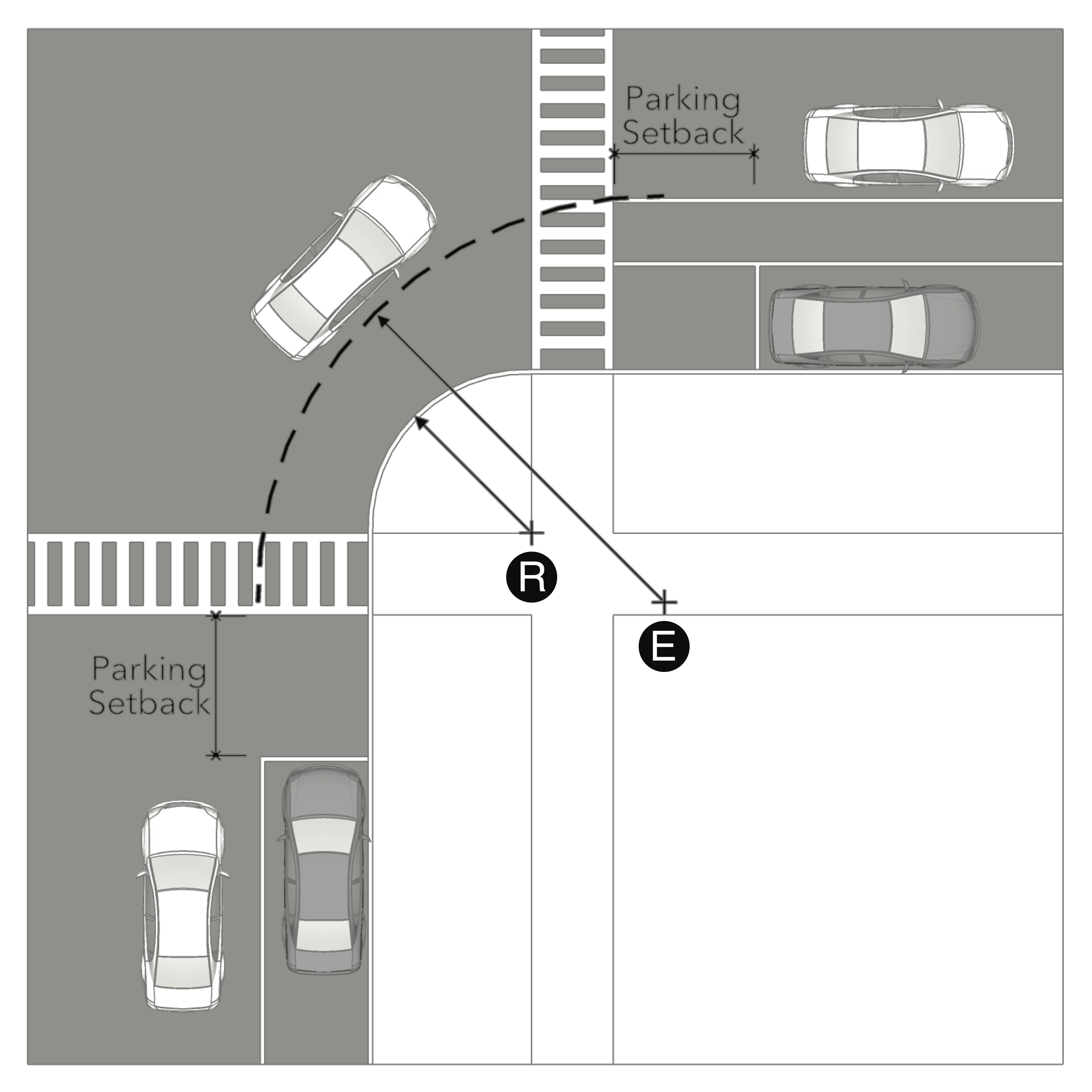
- Where on-street parking or bicycle facilities are provided, the effective curb return radius is measured along a curved line that connects tangent to lines corresponding with the outside edge of the outer-most travel lane at both roads, as illustrated in Figure 3.4.5.8.B Effective Curb Return Radius; and
- Examples of effective curb return radius measurement, including curb extensions, are illustrated in Figure 3.4.5.8.C Effective Radius Measurement Examples.
- As intersections with local streets, minimum curb radii must be provided as specified in Table 3.4.6.8.A Minimum Curb Radii for Local Streets.
- The City Engineer may require a larger curb return radius at intersections than specified in this section to accommodate large design vehicles.
- A swept path analysis may be utilized to determine the minimum actual curb return radius required.
3.4.6.9 Bikeways
- A network of bikeways must be provided, consisting of marked, shared lanes, dedicated lanes, shared-use paths, and dedicated bicycle trails.
- The local bikeway network must connect to all adjacent bikeways, regional open space, existing trail networks, schools, and parks, and must continue adjacent bikeway networks.
- Where the Master Street Plan depicts a bicycle facility throughout the site, that facility must be provided by the applicant. The trajectory may be different from the Master Street Planwithin the site provided that it connects to adjacent sites as specified, subject to approval by the City Engineer.
- Sites smaller than 5 acres only require the continuation of adjacent bikeways that terminate at site boundaries and facilities specified on the Master Street Plan.
- The City Engineer may require a specific facility type and trajectory to integrate with the citywide bikeway network.
- Bikeways must meet the design requirements specified in Table 3.4.6.9.A Bikeways.
3.4.7.1 Where Required
Vehicular access to all vehicular use areas shall be provided through an alley when:
- Creating lots whose exterior lot lines are less than 80 feet in T5 or T6; or
- Creating lots whose exterior lot lines are less than 60 feet in T2, T3, and T4; or
- When the arrangement of buildings would necessitate driveways within 55 feet, as measured at the sidewalk or in the absence thereof the right-of-way, of another driveway on the same blockface in T5 or T6; or
- When the arrangement of buildings would necessitate driveways within 40 feet, as measured at the sidewalk or in the absence thereof the right-of-way, of another driveway on the same blockface in T2, T3, and T4;
- Where necessary to meet the requirements of Section 3.5 Utilities.
(Ord 25-35, 7-8-2025)
3.4.7.2 Administrative Adjustments
- The Director is authorized to grant an administrative adjustment from the requirements of 3.4.7.1 when:
- An alley does not exist and cannot be constructed due to existing surrounding development under separate ownership; or
- When there is no available alley right-of-way extending to the subject lot and such right-of-way or access rights cannot be granted due to inadequate space, separate ownership, existing development; or
- Where alley construction is feasible but the subject lot is located mid-block or at such a distance from the nearest alley or street from which to extend an alley that construction of an alley would be disproportionate to the proposed development.
- In granting an adjustment the Director may:
- Allow a driveway from the street of such a width, location, or shared with an adjacent lot or building that brings it as close as possible to conforming with 3.4.7.1; and
- Where the condition described in 3.4.7.2.A.3 is present the Director may:
- Collect a fee instead of construction based upon the costs of constructing the alley according to the standards of this UDC across the width of the subject lot, as estimated by an engineer licensed in the State of Arkansas, to be utilized by the City in the future for the purposes of constructing the alley; and
- Collect a fee to cover the estimated costs of removal of the driveway, including driveway apron, utilized in the future by the City to remove the driveway; and
- An agreement filed against the deed of the property that:
- Forbids the owner from objecting to the future construction of the alley; and
- Forbids the owner from objecting to the removal of the driveway upon the construction of the alley; and
- Requires the owner to remove the driveway apron in its entirety and driveway from the exterior yard within 3 months of completion of the alley by the city or its contractors and acknowledges that if such is performed the amount held in escrow for such purpose will be refunded to the owner; and
- Grants an easement to the city authorizing the removal of the driveway from the exterior yard in the event the owner fails to perform per the agreement and authorizes the city to utilize the funds in escrow toward the costs incurred by the city in removing the driveway.
3.4.7.3 Design Specifications
- Alley design must be according to a Standard Alley Section and Entry as specified in Table 3.4.7.B Standard Alley Section and Entry.
- All alleys require a paved apron.
- Alleys may be paved with compacted, dustless gravel and other pervious materials, subject to approval by the City Engineer.
- Where lots face onto a park or pedestrian walkway, alley pavement must be a minimum of 20 feet wide and able to accommodate fire truck weight and turning movements.
- The interior radius of the alley pavement must be a minimum of 20 feet.
- Alley elevation at sidewalks must be at sidewalk grade to permit sidewalk continuity.
- Sidewalk material and appearance must be maintained across alley entrances and aprons.
- Alleys must intersect streets within 15 degrees of perpendicular.
- Where the distance between intersecting streets exceeds 500 feet in T3 and T4, alleys must be designed in a "T" shape so that all surrounding streets have lots oriented so that the front of buildings face all surrounding streets as depicted according to Figure 3.4.7.A Alley Configuration on Large Blocks.
(Ord 25-35, 7-8-2025)
Figure 3.4.7.A Alley Configuration on Large Blocks
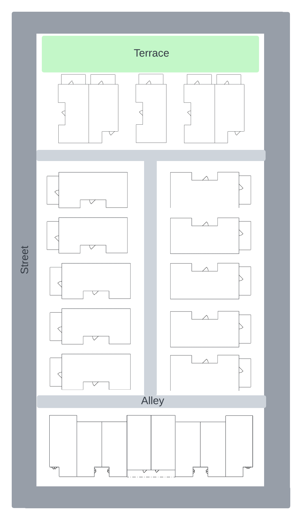 |
Table 3.4.7.B Standard Alley Section and Entry
| Neighborhood Alley | ||
 | A | Alley pavement must be 20ft. min. at the alley apron and extend at that width for at least 20ft. into the alley. |
| B | Where the sidewalk crosses the alley apron, it must be maintained in material, width, and elevation across the alley apron. | |
| C | The apron must have a 5 to 10ft. curb return radius. | |
| D | Parking must be set back a minimum of 20ft. from the alley pavement at the alley apron. | |
| Permitted Zones: T2, T3, T4 | ||
| Mixed-Use and Non-Residential Alley | ||
 | A | Alley pavement must be 20ft. min. at the alley apron and extend at that width for at least 20ft. into the alley. |
| B | Where the sidewalk crosses the alley apron, it must be maintained in material, width, and elevation across the alley apron. | |
| C | The alley apron may have a 5ft. taper or a 5ft. curb return radius. | |
| D | Parking must be set back a minimum of 20ft. from the alley pavement at the alley apron. | |
| Permitted Zones: T5, T6, HC, I-1, I-2 | ||
3.4.9.1 Purpose and Intent
To improve the quality and functioning of existing streets and other accommodations by requiring new development to improve them to current standards and by requiring new streets to be constructed to the same standards.
3.4.9.1 Required Street Improvements
- Existing streets along site boundaries must be modified to meet the requirements of:
- The Master Street Plan;
- Current street improvement plans by the Department of Community Development;
- ADA standards; and
- This Article; and
- National Association of City Transportation Officials (NACTO) guidelines, as specified by the City Engineer.
- Street improvements are required up to a full half street along the abutting lot lines of development sites, except to the extent that the Director may reduce required improvements proportional to the scale of development.
- The Director may accept or require a fee in lieu of street improvements.
3.5.2.1 New Utilities
These standards apply in full to the installation of any utility in new development. The Director may grant an administrative adjustment for infill or redevelopment sites where full compliance with this section would create a safety hazard for the public.
3.5.2.2 Existing Utilities
These standards apply in full to existing utilities where sites undergo new development, infill development, or redevelopment. The Director is authorized to grant an administrative adjustment to this requirement would full compliance would create a safety hazard for the public or is disproportionate to the development proposed.
3.5.3.1 Exemptions
Major transmission lines are exempt from these standards.
3.5.3.2 Location Standards
Sanitary sewer, stormwater, and water must be below streets, alleys, and mews between the edges of pavement. They may be located below street alternatives or programmed open spaces where they do not create a conflict with required placement or design of features at and above the surface, such as trees.
Power, telecom, natural gas must be below streets and alleys between the edges of pavement or in a required or permitted exterior yard. Their related transformers and pedestals may be located above grade only as follows:
Within an interior yard or alley right-of-way in all zones; or
Within an easement within permitted or required exterior yard in all zones; or
Within a furniture zone in T5 and T6.
- Power and telecom must be provided in a shared trench box, except:
- The City Engineer may permit a joint trench in place of a shared trench box;
- Above-ground service may be permitted by Administrative Adjustment within alleys and crossing streets, but not along streets; and
- Where service is provided from alleys, street lights and other street-side equipment may be serviced by a pipe installed below the sidewalk.
- The shared trench box must be located within the alley or below the sidewalk, as illustrated in Figure 3.5.3.2.D.
(Ord 25-35, 7-8-2025)
Table 3.5.3.2.A Utility Location Standards In T2, T3, T4, HC, I-1, and I-2 Zones
| Where Street and Alley are Present | 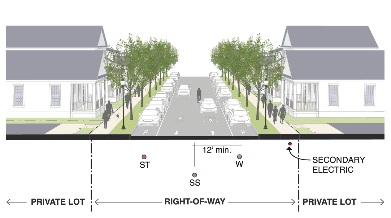 |  | |||||
| Street Location | Alley Location | ||||||
| Water | Required between curbs; 12 ft. min. separation from sewer | Prohibited | |||||
| Sewer | Required between curbs; 12 ft. min. separation from water | (Alternative)Below pavement, 5 ft. min. separation | |||||
| Electric | Secondary location only as power for streetlights | Primary location; required within shared trench box | |||||
| Telecom | Prohibited | Required within shared trench box | |||||
| Storm | Within right-of-way at curb | Prohibited | |||||
| Gas | Prohibited | Within the alley | |||||
| Utilities in Right-of-Way | Utilities in Private Yard | ||||||
| Where only Street is Present | 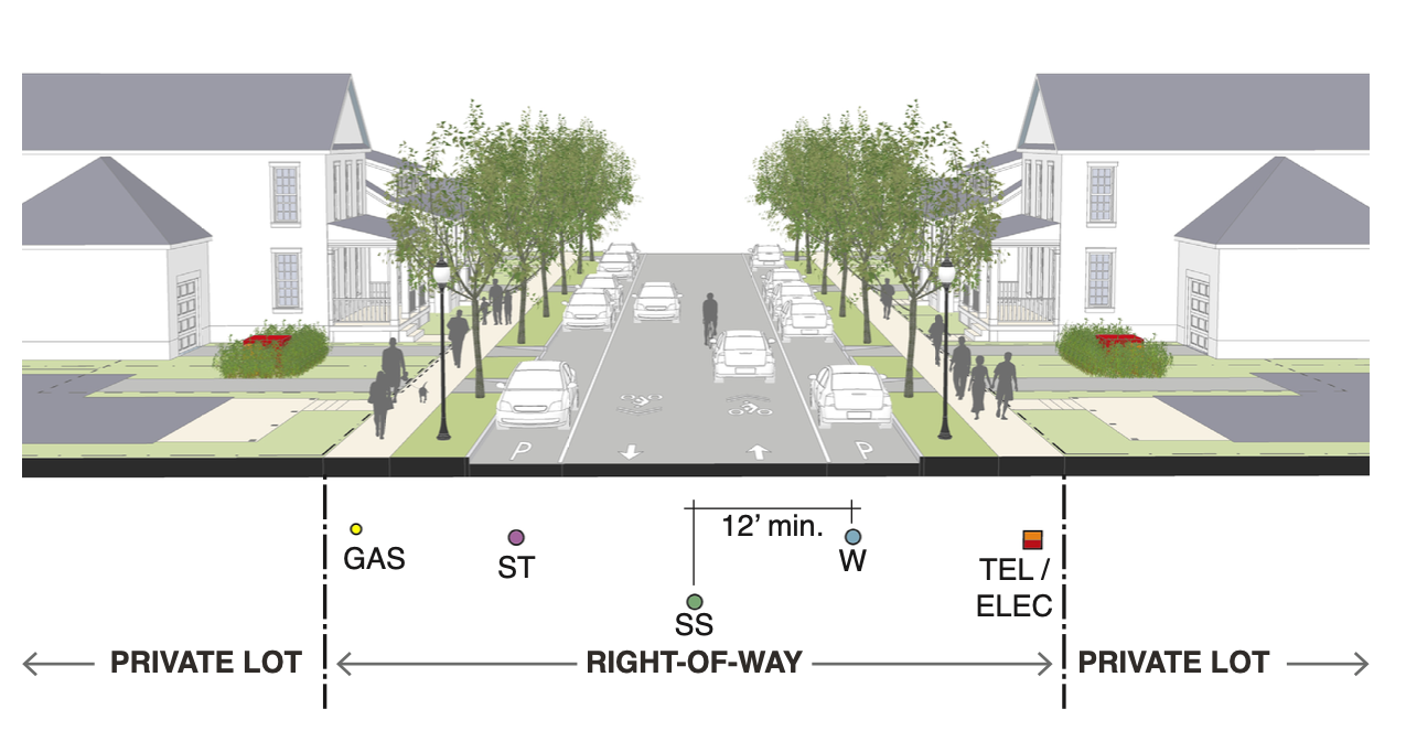 | 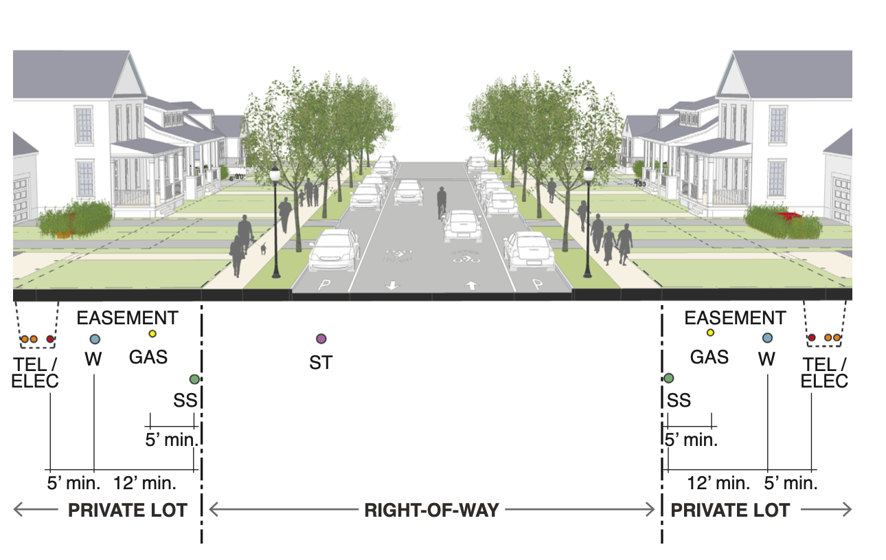 | |||||
| Water | Required between curbs; 12 ft. min. separation from sewer | Within easement on private property, 12 ft. min. separation from sewer | |||||
| Sewer | Required between curbs; 12 ft. min. separation from water | Within easement on private property; 12 ft min separation from water | |||||
| Electric | Under sidewalk | Joint trench in easement on private property, 5’ min. clearance to wet utilities | |||||
| Telecom | Under sidewalk | Joint trench in easement on private property, 5’ min. clearance to wet utilities | |||||
| Storm | Within right-of-way at curb | Within right-of-way at curb | |||||
| Gas | Under sidewalk | Located in easement on private property | |||||
Table 3.5.3.2.B Utility Location Standards In T5, T6, HC, and I Zones
| Where Street and Alley are Present | 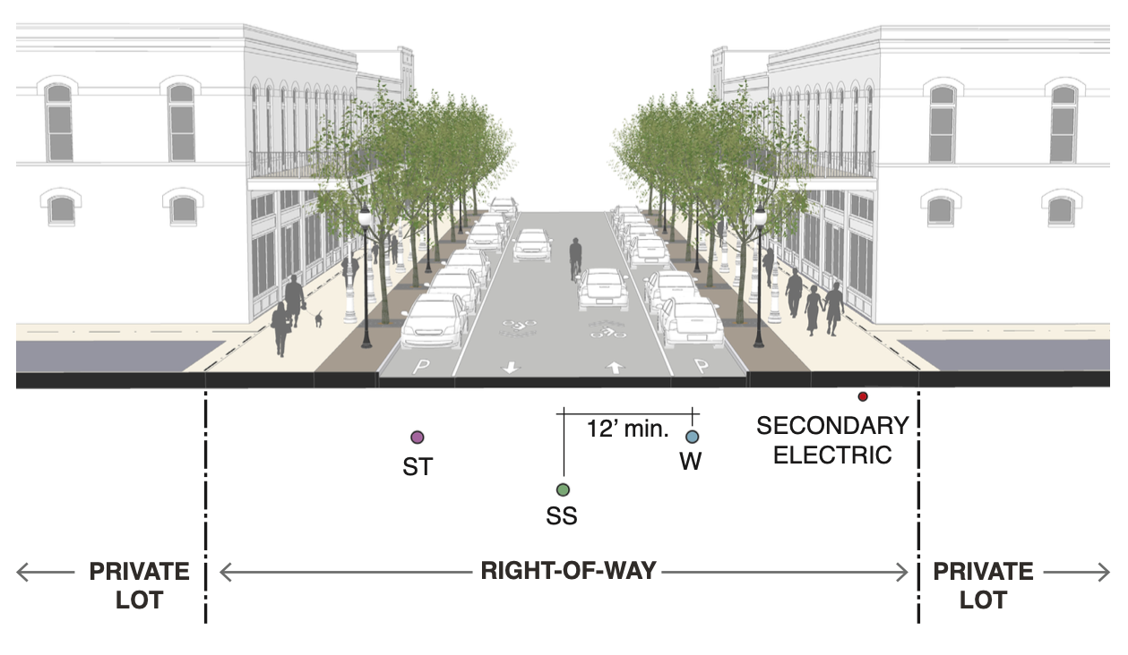 |  | |||||
| Street Location | Alley Location | ||||||
| Water | Required between curbs; 12 ft. min. separation from sewer | Prohibited | |||||
| Sewer | Required between curbs; 12 ft. min. separation from water | Prohibited | |||||
| Electric | Secondary location only as power for streetlights | Primary location; required within shared trench box | |||||
| Telecom | Prohibited | Required within shared trench box | |||||
| Storm | Within right-of-way at curb | Prohibited | |||||
| Gas | Prohibited | Located within easement on private property. | |||||
| Where only Street is Present |
| ||||||
| Water | Required between curbs; 12 ft. min. separation from sewer | ||||||
| Sewer | Required between curbs; 12 ft. min. separation from water | ||||||
| Electric | Under sidewalk | ||||||
| Telecom | Under sidewalk | ||||||
| Storm | Within right-of-way at curb | ||||||
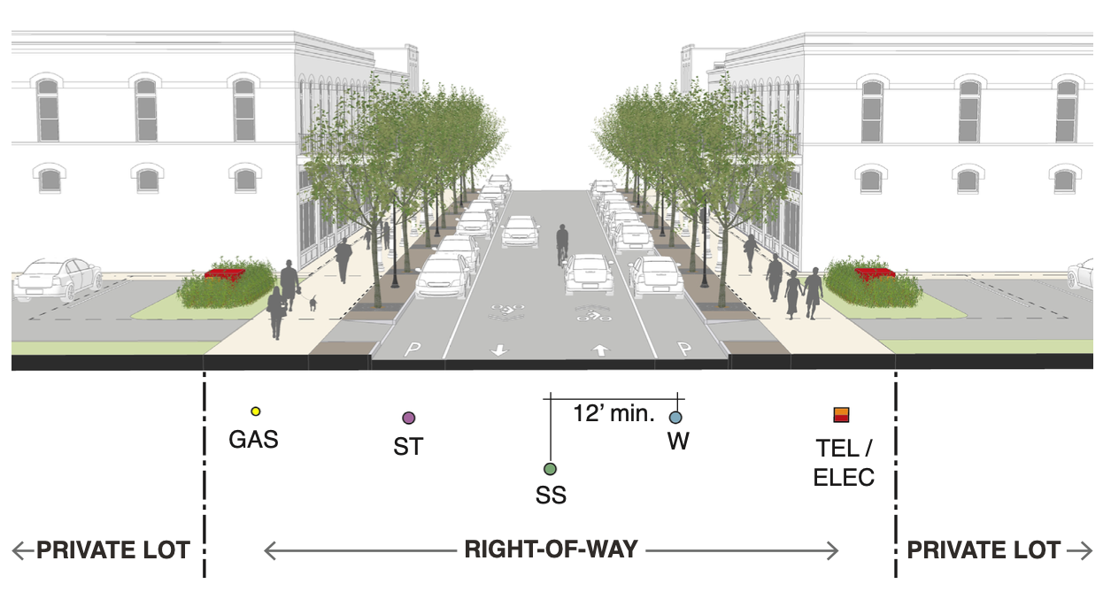
Table 3.5.3.2.C Transformer and Telecom Locations
| Pedestal | 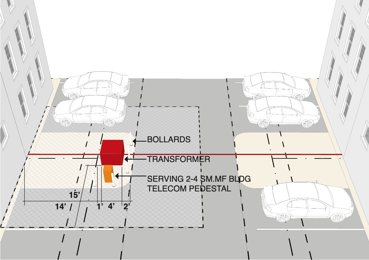 | |||||
| Pole-Mounted | 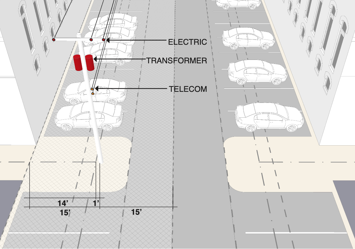 | |||||
Table 3.5.3.2.D Shared Trench Locations
Shared Trench in Alley | 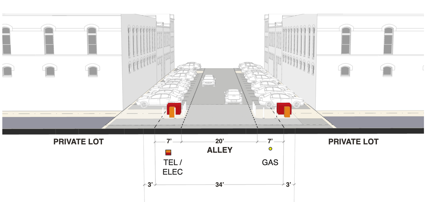 | |||||
Shared Trench Below Sidewalk |  | |||||
Figure 3.6.5.A Conservation Space
| Specifications | Minimum Standard |
|
Zoning Districts | Any, but only allowed where natural features identified by Section 3.3 Natural Features are proposed to be conserved. | |
Size | Minimum area to be conserved: 10,000 sq ft. Maximum percentage of required programmed open space: 90% for sites under 20 acres; 80% for sites between 20 and 40 acres, and 70% for sites over 40 acres. | |
Proportion | N/A | |
Edge Condition | N/A | |
Surface | Natural vegetation | |
Buildings | Prohibited |
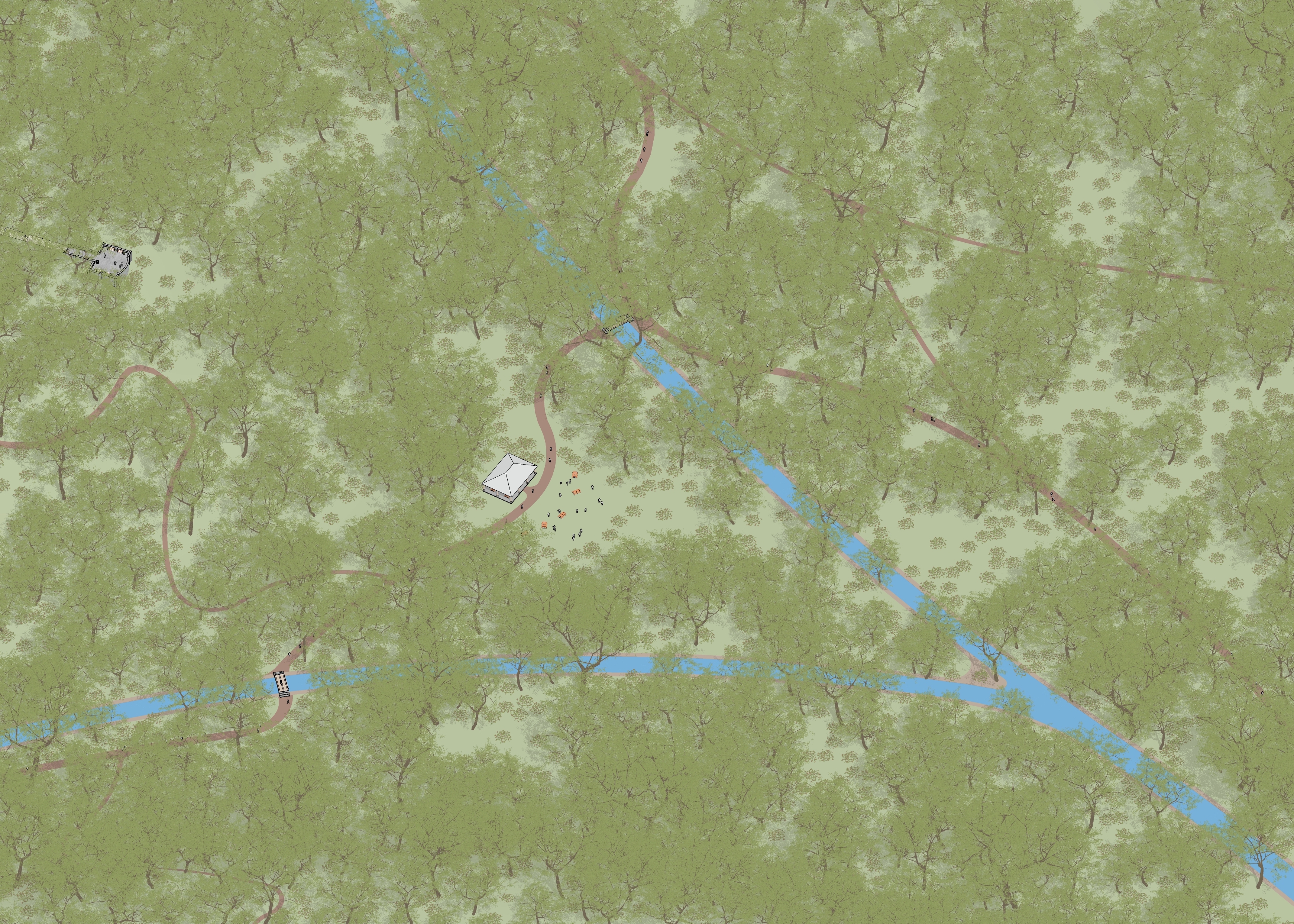
Figure 3.6.5.B Sport Space
| Specifications | Minimum Standard | 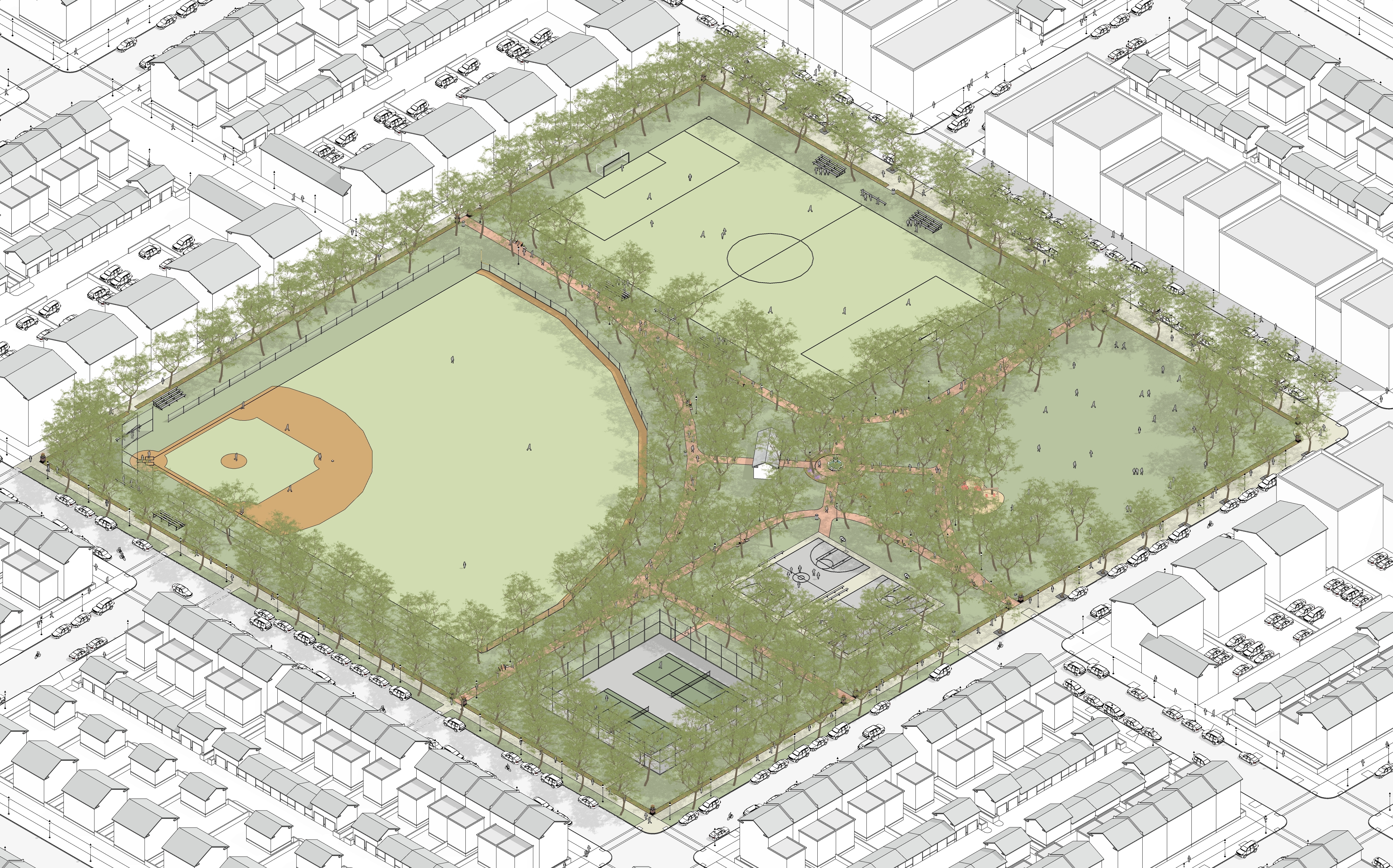 |
Zoning Districts | T2, T3, T4, T5, HC, I-1 | |
Size | 2 ac. min., 10 ac. max. | |
Proportion | 1:5 max. | |
Edge condition | Rights-of-way required on two sides minimum | |
Surface | Maximum 20% paved, Minimum 20% landscaped | |
Landscape | 20 foot landscape zone at perimeter, canopy tree required. | |
Fields may serve as a secondary purpose as stormwater management | ||
Figure 3.6.5.C Active Recreation
Zoning District | T2, T3, T4, T5, T6 | 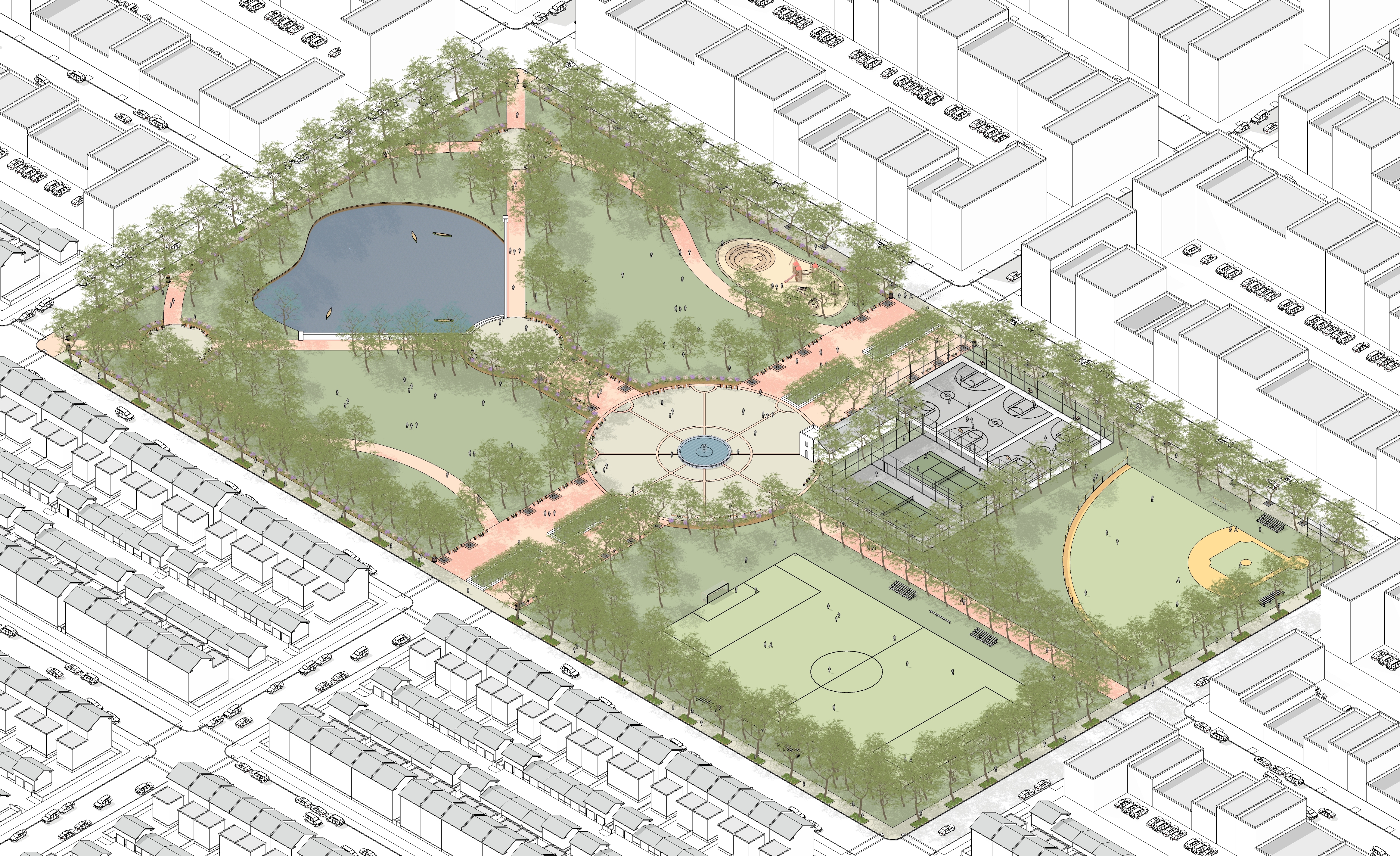 |
Size | 5 ac. min. | |
Proportion | 1:5 max. in T5 and T6 | |
Edge condition | Right-of-way required on all sides in T5 and T6; required on 2 or more sides in other zones | |
Surface | Planted, pervious and non-pervious paths, paved gathering spaces, sports facilities | |
Buildings | Pavilions, picnic areas, storage, rest rooms, food service |
Figure 3.6.5.D Green
Zoning District | T3, T4, T5 | 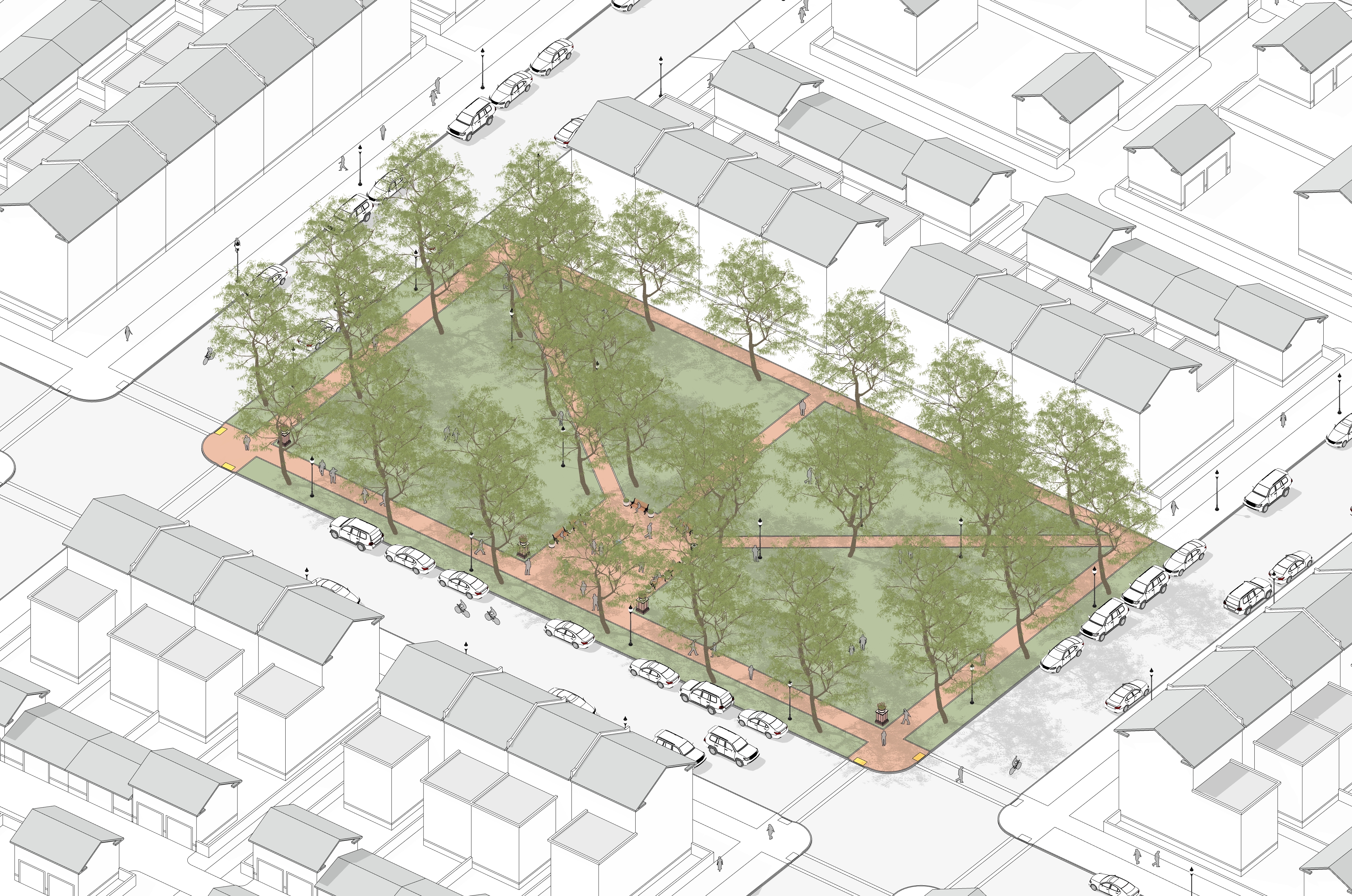 |
Size | 1/2 ac. min., 8 ac. max. | |
Proportion | N/A | |
Edge condition | Right-of-way required on at least one side | |
Surface | Planted, paved 15% max | |
Buildings | 40% min. canopy coverage at maturity |
Figure 3.6.5.E Square
Zoning District | T4, T5, T6, HC | 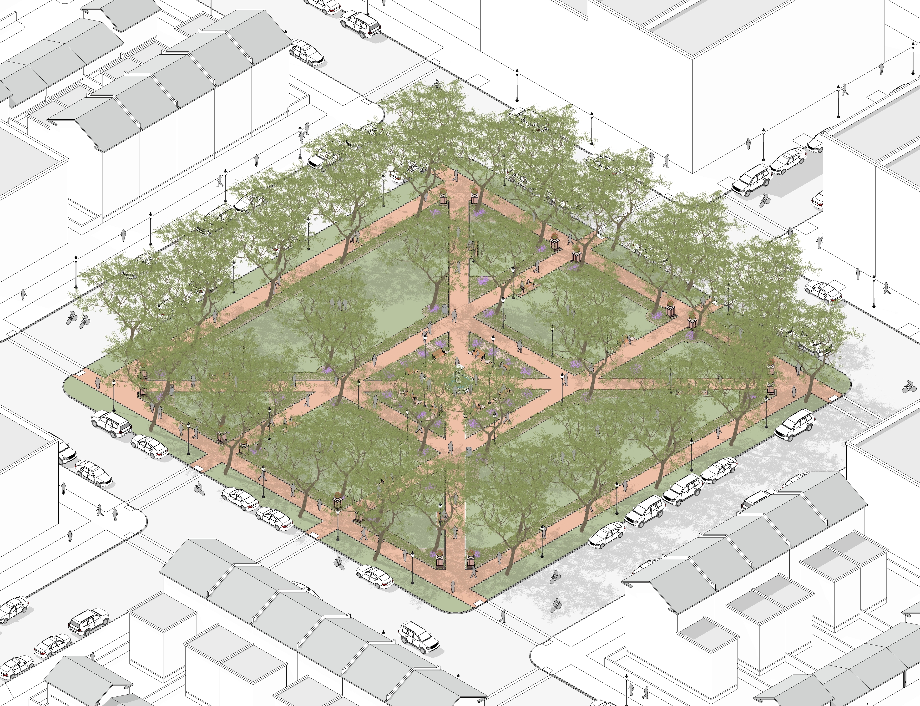 |
Size | 1/2 ac. min., 5 ac. max. | |
Proportion | 1:5 max. | |
Edge condition | Rights-of-way required on two sides minimum | |
Surface | Paved 50% max., pervious paving required | |
Buildings | 30% min. mature canopy coverage at maturity |
Figure 3.6.5.F Plaza
Zoning District | T5, T6, HC | 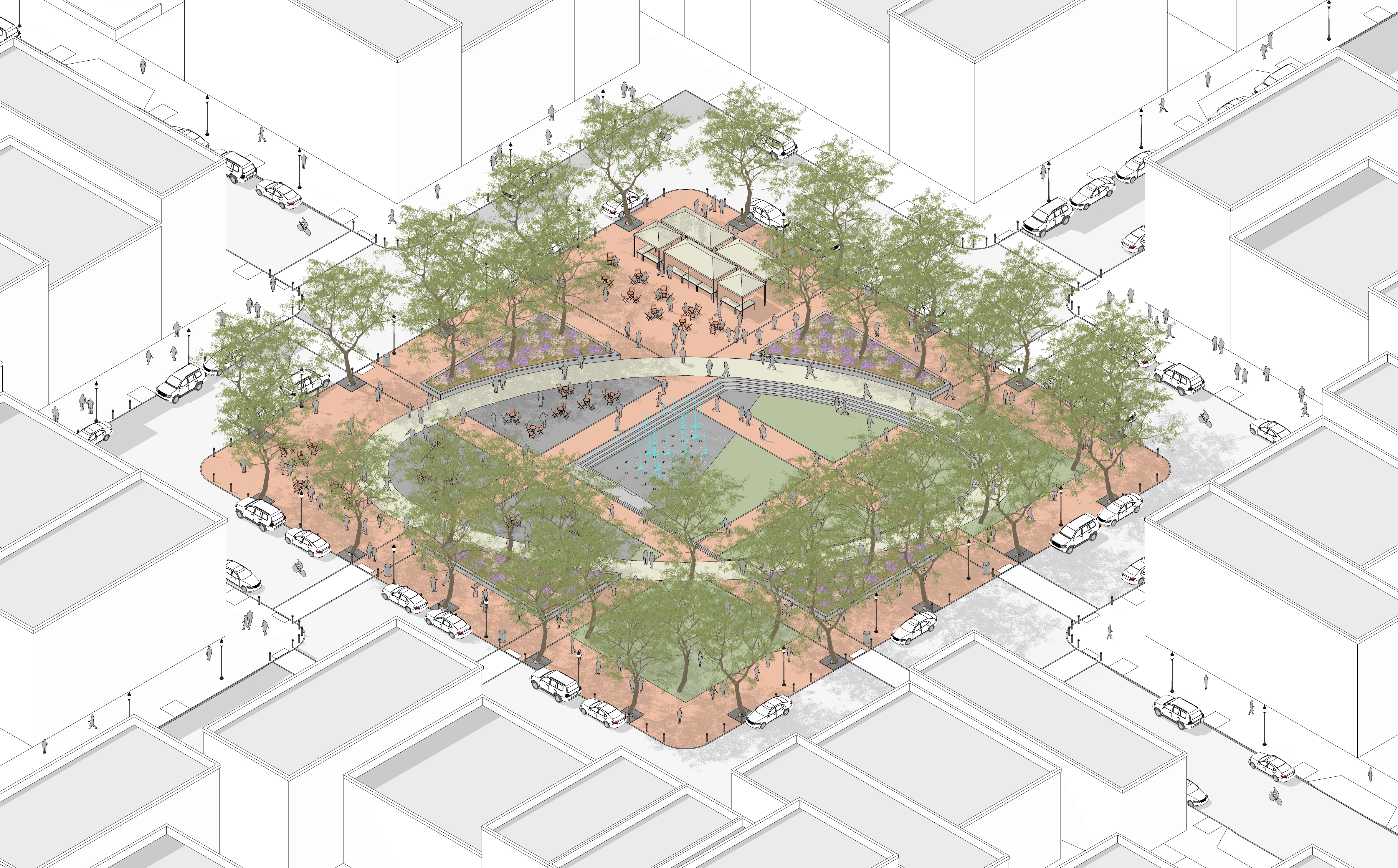 |
Size | 1/8 ac. min., 3 ac. max. | |
Proportion | 1:4 max. | |
Edge condition | Rights-of-way required on two sides minimum | |
Surface | Paved 50% min., pervious paving required | |
| Landscape | 20% mature canopy required | |
Buildings | Pavilions, storage, rest rooms, food service, vending |
Figure 3.6.5.G Greenway
Zoning District | T3, T4, T5, T6 | 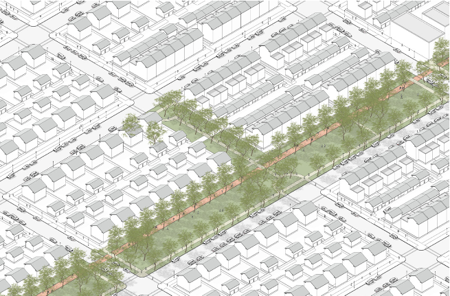 |
Size | 50 ft. min. in width, | |
Proportion | N/A | |
Edge condition | Rights-of-way or pedestrian way required on one side minimum | |
Surface | Lawn, paved 20% max. | |
Landscape | 20% min. canopy coverage at maturity |
Figure 3.6.5.H Pocket Space
Zoning District | T3, T4, T5, T6 | 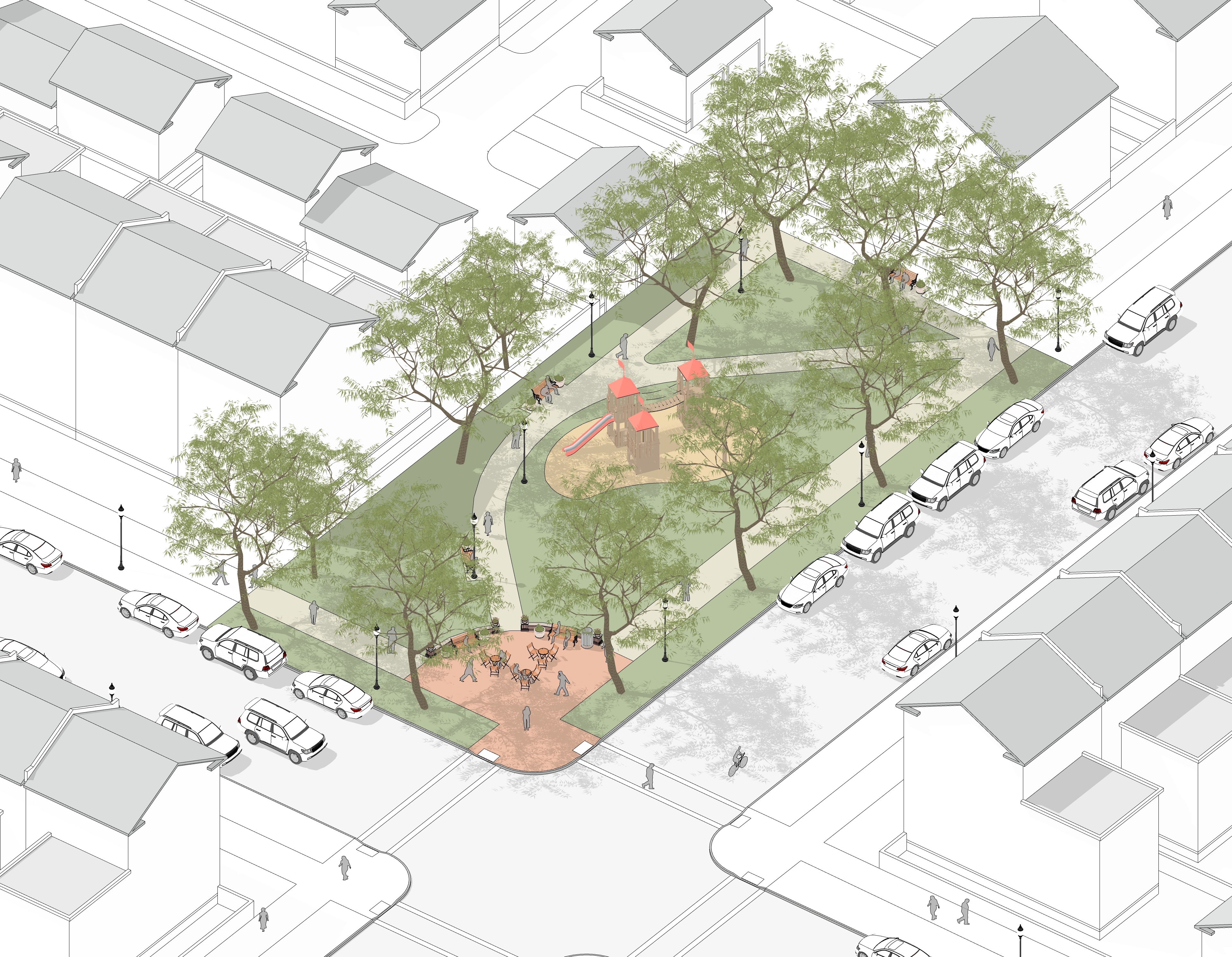 |
Size | 2,000 sq.ft. min., | |
Proportion | 1:5 max. | |
Edge condition | Rights-of-way required on one side minimum | |
Surface | Planted, play equipment, paved 30% max. | |
Landscape | 40% min. canopy coverage at maturity |
Figure 3.6.5.I Community Garden
Zoning District | T3, T4, T5 | 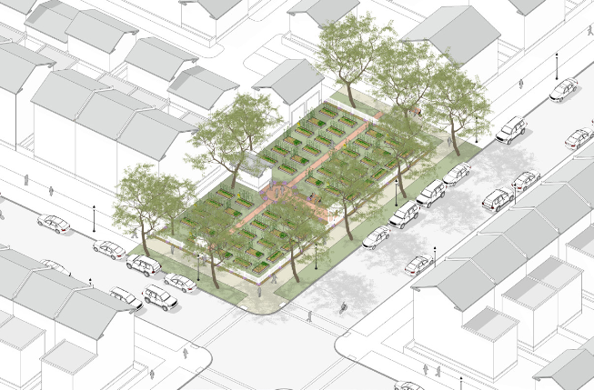 |
Size | N/A | |
Proportion | N/A | |
Edge condition | N/A | |
Surface | Water supply required | |
Landscape | 75% noon-time solar exposure |
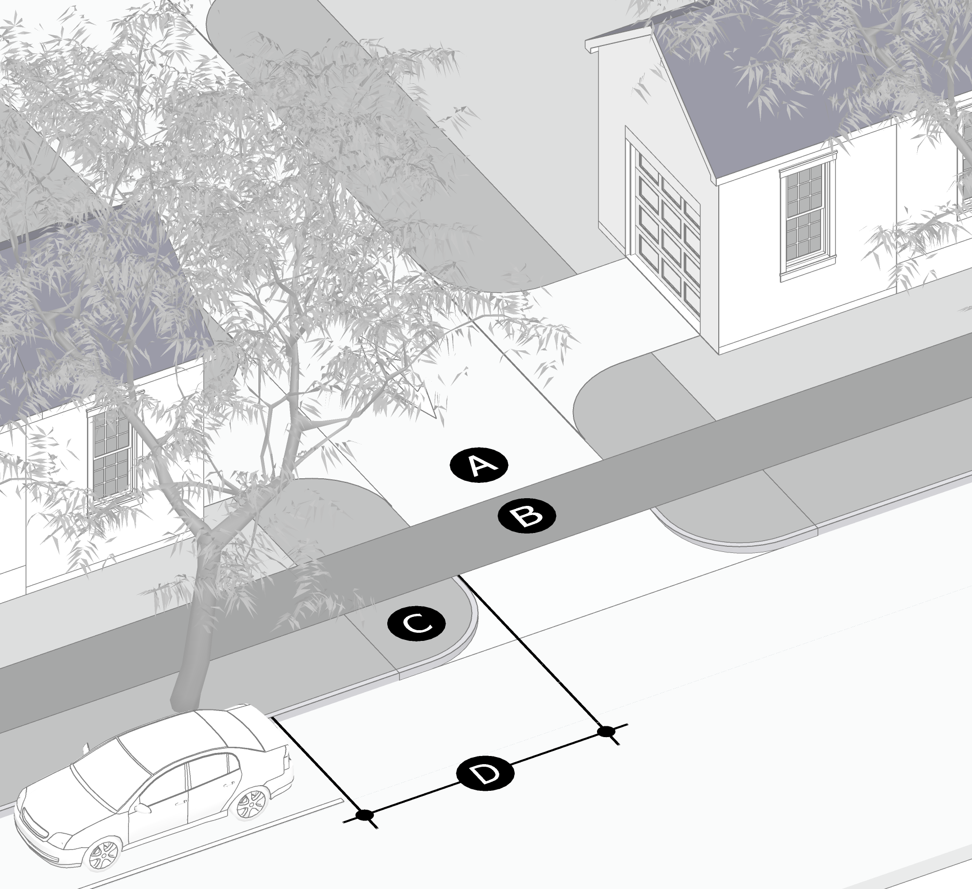
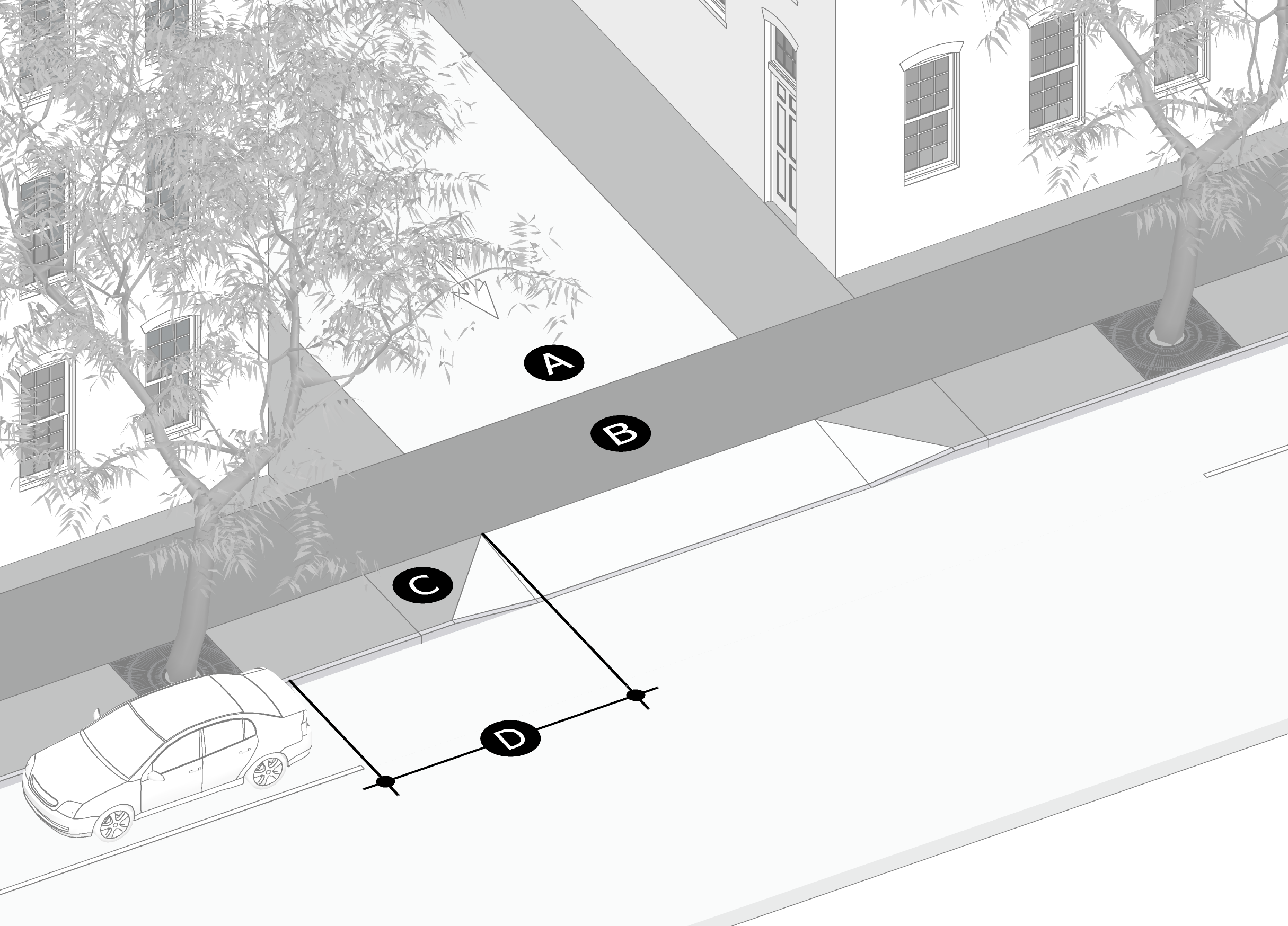
Figure 3.4.3.2.A External Street Connections
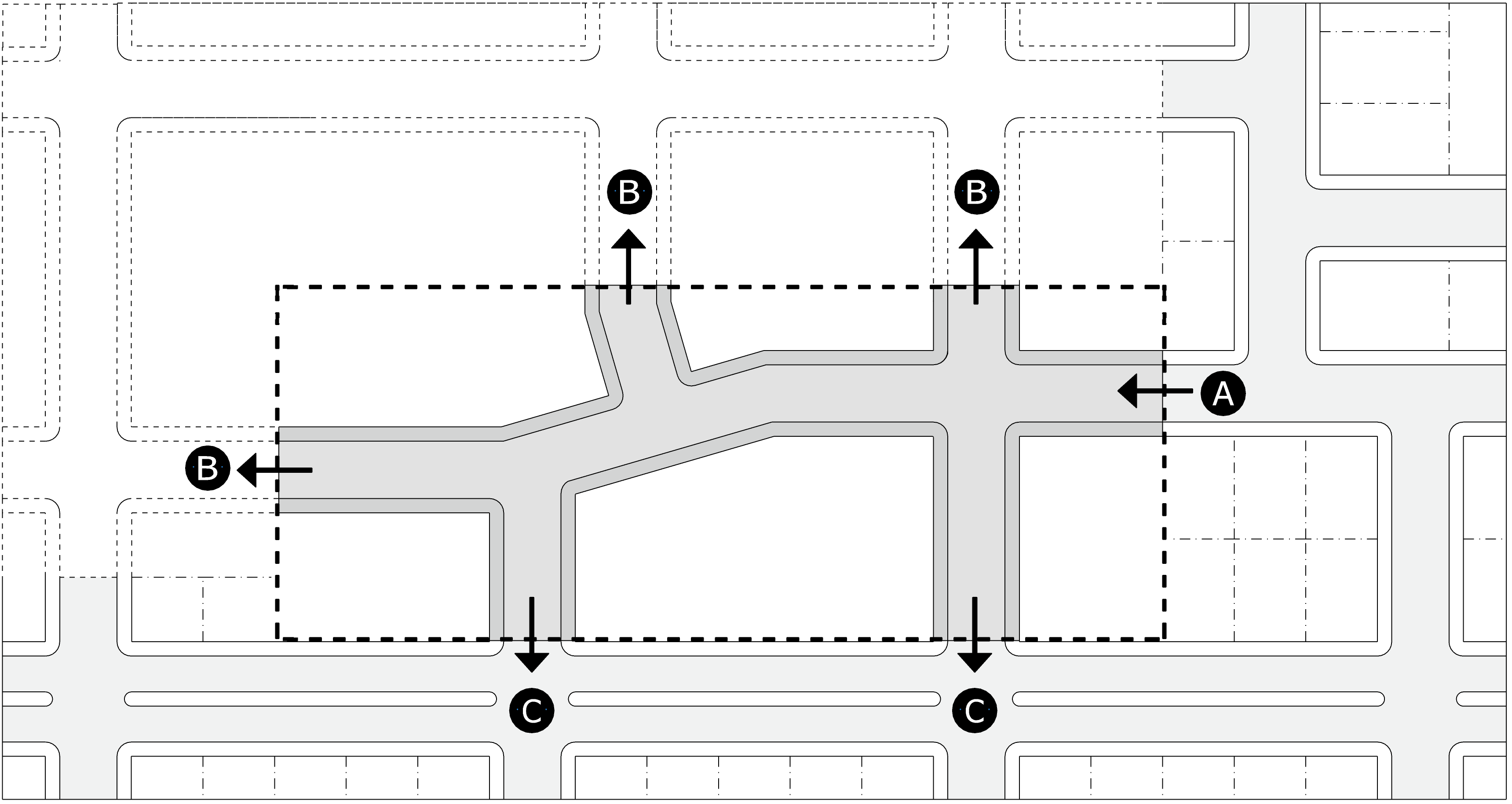 | |
| A | Street stubs abutting site boundaries must be extended through the subject property. |
| B | Street stubs to abutting properties, other than already developed lots, must be provided at least every 660 feet, except where restricted by natural features. |
| C | Street connections to adjacent streets must be provided at least every 660 feet, except where restricted by natural features. |
Figure 3.4.3.3.A Culs-De-Sac
Boulevard
| Typology | Standard Cross Section | |||||||||||||
|---|---|---|---|---|---|---|---|---|---|---|---|---|---|---|
Boulevard A typology applicable to arterial streets where on-street parking is undesirable but mixed-use urban form is desirable. A front parking lane is provided on private property for cross-access and parking. Two subtypes are provided that are applicable to highways with auto-oriented form. | 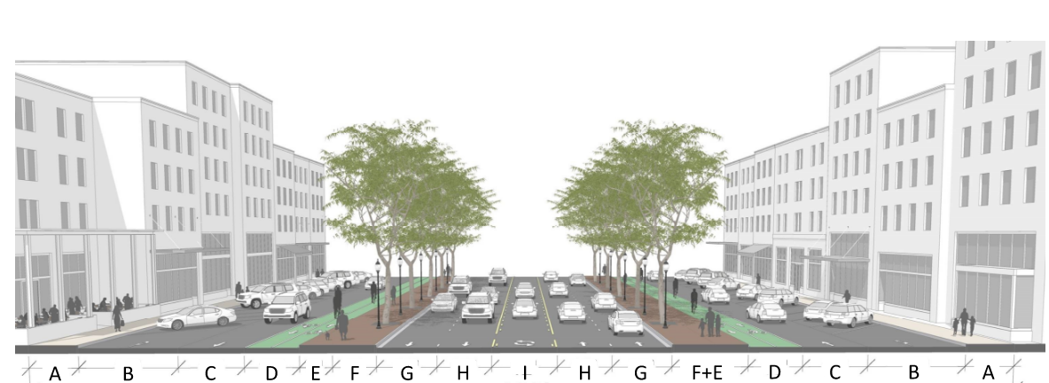 | |||||||||||||
| Subtype | Intended to Serve | A | B | C | D | E | F | Easement Depth | G | H | J | ROW from Centerline | Ground Floor Design | Ground Floor Use |
B-40 (subtypes may not change mid-block) | Arterials in zones with maximum exterior yard setbacks where parking in front of the building is desirable but on-street parking is not allowed. | 10' concrete sidewalk | 8' parallel parking | 12' travel lane | 10' bi-directional green bike lane | 40' | 6' concrete sidewalk | 10' hardscaped street tree and furniture zone | 12' median, bioswale, or center turn lane | 50' | Nonresidential design required. See 4.5.6. | Any use permitted by zoning. | ||
B-48 (subtypes may not change mid-block) | 10' concrete sidewalk | 8' parallel parking | 12' travel lane | 8' parallel parking | 10' bi-directional green bike lane | 48' | 6' concrete sidewalk | 10' hardscaped street tree and furniture zone | 12' median, bioswale, or center turn lane | 50' | Nonresidential design required. See 4.5.6. | Any use permitted by zoning. | ||
B-50 (subtypes may not change mid-block) | 10' concrete sidewalk | 18' angled parking | 12' travel lane | 10' bi-directional green bike lane | 50' | 6' concrete sidewalk | 10' hardscaped street tree and furniture zone | 12' median, bioswale, or center turn lane | 50' | Nonresidential design required. See 4.5.6. | Any use permitted by zoning. | |||
B-58A (subtypes may not change mid-block) | 10' concrete sidewalk | 18' angled parking | 12' travel lane | 8' parallel parking | 10' bi-directional green bike lane | 58' | 6' concrete sidewalk | 10' softscaped tree lawn | 12' median, bioswale, or center turn lane | 50' | Nonresidential design required. See 4.5.6. | Any use permitted by zoning. | ||
B-58B (subtypes may not change mid-block) | 10' concrete sidewalk | 8' parallel parking | 22' bi-directional travel lane | 8' parallel parking | 10' bi-directional green bike lane | 58' | 6' concrete sidewalk | 10' softscaped tree lawn | 12' median, bioswale, or center turn lane | 58' | Nonresidential design required. See 4.5.6. | Any use permitted by zoning. | ||
B-ARDOT (subtypes may not change mid-block) | 6' concrete sidewalk | 18' 90-degree parking | 24' bi-directional travel lane | 18' 90-degree parking | 10' concrete shared-use path | 9' softscaped tree lawn | 85' | Controlled by ArDOT | Nonresidential design required. See 4.5.6. | Any use permitted by zoning. | ||||
B-Highway (subtypes may not change mid-block) | Applicant's discretion | 2' x 4' streetscreen required where parking occurs in the exterior yard | 68' | 10' concrete shared-use path | 6' softscaped tree lawn , 11' travel lane | 12' median, bioswale, or center turn lane | 50' | Nonresidential design required. See 4.5.6. | Any use permitted by zoning. | |||||
Avenue
| Typology | Standard Cross Section | ||||||||||
|---|---|---|---|---|---|---|---|---|---|---|---|
Avenue A typology applicable to arterial streets where mixed-use urban form is desirable and on-street parking is allowed. | 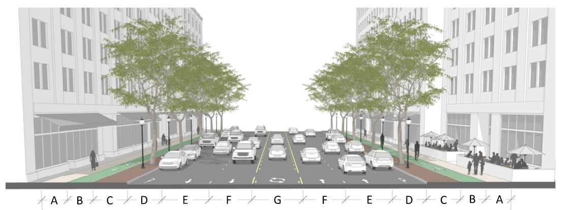 | ||||||||||
| Subtype | Serving | A | B | C | D | E | F | G | ROW from Centerline | Ground Floor Design | Ground Floor Use |
A-Highway (subtypes may not change mid-block) | Arterials in any neighborhood placetype where buildings back to the road or in Highway Corridor, Pleasant Grove Regional Center, or IAT placetypes. | 10' concrete shared-use path | 8' softscaped tree lawn | 8' parking | 11' travel lane | 11' travel lane | 12' bioswale or median | 60' | Nonresidential or residential design allowed. See 4.5.6. | Any use permitted by zoning. | |
A-40 (subtypes may not change mid-block) | 10' concrete shared-use path | 8' softscaped tree lawn | 8' parking | 11' travel lane | 11' travel lane | 40' | Nonresidential or residential design allowed. See 4.5.6. | Any use permitted by zoning. | |||
AP-50 (subtypes may not change mid-block) | Arterials in neighborhood placetypes. | 10' concrete shared-use path | 8' softscaped tree lawn | 8' parking | 11' travel lane | 11' travel lane | 50' | Nonresidential or residential design allowed. See 4.5.6. | Any use permitted by zoning. | ||
AP-52 (subtypes may not change mid-block) | Arterials in neighborhood center and city corridor placetypes. | 8' concrete sidewalk | 6' green bike path | 8' hardscaped street tree and furniture zone | 8' parking | 11' travel lane | 11' travel lane | 52' | Nonresidential or residential design allowed. See 4.5.6. | Any permitted nonresidential use when in neighborhood centers or at intersections. In all other cases any use permitted by zoning. | |
AP-62 (subtypes may not change mid-block) | Arterials in neighborhood placetypes | 6' concrete sidewalk | 6' green bike path | 8' softscaped tree lawn | 8' parking | 11' travel lane | 11' travel lane | 12' median, bioswale, or median | 62' | Nonresidential or residential design allowed. See 4.5.6. | Any use permitted by zoning. |
AP-64 (subtypes may not change mid-block) | Arterials in city center placetypes | 8' concrete sidewalk | 6' green bike path | 8' hardscaped street tree and furniture zone | 8' parking | 11' travel lane | 11' travel lane | 12' median, bioswale, or median | 64' | Nonresidential or residential design allowed. See 4.5.6. | |
Mixed Use Street
| Typology | Standard Cross Section | ||||||||
|---|---|---|---|---|---|---|---|---|---|
Mixed Use Street A typology applicable to collector streets where mixed-use urban form is desirable. | 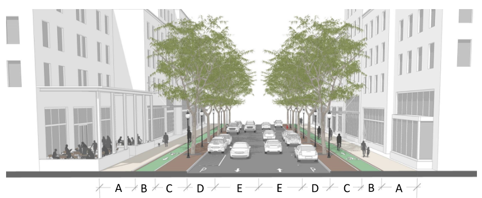 | ||||||||
| Subtype | Serving | A | B | C | D | E | ROW from Centerline | Ground Floor Design | Ground Floor Use |
MS-40 | Collectors in center, city corridor, and regional corridor placetypes | 9' concrete sidewalk | 5' green bike lane | 8' hardscaped furniture and street tree zone | 7' parking lane | 11' travel lane | 40' | Nonresidential design required. See 4.5.6. | Any nonresidential use permitted by zoning. |
MS-52 | Collectors in center, city corridor, and regional corridor placetypes | 10' concrete sidewalk | 5' green bike lane | 8' hardscaped furniture and street tree zone | 18' angled parking lane | 11' travel lane | 52' | Nonresidential design required. See 4.5.6. | Any nonresidential use permitted by zoning. |
Mixed Use Drive
| Typology | Standard Cross Section | |||||||
|---|---|---|---|---|---|---|---|---|
Mixed Use Drive A typology applicable to minor streets where mixed-use urban form is desirable. | 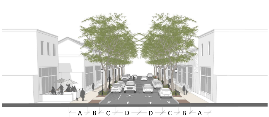 | |||||||
| Subtype | Serving | A | B | C | D | ROW from Centerline | Ground Floor Design | Ground Floor Use |
MD-30 | Minor Streets in centers, city corridor, and regional corridor placetypes | 8' concrete sidewalk | 5' hardscaped street tree and furniture zone | 7' parking lane | 10' travel lane | 30' | Nonresidential design required. See 4.5.6. | Any nonresidential use permitted by zoning. |
MD-42 | Minor Streets in centers, city corridor, and regional corridor placetypes | 9' concrete sidewalk | 5' hardscaped street tree and furniture zone | 18' angled parking lane | 10' travel lane | 42' | Nonresidential design required. See 4.5.6. | Any nonresidential use permitted by zoning. |
Neighborhood Avenue
| Typology | Standard Cross Section | |||||||
|---|---|---|---|---|---|---|---|---|
Neighborhood Avenue A typology applicable to collector streets within neighborhoods. | 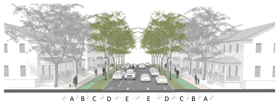 | |||||||
| Subtype | Serving | A | B | C | D | E | Center Turn Lane | ROW from Centerline |
NA-35 | Collectors or Minor Arterials in neighborhood, corridor, or center placetypes | 8' concrete sidewalk | 5' green bike path | 7' softscaped planting strip | 7' parking lane | 10' travel lane | n/a | 35' |
MD-42 | Minor Streets in centers, city corridor, and regional corridor placetypes | 10' shared use path | 8' softscaped planting strip | 8' parking lane | 10' travel lane | 12' | 42' | |
Neighborhood Street
| Typology | Standard Cross Section | |||||
|---|---|---|---|---|---|---|
Neighborhood Street A typology applicable to minor streets within neighborhoods. | 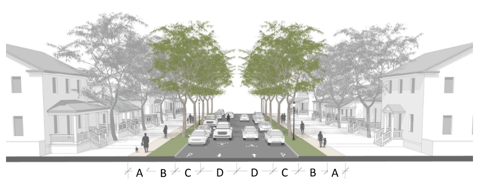 | |||||
| Subtype | Serving | A | B | C | D | ROW from Centerline |
NS-30 | Minor streets in neighborhood, corridor, or center placetypes | 5' concrete sidewalk | 8' softscaped tree lawn | 7' parking lane | 10' travel lane | 30' |
Neighborhood Drive
| Typology | Standard Cross Section | |||||
|---|---|---|---|---|---|---|
Neighborhood Drive A typology applicable to collector streets within neighborhoods but where street width is constrained. |  | |||||
| Subtype | Serving | A | B | C | D | ROW from Centerline |
ND-25 | Minor streets in neighborhood, corridor, or center placetypes | 5' concrete sidewalk | 5' tree lawn | 7' parking lane (one side) | 10' travel lane | 25' |
Service Road
| Typology | Standard Cross Section | |||||
|---|---|---|---|---|---|---|
Service Road A typology applicable to collector and minor streets outside of transect zones. |  | |||||
| Subtype | Serving | A | B | C | D | ROW from Centerline |
Service Collector | Collector Streets in highway corridor, and IAT placetypes | 10' shared use path | 8' tree lawn | 11' travel lane | 12' center turn lane | 35' |
| Service Minor | Collector Streets in highway corridor and IAT placetypes | 10' shared use path | 9' tree lawn | 11' travel lane | 30' | |
Table 3.4.6.A Roadway Dimensions
Target Speed | Travel Lane width | T2 | T3 | T4 | T5 | T6 | HC | I-1 | I-2 |
| Below 20 mph | 8 ft | X | X | ||||||
| 20-25 mph | 9 ft | X | X | X | |||||
| 25-35 mph | 10 ft | X | X | X | X | X | X | X | |
| 25-35 mph | 11 ft | X | X | X | X | X | X | ||
| Above 35 mph | 12 ft | X | X | X | X | ||||
| Target Speed | On-street Parking Lane Width | T2 | T3 | T4 | T5 | T6 | HC | I-1 | I-2 |
| Below 20 mph | Angle (18 ft) | X | X | X | |||||
| 20-25 mph | Parallel (7 ft) | X | X | X | |||||
| 25-35 mph | Parallel (8 ft) | X | X | X | X | X | |||
| Above 35 mph | Parallel (9 ft) | X | X | X | |||||
| Target Speed | Curb Return Radius | T2 | T3 | T4 | T5 | T6 | HC | I-1 | I-2 |
| Below 20 mph | 5-10 ft | X | X | X | X | X | |||
| 20-25 mph | 10-15 ft | X | X | X | X | X | X | X | |
| 25-35 mph | 15-20 ft | X | X | X | X | ||||
| Above 35 mph | 20-30 ft | X | X |
Table 3.4.6.7.A Planting Strip Requirements
| Standard Tree Well | ||
Allowed In | T6, T5, HC |
|
Tree Well Width | 6 ft. min. | |
Tree Well Length | 6 ft. min. | |
Surface: Between Tree Planters | Hardscape: To match sidewalk, unit pavers, or pervious pavement | |
Surface: Tree Planter | Unit pavers or metal grate | |
| Long Tree Well | ||
Allowed In | T6, T5, T4, HC |
|
Tree Well Width | 6 ft. min. | |
Tree Well Length | 12-20 ft. | |
Surface: Between Tree Planters | Hardscape: To match sidewalk, unit pavers, or pervious pavement | |
Surface: Tree Planter | Landscaped or ground cover with tree guards, rain gardens and LID, or unit pavers | |
| Continuous Planter | ||
Allowed In | T2, T3, T4, HC, I-1, I-2 |
|
Planter Width | 6 ft. min. | |
Planter Length | Continuous | |
Surface: Between Tree Planters | Landscaped, rain gardens and LID | |
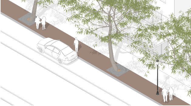
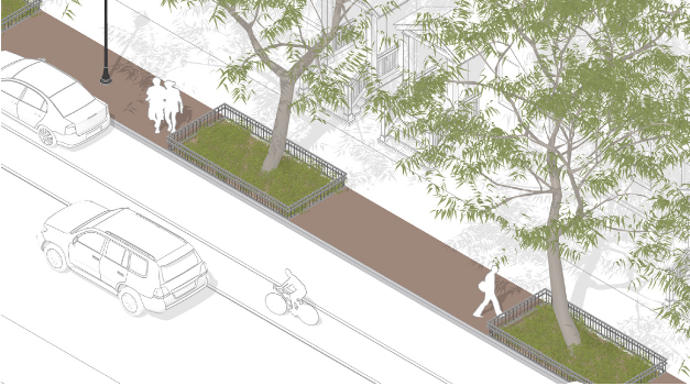
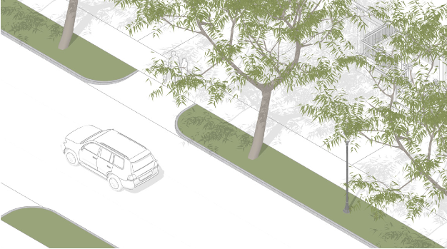
Table 3.4.6.8.A Minimum Curb Radii for Local Streets
Figure 3.4.6.8.B Effective Curb Return Radius
|
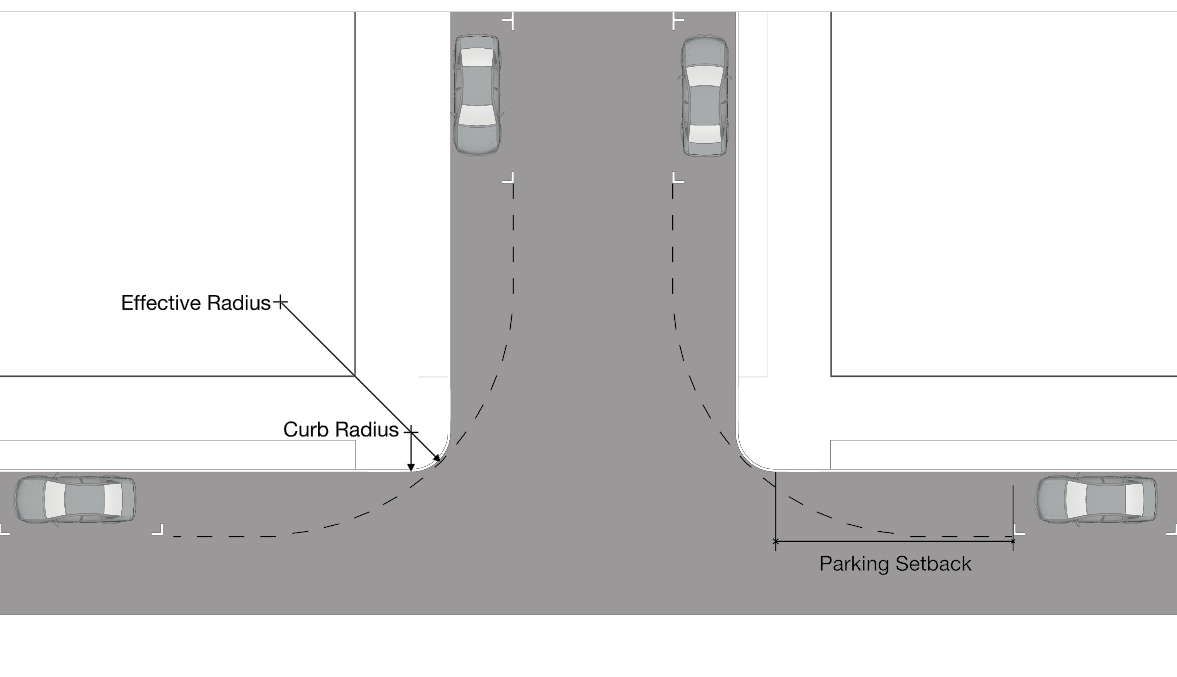
Figure 3.4.6.8.C Effective Radius Measurement Examples
| Illustrated: Addressing Curb Extensions with Effective Radius | |||
| Curb extensions reduce the effective radius and may require larger actual curb return radius measurements in order to provide the minimum required effective radius. Curb extensions are required at local street intersections with collectors and arterials. | 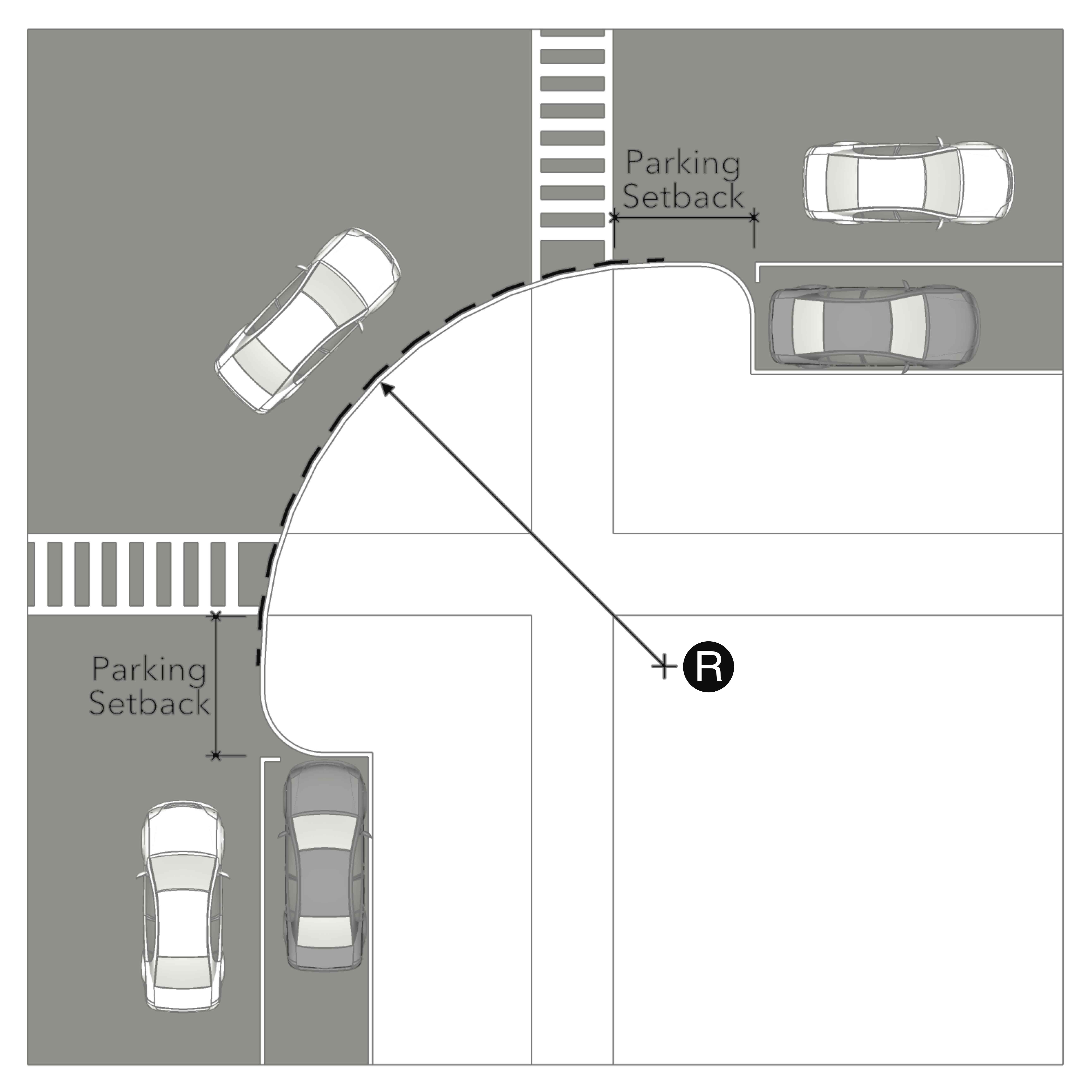 | 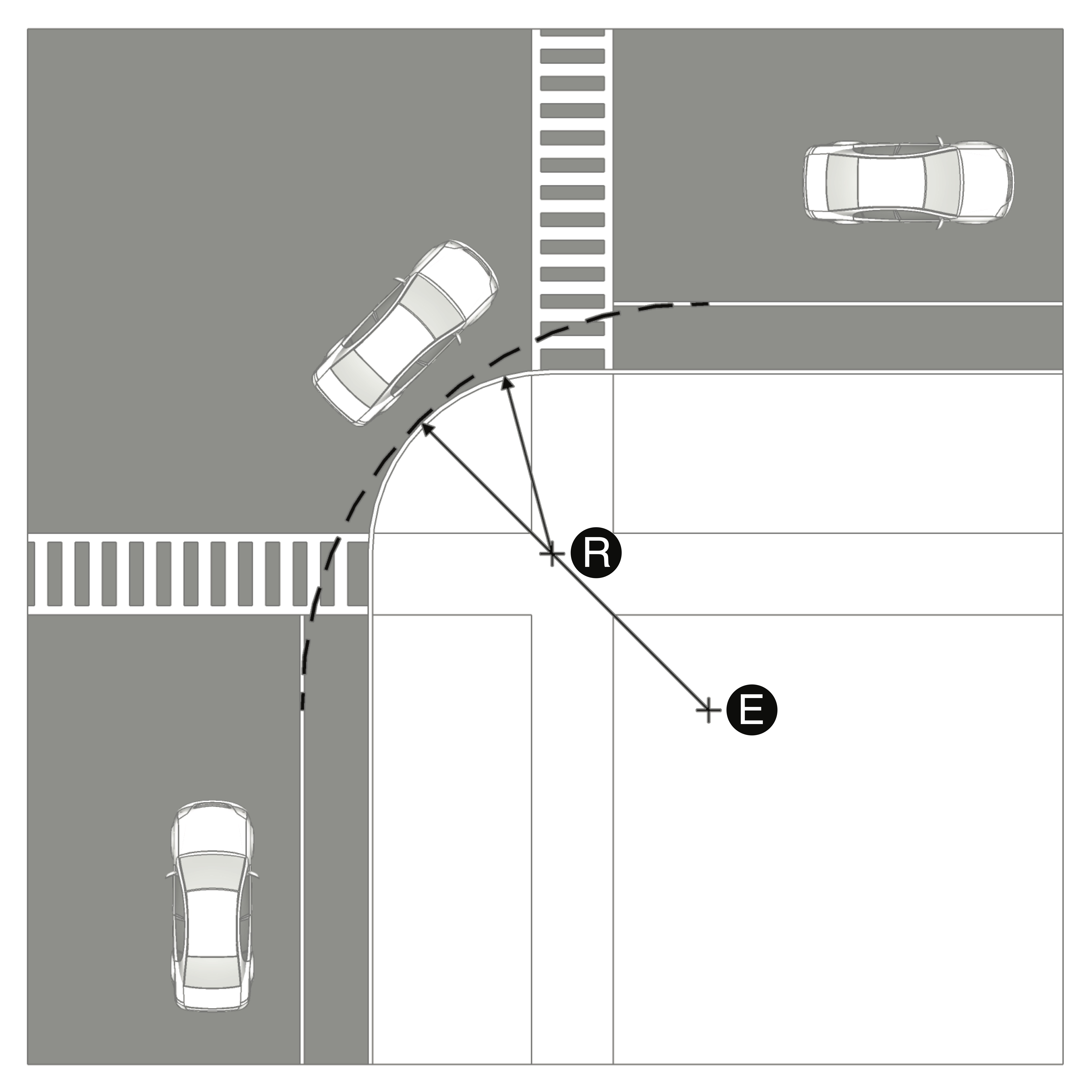 | |
| R | Actual Curb Return Radius | ||
| E | Effective Radius | ||
| Parking only | Bike lanes only | ||
| Illustrated: Effective Radius in Various Configurations | ||
 | |  |
| Parking, 1 leg only | Bike Lanes, both legs | Parking both legs, Bike Lane 1 leg |
Table 3.4.6.9.A Bikeways
Type | Zoning District | Street Posted Speed | Lane Width | Separation | Additional Requirements | |
|---|---|---|---|---|---|---|
Bike Trail or Shared-Use Path | T2, T3, T4 | N/A | 5 ft. min. each way | Landscape Strip | 10 ft. min. | Trails may be provided between sidewalks and planters in accordance with standard street sections. |
T5, T6, HC, I | 6 ft. min. each way | Landscape Strip, Raised Island, | 8 ft. min. | |||
Cycle Track (2-way Separated Bike Lane) | All | 45 mph max. | 6 ft. min. each way | Grade, Flexible Post, Inflexible Barrier, On-Street Parking, | 2 ft. min. | N/A |
Separated Bike Lane | All | 45 mph max. | 6 ft. min. | Grade, Flexible Post, Inflexible Barrier, On-Street Parking, | 2 ft. min. | N/A |
Buffered Lane | T2, T3, T4 | 40 mph max. | 5 ft. min. | Paint, | 3 ft. min. | N/A |
T5, T6, HC, I | 6 ft. min. | |||||
Dedicated Lane | T2, T3, T4 | 30 mph max. | 5 ft. min. | N/A | N/A | N/A |
T5, T6, HC, I | 6 ft. min. | |||||
Shared Lane | All | 2 mph max. | 10 ft. max. | N/A | N/A | Lane width on yield streets may exceed the maximum width indicated. |