
Rogers City Zoning Code
ARTICLE 5
SITE DEVELOPMENT STANDARDS
Section 5.1 Purpose and Intent
- To ensure consistency of development and predictable growth among separate properties and approaches to development whether subdividing, maintaining single ownership, or establishing condominiums.
- To ensure orderly growth of the City by establishing street connections, a street network, city blocks, alleys, usable parks, utility corridors, and areas necessary for storm drainage.
- To ensure that the elements such as parking, waste storage, fencing, walkways, landscaping, and stormwater areas are sufficiently provided and arranged to support pedestrian-oriented streets and minimize the impact of development on neighboring properties.
Section 5.3 Vehicular Use Areas
5.2.1 Purpose and Intent
The purpose and intent of these regulations is to facilitate the provision of a wide variety of housing types while ensuring high standards of livability for the future residents of such development and compatibility with adjacent properties.
5.2.2 Applicability
The residential site design standards apply to all residential development except detached house building types.
5.2.3 Standards Applicable to All Residential Development
All residential development must meet the following standards.
- Parking lots and parking structures are not permitted in exterior yards.
- The area within the exterior yard may consist of lawn and landscaped areas as well as programmed open spaces or similar uses for the enjoyment of residents.
- The side of residential buildings abutting an exterior yard shall be designed with walk-to units where units located on the ground floor of a building must be oriented toward the abutting street, pedestrian way, shared-use path, park or programmed open space shall be designed as a walk-to building where the front of the building, at ground level, is oriented toward the street, pedestrian way, shared-use path, park or programmed open space.
- Driveways, where permitted in exterior yards, shall be separated by a minimum of 60 feet.
5.2.4 Residential Site Typology Standards
The following standards apply to all residential and mixed-use building types where two or more buildings are proposed on the same lot and where the residential front façade of buildings nearest the street are not oriented toward the street. In such cases the developer must select one, or a combination of the typologies offered below and conform to the standards provided for each.
(Ord 25-35, 7-8-2025)
5.3.1 Purpose and Intent
- To ensure vehicular use is accommodated in all placetypes but not at the expense of pedestrian comfort; and
- To ensure that negative impacts of vehicular use areas are minimized where pedestrian use areas are the priority; and
- To ensure vehicular use areas do not create unsafe conditions for pedestrians and users of other modes of travel; and
- Where a site is part of an existing development:
- Driveways which exist and are depicted on an approved Master Plan as a future street are not considered parking access for the purpose of this Section; and
- Parking location is measured in relationship to future blocks and lots, not site boundaries.
(Ord 25-35, 7-8-2025)
5.3.2 Parking Requirements
5.3.4 Drive-Throughs
- Drive-through facilities and lanes are prohibited in exterior yards except in HC, I-1, and I-2; and
- Drive-through canopies and other structures incidental to the drive-through must be behind the front building façade except in HC, I-1, and I-2;
- Where drive-throughs are permitted in exterior yards in any transect zone, a street screen or hedge shall be provided in accordance with Section 5.6.6 Street screens and Hedges.
(Ord 25-35, 7-8-2025)
5.4.1 Building Location
The location of buildings is as regulated by Section 4.5 Zone Standards and as supplemented below.
5.5.1 Purpose and Interpretation
- To require that where new development is proposed to be more significant in height or activity than that allowed on adjacent properties, the new development provides a compatible transition to reduce the impact on surrounding properties.
- Where sites are part of a development plan, requirements related to lots apply to future lots.
5.5.2 Conditions Requiring Transitions
5.5.3 Reserved
5.5.4 Transition in Setback
- At abutting lot lines, buildings must meet the minimum side or rear lot line setback requirements of the abutting property, where lots abut.
- In HC and I-1 buildings must be set back 20 feet in addition to the minimum setback from lot lines where abutting T2, T3, and T4.
- In I-2, buildings must be set back 50 feet in addition to the minimum setback from lot lines where abutting T2, T3, and T4.
5.5.5 Transition with Landscape Buffers
- Landscape buffers are required at abutting lot lines that differ in zoning district, where indicated in Table 5.5.5.A Buffer Requirement by Adjacency.
- Landscape buffers must be configured according to Table 5.5.5.B Buffer Type Requirements, and as follows:
- Landscape buffers must be located along the lot line shared with the abutting lot;
- 2 understory trees may be substituted for each required canopy tree, up to 30% of the required trees;
- Hedges must be continuous and evergreen, one row for every 5 feet of buffer width; and
- Ground cover plants are required to cover all exposed soil.
- Natural drainage ways and existing natural vegetation may be used in place of a landscape buffer, if approved in writing by the Director. Natural drainage ways and existing vegetation used for this purpose must be a minimum of 20 feet wide.
5.5.6 Transition in Use
For HC, I-1, and I-2, required landscape buffers and extended setbacks as required in this section are exempted for residential uses on the HC, I-1, or I-2 lot.
5.6.1 Purpose and Intent
The purpose and intent of this section is to:
- Enhance the city's image and appearance; and
- Protect and improve the environmental health of the community by providing shade, air purification, oxygen regeneration, filtering of stormwater runoff, mitigating the impacts of noise, glare and heat; and
- Mitigate the adverse impacts of higher intensity development adjacent to lower intensity development.
5.6.9 Administrative Adjustments
The Director is authorized to grant an administrative adjustment fromt he requirements of Section 5.6 Landscape and Screening allowing for payment-in-lieu of planting when:
- Open space trees are required in T5 and T6 and there is insufficient site area for planting of required trees due to onsite building coverage; or
- There is insufficient site area for planting of required Open Space trees due to the presence of a natural feature such as a wetland, or where planting of such trees would adversely disturb the natural feature, or where underground utilities prevent the planting and the cost for the utility's relocation is disproportionate to the project.
(Ord 25-35, 7-8-2025)
5.6.10 Exemptions
Properties owned by the Rogers Municipal Airport are exempt from the requirements of Section 5.6 Landscape and Screening.
5.7.1 Purpose and Intent
The purpose and intent of these standards is to:
- Protect privacy by limiting the potential for glare and light trespass from outdoor lighting fixtures on adjacent properties; and
- Protect drivers, pedestrians, and the visually impaired from the glare of non-vehicular light sources that can impair safe travel; and
- Promote efficient and cost-effective lighting; and
- Allow for flexibility in the style of light fixtures; and
- Reduce light pollution.
(Ord 25-35, 7-8-2025)
5.7.2 Applicability
- All outdoor lighting fixtures installed after the effective date must comply.
- When an existing fixture is replaced, the replacement fixture shall comply.
5.7.3 Exemptions
- Detached houses and attached houses; and
- Sports and recreational field lighting; and
- Navigation lights for airports, heliports, and towers, etc; and
- Seasonal decor; and
- Security lighting controlled by motion-sensor which do not remain on longer than 12 minutes after activation; and
- Emergency lighting required by building code; and
- Illumination of flags; and
- Street lighting; and
- Architectural or landscape lighting only when directed toward the architectural feature or landscape feature.
- Pedestrian walkway lighting; and
- Strands of individual, low-intensity white decorative lights illumination outdoor patios, decks, and similar spaces.
5.7.4 Standards
- Fixtures must be full cut-off shielded downward and the light source shall not be visible from off-site; and
- Fixtures must be evenly distributed across the site being illuminated; and
- Illumination shall not exceed 2 footcandles at the property line.
5.7.5 Prohibited Lighting
Devices that flash, blink, fluctuate or that are animated.
5.8.1 Purpose and Intent
The purpose of this section is to promote high-quality community aesthetics and placemaking that aligns with the Unified Development Code's placetype strategy. These regulations ensure a balanced commercial environment where businesses can effectively communicate through signage while avoiding excessive or intrusive displays. The provisions aim to enhance the visual character of the community, foster safe and efficient pedestrian and vehicular traffic, and support economic vitality by discouraging sign clutter and over-proliferation. This section is content-neutral and does not intend in any way to regulate viewpoints or limit free speech, focusing solely on mitigating adverse impacts related to the location, size, and quantity of signage.
(Ord 25-35, 7-8-2025)
5.8.2 Applicability
5.8.3 Exemptions
The following signs are exempt from the requirements of this Section:
Any public notice or warning required by a valid or applicable federal, state or local law, regulation, or ordinance, or by order of a court.
Any sign not visible from a street or property other than the property on which it is located. Such signs must still go through the permitting process to verify the requested sign is adequately shielded from outside view.
Traffic control signs meeting the standards set forth in the Manual on Uniform Traffic Control Devices and which contain no commercial message.
Numbers, letters, and symbols etched as metal or masonry cornerstone plates or embedded into the facade of any building or other structure given the individual characters do not exceed 6” in height.
(Ord 25-35, 7-8-2025)
5.8.4 Prohibited Signs
All prohibited signs must be immediately removed at the owner’s expense upon notice that it is in violation of this section per Section 5.8.6. Code enforcement officers may remove any sign that is in violation of this section. Failure to comply with this section shall be a violation of the City of Rogers’ Code of Ordinances and subject to the penalty provisions contained in § 1-5 as well as any additional penalties as called for in this UDC. Each day shall constitute a separate offense and each sign shall be considered a separate offense.
The following are strictly prohibited:
Any sign erected without the required sign permit;
Animated, inflatable, noise-generating, moving, bow flags, and wind-blown signs;
Abandoned, blank, or damaged signs. Any sign that is excessively weathered, faded, has peeling or cracked paint, has missing panels, or is otherwise in disrepair shall be considered damaged and must, along with its supporting members, be immediately removed or restored to a good state of repair;
Any sign blocking ingress or egress to a building, including doors, windows, and fire escapes;
Any sign within the public right-of-way or on public property, except those expressly allowed by this section;
Signs that create a clear and present danger to public safety, such as those resembling traffic control devices or obstructing drivers' visibility as determined by the City Engineer;
Any sign type or message prohibited under federal or state law.
Any sign erected that is not exempt from this section, not established as a lawful nonconforming sign, and not expressly allowed by this section.
(Ord 25-35, 7-8-2025)
5.8.5 Nonconforming Signs
Any sign which was legally established and permitted but that does not conform to the provisions of this section is deemed legal nonconforming. Legal nonconforming signs may be retained until required to be removed in compliance with Section 5.8.6 due to abandonment, condemnation, or as a condition of a new sign permit. All other nonconforming signs are prohibited and subject to the provisions in 5.8.4.
- Removal Due to Abandonment
- Nonconforming signs are considered abandoned and must be immediately removed by the owner at the owner’s expense where they:
- Display out-of-date information for longer than 90 days; or
- Are in a state of disrepair or are destroyed; or
- Are left blank for a period of 90 days; or
- Are located on property that is vacant or abandoned.
- Nonconforming signs are considered abandoned and must be immediately removed by the owner at the owner’s expense where they:
- Removal or Compliance as Condition of Permit
- A nonconforming sign must either be brought into compliance with current regulations or removed under the following conditions:
- Structural Alteration of the Nonconforming Sign: Any request to alter the structure of a nonconforming sign (e.g., size, height, materials, or lighting) but not the content of the sign will trigger a requirement for the sign to be brought into compliance or removed as part of the permitting process.
Permit Request for a New Sign on the Same Property: If a permit application is submitted to add a new sign anywhere on the same property where a nonconforming sign exists, the nonconforming sign must be brought into compliance or removed before the new sign permit can be approved.
- A nonconforming sign must either be brought into compliance with current regulations or removed under the following conditions:
Exceptions and Allowances
Temporary signs on the same property as a noncompliant sign shall not trigger compliance requirements for existing nonconforming signs.
Routine maintenance or minor repairs to a nonconforming sign, such as repainting, replacing damaged panels, or repairing wear and tear, are permitted and do not trigger compliance requirements. Nonconforming signs must still meet the city’s requirements for good repair under Section 5.8.8 to ensure they do not become excessively weathered, faded, or unsafe.
The Board of Adjustment may not grant a variance from these requirements other than to extend the time frame for bringing a nonconforming sign into compliance or removing it.
(Ord 25-35, 7-8-2025)
5.8.6 Enforcement
Nonconforming and non-permitted Signs
Illegal signs shall be immediately removed by the responsible party upon notice. If the responsible party fails to remove the sign within seven (7) days after the notice has been sent, the City shall remove the sign at the expense of the responsible party.
If the City removes the non-conforming sign, it may be confiscated or discarded. The decision to confiscate or dispose of the sign shall be made by the City at the time of its removal. Confiscated signs will only be held for 14 days before disposal.
Hazardous Signs
Signs posing immediate safety hazards, such as obstructing visibility, will be removed immediately and without notice to the responsible party.
The responsible party bears the cost of any emergency action the City has taken to remove the hazardous sign.
(Ord 25-35, 7-8-2025; Ord 25-49, 8-26-2025)
5.8.7 Signs Allowed without a Permit
- The following signs shall be permitted in all zoning districts. No sign permit shall be required.
- Art. Works of art which do not advertise a commercial business, product or service.
- Flags (U.S. state, municipal, or corporate flags).
- Hand carried noncommercial signs.
- Historic markers. Attached or freestanding historic or memorial markers erected by a governmental agency, private nonprofit historic preservation, or education organization pursuant to a plan or program for the erection of such signs or markers applied on a national, state, or county wide basis or to properties within a duly authorized local historic district. Such plan or program must employ uniform standards of eligibility, and the sign or marker must commemorate a person, building, place or event of historical, civic, cultural, natural historical, scientific, or architectural significance. Historical markers are subject to the following regulations:
- Maximum area.
- Freestanding: Eighteen square feet.
- Wall: Six square feet.
- Materials. Each such sign or marker shall be made of cast metal, cut masonry, painted wood or metal or other similar weather proof material.
- Maximum area.
- Identification signs. Customary identification signs, such as: building numbers, addresses, private parking signs, no trespassing signs, or dangerous animal signs that are no larger than three square feet in area per sign.
- Incidental or directional signs. Incidental signs, those that give information or direction for the convenience and necessity of the public, such as entrance, exit, no admittance, telephone, or parking subject to the following regulations.
- Maximum area. Three square feet.
- Maximum height. Four feet.
- Interior signs. Signs visible only from the interior of a structure, such as in a mall, where they are not visible from a public right-of-way or public space.
- Non-profit announcements. Announcements by public or not-profit organizations of fund-raising events, special events or activities or interest to the general public, other than political signs, subject to the following regulations.
- Maximum area:
- Neighborhood placetypes: Six square feet.
- Placetypes other than Neighborhoods, or on a parcel owned and operated by the non-profit holding the event: Twelve square feet.
- Maximum number permitted. One per lot.
- Time period. Signs may be erected up to two weeks prior to the event.
- Removal. Signs shall be removed within three days after the event.
- Banner attachment. Banners shall be attached to a fixed structure, either a building or freestanding sign.
- Maximum area:
- Public notice. Any public notice or warning required by valid and applicable federal, state or local law, regulation, or ordinance.
- Public park signs. Signs in public parks of a noncommercial nature erected by a government agency such as directional signs, rules signs, safety signs or site identification signs that are no greater than eight feet in height.
- Public sign. Any federal, state or local traffic control or other public sign erected either by a governmental agency or at the direction of a governmental agency.
- Political campaign sign. The city recognizes the importance of political campaign signs in free speech and regulates their placement as follows:
- Political campaign signs are allowed starting 60 days before an election and must be removed within five days afterward.
- Signs may not be placed in city rights-of-way, on bridges, utility poles, traffic signals, or street signs.
- In the Neighborhood Placetype areas, signs may not exceed four square feet, must be ground-mounted or affixed to fences or structures, and cannot be roof-mounted or stacked.
- In placetypes areas other than Neighborhood:
- Signs are limited to 32 square feet in Corridor, and Industrial and Technology Placetypes.
- Signs are limited to eight square feet in all other placetype areas.
- Placement on private property requires the owner's consent.
Signs placed on public property will be removed by the City immediately, with notice provided, after the removal of the sign, if contact information is available.
Real estate signs—Residential. Real estate signs in Neighborhood Placetypes, or intended to advertise a single-family unit or structure are subject to the following:
Generally.
Location. No real estate signs shall be located in the public right-of-way. If the right-of-way cannot be determined, signs shall be placed behind sidewalks and/or utility poles.
Removal. Signs for properties for sale shall be removed within seventy-two (72) hours of property closing.
On-site signs. On-site real estate signs in residential districts are subject to the following regulations:
Maximum area. Without a rider: six (6) sq. ft.; with riders: eight (8) sq. ft.
Maximum height. Six (6) feet.
Maximum number permitted: one (1) per street frontage.
Riders permitted. Two sign riders are permitted as long as the maximum sign area does not exceed eight (8) square feet.
Off-site signs. Off-site directional real estate signs are not permitted in the City of Rogers. The City may remove the sign at the expense of the owner, after notice is sent to the owner’s last known address, and the owner has failed to remove the sign within seven (7) business days after the notice is sent.
Real estate signs—Placetypes other than Neighborhood, and/or advertising primarily commercial real estate:
Maximum area. Thirty-two (32) square feet.
Maximum height. Eight feet (8).
Maximum number permitted.
Freestanding: One (1) per street frontage
Wall: If the entire building is for sale or lease: One (1) per building façade. If portions of the buildings are for sale or lease; one per lease space.
Stadium signage. Commercial signs within city stadiums (e.g., high school football and baseball stadiums).
Traffic control signs. Traffic control signs on private property such as stop, yield, and similar signs, the face of which meet Arkansas Department of Transportation standards, subject to the following regulations:
Maximum area. Eight square feet.
Subject. Such sign shall not contain a corporate logo or commercial message.
Vending machines, ATMS, gas pumps. Vending machines, automatic tellers, or gasoline pumps, or similar types of kiosk-style structures which display the name, trademark or logo of the company or brand or prices shall not exceed thirty-two (32) square feet in area per side. The display shall be an integral part of the machine or pump, and not an expansion of the device.
Window signs. Any signs, pictures, symbols or combination thereof that is placed inside a window or upon the window panes or glass and is visible from the exterior of the window shall not exceed twenty (20%) percent of the window area.
(Ord 25-35, 7-8-2025)
5.8.8 Standards Applicable to All Signs
- Materials: Exterior signs shall be made of durable, weather-resistant materials and permanently affixed to the ground except for the following:
- Temporary signs meeting the requirements elsewhere in this article;
- Window signs;
- Location
- Signs must be located entirely on private property.
- No sign shall be placed in a location which constitutes a hazard to traffic, as determined by the Director of Community Development or City Engineer
- Sight triangle
- No sign shall constitute a hazard to traffic, as determined by the Director of Community Development or City Engineer, including, but not limited, to signs located within the sight triangle of an intersection.
- The sight triangle is defined by a triangular area formed by a diagonal line connecting two points on intersecting street rights-of-way, measured 25' along each right-of-way starting at the intersection point.
- No signs or structures between 30" and 60" in height will be allowed within the sight triangle.
- Off-Premise Signs
- Off-premise signs include signs advertising a business, person, activity, goods, products, or services not located on the site where the sign is installed, or that directs persons to any location not on that site.
- Off-premise signs are generally prohibited.
- Off-premise signs may be permitted under one of the following circumstances:
- Common Signage Plan: The sign is approved as part of a Common Signage Plan approved under Section 5.8.9 of this Code.
- Board of Adjustments Approval: The sign is approved by the Board of Adjustments upon a determination that:
- The sign complies with the purpose and intent of the city's sign regulations; and
- Specific conditions or characteristics of the property make it particularly impractical to locate the sign on the same property as the use, service, product, or activity being advertised.
- Proximity Requirement: In all cases, the sign must be located as close as reasonably possible to the property associated with the use, service, product, or activity being advertised, and under no circumstances may it be placed farther away than necessary to achieve compliance. Compliance with these requirements will be determined by the Board of Adjustments as part of its review.
- Changeable and Digital Copy
- Signs with changeable or digital copy must be on the same sign with fixed copy.
- The area of changeable or digital copy shall not exceed 100% of the area of the fixed copy.
- Changeable or digital copy, but not both, are permitted on any sign with fixed copy except in Neighborhood Placetypes, but the area of the changeable or digital copy shall not exceed 50% of the area of fixed copy.
- Digital copy shall meet the following criteria:
- Each image must remain static for a minimum of 8 seconds.
- Transitions between images must happen instantaneously, without flashing, animation, or movement of any kind.
- Backgrounds may change only with the image.
- Must be equipped with automatic dimming technology.
- Sign Illumination
- Internal illumination is limited to window and wall signs within storefronts and individually illuminated characters in other sign types.
- Neon is only permitted for window signs and marquee signs.
- Light sources must be mounted, shielded, and pointed toward the sign face to eliminate uplighting and glare on adjacent rights-of-way and properties.
- Sign Placement
- Signs shall not overlap windows, ingress or egress, or within 2 feet of the top of the wall if it is a wall mounted sign.
- A minimum of 8 feet of clearance shall be provided over all pedestrian ways.
- A minimum of 13 feet of clearance shall be provided over all vehicular use areas.
5.8.9 Common Signage Plan
- Purpose and Applicability
- The purpose of the Common Signage Plan (CSP) is to allow for sign entitlements to be established for multi-tenant and mixed-use developments. The CSP is also intended to allow for flexibility and context sensitive evaluations of signs for developments. Deviations from this section are allowed when the CSP is shown to adhere to the overall purpose.
- Any development request for a commercial subdivision, mixed-use development, or any other project that includes multiple businesses shall submit a CSP at the time of the development request.
- A CSP may also be submitted for an existing commercial subdivision, mixed use development, or any other development including multiple businesses to establish set sign allowances for active and prospective tenants.
- The CSP becomes permanently binding on the property until properly amended or superseded by City Ordinance.
- Standards for a Common Signage Plan
- General Compliance: The CSP must generally follow size, placement, and other standards based on the placetype within which the development is located.
- Flexibility: The CSP may include:
- Multi-tenant signs.
- Individual tenant signs.
- Coordinated or unified signage design across the development.
- Consistency with Purpose and Intent:Any deviations from the strict standards contained within this sign code must still meet the purpose and intent of the sign code, ensuring the signage is appropriate in scale, design, and impact for the development and surrounding area.
- Flexibility: The CSP may include:
- General Compliance: The CSP must generally follow size, placement, and other standards based on the placetype within which the development is located.
Review and Approval Process
Administrative Review
If the CSP is fully compliant with the sign code, it is subject to the same level of approval as the rest of the development request.
This review is typically conducted administratively by the Development Working Group.
Planning Commission Review
- If the CSP deviates from the sign code but is still consistent with its overall purpose and intent, it must be submitted to Planning Commission for approval.
- CSP review by the Planning Commission shall require a public hearing with proper notice per Section 2.3.4.
- The Planning Commission must evaluate the CSP based on its adherence to the sign code and the purpose and intent of the sign code. The Planning Commission shall review the following conditions when considering an adjustment from this code:
- Whether the proposal is compatible with the development and surrounding area;
- Whether the proposal is consistent with the intended character of the placetype;
- Whether the proposal minimizes visual clutter and maximizes readability and aesthetic appeal; and
- Whether the proposal presents a clear and public danger to public safety.
- Required Components of a Common Signage Plan
The CSP must include the following:
A scaled site plan showing the location of all proposed signs within the development.
Elevation drawings and design details for each proposed sign, including dimensions, materials, and illumination methods.
- A written narrative explaining how the CSP meets the purpose and intent of the sign code and aligns with the character of the placetype.
Authority and Function of the Common Signage Plan
Binding Authority:
Upon approval, the Common Signage Plan (CSP) establishes the authoritative framework for all signage within the associated development site.
(2) The CSP remains in effect until it is either formally amended by the landowner through the standard approval processes outlined in this section or superseded by a future ordinance.
Application of Sign Permits
All sign permit applications for signage within the site covered by the CSP must include a copy of the approved CSP.
Signage within the development must comply with the approved CSP unless explicitly authorized through an amendment or a special sign permit process.
Sign permits must meet the application requirements of Section 5.8.11(B).
Relationship to Special Sign Permits
The CSP process does not replace the special sign permitting process for signs that substantially deviate from the sign code.
Any sign proposed as part of the CSP that does not comply with the sign code and is not justified under the CSP's flexibility must go through the special sign permitting process as outlined in this section.
(Ord 25-49, 8-26-2025)
5.8.10 Special Sign Program
- Purpose and Applicability
- The Special Sign Program is intended to encourage creativity, support placemaking, and recognize exceptional architectural or design quality in signage that contributes positively to the community. It also provides a pathway for otherwise noncompliant signs to achieve compliance when demonstrating community value.
- Approval Process: A sign permit application through the Special Sign Program shall proceed as follows:
- Applicants shall provide detailed drawings and supporting documentation demonstrating the sign's value in terms of placemaking, design quality, or community benefit.
- A public hearing will be required at the Planning Commission, where the applicant shall establish their case for approval.
- The Planning Commission will review the application and recommend approval to the City Council, deny the request, or ask the applicant to resubmit with changes.
- Signs subject to Historic District Commission review must also receive a Certificate of Appropriateness.
- The City Council will make the final decision to approve or deny the request. Upon approval by the City Council, the City Planner shall issue and record a Sign Permit with the full design package attached.
- Evaluation Criteria
- The sign must meet at least one but ideally each of the following criteria:
- Demonstrate exceptional architectural or design quality;
- Contribute to the creation of a distinct sense of place or community identity;
- Serve as a lasting monument or landmark;
- Provide clear benefits to the community, such as enhancing the aesthetic environment or historical significance; or be an existing and otherwise nonconforming sign of either historical significance, or otherwise consistent with the requirements of the Special Sign Program
- The sign must meet at least one but ideally each of the following criteria:
- Responsibilities
- Applications must include:
- Scaled site plans showing the sign’s location.
- Detailed design drawings, including dimensions, materials, and any proposed illumination.
A written narrative explaining the sign’s community value and alignment with program criteria.
The requirements of Section 5.8.11(B).
- Applications must include:
5.8.11 Sign Permit Process and Approval
- Applicability
- All signs, whether permanent or temporary, shall require a sign permit issued by the Planning Department unless explicitly exempt under this section. A separate building/construction permit from the Risk Reduction Department is required to construct the sign once the sign has been approved and a permit has been issued by the Planning Department under this Code.
- A sign permit certifies that the structure, form, and placement of a sign comply with all applicable zoning and building code requirements.
- Application Requirements: To apply for a sign permit, the applicant must submit the following:
- Sign Permit Application: A completed application form provided by the Planning Department.
- Fee: Payment of the applicable fee as adopted by the City Council.
- Scaled Drawings: A scaled drawing of the sign that includes:
- Height, area, and dimensions.
- Design and content details.
- Dimensions and specifications for supports or fixtures used to attach the sign.
- Site Plan: A scaled site plan showing:
- The location of the sign on the property or building.
- Street, trail, sidewalk and all other right-of-way and property lines.
- For wall signs, dimensions of the building face.
- Materials List: A detailed list of materials used in the sign's construction.
- Review and Approval Process
- Permit Review
- The Planning Department will review the Sign Permit application to ensure compliance with all sign, zoning, and engineering requirements as found within this Unified Development Code.
- The Risk Reduction Department will review the application to ensure compliance with electrical, ICC Building Code, and related standards.
- Upon approval, the applicant will receive a sign permit and applicable building permit(s) to erect or install the sign.
- Inspection
- Applicants must request an inspection upon installation of permanent signs to confirm compliance with the approved permit. The sign permit-driven inspection shall be scheduled at the time the applicant schedules their inspection with Risk Reduction to close out the building permit.
- Permit Review
- Permit Expiration and Extensions
- Expiration: A sign permit is valid for six months. If the sign inspection is not completed within six (6) months of the issuance of the permit or the sign is not in conformance with the approved application, the permit shall be deemed null and void.
- Extensions: The City Planner may grant one (1) 30-day extension to a sign permit upon request; however, this request must be submitted and approved prior to the expiration of the sign permit.
- Temporary Signs
- Temporary sign permits are allowed as permitted in this code.
- Temporary sign permits are valid for up to ten (10) business days.
- The City Planner may grant one (1) 10-business day extension to a temporary sign permit upon request; however, this request must be submitted and approved prior to the expiration of the temporary sign permit.
- Minor Alterations and Revocation of Permits
- Minor Alterations: Minor adjustments to sign location due to unexpected on-site conditions may be reviewed and approved by the City Planner or their designee through submission of a sign permit.
- Revocation: The City Planner or their designee may revoke a sign permit if the sign is found to violate this section. Any sign erected pursuant to a revoked sign permit shall be deemed prohibited and shall be subject to the provisions contained in 5.8.4.
- Interpretation of Sign Regulations
- Measurement Standards
- Street Frontage: Each street frontage is measured separately along the property lines where the property meets the street.
- Maximum Area: The maximum area refers to one side of the sign.
- Measurable Area: The measurable area is the total area within the outer boundaries of the sign, typically a rectangular shape.
- Maximum Height: Sign height is measured from the point of ground attachment to the highest point on the sign or structure.
- Appeal of Interpretation: Administrative interpretations of sign regulations may be appealed to the Board of Adjustment.
- Measurement Standards
5.8.12 Allowable Forms for Permanent Signs
- This section provides a comprehensive list of all sign types allowed under standard permitting. Applicants are encouraged to consult with the Planner before submitting a permit application if they have any uncertainty. Decisions by the Planner may be appealed to the Board of Adjustments. Sign types not covered here may be considered through the Special Sign Program. All quantities and dimensions are maximum allowed unless otherwise noted.
- General Categories: Permanent signs are categorized based on their relationship to structures and the ground. The two primary categories are:
- Freestanding Signs – Signs that are independent structures, mounted on or anchored to the ground.
- Wall-Mounted Signs – Signs that are affixed to or integrated into a building or structure.
- Freestanding Signs: Freestanding signs are designed to provide visibility independent of any building or structure, while wall-mounted signs are attached to or integrated with the architecture of a building, emphasizing their reliance on the structure for support and placement. The following forms are permitted, depending on the Placetype within which the proposed sign will be placed:
- (General Spacing Requirement: No Monument, Pole, or Directory sign may be installed within 125 feet of another Monument, Pole, or Directory sign along the same street. Signs should always be located in such a way they do not interfere with lines of sight to other existing signs, or interfere with drivers’ abilities to see public signs, or otherwise create a hazard, e.g., block the view for motorists entering or existing driveways, etc. Post-and-Arm signs may be placed at a rate of one per address regardless of clearance from other signs provided they do not present a line- of-sight hazard.
- Monument Signs: Ground-mounted signs designed with a solid and unified base, often incorporating materials like stone, brick, or concrete to match the surrounding environment. The sign surface is typically integrated into the base for stability and aesthetic consistency.
- The total number of monument signs shall be limited to one (1) per address.
- The maximum area of any monument sign shall not exceed forty-eight (48) square feet.
- The maximum height of any monument sign shall not exceed six (6) feet.
Table 5.8.12.A Monument Signs Quantity One per address Area (square feet) 48 Height (feet) 6
Pole signs: Freestanding signs supported by one or more vertical poles. The design often includes decorative pole covers or skirts to enhance visual appeal and ensure compatibility with the surroundings.
The total number of pole signs shall be limited to one (1) per address.
The maximum area of any pole sign shall not exceed sixty (60) square feet.
The maximum area of any pole sign shall not exceed twenty-four (24) feet.
Table 5.8.12.B Pole Signs Quantity One per address Area (square feet) 60 Height (feet) 24
Pylon Signs: Tall freestanding signs supported by poles or columns, intended for visibility from highways. These signs often incorporate robust structural elements and may include lighting or electronic components for enhanced visibility. Pylon Signs shall only be located on lots adjacent to I-49. Pylon Signs must be located between the structure closest to the Interstate and the proepryt line abutting the Interstate. Pylon Signs shall be no closer than 5 feet from the property line adjacent to the Interstate.
The total number of pylon signs shall be limited to one (1) per address.
The maximum area of any pylon sign shall not exceed one hundred and twenty (120) square-feet.
The minimum height of any pylon sign shall not be less than thirty-five (35) feet.
The maximum height of any pylon sign shall not exceed seventy (70) feet.
Table 5.8.12.C Pylon Signs Quantity One per address Area (square feet) 120 Height (feet, minimum) 35 Height (feet, maximum) 70
Directory Signs: Multi-tenant signs displaying the names and locations of businesses or facilities within a single complex. These signs often feature modular panels for easy updates and are designed with clear, legible typography to prioritize readability. Directory Signs are only allowed as part of a Common Signage Plan.
The total number of directory sign shall be limited to one (1) per street frontage.
The maximum area of any directory sign shall not exceed twenty (20) square-feet plus five (5) times the number of tenants, up to twelve (12) per sign.
The maximum height of any directory sign shall be twelve (12) feet if a monument sign and thirty (30) feet if a pole sign.
Table 5.8.12.D Directory Signs Quantity One per street frontage Area (square feet) 20 plus (5 times number of tenants, up to 12 per sign) Height (feet) 12 if Monument, 30 if Pole
Wayfinding Signs: Freestanding directional signs guiding pedestrians or drivers within developments or public spaces. The design shall prioritize simplicity and clarity, using contrasting colors and minimal text to reduce visual clutter. Wayfinding signs are only allowed as part of a Common Signage Plan.
The total number of wayfinding signs shall be limited to one (1) per internal intersection, crossing, etc.
The maximum area of any wayfinding sign shall not exceed six (6) square-feet.
The maximum height of any wayfinding sign shall not exceed five (5) feet.
Table 5.8.12.E Wayfinding Signs Quantity One per internal intersection, crossing, etc Area (square feet) 6 Height (feet) 5
Post-and-Arm Signs: Simple, ground-mounted signs supported by a single or double post. These signs are typically designed with decorative posts or finials to enhance their aesthetic appeal, making them suitable for small-scale businesses or residential applications.
The total number of post-and-arm signs shall be limited to one (1) per address.
The maximum area of any post-and-arm sign shall not exceed four (4) square feet.
The maximum height of any post-and-arm sign shall not exceed seven (7) feet.
Table 5.8.12.F Post-and-Arm Signs Quantity One per address Area (square feet) 4 Height (feet) 7
Wall-Mounted Signs: Wall-mounted signs are attached to or integrated with the architecture of a building or structure. Signs shall align with or complement the building’s design elements, such as using similar materials, colors, or dimensions to maintain architectural harmony. The following forms are permitted:
Wall Signs: Flat signs mounted parallel to the exterior wall of a building, typically above windows or doorways. These signs are designed to align with architectural features, such as trim or cornices, and may include dimensional elements or lighting to enhance visibility.
The total number of wall signs shall be limited to one (1) per tenant.
The maximum area of any wall sign shall not exceed thirty (30) square feet.
The maximum projection of any wall sign shall not exceed ten (10) inches.
Table 5.8.12.G Wall Signs Quantity One per tenant Area (square feet) 30 Projection (inches) 10
Projecting Signs: Signs that extend perpendicularly from a building’s façade, designed for visibility to pedestrians. These signs often incorporate brackets or hardware that reflect the architectural style of the building and ensure secure mounting.
The total number of projecting signs shall be limited to one (1) per address.
The maximum area of any projection sign shall not exceed five (5) square feet plus ten (10) square feet per story of the building not to exceed sixty (60) square feet.
The maximum projection of any projecting sign shall not exceed six (6) feet or go beyond the middle of the sidewalk, whichever is less.
Table 5.8.12.H Projecting Signs Quantity One per address Area (square feet) 5 plus 10 square feet per story of the building, 60 max. Projection (feet) 6, but not beyond the middle of the sidewalk
Blade Signs: A subset of projecting signs, smaller in size and decorative, intended to provide identity and wayfinding in pedestrian-oriented areas. Blade signs may only be mounted on ground floors but may advertise businesses located above the ground floor if place adjacent to a stairwell entrance, external door. These signs often feature intricate designs or materials like wood or metal to complement their surroundings.
The total number of blade signs shall be limited to one (1) per address.
The maximum area of any blade sign shall not exceed four (4) square feet.
The minimum ground clearance of any blade sign shall be eight (8) feet.
Table 5.8.12.I Blade Signs Quantity One per address Area (square feet) 4 Height (feet) 8 minimum ground clearance
Awning (Canopy) Signs: Signs printed on or attached to awnings or canopies. Text or graphics shall fit within the architectural frame of the awning or canopy. Awnings may extend the entire façade of the building.
Awning (canopy) signs shall only be allowed on the ground floor as required.
The minimum projection of any awning (canopy) sign shall be four (4) feet.
The maximum valance height of any awning (canopy) sign shall not exceed one (1) foot.
Table 5.8.12.J Awning Signs Quantity As required, but may only be placed on ground floor Projection (feet) 4 minimum Valence height (feet) 1
Façade-Integrated Signs: Signs that are custom designed to blend with the building’s architecture, including dimensional lettering, inlays, or embedded lighting. These signs often incorporate high- quality materials and precise detailing to enhance the building’s overall design.
The total number of façade-integrated signs shall be limited to one (1) per street frontage.
The maximum area of any façade-integrated sign shall be thirty (30) square-feet.
Table 5.8.12.K Facade Integrated Signs Quantity One per street frontage Area (square feet) 30
(Ord 25-49, 8-26-2025)
5.8.13 Sign Standards by Placetype
- This section only applies to signs requiring a sign permit. Any sign that is allowed without a permit is allowed in every place type.
- To determine what signage is allowed at any given site, first determine the Placetype for the site based on the Zoning Map. The FLUM may be considered when determining place type and an applicant may use either to determine the place type in which to make a sign application. If you are developing a signage plan involving multiple commercial entities, refer to Section 5.8.9 for Common Signage Plan requirements and standards. Any sign being added to a site with a current approved Common Signage Plan must adhere to that plan, which supersedes this section. If you seek a permit for a sign form that is not listed in Section 5.8.11, refer to Section 5.8.10, Special Sign Program.
- Below are the sign standards by placetype.
- Urban Neighborhood and Neighborhood Fabric Placetypes allow for wall, blade, awning, façade, and post-and-arm signs
- Neighborhood Centers allow for wall, projecting, blade, awning, façade, monument, and directory signs.
- The Downtown City Center allows for wall, projecting, blade, awning, and façade signs.
- The Southwest City Center allows for wall, projecting, blade, awning, façade, monument, directory, and wayfinding signs.
- The Midtown City Center allows for wall, projecting, blade, awning, façade, monument, pole, directory, wayfinding, and post-and-arm signs.
- The Uptown Regional Center allows for wall, projecting, blade, awning, façade, monument, directory, and wayfinding signs.
- The Northwest Regional Center allows for wall, projecting, blade, awning, façade, monument, directory, and wayfinding signs.
- The Pleasant Grove Regional Center, City Corridor, Regional Corridor, Highway Corridor, and Industry and Technology Placetypes allow for wall, projecting, blade, awning, façade, monument, pole, directory, wayfinding, and post-and-arm.
5.9.1 Pedestrian Walkways
- Purpose and Interpretation
- To ensure users of the site have access between buildings and areas of activity on the site along paved or hardened surfaces, not only through landscaped areas.
- When a site is within a larger development plan or subdivision, to connect walkways on any particular site with the larger network of sidewalks and trails required by Article 3 Land Development.
- Access Within Sites
- All building entries must be provided walkway access to sidewalks at the site boundary.
- Where multiple building entries face towards the site interior rather than towards property lines, walkways must provide access to sidewalks along property lines from building entries in as direct a manner as feasible.
- Walkways must connect dedicated on-site parking areas with building entries and sidewalks along property lines.
- Access Within Parking Areas
- Walkways must be provided as specified in this subsection and indicated in Figure 5.9.1.A Walkways and Planting Within Parking Lots.
- Walkways must be provided at the ends of every tray.
- Where parking lots have more than 2 trays, a walkway must be provided traversing aisles at least every 20 vehicle stalls.
- Where parking lots have more than 4 trays, walkways must be provided along the length of parking trays, between every 3 trays.
- Sidewalks and planting strips along streets and major driveways count as walkways required by this Section.
- Walkways within parking lots must include a landscape area adjacent to the walkway, as specified in 4.4.3 Parking, Loading, and Circulation.
- Walkway Specifications
- Access must be provided in compliance with ADA standards.
- Walkways must be a minimum of 5 feet in width.
- Walkways must be concrete or unit pavers.
- The Director may permit asphalt walkways in I-1 and I-2, or gravel and pervious walkways provided compliance with ADA standards.
5.2.4.1 Courtyard
Courtyard site arrangements consist of a residential building or buildings, excluding detached houses, surrounding a shared open space. When the shared open space has frontage on one street only it is referred to as a forecourt. When it has frontage on two parallel streets it is referred to as a throughcourt. Such arrangements must conform to the following standards unless Administrative Relief is granted by the Director. The Director is authorized to grant an administrative waiver only when it is impossible to meet the requirement due to an issue intrinsic to the property. The Director is authorized to grant an administrative adjustment only when such an adjustment promotes the health, safety, or welfare of the residents of the development and the general public.
- The arrangement of buildings must conform to applicable standards in Table 4.5.A Selected Zone Standards.
- The minimum separation between each building must be ten feet, or where each building is placed on its own lot no setback is required where platted in accordance with 4.7.1.1.2 Subdivision of Individual Buildings and 4.7.1.1.3 Subdivision of Individual Units.
- Each unit must be provided with its own private outdoor space which may include a patio, garden area, balcony or similar.
- Each building must face the courtyard. The facade facing the courtyard shall include a door and covered porch.
- A pedestrian way system shall be provided throughout the courtyard connecting each unit to any amenities in the courtyard and the sidewalk at the street(s).
- A minimum of 25% of the site's frontage along the street shall consist of the courtyard. A minimum of 75% of the site's frontage along a street shall consist of the courtyard and buildings.
- All units must be located within 150 feet of a street or an approved fire apparatus route.
- Courtyards may be credited toward the requirements of Section 3.7 Programmed Open Space.
5.2.4.2 Terrace
Terrace site arrangements consist of a residential building or buildings, excluding detached houses, on one side of a shared open space with streets on the remaining sides. Such arrangements must conform to the following standards unless Administrative Relief is granted by the Director. The Director is authorized to grant an administrative waiver only when it is impossible to meet the requirement due to an issue intrinsic to the property. The Director is authorized to grant an administrative adjustment only when such an adjustment promotes the health, safety, or welfare of the residents of the development and the general public.
- The arrangement of buildings must conform to applicable standards in Table 4.5.A Selected Zone Standards.
- Terrace arrangements are permitted only at end-block locations and are not permitted mid-block.
- Where vehicular access is provided to individual units fronting upon a terrace it must come from an alley.
- The minimum separation between each building must be five feet except for attached houses and townhouses which can be zero feet.
- Each unit must be provided with its own private outdoor space.
- Each building must face the terrace. The facade facing the terrace shall include a door and covered porch.
- A pedestrian way system shall be provided throughout the terrace connecting each unit to any amenities in the terrace and the sidewalk at the street(s).
- All units must be located within 150 feet of a street or an approved fire apparatus route.
- Terraces may be credited toward the requirements of Section 3.7 Programmed Open Space.
5.2.4.3 Tandem
Tandem site arrangement consist of a residential building or buildings arranged in tandem on an interior lot; with one unit oriented toward the street and the additional units/buildings located behind the first. Such arrangements must conform to the following standards unless Administrative Relief is granted by the Director. The Director is authorized to grant an administrative waiver only when it is impossible to meet the requirement due to an issue intrinsic to the property. The Director is authorized to grant an administrative adjustment only when such an adjustment promotes the health, safety, or welfare of the residents of the development and the general public.
- The arrangement of buildings must conform to applicable standards in Table 4.5.A Selected Zone Standards.
- The minimum separation between each building must be five feet except where buildings are attached in which case there is no separation required when the proposed building conforms to building and fire codes.
- Each unit must be provided with its own private outdoor space.
- The unit closest to the street must be oriented so that its "front" faces the street as determined by the Director. The remaining units may be staggered or separated so that the front of these faces the street also, or may be oriented toward the side lot line; however in no case shall the front of any unit face toward the private outdoor space of another.
- All units must be located within 150 feet of a street or an approved fire apparatus route.
- A pedestrian way system shall be provided from the building entrances to the sidewalk along the street.
5.3.2.1 Minimum Parking Requirements
There are no minimum parking requirements for any use or in any zone in this UDC except that a parking demand and availability study shall be submitted where, in the determination of the Director, two or more uses with common peak demand periods are proposed within the same development and where there is insufficient onsite parking or insufficient publicly-available parking within 1,320 feet walking distance of the proposed uses.
5.3.2.2 Parking Demand and Availability Study
When a parking demand and availability study is required it shall be submitted concurrent with a rezoning, Master Plan, or site development plan where uses containing common peak demand periods are proposed and no such application shall be approved unless and until the study is accepted by the Director. The study shall include:
- The number of on-street spaces within 1,320 feet walking distance of the proposed use(s); and
- The number of off-street publicly-available spaces within 1,320 feet walking distance of the proposed use(s); and
- The number of off-street private spaces proposed to be utilized for the proposed use within 1,320 feet walking distance and whether such spaces are proposed to be utilized. If such spaces are proposed to be utilized, the study shall also provide:
- The location of the proposed spaces; and
- The number of proposed spaces to be utilized; and
- Other uses for which the spaces are intended or contractually obligated to serve; and
- Any agreement between the the owner of said spaces and the uses the spaces serve; and
- Any agreement between the owner of said spaces and the proposed uses; and
- Any proposed alternatives to conventional onsite parking.
(Ord 25-35, 7-8-2025)
5.3.2.3 Authorized Parking Alternatives
5.3.3.1 Applicability
The provisions of this subsection apply only to parking on private property.
5.3.3.2 Exemptions
This section does not apply to vehicle storage in I-1, I-2, and HC.
5.3.3.3 Standards
- Parking structures are subject to 5.4.2 Parking Structures.
- Parking lot design shall comply with ADA standards.
- Drive aisle stubs shall be provided to abutting properties, except those zoned T3.
- Parking space and aisle dimensions shall be as specified in Table 5.3.3.3.A Parking Space and Aisle Dimensions.
- Parking lots must be landscaped as required by Subsection 5.6.5 Vehicular Use Areas.
Parking lots must be paved with a hard surface approved by the City Engineer.
Bicycle racks shall be placed in accordance with Section 3.4.6.5.A unless provided within a proposed building for interior storage. However, bike storage within the building must be located near the primary building entrance closest to pedestrian access from the right-of-way.
Bicycle racks shall conform to the Association of Pedestrian and Bicycle Professionals guidelines and be provided meeting the following requirements:
Non-residential developments shall provide at least one bicycle rack per 20 private and public parking spaces the development includes in their parking count. Developments located adjacent to planned or established trails and bus routes may be required to provide one bicycle rack per 15 parking spaces. The development shall provide at least one bicycle rack.
Residential developments requiring the submission of a site development plan shall provide one bicycle rack per 20 dwelling units. Developments located adjacent to planned or established trails and bus routes may be required to provide one bicycle rack per 15 dwelling units. The development shall provide at least one bicycle rack.
(Ord 25-35, 7-8-2025)
Table 5.3.3.3.A Parking Space and Aisle Dimensions
Angle of Parking | Aisle: One-Way, | Aisle: One-Way, | Aisle: Two-Way, |
|---|---|---|---|
90 Degrees (not allowed between the building and a boulevard street typology) | 20 ft. min. | 22 ft. min. | 24 ft. min. |
60 Degrees | 18 ft. min. | 18 ft. min. | 22 ft. min. |
45 Degrees | 14 ft. min. | 14 ft. min. | 20 ft. min. |
Parallel | 10 ft. min. | 10 ft. min. | 20 ft. min. |
| Standard Stall | 8.5 ft. wide min. and 18 ft. long min. | ||
| Compact Stall | 7.5 ft. wide min. and 16 ft. long min. | ||
| 7 ft. wide min. and 22 ft. long min. | ||
5.4.1.1 Permitted Encroachments
- Building elements are permitted to encroach into required yards as follows:
- Up to 2 feet for roof overhangs, cornices, window and door surrounds, and other facade decorations;
- Up to 4 feet for balconies, bay windows, and awnings over residential windows;
- Up to 6 feet for stoops, excluding steps which may encroach beyond, and for non-residential display windows at the ground floor;
- Up to 10 feet for porches where the depth is at least 5 feet, excluding steps which may encroach beyond; and
- Up to the front or side street lot line for galleries and awnings over non-residential windows, where the depth is at least 6 feet. Further encroachment into the right-of-way may be permitted as specified in the following section.
- Building elements are permitted to encroach into maximum setbacks beyond the structure they are attached to up to the lot line, except where permitted to encroach further into the right-of-way as specified in g. Encroachment into rights-of-way.
- Building elements are not permitted to encroach into easements or other properties.
- Building elements are permitted to encroach into rights-of-way as follows:
- All encroachments into rights-of-way require a right-of-way utilization permit.
- Galleries and awnings may encroach into rights-of-way provided:
- There is a minimum vertical clearance of 8 feet above the sidewalks;
- There is a minimum vertical clearance of 10 feet above trails; and
- There is a minimum setback of 2 feet from trails.
- Galleries must be a minimum of 8 feet deep.
- Balconies may encroach into rights-of-way up to 4 feet, provided there is a minimum vertical clearance of 13 feet above the sidewalk.
Figure 5.4.1.C Encroachment Examples
5.4.2.1 Purpose
- To ensure that parking structures do not detract from pedestrian-oriented streets; and
- To ensure that parking structures do not impact adjacent lower-intensity properties; and
- To allow for more structured parking capacity in instances where structures are hidden, thus eliminating the negative impacts.
5.4.2.2 Standards
- Parking structures must be set back from lot lines as specified in Table 4.5.A Zone Standards and as follows:
- Parking structures must be set back at least 50 feet from shared lot lines with T3 and T4; and
- Parking structures entirely enclosed within a building may meet the building setback above the second building floor, except where prohibited by the above provision. The ground and second floors must be lined with habitable space along front and side street lot lines between the parking structure and the exterior building elevation.
- Parking structures must be screened from view as follows:
- Parking structures within 60 feet of shared lot lines with T3 and T4 must be screened with a buffer along the shared lot lines;
- Parking structures within 40 feet of front or side street lot lines must be screened with a buffer along the parking structure edge, expect where the structure is lined by buildings and at vehicular and pedestrian entrances; and
- Alongside and rear lot lines, the buffer must meet the following:
- A landscape buffer, 10 feet deep, minimum;
- Canopy trees, at a minimum spacing of 40 feet on center;
- A continuous hedge, a minimum of 6 feet tall at maturity; and
- Ground cover.
- Along front and side street lot lines the buffer must meet the following:
- A masonry wall within 3 feet of the lot line, between 3 and 4 feet high;
- A landscape buffer, 15 feet deep, minimum, towards the inside of the masonry wall;
- A continuous hedge towards the inside of the masonry wall, between 4 and 6 feet tall at maturity;
- Canopy trees, at a minimum spacing of 40 feet on center; and
- Ground cover.
- Along front and side street lot lines, parking structures must be lined by buildings as follows:
- Parking structures must be lined with active uses for 70% of their elevation along front lot lines and 40% of their elevation alongside street lot lines;
- Active uses must be at least 20 feet deep and built to the build-to area setback requirements specified in Table 4.5.A Zone standards; and
- Parking structures located behind other buildings relative to front and side street lot lines are not required to be lined, but may be required to be screened as specified in [screening section].
- Parking structure height is limited as follows:
- Free standing parking structures are subject to the height limitation in feet, specified in Table 4.5.A Zone standards;
- Where parking structures are lined with buildings for less than 70% of their elevation along front and side street lot lines, they are subject to the height limitation in feet, specified in Table 4.5.A Zone standards;
- Parking structures lined by buildings for 70% or more of their elevation along front and side street lot lines are permitted increased height, up to the eave or parapet height of the lowest attached building; and
- Parking structures contained within a building are subject to the height limitation for that building, by stories. The number of parking structure levels do not count towards building stories, except where less than 40% of the parking structure is lined with habitable spaces at any point, in which case parking structure levels count as building stories.
(Ord 25-35, 7-8-2025)
Figure 5.4.2.A Parking Structures
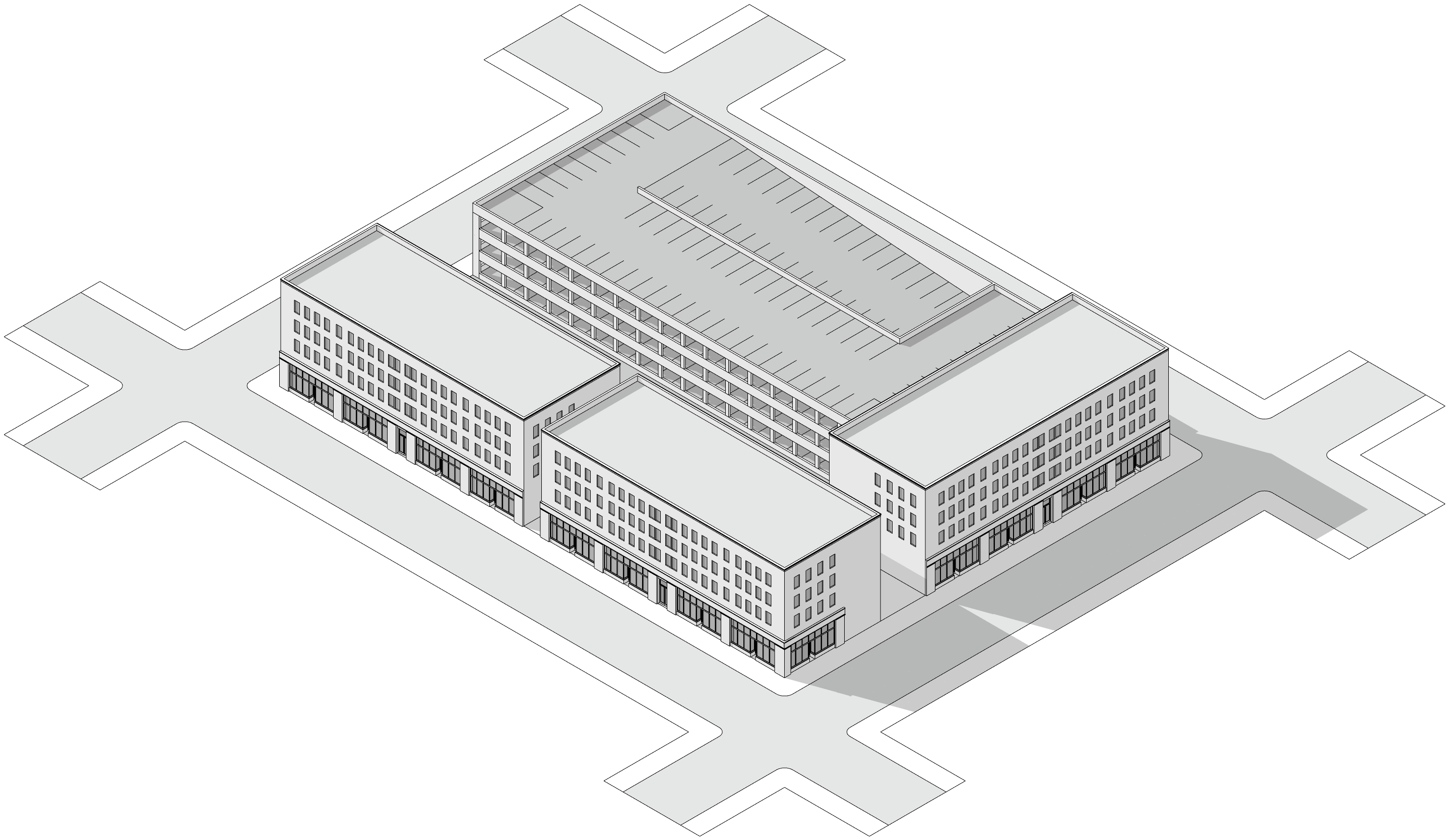 | 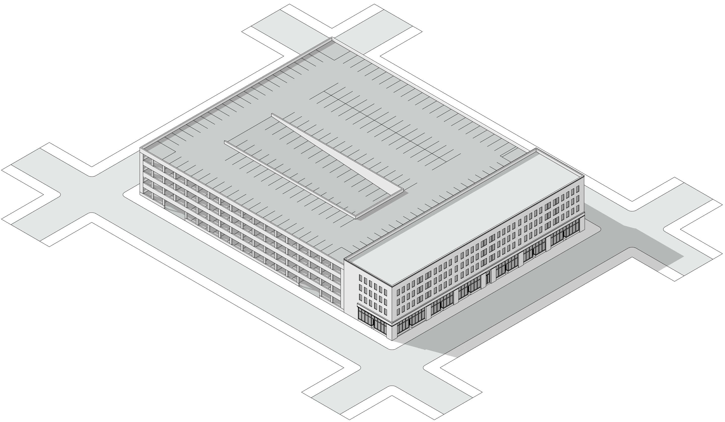 | ||
| Illustration of a free-standing parking structure surrounded by buildings. | Illustration of a parking structure that has a building attached to one side. | ||
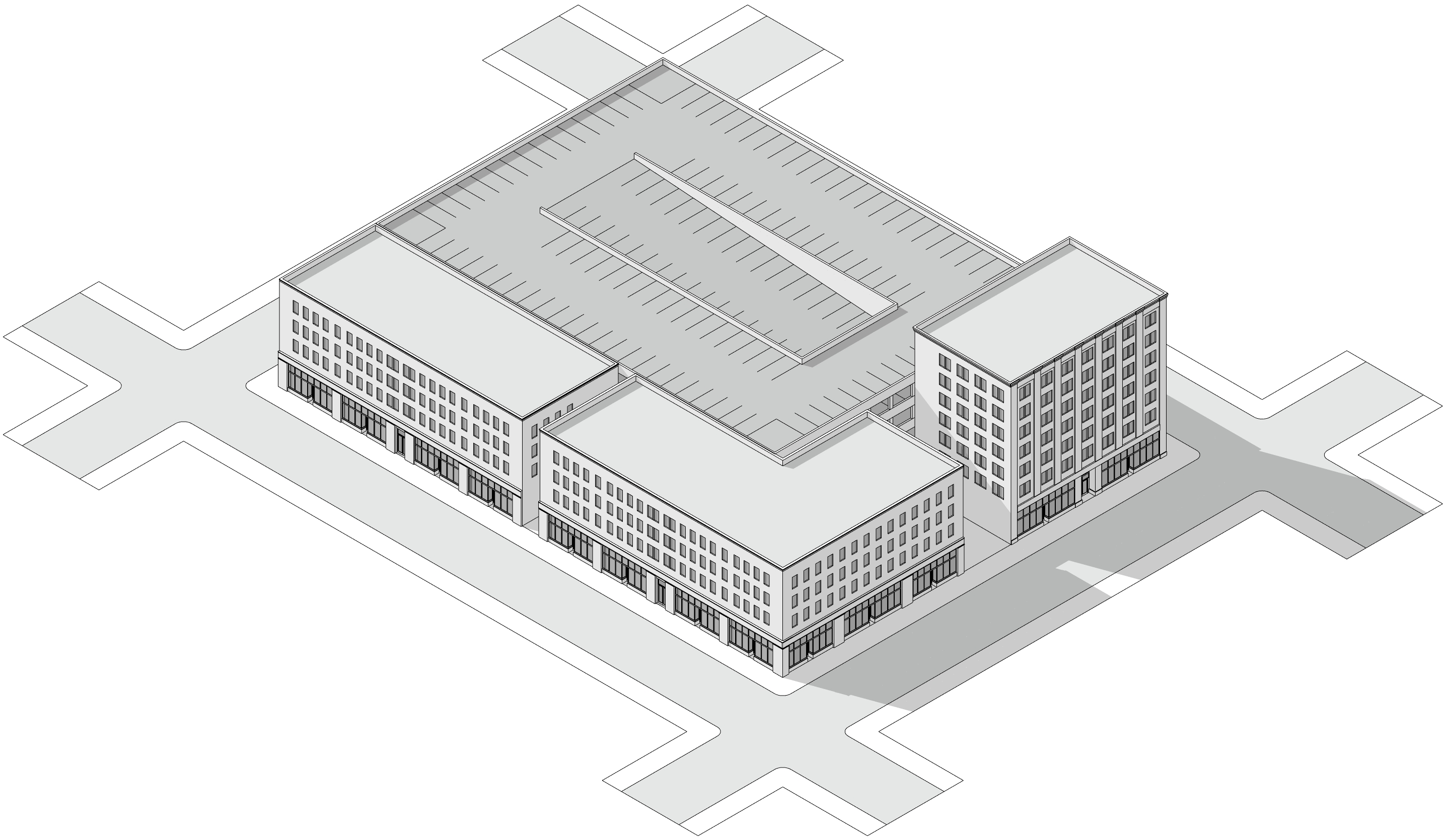 | 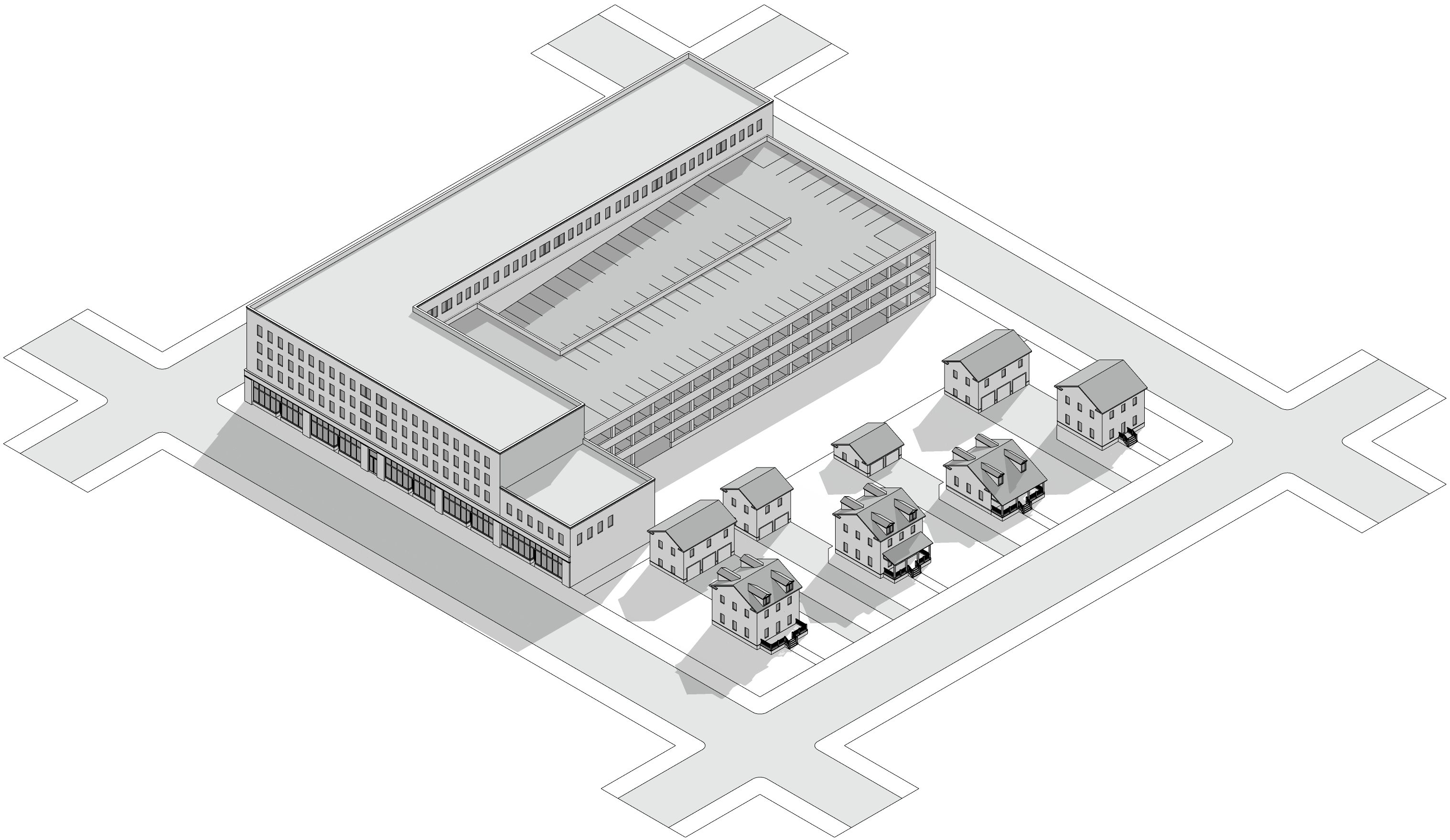 | ||
| Illustration of a parking garage attached to buildings along the front and side street lot lines. | Illustration of a parking structure on a lot abutting T3 or T4. | ||
| A | Height of parking structure by feet is as specified in Table 4.5.A Zone standards. | D | Additional setback required where abutting T3 and T4 lots. |
| B | Height of parking structure is limited to the height of the lowest attached building. | E | Buffer required. |
| C | Setbacks as specified in Table 4.5.A Zone standards. | ||
Figure 5.5.4.A Transitions in Height and Setback
Table 5.5.5.A Buffer Requirement by Adjacency
| Proposed Development | Existing Adjacent Zoning | |||||||
| T2 | T3 | T4 | T5 | T6 | HC | I-1 | I-2 | |
| T2 | ||||||||
| T3 | A | |||||||
| T4 | A | |||||||
| T5 | A | B | A | |||||
| T6 | B | C | A | A | ||||
| HC | C | C | B | A | A | |||
| 1-1 | B | B | A | A | ||||
| 1-2 | C | C | C | C | C | C | A | |
Table 5.5.5.B Buffer Type Requirements
Type | Width of Buffer | Hedge | Canopy Trees |
|---|---|---|---|
A | 6' minimum | 6' high at maturity, planted 30 inches on center, minimum. | 1 per each 50 linear ft. |
B | 10' minimum | 1 per each 40 linear ft. | |
C | 25' minimum | 2 per each 50 linear ft. |
5.6.2.1 Applicability
Trees are are required to be installed in the following conditions:
- When an existing street tree is removed; or
- When a street is constructed or altered; or
- When a tenant finish permit is required; or
- When a certificate of occupancy is required; or
- When exterior site or building changes are proposed or required; or
- Prior to recording of a final plat where financial guarantee is not provided.
5.6.2.2 Specifications
- All trees shall be canopy shade trees, unless a utility conflict exists, and shall conform to Subsection 5.6.9 Landscape Material Specifications.
- Street trees shall be a mix of species with no more than 40% of any single species.
(Ord 25-35, 7-8-2025)
5.6.2.3 Maintenance
The property owner is responsible for maintenance of trees including trimming branches such that a minimum clearance of 20 feet above travel lanes and 10 feet above paths is maintained.
5.6.2.4 Installation, Removal and Penalties
Street trees shall be installed per the following standards:
- No street tree shall be installed or removed without first securing approval of a right-of-way use permit. development permit from the Director. The owner of a property where any street tree is removed without such a permit shall be required to replant the tree in accordance with the requirements of this subsection and to pay a penalty of payment in-lieu to the City of Rogers Tree Fund for the per-tree value at a rate of 5 trees for every 1 removed
- Tree spacing shall be 30’ for trees less than 30’ tall (small species), 40’ for trees 30-45’ tall (medium species), and 50’ for trees 45’ or taller (large species).
- Trees must not impede the sight triangle on any street, alley, driveway, or for any other driving condition.
- Trees shall not be planted within the following distances of the infrastructure listed below:
- 25’ of any street corner, defined as the point where the curbs or curb lines intersect; or
- 20’ of light poles; or
- 10’ of fire hydrants.
- Only understory trees may be used within 20’ of overhead utilities or within 10’ of underground utilities.
- Understory trees shall be planted within medians or shall be maintained by the property owner to prevent sightline issues.
- It is prohibited to top or cutback to stubs the crown of any tree in street rights-of-way or on other public grounds.
- It is prohibited to damage, destroy, or mutilate trees in a rights-of-way or other public ground, unless written approval is received from the Director.
- It is prohibited to attach or place any rope or wire (other than rope lights or to support a young or broken tree or limb), sign, poster, handbill, or any other item to a tree.
(Ord 25-35, 7-8-2025)
5.6.3.1 Applicability
A path is any pedestrian way, including but not limited to trails, sidewalks, and shared use paths, whether paved or unpaved. Path trees are required to be installed in the following conditions:
- When an existing path tree is removed; or
- When a path is constructed or reconstructed; or
- When a tenant finish permit is required; or
- When a certificate of occupancy is required; or
- When exterior site or building changes are proposed or required; or
- Prior to recording of any final plat containing a path.
(Ord 25-35, 7-8-2025)
5.6.3.2 Standard
Canopy shade trees shall be planted along the south and west sides of all paths so as to cast shade for pedestrians and cyclists using the paths. When a path is adjacent and parallel to a street the required street trees may be substituted for this requirement when the street trees are located on the south and west sides of the path. In all cases, required open space trees may be utilized to meet this requirement.
(Ord 25-35, 7-8-2025)
5.6.3.3 Maintenance
The property owner is responsible for maintenance of trees including trimming branches such that a minimum clearance of 10 feet is maintained.
5.6.3.4 Exemption
Where pedestrian ways are located immediately adjacent to a parking lot or parking spaces and the pedestrian way does not exceed six feet in width path trees are not required.
(Ord 25-35, 7-8-2025)
5.6.4.1 Applicability
Open space trees are required to be installed as follows:
- When an existing open space tree is removed; or
- When a building is proposed to be constructed or expanded by 10% or more; or
- When impervious surface coverage is proposed to be constructed or expanded by 10% or more.
(Ord 25-35, 7-8-2025)
5.6.4.2 Standard
Canopy shade trees shall be provided at a rate of 1 tree per 1,000 square feet of added impervious area plus 1 trees per 2,500 square feet of added building floor area. The placement of trees required by this subsection shall conform to Section 5.6.3 Path Trees and Section 5.6.5 Vehicular Use Areas. Any remaining trees required may be placed anywhere on site at the applicant’s discretion.
(Ord 25-35, 7-8-2025)
5.6.5.1 Applicability
Vehicular use areas on private property are required to be landscaped in accordance with this subsection.
5.6.5.2 Standard
Vehicular use areas containing 10 or more parking spaces shall be landscaped as follows:
Tree Lawn, meeting the following standards:
Minimum 10 feet in width; and
Minimum 300 square feet in area; and
One canopy shade tree placed every 15 parking spaces or one placed every 30 linear feet, whichever provides more canopy.
Tree Island, meeting the following standards:
If the parking area is a single bay parking area, the tree island shall be a minimum width of 18 feet and a minimum length of 18 feet, or an area of not less than 324 square feet; and
If the area is a double bay parking area, the tree island shall be a minimum width of 18 feet and a minimum length of 36 feet, or an area of not less than 648 square feet. One tree shall be planted for every 15 parking spaces, with a maximum run of 15 parking spaces permitted without a tree island.
Where drive-aisles or driveways are proposed within vehicular use areas:
Those that are not identified as future streets shall be planted with deciduous shade trees placed on either side of the points of access within tree islands; and
Those that are identified as future streets shall be landscaped in accordance with 5.6.2 Street Trees; and
Where such drive-aisles or driveways within the vehicular use area form blocks that require mid-block pedestrian ways according to 3.4.2 Block Standards, a landscaped island of sufficient dimension to meet the requirements of 3.4.7 Pedestrian Ways is required and shall be landscaped in accordance with 5.6.3 Path Trees.
Dumpsters are permitted in interior yards only and shall be enclosed with a 6-foot vision-blocking screen on all sides. Materials used for screening shall be of a solid-type construction and consistent with the architectural style of the building. Screening walls with concrete foundations are prohibited in utility easements.
Where bioswales are proposed or required, they shall be landscaped in accordance with Article 7 Drainage Criteria Manual.
(Ord 25-35, 7-8-2025)
5.6.5.3 Other Vehicular Use Area Standards
See Section 5.3 Vehicular Use Areas for required design of drive-aisles, driveways, and mid-block pedestrian ways.
5.6.6.1 Applicability
Screetscreens or hedges are intended to screen certain site elements as viewed from a street or an adjacent property. They are required to be constructed or installed:
- When a vehicular use area is constructed, reconstructed, or expanded and is visible from a street or adjacent property; or
- When a drive-through lane is constructed, reconstructed, or expanded and is visible from a street or adjacent property; or
- In open frontages within a site’s build-to occupancy; or
- When mechanical equipment is installed.
5.6.6.2 Standard
- A masonry screen wall is required adjacent to the street within a property’s frontage not occupied by a building in T5 and T6 or in any zone where a front parking lane, parking lot, or drive-through is present between a building and the street.
- A masonry screen wall is required on the streetside of any ground-mounted mechanical equipment in any zone adjacent to an activity street or boulevard typology according to the Master Street Plan. In all other cases, ground-mounted mechanical equipment shall be screened as viewed from streets and paths with landscape hedge.
- Whether landscaping or a wall is used it shall measure between 4 ft and 3 ft above streetside or path side grade or in the case of mechanical equipment it shall measure the same height as the equipment.
5.6.8.1 Tree Specifications
Any tree required by this UDC shall be selected from the list provided in Table 5.6.9.A Permitted Trees and comply with the following:
- Deciduous ornamental trees must be balled-and-burlapped, at least 2-inch caliper, and at least 6 feet tall at time of planting; and
- Deciduous shade trees must be balled-and-burlapped, at least 2.5-inch caliper, and at least 6 feet tall at time of planting; and
- Evergreen trees must be balled-and-burlapped and at least 8 feet tall at time of planting; and
- No more than 25% of new trees on a site may be ornamental; and
- At least 10% of new trees on a site must be evergreen.
5.6.8.2 Permitted Trees
- This subsection provides trees permitted by size and location.
The lists below do not include every tree used in Rogers. The Director shall examine all proposed trees and will consider any viable options not listed below.
- The Director is authorized to grant an Administrative Adjustment approving an alternative species only when the permitted species are unavailable and when it is determined that the alternative accomplishes the intent of the specific tree requirement.
Plants specified in Table 5.6.8.D Prohibited Plant Species are prohibited as new plantings and shall be removed where existing.
(Ord 25-35, 7-8-2025)
Table 5.6.8.A Permitted Large Canopy Trees
"P" = Permitted "-" = Prohibited | As Street Trees | As Other Trees | ||||||
|---|---|---|---|---|---|---|---|---|
Common Name Scientific Name | In Planting Strip > 6 ft wide | In Planting Strip < 6 ft wide | In Planter Box | In Tree Well | Along Path | In Bioswale/Detention | In Open Space | In Parking Lots |
American Beech Fagus grandifolia | P | - | - | - | - | - | P | - |
American Elm Ulmus americana | - | - | - | - | - | P | P | - |
American Sycamore Plantus occidentalis | - | - | - | - | - | P | P | - |
Baldcypress Taxodium distichum | P | P | P | P | P | P | P | - |
Black Oak * Quercus velutina | P | P | - | - | P | - | P | P |
Black Tupelo * Nyssa sylvatica | P | P | P | P | P | P | P | P |
Black Walnut Juglans nigra | - | - | - | - | P | P | P | P |
Box Elder Acer negundo | - | - | - | - | - | P | - | - |
Bur Oak * Quercus macrocarpa | P | P | - | - | P | P | P | P |
Chinquapin Oak * Quercus muehlenbergii | P | P | - | - | P | - | P | P |
Common Hackberry * Celtis occidentalis | P | - | - | - | P | P | P | P |
Gingko (male only) Ginkgo biloba | P | P | P | P | P | - | P | P |
Honeylocust (thornless) * Gleditsia triacanthos | P | P | P | P | P | P | P | P |
Kentucky Coffeetree (male only)* Gymnocladus dioicus | P | P | P | P | P | P | P | P |
Green Vase Zelkova Zelkova serrata | P | P | P | P | P | - | P | P |
Jefferson Elm Ulmus americana ‘Jefferson | P | P | P | P | P | P | P | P |
Lacebark Elm (Allee) Ulmus parvifolia | P | P | P | P | P | P | P | P |
Lewis & Clark Elm U.americana ‘Lewis & Clark’ | P | P | P | P | P | P | P | P |
Littleleaf Linden Tilia cordata | P | P | P | P | P | - | P | P |
London Plane Platanus x acerifolia | P | - | P | P | P | - | P | - |
New Harmony Elm U.americana ‘New Harmony’ | P | P | P | P | P | P | P | P |
Northern Red Oak * Quercus rubra | P | - | - | - | P | - | P | P |
Princeton Elm U.americana ‘Princeton | P | P | P | P | P | P | P | P |
Red Maple Acer rubrum | - | - | - | - | - | P | P | - |
River Birch Betula nigra | - | - | - | - | - | P | - | P |
Shagbark Hickory Carya ovata | - | - | - | - | P | P | P | P |
Shumard Oak Quercus shumardii | P | P | - | - | P | P | P | P |
Southern Magnolia Magnolia grandiflora | P | P | - | - | P | - | P | P |
Southern Red Oak * Quercus falcata | P | P | - | - | P | - | P | P |
Sugar Maple * Acer saccharum | - | - | - | - | P | - | P | P |
Sugarberry * Celtis laevigata | P | - | - | - | P | - | P | P |
Swamp White Oak * Quercus bicolor | P | - | - | - | P | P | P | P |
Swamp Willow Salix myrtilloides | - | - | - | - | - | P | P | - |
Tulip Tree Liriodendron tulipifera | P | - | - | - | P | - | P | - |
Valley Forge Elm * U.americana ‘Valley Forge | P | P | P | P | P | P | P | P |
Water Oak * Quercus nigra | P | P | - | - | P | P | P | P |
Water Tupelo Nyssa aquatica | - | - | - | - | - | P | - | - |
White Oak * Quercus alba | P | P | - | - | P | P | P | P |
Willow Oak Quercus phellos | P | P | - | P | P | P | P | - |
| * Denotes a native species | ||||||||
(Ord 25-35, 7-8-2025)
Table 5.6.8.B Permitted Medium Canopy Trees
"P" = Permitted "-" = Prohibited | As Street Trees | As Other Trees | ||||||
|---|---|---|---|---|---|---|---|---|
Common Name Scientific Name | In Planting Strip > 6 ft wide | In Planting Strip < 6 ft wide | In Planter Box | In Tree Well | Along Path | In Bioswale/Detention | In Open Space | In Parking Lots |
American Holly Ilex opaca | P | P | P | P | P | P | P | P |
Bracken's Brown Magnolia Magnolia grandiflora ‘Bracken’s Brown Beauty' | P | - | - | - | P | - | P | P |
Eastern Arborvitae Thuja occidentalis | - | - | - | - | - | - | P | - |
English Oak Quercus robur | P | P | - | - | P | - | P | P |
Hawthorn Crataegus monogyna | P | P | P | P | P | - | P | P |
Hedge Maple Acer campestre ‘Queen Elizabeth | P | P | P | P | P | - | P | P |
Hornbeam Carpinus caroliniana | P | P | P | P | P | P | P | P |
Hophornbeam Ostrya virginiana | P | P | P | P | P | - | P | P |
Persian Ironwood Parrotia persica | P | P | P | P | P | - | P | P |
Scarlet Oak Quercus coccinea | P | P | - | - | P | - | P | P |
Trident Maple Acer buergerianum | P | P | P | P | P | - | P | P |
Yellowwood Cladrastis kentukea | P | - | - | - | P | - | P | P |
(Ord 25-35, 7-8-2025)
Table 5.6.8.C Permitted Understory Trees
"P" = Permitted "-" = Prohibited | As Street Trees | As Other Trees | ||||||
|---|---|---|---|---|---|---|---|---|
Common Name Scientific Name | In Planting Strip > 6 ft wide | In Planting Strip < 6 ft wide | In Planter Box | In Tree Well | Along Path | In Bioswale/Detention | In Open Space | In Parking Lots |
American Smoketree * Cotinus obovatus | P | P | P | P | P | P | P | P |
Amur Maple Acer ginnala | P | P | P | P | P | - | P | P |
Apple Serviceberry | P | P | P | P | P | - | P | P |
Blackhaw Viburnum Viburnum prunifolium | P | - | - | - | P | - | P | P |
Carolina Buckthorn * Rhamnus caroliniana | P | - | - | - | P | - | P | P |
Common Serviceberry* Amelanchier arborea | P | P | P | P | P | - | P | - |
Crabapple (fruitless, disease resistant) Malus sylvestris | P | P | P | P | P | - | P | P |
Dahoon Holly Ilex cassine | P | P | P | P | P | P | P | P |
Deciduous Holly * Ilex decidua | P | - | - | - | P | - | P | P |
Eagleston Holly * Ilex x attenuata ‘Eagleston | P | - | - | - | P | - | P | P |
Flowering Dogwood Cornus florida | - | - | - | - | P | - | P | P |
Foster Holly * Ilex x attenuata ‘Fosteri’ | P | - | - | - | P | - | P | P |
Fringe Tree * Chionanthus virginicus | P | P | P | P | P | - | P | P |
Hazelnut * Corylus americana | - | - | - | - | - | - | P | P |
Kousa Dogwood Cornus kousa | P | P | P | P | P | - | P | P |
Little Gem Magnolia Magnolia grandiflora ‘Little Gem' | P | P | P | P | P | - | P | P |
Pawpaw * Asimina triloba | - | - | - | - | P | - | P | P |
Redbud Cercis canadensis | P | P | P | P | P | - | P | P |
Red Chokeberry * | P | P | - | - | P | P | P | P |
Rusty Blackhaw * Viburnum rufidulum | P | - | - | - | P | - | P | P |
Shadlow Serviceberry Amelanchier canadensis | P | P | - | - | P | P | P | P |
Sweetbay Magnolia * Magnolia virginiana | P | P | P | P | P | P | P | P |
Yaupon Holly Ilex vomitoria | P | - | - | - | P | P | P | P |
| * Denotes a native species | ||||||||
(Ord 25-35, 7-8-2025)
Table 5.6.8.D Prohibited Plant Species
| Common Name | Scientific Name |
|---|---|
Asian wisteria | Wisteria sinensis, wisteria floribunda |
Bamboo | Pyllostachys spp. |
Bigleaf periwinkle | Vinca major |
Black locust | Robinia pseudoacacia |
Bradford pear | Pyrus calleryana |
Burning bush | Euonymus alatus |
Bush honeysuckle | Lonicera maackii, lonicera fragrantissima |
Chinaberry | Melia azedarach |
Chinese privet | Ligustrum sinese |
Cottonwood | Populus deltoides |
Creeping euonymus | Euonymus fortunei |
English ivy | Hedera helix |
Hardy Orange | Poncirus trifoliata |
Heavenly bamboo | Nandina domestica |
Japanese honeysuckle | Lonicera japonica |
Kudzu | Pueraria montana |
Littleleaf periwinkle | Vinca minor |
Mimosa, silktree | Albizia julibrissin |
Multiflora rosa | Rosa multiflora |
Paper mulberry | Broussonetia papyrifera |
Princess tree | Paulownia tomentosa |
Red cedar | Juniperus virginiana |
Sericea lespedeza | Lespedeza cuneata |
Shrubby lespedeza | Lespedeza bicolor |
Siberian Elm | Ulmus pumila |
Tallow berry | Triadica sebifera |
Tree-of-heaven | Ailanthus altissima |
White mulberry | Morus alba |
White poplar | Populus alba |
(Ord 25-35, 7-8-2025)
5.8.13.A Signs Allowed by Placetype
| Wall | Projecting | Blade | Awning | Facade | Monument | Pole | Pylon | Directory | Wayfinding | Post and Arm | ||
|---|---|---|---|---|---|---|---|---|---|---|---|---|
| Neighborhood | U-NH | X | X | X | X | X | ||||||
| F-NH | X | X | X | X | X | |||||||
| NH-C | X | X | X | X | X | X | X | |||||
| City Centers | DT-C | X | X | X | X | X | ||||||
| SW-CC | X | X | X | X | X | X | X | X | ||||
| MT-CC | X | X | X | X | X | X | X | X | X | X | ||
| Regional Centers | UT-RC | X | X | X | X | X | X | X | X | |||
| NW-RC | X | X | X | X | X | X | X | X | ||||
| PG-RC | X | X | X | X | X | X | X | X | X | X | ||
| Corridors | C-CO | X | X | X | X | X | X | X | X | X | X | |
| R-CO | X | X | X | X | X | X | X | X | X | X | ||
| H-CO | X | X | X | X | X | X | X | X | X | X | ||
| IAT | IAT | X | X | X | X | X | X | X | X | X | X |
(Ord 25-35, 7-8-2025)
Figure 5.9.1.A Walkways and Platting within Parking Lots
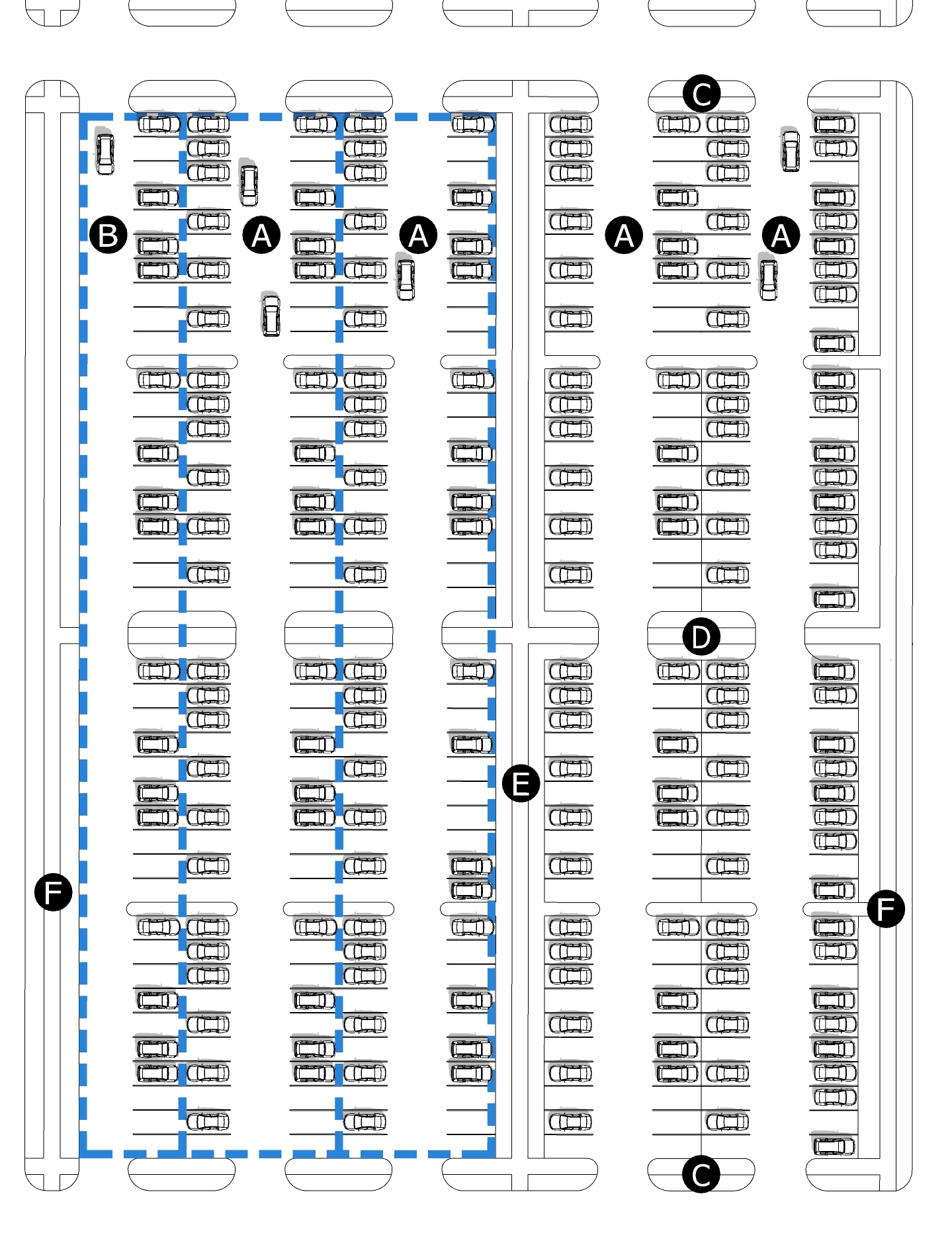 | |||
A | Parking tray - double-loaded | D | Planter and walkway every 20 spaces |
B | Parking tray - single-loaded | E | Planter and walkway between every 3 trays |
C | Planter and walkway at the end of aisles | F | Planter and walkway along lot lines |
Figure 5.2.4.1.A Courtyard Site Design
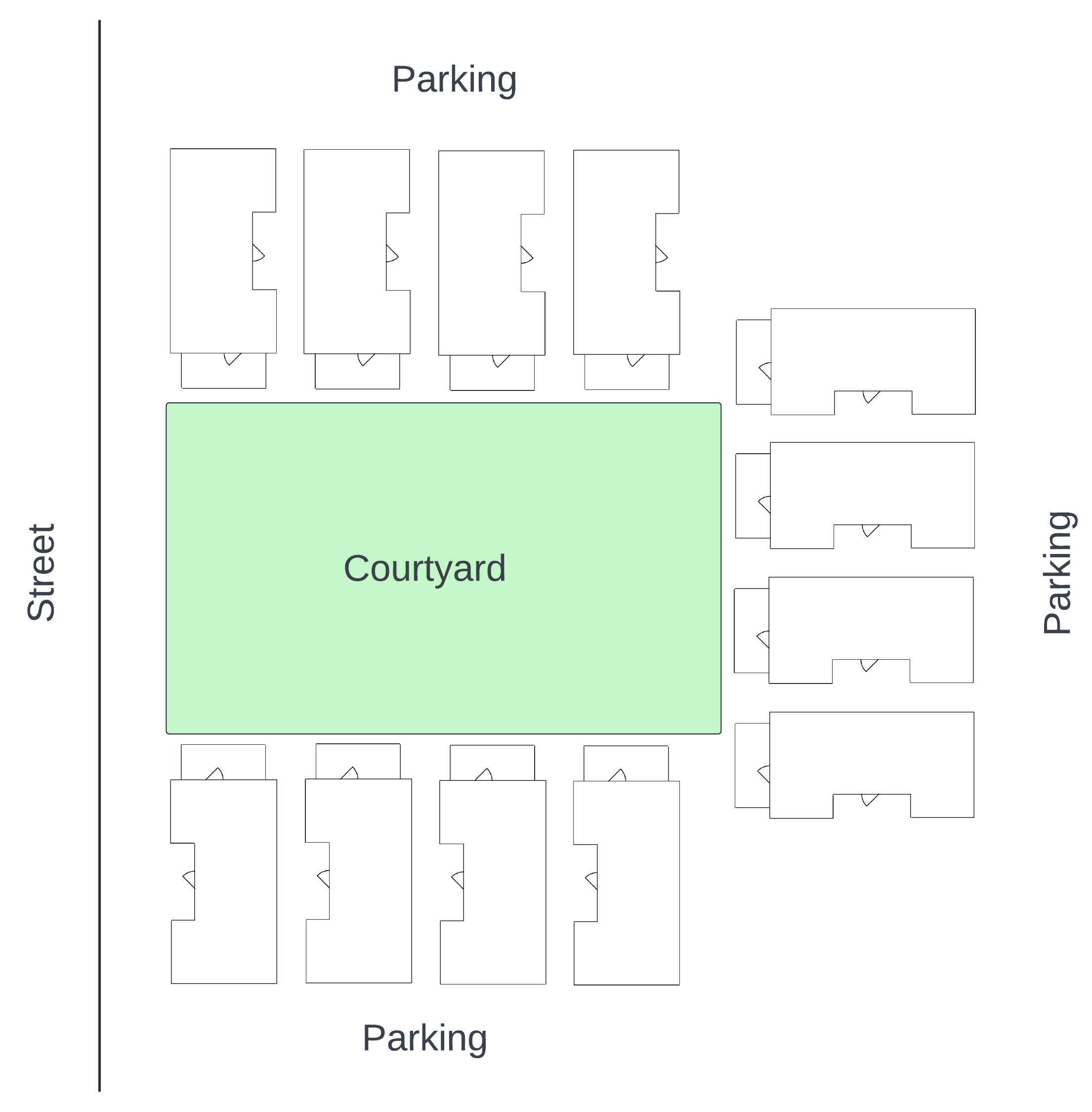 Forecourt arrangement with cottage houses | 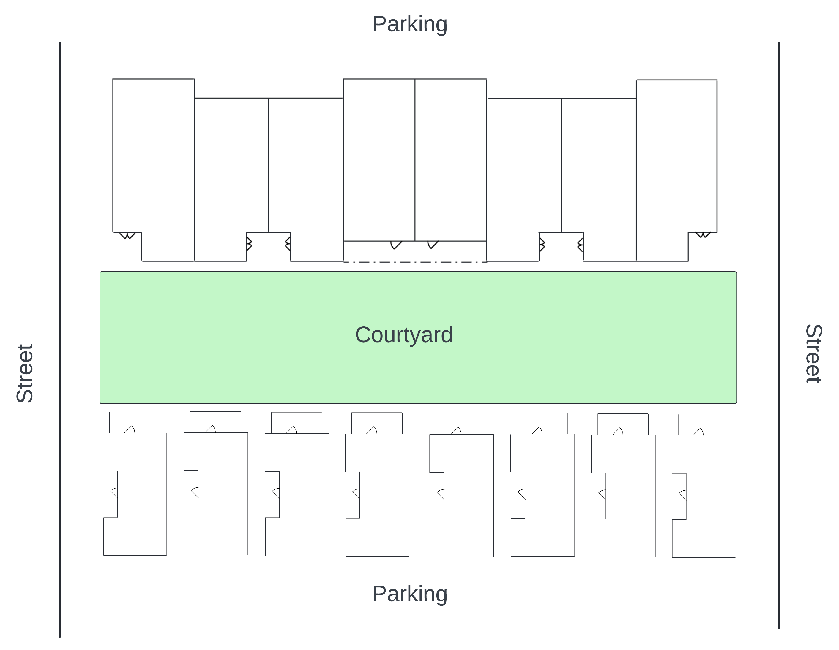 Throughcourt arrangement with cottage houses and town houses |
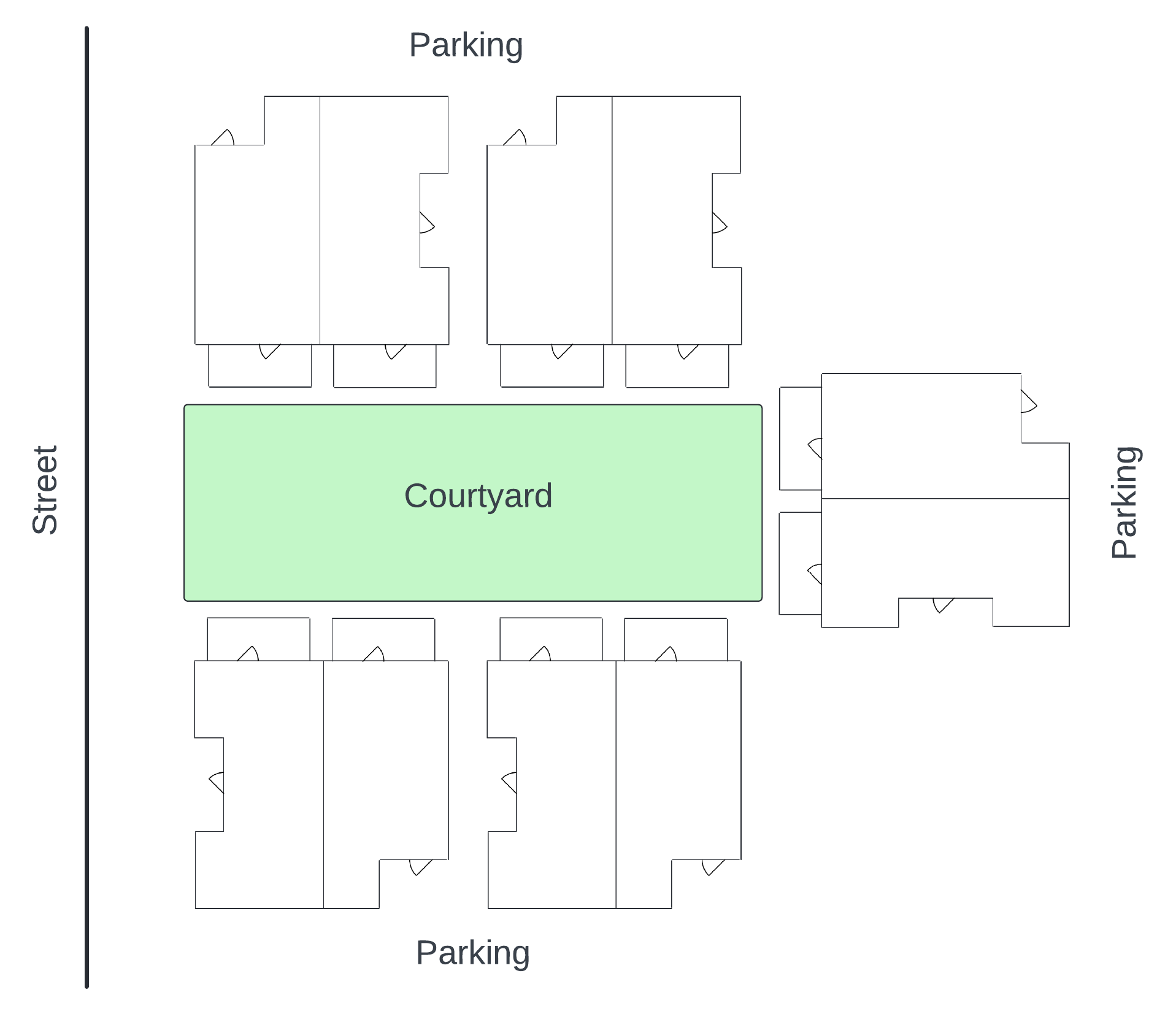 Forecourt arrangement with duplexes | 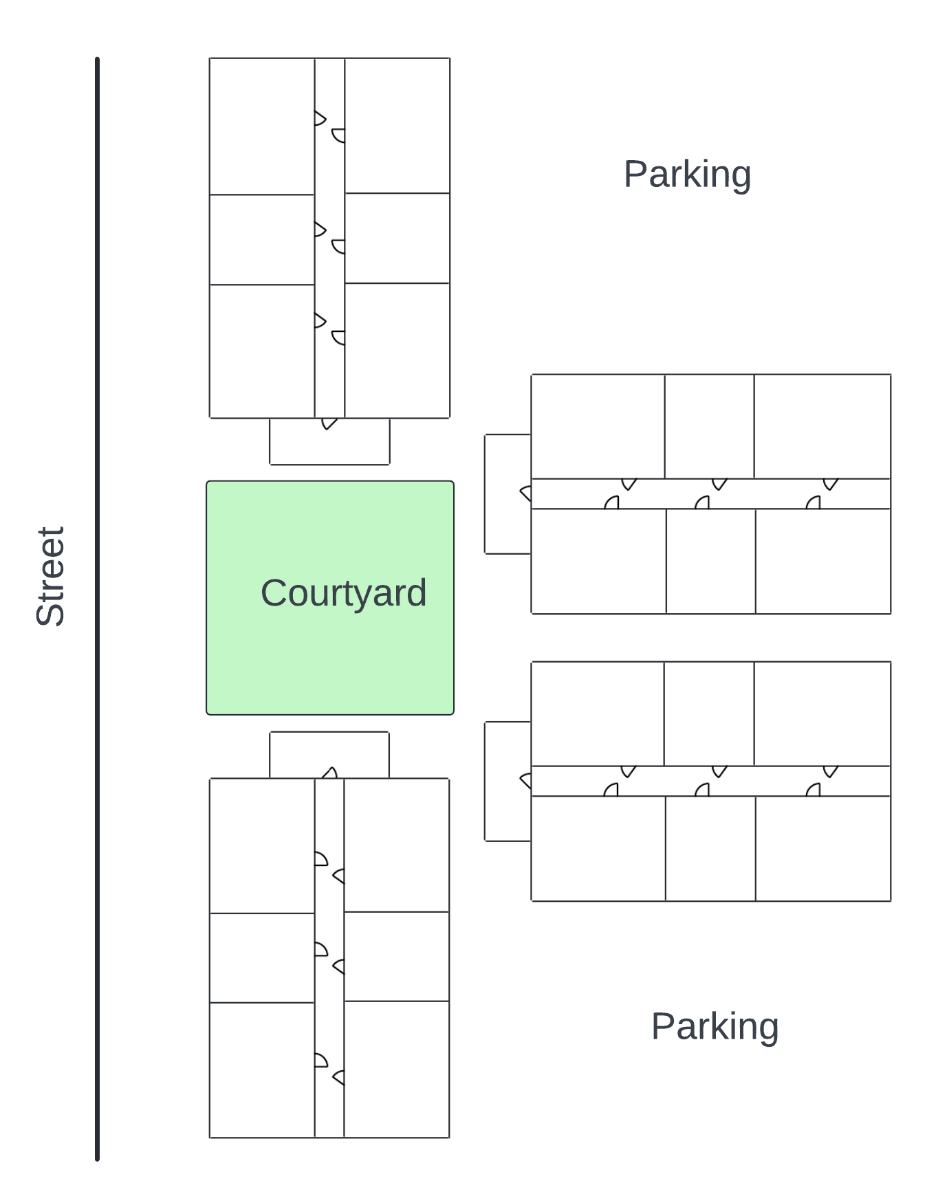 Forecourt arrangement with multi-unit houses |
Figure 5.2.4.2.A Terrace Site Design
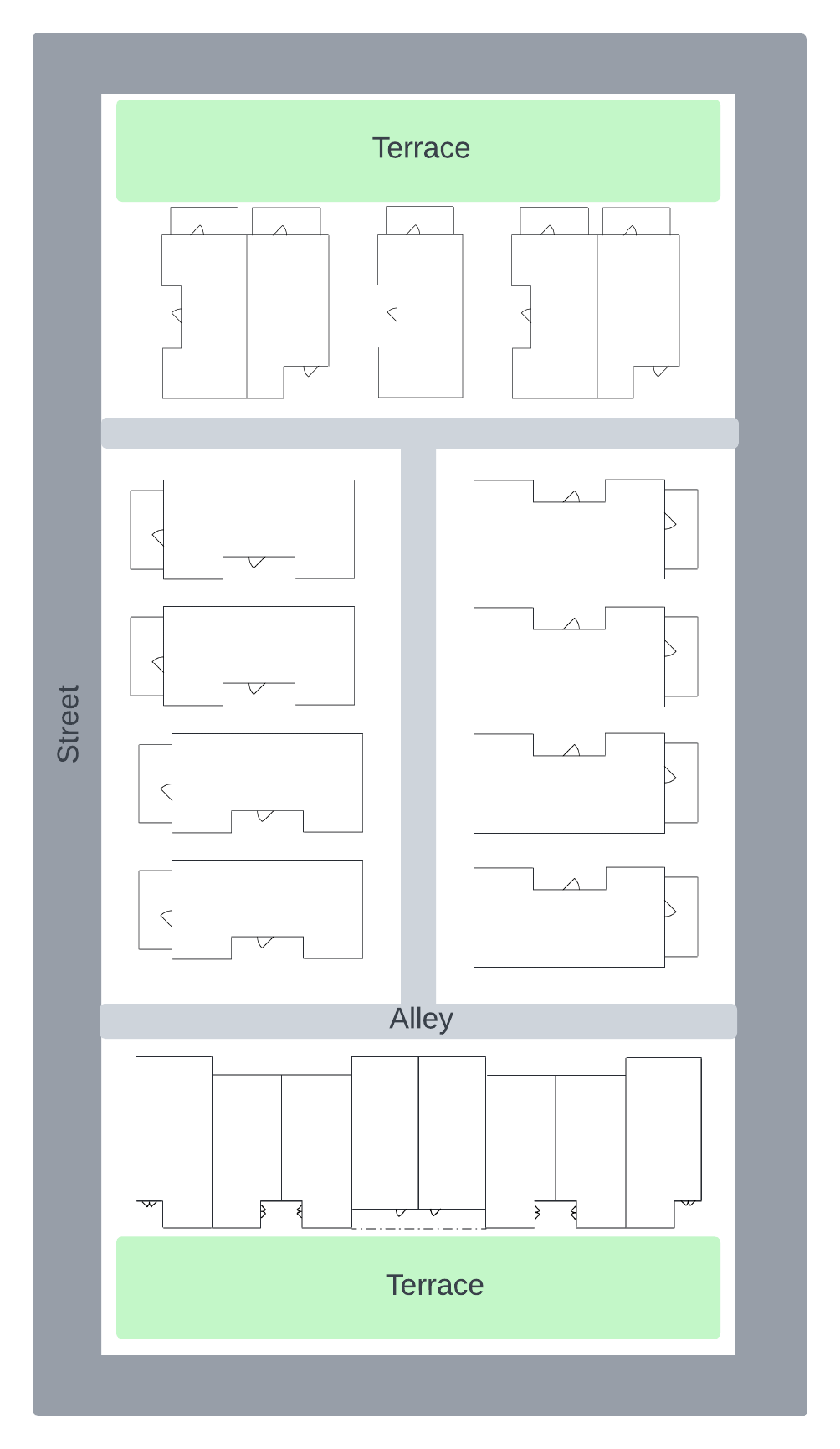
Figure 5.2.4.3.A Tandem Site Design
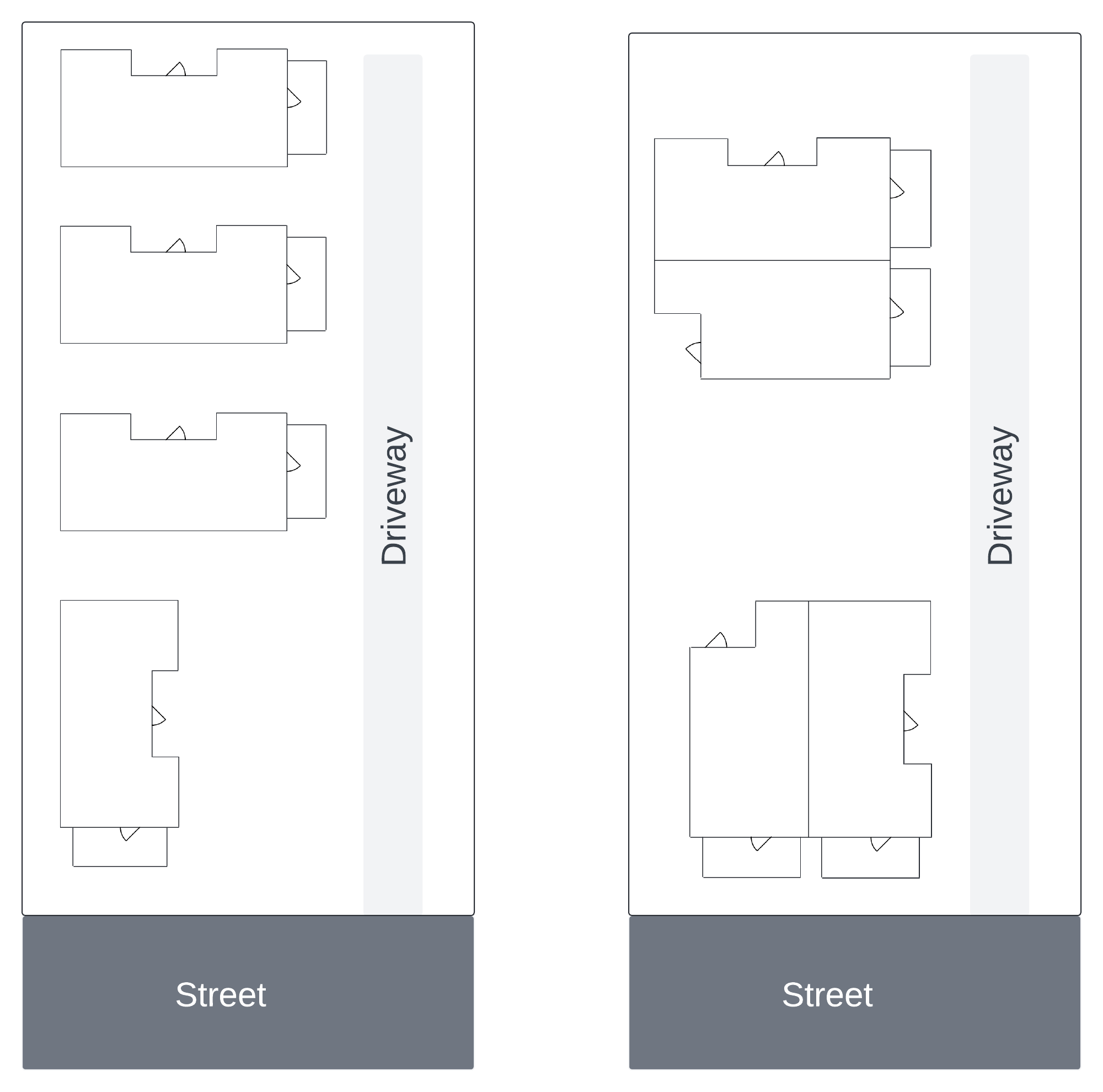
5.3.2.3.1 Shared Parking
Existing or proposed parking spaces within 1,320 feet walking distance, whether onsite or off, may be shared with the proposed uses whenever the other uses to which they are dedicated have different peak demand periods and where the owner of such spaces confirms, in writing, that such spaces are not already encumbered to be shared with another use with similar peak demand periods to the proposed use(s).
5.3.2.3.2 Valet Parking
Existing or proposed parking spaces within 2,640 feet walking distance, whether onsite or off, may be utilized for the proposed use(s) whenever the other uses to which they are dedicated have different peak demand periods and where the owner of such spaces confirms, in writing, that such spaces are not already encumbered to be shared with another use with similar peak demand periods to the proposed use(s) and where the owner of the property upon which the proposed use(s) are located agrees, in writing, to provide valet parking and depicts the locations for such valet spaces on their plan.
(Ord 25-35, 7-8-2025)
5.3.2.3.3 Rideshare
On-street spaces dedicated to rideshare vehicles may be credited toward the number of spaces considered sufficient for the proposed uses at a ratio accepted by the Director.
5.3.2.3.4 Alternate Modes
Alternate modes of travel made available or where space is dedicated for such modes onsite may be credited toward the number of spaces considered sufficient for the proposed uses at a ratio accepted by the Director. Alternate modes made available onsite may include, but are not limited to: provision of onsite bicycle parking or bicycle lockers, provision of onsite scooter or e-bikes or space dedicated to the parking and rental of such, and proximity to transit stops active during the peak demand period.
Porch Encroachment into the Front Setback
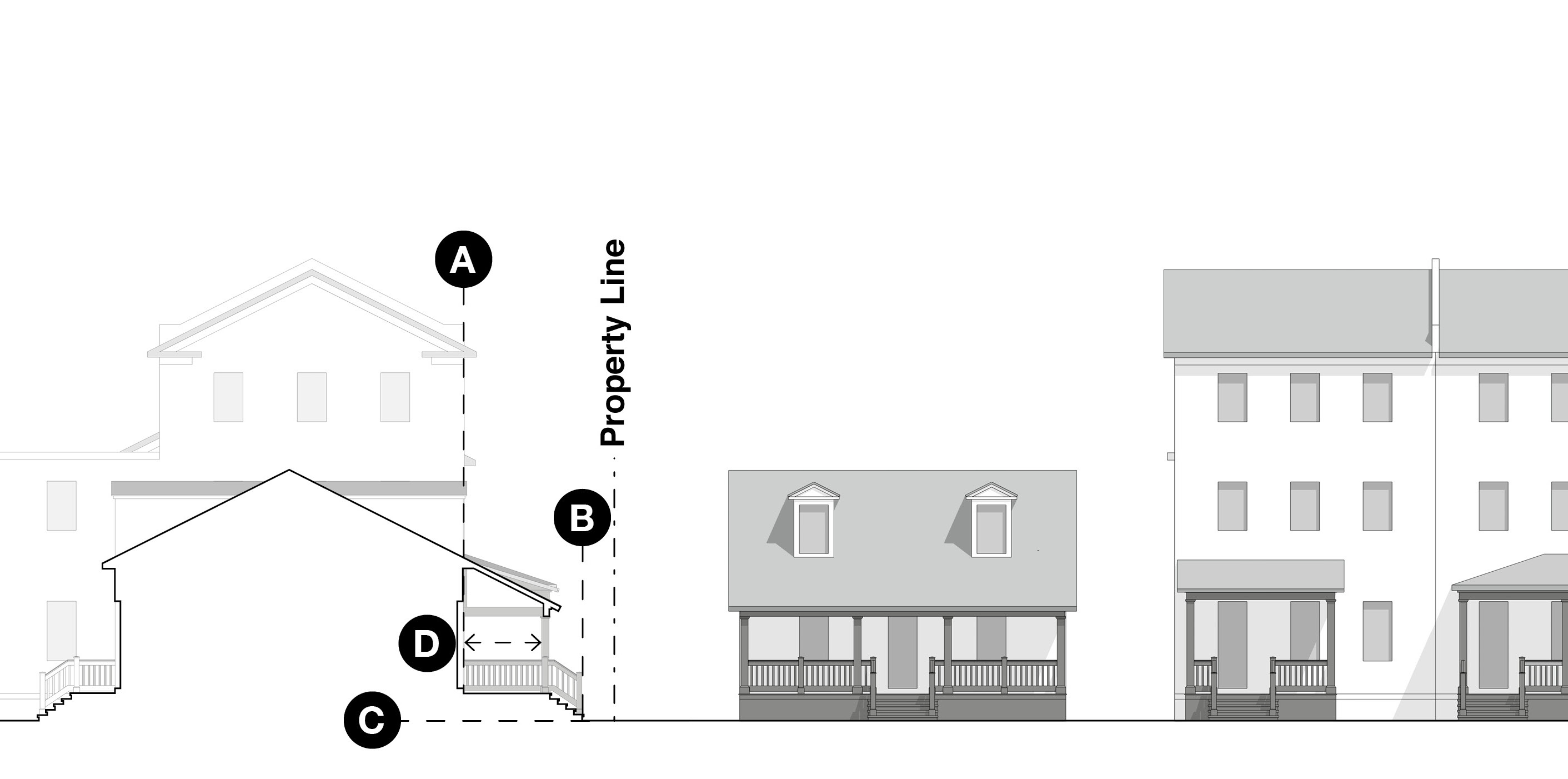 | A | Minimum setback |
| B | Encroachment of porch and steps | |
| C | Grade | |
| D | Minimum depth required for porches that encroach into a setback |
Stoop Encroachment into the Front Setback
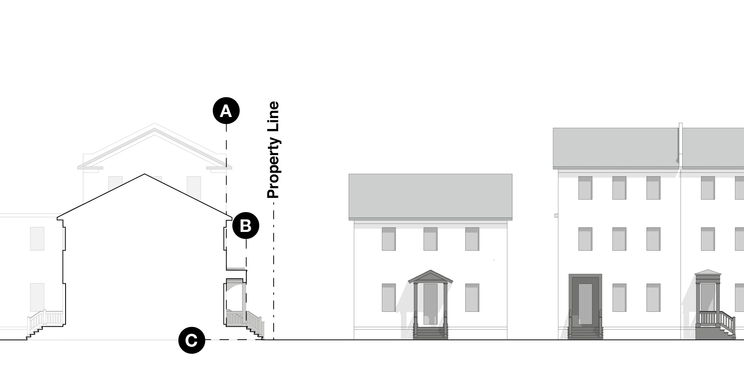 | A | Minimum setback |
| B | Encroachment of porch and steps | |
| C | Grade | |
Gallery Encroachment into the Right-of-way
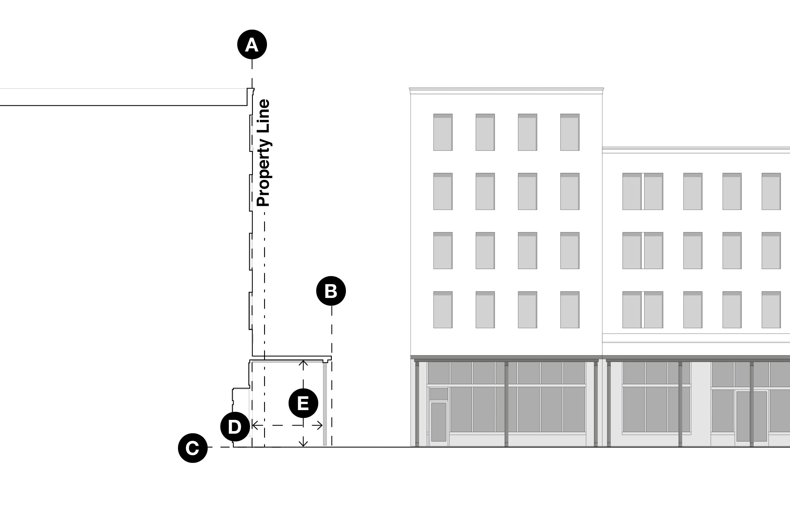 | A | Building setback, within the build-to area |
| B | Gallery encroachment into the right-of-way | |
| C | Grade | |
| D | Minimum gallery depth | |
| E | Minimum clearance above sidewalks |