
Saint Lucie County Unincorporated
City Zoning Code
City Zoning Code
CHAPTER III
ZONING DISTRICTS
3.00.01. - Zoning Districts Established.
In order to carry out the goals and policies of the St. Lucie County Comprehensive Plan and the purposes of this Code, the following zoning districts are hereby created:
(Ord. No. 04-003, 12-7-2004; Ord. No. 06-017, Pt. A, 5-30-2006)
3.01.01. - Generally.
A.
Permitted Uses. No structure or land in the unincorporated area of St. Lucie County shall hereafter be constructed, built, moved, remodeled, reconstructed, used, or occupied except in accordance with the requirements of the zoning district in which the structure or land is located, unless it is a nonconformity under the provisions of Section 10.00.02 of this Code.
B.
Conditional Uses. No structure or land shall be constructed, built, remodeled, reconstructed, used, or occupied as a conditional use under this Code except as approved under the procedures and requirements of Section 11.07.00, and the standards of Section 11.07.03.
C.
Accessory Uses and Structures. Accessory structures and uses are permitted in any zoning district in connection with any principal lawfully existing permitted use within such district, or in connection with any existing conditional use within such district, subject to the requirements of Section 11.07.00, provided that all accessory structures or uses shall meet the requirements for the zoning district in which the structure or use is located, as provided in Section 3.01.01, and all other requirements of this Section.
D.
Public Services and Facilities. The intent of this Section is to address infrastructure improvements that provide essential or important public services that by their nature may be required throughout unincorporated St. Lucie County.
1.
Transportation and Utility Rights-of-Way. Transportation and utility rights-of-way, except for those utility rights-of-way subject to review and approval under F.S. Ch. 403, Part II, and the linear portion of transportation facilities, e.g., pipes, poles lines, wires, cables, conduits, pavement rails, drainage and other similar equipment and accessories in connection herewith, shall be permitted in all zoning districts and shall comply, as applicable, with the resource protection and development standards for vegetation protection, protection of environmentally sensitive lands, protection of habitat for endangered and threatened species, flood damage prevention and stormwater management.
Prior to any local certification of consistency for those utility rights-of-way subject to review and approval under F.S. Ch. 403, Part II, a conditional use review, in accordance with the provisions of Section 11.07.03, shall be required.
2.
Essential Utility Service Facilities. Essential Utility Service Facilities that support the operation and function of a utility service provider shall be permitted in all zoning districts, subject to compliance with the provisions of this Section. For purposes of this Section, the term "service provider" shall mean a public entity; a Florida Public Service Commission certificated utility entity, a non-regulated utility entity such as a cable television service provider, or a public or a quasi-public entity, such as a community development district or drainage district.
a.
Essential Utility Service Facilities parcels shall be exempt from the lot width, lot size and road frontage requirements but all improvements on a parcel or parcels shall meet the maximum height requirements and all buildings and structures shall also meet the setback requirements of the zoning district in which they are located, unless otherwise regulated under Section 163.3208, Florida Statutes. The improvements shall comply with all resource protection and development standards for vegetation protection, protection of environmentally sensitive lands, protection of habitat for endangered and threatened species, flood damage prevention and stormwater management. In addition, above ground mechanical improvements located outside the right- of-way and adjacent to residentially zoned property and road rights-of-way shall be screened by landscaping with the type and location of the improvement and landscape treatments to be determined at the time of permitting.
b.
Except as provided for under the provisions of paragraph a. above, Essential Utility Service Facilities involving buildings or structures that shield the infrastructure for aesthetic purposes or that provide storage incidental to the Essential Utility Service shall be permitted upon a demonstration of compliance with all applicable sections of this Code, and the provisions below:
1)
The cumulative area of the Essential Utility Service Facilities building or structure shall not exceed three hundred (300) square feet. Essential Utility Service Facilities involving buildings or structures with a cumulative total area larger than three hundred (300) square feet, or not compliant with this section, shall only be permitted within a zoning district when specifically listed as a permitted, conditional or accessory use.
2)
The Essential Utility Service Facilities building or structure shall comply with all applicable building codes, resource protection and development design standards, including landscaping and screening requirements. Where necessary, the Planning and Development Services Director may approve alternative plans for security purposes or to ensure compatibility with the surrounding zoning district and existing uses.
3)
Within residentially zoned areas, Essential Utility Service Facilities buildings or structures shall require approval by the Planning and Development Services Director. The Director shall deny any building or structure that would likely create an adverse impact on neighboring properties.
4)
For the purpose of this section, an opaque screening wall or fence, erected or constructed for the purpose of screening or providing security to an Essential Utility Service Facility shall not be included in the three hundred (300) square foot limitation cited in Paragraph 1 above. All screening walls or fences shall be subject to applicable local height and site distance placement requirements.
c.
Essential Utility Service Facilities, as defined in this Code, existing as of May 1, 2012 shall be considered permitted uses in the zoning district in which they are located and allowed to continue in compliance with this Code and any applicable conditions of approval.
3.
Public services and facilities not meeting the provisions for Transportation and Utility Rights-of-way or Essential Utility Service Facilities, including, but not limited to, those involving substations, generation plants, treatment plants, or stormwater pumping stations shall be permitted within zoning districts only when listed as a permitted or conditional use. Where an Essential Utility Service Facilities improvement is specifically addressed in another section of this Code, and conflicts with this section, the most restrictive requirements shall apply.
In the event any of the provisions of this section prohibit the installation of an emergency improvement or a utility improvement required by an environmental regulatory agency, the Planning and Development Services Director may grant a waiver of the provisions of this section upon determination that strict application would result in a threat to public health, safety or welfare.
(Ord. No. 12-009, Pt. A, 4-17-2012; Ord. No. 2024-29, § 2, 10-1-2024)
3.01.02. - Administrative Use Regulations for Permitted and Conditional Uses.
A.
For the purposes of clarifying and detailing the intent and purpose of the uses of the Zoning Districts in §§ 3.01.03(A) through 3.01.03(HH), the Planning and Development Services Director shall utilize the Standard Industrial Classification (SIC) Manual (1987 ed.), prepared by the Executive Office of the President, Office of Management and Budget.
B.
Whenever a use is not specifically listed in Sections 3.01.03(A) through 3.01.03(HH) the Planning and Development Services Director shall make a determination as to whether the proposed use is of the same general type as identified in the Standard Industrial Classification Manual (1987 ed.), prepared by the Executive Office of the President, Office of Management and Budget. When a proposed use is listed in another Section, the Director may make a determination whether the use may also be appropriate in another district based upon an analysis of compatibility. The analysis of compatibility shall include, but not necessarily be limited to: traffic circulation, parking, noise, odor, hours of operation, buffers, stormwater run-off, or other determinations of impacts on nearby residences, uses or districts. Should the Director determine a proposed use is compatible in another district, future similar use proposals in the same district will have a presumption of compatibility.
(Ord. No. 12-003, Pt. B, 5-15-2012)
3.01.03. - Zoning Districts.
A.
AG-1 AGRICULTURAL - 1.
1.
Purpose. The purpose of this district is to provide and protect an environment suitable for productive commercial agriculture, together with such other uses as may be necessary to and compatible with productive agricultural surroundings. Residential densities are restricted to a maximum of one (1) dwelling unit per gross acre. The number in "( )" following each identified use corresponds to the SIC Code reference described in Section 3.01.02(B). The number 999 applies to a use not defined under the SIC Code but may be further defined in Section 2.00.00 of this Code.
2.
Permitted Uses.
a.
Agricultural production - crops. (01)
b.
Agricultural production - livestock and animal specialties. (02)
c.
Agricultural services. (07)
d.
Family day care homes. (999)
e.
Family residential homes provided that such homes shall not be located within a radius of one thousand (1,000) feet of another existing such family residential home and provided that the sponsoring agency or Department of Health and Rehabilitative Services (HRS) notifies the Board of County Commissioners at the time of home occupancy that the home is licensed by HRS. (999)
f.
Fishing, hunting and trapping. (09)
g.
Forestry. (08)
h.
Kennels. (0752)
i.
Research facilities, non-commercial. (8733)
j.
Riding stables. (7999)
k.
Single-family detached dwellings. (999)
l.
Solar generation station, subject to the requirements of Section 7.10.28. (999)
3.
Lot Size Requirements. Lot size requirements shall be in accordance with Table 7-10 in Section 7.04.00.
4.
Dimensional Regulations. Dimensional requirements shall be in accordance with Table 7-10 in Section 7.04.00.
5.
Off-Street Parking and Loading Requirements. Off-street parking and loading requirements are subject to Section 7.06.00.
6.
Landscaping Requirements. Landscaping requirements are subject to Section 7.09.00.
7.
Conditional Uses.
a.
Agricultural labor housing. (999)
b.
Aircraft storage and equipment maintenance. (4581)
c.
Airports and flying, landing, and takeoff fields. (4581)
d.
Family residential homes located within a radius of one thousand (1,000) feet of another such family residential home. (999)
e.
Farm products warehousing and storage. (4221/4222)
f.
Farmers' markets - subject to the requirements of Section 7.10.37. (999)
g.
Gasoline service stations. (5541)
h.
Industrial wastewater disposal. (999)
i.
Manufacturing:
(1)
Agricultural chemicals. (287)
(2)
Food and kindred products. (20)
(3)
Lumber and wood products, except furniture. (24)
j.
Mining and quarrying of nonmetallic minerals, except fuels. (14)
k.
Retail trade:
(1)
Farm equipment and related accessories. (999)
(2)
Apparel and accessory stores. (56)
l.
Sewage disposal subject to the requirements of Section 7.10.13. (999)
m.
Telecommunication towers - subject to the standards of Section 7.10.23. (999)
n.
Camps - sporting and recreational. (7032)
8.
Accessory Uses. Accessory uses are subject to the requirements of Section 8.00.00, and include the following:
a.
Mobile homes subject to the requirements of Section 7.10.05.
b.
Retail trade and wholesale trade - subordinate to the primary authorized use or activity.
c.
Guest house subject to the requirements of Section 7.10.04. (999)
d.
Solar energy system subject to the requirements of Section 7.10.28. (999)
e.
Cargo containers subject to the requirements of Section 7.10.35.
B.
AG-2.5 AGRICULTURAL - 2.5.
1.
Purpose. The purpose of this district is to provide and protect an environment suitable for productive commercial agriculture, together with such other uses as may be necessary to and compatible with productive agricultural surroundings. Residential densities are restricted to a maximum of one (1) dwelling unit per two and one-half (2.5) gross acres. The number in "( )" following each identified use corresponds to the SIC Code reference described in Section 3.01.02(B). The number 999 applies to a use not defined under the SIC Code but may be further defined in Section 2.00.00 of this Code.
2.
Permitted Uses.
a.
Agricultural production - crops. (01)
b.
Agricultural production - livestock and animal specialties. (02)
c.
Agricultural services. (07)
d.
Family day care homes. (999)
e.
Family residential homes provided that such homes shall not be located within a radius of one thousand (1,000) feet of another existing such family residential home and provided that the sponsoring agency or Department of Health and Rehabilitative Services (HRS) notifies the Board of County Commissioners at the time of home occupancy that the home is licensed by HRS. (999)
f.
Fishing, hunting and trapping. (09)
g.
Forestry. (08)
h.
Kennels. (0752)
i.
Research facilities, noncommercial. (8733)
j.
Riding stables. (7999)
k.
Single-family detached dwellings. (999)
l.
Solar generation station, subject to the requirements of Section 7.10.28. (999)
3.
Lot Size Requirements. Lot size requirements shall be in accordance with Table 7-10 in Section 7.04.00.
4.
Dimensional Regulations. Dimensional requirements shall be in accordance with Table 7-10 in Section 7.04.00.
5.
Off-Street Parking and Loading Requirements. Off-street parking and loading requirements are subject to Section 7.06.00.
6.
Landscaping Requirements. Landscaping requirements are subject to Section 7.09.00
7.
Conditional Uses:
a.
Agricultural labor housing. (999)
b.
Aircraft storage and equipment maintenance. (4581)
c.
Airports and flying, landing, and takeoff fields. (4581)
d.
Family residential homes located within a radius of one thousand (1,000) feet of another such family residential home. (999)
e.
Farm products warehousing and storage. (4221/4222)
f.
Farmers' markets - subject to the standards of Section 7.10.37. (999)
g.
Gasoline service stations. (5541)
h.
Industrial wastewater disposal. (999)
i.
Manufacturing:
(1)
Agricultural chemicals. (287)
(2)
Food and kindred products. (20)
(3)
Lumber and wood products, except furniture. (24)
j.
Mining and quarrying of nonmetallic minerals, except fuels. (14)
k.
Radio, television, and microwave communication stations and towers. (999)
l.
Retail trade:
(1)
Farm equipment and related accessories. (999)
(2)
Apparel and accessory stores. (56)
m.
Sewage disposal subject to the requirements of Section 7.10.13. (999)
n.
Telecommunication towers - subject to the standards of Section 7.10.23. (999)
o.
Camps - sporting and recreational. (7032)
p.
Outdoor shooting ranges, providing site plan approval is obtained according to the provisions of Sections 11.02.07 through 11.02.09 and Section 7.10.19 of this Code.
q.
Utility trade contractors, with specialty storage engaged in the construction of water and sewer mains, pipelines, and communication and powerline construction subject to the requirements of Section 7.10.36. (1623)
8.
Accessory Uses: Accessory uses are subject to the requirements of Section 8.00.00, and include the following:
a.
Mobile homes subject to the requirements of Section 7.10.05.
b.
Retail trade and wholesale trade - subordinate to the primary authorized use or activity.
c.
Guest house subject to the requirements of Section 7.10.04. (999)
d.
Solar energy system subject to the requirements of Section 7.10.28. (999)
e.
Cargo containers subject to the requirements of Section 7.10.35.
C.
AG-5 AGRICULTURAL - 5.
1.
Purpose. The purpose of this district is to provide and protect an environment suitable for productive commercial agriculture, together with such other uses as may be necessary to and compatible with productive agricultural surroundings. Residential densities are restricted to a maximum of one (1) dwelling unit per five (5) gross acres. The number in "( )" following each identified use corresponds to the SIC Code reference described in Section 3.01.02(B). The number 999 applies to a use not defined under the SIC Code but may be further defined in Section 2.00.00 of this Code.
2.
Permitted Uses:
a.
Agricultural production - crops. (01)
b.
Agricultural production - livestock and animal specialties. (02)
c.
Agricultural services. (07)
d.
Family day care homes. (999)
e.
Family residential homes provided that such homes shall not be located within a radius of one thousand (1,000) feet of another existing such family residential home and provided that the sponsoring agency or Department of Health and Rehabilitative Services (HRS) notifies the Board of County Commissioners at the time of home occupancy that the home is licensed by HRS. (999)
f.
Fishing, hunting and trapping. (09)
g.
Forestry. (08)
h.
Kennels. (0752)
i.
Research facilities, noncommercial. (8733)
j.
Riding stables. (7999)
k.
Single-family detached dwellings. (999)
l.
Telecommunication towers - subject to the standards of Section 7.10.23. (999)
m.
Solar generation station, subject to the requirements of Section 7.10.28. (999)
3.
Lot Size Requirements. Lot size requirements shall be in accordance with Table 7-10 in Section 7.04.00.
4.
Dimensional Regulations. Dimensional requirements shall be in accordance with Table 7-10 in Section 7.04.00.
5.
Off-Street Parking and Loading Requirements. Off-street parking and loading requirements are subject to Section 7.06.00.
6.
Landscaping Requirements. Landscaping Requirements are subject to Section 7.09.00.
7.
Conditional Uses:
a.
Agricultural labor housing. (999)
b.
Aircraft storage and equipment maintenance. (4581)
c.
Airports and flying, landing, and take-off fields. (4581)
d.
Family residential homes located within a radius of one thousand (1,000) feet of another such family residential home. (999)
e.
Farm products warehousing and storage. (4221/4222)
f.
Farmers' markets - subject to the standards of Section 7.10.37. (999)
g.
Gasoline service stations. (5541)
h.
Industrial wastewater disposal. (999)
i.
Manufacturing:
(1)
Agricultural chemicals. (287)
(2)
Food and kindred products. (20)
(3)
Lumber and wood products, except furniture. (24)
j.
Mining and quarrying of nonmetallic minerals, except fuels. (14)
k.
Retail trade:
(1)
Farm equipment and related accessories. (999)
(2)
Apparel and accessory stores. (56)
l.
Sewage disposal subject to the requirements of Section 7.10.13. (999)
m.
Camps - sporting and recreational. (7032)
n.
Off-road vehicle parks, except go-cart raceway operation or rentals (7999), subject to the requirements of Section 7.10.21. (999)
o.
Outdoor shooting ranges, providing site plan approval is obtained according to the provisions of Sections 11.02.07 through 11.02.09 and Section 7.10.19 of this Code.
p.
Commercial composting facilities subject to the requirements of Section 7.10.34.
q.
Recreational vehicle and boat storage facilities subject to the requirements of Section 7.10.36. (999)
r.
Utility trade contractors, with specialty storage engaged in the construction of water and sewer mains, pipelines, and communication and powerline construction subject to the requirements of Section 7.10.36. (1623).
8.
Accessory Uses: Accessory uses are subject to the requirements of Section 8.00.00, and include the following:
a.
Mobile homes subject to the requirements of Section 7.10.05.
b.
Retail trade and wholesale trade - subordinate to the primary authorized use or activity.
c.
Guest house subject to the requirements of Section 7.10.04. (999)
d.
Solar energy system subject to the requirements of Section 7.10.28. (999)
e.
Cargo containers subject to the requirements of Section 7.10.35.
D.
R/C RESIDENTIAL/CONSERVATION.
1.
Purpose. The purpose of this district is to provide and protect an environment suitable for single-family dwellings at a maximum gross density of one (1) dwelling unit per five (5) gross acres, together with such other uses as may be necessary for and compatible with low density residential surroundings. The number in "( )" following each identified use corresponds to the SIC Code reference described in Section 3.01.02(B). The number 999 applies to a use not defined under the SIC Code but may be further defined in Section 2.00.00 of this Code.
2.
Permitted Uses:
a.
Family day care homes. (999)
b.
Family residential homes provided that such homes shall not be located within a radius of one thousand (1,000) feet of another existing such family residential home and provided that the sponsoring agency or Department of Health and Rehabilitative Services (HRS) notifies the Board of County Commissioners at the time of home occupancy that the home is licensed by HRS. (999)
c.
Single-family detached dwellings. (999)
3.
Lot Size Requirements. Lot size requirements shall be in accordance with Section 7.04.00.
4.
Dimensional Regulations. Dimensional requirements shall be in accordance with Section 7.04.00.
5.
Off-Street Parking Requirements. Off-street parking requirements shall be in accordance with Section 7.06.00.
6.
Landscaping Requirements. Landscaping requirements shall be subject to Section 7.09.00.
7.
Conditional Uses:
a.
Family residential homes located within a radius of one thousand (1,000) feet of another such family residential home. (999)
b.
Telecommunication towers - subject to the standards of Section 7.10.23. (999)
8.
Accessory Uses. Accessory uses are subject to the requirements of Section 8.00.00, and include the following:
a.
Guest house subject to the requirements of Section 7.10.04. (999)
b.
Solar energy systems, subject to the requirements of Section 7.10.28.
E.
AR-1 AGRICULTURAL, RESIDENTIAL - 1.
1.
Purpose. The purpose of this district is to provide and protect an environment suitable for single-family dwellings at a maximum density of one (1) dwelling unit per gross acre, together with such other uses as may be necessary for and compatible with very low density rural residential surroundings. The number in "( )" following each identified use corresponds to the SIC Code reference described in Section 3.01.02(B). The number 999 applies to a use not defined under the SIC Code but may be further defined in Section 2.00.00 of this Code.
2.
Permitted Uses:
a.
Family day care homes. (999)
b.
Family residential homes provided that such homes shall not be located within a radius of one thousand (1,000) feet of another existing such family residential home and provided that the sponsoring agency or Department of Health and Rehabilitative Services (HRS) notifies the Board of County Commissioners at the time of home occupancy that the home is licensed by HRS. (999)
c.
Single-family detached dwellings. (999)
3.
Lot Size Requirements. Lot size requirements shall be in accordance with Table 7-10 in Section 7.04.00.
4.
Dimensional Regulations. Dimensional requirements shall be in accordance with Table 7-10 in Section 7.04.00.
5.
Off-Street Parking Requirements. Off-street parking requirements shall be in accordance with Section 7.06.00.
6.
Conditional Uses:
a.
Crop services. (072)
b.
Family residential homes located within a radius of one thousand (1,000) feet of another such family residential home. (999)
c.
Industrial wastewater disposal. (999)
d.
Kennels - completely enclosed. (0752)
e.
Landscaping and horticultural services. (078)
f.
Retail:
(1)
Fruits and vegetables. (543)
g.
Riding stables. (7999)
h.
Veterinary services. (074)
i.
Telecommunication towers - subject to the standards of Section 7.10.23. (999)
7.
Accessory Uses. Accessory uses are subject to the requirements of Section 8.00.00, and include the following:
a.
Agriculture (farms and ranches accessory to single-family detached dwelling). (01/02)
b.
Animals, subject to the requirements of Section 7.10.03. (999)
c.
Guest house subject to the requirements of Section 7.10.04. (999)
d.
Mobile home subject to the requirements of Section 7.10.05. (999)
e.
Retail and wholesale trade - subordinate to the primary authorized use or activity.
f.
Solar energy systems, subject to the requirements of Section 7.10.28.
g.
Cargo containers subject to the requirements of Section 7.10.35.
F.
RE-1 RESIDENTIAL, ESTATE - 1.
1.
Purpose. The purpose of this district is to provide and protect an environment suitable for single-family dwellings at a maximum gross density of one (1) dwelling unit per acre, together with such other uses as may be necessary for and compatible with low density residential surroundings. The number in "( )" following each identified use corresponds to the SIC Code reference described in Section 3.01.02(B). The number 999 applies to a use not defined under the SIC Code but may be further defined in Section 2.00.00 of this Code.
2.
Permitted Uses.
a.
Family day care homes. (999)
b.
Family residential homes provided that such homes shall not be located within a radius of one thousand (1,000) feet of another existing such family residential home and provided that the sponsoring agency or Department of Health and Rehabilitative Services (HRS) notifies the Board of County Commissioners at the time of home occupancy that the home is licensed by HRS. (999)
c.
Single-family detached dwellings. (999)
3.
Lot Size Requirements. Lot size requirements shall be in accordance with Section 7.04.00.
4.
Dimensional Regulations. Dimensional requirements shall be in accordance with Section 7.04.00.
5.
Off-Street Parking Requirements. Off-street parking requirements shall be in accordance with Section 7.06.00.
6.
Conditional Uses:
a.
Bed and breakfast residences - Subject to the requirements of Section 7.10.20. (999)
b.
Family residential homes located within a radius of one thousand (1,000) feet of another such family residential home. (999)
c.
Landscaping and horticultural services. (078)
d.
Veterinary services. (074)
e.
Telecommunication towers - subject to the standards of Section 7.10.23. (999)
7.
Accessory Uses. Accessory uses are subject to the requirements of Section 8.00.00, and including the following:
a.
Guest house subject to the requirements of Section 7.10.04. (999)
b.
Horses, subject to the requirements of Section 7.10.03. (999)
c.
Retail and wholesale trade - subordinate to the primary authorized use or activity.
d.
Solar energy systems, subject to the requirements of Section 7.10.28.
G.
RE-2 RESIDENTIAL, ESTATE - 2.
1.
Purpose. The purpose of this district is to provide and protect an environment suitable for single-family dwellings at a maximum gross density of two (2) dwelling units per acre, together with such other uses as may be necessary for and compatible with low density residential surroundings. The number in "( )" following each identified use corresponds to the SIC Code reference described in Section 3.01.02(B). The number 999 applies to a use not defined under the SIC Code but may be further defined in Section 2.00.00 of this Code.
2.
Permitted Uses:
a.
Family day care homes. (999)
b.
Family residential homes provided that such homes shall not be located within a radius of one thousand (1,000) feet of another existing such family residential home and provided that the sponsoring agency or Department of Health and Rehabilitative Services (HRS) notifies the Board of County Commissioners at the time of home occupancy that the home is licensed by HRS. (999)
c.
Single-family detached dwellings. (999)
3.
Lot Size Requirements. Lot size requirements shall be in accordance with Section 7.04.00.
4.
Dimensional Regulations. Dimensional requirements shall be in accordance with Section 7.04.00.
5.
Off-Street Parking Requirements. Off-street parking requirements shall be in accordance with Section 7.06.00.
6.
Conditional Uses:
a.
Bed and breakfast residences - Subject to the requirements of Section 7.10.20. (999)
b.
Family residential homes located within a radius of one thousand (1,000) feet of another such family residential home. (999)
c.
Telecommunication towers - subject to the standards of Section 7.10.23. (999)
7.
Accessory Uses. Accessory uses are subject to the requirements of Section 8.00.00, and including the following:
a.
Guest house subject to the requirements of Section 7.10.04. (999)
b.
Horses, subject to the requirements of Section 7.10.03. (999)
c.
Solar energy systems, subject to the requirements of Section 7.10.28.
H.
RS-2 RESIDENTIAL, SINGLE-FAMILY - 2.
1.
Purpose. The purpose of this district is to provide and protect an environment suitable for single-family dwellings at a maximum density of two (2) dwelling units per gross acre, together with such other uses as may be necessary for and compatible with low density residential surroundings. The number in "( )" following each identified use corresponds to the SIC Code reference described in Section 3.01.02(B). The number 999 applies to a use not defined under the SIC Code but may be further defined in Section 2.00.00 of this Code.
2.
Permitted Uses:
a.
Family day care homes. (999)
b.
Family residential homes provided that such homes shall not be located within a radius of one thousand (1,000) feet of another existing such family residential home with and provided that the sponsoring agency or Department of Health and Rehabilitative Services (HRS) notifies the Board of County Commissioners at the time of home occupancy that the home is licensed by HRS. (999)
c.
Single-family detached dwellings. (999)
3.
Lot Size Requirements. Lot size requirements shall be in accordance with Section 7.04.00.
4.
Dimensional Regulations. Dimensional requirements shall be in accordance with Section 7.04.00.
5.
Off-Street Parking Requirements. Off-street parking requirements shall be in accordance with Section 7.06.00.
6.
Conditional Uses:
a.
Family residential homes located within a radius of one thousand (1,000) feet of another such family residential home. (999)
b.
Telecommunication towers - subject to the standards of Section 7.10.23. (999)
7.
Accessory Uses. Accessory uses are subject to the requirements of Section 8.00.00.
a.
Solar energy systems, subject to the requirements of Section 7.10.28.
I.
RS-3 RESIDENTIAL, SINGLE-FAMILY - 3.
1.
Purpose. The purpose of this district is to provide and protect an environment suitable for single-family dwellings at a maximum density of three (3) dwelling units per gross acre, together with such other uses as may be necessary for and compatible with low density residential surroundings. The number in "( )" following each identified use corresponds to the SIC Code reference described in Section 3.01.02(B). The number 999 applies to a use not defined under the SIC Code but may be further defined in Section 2.00.00 of this Code.
2.
Permitted Uses.
a.
Family day care homes. (999)
b.
Family residential homes provided that such homes shall not be located within a radius of one thousand (1,000) feet of another existing such family residential home and provided that the sponsoring agency or Department of Health and Rehabilitative Services (HRS) notifies the Board of County Commissioners at the time of home occupancy that the home is licensed by HRS. (999)
c.
Single-family detached dwellings. (999)
3.
Lot Size Requirements. Lot size requirements shall be in accordance with Section 7.04.00.
4.
Dimensional Regulations. Dimensional requirements shall be in accordance with Section 7.04.00.
5.
Off-Street Parking Requirements. Off-street parking requirements shall be in accordance with Section 7.06.00.
6.
Conditional Uses:
a.
Family residential homes located within a radius of one thousand (1,000) feet of another such family residential home. (999)
b.
Telecommunication towers - subject to the standards of Section 7.10.23. (999)
7.
Accessory Uses. Accessory uses are subject to the requirements of Section 8.00.00.
a.
Solar energy systems, subject to the requirements of Section 7.10.28.
J.
RS-4 RESIDENTIAL, SINGLE-FAMILY - 4.
1.
Purpose. The purpose of this district is to provide and protect an environment suitable for single-family dwellings at a maximum density of four (4) dwelling units per gross acre, together with such other uses as may be necessary for and compatible with low density residential surroundings. The number in "( )" following each identified use corresponds to the SIC Code reference described in Section 3.01.02(B). The number 999 applies to a use not defined under the SIC Code but may be further defined in Section 2.00.00 of this Code.
2.
Permitted Uses:
a.
Family day care homes. (999)
b.
Family residential homes provided that such homes shall not be located within a radius of one thousand (1,000) feet of another existing such family residential home and provided that the sponsoring agency or Department of Health and Rehabilitative Services (HRS) notifies the Board of County Commissioners at the time of home occupancy that the home is licensed by HRS. (999)
c.
Single-family detached dwellings. (999)
3.
Lot Size Requirements. Lot size requirements shall be in accordance with Section 7.04.00.
4.
Dimensional Regulations. Dimensional requirements shall be in accordance with Section 7.04.00.
5.
Off-Street Parking Requirements. Off-street parking requirements shall be in accordance with Section 7.06.00.
6.
Conditional Uses:
a.
Family residential homes located within a radius of one thousand (1,000) feet of another such family residential home. (999)
b.
Telecommunication towers - subject to the standards of Section 7.10.23. (999)
7.
Accessory Uses. Accessory uses are subject to the requirements of Section 8.00.00.
a.
Solar energy systems, subject to the requirements of Section 7.10.28.
K.
RMH-5 RESIDENTIAL, MOBILE HOME - 5.
1.
Purpose. The purpose of this district is to provide for the permanent location of mobile homes for residential purposes, together with such other non-residential uses as may be necessary for and compatible with mobile homes. The number in "( )" following each identified use corresponds to the SIC Code reference described in Section 3.01.02(B). The number 999 applies to a use not defined under the SIC Code but may be further defined in Section 2.00.00 of this Code.
2.
Permitted Uses.
a.
Family day care homes. (999)
b.
Mobile home parks and courts subject to the requirements of Section 7.10.17. (999)
c.
Single-family detached dwellings on lots conforming to the dimensional requirements of Table 7-10. (999)
3.
Density, Area, Yard, and Height Requirements. The density and dimensional requirements shall be in accordance with Section 7.04.00.
4.
Parking. Parking shall be in accordance with Section 7.06.00.
5.
Landscaping. Landscaping shall be in accordance with Section 7.09.00.
6.
Conditional Uses:
a.
Telecommunication towers - subject to the standards of Section 7.10.23. (999)
7.
Accessory Uses. Accessory uses are subject to the requirements of Section 8.00.00.
a.
Solar energy systems, subject to the requirements of Section 7.10.28.
L.
RM-5 RESIDENTIAL, MULTIPLE-FAMILY - 5.
1.
Purpose. The purpose of this district is to provide and protect an environment suitable for single-family, two-family, three-family, and multiple-family dwellings at a maximum density of five (5) dwelling units per gross acre, together with such other uses as may be necessary for and compatible with low and medium density residential surroundings. The number in "( )" following each identified use corresponds to the SIC Code reference described in Section 3.01.02(B). The number 999 applies to a use not defined under the SIC Code but may be further defined in Section 2.00.00 of this Code.
2.
Permitted Uses:
a.
Community residential homes subject to the provisions of Section 7.10.07. (999)
b.
Family day care homes. (999)
c.
Family residential homes provided that such homes shall not be located within a radius of one thousand (1,000) feet of another existing such family residential home and provided that the sponsoring agency or the Department of Health and Rehabilitative Services (HRS) notifies the Board of County Commissioners at the time of home occupancy that the home is licensed by HRS. (999)
d.
Multiple-family dwellings (3 or more units). (999)
e.
Single-family detached dwellings. (999)
f.
Two-family dwellings. (999)
3.
Lot Size Requirements. Lot size requirements shall be in accordance with Section 7.04.
4.
Dimensional Regulations. Dimensional requirements shall be in accordance with Section 7.04.00.
5.
Off-Street Parking Requirements. Off-street parking requirements shall be in accordance with Section 7.06.00.
6.
Landscaping Requirements. Landscaping requirements shall be in accordance with Section 7.09.00.
7.
Conditional Uses:
a.
Family residential homes located within a radius of one thousand (1,000) feet of another such family residential home. (999)
b.
Telecommunication towers - subject to the standards of Section 7.10.23. (999)
8.
Accessory Uses. Accessory uses are subject to the requirements of Section 8.00.00.
a.
Solar energy systems, subject to the requirements of Section 7.10.28.
M.
RM-7 RESIDENTIAL, MULTIPLE-FAMILY - 7.
1.
Purpose. The purpose of this district is to provide and protect an environment suitable for single-family, two-family, three-family, and multiple-family dwellings at a maximum density of seven (7) dwelling units per gross acre, together with such other uses as may be necessary for and compatible with low and medium density residential surroundings. The number in "( )" following each identified use corresponds to the SIC Code reference described in Section 3.01.02(B). The number 999 applies to a use not defined under the SIC Code but may be further defined in Section 2.00.00 of this Code.
2.
Permitted Uses:
a.
Community residential homes subject to the provisions of Section 7.10.07. (999)
b.
Family day care homes. (999)
c.
Family residential homes provided that such homes shall not be located within a radius of one thousand (1,000) feet of another existing such family residential home and provided that the sponsoring agency or the Department of Health and Rehabilitative Services (HRS) notifies the Board of County Commissioners at the time of home occupancy that the home is licensed by HRS. (999)
d.
Multiple-family dwellings (three (3) or more units). (999)
e.
Single-family detached dwellings. (999)
f.
Two-family dwellings. (999)
3.
Lot Size Requirements. Lot size requirements shall be in accordance with Section 7.04.00.
4.
Dimensional Regulations. Dimensional requirements shall be in accordance with Section 7.04.00.
5.
Off-Street Parking Requirements. Off-street parking requirements shall be in accordance with Section 7.06.00.
6.
Landscaping. Landscaping requirements shall be in accordance with Section 7.09.00.
7.
Conditional Uses:
a.
Family residential homes located within a radius of one thousand (1,000) feet of another such family residential home. (999)
b.
Telecommunication towers - subject to the standards of Section 7.10.23. (999)
8.
Accessory Uses. Accessory uses are subject to the requirements of Section 8.00.00.
a.
Solar energy systems, subject to the requirements of Section 7.10.28.
N.
RM-9 RESIDENTIAL, MULTIPLE-FAMILY - 9.
1.
Purpose. The purpose of this district is to provide and protect an environment suitable for single-family, two-family, three-family, and multiple-family dwellings at a maximum density of nine (9) dwelling units per gross acre, together with such other uses as may be necessary for and compatible with low and medium density residential surroundings. The number in "( )" following each identified use corresponds to the SIC Code reference described in Section 3.01.02(B). The number 999 applies to a use not defined under the SIC Code but may be further defined in Section 2.00.00 of this Code.
2.
Permitted Uses:
a.
Community residential homes subject to the provisions of Section 7.10.07 of this Code. (999)
b.
Family day care homes. (999)
c.
Family residential homes provided that such homes shall not be located within a radius of one thousand (1,000) feet of another existing such family residential home and provided that the sponsoring agency or the Department of Health and Rehabilitative Services (HRS) notifies the Board of County Commissioners at the time of home occupancy that the home is licensed by HRS. (999)
d.
Multiple-family dwellings (three (3) or more units). (999)
e.
Single-family detached dwellings. (999)
f.
Two-family dwellings. (999)
3.
Lot Size Requirements. Lot size requirements shall be in accordance with Section 7.04.00.
4.
Dimensional Regulations. Dimensional requirements shall be in accordance with Section 7.04.00.
5.
Off-Street Parking Requirements. Off-street parking requirements shall be in accordance with Section 7.06.00.
6.
Landscaping Requirements. Landscaping requirements shall be in accordance with Section 7.09.00.
7.
Conditional Uses:
a.
Family residential homes located within a radius of one thousand (1,000) feet of another such family residential home. (999)
b.
Telecommunication towers - subject to the standards of Section 7.10.23. (999)
8.
Accessory Uses. Accessory uses are subject to the requirements of Section 8.00.00.
a.
Solar energy systems, subject to the requirements of Section 7.10.28.
O.
RM-11 RESIDENTIAL, MULTIPLE-FAMILY - 11.
1.
Purpose. The purpose of this district is to provide and protect an environment suitable for single-family, two-family, three-family, and multiple-family dwellings at a maximum density of eleven (11) dwelling units per gross acre, together with such other uses as may be necessary for and compatible with medium density residential surroundings. The number in "( )" following each identified use corresponds to the SIC Code reference described in Section 3.01.02(B). The number 999 applies to a use not defined under the SIC Code but may be further defined in Section 2.00.00 of this Code.
2.
Permitted Uses:
a.
Community residential homes subject to the provisions of Section 7.10.07. (999)
b.
Family day care homes. (999)
c.
Family residential homes provided that such homes shall not be located within a radius of one thousand (1,000) feet of another existing such family residential home and provided that the sponsoring agency or the Department of Health and Rehabilitative Services (HRS) notifies the Board of County Commissioners at the time of home occupancy that the home is licensed by HRS. (999)
d.
Multiple-family dwellings (three (3) or more units). (999)
e.
Single-family detached dwellings. (999)
f.
Two-family dwellings. (999)
3.
Lot Size Requirements. Lot size requirements shall be in accordance with Section 7.04.00.
4.
Dimensional Regulations. Dimensional requirements shall be in accordance with Section 7.04.00.
5.
Off-Street Parking Requirements. Off-street parking requirements shall be in accordance with Section 7.06.00.
6.
Landscaping. Landscaping requirements shall be in accordance with Section 7.09.00.
7.
Conditional Uses:
a.
Family residential homes located within a radius of one thousand (1,000) feet of another such family residential home. (999)
b.
Telecommunication towers - subject to the standards of Section 7.10.23. (999)
8.
Accessory Uses. Accessory uses are subject to the requirements of Section 8.00.00.
a.
Solar energy systems, subject to the requirements of Section 7.10.28.
P.
RM-15 RESIDENTIAL, MULTIPLE-FAMILY - 15.
1.
Purpose. The purpose of this district is to provide and protect an environment suitable for single-family, two-family, three-family, and multiple-family dwellings at a maximum density of fifteen (15) dwelling units per gross acre, together with such other uses as may be necessary for and compatible with high density residential surroundings. The number in "( )" following each identified use corresponds to the SIC Code reference described in Section 3.01.02(B). The number 999 applies to a use not defined under the SIC Code but may be further defined in Section 2.00.00 of this Code.
2.
Permitted Uses:
a.
Community residential homes subject to the provisions of Section 7.10.07. (999)
b.
Family day care homes. (999)
c.
Family residential homes provided that such homes shall not be located within a radius of one thousand (1,000) feet of another existing such family residential home and provided that the sponsoring agency or the Department of Health and Rehabilitative Services (HRS) notifies the Board of County Commissioners at the time of home occupancy that the home is licensed by HRS. (999)
d.
Multiple-family dwellings (three (3) or more units). (999)
e.
Single-family detached dwellings. (999)
f.
Two-family dwellings. (999)
3.
Lot Size Requirements. Lot size requirements shall be in accordance with Section 7.04.00.
4.
Dimensional Regulations. Dimensional requirements shall be in accordance with Section 7.04.00.
5.
Off-Street Parking Requirements. Off-street parking requirements shall be in accordance with Section 7.06.00.
6.
Landscaping. Landscaping requirements shall be in accordance with Section 7.09.00.
7.
Conditional Uses:
a.
Family residential homes located within a radius of one thousand (1,000) feet of another such family residential home. (999)
b.
Telecommunication towers - subject to the standards of Section 7.10.23. (999)
8.
Accessory Uses. Accessory uses are subject to the requirements of Section 8.00.00.
a.
Solar energy systems, subject to the requirements of Section 7.10.28.
Q.
CN COMMERCIAL, NEIGHBORHOOD.
1.
Purpose. The purpose of this district is to provide and protect an environment suitable for limited retail trade and service activities covering a relatively small area and that is intended to serve the population living in surrounding neighborhoods. The number in "( )" following each identified use corresponds to the SIC code reference described in Section 3.01.02(B). The number 999 applies to a use not defined under the SIC code but may be further defined in Section 2.00.00 of this code.
2.
Permitted Uses:
a.
Beauty and barber services. (723/724)
b.
Membership organizations subject to the provisions of Section 7.10.31. (86)
c.
Depository institutions. (60)
d.
Laundering and dry cleaning (self service). (7215)
e.
Real estate. (65)
f.
Repair services:
(1)
Electrical repair. (762)
(2)
Shoe repairs. (725)
(3)
Watch, clock, jewelry, and musical instrument repair. (7631)
g.
Retail trade (each building shall be less than 6,000 square feet gross floor area, all uses inclusive):
(1)
Antiques. (5932)
(2)
Apparel an accessories. (56)
(3)
Books and stationery. (5942/5943)
(4)
Cameras and photographic supplies. (5946)
(5)
Drugs and proprietary. (5912)
(6)
Eating places. (5812)
(7)
Florists. (5992)
(8)
Food stores. (54)
(9)
Gifts, novelties, and souvenirs. (5947)
(10)
Hobby, toy and game shops. (5945)
(11)
Household appliances. (572)
(12)
Jewelry. (5944)
(13)
Newspapers and magazines. (5994)
(14)
Optical goods. (5995)
(15)
Nurseries, lawn and garden supplies. (526)
(16)
Radios, TV's, consumer electronics and music supplies. (573)
(17)
Sporting goods and bicycles. (5941)
(18)
Tobacco products. (5993)
h.
Video tape rental. (784)
i.
Low THC and medical marijuana dispensing facility. The facility may not be located within five hundred (500) feet of the real property that comprises a public or private elementary school, middle school, or secondary school.
3.
Lot Size Requirements. Lot size requirements shall be in accordance with Section 7.04.00.
4.
Dimensional Regulations. Dimensional requirements shall be in accordance with Section 7.04.00.
5.
Off-street Parking and Loading Requirements. Off-street parking and loading requirements are subject to Section 7.06.00.
6.
Landscaping Requirements. Landscaping requirements are subject to Section 7.09.00.
7.
Conditional Uses:
a.
Car washes (self service only) -subject to the provisions of Section 7.10.22. (999)
b.
Day care ;hg;- adult. (8322)
- child. (8351)
c.
Postal services. (4311)
d.
Retail trade:
(1)
Gasoline services - accessory to retail stores under SIC-5411. (999)
(2)
Unstilled alcoholic beverages accessory to retail of food. (5921 - Except for liquor)
(3)
Auto/home supply stores, not to exceed ten thousand (10,000) square feet in floor area, offering retail sale of new automobile batteries, parts, and accessories, excluding tire dealers, with the hours of operation limited from 7:00 a.m. to 8:00 p.m. (5531)
(4)
Hardware stores between six thousand one (6,001) and ten thousand (10,000) square feet in floor area with hours of operation limited from 7:00 a.m. to 8:00 p.m. (5251)
(5)
Household appliance stores dealing in primarily new appliances between six thousand one (6,001) and ten thousand (10,000) square feet with the hours of operations limited from 7:00 a.m. to 8:00 p.m. (5722)
(6)
Food stores between six thousand one (6,001) and fifteen thousand (15,000) square feet in floor area on a parcel of at least four (4) acres, with hours of operation limited from 7:00 a.m. to 9:00 p.m. and which stocks an array of fresh meats/proteins, fruits, and vegetables. (5411)
e.
Telecommunication towers - subject to the standards of Section 7.10.23. (999)
f.
Self-storage facility limited to enclosed storage, single-story in height, and intended to serve the population living in surrounding neighborhoods. (999)
8.
Accessory Uses. Accessory uses are subject to the requirements of Section 8.00.00 and include the following:
a.
Drinking places (undistilled alcoholic beverages) accessory to an eating place. (999)
b.
One dwelling unit contained within the commercial building, for on-site security purposes. (999)
R.
CO COMMERCIAL, OFFICE.
1.
Purpose. The purpose of this district is to provide and protect an environment suitable for selected office and commercial uses, together with such other uses as may be necessary to and compatible with commercial office surroundings. The number in "( )" following each identified use corresponds to the SIC Code reference described in Section 3.01.02(B). The number 999 applies to a use not defined under the SIC Code but may be further defined in Section 2.00.00 of this Code.
2.
Permitted Uses:
a.
Adjustment/collection and credit reporting services. (732)
b.
Advertising. (731)
c.
Communications - except towers. (48)
d.
Computer programming, data processing and other computer related services. (737)
e.
Contract construction services - office only. (15, 16, 17)
f.
Duplicating, mailing, commercial art/photography and stenographic services. (733)
g.
Engineering, accounting, research, management and related services. (87)
h.
Executive, legislative, and judicial functions. (91, 92, 93, 94, 95, 96, 97)
i.
Finance, insurance, and real estate services. (60, 61, 62, 63, 64, 65, 67)
j.
Health services - except nursing homes and hospitals. (80)
k.
Membership organizations subject to the provisions of Section 7.10.31. (86)
l.
Miscellaneous business services:
(1)
Detective, guard and armored car services. (7381)
(2)
Security system services. (7382)
(3)
News syndicate. (7383)
(4)
Photofinishing laboratories. (7364)
(5)
Business Services - misc. (7389)
m.
Personnel supply services. (736)
n.
Social services:
(1)
Individual and family social services. (832/839)
o.
Travel agencies. (4724)
3.
Lot Size Requirements. Lot size requirements shall be in accordance with Section 7.04.00.
4.
Dimensional Regulations. Dimensional requirements shall be in accordance with Section 7.04.00.
5.
Off-street Parking and Loading Requirements. Off-street parking and loading requirements are subject to Section 7.06.00.
6.
Landscaping Requirements. Landscaping requirements are subject to Section 7.09.00.
7.
Conditional Uses:
a.
Child care services. (835)
b.
Television and radio transmitting towers. (999)
c.
Telecommunication towers - subject to the standards of Section 7.10.23. (999)
8.
Accessory Uses. Accessory uses are subject to the requirements of Section 8.00.00 and include the following:
a.
Eating and drinking places (undistilled alcoholic beverages as an accessory to a restaurant).
b.
Postal services. (43)
c.
Solar energy systems, subject to the requirements of Section 7.10.28.
S.
CG COMMERCIAL, GENERAL.
1.
Purpose. The purpose of this district is to provide and protect an environment suitable for a wide variety of commercial uses intended to serve a population over a large market area, which do not impose undesirable noise, vibration, odor, dust, or offensive effects on the surrounding area, together with such other uses as may be necessary to and compatible with general commercial surroundings. The number in "( )" following each identified use corresponds to the SIC Code reference described in Section 3.01.02(B). The number 999 applies to a use not defined under the SIC Code but may be further defined in Section 2.00.00 of this Code.
2.
Permitted Uses:
a.
Adjustment/collection and credit reporting services. (732)
b.
Advertising. (731)
c.
Amphitheaters. (999)
d.
Amusements and recreation services - except stadiums, arenas, race tracks, amusement parks. (79)
e.
Apparel and accessory stores. (56)
f.
Automobile dealers. (55)
g.
Automotive rental, repairs and serv. (except body repairs). (751, 753, 754)
h.
Beauty and barber services. (723/724)
i.
Building materials, hardware and garden supply. (52)
j.
Cleaning services. (7349)
k.
Commercial printing. (999)
l.
Communications - except towers. (48)
m.
Computer programming, data processing and other computer serv. (737)
n.
Contract construction serv. (office and interior storage only). (15/16/17)
o.
Cultural activities and nature exhibitions. (999)
p.
Duplicating, mailing, commercial art/photo. and stenog. serv. (733)
q.
Eating places. (581)
r.
Educational services - except public schools. (82)
s.
Engineering, accounting, research, management and related services. (87)
t.
Equipment rental and leasing services. (735)
u.
Executive, legislative, and judicial functions. (91/92/93/94/95/96/97)
v.
Farm labor and management services. (076)
w.
Financial, insurance, and real estate. (60/61/62/63/64/65/67)
x.
Food stores. (54)
y.
Funeral and crematory services. (726)
z.
Gasoline service stations. (5541)
aa.
General merchandise stores. (53)
bb.
Health services. (80)
cc.
Home furniture and furnishings. (57)
dd.
Landscape and horticultural services. (078)
ee.
Laundry, cleaning and garment services. (721)
ff.
Membership organizations subject to the provisions of Section 7.10.31. (86)
gg.
Miscellaneous retail (see SIC Code Major Group 59):
(1)
Drug stores. (591)
(2)
Used merchandise stores. (593)
(3)
Sporting goods. (5941)
(4)
Book and stationary. (5942/5943)
(5)
Jewelry. (5944)
(6)
Hobby, toy and games. (5945)
(7)
Camera and photographic supplies. (5946)
(8)
Gifts, novelty and souvenir. (5947)
(9)
Luggage and leather goods. (5948)
(10)
Fabric and mill products. (5949)
(11)
Catalog, mail order and direct selling. (5961/5963)
(12)
Liquefied petroleum gas (propane). (5984)
(13)
Florists. (5992)
(14)
Tobacco. (5993)
(15)
News dealers/newsstands. (5994)
(16)
Optical goods. (5995)
(17)
Misc. retail (See SIC Code for specific uses). (5999)
hh.
Miscellaneous personal services (see SIC Code Major Group 72):
(1)
Tax return services. (7291)
(2)
Misc. retail (See SIC Code for specific uses). (7299)
ii.
Miscellaneous business services (see SIC Code Major Group 73):
(1)
Detective, guard and armored car services. (7381)
(2)
Security system services. (7382)
(3)
News syndicate. (7383)
(4)
Photofinishing laboratories. (7384)
(5)
Business services - misc. (7389)
jj.
Mobile home dealers. (527)
kk.
Mobile food vendors (eating places, fruits and vegetables-retail). (999)
ll.
Motion pictures. (78)
mm.
Motor vehicle parking-commercial parking and vehicle storage. (752)
nn.
Museums, galleries and gardens. (84)
oo.
Personnel supply services. (736)
pp.
Photo finishing services. (7384)
qq.
Photographic services. (722)
rr.
Postal services. (43)
ss.
Recreation facilities. (999)
tt.
Repair services. (76)
uu.
Retail trade-indoor display and sales only, except as provided in Section 7.00.00. (999)
vv.
Social Services:
(1)
Individual and family social services. (832/839)
(2)
Child care services. (835)
(3)
Job training and vocational rehabilitation services. (833)
ww.
Travel agencies. (4724)
xx.
Veterinary services. (074)
yy.
Low THC and medical marijuana dispensing facility. The facility may not be located within five hundred (500) feet of the real property that comprises a public or private elementary school, middle school, or secondary school.
3.
Lot Size Requirements. Lot size requirements shall be in accordance with Section 7.04.00.
4.
Dimensional Regulations. Dimensional requirements shall be in accordance with Section 7.04.00.
5.
Off-Street Parking and Loading Requirements. Off-street parking and loading requirements are subject to Section 7.06.00.
6.
Landscaping Requirements. Landscaping requirements are subject to Section 7.09.00.
7.
Conditional Uses:
a.
Adult establishments subject to requirements of Section 7.10.10. (999)
b.
Drinking places (alcoholic beverages) - free-standing. (5813)
c.
Disinfecting and pest control services. (7342)
d.
Amusement parks. (7996)
e.
Go-cart tracks. (7999)
f.
Hotels and motels. (701)
g.
Household goods warehousing and storage-mini-warehouses. (999)
h.
Marina - recreational boats only. (4493)
i.
Motor vehicle repair services - body repair. (753)
j.
Sporting and recreational camps. (7032)
k.
Retail trade:
(1)
Liquor stores. (592)
l.
Stadiums, arenas, and race tracks. (794)
m.
Telecommunication towers - subject to the standards of Section 7.10.23. (999)
8.
Accessory Uses. Accessory uses are subject to the requirements of Section 8.00.00, and include the following:
a.
Drinking places (alcoholic beverages as an accessory use to a restaurant and/or civic, social, and fraternal organizations).
b.
One (1) single-family dwelling unit contained within the commercial building, or a detached single-family dwelling or mobile home, (for on-site security purposes).
c.
Retail trade:
(1)
Undistilled alcoholic beverages (accessory to retail sale of food).
d.
Solar energy systems, subject to the requirements of Section 7.10.28.
T.
IL INDUSTRIAL, LIGHT.
1.
Purpose. The purpose of this district is to provide and protect an environment suitable for light manufacturing, wholesale, and warehousing activities that do not impose undesirable noise, vibration, odor, dust, or other offensive effects on the surrounding are, together with such other uses as may be necessary to and compatible with light industrial surroundings. The number in "( )" following each identified use corresponds to the SIC Code reference described in Section 3.01.02(B). The number 999 applies to a use not defined under the SIC Code but may be further defined in Section 2.00.00 of this Code.
2.
Permitted Uses:
a.
Business services. (73)
b.
Communications - including telecommunication towers - subject to the standards of Section 7.10.23. (48)
c.
Construction services:
(1)
Building construction - general contractors. (15)
(2)
Other construction - general contractors. (16)
(3)
Construction - special trade contractors. (17)
d.
Engineering, architectural and surveying services. (871)
e.
Commercial fishing. (091)
f.
Laundry, cleaning and garment services. (721)
g.
Local and suburban transit. (41)
h.
Manufacturing:
(1)
Food and kindred products. (20)
(2)
Tobacco products. (21)
(3)
Textile mill products. (22)
(4)
Apparel and other finished products. (23)
(5)
Furniture and fixtures. (25)
(6)
Printing, publishing and allied industries. (27)
(7)
Drugs. (283)
(8)
Leather and leather products. (31)
(9)
Glass:
(a)
Flat glass. (321)
(b)
Glass and glassware - pressed or blown. (322)
(c)
Glass products - made of purchased glass. (323)
(10)
Fabricated metal prod. - except machinery and transport. equip.:
(a)
Metal cans and shipping containers. (341)
(b)
Cutlery, handtools and general hardware. (342)
(c)
Heating equipment, except electric and warm air, and plumbing fixtures. (343)
(d)
Fabricated structural metal products. (344)
(e)
Coating, engraving and allied services. (347)
(f)
Miscellaneous fabricated metal products:
(1)
Wire products. (3495)
(2)
Misc. fabricated wire products. (3496)
(3)
Metal foil and leaf. (3497)
(4)
Fabricated metal products - NEC. (3499)
(11)
Industrial/commercial machinery and computer equipment:
(a)
Metalworking machinery and equipment. (354)
(b)
Special industry machinery, except metalworking machinery. (355)
(c)
General industrial machinery and equipment. (356)
(d)
Computers and office equipment. (357)
(12)
Electronic and other electrical equipment and components, except computer equipment:
(a)
Household appliances. (363)
(b)
Electric lighting and wiring equipment. (364)
(c)
Household audio and video equipment. (365)
(d)
Communications equipment. (366)
(e)
Electronic components and accessories. (367)
(f)
Misc. electrical machinery equipment and supplies. (369)
(13)
Measuring, analyzing and controlling instruments. (38)
(14)
Photographic, medical and optical goods. (38)
(15)
Watches and clocks. (38)
(16)
Misc. manufacturing industries:
(a)
Jewelry, silverware, and platedware. (391)
(b)
Musical instruments and parts. (393)
(c)
Dolls, toys, games and sporting goods. (394)
(d)
Pens, pencils, and other office and artists' materials. (395)
(e)
Costume jewelry, costume novelties, and notions. (396)
(f)
Brooms and brushes. (3991)
(g)
Signs and advertising displays. (3993)
(h)
Morticians goods. (3995)
(i)
Manufacturing industries, NEC. (3999)
(17)
Plastic products - fabrication, molding, cutting, extrusion, and injection processing. (308)
i.
Marinas. (4493)
j.
Millwork and structural wood members. (243)
k.
Motion pictures. (78)
l.
Motor freight transportation and warehousing. (42)
m.
Repair services:
(1)
Automotive and automotive parking. (75)
(2)
Electrical. (762)
(3)
Watch, clock and jewelry repair. (763)
(4)
Reupholstery and furniture repair. (764)
(5)
Misc. repairs and services. (769)
n.
Retail trade:
(1)
Lumber and other building materials. (521)
(2)
Paint, glass and wallpaper. (523)
(3)
Hardware. (525)
(4)
Nurseries, lawn and garden supplies. (526)
(5)
Mobile home dealers. (527)
(6)
Automotive/boat/RV/motorcycle dealers. (55)
(7)
Gasoline service. (55)
(8)
Furniture and furnishings. (57)
o.
Research, development, and testing services. (873)
p.
Ship, boat building and repairing - less than forty-five (45) feet. (373)
q.
Sorting, grading and packaging services - citrus/vegetables. (0723)
r.
Vocational schools. (824)
s.
Wholesale trade - durable goods:
(1)
Motor vehicle and automotive equipment. (501)
(2)
Furniture and home furnishings.(502)
(3)
Lumber and other building materials. (503)
(4)
Professional and commercial equipment/supplies. (504)
(5)
Metals and minerals except petroleum. (505)
(6)
Electrical goods. (506)
(7)
Hardware, plumbing and heating equipment, and supplies. (507)
(8)
Machinery, equipment, and supplies. (508)
(9)
Misc. durable goods:
(a)
Sporting and recreational goods. (5091)
(b)
Toys and hobby goods. (5092)
(c)
Jewelry, watches, precious stones and metals. (5094)
(d)
Durable goods NEC. (5099)
t.
Wholesale trade - nondurable goods:
(1)
Paper and paper products. (511)
(2)
Drugs. (512)
(3)
Dry goods and apparel. (513)
(4)
Groceries and related products. (514)
(5)
Farm products - raw materials. (515)
(6)
Chemicals, and allied products. (516)
(7)
Beer, wine, and distilled alcoholic beverages. (518)
(8)
Misc. nondurable goods:
(a)
Farm supplies. (5191)
(b)
Books, periodicals and newspapers. (5192)
(c)
Flowers, nursery stock and florists' supplies. (5193)
(d)
Tobacco/tobacco products. (5194)
(e)
Paints, varnishes and supplies. (5198)
(f)
Nondurable goods, NEC. (5199)
u.
Mobile food vendors. (999)
v.
Single-family detached dwelling units provided that the single-family dwelling unit is located on an existing lot or parcel or record, as further defined in this Code, that was existing on or before August 1, 1990. (999)
w.
Kennels. Allowed as a permitted use only when the property is surrounded by industrial uses or zoning and is five hundred (500) feet or more from residential uses or zoning. All distance requirements shall be measured from the nearest point of the existing home or area of single-family zoning to the nearest point of the proposed kennel.
x.
Landscape and horticultural services. (078)
y.
Personal services. (72)
3.
Lot Size Requirements. Lot size requirements shall be in accordance with Table 7-10 in Section 7.04.00.
4.
Dimensional Regulations. Dimensional requirements shall be in accordance with Table 7-10 in Section 7.04.00.
5.
Offstreet Parking and Loading Requirements. Offstreet parking and loading requirements are subject to Section 7.06.00.
6.
Landscaping Requirements. Landscaping requirements are subject to Section 7.09.00.
7.
Conditional Uses:
a.
Airports, landing and takeoff fields - general aviation. (4581)
b.
Manufacturing:
(1)
Cut stone and stone products. (328)
(2)
Motorcycles, bicycles, and parts. (375)
(3)
Wood containers, wood buildings and mobile homes. (244/245)
c.
Ship, boat building and repairing (excluding ship or boat salvaging) - forty-five (45) to one hundred fifty (150) feet. (373)
d.
Wholesale:
(1)
Petroleum bulk stations and terminals.
e.
Scrap and waste materials - subject to the provisions of Section 7.10.12.A.
f.
Kennels. (0752) Other than those permitted under Section 3.01.03 T.2.w. of the Land Development Code.
8.
Accessory Uses. Accessory uses are subject to the requirements of Section 8.00.00 and include the following:
a.
Co-generation facilities. (999)
b.
Fueling facilities. (999)
c.
Industrial wastewater disposal. (999)
d.
One detached single-family dwelling or mobile home for on-site security purposes per property. (999)
e.
Retail trade accessory to the primary manufacturing or wholesaling use. (999)
f.
Solar energy systems, subject to the requirements of Section 7.10.28.
g.
Cargo containers subject to the requirements of Section 7.10.35.
U.
IH INDUSTRIAL, HEAVY.
1.
Purpose. The purpose of this district is to provide an environment suitable for heavy manufacturing and other activities that may impose undesirable noise, vibration, odor, dust, or other offensive effects on the surrounding area together with such other non-residential uses as may be necessary to and compatible with heavy industrial surroundings. The number in "( )" following each identified use corresponds to the SIC Code reference described in Section 3.01.02(B). The number 999 applies to a use not defined under the SIC Code but may be further defined in Section 2.00.00 of this Code.
2.
Permitted Uses. Any use permitted in the Industrial Light (IL) zoning district:
a.
Agricultural services. (07)
b.
Construction services:
(1)
Building construction - general contractors. (15)
(2)
Other construction - general contractors. (16)
(3)
Construction - special trade contractors. (17)
c.
Docks and boathouses (private). (999)
d.
Engineering services. (871)
e.
Manufacturing:
(1)
Food and kindred products. (20)
(2)
Tobacco products. (21)
(3)
Textile mill products. (22)
(4)
Apparel and other finished products. (23)
(5)
Lumber and wood products, except furniture. (24)
(6)
Furniture and fixtures. (25)
(7)
Printing and publishing and allied industries. (27)
(8)
Chemicals and allied products:
(a)
Drugs. (283)
(b)
Soap, detergents and cleaning preparations; perfumes, cosmetics and other toilet preparations. (284)
(c)
Agricultural chemicals. (287)
(9)
Rubber and misc. plastic products. (30)
(10)
Leather and leather products. (31)
(11)
Glass:
(a)
Flat glass. (321)
(b)
Glass and glassware - pressed or blown. (322)
(c)
Glass products - made of purchased glass. (323)
(12)
Fabricated metal products (except ammunition and ordnance). (34)
(13)
Industrial/commercial machinery and computer equipment. (35)
(14)
Electronic and other electrical equipment and components, except computer equipment. (36)
(15)
Transportation equipment. (37)
(16)
Measuring, analyzing and controlling instruments. (38)
(17)
Misc. manufacturing industries:
(a)
Jewelry, silverware, and plated ware. (391)
(b)
Musical instruments and parts. (393)
(c)
Dolls, toys, games and sporting goods. (394)
(d)
Pens, pencils and other office and artists' materials. (395)
(e)
Costume jewelry, costume novelties, and notions. (396)
(f)
Brooms and brushes. (3991)
(g)
Signs and advertising displays. (3993)
(h)
Morticians goods. (3995)
(i)
Manufacturing industries, NIC. (3999)
(18)
Paper and allied products:
(a)
Paperboard containers and boxes. (265)
(b)
Converted paper and paperboard products. (267)
f.
Local and suburban transit. (41)
g.
Water transportation. (44)
h.
Transportation services. (47)
i.
Communications. (48)
j.
Motor freight transportation and warehousing. (42)
k.
Motion pictures. (78)
l.
Membership organizations. (86)
m.
Personal and business services. (72)
n.
Research, development, and testing services. (873)
o.
Repair services:
(1)
Automotive and automotive parking. (75)
(2)
Electrical. (762)
(3)
Watch, clock and jewelry repair. (763)
(4)
Reupholstery and furniture repair. (764)
(5)
Misc. repairs and services. (769)
p.
Retail trade:
(1)
Lumber and other building materials. (521)
(2)
Paint, glass and wallpaper. (523)
(3)
Hardware. (525)
(4)
Nurseries, lawn and garden supplies. (526)
(5)
Mobile home dealers. (527)
(6)
Automotive/boat/RV/motorcycle dealers. (55)
(7)
Gasoline service. (55)
(8)
Furniture and furnishings. (57)
q.
Telecommunication towers - subject to the standards of Section 7.10.23. (999)
r.
Wholesale trade - durable goods:
(1)
Motor vehicle and automotive equipment. (501)
(2)
Furniture and home furnishings. (502)
(3)
Lumber and other building materials. (503)
(4)
Professional and commercial equipment/supplies. (504)
(5)
Metals and minerals, except petroleum. (505)
(6)
Electrical goods. (506)
(7)
Hardware, plumbing and heating equipment, and supplies. (507)
(8)
Machinery, equipment, and supplies. (508)
(9)
Misc. durable goods:
(a)
Sporting and recreational goods. (5091)
(b)
Toys and hobby goods. (5092)
(c)
Jewelry, watches, precious stones and metals. (5094)
(d)
Durable goods NEC. (5099)
s.
Wholesale trade - nondurable goods:
(1)
Paper and paper products. (511)
(2)
Drugs. (512)
(3)
Dry goods and apparel. (513)
(4)
Groceries and related products. (514)
(5)
Farm products - raw materials. (515)
(6)
Chemicals, and allied products. (516)
(7)
Beer, wine, and distilled alcoholic beverages. (518)
(8)
Misc. nondurable goods:
(a)
Farm supplies. (5191)
(b)
Books, periodicals, and newspapers. (5192)
(c)
Flowers, nursery stock and florists' supplies. (5193)
(d)
Tobacco/tobacco products. (5194)
(e)
Paints, varnishes and supplies. (5198)
(f)
Nondurable goods, NEC. (5199)
t.
Mobile food vendors. (999)
3.
Lot Size Requirements. Lot size requirements shall be in accordance with Section 7.04.00.
4.
Dimensional Regulations. Dimensional requirements shall be in accordance with Section 7.04.00.
5.
Offstreet Parking and Loading Requirements. Offstreet parking and loading requirements are subject to Section 7.06.00.
6.
Landscaping Requirements. Landscaping requirements are subject to Section 7.09.00.
7.
Conditional Uses:
a.
Airport, landing and takeoff fields - general aviation. (4581)
b.
Manufacturing:
(1)
Paper and allied products. (26)
(2)
Chemicals and allied products. (28)
(3)
Petroleum refining and related products. (29)
(4)
Stone, clay, glass and concrete products. (32)
(5)
Primary metal industries. (33)
(6)
Ammunition and ordinance. (348)
c.
Natural or manufactured gas storage and distribution points. (492)
d.
Scrap, waste and land clearing and yard trash recycling operations - subject to the provisions of Section 7.10.12.
e.
Warehousing and storage services - stockyards. (999)
f.
Wholesale trade - nondurable goods:
(1)
Petroleum and petroleum products. (999)
8.
Accessory Uses. Accessory uses are subject to the requirements of Section 8.00.00, and include the following:
a.
Co-generation facilities. (999)
b.
Fueling facilities. (999)
c.
Industrial wastewater disposal. (999)
d.
One (1) detached single-family dwelling or mobile home, for on-site security purposes per property. (999)
e.
Retail:
(1)
Bottled gas. (999)
(2)
Fuel oil. (999)
(3)
Gasoline service stations. (999)
(4)
Retail trade accessory to the primary manufacturing or wholesaling use. (999)
f.
Solar energy systems, subject to the requirements of Section 7.10.28.
g.
Cargo containers subject to the requirements of Section 7.10.35.
V.
IX INDUSTRIAL, EXTRACTION.
1.
Purpose. The purpose of this district is to provide and protect an environment suitable for the extraction of natural resources from the ground, together with such other uses as may be necessary to and compatible with industrial extraction surroundings. The number in "( )" following each identified use corresponds to the SIC Code reference described in Section 3.01.02(B). The number 999 applies to a use not defined under the SIC Code but may be further defined in Section 2.00.00 of this Code.
2.
Permitted Uses:
a.
Mining and quarrying of nonmetallic minerals, except fuels. (14)
b.
Mobile food vendors. (999)
3.
Lot Size Requirements. Lot size requirements shall be in accordance with Section 7.04.00.
4.
Dimensional Regulations. Dimensional requirements shall be in accordance with Section 7.04.00.
5.
Off-Street Parking and Loading Requirements. Off-street parking and loading requirements are subject to Section 7.06.00.
6.
Landscaping Requirements. Landscaping requirements are subject to Section 7.09.00.
7.
Conditional Uses:
a.
Telecommunication towers - subject to the standards of Section 7.10.23. (999)
8.
Accessory Uses. Accessory uses are subject to the requirements of Section 8.00.00, and include the following:
a.
Detached single-family dwelling unit or mobile home, for on-site security purposes. (999)
W.
U UTILITIES.
1.
Purpose. The purpose of this district is to provide and protect an environment suitable for utilities, transportation, and communication facilities, together with such other uses as may be compatible with utility, transportation, and communication facility surroundings. The number in "( )" following each identified use corresponds to the SIC Code reference described in Section 3.01.02(B). The number 999 applies to a use not defined under the SIC Code but may be further defined in Section 2.00.00 of this Code.
2.
Permitted Uses:
a.
Air transportation services. (451,452)
b.
Agriculture, including farms, groves, and ranches. (01,02)
c.
Communication. (48)
d.
Electric services. (491)
e.
Electric transmission rights-of-way. (491)
f.
Gas pipeline rights-of-way. (492)
g.
Gas production and distribution. (492)
h.
Industrial wastewater disposal. (999)
i.
Railroad, rapid rail transit, and street railway transportation. (40,41)
j.
Sanitary services. (495)
k.
Transportation services. (47)
l.
Telecommunication towers - subject to the standards of Section 7.10.23. (999)
m.
Water supply and irrigation systems. (494, 497)
n.
Water transportation. (44)
3.
Lot Size Requirements. Lot size requirements shall be in accordance with Section 7.04.00.
4.
Dimensional Regulations. Dimensional requirements shall be in accordance with Section 7.04.00.
5.
Off-Street Parking and Loading Requirements. Off-street parking and loading requirements are subject to Section 7.06.00.
6.
Landscaping Requirements. Landscaping requirements are subject to Section 7.09.00.
7.
Conditional Uses:
a.
Airports. (458)
b.
Electric generation plants. (491)
c.
Gas production plants. (492)
d.
Land clearing and yard trash recycling operations - subject to the provisions of Section 7.10.12. (999)
e.
Natural or manufactured gas storage and distribution points. (492)
f.
Protective functions and their related activities - Correctional institutions. (9223)
g.
Solid waste disposal. (4953)
h.
Outdoor shooting ranges, providing site plan approval is obtained according to the provisions of Sections 11.02.07 through 11.02.09 and Section 7.10.19 of this Code. (999)
i.
Solar generation station subject to the requirements of Section 7.10.28. (999)
8.
Accessory Uses. Accessory uses are subject to the requirements of Section 8.00.00 and include the following:
a.
Automobile and truck rental services.
b.
Restaurants. (Including the sale of alcoholic beverages for on premises consumption only). (999)
c.
Solar energy system subject to the requirements of Section 7.10.28 (999)
X.
I INSTITUTIONAL.
1.
Purpose. The purpose of this district is to provide and protect and environment suitable for institutional, public, and quasi-public uses, together with such other uses as may be compatible with institutional, public, and quasi-public surroundings. The number in "( )" following each identified use corresponds to the SIC Code reference described in Section 3.01.02(B). The number 999 applies to a use not defined under the SIC Code but may be further defined in Section 2.00.00 of this Code.
2.
Permitted Uses.
a.
Community residential homes subject to the provisions of Section 7.10.07. (999)
b.
Family day care homes. (999)
c.
Family residential homes provided that such homes shall not be located within a radius of one thousand (1,000) feet of another existing such family residential home and provided that the sponsoring agency or the Department of Health and Rehabilitative Services (HRS) notifies the Board of County Commissioners at the time of home occupancy that the home is licensed by HRS. (999)
d.
Institutional residential homes. (999)
e.
Parks. (999)
f.
Police and fire protection. (9221,9224)
g.
Recreational activities. (999)
h.
Religious organizations. (866)
3.
Lot Size Requirements. Lot size requirements shall be in accordance with Section 7.04.00.
4.
Dimensional Regulations. Dimensional requirements shall be in accordance with Section 7.04.00.
5.
Off-Street Parking and Loading Requirements. Off-street parking and loading requirements are subject to Section 7.06.00.
6.
Landscaping Requirements. Landscaping requirements are subject to Section 7.09.00.
7.
Conditional Uses:
a.
Amphitheaters. (999)
b.
Cemeteries. (6553)
c.
Membership organizations. (86)
d.
Correctional institutions. (9223)
e.
Cultural activities and nature exhibitions. (999)
f.
Educational services and facilities. (82)
g.
Executive, legislative, and judicial functions. (91, 92, 93, 94, 95, 96, 97)
h.
Fairgrounds. (999)
i.
Funeral and crematory services. (726)
j.
Theaters. (999)
k.
Medical and other health services. (80)
l.
Postal service. (43)
m.
Residential care facilities for serious or habitual juvenile offenders. (999)
n.
Social services. (83)
o.
Sporting and recreational camps. (7032)
p.
Stadiums, arenas, race tracks. (794)
q.
Telecommunication towers - subject to the standards of Section 7.10.23. (999)
8.
Accessory Uses. Accessory uses are subject to the requirements of Section 8.00.00, and include the following:
a.
Drinking places (alcoholic beverages related to civic, social, and fraternal uses). (999)
b.
Restaurants. (Including the sale of alcoholic beverages for on-premises consumption only.) (999)
c.
Funeral and crematory services. (726)
d.
Heliport landing/takeoff pads. (999)
e.
Detached single-family dwelling unit or mobile home, for on-site security purposes. (999)
f.
Residence halls or dormitories. (999)
g.
Solar energy systems, subject to the requirements of Section 7.10.28.
Y.
RF RELIGIOUS FACILITIES.
1.
Purpose. The purpose of this District is to provide and protect an environment suitable for the establishment and operation of churches, synagogues, temples, and similar uses. The number in "( )" following each identified use corresponds to the SIC Code reference described in Section 3.01.02(B). The number 999 applies to a use not defined under the SIC Code but may be further defined in Section 2.00.00 of this Code.
2.
Permitted Uses:
a.
Churches, synagogues, temples, and similar uses. (999)
3.
Lot Size Requirements. Lot size requirements shall be in accordance with Section 7.04.00.
4.
Dimensional Regulations. Dimensional requirements shall be in accordance with Section 7.04.00.
5.
Off-Street Parking and Loading Requirements. Off-street parking and loading requirements are subject to Section 7.06.00.
6.
Landscaping Requirements. Landscaping requirements are subject to Section 7.09.00.
7.
Conditional Uses:
a.
Day care facilities, associated and operated by the principal religious use located on that property. This would include the operation of a day care facility during the normal business week, as licensed by the State of Florida, as well as during any religious function or associated activity. (999)
b.
Educational services, associated with and operated by the principal religious use located on that property. This would include the operation of an educational facility providing general academic and/or special training from grades K to 12, and as licensed by the State of Florida. (999)
c.
Telecommunication towers - subject to the standards of Section 7.10.23. (999)
8.
Accessory Uses. Accessory uses are subject to the requirements of Section 8.00.00, and include the following:
a.
Parking lots and parking areas, together with related circulation elements.
b.
Enclosed storage structures.
c.
Playgrounds and athletic fields (no artificial lights) provided that no activity area shall be permitted within twenty-five (25) feet of the perimeter of the property.
d.
Private water and sewage utility services provided that they are for the sole use of the particular private development, are not intended to be a sub-regional system, and do not involve industrial wastewater as defined.
e.
Single-family dwelling (detached or as part of the principal structure).
(1)
Private swimming pool accessory to the single-family dwelling provided that the swimming pools shall be walled or fenced to prevent uncontrolled access to such swimming pool from the street or from adjacent properties.
(2)
Non-commercial garages accessory to the single-family dwelling.
f.
Solar energy systems, subject to the requirements of Section 7.10.28.
Z.
RVP RECREATIONAL VEHICLE PARK.
1.
Purpose. The purpose of this district is to provide for the location of recreational vehicles and travel trailers. The number in "( )" following each identified use corresponds to the SIC Code reference described in Section 3.01.02(B). The number 999 applies to a use not defined under the SIC Code but may be further defined in Section 2.00.00 of this Code.
2.
Permitted Uses:
a.
Single-family residences, including Mobile Homes, subject to the requirements of Section 7.10.16. (999)
b.
Recreational vehicles and travel trailers. (7033)
c.
Recreational vehicle parks are subject to the requirements of Section 7.10.16. (7033)
3.
Conditional Uses:
a.
Telecommunication towers - subject to the standards of Section 7.10.23. (999)
4.
Accessory Uses. Accessory uses are subject to the requirements of Sections 7.10.16 and 8.00.00.
a.
Solar energy systems, subject to the requirements of Section 7.10.28.
AA.
HIRD HUTCHINSON ISLAND RESIDENTIAL DISTRICT.
1.
Purpose. The purpose of the Hutchinson Island Residential District (HIRD) is to provide a residential environment on North and South Hutchinson Island that is respectful of the natural resources and value of the barrier islands and can be supported by available public and private services. HIRD is intended to ensure that the intensity, location, and timing of new residential growth and development is of a character that can be served by adequate public and private facilities, and that protects, preserves and enhances the public health, safety, and welfare of the citizens of St. Lucie County. Hutchinson Island constitutes a unique and valuable public resource that plays a vital role in defining the County's economic and geographic character. HIRD is intended to facilitate growth and development of the barrier islands while conserving the natural and human values the islands represent. Given the environmentally sensitive nature of barrier islands, HIRD is designed to ensure that growth and development is clustered away from environmentally sensitive lands and is limited to the more tolerant upland portions of Hutchinson Island. HIRD is also intended to implement and be consistent with the St. Lucie County Comprehensive Plan.
2.
Intent of Application:
a.
It is the intent of the Board of County Commissioners that HIRD shall apply to all multi-family residential property in the unincorporated areas of North and South Hutchinson Island.
b.
No application for an amendment to this Code, shall be accepted which proposes to change the zoning classification of any land on North or South Hutchinson Island to a classification other than to: Hutchinson Island Residential District (HIRD); Planned Unit Development (PUD); Planned Non-Residential Development (PNRD); Planned Mixed Use Development (PMUD); Utilities (U); Institutional (I); Religious Facilities (RF); any Residential, Estate (RE-1 or RE-2) or any Residential, Single-Family (RS-2, RS-3, RS-4) zoning district. Any residential development on North or South Hutchinson Island must be consistent with Paragraphs 4, 5, 6, 7, 8 and 9 of this Section.
3.
Subdistricts. For the purposes of this District, lands located on North and South Hutchinson Island are hereby classified into the following subdistricts:
a.
North Hutchinson Island Residential District (NHIRD), which includes those lands located on North Hutchinson Island in St. Lucie County;
b.
South Hutchinson Island Residential District, North (SHIRD-N), which includes those lands located on South Hutchinson Island between the Florida Power and Light Company nuclear power plant and the city limits of the City of Fort Pierce; and
c.
South Hutchinson Island Residential District, South (SHIRD-S), which includes those lands located on South Hutchinson Island between the Florida Power and Light Company nuclear power plant and Martin County.
4.
Environmental Zones. For the purposes of this District, all lands located on North and South Hutchinson Island are classified into one (1) of the following environmental zones based on their geologic, hydrologic, topographic, and biologic character:
a.
Dune Preservation Zone, which includes those lands lying between the mean high water line to the east and the western edge of the primary dune system, as defined by vegetation and elevation. The Dune Preservation Zone shall have the characteristics of the Beach and Dunelands environmental zone as described in Chapter VIII, Natural Environmental Analysis, of the St. Lucie County Barrier Island Study: Analysis of Growth Management Policy Plan (August, 1982). Where the western edge of the primary dune system cannot be ascertained, the Dune Preservation Zone shall be set by reference to a management/ restoration plan that has been prepared based on natural coastal dynamics.
b.
Uplands, which include those lands lying west of the western edge of the primary dune system and which are not classified as wetlands as defined in paragraph (c) of this subsection.
c.
Wetlands, which include those lands lying west of the western edge of the primary dune system that are above the elevation of mean high water and are included in the landward extent of waters of the state as defined in Rule 17-4.02(17), Florida Administrative Code, on the date of adoption of this Code.
5.
Permitted Uses. The following uses shall be permitted as of right in environmental zones in the Hutchinson Island Residential District:
a.
Dune Preservation Zone:
(1)
Residential densities that can be clustered to Uplands located on the parcel proposed for development.
(2)
Elevated walkways.
(3)
Recreational uses not involving structures other than elevated walkways.
b.
Uplands:
(1)
Detached single-family dwelling units.
(2)
Two- and three-family dwelling units.
(3)
Multiple family dwelling units.
(4)
Parks.
(5)
Accessory uses, subject to the requirements of Section 8.00.00.
c.
Wetlands:
(1)
Residential densities that can be clustered to Uplands located on the parcel proposed for development.
(2)
Elevated walkways.
(3)
Bridges and bridge approaches.
(4)
For that portion filled in accord with permits received from federal and state agencies exercising jurisdiction over such area, any permitted Uplands use.
6.
Conditional Uses:
a.
Dune Preservation Zone:
(1)
None.
b.
Uplands:
(1)
Hotel, motel, resort, rooming and boarding houses, tourist court, and time-share or transient lodging facilities with rooms or dwelling units used for occupancies of less than four (4) weeks, provided that the number of rooms does not exceed the residential densities set forth in Section 7. of this Section. (999)
(2)
Athletic and entertainment clubs or facilities, provided that the proposed use will not generate traffic in excess of that projected for the parcel if developed at the maximum permitted residential density. (999)
(3)
Bed and breakfast residences, subject to the requirements of Section 7.10.20.
(4)
Telecommunication towers - subject to the standards of Section 7.10.23. (999)
c.
Wetlands:
(1)
Marinas and boat launching facilities, provided that the area of wetland altered does not exceed five percent (5%) of the wetlands located on the parcel proposed for development;
(2)
Utility transmission facilities;
(3)
For that portion filled in accord with permits received from federal and state agencies exercising jurisdiction over such area, any conditional upland use.
7.
Residential Densities.
a.
Maximum Residential Densities. Except as provided in paragraphs b and c of this subsection, no structure shall be constructed, built, moved, remodeled, occupied, or used as a residential use at a density greater than the applicable maximum residential density set forth in this paragraph.
MAXIMUM RESIDENTIAL DENSITIES
(Expressed as percentage of maximum density set forth in the future land use
designation of the St. Lucie County Comprehensive Plan)
When the maximum percentage indicated in the table above would yield less than one (1) unit per acre, a maximum density of one (1) unit per acre shall apply except for the R/C (Residential Conservation) future land use designation. Properties within the R/C future land use designation shall have their density computation based upon .2 du/ac for all lands above mean high water.
b.
Existing Uses. Any structure, project or use that exceeds the applicable maximum residential density set forth in paragraph (a) of this subsection or the maximum building height set forth in Section 11(b)(2) of this Section, shall not be subject to the provisions of this subsection but shall be considered a pre-existing use and be subject to the provisions of Section 11.07.05(G) if and only if:
(1)
The structure, project, or use has been occupied or constructed, or has received a building permit, site plan, or other County development approval prior to July 12, 1984; and
(2)
Development of the structure, project, or use is completed within all applicable approval periods and time limits.
No change or alteration of a pre-existing use as defined in this paragraph shall be permitted if the change or alteration would allow a residential density exceeding that set forth in the building permit, site plan, or other County development approval for such existing pre-existing use.
c.
Payment of Alternate Development Fee. A site plan for a structure may be approved at a density greater than the applicable maximum set forth in paragraph a of this subsection upon the condition that the developer pay to the Board of County Commissioners the applicable alternate development fee set forth in this paragraph. In addition, if the proposed development, together with existing and previously approved development, will necessitate any roadway, bridge, or other improvement to maintain Level of Service C annually or D during peak season, or will require any traffic control device or access improvement, the site plan shall not be approved except upon the condition that building permits not be issued until after such improvement or traffic control device is installed or until the developer has executed a contract for construction of needed improvements and has provided security in a form and amount acceptable to the County Attorney. The alternate development fee shall be payable at issuance of building permits and for each unit exceeding the maximum set forth in paragraph (a) of this subsection.
Each alternate development fee represents an amount equal to the estimated cost per residential unit to provide the transportation improvements specified in Section 8. of this Section. All alternate development fees collected pursuant to this paragraph shall be received and expended solely for the transportation improvements, or equivalent, specified in Section 8. of this Section. Nothing in the paragraph shall permit a structure to be constructed, built, moved, remodeled, occupied, or used as a residential use at a density exceeding the maximum set forth in Level 4 for the NHIRD subdistrict or in Level 3 for the SHIRD-N and SHIRD-S subdistricts.
d.
Increase in Maximum Residential Densities. If, at any time after a residential use is approved under paragraph a of this subsection, the capacity of the roadway system in a subdistrict increases to the extent that maximum residential densities increase from the Commencement Level to Level 2, from Level 2 to Level 3, or from Level 3 to Level 4, a developer may submit a development application for the subject property for additional density as long as the development proposed in the application, when considered with the initially approved development, meets the requirements of this Section and all other provisions of this Code.
e.
Credit for Payment of Roads Impact Fee. Any roads impact fee paid pursuant to Section 1-17-30 of the Code of Ordinances of St. Lucie County, shall be credited against the applicable alternate development fee as set forth in Section 3.01.03.AA(7)(c) of this Code.
8.
Traffic Capacity Levels. For the purposes of this Code, the following levels of service or equivalent capacity, as determined to be acceptable by the Board of County Commissioners, shall govern the density of development according to Section 7. of this Section. A traffic capacity level shall be deemed available when the Board of County Commissioners or other appropriate authority has accepted a construction bid for the stated improvement.
a.
Commencement Level:
(1)
Existing conditions.
b.
Level 2:
(1)
NHIRD - Existing conditions as of October 12, 1983, together with the addition of northbound right turn lane at Old Dixie Highway and the North Beach Causeway and signalization improvements at that intersection, and the addition of a southbound right turn lane at State Road A1A and Atlantic Beach Boulevard.
(2)
SHIRD-N - Existing conditions together with the improvement of Seaway Drive to a four-lane road from the South Beach Causeway Bridge to Binney Drive, the addition of a northbound left turn lane at the intersection of Ocean Drive and Binney, and the improvement of Ocean Drive in the City of Fort Pierce to a three-lane road.
(3)
SHIRD-S - Existing conditions together with the improvement of either:
(a)
The Jensen Beach Causeway to a four-lane facility, together with improvement of Indian River Drive to a four-lane road between the Jensen Causeway and Jensen Beach Boulevard, the improvement of State Road A1A to a four-lane roadway from the Jensen Beach Causeway to a point one (1) mile north of the St. Lucie - Martin County line, and the improvement of Jensen Beach Boulevard to U.S. one (1) to four (4) lanes;
(b)
The Stuart Bridge to a four-lane facility, together with the four-laning of the Ocean Boulevard Causeway from Indian River Plantation west through the intersection of Monterey Road, and the four-laning of State Road A1A from the Jensen Beach Causeway to a point one (1) mile north of the St. Lucie County - Martin County line; or
(c)
The construction of a two-lane bridge to South Hutchinson Island at the Walton Road corridor, together with improvements of Walton Road to four (4) lanes west of the Savannahs to U.S. 1.
c.
Level 3:
(1)
HIRD - Level 2 improvements plus expansion of the North Beach Causeway to four (4) lanes from north of Atlantic Beach Boulevard to U.S. 1, and the addition of a north bound right turn lane at U.S. 1 and Seaway Drive.
(2)
SHIRD-N - Level 2 improvements plus the four-laning of Seaway Drive from Binney Drive to Ocean Drive or an equivalent improvement, improvement of Ocean Drive within the City of Fort Pierce to a four-lane road, and the addition of a northbound right turn lane at the intersection of U.S. 1 and Seaway.
(3)
SHIRD-S - Existing conditions together with two (2) of the improvements specified under Level 2 above.
d.
Level 4:
(1)
NHIRD - Level 3 improvements plus grade separation of the North Beach Causeway and the Florida East Coast Railway tracks, an interchange at Seaway Drive and U.S. 1, or other improvements that will provide at least Level of Service D conditions during the peak season at the Seaway Drive and U.S. 1 intersection, and the four-laning of State Road A1A from north of Atlantic Beach Boulevard to the Indian River County line.
(2)
SHIRD-N - Does not apply.
(3)
SHIRD-S - Does not apply.
9.
Environmentally Sensitive Areas. The residential densities permitted in the Dune Preservation Zone and in the wetlands may be used only if clustered to uplands located on the parcel proposed for development, or if clustered to that portion of the wetlands filled in accord with permits received from federal or state agencies exercising jurisdiction over such area.
10.
Lot Size Requirements:
a.
Single-Family Development: Lot size requirements for detached single-family dwelling units shall be in accordance with the lot size requirements for the RS-4 District found in Table 7-10 in Section 7.04.00.
b.
Multi-Family Development: Lot size requirements for multiple-family dwelling units and two- and three-family dwelling units shall be in accordance with the lot size requirements for the RM-11 District found in Table 7-10 in Section 7.04.00.
11.
Dimensional/Building Height Requirements:
a.
Single-Family Development: Dimensional requirements for detached single-family residential units shall be in accordance with the dimensional requirements for the RS-4 District found in Table 7-10 in Section 7.04.00, with the exception of residential densities that are outlined in this Section and the requirements of Section 4.01.00, Hutchinson Island - Building Height Overlay Zone.
b.
Multi-Family Development: Dimensional requirements for all multiple-family dwelling units and two- and three-family dwelling units shall be in accordance with the dimensional requirements for the RM-11 District found in Table 7-10 in Section 7.04.00, except as follows:
(1)
Residential densities shall be as set forth in Section 7. of this Section.
(2)
For any structure that has not been occupied constructed, or has not received a building permit, site plan or other County development approval prior to January 10, 1995 the requirements of Section 4.01.00, Hutchinson Island - Building Height Overlay Zone shall apply.
12.
Off-Street Parking and Loading Requirements. Off-street parking and loading requirements shall be in accordance with Section 7.06.00.
13.
Landscaping Requirements. Landscaping requirements shall be in accordance with Section 7.09.00.
14.
Nonconforming Lots of Record. Notwithstanding any other provision of this Section, the provisions of Section 10.00.04 shall govern the erection of a single-family dwelling and customary accessory buildings on any single lot of record existing on the effective date of this Code.
15.
Additions to Recreational Vehicles, Mobile Homes, and Travel Trailers.
a.
Notwithstanding any other provision of this Section, any mobile home, recreational vehicle, or travel trailer park space located in this district shall be considered an existing conditional use under Section 11.07.05(G) if and only if:
(1)
The mobile home has been erected and occupied, or the recreational vehicle or travel trailer park space constructed and used, prior to the effective date of this Code; and
(2)
The mobile home, recreational vehicle, or travel trailer park space was a fully conforming use on the effective date of this Code.
b.
No addition to an existing mobile home shall be permitted unless the addition meets all requirements of the RMH-5 District.
c.
No Recreational Vehicle, Travel Trailer, Detached Single-Family Residence, Mobile Home or addition thereto shall be permitted unless the Recreational Vehicle, Travel Trailer, Detached Single-Family Residence, Mobile Home or addition thereto meets all applicable requirements of Section 7.10.16 (Recreational Vehicle Parks) in existing recreational vehicle parks, or Section 7.10.17 (Mobile Home Parks) in existing mobile home parks.
d.
An addition in existence as of April 18, 1989, (Ordinance 89-09) which does not meet the requirement established in this Section shall be deemed a nonconforming structure and shall be subject to the provisions of Section 10.00.03. However, existing additions which pose a threat of imminent danger to the health, safety, or welfare of the general public as determined by the Fire Marshal pursuant to the Standard for Fire Safety Criteria for Mobile Home Installations, Sites, and Communities, NFPA 501A-1982, as applicable, must be brought into compliance or removed. The decision of the Fire Marshal may be appealed to the Board of Construction and Appeal.
16.
Sea Turtle Protection. Sea turtle protection requirements shall be in accordance with Section 6.04.02.
BB.
PUD PLANNED UNIT DEVELOPMENT. See Section 7.01.00.
CC.
PNRD PLANNED NONRESIDENTIAL DEVELOPMENT. See Section 7.02.00.
DD.
PMUD PLANNED MIXED USE DEVELOPMENT. See Section 7.03.00.
EE.
PTV (PLANNED TOWN OR VILLAGE).
1.
Purpose. The Planned Town or Village (PTV) district provides a specialized zoning district to expedite county approval of a Town or Village on land designated TVC on the Future Land Use Map of the St. Lucie County Comprehensive Plan.
2.
Standards and Requirements. Standards and requirements for Planned Town or Villages shall be as follows:
a.
Design Concepts for Towns and Villages. Towns and Villages use the principles of traditional neighborhood design to create a sustainable growth pattern characterized by a mix of uses, building types, and income levels on a pedestrian-friendly block and street network. Each Town and Village also preserves a significant amount of Countryside that includes viable agriculture, public open space, and environmental preservation and restoration. Design concepts for Towns and Villages are described further in the TVC Element of the St. Lucie County Comprehensive Plan, which contains specific settlement principles which must be followed in the design of new neighborhoods.
b.
Overall Requirements for Towns and Villages.
(1)
Each Town consists of two (2) or more neighborhoods and adjoining Countryside and must meet the following requirements:
(2)
Each Village consists of one (1) neighborhood and adjoining Countryside and must meet the following requirements:
(3)
Regional roadways are thoroughfares provided as links of the Future Street Network (Figure 3-15 of the TVC Element). The right-of-way of a regional roadway located within a neighborhood of a Town or Village is counted as part of the Net Developable Area and is included in the minimum average density requirement. The right-of-way of a regional roadway located outside of a neighborhood of a Town or Village is considered part of the Net Developable Area, but is not included in the calculation of the minimum average density requirement. Regional roadways are not counted toward the required amount of Open Space or Countryside.
(4)
For details on computing the minimum Open Space and Countryside percentages, see Section 3.01.03.EE.2.o. Civic Building Lots, including those used for public schools, that are located within the net developable area of a Town or Village are not included in the calculation of the required minimum average density.
c.
Transect Zones Generally.
(1)
Transect zones. All land within each PTV must be allocated to one (1) of the six (6) transect zones described below. Each transect zone controls allowable street types and lot types, which then control the placement and intensity of buildings and other uses of land. Each neighborhood may be comprised of the following Neighborhood transect zones:
i.
Core
ii.
Center
iii.
General
iv.
Edge
The Countryside surrounding neighborhoods must be allocated to the following Countryside transect zones:
v.
Fringe
vi.
Rural
The general standards for each transect zone are described in Section 3.01.03.EE.2.d.
(2)
Transect assignment concepts. Each PTV application must include a regulating plan that clearly identifies the proposed allocation of transect zones within the entire Town or Village and adjoining Countryside on the same parcel (see Section 3.01.03.EE.3). The allocation of transect zones is intended to ensure variety and mixture of use and lot types in neighborhoods and to delineate the Countryside that will be permanently protected after development of the Town or Village. The following general guidelines shall be followed when proposing transect zones:
i.
Generally, a neighborhood has more intensity (Core or Center) in the center less intensity (General or Edge) at the extremes.
ii.
When the neighborhood is adjacent to a busy street or highway, or adjacent to an established urban area, the transect zones with greater intensity (Core or Center) may adjoin that highway or urban area.
iii.
Similar uses should face across streets; changes in transect zones should generally occur along rear or side lot lines rather than along streets.
iv.
The character of the neighborhood is determined by the transect zones of which it is comprised; neighborhoods vary in character internally. Some neighborhoods may be more intense and have a higher percentage of Core and Center while others may have a higher percentage of General and Edge. However, each neighborhood must meet the percentage requirements set forth below.
v.
When a new neighborhood will adjoin an existing development, existing agriculture, or an existing or approved neighborhood, the new neighborhood should establish similar transect conditions (such as Core aligning with Core or Center, and Rural aligning with Rural) to ensure compatibility. Transect juxtapositions may be approved by St. Lucie County where natural conditions warrant them or where alignment of similar transect conditions would be inappropriate.
(3)
Transect assignment percentages. Each proposed regulating plan must allocate transect zones within the following percentage ranges. An applicant may propose minor variations on these percentages during the PTV rezoning process based upon site-specific constraints and compliance with the intent of the TVC Element and this Code. The Board of County Commissioners shall decide whether to accept, modify, or reject such variations during the approval process.
i.
Core: for Villages, no minimum; for Towns, one percent (1%) of each neighborhood minimum; ten percent (10%) maximum in any neighborhood.
ii.
Center: Five percent (5%) of each neighborhood minimum; thirty percent (30%) maximum.
iii.
General: Thirty percent (30%) of each neighborhood minimum; sixty percent (60%) maximum.
iv.
Edge: Ten percent (10%) of each neighborhood minimum; forty-five percent (45%) maximum.
v.
Fringe: no minimum; maximum thirty percent (30%) of Countryside.
vi.
Rural: see Section 3.01.03.EE.2.b
d.
Standards for each Transect Zone. The general standards for each transect zone are described below.
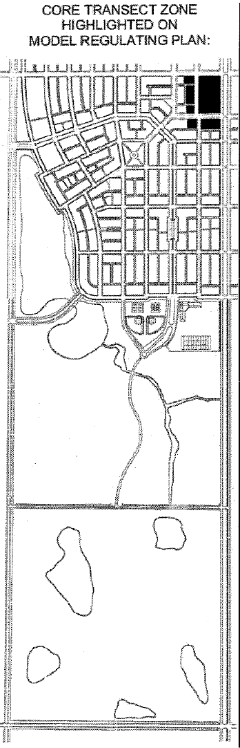
(1)
"Core" Transect Zone.
Purpose: Development is most intense in the Core, the most urban of the transect zones. Buildings are normally attached and built along the front property line, creating a continuous street facade to increase walk -ability. Commercial and civic uses are anticipated in the Core; a mix of apartments and live/work buildings constitute the residential component. Core zones must be within walking distance of surrounding residential areas.
Permitted Lot Types in the Core transect zone (refer to Section 3.01.03.EE.2.e):
•
Mixed-Use Building Lot
•
Retail Building Lot
•
Apartment Building Lot
•
Live/Work Building Lot
•
Civic Building Lot
Building Form and Placement on Lots for the Center transect zone: refer to Section 3.01.03.EE.2.f.
Development Standards for the Core transect zone: refer to Section 3.01.03.EE.2.g.
Permitted Uses for the Core transect zone: permitted uses are determined by lot type — refer to Section 3.01.03.EE.2.h.
Allowable Street Types in the Core transect zone (refer to Section 3.01.03.EE.2.i):
•
Main Street
•
Boulevard
•
Avenue
•
Alley
•
Trail
Streetscape Standards for the Core transect zone: refer to Section 3.01.03.EE.2.j.
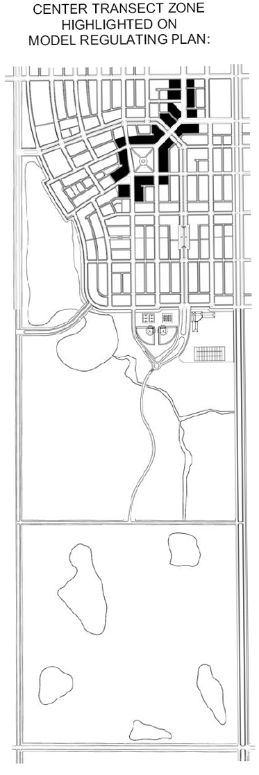
(2)
"Center" Transect Zone.
Purpose: A wide range of uses is expected and encouraged in the Center, which should be compact and contain both attached and detached buildings. Multi-story buildings accommodate a mix of uses such as apartments or offices over shops. Lofts (flexible spaces that can be used for either living or working space) and buildings designed for changing uses over time are also appropriate for the Center. Center zones must be within walking distance of surrounding residential areas.
Permitted Lot Types in the Center transect zone (refer to Section 3.01.03.EE.2.e):
•
Mixed-Use Building Lot
•
Retail Building Lot
•
Apartment Building Lot
•
Live/Work Building Lot
•
Apartment House Lot
•
Rowhouse Lot
•
Cottage House Lot
•
Sideyard House Lot
•
Civic Building Lot
Building Form and Placement on Lots for the Center transect zone: refer to Section 3.01.03.EE.2.f.
Development Standards for the Center transect zone: refer to Section 3.01.03.EE.2.g.
Permitted Uses for the Center transect zone: permitted uses are determined by lot type — refer to Section 3.01.03.EE.2.h.
Allowable Street Types in the Center transect zone (refer to Section 3.01.03.EE.2.i):
•
Main Street
•
Boulevard
•
Avenue
•
East/West Street
•
North/South Street
•
Alley
•
Lane
•
Trail
Streetscape Standards for the Center transect zone: refer to Section 3.01.03.EE.2.j.
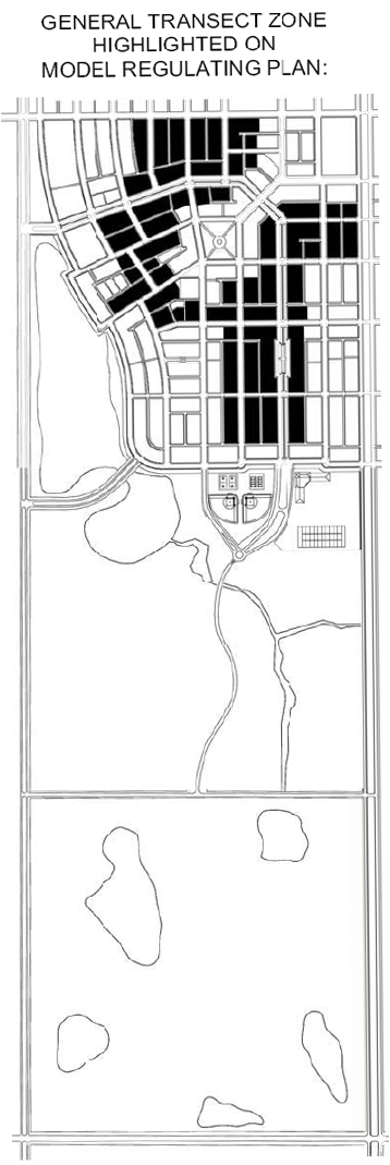
(3)
"General" Transect Zone.
Purpose: The General zone is the largest area of most neighborhoods. It is residential in character with a mix of housing types including single-family attached and detached homes and multi-family units. Homes located in the General zone are normally set back from the front property line to allow a front yard with a porch or stoop; lots often have private rear yards.
Permitted Lot Types in the General transect zone (refer to Section 3.01.03.EE.2.e):
•
Apartment Building Lot
•
Live/Work Building Lot
•
Apartment House Lot
•
Rowhouse Lot
•
Cottage House Lot
•
Sideyard House Lot
•
House Lot
•
Civic Building Lot
Building Form and Placement on Lots for the General transect zone: refer to Section 3.01.03.EE.2.f.
Development Standards for the General transect zone: refer to Section 3.01.03.EE.2.g.
Permitted Uses for the General transect zone: permitted uses are determined by lot type — refer to Section 3.01.03.EE.2.h.
Allowable Street Types in the General transect zone (refer to Section 3.01.03.EE.2.i):
•
Boulevard
•
Avenue
•
East/West Street
•
North/South Street
•
Lane
•
Trail
Streetscape Standards for the General transect zone: refer to Section 3.01.03.EE.2.j.
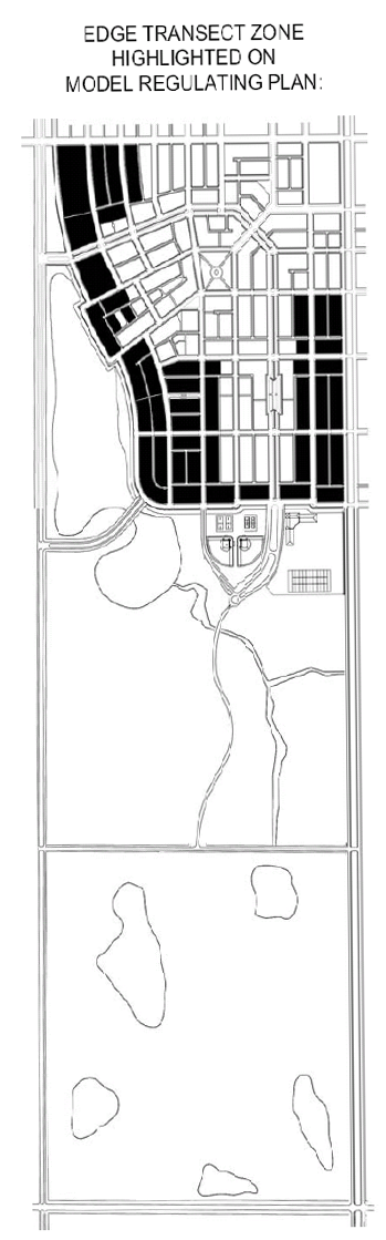
(4)
"Edge" Transect Zone.
Purpose: The Edge zone is single-family residential in character with a lower density of homes than other parts of the neighborhood. Edge zones are bounded by the beginnings of rural, natural, or open-space features such as pasture, groves, forest, lake, meadow, or golf course. These features provide a physical change that defines the neighborhood.
Permitted Lot Types in the Edge transect zone (refer to Section 3.01.03.EE.2.e):
•
House Lot
•
Estate Lot
•
Civic Building Lot
Building Form and Placement on Lots for the Edge transect zone: refer to Section 3.01.03.EE.2.f.
Development Standards for the Edge transect zone: refer to Section 3.01.03.EE.2.g.
Permitted Uses for the Edge transect zone: permitted uses are determined by lot type — refer to Section 3.01.03.EE.2.h.
Allowable Street Types in the Edge transect zone (refer to Section 3.01.03.EE.2.i):
•
East/West Street
•
North/South Street
•
Edge Drive
•
Parkway
•
Lane
•
Trail
Streetscape Standards for the Edge transect zone: refer to Section 3.01.03.EE.2.j.
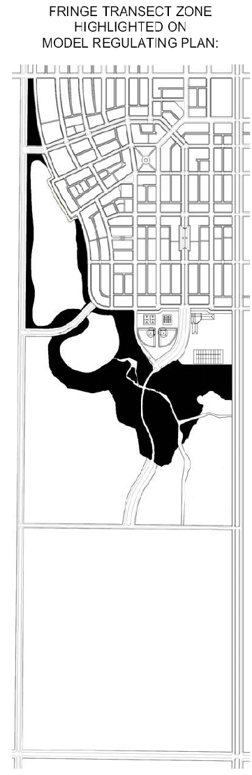
(5)
"Fringe" Transect Zone.
Purpose: The Fringe zone is the first layer of the Countryside that provides a harmonious transition between neighborhoods and the Rural transect zone. The resulting landscape is typically more manicured and includes uses that are compatible with adjoining neighborhoods such as open spaces, recreational uses, and limited agricultural uses.
Permitted Lot Types in the Fringe transect zone (refer to Section 3.01.03.EE.2.e):
•
Estate Lot (limited, see footnote to Table 3-2)
•
Civic Building Lot
•
Countryside Tract
Building Form and Placement on Lots for the Fringe transect zone: refer to Section 3.01.03.EE.2.f.
Development Standards for the Fringe transect zone: refer to Section 3.01.03.EE.2.g.
Permitted Uses for the Fringe transect zone: refer to Section 3.01.03.EE.2.o.
Allowable Street Types in the Fringe transect zone (refer to Section 3.01.03.EE.2.i):
•
Boulevard
•
Parkway
•
Trail
Streetscape Standards for the Fringe transect zone: refer to Section 3.01.03.EE.2.j.
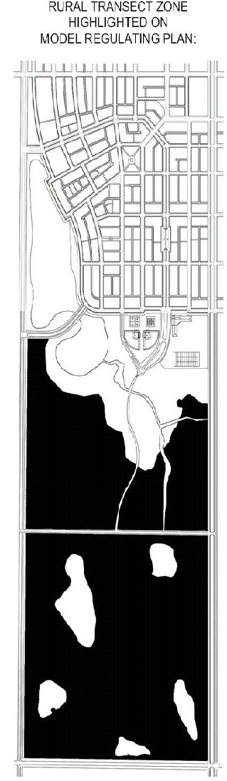
(6)
"Rural" Transect Zone.
Purpose: The Rural zone is the second layer of the Countryside that does not adjoin neighborhoods. Land uses in the Rural zone encompass the full range of permitted agricultural, recreational, and open space uses.
Permitted Lot Types in the Rural transect zone (refer to Section 3.01.03.EE.2.e):
•
Countryside Tract
Building Form and Placement on Lots for the Rural transect zone: refer to Section 3.01.03.EE.2.f.
Development Standards for the Rural transect zone: refer to Section 3.01.03.EE.2.g.
Permitted Uses for the Rural transect zone: refer to Section 3.01.03.EE.2.o.
Allowable Street Types in the Rural transect zone (refer to Section 3.01.03.EE.2.i):
•
Boulevard
•
Parkway
•
Trail
Streetscape Standards for the Rural transect zone: refer to Section 3.01.03.EE.2.j.
e.
Lot types.
(1)
Each neighborhood must contain a mixture of lot types to provide a variety of uses and diverse housing options within the neighborhood. Differing lot types may be placed back-to-back on a single block to provide harmonious transitions between lot types. Lot types should be selected to provide buildings of like scale and massing on opposite sides of streets. Each neighborhood must contain at least one (1) Mixed-Use or Retail Building
Lot. Each neighborhood must contain at least three (3) Civic Building Lots; one (1) civic building must be constructed within two (2) years after development commences.
(2)
The following lot types may be assigned within the corresponding transect zones as shown in the following matrix. An applicant may propose additional lot types during the PTV rezoning process provided the lot types comply with the intent of the TVC Element; the Board of County Commissioners shall decide whether to accept, modify, or reject such additional lot types during the approval process based on consistency with the goals, objectives and policies of the TVC Element and the applicable site plan approval standards in Chapter XI of this Code.
f.
Building Form and Placement on Lots. The primary entrance of every building must directly face a street, a square, a park, a plaza, or a green. The proper building placement is illustrated below for each lot type, along with additional regulations plus illustrations of some of the lot size and dimensional requirements from Table 3-1.
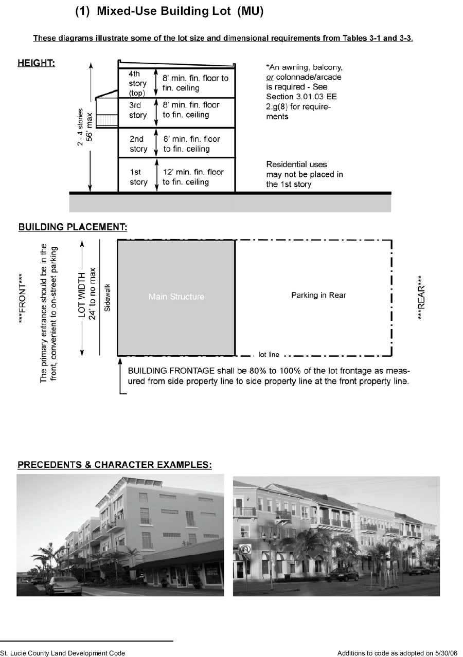
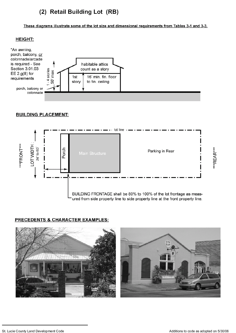
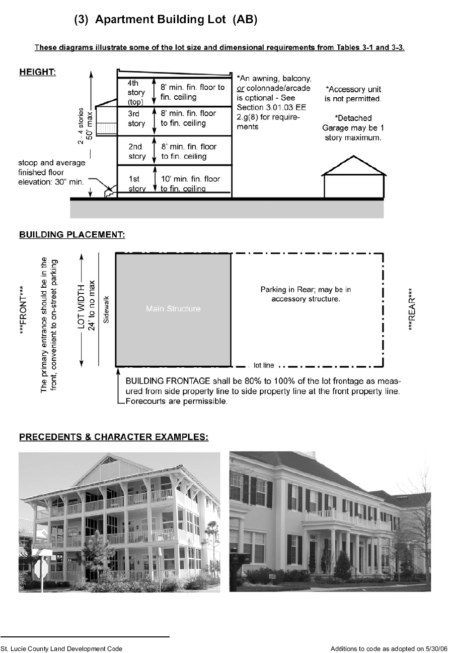
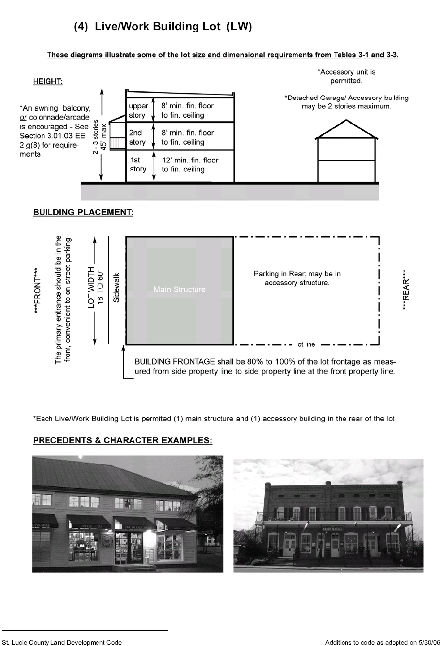
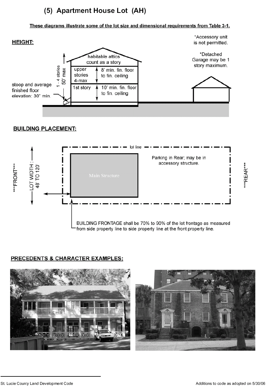
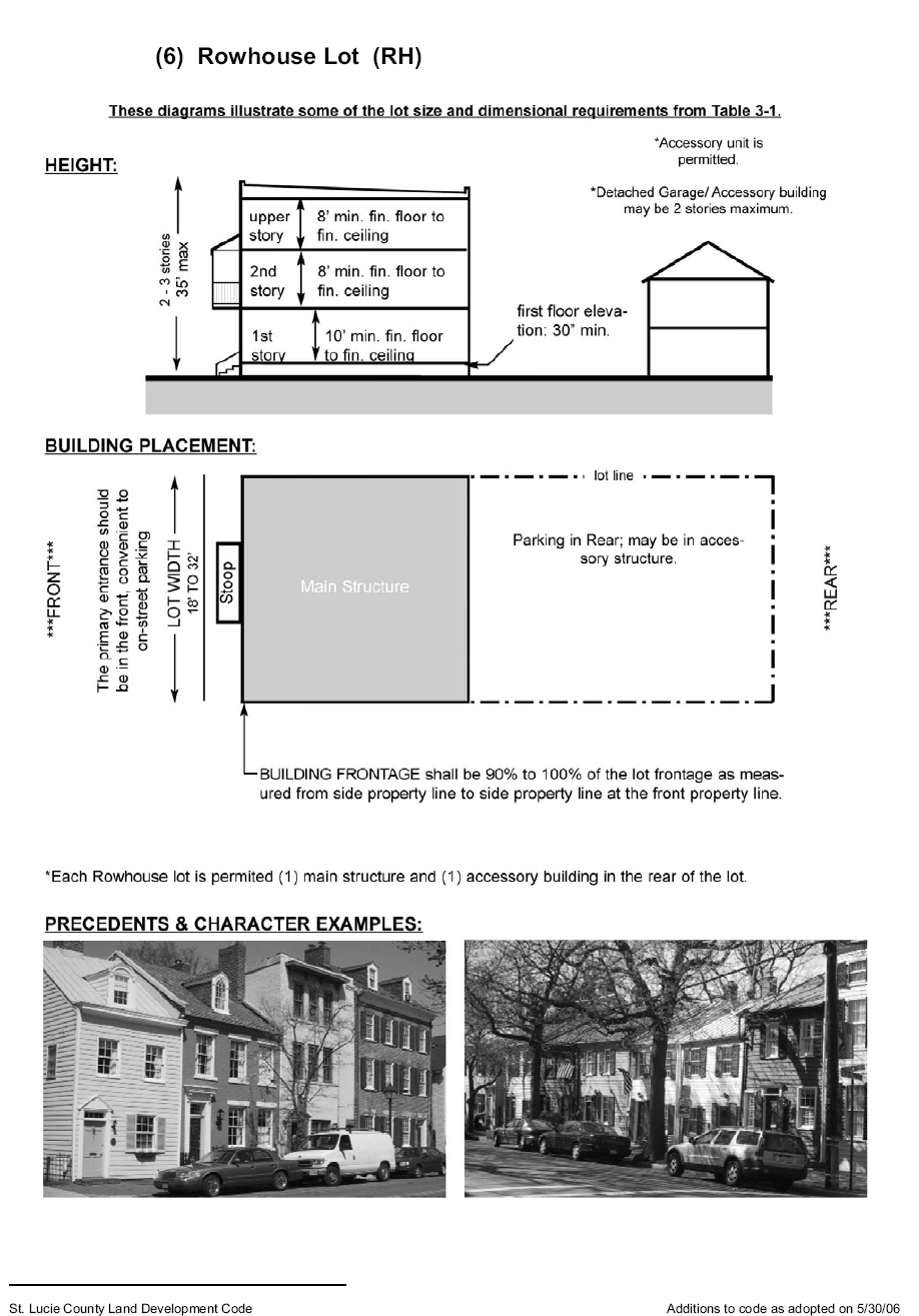
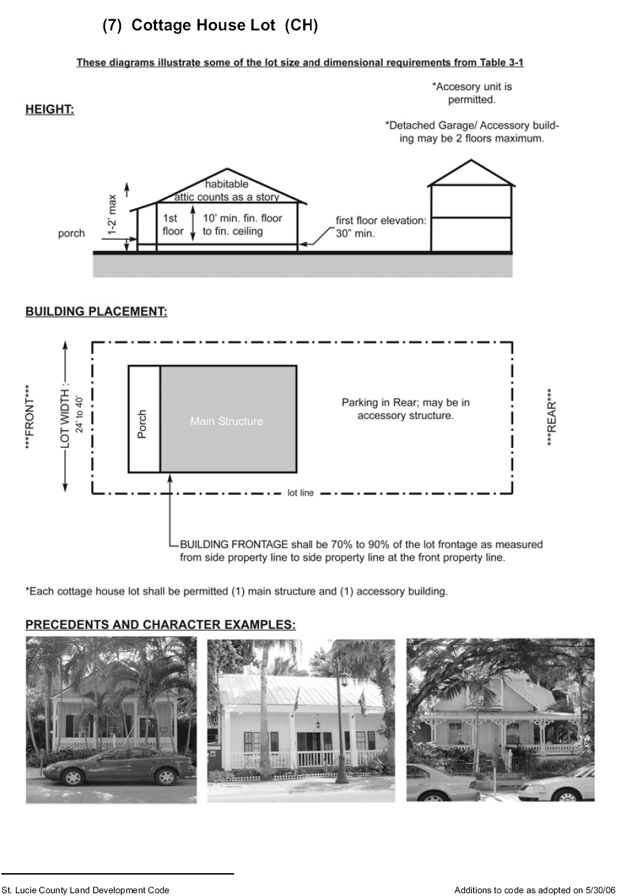
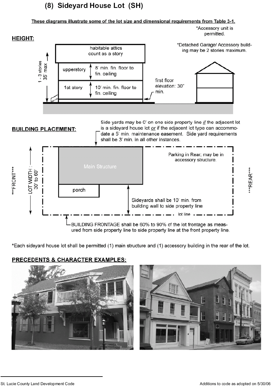
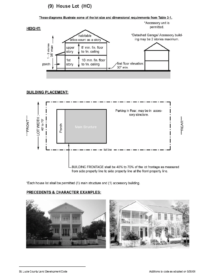
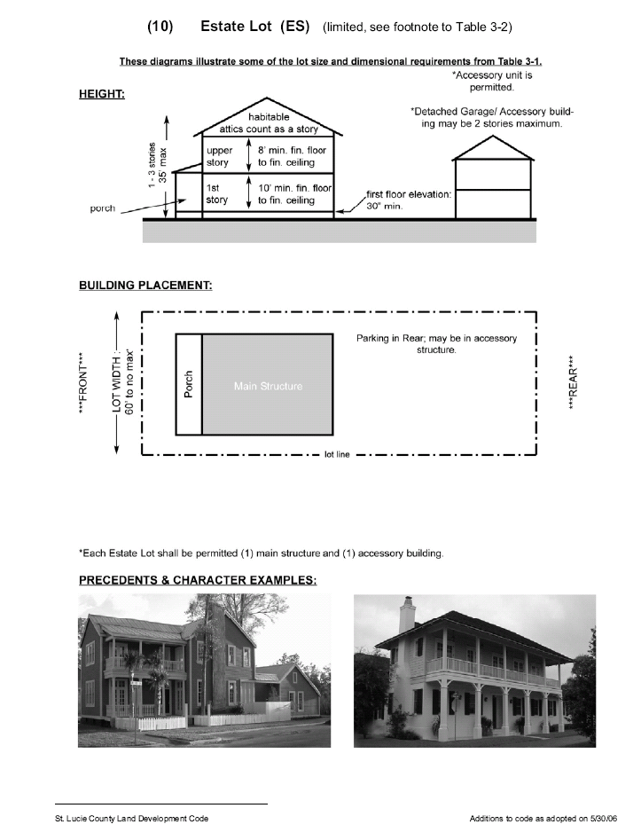
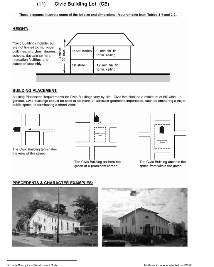
g.
Development Standards for Lots.
(1)
Table 3-1 provides dimensional requirements that apply to all lots of each designated type. These requirements replace those found in Section 7.04.01.
(2)
If additional lot types are proposed by an applicant, comparable dimensional requirements must also be proposed. An applicant may also propose changes to the dimensional requirements in Table 3-1 for a particular neighborhood. All changes must comply with the intent of the TVC Element. The Board of County Commissioners shall decide whether to accept, modify, or reject such additional or modified dimensional requirements during the approval process based on consistency with the goals, objectives and policies of the TVC Element and the applicable site plan approval standards in Chapter XI of this Code.
(3)
Each Live/Work, Rowhouse, Cottage, Sideyard, House, and Estate Lot is permitted one (1) main structure and one (1) accessory dwelling. Accessory dwellings are not counted for density purposes, for instance for meeting the minimum density requirements of Section 3.01.03.EE.2.b. Accessory dwellings, where permitted:
i.
May not exceed the size limitations in Table 3-1;
ii.
Must maintain at least a three-foot side yard except on Rowhouse Lots; and
iii.
Must be separated at least ten (10) feet from the main structure.
(4)
Building frontage is the percentage of the total width of a lot which is required to be building wall, measured where the front yard ends and the front of the building begins. For this purpose only, the width of a porte cochere may be counted as building wall even though it has no front or rear wall.
(5)
Front porches and balconies may extend up to ten (10) feet into front yards provided that walls, screened areas, or railings in the front yard extend no higher than forty-two (42) inches above the floor of the porch or balcony. Front porches and balconies may not extend into the right-of-way. Stoops may extend into front yards provided that walls, screened areas, or railings in the front yard extend no higher than forty-two (42) inches above the floor of the stoop. Stoops may extend into the right-of-way to the extent specifically provided by the Board of County Commissioners during the approval process.
(6)
Each building must have separate walls to support all loads independently of any walls located on an adjacent lot. Buildings with side-facing windows must provide necessary light and air shafts within their own lot without relying on the side yard of an adjacent lot.
(7)
Each building must have an entrance facing a street or public open space.
TABLE 3-1
LOT SIZE AND DIMENSIONAL REQUIREMENTS
1 Corner lots must meet front yard requirements on both streets.
2 Minimum rear yards in this column apply to principal buildings. Buildings for all accessory uses (including garages and accessory dwellings) must maintain a 5-foot minimum rear yard, except when the rear yard adjoins an alley (see Section 3.01.03.EE.2); no separation is required from an alley. Fences are regulated by Section 8.00.04.
3 See definition of "story" for further details on height measurements. The building spacing formula in Section 7.04.03 does not apply in PTV districts.
4 See additional requirements in Section 3.01.03.EE.2.g(3).
5 See Section 3.01.03.EE.2.f(8) for further details.
6 Non-elevator apartments three stories in height or less may be built at grade and shall provide a minimum front yard of 5 feet.
7 No maximum building size or width applies to Retail Building Lots proposed on property with existing Commercial, General (CG) zoning as of August 28, 2009.
(8)
Each building on a Mixed-Use Building Lot is required to have an awning, balcony, colonnade, or arcade facing the street. The same requirement applies to Retail Building Lots except that a porch may be substituted. Buildings on Live/Work Building Lots are encouraged but not required to have one (1) of these features. Any of these features may extend into the front yard. Extensions of awnings, balconies, colonnades, or arcades over public sidewalks require approval of the County Attorney who may require the property owner to enter into a right-of-way agreement establishing the property owner's sole responsibility for repairing any damage that may result from public maintenance or improvements. When providing a required awning, balcony, colonnade, arcade, or porch, the following design requirements apply:
i.
Awnings over first-floor doors or windows must have a depth of at least six (6) feet. Back-lit, high-gloss, or plasticized fabrics are prohibited.
ii.
Balconies must have a depth of at least five (5) feet and a clear height below of at least ten (10) feet from the sidewalk. Balconies may have roofs but must be open and not air-conditioned.
iii.
Colonnades and arcades must have a clear width from column to building face of at least eight (8) feet and a clear height of at least ten (10) feet above the sidewalk.
iv.
Porches must be at least eight (8) feet deep and sixteen (16) feet wide. Porches typically have roofs but must be open and not air-conditioned.
(9)
Minimum and maximum depths of front yards are shown Table 3-1. For Mixed-Use Building Lots and Retail Building Lots, a portion of the building frontage may be set back up to an additional twenty (20) feet beyond the maximum front yard depth if this space is constructed as a courtyard or entryway that is open to the sidewalk. This portion may be up to forty percent (40%) of the actual building frontage and may not be used for parking.
(10)
On all Mixed-Use Building Lots and Retail Building Lots, building walls that face streets are required to have between fifteen percent (15%) and seventy-five percent (75%) of their area in transparent windows. In addition, retail stores must comply with the following:
i.
The ground floor must have transparent storefront windows covering no less than seventy-five percent (75%) of the wall area in order to provide clear views of merchandise in stores and to provide natural surveillance of exterior street spaces.
ii.
Storefronts must remain unshuttered at night to provide views of display spaces, and are encouraged to remain lit from within until 10:00 p.m. to provide security to pedestrians.
iii.
Doors allowing public access to streets must be provided at intervals of at least seventy-five (75) feet to maximize street activity, to provide pedestrians with frequent opportunities to enter and exit buildings, and to minimize any expanses of Inactive wall.
To be considered transparent, window and door glass, whether integrally tinted or with applied film, must transmit at least fifty percent (50%) of visible daylight. These requirements do not apply to walls that face alleys or lanes.
h.
Permitted Uses. Table 3-2 identifies the permitted, conditional and accessory uses for each lot type. Where the upper row of Table 3-2 indicates an entire zoning district, an "S" in the column below indicates that a particular lot type is also allowed to have the same permitted, conditional, and accessory uses that are allowable to any parcel located in that zoning district, in addition to all uses specifically indicated for that lot type in other columns of Table 3-2.
Table 3-2
Permitted Land Uses
i.
Allowable Street Types by Transect Zone. The following street types are be permitted by right in the transect zones shown. These streets must comply with the streetscape standards in Section 3.01.03.EE.2.j and the street cross-sections in Section 3.01.03.EE.2.l. An applicant may propose additional street types or modified cross-sections and streetscape standards during the PTV rezoning process provided the street types and modified standards comply with the intent of the TVC Element; the Board of County Commissioners shall decide whether to accept, modify, or reject such proposals during the approval process based on consistency with the goals, objectives and policies of the TVC Element and the applicable site plan approval standards in Chapter XI of this Code.
j.
Streetscape Standards by Transect Zone. The following standards apply to all street types as they pass through the indicated transect zone:
k.
Street Network Design.
(1)
New development must accommodate the Future Street Network Plan (see Section 4.04.04.B).
(2)
Each neighborhood must provide an interconnected network of streets, alleys or lanes, and other public passageways.
i.
Neighborhood streets must be designed to encourage pedestrian and bicycle travel by providing short routes to connect residential uses with nearby commercial services, schools, parks, and other neighborhood facilities within the same or adjoining Towns or Villages. Sidewalks and rows of street trees must be provided on both sides of all neighborhood streets.
ii.
Neighborhood streets should be organized according to a hierarchy based on function, size, and design speed. Rights-of-way are expected to differ in dimension and must meet the appropriate standards for the transect zones in which they are located (see Section 3.01.03.EE.2.i). There must be a minimum of two (2) street types within each neighborhood.
iii.
Neighborhood streets do not have to form an orthogonal grid and are not required to intersect at ninety-degree angles. These streets may be curved or bent but must connect to other streets. Jogs or centerline offsets shall be at least one hundred (100) feet for local streets; this requirement does not apply to alleys.
iv.
Neighborhoods must accommodate one (1) or more public transit nodes for service to points beyond the neighborhood.
v.
All streets must be publicly dedicated. Private streets and closed or gated streets are prohibited, notwithstanding the provisions of Sections 7.05.03.E and 7.10.15.
vi.
The use of raised intersections, lateral shifts, and traffic circles are encouraged as alternatives to more conventional traffic calming measures such as speed bumps.
vii.
A continuous network of rear and side alleys and/or lanes is desirable to serve as the primary means of vehicular ingress to individual lots. Such networks are mandatory in Core and Center transect zones and for Mixed use, Retail, Live/Work, Apartment, and Rowhouse, and Cottage Lots regardless of transect zones. Alley and rear lane entrances should align so as to provide ease of ingress for service vehicles. Internal deflections or variations in the alley/rear lane network are encouraged to prevent excessive or monotonous views of the rear of structures resulting from long stretches of alleys and rear lanes.
viii.
Cul-de-sacs are not permitted except where physical conditions such as freeways provide no practical alternatives for connection for through traffic. Canals may or may not be physical barriers; appropriate crossings will be considered at the time of PTV approval. Each cul-de-sac must be detailed as a close, with landscaping in the center (see Figure 3-9).
ix.
Street stubs must be provided to adjacent undeveloped land to ensure an integrated street network is achieved over time, except where the adjacent land is being designated as Countryside through the PTV approval. Stub-out streets to connect to future development will not be considered cul-de-sacs if they are less than three hundred (300) feet long.
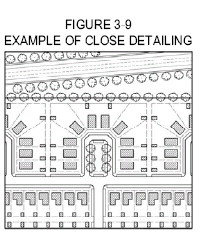
x.
Full access intersections along Indrio Road must be separated by at least six hundred sixty (660) feet. Full access intersections along other roads on the regional street network must be separated by at least three hundred thirty (330) feet (see Section 4.04.04.B).
(3)
The average perimeter of all blocks within a neighborhood may not exceed 1,500 feet. The maximum perimeter of any block may not exceed 2,400 feet. The portion of any block between intersecting streets may not exceed 500 feet without a publicly dedicated pedestrian sidewalk or trail providing access to another street. Smaller block sizes are encouraged to promote walkability. An applicant may propose minor modifications to these block size standards during the PTV rezoning process; the Board of County Commissioners shall decide whether to accept, modify, or reject such modifications during the approval process based on consistency with the goals, objectives and policies of the TVC Element and the applicable site plan approval standards in Chapter XI of this Code.
(4)
The Edge Drive street type is intended to demarcate the Edge transect zone from the Countryside. Edge Drives are primarily "single-loaded," having private lots on one side while providing visual and often physical access to the Countryside on the other. A double-loaded Edge Drive is limited to 30% of the linear edge; where Edge Drives are double-loaded, a physical line of demarcation (e.g. a split rail fence) must be provided separating private lots from public trails and the Countryside. An applicant may propose to exceed the 30% limitation during the PTV rezoning process where there is no significant view of the Countryside that would be lost or where it is deemed to be in the balanced public/private interest while remaining consistent with the TVC Element. The Board of County Commissioners shall decide whether to accept, modify, or reject a proposed increase in double-loaded Edge Drive during the approval process based on consistency with the goals, objectives and policies of the TVC Element and the applicable site plan approval standards in Chapter XI of this Code.
(5)
In addition to its network of streets, each PTV shall also include a network of trails or greenways connecting urban, recreational, academic, and rural locations. Trails shall be provided along the Flow Way System and along remaining canals to provide connections and access to the Countryside. Trails in the Fringe transect zone should be located in the center of the Fringe zone or adjacent to the Rural zone to provide separation from private lots in the Edge zone. Existing hedgerows, environmentally significant or sensitive lands, tree clusters, flow ways, knolls, and viewsheds from scenic roads or parkways shall be considered for connecting linkages between Towns and Villages. Greenway lands shall be interconnected wherever possible to provide a continuous network of such lands within and adjoining each PTV and remaining separated from streets wherever possible.
(6)
The street design requirements of Section 7.05 apply except where they conflict with standards for the TVC Overlay Zone or this zoning district. Further exceptions to the requirements of Section 7.05 may be authorized by the Board of County Commissioners through approval of a regulating plan during the PTV rezoning process.
l.
Street Cross-Sections. Street types in all PTV districts must be assigned in accordance with Section 3.01.03.EE.2.i. The specific design of each street must follow the cross-sections illustrated below for each street type, as adjusted for the transect zone they pass through in accordance with Section 3.01.03.EE.2.j. The lane widths shown include the width of gutter pans. In the event of direct conflicts, these standards shall supersede other standards in this Code or in public works manuals.
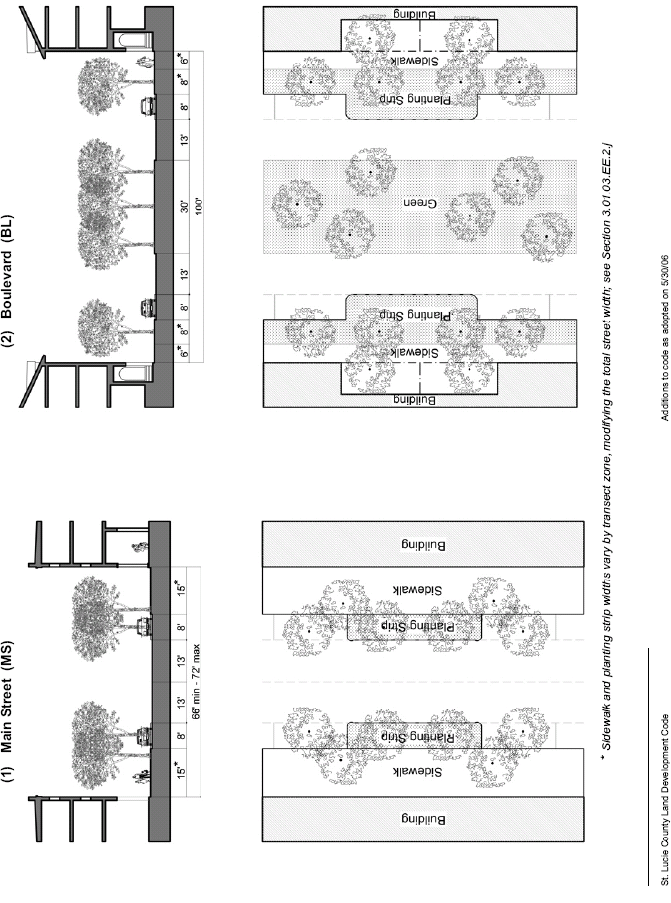
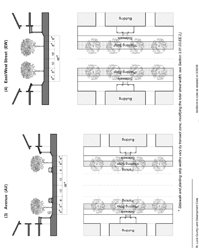
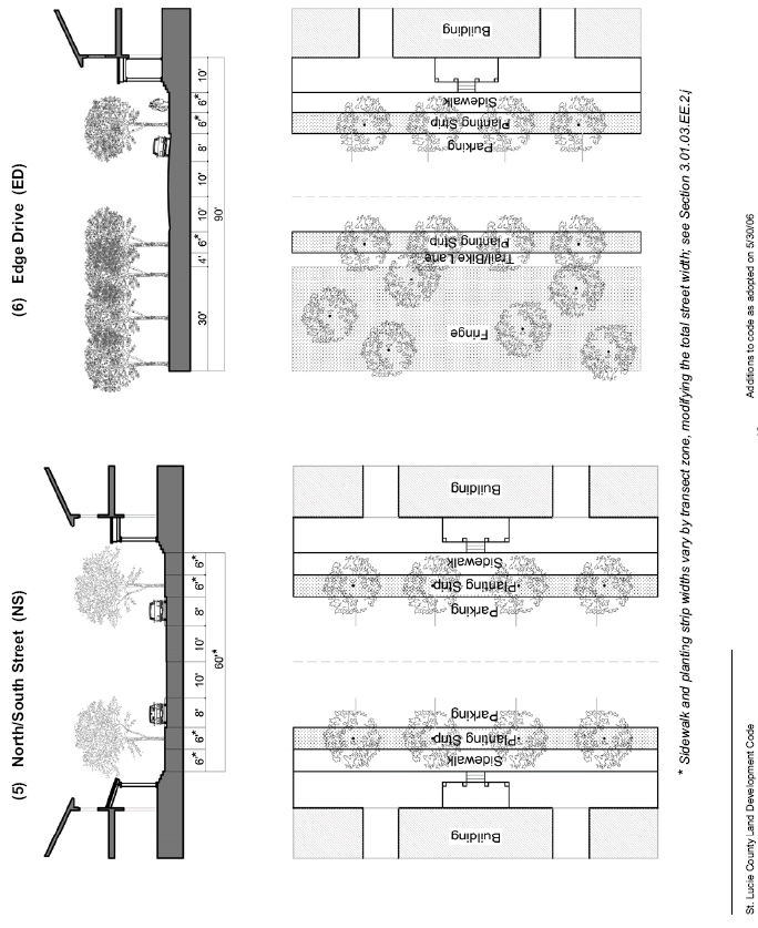
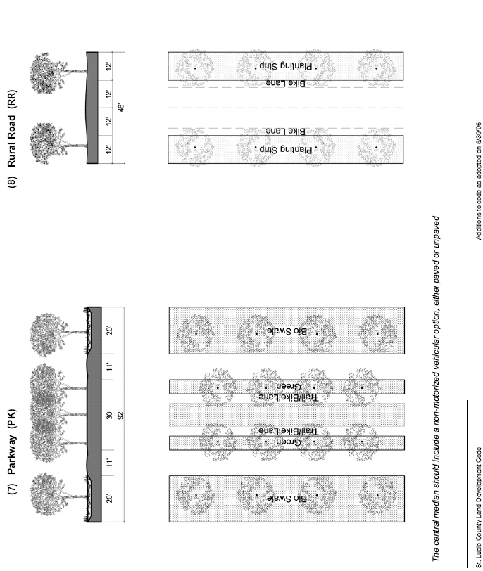
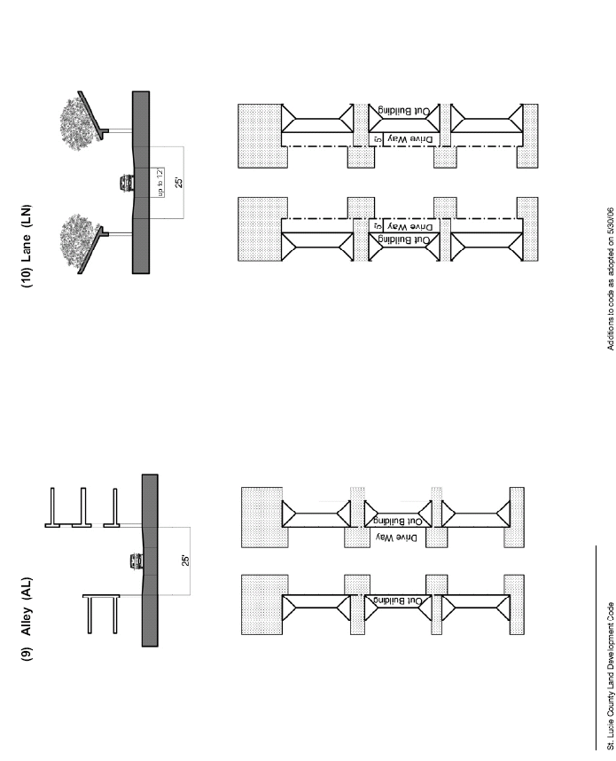
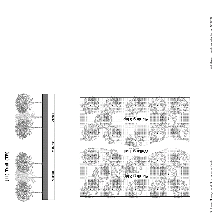
m.
Off-Street Parking Regulations. Certain modifications are needed to the off-street parking regulations found in Section 7.06.00 of this Code. Planned Towns or Villages provide extensive on-street parking, a mix of compatible land uses, sidewalks and trails, and rear alleys or lanes. Based on these factors, the following modifications will apply:
(1)
The following minimum dimensions for parking access aisles and standard parking stalls apply in lieu of the specific requirements in Section 7.06.00:
(2)
Wherever possible, parking lots shall be located behind buildings so that buildings can screen parking areas from sidewalks and streets. In no case may parking be located in front of a building. Small parking lots in side yards may be permitted provided the buildings they serve can meet the lot width and building frontage requirements of Table 3-1 and provided these lots are set back a minimum of twenty (20) feet from lot lines adjoining rights-of-way, excluding alleys or lanes.
(3)
The following multipliers shall be applied to the required number of off-street parking spaces shown in Section 7.06.02. The result of this multiplication will be the required number of off-street parking spaces in each transect zone.
(4)
Access to Off-Street Parking.
i.
In the Core and Center transect zones, alleys or lanes shall be the primary source of access to off-street parking. In the General and Edge transect zones, alleys or lanes are the desirable source of access to off-street parking. Parking along alleys or lanes may be head-in, diagonal, or parallel.
ii.
Alleys or lanes may be incorporated into parking lots as if they were standard parking access aisles. Access to all properties adjacent to the alley must be maintained.
iii.
Access between rear parking lots across property lines is strongly encouraged.
iv.
Residential buildings on individual lots must meet the garage standards in Section 4.04.04.F.
(5)
Parking structures are permitted only in the Core and Center transect zones and must be no taller than four (4) stories and must be separated from adjacent streets by liner buildings at least two (2) stories in height and no less than twenty (20) feet in depth. Liner buildings may be detached from or attached to parking structures.
(6)
Landscaping for off-street parking and loading areas shall, as a minimum, meet the requirements of Section 7.09.00.
n.
Civic Spaces and Civic Buildings.
(1)
Civic Spaces. Civic spaces must be designed and configured to be clearly recognizable as public open space. Civic spaces should be located so that building walls having at least fifteen percent (15%) of their area in transparent windows will face the space to make the space safer for the public. Each neighborhood must have at least four (4) separate civic spaces, which may include neighborhood parks, greens, squares, plazas, and playgrounds.
i.
Each civic space should be consistent with the character of the transect zone in which it is located. For example, a plaza located in the Core or Center transect zone would be detailed with hardscaping and a formal planting pattern of a single species (see Figure 3-10), while a neighborhood park in the Edge transect zone may be green with paths through an informal planting pattern of multiple species (see Figure 3-11).
ii.
Each civic space must have at least twenty-five percent (25%) of its perimeter and at least two (2) sides directly adjoining a street.
iii.
Except for civic spaces located along the periphery of a neighborhood, the combined size of all civic spaces located within a neighborhood must be at least two and one-half percent (2.5%) but no more than seven and one-half percent (7.5%) of the total acreage assigned to the Core, Center, General, and Edge transect zones.
iv.
Each civic space must provide shaded seating and a water fountain.
v.
Civic spaces placed in Fringe and Rural transect zones are not affected by nor counted toward these civic space requirements.
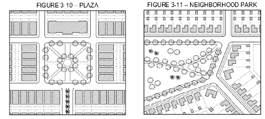
(2)
Civic Buildings. Civic buildings contain uses of special public importance and must be designed to physically express that prominence. Civic buildings include, but are not limited to, municipal buildings, churches, libraries, schools, day care centers, recreation facilities, and places of assembly. Civic buildings do not include retail buildings, residential buildings, or buildings with private offices.
i.
Each neighborhood must contain at least three (3) Civic Building Lots. Civic Building Lots are usually sited to adjoin civic spaces or to provide visual landmarks by being placed at the axial termination of streets (see Section 3.01.03.EE.2.f (9)). At least one (1) civic building must be constructed within two (2) years after development commences.
ii.
In order to provide greater flexibility in building types and to allow more distinctive architectural expression, Civic Building Lots do not include building frontage or front yard standards.
iii.
Oversized Civic Building Lots such as those sometimes required for public schools or for churches with regional congregations should be located at the periphery of neighborhoods so as not to impede the walkability of the remainder of the neighborhood.
o.
Open Space and Countryside Standards.
(1)
Purpose and intent.
i.
Land in the Countryside is an integral component of each Town and Village for the following purposes:
1)
Preserving and enhancing rural character between neighborhoods;
2)
Preserving and restoring native habitats;
3)
Providing opportunities for sustained agriculture;
4)
Mitigating the biological and ecological impacts of new development; and
5)
Accommodating the Flow Way System which includes water storage to serve the neighborhoods (see Section 3.01.03.EE.2.p).
ii.
To maximize both the aesthetics of the rural landscape and the biological and ecological systems intended by the Countryside requirements, Towns and Villages must link to the greatest extent possible the areas set aside for these purposes both within the site as well as to any existing neighboring Countryside areas, existing or planned passive parks, existing uses of an agricultural character, or environmental preserves.
iii.
For purposes of this Code, two (2) transect zones are used to designate the appropriate locations for most Countryside components: the Fringe zone which adjoins neighborhoods or other public spaces, and Rural zone which does not adjoin neighborhoods.
(2)
Open Space and Countryside requirements.
i.
To ensure that the rural landscape is preserved, large areas of Towns and Villages must be reserved for Open Space and Countryside. Specific percentage standards for Open Space and Countryside are established for each new Town or Village in Section 3.01.03.EE.2.b.
ii.
The required Countryside percentage may be fulfilled by land that is restricted to a combination of the following components:
1)
Agricultural uses and facilities, including farmer's markets and agriculture-based targeted industry;
2)
Restored or preserved native habitat and environmentally significant or sensitive l and (see Section 3.01.03.EE.2.o(4));
3)
The Flow Way System including adjoining water management facilities and wastewater re-use facilities (see Section 3.01.03.EE.2.p);
4)
Community recreation areas such as community or regional parks, recreational fields, picnic areas, primitive campgrounds, greenways, and trails, provided they:
a)
Link with trails to neighborhoods and adjacent Countryside areas;
b)
Provide opportunities for shaded seating; and
c)
Provide facilities such as public restrooms and water fountains;
5)
Civic spaces including neighborhood parks, greens, squares, plazas, and playgrounds, provided they are publicly accessible in perpetuity (see Section 3.01.03.EE.2.n); and
6)
Golf course (limited to eighteen (18) holes per Town or Village), provided that it does not interfere with the creation of a continuous flow way and integrated trail system, remains open to the public, accommodates re-use wastewater, and uses Best Management Practices for Florida Golf Courses published by the Institute of Food and Agricultural Sciences at the University of Florida in 1999.
iii.
Where Section 3.01.03.EE.2.b. provides that up to ten percent (10%) of a new Town or Village may be designated Open Space in lieu of Countryside, this allowance may be fulfilled by land that is restricted to a combination of the following Open Space components; however, all Fringe or Rural areas that are not designated in the regulating plan as reserved for an Open Space or Countryside component shall be limited in the future to Countryside uses:
1)
Civic uses, as defined in Section 4.04.06, including the playfields associated with a school (see Section iii.7);
2)
Targeted industry (as defined in Section 4.04.06 and discussed in Section 3.01.03.EE.2.r) (see Section iii.7);
3)
Higher education (as defined in Section 4.04.06) (see Section iii.7);
4)
Parking garages or portions thereof, provided they meet the following requirements:
a)
Parking spaces in the garage are unassigned and are available to the general public or to nearby customers, employees, or residents at up to market-rate parking fees.
b)
The parking garage contains at least four (4) levels of parking spaces.
c)
Any parking spaces dedicated solely for the use of individual patrons, businesses, or residential complexes must be subtracted, along with their pro-rata share of ramps and aisles.
5)
Estate Lots, which may occupy up to five percent (5%) of the land area for Open Space and Countryside, but must be included in the ten percent (10%) allocation of the site permitted for Open Space components. Additionally, the allowance for these lots must be acquired by TDR Credits transferred from an off-site eligible sending site (see Section 4.04.05); and
6)
The total area of lots for workforce housing that is being provided above the eight percent (8%) that is required in a Town or Village (see Section 3.01.03.EE.2.q), but not counting any accessory dwellings as described in Section 3.01.03.EE.2.g(3).
7)
Parking areas (including access drives and aisles) that serve civic uses, targeted industry, and higher education can be counted as Open Space components; reduced asphalt and pervious surfaces are encouraged.
8)
Solar generation station, subject to the supplemental standards in Section 7.10.28.
iv.
Some of the required Countryside percentage may be fulfilled by non-contiguous acreage within the TVC area provided that this acreage is included in the proposed PTV zoning district and is similarly restricted to Countryside uses.
v.
Except for approved Estate Lots, the transferable development rights assigned to Fringe and Rural transect zones and to other land designated as Open Space components is formally transferred to neighborhoods in a Town or Village upon approval of a PTV application. Depending on the components identified for the land dedicated to the required percentage of Countryside, a multiplier may be applied to the transferable development rights pursuant to the TDR program (see Section 4.04.05). At the time of final site plan approval for the PTV, evidence of this transfer must be recorded in the public records of St. Lucie County through a conservation easement acceptable to the County Attorney and meeting the requirements of Section 4.04.05.H, Conditions of the Conservation Easement or Deed Restriction.
(3)
Location of Open Space and Countryside components in the transect. Open Space and Countryside components shall be located and arranged within the transect as described in this subsection. Figure 3-12 illustrates this description by applying vertical hatching to typical locations of Open Space and Countryside components.
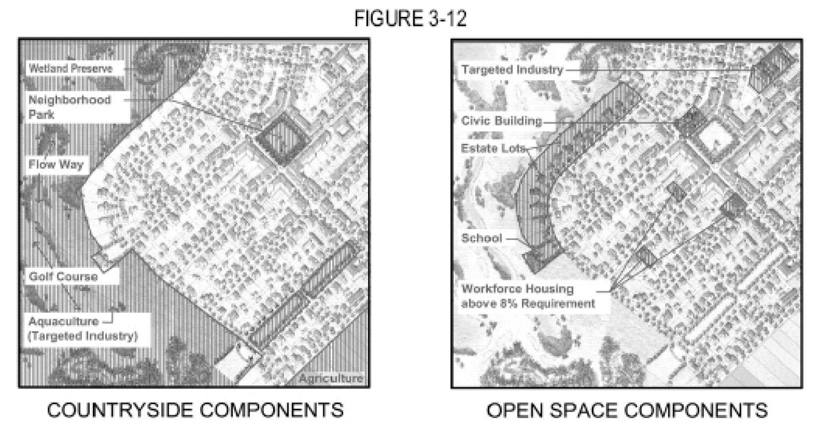
i.
Within the PTV zoning district, the Flow Way System is to be designated as a Rural or Fringe transect zone. Where the Flow Way System runs through a neighborhood, its edges should reflect the character of adjacent transect zones as described in Section 3.01.03.EE.2.p.
ii.
The continuation of viable agricultural uses in the Countryside and on neighboring properties is a primary design goal for the Countryside. Such uses constitute unique and irreplaceable resources and are major contributors to the economy. The assignment of transect zones must accomplish this goal in a manner consistent with Florida's Right to Farm Act. Once transect zones are assigned, the following limitations apply to agricultural uses and facilities within the PTV:
1)
Agricultural uses and facilities in the Fringe transect zone are limited to passive agriculture that is compatible with nearby residential uses such as, but not limited to, horse and cattle pasture and native range.
2)
Active agricultural uses must be located only in the Rural transect zone; such uses include crops that require extensive cultivation or spray applications of pesticide and fertilizer and concentrated livestock facilities.
3)
Agricultural or utility uses or facilities that may generate noise or odor must be located only in the Rural transect zone.
iii.
Other Countryside components shall also be located in the Fringe and Rural transect zones, except for community recreation areas which may be located in any transect zone.
iv.
Open Space components may be located within any of the four (4) neighborhood transect zones, except that Estate Lots may be located in the Fringe transect zone when limited in accordance with the footnote to Table 3-2.
(4)
Countryside uses (Fringe and Rural transect zones). Land in the Fringe and Rural transect zones may be used only for the following purposes, and structures are allowed only to serve these permitted uses:
i.
Agricultural uses and facilities including farmer's markets and agriculture-based targeted industry, except as follows:
1)
Agricultural uses and facilities in the Fringe transect zone are limited to passive agriculture that is compatible with nearby residential uses such as, but not limited to, horse and cattle pasture and native range.
2)
Active agricultural uses must be located only in the Rural transect zone; such uses include crops that require extensive cultivation or spray applications of pesticide and fertilizer and concentrated livestock facilities.
3)
Agricultural or utility uses or facilities that may generate noise or odor must be located only in the Rural transect zone.
ii.
Restored or preserved native habitat and environmentally significant or sensitive land (see Section 3.01.03.EE.2.o(4));
iii.
The Flow Way System including adjoining water management facilities and wastewater re-use facilities (see Section 3.01.03.EE.2.p);
iv.
Community recreation areas such as community or regional parks, recreational fields, picnic areas, primitive campgrounds, greenways, and trails, provided they:
1)
Link with trails to neighborhoods and adjacent Countryside areas;
2)
Provide opportunities for shaded seating; and
3)
Provide facilities such as public restrooms and water fountains.
v.
Civic uses on Civic Building Lots;
vi.
Golf course (limited to eighteen (18) holes per Town or Village), provided that it was designated on an approved PTV regulating plan, does not interfere with the creation of a continuous flow way and integrated trail system, remains open to the public, accommodates re-use wastewater, and uses Best ManagementPractices for Florida Golf Courses published by the Institute of Food and Agricultural Sciences at the University of Florida in 1999; and
vii.
Allowable residential uses on Estate Lots. Estate Lots in the Fringe transect zone are limited to a maximum of five percent (5%) of the land area dedicated to Open Space and Countryside; the allowance for these lots must be acquired by TDR Credits transferred from an off-site eligible sending site (see footnote to Table 3-2).
(5)
Restoration and preservation. The restoration and preservation of native habitats and environmentally significant land is strongly encouraged in the Fringe and Rural transect zones. Restored habitats may qualify for increased TDR credits as described in Section 4.04.05 if they meet the following minimum standards:
i.
Restored habitats are at least twenty-five (25) acres in size;
ii.
Restored habitats are connected to the greatest extent possible to existing preserved native habitat or preserved environmentally significant land or to the Flow Way System;
iii.
Restored habitats must include multiple upland and wetland habitat types consistent with habitat types that can be supported by the existing soil types and the proposed hydrology for the site;
iv.
Restored habitats include only native species in the canopy, understory, and groundcover in proportions similar to those found in representative naturally occurring plant communities in St. Lucie County; and
v.
Shallow marsh systems are encouraged. Deep water habitat and the required littoral zone and upland buffer habitat (Section 3.01.03.EE.2.p(4)(ii)and (iii)) are not eligible for restoration credit, but shallow marsh acreage beyond the requirements may be eligible for full restoration credit.
vi.
Proposals that request an increased multiplier for transferable development rights based on creating or restoring natural habitats from former agricultural lands must be accompanied by a restoration and management plan. The Board of County Commissioners will decide whether to accept or modify such plans during the PTV approval process. The restoration and management plan must include the following:
1)
Identifies the area to be restored;
2)
Identifies the strategy that will be employed to restore the land;
3)
Provides an acceptable time table for completion of the restoration;
4)
Identifies measures that will be used to evaluate the success of the restoration, including the density and distribution of species; and
5)
Includes a funding strategy for monitoring and maintaining the habitat, including the ongoing maintenance and removal of exotic vegetation.
(6)
Use of reclaimed water.
i.
Each new Town or Village must propose a reclaimed water management plan which:
1)
Meets the design standards of FDEP and SFWMD and is capable of meeting water quality standards for ultimate discharge into the Indian River Lagoon;
2)
Accommodates within its PTV boundaries the volume of reclaimed water produced from its wastewater discharges;
3)
Identifies the lands designated to receive reclaimed water;
4)
Encourages subsurface drip irrigation systems;
5)
Prioritizes the irrigation of agricultural lands and golf courses as the preferred method of re-use; and
6)
Provides secondarily, and as necessary to accommodate the required disposal volumes, applications on other land uses allowed by FDEP.
ii.
The reclaimed water management plan shall be reviewed and approved by the utility providing the re-use water. Documentation of such approval must be available prior to public hearings on the PTV request.
iii.
These requirements were established to offset the biological impacts of new development, to ensure the re-use of nutrients in reclaimed water, to enhance the ecological functions of the Countryside, and to enhance the county's strategy of disposing of reclaimed water near its origin.
(7)
Countryside management. Land in the Countryside, regardless of use or ownership, is a critically important landscape component of St. Lucie County and must be properly managed and maintained to further the purposes of the TVC Element. A detailed countryside management plan must be submitted with each PTV application identifying the entities that will be responsible for the funding, construction, ownership, and management of each component of land designated as Countryside, specifically including the Flow Way System. The Board of County Commissioners will decide whether to accept or modify this plan during the PTV approval process.
p.
Regional Flow Way System.
(1)
Purpose and intent.
i.
A regional Flow Way System will improve water quality through a comprehensive interconnected storm water management system that also serves as a linear park. The Flow Way System is intended to provide for a high level of retention and treatment of stormwater, reduction in water lost to tide through storage and re-use of retained water, supplemental water supply for irrigation, habitat for fish and wildlife, wildlife corridors, opportunities for habitat mitigation, and the recreational and aesthetic values provided by natural riverine systems.
ii.
The regional Flow Way System will be created incrementally and become a continuous water management system that enhances the conveyance functions of the existing drainage canals and incorporates the storm water detention, conveyance, and discharge systems for new development so as to reduce total runoff volume and improve water quality prior to discharge into the Indian River Lagoon.
iii.
Where not inconsistent with SFWMD permitting criteria, natural habitat restoration is preferred to open water systems for treating stormwater and may be eligible for higher multipliers offered for restoration and preservation.
(2)
Location and connectivity.
i.
The Flow Way System shall be integrated within each development site as well as with adjacent flow way systems and existing human and native habitats in order to create a fully integrated regional system.
ii.
The Flow Way System shall be located within the Fringe or Rural transect zones where it can provide sufficient water storage to serve the neighborhoods while maximizing the viability of the adjacent land for agricultural uses and native habitat restoration. The system may pass through or between neighborhood transect zones provided the following criteria are met:
1)
The location and width of that portion of the system does not negatively impact the desired walkable, compact structure required for each Town or Village;
2)
An adequate number of crossings is provided in order to maintain the required connectivity of the street network and the navigability of the waterway; and
3)
That portion of the system is detailed to reflect the appropriate urban or rural character of the neighborhood transect zones (see Figure 3-13).
(3)
Accessibility and edges.
i.
In order to reinforce the desired linear park quality intended for the Flow Way System, the water's edge must be easily and safely accessible. A pedestrian and bicycle trail system shall be provided and maintained along at least one (1) side of the system. In neighborhoods, the trail may take the form of paved sidewalks that runs adjacent to the system. In the Countryside, trails of a suitable material for walking, cycling, or equestrian uses should be provided within the upland buffer adjacent to the system.
ii.
The edge of the Flow Way System should be varied and should reflect the character of the adjacent transect zone. The following edge conditions may be used (as illustrated in Figure 3-13) or other designs may be submitted for approval consistent with the following intent:
1)
Neighborhood: Core, Center. Near the center of Towns and Villages, the system may be bulkheaded with adjacent sidewalks, railings, and formal landscaping. Bulkheaded sections should provide periodic access via stairs and landings to the waters' edge.
2)
Neighborhood: General, Edge. The area from the waters' edge landward should be fairly level to gently sloping for a minimum of fifteen (15) feet, with any required elevation changes to an adjacent sidewalk accommodated by terraces or landscaped slopes. Landscaping may be either formal or informal, with care given to species selection on sloped areas for long-term maintenance.
3)
Countryside. In order to create a natural relationship between land and water within the Countryside, the slope of the land from the water's edge landward shall be no steeper than one (1) foot of vertical change in elevation for every ten (10) feet of horizontal distance for the first twenty (20) feet landward from the waters' edge. A wide walking path can meander along the edge of the water within native habitat. This edge condition may also be appropriate along a park.
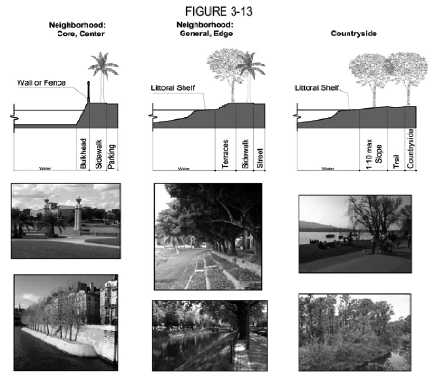
(4)
Fish and wildlife.
i.
The Flow Way System is intended to provide fish and wildlife habitat in addition to its other functions. In order to promote use by wildlife, wading birds, and in particular endangered species such as the wood stork, the system must be designed and managed to provide wading bird feeding areas and healthy fish populations.
ii.
A vegetated and functional littoral zone shall be established as part of the Flow Way System. Prior to construction of the surface water management system for any phase of a project, the developer shall prepare a design and management plan for the littoral zone that will be established as part of these systems. The littoral zone established shall consist entirely of native vegetation and shall be maintained as part of the water management system.
1)
As a minimum, twenty (20) square feet of vegetated littoral zone per linear foot of shoreline shall be established as part of the water management system.
2)
This area of vegetated littoral zone habitat shall be located such that no less than fifty percent (50%) of the total shoreline of the Flow Way System is buffered by littoral zone habitat.
3)
Littoral zone habitat shall be a minimum width of twenty (20) feet and a minimum of twenty-five percent (25%) of the shoreline shall be designed as a wide littoral zone habitat a minimum of sixty (60) feet in width (see Figures 3-14 and 3-15). For example, one hundred (100) feet of shoreline requires two thousand (2,000) square feet of littoral zone along at least fifty (50) feet of the Flow Way edge; twenty-five (25) feet of the fifty (50) feet of shoreline with littoral zone must be sixty (60) feet wide.
4)
Average water depth over the littoral shelf should range between two (2) to eighteen (18) inches at the control elevation. The littoral shelf should be contoured to create areas with shallow depressions that should dry down or retain two (2) to six (6) inches of water when the water level is one (1) foot below the control elevation (see Figure 3-15), except for points of inflow which may be deeper.
5)
These littoral areas are considered part of the Flow Way System and are not eligible for the higher multiplier offered for restored native habitat by the TDR program.
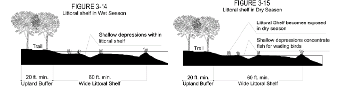
iii.
A buffer zone of native upland edge vegetation shall be provided and maintained around the Flow Way System. The habitat may consist of preserved or planted vegetation, but shall include canopy, understory, and ground cover of native species only. The edge habitat shall begin at the upland limit of the Flow Way System. As a minimum, twenty (20) square feet of edge habitat shall be provided for each linear foot of shoreline. This upland edge habitat shall be located such that no less than fifty percent (50%) of the total shoreline is buffered by a minimum width of twenty (20) feet of upland habitat. This edge habitat is considered part of the Flow Way System and is not eligible for the higher multiplier offered for restored native habitat by the TDR program (see Figures 3-14 and 3-15).
(5)
Navigability.
i.
The Flow Way System shall be designed primarily for water quality and restoration purposes. When consistent with these primary purposes, navigability by non-motorized boats is also a design goal. Where SFWMD requirements prevent navigation due to required separations or features such as existing canals or spillways, easy portage opportunities shall be provided at such obstructions.
ii.
Except where navigability would be inconsistent with the water quality and restoration goals for the Flow Way System, bridge crossings must provide at least four (4) feet of clearance between the system's control elevation and the bottom of the bridge crossing. Large culverts may be used to provide navigability if this clearance standard can be met.
(6)
Planning and maintenance.
i.
Planning. The Flow Way System must be designed to the following standards and incrementally constructed as development proceeds:
1)
All elements of the stormwater management system must be designed to prevent negative impacts to adjacent areas and to receiving water bodies. The developer must establish a permanent water quality monitoring system to demonstrate that adjacent properties and receiving bodies of water are not being negatively impacted by water not meeting standards. The proposed monitoring system requires approval by St. Lucie County in consultation with SFWMD prior to construction of the surface water management system.
2)
Water attenuation and discharge criteria must use the ten-year, three-day storm event with a peak discharge rate of 2.6 inches per twenty-four (24) hours, or the criteria required by SFWMD, whichever is more restrictive. Each portion of the Flow Way System must meet all permitting criteria required by SFWMD.
3)
Best Management Practices must be used to ensure water quality.
4)
Before final approval is granted to excavate, a Phase I environmental assessment, and if warranted a Phase II environmental assessment, shall be submitted to St. Lucie County. If levels of contaminants in the soil such as pesticides, herbicides, and metals are found to exceed state standards, the area shall be remediated or the site redesigned to accommodate storm water management in another location.
5)
Once St. Lucie County creates an institutional structure to facilitate the implementation of the Flow Way System, further approvals must be in accordance with that structure.
ii.
Maintenance. The long-term operation, management, and maintenance of the overall system should be conducted by a single entity responsible to meet the performance criteria set forth for the regional system. These responsibilities shall include the following:
1)
Provide connectivity between Towns, Villages, and other developments;
2)
Manage the health of the aquatic system;
3)
Manage the fish and wildlife values;
4)
Provide navigability between Towns and Village; and
5)
Provide and implement mitigation as needed.
q.
Workforce Housing. To encourage a broad range of family sizes and incomes, each Town and Village must provide a minimum of eight percent (8%) of the proposed number of dwellings as workforce housing, as defined generally in Section 4.04.06 and as further defined by St. Lucie County through ordinances or during the process of approving an individual Planned Town or Village.
(1)
When workforce housing will be provided above the required eight percent (8%), the total area of its lots may be counted towards the fulfillment of the required amount of Countryside, but may not be located in either the Rural or Fringe transect zones.
i.
Accessory dwellings in neighborhoods may provide additional workforce housing, but such dwellings may not be counted towards the fulfillment of either the eight percent (8%) workforce housing requirement or the required amount of Countryside.
ii.
Accessory dwellings and any workforce housing above the required eight percent (8%) that is not counted toward the fulfillment of the required amount of Countryside will not be required to comply with the remaining provisions of Section 3.01.03.EE.2.q.
(2)
Workforce housing must be made available on approximately the same schedule as the balance of housing in each Town or Village; workforce housing may not be deferred until the final phases.
i.
A specific schedule for the types, location, and phasing of construction of workforce housing must be proposed with each PTV application.
ii.
The Board of County Commissioners shall decide whether to accept or modify this schedule during the approval process based on consistency with the goals, objectives and policies of the TVC Element and the applicable site plan approval standards in Chapter XI of this Code.
(3)
Workforce housing units must be roughly proportional to the tenure types (fee simple, condominium, rental) of the market rate homes in each Town or Village.
(4)
The bedroom mix of workforce housing units must be roughly proportional to the bedroom mix of the market rate homes in each Town or Village.
(5)
Workforce housing units are expected to vary from the market rate offerings in each Town or Village due to smaller sizes and fewer interior amenities. However, these variations must not adversely affect the energy efficiency of the workforce units. Workforce units must be complementary in exterior design and materials and must be dispersed throughout each Town or Village.
(6)
Workforce housing must be sold or rented only to qualified households as defined by St. Lucie County.
i.
Half of the required workforce housing must be affordable to families earning eighty percent (80%) to one hundred percent (100%) of the Area Median Income. The other half must be affordable to families earning one hundred percent (100%) to one hundred twenty percent (120%) of the Area Median Income.
ii.
Workforce housing may be offered for sale or rent through agencies operating affordable housing programs that are specifically approved by the St. Lucie County for this purpose.
(7)
Affordability must be maintained for a minimum of eight (8) years, or the period of affordability specified by the funding secured by the developer, whichever is longer. St. Lucie County will establish standards for maintenance of affordability during this period.
i.
These standards may include documents being recorded in the public records of St. Lucie County describing the affordability requirements for each workforce housing unit.
ii.
These standards may include a program that would restrict the resale of individual workforce housing units or the subsequent rental of a purchased unit only to other qualified households as defined by St. Lucie County.
iii.
These standards may include a program for setting resale prices for individual workforce housing units to maintain affordability and resetting the twenty-five-year affordability period upon resale, and may provide for appreciation in the value of the unit to accrue to the seller in increasing percentages based on the length of time that the unit is occupied by a qualifying household.
r.
Targeted Industries. St. Lucie County identifies targeted industries that will enhance industry clusters vital to the county's economic future and that will expand job opportunities for county residents. These targeted industries are defined by St. Lucie County through its economic development program and may be adjusted during the process of approving an individual Planned Town or Village. In addition to other incentives provided by St. Lucie County:
(1)
Manufacturing Facilities identified by St. Lucie County as desirable targeted industries may be located within areas indicated on the Transferable Development Value Map (Figure 3-3 of the TVC Element) as suitable for industrial uses, excepting "aquaculture" which may be located within the Countryside of a PTV.
(2)
Distribution Centers identified by St. Lucie County as desirable targeted industries are suitable within areas indicated on the Transferable Development Value Map (Figure 3-3 for the TVC Element) as suitable for industrial uses or within areas west of I-95 that are identified on the North St. Lucie County General Workplace Plan (Figure 3-16 of the TVC Element) as appropriate for Highway Service/Warehouse.
(3)
Targeted industries categorized as Finance and Insurance Carriers; Information Industries; Professional, Science and Technical Services; or Administrative and Support Services may be located within Core or Center transect zones of a PTV.
(4)
Land that is developed for the sole use of targeted industries within a PTV may be counted as an Open Space component but may not be located in either the Rural or Fringe transect zones unless the use is agricultural in nature including aquaculture. See Section 3.01.03.EE.2.o(2)iii.
(5)
Development rights that are transferred from a targeted industry site are eligible for the highest multiplier offered by the TDR program (see Section 4.04.05).
s.
Landscaping and Natural Features.
(1)
In addition to complying with the Resource Protection Standards in Chapter VI, native trees and vegetation and other natural features must be preserved to the extent practicable.
(2)
The landscaping and screening requirements in Section 7.09 apply except as follows:
i.
The landscaping adjacent to streets otherwise required by Section 7.09.04.A will not be required between buildings and streets. However, this requirement still applies between off-street parking areas (and other vehicular use areas) and streets.
ii.
The landscaped buffer areas required by Section 7.09.04.E to segregate single-family or two-family residential uses will not be required in the PTV zoning district.
t.
Signs. Permanent and temporary signs within any Planned Town or Village shall comply with the following provisions of Chapter IX of this Code:
(1)
For Rural and Fringe transect zones, the same regulations that apply to the Agricultural-5 (AG-5) zoning district, except that no off-premises signs are permitted.
(2)
For Edge and General transect zones, the same regulations that apply to the Residential Estate-2 (RE-2) zoning district.
(3)
For Center and Core transect zones, the same regulations that apply to the Commercial Neighborhood (CN) zoning district, except that ground signs may not exceed a height of ten (10) feet.
3.
Approval Process.
a.
The approval process for the Planned Town or Village district shall be as provided in Chapter XI for Planned Developments, except that the approval of final site plans shall be administrative and shall not require the public hearing described in Section 11.02.05.B.4 or the public notices described in Section 11.00.03. This zoning district provides certain opportunities for applicants to request minor modifications to its standards. During the final public hearing for the preliminary approval of each PTV zoning district, the Board of County Commissioners must explicitly respond to each of these requests. Except to the extent that such requests are formally accepted or accepted with modifications, the written standards of this zoning district shall apply.
b.
Submittal requirements for preliminary approval shall be as provided for Planned Developments except as follows:
(1)
General Information: the same information required for all Planned Developments.
(2)
Existing Conditions: the same information required for all Planned Developments.
(3)
Proposed Development Activity and Design: the same information required for all Planned Developments except that the following items may be deleted:
i.
location of buildings;
ii.
location of parking/loading areas;
iii.
location of pedestrian circulation;
iv.
location of landscaping;
v.
location of signs and lighting; and
vi.
location of lots and yard requirements.
(4)
Preliminary Regulating Plan: In lieu of these deleted items, the applicant must submit a proposed preliminary regulating plan that complies with the following standards. This preliminary regulating plan may contain some or all of the other information required by this Code for a proposed development activity if that other information does not obscure the following required information for regulating plans:
i.
The entire area within the proposed PTV and all adjoining roads, canals, and other rights-of-way or easements must be shown on the regulating plan.
ii.
A conceptual assignment of a transect zone to all land including proposed streets within the PTV (see Section 3.01.03.EE.2.c). All land shall be assigned one (1) of the six (6) transect zones and no land may be assigned two (2) or more transect zones. Conceptual assignments may be altered during final site plan as long as the intent remains consistent with transect percentage allocation requirements as outlined in Section 3.01.03.EE.3.
iii.
The approximate location of proposed streets throughout the PTV, indicating the specific type of each street. Streets types must comply with the transect zone through which they pass (see Section 3.01.03.EE.2.i) and must provide right-of-way in accordance with the standards in Section 3.01.03.EE.2.l. Street locations may be amended at final site plan in a manner that is consistent with the requirements of Section 3.01.03.EE. and the intent of the Preliminary Regulating Plan.
iv.
Proposed lot lines do not need to be shown on the regulating plan, but all land to be subdivided into lots must indicate the proposed lot types, which must comply with the transect zones where the lots are to be located (see 3.01.03.EE.2.e) and be able to meet the development standards for each lot type (see 3.01.03.EE.2.g)
v.
The approximate location of the surface water management system, including its outfall and all connections with existing drainage features and the new regional Flow Way System.
vi.
The location of civic spaces including those required by Section 3.01.03.EE.2.n, and if qualifying as Open Space components, the location of civic uses, targeted industry, higher education, estate lots in the Fringe transect zone, and workforce housing above the required eight percent (8%).
vii.
The graphic format of the regulating plan should be similar to the regulating plan in Section 3.01.03.EE.3.c and be produced at the same scale and sheet size as similar documents required for all Planned Developments.
viii.
The proposed regulating plan must be accompanied by tabular data demonstrating compliance with all requirements of the PTV zoning district.
ix.
The proposed regulating plan must be also be provided electronically in a standard CAD format.
(5)
Other Supporting Documents: The application should also contain other supporting documents that are required or that demonstrate compliance with the standards set forth in this Code and in the TVC Element. Examples include:
i.
A conceptual restoration and management plan (Section 3.01.03.EE.2.o.5).
ii.
A conceptual reclaimed water management plan (Section 3.01.03.EE.2.o.6) if such services are available on the subject property.
iii.
A conceptual countryside management plan (Section 3.01.03.EE.2.o.7).
iv.
A proposed schedule for the types, location, and phasing of construction of workforce housing for each phase (Section 3.01.03.EE.2.q).
c.
Submittal requirements for final approval of a planned Town or Village shall be as provided in Chapter XI for final site plan approval of all other Planned Developments except as follows:
(1)
A final version of the preliminary regulating plan that was approved with the PTV zoning must be submitted which includes all of the information on the preliminary regulating plan plus the final location and dimension of all lots and streets in accordance with the PTV standards.
(2)
Final data tabulations that demonstrate compliance with all requirements of the PTV zoning district.
(3)
Other supporting documents and diagrams as needed to demonstrate compliance with the standards set forth in this Code and in the TVC Element, including final versions of Other Supporting Documents submitted with the Preliminary Regulating Plan.
(4)
Minor modifications to an approved preliminary regulating plan may be approved at the time of final approval, or later as an amendment to the final approval, provided they comply with all requirements of this Code, any conditions imposed at the preliminary approval stage, and with the goals, objectives, and policies of the TVC Element. No modifications may reduce the diversity of lot types or street types that had been shown on an approved preliminary regulating plan.
d.
A model regulating plan is shown in Figure 3-16 to demonstrate the graphic format and level of detail required when seeking preliminary approval for a Town or Village. This model regulating plan is reduced in size for inclusion in this Code but a full-scale copy of this plan may be obtained from the Growth Management Director.
4.
Phasing of Towns and Villages. Preliminary approval of PTV zoning must be obtained for the entire Town or Village, including its Countryside component, even if subsequent development may occur in phases. If final approval is sought in phases, the first phase must include the entire Countryside component including recorded easements indicating that residential density has been transferred into Neighborhoods. Each phase must indicate how the remaining phases are planned to be integrated with the earlier phases. Tabular data must be provided at preliminary approval for the overall Preliminary Regulating Plan and for each future phase upon submittal for each Final PTV approval to ensure that all requirements of the PTV district will be met.
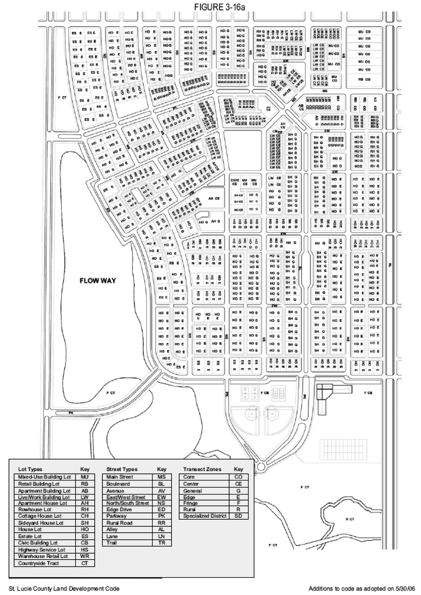
FIGURE 3-16a
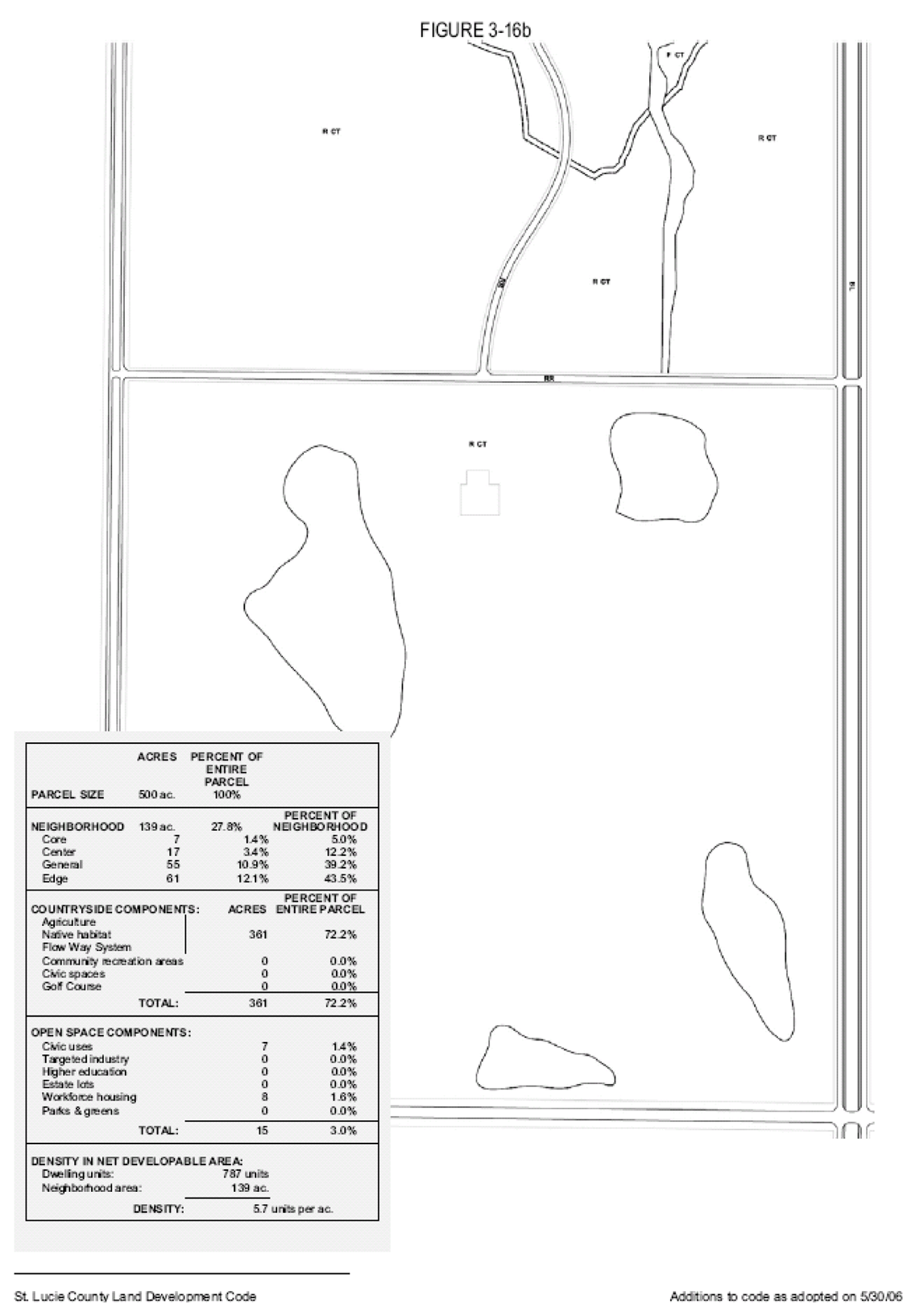
FIGURE 3-16b
FF.
PCS (PLANNED COUNTRY SUBDIVISION).
1.
Purpose. The Planned Country Subdivision (PCS) district provides a specialized zoning district to accommodate landowners who choose to subdivide their land into individual home sites using the transferable development value assigned to that land. The PCS district may only be used on land outside the Urban Service Boundary land but within the TVC designation on the Future Land Use Map of the St. Lucie County Comprehensive Plan.
2.
Standards and Requirements. Standards and requirements for Planned Country Subdivisions shall be as follows:
a.
Permitted Uses. Unless otherwise specified by the Board of County Commissioners during the approval process, the same permitted and accessory uses allowed in the Agricultural Residential-1 (AR-1) zoning district shall apply to the PCS zoning district. An applicant for PCS zoning may request additional uses or propose restrictions beyond those in the AR-1 zoning district by providing a complete identification of all intended land uses with the PCS application. These uses should be selected from the lists of permitted, conditional, and accessory uses in this Code and must be consistent with the TVC Element of the St. Lucie County Comprehensive Plan. If the PCS approval includes any change to the permitted and accessory uses that are allowed in the AR-1 zoning district, that change will be made by the Board of County Commissioners during the approval process.
b.
Size. A Planned Country Subdivision must be a minimum of five (5) contiguous acres under common ownership or control and may not be used for parcels that exceed five hundred (500) acres (see Policy 3.1.2.7 of the TVC Element).
c.
Density. The maximum residential density for a parcel being rezoned to the PCS district is determined by the Transferable Development Value Map (Figure 3-3) and Policy 3.1.2.5 of the TVC Element. The TDR program in Section 4.04.05 of this Code may not be used to transfer density to or from land zoned PCS; the only exception is when the PCS zoning district is used in accordance with Section 4.04.04.D.3.
d.
Dimensional Requirements. Unless otherwise specified by the Board of County Commissioners during the approval process, the following dimensional regulations shall apply to residential lots in the PCS zoning district:
(1)
Minimum lot size, width, road frontage, yard, height, and lot coverage shall be the same as applies to the Residential Estate-2 (RE-2) zoning district, see Table 7-10 and Section 7.04.01.
(2)
Minimum building/structure elevations as established by Section 7.04.01.C may not be altered.
(3)
The building spacing formula in Section 7.04.03 does not apply in PCS districts.
(4)
The base building line setback requirements of Section 7.04.04 must be observed by all development in PCS districts.
(5)
Residential buildings on individual lots must meet the garage standards in Section 4.04.04.F.
e.
Regional Flow Way System. New development must provide water management in the form of an interconnected system consistent with and connected, if possible, to the Flow Way System as described in Section 3.01.03.EE.2.p).
f.
Compatibility. Applications for PCS zoning must not be incompatible with existing and planned adjoining uses of land. Compatibility will be determined by the Board of County Commissioners during the preliminary approval stage.
g.
Street Network. Applications for PCS zoning that propose twenty-five (25) or more lots must provide at least two (2) points of vehicular access not be restricted by gates and must provide an interconnected street network as described in Section 3.01.03.EE.2.k. The proposed development plan must also accommodate the Future Street Network Plan (see Section 4.04.04.B).
h.
Urban Services. In accordance with Policy 3.1.2.6 of the TVC Element, properties rezoned to the PCS zoning district are not eligible for urban services. The only exception is when the PCS zoning district is used in accordance with Section 4.04.04.D.3.
i.
Natural Features. In addition to complying with the Resource Protection Standards in Chapter VI, native trees and vegetation and other natural features must be preserved to the extent practicable.
j.
Open Space Standards. In addition to the general open space guidelines in Section 7.04.02.B, applications for PCS zoning must comply with the open space standards for Planned Unit Developments in Residential Future Land Use Categories as found in Section 7.01.03.I.1.a.
k.
Phasing. Applications for PCS zoning must propose only a single phase of development.
l.
Lighting. All lighting facilities shall be arranged in such a manner so as to prevent direct glare or hazardous interference of any kind to adjoining streets or properties.
m.
Signs. Permanent and temporary signs within any Planned Country Subdivision shall comply with the provisions of Chapter IX of this Code as they apply to the Residential Estate-2 (RE-2) zoning district.
3.
Approval Process. The approval process and submittal requirements for the Planned Country Subdivision district shall be as provided in Chapter XI for Planned Developments, except that the approval of final site plans shall be administrative and shall not require the public hearing described in Section 11.02.05.B.4 or the public notices described in Section 11.00.03.
GG.
PRW (PLANNED RETAIL/WORKPLACE).
1.
Purpose. The Planned Retail/Workplace (PRW) district provides a specialized zoning district to accommodate landowners who choose to place retail or workplace land uses outside a Town or Village in a manner consistent with the goals, objectives, and policies of the TVC Element.
a.
The PRW district may only be used on land designated TVC on the Future Land Use Map of the St. Lucie County Comprehensive Plan.
b.
PRW proposals must meet the retail standards under Objective 3.1.8 and/or the workplace standards under Objective 3.1.10 of the St. Lucie County Comprehensive Plan, in addition to the TVC Overlay Zone requirements in Section 4.04 of this Code. Such requirements and standards shall be applied consistently with Policies 3.1.2.5 and 3.1.3.1(4) of the TVC Element.
c.
The PRW district can be used only for one (1) of the following primary purposes:
(1)
Local Retail: Local stores, convenience centers, neighborhood centers, village centers, town centers (or portions thereof) that comply with the North St. Lucie County General Retail Development Plan (Figure 3-13 and Objective 3.1.8 of the St. Lucie County Comprehensive Plan).
(2)
Interstate Retail: Highway service/warehouse uses along Indrio Road immediately west and east of Interstate 95 that comply with the North St. Lucie County General Retail Development Plan (Figure 3-13 and Objective 3.1.8 of the St. Lucie County Comprehensive Plan).
(3)
Mixed-Use Business District: Mixed-use business districts between Interstate 95 and the Florida Turnpike that comply with the North St. Lucie County General Workplace Plan (Figure 3-16 and Objective 3.1.10 of the St. Lucie County Comprehensive Plan).
(4)
Transitional Retail: Retail, workplace, and residential uses in the Transitional Areas near St. Lucie Boulevard and Kings Highway that comply with the North St. Lucie County General Workplace Plan (Figure 3-16 and Objective 3.1.10 of the St. Lucie County Comprehensive Plan).
i.
PRW zoning is required for new retail and mixed-use developments and for most new workplace developments.
ii.
PRW zoning is not required for land indicated on the Transferable Development Value Map (Figure 3-3) as suitable for industrial uses. Land so indicated may also qualify for light or heavy industrial zoning districts provided the zoned lands comply with St. Lucie County standards for the Future Land Use category of Industrial.
d.
PRW proposals are encouraged to include mixed-use buildings. The maximum number of residential units is established by the transferable development value of the land pursuant to the Transferable Development Value Map (Figure 3-3 of the St. Lucie County Comprehensive Plan), by TDR credits obtained, or by the approval of the Board of County Commissioners for the provision of workforce or affordable housing.
e.
For purposes of interpreting compliance of a PRW application with the designations of land on Figures 3-13 and 3-16 (see Figure 3-17 below), the Board of County Commissioners may approve retail or workplace development as far as one-quarter-mile beyond the precise designations provided such uses are integrated with and accessible through the designated land and are not incompatible with surrounding uses.
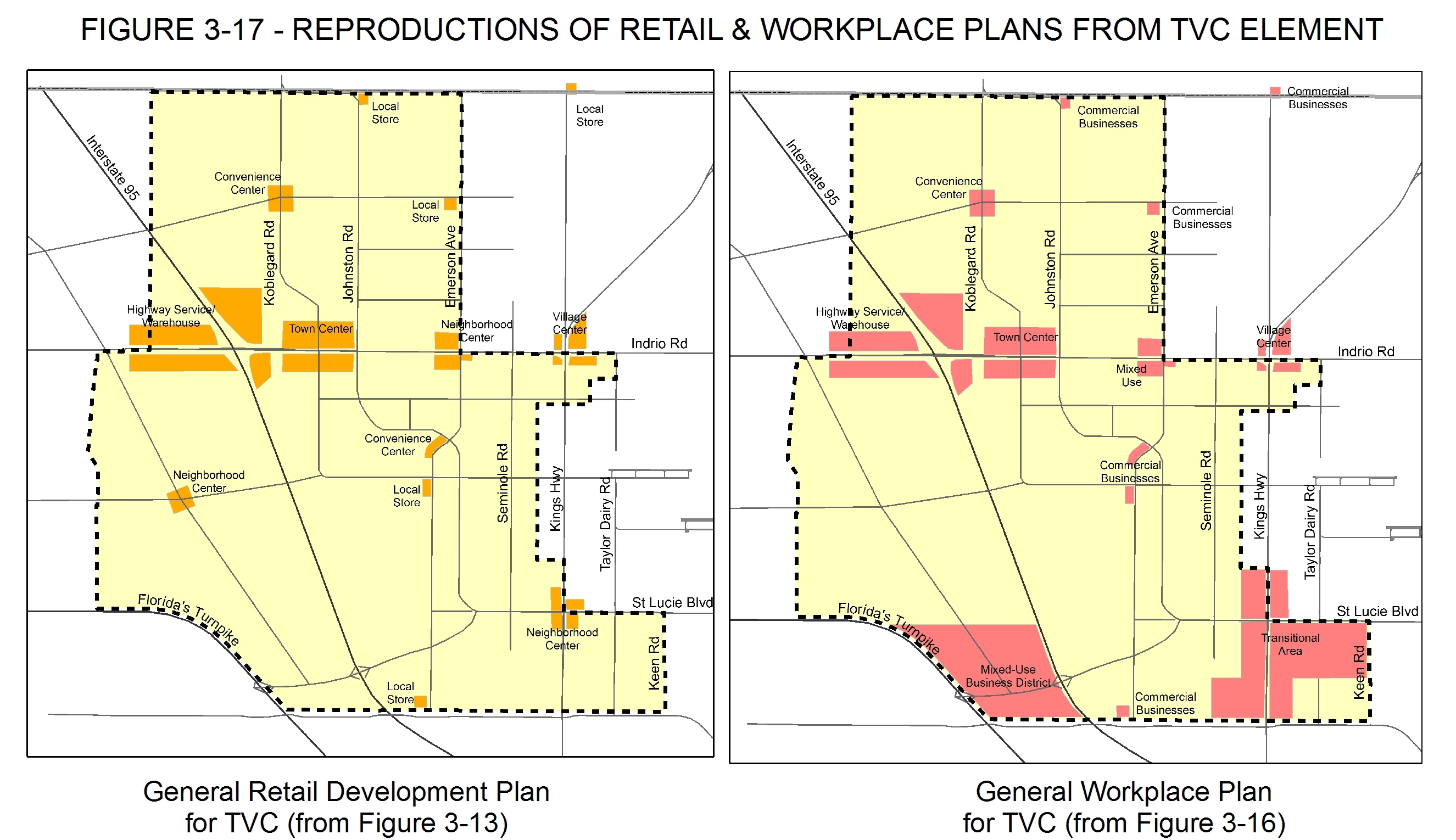
2.
Standards and Requirements. Standards and requirements for the Planned Retail/Workplace district shall be as follows:
a.
Transect Zones.
(1)
All land within each PRW must be allocated to one (1) of the four (4) transect zones described below. Each transect zone controls land use, lot types, and the placement and intensity of buildings and other uses of land:
i.
Core
ii.
Center
iii.
Fringe
iv.
Specialized District (allowable only for Interstate Retail and Mixed-Use Business District as defined in 3.01.03.GG.1.c).
(2)
The general standards for the Core, Center, and Fringe transect zones are described in Section 3.01.03.EE.2.d. The general standards for the Specialized District transect zone are described immediately below.
(3)
"Specialized District" Transect Zone.
Purpose: Specialized Districts are used for development types or forms that are not fully integrated with Towns, Villages, or the Countryside. Examples include large industrial uses, institutional campuses, medical facilities, and vehicle-oriented warehouse or large-format retail establishments.
Allowed Where: The Specialized District transect zone may be used only for Interstate Retail west of I-95 or for Mixed-Use Business Districts as defined in 3.01.03.GG.1.c.
Permitted Lot Types in the Specialized District transect zone (see listed sections for details):
•
Mixed-Use Building Lot (3.01.03.EE.2.e)
•
Retail Building Lot (3.01.03.EE.2.e)
•
Apartment Building Lot (3.01.03.EE.2.e)
•
Live/Work Building Lot (3.01.03.EE.2.e)
•
Civic Building Lot (3.01.03.EE.2.e)
•
Highway Service Lot (3.01.03.GG.2.c)
•
Warehouse Retail Lot (3.01.03.GG.2.c)
Building Form and Placement on Lots for the Specialized District transect zone: refer to Section 3.01.03.GG.2.c.3.
Development Standards for the Specialized District transect zone: refer to Section 3.01.03.GG.2.d.
Permitted Uses for the Specialized District transect zone: refer to Section 3.01.03.GG.2.e.
Allowable Street Types in the Specialized district transect zone (refer to Section 3.01.03.GG.2.g):
•
Main Street
•
Boulevard
•
Avenue
•
East/West Street
•
North/South Street
•
Alley
Streetscape Standards for the Specialized District transect zone: refer to Section 3.01.03.GG.2.h.
b.
Transect Assignment Concepts. Each proposed regulating plan must clearly indicate the allocation of transect zones within the entire PRW district to define the character of various portions of the district. The following general guidelines shall be followed when proposing transect zones:
(1)
A PRW district should generally have less intensity where it adjoins existing or planned development with less intensity. Where adjacent to a busy street or highway, or adjacent to an established urban area, the transect zones with greater intensity may adjoin that highway or urban area.
(2)
Similar uses should face across streets; changes in transect zones should generally occur along rear or side lot lines rather than along streets.
(3)
When a PRW will adjoin an existing or approved neighborhood, the PRW should establish similar transect conditions (such as Center aligning with Center, and Fringe aligning with Fringe). Transect juxtapositions may be approved by St. Lucie County where natural conditions warrant them or where alignment of similar transect conditions would be inappropriate due to existing or proposed uses on adjacent properties.
(4)
The Specialized District transect zone may only be used in the following situations:
i.
Only for Interstate Retail west of I-95 and for Mixed-Use Business Districts as defined in 3.01.03.GG.1.c; and
ii.
Only where it is not possible or desirable to integrate the desired development type or form with adjoining uses; and
iii.
Only for that portion of a proposed development where the other transect zones allowable in the PRW district are unsuitable; and
iv.
Only where the details proposed within the Specialized District will not interfere with any of the goals, objectives, and policies of the TVC Element.
c.
Lot Types.
(1)
The following lot types may be assigned within the corresponding transect zones as shown in the following matrix. An applicant may propose additional lot types, including Highway Service or warehouse retail lots outside of a specialized district transect zone, during the PRW rezoning process provided the lot types comply with the intent of the TVC Element. The Board of County Commissioners shall decide whether to accept, modify, or reject such additional lot types during the approval process based on consistency with the goals, objectives and policies of the TVC Element and the applicable site plan approval standards in Chapter XI of this Code.
(2)
Differing lot types may be placed back-to-back on a single block to provide harmonious transitions between lot types. Lot types should be selected to provide buildings of like scale and massing on opposite sides of streets. The primary entrance of every building must directly face a street, a square, a park, a plaza, or a green.
(3)
Proper building placement and other regulations are illustrated immediately below for Highway Service Lots and Warehouse Retail Lots. Similar requirements for the other lot types are described in Section 3.01.03.EE.2. f.
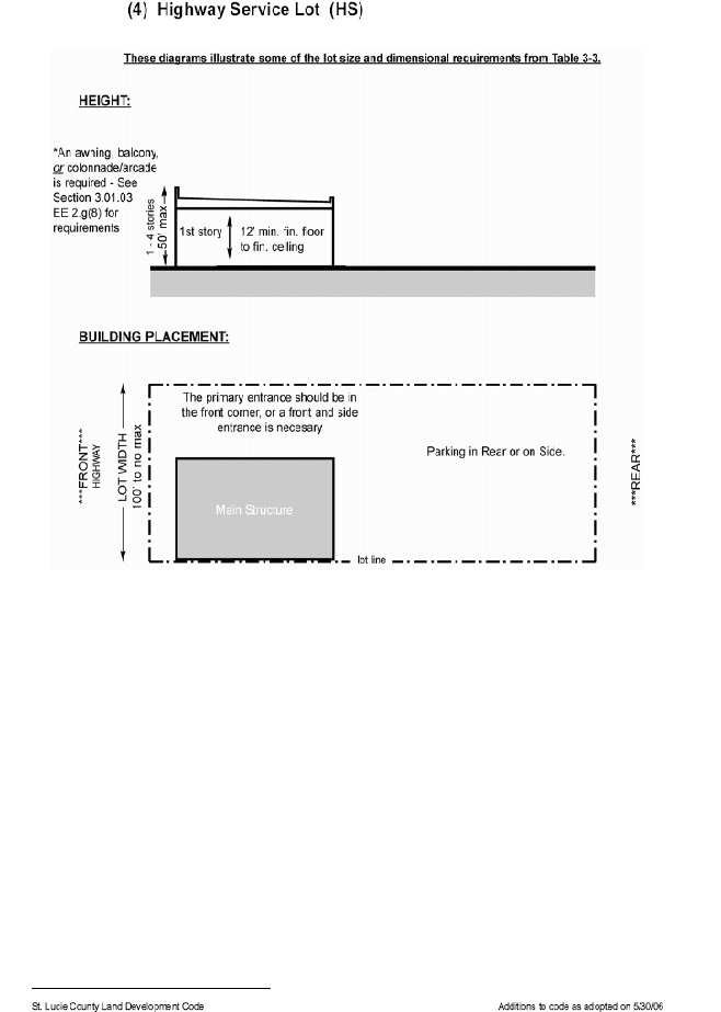
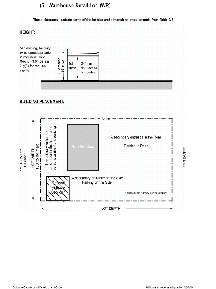
d.
Development Standards for Lots.
(1)
Table 3-3 provides dimensional requirements that apply to all lots of each designated type. These requirements replace those found in Section 7.04.01.
TABLE 3-3
LOT SIZE AND DIMENSIONAL REQUIREMENTS
1 Corner lots must meet front yard requirements on both streets.
2 Minimum rear yards in this column apply to principal buildings. Buildings for all accessory uses (including garages and accessory dwellings) must maintain a 5-foot minimum rear yard, except when the rear yard adjoins an alley (see Section 3.01.03.EE.2); no separation is required from an alley. Fences are regulated by Section 8.00.04.
3 See definition of "story" for further details on height measurements. The building spacing formula in Section 7.04.03 does not apply in PTV districts.
4 See additional requirements in Section 3.01.03.EE.2.g(3).
5 No maximum building size or width applies to Retail Building Lots proposed on property with existing Commercial, General (CG) zoning as of August 28, 2009.
(2)
If additional lot types are proposed by a PRW applicant, comparable dimensional requirements must also be proposed. An applicant may also propose changes to the dimensional requirements in Table 3-3 for a particular lot type. The Board of County Commissioners shall decide whether to accept, modify, or reject such additional or modified dimensional requirements during the approval process based on consistency with the goals, objectives and policies of the TVC Element and the applicable site plan approval standards in Chapter XI of this Code.
(3)
Building frontage is the percentage of the total width of a lot which is required to be building wall, measured where the front yard ends and the front of the building begins. For this purpose only, the width of a porte cochere may be counted as building wall even though it has no front or rear wall.
(4)
Each building shall have separate walls to support all loads independently of any walls located on an adjacent lot.
(5)
Each building on a Mixed-Use Building Lot, a Retail Building Lot, a Live/Work Building Lot, or a Civic Building Lot must have an entrance facing a street or public open space.
(6)
Each building on a Mixed-Use Building Lot or a Retail Building Lot is required to have an awning/marquee, balcony, or colonnade/arcade in accordance with the design requirements of Section 3.01.03.EE.2.g.(8).
(7)
Minimum and maximum depths of front yards are shown Table 3-3. For Mixed-Use Building Lots and Retail Building Lots, a portion of the building frontage may be set back up to an additional twenty (20) feet beyond the maximum front yard depth if this space is constructed as a courtyard or entryway that is open to the sidewalk. This portion may be up to forty percent (40%) of the actual building frontage and may not be used for parking.
e.
Permitted Uses. Table 3-4 identifies the permitted, conditional and accessory uses for each lot type. Where the upper row of Table 3-4 indicates an entire zoning district, an "S" in the column below indicates that a particular lot type is also allowed to have the same permitted, conditional, and accessory uses that are allowable to any parcel located in that zoning district, in addition to all uses specifically indicated for that lot type in other columns of Table 3-4.
TABLE 3-4
PERMITTED LAND USES
f.
Density. The PRW district primarily accommodates retail and workplace uses but these uses may be located within or contiguous to surrounding neighborhoods or may be in buildings that also contain residential uses.
(1)
Residential units may be placed in freestanding buildings on portions of a site. The density of those portions of the site cannot exceed the density limitations of the Transferable Development Value Map in Figure 3-3 of the TVC Element.
(2)
Residential units may also be placed on upper stories of buildings that contain retail or workplace uses, or may be part of freestanding live/work buildings. The total number of such residential units on the site cannot exceed the entire site's density limitations as set forth in the Transferable Development Value Map in Figure 3-3 of the TVC Element, or five (5) dwelling units per acre, whichever is higher.
g.
Allowable Street Types by Transect Zone. The following street types are be permitted by right in the transect zones shown. These streets must comply with the streetscape standards in Section 3.01.03.GG.2.i and the street cross-sections in Section 3.01.03.EE.2.l. An applicant may propose additional street types or modified cross-sections and streetscape standards during the PRW rezoning process provided the street types and modified standards comply with the intent of the TVC Element; the Board of County Commissioners shall decide whether to accept, modify, or reject such proposals during the approval process based on consistency with the goals, objectives and policies of the TVC Element and the applicable site plan approval standards in Chapter XI of this Code.
h.
Streetscape Standards by Transect Zone. The following standards apply to all street types as they pass through the indicated transect zone:
i.
Street Network Design.
(1)
New development must accommodate the Future Street Network Plan (see Section 4.04.04.B).
(2)
Except in Specialized Districts, each PRW must provide an interconnected network of streets, alleys or lanes, and other public passageways:
i.
Streets must be designed to encourage pedestrian and bicycle travel by providing short routes to connect residential uses with nearby commercial services, schools, parks, and other neighborhood facilities.
ii.
Streets should be organized according to a hierarchy based on function, size, and design speed. Rights-of-way are expected to differ in dimension and must meet the appropriate standards for the transect zones in which they are located (see Section 3.01.03.GG.2.g).
iii.
Streets do not have to form an orthogonal grid and are not required to intersect at ninety-degree angles. These streets may be curved or bent but must connect to other streets. Jogs or centerline offsets shall be at least one hundred (100) feet for local streets; this requirement does not apply to alleys.
iv.
All streets in the Future Street Network Plan must be publicly dedicated. Private streets and closed or gated streets are prohibited, notwithstanding the provisions of Sections 7.05.03.E and 7.10.15.
v.
The use of raised intersections, lateral shifts, and traffic circles are encouraged as alternatives to more conventional traffic calming measures such as speed bumps.
vi.
A continuous network of rear and side alleys and/or lanes is desirable to serve as the primary means of vehicular ingress to individual lots. Such networks are mandatory in Core transect zones. Alley and rear lane entrances should align so as to provide ease of ingress for service vehicles. Internal deflections or variations in the alley/rear lane network are encouraged to prevent excessive or monotonous views of the rear of structures resulting from long stretches of alleys and rear lanes.
vii.
Cul-de-sacs are not permitted except where physical conditions such as freeways provide no practical alternatives for connection for through traffic. Canals may or may not be physical barriers; appropriate crossings will be considered at the time of PRW approval.
viii.
Street stubs must be provided to adjacent undeveloped land to ensure an integrated street network is achieved over time, except where the adjacent land is being designated as Fringe. Stub-out streets to connect to future development will not be considered cul-de-sacs if they are less than three hundred (300) feet long.
ix.
Streets intersecting Indrio Road must be separated by at least six hundred sixty (660) feet. Streets intersecting other roads on the regional street network must be separated by at least three hundred thirty (330) feet (see Section 4.04.04.B).
(3)
Except in Specialized Districts, the average perimeter of all blocks within a neighborhood may not exceed 1,500 feet. The maximum perimeter of any block may not exceed 2,400 feet. The portion of any block between intersecting streets may not exceed 500 feet without a publicly dedicated pedestrian sidewalk or trail providing access to another street. Smaller block sizes are encouraged to promote walkability. An applicant may propose minor modifications to these block size standards during the PRW rezoning process; the Board of County Commissioners shall decide whether to accept, modify, or reject such modifications during the approval process based on consistency with the goals, objectives and policies of the TVC Element and the applicable site plan approval standards in Chapter XI of this Code.
(4)
The street design requirements of Section 7.05 apply except where they conflict with standards for the TVC Overlay Zone or this zoning district. Further exceptions to the requirements of Section 7.05 may be authorized by the Board of County Commissioners through approval of a regulating plan during the PRW rezoning process.
(5)
Applications for PRW zoning on tracts larger than twenty-five (25) acres must provide at least two (2) points of vehicular access. These access points may not be restricted by gates.
j.
Off-Street Parking Regulations. Certain modifications to the off-street parking regulations found in Section 7.06.00 of this Code will apply in the PRW district:
(1)
Except in Specialized Districts, the following minimum dimensions for parking access aisles and standard parking stalls apply in lieu of the specific requirements in Section 7.06.00:
(2)
Except in Specialized Districts, parking lots shall be located behind buildings wherever possible so that buildings can screen parking areas from sidewalks and streets. In no case shall parking be located in front of a building. Small parking lots in side yards may be permitted provided the buildings they serve can meet the lot width and building frontage requirements of Table 3-1 and provided these lots are set back a minimum of twenty (20) feet from lot lines adjoining rights-of-way, excluding alleys or lanes.
(3)
The following multipliers shall be applied to the required number of off-street parking spaces shown in Section 7.06.02. The result of this multiplication will be the required number of off-street parking spaces in each transect zone.
(4)
Access to Off-Street Parking. Except in Specialized Districts:
i.
Alleys or lanes shall be the primary source of access to off-street parking. Parking along alleys or lanes may be head-in, diagonal, or parallel.
ii.
Alleys or lanes may be incorporated into parking lots as if they were standard parking access aisles. Access to all properties adjacent to the alley must be maintained.
iii.
Access between rear parking lots across property lines is strongly encouraged.
(5)
Except in Specialized Districts, parking structures must be separated from adjacent streets by liner buildings at least two (2) stories in height and no less than twenty (20) feet in depth. Liner buildings may be detached from or attached to parking structures.
k.
Compatibility. Applications for PRW zoning must demonstrate compatibility of the proposed development with existing and planned adjoining uses of land. Compatibility will be determined by the Board of County Commissioners during the preliminary approval stage.
l.
Regional Flow Way System. New development must accommodate the Flow Way System (see Section 3.01.03.EE.2.p).
m.
Landscaping and Natural Features.
(1)
In addition to complying with the Resource Protection Standards in Chapter VI, native trees and vegetation and other natural features must be preserved to the extent practicable.
(2)
The landscaping and screening requirements in Section 7.09 apply except that the landscaping adjacent to streets otherwise required by Section 7.09.04.A will not be required between buildings and streets. However, this requirement still applies between off-street parking areas (and other vehicular use areas) and streets.
(3)
The landscaped buffer areas required by Section 7.09.04.E to segregate residential and non-residential uses, unless imposed as a special condition, will not be required within the PRW zoning district.
n.
Signs. Permanent and temporary signs within any Planned Retail/Workplace shall comply with the provisions of Chapter IX of this Code as they apply to the Commercial Neighborhood (CN) zoning district, except that ground signs may not exceed a height of ten (10) feet.
For uses with trip generation rates exceeding ten thousand (10,000) daily diverted trips from I-95, a single Ground Sign of up to one hundred (100) feet in height above the crown of the primary frontage road and six hundred forty (640) square feet in area may be permitted adjacent to an I-95 interchange. Such signs are subject to the following additional standards:
(1)
No horizontal or vertical sign face dimension may exceed thirty (30) feet;
(2)
The sign faces must be oriented perpendicular to I-95 with the sign profile facing the view from local roads;
(3)
The sign must be separated from residential areas by a minimum of five hundred (500) feet;
(4)
The sign must be setback at least twenty-five (25) feet from the right-of-way or property boundary;
(5)
All sign lighting shall be internally illuminated; and
(6)
Landscaping shall be provided around the sign pole and such landscaping shall include trees and shrubs, the mature height of which shall obscure the sign pole base, with trees no less than twelve (12) feet in height and shrubs no less than three (3) feet in height at the time of planting. Where necessary for security, a barrier fence, around the sign base, may be required by the Planning and Development Services Director to deter unauthorized access. In all cases, landscaping must be placed outside the barrier fence.
3.
Approval Process.
a.
The approval process for the Planned Retail/Workplace district shall be as provided in Chapter XI for Planned Developments, except that the approval of final site plans shall be administrative and shall not require the public hearing described in Section 11.02.05.B.4 or the public notices described in Section 11.00.03. This zoning district provides certain opportunities for applicants to request minor modifications to its standards. During the final public hearing for the preliminary approval of each PTV zoning district, the Board of County Commissioners must explicitly respond to each of these requests. Except to the extent that such requests are formally accepted or accepted with modifications, the written standards of this zoning district shall apply.
b.
Submittal requirements shall be as provided for Planned Developments except that the same modifications to submittal requirements that apply to PTV applications also apply to PRW applications (see Section 3.01.03.EE.3.b and 3.c).
c.
If final PRW approval is sought in phases, each phase must indicate how the remaining phases are planned to be integrated with the earlier phases.
HH.
CPUB CONSERVATION - PUBLIC.
1.
Purpose. The purpose of this district is to provide an environment suitable for the protection, preservation or enhancement of public lands in the community, together with such other uses as may be compatible with public and quasi-public surroundings. The number in "()" following each identified use corresponds to the SIC code reference described in Section 3.01.02(B). The number 999 applies to a use not defined under the SIC code but may be further defined in Section 2.00.00 of this Code.
2.
Permitted Uses.
a.
Cultural activities consistent with the environmental, historic, and/or archeological values of the site. (999)
b.
Public Conservation areas, including hiking, canoeing, fishing, bird watching, picnicking, nature exhibits and all existing uses that are not negatively affecting the purpose of the public purchase. (999)
3.
Lot Size Requirements. Lot size requirements shall be in accordance with Section 7.04.00.
4.
Dimensional Regulations. Dimensional requirements shall be in accordance with Section 7.04.00.
5.
Off-Street Parking and Loading Requirements. Off-street parking and loading requirements are subject to Section 7.06.00.
6.
Landscaping Requirements. Landscaping requirements are subject to Section 7.09.00.
7.
Conditional Uses.
a.
Telecommunication towers - subject to the standards of Section 7.10.23. (999)
b.
Heliport landing/takeoff pads. (999)
c.
Restaurants. (Including the sale of alcoholic beverages for on-premises consumption only.) (999)
8.
Accessory Uses. Accessory uses are subject to the requirements of Section 8.00.00, and include the following:
a.
Uses associated with agency approved management plans. (999)
II.
CR COMMERCIAL RESORT.
1.
Purpose: The purpose of this district is to provide and protect an environment suitable for the development and operation of resorts that are intended to serve both resident and nonresident populations, over a large market area. This district is not intended for general application, but should be generally limited to only those areas of the County that have been specifically determined by the County Commission to be suitable for resorts that promote convention, entertainment, civic and related activities, or that combine multi-activity centers or venues, intended to promote economic development, broaden the tax base, protect and leverage public investment with private investment, ensure land use compatibility with existing residential areas, ensure good pedestrian movement systems, and provide exceptional design quality.
2.
Permitted Uses: Resorts, subject to the use standards found in this Section. Resorts may contain hotel/motel units or condo-hotel units.
3.
Use Standards:
a.
Land Use Compatibility. The CR (Commercial Resort) Zoning District may only be located in the COM (Commercial) or MXD (Mixed Use) Future Land Use District.
b.
Minimum Parcel Size. The minimum lot size requirement for the development, or redevelopment of a Resort shall be five (5) acres
c.
Requirement for Unified Property Control. Resorts shall be under common ownership or property management control.
d.
Requirement for Site Plan Review/Approval. Resorts permitted under this Section shall be subject to review in accord with the processes and procedures for a Planned Development review as described in Section 11.02.05 of this Code. Should a Resort be developed on a property in the unincorporated area of the County as part of any Planned Development zoning category or district, the requirements and standards of review of the CR zoning district (Section 3.01.03 (II)) shall govern the review and approval of such resort.
e.
Dimensional Requirements. Minimum dimensional requirements shall be in accordance with Table 7-10, as found in Section 7.04.01 of this Code, provided, however, the Board of County Commissioners may condition the approval of any resort with more stringent or restrictive dimensional requirements in order to ensure compatibility with surrounding land uses; to mitigate impacts on the environment and natural resources; to ensure public safety and to ensure compliance with the St. Lucie County Comprehensive Plan.
Any Resort that is located on North or South Hutchinson Island, shall be subject to the requirements of Section 4.01.00, Hutchinson Island—Building Height Overlay Zone.
f.
Density. The maximum number of units shall not exceed thirty-six (36) hotel/motel or condominium hotel units per acre. In addition to the maximum number of units, amenities may be constructed, provided that the Resort may not exceed the maximum permitted lot coverage for the applicable land use. However, the Board of County Commissioners may condition the approval of any site plan for any Resort with more stringent or restrictive site density standards if it is shown to the satisfaction of the Board of County Commissioners that the proposed site density will be incompatible with the surrounding land uses or would cause unmitigatable impacts to the local community infrastructure. Overall site density shall be computed in manner consistent with this Code.
g.
Requirement for Amenities.
1.
General Requirements for all Resorts: Any resort shall be a full-service facility that provides access to or offers a range of amenities and recreation facilities to emphasize a leisure experience. Such resort shall serve as the primary provider of the guests' experience and is characteristically located in a vacation-oriented setting. The resort may provide services for business, meetings, conferences or conventions. The resort shall provide on-site management services which shall be available twenty-four (24) hours per day/seven (7) days a week. It must also provide that certain minimum qualifications be met including the provision of:
•
A minimum of twenty-five (25) rooms or other accommodations;
•
At least one (1) signature amenity or anchor attribute (as further described in this section);
•
At least five (5) secondary recreation/leisure/entertainment experiences (as further described in this section);
•
At least one (1) full-service food & beverage outlet;
•
An emphasis on leisure or retreat-environment experience
•
It is intended that certain amenities, such as, but not limited to restaurants and areas of public assembly, shall be identified as being open to the public or open for membership to the public, provided however, that the Board of County Commissioners may approve some or all amenities being closed to the public.
2.
Signature Amenity: Any resort property containing rental units intended for short-term occupancy on any parcel of land zoned CR (Commercial Resort) must provide for signature amenities. Signature amenities are amenities, attractions and/or geographically significant attributes that a permitted use in the CR Zoning District is required to provide access to in order to be considered a resort hotel consistent with the intent of the CR Zoning District. Uses considered to be signature amenities include, but are not necessarily limited to the following examples:
•
Beach: Beach and ocean frontage (beach access with no frontage does not apply.);
•
River: Frontage/access onto estuarine and non-estuarine waters of sufficient size and quality to support public use or activities;
•
Boating: Marina or dock facilities (fuel facilities optional);
•
Spa: Spa/health/wellness facilities;
•
Golf: Golf course(s) and related golf amenities
•
Tennis or Other Sports: Tennis or other court or field-based sport facilities of size and quality to support tournament competition;
•
Dude Ranch: Working ranch with equestrian facilities; and
•
All-inclusiveness.
•
Anchor Attribute: An anchor attribute is a collection of secondary recreation/leisure/entertainment experiences, as described below, which share a common theme. To be identified as an anchor attribute, a minimum of five (5) recreation/leisure/entertainment experiences linking to a common theme must be provided. Examples include but are not limited to: couples, family, educational, or tropical.
3.
Secondary Recreation/Leisure/Entertainment Experiences: A secondary recreation/leisure/entertainment experience is a secondary amenity that adds to the resort experience. While such secondary amenities are not considered primary resort features, they are important in creating the appropriate atmosphere and providing a range of activities for guests to participate in. Secondary amenity uses include, but are not limited to the following:
h.
Architectural Design Standards. The architectural design of a resort shall be in keeping with the signature amenity or anchor attribute of the facility. The design shall reflect traditional proportioning systems of the chosen recognized architectural style. Consideration of quality and compatibility shall be based on the massing, form and articulation of building walls, and the order, rhythm and proportion of doors and windows, rather than on gratuitous ornamentation.
4.
Off-Street Parking and Loading Requirements: Off-street parking and loading requirements are subject to Section 7.06.00
5.
Landscaping Requirements: All site landscaping shall be in accord with the requirements of Section 7.09.00 of this Code, with the following specific additions:
a.
Buffering and Screening: The placement of natural landscape materials (trees, shrubs, and hedges) is the preferred method for buffering uses in the commercial resort zoning district from adjoining land uses, for providing a transition between adjacent properties, and to screen the view of any parking or storage area, refuse collection, utility enclosures, or service area visible from a public street, alley, pedestrian area or adjoining property. Plants may be used in concert with decorative fences and/or berms to achieve the desired screen or buffering effect. Landscape material should be mature enough at the time of planting to provide an effective buffer or screen, and should be planted in an appropriate location to allow for desired growth within a reasonable period of time. When used to screen an activity area such as a parking lot, landscaping should not obstruct the visibility of motorists or pedestrians and shall not interfere with public safety.
b.
Responsive to Local Context and Character: Landscape designs in the commercial resort zoning district should build on the specific properties unique physical characteristics, conserving and complementing existing natural features, when available. Naturalistic design elements such as irregular plant spacing, undulating contours, and mixed proportions of plant species should be used to ensure new landscaping blends and contribute to the quality of the surrounding area. Selection and spacing of plant material should be reflective of the neighborhood, district, or character of the area.
c.
Use of Native and Drought Resistant Plants: Wherever feasible and environmentally beneficial, landscape designs should feature native and/or drought-tolerant plant species, especially in areas adjacent to existing native vegetation, to take advantage of the unique natural character and diversity of the region, and the adaptability of native plants to local environmental conditions. Where feasible, the re-establishment of native habitats should be incorporated into the landscape design. In the same manner, landscape designs are encouraged to utilize drought tolerant plant materials to the maximum extent feasible. The use of drought tolerant plants should enrich the existing landscape character, conserve water and energy, and provide as pleasant and varied a visual appearance as plants that require more water.
The Board of County Commissioners may condition the approval of any resort with more stringent or restrictive landscape requirements in order to ensure compatibility with surrounding land uses.
6.
Sign Requirements: Site signage shall be consistent with the provisions of Section 9.01.01(E). A preliminary site signage plan shall be required as part of the site plan review process of all resorts developed under of the CR zoning district.
Site signage for a resort shall be in keeping with the resort's character, architecture and signature amenity or anchor attribute, both in scale and design. The scale and design of the sign shall also be appropriate to the surrounding area in which the resort is located. The Board of County Commissioners may condition the approval of any resort with more stringent or restrictive signage requirements in order to ensure compatibility with surrounding land uses and the speed limit of the road or roads which the sign(s) faces.
7.
Conditional Uses:
a.
Telecommunication towers — subject to the standards of Section 7.10.23.
8.
Accessory Uses: Accessory uses are subject to the requirements of Section 8.00.00, and include the following:
a.
Solar energy systems, subject to the requirements of Section 7.10.28.
(Ord. No. 10-026, Pt. A, 9-7-2010; Ord. No. 10-034, Pt. A, 11-9-2010; Ord. No. 11-015, Pt. A, 4-19-2011; Ord. No. 11-021, Pt. A, 8-2-2011; Ord. No. 11-017, Pt. A, 6-21-2011; Ord. No. 11-002, § 4, 12-6-2011; Ord. No. 12-004, § A, 2-7-2012; Ord. No. 12-013, Pt. A, 12-4-2012; Ord. No. 13-007, § A, 3-5-2013; Ord. No. 15-002, Pt. A, 4-7-2015; Ord. No. 17-005, Pt. A, 5-16-2017; Ord. No. 17-015, § 3, 7-5-2017; Ord. No. 17-023, Pt. A, 12-19-2017; Ord. No 2020-8, Pt. A, 3-3-2020; Ord. No. 2020-22, Pt. A, 8-4-2020; Ord. No. 2020-28, Pt. A, 10-20-2020; Ord. No. 2022-11, Pt. A, 6-7-2022; Ord. No. 2022-12, Pt. A, 6-7-2022; Ord. No. 2022-21, Pt. A, 7-19-2022; Ord. No. 2022-027, § 2, 9-20-2022; Ord. No. 2024-10, § Pt. A, 2-20-2024; Ord. No. 2024-014, § 2, 4-2-2024; Ord. No. 2024-19, § Pt. A, 6-4-2024; Ord. No. 2024-26, § 1, 7-2-2024; Ord. No. 2024-31, § 2, 9-17-2024; Ord. No. 25-6, § Pt. A, 4-22-2025)