
Saint Lucie County Unincorporated
City Zoning Code
City Zoning Code
CHAPTER VI
RESOURCE PROTECTION STANDARDS
6.05.00. - FLOODPLAIN MANAGEMENT[1]
Editor's note—Ord. No. 18-001, Pt. A adopted January 23, 2018, repealed the former 6.05.00, §§ 6.05.01—6.05.07, and enacted a 6.05.00 as set out herein. The former 6.05.00 pertained to flood damage prevention and derived from Ord. No. 11-031, adopted December 2, 2011 and Ord. No. 12-010, adopted February 14, 2012.
6.00.01. - Intent.
It is the intent of the Board of County Commissioners to provide for the health, safety, and welfare of the residents of and visitors to St. Lucie County by establishing an administrative review process which encourages preservation of native habitat, and long-term sustainability of our urban forest in accordance with the St. Lucie County Comprehensive Plan and beneficial land and forest management practices by minimizing the unnecessary removal of valuable existing vegetation in advance of approved land development within the unincorporated area of St. Lucie County. Healthy vegetation reduces air and noise pollution, provides for the production of oxygen and sequestering of carbon dioxide, provides energy-saving shade and cooling, furnishes habitat for wildlife, enhances aesthetics and property values, and is an important contributor to community image, pride, and quality of life. In addition, it is the intent of the Board to prevent such destructive land development practices as speculative vegetation removal and clear cutting of land without a site plan or vegetation management and mitigation plan.
6.00.02. - Relationship to Other Sections of this Code.
A.
The provisions of the following Sections shall supersede the provisions of this Section to the extent of conflict.
1.
Mangrove Protection, Section 6.01.00;
2.
Environmentally Sensitive Lands, Section 6.02.00;
3.
Wetland Protection, Section 6.02.03;
4.
Coastal Area Protection, Section 6.02.01;
5.
Shoreline Protection, Section 6.02.02;
6.
Habitat of Endangered and Threatened Species, Section 6.03.00;
6.00.03. - Notice of Vegetation Removal Required.
A.
No person shall conduct any vegetation removal activities from or on any lot or parcel of land or portion thereof in the unincorporated area of St. Lucie County without first obtaining a Vegetation Removal Permit or Exemption from the Environmental Resources Director, or his/her designee. The Notice of Vegetation Removal application shall be completed in conformance with Section 11.05.06 of this Code. Protected vegetation shall be defined as native vegetation. Types of Notice of Vegetation Removal approval include:
1.
Exemptions. A number of specific activities have been determined to have minimal adverse impact and are listed in Section 6.00.04. An application is required for the Environmental Resources Department to review and issue a Vegetation Removal Exemption for the exemption to mitigation.
2.
Vegetation Removal Permit. A Vegetation Removal Permit shall be issued if all the criteria set forth in 6.00.05 have been met. An application is required for the Environmental Resources Department to review and issue a Vegetation Removal Permit.
B.
Unless otherwise provided in this Code, all public entities, including all departments of St. Lucie County government, shall be subject to the requirements of this Section. Public entities, however, shall not be subject to:
1.
The application fees under Section 11.12.00 of this Code; or
2.
The penalties under by Section 11.13.03 of this Code.
C.
The provisions of this Section may be suspended or waived by the Environmental Resources Director, or his/her designee during a period of emergency officially declared by the Board of County Commissioners.
D.
The following activities shall require no official notification to the Environmental Resources Director, or his/her designee and do not require a Vegetation Removal Permit or Exemption:
1.
Preserve and Parks Management Activities. Vegetation removal activities associated with an adopted management plan for government maintained parks, recreation areas, wildlife management areas, conservation areas and preserves. The purpose of the vegetation removal activity shall be to protect and preserve the natural values and functions of the ecological communities present, such as, clearing for firebreaks, conducting prescribed burns, or construction of fences.
2.
Existing Agricultural Operations. Vegetation removal, except within required preserve areas or deeded conservation easements, which are part of the on-going activities of the existing agricultural operation, shall not require a permit or exemption.
a.
Initial clearing of native vegetation on a site shall be preceded by a letter to the Environmental Resources Department. Bona fide agricultural activities include commercial nursery, citrus groves, tree farm, aquaculture, row crops, ranch, or similar operations. When removal of protected vegetation, has been performed under this provision, no development order shall be approved for any other use or improvement, including subdividing, on the same land within four (4) years from the date of the last agricultural classification granted for that land by the St. Lucie County Property Appraiser per F.S. § 193.461.
b.
In the event of a hardship such as a natural disaster, the owner may request that the Board of County Commissioners grant a variance from the provisions of this subsection. The Board shall only grant the variance if the Board determines that the owner has presented evidence that the owner has satisfied the standards for granting variances in Section 10.01.02 of the Land Development Code.
3.
Routine Landscape Maintenance. Trimming or pruning of vegetation which is not intended to result in the eventual death of the vegetation, mowing of yards or lawns, or any other landscaping or gardening activity which is commonly recognized as routine maintenance, replacement or relandscaping which does not result in the eventual death of any vegetation, does not require the approval of a Notice of Vegetation Removal Permit or Exemption.
4.
Water Control District Management Activities. Vegetation removal activities associated with the operation and maintenance of a water control district system for drainage purposes. The purpose of the vegetation removal activity shall be to protect and preserve drainage function within jurisdictional rights-of-way, easement, and prescribed easement according to historical maintenance efforts. All activities shall require implementation of best management practices, as appropriate, to ensure State water quality standards are met.
5.
Pursuant to F.S. § 163.045, the removal of a native tree on a residential property with a single-family, detached dwelling unit, if the property owner possesses documentation from an arborist certified by the ISA or a Florida licensed landscape architect that the tree poses an unacceptable risk to persons or property. A tree poses an unacceptable risk if removal is the only means of practically mitigating its risk below moderate, as determined by the tree risk assessment procedures outlined in Best Management Practices—Tree Risk Assessment, Second Edition (2017).
(Ord. No. 2025-025, Pt. B, 12-2-2025)
6.00.04. - Exemptions.
Any person who intends to remove or cause the death of any vegetation pursuant to any of the following mitigation exemptions must first obtain a Notice of Vegetation Removal Exemption from the Environmental Resources Director, or his/her designee. The burden of proving entitlement to any particular exemption shall lie, at all times, with the person or persons claiming the exemption.
A.
The removal of any native vegetation as necessary for the following activities:
1.
The minimal removal of native vegetation necessary for a path not to exceed four (4) feet in width to provide physical access or view necessary to conduct a survey or site examination for the preparation of bona fide site development plans or vegetation inventories; or
2.
The minimal removal of native vegetation necessary for a path not to exceed ten (10) feet in width to provide vehicular access necessary to conduct soil percolation or soil bore tests, provided such clearing or removal is conducted under the direction of Florida registered surveyor or engineer.
B.
The removal of any native vegetation in an existing utility easement, drainage easement, storm water management tract or facility, or right-of-way provided such work is done by or under the control of the operating unit of local, state, or federal government, utility company and that unit of local, state, or federal government or utility company has obtained all necessary licenses or permits to provide service through the easement.
C.
The removal of any native vegetation for the construction of a non-site related roadway extension or expansion, for roads identified in the County's Right-of-Way Protection Plan or the Jenkins Road Area Plan (special district) as well as prescribed by a site plan approval, site development permit or roadway improvement agreement, provided the roadway will be dedicated to and is agreed to be accepted by St. Lucie County for perpetual ownership and maintenance. The roadway acceptance will be determined by the County; at such time the improvement serves as a thoroughfare for the County's overall roadway network.
D.
The removal of any native vegetation within an existing County right-of-way, when such removal is necessary to accommodate the construction, reconstruction or improvement prescribed by a site plan approval, site development permit or roadway improvement agreement. As used in this section, County right-of-way means land in which St. Lucie County currently owns the fee or has a platted or conveyed easement devoted to, or required for, use by the public.
E.
The removal of native vegetation which has been determined to be a safety hazard, destroyed or damaged beyond saving by natural causes or causes not covered by other sections of this chapter, is infected with disease or is infested with insects, or which constitutes immediate peril to life property or other trees, and where pruning or trimming of the vegetation is not able to alleviate the hazard.
F.
The removal of native vegetation, upon any detached single-family residential lot or parcel of land having an area of one (1) acre or less. This exemption is, however, subject to the following conditions:
1.
Nothing in this exemption shall exempt any person from the landscaping requirements set forth in Section 7.09.00 of this Code;
2.
This exemption shall not be construed to allow the removal or alteration of any protected vegetation without a Vegetation Removal Permit on any exempted lot or parcel of land by its subdivider unless the subdivider intends in good faith to construct a residential unit or units upon the lot or parcel of land prior to its sale. Advertisement or listing the lot or parcel of land for sale without a residential unit shall create a presumption that the subdivider does not intend to construct such a unit and that the intent is for a subsequent purchaser to develop the lot or parcel.
3.
No native vegetation twenty-four (24) inches, or greater, DBH shall be removed from any residential parcel (including those in the AG-5, AG-2.5, AG-1, AR-1, RE-1, and R/C zoning districts), regardless of parcel size, without an approved Vegetation Removal Permit and an approved mitigation plan. The Environmental Resources Director, or his/her designee may reduce the requirements for mitigation on individual residential lots one-half-acre or less where a protected tree twenty-four (24) inches DBH or greater must be removed in order to provide for the reasonable use of the property.
G.
The removal or alteration of any non-native vegetation.
(Ord. No. 2025-025, Pt. B, 12-2-2025)
6.00.05. - Criteria Governing Approval of Vegetation Removal Permit.
A.
Removal of Native Vegetation. The Environmental Resources Director, or his/her designee, shall issue a Vegetation Removal Permit only if a completed application has been submitted to the Environmental Resources Director, or his/her designee, and is accompanied by sufficient evidence demonstrating that at least one (1) of the following criteria has been satisfied:
1.
The applicant for a final development order shall demonstrate that the removal of the native vegetation is the minimum necessary in order to implement a Final Development Order and that reasonable efforts have been made to microsite impervious surfaces to protect native vegetation or provide details supporting why preservation of the existing native vegetation is not practically feasible and prevents the reasonable development of the site. The Environmental Resources Director, or his/her designee shall determine the appropriateness of any such claim. The applicant shall provide the Environmental Resources Director, or his/her designee, or his/her designee, a survey of the property outlining the areas of proposed vegetation removal including the location of all vegetation as outlined in Section 11.05.06.
2.
A Final Development Order has not been issued, or is not required by this Code. The applicant for the vegetation removal permit shall demonstrate that the removal of the native vegetation is the minimum necessary in order to allow for the construction of the intended use or improvement of the property and that reasonable efforts have been made to microsite impervious surfaces to protect native vegetation or provide details supporting why preservation of the existing native vegetation is not practically feasible and prevents the reasonable development of the site. The Environmental Resources Director, or his/her designee shall determine the appropriateness of any such claim. The applicant shall provide the Environmental Resources Director, or his/her designee, or his/her designee, a survey of the property outlining the areas of proposed vegetation removal including the location of all vegetation as outlined in Section 11.05.06.
B.
Limiting Removal of Native Vegetation. Prior to the removal of any native vegetation, the removal plan must demonstrate that effective efforts have been made to micro-site impervious surfaces to avoid or minimize impacts to such vegetation.
The extent of approval to remove any native vegetation shall be limited by the Environmental Resources Director, or his/her designee to the minimum necessary to accomplish the purpose of the removal. This may include limiting the extent of approval to portions of a lot or parcel of land or specifying special conditions by which removal shall take place. Such limitation shall be clearly indicated in writing on or attached to the Vegetation Removal Permit. If vegetation removal is limited to a portion of a lot or parcel of land, the extent of such limitation shall be clearly delineated on the face of any site development plans. The application for Vegetation Removal Permit shall demonstrate consistency with the requirements of Section 7.09.03(E)(7).
C.
Vegetation Protection Standards During the Duration of an Approved Notice of Vegetation Removal. The following minimum standards for vegetation protection shall be applied to any area of vegetation designated to be preserved under the terms of an approved Vegetation Removal:
1.
A conspicuous, suitable protective barrier, constructed of metal, wood, safety fencing or other durable material, shall be placed and maintained around the perimeter of the protected area to form a continuous unbroken boundary, around individual protected trees, or groups of protected vegetation, or other protected areas, as follows:
a.
At a minimum distance of twenty-five (25) feet from all jurisdictional wetlands; or
b.
At a minimum distance of ten (10) feet from all required shoreline buffer zones as required in Sections 6.02.01 and 6.02.02.
c.
At a minimum distance of either ten (10) feet from the edge of groups or areas of protected vegetation or from the radius of the dripline from all protected trees, whichever is greater; or
d.
As otherwise provided in special conditions attached to a Notice of Vegetation Removal.
2.
Special care shall be taken that preservation areas are properly marked and highly visible so that equipment operators can see the limits of permitted removal activity.
3.
Protective barriers or protective designations shall remain in place until removal is authorized by the Environmental Resources Director, or his/her designee, or until issuance of a certificate of occupancy or other use authorization as may be granted by the Environmental Resources Director, or his/her designee.
In the event that any protective barriers are removed or altered and clearing activities are conducted within an area identified for preserve under the issued Vegetation Removal Permit, the Environmental Resources Director, or his/her designee is authorized to direct that all land clearing and site alteration work at the site be stopped until the barriers are restored and any necessary corrective actions taken to repair or replant any vegetation removed or damaged as a result of these encroachments.
4.
The entire vegetation preservation area shall be maintained in its natural state so as not to alter the water and oxygen content of the soil and impair its natural function.
5.
No grade changes or excavation of any sort may be made within the vegetation preservation area that require trenching or cutting of roots, except in compliance with the terms of special conditions in an approved Vegetation Removal Permit. If underground utilities must be routed through a protected root zone area, tunneling under the roots shall be required. Irrigation shall be installed outside of the dripline of all protected trees.
These modifications shall be based upon the suggested standards in the latest edition of the "Tree Protection Manual for Builders and Developers" published by the Division of Forestry of the Florida Department of Agriculture and Consumer Services, or a similarly recognized reference manual.
6.
No soil shall be removed from within a vegetation preservation area.
7.
No fill material, construction material, concrete, paint, chemicals, or other foreign materials shall be stored, deposited or disposed of within a vegetation preservation area.
8.
No signs, permits, wires, or other attachments, other than those of protective and non-damaging nature, shall be affixed or attached to protected vegetation.
9.
If landscaping is to be installed within a vegetation preservation area after removal of protective barriers or designations, installation shall be accomplished using hand labor, unless use of light machinery is proven to be necessary and methodology is approved by the Environmental Resources Director, or his/her designee.
10.
Any equipment, including passenger vehicles, shall not be driven, parked, or stored or repaired within designated vegetation preservation areas.
11.
Vegetation destroyed or damaged as part of the development of a site or parcel, shall be replaced by vegetation of equal environmental value as specified by the Environmental Resources Director, or his/her designee, in consultation with the Planning and Development Services Director, before any occupancy or final use permit authorizations are issued.
12.
The authorized removal of any non-protected vegetation in the vegetation preservation area shall be accomplished using hand labor, unless use of light machinery is proven to be necessary and methodology is approved by the Environmental Resources Director, or his/her designee. Only the above ground portions of the non-protected vegetation may be removed and the stump shall be properly treated with an approved herbicide; the root systems of the protected vegetation must remain undisturbed.
13.
If any roots of protected vegetation is exposed or damaged, the applicant shall immediately correct the situation by covering the roots with a high quality of soil to match the existing grades, pruning any splintered roots and providing water until the vegetation has recovered.
14.
The applicant shall provide the Environmental Resources Director, or his/her designee, a written plan to control erosion which may be expected to occur as a result of the proposed removal of protected vegetation. The erosion control plan must be approved by the Environmental Resources Director, or his/her designee, prior to the commencement of any removal of protected vegetation. All provisions of the plan shall be incorporated as express conditions of any Notice of Vegetation Removal issued under this paragraph.
D.
Mitigation. When native vegetation meeting the mitigation size thresholds in Table 1 below has been approved for removal based on meeting one (1) or more of the above standards, the Vegetation Removal Permit shall only be used after an acceptable mitigation plan has been reviewed and approved by the Environmental Resources Director, or his/her designee. Prior to the issuance of any zoning compliance, certificate of capacity or other recognized authorization for the commencement of the permitted development activity, the replacement vegetation shall be preserved, relocated, or planted, or the appropriate mitigation fees shall be paid to the County. Only native vegetation shall be allowed to meet any required mitigation. The replacement vegetation shall be the same species as that which was removed, unless proven to be impractical, in which case, an alternative native species, approved by the Environmental Resources Director, or his/her designee, shall be used. The quality and size of the replacement trees shall meet the minimum landscape requirements set forth in Section 7.09.03(E). The Environmental Resources Director may authorize substitutions and phased or longer planting schedules that meet the environmental and aesthetic intent of the Land Development Code as long as the total diameter-at-breast-height requirement is still met, allowing trees to be mitigated with native shrubs and herbaceous plant materials at a ratio of one (1) inch to twenty-four (24) one-gallon plants. A waiver of all mitigation requirements shall require the approval of the Board of County Commissioners.
1.
Mitigation Sizes. Mitigation shall be required for the loss of any healthy, native vegetation with the minimum sizes as outlined in Table 1 below.
Vegetation shall be measured as "DBH", or diameter at breast height, which refers to trunk diameter at four and one-half (4½) feet above grade; or "C.T.", or clear trunk, which refers to the measurement of palm trees from grade to the base of the living fronds, or base of the head of palm trees. The three (3) multiple trunk species below, Seagrape, Pigeon Plum, and Wax Myrtle, shall qualify for mitigation when one (1) of their trunks meets the minimum size threshold listed below.
TABLE 1
2.
Mitigation Ratios.
a.
Calculating Required Mitigation.
1.
Where mitigation is required to compensate for the loss of native vegetation, meeting the minimum size thresholds outlined in Table 1, the replacement vegetation shall be calculated at a ratio of two (2) inches DBH replacement per one (1) inch DBH removed (2:1). {For example, removal of a twelve-inch Slash Pine results in twenty-four (24) inches required mitigation}
2.
Palm tree mitigation shall be calculated at a ratio of one (1) palm tree preserved/relocated/planted per one (1) palm tree removed (1:1). Palm trees shall not be counted towards mitigation of non-palm species. {For example, removal of one (1) Cabbage Palm with a clear trunk measuring ten (10) feet or greater results in required mitigation of one (1) Cabbage Palm with a clear trunk measuring ten (10) feet or greater.}
b.
Calculating Mitigation Credit.
TABLE 2.a.
{For example, if a six-inch Slash Pine is preserved on site, twelve (12) inches of credit is granted; if a six-inch Slash Pine is relocated, nine (9) inches of credit is granted; and if a six-inch Slash Pine is planted on site, six (6) inches of credit is granted.}
Table 2.b.
{For example, if a ten-foot Cabbage Palm is preserved on site a credit of one (1) palm tree is granted; if a ten-foot Cabbage Palm is relocated on or off site, a credit of one (1) palm tree is granted; and if a ten-foot Cabbage Palm is planted on site, a credit of one-half (½) of a palm tree is granted.}
3.
Mitigation Compliance Methods.
a.
Diameter based mitigation methods shall be considered as follows:
1.
All native vegetation shall be protected on site to the greatest extent possible. If this is demonstrated to the satisfaction of the Environmental Resources Director, or his/her designee, to be impractical, then;
2.
All native vegetation, that occurs in areas to be impacted by a proposed development activity requiring the removal of the vegetation, shall be relocated elsewhere on or off site, to the greatest extent possible. Vegetation relocated off-site shall be relocated to a publicly owned property within St. Lucie County, to a location approved by the County. A plan, outlining proposed transplant and maintenance methods, shall be approved by the Environmental Resources Director pursuant to this option being permitted. In order to be credited towards mitigation for a site, the applicant must be responsible for all of the costs responsibilities of the relocation operation. If this is demonstrated to the satisfaction of the Public Works Director, or his/her designee, to be impractical, then;
3.
The amount of mitigation shall be planted on the development site using the following credit ratios.
Table 3
{For example, if a twelve-inch tree is planted, then twenty-four (24) inches of credit are granted.}
The replanting design shall allow for adequate root and crown development. If this is demonstrated to the satisfaction of the Environmental Resources Director, or his/her designee, the development site does not have the capacity to hold all of the required mitigation, then;
4.
Contribute two hundred dollars ($200.00) per inch DBH of remaining required mitigation to the County to be used at the County's discretion for either the acquisition and maintenance of publicly owned environmentally unique lands, or to be used for relocating or replanting native trees on public lands.
b.
Alternative Mitigation Compliance Methods. A complete Environmental Assessment shall be required for the following mitigation methods, therefore a tree survey shall not be required unless specifically requested by the Environmental Resources Director, or his/her designee.
1.
If a site is consistent with the following minimum standards, twenty-five percent (25%) of the existing native upland habitat can be preserved on site to take the place of all tree mitigation requirements.
a.
The habitat preservation area shall not measure less than fifteen precent (15%) of a total site, unless it is proven to the satisfaction to the Environmental Resources Director, or his/her designee, that fifteen percent (15%) of the total site would prevent reasonable development of the site, then the preserve area may measure less than fifteen percent (15%) of the site, but shall measure no less than fifty (50) acres;
b.
The habitat preservation area shall be interconnected with adjacent habitat preserve areas in neighboring parcels where applicable, to facilitate appropriate management and to maximize natural resources values;
c.
Habitat preservation areas shall minimize edge to interior ratio, and shall have no minimum dimension less than one hundred (100) feet, and shall not exceed a length to width ratio of three to one (3:1) unless exceeding this ratio allows for superior connections with adjacent parcels or other environmental benefits.
d.
The habitat preservation area shall be platted in its entirety as separate tract or tracts.
e.
The habitat preservation area must be covered by a Conservation Easement dedicated to, or made in favor of, the County.
f.
The habitat preserve area shall have "Preserve Area Management and Monitoring Plan" approved by the County in order to ensure the continued, adequate, and appropriate management of the site and the continued protection of the site from adverse impacts. The Preserve Area Management Plan shall be recorded in the public records of the County and shall at a minimum identify the area covered by the plan, its ownership, and assignment of management and maintenance responsibility.
g.
If the preserve area is identified in either the St. Lucie County Native Habitat Inventory or the St. Lucie County Greenway's and Trails Master Plan, then all or portions of the above outlined guidelines may be waived with the approval of the County Commission.
h.
If the area proposed for preservation does not qualify as high quality native habitat, a restoration plan may be submitted including one hundred percent (100%) exotic removal, a planting plan incorporating canopy, sub-canopy, and ground cover species. Ninety percent (90%) survival rate will be required of the plant materials and shall be guaranteed as part of the "Preserve Area Management and Monitoring Plan".
2.
Purchase the required amount of remaining mitigation, using the credit ratio outlined in Table 3, and facilitate the installation, by a qualified professional, on an approved publicly managed site, including Environmental Significant Land properties, parks, road rights-of-way, or other public facility, or delivery to the St. Lucie County nursery program; or
3.
The purchase of land off the subject parcel, elsewhere in St. Lucie County on a property identified in either the St. Lucie County Native Habitat Inventory or the St. Lucie County Greenway's and Trails Master Plan, to be given to St. Lucie County for ownership and management. The off-site land shall be similar in ecological value based on habitat existing on site as well as the land value of the subject parcel.
4.
A property owner may propose to establish or acquire credits in an off-site mitigation bank located in St. Lucie County. A report, including the location of the property, an environmental assessment of the property, a tree survey (if applicable), a restoration plan (if applicable), and a management plan shall be submitted for this option to be considered. The mitigation bank property shall either be given to St. Lucie County for ownership and management or placed under a conservation easement, dedicated to, or in favor of, St. Lucie County.
4.
Inspection Required. As part of the issuance of any Final Development Order/Permit requiring the mitigation of trees as set forth in this Code, the property owner shall submit to an inspection of the planted/relocated/preserved materials eighteen (18) months after the issuance of a certificate of occupancy or other use authorization as may be granted by the Environmental Resources Director, or his/her designee for the County. If it is determined that the planted/relocated/preserved trees are dead, diseased or otherwise not in compliance with the provisions of this Code and the original approved mitigation plan, the property owner shall be provided notice and directed to correct any observed deficiencies and replace all noncompliant trees within sixty (60) days. Failure to maintain all required mitigation shall be grounds for referral to the Code Enforcement Board for appropriate enforcement actions. The Environmental Resources Director, or his/her designee is authorized to include within the building permit fee, adequate charges to cover the costs of enforcing the requirements of this section.
E.
Supplemental Requirements. The Environmental Resources Director, or his/her designee may impose supplemental requirements as a special condition of a Vegetation Removal Permit when necessary to carry out the intent of this section. These supplemental standards shall be based upon the suggested standards in the latest edition of the "Tree Protection Manual for Builders and Developers" published by the Division of Forestry of the Florida Department of Agriculture and Consumer Services, or a similarly recognized reference manual.
(Ord. No. 12-003, Pt. C, 5-15-2012; Ord. No. 2025-025, Pt. B, 12-2-2025)
6.01.01. - Reference to State Regulation and Authority.
F.S. §§ 403.9321 through 403.9333, recognize the value that mangroves have on the natural function of the ecosystem throughout the State of Florida and the economic impact that a healthy mangrove system has on the sports and commercial fishing industries of the State. The Florida Department of Environmental Protection has been delegated by the Florida Legislature the statewide responsibility for the protection of the mangrove forest system, with specific allowances for limited trimming and alteration to be conducted by professional mangrove trimmers without the need for prior permit authorizations. Any person seeking to alter or trim mangroves in the unincorporated parts of St. Lucie County may do so only incompliance with the provisions of F.S. §§ 403.9321 through 403.9333, as may be amended from time to time. Any person seeking to alter or trim mangroves in the unincorporated parts of St. Lucie County must contact the Florida Department of Environmental Protection for permitting requirements.
Local delegation of mangrove regulation has not been requested by St. Lucie County.
6.02.01. - Coastal Area Protection.
A.
Purpose and Intent. The purpose of these regulations, recognizing the unique and environmentally sensitive characteristics of the coastal area, is to protect the economy and ecology of the coastal area by establishing policies and procedures for evaluating and minimizing the impacts of development within the coastal area and to provide controlled access to the shoreline.
The intent of these regulations is to assist in implementing Federal and State laws regarding coastal management, including the Federal Coastal Zone Management Act of 1972; F.S. Ch. 163, Part II, County and Municipal Planning and Land Development Regulation; and recommendations of the Hutchinson Island Resource Planning and Management Plan.
B.
Overall Review and Consistency.
1.
The regulations contained in this Section shall apply to all development within the unincorporated limits of North Hutchinson Island and South Hutchinson Island and to land within the Coastal High Hazard Area in the unincorporated area of St. Lucie County, which shall be considered the "V" zone according to the best available information from the Federal Emergency Management Administration.
2.
No development shall be approved unless consistent with the applicable policies set out in this Section. All development shall be reviewed by the Growth Management Director for consistency with the policies set out in this Section.
3.
All development not required to file for site plan approval under Section 11.02.00 of this Code shall provide the information necessary to evaluate conformance to this Section on forms provided by the Growth Management Director.
C.
Environmentally Sensitive Resources and Habitats. All development in the coastal area as defined in Section 6.02.01(B) is required to comply with the following criteria in order to protect environmentally sensitive resources and habitats:
1.
Alteration, Degradation or Destruction Criteria: No development shall be allowed that results in the alteration, degradation or destruction of environmentally sensitive resources or habitats, except when any of the following apply:
a.
The development is necessary to prevent or eliminate a public hazard.
In order for this exception to apply, all of the following must be found applicable:
(1)
A hazard or danger exists;
(2)
The development would eliminate or prevent the hazard;
(3)
The development would represent the best way to accomplish the desired end with minimal impact on the resources or habitats; and
(4)
Elimination of the hazard unavoidably impacts the resources or habitats.
b.
The development would provide direct public benefits which would exceed those lost to the public as a result of the resource or habitat alteration, degradation or destruction.
In order for this exception to apply, all of the following must be found applicable:
(1)
The development would meet a demonstrated public need;
(2)
The development would provide public benefits more valuable than those already provided by the resource or habitat prior to development;
(3)
The development would cause a minimal loss of resource or habitat function consistent with meeting the need; and
(4)
The development would represent the best method of satisfying the identified need.
c.
The development is proposed for environmentally sensitive habitats in which the functions and values currently provided are significantly less than those typically associated with such habitat types.
In order for this exception to apply, all of the following must be found applicable:
(1)
The functions and values provided by the habitat are significantly reduced below those typically associated with that habitat type;
(2)
The benefits currently provided are minimal and of little ecological consequence;
(3)
The reduction in value is irreversible and cannot practically be restored by the landowner, persons undertaking development, or governmental agencies; and
(4)
The development would be carried out in a manner least damaging to the habitat.
d.
The development is water dependent or, due to the unique configuration of the site, minimal impact is the unavoidable consequence of development for uses which are appropriate given general site characteristics; however, in no case shall such development be allowed for the purpose of obtaining fill.
In order for this exception to apply, all of the following must be found applicable:
(1)
The development is necessary in order to develop usable portions of the site;
(2)
The proposed use is appropriate and reasonable given site characteristics or is water dependent; and
(3)
The design and layout of the proposed development is the least disruptive to the environmentally sensitive resources or habitats.
2.
Groundwater and Surface Water: All development shall comply with the following criteria in order to facilitate the recharging of groundwater and protect the quality of groundwater and surface water resources:
a.
Impervious surfaces shall be held to a minimum and porous materials shall be substituted to the maximum extent feasible.
b.
Site design shall maximize use of onsite water recharge capability.
c.
Surface water management measures shall be designed to minimize changes in the pre-development quantity, quality, rate and temporary characteristics of stormwater discharge.
d.
Surface water management measures shall result in no degradation of surface water draining into environ-mentally sensitive resources and habitats.
3.
Protected Species: All development shall comply with the following criteria concerning federal and state protected species, as defined in Chapter II, and their habitats:
a.
Pre-development: If it is determined that a federal or state protected species is resident on or otherwise is significantly dependent upon the subject parcel of land, the person undertaking development shall consult with the Florida Game and Fresh Water Fish Commission, U.S. Fish and Wildlife Service, and the County. Appropriate protection to the satisfaction of all parties shall be provided prior to approval of the development. When off-site mitigation or relocation of federal or state protected species is required, these activities shall be required to take place within St. Lucie County unless the appropriate federal or state regulatory agency finds that no suitable habitat located in the County is available to accept additional relocated species.
b.
Notification Requirement: In the event that it is determined that any representative of a federal or state protected species is resident on or otherwise is significantly dependent upon the subject parcel of land for which development is underway, the person undertaking development shall be required to cease all development work which might adversely affect that individual species or population and immediately notify the Florida Game and Fresh Water Fish Commission, U.S. Fish and Wildlife Service, and the County. Appropriate protection to the satisfaction of all parties shall be provided by the person undertaking development prior to resuming development.
4.
[Permit required.] A permit from the Florida Department of Environmental Protection must be obtained for all construction seaward of the adopted Coastal Construction Control Line. This includes all buildings, garages, and accessory structures, including but not limited to, pools, sun decks, boardwalks, tennis courts, and paved areas for parking.
D.
Vegetation and Landscaping. All development is required to comply with the following criteria concerning the preservation of existing native vegetation, the use of native and non-native vegetation in landscaping, and the removal of exotic vegetation:
1.
Selective Clearing and Micro-Siting: All development requiring a County permit shall set aside through selective clearing and micro-siting of buildings, as a minimum, twenty-five percent (25%) of each native plant community which occurs onsite, such as, upland scrubland, upland mixed hammock, and duneland communities.
2.
Minimum Disturbance: Existing native vegetation shall be disturbed to the least degree practical.
3.
Landscape Criteria for Native or Drought Tolerant Vegetation: Landward of the frontal due one hundred percent (100%) of all landscaped areas, required pursuant to Section 7.09.00, shall be composed of native or drought tolerant vegetation adapted to soil and climatic conditions occurring onsite. It is recommended that compliance with these requirements is achieved through preservation of existing native vegetation.
E.
Beach and Dune Protection. All development shall comply with the following restrictions and criteria in order to protect against erosion, maintain habitat value and productivity, maintain natural scenic values, prevent damage to beach and dune vegetation, and promote natural rebuilding of the dune through wind forces.
1.
Dune Preservation Zone Restriction: No development shall be approved within the Dune Preservation Zone other than for non-rigid or flexible structures, rigid structures, or other shoreline protection development; beach access; beach safety; approved sea turtle research; and other beach dependent or public uses approved by the Florida Department of Environmental Protection.
2.
Beach and Dune Criteria: No development shall be approved that would threaten the stability of the frontal dune or beach in front of or adjacent to any parcel of land.
3.
Restrictions on the Use of Rigid, Fixed Above-Ground Structures and Materials: The use of continuous, rigid, fixed above-ground structures and materials which provide limited or no beach access to sea turtles or eliminates portions of the beach-dune system as a nesting habitat, such as sea-walls or rip-rap, shall be prohibited except when:
a.
Used a part of a comprehensive plan for beach-dune restoration.
b.
Non-structural alternatives are unacceptable.
c.
Such structures and materials can be convincingly demonstrated to have no negative impact on water quality, the natural habitat, adjacent shore areas, or beach use.
4.
Design and/or Positioning of Structures: Buried, emergent or above-ground structures shall be designed and/or positioned such that they do not act as traps to adult sea turtles or their hatchlings.
5.
Treatment of Impenetrable, Buried, Synthetic Materials: Any impenetrable, buried, synthetic materials used for beach-dune preservation, stabilization, or restoration projects shall be sufficiently covered by beach sediments and maintained in such a state to allow for normal sea turtle nesting.
6.
Erosion Control: All development shall comply with the following criteria in order to protect coastal area resources and natural processes within the Beach-Dune Shoreline Area:
a.
Limitations: Erosion control measures shall be limited to those that do not interfere with normal littoral processes, sea turtle nesting and hatching activities, or negatively impact coastal area resources.
b.
Replacement of Damaged Structure: Damaged erosion control structures may be replaced only with structures which are compatible with the intent of subsection 6.a and identified as necessary to protect existing, previously approved development.
F.
Dune Restoration. All development shall comply with the following criteria concerning site development and maintenance, beach nourishment, and dune height elevations:
1.
Restoration Requirement: Dune restoration shall be required for development which requires a County permit when the elevation of the existing dune is less than the maximum height elevation specified in subsection 4.
2.
Developed Sites: Persons with habitable major structures onsite shall be encouraged to maintain or restore their dune with sand and vegetation to the maximum height elevation specified in subsection 4.
3.
Dune Restoration with Beach Nourishment: Dune restoration where needed shall be an integral part of any proposed beach nourishment plan.
4.
Dune Restoration Height Elevation: All restored dunes, unless otherwise approved by the State, shall have the maximum height elevation specified below:
a.
One (1) foot greater than the minimum required flood elevation for the subject parcel of land; or
b.
Equal to the height of the adjacent dune.
In no case shall the restored dune be less than eight (8) feet in elevation above mean sea level, i.e., the nineteen (19) year hourly average of heights as defined by the Florida Department of Environmental Protection in Chapter 16B-33, Florida Administrative Code, unless otherwise approved by the State.
5.
Character of Restored and Stabilized Beaches and Dunes: Restored and stabilized beaches and dunes shall comply with the following, as applicable:
a.
Restore beaches shall, to the maximum extent possible, resemble the characteristics of pre-existing or adjacent natural beaches in terms of sediment grain size, compaction, and beach slope.
b.
Restored and stabilized dunes shall, to the maximum extent possible, be similar in appearance to pre-existing or adjacent natural beaches in terms of profile, vegetation and sediment characteristics.
c.
Restored and stabilized dunes shall be designed such that the reconstructed dune profile does not effectively exclude access by nesting sea turtles.
G.
Dune Landscaping. All development shall comply with the following criteria and recommendations concerning the use and maintenance of nature dune vegetation:
1.
Minimum Criteria: One hundred percent (100%) of all landscaping material used on the frontal dune shall be composed of native vegetation adapted to soil and climatic conditions occurring onsite. Efforts on the part of the public, community organizations, or regulatory agencies to restore native vegetation on dune systems shall be encouraged and supported.
2.
Sprinkler Systems: The use of temporary sprinkler systems to irrigate vegetated restored dunes shall be required. Once the vegetation has become established, all irrigation shall cease and all associated equipment shall be removed from the dunes. The use of permanent sprinkler or irrigation systems within the Dune Preservation Zone shall not be encouraged. The design and operation of sprinkler or irrigation systems shall not interfere with the normal development of sea turtle eggs in the nests or adversely affect emergency hatchlings.
H.
Shoreline Access Requirements. All development when providing shoreline access shall comply with the following requirements and criteria in order to protect the functions and values of the estuarine and beach-dune shoreline areas:
1.
Plan Requirement: All development shall include all proposed public access points on the development plan.
2.
Walkway Criteria: New beach or shoreline access point walkways shall be designed to avoid any adverse impact on the natural environment, be adequately landscaped, and include native vegetation.
3.
Landscape and Scenic Views: All new shoreline access points shall be designed to preserve the natural landscaping of the site and to enhance scenic views of estuarine and beach-dune shoreline areas.
4.
Estuarine Shoreline Criteria: All new access points to the estuarine shoreline shall avoid wetland areas or be constructed on elevated structures, which permit the flow of seasonal high waters, as defined by the Florida Department of Environmental Protection in Chapter 16B-33, Florida Administrative Code, and which minimize shading of wetland vegetation.
5.
Beach-Dune Shoreline Criteria: All new beach access points and beachfront parks shall be provided with dune crossovers. Existing public beach access points shall be provided with dune crossovers as soon as practical to implement this provision.
I.
Use of Public Funds in Coastal High Hazard Area.
1.
No St. Lucie County funds shall be used to construct public facilities within the coastal high hazard area, unless at least one (1) of the following criteria is met:
a.
The facility is necessary for public access; or,
b.
The expenditure will restore or enhance a natural resource; or,
c.
The facility provides recreation; or,
d.
The facility is water-dependent and will not degrade the quality of water or other natural resources.
2.
No public funds from any level of government shall be used to improve or expand infrastructure within the coastal high hazard area unless such funds are necessary for at least one (1) of the following purposes:
a.
To provide services to structures that received a Preliminary or Final Development order prior to January 9, 1990; or,
b.
To provide adequate evacuation in the event of an emergency; or,
c.
To provide for recreational needs; or,
d.
To restore or enhance a natural resources; or,
e.
To provide for other water dependent uses that will not degrade the quality of water or other natural resources; or,
f.
To enhance the quality of natural resources.
6.02.02. - Riverine Shoreline Protection.
A.
Purpose and Intent. The Board of County Commissioners recognizes that shorelines and adjacent upland areas along water bodies such as the Indian River Lagoon, St. Lucie River and its tributaries are valuable natural resources in need of protection. Shorelines and associated uplands provide riparian and aquatic habitat, aesthetic value, filter pollutants from storm water, prevent erosion and protect water quality. The purpose and intent of this section is to protect the function and values of shorelines and adjacent uplands by the establishment of shoreline buffers and regulations.
B.
St. Lucie River Shorelines.
1.
Applicability. Shorelines adjacent to the St. Lucie River and associated natural creeks, tributaries, riparian wetlands and oxbows, as described below, are subject to the regulations contained herein.
a.
The North Fork of the St. Lucie River in unincorporated St. Lucie County from the Martin County Line north to the confluence with Five and Ten Mile Creeks; and
b.
Five Mile Creek in unincorporated St. Lucie County from the confluence of the North Fork of the St. Lucie River northwest to Edwards Road; and
c.
Ten Mile Creek in unincorporated St. Lucie County from the confluence of the North Fork of the St. Lucie River northwest to McCarty Road.
2.
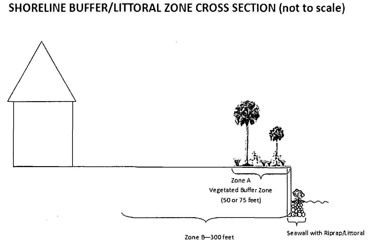
Shoreline Buffer Requirements. Development Regulations. Two (2) zones are hereby created. The boundaries of the zones and the restrictions applying to these zones are as follows:
a.
Zone A and Zone B Buffer Areas. Each Buffer Area shall be measured as follows:
(1)
Downstream of the Gordy Road structure; the area measured from the mean high water line (MHWL) landward;
(2)
Upstream of Gordy Road structure; the area measured from the ordinary high water line (OHWL) landward, or
(3)
Adjacent riparian wetlands; the area measured from the landward boundary of Waters of the State, as defined by the Florida Department of Environmental Protection or South Florida Water Management District, whichever is greater, landward.
b.
Buffer Widths.
(1)
Zone A.
i.
Fifty (50) feet for platted lots of record prior to, and on August 1, 1989; and
ii.
Seventy-five (75) feet for platted lots of record after August 1, 1989 and unplatted lots.
(2)
Zone B. The buffer width for Zone B shall be three hundred (300) feet for all platted lots of record and unplatted lots.
c.
Buffer Regulations.
(1)
Zone A.
i.
Activities permitted in Zone A include the removal of non-native vegetation and/or the minimum alteration of native vegetation associated with the construction of a permitted private access point or dock. An access path shall not exceed twenty (20) feet in width.
ii.
Activities prohibited in Zone A include any construction, development activities, motorized vehicles, and shoreline alteration, unless authorized by a variance granted in accordance with Section 10.01.30 of the St. Lucie County Land Development Code.
iii.
Zone A shall be preserved or planted with native vegetation as approved by the Environmental Resources Director, or designee. If native vegetation does not exist within all, or a portion of Zone A the buffer shall be planted with native vegetation. Shoreline replanting shall be in accordance with the minimum planting requirements in Section 6.02.02(E).
(2)
Zone B. The following activities are prohibited in Zone B unless authorized by a variance granted in accordance with Section 10.01.30 of the St. Lucie County Land Development Code:
i.
Development activity that does not comply with St. Lucie County's flood damage prevention regulations (Section 6.05.00 of the St. Lucie County Land Development Code);
ii.
Public or private road rights-of-way (except for individual driveways and/or canal maintenance easements);
iii.
Retention ponds or stormwater systems other than a berm and/or swale for the purpose of preventing sheet flow into the water body as approved by the Environmental Resources Director (except for lawfully permitted drainage conveyance outfalls);
iv.
New septic systems;
v.
Wastewater lift stations;
vi.
Petroleum, chemical, fertilizer or manure storage areas.
C.
Indian River Lagoon Shorelines.
1.
Applicability. Shorelines of any lot of record platted after August 1, 1989 adjacent to the Indian River Lagoon and associated natural creeks, tributaries, riparian wetlands and oxbows, including Taylor Creek between the submerged weir east of Rosarita Avenue northwest to the Fort Pierce Farms Water Control District Structure No. 1, are subject to the regulations contained herein.
2.
Shoreline Buffer Requirements.
a.
Buffer Area. The Buffer Area shall be measured as follows:
(1)
The area measured from the mean high water line (MHWL) landward;
(2)
Adjacent riparian wetlands; the area measured from the landward boundary of Waters of the State, as defined by the Florida Department of Environmental Protection or South Florida Water Management District, whichever is greater, landward.
b.
Buffer Widths. The Indian River Lagoon Shoreline Buffer shall measure fifty (50) feet, unless physically impossible as in the case of Indian River Drive occurring within fifty (50) feet of the MHWL.
c.
Buffer Regulations.
(1)
Activities permitted in the Buffer include the removal of non-native vegetation and/or the alteration of native vegetation associated with the construction of a permitted private access point or dock.
(2)
Activities prohibited in the Buffer include any construction, development activities, motorized vehicles, and shoreline alteration, unless authorized by a variance granted in accordance with Section 10.01.30 of the St. Lucie County Land Development Code.
(3)
The Buffer shall be preserved or planted with native vegetation as approved by the Environmental Resources Director, or designee. If native vegetation does not exist within all, or a portion of, the Indian River Lagoon Shoreline Buffer, the buffer shall be planted with native vegetation. Shoreline replanting shall be in accordance with the minimum planting requirements in Section 6.02.02.E.
D.
Hardened/Armored Shorelines.
1.
New Construction. Installation of any new shoreline hardening or armoring in waterways as defined by Section 6.02.02(B) and Section 6.02.02(C) shall only be permitted when a Variance has been granted per Section 10.01.30.
In the absence of design criteria provided by the appropriate jurisdictional agency, the structure shall be constructed as follows:
a.
Seawalls shall include riprap installed at a minimum 2H:1V slope and to the mean high water line (MHWL), ordinary high water line (OHWL), or four feet (4) above the bottom of the seawall, whichever is higher; unless otherwise certified by a Professional Engineer (P.E.). The riprap shall be planted with native vegetation at elevations as determined by the Environmental Resources Director, or designee.
b.
Hardened shorelines other than a seawall, shall include riprap installed at a minimum 2H:1V slope, to the mean high water line (MHWL), ordinary high water line (OHWL); unless otherwise certified by a Professional Engineer (P.E.). The riprap shall be planted with native vegetation as detailed in D. 3. below.
c.
New construction projects are required to meet the shoreline buffer requirements as outlined in Sections 6.02.02 (B), (C), and (D).
2.
Replacement Construction. Replacement of existing seawalls or other hardened shoreline armoring in waterways as defined by Section 6.02.02(B) and Section 6.02.02(C) shall be permitted only if no impacts to mangrove or seagrass are proposed unless authorized by a variance granted in accordance with Section 10.01.30 of the St. Lucie County Land Development Code. New structures shall be constructed using the design criteria in D.1.a. and b. above or to the design criteria required by a state and/or federal jurisdictional agency.
Replacement construction projects are required to meet the shoreline buffer requirements as outlined in Sections 6.02.02 (B), (C), and (D).
3.
Littoral Zone Planting Requirement. A minimum five (5) foot wide littoral zone is required and shall be planted with native aquatic vegetation as required in Section 6.02.02(B) and Section 6.02.02(C) unless otherwise approved by the Environmental Resources Director.
4.
Water Control Structure Maintenance. Nothing in this section shall be construed to inhibit the revetment installation or maintenance, repair, or restoration of existing revetment around structures installed and maintained for the purpose of water control. All repair and restoration work shall implement appropriate best management practices to ensure that State water quality standards are met.
E.
Minimum Planting Requirements.
1.
One (1) 25-gallon tree species per nine hundred (900) square feet of buffer; and
2.
One (1) 3-gallon shrub species per one hundred (100) square feet of buffer; and
3.
One (1) 1-gallon groundcover species per nine (9) square feet of buffer; and
4.
One (1) bare root or liner grass or herbaceous species per four (4) square feet of buffer shall be planted.
5.
Where appropriate, the buffer shall include plants that are tolerant to inundation as a measure to minimize bank erosion and improve water quality.
6.
Planting requirements shall not interfere with maintenance activities encumbered by a maintenance easement which has been granted by any governmental agency, including all 298 Districts including North St. Lucie River Water Control District and the Fort Pierce Farms Water Control District.
F.
Preserve Area Management Plan. A Preserve Area Management Plan is required for shorelines that are impacted as part of a development permit. The Preserve Area Management Plan shall detail management of the Shoreline Buffer including native plant replanting, exotic removal, allowable uses, etc. The Preserve Area Management Plan shall be submitted at the time of application and approved by the Environmental Resources Director, or designee prior to issuance of a Vegetation Removal Permit.
G.
Exemptions. The following activities are exempt from the Shoreline Protection Regulations in Section 6.02.02, with conditions:
1.
Existing lots of record as of August 1, 1989, adjoining the Indian River and its tributaries.
2.
Activities conducted by 298 Water Control Districts (including Fort Pierce Farms Water Control District and North St. Lucie River Water Control District). Removal of native vegetation which is necessary for the construction of utilities including roads, streets, culverts, bridges, canals, ditches control structures, and utilities excluding staging areas and with the following conditions:
a.
Any disturbed area shall be restored to existing grade where feasible and planted with native vegetation within ninety (90) days of completion of construction.
b.
The shoreline shall be replanted according to the minimum planting requirements in Section 6.02.02(E) within ninety (90) days of completion of construction.
H.
Violations.
1.
Activities within the shoreline buffer not in compliance with the requirements of this section will be issued a Notice of Violation and/or Stop Work Order by The Environmental Resources Department or Code Enforcement requiring the cessation of all work. The Notice of Violation and/or Stop Work Order shall be served to any person performing work and a copy of the Order shall be posted upon the property visible from the street. A copy of the Notice of Violation and/or Stop Work Order shall also be sent by Certified Mail, return receipt requested, to the address of the owner listed on the rolls of the St. Lucie County Property Appraiser. Posting of the notice on the subject property shall be prima facie evidence of the notice to owner.
2.
In the event that the violation is not corrected within ninety (90) days from the date of Notice of Violation and/or Stop Work Order, the County may pursue code enforcement action following Sections 1-2-22 through 1-2-25 of the St. Lucie County Code of Ordinances. The Environmental Resources Director may recommend restoration of the buffer at the County's expense and the cost of restoration including the cost of plants, transportation, staff time, installation and maintenance, shall become a lien upon the property.
(Ord. No. 13-038, Pt. A, 9-3-2013; Ord. No. 14-019, Pt. A, 9-16-2014)
6.02.03. - Wetlands Protection.
A.
Generally.
1.
Purpose: The purpose of this Section is to protect the wetlands of St. Lucie County from net loss. Wetlands provide the functions of floodwater storage, aquifer recharge, stormwater filtering, and habitat for fish and wildlife.
2.
Permit Required: Any construction, dredging, filling, or alteration in, on, or over a jurisdictional wetland shall require a permit in accordance with this Section and Section 11.05.12 unless specifically exempted by Section 6.02.03(G) of this Code.
B.
Jurisdiction.
1.
The County shall have regulatory authority over all wetlands as defined in Chapter II of this Code, with the exception of:
a.
Isolated wetlands, less than one-half-acre total area, entirely surrounded by uplands; and
b.
Stormwater treatment and flood attenuation ponds as permitted by the South Florida Water Management District which are located behind a water control structure, with no overlap on wetlands.
c.
Manmade sewage treatment and percolation ponds as permitted by the Florida Department of Environmental Protection.
2.
Permit applications for which the St. Lucie County Board of County Commissioners is the applicant shall be processed by other State and Federal agencies as appropriate.
3.
Upon request, the Growth Management Director shall provide a wetlands jurisdictional determination of a specified parcel of land. The request shall include at least three (3) aerial photographs of the land at a scale of 1"=200' or less scale, with the subject property boundaries clearly marked. At the request of the Director, the land owner may be required to provide directions, access, or field marking of the subject parcel. Such jurisdictional determinations shall be considered accurate by the Director for a period of two (2) years, unless a subsequent request for jurisdictional determination is made.
C.
Coordination with other Agencies.
1.
The County permitting mechanism in this section is not intended to supersede or substitute for other permits required by state or federal agencies, but the County permit shall be construed as a formal recognition that the actions of state and federal regulatory agencies are sufficient to implement the St. Lucie County Comprehensive Plan goals, objectives, and policies related to wetlands.
2.
To the maximum extent practical, the County shall use application forms already being utilized by state and federal regulatory agencies. Where another permit is required, the County shall review applications within the same time frame as the other permitting agencies, except that where the County requires additional information not provided to any other agency, the County may review the application for a period of time not to exceed an additional twenty (20) days.
D.
Criteria for Granting Permits.
1.
A permit may not be issued pursuant to this Code until it is determined that the following general criteria will be met:
a.
There shall be no net loss of wetland values and functions.
b.
The project will not adversely affect the conservation of fish or wildlife or their habitats.
c.
The project will not cause excessive shoaling or erosion.
d.
The project will not adversely affect commercial or recreational fisheries or their habitat.
e.
The project will not adversely impact endangered species, threatened species, and species of special concern and/or their habitat.
f.
Project alternatives and modifications to lessen impacts are not feasible.
g.
The project does not adversely impact any other federal, state or local designated preserve or conservation area.
h.
The cumulative impacts of the subject project and other similar projects also will meet the criteria of this section.
i.
No dredging or filling shall occur in seagrasses except that which may be allowed by Section 6.02.03(E).
j.
Any structure proposed on or over a wetland is water dependent.
2.
In addition to the foregoing general criteria, a permit for any bulkhead permitted by the Growth Management Director (except those located within a commercial boat haul out facility) shall be issued only if:
a.
The bulkhead is faced with riprap stacked at a minimum 2 horizontal: 1 vertical (2H:1V) slope at least to the height of MHW (or OHW), or four (4) feet above bottom, whichever is less, or
b.
A minimum three-foot-wide littoral zone is planted and maintained with native aquatic vegetation at the appropriate elevations. Alternatively, new sections of riprap of no more than fifty (50) feet in length shall be permitted providing all other criteria of this Section are met.
E.
Mitigation.
1.
For projects that do not meet the permitting criteria of Section 6.02.03(D), the Growth Management Director may evaluate proposals for mitigation when the criteria in paragraphs 2 or 3 below are met.
2.
When to Evaluate Mitigation Proposals.
a.
No Alternative Site: Restoration or creation may be permitted to compensate for wetland loss where an applicant demonstrates that the proposed activity cannot be practicably located on the upland portion of this site or another site.
b.
All Practical Measures will be taken to Reduce Impact: Restoration or creation may be permitted to compensate for wetland loss only where the applicant has modified the proposed development to reduce wetland loss and degradation. Acceptable modifications include site design to reduce fill into or drainage of the wetland; other erosion control measures where the activity will cause erosion; construction of pretreatment facilities for stormwater to be discharged into wetlands; and, scheduling restoration activities at such time of year as would have the least impact upon the wetland or endangered or threatened species.
3.
Mitigation for Loss of Small Wetlands. A developer may propose off-site mitigation for loss of wetlands of less than two (2) contiguous acres, but more than one-half-acre and otherwise subject to the regulations under Section 6.02.03.
4.
Standards for Mitigation.
a.
No Overall Net Losses: Restoration or creation of wetlands shall be permitted to compensate for wetland losses only where restoration and/or creation will restore lost wetland functions and values. The following mitigation ratios shall be presumed to provide wetland functions and values if new wetlands are being created:
(1)
Tidal wetlands 2.0:1;
(2)
Freshwater forested swamp, non-cypress dominated 2.5:1;
(3)
Freshwater forested swamp, cypress dominated 2.0:1;
(4)
Freshwater marshes 1.5:1.
If the proposed wetland creation depends extensively on natural recolonization the ratio may be 3.0:1 to 4.0:1. Only where the created wetland can be expected to surpass the values and functions of the existing wetland can the ratio be adjusted downward.
The Growth Management Director shall require a ratio for restored or created functions and/or acreage exceeding the above ratios where:
(1)
Uncertainties exist as to the probable success of the proposed restoration or creation of wetlands; or,
(2)
The degradation or destruction of wetlands will deprive St. Lucie County of various wetland values for a period of time until the restoration or creation is completed and functional; or,
(3)
Mitigation is proposed offsite or not in kind; or,
(4)
Mitigation proposed includes restoration or enhancement of existing wetlands rather than creation of new wetlands.
b.
Adequate Hydrology, Soils and Other Basic Requirements: Wetland restoration, enhancement, or creation shall be permitted only where those hydrologic, soil, side slope, and other basic characteristics of the proposed project are adequate to achieve the proposed project goals.
c.
Function: Wetland restoration or creation shall be permitted to compensate for new wetland losses only where the restored or created wetland will be at least as functional as the existing wetland system it is intended to replace.
d.
Sufficient Financial Resources: Guarantees and sureties for approved mitigation shall be provided in accordance with Section 11.04.00.
e.
Maintenance and Monitoring: For all mitigation projects, the Growth Management Director shall require, at a minimum:
(1)
Maintenance of at least ninety percent (90%) survivorship of all plantings for at least two (2) years; and,
(2)
Annual monitoring reports of the status of the mitigation area, including number of surviving plantings and any plantings made to maintain ninety percent (90%) survivorship; and,
(3)
Annual replantings to maintain ninety percent (90%) survivorship; and,
(4)
Removal of exotic vegetation, as appropriate.
F.
Required Buffering. A buffer zone of native upland edge (i.e., transitional) vegetation shall be provided and maintained around isolated wetlands covered by this Section which are constructed or preserved on new development sites. The buffer zone may consist of preserved or planted vegetation but shall include canopy, understory, and ground cover of native species only. The edge habitat shall begin at the upland limit of any wetland or deepwater habitat. As a minimum, ten (10) square feet of such buffer shall be provided for each linear foot of wetland or deepwater habitat perimeter that lies adjacent to uplands. This upland edge habitat shall be located such that no less than fifty percent (50%) of the total shoreline is buffered by a minimum width of ten (10) feet of upland habitat. The upland buffer requirement does not apply to drainage canals or stormwater conveyance systems requiring periodic maintenance.
G.
Exemptions.
1.
The following activities are exempt from the permitting requirements of this Section:
a.
The installation of transmission lines that do not require dredging and/or filling of wetlands or alteration of mangroves or seagrasses.
b.
The installation of a dock in non-tidal waters, provided that:
(1)
The coverage over jurisdictional wetlands is four hundred (400) square feet or less; and,
(2)
The dock is intended for private, recreational, noncommercial use; and,
(3)
The dock is the sole dock as measured along the shoreline for a minimum distance of sixty-five (65) feet; and
(4)
No dredging or filling is necessary except for the placement of pilings; and,
(5)
The dock terminates in at least minutes three (3) feet OLW; and,
(6)
The dock will not obstruct navigation.
c.
The replacement or repair of existing functional piers, mooring piles or boat ramps at the same location and of the same dimensions as the pier, mooring pile or boat ramp being repaired or replaced.
d.
Replacement of an existing functional seawall, where no mangroves or seagrasses will be altered or removed, and dredging is done only as necessary to install the new wall, and provided further that the new wall is faced with:
(1)
Riprap stacked at a minimum 2H:1V slope, at least to the height of MHW (or OHW), or four (4) feet above bottom, whichever is less; or
(2)
A minimum three (3) feet wide littoral zone planted and maintained with native aquatic vegetation at the appropriate elevations as determined by the Growth Management Director.
e.
The performance of maintenance dredging of existing manmade nontidal canals, channels, and intake and discharge structures, where the spoil material is to be removed and deposited on a self-contained, upland spoil site which will prevent the escape of spoil material and return water from the spoil site into surface waters of the state, provided no more dredging is performed than is necessary to restore the canals, channels, and intake and discharge structures to original design specifications, and provided further that control devices are used at the dredge site to prevent turbidity and toxic or deleterious substances from discharging into adjacent waters during maintenance dredging. This exemption shall apply to all canals constructed before April 3, 1970, and to those canals constructed pursuant to all necessary state permits on or after April 3, 1970. This exemption shall not apply to the removal of a natural or man-made barrier separating a canal or canal system from adjacent waters of the state. For those canals constructed prior to April 3, 1970, where no previous permit has been issued by the Board of Trustees of the Internal Improvement Trust Fund or the United States Army Corps of Engineers for construction or maintenance dredging of the existing man-made canal orintake or discharge structure, such maintenance dredging shall be limited to a depth of no more than five (5) feet below OLW.
f.
The installation of aids to navigation, including but not limited to bridge fender piles, "No Wake" and similar regulatory signs, and buoys associated with such aids, provided that the devices are marked pursuant to F.S. § 327.40.
g.
Repair or replacement of existing stormwater discharge pipes to original configurations.
h.
The placement of riprap at the to of an existing seawall provided that no mangroves or seagrasses would be impacted.
i.
The construction of a culverted roadway crossing of a wholly artificial, non-tidal drainage conveyance canal provided that:
(1)
The size and number of culverts are adequate to pass normal high water stages of the canal being crossed; and,
(2)
The elevation of the culvert invert shall be at the existing bottom grade of the canal; and,
(3)
Clean fill shall be used, with resulting side slopes no steeper than 2H:1V; and,
(4)
The structure shall be maintained so as to continue to provide at least the same volume of discharge through the culvert(s); and,
(5)
Turbidity control devices are placed on either side of the structure so as to effectively isolate the project area from upstream and downstream waters.
j.
The installation, replacement, repair and maintenance of water control structures located in canal conveyance systems owned and operated by water management districts.
k.
Those projects to alter isolated wetlands that are permitted pursuant to the South Florida Water Management District isolated wetlands rule on or before the effective date of this Code, or where an application is received by the South Florida Water Management District on or before the effective date of this Code.
l.
Dredging or filling which is required to connect stormwater management facilities permitted by the South Florida Water Management District to non-tidal wetlands and which is incidental to the construction of such stormwater management facilities. Incidental dredging or filling shall include:
(1)
Headwalls and discharge structures; and,
(2)
Erosion control devices or structures to dissipate energy which are associated with discharge structures; and,
(3)
Outfall pipes less than twenty (20) feet in length in waters provided the pipe does not interfere with navigation; and,
(4)
Other dredging or filling which the Growth Management Director determines will have a similar effect as those activities listed above.
6.02.04. - Regulation of Motorized Vehicles in Environmentally Sensitive Areas.
1.
No motorized vehicle of any type shall be permitted on land owned by any governmental agency east of the Coastal Construction Control Line, unless authorized by the owner.
2.
Motor vehicle traffic is hereby strictly prohibited within the Dune Preservation Zone with the following exceptions:
a.
Emergency vehicles,
b.
County and private vehicles approved by the Florida Department of Environmental Protection (DEP) for use in beach cleaning and maintenance, or for other DEP approved uses,
c.
DEP approved sea turtle research vehicles, and
d.
Vehicles on any paved surface, driveway, parking lot, or maintained unpaved surface existing as of the effective date of this Code.
e.
Property permitted and constructed parking and driveway areas.
3.
No off-road use of a vehicle shall be permitted in any of the following areas:
a.
Wetlands regulated in Section 6.02.03 of this Code.
b.
Shorelines protected under Section 6.02.02 of this Code.
c.
Savannas State Reserve.
d.
Atlantic Coastal Ridge.
e.
Hutchinson Island dunes.
6.03.01. - Generally.
A.
Legislative Intent. The intent and purpose of this Section is to protect and safeguard the health, safety, and welfare of the residents of and visitors to St. Lucie County, Florida, by providing criteria for regulating deleterious substances and contaminants, and the design, location and operation of development, land uses and activities which may impair existing and future public water supply wells.
B.
Applicability.
1.
The prohibitions of this Section shall not apply to:
a.
residential activity, except as set out in Section 6.03.04 and
b.
nonresidential activity which has received prior development approval as set out in the exemptions in Section 6.03.05.
C.
Administrative Regulations.
1.
The Growth Management Director is charged by the Board of County Commissioners with the responsibility for administering and enforcing this ordinance and the regulations promulgated pursuant thereto.
2.
Any final action by the Growth Management Director may be appealed to the Board. An appeal may only be initiated by filing a written request with the County Administrator, or designee. Upon receipt of the request; and within a reasonable period of time not to exceed thirty (30) days, the request shall be scheduled before the Board. The request shall not be subject to the formal notice and advertisement requirements set out in Section 11.00.03. The appellant, however, shall be notified of the time and date of the public hearing. The Administrator shall be required to submit a report to the Board citing the reasons for the final action.
6.03.02. - Zone of Protection Maps.
Regulated Areas shall be shown on the maps described in this Section, as adopted by the Board, and incorporated herein by this reference. These maps shall be maintained by the Department and copies shall be provided to the St. Lucie County Public Health Unit, Treasure Coast Regional Planning Council, South Florida Water Management District, and any other agency requesting said maps.
A.
The Regulated Area maps shall illustrate existing and future public water supply wells and their zones of protection on both zoning maps and aerial maps (1" = 200') on file in the Department.
B.
The Regulated Area maps shall be reviewed annually and, if necessary, updated. Any amendments, additions or deletions shall be adopted by the Board by ordinance and shall be show on the Regulated Area maps.
6.03.03. - Prohibited Activities.
A.
No Development Order shall be issued for any nonresidential activity which stores, handles, produces or uses any Regulated Substances as defined in Chapter II within Regulated Areas unless exempt pursuant to Section 6.03.05.
B.
The following activities whether for residential or nonresidential activities are also prohibited:
1.
The location of septic systems within two hundred (200) feet of public water supply well, unless otherwise approved by DEP or HRS;
2.
The location of storm water wet retention/detention areas, as defined by SFWMD, within three hundred (300) feet of a public water supply well, unless otherwise approved by SFWMD;
3.
The location of wastewater treatment plant effluent discharges, including but not limited to, percolation ponds, surface water discharge, spray irrigation, or drainfields, within five hundred (500) feet of a public water supply well, unless otherwise approved by DER.
6.03.04. - Protection of Future Public Water Supply Well Sites.
The prohibitions and restrictions set forth in this Section, and any regulations promulgated pursuant thereto, shall apply to any future public water supply well sites adopted by the Board by resolution, provided, however, that the restrictions shall not apply to residential or nonresidential activities that have received development order approval as defined in Chapter II prior to the effective date of this Code.
6.03.05. - Exemptions.
A.
The following activities shall be exempt from the Regulated Area prohibition set forth in Section 6.03.03.
1.
Exemptions for Public Utilities: Public Utilities as defined herein for the routine operation; and maintenance of water treatment systems. This exemption does not apply to the Development Order for the maintenance and refueling of vehicles or the storage of Regulated Substances.
2.
Exemption for Continuous Transit and Deliveries: The transportation of any Regulated Substance through Regulated Areas provided the Regulated Substances are not being stored, handled, produced, or used within the Regulated Area in violation of this ordinance, and the delivery of Regulated Substances to nonresidential activities that have received a development order as defined in Chapter II prior to the effective date of this Code, provided that these activities require such substances for the continued operation; and maintenance of the activities as approved.
3.
Exemption for Vehicular Fuel and Lubricant Use: The use in a vehicle of any Regulated Substance solely as operating fuel in that vehicle or as lubricant in that vehicle.
4.
Exemption for Application of Pesticides, Herbicides, Fungicides, and Rodenticides: The application of those Regulated Substances used as pesticides, herbicides, fungicides, and rodenticides in recreation, agriculture, pest control and aquatic weed control activities provided that:
a.
In all Regulated Areas the application is in strict conformity with the use requirement as set forth in the EPA registries for substances and as indicated on the containers in which the substances are sold; and,
b.
In all Regulated Areas the application is in strict conformity with the requirements as set forth in F.S. Chs. 482 and 487, and Chapters 5E-2 and 5E-9, Florida Administrative Code. This exemption applies only to the application of pesticides, herbicides, fungicides, and rodenticides.
5.
Exemption for the Use of Fertilizers Containing Any Form of Nitrogen: The use of fertilizers containing any form of nitrogen provided that:
a.
For nonresidential recreational areas, including private golf courses, the application of nitrogen-containing materials shall be in accordance with manufacturers directions or recommendations of the St. Lucie County Agricultural Extension Agent, provided, however, the amount of fertilizer applied shall not exceed forty (40) pounds of nitrogen per acre per month average for the total area of two (2) pounds per thousand (1,000) square feet per month for any localized area within the activity.
b.
For agricultural areas, the application of nitrogen-containing materials shall be in accordance with manufacturers directions or recommendations of the St. Lucie County Agricultural Extension Agent, provided, however, the amount of fertilizer applied shall not exceed two hundred (200) pounds of nitrogen per acre per year.
c.
For nonresidential landscape areas, the application of nitrogen-containing materials shall be in accordance with manufacturers directions or recommendations of the St. Lucie County Agricultural Extension Agent on areas of ten thousand (10,000) square feet or less.
6.
Exemptions for Retail Sale and Wholesale Activities: Retail sale and wholesale establishments in Regulated Areas provided that the establishments only store and handle Regulated Substances for resale in their original unopened containers.
7.
Exemptions for Office Uses: Regulated Substances for the maintenance and cleaning of office buildings and Regulated Substances associated with office equipment such as copier or blueprint machines shall not be allowed onsite in quantities greater than the quantities exempted in Section 6.03.05(B).
8.
Exemptions for Approved Nonresidential Activities: The following nonresidential activities:
a.
Nonresidential activities existing as of the effective date of this Code which have received site plan, subdivision or similar development approval as defined in Chapter II and building permits as defined in Chapter II.
b.
Nonresidential activities existing as of the effective date of this Code which have received zoning compliance, occupational license, or similar forms of annual development approval as defined in Chapter II, and which do not require site plan, subdivision, or similar development approval and building permits. For the purposes of this exemption, renewal of annual Development Order shall also be exempt, provided, however, that there are not expansions, modifications or alterations that would increase the storage, handling, production, or use of the Regulated Substances.
B.
Any nonresidential activity which only stores, handles, produces, or uses the following quantities of Regulated Substances shall be exempt from the Regulated Area prohibition set out in Section 6.03.03.
1.
Whenever the aggregate sum of all quantities of any one (1) Regulated Substance for any one (1) nonresidential activity at a given facility/building or property at any one (1) time does not exceed six (6) gallons where said substance is a liquid, or twenty-five (25) pounds where said substance is a solid.
2.
Whenever the aggregate sum of all Regulated Substances for any one (1) nonresidential activity at one facility/building or property at any one (1) time does not exceed one hundred (100) gallons if said substances are liquids, or five hundred (500) pounds if said substances are solids, and the aggregate sum of all quantities of any one (1) Regulated Substance does not exceed the reference limits in Section 6.03.03.
3.
Where Regulated Substances are dissolved in or mixed with other Non-regulated Substances only the actual quantity of the Regulated Substance present shall be used to determine compliance with the provisions of this Section. The actual quantity of the Regulated Substance present shall be the total quantity of the original unopened container(s) regardless of concentration or purity.
6.03.06. - Special Exemptions.
A.
Request for exemption. Any person subject to the prohibitions set out in Section 6.03.03 may apply to the Growth Management Director for a Special Exemption.
B.
Information and fee required. The application for Special Exemption shall include, at a minimum, the following information on a form provided by the Director, as well as the appropriate filing fee as set out below:
1.
A concise statement detailing the circumstances which the applicant feels demonstrates the need for a Special Exemption.
2.
A description of the mechanisms that will be utilized to meet the conditions required for issuance of the exemption as set out in Section 6.03.06(C) below;
3.
The signatures of the owner of the subject site and applicant, if different, and a Florida registered Professional Engineer or Hydrogeologist certified in the State of Florida;
4.
A filing fee established by resolution of the Board to defray the costs of processing such application; and
5.
An agreement to indemnify and hold St. Lucie County harmless from any and all claims, liabilities, causes of action, or damages arising out of the issuance of the special Exemption. The County shall provide reasonable notice to the, exemptee of any such claims.
C.
Review by the Planning and Development Services Director.
1.
Within thirty (30) working days of receipt of an application for Special Exemption, the Director or designee shall inform the applicant in writing whether such application contains sufficient information for a proper determination to be made. If the application is found to be insufficient, then the Director shall provide to the applicant a written statement by certified mail or hand delivery requesting the additional information required. The applicant shall inform the Director or designee within ten (10) working days of the date of the written statement of his or her intent to either furnish the information or have the application processed as it stands.
2.
Prior to notifying the applicant where applicable in subsection 1. above, the Growth Management Director shall request from the County Hydrogeologist, as applicable:
a.
Written comments regarding the sufficiency of the application; and
b.
A written recommendation for issuance with applicable conditions or denial.
3.
The County Hydrogeologist shall make appropriate surveys, tests and inspections of property, facilities, equipment and processes proposed or operating under the provisions of this section to determine compliance with the provisions of this section. At a minimum, a written inspection report from the County Hydrogeologist to the Growth Management Director shall be required prior to the issuance of a Certificate of Occupancy.
4.
Issuance or denial: At the end of said ten-day period or receipt of the additional information the Growth Management Director or designee shall within thirty (30) working days inform the applicant whether the Special Exemption has been granted or denied. If the Director denies the application, the Director or designee shall provide the applicant with a written notice outlining the reasons that the permit was denied.
5.
Criteria for issuance: The Growth Management Director shall grant an exemption if the person applying for the exemption demonstrates that adequate technology exists to isolate the facility or activity from the potable water supply within the Zone of Protection wherein the proposed facility or activity would be located. At a minimum, the following conditions shall be met in order to meet this criteria:
a.
Substance inventory;
b.
Containment;
c.
Emergency collection devices;
d.
Emergency plan;
e.
Daily monitoring;
f.
Equipment maintenance;
g.
Reporting of spills;
h.
Potable water well monitoring;
i.
Groundwaste monitoring;
j.
Alterations/expansions;
k.
Reconstruction after catastrophe (fire, vandalism, flood, explosion, collapse, wind, war or other); and,
l.
Others, as applicable to groundwater protection.
All costs associated which such applicable conditions shall be borne by the applicant or exemptee, as applicable.
6.
Revocation or revision: Any Special Exemption granted by the Planning and Development Services Director pursuant to this Section shall be subject to revocation or revision by the Director for violation of any condition of said Special Exemption by first issuing a written notice of intent to revoke or revise (certified mail return receipt requested or hand delivery). The applicant shall have the right to a hearing before the Code Enforcement Board prior to revocation or revision in accordance with the procedures set out in Section 11.13.00. Upon revocation or revision, the activity will immediately be subject to the enforcement provisions of this ordinance.
7.
Appeals: Any final action by the Planning and Development Services Director may be appealed according to the procedures set forth in Section 11.11.00 of this Code.
8.
Other agency requirements: Any Special Exemption granted by the Growth Management Director pursuant to this Code shall not relieve the exemptee of the obligation to comply with any other applicable federal, state, a regional or local regulation, rule, ordinance or requirement. Nor shall said exemption relieve any exemptee of any liability for violation of such regulations, rules, ordinances or requirements.
9.
New regulations: Upon adoption of any amendment to this Section or any regulation that supersedes this Section, the Special Exemption shall be subject to the newly adopted regulations.
(Ord. No. 21-030, § 2, 9-7-2021)
6.03.07. - Enforcement and Penalties.
A.
Enforcement, penalties, appeals, and remedy of matters related to this ordinance shall be in accordance with Section 11.13.00, Enforcement of Code Provisions.
B.
Each person who commits, attempts to commit, conspires to commit, or aids and abets in the commission of any act declared herein to be in violation of this ordinance whether individually or in connection with one (1) or more persons, or as a principal, agent or accessory, shall be guilty of such offense and every person who falsely, fraudulently, forcibly or willfully entices, causes, coerces, requires, permits or directs another to violate any provision of this ordinance is likewise guilty of such offense.
C.
Each day that a violation of this ordinance is continued or permitted to exist without compliance shall constitute a separate offense.
D.
No development orders shall be issued to any violator of this Section until the violation(s) have been properly abated to the satisfaction of the County.
(Ord. No. 21-030, § 2, 9-7-2021)
6.04.01. - Native Upland Habitat Protection.
A.
Purpose. The purpose of this Section is to contribute to implementation of Objective 8.1.8 of the St. Lucie County Comprehensive Plan and to protect native upland habitats from destruction through development or the effects of development, in order that St. Lucie County might continue to enjoy a diversity of plant and animal life supported by the plant communities native to this area, and in particular the endangered and threatened species found within the County.
B.
Generally.
1.
The Growth Management Director shall designate and map the areas to be to be included in the Inventory of Environmentally Sensitive Native Upland Habitats for purposes of this Code. The Inventory shall include properties or portions of properties that, as a part of any proposal for development or alteration, shall be reviewed for possible public acquisition or for partial preservation through a conservation easement or other method to be approved by the Board of County Commissioners.
2.
Unless designated and mapped by the Growth Management Director prior to the application for a Development Order, the following areas shall be excluded from consideration as native ecosystems for purposes of this Section:
a.
All residentially zoned lots of record as of August 1, 1990, consisting of less than one and one-half (1½) acres.
b.
An area where the environmentally sensitive land has been altered lawfully prior to the adoption of this Code and where the environmentally sensitive land no longer retains the natural values and functions on which the designation of environmental sensitivity is based.
3.
A property owner who desires an exemption from this Section on the basis of prior lawful alteration may submit an application for exemption to the Growth Management Director, with accompanying evidence that he or she is entitled to the exemption pursuant to this Section.
4.
All lots or properties on which an application for a vegetation removal permit or an application for a Preliminary Development Order has been received shall be evaluated for possible inclusion wholly or in part in the Inventory of Environmentally Sensitive Native Upland Habitats, unless the Growth Management Director has previously issued an exemption.
C.
Approval Criteria for Alteration or Development. A proposed land alteration, as defined in Chapter II, or development on a property listed wholly or in part on the Inventory of Environmentally Sensitive Native Upland Habitats shall be approved only if:
1.
The project design and approval conditions provides for the protection and preservation of the values and functions of the environmentally sensitive lands to the maximum extent feasible, considering the type of development proposed; and
2.
A satisfactory management plan of any proposed preserve area has been prepared by the applicant which shall include, but not be limited to, eradication and continued monitoring and removal of exotic species, fencing, and periodic controlled burning or other mechanical methods that would simulate the natural processes of the historic fire regime, as appropriate; and
3.
For those lands identified for preserve status, appropriate deed restrictions, dedication to a public entity or approved private conservation group, or conservation easements are proposed to ensure preservation; and
4.
Clustering of development on less sensitive portions of the site has been considered; and
5.
For a site on which endangered, threatened or rare species or species of special concern (listed species) are present, one (1) of the following criteria can be satisfied:
a.
The applicant successfully demonstrates that the proposed alteration or development will not preclude the continued survival and viability of those listed species located on the site; or
b.
The applicant presents a plan for relocation, either on-site or off-site, for those listed species, which has been reviewed and approved by all appropriate agencies.
D.
Supplemental Information Required When Applications are Filed Pertaining to Properties Listed on the Inventory.
1.
Any Person applying for a vegetation removal permit or Development Order on land that is listed on the Inventory of Environmentally Sensitive Native Upland Habitats, shall provide a professionally prepared supplemental submission containing the following information:
a.
A list of endangered or threatened species and species of special concern found on the site; and
b.
Colonial bird nesting or roosting areas or areas in which migratory species are known to congregate; and
c.
A description of proposed operations to be performed on site, including use, storage, handling, or production of substances known to be harmful to plants and/or animals; identification of any pollutants expected to be emitted during project operation; and identification of solid wastes generated and disposal methods expected to be used; and
d.
A discussion of project alternatives, including options considered and rejected and the rationale for rejection of each option considered; and
e.
Proposed mitigation measures in detail as they relate to possible loss of habitat or impact on endangered, threatened or rare animal and plant species, or species of special concern.
2.
If no other application under this Code is pending, but an alteration is proposed for property already listed on the Inventory of Environmentally Sensitive Native Upland Habitats, an application for a sensitive land alteration permit shall be prepared on a form furnished by the Growth Management Director.
E.
Procedure for Review of Applications Pertaining to Inventory Properties.
1.
Upon receipt of the completed application for a sensitive land alteration permit, vegetation removal permit, or Development Order pertaining to a property listed on the Inventory of Environmentally Sensitive Native Upland Habitats, the Growth Management Director shall review and evaluate the environmental impacts of said proposal in light of Objective 8.1.8 of the Conservation Element of the Comprehensive Plan and the associated policies. The Director shall work with the applicant and other environmental agencies to provide the best possible development or alteration proposal to satisfy the goals this Code and the Comprehensive Plan as well as allowing for economic use of the property.
2.
The Growth Management Director shall complete its review of the completed application for an alteration permit within twenty (20) working days and approve, approve with conditions, or deny the permit.
3.
The Growth Management Director shall review a supplemental submission of native ecosystems information within twenty (20) days or within the same time period that the underlying application is required to be reviewed, whichever is longer.
F.
Public Acquisition.
1.
Should the Growth Management Director determine that public acquisition of an interest in the property is the best option to protect these environmentally sensitive lands proposed for development, the Director shall initiate action before the Board of County Commissioners or other appropriate governmental entity for consideration of such possibility. Action on the development application shall be deferred by the Director for a period of time not to exceed sixty (60) days while said agencies consider the public acquisition of said land. At the expiration of the sixty-day period, the development application shall be allowed to proceed through the development approval process, subject to review as described in this Section unless the land has been acquired or interest in public acquisition is formally confirmed.
2.
Should the Board and/or other governmental entity decide that public acquisition is the best option to protect all or part of these environmentally sensitive lands proposed for development, approval of the proposed development will be deferred for a period not to exceed one hundred eighty (180) days to allow time to complete public acquisition.
3.
Should the Board and/or other governmental entity decide not to acquire all or part of the particular site containing environmentally sensitive lands, the development application, as modified for any lands acquired by the public, shall be allowed to proceed through the development approval process, subject to review as described in this Section.
G.
Determination of Sufficiency.
1.
The owner of land listed on the Inventory of Environmentally Sensitive Native Upland Habitats who wishes to arrange for the preservation of environmentally sensitive portions of his or her lands prior to development may file an application with the Growth Management Director for a determination of sufficiency of the proposed boundaries of environmentally sensitive native ecosystems to be preserved.
2.
The application for a determination of sufficiency shall include at least the following information prepared by a qualified professional approved by the Growth Management Director:
a.
Boundaries of land to be set aside in a preserve status and a legal description of the entire tract;
b.
A vegetation inventory and such other information as the Growth Management Director may require to determine the quality of the habitat;
c.
A list of endangered or threatened species and species of special concern found on the site; and
d.
Colonial bird nesting or roosting areas or areas in which migratory species are known to congregate; and
e.
A proposal for appropriate deed restrictions, dedication to a public entity or approved private conservation group, or conservation easements to ensure preservation; and
f.
A proposal for conditions to be attached to the development to assure that construction and operations do not degrade the quality of habitat found on the area to be preserved.
3.
Upon receipt of the application for a determination of sufficiency, the Growth Management Director shall review the proposal for completeness and respond to the applicant within twenty (20) working days with an approval or a denial. The Director shall approve the application unless it is determined that:
a.
The property should be submitted to the Board of County Commissioners or other appropriate governmental entity for consideration for possible acquisition; or
b.
The values and functions of the habitat proposed for preservation are insufficient to meet the goals and policies of the St. Lucie County Comprehensive Plan with regard to preservation of environmentally sensitive habitat; or
c.
There is a reasonable doubt whether the preservation measures proposed will meet the spirit and intention of the goals and policies of the Comprehensive Plan with regard to habitat preservation.
H.
Fees. Fees shall be charged for the determination of sufficiency according to a schedule set by resolution of the Board of County Commissioners.
I.
Appeals. Any administrative decision made under this Section may be appealed according to the procedures described in Chapter 11.11.00.
(Ord. No. 21-030, § 3, 9-7-2021)
6.04.02. - Sea Turtle Protection.
A.
Purpose and Intent.
1.
The purpose of this Section, recognizing the unique characteristics of the sea turtle, particularly its nesting cycle, is to prevent and reduce the hazards impacting sea turtles from uncontrolled development activity, beachfront lighting, beach access, beach-dune preservation, stabilization and restoration activities, mechanical beach cleaning, and other coastal activities.
2.
It is the intent of this Section to assist in implementing Federal and State laws regarding the protection of sea turtles, to implement the recommendations of the Hutchinson Island Resource Planning and Management Plan, the analysis entitled "Issues Confronting Sea Turtle Protection in St. Lucie County", and the St. Lucie County Comprehensive Plan, and to provide a management framework for sea turtle protection.
B.
Management Coordination. The Growth Management Director shall be responsible for establishing administrative policies germane to the effective and timely implementation of conditions set out in this Section.
1.
The Growth Management Director shall maintain a process whereby:
a.
A person submitting a site plan and/or building plan for coastal development within jurisdictional boundaries is made aware of all instructions, requirements, and guidelines contained herein by inclusion or reference.
b.
Check off procedures are established to ensure that coastal development within jurisdictional boundaries is not approved as part of a site plan and/or building plan prior to approval of a Sea Turtle Protection Plan (STPP), if required, and that no Certificate of Occupancy is issued prior to approval of the beachfront lighting for coastal development.
2.
Coordination with the Department of Environmental Protection (DEP): The Growth Management Director shall maintain, in consultation with DEP, a process whereby:
a.
A person submitting a Sea Turtle Protection Plan (STPP), or a permit application to DEP, is made aware of the potential approval and permitting requirements of each agency, respectively.
b.
A STPP submitted to the Growth Management Director is made available to DEP if requested.
c.
A STPP submitted to the Growth Management Director is reviewed in consultation with DNR if the proposed activity requires a DEP permit.
d.
Conditions imposed by the Growth Management Director for sea turtle protection are consistent with State guidelines, rules and regulations.
e.
The Growth Management Director receives a copy of all permits granted by DEP for coastal construction seaward of the Coastal Construction Control Line, established pursuant to F.S. § 161.053.
3.
Coordination with the Florida Department of Environmental Protection (DEP): The Growth Management Director shall maintain, in consultation with DEP, a process whereby upon adoption of this article the Growth Management Director receives a copy of all permits granted by DER for any coastal development within jurisdictional boundaries or below mean high water in the Atlantic Ocean.
4.
Coordination with the U.S. Army Corp of Engineers (COE): The Growth Management Director shall maintain, in consultation with COE, a process whereby upon adoption of this article the Director receives a copy of all permits granted by COE for any coastal development within jurisdictional boundaries or below mean high water in the Atlantic Ocean.
C.
Jurisdiction. As used in this Section, jurisdictional boundaries means the area between State Road A1A and the Atlantic Ocean, or between the coastal construction control line, established pursuant to F.S. § 161.053, and the Atlantic Ocean, whichever is greater.
D.
Prohibition of Activities Disruptive to Sea Turtles. The following prohibitions during the nesting season (March 1 through November 15) are established for the protection of sea turtles:
1.
Prohibition of Horseback Riding. Horseback riding shall be prohibited on or seaward of the primary dune during the nesting season, except when a special permit is issued by the Growth Management Director in accordance with regulations adopted by resolution of the Board.
2.
Prohibition of Campfires. Campfires shall be prohibited on or seaward of the primary dune during the nesting season.
3.
Extension of Prohibition Areas. Areas of prohibition for the miscellaneous activities described in this section are extended to all areas landward of the primary dune where sea turtles are known to nest.
E.
Sea Turtle Protection Plan (STPP) Requirement for Coastal Development within Jurisdictional Boundaries.
1.
A Sea Turtle Protection Plan (STPP) shall be required for:
a.
All coastal development within jurisdictional boundaries involving the installation of permanently mounted light fixtures.
b.
All coastal development conducted during the nesting season (March 1 through November 15) seaward of the primary due or at night within jurisdiction boundaries, including site development, beach-dune preservation, stabilization and restoration projects, and mechanical beach cleaning.
F.
Sea Turtle Protection Plan (STPP) Application Contents.
1.
Preparation and Submission of STPP. A STPP shall be submitted to the Growth Management Director concurrently with the submission of a building and/or site plan. The STPP shall include the following information, as applicable:
a.
General Information. A STPP required pursuant to Sections 6.04.02(E)(1)(a) and (b) shall include the following information, as applicable:
(1)
Identification of person(s) having a legal or equitable interest in the subject property.
(2)
Legal description of the subject property.
(3)
Name of the general contractor for the project.
(4)
Assurance that the applicant has written authority to act as agent for person(s) with legal or equitable interest in the subject property.
(5)
Description of the proposed development and intended land use.
(6)
Scaled map of the site with a north arrow.
b.
Light Information. A STPP required pursuant to Section 6.04.02(E)(1)(a) shall include the following information, as applicable, for all areas of the subject property within line of sight of the beach:
(1)
The location, number and positioning of proposed floodlights, spotlights and other fixtures discharging high intensity lighting from incandescent, fluorescent, mercury vapor or high pressure sodium lamps.
(2)
The intensity of the light source emanating from the fixtures identified in Section 6.04.02(F)(1)(b)(1).
(3)
The location, number, positioning, and type of all other artificial light sources including, but not limited to, those used on balconies, walkways, recreational areas, roadways, parking lots, dune crossovers, decks, boardwalks and signs.
(4)
Protective/mitigative measures to minimize lighting impacts on sea turtles, including measures to prevent direct illumination of areas seaward of the primary dune.
c.
Development Information. A STPP required pursuant to Section 6.04.02(E)(1)(b) shall include the following information, as applicable:
(1)
A schedule of proposed development periods.
(2)
The number of linear feet of shoreline seaward of the primary dune upon which development will occur.
(3)
The number and type of vehicles anticipated during development, the type of equipment and materials to be used seaward of the primary dune, and the location of beach access points to be used in moving equipment and materials to and from the development site.
(4)
The location, number, positioning, and type of temporary nighttime security lights.
(5)
The location, number, positioning, and type of nighttime construction lights and the extent of areas seaward of the primary dune to be illuminated.
(6)
Protective/mitigative measures to minimize development impacts on sea turtles.
G.
General Standards for Coastal Development within Jurisdictional Boundaries. The following standards shall apply to all coastal development specified in Section 6.04.02(E) and, as applicable, shall be incorporated in a Sea Turtle Protection Plan (STPP):
1.
Sea Turtle Protection Plan (STPP) Approval: Growth Management Director approval of a STPP is required prior to the issuance of a building permit or approval of a site plan. Approval of a STPP does not relieve person(s) from complying with all other applicable conditions set out in this Section or from mitigation against subsequent negative impacts to sea turtles, their nests or eggs resulting from the approved activity.
2.
Timing Considerations: Coastal development shall be limited to the maximum extent possible to the non-nesting season (November 16 through February 29). Coastal development occurring during any portion of the nesting season (March 1 through November 15) shall be conducted during daylight hours whenever possible.
3.
Coastal Development Seaward of Primary Dune During the Nesting Season: Appropriate protective/mitigation measures for sea turtles, developed pursuant to this Section, shall be implemented for all coastal development seaward of the primary dune during the nesting season.
4.
Restrictions on Nighttime Security Lighting: Temporary nighttime security lighting should be limited to the fewest number of lights necessary to provide adequate security. Those lights which are used shall not:
a.
Be mounted more than fifteen (15) feet above the ground.
b.
Illuminate areas outside of the subject property.
c.
Directly illuminate areas seaward of the primary due unless specific protective/mitigative measures for lighting impacts are developed pursuant to this Section.
5.
Nighttime Development During the Nesting Season: To avoid potential lighting impacts on nesting adults and emergent hatchlings, protective/mitigative measures for sea turtles which comply with Section 6.04.02(l) may be required for nighttime coastal development during the nesting season, in addition to those below.
6.
Protective/Mitigation Measures: Protective/mitigative measures shall include, but not be limited to, the following, as applicable:
a.
Preliminary Site Survey. A permitted agent of the State shall conduct a preliminary site survey and relocate all sea turtle nests to a safe habitat for coastal development seaward of the primary due during the nesting season.
b.
Exemption of Preliminary Site Survey. Development activity in progress as of March 1 of each year shall be exempt from a preliminary site survey but shall implement daily nesting surveys pursuant to Section 6.04.02(G)(6)(e).
c.
Delay of Development. If nests are known to be present during a preliminary site survey and cannot be located and removed to a safe habitat, development shall be delayed for sixty (60) days or until all potentially affected nests have hatched.
d.
Prevention of Development Delays. Person(s) anticipating development starts during the nesting season may obtain the services of a permitted agent of the State to relocate nests from development areas on a daily basis, beginning no later than March 1 of each year.
e.
Daily Nesting Surveys. A permitted agent of the State shall conduct daily nesting surveys of development areas seaward of the primary dune, and shall cage sea turtle nests or relocate the nests to a safe habitat, beginning with the preliminary site survey or the nesting season, as applicable, until one (1) of the following occurs:
(1)
Exclusion fences, if permitted by DEP, are erected pursuant to Section 6.04.02(G)(6)(f).
(2)
Development activities are completed.
(3)
The nesting season has ended.
f.
Use of Exclusion Fences. Any physical barrier used to prevent sea turtles from entering development areas may be used as an exclusion fence in lieu of daily nesting surveys if permitted by DEP. Exclusion fences shall:
(1)
Be constructed so they are non-injurious to adult sea turtles.
(2)
Form a continuous barrier against sea turtle intrusions.
(3)
Be monitored daily by DEP approved personnel.
(4)
Be repaired as necessary to prevent breaches.
g.
Breaches. Breaches through an exclusion fence which result in successful nesting shall be reported to the Growth Management Director and the nest(s) shall be relocated from the development area by a permitted agent of the State.
h.
Delimitation of Development Areas. Preliminary site surveys, daily nesting surveys and/or exclusion fences shall encompass all areas seaward of the primary dune upon which development activities occur and upon which equipment and materials are moved to and from the development areas.
i.
Record Maintenance. Daily records shall be maintained for all sea turtle monitoring conducted pursuant to this Section, and together with a summary of the monitoring results, shall be provided to the Growth Management Director by the person(s) identified in Section 6.04.02(F)(1)(a)(1) upon completion of development activities, or the end of the sea turtle nesting season, whichever comes first. Daily records shall include, as appropriate:
(1)
The date of the preliminary site survey.
(2)
The date(s) of the daily nesting survey.
(3)
The date(s) of exclusion fence monitoring.
(4)
The observed nesting activity within the development area.
(5)
The number of nests relocated.
(6)
The number of eggs per nest relocated.
(7)
The nest relocation area(s).
(8)
The hatch success if required.
(9)
The effectiveness of the exclusion fence(s).
(10)
The name(s) of the permitted agent of the State performing the monitoring program.
H.
Standards for Site Development. All site development activities within jurisdictional boundaries, approved by the County shall comply with the following standards, as applicable, and the standards shall be incorporated into a Sea Turtle Protection Plan (STPP):
1.
Location, Alignment, and Placement of Structures. The positioning of buildings, recreational facilities, walkways, beach access points, parking lots and other features of the site shall be predicated on minimizing operational impacts of these features on sea turtles.
2.
Ground-Level Barriers and Dune Enhancement. Natural or artificial structures rising above the ground should be used to the maximum extent possible to prevent lighting from directly illuminating the beach-dune system and to buffer noise and conceal human activity from the beach. Improving dune height in areas of low dune profile, planting natural vegetation, or using hedges and/or privacy fences is encouraged.
I.
Standards for New Beachfront Lighting. All lighting required for the coastal development activities specified in Section 6.04.02(E)(1)(a), installed after December 1, 1986, shall comply with the following standards, as applicable, and shall be incorporated into a Sea Turtle Protection Plan (STPP):
1.
General Prohibition: No artificial public or private light source shall directly illuminate areas seaward of the primary dune where it may deter adult female sea turtles from nesting or disorient hatchlings.
2.
Permanent Lighting: The installation of permanent lighting should reflect the standards and mitigative measures published in the current state-of-the-art manual pertaining to coastal lighting and sea turtle conservation.
3.
Reference Availability: The Growth Management Director shall have copies of the current state of the art manuals available for review. As design and/or performance standards are developed or upgraded and become available, the Growth Management Director may provide additional references.
4.
Controlled Use, Design and Positioning of High Intensity Lighting:
a.
The use of high intensity lighting for decorative and accent purposes, such as that emanating from spotlights or floodlights, is prohibited.
b.
The use of high intensity lights for safety and security purposes shall be limited to the minimum number required to achieve their functional role(s).
c.
Fixtures containing high intensity lights shall be designed and/or positioned such that they do not cause direct illumination of areas seaward of the primary dune and the source of light is not directly visible from the beach.
5.
Design and Positioning of Low Intensity Lighting:
a.
Wallmount fixtures, landscape lighting and other sources of low intensity lighting shall be designed and/or positioned such that light does not directly illuminate areas seaward of the primary dune.
b.
All low intensity lights on balconies shall be shielded from the beach.
c.
Low intensity lighting shall be used in parking lots within line of sight of the beach. Such lighting shall be:
(1)
Set on a base which raises the source of light no higher than forty-eight (48) inches off the ground.
(2)
Positioned and/or shielded such that the source of light is not visible from the beach.
6.
Installation of Tinted Glass or Window Tint: Tinted glass, as defined in Chapter II, or any window film applied to window glass which meets the shading criteria for tinted glass, shall be installed on all windows of single and multi-story structures within line of sight of the beach.
7.
Design of Vehicular Circulation Improvements and Parking Areas:
a.
Parking lots and roadways, including any paved or unpaved area upon which motorized vehicles will operate, should be designed and/or positioned such that vehicular headlights do not cast light toward the beach.
b.
Vehicular lighting shall be shielded from the beach through the use of hedges, dune vegetation and/or other ground-level barriers.
8.
Lighting for Pedestrian Traffic:
a.
Beach access points, dune crossovers, beach walkways, piers or any other structure on or seaward of the primary dune designed for pedestrian traffic shall use the minimum amount of light necessary to ensure safety.
b.
Pedestrian lighting shall be of low intensity and recessed or shielded so that the source of light is not directly visible from the beach.
9.
Beachfront Lighting Approval: Prior to the issuance of a Certificate of Occupancy, compliance with the beachfront lighting standards set out in the Sea Turtle Protection Plan (STPP) shall be approved as follows:
a.
Upon completion of the development activities, a registered Florida architect or professional engineer shall conduct a site inspection which includes a night survey with all the beachfront lighting turned on.
b.
The inspector shall prepare and report the inspection findings in writing to the Growth Management Director identifying:
(1)
The date and time of initial inspection.
(2)
The extent of compliance with this section.
(3)
All areas of potential and observed non-compliance with this section.
(4)
Any action(s) taken to remedy observed non-compliance, if applicable.
(5)
The date(s) and time(s) of remedial inspection(s), if applicable.
c.
The inspector shall sign and seal the inspection report which includes a certification that:
(1)
The beachfront lighting has been constructed in substantial accordance with the Sea Turtle Protection Plan (STPP).
(2)
The beachfront lighting does not illuminate areas seaward of the primary dune at the time of the night inspection.
(3)
The beachfront light sources are not directly visible from the beach at the time of the night inspection.
10.
Approval Not Exclusive: Determination of compliance with the beachfront lighting standards set out in the STPP shall not relieve person(s) from complying with all other applicable conditions set out in this Section or from mitigating against subsequent negative impacts to sea turtles, their nests or eggs resulting from the approved activity.
J.
Standards for Existing Beachfront Lighting. Existing beachfront lighting shall comply with the following conditions:
1.
Adjustment to Essential Lighting: Existing artificial light sources shall be repositioned, modified or replaced with modern alternatives so that the source of light is not directly visible from the beach and/or does not directly illuminate areas seaward of the primary dune. Techniques and/or materials used shall be consistent with the manual referenced in Section 6.04.02(l)(2) and other reference manuals identified by the Growth Management Director.
2.
Reduction of High Intensity Lighting: Either, or a combination, of the following alternatives shall be used to reduce high intensity lighting:
a.
High intensity lighting shall be eliminated.
b.
High intensity light shall be equipped with shades or shields so that light sources are not directly visible from the beach and do not directly illuminate areas seaward of the primary dune.
3.
Reduction of Indirect Lighting on the Beach: The installation of ground level barriers is encouraged to reduce the amount of indirect lighting striking the beach-dune system.
4.
Lighting For Pedestrian Traffic: Lights illuminating beach access points, due crossovers, beach walkways, piers or any other structure seaward of the primary dune designed for pedestrian traffic shall be shielded such that they are not directly visible from the beach.
5.
Use of Window Treatments: To prevent interior lights from illuminating the beach, window treatment shall be required on all windows of single and multi-story structures if those windows are within the line of sight of the beach. Blackout draperies or shadescreens are preferred. Alternatively, window tint may be applied to beachfront windows. The turning out of all unnecessary interior lights during the nesting season is encouraged.
6.
Enforcement and Implementation of Mitigation Measures: In areas where compliance with the lighting conditions of this Section are not evidenced, non-compliant property owners shall be required to implement appropriate protective measures, developed in consultation with the Growth Management Director, to mitigate against potential negative impacts to sea turtles. Mitigative measures shall be implemented in addition to applicable penalties and fines. Any mitigation program implemented as a result of non-compliance with lighting conditions of this Section shall remain in effect until such time that acceptable beachfront lighting is achieved.
K.
Special Lighting Restrictions During the Nesting Season. Throughout each nesting season (March 1 through November 15), exterior light sources directly visible from the beach or illuminating areas seaward of the primary dune shall be turned off after 11:00 P.M. each night. Effective March 1, 1992, throughout each nesting season, exterior light sources directly visible from the beach or illuminating areas seaward of the primary dune shall be turned off between sunset and sunrise each night.
L.
Standards for New Beach Access Points. All beach access points constructed after December 1, 1986 shall comply with the following standards, and the standards shall be incorporated into a Sea Turtle Protection Plan (STPP):
1.
Pedestrian Traffic: Pedestrian traffic shall be directed and limited to beach access points provided with dune crossovers.
2.
Information Sign Requirements: Permanent sea turtle information signs shall be conspicuously posted at all new public beach, commercial, and private multi-family access points provided with dune crossovers. The information signs shall be:
a.
Standardized by the Community Development Department.
b.
Provided at cost by the County.
c.
Installed and maintained by the property owner.
3.
Standardized Information Requirement: Information printed on the signs shall inform beach users:
a.
That sea turtles use the beach as a nesting habitat.
b.
Of potential penalties for the possession, molestation, disturbance, harassment or destruction of sea turtles, their nests or eggs.
c.
Of a contact address or phone number for public use in obtaining additional information.
4.
Sign Maintenance Requirements: Standardized sea turtle information signs shall be maintained in perpetuity such that information printed on the signs remains legible and the signs positioned such that they are conspicuous to persons accessing the beach.
5.
Sign Removal: Removal of the information signs by anyone other than those authorized by the Growth Management Director is prohibited.
M.
Standards for Existing Beach Access Points. Permanent sea turtle informational signs shall be conspicuously posted and maintained at all existing public, commercial, and private multi-family beach access points provided with dune crossovers in accordance with the standards set out in Section 6.04.02(L) by March 1, 1993.
N.
Standards for Mechanical Beach Cleaning. All mechanical beach cleaning activities approved by the State to remove debris from the beach, alter beach profiles, or disturb more than the upper two (2) inches of beach sediment through the use of motorized vehicles or other mechanical means, shall comply with the following standards, and the standards shall be incorporated into a Sea Turtle Protection Plan (STPP), as applicable:
1.
Compliance with County and State Beach-Dune Preservation Policies: Equipment, methodologies and points of access shall be consistent with long-term beach-dune preservation policies established by the County and State.
2.
Timing: Beach cleaning shall be confined to daylight hours and should be confined to the non-nesting season.
3.
Mode of Operations: During the nesting season (March 1 through November 15):
a.
Beach cleaning operations should be limited to the strand line (previous high tide mark) whenever possible.
b.
Light-weight motorized vehicles having wide, low- profile, low-pressure tires should be used to conduct beach cleaning operations instead of heavy equipment.
c.
Devices used for removing debris from the beach should be designed and/or operated such that they do not penetrate beach sediments by more than two (2) inches.
4.
Sea Turtle Protection Plan (STPP) Exemption: A STPP may not be required for mechanical beach cleaning activities if it is demonstrated to the Growth Management Director that the proposed operation(s) will have no adverse effects on the normal development and viability of eggs and hatchlings in sea turtle nests and habitats, pursuant to the following procedures:
a.
The Growth Management Director shall be notified in writing by the applicant that the protective/mitigative measures set out in Section 6.04.02(G)(6) shall not be required as part of the State permit.
b.
The Growth Management Director shall grant an exemption from the STPP upon consultation with the State and receipt of a copy of the State permit prior to commencement of the mechanical beach cleaning activities.
5.
Coordination of Beach Cleaning Operations With State-Sanctioned Scientific Studies: All beach cleaning operations shall be coordinated through the State to ensure that these operations do not interfere with state-sanctioned scientific studies of sea turtle nesting activities.
6.05.01. - General.
A.
Title. These regulations shall be known as the Floodplain Management Ordinance of St. Lucie County, hereinafter referred to as "this ordinance."
B.
Scope. The provisions of this ordinance shall apply to all development that is wholly within or partially within any flood hazard area, including but not limited to the subdivision of land; filling, grading, and other site improvements and utility installations; construction, alteration, remodeling, enlargement, improvement, replacement, repair, relocation or demolition of buildings, structures, and facilities that are exempt from the Florida Building Code; placement, installation, or replacement of manufactured homes and manufactured buildings; installation or replacement of tanks; placement of recreational vehicles; installation of swimming pools; and any other development.
C.
Intent. The purposes of this ordinance and the flood load and flood resistant construction requirements of the Florida Building Code are to establish minimum requirements to safeguard the public health, safety, and general welfare and to minimize public and private losses due to flooding through regulation of development in flood hazard areas to:
1.
Minimize unnecessary disruption of commerce, access and public service during times of flooding;
2.
Require the use of appropriate construction practices in order to prevent or minimize future flood damage;
3.
Manage filling, grading, dredging, mining, paving, excavation, drilling operations, storage of equipment or materials, and other development which may increase flood damage or erosion potential;
4.
Manage the alteration of flood hazard areas, watercourses, and shorelines to minimize the impact of development on the natural and beneficial functions of the floodplain;
5.
Minimize damage to public and private facilities and utilities;
6.
Help maintain a stable tax base by providing for the sound use and development of flood hazard areas;
7.
Minimize the need for future expenditure of public funds for flood control projects and response to and recovery from flood events; and
8.
Meet the requirements of the National Flood Insurance Program for community participation as set forth in Title 44 Code of Federal Regulations, Section 59.22.
D.
Coordination with the Florida Building Code. This ordinance is intended to be administered and enforced in conjunction with the Florida Building Code. Where cited, ASCE 24 refers to the edition of the standard that is referenced by the Florida Building Code.
E.
Warning. The degree of flood protection required by this ordinance and the Florida Building Code, as amended by this community, is considered the minimum reasonable for regulatory purposes and is based on scientific and engineering considerations. Larger floods can and will occur. Flood heights may be increased by man-made or natural causes. This ordinance does not imply that land outside of mapped special flood hazard areas, or that uses permitted within such flood hazard areas, will be free from flooding or flood damage. The flood hazard areas and base flood elevations contained in the Flood Insurance Study and shown on Flood Insurance Rate Maps and the requirements of Title 44 Code of Federal Regulations, Sections 59 and 60 may be revised by the Federal Emergency Management Agency, requiring this community to revise these regulations to remain eligible for participation in the National Flood Insurance Program. No guaranty of vested use, existing use, or future use is implied or expressed by compliance with this ordinance.
F.
Disclaimer of Liability. This ordinance shall not create liability on the part of St. Lucie County Board of County Commissioners of St. Lucie County or by any officer or employee thereof for any flood damage that results from reliance on this ordinance or any administrative decision lawfully made thereunder.
(Ord. No. 18-001, Pt. A, 1-23-2018)
6.05.02. - Applicability.
A.
General. Where there is a conflict between a general requirement and a specific requirement, the specific requirement shall be applicable.
B.
Areas to Which this Ordinance Applies. This ordinance shall apply to all flood hazard areas within St. Lucie County, as established in Section 6.05.02(C) of this ordinance.
C.
Basis for Establishing Flood Hazard Areas. The Flood Insurance Study for St. Lucie County, Florida and Incorporated Areas dated February 19, 2020, and all subsequent amendments and revisions, and the accompanying Flood Insurance Rate Maps (FIRM), and all subsequent amendments and revisions to such maps, are adopted by reference as part of this ordinance and shall serve as the minimum basis for establishing flood hazard areas. Studies and maps that establish flood hazard areas are on file at the Planning and Development Department located at 2300 Virginia Avenue, Fort Pierce, FL 34982.
D.
Submission of Additional Data to Establish Flood Hazard Areas. To establish flood hazard areas and base flood elevations, pursuant to Section 6.05.05 of this ordinance the Floodplain Administrator may require submission of additional data. Where field surveyed topography prepared by a Florida licensed professional surveyor or digital topography accepted by the community indicates that ground elevations:
1.
Are below the closest applicable base flood elevation, even in areas not delineated as a special flood hazard area on a FIRM, the area shall be considered as flood hazard area and subject to the requirements of this ordinance and, as applicable, the requirements of the Florida Building Code.
2.
Are above the closest applicable base flood elevation, the area shall be regulated as special flood hazard area unless the applicant obtains a Letter of Map Change that removes the area from the special flood hazard area.
E.
Other Laws. The provisions of this ordinance shall not be deemed to nullify any provisions of local, state or federal law.
F.
Abrogation and Greater Restrictions. This ordinance supersedes any ordinance in effect for management of development in flood hazard areas. However, it is not intended to repeal or abrogate any existing ordinances including but not limited to land development regulations, zoning ordinances, stormwater management regulations, or the Florida Building Code. In the event of a conflict between this ordinance and any other ordinance, the more restrictive shall govern. This ordinance shall not impair any deed restriction, covenant or easement, but any land that is subject to such interests shall also be governed by this ordinance.
G.
Interpretation. In the interpretation and application of this ordinance, all provisions shall be:
1.
Considered as minimum requirements;
2.
Liberally construed in favor of the governing body; and
3.
Deemed neither to limit nor repeal any other powers granted under state statutes.
(Ord. No. 18-001, Pt. A, 1-23-2018; Ord. No. 2020-005, Pt. A, 2-4-2020)
6.05.03. - Duties and powers of the Floodplain Administrator.
A.
Designation. The Planning and Development Director is designated as the Floodplain Administrator. The Floodplain Administrator may delegate performance of certain duties to other employees.
B.
General. The Floodplain Administrator is authorized and directed to administer and enforce the provisions of this ordinance. The Floodplain Administrator shall have the authority to render interpretations of this ordinance consistent with the intent and purpose of this ordinance and may establish policies and procedures in order to clarify the application of its provisions. Such interpretations, policies, and procedures shall not have the effect of waiving requirements specifically provided in this ordinance without the granting of a variance pursuant to Section 6.05.07 of this ordinance.
C.
Applications and Permits. The Floodplain Administrator, in coordination with other pertinent offices of the community, shall:
1.
Review applications and plans to determine whether proposed new development will be located in flood hazard areas;
2.
Review applications for modification of any existing development in flood hazard areas for compliance with the requirements of this ordinance;
3.
Interpret flood hazard area boundaries where such interpretation is necessary to determine the exact location of boundaries; a person contesting the determination shall have the opportunity to appeal the interpretation;
4.
Provide available flood elevation and flood hazard information;
5.
Determine whether additional flood hazard data shall be obtained from other sources or shall be developed by an applicant;
6.
Review applications to determine whether proposed development will be reasonably safe from flooding;
7.
Issue floodplain development permits or approvals for development other than buildings and structures that are subject to the Florida Building Code, including buildings, structures and facilities exempt from the Florida Building Code, when compliance with this ordinance is demonstrated, or disapprove the same in the event of noncompliance; and
8.
Coordinate with and provide comments to the Building Official to assure that applications, plan reviews, and inspections for buildings and structures in flood hazard areas comply with the applicable provisions of this ordinance.
D.
Substantial Improvement and Substantial Damage Determinations. For applications for building permits to improve buildings and structures, including alterations, movement, enlargement, replacement, repair, change of occupancy, additions, rehabilitations, renovations, substantial improvements, repairs of substantial damage, and any other improvement of or work on such buildings and structures, the Floodplain Administrator, in coordination with the Building Official, shall:
1.
Estimate the market value, or require the applicant to obtain an appraisal of the market value prepared by a qualified independent appraiser, of the building or structure before the start of construction of the proposed work; in the case of repair, the market value of the building or structure shall be the market value before the damage occurred and before any repairs are made;
2.
Compare the cost to perform the improvement, the cost to repair a damaged building to its pre-damaged condition, or the combined costs of improvements and repairs, if applicable, to the market value of the building or structure;
3.
Determine and document whether the proposed work constitutes substantial improvement or repair of substantial damage; and
4.
Notify the applicant if it is determined that the work constitutes substantial improvement or repair of substantial damage and that compliance with the flood resistant construction requirements of the Florida Building Code and this ordinance is required.
E.
Modifications of the Strict Application of the Requirements of the Florida Building Code. The Floodplain Administrator shall review requests submitted to the Building Official that seek approval to modify the strict application of the flood load and flood resistant construction requirements of the Florida Building Code to determine whether such requests require the granting of a variance pursuant to Section 6.05.07 of this ordinance.
F.
Notices and Orders. The Floodplain Administrator shall coordinate with appropriate local agencies for the issuance of all necessary notices or orders to ensure compliance with this ordinance.
G.
Inspections. The Floodplain Administrator shall make the required inspections as specified in Section 6.05.06 of this ordinance for development that is not subject to the Florida Building Code, including buildings, structures and facilities exempt from the Florida Building Code. The Floodplain Administrator shall inspect flood hazard areas to determine if development is undertaken without issuance of a permit.
H.
Other Duties of the Floodplain Administrator. The Floodplain Administrator shall have other duties, including but not limited to:
1.
Establish, in coordination with the Building Official, procedures for administering and documenting determinations of substantial improvement and substantial damage made pursuant to Section 6.05.03(D) of this ordinance;
2.
Require that applicants proposing alteration of a watercourse notify adjacent communities and the Florida Division of Emergency Management, State Floodplain Management Office, and submit copies of such notifications to the Federal Emergency Management Agency (FEMA);
3.
Require applicants who submit hydrologic and hydraulic engineering analyses to support permit applications to submit to FEMA the data and information necessary to maintain the Flood Insurance Rate Maps if the analyses propose to change base flood elevations, flood hazard area boundaries, or floodway designations; such submissions shall be made within six (6) months of such data becoming available;
4.
Review required design certifications and documentation of elevations specified by this ordinance and the Florida Building Code to determine that such certifications and documentations are complete;
5.
Notify the Federal Emergency Management Agency when the corporate boundaries of St. Lucie County are modified; and
6.
Advise applicants for new buildings and structures, including substantial improvements, that are located in any unit of the Coastal Barrier Resources System established by the Coastal Barrier Resources Act (Pub. L. 97-348) and the Coastal Barrier Improvement Act of 1990 (Pub. L. 101-591) that federal flood insurance is not available on such construction; areas subject to this limitation are identified on Flood Insurance Rate Maps as "Coastal Barrier Resource System Areas" and "Otherwise Protected Areas."
I.
Floodplain Management Records. Regardless of any limitation on the period required for retention of public records, the Floodplain Administrator shall maintain and permanently keep and make available for public inspection all records that are necessary for the administration of this ordinance and the flood resistant construction requirements of the Florida Building Code, including Flood Insurance Rate Maps; Letters of Map Change; records of issuance of permits and denial of permits; determinations of whether proposed work constitutes substantial improvement or repair of substantial damage; required design certifications and documentation of elevations specified by the Florida Building Code and this ordinance; notifications to adjacent communities, FEMA, and the state related to alterations of watercourses; assurances that the flood carrying capacity of altered watercourses will be maintained; documentation related to appeals and variances, including justification for issuance or denial; and records of enforcement actions taken pursuant to this ordinance and the flood resistant construction requirements of the Florida Building Code. These records shall be available for public inspection at Planning and Development Department.
(Ord. No. 18-001, Pt. A, 1-23-2018)
6.05.04. - Permits.
A.
Permits Required. Any owner or owner's authorized agent (hereinafter "applicant") who intends to undertake any development activity within the scope of this ordinance, including buildings, structures and facilities exempt from the Florida Building Code, which is wholly within or partially within any flood hazard area shall first make application to the Floodplain Administrator, and the Building Official if applicable, and shall obtain the required permit(s) and approval(s). No such permit or approval shall be issued until compliance with the requirements of this ordinance and all other applicable codes and regulations has been satisfied.
B.
Floodplain Development Permits or Approvals. Floodplain development permits or approvals shall be issued pursuant to this ordinance for any development activities not subject to the requirements of the Florida Building Code, including buildings, structures and facilities exempt from the Florida Building Code. Depending on the nature and extent of proposed development that includes a building or structure, the Floodplain Administrator may determine that a floodplain development permit or approval is required in addition to a building permit.
C.
Buildings, Structures and Facilities Exempt from the Florida Building Code. Pursuant to the requirements of federal regulation for participation in the National Flood Insurance Program (44 C.F.R. Sections 59 and 60), floodplain development permits or approvals shall be required for the following buildings, structures and facilities that are exempt from the Florida Building Code and any further exemptions provided by law, which are subject to the requirements of this ordinance:
1.
Railroads and ancillary facilities associated with the railroad.
2.
Nonresidential farm buildings on farms, as provided in F.S. § 604.50.
3.
Temporary buildings or sheds used exclusively for construction purposes.
4.
Mobile or modular structures used as temporary offices.
5.
Those structures or facilities of electric utilities, as defined in F.S. § 366.02, which are directly involved in the generation, transmission, or distribution of electricity.
6.
Chickees constructed by the Miccosukee Tribe of Indians of Florida or the Seminole Tribe of Florida. As used in this paragraph, the term "chickee" means an open-sided wooden hut that has a thatched roof of palm or palmetto or other traditional materials, and that does not incorporate any electrical, plumbing, or other non-wood features.
7.
Family mausoleums not exceeding two hundred fifty (250) square feet in area which are prefabricated and assembled on site or preassembled and delivered on site and have walls, roofs, and a floor constructed of granite, marble, or reinforced concrete.
8.
Temporary housing provided by the Department of Corrections to any prisoner in the state correctional system.
9.
Structures identified in F.S. § 553.73(10)(k), are not exempt from the Florida Building Code if such structures are located in flood hazard areas established on Flood Insurance Rate Maps.
D.
Application for a Permit or Approval. To obtain a floodplain development permit or approval the applicant shall first file an application in writing on a form furnished by the community. The information provided shall:
1.
Identify and describe the development to be covered by the permit or approval.
2.
Describe the land on which the proposed development is to be conducted by legal description, street address or similar description that will readily identify and definitively locate the site.
3.
Indicate the use and occupancy for which the proposed development is intended.
4.
Be accompanied by a site plan or construction documents as specified in Section 6.05.05 of this ordinance.
5.
State the valuation of the proposed work.
6.
Be signed by the applicant or the applicant's authorized agent.
7.
Give such other data and information as required by the Floodplain Administrator.
E.
Validity of Permit or Approval. The issuance of a floodplain development permit or approval pursuant to this ordinance shall not be construed to be a permit for, or approval of, any violation of this ordinance, the Florida Building Codes, or any other ordinance of this community. The issuance of permits based on submitted applications, construction documents, and information shall not prevent the Floodplain Administrator from requiring the correction of errors and omissions.
F.
Expiration. A floodplain development permit or approval shall become invalid unless the work authorized by such permit is commenced within one hundred eighty (180) days after its issuance, or if the work authorized is suspended or abandoned for a period of one hundred eighty (180) days after the work commences. Extensions for periods of not more than one hundred eighty (180) days each shall be requested in writing and justifiable cause shall be demonstrated.
G.
Suspension or Revocation. The Floodplain Administrator is authorized to suspend or revoke a floodplain development permit or approval if the permit was issued in error, on the basis of incorrect, inaccurate or incomplete information, or in violation of this ordinance or any other ordinance, regulation or requirement of this community.
H.
Other Permits Required. Floodplain development permits and building permits shall include a condition that all other applicable state or federal permits be obtained before commencement of the permitted development, including but not limited to the following:
1.
The South Florida Water Management District; F.S. § 373.036.
2.
Florida Department of Health for onsite sewage treatment and disposal systems; F.S. § 381.0065 and Chapter 64E-6, F.A.C.
3.
Florida Department of Environmental Protection for construction, reconstruction, changes, or physical activities for shore protection or other activities seaward of the coastal construction control line; F.S. § 161.141.
4.
Florida Department of Environmental Protection for activities subject to the Joint Coastal Permit; F.S. § 161.055.
5.
Florida Department of Environmental Protection for activities that affect wetlands and alter surface water flows, in conjunction with the U.S. Army Corps of Engineers; Section 404 of the Clean Water Act.
6.
Federal permits and approvals.
(Ord. No. 18-001, Pt. A, 1-23-2018)
6.05.05. - Site plans and construction documents.
A.
Information for Development in Flood Hazard Areas. The site plan or construction documents for any development subject to the requirements of this ordinance shall be drawn to scale and shall include, as applicable to the proposed development:
1.
Delineation of flood hazard areas, floodway boundaries and flood zone(s), base flood elevation(s), and ground elevations if necessary for review of the proposed development.
2.
Where base flood elevations or floodway data are not included on the FIRM or in the Flood Insurance Study, they shall be established in accordance with Section 6.05.05(B)(2) or (B)(3) of this ordinance.
3.
Where the parcel on which the proposed development will take place will have more than fifty (50) lots or is larger than five (5) acres and the base flood elevations are not included on the FIRM or in the Flood Insurance Study, such elevations shall be established in accordance with Section 6.05.05(B)(1) of this ordinance.
4.
Location of the proposed activity and proposed structures, and locations of existing buildings and structures; in coastal high hazard areas, new buildings shall be located landward of the reach of mean high tide.
5.
Location, extent, amount, and proposed final grades of any filling, grading, or excavation.
6.
Where the placement of fill is proposed, the amount, type, and source of fill material; compaction specifications; a description of the intended purpose of the fill areas; and evidence that the proposed fill areas are the minimum necessary to achieve the intended purpose.
7.
Delineation of the Coastal Construction Control Line or notation that the site is seaward of the coastal construction control line, if applicable.
8.
Extent of any proposed alteration of sand dunes or mangrove stands, provided such alteration is approved by the Florida Department of Environmental Protection.
9.
Existing and proposed alignment of any proposed alteration of a watercourse.
The Floodplain Administrator is authorized to waive the submission of site plans, construction documents, and other data that are required by this ordinance but that are not required to be prepared by a registered design professional if it is found that the nature of the proposed development is such that the review of such submissions is not necessary to ascertain compliance with this ordinance.
B.
Information on Flood Hazard Areas without Base Flood Elevations (Approximate Zone A). Where flood hazard areas are delineated on the FIRM and base flood elevation data have not been provided, the Floodplain Administrator shall:
1.
Require the applicant to include base flood elevation data prepared in accordance with currently accepted engineering practices.
2.
Obtain, review, and provide to applicants base flood elevation and floodway data available from a federal or state agency or other source or require the applicant to obtain and use base flood elevation and floodway data available from a federal or state agency or other source.
3.
Where base flood elevation and floodway data are not available from another source, where the available data are deemed by the Floodplain Administrator to not reasonably reflect flooding conditions, or where the available data are known to be scientifically or technically incorrect or otherwise inadequate:
(a)
Require the applicant to include base flood elevation data prepared in accordance with currently accepted engineering practices; or
(b)
Specify that the base flood elevation is three (3) feet above the highest adjacent grade at the location of the development, provided there is no evidence indicating flood depths have been or may be greater than three (3) feet.
4.
Where the base flood elevation data are to be used to support a Letter of Map Change from FEMA, advise the applicant that the analyses shall be prepared by a Florida licensed engineer in a format required by FEMA, and that it shall be the responsibility of the applicant to satisfy the submittal requirements and pay the processing fees.
C.
Additional Analyses and Certifications. As applicable to the location and nature of the proposed development activity, and in addition to the requirements of this section, the applicant shall have the following analyses signed and sealed by a Florida licensed engineer for submission with the site plan and construction documents:
1.
For development activities proposed to be located in a regulatory floodway, a floodway encroachment analysis that demonstrates that the encroachment of the proposed development will not cause any increase in base flood elevations; where the applicant proposes to undertake development activities that do increase base flood elevations, the applicant shall submit such analysis to FEMA as specified in Section 6.05.05(D) of this ordinance and shall submit the Conditional Letter of Map Revision, if issued by FEMA, with the site plan and construction documents.
2.
For development activities proposed to be located in a riverine flood hazard area for which base flood elevations are included in the Flood Insurance Study or on the FIRM and floodways have not been designated, hydrologic and hydraulic analyses that demonstrate that the cumulative effect of the proposed development, when combined with all other existing and anticipated flood hazard area encroachments, will not increase the base flood elevation more than one (1) foot at any point within the community. This requirement does not apply in isolated flood hazard areas not connected to a riverine flood hazard area or in flood hazard areas identified as Zone AO or Zone AH.
3.
For alteration of a watercourse, an engineering analysis prepared in accordance with standard engineering practices which demonstrates that the flood-carrying capacity of the altered or relocated portion of the watercourse will not be decreased, and certification that the altered watercourse shall be maintained in a manner which preserves the channel's flood-carrying capacity; the applicant shall submit the analysis to FEMA as specified in Section 6.05.05(D) of this ordinance.
4.
For activities that propose to alter sand dunes or mangrove stands in coastal high hazard areas (Zone V), an engineering analysis that demonstrates that the proposed alteration will not increase the potential for flood damage.
D.
Submission of Additional Data. When additional hydrologic, hydraulic or other engineering data, studies, and additional analyses are submitted to support an application, the applicant has the right to seek a Letter of Map Change from FEMA to change the base flood elevations, change floodway boundaries, or change boundaries of flood hazard areas shown on FIRMs, and to submit such data to FEMA for such purposes. The analyses shall be prepared by a Florida licensed engineer in a format required by FEMA. Submittal requirements and processing fees shall be the responsibility of the applicant.
(Ord. No. 18-001, Pt. A, 1-23-2018)
6.05.06. - Inspections.
A.
General. Development for which a floodplain development permit or approval is required shall be subject to inspection.
B.
Development Other Than Buildings and Structures. The Floodplain Administrator shall inspect all development to determine compliance with the requirements of this ordinance and the conditions of issued floodplain development permits or approvals.
C.
Buildings, Structures and Facilities Exempt from the Florida Building Code. The Floodplain Administrator shall inspect buildings, structures and facilities exempt from the Florida Building Code to determine compliance with the requirements of this ordinance and the conditions of issued floodplain development permits or approvals.
D.
Buildings, Structures and Facilities Exempt from the Florida Building Code, lowest floor inspection. Upon placement of the lowest floor, including basement, and prior to further vertical construction, the owner of a building, structure or facility exempt from the Florida Building Code, or the owner's authorized agent, shall submit to the Floodplain Administrator:
1.
If a design flood elevation was used to determine the required elevation of the lowest floor, the certification of elevation of the lowest floor prepared and sealed by a Florida licensed professional surveyor; or
2.
If the elevation used to determine the required elevation of the lowest floor was determined in accordance with Section 6.05.06(B)(3)(b) of this ordinance, the documentation of height of the lowest floor above highest adjacent grade, prepared by the owner or the owner's authorized agent.
E.
Buildings, Structures And Facilities Exempt from the Florida Building Code, Final Inspection. As part of the final inspection, the owner or owner's authorized agent shall submit to the Floodplain Administrator a final certification of elevation of the lowest floor or final documentation of the height of the lowest floor above the highest adjacent grade; such certifications and documentations shall be prepared as specified in Section 6.05.06(D) of this ordinance.
F.
Manufactured Homes. The Floodplain Administrator shall inspect manufactured homes that are installed or replaced in flood hazard areas to determine compliance with the requirements of this ordinance and the conditions of the issued permit. Upon placement of a manufactured home, certification of the elevation of the lowest floor shall be submitted to the Floodplain Administrator.
(Ord. No. 18-001, Pt. A, 1-23-2018)
6.05.07. - Variances and appeals.
A.
General. The Board of Adjustment shall hear and decide on requests for appeals and requests for variances from the strict application of this ordinance. Pursuant to F.S. § 553.73(5), the Board of Adjustment shall hear and decide on requests for appeals and requests for variances from the strict application of the flood resistant construction requirements of the Florida Building Code. This section does not apply to Section 3109 of the Florida Building Code, Building.
B.
Appeals. The Board of Adjustment shall hear and decide appeals when it is alleged there is an error in any requirement, decision, or determination made by the Floodplain Administrator in the administration and enforcement of this ordinance. Any person aggrieved by the decision may appeal such decision to the Circuit Court, as provided by Florida Statutes.
C.
Limitations on Authority to Grant Variances. The Board of Adjustment shall base its decisions on variances on technical justifications submitted by applicants, the considerations for issuance in Section 6.05.07(G) of this ordinance, the conditions of issuance set forth in Section 6.05.07(H) of this ordinance, and the comments and recommendations of the Floodplain Administrator and the Building Official. The Board of Adjustment has the right to attach such conditions as it deems necessary to further the purposes and objectives of this ordinance.
D.
Restrictions in Floodways. A variance shall not be issued for any proposed development in a floodway if any increase in base flood elevations would result, as evidenced by the applicable analyses and certifications required in Section 6.05.05(C) of this ordinance.
E.
Historic Buildings. A variance is authorized to be issued for the repair, improvement, or rehabilitation of a historic building that is determined eligible for the exception to the flood resistant construction requirements of the Florida Building Code, Existing Building, Chapter 12 Historic Buildings, upon a determination that the proposed repair, improvement, or rehabilitation will not preclude the building's continued designation as a historic building and the variance is the minimum necessary to preserve the historic character and design of the building. If the proposed work precludes the building's continued designation as a historic building, a variance shall not be granted and the building and any repair, improvement, and rehabilitation shall be subject to the requirements of the Florida Building Code.
F.
Functionally Dependent Uses. A variance is authorized to be issued for the construction or substantial improvement necessary for the conduct of a functionally dependent use, as defined in this ordinance, provided the variance meets the requirements of Section 6.05.07(D), is the minimum necessary considering the flood hazard, and all due consideration has been given to use of methods and materials that minimize flood damage during occurrence of the base flood.
G.
Considerations for Issuance of Variances. In reviewing requests for variances, the Board of Adjustment shall consider all technical evaluations, all relevant factors, all other applicable provisions of the Florida Building Code, this ordinance, and the following:
1.
The danger that materials and debris may be swept onto other lands resulting in further injury or damage;
2.
The danger to life and property due to flooding or erosion damage;
3.
The susceptibility of the proposed development, including contents, to flood damage and the effect of such damage on current and future owners;
4.
The importance of the services provided by the proposed development to the community;
5.
The availability of alternate locations for the proposed development that are subject to lower risk of flooding or erosion;
6.
The compatibility of the proposed development with existing and anticipated development;
7.
The relationship of the proposed development to the comprehensive plan and floodplain management program for the area;
8.
The safety of access to the property in times of flooding for ordinary and emergency vehicles;
9.
The expected heights, velocity, duration, rate of rise and debris and sediment transport of the floodwaters and the effects of wave action, if applicable, expected at the site; and
10.
The costs of providing governmental services during and after flood conditions including maintenance and repair of public utilities and facilities such as sewer, gas, electrical and water systems, streets and bridges.
H.
Conditions for Issuance of Variances. Variances shall be issued only upon:
1.
Submission by the applicant, of a showing of good and sufficient cause that the unique characteristics of the size, configuration, or topography of the site limit compliance with any provision of this ordinance or the required elevation standards;
2.
Determination by the Board of Adjustment that:
(a)
Failure to grant the variance would result in exceptional hardship due to the physical characteristics of the land that render the lot undevelopable; increased costs to satisfy the requirements or inconvenience do not constitute hardship;
(b)
The granting of a variance will not result in increased flood heights, additional threats to public safety, extraordinary public expense, nor create nuisances, cause fraud on or victimization of the public or conflict with existing local laws and ordinances; and
(c)
The variance is the minimum necessary, considering the flood hazard, to afford relief;
3.
Receipt of a signed statement by the applicant that the variance, if granted, shall be recorded in the Office of the Clerk of the Court in such a manner that it appears in the chain of title of the affected parcel of land; and
4.
If the request is for a variance to allow construction of the lowest floor of a new building, or substantial improvement of a building, below the required elevation, a copy in the record of a written notice from the Floodplain Administrator to the applicant for the variance, specifying the difference between the base flood elevation and the proposed elevation of the lowest floor, stating that the cost of federal flood insurance will be commensurate with the increased risk resulting from the reduced floor elevation (up to amounts as high as twenty-five dollars ($25.00) for one hundred dollars ($100.00) of insurance coverage), and stating that construction below the base flood elevation increases risks to life and property.
(Ord. No. 18-001, Pt. A, 1-23-2018)
6.05.08. - Violations.
A.
Violations. Any development that is not within the scope of the Florida Building Code but that is regulated by this ordinance that is performed without an issued permit, that is in conflict with an issued permit, or that does not fully comply with this ordinance, shall be deemed a violation of this ordinance. A building or structure without the documentation of elevation of the lowest floor, other required design certifications, or other evidence of compliance required by this ordinance or the Florida Building Code is presumed to be a violation until such time as that documentation is provided.
B.
Authority. For development that is not within the scope of the Florida Building Code but that is regulated by this ordinance and that is determined to be a violation, the Floodplain Administrator is authorized to serve notices of violation or stop work orders to owners of the property involved, to the owner's agent, or to the person or persons performing the work.
C.
Unlawful Continuance. Any person who shall continue any work after having been served with a notice of violation or a stop work order, except such work as that person is directed to perform to remove or remedy a violation or unsafe condition, shall be subject to penalties as prescribed by law.
(Ord. No. 18-001, Pt. A, 1-23-2018)
6.05.09. - Flood resistant development.
A.
Buildings and Structures.
1.
Design and Construction of Buildings, Structures and Facilities Exempt from the Florida Building Code. Pursuant to Section 6.05.04(C) of this ordinance, buildings, structures, and facilities that are exempt from the Florida Building Code, including substantial improvement or repair of substantial damage of such buildings, structures and facilities, shall be designed and constructed in accordance with the flood load and flood resistant construction requirements of ASCE 24. Structures exempt from the Florida Building Code that are not walled and roofed buildings shall comply with the requirements of Section 6.05.09(G) of this ordinance.
2.
Buildings and Structures Seaward of the Coastal Construction Control Line. If extending, in whole or in part, seaward of the coastal construction control line and also located, in whole or in part, in a flood hazard area:
(a)
Buildings and structures shall be designed and constructed to comply with the more restrictive applicable requirements of the Florida Building Code, Building Section 3109 and Section 1612 or Florida Building Code, Residential Section R322.
(b)
Minor structures and non-habitable major structures as defined in F.S. § 161.54, shall be designed and constructed to comply with the intent and applicable provisions of this ordinance and ASCE 24.
3.
Non-elevated accessory structures. Accessory structures are permitted below elevations required by the Florida Building Code provided the accessory structures are used only for parking or storage and:
(a)
If located in special flood hazard areas (Zone A/AE) other than coastal high hazard areas, are one-story and not larger than 600 sq. ft. and have flood openings in accordance with Section R322.2 of the Florida Building Code, Residential.
(b)
If located in coastal high hazard areas (Zone V/VE), are not located below elevated buildings and are not larger than 100 sq. ft.
(c)
Are anchored to resist flotation, collapse or lateral movement resulting from flood loads.
(d)
Have flood damage-resistant materials used below the base flood elevation plus one (1) foot.
(e)
Have mechanical, plumbing and electrical systems, including plumbing fixtures, elevated to or above the base flood elevation plus one (1) foot.
B.
Subdivisions.
1.
Minimum Requirements. Subdivision proposals, including proposals for manufactured home parks and subdivisions, shall be reviewed to determine that:
(a)
Such proposals are consistent with the need to minimize flood damage and will be reasonably safe from flooding;
(b)
All public utilities and facilities such as sewer, gas, electric, communications, and water systems are located and constructed to minimize or eliminate flood damage; and
(c)
Adequate drainage is provided to reduce exposure to flood hazards; in Zones AH and AO, adequate drainage paths shall be provided to guide floodwaters around and away from proposed structures.
2.
Subdivision Plats. Where any portion of proposed subdivisions, including manufactured home parks and subdivisions, lies within a flood hazard area, the following shall be required:
(a)
Delineation of flood hazard areas, floodway boundaries and flood zones, and design flood elevations, as appropriate, shall be shown on preliminary plats;
(b)
Where the subdivision has more than fifty (50) lots or is larger than five (5) acres and base flood elevations are not included on the FIRM, the base flood elevations determined in accordance with Section 6.05.05(B)(1) of this ordinance; and
(c)
Compliance with the site improvement and utilities requirements of Section 6.05.09(C) of this ordinance.
C.
Site Improvements, Utilities and Limitations.
1.
Minimum Requirements. All proposed new development shall be reviewed to determine that:
(a)
Such proposals are consistent with the need to minimize flood damage and will be reasonably safe from flooding;
(b)
All public utilities and facilities such as sewer, gas, electric, communications, and water systems are located and constructed to minimize or eliminate flood damage; and
(c)
Adequate drainage is provided to reduce exposure to flood hazards; in Zones AH and AO, adequate drainage paths shall be provided to guide floodwaters around and away from proposed structures.
2.
Sanitary Sewage Facilities. All new and replacement sanitary sewage facilities, private sewage treatment plants (including all pumping stations and collector systems), and on-site waste disposal systems shall be designed in accordance with the standards for onsite sewage treatment and disposal systems in Chapter 64E-6, F.A.C. and ASCE 24 Chapter 7 to minimize or eliminate infiltration of floodwaters into the facilities and discharge from the facilities into flood waters, and impairment of the facilities and systems.
3.
Water Supply Facilities. All new and replacement water supply facilities shall be designed in accordance with the water well construction standards in Chapter 62-532.500, F.A.C. and ASCE 24 Chapter 7 to minimize or eliminate infiltration of floodwaters into the systems.
4.
Limitations on Sites in Regulatory Floodways. No development, including but not limited to site improvements, and land disturbing activity involving fill or regrading, shall be authorized in the regulatory floodway unless the floodway encroachment analysis required in Section 6.05.05(C)(1) of this ordinance demonstrates that the proposed development or land disturbing activity will not result in any increase in the base flood elevation.
5.
Limitations on Placement of Fill. Subject to the limitations of this ordinance, fill shall be designed to be stable under conditions of flooding including rapid rise and rapid drawdown of floodwaters, prolonged inundation, and protection against flood-related erosion and scour. In addition to these requirements, if intended to support buildings and structures (Zone A only), fill shall comply with the requirements of the Florida Building Code.
6.
Limitations on Sites in Coastal High Hazard Areas (Zone V). In coastal high hazard areas, alteration of sand dunes and mangrove stands shall be permitted only if such alteration is approved by the Florida Department of Environmental Protection and only if the engineering analysis required by Section 6.05.05(C)(4) of this ordinance demonstrates that the proposed alteration will not increase the potential for flood damage. Construction or restoration of dunes under or around elevated buildings and structures shall comply with Section 6.05.09(G)(8)(3) of this ordinance.
D.
Manufactured Homes.
1.
General. All manufactured homes installed in flood hazard areas shall be installed by an installer that is licensed pursuant to F.S. § 320.8249, and shall comply with the requirements of Chapter 15C-1, F.A.C. and the requirements of this ordinance. If located seaward of the coastal construction control line, all manufactured homes shall comply with the more restrictive of the applicable requirements.
2.
Limitations on Installation in Floodways and Coastal High Hazard Areas (Zone V). New installations of manufactured homes shall not be permitted in floodways and coastal high hazard areas (Zone V).
3.
Foundations. All new manufactured homes and replacement manufactured homes installed in flood hazard areas shall be installed on permanent, reinforced foundations that:
(a)
In flood hazard areas (Zone A) other than coastal high hazard areas, are designed in accordance with the foundation requirements of the Florida Building Code, Residential Section R322.2 and this ordinance.
(b)
In coastal high hazard areas (Zone V), are designed in accordance with the foundation requirements of the Florida Building Code, Residential Section R322.3 and this ordinance.
4.
Anchoring. All new manufactured homes and replacement manufactured homes shall be installed using methods and practices which minimize flood damage and shall be securely anchored to an adequately anchored foundation system to resist flotation, collapse or lateral movement. Methods of anchoring include, but are not limited to, use of over-the-top or frame ties to ground anchors. This anchoring requirement is in addition to applicable state and local anchoring requirements for wind resistance.
5.
Elevation. All manufactured homes that are placed, replaced, or substantially improved in flood hazard areas shall be elevated such that the bottom of the frame is at or above the elevation required, as applicable to the flood hazard area, in the Florida Building Code, Residential Section R322.2 (Zone A) or Section R322.3 (Zone V and Coastal A Zone).
6.
Enclosures. Enclosed areas below elevated manufactured homes shall comply with the requirements of the Florida Building Code, Residential Section R322.2 or R322.3 for such enclosed areas, as applicable to the flood hazard area.
7.
Utility Equipment. Utility equipment that serves manufactured homes, including electric, heating, ventilation, plumbing, and air conditioning equipment and other service facilities, shall comply with the requirements of the Florida Building Code, Residential Section R322, as applicable to the flood hazard area.
E.
Recreational Vehicles and Park Trailers.
1.
Temporary Placement. Recreational vehicles and park trailers placed temporarily in flood hazard areas shall:
(a)
Be on the site for fewer than one hundred eighty (180) consecutive days; or
(b)
Be fully licensed and ready for highway use, which means the recreational vehicle or park model is on wheels or jacking system, is attached to the site only by quick-disconnect type utilities and security devices, and has no permanent attachments such as additions, rooms, stairs, decks and porches.
2.
Permanent Placement. Recreational vehicles and park trailers that do not meet the limitations in Section 6.05.09(E)(1) of this ordinance for temporary placement shall meet the requirements of Section 6.05.09(D) of this ordinance for manufactured homes.
3.
Limitations on Placement on Coastal High Hazard Areas (Zone V). Temporary or permanent placement of recreational vehicles shall not be permitted in coastal high hazard areas (Zone V) except in an existing recreational vehicle park.
F.
Tanks.
1.
Underground Tanks. Underground tanks in flood hazard areas shall be anchored to prevent flotation, collapse or lateral movement resulting from hydrodynamic and hydrostatic loads during conditions of the design flood, including the effects of buoyancy assuming the tank is empty.
2.
Above-Ground Tanks, Not Elevated. Above-ground tanks that do not meet the elevation requirements of Section 6.05.09(F)(3) of this ordinance shall:
(a)
Be permitted in flood hazard areas (Zone A) other than coastal high hazard areas, provided the tanks are anchored or otherwise designed and constructed to prevent flotation, collapse or lateral movement resulting from hydrodynamic and hydrostatic loads during conditions of the design flood, including the effects of buoyancy assuming the tank is empty and the effects of flood-borne debris.
(2)
Not be permitted in coastal high hazard areas (Zone V).
3.
Above-Ground Tanks, Elevated. Above-ground tanks in flood hazard areas shall be elevated to or above the design flood elevation and attached to a supporting structure that is designed to prevent flotation, collapse or lateral movement during conditions of the design flood. Tank-supporting structures shall meet the foundation requirements of the applicable flood hazard area.
4.
Tank Inlets and Vents. Tank inlets, fill openings, outlets and vents shall be:
(a)
At or above the design flood elevation or fitted with covers designed to prevent the inflow of floodwater or outflow of the contents of the tanks during conditions of the design flood; and
(b)
Anchored to prevent lateral movement resulting from hydrodynamic and hydrostatic loads, including the effects of buoyancy, during conditions of the design flood.
G.
Other Development.
1.
General Requirements for Other Development. All development, including man-made changes to improved or unimproved real estate for which specific provisions are not specified in this ordinance or the Florida Building Code, shall:
(a)
Be located and constructed to minimize flood damage;
(b)
Meet the limitations of Section 6.05.09(C)(4) of this ordinance if located in a regulated floodway;
(c)
Be anchored to prevent flotation, collapse or lateral movement resulting from hydrostatic loads, including the effects of buoyancy, during conditions of the design flood;
(d)
Be constructed of flood damage-resistant materials; and
(e)
Have mechanical, plumbing, and electrical systems above the design flood elevation or meet the requirements of ASCE 24, except that minimum electric service required to address life safety and electric code requirements is permitted below the design flood elevation provided it conforms to the provisions of the electrical part of building code for wet locations.
2.
Fences in Regulated Floodways. Fences in regulated floodways that have the potential to block the passage of floodwaters, such as stockade fences and wire mesh fences, shall meet the limitations of Section 6.05.09(C)(4) of this ordinance.
3.
Retaining Walls, Sidewalks and Driveways in Regulated Floodways. Retaining walls and sidewalks and driveways that involve the placement of fill in regulated floodways shall meet the limitations of Section 6.05.09(C)(4) of this ordinance.
4.
Roads and Watercourse Crossings in Regulated Floodways. Roads and watercourse crossings, including roads, bridges, culverts, low-water crossings and similar means for vehicles or pedestrians to travel from one side of a watercourse to the other side, that encroach into regulated floodways shall meet the limitations of Section 6.05.09(C)(4) of this ordinance. Alteration of a watercourse that is part of a road or watercourse crossing shall meet the requirements of Section 6.05.05(C)(3) of this ordinance.
5.
Concrete Slabs Used as Parking Pads, Enclosure Floors, Landings, Decks, Walkways, Patios and Similar Nonstructural Uses in Coastal High Hazard Areas (Zone V). In coastal high hazard areas, concrete slabs used as parking pads, enclosure floors, landings, decks, walkways, patios and similar nonstructural uses are permitted beneath or adjacent to buildings and structures provided the concrete slabs are designed and constructed to be:
(a)
Structurally independent of the foundation system of the building or structure;
(b)
Frangible and not reinforced, so as to minimize debris during flooding that is capable of causing significant damage to any structure; and
(c)
Have a maximum slab thickness of not more than four (4) inches.
6.
Decks and Patios in Coastal High Hazard Areas (Zone V). In addition to the requirements of the Florida Building Code, in coastal high hazard areas decks and patios shall be located, designed, and constructed in compliance with the following:
(a)
A deck that is structurally attached to a building or structure shall have the bottom of the lowest horizontal structural member at or above the design flood elevation and any supporting members that extend below the design flood elevation shall comply with the foundation requirements that apply to the building or structure, which shall be designed to accommodate any increased loads resulting from the attached deck.
(b)
A deck or patio that is located below the design flood elevation shall be structurally independent from buildings or structures and their foundation systems, and shall be designed and constructed either to remain intact and in place during design flood conditions or to break apart into small pieces to minimize debris during flooding that is capable of causing structural damage to the building or structure or to adjacent buildings and structures.
(c)
A deck or patio that has a vertical thickness of more than twelve (12) inches or that is constructed with more than the minimum amount of fill necessary for site drainage shall not be approved unless an analysis prepared by a qualified registered design professional demonstrates no harmful diversion of floodwaters or wave runup and wave reflection that would increase damage to the building or structure or to adjacent buildings and structures.
(d)
A deck or patio that has a vertical thickness of twelve (12) inches or less and that is at natural grade or on nonstructural fill material that is similar to and compatible with local soils and is the minimum amount necessary for site drainage may be approved without requiring analysis of the impact on diversion of floodwaters or wave runup and wave reflection.
7.
Other Development in Coastal High Hazard Areas (Zone V). In coastal high hazard areas, development activities other than buildings and structures shall be permitted only if also authorized by the appropriate federal, state or local authority; if located outside the footprint of, and not structurally attached to, buildings and structures; and if analyses prepared by qualified registered design professionals demonstrate no harmful diversion of floodwaters or wave runup and wave reflection that would increase damage to adjacent buildings and structures. Such other development activities include but are not limited to:
(a)
Bulkheads, seawalls, retaining walls, revetments, and similar erosion control structures;
(b)
Solid fences and privacy walls, and fences prone to trapping debris, unless designed and constructed to fail under flood conditions less than the design flood or otherwise function to avoid obstruction of floodwaters; and
(c)
On-site sewage treatment and disposal systems defined in 64E-6.002, F.A.C., as filled systems or mound systems.
8.
Nonstructural Fill in Coastal High Hazard Areas (Zone V). In coastal high hazard areas:
(a)
Minor grading and the placement of minor quantities of nonstructural fill shall be permitted for landscaping and for drainage purposes under and around buildings provided the fill will wash out from storm surge, thereby rendering the building free of obstruction prior to generating excessive loading forces, ramping effects, or wave deflection.
(b)
Nonstructural fill with finished slopes that are steeper than one (1) unit vertical to five (5) units horizontal shall be permitted only if an analysis prepared by a qualified registered design professional demonstrates no harmful diversion of floodwaters or wave runup and wave reflection that would increase damage to adjacent buildings and structures, and that the volume and distribution of fill will not cause wave deflection on adjacent buildings and structures.
(c)
Where authorized by the Florida Department of Environmental Protection or applicable local approval, sand dune construction and restoration of sand dunes under or around elevated buildings are permitted without additional engineering analysis or certification of the diversion of floodwater or wave runup and wave reflection if the scale and location of the dune work is consistent with local beach-dune morphology and the vertical clearance is maintained between the top of the sand dune and the lowest horizontal structural member of the building.
(Ord. No. 18-001, Pt. A, 1-23-2018; Ord. No. 2022-18, § 2, 7-19-2022)
6.06.01. - Restrictions, Regulations, and Conditions on Mining Permit.
A.
It shall be illegal to excavate or mine, as defined in Chapter II, any real property in St. Lucie County without first obtaining a mining permit for such activity, except as exempted in Section 11.05.11.
B.
All mining operations conducted under authority of a permit issued in accordance with the provisions of this Code shall be subject to the following restrictions, regulations, and conditions:
1.
Dimensions: The mine or excavation, as shown on the mining plan, shall comply with the following dimensional requirements:
a.
Side slopes:
(1)
From the bottom of the excavation to a point four (4) feet below the normal water table, side slopes shall be limited to a maximum of one and one-half (1.5) feet horizontal to one (1) foot vertical; provided, however, that when mining activities involve consolidated mineral matter, no maximum shall apply.
(2)
From a point four (4) feet below the normal water table to natural ground surface or the top of the berm, the side slopes shall be limited to a maximum of four (4) feet horizontal to one (1) foot vertical; provided, however, that when mining activities involve consolidated mineral matter, the slope from a point four (4) feet below the normal water table to the top of the consolidated mineral matter may be increased to two (2) feet horizontal to one (1) foot vertical.
b.
Berm and swale:
(1)
A berm shall be constructed extending around the perimeter of the excavation, which berm shall be two (2) feet above natural ground, have a top three (3) feet wide, and have maximum front and back slopes of four (4) feet horizontal to one (1) foot vertical.
(2)
A swale shall be constructed extending around the perimeter of the excavation or berm, which swale shall have a depth of between one (1) and two (2) feet, maximum slopes of four (4) feet horizontal to one (1) foot vertical, and minimum horizontal grade of two-tenths percent (0.2%) in five-hundred-foot lengths.
(3)
The Board of County Commissioners shall authorize relief from the berm or swale requirements if it finds, after receiving the recommendation of the County Engineer, and based upon conditions peculiar to the proposed mining operation, that either or both are unnecessary to protect the public interest.
c.
Setbacks and Buffers:
(1)
No excavation below adjacent road grade shall be permitted within one hundred fifty (150) feet of the right-of-way line of any public road or street, other than a state road, or within twenty-five (25) feet of the right-of-way line of any other state road, or within fifteen (15) feet of adjoining property; provided, however, that when adjoining property is being or has been used for mining or is owned by the applicant, mining may be permitted within fifteen (15) feet of such adjoining property.
(2)
Mining operations requiring a permit shall be buffered from all adjacent commercial or residential uses within two hundred (200) feet by a wall, hedge, or other durable landscape barrier of at least six (6) feet in height that forms a continuous screen between the uses. If such a barrier is of non-living material, at least one (1) shrub or vine shall be provided for each five (5) feet of barrier on the side of the barrier toward the residential or commercial use.
2.
Performance Security: Prior to receiving a permit, an applicant for mining permit shall provide a performance bond or other security, approved as to form and legal sufficiency by the County Attorney, to assure compliance with the requirements of the mining permit and the reclamation plan.
a.
Amount: The bond or other security shall be set by the Board of County Commissioners, upon recommendation of the County Engineer, in an amount reasonably related to the cost of reclamation activity. For a Class II permit, the bond or other security shall be required only for the active phases of the mining operation.
b.
Release: The bond or other security shall be released by the Board of County Commissioners only upon certification by the County Engineer that all ordinances, conditions, and reclamation requirements have been fulfilled.
3.
Boundary Markers: Prior to commencing operations, the permittee shall have all property lines and corners marked with poles no less than three (3) feet in height and painted red, spaced no greater than two hundred (200) feet apart or such other spacing as recommended by the County Engineer and approved by the Board of County Commissioners, and set in the ground such that the top of each pole can be clearly seen with the naked eye from the next marker.
4.
Notice of Commencement or Cessation: No later than five (5) days after commencement, the permittee shall notify the County Engineer that mining operations have commenced. No later than ten (10) days after mining operations have ceased or been interrupted, the permittee shall notify the County Engineer of such cessation or interruption.
5.
Inspection: The County Engineer or designate shall have authority to conduct inspections of any permitted mining operation, and to measure water levels in and take water samples from the mine. By seeking and obtaining a permit under this Code, a permit applicant shall be deemed to have consented to such inspections at any reasonable time upon presentation of proper identification by the County Engineer or designate.
6.
Dewatering: In the event of dewatering associated with excavations (including mining), the applicant shall present evidence that no salt-water intrusion and or reduction in quality or quantity of well water available to properties within 1/4 mile of the permitted activity will occur.
7.
Revegetation: All disturbed areas shall be seeded promptly and mulched with grass mixtures, at a rate of application in accordance with Florida Department of Transportation specifications, to establish capable cover during the growing season for which they are applied. Revegetation shall be considered complete upon demonstrating a reasonable stand of perennial cover established one (1) year after reclamation. The permittee shall be responsible for any erosion that occurs during the first year following reclamation.
8.
Time for Reclamation: The permittee under a Class I permit shall reclaim the land to a suitable condition within six (6) months following expiration of the permit or cessation of mining operations, whichever first occurs.
The permittee under a Class II permit shall reclaim the land to a suitable condition within twelve (12) months following completion or expiration of each phase of the excavation, cessation of mining operations, or expiration of the permit, whichever first occurs.
9.
Criteria for Reviewing the Reclamation Plan: In reviewing the reclamation plan, the County Engineer shall evaluate the plan and recommend conditions as may be necessary to assure that:
a.
Groundwater quality in the surrounding area is maintained; and,
b.
Surface water in the surrounding area is not degraded.
10.
Conditions: The Board of County Commissioners shall attach any reasonable condition, limitation, or requirement to a mining permit as is necessary to effectuate the purposes and to carry out the spirit of this Code. Such conditions, which may include regulations either in addition to or more restrictive than those otherwise set forth in this Code, shall be set forth expressly in the mining permit.
11.
Environmentally Sensitive Areas: Mining shall not be permitted in the following environmentally sensitive areas:
a.
Within any jurisdiction wetland as delineated in F.S. § 373.421(1), or within fifty (50) feet of any jurisdictional wetland except that mining may occur within an isolated jurisdictional wetland that has been determined by the South Florida Water Management District for the purpose of establishing wetland quality as either "poor" or fair", and is entirely surrounded by uplands, if and to the extent:
1.
) Alteration of such wetland is permitted in accordance with Section 6.02.03 of this Code;
2.
) Mining activities have received appropriate environmental resource permits issued in accordance with Part IV (Management and Storage of Surface Waters) of F.S. Ch. 373 (Water Resources); and
3.
) All wetland mitigation shall be on-site or at a mitigation site approved by St. Lucie County, except that no wetland littoral zone constructed in accord with requirements of Section 6.06.03 of this Code may be counted towards this required mitigation.
b.
Savannahs State Reserve and the planned acquisition area for the Savannahs State Reserve; (see Figure 6-10),
c.
North Indrio/Savannas and planned acquisition area; (see Figure 6-11),
d.
Atlantic Coastal Ridge;
e.
Within two hundred (200) feet of any area designated for conservation, preservation or other form of resource protection through the execution of a conservation easement or similar dedication in favor of St. Lucie County, the South Florida Water Management District or other lawful entity recognized by St. Lucie County;
f.
Dune Preservation Zone.
6.06.02. - Extraction Incidental to Development Activities.
A.
Temporary mining activities may be performed as part of the development an approved site plan, an approved conditional use permit, a Planned Development that has received preliminary approval, or a Development of Regional Impact for which an Application for Development Approval has been submitted and found sufficient for review by the Regional Planning Council, provided, however, that prior to undertaking such activities, all required local, state, and federal permits must be secured, including obtaining a mining permit from the Board of County Commissioners when required by this Section and Section 11.05.11.
B.
Construction of a stormwater management system for a site plan approved project shall be exempt from the requirements of Section 6.06.01(B)(1), Dimensional Requirements, provided that all applicable construction authorization for that development have been issued by St. Lucie County and the South Florida Water Management District.
C.
Construction of a stormwater management system incidental to the construction of any linear roadway construction or expansion project shall be exempt from the requirements of this Section provided that all applicable construction authorizations for that development have been issued by St. Lucie County and the South Florida Water Management District for roadways not under the jurisdiction of the State of Florida or for roadways that are under the jurisdiction of the State of Florida provided that all applicable construction authorization for that development have been issued by the South Florida Water Management District.
6.06.03. - Excavation or Mining Resulting in the Creation of a Water Body.
A.
A littoral zone shall be established as part of any water body created by an excavation requiring a mining permit. A design and management plan must be submitted which shall:
1.
Include a topographic map of the proposed littoral zone showing the control elevation contour and the minus two and one-half-foot control water elevation contour, and include a cross-sectional view of the littoral zone planting design, showing the required slopes from the top of the bank to a depth of two and one-half (2½) feet below the control water elevation;
2.
Specify how the vegetation is to be established, including the extent, method, type, and timing of any planting provided;
3.
Provide a description of any water management procedures to be followed in order to ensure the continued viability and health of the littoral zone; and,
4.
Include a plan view which documents the location and extent of the littoral zone.
B.
The established littoral zone shall consist of native vegetation and shall be maintained permanently as part of the water body. All landscaping, littoral zone revegetation plans, and lake management plans shall comply with South Florida Water Management District rules.