
Saint Lucie County Unincorporated
City Zoning Code
City Zoning Code
CHAPTER IV
SPECIAL DISTRICTS
4.11.00. - HISTORIC PRESERVATION[1]
Editor's note— Ord. No. 10-003, Pt. B, adopted Feb. 15, 2010, amended Art. 4.11.00 in its entirety to read as herein set out. Former Art. 4.11.00, § 4.11.01, pertained to similar subject matter, and derived from the 2009 Republication.
4.00.01. - Generally.
A.
In order to carry out the provisions of this Code, there are hereby created and established certain zones which include all of the land lying beneath the approach surfaces, transitional surfaces, horizontal surfaces, and conical surfaces as they apply to the St. Lucie County International Airport.
B.
Such zones are shown on the St. Lucie County International Airport Ultimate Capability Approach Clear Zone Plan consisting of one (1) sheet dated May, 1984, which is adopted by reference. An area located in more than one (1) of the following zones is considered to be only in the zone with the more restrictive height limitation.
C.
Except as specifically provided in Section 10.01.00 and Section 11.05.08, no material change shall be made in the use of land, no structure shall be erected or otherwise established, and no tree shall be planted in any airport zone hereby created unless a permit therefore shall have been applied for and granted.
4.00.02. - Airport Zones.
The various zones are hereby established and defined as follows:
A.
Primary Zones. The areas longitudinally centered on each runway, extending two hundred (200) feet beyond the end of the prepared hard landing surface of each runway. The primary zones for runways 9L/27R, 9R/27L and 14/32 are one thousand (1,000), one thousand (1,000) and five hundred (500) feet wide, respectively.
B.
Nonprecision Instrument Approach Zones. The inner edge of the approach zones to runway ends 27L, 27R, 14 and 32 coincide with the width of the primary surface and are one thousand (1,000), one thousand (1,000), five hundred (500) and five hundred (500) feet wide, respectively. The approach zones expand outward uniformly to widths of three thousand five hundred (3,500) feet, at horizontal distances of ten thousand (10,000) feet from the primary surface. Their centerlines are the continuation of the centerline of the respective runways.
C.
Precision Instrument Approach Zones. The inner edge of the approach zones to runway end 9R and 9L coincides with the width of the primary surface and are one thousand (1,000) feet wide. The approach zones expand outward uniformly to widths of sixteen thousand (16,000) feet at horizontal distances of fifty thousand (50,000) feet from the primary surface. Their centerlines are the continuation of the centerline of the respective runways.
D.
Transitional Zones. The transitional zones are the areas beneath the transitional surfaces.
E.
Horizontal Zone. The horizontal zone is established by swinging arcs of ten thousand (10,000) feet for runways designated nonprecision or precision from the center of each end of the primary surface of each runway and connecting the adjacent arcs by drawing lines tangent to those arcs. The horizontal zone does not include any approach or transitional zones.
F.
Conical Zone. The conical zone is established as the area that commences at the periphery of the horizontal zone and extends outward therefrom a horizontal distance of four thousand (4,000) feet.
4.00.03. - Airport Zone Height Limitations.
Except as otherwise provided in this Code, no structure shall be erected, altered, or maintained, and no tree shall be allowed to grow in any zone created by this Code to a height in excess of the applicable height limit herein established for such zone. Such applicable height limitations are hereby established for each of the zones in question as follows:
A.
Primary Zones. Established as the same height as the elevation of the nearest point on the respective runway centerlines.
B.
Nonprecision Instrument Approach Zones. Slope one (1) foot upward for each thirty-four (34) feet outward beginning at the end of and at the same elevation as the primary zone extending to a horizontal distance of ten thousand (10,000) feet along the extended runway centerline.
C.
Precision Instrument Approach Zones. Slope one (1) foot upward for each fifty (50) feet outward beginning at the end of and at the same elevation as the primary zone extending to a horizontal distance of ten thousand (10,000) feet along the extended runway centerlines; thence slope upward one (1) foot vertically for each forty (40) foot horizontally for an additional horizontal distance of forty thousand (40,000) feet along the extended runway centerlines.
D.
Transitional Zones. Slope one (1) foot upward for each seven (7) feet outward beginning at the sides of and at the same elevation as the primary zone and the approach zone, extending to one hundred seventy-four (174) feet above mean sea level. In addition to the foregoing, there are established height limits sloping one (1) foot upward for each seven (7) feet outward beginning at the sides of and at the same elevation as the approach zone, extending to where they intersect the conical zone. Where the precision instrument runway approach zone projects beyond the conical zone, there are established height limits sloping one (1) foot upward for each seven (7) feet outward beginning at the sides of and at the same elevation as the approach zone, and extending a horizontal distance of five thousand (5,000) feet measured at ninety-degree angles to the extended runway centerlines.
E.
Horizontal Zone. Established at one hundred fifty (150) feet above the airport elevation or at a height of one hundred seventy-four (174) feet above mean sea level.
F.
Conical Zone. Slopes one (1) foot upward for each twenty (20) feet outward beginning at the periphery of the horizontal zone one hundred fifty (150) feet above the airport elevation extending to a height of three hundred fifty (350) feet above the airport elevation.
G.
Other Areas. In addition to the height limitations imposed in sections A through F above, no structure or obstruction will be permitted in St. Lucie County that would cause a minimum obstruction clearance altitude, a minimum descent altitude, minimum vector altitude or decision height to be raised or that would impose a climb gradient for any runway departure at St. Lucie County International Airport.
4.00.04. - Use Restrictions.
Notwithstanding any other provisions of this Code, no use may be made of land or water within any zone established by this section in such a manner as to create electrical interference with navigational signals or radio communication between aircraft and the airport; result in glare in the eyes of pilots using the airport; impair visibility in the vicinity of the airport; operate or install lights which are misleading or dangerous to aircraft operation; create bird strike hazards, or otherwise in any way endanger or interfere with the landing, takeoff, or maneuvering of aircraft intending to use the airport.
4.01.01. - Intent.
A.
This section is intended to recognize the dynamic, scenic and unique characteristics of Hutchinson Island in the unincorporated areas of St. Lucie County through regulating the maximum permitted heights of buildings.
B.
Objective 1.1.10 of the St. Lucie County Comprehensive Plan, recognizes the unique coastal resources of the County and the need to provide balance between private property development and still assure a full range of public use of the beach environment.
C.
Policy 1.1.10.1 of the St. Lucie County Comprehensive Plan recognizes the Hutchinson Island Resource Planning and Management Plan and the need to consider its polices and objectives in the development of Hutchinson Island.
D.
Policy 7.1.1.1 of the St. Lucie County Comprehensive Plan recognizes the need for development in the coastal area to be compatible with the physical and environmental characteristic of the property.
4.01.02. - Generally.
A.
In order to carry out the provisions of this section, there are hereby created and established certain zones which include all of the land lying east of the Atlantic Intercoastal Waterway within the unincorporated areas of St. Lucie County.
B.
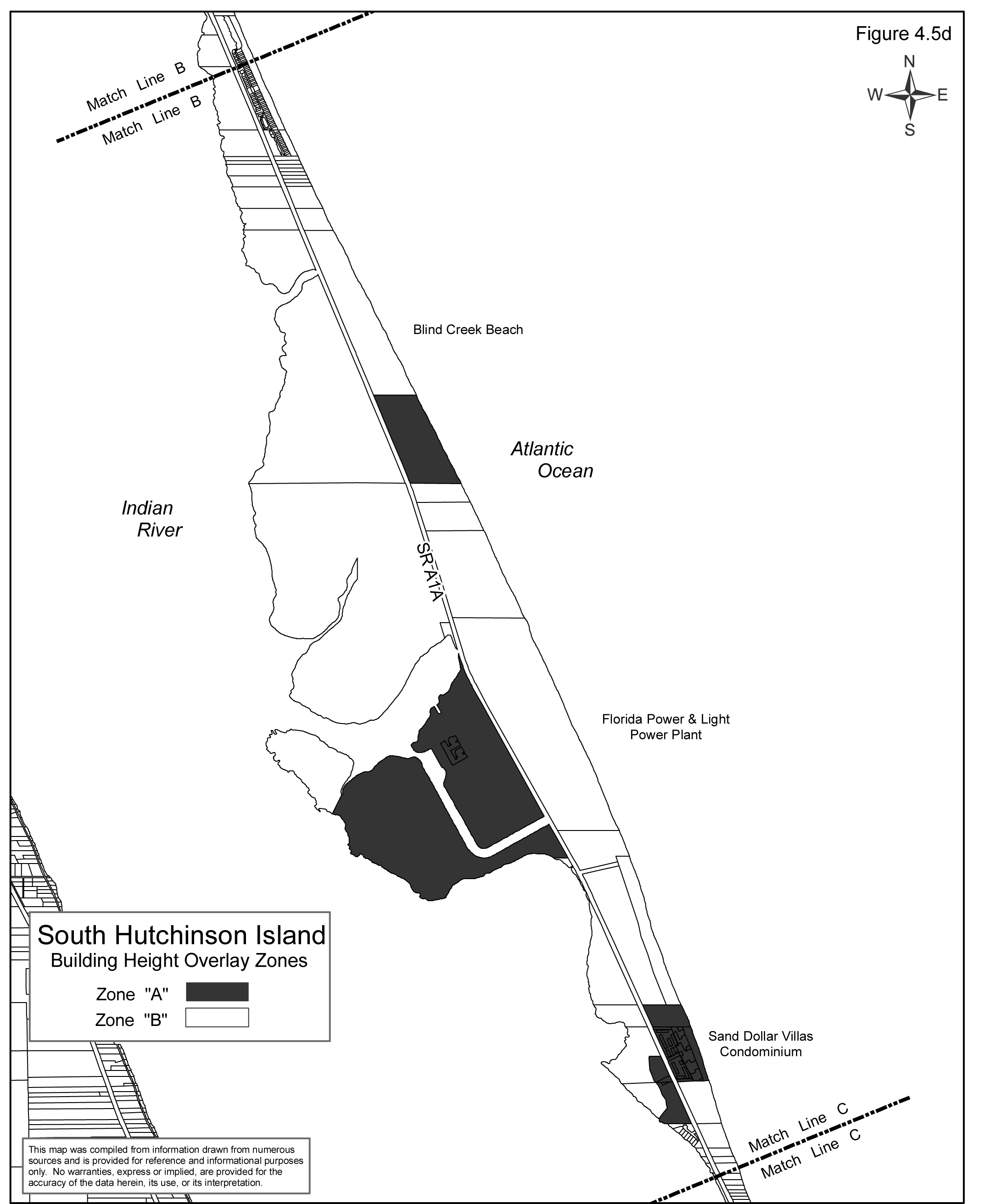
Such zones are shown on the Hutchinson Island Building Height Overlay Plan as depicted in Figures 4.5a through 4.5e.
C.
Except as specifically provided for in Section 3.01.03 and 10.01.03, no structure shall be erected or otherwise established on Hutchinson Island unless it complies with the provisions of this Section.
D.
Except as specifically provided for in Sections 3.01.03 and 10.01.03, nothing in this section shall serve to relieve any person seeking a Final Development Order from complying with the requirements of Section 7.04.00 (Table 7.10 and Building Spacing).
4.01.03. - Hutchinson Island Building Height Zones.
The various zones regulating the maximum building height on Hutchinson Island are hereby established and specifically defined as follows:
A.
Hutchinson Island—Zone A.
North Hutchinson Island:
Those lands lying east of Blue Hole Creek and west of the west right-of-way line for State Road A-1-A, bounded on the north by a line 2058 feet, more or less, north of and parallel to the south section line of Sections 10 and 11, Township 34 South, Range 40 East and on the south by a line 1150 feet north of and parallel to the 1/2 section line of Sections 14 and 15, Township 34 South, Range 40 East; and,
Those lands lying east of the east right-of-way line of SR A-1-A and west of the Atlantic Ocean, bounded on the north by the north section line of Section 23, Township 34 South, Range 40 East and on the south by the north right-of-way line of Shorewinds Drive; and,
South Hutchinson Island:
The south 1550 feet, more or less, of Section 4, Township 36 South, Range 41 East, and the north 437 feet, more or less, of Section 9, Township 36 South, Range 41 East, all lands lying east of SR A-1-A; and,
Those areas west of SR A-1-A lying between Big Mud Creek on the north and the south line of Section 16, Township 36 South, Range 41 East, more commonly referred as the St. Lucie Nuclear Power Plant, where the regulations of the Utility (U) zoning district shall apply; and,
That portion of Sections 22, Township 36 South, Range 41 East, more commonly known as Sand Dollar Villas, Sand Dollar North, and the South Hutchinson Island Wastewater Treatment Plant area; and,
Those lands lying east of the east right-of-way line for SR A-1-A and west of the Atlantic Ocean, bounded on the north by the south line of the north 281.2 feet of Section 34, Township 36 South, Range 41 East and on the south by the Martin County Line.
B.
Hutchinson Island—Zone B.
North Hutchinson Island:
Those lands lying east of the Atlantic Intercoastal Waterway and west of the Atlantic Ocean, bounded on the north by the Indian River County Line and on the south by the Ft. Pierce Inlet, less and excepting the following:
•
Those lands lying east of Blue Hole Creek and west of the west right-of-way line for State Road A-1-A, bounded on the north by a line 2058 feet, more or less, north of and parallel to the south section line of Sections 10 and 11, Township 34 South, Range 40 East and on the south by a line 1150 feet north of and parallel to the 1/2 section line of Sections 14 and 15, Township 34 South, Range 40 East; and,
•
Those lands lying east of the east right-of-way line of SR A-1-A and west of the Atlantic Ocean, bounded on the north by the north section line of Section 23, Township 34 South, Range 40 East and on the south by the north right-of-way line of Shorewinds Drive; and,
South Hutchinson Island:
Those lands lying east of the Atlantic Intercoastal Waterway and west of the Atlantic Ocean, bounded on the north by the Ft. Pierce City Limits and on the south by the Martin County Line, less and excepting the following:
•
The south 1550 feet, more or less, of Section 4, Township 36 South, Range 41 East, and the north 437 feet, more or less, of Section 9, Township 36 South, Range 41 East, all lands lying east of SR A-1-A; and,
•
Those areas west of SR A-1-A lying between Big Mud Creek on the north and the south line of Section 16, Township 36 South, Range 41 East, more commonly referred as the St. Lucie Nuclear Power Plant, where the regulations of the Utility (U) zoning district shall apply; and,
•
That portion of Sections 22, Township 36 South, Range 41 East, more commonly known as Sand Dollar Villas, Sand Dollar North, and the South Hutchinson Island Wastewater Treatment Plant area; and,
•
Those lands lying east of the east right-of-way line for SR A-1-A and west of the Atlantic Ocean, bounded on the north by the north line of Section 34, Township 36 South, Range 41 East and on the south by the Martin County Line.
•
Those lands lying east of the east right-of-way line for SR A-1-A and west of the Atlantic Ocean, bounded on the north by the south line of the north 281.2 feet of Section 34, Township 36 South, Range 41 East and on the south by the Martin County Line.
(Ord. No. 2024-1A, § 2, 1-9-2024)
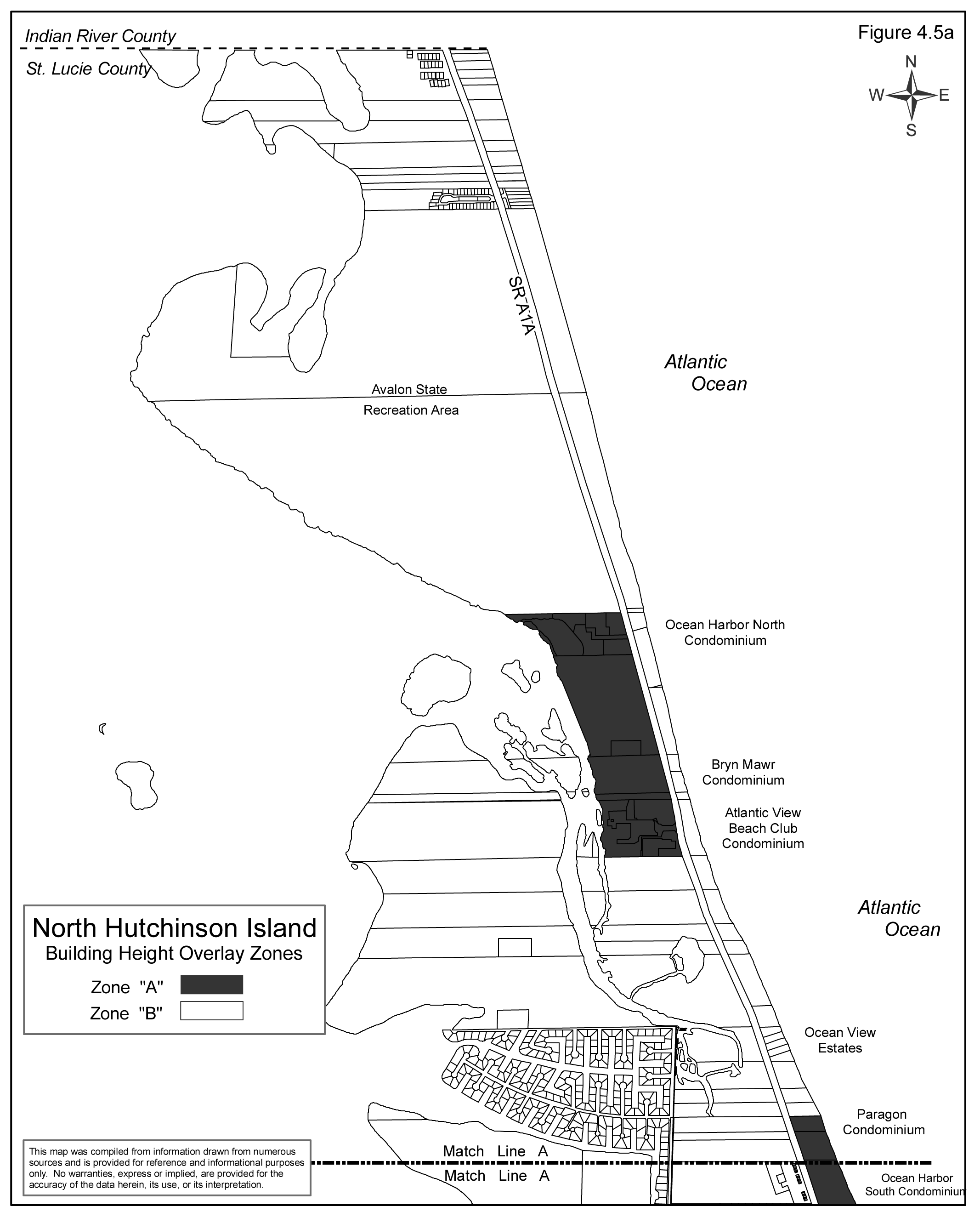
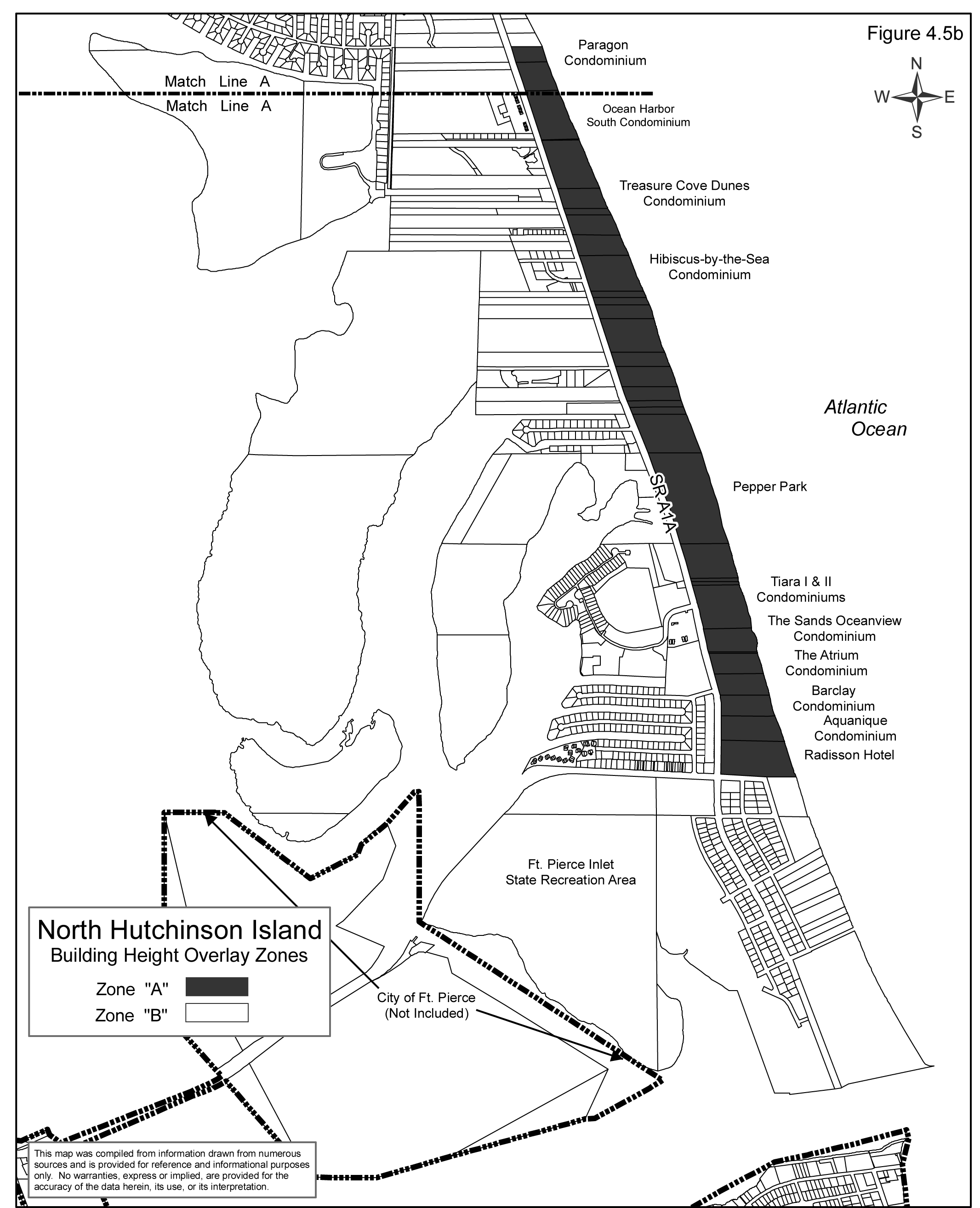
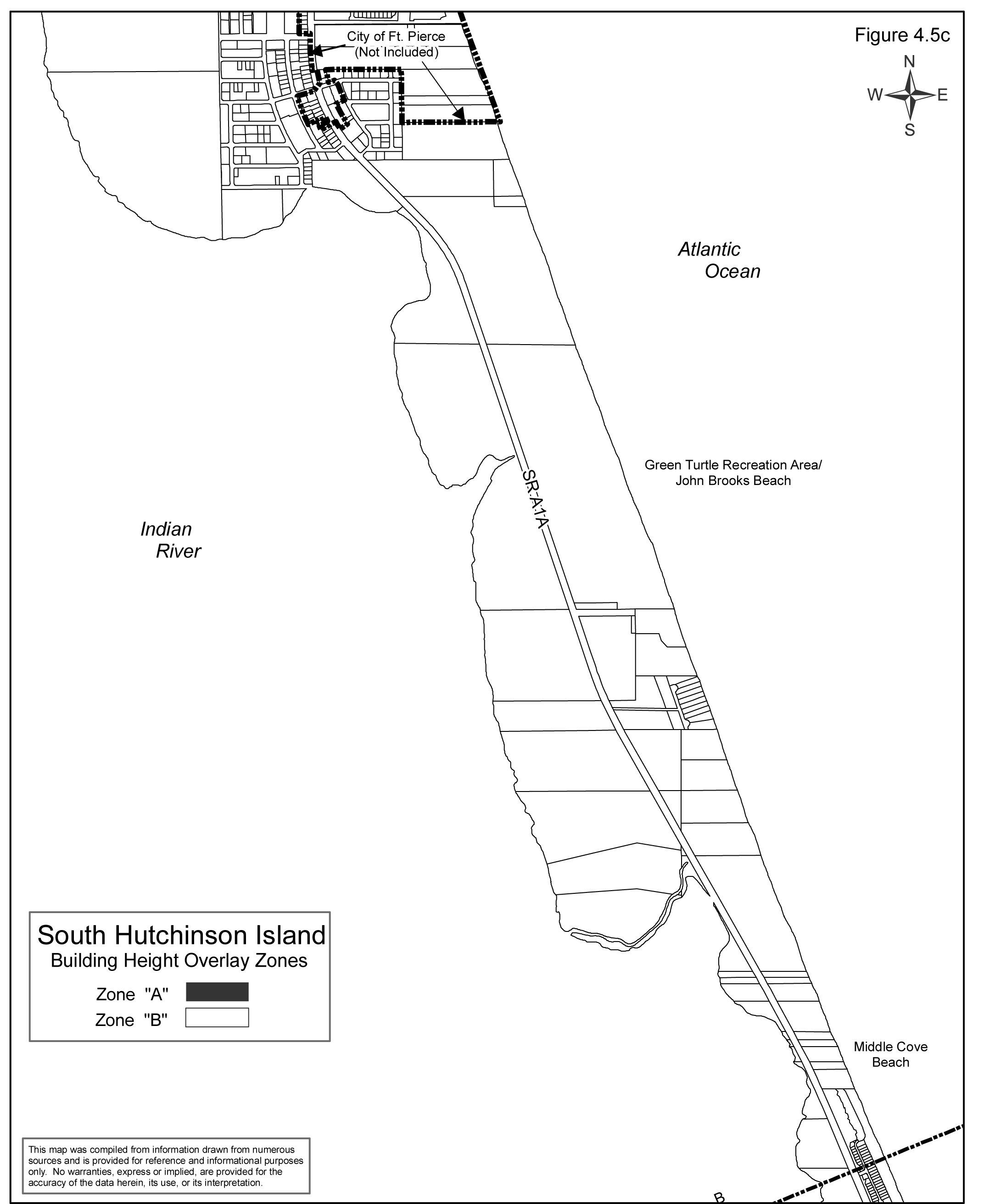
FIGURE 4.5D
4.01.04. - Hutchinson Island Height Limitations.
Except as otherwise provided in this Code, no structure shall be erected or altered in excess of the applicable height limit herein established for such zone. Such applicable height limitations are hereby established for each of the following zones:
A.
Hutchinson Island—Zone A. The maximum building height shall not exceed 125 feet.
B.
Hutchinson Island—Zone B. The maximum building height shall not exceed 35 feet.
4.01.05. - Exceptions.
The following structures are not subject to the provisions of this Section:
A.
Any lawfully approved and valid site plan recognized under Section 1.03.03 of this Code, pursuant to Vested Rights determination, as described in Section 11.09.00 of this Code.
B.
Communication towers/sirens erected by or for a duly authorized public safety activity.
C.
Electrical, telephone, cable tv/radio or similar communications transmission poles.
D.
Street lights and/or traffic control/surveillance devices.
E.
Telecommunication Towers and antenna that are located in Hutchinson Island Zone A as described in Section 4.01.03, subject to the standards of Section 7.10.23. The location for any such located tower or antenna shall be as a co-located facility on an existing building or structure in the Hutchinson Island Zone A. The maximum height of any antenna or tower so located shall be 1/10 of the building height or fifteen (15) feet above the main roof surface of the building, whichever is lower. All towers or antennas shall be located so as not to be visible from the ground.
F.
Roads or Bridges.
4.01.06. - Variances.
A.
Any request for variance from the maximum height regulations set forth in this section shall be reviewed in accordance with the provisions of Section 10.01.00.
B.
No variance from the provisions of this section shall be granted that would permit any building to have a height in excess of one hundred twenty-five (125) feet.
4.02.01. - Purpose and Intent.
A.
It is the purpose and intent of this section to recognize changing conditions along Prima Vista Boulevard, in the River Park Subdivision, between South US #1 (SR 5) and Airoso Boulevard and to establish supplemental performance standards of review by which to evaluate all applications for change in zoning, use and development to nonresidential use which may be filed for parcels in the River Park subdivision area as further described in this Section.
B.
This section is intended to encourage and provide for a logical and orderly transition from residential to nonresidential zoning, use and development where appropriate, and to protect those parcels which remain residential from the impacts of the nonresidential development.
C.
Nothing in this Section is intended to supersede the minimum standards of review for any amendment to the Official Zoning Atlas of St. Lucie County as set forth in Section 11.06.03 of this Code.
(Ord. No. 2018-09, Pt. A, 6-5-2018)
4.02.02. - River Park Community Overlay Zone Established.
A.
The River Park Community Overlay Zone shall consist of all those parcels of land lying in the following subdivisions as recorded in the official land records of St. Lucie County, Florida, and which share a common property line with the right-of-way for Prima Vista Boulevard and/or and are contiguous to a parcel of land that shares a common property line with the right-of-way for Prima Vista Boulevard:
Except that those properties in the above subdivisions that were classified with a COM (Commercial) Future Land Use designation on August 6, 1996, the date of establishment of these regulations, shall not be included in the River Park Overlay Zone.
Figure 4-8 generally depicts the limits of the above described overlay zone.
B.
The River Park Community Overlay Zone, created in Part A above, shall be divided into two (2) subzones, generally described as follows:
1.)
Intersection Zone. The Intersection Zone(s) shall be centered at the following locations:
a.)
Prima Vista Boulevard and South US #1
b.)
Prima Vista Boulevard and Floresta Drive
c.)
Prima Vista Boulevard and Airoso Boulevard
The Intersection Zone shall consist of those properties which share a common property line with the right-of-way for Prima Vista Boulevard and/or are contiguous to a parcel of land, under the common ownership or control of the same person, party or interest group, that shares a common property line with the right-of-way for Prima Vista Boulevard.
In no instance shall an Intersection Zone extend more than five hundred (500) feet (approximately five (5) platted lots) from the center of any of the intersections identified above.
2.)
Mid-Block Zone. The Mid-Block Zone(s) shall consist of those properties which share a common property line with the right-of-way for Prima Vista Boulevard and/or are contiguous to a parcel of land, under the common ownership or control of the same person, party or interest group, that shares a common property line with the right-of-way for Prima Vista Boulevard.
(Ord. No. 2018-09, Pt. A, 6-5-2018)
4.02.03. - Uses, Rezoning and Land Development Applications.
A.
Uses. Authorized uses within the Overlay Zone that may be pursued within any existing zoning district without a change in zoning shall include: permitted, conditional and accessory uses in the RS-4 (Residential, Single Family) and CO (Commercial, Office) Zoning Districts, except eating and drinking establishments. All permitted and accessory uses shall be allowed upon issuance of a Zoning Compliance Certificate and a determination of compliance with this section and applicable sections of the Land Development Code. Conditional Uses within the CO and RS-4 Zoning Districts shall require approval of a Conditional Use Permit as set forth in LDC Section 11.07.00.
B.
Dimensional Requirements. All dimensional requirements, including minimum lot size and yard requirements, shall follow the existing or proposed zoning district provisions as set forth in Section 7.04.01 of this Code, except for non-residential uses in residential zoning districts that are authorized in this section. The conversion of an existing residential building to a use permitted in the CO Zoning District through an application for Zoning Compliance, or any new commercial office development, within a residential zoning district shall continue to follow the dimensional standards of the residential zoning district.
C.
Two Lots Deep. An application for conversion from residential to a CO Zoning District use, and new commercial office development, is intended primarily for lots that share a common property line with the right-of-way for Prima Vista Boulevard. Such application that also includes property contiguous to a parcel of land that shares a common property line with the right-of-way for Prima Vista Boulevard but does not itself have frontage along Prima Vista Boulevard, shall be required to obtain a conditional use permit as set forth in [Section] 11.07.00. The conditional use application shall be accompanied by a concept plan providing the information in Section 11.02.09 of this Code and any other information deemed necessary for a full review of the project impacts.
D.
Rezoning. All applications for change in zoning in the River Park Community Overlay Zone shall be consistent with Table 4-8 below. No change in zoning to a non-residential zoning designation shall be granted for any parcel of less than twenty thousand (20,000) square feet (approximately two (2) lots as shown on the recorded plats for the River Park s/d).
TABLE 4-8
4.02.04. - Performance Standards.
The following performance standards are applicable to any conversion of an existing residential building to a CO (Commercial, Office) use through an application for Zoning Compliance per Section 11.05.00, or any new commercial office development within the River Park Community Overlay Zone. Notwithstanding the provisions of this Overlay, all conversions to commercial uses shall comply with applicable building code and accessibility requirements.
A.
Building Height: Maximum height for any structure shall be twenty-five (25) feet for any non-residential use. Upon approval of a conditional use permit the building height may be increased to twenty-eight (28) feet.
B.
Maximum Building Size: New commercial development, or redevelopment of a residential building for commercial use, permitted under existing residential zoning shall not exceed six thousand (6,000) square feet in total size.
C.
Access Management: In addition to the minimum standards set forth in Section 7.05.06 of this Code, the following driveway locations standards shall apply:
1.)
Number of Driveway Connections: No more than one (1) driveway per street frontage under common ownership shall be permitted.
2.)
Distance from Intersections: The nearest edge of any driveway shall be located no closer than one hundred fifty (150) feet from the centerline of any perpendicular intersecting street.
3.)
This district shall maximize efficiency of automobile access by prohibiting the creation of new curb cuts on already developed parcels on Prima Vista Boulevard for non-residential use, and requiring existing curb cuts to be combined into joint-access driveways and/or eliminated when parcels are combined and redeveloped in conformance with this Overlay.
D.
Development Prior to Abutting Property: In the event that a building site is converted or developed for non-residential use before an abutting property is converted, developed or redeveloped, the site shall be designed to insure that its parking, access, and circulation may be easily modified to create a unified system with adjacent parcels at a later date.
E.
Existing Abutting Uses: When a property applying for conversion, development or redevelopment abuts an existing property that has been developed for a non-residential use using the guidelines herein, it shall be designed to connect to the abutting parking, access and circulation areas to create a unified system unless the County Administrator's designee finds that this would be impractical.
F.
Easements Required to be Dedicated: When the joint-access provisions are utilized by the owner of property applying for conversion, development or redevelopment of a non-residential use, the use shall not be approved unless the property owner grants an easement for cross access to and from abutting properties. Such easement shall be recorded by the property owner in the public records of St. Lucie County and constitute a covenant running with the land.
G.
Offstreet Parking and Loading:
1.)
Offstreet parking and loading shall meet the minimum requirements of Section 7.06.00 of this Code. Specifically, "off-street parking areas shall be designed so that motor vehicles can exit without backing into a street." (Section 7.06.02(B)(2)(c)
2.)
In order to preserve the residential neighborhood character, the design and location of parking shall be consistent with the following standards that shall apply when more than three (3) parking spaces are being provided:
a)
Parking stall minimum dimensions may be nine (9) feet by eighteen (18) feet.
b)
The driveway area may count towards up to two (2) parking spaces, provided the length of the driveway meets the minimum stall dimensions as provided in Section 7.06.02(B)(1), Off-Street Parking and Loading Performance Standards.
c)
Bicycle parking may be substituted for one (1) required parking space per Section 7.05.04(C).
H.
Buffering and Landscaping:
1.)
Buffering and landscaping shall meet the minimum requirements of Section 7.09.00 of this Code, with the following standards applicable to any non-residential use.
a)
Landscaped buffers and screening between single-family residential and non-residential uses shall be required consistent with Section 7.09.04(E), except the wall or fence required in such buffers shall be exempt from side yards.
b)
The rear landscaped buffers and screening required pursuant to Section 7.09.04(E) may be waived by the Environmental Resources Director according to the procedure outlined in that section.
2.)
The area between the building, off-street parking area or other vehicular use area abutting a street or road right-of-way, shall be landscaped with one (1) street tree for each forty-five (45) linear feet of abutting right-of-way or major fraction thereof. The street tree shall not be planted in a utilities right-of-way or a utilities easement and shall be placed so their canopies shall not interfere with any power line.
I.
Lighting:
1.)
All site lighting shall be installed so that no off site areas are directly illuminated.
J.
Signs:
1.)
A maximum of two (2) signs are permitted per parcel. The maximum square footage allowable of total signage shall not exceed sixteen (16) square feet, except for a ground or monument sign. The following signs are permitted:
a)
Wall sign.
b)
Canopy sign.
c)
Projecting sign.
d)
One (1) primary monument sign may be provided along Prima Vista Boulevard. The sign shall not exceed six (6) feet in height or sixteen (16) square feet in total size. Monument signs shall be located a minimum of ten (10) feet from any right-of-way and five (5) feet from any adjoining property line.
2.)
No sign shall be internally lit; lighting without any visual light spillover is permitted.
3.)
Monument signs shall be landscaped in accordance with Land Development Code 9.02.01(D)(6).
K.
Building Design Standards: Overall design for any new and renovated buildings for a commercial use shall fit with the character of the residential neighborhood.
1.)
Windows, Doors and Entrances:
a)
Windows shall not be covered with any type of material that is used for advertisement.
b)
Clear glass windows (eighty-eight percent (88%) light transmission or more) are required.
c)
Buildings must have a primary entrance door facing a public sidewalk and/or public road.
2.)
Building Design: Any new construction, modification, alteration, renovations or refurbishment of an existing building within the Overlay district is subject to these general design guidelines:
a)
The following primary façade features are discouraged:
i.
Large, blank, unarticulated walls.
ii.
Siding comprised of the following materials: corrugated metal, corrugated fiberglass, plastic, and plywood.
iii.
Unpainted concrete block.
iv.
Imitation rockwork veneer.
b)
The following architectural and site elements are encouraged:
i.
Building articulation features such as Bahama shutters, entry porches, and parapets over doors.
ii.
Civic features such as an arcade/loggia, canopy, portico/porte-cochere, or pedestrian courtyard or plaza.
iii.
Landscape features such as an arbor, pergola, or stone or stamped concrete pavement at project entry, drop-off, or pedestrian crossing.
(Ord. No. 2018-09, Pt. A, 6-5-2018)
4.02.05. - Use Limitations.
The following uses shall be specifically prohibited, regardless of zoning classification, within the River Park Community Overlay Zone.
A.
Drive-in facilities.
(Ord. No. 2016-19, Pt. A, 12-20-2016; Ord. No. 2018-09, Pt. A, 6-5-2018)
4.02.06. - Eating and Drinking Places; Gasoline and Other Fuel Sales Services.
These uses shall be allowed at intersection zones with the required PNRD zoning.
(Ord. No. 2016-19, Pt. A, 12-20-2016; Ord. No. 2018-09, Pt. A, 6-5-2018)
4.02.07. - Live/Work Units.
Within this overlay district, live/work units shall be a considered an accessory use to all permitted or conditional nonresidential uses. "Live/work unit" or "live/work space" means a building or spaces within a building used jointly for commercial and residential purposes where the residential use of the space is secondary or accessory to the primary use as a place of work.
(Ord. No. 2018-09, Pt. A, 6-5-2018)
4.03.01. - Purpose and Intent.
A.
It is the purpose of this Section to protect, promote and strengthen the research, education and development of agriculture and the life sciences in the area generally described as lying between Orange Avenue and State Route 70, and west of Kings Highway to the North St. Lucie Water Control District Canal No. 52.
B.
It is the intent of this Section to provide a district where established and new education, research and scientific institutions, technological entrepreneurial ventures, and support services for these uses can develop and prosper. The district sets forth uses and standards that will protect, create and promote a community of scientific excellence and innovative education and technology by providing an atmosphere conducive to these activities.
C.
This Section indicates the permitted, conditional and accessory uses and performance standards that will be utilized when reviewing applications for a change in zoning, future land use designation, site plan or building permit in the area further described in this Section.
4.03.02. - Research and Education Park Overlay Zone Established.
A.
The Research and Education Park Overlay Zone shall consist of all those parcels of land lying in the boundaries of the Research and Education Overlay Zone Map as shown below and on the County's Official Zoning Atlas:
B.
The Research and Education Park Overlay Zone, created in Paragraph A above is generally described as follows:
Lands dedicated to a Research and Education Park consisting of public and private research and education institutions and business support facilities that further the intent of the Research and Education Park Overlay Zone.
The area is intended to accommodate research institutions, low environmental impact manufacturing facilities that support or are associated with the research and education institutions within the Research and Education Park.
(Ord. No. 2025-05, § 2, 2-18-2025)
4.03.03. - Limitations on Land Use Applications.
Any Future Land Use Map Change within the Overlay Zone shall be to Special District (SD - Research and Education Park). All applications for a change in zoning within the Research and Education Park Overlay Zone shall be to Planned Non-Residential Development (PNRD). All building permit applications shall be reviewed and approved by the Planning and Development Services Director or his or her designee prior to the issuance of construction authorizations within the Research and Education Park Overlay Zone.
The appropriate location and mix of uses will be determined through the planned development process in a manner that adheres to the guidelines and standards set forth in this overlay zone and the Research and Education Park Master Plan. Uses are to be segregated as to intensity and are to ensure compatibility with lands outside the overlay zone.
The following sub-zones are created to identify the type of permitted, conditional and accessory uses allowed within Zone A and Zone B. The specific uses are identified below and Section 4.03.05.
LAND USE OPTIONS
Research Education Zone: The Research Zone is established to provide sites for education and research activities, related manufacturing, business and scientific activities that could benefit from location in or adjacent to Research and Education Park facilities. This zone is intended to accommodate educational facilities that promote higher learning and research facilities, prototype production facilities and other manufacturing operations that require the continual or recurrent application of research knowledge and activity as an integral part of the manufacturing process. Professional office and commercial support facilities may also be located within this zone. This zone is intended to support the life cycle of education, food, agriculture, and technology uses spurred by the research zone, from research, to business incubator and accelerator, to processing, and distribution of the products created at the Park.
Research Agriculture Zone: The Research Agriculture Zone is established to provide an area of scientific research and development in the life sciences and agriculture for training and the production of prototype products, plans or designs. This zone is intended to accommodate agriculture production associated research facilities, and pilot projects that require the continual application of agriculture research knowledge and activity.
(Ord. No. 10-034, Pt. A, 11-9-2010; Ord. No. 2020-12, Pt. A, 6-1-2020)
4.03.04. - Performance Standards.
The following performance standards shall be maintained for approval of any planned development within the Research and Education Park Overlay Zone. The Research and Education Park Overlay standards shall supersede when more limiting than other provisions of this Code.
A.
Building Height:
Zone A: Maximum height for any structure shall be sixty (60) feet.
Zone B: Maximum height for any structure shall be thirty-five (35) feet.
B.
Signs: Signs for all uses within the Research and Education Center Overlay Zone shall conform to the requirements of Section 9.01.01(E), (Commercial, Neighborhood) of this Code.
Billboards that are specific to marketing or identification of the Research and Education Park are permitted along the Florida Turnpike and may be installed in accordance with Section 9.02.02—Off Premises Signs.
C.
Lot Coverage by Buildings:
D.
Minimum Yard requirements: Minimum yard and minimum lot size requirements will be determined through the planned non-residential development process.
Buildings under the site plan threshold shall meet the minimum yard requirement of the property's underlining zoning district.
E.
Landscaping Requirements: Landscaping requirements related to screening uses outside the Research and Education Overlay Zone boundary, retention of native landscapes, drought-tolerate vegetation and exotic removal shall be subject to Section 7.09.00.
Landscape buffers along roadways and between uses within the Research and Education Overlay Zone shall be determined as part of the planned development process and in all cases shall be consistent with the intent of the Research and Education Overlay Zone and the Research and Education Park Master Plan.
F.
Off-street Parking and Loading Requirements: Off-street parking and loading requirements are subject to Section 7.06.00. A fifteen percent (15%) reduction may be applied if the Planned Development contains two (2) or more uses. Agricultural production structures are not subject to the requirements of Section 7.06.00.
Parking garage structures may be proposed for individual or shared use within Zone A.
(Ord. No. 2020-12, Pt. A, 6-1-2020)
4.03.05. - Research and Education Park Overlay Zone Use Limitations.
The purpose of these regulations is to provide and protect an environment suitable for agriculture, education, and research with such other uses as may be necessary to and compatible with these primary uses. Uses are identified by their SIC (Standard Industrial Classification) Code (00). The identified use shall only be allowed when consistent with the properties Future Land Use Designation and the Zone A and B Land Use Options set forth in Section 4.03.03 and the Research and Education Park Master Plan.
A.
Permitted Uses. (Notes: The uses below include the life sciences with a focus on agriculture and education)
The permitted uses in Zone A and Zone B shall be:
1.)
Agriculture production - crops (SIC 01).
2.)
Animal aquaculture (SIC 0273).
3.)
Education services and facilities (SIC 82).
4.)
Solar generation station, subject to the requirements of Section 7.10.28. (999)
5.)
Public, and quasi-public support services, for fire protection (SIC 92).
(Notes: Includes establishments engaged in non-commercial agriculture and biological research and development; such as, agriculture, food and medicine.)
The permitted uses in Zone A only shall include:
1.)
Business services (SIC 73).
2.)
Manufacturing and Processing:
a.
Drugs (SIC 283).
b.
Beer, wine, distilled alcoholic beverages (SIC 518).
c.
Farm and garden machinery and equipment (SIC 5083).
d.
Farm-products raw materials, not elsewhere classified (SIC 5169).
e.
Farm supplies (SIC 5191).
f.
Food and kindred products (SIC 20).
g.
Food products machinery (SIC 3556).
h.
Grain and field beans (SIC 5153).
i.
Groceries and related products (SIC 514).
j.
Measuring, analyzing, and controlling instruments, photographic, medical and optical goods; watches and clocks (SIC 38).
k.
Pharmaceutical preparations (SIC 2834).
l.
Soap, detergents, and cleaning preparations, perfumes, cosmetics, and other toilet preparations (SIC 284).
m.
Tobacco stemming and redrying (SIC 21).
3.)
Research, development and testing services (SIC 873).
4.)
Solar generation station, subject to the requirements of Section 7.10.28. (999)
(Notes: Includes establishments engaged in commercial and manufacturing physical and biological research and development; such as, agriculture, food and medical research, business services and x-ray machine inspection services)
B.
Conditional Uses.(Notes: The uses below primarily include those associated with the manufacturing and support of the life sciences or the Park in general, such as financial institutions and eating establishments.)
The conditional uses within Zone A shall be:
1.)
Meat packaging plants (SIC 2011).
2.)
Financial institutions (SIC 60 and SIC 61).
3.)
Eating places (SIC 5812).
C.
Accessory Uses. Accessory uses are subject to the requirements of Section 8.00.00, and include the following:
1.)
Residential units may be permitted as accessory uses to educational facilities, when approved through the Planned Development process.
2.)
Solar energy system subject to the requirements of Section 7.10.28 (999).
D.
Use Limitations. The following uses shall be specifically prohibited within the Research and Education Park Overlay Zone boundary.
1.)
Residential subdivisions.
2.)
Heavy, industrial.
3.)
Industrial extraction.
(Ord. No. 10-034, Pt. A, 11-9-2010; Ord. No. 2020-12, Pt. A, 6-1-2020; Ord. No. 2022-21, Pt. A, 7-19-2022)
4.04.01. - Purpose and Intent.
The purpose and intent of Section 4.04.00 of this Code is to:
A.
Guide the creation of Towns, Villages, Hamlets, protected Countryside, and other permitted uses and development patterns on land designated TVC on the Future Land Use Map of the St. Lucie County Comprehensive Plan.
B.
Ensure that all development of land designated TVC takes place in accordance with the settlement principles set forth in the TVC Element of the Comprehensive Plan. Where this overlay zone directly conflicts with other portions of this Code, this overlay zone will prevail; however, no development may be approved that conflicts with the St. Lucie County Comprehensive Plan.
C.
Provide procedures for transferring development rights using TDR credits. Such transfers will allow continued rural uses of land that is designated TVC by transferring some or all of its development rights to Towns or Villages or to land within the Urban Service Boundary.
(Ord. No. 2024-28, § Pt. B(Exh. A), 8-6-2024)
4.04.02. - Essential TVC Concepts.
Four (4) essential concepts for the regulation of land designated TVC are highlighted here:
A.
TVC Overlay Zone. This section of the code establishes a TVC Overlay Zone whose boundaries are identical to the TVC designation on the Future Land Use Map of the Comprehensive Plan as initially adopted in May 2006. This overlay zone provides general guidance and specific standards that, in conjunction with the remainder of this Code, will carry out the goals, objectives, and policies of the TVC Element. The TVC Overlay Zone contains two (2) sub-zones whose boundary is the Urban Service Boundary in the Comprehensive Plan as it existed in May 2006. The location and approximate boundaries of the TVC Overlay Zone and its sub-zones are shown on Figure 4-10. Comprehensive Plan amendments that make more than incidental adjustments to these boundaries will necessitate changes to this Code.
B.
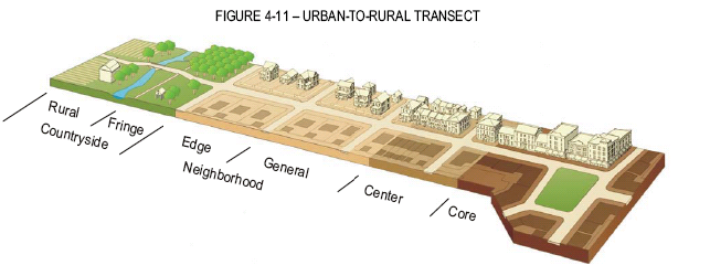
Urban-to-Rural Transect. Towns and Villages have physical forms that vary in character and intensity. An urban-to-rural transect that describes these characteristics in existing communities is also ideal for use as the organizing principle for new communities. New Towns, Villages and Planned Unit Developments on land designated TVC are to be planned using the "transect zones" shown on Figure 4-11. These transect zones must be delineated on a regulating plan prepared by a developer and submitted to St. Lucie County for consideration as part of rezoning to the PTV (Planned Town or Village - see Section 3.01.03.EE) or PUD (Planned Unit Development - see Section 4.04.04.E(1)(b)) zoning district.
C.
Urban Service Boundary. The St. Lucie County Comprehensive Plan establishes an Urban Service Boundary (USB) which limits the geographic area where the county will provide certain services. The purpose is to restrict the negative impacts of a sprawling low-density development pattern including the fiscal burden placed on service providers by that pattern. About sixty-three percent (63%) of the land designated TVC is outside this boundary and the remainder is inside. The TVC Element provides incentives for moving potential development to new Towns and Villages or to certain locations inside the USB. Under certain circumstances the TVC Element allows new development to qualify for urban services even if located outside the USB (see policies under Objective 3.1.2 of the St. Lucie County Comprehensive Plan).
D.
Transferable Development Rights. The development rights attached to a parcel of land can sometimes be transferred to other parcels. The TVC Element encourages the transfer of density for several purposes: to move potential development to certain locations inside the USB; To encourage continued use of land for rural and open space purposes by transferring potential density off the land; and to allow the accumulation of sufficient development rights to create Towns or Villages. Transferable development values are set in Figure 3-3 of the TVC Element and may be increased by using the multipliers in the TDR Credit Matrix in Table 3-4 of the TVC Element. See Section 4.04.05.
(Ord. No. 11-002, § 4, 12-6-2011)
4.04.03. - Overview of TVC Approval Processes.
Development approvals for land designated TVC differ in several aspects from approvals in the remainder of unincorporated St. Lucie County. These processes can be summarized as follows:
A.
Owners of five hundred (500) or more acres of land located outside the USB and owners of one hundred ten (110) acres or more of land located inside the USB may seek approval of a new Town or Village by applying to rezone the land to the PTV (Planned Town or Village) zoning district. See Section 3.01.03.EE. Owners of five hundred (500) acres or more located outside the USB may also seek approval of a Hamlet by applying to rezone the land to the Hamlet PUD zoning district, pursuant to Sections 7.01.02 and 7.01.04. Any Hamlet proposed on land fronting Indrio Road must demonstrate consistency with Comprehensive Plan Policy 11.1.5.7.
B.
Owners of less than five hundred (500) acres of land outside the USB may take any of the following actions:
1.
Maintain the land in its natural state or with agricultural uses consistent with its agricultural zoning district and utilize the Transfer of Development Rights (TDR) program to move at least ninety percent (90%) of the unused transferable development value from the land to an eligible receiving site. See Section 4.04.05.
2.
Subdivide the land into individual home sites using the transferable development value assigned to that land by applying to rezone the land to the PCS (Planned Country Subdivision) zoning district. See Section 3.01.03.FF. Upon approval, the TDR program may not be used to transfer density to or from the land.
3.
Utilize the Transfer of Development Rights (TDR) program to move or permanently set aside at least ninety percent (90%) of the transferable development value from the land and subdivide the land into individual home sites using the remaining development rights. See Section 4.04.04.D.3.
4.
When consistent with the retail standards under Objective 3.1.8 of the TVC Element or the workplace standards under Objective 3.1.10 of the TVC Element, apply to rezone the land to the PRW (Planned Retail/Workplace) zoning district. See Section 3.01.06.GG.
C.
Owners of less than one hundred ten (110) acres of land inside the USB may take any of the following actions:
1.
Develop or use the land for residential purposes in accordance with the TVC Overlay Zone requirements in Sections 4.04.01—4.04.06 of this Code.
2.
Residential development is limited to the maximum residential densities on the Transferable Development Value Map (Figure 3-3 of the TVC Element), except that.
a.
Density may be increased as a county incentive for providing affordable housing, workforce housing, or mixed-use development.
b.
For development built in the form of a Town or Village, density may be increased through acquisition of TDR credits from eligible sending sites. See Sections 3.01.03.EE and 4.04.05.
D.
Owners of land of any size inside the USB (Urban Service Boundary) may place retail or workplace land uses outside a Town or Village by taking either of the following actions:
1.
Seek rezoning of the land to the PRW (Planned Retail/Workplace) zoning district (Section 3.01.06.GG) if the proposed uses are fully consistent with the goals, objectives, and policies of the TVC Element, and in particular with the retail standards under Objective 3.1.8 and/or the workplace standards under Objective 3.1.10. Such proposals must also conform to the TVC Overlay Zone requirements of Section 4.04 of this Code.
2.
Owners of property with existing commercial zoning (CO, CN, or CG) as of August 28, 2009, are not required to rezone to PRW, but must follow the development standards contained in Section 3.01.03.GG.2 for that zoning district and must otherwise be consistent with the TVC Element. All such proposals, except as necessary to achieve underlying nonresidential use intensity pursuant to Land Use Element Policies 3.1.2.5 and 3.1.3.1(4), must meet the retail standards under Objective 3.1.8 and/or the workplace standards under Objective 3.1.10, in addition to the TVC Overlay Zone requirements in Section 4.04 of this Code.
E.
Owners of land of any size may initiate, continue, or expand agricultural uses (including forestry and equestrian uses) in accordance with the requirements of the agricultural zoning district that applies to the land. This option is available both inside and outside the USB. See Section 3.01.03 for lists of permitted and conditional agricultural uses in each agricultural zoning district.
(Ord. No. 11-002, § 4, 12-6-2011; Ord. No. 2024-28, § Pt. B(Exh. A), 8-6-2024)
4.04.04. - TVC Specific Standards.
A.
Applicability of TVC Specific Standards.
1.
The standards in Section 4.04.00 apply to land use and land development within the TVC Overlay Zone regardless of zoning designations, except as specifically provided.
2.
The provisions of the remainder of this Code apply except where modified by this TVC Overlay Zone, by the PTV, PCS, PRW, or PUD zoning districts, or by the St. Lucie County Comprehensive Plan.
B.
Regional Street Network.
1.
The TVC Element of the St. Lucie County Comprehensive Plan established in May 2006 a Future Street Network Plan that includes street improvements and new streets to be completed by the year 2030, as depicted on Figure 4-12.
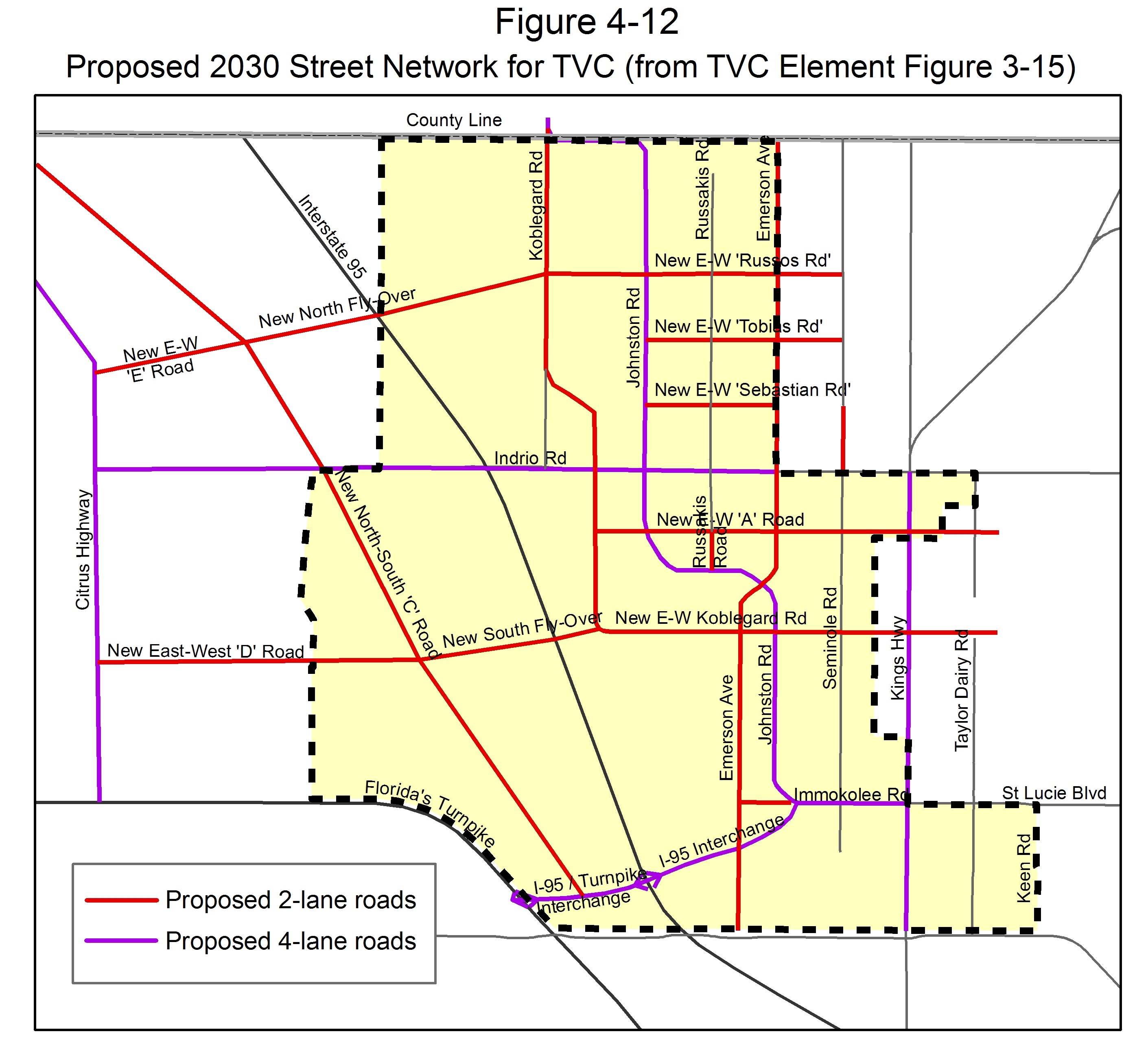
2.
St. Lucie County will not approve any construction or development of land that would interfere with the creation of or improvements to the streets identified on the Future Street Network Plan.
3.
Development of land must accommodate and incorporate appropriate links of the Future Street Network Plan. Final alignments will be determined by St. Lucie County. Roadway capacity to support the proposed development must exist or be provided concurrently. Appropriate connectivity of new development to these streets and their integration with adjoining development must be demonstrated prior to development approvals.
4.
Streets in the Future Street Network that connect rural areas to urban areas must provide transitions from higher design speeds in rural areas to lower design speeds for neighborhoods and other developed areas. Lower design speeds can be achieved by reducing the widths of travel lanes, clear zones, and medians. Lower design speeds can also be achieved by adding curbs, regularly spaced street trees, and on-street parking.
C.
Agricultural Uses. Owners of land are encouraged to initiate, continue, or expand agricultural uses (including forestry and equestrian uses) in accordance with the requirements of the agricultural zoning district that applies to the land; Section 3.01.03 for lists of permitted and conditional agricultural uses in each agricultural zoning district. This option is available to all land regardless of size both inside and outside the USB. At a minimum, nothing in the TVC Overlay or other implementing regulations may be construed to supersede or interfere with agricultural rights protected under Florida's Right to Farm Act. Participation is optional in the Transfer of Development Rights program which allows unused transferable development value to be moved to an eligible receiving site (see Section 4.04.05).
D.
Residential Subdivisions Outside the Urban Service Boundary. Residential subdivisions may be created outside the Urban Service Boundary (USB) on land designated TVC only by following one (1) of these four (4) approaches:
1.
As part of a new Town or Village, using the PTV zoning district (see Section 3.01.03.EE).
2.
Outside a Town or Village through the use of the existing transferable development value assigned to a parcel of land, using the PCS zoning district (see Section 3.01.03.FF).
3.
Outside a Town or Village after moving or permanently setting aside at least ninety percent (90%) of the transferable development value from the land to an eligible receiving site in accordance with Section 4.04.05:
a.
Transferable development value remaining on the land may be used to create residential lots in accordance with the standards of this Code including all TVC Overlay Zone standards.
(1)
There is no requirement to rezone from an existing AG-1 zoning district if the residential lots will comply with all AG-1 requirements. Such a development would be approved using the site plan approval process found in Chapter XI of this Code.
(2)
If the landowner wishes to allocate the remaining transferable development value in a more clustered manner, rezoning may be requested to PCS or other suitable zoning district. The rezoning application and subsequent site plan approval applications must be accompanied by a regulating plan that meets the standards of Section 3.01.03.EE.3.b(4) and that identifies appropriate transect zones (either Edge, General, or Center), lot types, and street types and that includes at least one (1) civic space in order to achieve development forms consistent with the TVC Element.
b.
Upon approval of this option, urban services may be extended at the property owners' expense to lots that use the remaining transferable development value despite being located outside the USB.
c.
The new residential lots must be placed on one (1) contiguous portion of the land and to the extent possible must provide an interconnected street network as described in Section 3.01.03.EE.2.k and water management in the form of an interconnected system consistent with and connected to the Flow Way System as described in Section 3.01.03.EE.2.p.
4.
Outside a Town or Village, as a Hamlet Planned Unit Development (PUD), pursuant Sections 7.01.02 and 7.01.04. The Hamlet PUD shall consist of compact, pedestrian-friendly residential settlement with a variety of housing types. Home sites within a Hamlet PUD are eligible to receive urban services at the developer's expense. Development of a Hamlet PUD must ensure compatibility with existing or planned nearby development and provide connectivity of roadways, trails, open space, and a flow way.
E.
Residential Subdivisions Inside the Urban Service Boundary.
1.
Residential subdivisions may be created inside the Urban Service Boundary (USB) on land designated TVC only by following one (1) of these two approaches:
a.
As part of a new Town or Village, using the PTV zoning district (see Section 3.01.03.EE). Planned Towns or Villages inside the USB require less acreage and a lower percentage of land to be designated as Countryside than for a Town or Village outside the USB (see Section 3.01.03.EE.2.b).
b.
Outside a Town or Village but still inside the USB, using the transferable development value assigned to a parcel of land, plus any TDR credits acquired and/or any density bonuses that St. Lucie County may provide for affordable housing, workforce housing, or mixed uses.
(1)
If the land is not currently zoned to allow the desired density, the land must be rezoned to a suitable planned zoning district (for instance, see Sections 3.01.03.BB and 7.01.00, the standard planned unit development category and associated PUD regulations). The rezoning application and subsequent site plan approval applications must be accompanied by a regulating plan that includes the information required by Section 3.01.03.EE.3.b(4) and that identifies appropriate transect zones, lot types, and street types to achieve development forms consistent with the TVC Element. The required Center, General, and Edge transect zone percentages set forth in Section 3.01.03.EE.2.c(3) for Villages would apply to such land, unless the parcel is less than thirty-two (32) acres. The five-acre minimum parcel size for the standard PUD category would not apply to such an application.
(2)
Such residential subdivisions must provide an interconnected street network as described in Section 3.01.03.EE.2.k and water management in the form of an interconnected system consistent with and connected, if possible, to the Flow Way System as described in Section 3.01.03.EE.2.p.
2.
Residential development on land designated TVC that is inside the Urban Service Boundary (USB) is afforded the following special allowances:
a.
Density may be increased in all proposed development inside the USB through acquisition of TDR credits from eligible sending sites (see Section 4.04.05).
b.
Transferable development rights are awarded higher multipliers when the receiving site is located inside the USB.
F.
Residential Driveways and Garages.
1.
Intent. TVC Settlement Principles include public streets designed to meet the needs of all users, including pedestrians, bicyclists, and motor vehicles. In residential neighborhoods, an important walkability consideration is whether driveways, cars and on-street parking dominate the streetscape or continuous, wide, uninterrupted sidewalks and healthy street trees are provided. The intent of this sub-section is to ensure that residential garages and driveways do not compromise the walkability and intended pedestrian character of a neighborhood.
2.
Applicability. The standards in this sub-section apply to new dwellings built in new subdivisions in the PTV, PCS, or PRW Zoning Districts and to new dwellings in new subdivisions approved pursuant to 4.04.04.D. and 4.04.04.E. Residential development on existing parcels and residential development in new subdivisions created pursuant to LDC sub-section 4.04.04.D.3. (after transfer of development rights) are exempt from these garage and driveway standards.
3.
Garage and Driveway Standards.
a.
Front-loaded garage doors shall not comprise more than fifty percent (50%) of the width of the front elevation of the house (including the garage).
b.
Notwithstanding the previous provision, up to twenty percent (20%) of dwellings within a neighborhood can include garage doors which measure up to sixty percent (60%) of the width of the front elevation of the house.
c.
Different house types and lot widths must be dispersed throughout the neighborhood to provide variety to the streetscape.
d.
Driveway width should be limited at the property line to protect the priority of the sidewalk and to enable on-street parking. In no case shall the driveway width exceed fifty percent (50%) of the lot width or twenty (20) feet, whichever is narrower, where the driveway meets the property line. Where measured elsewhere, single-family residential driveway widths shall not exceed twenty-two (22) feet.
e.
Front-loaded garages on residential lots greater than forty-five (45) feet in width shall be recessed from the main façade no less than ten (10) feet. The garage recess may be measured from a front porch so long as the porch is at least six (6) feet deep and the width is at least thirty percent (30%) of the front elevation. (Front porches meeting this standard may encroach into the front setback.)
f.
Front-loaded garages on residential lots less than forty-five (45) feet in width must meet this standard unless modifications are granted, pursuant to paragraph 4 below.
g.
The width of a side-loaded garage shall not be limited relative to the width of the lot or dwelling, if the wall of the garage facing a street includes at least two (2) windows and other features to resemble living space. The width of a driveway serving a side-loaded garage shall be limited to twenty (20) feet where it meets the property line. Side-loaded garages may also have reduced setbacks from the front property line.
h.
The width of a garage or driveway accessed from a rear alley shall not be limited relative to the width of the lot or dwelling.
4.
Design Flexibility.
a.
Deviations from these standards may be approved by the Board of County Commissioners upon demonstration that other proposed design features adequately mitigate the impacts of larger garages and driveways on the neighborhood streetscape. At time of approval of a Regulating Plan and Preliminary Development Plan, the Board of County Commissioners may delegate to the Planning and Development Services Director authority to approve deviation from the standards in paragraph 3 if the Director, in his or her professional judgment, determines that the proposed alternative design is consistent with the intent to provide safe and inviting streetscapes that encourage walking and that the impact of larger driveways or garages has been adequately mitigated.
b.
Such alternative design options include but are not limited to:
i.
Commitment to provide a minimum percentage of dwellings within the neighborhood that have a one-car garage and/or a driveway that does not exceed twelve (12) feet in width;
ii.
Provision of structured soils or a modular suspended pavement system designed to meet the needs for water, soil and oxygen for the roots of mature street trees, while still supporting the weight of heavy vehicles.
iii.
Additional shade trees on individual residential lots, beyond what is required by code.
iv.
Wider sidewalks than what is required by code.
v.
Providing a Boulevard street section with shade trees and pedestrian pathways in the center median that is at least thirty (30) feet wide.
vi.
Second floor living space over the garage with windows overlooking the street and including Accessory Dwelling Units.
vii.
Brick pavers or other improved hardscape materials on the driveway.
viii.
Providing two (2) separate garage doors for two-car garages rather than one (1) larger door.
ix.
Providing a minimum percentage of dwellings where the front-loaded garage is located in the rear of the lot and accessed by a narrow driveway.
x.
Providing a minimum percentage of dwellings where the garage parking is accessed from a rear alley.
xi.
Provide a minimum number or percentage of wider lots.
G.
Other Non-Residential Uses.
1.
Retail and workplace land uses may be placed in a Town or Village through approval of PTV zoning (see Section 3.01.03.EE).
2.
Retail and workplace land uses may also be placed outside a Town or Village when consistent with the retail standards under Objective 3.1.8 of the TVC Element or the workplace standards under Objective 3.1.10 of the TVC Element, or as necessary to achieve underlying nonresidential use intensity pursuant to Land Use Element Policies 3.1.2.5 and 3.1.3.1(4). PRW zoning (see Section 3.01.06.GG) is required except on land indicated on the Transferable Development Value Map (Figure 3-3) as suitable for industrial uses; land so indicated may also qualify for light or heavy industrial zoning districts as if the land were designated Industrial on the Future Land Use Map of the St. Lucie County Comprehensive Plan. PRW zoning is also not required for property with existing commercial zoning (CO, CN, or CG) as of August 28, 2009, but commercial development on such property must follow the development standards contained in Section 3.01.03.GG.2 and be consistent with the TVC Element. If the owner of any such existing commercially-zoned property elects to seek approval for commercial development without PRW rezoning, then the development application shall follow the submittal requirements, review procedures, and approval standards as provided for Major Site Plans under Chapter XI of this Code.
(Ord. No. 11-002, § 4, 12-6-2011; Ord. No. 2020-28, Pt. A, 10-20-2020; Ord. No. 2024-014, § 2, 4-2-2024; Ord. No. 2024-28, § Pt. B(Exh. A), 8-6-2024)
4.04.05. - Transferable Development Rights.
A.
Applicability. Section 4.04.05 establishes procedures for the Transfer of Development Rights Program for the North St. Lucie County Special Area Plan (SAP). This section establishes procedures by which transferable development rights are calculated, applied, conveyed, and recorded, for the purpose of the preservation of the County's valuable agricultural land, open space, and environmental quality, and in promoting well-designed communities, social diversity, and economic growth. Paragraph C describes how transferable development rights are assigned to land within the North St. Lucie County SAP. Paragraph D explains that landowners are under no obligation to exercise their transferable development rights and how Transferable Development Rights Credits (TDR credits) are created. The description of the qualifying sending and receiving areas are set out in paragraphs E and F herein. The use of transferable development rights, including calculation of the number of TDR credits that may be transferred is established in paragraph F. Procedures for approval of use of TDR credits are set out in paragraph G.
B.
Findings. St. Lucie County finds that the planning approach outlined in the Towns, Villages and Countryside (TVC) Comprehensive Plan Element promotes more efficient, predictable, and sustainable patterns of development, by encouraging new development in mixed-use Towns and Villages that reduce automobile dependency and provide greater opportunities for transit use, walking, and biking. The Town and Village developments also protect and enhance the natural environment, maintain agricultural land, and improve the citizens' quality of life. In furtherance of the Element, this section preserves and enhances existing private property rights of small and large landowners while providing incentive-based options to landowners for new development consistent with the TVC Comprehensive Plan Element.
C.
Allocation of Transferable Development Rights Within the North St. Lucie County Special Area Plan (SAP).
1.
Transferable development rights are afforded only to properties with residential densities consistent with Figure 3-3 of the TVC Element. Except as noted below, every parcel within the TVC Overlay Zone which is also outside of the USB, on the effective date of the TVC Element, is allocated one (1) transferable development right for each gross acre contained therein, excepting one (1) acre of the curtilage around any existing house that is designated to remain on the property. Except as noted below, every parcel within the TVC Overlay Zone which is inside the USB is allocated transferable development rights equal to the number of dwelling units allowed per acre as depicted on the Transferable Development Value Map (figure 3-3 of the TVC Comprehensive Plan Element) for each gross acre contained therein, excepting one (1) acre of the curtilage around any existing house that is designated to remain on the property. Except as noted below, parcels within the North St. Lucie SAP which are both inside the USB and designated by the County as Environmentally Significant are allocated transferable development rights equal to the number of dwelling units allowed per acre in the Future Land Use Element for each gross acre contained therein, excepting one (1) acre of the curtilage around any existing house that is designated to remain on the property.
2.
Allocations for the Future Street Network. Parcels within the TVC Overlay Zone that provide right-of-way for the Future Street Network, shall not have the gross transferable development rights reduced by the accommodation of the roadway. For parcels located outside the USB less than five hundred (500) acres in size, the area donated for the right-of-way is afforded the multiplier offered in Table F-2.
D.
Obligation to Convey Transferable Development Rights; TDR Credits.
1.
The conveyance of transferable development rights from a sending area to a receiving area is intended to occur solely on a voluntary basis between consenting landowners. Landowners are not compelled by this section to convey their transferable development rights; but if they are conveyed, the conveyance shall occur pursuant to the procedures and standards of paragraphs F and G. Transferable development rights may be severed from the sending area and conveyed by sale, donation or bequest.
2.
Transferable Development Rights Credits (TDR credits) are created when a multiplier (Table F-2) is applied to the transferable development rights of a property. Each TDR credit secures one (1) additional residential dwelling unit when applied to an eligible receiving site.
3.
Once transferred, TDR credits may be used to construct residential development within that receiving site without a time limitation; however, TDR credits that are not applied to that receiving area within twenty (20) years of their initial transfer shall no longer be available for transfer to another receiving area. Planned Towns or Villages (PTV) that do not use the TDR Credits generated by the Open Space and Countryside requirement within twenty (20) years of approval shall not be eligible to transfer the unused TDR Credits to another receiving site; however such credits may be used to construct residential development within the PTV without time limitation.
E.
The TDR Sending Area.
1.
The area from which transferable development rights may be transferred is designated as the sending area, and is identified as those properties within the North St. Lucie County SAP and which are identified as desirable for conservation based on the existing natural habitat, agricultural use, location, or historic status. Sending Sites are either designated by the County as Environmentally Significant or shown on the Transferable Development Value Map (figure 3-3 of the TVC Comprehensive Plan Element, excepting one (1) acre of the curtilage around any existing house that is designated to remain after TDR transfer. The following areas may participate in the TDR Program as sending sites:
a.
Areas permanently designated for the Open Space and Countryside (See Subsection H, Conditions of Conservation Easement or Deed Restriction) including land used for the following uses:
i.
Agricultural uses,
ii.
Restored or Preserved Native habitat; or Environmentally Significant Land;
iii.
Flow Way System;
iv.
Community Parks, trails, or recreation areas;
v.
Golf course (limited to eighteen (18) holes within a Planned Town or Village);
vi.
Civic Spaces within a Planned Town or Village (PTV) including neighborhood parks, greens, squares, plazas, and playgrounds provided they are publicly accessible in perpetuity;
b.
The following areas may also participate as sending sites (See Subsection H, Conditions of Conservation Easement or Deed Restriction):
i.
Parcels designated for higher education;
ii.
Parcels designated for targeted industry;
iii
Additional Building Lots designated for workforce housing above the requirement for eight percent (8%) of the proposed number dwellings in a PTV (See Section 3.01.03.EE.2.q);
iv.
Civic Building Lots including schools, police stations, houses of worship;
v.
Parcels containing sites of archaeological or historical significance (See Subsection I, Conditions of Deed Restriction);
vi.
For parcels less than five hundred (500) acres, land donated as right-of-way for the Regional Street Network. Parcels greater than five hundred (500) acres may not count land used as right-of-way for the Future Street Network as Open Space and Countryside or use a multiplier on the underlying transferable development rights.
2.
The properties within the North St. Lucie County SAP include two (2) distinct areas: (a) lands outside of the Urban Service Boundary, and (b) lands within the Urban Service Boundary.
a.
Outside of the USB, TDR credits may be sent from any one (1) property to another providing the receiving site is a minimum of five hundred (500) acres in size.
b.
Outside the USB, TDR credits may be sent from any one (1) property, to any property within the USB providing the receiving site is within the TVC Overlay Zone or is designated on the North St. Lucie County Preferred TDR Receiving Site Map (Figure 3-12 of the TVC Comprehensive Plan Element).
c.
Inside the USB, within the TVC Overlay Zone, TDR credits may be sent from any one (1) property to another.
d.
TDR Credits may not be sent from a property within the USB to a property outside of the USB, except if (1) the sending property is both within the North St. Lucie County SAP and is designated by the County as Environmentally Significant or (2) the property is contiguous (parcels are adjoining for a minimum of ¼ mile) and partially located both inside the USB and outside USB but wholly located within the TVC Overlay Zone.
3.
In addition, the following limitations apply for parcelsof less than five hundred (500) acres located outside of the USB:
a.
A parcel of less than five hundred (500) acres located outside the Urban Service Boundary may not be developed at a higher density, including by the use of TDR Credits generated on-site or acquired from off-site locations, than that allowed by the density permitted by the Transferable Development Value Map (figure 3-3 of the TVC Element), unless a landowner of less than five hundred (500) acres enters into an agreement with one (1) or more adjoining landowners to develop five hundred (500) or more acres into a Town or Village pursuant to these land development regulations.
b.
Properties of less than five hundred (500) acres located outside of the USB may be subdivided into individual home sites equal to or less than the number of lots permitted by the Transferable Development Value Map (figure 3-3 of the TVC Element), however, any unused transferable development rights are not eligible for participation in the TDR Program.
c.
Transferable development rights on properties of less than five hundred (500) acres located outside of the USB may be transferred but only (i) in a minimum amount of ninety percent (90%) of the total transferable development rights on the property; and (ii) to an eligible receiving site within the North St. Lucie County SAP. Once a minimum of ninety percent (90%) of the transferable development rights is transferred or designated for future transfer pursuant to the process outlined in Subsection H, the sending property may then be subdivided into individual home sites up to the number of lots permitted by the remaining development rights. Such home sites are eligible to receive urban services only at the property owner's expense. Parcels of at least 1.5 acres and under ten (10) acres may transfer development rights provided only one (1) transferable development right remains on the parcel and all others are transferred or designated for future transfer.
4.
Parcels of five hundred (500) or more acres located outside of USB and parcels of one hundred ten (110) or more acres located inside the USB may use the TDR Program to increase density to create a Village or Town, pursuant to these land development regulations. Landowners may act as both transferor and transferee of the TDR Credits and may apply TDR credits generated on site to developing the Net Developable Area of the Town or Village. In addition, the following limitations apply:
a.
Landowners who own five hundred (500) or more contiguous acres outside the USB in the TVC Overlay Zone may not subdivide the property into individual home sites according to the underlying base zone.
b.
Subdividing parcels of five hundred (500) or more acres located outside the USB for the express purpose of avoiding the regulations of the TVC Overlay Zone is prohibited.
5.
Parcels inside the USB that opt to develop in accordance with a planned zoning district other than a PTV (See Section 4.04.04.E(1)(b)) may not participate in the TDR Program as sending sites for either internal or off-site transferable development right transfers.
F.
The Use of Transferable Development Rights Within the Receiving Area.
1.
The area to which TDR credits may be transferred is the receiving area. Eligible receiving sites must be located within the North St. Lucie County SAP and include the following:
a.
Sites inside the Urban Service Boundary that are (i) designated on the North St. Lucie County Preferred TDR Receiving Sites Map (Comprehensive Plan Figure 11-12 of the TVC Element) or (ii) located within the TVC Overlay Zone; or
b.
Sites located outside the Urban Service Boundary, of five hundred (500) or more acres in size, on which there is County approval to build a Town or a Village or a Hamlet PUD. In such case, however, TDR credits sent from inside the USB may only be from lands designated as Environmentally Significant by the County, unless the land is contiguous. In addition, the transferable development rights assigned to properties of five hundred (500) or more acres may be used to develop the site as a Town or Village or a Hamlet PUD pursuant to this Section.
2.
Consolidation of Property. A parcel of five hundred (500) or more acres outside the USB or one hundred ten (110) acres or more inside the USB in the TVC Overlay Zone may be developed as a Town or Village through the use of transferable development rights. Land area of five hundred (500) acres or more outside the USB may be developed as a Hamlet using transferable development rights. If a landowner completes a Town, Village and owns remaining land not associated with the Town or Village, the transferable development rights from that remaining land may be sold to another landowner or the land may be consolidated with other properties to form the minimum size required to create another Town, Village using transferable development rights pursuant to this Section. Separately owned, noncontiguous parcels of less than the minimum size of a Town or Village in the TVC Overlay Zone may be consolidated to create a Town or Village. Noncontiguous parcels may be consolidated to form a Hamlet, provided, at least one (1) of the parcels is at least two hundred fifty (250) acres and all parcels proposed for inclusion in a Hamlet are located within one thousand five hundred (1,500) feet of the primary development parcel. Hamlets utilizing noncontiguous parcels shall prioritize countryside (preservation or restoration of native habitat, perpetual agricultural uses, other open space) on the outlying parcels while ensuring compatibility of density, design and transition with surrounding land uses.
3.
Calculation of Transferable Development Rights Credits. The number of TDR credits that can be transferred from an eligible sending site to an eligible receiving site is calculated by (a) on the sending site, multiplying the acreage and the dwelling units per acre allowed on the Transferable Development Value Map (figure 3-3 of the TVC Element), then subtracting the number of existing dwellings designated to remain on the site and (b) multiplying the resulting sum by the applicable multiplier on Table F-2 to yield the total number of TDR credits. (See Table F-1 as an example).
Table F-1. Example A: Outside the Urban Service Boundary - Transferable Development Rights Credits Sent From a Parcel Outside the Urban Service Boundary of Less than five hundred (500) Acres to Another Parcel
Table F-2 indicates the multiplier that is applicable to the appropriate transfer condition, and used to multiply the allowable base zone density of the sending area. For parcels that have more than one (1) transfer condition as described in Table F-2, the multipliers for the corresponding portions of the site shall be applied. The resulting sums shall be added together to compute the total TDR Credits for the sending site (see the example in Table F-3).
Table F-2. TVC Transferable Development Right Credit Multipliers
4.
The number of dwelling units available in the Net Developable area of a PTV is established by (1) multiplying the gross acres in the net developable area by the density permitted by the Transferable Development Value Map (figure 3-3 of the TVC Element) then, (2) adding TDR Credits available from both internal and external sending sites. The total number of dwelling units available in the proposed Town or Village, is the sum of the number of TDR credits (as established in Subsection 3. above) and the number of dwelling units permitted in the Net Developable Area.
Example B. The owner of a five-hundred-acre parcel located outside of the Urban Service Boundary proposes to build a new Village development. At least seventy-five percent (75%) of the site must be set aside as Open Space and Countryside. The net development density must result in at least six hundred twenty-five (625) dwelling units, and at least fifty (50) units (eight percent (8%)) must be Workforce Housing units. Transferable development rights moved from the Countryside for use as Workforce Housing receives a multiplier of 2.5. The remaining land set aside for Countryside receives a multiplier of 1.25. The TDR credits and total dwelling units for the Village are shown in Table F-3.
Table F-3.
Example C. The owner of a one-thousand-acre parcel located outside of the Urban Service Boundary proposes to build a new Town development. At least sixty percent (60%) of the site must be set aside as Open Space and Countryside. The net development density must result in at least two thousand (2,000) dwelling units, and at least one hundred sixty (160) units (eight percent (8%)) must be Workforce Housing units. Transferable development rights moved from the Countryside for use as Workforce Housing receives a multiplier of 2.5. The remaining land set aside for Countryside receives a multiplier of 1.5. The TDR credits and total dwelling units for the Town are shown in Table F-4.
Table F-4. Example C: Transferable Development Rights Transferred within a Parcel of one thousand (1,000) acres Outside of the Urban Service Boundary
Note for Example C: Five hundred forty (540) additional TDR credits are needed to meet the minimum density required to build a town. Credits can be acquired or generated through various methods in the TDR Program.
G.
Procedures for Use of Transferable Development Rights Credits. The use of TDR credits must comply with the following procedures.
1.
The owner of the sending site (the "transferor") and the owner of the receiving site (the "transferee") shall submit a signed application on a form provided by the St. Lucie County Planning Department. Along with the application form, the following shall be submitted:
a.
A legal description of the sending site.
b.
A plot plan or survey, showing total acreage of the sending site, and that property within the sending site that is subject to any easement or restrictions against development, and one (1) acre of the curtilage around any existing house that is intended to remain.
c.
For parcels proposing to build a Town or Village, in addition to the requirements for the PTV, a plan that clearly indicates the total acreage of the parcel, the amount of acreage in each category of the Transferable Development Value Map (figure 3-3 of the TVC Element), the portion of the parcel from which development rights are to be transferred, the multiplier identified for each transferable development right, the appropriate conservation easement or deed restriction for the sending area; the total TDR credits and number of dwelling units.
d.
For those parcels less than five hundred (500) acres located outside of the USB that seek to transfer a minimum of ninety percent (90%) of the transferable development rights from the property, a plan that (1) notes the transferable development rights attributed to the entire parcel, (2) identifies the number of transferable development rights proposed to remain on the site, (3) identifies the proposed multiplier, (4) calculates the number of TDR credits available for transfer.
e.
A title search of the sending site sufficient to determine all owners of the site and all lien holders. Title insurance shall be required for any sending site on which a Conservation Easement or Deed Restriction is recorded.
f.
A copy of the proposed Deed of Transferable Development Rights Credits and a copy of the proposed Conservation Easement or Deed Restriction.
g.
An Agreement of Conveyance for the development rights between the owner of the development rights to be transferred and the purchaser of the transferable development rights. The agreement may be contingent upon approval of a final subdivision plan for the receiving property.
h.
Proof of previously severed transferable development rights, if the transferee proposes to use transferable development rights which were previously severed from a tract in the sending area.
2.
The Growth Management Director shall review the application and determine if it is complete. If the application is complete, the Director shall issue a Certificate of Filing to the applicants.
3.
Review and Approval for Conveyance of Transferable Development Rights.
a.
Upon receiving a complete application, as required above, the Growth Management Director shall determine the number of transferable development rights which can be conveyed from the sending tract. The Growth Management Director shall also determine, with the advice of the County Attorney and County Engineer, the sufficiency of (1) the Conservation Easement or Deed Restriction, and (2) the Deed of Transferable Development Rights. The Growth Management Director's determination shall be provided to the applicants in a written Preliminary Certification of Transferable Development Rights Credits. A final Certification of Transferable Development Rights Credits shall be approved by the County Commissioners and recorded with the Clerk of the Circuit Court along with the approved Conservation Easement.
b.
Any appeals of the Preliminary Certification of Transferable Development Rights Credits shall be made in accordance with the provisions of Section 11.11.00 of this Code.
c.
For proposed developments that rely upon transferable development rights to increase permitted dwelling units per acre beyond that of the base permitted density, no building permit shall be issued until the County has been presented with a copy of the recorded Deed of Transferable Development Rights and a copy of the recorded Conservation Easement. The entity responsible for the administration, management, and maintenance of the land set aside for the Open Space and Countryside of each new Town or Village shall be identified as part of the subdivision approval.
d.
St. Lucie County shall not approve the Deed of Transferable Development Rights Credits or issue a Final Certification of Transferable Development Rights Credits until the County has received evidence that the Conservation Easement or Deed Restriction has been duly signed by all relevant parties and recorded with the Clerk of the Circuit Court.
e.
A transferee acquiring transferable development rights may donate or sell all or part of the required Open Space and Countryside associated with a Town or Village to St. Lucie County or to either a duly qualified conservancy or land trust that has received a 501(c)(3) designation from the Internal Revenue Service. The conservancy or land trust must be approved by the County.
H.
Conditions of the Conservation Easement or Deed Restriction.
1.
The owner conveying transferable development rights shall perpetually restrict the use of the sending site by a Conservation Easement or Deed Restriction. The Conservation Easement or Deed Restriction shall be in a form approved by the St. Lucie County Attorney. The Conservation Easement shall be used to restrict future use of the Open Space and Countryside to the following:
a.
Agricultural uses;
b.
Restored or Preserved Native habitat; or Environmentally Significant Land;
c.
Flow Way System;
d.
Community Parks, trails, or recreation areas;
e.
Golf course (limited to eighteen (18) holes within a Town or Village);
f.
Civic Spaces within a PTV including neighborhood parks, greens, squares, plazas, and playgrounds provided they are publicly accessible in perpetuity.
The Deed Restriction shall be used to restrict the use of the parcel to the following:
a.
A limited number of dwelling units;
b.
Higher education;
c.
Targeted industry;
d.
Building Lots designated for workforce housing;
e.
Civic Building Lots including schools, police stations, houses of worship;
f.
Parcels containing sites of archaeological or historical significance.
2.
The Conservation Easement shall also reference and include a land and water management plan.
3.
Any Conservation Easement shall designate, as a third party beneficiary of the restrictions imposed upon the sending property, St. Lucie County, a Conservancy approved by St. Lucie County, or a land trust that has received a designation of 501(c)(3) status from the Internal Revenue Service and approved by St. Lucie County. Such restrictions shall be enforceable by the County as a third party beneficiary.
4.
If less than all of the transferable development rights are to be conveyed from the parcel, the remaining number of transferable development rights shall be recorded by Deed Restriction acceptable to the County Attorney. All owners of the tracts from which transferable development rights are conveyed shall execute the Deed Restriction or Conservation Easement. All lien holders of the tract from which transferable development rights are conveyed shall execute a Subordination Agreement to the Conservation Easement. The Subordination Agreement shall be recorded with the Clerk of the Circuit Court. All owners of the sending site shall also provide title insurance.
I.
Requirements of Open Space and Countryside Associated with Towns or Villages Created through the Transfer of Development Rights.
1.
The owner applying transferable development rights to the development of a Town or Village shall perpetually restrict the associated Open Space and Countryside by a Conservation Easement or Deed Restriction. The Conservation Easement or Deed Restriction shall be in a form approved by the St. Lucie County Attorney. The Conservation Easement shall be used to restrict future use of the Open Space and Countryside to the following:
a.
Agricultural uses;
b.
Restored or Preserved Native habitat; or Environmentally Significant Land;
c.
Flow Way System;
d.
Community Parks, trails, or recreation areas;
e.
Golf course (limited to eighteen (18) holes within a Town or Village);
f.
Civic Spaces within a PTV including neighborhood parks, greens, squares, plazas, and playgrounds provided they are publicly accessible in perpetuity.
The Deed Restriction shall be used to restrict future use of the parcel to the following:
a.
Higher education;
b.
Targeted industry;
c.
Building Lots designated for workforce housing;
d.
Civic Building Lots including schools, police stations, houses of worship;
e.
Parcels containing sites of archaeological or historical significance.
2.
The Conservation Easement shall also reference and include a land and water management plan for the Open Space and Countryside portion of the Town or Village.
J.
Value of Transferable Development Rights. The monetary value of Transferable Development Rights is determined between buyer and seller.
K.
Public Acquisition of Transferable Development Rights. The County Commission may purchase development rights and may accept ownership of transferable development rights through gift. Any such purchase or gift shall be accompanied by a Conservation Easement or Deed Restriction, as specified in Subsection H of this Ordinance. The County may re-sell, subject to the time limitation in Subsection D, or retire any transferable development rights credits it has acquired.
L.
Definitions. The following definitions shall apply to this Section 4.04.05.
Agricultural Research and Education Facilities: The agricultural uses and the associated facilities including green houses, laboratories and field offices related to agricultural research activities such as, but not limited to USDA, the Institute of Food and Agriculture Sciences (IFAS), the St. Lucie Agricultural Research and Education Park and Harbor Branch Oceanographic Institute.
Certificate of Filing: A document issued by the St. Lucie County to an applicant for a development project indicating that a full and complete application has been submitted.
Conservation Easement: A legal document filed in the County's official property records, placing limits on the use of a property. A deed restriction within the TVC extinguishes the right to build homes on or subdivide residential lots from a sending property but allows other uses, such as agriculture, drainage, low intensity recreation, and those described in the TVC element as possible uses for the countryside and open space.
Deed Restriction: A legal document filed in the County's official property records, placing limits on the use of a property. A deed restriction within the TVC required by this Section reduces the right to build homes on or subdivide residential lots from a sending property or may restrict the property to specific uses such as higher education, workforce housing, and those uses described in the TVC Element as possible uses for the countryside and open space.
Density: The number of dwellings that can be placed on a unit of land. Density is expressed as the number of dwelling units per acre of land.
Development Rights: The maximum amount of residential development that would be permitted on a parcel of land under the applicable zoning and subdivision regulations. Development rights are expressed as the maximum number of dwelling units per acre.
Dwelling Unit: A dwelling unit as defined in the TVC Overlay Zoning District may consist of a single-family detached house, a single-family attached house, a condominium, or an apartment.
Encumber: The act of burdening a transferable development right with a financial liability, such as pledging a transferable development right as security or collateral for a loan.
Receiving site: A parcel of land located within the Special Area Plan, to which development rights may be transferred.
Redeem: The act of using transferable development rights to obtain density bonuses on receiving properties. Once redeemed, transferable development rights can never be used again.
Sending site: A parcel of land located within the Special Area Plan (SAP) from which development rights may be transferred.
Severed: The act of officially separating and retiring transferable development rights from sending properties. This occurs after a conservation easement or deed restriction is recorded.
Title Search: A report issued by a title insurance or abstract company. In the Transfer of Development Rights program, it ensures that landowners have a legal right to place a deed restriction on their properties.
Transferable Development Rights Certificate: A document issued by St. Lucie County which attests to the fact that transferable development rights are available for sale or use. It identifies the number of transferable development rights, the current owner, and the originating parcel of land from which the transferable development rights were severed. The certificate also includes sections that must be completed whenever the transferable development rights are sold, transferred, encumbered, or redeemed.
(Ord. No. 2024-28, § Pt. B(Exh. A), 8-6-2024)
4.04.06. - Definitions.
When used in Section 4.04 and Sections 3.01.03.EE through GG of this Code, the following terms shall have the meanings ascribed to them. Terms defined in Chapter II of this Code shall those same meanings.
Accessory Dwelling: One (1) ancillary building that may contain an independent dwelling unit, limited in size, sharing ownership and utility connections with a principal building on the same lot, typically located in the rear of the lot.
Affordable: Monthly rents or mortgage payments, including taxes, insurance, and utilities do not exceed thirty percent (30%) of the monthly income of the family.
Affordable Housing: Rental or for-sale housing that is affordable to people earning fifty percent (50%) to eighty percent (80%) of Area Median Income.
Agriculture: Farming: the cultivation of soil, production of crops, or raising of livestock.
Arcade: A series of piers topped by arches that support a permanent roof over a sidewalk.
Average Density: The average number of dwelling units per acre within the Net Developable Area. This number is an average to allow denser development in the Core and Center transect zones with development becoming less dense through the General and Edge zones.
Balcony: An open portion of an upper floor extending beyond a building's exterior wall that is not supported from below by vertical columns or piers.
Building Frontage: The percentage of the total width of a lot which is required to be building wall, measured where the front yard ends and the front of the building begins.
Center: One (1) of the four (4) neighborhood zones that make up a cross-section or transect of a Town or Village. The Center transect zone is the second most intensely occupied zone in a neighborhood, with a wide range of uses in detached and attached buildings. See Section 4.04.02.B.
Civic Building: Civic buildings contain uses of special public importance. Civic buildings include, but are not limited to, municipal buildings, churches, libraries, schools, day care centers, recreation facilities, and places of assembly. Civic buildings do not include retail buildings, residential buildings, or buildings with private offices.
Civic Space: Civic spaces are open areas dedicated for public use. Typical civic spaces include neighborhood parks, greens, squares, plazas, and playgrounds.
Civic Use: The use of land or buildings by not-for-profit organizations primarily for governmental, educational, artistic, cultural, social, or religious purposes. Civic uses may be outdoors (in civic spaces), in civic buildings, or in buildings with other uses.
Close: A small green area surrounded by a driveway that provides vehicular access to several buildings and performs the same function as a cul-de-sac.
Colonnade: Similar to an arcade except that it is supported by vertical columns without arches.
Community Development District (CDD): A unit of the government classified as an independent special district governed by a board composed of landowners within the district. A CDD is created pursuant to Florida Statutes and has the power to assess ad valorem taxes upon the lands in the district and special assessments in order to provide services required to develop the land, such as road building, water and sewer facilities, drainage, conservation and mitigation areas, parks, and other recreational facilities.
Community Stewardship Organization (CSO): Not-for-profit organization dedicated to education and conservation efforts that benefit both development and the community.
Convenience Center: A collection of small stores servicing a range of daily needs from dry cleaning to baked goods, ranging between three thousand (3,000) and eighty thousand (80,000) square feet in size, located along an important thoroughfare, between two (2) neighborhoods, serving the daily needs of two (2) to three (3) neighborhoods.
Core: One (1) of the four (4) neighborhood zones that make up a cross-section or transect of a Town or Village. The Core transect zone is the most intensely occupied zone in a neighborhood, with mostly attached buildings that create a continuous street facade within walking distance of surrounding residential areas. See Section 4.04.02.B.
Countryside: Land, including natural habitat, agriculture, community recreation areas and similar uses, required to be set aside as open and unobstructed to the sky in perpetuity, but not including rights-of-way dedicated for streets, roads, or alleys. For purposes of this Code, the Countryside is divided into two (2) transect zones, the Fringe zone which adjoins neighborhoods or other public spaces and Rural zone which does not adjoin neighborhoods.
Countryside Uses: Land in the Countryside as defined in this Code may be used only for purposes described in Section 3.01.03.EE.2.o.
Edge: One (1) of the four (4) neighborhood zones that make up a cross-section or transect of a Town or Village. The Edge transect zone has larger lots for detached homes and provides a physical change between the remainder of the neighborhood and the adjoining countryside. See Section 4.04.02.B.
Environmentally Significant Land: Land identified as Environmentally Significant and/or ranked as A, B or C on the County's Native Habitat Inventory Map, as those may change from time to time.
Flow Way System: The land and water areas that together will comprise a continuous water management system for the TVC area. This system will provide water storage and attenuation to manage stormwater before it discharges into the Indian River Lagoon. This regional system will be created incrementally as it expands, supplements, or modifies the existing canal network in order to restore more natural discharge patterns.
Fringe: One (1) of the two (2) countryside zones that make up a cross-section or transect of a Town or Village. The Fringe transect zone is the first layer of the Countryside that provides a harmonious transition between neighborhoods and the Rural transect zone. See Section 4.04.02.B.
General: One (1) of the four (4) neighborhood zones that make up a cross-section or transect of a Town or Village. The General transect zone is usually the largest part of a neighborhood with a mix of detached homes and some multifamily buildings, typically separated from the street with front yards. See Section 4.04.02.B.
Greenway: A narrow or wide corridor of open space managed for natural resource conservation and/or recreation.
Higher Education: Education institutions operated by the state university system, state department of education, or private accredited institutions providing post-secondary, vocational, or other specialized forms of learning.
Highway Service Retail: Vehicular-oriented retail such as gas stations, motels, and fast food restaurants.
Lane: A right-of-way for service access to the back of properties, similar to an alley but less urban in character.
Liner Building: A building or portion of a building constructed in front of a parking garage, cinema, supermarket etc., to conceal large expanses of blank wall area and to face the street space with a facade that has ample doors and windows opening onto the sidewalk.
Live/Work Building: An attached building that can accommodate residential use, business use, or a combination of the two (2) within individually occupied units. These uses may occur on any story of a live/work building.
Local Store: Typically a single proprietor establishment, the average size is five hundred (500) to two thousand (2,000) square feet. Local stores are located in either the within or along the edge of a neighborhood and typically serve one (1) neighborhood. Either residential or office uses are appropriate above the ground level retail. Local stores are not expected to expand in size over time.
Mixed-Use: Combining two (2) or more of the following uses: retail, commercial, and residential within the same building or on the same site.
Mixed-Use Business District: An area that due to its location has the development potential to specialize in terms of accommodating significant business functions. A Mixed-Use Business District should include a variety of uses and is encouraged to provide a place for office complexes that would not be compatible in neighborhoods. Land located within the Mixed-Use Business District may also develop pursuant to the density and intensity established by the Transferable Development Value Map (Figure 3-3 of the St. Lucie County Comprehensive Plan) and otherwise in accordance with the Goals, Objectives and Policies of the TVC Element. Mixed-Use Business Districts are depicted on the North St. Lucie County General Workplace Plan (Figure 3-16 and Objective 3.1.10 of the St. Lucie County Comprehensive Plan).
Neighborhood: The basic building block of all new development within the TVC, generally ranging in size from eighty (80) to one hundred fifty (150) acres (not including land set aside for the Countryside component), scaled upon a radius of approximately one-quarter-mile and containing a mix of uses that include residential, retail, office, civic and recreation spaces to support the daily needs of its residents within walking/bicycling/wheelchair distance.
Neighborhood Center: Larger than a Convenience Center, the Neighborhood Center averages one hundred thousand (100,000) square feet in size and is anchored with a grocery store. The Neighborhood Center is located at the intersection of two (2) important roads and serves the daily needs of three (3) to four (4) neighborhoods.
Net Developable Area: The land area remaining for neighborhood development once the acreage requirement for Countryside has been achieved (see Section 3.01.03.EE.2.b).
Open Space: Land that is dedicated to Countryside including natural habitat, agriculture, and recreational parks, or used to fulfill other county objectives (see TVC Element Policy 3.1.5.4).
Planting Strip: Grassy strip of land that accommodates rows of street trees, usually located between the edge of a travel lane and the sidewalk. In urban areas, the planting strip often consists of trees planted in tree wells recessed into the sidewalk rather than planted on a grassy strip.
Porch: An elevated, roofed, and unwalled platform on the facade of a building. Porches are supported from below by vertical columns or piers, and have sufficient depth to allow outdoor seating without interfering with any entry functions of the porch.
Porte Cochere: A roofed porch or portico-like structure extending from the side entrance of a building over an adjacent driveway to shelter those getting in or out of vehicles. A porte cochere differs from a carport in that it is not used to cover parked vehicles.
Regulating Plan: A type of site plan or a supplement to a site plan for a proposed development in the TVC Overlay that must be submitted to St. Lucie County under certain conditions. A regulating plan identifies proposed transect zones, lot types, and street types. A regulating plan defines the character of the proposed development and, if approved, becomes an integral part of the development approval. See Section 3.01.03.EE.3.
Rural: One (1) of the two (2) countryside zones that make up a cross-section or transect of a Town or Village. The Rural transect zone is further from neighborhoods and contains the full range of permitted agricultural, recreational, and open space uses. See Section 4.04.02.B.
Settlement Principles: The guidelines for development established in Policy 3.1.4.2 of the St. Lucie County Comprehensive Plan.
Specialized District: A transect zone that accommodates development types or forms that are not fully integrated with adjoining neighborhoods. See Section 3.01.03.GG.
Stoop: A staircase on the facade of a building, usually constructed of concrete or stone, that leads either to a small unwalled entrance platform or directly to the main entry door.
Story: That portion of a building or structure included between the upper surface of a floor and the lower surface of the ceiling or exposed roof next above. Each mezzanine that exceeds the percentage of floor area for a mezzanine defined in the Florida Building Code is counted as a story for the purposes of measuring height. Each story used exclusively for parking vehicles is also counted as a story. Space within a roofline that is entirely non-habitable shall not be considered to be a story.
Targeted Industry: Businesses identified by the St. Lucie County Growth Management Department in conjunction with the Economic Development Council as desirable to promote job growth in the County. Such businesses are set forth every two (2) years as eligible for the Job Growth Investment Grant Program and include a wide range of commerce; approval by the Board of County Commissioners is required when proposed in the TVC area. See Section 3.01.03.EE.2.r.
TDR Credits: Credits that are created when the unused transferable development rights of a property receive a multiplier. One (1) credit may be eligible to secure one (1) additional dwelling unit of density when applied to a qualified development.
Town: Two (2) or more neighborhoods in the Countryside.
Town Center: Town Centers are an open-air collection of core retailers, typically a minimum of two hundred thousand (200,000) square feet, serving approximately twenty-five thousand (25,000) persons with a primary trade area of six (6) to ten (10) miles. Tenants include multiple anchors, shops, movie theaters, a grocery store, department store, bookseller, restaurants, boutiques, residential units and possibly a hotel. A Town Center distinguishes itself from conventional open-air centers by including a variety of residential types, office and civic uses. The Town Center could ultimately evolve into areas served by mass transit with higher densities. Appropriate locations are along major thoroughfares close to an interstate interchange or within downtown areas.
Transect Zone: A distinct category of physical form ranging from the most urban to the most rural of human habitats. This code defines four (4) neighborhood transect zones: Core, Center, General, and Edge; two (2) Countryside transect zones: Fringe and Rural; and a Specialized District transect zone. See Sections 4.04.02.B and 3.01.03.GG.
Transferable Development Value: The density and intensity designated on a property by the Transferable Development Value Map.
Transitional Areas: A defined area near St. Lucie Boulevard and Kings Highway as shown on the North St. Lucie County General Workplace Plan (Figure 3-16 and Objective 3.1.10 of the St. Lucie County Comprehensive Plan).
TVC Element: The Towns, Villages and Countryside Element of the St. Lucie County Comprehensive Plan.
TVC Overlay Zone: See Section 4.04.02.
Urban Services: Potable water supply and distribution; sanitary sewer collection, treatment, and disposal.
Village: One (1) neighborhood in the Countryside.
Village Center: A Village Center is eighty thousand (80,000) to one hundred forty thousand (140,000) square feet and has tenants similar to those in a Neighborhood Center and may include hotels or motels. Village Centers are located at an intersection of two (2) important thoroughfares and serve four (4) to five (5) adjacent neighborhoods.
Warehouse Type: Often associated with discount or home improvement retail, typically located along heavily traveled roads or rail corridors.
Workforce Housing: Housing that is affordable to families earning from eighty percent (80%) to one hundred twenty percent (120%) of the Area Median Income. Area Median Income is based on the most recent figures for the Port St. Lucie-Fort Pierce Metropolitan Statistical Area as reported annually by the United States Department of Housing and Urban Development. Area Median Income data is available from the St. Lucie County Department of Growth Management.
4.04.07 - Performance Monitoring.
St. Lucie County will monitor and evaluate the performance of the TVC Element of the Comprehensive Plan, including the performance of these implementing regulations, to include at least the following performance measures:
A.
Development Plans in TVC Overlay:
1.
Acres of land rezoned to PTV, PCS, and PRW
2.
Acres of land rezoned to other zoning districts
3.
Net developable area of each approved Town and Village
4.
Number of proposed residential units in each approved Town and Village
5.
Number of proposed residential units that were approved as workforce housing
B.
Open Space and Countryside:
1.
Acres of land designated as Countryside
2.
Mapping of Countryside acreage to illustrate its size and contiguity
3.
Acres of land credited as Open Space components through PTV zoning
4.
Acres of land designated for the Flow Way System through PTV zoning
5.
Mapping of Flow Way System acreage to illustrate its contiguity and its relationship to existing drainage canals
C.
Transferable Development Credits:
1.
Acres of land from which residential development rights have been transferred;
2.
Number of TDR credits that have been created;
3.
Number of TDR credits that have been applied to construct residential units.
D.
Future Street Network:
1.
Mapping of street network overlaid on conceptual TVC Street Network for 2030 (see Figure 4-12)
4.05.01. - Purpose and Intent.
The intent of the Rural Land Stewardship Area (RLSA) Overlay Zone is to protect and conserve natural resources and retain and promote agriculture by promoting sustainable mixed-use development as an alternative to low-density single use development, and provide a system of compensation to private property owners for the elimination of certain land uses in order to protect and conserve natural and cultural resources, Open Space and agriculture in exchange for transferable Credits that can be used to entitle such sustainable development. The strategies herein are based on Florida's Rural Land Stewardship Act, pursuant to Florida Rural Land Stewardship Statute, F.S. § 163.3177(11)(d). The RLSA Overlay Zone shall include innovative and incentive based tools, techniques and strategies that are not dependent on a regulatory approach, but will complement existing local, regional, state and federal regulatory programs. This section is intended to recognize the unique characteristics of certain lands within unincorporated St. Lucie County and to protect and conserve agricultural lands, to promote agriculture within Stewardship Sending Areas (SSAs), and to direct incompatible uses away from wetlands. It is further designed to discourage urban sprawl though the RLSA program, and to ensure development within the RLSA that includes a functional mix of land uses and promotes economic diversification within Stewardship Receiving Areas (SRAs). The regulations and definitions in this section shall apply only within the RLSA Overlay Zone.
4.05.02. - Specific Definitions Applicable to the Rural Land Stewardship Area (RLSA) Overlay Zone.
As used in the RLSA Overlay Zone, the terms set forth below shall have the following meanings to the exclusion of any meanings ascribed to such terms in Section 2.00.00, but shall apply only within the RLSA Overlay Zone:
Accessory Dwelling Unit. A dwelling unit that is supplemental and subordinate to a primary dwelling on the same premises, limited to nine hundred (900) square feet.
Adequate Affordable or Workforce Housing. Adequate affordable or workforce housing within a RLSA Town or RLSA Village shall be demonstrated through an analysis applying the standards under Rule 9J-2.048, F.A.C., even if the RLSA Town or RLSA Village is not a Development of Regional Impact. Pursuant to F.S. § 163.3177(11)(d)4.c, any SRA that includes residential housing shall also provide for adequate affordable or workforce housing, in the amount of eight percent (8%) of the residential units in that SRA on-site, including very-low, low and moderate income housing, for the development anticipated in the SRA.
Agriculture Index. A measurement system that establishes a value for existing agriculture activities where all land use layers above agriculture are removed through approval of an SSA by the BOCC and recordation of a Stewardship Easement Agreement.
Alley-Loaded Unit. A unit by which vehicular access is obtained from an alley behind the principal structure rather than from the frontage street.
Block Face. The building facades on one (1) side of a building street frontage.
BOCC. The Board of County Commissioners of St. Lucie County.
Building Height. Refers to the vertical extent of a building. Building height is measured in Stories or, for purposes of calculating Minimum Building Height and the Building Height to Street Width Ratio, in feet.
Building Height to Street Width Ratio. The height of the building measured in feet divided by the width of the street measured in feet. The street width is the distance from front of curb to front of curb. Maximum building setbacks shall not vary more than five (5) feet from an adjacent building.
Build-to Line. Establishing the minimum and maximum setback of the primary building's front setback by measuring the distance between a property boundary and a building.
Centralized Wastewater Treatment System. A wastewater collection and treatment system that consists of collection sewers and a centralized treatment facility. Centralized systems are used to collect and treat wastewater from entire communities.
Centralized Water System. A potable water system consisting of a water supply, a water treatment facility and distribution piping to multiple users. Centralized systems are used to provide water to either a portion of a community or an entire community.
Civic and Institutional Uses. Uses or structures for and/or used by established organizations or foundations dedicated to public service or cultural activities including the arts, education, government and religion.
Classification. The systematic grouping of shared characteristics based on the analyses of Natural Resource Index factors resulting in classified areas of Habitat Stewardship Areas (HSA), Hydrologic Stewardship Areas (HYSA) and Water Retention Areas (WRA) as depicted on the St. Lucie County Rural Land Stewardship Area Overlay Map (RLSA Figure 1).
Compact Rural Development (CRD). A form of SRA development that provides flexibility with respect to the mix of uses and design standards by allowing an ecotourism lodge, office, welcome center or research facility that would have a unique set of uses and support services different from a traditional residential village. It could contain transient lodging facilities and services appropriate to eco-tourists or researchers, but may not provide for the range of services that are necessary to support permanent residents. CRDs provide flexibility with respect to the mix of uses and design standards. A CRD may include, but is not required to have, permanent residential housing, but only if the housing supports and is associated with the proposed non-residential use(s). A CRD shall conform to the characteristics as set forth in RLSA Figure 5 with a minimum size of twenty (20) acres and a maximum size of one hundred (100) acres. To maintain a proportion of CRDs to RLSA Villages and RLSA Towns, a RLSA Village or RLSA Town must be approved prior to not more than three (3) CRDs.
Conserve. To use carefully or sparingly, avoiding waste.
Context Zones. Areas that establish the uses, density and intensity of use and other characteristics within a RLSA Town or RLSA Village. Context zones specify permitted land uses, FARs, building height, setbacks, and other regulating elements.
Cultural Heritage. Designation as cultural heritage shall apply to lands that have been recognized as being culturally significant to St. Lucie County for fifty (50) years or more, historically significant structures, facilities and locations as identified by the State Historic Preservation Officer, the National Register of Historic Places, or the BOCC.
Decentralized Wastewater System. Onsite and/or cluster wastewater systems used to treat and disperse or discharge small volumes of wastewater, generally from dwellings and businesses that are located relatively close together. Decentralized systems in a particular management area or jurisdiction are managed by a private management entity.
Decentralized Water System. Onsite and/or cluster potable water system consisting of a water supply, a water treatment facility and distribution of small volumes though piping to users that are located relatively close together. Decentralized systems in a particular management area or jurisdiction are managed by a private management entity.
Density, Gross. The number of residential dwelling units per gross acre of land within the development.
Density, Net. The number of residential dwelling units per Net Residential Acre of land within the development.
Eco-tourism. The practice of touring natural habitats and support facilities thereof in a manner meant to minimize ecological impact.
Eligible Sending Area. All lands within the RLSA Overlay Zone.
Eligible Receiving Area. Only those lands within the RLSA Overlay Zone designated as "Open" and having an NRI of 1.4 or below.
Existing Agriculture Activity Index. The index comprising the Agriculture Index Factor. The index value is based on the intent of conserving agriculture in St. Lucie County.
Floor Area Ratio (FAR). A method of measuring intensity through the number of square feet of building divided by the number of square feet of land. FAR can determine the amount of non-residential building that can be constructed and therefore may be a better indicator of future requirements for infrastructure. Residential is allowed to be counted as FAR if constructed over retail space but that shall not preclude it from being counted towards density within the SRA.
Gross Acreage. Within a RLSA Town, RLSA Village or CRD, the Gross Acreage includes only that area of development within the SRA that requires the consumption of Stewardship Credits.
HSA - Habitat Stewardship Area. Privately owned lands delineated on the RLSA Overlay Map (RLSA Figure 1), which consist of areas with natural characteristics that make them preferred habitat for listed species.
HYSA - Hydrologic Stewardship Area. Privately owned lands delineated on the RLSA Overlay Map (RLSA Figure 1), which primarily include privately owned wetlands. HYSAs form the primary wetland Hydrologic systems in the RLSA Overlay Zone.
Intensity. See Floor Area Ratio.
Landmark Building. A prominent civic, institutional or other building or structure that creates a significant community feature, focal point, or terminating vista.
Land Use/Land Cover Indices. One (1) of the indices comprising the Natural Resource Index Value of land, with values assigned. For purposes of assigning values, land use and land cover codes are grouped according to native, hydric, special habitat designation, and moderate to high species value.
LDC. The St. Lucie County Land Development Code.
Listed Species Habitat Indices. One (1) of the indices comprising the Natural Resource Index Value, with values assigned based upon the habitat value of the land for listed species. Index values are based on documentation of occupied habitat as established by the intersect of documented and verifiable observations of listed species with land cover identified as preferred or tolerated habitat for that species. Listed species include all federal and state listed species, federal wading bird rookeries, and state wading bird foraging.
Live-work. A building in single ownership that provides limited commercial space and a dwelling unit with separate entrances. The operator of the commercial use may reside in the dwelling unit, or either the commercial space or the dwelling unit may be leased or rented.
Natural Resource Index (NRI or Index). A measurement system that establishes the relative natural resource value of each area of land by objectively measuring characteristics of land and assigning an index factor based on each characteristic. The sum of these factors is the Natural Resource Index value for the land. The characteristics measured are: Land Use/Land Cover, Soils/Surface Water, Listed Species, and RLSA Overlay designation.
Natural Resource Index Map (Index Map). The Rural Land Stewardship Area Natural Resource Index Map (RLSA Figure 3) graphically illustrates the index as existent at time of adoption of the Comprehensive Plan amendment which established the RLSA Overlay Zone.
Natural Resource Index Value (Index Value). The sum of the values assigned to each area, derived through the calculation of the values assigned to each of the characteristics included in the Index.
Net Residential Acre. The number of acres within the boundary of a development excluding areas devoted to Open Space, stormwater retention areas, wetlands, recreational space, parks, rights-of-way, easements and non-residential development.
Neighborhood Edge. A Context Zone that includes the least intensity and diversity within a RLSA Town or RLSA Village. The zone may be predominantly single-family residential and recreational uses. The Neighborhood Edge may be used to provide a transition to adjoining land uses.
Neighborhood General. A Context Zone that creates community diversity with the inclusion of a mix of single and multi-family housing, neighborhood scale goods and services, schools, parks and other recreational uses, and Open Space.
Open. Privately owned lands delineated on the Rural Land Stewardship Area Overlay Map (RLSA Figure 1), the majority of which have a Natural Resource Index Value of 1.4 or less, and are typically suitable for development.
Open Space. Any parcel or area of land or water that is set aside, open and unobstructed to the sky, and designated or reserved for public or private use or enjoyment. Open Space includes active and passive recreational areas such as parks, playgrounds, ball fields, golf courses, lakes, waterways, lagoons, reservoirs, flood plains, nature trails, buffers, native vegetation preserves, landscape areas, public and private conservation lands, agricultural areas (not including structures), easements for underground utilities, and water retention and management areas. Buildings shall not be counted as part of any Open Space calculation. Vehicular use surface areas of streets, alleys, driveways, and off- street parking and loading areas shall not be counted as part of any Open Space calculation.
Pathway. A defined corridor for the primary use of non-motorized travel.
Post-Secondary Institution Ancillary Uses. Any use or facility owned by a public or private post-secondary institution.
Preliminary SRA Credit Agreement Memorandum. A memorandum that states that an SRA Applicant and the County shall enter into a Preliminary SRA Credit Agreement for those Stewardship Credits needed to develop that portion of an SRA that is the subject of a Preliminary Development Agreement with the Florida Department of Community Affairs for purposes of the Development of Regional Impact program. Such memorandum shall contain the same information as required for an SRA Credit Agreement Memorandum.
Public Benefit Uses. Public benefit uses include public and private schools (pre-K-12); public or private post-secondary institutions; Post Secondary Institution Ancillary Uses; Adequate Affordable or Workforce Housing; cultural facilities; future transportation corridors including transit; community parks exceeding the minimum requirement of two hundred (200) square feet per dwelling unit; regional parks; agricultural, environmental or natural resource research centers; and governmental facilities or similar community service uses as determined by the BOCC in its approval of an SRA application.
RLSA Overlay Map. The map entitled "St. Lucie County Rural Land Stewardship Area Overlay Map," which identifies those areas classified as HYSA, HSA, WRA, and Open (RLSA Figure 1).
RLSA Overlay Zone. St. Lucie County Rural Land Stewardship Area Overlay Zone. The area generally depicted on the Future Land Use Map and specifically depicted on the Official Zoning Atlas Map as the Rural Land Stewardship Area Overlay.
RLSA Town. Towns are a form of SRA and are the largest and most diverse form of SRA, with a full range of housing types and mix of uses. Towns have high level services and infrastructure which support development that is sustainable, mixed use, walkable, and provides a balance of land uses to reduce automobile trips and increase livability. Towns are comprised of several neighborhoods that have individual identity and character.
RLSA Village. RLSA Villages are a form of SRA and are primarily residential communities with a diversity of housing types and mix of uses appropriate to the scale and character of the particular RLSA Village. RLSA Villages are comprised of residential neighborhoods and shall include a mixed-use village center to serve as the focal point for the community's support services and facilities.
Rural. Lands located outside of the Urban Service Boundary area identified as AG-5 or AG-2.5 in the Future Land Use Element of the St. Lucie County Comprehensive Plan.
Sending Area Land Use Layer (Layer). Permitted and conditional land uses within the underlying zoning that are of a similar type or intensity and that are grouped together in the same column on the St. Lucie County Rural Land Stewardship Area Overlay Sending Area Land Use Layer Matrix (RLSA Figure 4).
Sending Area Land Use Layer Matrix (Matrix). The tabulation of the permitted and conditional land uses within the underlying zoning set forth in Section 4.05.07.B.6 with each Sending Area Land Use Layer displayed as a single column (RLSA Figure 4).
Soils/Surface Water Indices. One (1) of the indices comprising the Natural Resource Index Value of land, with values assigned based upon soil types classified using the Natural Soils Landscape Positions (NSLP) categories.
Special Use District. An area for certain uses that cannot be incorporated into one (1) of the Context Zones. Special Use Districts provide for the inclusion of unique uses and development standards not otherwise defined in a Context Zone.
SRA Application. An application submitted to the County, reviewed by staff and subject to approval by the BOCC, to designate a Stewardship Receiving Area.
SRA Credit Agreement. An Agreement required by the County between the County and a landowner petitioning to have all or a portion of land owned within the RLSA Overlay Zone designated as an SRA and who will utilize Credits to develop land within the SRA.
SRA Credit Agreement Memorandum. A memorandum that states that an SRA Applicant and the County shall enter into an SRA Credit Agreement.
SRA - Stewardship Receiving Area Zone. A designated area within the RLSA Overlay Zone that may be or already has been approved by the BOCC for the development of a RLSA Town, RLSA Village or CRD and that requires the consumption of Stewardship Credit, commonly referred to as a Stewardship Receiving Area or an SRA.
SSA Application. An application submitted to the County, reviewed by staff and subject to approval by the BOCC, to designate a Stewardship Sending Area.
SSA Credit Agreement. An agreement required by the County between the County and any landowner petitioning to have all or a portion of land owned within the RLSA Overlay Zone designated as an SSA and who is to obtain SSA Credits for the land so designated. SSA Credit Agreements entered into by and between a landowner and the County that include restoration credits shall reference the plans and specifications for the restoration activity upon which the restoration credits are based.
SSA - Stewardship Sending Area Zone. A designated area within the RLSA Overlay Zone that may be or already has been approved for the generation of Stewardship Credit in exchange for the elimination of one (1) or more Sending Area Land Use Layers, commonly referred to as a Stewardship Sending Area or SSA.
Stewardship Credit (Credit). A transferable unit of measure generated by an SSA and consumed by an SRA. Seven (7) Credits are required in exchange for the development of one (1) acre of land in an SRA as provided in Section 4.05.07.B.
Stewardship Credit Database. A database maintained by the County that keeps track of all of the Credit transactions (creation of Credits through SSA designation and the use of Credits through SRA designation) approved by the County.
Stewardship Credit System. A system that creates incentives to protect and preserve natural resources, cultural and historical areas, and agricultural areas in exchange for the use of Stewardship Credits to entitle development. The greater the natural resource, agricultural, historical or cultural value of the area being preserved, the greater the number of Stewardship Credit can be generated. Credits are generated through the designation of SSAs and consumed through the designation of SRAs. Credits may also be created and held for future transfer.
Stewardship Credit Use and Reconciliation Application. An application required to be submitted by an Applicant as part of an SRA Application Package in order to track the transfer of Credits from SSA(s) to SRA(s).
Stewardship Credit Worksheet. An analytical tool that describes the Stewardship Credit calculation process including the Natural Resource Index, Agriculture Index and Sending Area Land Use Layer components shown as RLSA Figure 2.
Stewardship Easement Agreement. An agreement that is required to be prepared and submitted by an applicant for an SSA. Such an agreement is required for all SSA Applications. The agreement shall impose a restrictive covenant or grant a perpetual restrictive easement that shall be recorded for each SSA, shall run with the land and shall be in favor of St. Lucie County and one (1) or more of the following: Florida DEP, Florida Department of Agriculture and Consumer Services, SFWMD, or a recognized land trust. The Stewardship Easement Agreement shall identify the specific land management measures that will be undertaken and the party responsible for such measures, including performance standards and annual monitoring requirements.
Stewardship Overlay Classification. One (1) of the indices comprising the Natural Resource Index Value of land, with values assigned based upon the classification of the land on the RLSA Overlay Map (RLSA Figure 1) as Hydrologic Stewardship Area (HYSA), Habitat Stewardship Area (HSA), or Water Retention Area (WRA).
Story. That portion of a building included between a floor which is calculated as part of the building's habitable floor area and the floor or roof next above it.
Targeted Capital Improvements (TCI). Targeted Capital Improvements (TCI) can be defined as investments in capital facilities including, but not necessarily limited to, roads, stormwater management, utilities, public safety facilities, libraries, and schools located in SRAs. Such investments are sized to meet the needs of the SRA communities.
Targeted Industry. Businesses identified by the St. Lucie County Growth Management Department in conjunction with the Economic Development Council as desirable to promote job growth in the County. Such businesses are set forth every two (2) years as eligible for the Job Growth Investment Grant Program and include a wide range of commerce; approval by the Board of County Commissioners is required when proposed within the RLSA Overlay.
Town Center. A Context Zone that is intended to provide a wide range of uses, including daily goods and services, culture and entertainment, and residential uses within a RLSA Town. The Town Center is an extension of the Town Core, however the density and intensity are less as the Town Center serves as a transition to surrounding neighborhoods.
Town Core. A Context Zone within a RLSA Town. The Town Core is the most dense and diverse Context Zone with a full range of uses. The Town Core is the most active area within the Town with uses mixed vertically and horizontally.
Underlying Zoning. The allowable uses, density, intensity and other land development regulations assigned to land within the RLSA Overlay Zone by the St. Lucie County Land Development Code in effect prior to the adoption of the RLSA Overlay Zone and prior to SSA and/or SRA approval.
Village Center. A Context Zone within a RLSA Village that is intended to provide a wide range of uses including daily goods and services, culture and entertainment, and residential uses within a RLSA Village.
Wildlife Corridor. Wildlife corridors are avenues along which wide-ranging animals travel, plants can propagate, genetic interchange can occur, populations can move in response to environmental changes and natural disasters, and threatened species can be replenished from other areas.
WRA - Water Retention Area. Privately owned lands delineated on the RLSA Overlay Map (RLSA Figure 1), that serve to function as water retention and conveyance areas or other water storage areas and that provide surface water quality and other natural resource value. WRA's may continue to function for agricultural uses; surface water retention, detention, treatment and/or conveyance; habitat and passive recreational uses.
4.05.03. - Establishment of RLSA Overlay Zone.
In order to implement the RLSA Overlay Zone Regulations, a RLSA Overlay Zone, to be designated as "RLSAO" on the official zoning atlas, is hereby established.
A.
The lands included in the RLSA Overlay Zone and to which the RLSA Overlay Zone Regulations apply are depicted by the St. Lucie County Rural Land Stewardship Area Overlay Map (RLSA Figure 1) in the St. Lucie County Comprehensive Plan.
B.
Within the RLSA Overlay Zone, lands may be designated to implement the Stewardship Credit system as follows:
1.
Establishment of SSA designations. A RLSA Overlay Zone classification to be known as SSAs, and to be designated on the official zoning atlas by the symbol "RLSA-SSA #_______", is hereby established. This Overlay Zone classification will be used for those lands within the RLSA Overlay Zone that are designated by the Board of County Commissioners (BOCC) as SSAs. The approval of this designation shall be governed by the procedures as prescribed in the RLSA Overlay Zone Regulations.
2.
Establishment of SRA designations. A RLSA Overlay Zone classification to be known as SRAs, and to be designated on the official zoning atlas by the symbol "RLSA-SRA #_______", is hereby established. This Overlay Zone classification will be used for those lands within the RLSA Overlay Zone that are designated by the BOCC as SRAs. The approval of this designation shall be governed by the procedures as prescribed in the RLSA Overlay Zone Regulations.
4.05.04. - Land Uses Allowed in the RLSA Overlay Zone.
Permitted land uses allowed within the RLSA Overlay Zone are of two (2) types: those allowed by the underlying zoning prior to designation of SSAs and SRAs; and those uses provided for in SSAs and SRAs after designation. The underlying permitted uses within the RLSA Overlay Zone are defined in the underlying zoning. Lands that are in the RLSA Overlay Zone but that have not been designated as an SSA or SRA, maintain the same underlying zoning and conditional use rights, including uses and densities and intensities of use, until such zoning and conditional use rights are changed pursuant to the St. Lucie County Rural Land Stewardship Area Overlay and the provisions of this Section.
4.05.05. - Stewardship Credits.
A.
Establishment of a Stewardship Credit Database. The Growth Management Director or designee shall cause to be developed a Stewardship Credit Database to track the generation (by SSAs) and consumption (by SRAs) of Stewardship Credits within the RLSA Overlay Zone. The database shall be in an electronic form that can be linked to the RLSA Overlay Map (RLSA Figure 1) and can readily produce reports that will afford convenient access to the data by the public. The database shall be updated upon approval of an SSA or SRA Application Package.
B.
Density and Use. Except as provided herein, there shall be no change to the underlying density and permitted uses of land within the RLSA Overlay Zone, as set forth in the underlying zoning. No part of the Stewardship Credit System shall be imposed upon a property owner without that owner's written consent. The underlying zoning will remain in effect for all land not subject to the creation, transfer or receipt of Stewardship Credits. The establishment of the Overlay does not by itself alter the uses or density or intensity of use for underlying land uses within the Overlay.
C.
Creation of Stewardship Credits. Stewardship Credits (Credits) may be created from any lands within the RLSA Overlay Zone from which one (1) or more Sending Area Land Use Layers are removed. These lands will be identified as SSAs. All privately owned lands within the RLSA Overlay Zone are eligible for designation as an SSA. The creation of the RLSA Overlay and the inclusion of property within it includes the right to create the Stewardship Credits through the SSA application process and using the formulas established through the Overlay Map (RLSA Figure 1), the Credit Worksheet (RLSA Figure 2), the Natural Resource Index Map (Figure 3), and the Stewardship Sending Area Matrix (RLSA Figure 4). An approved SSA Application creates the Stewardship Credits, which become effective once the Stewardship Easement Agreement is recorded in the public records of St. Lucie County. Stewardship Credits may be transferred from any approved SSA to an entity or individual, to an eligible receiving area, or applied to an SRA, subject to compliance with all applicable provisions of these policies. Upon petition by the property owner seeking an SSA designation, and approval by Ordinance by the BOCC, land becomes designated as an SSA. For each SSA, an SSA Credit Agreement shall be executed that identifies those land uses that have been removed. Once land is designated as an SSA and Credits are granted to the owner, no increase in density or uses that are inconsistent with the SSA Credit Agreement shall be allowed on such property. Once a land use layer has been removed from an SSA through a recorded Stewardship Easement Agreement, those uses are permanently eliminated, and those layers removed cannot be thereafter reestablished. In the event that any lands in an SSA are encumbered by a mortgage, the owner of such lands shall be required to obtain from the holder of the mortgage a consent and joinder agreeing to the imposition of the Stewardship Easement Agreement on the lands encumbered by the mortgage, and the subordination of its mortgage, lien or encumbrance to the Stewardship Easement Agreement.
D.
Transfer of Stewardship Credits. Credits can be transferred only to lands within the RLSA Overlay Zone that meet suitability criteria in Section 4.05.08.A.1. Stewardship Credits may be transferred to another entity, to an eligible receiving area, or applied to an SRA. The procedures for the establishment and transfer of Credits and SRA designation are set forth herein. Stewardship Credits will be exchanged for additional residential or non-residential entitlements in an SRA on a per acre basis. Stewardship Credits shall only be used within approved SRAs.
E.
Allocation of Stewardship Credits. Stewardship Credits generated from one (1) SSA may be allocated to one (1) or more SRAs, and an SRA may receive Stewardship Credits generated from one (1) or more SSAs.
4.05.06. - Lands within the RLSA Overlay Zone prior to SSA or SRA Designation.
All lands within the RLSA Overlay Zone have been delineated on the RLSA Overlay Map (RLSA Figure 1). Unless and until designated as an SSA or SRA, lands within the RLSA Overlay Zone shall remain subject to the underlying zoning.
A.
Underlying zoning and permitted uses. The underlying zoning and permitted uses shall apply until lands within the RLSA Overlay Zone are voluntarily designated as an SSA or SRA.
B.
Density and Intensity. No increase in density or intensity within the RLSA Overlay Zone is permitted beyond the underlying zoning except in areas designated as SRAs. Within SRAs, density and intensity may only be increased through the provisions of the Stewardship Credit System outlined in Section 4.05.08.
4.05.07. - SSA Designation.
Lands within the RLSA Overlay Zone may be designated as an SSA pursuant to the requirements of this section:
A.
Lands within the RLSA Overlay Zone that may be designated as an SSA. Any privately owned land within the RLSA Overlay Zone may be designated as an SSA.
1.
At a minimum, Residential uses (layer 1) as listed in the St. Lucie County RLSA Sending Area Land Use Layer Matrix (RLSA Figure 4) shall be eliminated as permitted land uses within an SSA.
2.
During permitting to serve new uses within an SRA, additions or modifications to WRAs may be required, including but not limited to changes to control elevations, discharge rates, storm water pre-treatment, grading, excavation or fill. Such additions and modifications shall be allowed subject to review and approval by the SFWMD. Such additions and modifications to WRAs shall be designed to ensure that there is no net loss of habitat function within the WRAs unless there is compensating mitigation or restoration in other areas of the RLSA Overlay Zone that will provide comparable habitat function.
B.
SSA Credit Generation - Stewardship Credit System. Stewardship Credits (Credits) are created from any lands within the RLSA Overlay Zone from which one (1) or more Sending Area Land Use Layers are removed and that are subsequently designated as SSAs by the BOCC.
1.
Matrix Calculation. The number of Credit generated through designation as an SSA is established in a matrix calculation as follows, and as set forth on RLSA Figure 2 (Stewardship Credit Worksheet):
Natural Resource Stewardship Credits: Natural Resource Index Factor Values × Acreage × Land Value Removed = # of Stewardship Credits for Natural Resources
Plus (if any):
Agricultural Stewardship Credits (if applicable): Acreage × Land Value Removed = # of Stewardship Credits for Agriculture
Plus (if any):
Cultural Heritage Resource Credits (if applicable): Acreage × .5 = # of Stewardship Credits for Cultural Heritage
A methodology has been adopted in the Comprehensive Plan for the calculation of Credits based upon: 1) the Natural Resource or Agricultural Index Value of the land being designated as an SSA, and 2) the number of Sending Area Land Use Layers being eliminated from that land. Incentive Credits are also established to encourage the protection and conservation of agriculture activities, the restoration of environmentally significant lands, the creation of wildlife corridors and the protection of cultural heritage.
2.
Agricultural Incentive Credits. If an applicant protects and conserves agriculture activities by designating agriculture lands as an SSA, Agriculture Stewardship Credits shall be granted in a Stewardship Sending Area.
3.
Cultural Heritage Incentive Credits. Priority is given to protecting and conserving lands that are of historical value to St. Lucie County. Designation as cultural heritage shall apply to lands that have been recognized as being culturally significant to St. Lucie County for fifty (50) years or more, historically significant structures, facilities and locations as identified by the State Historic Preservation Officer, the National Register of Historic Places, or the BOCC. Any SSA application that includes supporting data and analysis, and requests Cultural Heritage Credits, shall be reviewed by the St. Lucie County Historical Commission for recommendation to the BOCC. All contributing structures, facilities and locations shall be mapped and tabulated in acres. Cultural heritage preservation approved by the BOCC in an SSA shall be granted .5 Credits per acre.
4.
Restoration Incentive Credits. If the applicant asserts that the land being designated as an SSA has restoration potential, including but not limited to conversion of citrus grove to pasture having habitat value, restoration of upland/wetland habitat, or enhanced wildlife corridors or habitat function, or as part of a designated Comprehensive Everglades Restoration Program (CERP) project, an evaluation of the restoration potential of the land being designated shall be prepared by a qualified environmental consultant on behalf of the applicant and submitted as part of the SSA Designation Application Package. Restoration Stewardship Credits shall be applied to an SSA subject to the following regulations:
a.
Lands designated "Restoration" shall be restricted in accordance with the Stewardship Credit Agreement and shall be maintained in their existing condition until such time as restoration activities occur as determined by the agency with jurisdiction for the restoration work. Upon completion of restoration, the land shall be managed in accordance with the applicable restoration permit conditions and/or the recorded Stewardship Easement Agreement.
b.
If the applicant agrees to complete the restoration improvements and the eligibility criteria below are satisfied, three (3) Credits shall be generated for each acre of land.
c.
Stewardship Credits shall be authorized at the time of SSA designation and are awarded when the restoration work has been completed if the restoration is meeting established performance standards. Credits shall be proposed and justified by applicant and approved by BOCC at the time of public hearing.
d.
One (1) or more of the following eligibility criteria shall be used in evaluating a request for Restoration Stewardship Credits:
i.
Land could be converted or restored (i.e. from a grove to pasture having habitat value);
ii.
Documentation of state or federal listed species utilizing the land or a contiguous parcel. Such lands do not have to be under common ownership with the lands proposed to be restored.
iii.
Uplands or wetlands that could be restored and managed to provide habitat for specific listed species.
iv.
Lands within foraging distance from a wading bird rookery or other listed bird species colony, where restoration and proper management could increase foraging opportunities.
v.
Lands where restoration would improve environments for recreation and eco-tourism activities.
vi.
Lands within a designated Comprehensive Everglades Restoration Program (CERP) project.
5.
Wildlife Corridor Incentive Credits. Wildlife corridors help increase the use and gene flows between fragmented habitats improving the fitness of species. Lands within the RLSA that function, or could function with improvement, as a wildlife corridor will be eligible for additional 0.5 credits per acre. The following criteria must be met to receive Wildlife Corridor Incentive Credit:
a.
The acreage in question must connect two (2) fragmented habitats known to harbor or contain appropriate habitat for wildlife or plant species listed as endangered, threatened, or species of special concern by either the U.S. Fish and Wildlife Service (USFWS) or the Florida Fish and Wildlife Conservation Commission (FFWCC) at the time of application for credit.
i.
The corridor should be designed based on use by one (1) or more targeted species.
ii.
There must be data confirming the existence of the targeted species on land proximate or adjacent to the proposed corridor and an analysis justifying the use or potential use of the corridor by the targeted species.
iii.
The state or federal agency with jurisdiction over the targeted species must concur with the analysis that the proposed wildlife corridor is justified.
b.
The acreage in question must be large enough and provide suitable habitat for the use of the targeted species to minimize edge effect and encourage the movement of the targeted species between the fragmented habitats. This requirement shall be met through consent of staff from the USFWS and/or FFWCC. A corridor that may be advantageous for one (1) species may not fulfill the needs of another species.
i.
The corridor should be as wide as possible with a minimum width of one thousand (1,000) feet.
ii.
Housing or similar human impacts, other than agriculture, will not be allowed to project into the corridor, forming impediments to movement by the targeted species.
iii.
Certain species, particularly birds, may not need a continuously linked corridor. A series of sites with suitable habitat may suffice as a linkage between larger fragmented habitats for certain species.
6.
Indices and Values. A set of Index Factors has been established as part of the Stewardship Credit Worksheet (RLSA Figure 2).
a.
Natural Resource Indices.
Land Cover/Land Use Indices
Soils/Surface Water Indices
Listed Species Indices
RLSA Overlay Characteristic Indices (HSA, HYSA, WRA)
b.
Agriculture Index.
Existing Agriculture Activity (removal of layers 1, 2 and 3)
c.
Index Values. During the RLSA Overlay study, based upon data and analysis, all lands within the RLSA Overlay Zone were assigned a value for each Index.
d.
Index Map. A Natural Resource Index Map (RLSA Figure 3) adopted as a part of the RLSA Overlay, indicates the Natural Resource Stewardship Index Value for all land within the RLSA Overlay Zone. Credits from any lands designated as SSAs shall be based upon the Natural Resource Index values in effect at the time of designation. At the time of designation, the Natural Resource Index Assessment required in Section 4.05.07.C.3 shall document any necessary adjustments to the index values reflected on the Index Map (RLSA Figure 3). Any change in the characteristics of land due to alteration of the land prior to the designation of an SSA that either increases or decreases any Index Value shall result in a corresponding adjustment in the Credit value.
7.
Sending Area Land Use Layers to be Eliminated. A set of Sending Area Land Use Layers has been established as part of the Stewardship Credit Worksheet (RLSA Figure 2) and adopted as the St. Lucie County Rural Land Stewardship Area Sending Area Land Use Layer Matrix (RLSA Figure 4) set forth below. Each Layer incorporates the permitted or conditional uses currently allowed under the underlying zoning. Each Layer listed below has an established Credit value (percentage of a base Credit) developed during the RLSA Overlay Study. At the time of SSA application, a landowner proposing to have land designated as an SSA shall determine how many of the Sending Area Land Use Layers are to be removed from the proposed SSA. A Sending Area Land Use Layer can be removed in its entirety (all associated activities/land use are removed) or as approved by the BOCC, and Layers shall be removed sequentially and cumulatively in the order listed below. The removal of land use layers and uses are subject to review and approval by the BOCC through the SSA application process. Each Layer is assigned a percentage of a base credit in the Worksheet (RLSA Figure 2). The assigned percentage for each layer to be removed is added together and then multiplied by the Natural Resource Index value and the Agriculture Resource (if applicable) on a per acre basis, plus the Cultural Incentive Credit (if any) and Wildlife Corridor Incentive Credit (if any) to arrive at a total Stewardship Credit Value of land being designated as an SSA.
Sending Area Land Use Layers.
1 - Residential Land Uses
2 - General and Conditional uses
3 - Earth Mining and Processing Uses
4 - Agriculture - Group 1 Uses
5 - Agriculture - Group 2 Uses
6 - Restoration and Natural Resource Uses
St. Lucie County Rural Land Stewardship Area Sending Area Land Use Layer Matrix
Note: Groupings of Land Uses permitted in accordance with Policy 1.10 of the RLSA Overlay in the St. Lucie County Comprehensive Plan
C.
SSA Application Package. An application to designate lands(s) within the RLSA Overlay Zone as an SSA shall be filed pursuant to the regulations of this Section. An SSA Application Package shall include the following:
1.
SSA Application. A landowner or his/her agent, hereafter "applicant," shall submit an application for the designation of SSA for lands within the RLSA Overlay Zone to the Growth Management Director or his/her designee, on an approved application form. The application shall be accompanied by the documentation as required by this Section, including a completed Stewardship Credit Worksheet (RLSA Figure 2) that reflects the pertinent information requested below.
2.
Application Fee. An application fee shall accompany the application.
3.
Natural Resource Index Assessment. The applicant shall prepare and submit as part of the SSA Application a report entitled Natural Resource Index Assessment that documents the Natural Resource Index Value sources. The Assessment shall include a summary analysis that quantifies the number of acres by Index Values, the permitted land uses being removed, and the resulting number of Credits being generated. The Assessment shall:
a.
Verify that the Index Value scores assigned during the RLSA Overlay Designation are still valid through recent aerial photography or satellite imagery, agency-approved mapping, or other documentation, as verified by field inspections.
b.
If this Assessment establishes that the Index Value scores assigned during the RLSA Overlay Study are no longer valid, the Assessment shall document the Index Value scores of the land as of the date of the SSA Designation Application.
c.
Quantify the acreage of agricultural lands, by type, being protected and conserved;
d.
Quantify the acreage of non-agricultural acreage, by type, being protected and conserved;
e.
Quantify the acreage of all lands by type within the proposed SSA that have an Index Value greater than 1.4.
4.
Support Documentation. In addition, the following support documentation shall be provided for each SSA being designated:
a.
Legal description, including sketch or survey;
b.
Acreage calculations, e.g., acres of HYSAs, HSAs, and WRAs, etc., being put into the SSA;
c.
RLSA Overlay Map (RLSA Figure 1) delineating the area of the RLSA Overlay Zone being designated as an SSA;
d.
Aerial photograph(s) at a suitable scale, delineating the area being designated as an SSA;
e.
Natural Resource Index Map of area being designated as an SSA;
f.
FDOT Florida Land Use Cover and Forms Classification System (FLUCFCS) map(s) at a suitable scale delineating the area being designated as an SSA on an aerial photograph;
g.
Listed species occurrence map(s) from United States Fish and Wildlife Service, Florida Fish Wildlife Conservation Commission, and Florida Natural Areas Inventory, delineating the area being designated as an SSA;
h.
United States Department of Agriculture-Natural Resources Conservation Service (USDA-NRCS) Soils map(s) delineating the area being designated as an SSA;
i.
Documentation to support a change in the related Natural Resource Index Value scores, if appropriate; and
j.
Calculations that quantify the number of acres by Index Values, the sending area land use layers being removed, and the resulting number of Credits being generated.
k.
If applicable, the number of Credits to be granted for Agricultural Incentive Credits
l.
If applicable, the number of Credits to be granted for Cultural Heritage Incentive Credits, together with the following information:
(1)
A legal description of lands to be designated for Cultural Heritage (i.e. as an archeological or historical site by an archeologist or historian);
(2)
A map depicting the land being designated as an SSA, with the lands to be designated as a cultural heritage site;
(3)
The number of Incentive Credits to be granted for the lands designated a cultural heritage site;
(4)
An Archeological and/or Historical Analysis and Report, which shall include a written evaluation of the area or site consistent with the requirements of Chapter 1A-46, F.A.C., adopted by the State Historic Preservation Officer;.
m.
If applicable, the number of Credits to be granted for Restoration Incentive Credits, together with the following information:
(1)
A legal description of lands to be designated for restoration;
(2)
A map at a suitable scale depicting the land being designated as SSA, with the lands to be designated for restoration for which the applicant has committed to complete the restoration identified as Restoration Incentive ("R I");
(3)
The number of Restoration Incentive Credits to be granted for the lands designated "R I";
(4)
A Restoration Analysis and Report, which shall include a written evaluation of the restoration area's existing ecological/habitat value and the necessary restoration efforts required to reestablish original conditions; enhance the functionality of wetlands or wildlife habitat; remove exotics so as to enhance the continued viability of native vegetation and wetlands or otherwise; and
(5)
A Restoration Plan that addresses, at a minimum, the following elements:
(a)
Restoration goals or species potentially affected;
(b)
Description of the work to be performed;
(c)
Identification of the entity responsible for performing the work;
(d)
Work Schedule;
(e)
Success Criteria; and
(f)
Annual management, maintenance and monitoring.
n.
If applicable, the number of Credits to be granted for Wildlife Corridor Incentive Credits, together with the following information:
(1)
A legal description of lands to be designated for wildlife corridor;
(2)
A map at a suitable scale depicting the land being designated as SSA, with the lands to be designated for wildlife corridor.
(3)
The number of Wildlife Corridor Incentive Credits to be granted
(4)
A Wildlife Corridor Analysis and Report, which shall include a written evaluation of the wildlife corridor area's existing ecological/habitat value.
5.
SSA Credit Agreement. Any landowner petitioning to have all or a portion of land owned within the RLSA Overlay Zone designated as an SSA and who is to obtain SSA Credits for the land so designated shall enter into an SSA Credit Agreement with the County. SSA Credit Agreements entered into by and between a landowner and the County shall contain the following applicable criteria:
a.
The number of acres, and a legal description of all lands subject to the SSA Credit Agreement;
b.
A map or plan of the land subject to the agreement that depicts any lands designated HYSAs, HSAs, or WRAs and the acreage of lands so designated;
c.
A narrative description of all land uses that shall be removed from the land upon approval of the SSA Credit Agreement;
d.
Calculations that support the total number of SSA Credits that result from the Natural Resource Index Assessment;
e.
A copy of the Stewardship Easement Agreement applicable to the land, which shall be granted in perpetuity and shall be recorded within one hundred twenty (120) days following approval of the SSA Credit Agreement;
f.
Land management measures that will be undertaken and the party responsible for such measures, including performance standards and annual monitoring requirements;
g.
Provisions requiring that, upon designation of land as an SSA, the owner shall not seek or request, and the County shall not grant or approve, any increase in density or any inconsistent uses beyond those specified in the SSA Credit Agreement on the land, including the permanent removal of land use layers; and
h.
Provisions regarding and ensuring the enforceability of the SSA Credit Agreement.
6.
Public Hearing for SSA Credit Agreement. The SSA Credit Agreement shall be approved by an Ordinance of the BOCC after an advertised public hearing by majority vote. The hearing on the SSA Credit Agreement may be concurrent with the hearing on an SSA Application Package.
7.
Stewardship Easement Agreement. The applicant shall prepare and submit a Stewardship Easement Agreement including the following:
a.
The Stewardship Easement Agreement shall impose a restrictive covenant or grant a perpetual restrictive easement that shall be recorded for each SSA, shall run with the land and shall be in favor of St. Lucie County and one (1) or more of the following: Florida Department of Environmental Protection (DEP), Florida Department of Agriculture and Consumer Services (DOACS), South Florida Water Management District (SFWMD), or a recognized land trust.
b.
The Stewardship Easement Agreement shall identify the specific land management measures that will be undertaken and the party responsible for such measures, including performance standards and annual monitoring requirements.
c.
In the event that the land being designated as an SSA is being transferred to a conservation or governmental entity by fee simple title, the deed shall reference the Stewardship Easement Agreement.
D.
SSA Review Process.
1.
Pre-application Conference with County Staff. Prior to the submission of an application for SSA designation, the applicant shall attend a pre-application conference with the Growth Management Director or his/her designee and other county staff, agencies, and officials involved in the review and processing of such applications and related materials. If an SRA designation application is to be filed concurrent with an SSA application, only one (1) pre-application conference shall be required. This pre-application conference should address, but not be limited to, such matters as:
a.
Conformity of the proposed SSA with the goals, objectives, and policies of the Comprehensive Plan;
b.
Review of the Stewardship Credit Worksheet (RLSA Figure 2) and Natural Resource Index Assessment for the property;
c.
Identification of the recognized entity to be named in the restrictive covenant or perpetual restrictive easement, and;
d.
Identification of the proposed land management measures that will be undertaken and the party responsible for such measures, including performance standards and annual monitoring requirements.
2.
Application Package Submittal and Processing Fees. The required number of copies of each SSA Application and the associated processing fee shall be submitted to the Growth Management Director or his/her designee. The contents of said application package shall be in accordance with Section 4.05.07.C.
3.
Application Deemed Complete and Sufficient for Review. Within ten (10) days of receipt of the SSA Application, the Growth Management Director or his/her designee shall notify the applicant in writing that the application is complete and sufficient for agency review or specify additional information needed to find the application to be complete and sufficient. If required, the applicant shall submit additional information. Within ten (10) days of receipt of the additional information, the Growth Management Director or his/her designee shall review it and notify the applicant in writing that the application is complete and sufficient, or request further information needed to clarify the additional information or to answer new questions raised by, or directly related to, the additional information. The County may request additional information no more than twice, unless the applicant waives this limitation.
4.
Review by County Reviewing Agencies. Once the SSA application is deemed complete and sufficient, the Growth Management Director or his/her designee will distribute it to specific County staff for their review.
5.
Designation Report. Within twenty (20) days from the receipt of a complete and sufficient application, county staff shall prepare a written report containing their review findings and a recommendation of approval, approval with conditions or denial. This timeframe may be extended upon written agreement by the applicant.
E.
SSA Approval Process.
1.
Review by Environmental Advisory Committee (EAC). The EAC shall review any proposed Ordinance to designate lands within the RLSA Overlay Zone as an SSA. The EAC shall forward its comments to the BOCC.
2.
Public Hearing Before BOCC. The BOCC shall hold an advertised public hearing on the proposed Ordinance to approve an SSA Application, SSA Credit Agreement and Stewardship Easement Agreement. Notice of the Board's intention to consider the Ordinance shall be given at least ten (10) days prior to said hearing by publication in a newspaper of general circulation in the County. A copy of such notice shall be kept available for public inspection during regular business hours of the Office of Clerk to the BOCC. The notice shall state the date, time and place of the hearing, the title of the proposed Ordinance, and the place or places within the County where the proposed Ordinance and the SSA Application Package may be inspected by the public. The notice shall provide a general description and a map or sketch of the affected land and shall advise that interested parties may appear at the hearing and be heard with respect to the proposed Ordinance. The BOCC shall review the staff report and recommendations, oral and written submissions from the public received at the hearing and, if it finds that all requirements for designation have been met, shall, by Ordinance, approve the application. If the BOCC finds that one (1) or more of the requirements for designation have not been met, it shall either deny the application or approve it with conditions mandating compliance with all unmet requirements. Approval of such Ordinance shall require a majority vote by the BOCC.
3.
Legal Description. Following the BOCC's approval of the SSA Application and SSA Credit Agreement, a legal description of the land designated SSA, the SSA credits granted, and the executed Stewardship Easement Agreement applicable to such lands (as prepared by the SSA Applicant and reviewed and approved by St. Lucie County staff), shall be provided to the St. Lucie County Property Appraiser and the SSA Applicant. The Stewardship Easement Agreement shall be recorded within one hundred twenty (120) days by the applicant in the public records of St. Lucie County.
4.
Pursuant to F.S. § 163.3177(11)(d), designations of SSAs and SRAs within the RLSA Overlay Area shall be by Ordinance and do not require a Comprehensive Plan amendment. For informational purposes and as a ministerial act, the County shall illustrate each approved SSA and SRA on the FLUM and Overlay Map (RLSA Figure 1) with the symbol "RLSA-SSA #_______" at such time as any other updates are made to the FLUM or Overlay Map (RLSA Figure 1). Update the RLSA Overlay Map (RLSA Figure 1) and Official Zoning Map. The Official Zoning Map shall then be updated to reflect the designation of the SSA. Sufficient information shall be included on the updated zoning maps so as to direct interested parties to the appropriate public records associated with the designation, including but not limited to Ordinance number and SSA Designation Application number.
F.
SSA Amendments. St. Lucie County shall consider an amendment to an approved SSA in the same manner described in this subsection for the designation of an SSA. Under no circumstances shall Sending Area Land Use Layers, once removed as part of an SSA designation, be added back to the SSA. At the pre-application conference on a proposed amendment, the Growth Management Director or designee may grant a waiver to any portion of an SSA Application Package for which the required information has not materially changed since SSA designation or is not relevant to the requested amendment.
4.05.08. - SRA Designation.
Lands within the RLSA Overlay Zone may be designated as an SRA pursuant to the requirements of this section.
A.
Lands within the RLSA Overlay Zone that may be designated as an SRA. Any privately owned land within the RLSA Overlay Zone that meets the suitability criteria may be designated as an SRA, except land delineated on the RLSA Overlay Map (RLSA Figure 1) as HYSA, HSA, or designated as an SSA. WRAs may be located within the boundaries of an SRA and may be incorporated into an SRA Master Plan to provide water management functions for properties within such SRA, as permitted by SFWMD, and may also be used for Open Space, habitat and passive recreation.
1.
Suitability Criteria. Land within the RLSA Overlay Zone must meet the following suitability criteria in order to be eligible for designation as an SRA:
a.
The land must be designated on the RLSA Overlay Map (RLSA Figure 1) as "Open".
b.
An SRA must contain sufficient suitable land to accommodate the planned development.
c.
Residential, retail, office, manufacturing, light industrial, hotel, group housing, transient housing, Civic and Institutional, active recreation, governmental, and community service uses within an SRA shall not be located on lands that receive a Natural Resource Index value of greater than 1.4.
d.
Lands or parcels that are greater than one (1) acre and have an Index Value greater than 1.4 shall be retained as Open Space and maintained in a predominantly natural vegetated or agricultural state.
e.
Open Space shall comprise thirty-five percent (35%) of the Gross Acreage of a RLSA Town RLSA Villageor CRDf. Open Space on lands within an SRA that exceeds the required thirty-five percent (35%) Open Space shall not consume Stewardship Credits.
f.
If an HSA or WRA is contiguous to an SRA as delineated in the RLSA Overlay Map (RLSA Figure 1) and designed to be available to the public for passive recreation, its acreage shall count toward the required thirty-five percent (35%) Open Space. When located adjacent to or included in an SRA, acreage within a WRA may be counted as Open Space so long as the same percentage of the WRA is not relied upon to generate Stewardship Credits for development within the SRA.
g.
An SRA may be contiguous to an HYSA or HSA as delineated in the RLSA Overlay Map (RLSA Figure 1), but shall not encroach into such areas, and shall buffer such areas as described in Policy 4.11 of the St. Lucie County Rural Land Stewardship Area Overlay in the Comprehensive Plan. An SRA may be contiguous to, or encompass a WRA.
h.
The SRA must have either direct access to a County collector or arterial road or indirect access via a road provided by the developer that has adequate capacity to accommodate the proposed development in accordance with Policy 4.12 of the St. Lucie County Rural Land Stewardship Area Overlay in the Comprehensive Plan.
B.
Transfer and Use of Stewardship Credits. Stewardship Credits may be transferred and used for residential or non-residential entitlements in an SRA on a per acre basis pursuant to these requirements:
1.
Transfer of Credits. The transfer or use of Stewardship Credits shall only be in a manner as provided for herein. Stewardship Credits may be transferred from any approved SSA to an entity or individual, to an eligible receiving area, or applied to an SRA, subject to compliance with all applicable provisions of these policies.
2.
Stewardship Credit Use. Stewardship Credits shall create development entitlements in an SRA on a per acre basis at a rate of seven (7) Stewardship Credits per gross acre. Lands within an SRA greater than one (1) acre, with Index Values of greater than 1.4, shall be retained as agricultural land or Open Space and maintained in a predominantly natural, vegetated state. Any such lands within an SRA exceeding the required thirty-five percent (35%) shall not consume Stewardship Credits.
3.
Public Benefit Uses. The acreage within an SRA devoted to a Public Benefit Use shall not consume Stewardship Credits and shall not count toward the maximum acreage limits of an SRA.
4.
Mixed Land Use Entitlements. In order to promote sustainable, mixed use development and provide the necessary support facilities and services to residents of rural areas, an SRA shall be allowed the full range of uses permitted by the Mixed Use Development (MXD) land use category of the Future Land Use Element, as modified by Policy 4.6 and RLSA Figure 5 in the St. Lucie County Rural Land Stewardship Area Overlay of the Comprehensive Plan. Depending on the size, scale, and character of an SRA, it shall be designed to include an appropriate mix of retail, office, manufacturing, light industrial, recreational, Civic and Institutional, community service and governmental uses, in addition to residential uses.
C.
Forms of SRA Developments. Only the following four (3) forms of development are permitted within an SRA designated within the RLSA Overlay Zone. Each requires a functional and integrated mix of uses in accordance with Policies 4.6.1, 4.6.2 and 4.6.3 of the St. Lucie County RLSA Overlay, including RLSA Figure 5, of the Comprehensive Plan.
1.
RLSA Towns. Towns are the largest and most diverse form of SRA. RLSA Towns shall be not less than one thousand (1,000) acres or more than five thousand (5,000) acres in Gross Acreage and shall be designed to provide for a broad range of residential and nonresidential uses in accordance with the required Stewardship Receiving Area Characteristics Chart (RLSA Figure 5) of the Rural Land Stewardship Area Overlay of the Comprehensive Plan. See LDC Section 4.05.08.G.2 for RLSA Town design criteria.
2.
RLSA Villages. RLSA Villages shall provide a diversity of housing types and mix of uses appropriate to the scale and character of the particular RLSA Village. RLSA Villages shall be not less than five hundred (500) acres or more than one thousand (1,000) acres in Gross Acreage and shall comply with the required Stewardship Receiving Area Characteristics Chart (RLSA Figure 5) in the Rural Land Stewardship Area Overlay of the Comprehensive Plan. See Section 4.05.08.G.3 for RLSA Village design criteria.
3.
Compact Rural Developments (CRDs). Compact Rural Development (CRD) is a form of SRA that shall support and further St. Lucie County's valued attributes and characteristics as defined in the preamble to the Comprehensive Plan. CRDs provide flexibility with respect to the mix of uses and design standards by allowing an eco-tourism lodge, office, welcome center or research facility that would have a unique set of uses and support services different from a traditional residential village. It could contain transient lodging facilities and services appropriate to eco-tourists or researchers, but may not provide for the range of services that are necessary to support permanent residents. CRDs provide flexibility with respect to the mix of uses and design standards. A CRD may include, but is not required to have, permanent residential housing, but only if the housing supports and is associated with the proposed non-residential use(s). A CRD shall conform to the characteristics as set forth in RLSA Figure 5 with a minimum size of twenty (20) acres and a maximum size of one hundred (100) acres. To maintain a proportion of CRDs to RLSA Villages and RLSA Towns, a RLSA Village or RLSA Town must be approved prior to not more than three (3) CRDs.
4.
Proportion of CRDs to RLSA Villages and RLSA Towns. In order to maintain the correct proportion of CRDs to the number of RLSA Villages and RLSA Towns approved as SRAs, not more than three (3) CRDs may be approved prior to the approval of a RLSA Village or RLSA Town, and thereafter not more than three (3) additional CRDs, may be approved for each subsequent RLSA Village or RLSA Town.
5.
Development of Regional Impact (DRI). SRAs are permitted as all or part of a DRI subject to the provisions of F.S. § 380.06, and the RLSA Overlay Zone Regulations.
a.
An SRA Application Package may be submitted simultaneously with a Preliminary Development Agreement (PDA) application that occurs prior to a DRI Application for Development Approval (ADA). In such an application, the form of SRA development shall be determined by the characteristics of the DRI project, as described in the PDA.
b.
The DRI may encompass more than a single SRA Designation Application. It is the intent of this subsection to allow for the future designations of SRAs within a DRI as demonstrated by the DRI phasing schedule.
c.
A DRI applicant is required to demonstrate that:
(1)
The applicant has the necessary Stewardship Credits to entitle the DRI as part of subsequent SRA Designation Applications, or
(2)
The applicant owns or has a contract with an owner of enough land that would qualify as SSAs to entitle the DRI as part of subsequent SRA Designation Applications, or has the ability to obtain the necessary Stewardship Credits to entitle the DRI as part of subsequent SRA Designation Applications.
6.
Affordable Housing Component within an SRA. An SRA that includes residential housing shall provide Adequate Affordable or Workforce Housing, in the amount of eight percent (8%) of the residential units in that SRA on-site, including very low-, low- and moderate-income housing for the development anticipated in the SRA. Adequate Affordable or Workforce Housing shall be determined on the basis of an analysis applying the standards under Rule 9J-2.048, F.A.C., regardless of whether the development within the SRA is required to undergo DRI review pursuant to F.S. § 380.06.
7.
Land Uses within an SRA. Allowed, conditional and prohibited uses within a RLSA Town, RLSA Village or CRD shall be specified in the SRA Plan.
D.
Stewardship Receiving Area (SRA) Review and Approval Processes. This SRA standards and requirement and review section shall reference back to the St. Lucie County Code, Section 11.01.00 and Section 11.03.00 as amended from time to time and where applicable. This SRA approval process shall reference back to the St. Lucie County Code, Chapter 11, Section 11.02.00 as amended from time to time.
1.
Pre-Application Conference.
A.
Purpose. See Section 11.01.05(A).
B.
Applicability. A pre-application conference is mandatory prior to the submittal of an SRA application.
C.
Initiation: Conference. An application for designation of a Stewardship Receiving Area (SRA) is initiated by requesting in writing a pre-application conference with the Growth Management Director, or his/her designee. Within twenty (20) working days of the request, the Growth Management Director shall schedule a pre-application conference with the applicant and other relevant County departments. If an application for SRA designation is to be filed concurrent with an SSA application, only one (1) pre-application conference shall be required. This pre-application conference shall be held within twenty (20) working days of the submitted request, unless waived by the applicant, should address, but not be limited to, such matters as:
a.
Conformity of the proposed SRA with the goals, objectives, and policies of the Comprehensive Plan;
b.
Consideration of suitability criteria described in Section 4.05.08.A.1 and other standards of this Section;
c.
SRA master plan compliance with all applicable policies of the RLSA Overlay Zone Regulations, and demonstration that incompatible land uses are directed away from HYSAs, HSAs, WRAs, and Conservation Lands;
d.
Confirmation in the manner prescribed herein that the applicant has acquired or will acquire sufficient Stewardship Credits to create the type of SRA (whether RLSA Town, RLSA Village or CRD) in the amount of acres requested in the SRA application, and;
e.
Consideration of impacts, including environmental and public facility impacts.
E.
Submission Materials. An SRA Application Package to support a request to designate land(s) within the RLSA Overlay Zone as an SRA shall be filed pursuant to the regulations of the RLSA Overlay Zone Regulations. The SRA Application Package shall include the following:
1.
SRA Application. A landowner or his/her agent, hereafter "applicant," shall submit an application for the designation of an SRA within the RLSA Overlay Zone to the Growth Management Director or his/her designee, on an approved application form. The application shall include:
a.
The legal description of, or descriptive reference to, the SRA to which the Stewardship Credits are being transferred;
b.
Total number of acres within the proposed SRA;
c.
Number of acres within the SRA designated "public use" that do not require the redemption of Stewardship Credits in order to be entitled (i.e., that do not consume Credits);
d.
Number of acres of "excess" Open Space within the SRA that do not require the consumption of Credits;
e.
Number of acres of WRAs adjacent to the SRA but not included in the SRA designation;
f.
Number of acres within the SRA that consume Credits;
g.
The number of Stewardship Credits required for the SRA and documentation that the applicant has acquired or has a contractual right to acquire those Stewardship Credits;
h.
A specific reference to one (1) or more approved or pending SSA Designation Applications from which the Stewardship Credits are being obtained. Copies of the reference documents, e.g., SSA Stewardship Credit Agreement, etc., shall be provided, including:
(1)
SSA application number;
(2)
SSA Designation Ordinance (or Ordinance Number);
(3)
SSA Credit Agreement (Stewardship Credit Agreement);
(4)
Stewardship Credits Database Report.
i.
A summary table in a form provided by St. Lucie County that identifies the exchange of all Stewardship Credits that involve the SRA and all of the associated SSAs from which the Stewardship Credits are being obtained.
2.
Application Fee. An application fee shall accompany the application.
3.
Natural Resource Index Assessment. An assessment that documents the Natural Resource Index Value scores shall be prepared and submitted as part of the SRA Application. The Assessment shall include an analysis that quantifies the number of acres by Index Values. The Assessment shall:
a.
Identify any lands within the proposed SRA that have an Index Value greater than 1.4;
b.
Verify that the Index Value scores assigned during the RLSA Overlay Study are still valid through recent aerial photography or satellite imagery or agency-approved mapping, or other documentation, as verified by field inspections.
c.
If the Index Value scores assigned during the RLSA Overlay Study are no longer valid, document the current Index Value scores of the land.
d.
Quantify the acreage of agricultural lands, by type, being converted;
e.
Quantity the acreage of non-agricultural acreage, by type, being converted;
f.
Quantify the acreage of any lands by type within the proposed SRA that have an Index Value greater than 1.4;
g.
Demonstrate compliance with suitability criteria contained in Section 4.05.08.A.1.
4.
Natural Resource Index Assessment Support Documentation. Documentation to support the Natural Resource Index Assessment shall be provided for each SRA being designated to include:
a.
Legal Description, including sketch or survey;
b.
Acreage calculations of lands being put into the SRA, including acreage calculations of WRAs (if any) within SRA boundary but not included in SRA designation;
c.
RLSA Overlay Map (RLSA Figure 1) delineating the area of the RLSA Overlay Zone being designated as an SRA;
d.
SRA overlay map with current land uses and wetland boundaries and highlighting potential wetland and listed species impacts within the Master Plan;
e.
Aerial photograph delineating the area being designated as an SRA;
f.
Natural Resource Index Map of area being designated as an SRA;
g.
Documentation to support a change in the related Natural Resource Index Value(s), if appropriate.
5.
Cultural Resources Assessment Survey. A cultural resources assessment survey, addressing on-site archaeological and historic resources, which has been found sufficient by the State Historic Preservation Officer pursuant to Chapter 1A-46, Florida Administrative Code.
6.
SRA Plan and Master Plan. An SRA Plan and Master Plan shall be prepared and submitted by the applicant as part of the SRA Application Package. The SRA Plan and Master Plan shall be consistent with the requirements of Section 4.05.08.E.
7.
SRA Public Facilities Impact Assessment Report. An Impact Assessment Report shall be prepared and submitted by the applicant as part of the SRA Application Package. The SRA Impact Assessment Report shall address the requirements of Section 4.05.08.H.
8.
SRA Economic Assessment Report. An Economic Assessment Report shall be prepared and submitted by the applicant as part of the SRA Application Package. The SRA Economic Assessment Report shall address the requirements of Section 4.05.08.I.
9.
SRA Credit Agreement.
a.
Any applicant for designation of an SRA shall enter into an SRA Credit Agreement with the County.
b.
The SRA Credit Agreement shall contain the following information:
(1)
The number of SSA Credits the applicant for an SRA designation is utilizing and which shall be applied to the SRA land in order to carry out the plan of development on the acreage proposed in the SRA Plan.
(2)
A legal description of the SRA land and the number of acres;
(3)
The SRA master plan depicting the land uses and identifying the number of residential dwelling units, gross leaseable area of retail, office and other non-residential square footage and other land uses depicted on the master plan;
(4)
A description of the Credits that are needed to entitle the SRA land and the anticipated source of said Credits;
(5)
The applicant's acknowledgment that development of SRA land may not commence until the applicant has recorded an SRA Credit Agreement Memorandum in the Official Records of the St. Lucie County; and
(6)
The applicant's commitments, if any, regarding conservation, or any other restriction on development on any lands, including wetlands, within the SRA, as may be depicted on the SRA master plan for special treatment.
c.
The SRA Credit Agreement shall be effective on the latest of the following dates:
(1)
The date that the County approves the SRA Application;
(2)
The date that documentation of the applicant's acquisition of the Stewardship Credits to be utilized for the SRA is determined by the County to be sufficient, such sufficiency shall be determined within five (5) working days after the receipt of documentation of the acquisition of the Stewardship Credits to be utilized.
d.
If the development provided for within an SRA constitutes, or will constitute, a development of regional impact ("DRI") pursuant to F.S. §§ 380.06 and 380.0651, and if the applicant has obtained a preliminary development agreement ("PDA") from the Florida Department of Community Affairs for a portion of the SRA land, the applicant may request the County to enter into a Preliminary SRA Credit Agreement for those Stewardship Credits needed in order to develop the PDA authorized development. Commencement of the PDA authorized development may not proceed until the applicant has recorded a Preliminary SRA Credit Agreement Memorandum. The Preliminary SRA Credit Agreement and Preliminary SRA Credit Agreement Memorandum shall include the same information and documentation as is required for an SRA Credit Agreement and an SRA Credit Agreement Memorandum.
2.
Filing Application for Stewardship Receiving Area (SRA). Reference Sections 11.01.06 through and including 11.01.19 as amended from time to time in addition to the following sections:
A.
Department of Community Affairs Review. After the Growth Management Director or his/her designee, determines that an application for Stewardship Receiving Area (SRA) is complete, the Growth Management Director or his/her designee, shall transmit the complete SRA Application, in accordance with RLSA Policy 4.5 within the St. Lucie County Comprehensive Plan to the Florida Department of Community Affairs to review the proposed SRA Application for consistency with the RLSA Overlay and provide comments to the County within a period of thirty (30) calendar days.
B.
Environmental Advisory Committee Review. After the Growth Management Director or his/her designee, determines that an application for Stewardship Receiving Area (SRA) is complete, the Growth Management Director or his/her designee, shall transmit the complete SRA Application, to the St. Lucie County Environmental Advisory Committee (EAC) for review and comments. The EAC shall be authorized to review and comment on any proposed Ordinance to designate lands within a RLSA Overlay Zone as a SRA. The EAC shall forward its comments on the application for Stewardship Receiving Area (SRA) designation to the Growth Management Director, or his/her designee, who shall then report those comments as part of the public hearing review of the proposed designation of an SRA.
C.
Official Development Document. Following the Board of County Commissioners approval of the SRA Application and SRA Credit Agreement, a legal description of the land designated SRA, the SRA credits granted, and the executed Stewardship Easement Agreement applicable to such lands (as prepared by the SRA Applicant and reviewed and approved by St. Lucie County staff), shall be provided to the St. Lucie County Property Appraiser and the SRA Applicant. The Stewardship Easement Agreement shall be recorded within one hundred twenty (120) days by the applicant in the public records of St. Lucie County. Following the effective date of the approval of the SRA Application, the adopted Ordinance, including the SRA Plan and Master Plan, shall become the official development document for the approved SRA. In addition to the requirement for BOCC approval of an SRA Application Package, the SRA shall be subject to other applicable regulations in the Code, including but not limited to subdivision and site plan approval; however, no further review or approval of the SRA under this section or in the Code shall be required except for an amendment requested by the applicant or a successor in interest.
D.
Update Stewardship Credits Database. Following the effective date of the approval of the SRA, the County shall update the Stewardship Credits Database used to track both SRA Credits generated and SRA Credits consumed.
E.
Update the RLSA Overlay Map and Official Zoning Atlas. Upon the approval, with or without conditions, of the application for designation of a Stewardship Receiving Area (SRA), The Official Zoning Atlas shall be updated to reflect the designation of the SRA. The County will delineate the boundaries of each approved SRA with the symbol "RLSA-SRA #_______." Sufficient information shall be included on the updated zoning maps so as to direct interested parties to the appropriate public records associated with the designation, including but not limited to Ordinance number and SRA Designation Application number. After the approval of any SRA, and during the County's next regular Future Land Use Map amendment process, as a ministerial act and for information purposes only, the County will delineate the boundaries of the approved SRA on the Future Land Use Map and on the RLSA Overlay Map and amend the Capital Improvements Element and Traffic Circulation Element to reflect any public facilities needed to serve the approved SRA.
F.
Conditional Stewardship Receiving Area (SRA) Designation. If, at the time of the approval of the Stewardship Receiving Area (SRA) Application Package by the Board of County Commissioners, the applicant has not acquired the number of Stewardship Credits needed to entitle the SRA, then the SRA designation shall be conditional. The applicant shall have ninety (90) days from the date of the conditional approval to provide documentation of the acquisition of the required number of Stewardship Credits. Upon presentation of such documentation by the applicant, the County shall provide written acknowledgement to the applicant that the condition has been satisfied. If the applicant does not provide such documentation within ninety (90) days, the conditional SRA designation shall be null and void.
G.
Stewardship Receiving Area (SRA) Amendments. Amendments to the Stewardship Receiving Area (SRA) shall be considered in the same manner as described in this section for the establishment of an SRA, except as follows.
a.
Waiver of Required SRA Application Package Component(s). At the pre-application conference on a proposed SRA amendment, the Growth Management Director or designee may grant a waiver to any portion of the SRA Application Package for which the required information has not materially changed since SRA designation or is not relevant to the requested amendment. The Growth Management Director or designee shall determine what application components and associated documentation are required in order to review the amendment request.
b.
Approval of Minor Changes by Growth Management Director or Designee. The Growth Management Director shall be authorized to approve minor changes and refinements to an SRA Master Plan or SRA Plan upon written request of the applicant. Minor changes and refinements shall be reviewed by appropriate County staff to ensure that said changes and refinements are otherwise in compliance with all applicable County ordinances and regulations prior to the Growth Management Director or designee's consideration for approval. The following limitations shall apply to such requests:
(1)
The minor change or refinement shall be consistent with the general intent of the RLSA Overlay, the RLSA Overlay Zone Regulations, and the SRA Plan's amendment provisions.
(2)
The minor change or refinement shall be compatible with contiguous land uses and shall not create detrimental impacts to abutting land uses, water management facilities, and conservation areas within or external to the SRA.
(3)
Minor changes or refinements, include but are not limited to:
(a)
Reconfiguration of lakes, ponds, canals, or other water management facilities where such changes are consistent with the criteria of the SFWMD and St. Lucie County;
(b)
Internal realignment of rights-of-way, other than a relocation of access points to the SRA itself, where water management facilities, preservation areas, or required easements are not adversely affected;
(c)
Reconfiguration of parcels when there is no encroachment into the preservation areas or lands with an Index Value of 1.4 or higher; and,
(d)
Any other changes authorized by the BOCC in the Ordinance designating the SRA and approving the SRA Plan and Master Plan, provided they do not materially change the character of the SRA.
c.
Relationship to Subdivision or Site Development Approval. Approval by the Growth Management Director or designee of a minor change or refinement may occur independently from, and prior to, any application for subdivision or site plan approval. However, approval of the minor change shall not constitute authorization for development or implementation of the minor change or refinement without obtaining all other necessary County permits and approvals.
d.
Process for Minor Change or Refinement. The process to be followed for any minor change or refinement to an SRA shall be in accordance with County procedures as outlined in Chapter 11.
E.
SRA Plan and SRA Master Plan. Data supporting the SRA designation and describing the SRA application shall be in the form of an SRA Plan that shall consist of the information listed below, unless determined by the Growth Management Director or designee at the pre-application conference to be unnecessary to describe the development strategy. The SRA Master Plan will demonstrate that the SRA complies with all applicable Comprehensive Plan policies and the RLSA Overlay Zone and is designed so that incompatible land uses are directed away from lands identified as HYSAs, HSAs, and Conservation Lands as designated on the RLSA Overlay Map (RLSA Figure 1).
1.
The SRA Plan and SRA Master Plan shall be prepared by an urban planner who possesses an AICP certification, together with a qualified environmental consultant and the following: A professional engineer (P.E.) with expertise in the area of civil engineering licensed by the State of Florida and a registered landscape architect licensed by the State of Florida.
2.
SRA Master Plan Content. At a minimum, the master plan shall include the following elements:
a.
The title of the project and name of the developer;
b.
Scale, date, north arrow;
c.
Boundaries of the subject property, HSAs, HYSAs, and WRAs located within or adjacent to the SRA, all existing roadways within and adjacent to the site, watercourses, and other important physical features within and adjoining the proposed development;
d.
Identification of all proposed Context Zones within the SRA, proposed pedestrian network, proposed open space, proposed conservation/preservation areas, lakes and/or other water management facilities, the location and function of all areas proposed for dedication or to be reserved for community and/or public use, and areas proposed for recreational uses; and
e.
The location of all proposed major internal rights-of-way.
3.
The SRA Plan shall identify, locate and quantity the full range of uses, including accessory uses that provide the mix of services to, and are supportive of, the residential population of an SRA, and shall include, as applicable, the following:
a.
Title page to include name of project;
b.
Index/table of contents;
c.
List of exhibits with exhibit date shown;
d.
Statement of compliance with the RSLA Overlay and the RLSA Overlay Zone Regulations;
e.
General location map showing the location of the site within the boundaries of the RLSA Overlay Map (RLSA Figure 1) and in relation to other designated SRAs and such external facilities as highways;
f.
Property ownership and general description of site (including statement of unified ownership);
g.
Description of project development;
h.
Legal description of the SRA boundary, and for any WRAs encompassed by the SRA;
i.
The overall acreage of the SRA that requires the consumption of Stewardship Credits and proposed gross density for the SRA;
j.
Identification of all proposed land uses within each Context Zone or increment describing: acreage; proposed number of dwelling units; proposed density and percentage of the total development represented by each type of use for the subject phase;
k.
Design standards for each Context Zone within the SRA. Design standards shall be consistent with the Design Criteria contained in Section 4.05.08.G. for the subject phase;
l.
Identification of inclusion of very-low, low and moderate income housing within the proposed SRA;
m.
The proposed schedule of development, and the sequence of phasing or incremental development within the SRA, if applicable;
n.
A Natural Resource Index Assessment as required in Section 4.05.08.E.3.;
o.
The location and nature of all existing or proposed public facilities (or sites), such as schools, parks, and fire stations;
p.
Typical cross sections for all arterial, collector, and local streets, public or private, within the proposed SRA;
q.
Development commitments for all infrastructure; and
r.
SRA Plan amendment provisions.
F.
DRI Master Plan. If applicable, the proposed DRI master plan, or PDA, shall be included as part of the SRA Application Package. The DRI master plan shall identify the location of the SRA being designated, and any previously designated SRAs within the DRI.
G.
Design Criteria. Criteria are hereby established to guide the design and development of SRAs. The size and base density of each form of SRA shall be consistent with the standards set forth below. The base residential density is calculated by dividing the total number of residential units in an SRA by the acreage therein that is entitled through Stewardship Credits. The base residential density does not restrict net residential density of parcels within an SRA. The location, size and density of each SRA will be determined on an individual basis, subject to the regulations below, during the SRA designation review and approval process.
1.
SRA Characteristics. All SRAs shall be consistent with the required characteristics identified within the St. Lucie County Comprehensive Plan, RLSA Overlay SRA Characteristics Chart (RLSA Figure 5) and the design criteria in this Section.
2.
RLSA Town Design Criteria.
a.
General design criteria. A master plan is required for a RLSA Town as a component of the SRA application and shall:
•
Include clearly defined neighborhoods with each having its own identity and character and providing focal points in the form of neighborhood-scale retail, office, civic uses, schools, parks or other public places.
•
Foster an urban, pedestrian-oriented environment in a mixed-use Town Center by co-locating residential, retail, office, civic and other uses in the Town Center; creating aesthetically pleasing spatial relationships between streets, sidewalks and building facades; providing for shared and alternative parking in the Town Center; and locating higher-density residential areas proximate to the Town Center.
•
Promote internal capture of shopping and business trips by facilitating walk-to shopping and employment, maximizing bicycle and pedestrian mobility; providing a connected pathway, bikeway and multi-use trail system; and reserving adequate sites for transit stops and shelters for construction when transit service becomes available to the RLSA Town.
•
Achieve connectivity through an interconnected network of roads and streets and block designs in each context zone, as established in the RLSA LDRs, to provide multiple pathways allowing for trip dispersion and reduced trip lengths.
•
Provide for a range of housing types and price levels to accommodate diverse ages and incomes, including adequate housing for the RLSA Town's very low-, low- and moderate-income households that is reasonably accessible to the RLSA Town's places of employment.
•
Integrate Open Space in neighborhoods throughout the RLSA Town through such features as town greens and squares, greenways, multi-use trails, community parks, neighborhood parks and tot lots.
•
Include in each phase of development for the RLSA Town a reasonable balance of residential and non-residential uses, reflecting market trends and projections for absorption, in order to ensure a land use balance at built-out that is consistent with RLSA Figure 5.
The following specific information that shall be included on any RLSA Town master plan:
RLSA Towns shall have parks or public green spaces within all neighborhoods. RLSA Towns shall include a minimum of five (5) acres of community park per one thousand (1,000) people.
RLSA Town Plans shall be coordinated with the St. Lucie County School Board to provide for the appropriate range of schools, as applicable. To the extent possible, schools and parks shall be located adjacent to each other and be sized and located to enable children to walk or bicycle to them. In coordination with the St. Lucie County School District, the RLSA Town's master plan shall identify a "Safe Route to Schools and Parks" through a system of sidewalks, pathways and trails.
The Cloud Grove Town SRA shall reserve to the County sufficient land for five hundred thousand (500,000) gross square feet based on the required F.A.R. on RLSA Figure 5 and required parking, for Targeted Industry as an integrated part of the town, to be deeded to the County upon binding commitment by the end user(s). If the County does not obtain binding commitments for such user(s) within five (5) years of SRA approval, any non-committed land shall revert to the developer.
b.
Context Zones. Context Zones are intended to guide the location of uses and their intensity and diversity within a RLSA Town, and provide for the transition of uses back to the surrounding rural environment. A RLSA Town shall include the following Context Zones and may include additional Context Zones as approved by the BOCC in the SRA Plan and Master Plan:
i.
Town Core. The Town Core shall be the civic center of a RLSA Town. It is the most dense and diverse zone, with a full range of uses within walking distance. The Core shall be a primary pedestrian zone with buildings positioned near the right-of-way, sidewalks shall be shaded through streetscape planting, awnings and other architectural elements. Entrances to structures in the Town Core should reinforce the pedestrian scale. Parking shall be provided on street and in the rear of buildings within lots or parking structures. Signage shall be pedestrian scale and designed to compliment the building architecture. The following design criteria shall apply within the Town Core. Civic or institutional buildings shall be subject to specific design standards set forth in the SRA Plan and approved by the BOCC that address the perspective of these buildings' creating focal points, terminating vistas and significant community landmarks.
a)
Uses—Commercial, retail, office, civic, institutional, light industrial and manufacturing, essential services, residential, live-work, parks and accessory uses. Such uses may occur in shared use buildings or single use buildings.
b)
The intensity of non-residential development shall be consistent with the characteristics identified on the St. Lucie County RLSA Overlay SRA Characteristics Chart (RLSA Figure 5) herein. More specific intensity standards may be established during the SRA designation review and approval process.
c)
The density of transient lodging uses shall not exceed twenty-six (26) dwelling units per Town Core gross acre.
d)
The maximum building height shall be five (5) stories. The minimum building height shall be two (2) stories and may additionally include parapet walls or other architectural features.
e)
The minimum lot size shall be four hundred fifty (450) square feet.
f)
The maximum block perimeter shall be two thousand five hundred (2,500) linear feet.
g)
The minimum building setback/build-to line from all property boundaries shall be zero (0) feet. The maximum front building setback shall be ten (10) feet, unless otherwise established in these regulations. Maximum building setbacks shall not vary more than five (5) feet from an adjacent building. Buildings should be sited at the edge of the sidewalk (front and/or side boundary) and be oriented to the street. The build-to line from the front and side boundaries may be increased in order to create public spaces such as plazas and courtyards. Access shall comply with the American's with Disability Act as applicable.
h)
Overhead encroachments such as awnings, balconies, arcades and the like, shall maintain a clear distance of nine (9) feet above the sidewalk and fifteen (15) feet above the street.
i)
Seating for outdoor dining shall be permitted to encroach into the public sidewalks and shall leave a minimum six-foot clear pedestrian way between the outdoor dining and the streetscape planting area.
j)
Buildings within the Town Core shall be made compatible through similar massing, volume, frontage, scale and architectural features.
k)
The majority of parking spaces shall be provided off-street in the rear of buildings, or along the side (secondary streets), organized into a series of small bays separated by landscape islands or diamonds of varied sizes. Parking is prohibited in front of buildings, except within the right-of-way. Parking structures fronting on a street shall either include ground floor retail or have a minimum ten-foot-wide landscaped area at grade and include facade treatments. The amount of required parking shall be demonstrated through a shared parking analysis submitted with an SRA designation application. Parking shall be determined utilizing the model splits and parking demands for various uses recognized by ITE, ULI or other sources or studies. The analysis shall demonstrate the number of parking spaces available to more than one (1) use or function, recognizing the required parking will vary depending on the multiple functions or uses in close proximity which are unlikely to require the spaces at the same time. The shared parking analysis methodology will be determined and agreed upon by the County Transportation staff and the applicant during the pre-application meeting. The shared parking analysis shall use the maximum square footage of uses proposed by the SRA Plan.
l)
Streets shall adhere to the cross sections contained in the SRA Plan. At a minimum all proposed streets with the exception of alleys shall include sidewalks on both sides of the street, parallel to the right-of-way. Pedestrian passages or walkway connections within or between buildings on a block may be permitted. A streetscape area with a minimum planter size five (5) feet in width and eight (8) feet in length located between the back of curb and the sidewalk shall be provided. In these areas, sidewalk protection such as root barriers, continuous tree pits, and/or structural soils shall be provided. Streets shall maintain a minimum average building height to street width ratio of 1:1, excluding landmark buildings.
m)
Landscaping minimums within the Town Core shall be met by providing landscaping within parking lots as described, and by providing a streetscape area between the sidewalk and curb with a minimum planter size five (5) feet in width and eight (8) feet in length, with trees spaced no greater than forty (40) feet on-center or as otherwise allowed. The street tree pattern may be interrupted by architectural elements such as arcades and columns.
n)
General signage standards.
i)
Signage design shall be carefully integrated with site and building design to create a unified appearance for the total property.
ii)
Creativity in the design of signs is encouraged in order to emphasize the unique character of the SRA.
iii)
Signs shall comply with a signage plan included in the SRA Plan.
ii.
Town Center. The Town Center shall provide a wide range of uses including daily goods and services, culture and entertainment, within walking distance. Like the Town Core, the Town Center is the primary pedestrian zone, designed at human scale to support the walking environment. It is the "Main Street" area of the RLSA Town. Buildings shall be positioned near the right-of-way line, wide sidewalks shall be shaded by street trees and architectural elements. Entrances to structures in the Town Center should reinforce the pedestrian scale. Civic or institutional buildings shall be subject to specific design standards that address these buildings' creating focal points, terminating vistas, and significant community landmarks and that are set forth in the SRA Plan and approved by the BOCC. The following design criteria shall apply within the Town Center:
a)
Commercial, retail, office, civic, institutional, light industrial and manufacturing, essential services, parks, residential, live-work, and schools and accessory uses shall be permitted. These uses may occur in shared use buildings or single use buildings.
b)
The intensity and density of development shall be consistent with the characteristics identified on the St. Lucie County RLSA Overlay SRA Characteristics Chart (RLSA Figure 5) herein. More specific intensity standards may be established during the SRA designation review and approval process.
c)
The maximum building height shall be four (4) stories. The minimum building height shall be two (2) stories and may additionally include parapet walls or other architectural features.
d)
The minimum lot area shall be one thousand (1,000) square feet.
e)
The maximum block perimeter shall be two thousand five hundred (2,500) linear feet.
f)
The minimum building setback/build-to line from all property boundaries shall be zero (0) feet. The maximum front building setback shall be ten (10) feet, unless otherwise established in these regulations. Maximum building setbacks shall not vary more than five (5) feet from an adjacent building. Buildings should be sited at the edge of the sidewalk (front and/or side street boundary) and be oriented to the street. The build-to line from the front and side boundaries may be increased in order to create public spaces such as plazas and courtyards. Access shall comply with the American's with Disability Act as applicable.
g)
Overhead encroachments such as awnings, balconies, arcades and the like, must maintain a clear distance of nine (9) feet above the sidewalk and fifteen (15) feet above the street.
h)
Seating for outdoor dining shall be permitted to encroach the public sidewalks and shall leave a minimum six-foot clear pedestrian way between the outdoor dining and the streetscape planting area.
i)
Buildings within the Town Center shall be made compatible through similar massing, volume, frontage, scale and architectural features.
j)
Streets shall adhere to the cross sections contained in the SRA Plan. At a minimum all proposed streets with the exception of alleys must include sidewalks on both sides of the street, parallel to the right-of-way, and a streetscape area with a minimum planter size five (5) feet in width and eight (8) feet in length located between the back of curb and the sidewalk. Streets shall maintain a minimum average building height to street width ratio of 1:1, excluding landmark buildings.
k)
Parking space requirements and design are the same as in the Town Core.
l)
Signage requirements are the same as in the Town Core.
iii.
Neighborhood General. Neighborhood General is predominantly residential with a mix of single and multi-family housing. Neighborhood scale goods and services, schools, parks and Open Space diversify the neighborhoods. The interconnected street pattern is maintained through the Neighborhood General to disperse traffic. Sidewalks and streetscape support the pedestrian environment. The following design criteria shall apply within Neighborhood General:
a)
Residential, neighborhood scale goods and services, live-work, civic, institutional, parks, schools and accessory uses, including an accessory dwelling unit for single-family residential use, shall be permitted.
b)
The maximum allowable building height shall be three (3) stories.
c)
The maximum block perimeter shall be three thousand five hundred (3,500) linear feet, except that a larger block perimeter shall be allowed where an alley or pathway provides through access, or the block includes water bodies or public facilities.
d)
The SRA Plan shall set forth the development standards for all allowable types of single-family residential development, which shall, at a minimum, adhere to the following:
i)
The minimum lot area shall be one thousand (1,000) square feet.
ii)
Landscaping shall include a minimum of sixty (60) square feet of shrub planting per lot, on lots that are three thousand (3,000) square feet or less in area; eighty (80) square feet on lots that are greater than three thousand (3,000) square feet but less than five thousand (5,000) square feet in area; and one hundred (100) square feet for lots five thousand (5,000) square feet or larger in area or as otherwise allowed. Plantings shall be in identified planting areas, raised planters, or planter boxes in the front of the dwelling, with, at a minimum, turf grass for the remainder of the property.
iii)
Required off-street parking for single-family dwelling units shall be permitted at the front, side or rear of the lot.
e)
Multi-family residential uses shall adhere to the following:
i)
Maximum building width of two hundred seventy-five (275) feet and minimum building width of eighteen (18) feet.
ii)
Twenty-foot minimum building separation required and not more than ten (10) consecutive townhome units.
iii)
The minimum building front and side setback/build-to lines from all property boundaries shall be zero (0) feet for primary structures. Rear yard setbacks shall be a minimum of ten (10) feet for the primary structure and five (5) feet for any accessory structures.
iv)
Porches, stoops, chimneys, bays, canopies, balconies and overhangs may encroach into the front and side yards a maximum of five (5) feet.
v)
The majority of parking spaces shall be provided off-street in the rear of buildings or along side (secondary) streets. Parking areas shall be organized into a series of small bays separated by landscape islands or diamonds of varied sizes. Parking lots shall be accessed from alleys, service lanes or secondary streets. On-street parking spaces within the limits of the front property line, as projected into the right-of-way, shall count toward the required number of parking spaces.
vi)
A minimum of one hundred (100) square feet of shrub planting shall be required for each two thousand (2,000) square feet of building footprint, and one (1) tree shall be required for each four thousand (4,000) square feet of lot area, inclusive of street trees, with such plantings in planting areas, raised planters, or planter boxes in the front of the building and a minimum of turf grass for the remainder of the property.
f)
Non-residential uses shall adhere to the following:
i)
All such uses shall be located at intersection corners unless the entire block face and cross-street block face consist of non-residential uses or the block face is adjoining the Town Core or Town Center. These uses shall not be permitted at mid-block locations if a residential unit is adjacent to either side;
ii)
If the non-residential use is a restaurant, grocery store, or convenience store, it shall be located on an alley loaded site;
iii)
The use shall have a minimum lot area of not less than the size of the smallest adjacent lot.
iv)
The minimum front and side building setback/build-to line shall be zero (0) feet. If located adjacent to an existing structure, the minimum side setback shall be equal to the setback of the adjacent property. The minimum rear setback shall be ten (10) feet from the rear property boundary for the principal structure and five (5) feet from the rear property boundary for any accessory structures. Access shall comply with the American's with Disability Act as applicable.
v)
Parking space requirements and design are the same as in the Town Core, with on-street parking provided only along the lot's street frontage. No off-street parking shall be permitted between the front facade and the front property line. No off-street parking shall be permitted between the side facade and the street side property line for corner lots. All off-street parking shall be screened from the street and adjacent property by wall, fence and/or landscaping.
vi)
Landscaping shall include a minimum of one hundred (100) square feet of shrub planting per two thousand (2,000) square feet of building footprint, and one (1) tree per four thousand (4,000) square feet of lot area, inclusive of street trees. Plantings shall be in planting areas, raised planters, or planter boxes in the front of the building. Minimum of turf grass for the remainder of the property.
g)
Signage requirements shall be the same as in Town Center.
h)
At a minimum all proposed streets must include sidewalks on both sides of the street, parallel to the right-of-way, and a five (5) feet streetscape area between the back of curb and the sidewalk.
iv.
Neighborhood Edge (optional). Neighborhood Edge is predominantly a single-family residential neighborhood. This zone has the least intensity and diversity within the RLSA Town. The mix of uses is limited. Residential lots are larger and more Open Space is evident. The Neighborhood Edge may be used to provide a transition to adjoining land uses. The following standards shall apply with the Neighborhood Edge:
a)
The permitted uses within the Neighborhood Edge are residential, schools, parks, Open Space, golf courses, and accessory uses.
b)
Building heights shall not exceed two (2) stories.
c)
Lots shall have a minimum area of five thousand (5,000) square feet with lot dimensions and setbacks to be further defined with the SRA Plan.
d)
The perimeter of each block may not exceed five thousand (5,000) linear feet, unless an alley or pathway provides through access, or the block includes water bodies or public facilities.
e)
Landscaping shall include a minimum of one hundred (100) square feet of planting per lot, and a minimum of turf grass for the remainder of the property.
f)
Streets shall adhere to the cross sections contained in the SRA Plan. At a minimum all proposed streets with the exception of alleys must include a sidewalk or multi-use path on one (1) side of the street with a five-foot streetscape area between the edge of curb and the pathway.
g)
Required off-street parking for single-family dwelling units shall be permitted at the front, side or rear of the lot.
v.
Special Use District (optional). The Special Use District is intended to provide for uses and development standards not otherwise provided for within the Context Zones. Special Use Districts would be primarily single use districts, such as universities, medical parks and resorts that require unique development standards to ensure compatibility with surrounding neighborhoods. The location of Special Use Districts shall be illustrated on the SRA Master Plan, and uses and development standards shall be defined in detail within the SRA development application for review by St. Lucie County staff.
3.
RLSA Village Design Criteria.
a.
General design criteria. A master plan for a RLSA Village is required as a component of the SRA application and shall:
•
Include clearly defined neighborhoods with each having its own identity and character and providing focal points in the form of neighborhood-scale retail, office and civic uses in addition to schools, parks or other public places.
•
Foster an urban, pedestrian-oriented environment by co-locating residential, retail, office, civic and other uses in a Village Center; creating aesthetically pleasing spatial relationships between streets, sidewalks and building facades providing for shared and alternative parking in the Village Center; and locating higher-density residential areas proximate to the Village Center.
•
Promote internal capture of shopping and business trips by facilitating walk-to shopping and employment, maximizing bicycle and pedestrian mobility; providing a connected pathway, bikeway and multi-use trail system; and reserving adequate sites for transit stops and shelters for construction when transit service becomes available to the RLSA Village.
•
Achieve connectivity through an interconnected network of roads and streets and block designs in each context zone, as established in the RLSA LDRs, to provide multiple pathways allowing for trip dispersion and reduced trip lengths.
•
Provide for a range of housing types and price levels to accommodate diverse ages and incomes, including adequate housing for the RLSA Village's very low-, low- and moderate-income households that is reasonably accessible to the RLSA Village's places of employment.
•
Integrate Open Space in neighborhoods throughout the RLSA Village through such features as village greens and squares, greenways, multi-use trails, community parks, neighborhood parks and tot lots.
•
Include in each phase of development for the RLSA Village a reasonable balance of residential and non-residential uses, reflecting market trends and projections for absorption, in order to ensure a land use balance at built-out that is consistent with RLSA Figure 5.
The following specific information that shall be included on any RLSA Village master plan:
RLSA Villages shall have parks or public green spaces within all neighborhoods. RLSA Villages shall include a minimum of five (5) acres of community park per one thousand (1,000) people.
RLSA Village Plans shall be coordinated with the St. Lucie County School Board to provide for the appropriate range of schools, as applicable, in accordance with the size of the RLSA Village. To the extent possible, schools and parks shall be located adjacent to each other and be sized and located to enable children to walk or bicycle to them. In coordination with the St. Lucie County School District, the RLSA Village's master plan shall identify a "Safe Route to Schools and Parks" through a system of sidewalks, pathways and trails.
b.
Context Zones.
i.
General.
a)
RLSA Villages shall be designed to include a minimum of two (2) Context Zones: Village Center and Neighborhood General. A RLSA Village may include additional Context Zones as approved by the BOCC in the SRA Plan and Master Plan.
b)
Each Zone shall blend into the other without the requirements of buffers.
c)
RLSA Villages may include the Context Zone of Neighborhood Edge.
d)
RLSA Villages may include Special Use Districts to accommodate uses that require use specific design standards not otherwise provided for within the Context Zones.
e)
The SRA Master Plan shall designate the location of each Context Zone and each Special Use District. The village center shall be designated in one (1) location. Neighborhood General, Neighborhood Edge and Special Use District may be designated in multiple locations.
f)
Context Zones are intended to guide the location of uses and their intensity and diversity within a RLSA Village, and provide for the transition of uses back to the surrounding rural environment.
ii.
Village Center.
a)
The allowable uses within a village center are commercial, retail, office, civic, institutional, essential services, parks, residential, live-work, and schools and accessory uses.
b)
Uses may occur in shared use buildings or single use buildings.
c)
The intensity and density of development shall be consistent with the characteristics identified on the St. Lucie County RLSA Overlay SRA Characteristics Chart (RLSA Figure 5) herein. More specific intensity standards may be established during the SRA designation review and approval process.
d)
Maximum building height: Four (4) Stories, excluding roofs and architectural features.
e)
Minimum lot area: The minimum lot size shall be four hundred fifty (450) square feet.
f)
Block Perimeter: Two thousand five hundred (2,500) linear feet maximum.
g)
The minimum building setback/build-to line from all property boundaries shall be zero (0) feet unless otherwise noted herein. Buildings should be sited at the edge of the sidewalk (front and/or side street boundary) and be oriented to the street. The build-to line from the front and side boundaries may be increased in order to create public spaces such as plazas and courtyards. Access shall comply with the American's with Disability Act as applicable.
h)
Overhead encroachments such as awnings, balconies, arcades and the like, must maintain a clear distance of nine (9) feet above the sidewalk and fifteen (15) feet above the street.
i)
Seating for outdoor dining shall be permitted to encroach the public sidewalks and shall leave a minimum six-foot clear pedestrian way between the outdoor dining and the streetscape planting area.
j)
Civic or Institutional Uses shall be subject to specific design standards that address the perspective of these buildings' creating focal points, terminating vistas, and significant community landmarks and that are set forth in the SRA Application Package and approved by the BOCC.
k)
Buildings within the Village Center shall be made compatible through similar massing, volume, frontage, scale and architectural features.
l)
At a minimum all proposed streets with the exception of alleys shall include sidewalks on both sides of the street, parallel to the right-of-way, and a streetscape area with a minimum planter size five (5) feet in width and eight (8) feet in length located between the back of curb and the sidewalk. Streets shall maintain a minimum average building height to street width ratio of 1:1, excluding landmark buildings.
m)
General parking criteria.
i)
On-street parking spaces within the limits of the front property line, as projected into the right-of-way, shall count towards the required number of parking spaces.
ii)
The majority of parking spaces shall be provided off- street in the rear of buildings, or along the side (secondary streets). Parking is prohibited in front of buildings.
iii)
Parking areas shall be organized into a series of small bays separated by landscape islands or diamonds of varied sizes.
iv)
Parking lots shall be accessed from alleys, service lanes or secondary streets.
n)
The majority of parking spaces shall be provided off-street in the rear of buildings, or along the side (secondary streets), organized into a series of small bays delineated by landscape islands of varied sized. An average spacing between landscape islands shall be ten (10) spaces. Parking is prohibited in front of buildings, except within the right-of-way. Parking lots shall be accessed from alleys, service lanes or secondary streets. Parking structures fronting on a street shall include ground floor retail or shall have a minimum ten (10) feet wide landscaped area at grade and include facade treatments. The amount of required parking shall be demonstrated through a shared parking analysis submitted with an SRA Application Package. Parking shall be determined utilizing the modal splits and parking demands for various uses recognized by ITE, ULI or other sources or studies. The analysis shall demonstrate the number of parking spaces available to more than one (1) use or function, recognizing the required parking will vary depending on the multiple functions or uses in close proximity which are unlikely to require the spaces at the same time.
o)
Landscaping minimums within the village center shall be met by providing landscaping within parking lots as described, and by providing a streetscape area between the sidewalk and curb with a minimum planter size five (5) feet in width and eight (8) feet in length. In these areas, sidewalk protection such as root barriers, continuous tree pits, and/or structural soils shall be provided. Trees shall be spaced no more than forty (40) feet on-center. The street tree pattern may be interrupted by architectural elements such as arcades and columns.
p)
Signage standards within the village center shall comply with those provided in the Town Center.
iii.
Neighborhood General. Design standards for the Neighborhood General within a RLSA Village shall be the same as defined within a RLSA Town.
iv.
Neighborhood Edge (optional). Design standards for the Neighborhood Edge within a RLSA Village shall be the same as defined within a RLSA Town.
v.
Special Use District (optional). The Special Use District is intended to provide for uses and development standards not otherwise provided for within the Context Zones. Uses and development standards shall be defined in detail within the SRA Application Package and be approved by the BOCC.
4.
Compact Rural Development Design Criteria.
a.
General. Compact Rural Development (CRD) is a form of SRA that shall support and further St. Lucie County's valued attributes and characteristics as defined in the preamble to the Comprehensive Plan. CRDs provide flexibility with respect to the mix of uses and design standards by allowing an eco-tourism lodge, office, welcome center or research facility that would have a unique set of uses and support services different from a traditional residential village. It could contain transient lodging facilities and services appropriate to eco-tourists or researchers, but may not provide for the range of services that are necessary to support permanent residents. CRDs provide flexibility with respect to the mix of uses and design standards. A CRD may include, but is not required to have, permanent residential housing, but only if the housing supports and is associated with the proposed non-residential use(s). A CRD shall conform to the characteristics as set forth in RLSA Figure 5 with a minimum size of twenty (20) acres and a maximum size of one hundred (100) acres. To maintain a proportion of CRDs to RLSA Villages and RLSA Towns, a RLSA Village or RLSA Town must be approved prior to not more than three (3) CRDs.
The uses and acreage shall be included on any Compact Rural Development master plan.
b.
Building height—Three (3) stories.
c.
For single-family residential uses:
i)
Minimum lot area: One thousand (1,000) square feet.
ii)
Setbacks and encroachments to be defined in the SRA development Document.
iii)
Required off-street parking for single-family dwelling units shall be permitted at the front, side or rear of the lot.
d.
Non-residential uses:
i)
Location: at intersection corner. Mid-block locations are not allowed.
ii)
Maximum square footage per use is five thousand (5,000).
iii)
Maximum square footage per location is twenty thousand (20,000).
iv)
Minimum lot area: No less than the minimum lot area of the smallest adjacent lot.
v)
The minimum front and side building setback shall be zero (0) feet. If located adjacent to an existing structure, the minimum front and side setback shall be equal to the setback of the adjacent property. The minimum rear setback shall be twenty (20) feet for the primary structure and five (5) feet from the rear property boundary for any accessory structures. Access shall comply with the American's with Disability Act as applicable.
vi)
On-street parking may be provided along the lot street frontage. All off-street parking shall be screened from the street and adjacent property by a wall, fence or landscaping.
vii)
Landscaping. Minimum of one hundred (100) square feet of shrub planting per two thousand (2,000) square feet of building footprint, and on tree per four thousand (4,000) square feet of lot area, inclusive of street trees. Plantings shall be in planting areas, raised planters, or planter boxes in the front of the building or as otherwise allowed. Minimum of turf grass for the remainder of the property.
viii)
At a minimum all proposed streets with the exception of alleys must include a sidewalk on both sides of the street, parallel to the right-of-way, and a five-foot streetscape area between the back of curb and the sidewalk.
e.
Streets. Shall be designed to support the rural character of the Compact Rural Development.
5.
Buffer Required. Each SRA must include an edge area to provide a transition from the SRA to adjacent land uses. The edge area shall be designed to be compatible with the character of the adjoining property, based upon site specific conditions. The edge area of an SRA shall be an average one hundred (100) feet in width and may include Open Space; landscape buffers; forested or reforested areas; compatible agricultural uses; roads or multi-modal transportation facilities; active or passive recreational areas; connections to present or planned regional greenways or trails; habitat restoration; stormwater management lakes, ponds or flow-ways; and similar uses unless otherwise prohibited by Policy 4.9 of the St. Lucie County Rural Land Stewardship Area Overlay.
6.
Infrastructure Required. An SRA shall have adequate infrastructure available to serve the proposed development, or such infrastructure must be provided concurrently with the demand as identified in Chapter 5 of the St. Lucie County LDC. The level of infrastructure required will depend on the type of development, accepted civil engineering practices, and the requirements of this Section.
a.
The capacity of infrastructure serving the SRA must be demonstrated during the SRA designation process in accordance with the provisions in Chapter 5 of the St. Lucie County LDC in effect at the time of SRA designation.
b.
Infrastructure to be analyzed will include facilities for transportation, potable water, wastewater, irrigation water, stormwater management, solid waste, schools, parks and recreation, Fire Department, Emergency Management Services and Sheriff's Department.
c.
Centralized or decentralized community water and wastewater utilities are required in RLSA Towns and RLSA Villages. Centralized or decentralized community water and wastewater utilities shall be constructed, owned, operated and maintained by St. Lucie County Utilities or another governmental utility provider per an interlocal agreement with the County. As the RLSA Overlay, pursuant to F.S. § 163.3177(11)(d), is outside the County's urban services boundary, and RLSA Towns and RLSA Villages will therefore be outside the County's urban services boundaries, such water and wastewater utilities shall be included in the County or other governmental utility service territory without the requirement to move the urban services boundary. Developer shall have the option of designing, permitting, and constructing the water and wastewater utility within the RLSA Overlay, for the benefit of the County, using innovative financing vehicles to fund or provide satisfactory reimbursement for the developer's investment and unreimbursed expenses in design, permits, construction, infrastructure, impacts and requirements, including but not limited to community development districts, or voluntary assessment units. The water and wastewater utility shall be conveyed to the County upon receipt of the appropriate operating permits. The provision of water and wastewater utilities in the RLSA Overlay shall not be delayed by any potential future consolidation of utilities in St. Lucie County into a regional utility system. Innovative or alternative water and wastewater treatment systems, such as decentralized community treatments systems, shall not be prohibited by this policy, provided that they meet all applicable regulatory criteria. Individual potable water supply wells and septic systems, limited to a maximum of one hundred (100) acres, are permitted on an interim basis until services from a centralized/decentralized community system are available. Individual potable water supply wells and septic systems may be permitted in CRDs. Any potable water systems shall meet Department of Environmental Protection standards. Any septic systems shall meet Department of Health standards. Central water and wastewater services shall not be provided beyond the RLSA boundary except as authorized by the Comprehensive Plan.
d.
Although water, sewer and other utilities may run through areas outside the RLSA boundary, or as part of a regional system, no connection to such services outside the RLSA Overlay is allowed unless those properties are also included in the RLSA boundary except as authorized by the Comprehensive Plan.
e.
Although no restrictions shall be placed on adjacent lands not within the RLSA boundary, the County shall, within two (2) years of the adoption of the RLSA Overlay, establish additional incentives for property outside any SRA boundary, to provide buffers, greenways and other separations to any established SRA.
f.
Individual potable water supply wells and septic systems to be used for construction and/or sale trailers and model homes only, are permitted on an interim basis within RLSA Towns, RLSA Villages or CRDs up to a maximum of ten thousand (10,000) gallons per day until services from a centralized/decentralized community system are available. Individual wells and septic tanks shall also be allowed for isolated guard house and/or comfort stations on a trail system or golf course up to two thousand (2,000) gallons per day.
g.
Individual potable water supply wells and septic systems are permitted in CRDs.
h.
As it is the goal of Rural Land Stewardship to protect and conserve natural resources and agriculture, applicants are encouraged to utilize environmentally-friendly infrastructure techniques ("green design/technology"), best practices and latest technology. Further, applicants will cooperate with St. Lucie County as it investigates green building technology and considers adopting green building standards.
7.
Requests for Deviations from the LDC. The SRA Plan may provide for nonprocedural deviations from the LDC, provided that all of the following requirements are satisfied:
a.
The deviation(s) are consistent with the Comprehensive Plan, including the RLSA Overlay;
b.
The deviation(s) further the RLSA Overlay Zone Regulations and are consistent with the specific Design Criteria from which Section 4.05.08.G. expressly prohibits deviation; and
c.
The applicant can demonstrate to the satisfaction of the BOCC that the proposed deviation(s) further enhance the tools, techniques and strategies based on principles of innovative planning and development strategies, pursuant to Florida Rural Land Stewardship statute, F.S. § 163.3177 (11)(d), and Rule 9J-5.006(5)(L), F.A.C.
d.
The process to be followed for deviations from the LDC shall be in accordance with County procedures as outlined in Chapter 11.
H.
SRA Public Facilities Impact Assessments. Impact assessments are intended to identify methods to be utilized to meet the SRA generated impacts on public facilities and to evaluate the self-sufficiency of the proposed SRA with respect to these public facilities. Information provided within these assessments may also indicate the degree to which the SRA is consistent with the fiscal neutrality requirements of Section 4.05.08.I. The Public Facilities Impact Assessment Report shall address:
1.
Transportation. A transportation impact assessment meeting the requirements of Section 11.02.09 of the LDC or its successor regulation or procedure, shall be prepared by the applicant as component of the Public Facilities Impact Assessment Report that is submitted as part of an SRA Application Package.
a.
In addition to the standard requirements of the analyses required above, the transportation impact assessment shall address, to the extent applicable, the following issues:
(1)
Impacts to the level of service of impacted roadways and intersections, comparing the proposed SRA to the impacts of conventional underlying zoning development;
(2)
Effect(s) of new roadway facilities planned as part of the SRA Master Plan on the surrounding transportation system;
(3)
Impacts to agricultural transportation issues, especially the farm-to-market movement of agricultural products.
(4)
Connection of SRAs with the rest of the RLSA using rural design and rural road corridors.
(5)
Mitigation for transportation impacts that would cause a transportation facility to operate below the adopted level of service standard. Mitigation measures may include facility improvements by the developer or other authorized entity; level-of-service monitoring; proportionate fair-share payments pursuant to the "Model Ordinance for Proportionate Fair-Share Mitigation of Development Impacts on Transportation Corridors" (dated Feb. 14, 2006), adopted pursuant to F.S. § 163.3180(16)(a), for all projects except multi-use DRIs which qualify for the proportionate fair-share payment provisions of F.S. § 163.3180(12), or any other mitigation measure approved by the BOCC.
b.
The transportation impact assessment shall also consider public transportation (transit) and bicycle and pedestrian issues to the extent applicable.
c.
No SRA shall be approved unless the transportation impact assessment required by this section demonstrates that the capacity of County/State collector or arterial road(s) serving the SRA to be adequate to serve the intended SRA uses in accordance with Chapter 5 of the LDC in effect at the time of SRA designation.
2.
Potable Water. A potable water assessment shall be prepared by the applicant as a component of the Public Facilities Impact Assessment Report that is submitted as part of an SRA Application Package. The assessment shall specify how the applicant will meet the adopted level of service standard for potable water. In addition, the potable water assessment shall consider, to the extent applicable, the disposal of waste products, if any, generated by the proposed treatment process. The applicant shall identify the sources of water proposed for potable water supply.
3.
Wastewater. A wastewater assessment shall be prepared by the applicant as a component of the Public Facilities Impact Assessment Report that is submitted as part of an SRA Application Package. The assessment shall specify how the applicant will meet the adopted level of service standard for wastewater treatment. In addition, the wastewater assessment shall specifically consider, to the extent applicable, the disposal of waste products generated by the proposed treatment process.
4.
Solid waste. A solid waste assessment shall be prepared by the applicant as a component of the Public Facilities Impact Assessment Report that is submitted as part of an SRA Application Package. The assessment shall specify how the applicant will meet the adopted level of service standard for solid waste. In addition, the assessment shall identify the means and methods for handling, transporting and disposal of all solid waste generated including but not limited to the collection, handling and disposal of recyclables and horticultural waste products. The applicant shall identify the location and remaining disposal capacity available at the disposal site.
5.
Stormwater Management. A stormwater management impact assessment shall be prepared by the applicant as a component of the Public Facilities Impact Assessment Report that is submitted as a part of an SRA Application Package. The stormwater management impact assessment shall specify how the applicant will meet the adopted level of service standard for stormwater and shall also provide the following information:
a.
An exhibit showing the boundary of the proposed SRA including the following information:
i.
The location of any WAR adjacent to an SRA;
ii.
A generalized representation of the existing stormwater flow patterns across the site including the location(s) of discharge from the site to the downstream receiving waters;
iii.
The land uses of adjoining properties and, if applicable, the locations of stormwater discharge into the site of the proposed SRA from the adjoining properties.
b.
A narrative component to the report including the following information:
i.
The name of the receiving water or, if applicable, HYSA or WRA to which the stormwater discharge from the site will ultimately outfall;
ii.
The peak allowable discharge rate (in cfs/acre) allowed for the SRA per St. Lucie County regulations;
iii.
If applicable, a description of the provisions to be made to accept stormwater flows from surrounding properties into, around, or through the constructed surface water management system of the proposed development;
iv.
The types of stormwater detention areas to be constructed as part of the surface water management system of the proposed development and water quality treatment to be provided prior to discharge of the runoff from the site; and
v.
If a WRA has been incorporated into the stormwater management system of an SRA, the report shall demonstrate compliance with provisions of Section 4.05.07.A.2.
6.
Parks and Recreation. A parks and recreation assessment shall be prepared by the applicant as a component of the Public Facilities Impact Assessment Report that is submitted as part of an SRA Application Package. The assessment shall specify how the applicant will meet the adopted level of service standard for parks and recreation. In addition, the assessment shall describe the parks and recreational facilities that will be provided on-site; which shall be open to the public and/or dedicated to the County; and for those parks or facilities not dedicated to the County, the entity responsible for operating and maintaining such parks or facilities. The Assessment shall also indicate public ownership of lands adjacent to the SRA boundary.
7.
Public Schools. A public schools assessment shall be prepared by the applicant as a component of the Public Facilities Impact Assessment Report that is submitted as part of an SRA Application Package. The assessment shall specify how the applicant will meet the adopted level of service standard for public schools, based on the generally applicable pupil generation rates adopted by the St. Lucie County School Board. In addition, the assessment shall specify whether any needed school facilities or sites will be dedicated or otherwise provided on-site, and the method for financing any needed school facilities or sites.
8.
Irrigation. An irrigation assessment shall be prepared by the applicant as a component of the Public Facilities Impact Assessment Report that is submitted as part of an SRA Application Package. The assessment shall specify the demand for non-potable water supply for irrigation, the source(s) for non-potable water supply for irrigation, the general location of any existing or proposed on-site non-potable water supply wells, the entity responsible for operating and maintaining on-site non-potable water supply for irrigation, the availability of reclaimed water for purposes of irrigation, and water conservation methods or devices incorporated into the SRA Plan or Master Plan.
I.
SRA Economic Assessment. An Economic Assessment meeting the requirements of this section shall be prepared and submitted as part of the SRA Application Package. The fiscal analysis shall consider the capital and operational costs of the following public facilities and services: transportation, potable water, irrigation water, wastewater, stormwater management, solid waste, parks and recreation, law enforcement, emergency medical services, fire, and schools. Development phasing and funding mechanisms shall address any adverse impacts to adopted minimum levels of service pursuant to the Chapter 6 of the LDC.
1.
Demonstration of Fiscal Neutrality. In addition to meeting the Concurrency Management System requirements at the time of final local development orders, approved development within each SRA must demonstrate that it will be fiscally neutral or positive to St. Lucie County, including capital and operating costs. The final development order will define phasing, provide monitoring requirements and in the event fiscal neutrality is not met, remedial measures. This demonstration will be made for each independent unit of government responsible for the services listed below, using one (1) of the following methodologies:
a.
St. Lucie County Fiscal Impact Model. The fiscal impact model officially adopted and maintained by St. Lucie County.
b.
Alternative Fiscal Impact Model. If St. Lucie County has not adopted a fiscal impact model as indicated above, the applicant may develop an alternative fiscal impact model using a methodology approved by St. Lucie County. The model methodology will be consistent with the Fiscal Impact Analysis Model ("FIAM") developed by the State of Florida. The BOCC may grant exceptions to this policy of fiscal neutrality to accommodate very low-, low-, and moderate-income housing.
2.
An Ordinance which approves an SRA Application Package shall include a finding by the BOCC that the SRA will be fiscally neutral or positive to St. Lucie County. It shall further provide for: 1) the monitoring of fiscal neutrality ; 2) modification of the project or other remedial measures in the event a negative fiscal impact is identified during monitoring; and 3) the authorization of the specific techniques that will be utilized to support fiscal self-sufficiency such as Community Development Districts, Independent Special Districts, private partnership agreements, and public-private developer or interlocal agreements. The final development order will define phasing, provide monitoring requirements and in the event fiscal neutrality is not met, remedial measures. Development phasing and funding mechanisms under a final development order shall address any adverse impacts to adopted minimum levels of service standards adopted in the St. Lucie County Comprehensive Plan and Land Development Code. In the event that water and wastewater utilities are provided by a private utility provider, those services shall not be addressed in the periodic fiscal monitoring required by this regulation. An enforceable developer agreement shall be required to ensure that public facilities provided by the developer are completed in accordance with Florida law. Such a developer agreement may authorize the developer to assign any obligation for construction, operation or maintenance of a public facility to a Community Development District, Independent Special District or other unit of local government.
APPENDIX
The following forms are hereby adopted to implement the provisions of this Section:
1.
SSA Application.
2.
SRA Application.
4.11.01. - Purpose.
A.
It is hereby declared as a matter of public policy that the protection, enhancement, and perpetuation of properties of historical, cultural, archaeological, aesthetic, engineering, and architectural significance are in the best interests of the health, prosperity and welfare of the people of St. Lucie County.
B.
The purpose of this ordinance is to protect the significant historic and archaeological resources of St. Lucie County, to the maximum extent practicable, in accordance with the goals and policies of the St. Lucie County Comprehensive Plan, by providing procedures for the designation and subsequent review of certain types of changes that are proposed for these resources.
C.
The safeguarding of the significant historic resources in St. Lucie County is also intended to:
1.
Foster civic pride in the accomplishments of the past;
2.
Protect and enhance the County's historical and archaeological heritage and provide an economic stimulus through heritage tourism;
3.
Promote the protection and maintenance of individual sites and districts in public acquisition programs for the education, pleasure and welfare of the people of St. Lucie County;
4.
Encourage adaptive use of historic resources by giving them priority over activities that would harm or otherwise destroy their historic value;
5.
Enhance property values;
6.
Stabilize neighborhoods and business centers;
7.
Increase economic and financial benefits to the County and its inhabitants;
8.
Combat blight and strengthen the economy of the County by stabilizing and improving property values in historic areas and by encouraging new building development that is harmonious with existing historic buildings and districts;
9.
Promote historic and archaeological awareness in the County and provide historic resources education to County residents and visitors;
10.
Enhance the visual and aesthetic character of the County; and,
11.
Protect and enhance all of the archaeological resources of the County.
12.
Promote sustainability by encouraging residents to rehabilitate, reuse, restore, and revitalize the historic resources of the past to meet the needs of the present without compromising the ability of future generations to meet their own needs.
D.
In addition, the provisions of this Section will assist the County and property owners in any attempts to be eligible for federal tax incentives, federal and state grant funds, and other potential property tax abatement programs for the purpose of furthering historic preservation activities, including, but not limited to, Section 193.503, Florida Statutes, and the National Register of Historic Places program.
E.
This ordinance is intended to and shall govern and be applicable to, all property located within the unincorporated areas of St. Lucie County, Florida.
F.
The Historic Preservation Ordinance shall be filed, and it shall address the following sections: the establishment of certain powers and duties for the Historical Commission; the creation of a process to designate historic buildings, sites, districts, landscape features, roads, objects, structures, and archaeological sites; a process of review for issuing certificates of appropriateness, and an appeal process. The County shall submit the ordinance to the National Register of Historic Places for certification of eligibility for the 1981 Economic Recovery Tax Act, as amended.
G.
The St. Lucie County Register of Historic Places is hereby created as a means of identifying and classifying various sites, buildings, structures, objects and districts as historically significant. Any historic or archaeological site or structure in the unincorporated County which is listed on the National Register of Historic Places shall automatically be listed on the St. Lucie County Register of Historic Places.
(Ord. No. 10-003, Pt. B, 2-15-10)
4.11.02. - Definitions
Adaptive use: The process of converting a building to a use other than that for which it was designed.
Addition: A construction project physically connected to the exterior of a historic building.
Alteration: Any change affecting the exterior or appearance of an existing improvement by additions, reconstruction, remodeling or maintenance involving change of color, form, texture or materials, or any such changes in appearance of specially designated interiors.
Applicant: A local, state or national historical organization or owner of a property who provides sufficient written information to the Historic Preservation Officer to ascertain that his or her property potentially meets the minimum eligibility requirements for local historic designation or who is applying for a Certificate of Appropriateness.
Archaeological Site: A single specific location that has yielded or is likely to yield information on significant local history or prehistory.
Archaeological Zone: A geographically defined area, defined in the Archaeological Survey of St. Lucie County, Florida (2000), as amended, which may reasonably be expected to yield information on significant local history or prehistory based upon broad prehistoric or historic settlement patterns.
Artifact: A manmade object or any object that is a product of human modification or objects that have been transported to a site by people.
Building: A resource created principally to shelter any form of human activity such as a house, barn, church, hotel or similar construction.
Board: The St. Lucie County Board of County Commissioners.
Certificate of Appropriateness: A special certificate issued by the St. Lucie County Historical Commission or a standard certificate of appropriateness issued by County staff, which permits certain alterations or improvements to a property within a historic district or a designated individual site:
1.
Special Certificate of Appropriateness: A Special Certificate of Appropriateness is required for work that includes: additions, alterations, new construction, relocations, or demolition, and for those instances when the proposed work is deemed to have a significant impact on the historic resource(s). The Historical Commission shall review the request.
2.
Standard Certificate of Appropriateness: A Standard Certificate of Appropriateness shall be issued by the Historic Preservation Officer when the work proposed is a minor alteration, routine maintenance or in-kind replacement.
Certificate to Dig: A type of certificate of appropriateness required by the County for certain ground disturbing activities, such as filling, grading, and the removal of vegetation and trees but excluding swimming pool excavation.
Certified Local Government: A government satisfying the requirements of the National Historic Preservation Act Amendments of 1980 (P.L. 96-515) and the implementing of regulations of the U.S. Department of the Interior and the State of Florida, Division of Historical Resources. A government that is certified will review all nominations to the National Register of Historic Places within its jurisdiction prior to reviews at the state and federal levels.
Contributing Resource: A building, site, landscape feature, object, structure, or archaeological resource that adds to the historic associations, historic architectural qualities, or archaeological values for which a property is significant because it was present during the period of architectural or historical significance, relates to the documented significance of the property, and possesses historic integrity or is capable of yielding important historical information.
County: St. Lucie County, Florida.
Demolition: The act or process of wrecking, destroying or removing any building or structure, or any portion thereof.
Designated Exterior: All outside surfaces of any building or structure that is individually listed or listed in the designation report as having significant value to the historic character of the building or district.
Designation Report: A document prepared by the Historic Preservation Officer for all properties or districts that are proposed for local historic designation. The report, at a minimum, must include a boundary description of the proposed site or district, an evaluation of its significance as it relates to the criteria for significance, as set forth in Section 4.11.06(A), location maps, representative photographs, any archaeological significance, and a physical description of the historic resource(s).
Earthworks: Earthworks consist of linear ridges, circular embankments, and causeways constructed of earth and/or shell, as well as their associated borrow pits, and both linear and circular ditches. These are most often associated with other precontact features such as mounds or middens, but they may occasionally be encountered in isolation.
Excavation: Any mechanical or manual removal of rock, consolidated or unconsolidated soil material, sand, or vegetation. "Excavation" includes, but is not limited to, dredging, draglining, bulldozing, scraping, digging, scooping, or hollowing out.
Exceptional historic resource: The quality of significance in local history, architecture, archeology, engineering, and culture is present in districts, sites, buildings, structures, earthworks, mounds, and objects that possess integrity of location, design, setting, materials, workmanship, feeling, and association, and:
(1)
That are associated with events that have made a significant contribution to the broad patterns of our history; or
(2)
That are associated with the lives of persons significant in our past; or
(3)
That embody the distinctive characteristics of a type, period or method of construction, or that represent the work of a master, or that possess high artistic values, or that represent a significant and distinguishable entity whose components may lack individual distinction; or
(4)
That have yielded, or may be likely to yield, information important to history or prehistory.
Historical Commission: The St. Lucie County Historical Commission established pursuant to 4.11.05.
Historic District: A geographically defined area possessing a significant concentration, linkage or continuity of buildings, structures, objects, improvements or landscape features, united by historic events or by plan or physical development, and which area has been designated as a Historic District pursuant to procedures described herein. The boundaries for such district shall be clearly established.
Historic Landscape Feature: Individual plants, such as a specimen tree, or groups of plants, such as a hedge, allee, agricultural field, planting bed, or a naturally occurring plant community or habitat, with historical significance.
Historic Preservation Officer: A person appointed by the County Administrator to serve as liaison to the Historical Commission. That person shall be experienced in, or knowledgeable about, architectural history, urban design, historic and archaeological preservation principles, archaeology, planning and land use regulations.
Historic Preservation Trust Fund: The St. Lucie County Historic Preservation Trust Fund created for the purpose of funding the preservation of historic resources within the unincorporated areas of the County.
Historic Resource: Any prehistoric or historic district, site, building, structure, object or other real or personal property of significant historical, architectural, engineering, cultural or archaeological value. Typically, an historic resource is at least fifty (50) years old, unless other criteria apply, including that it has achieved significance in the last fifty (50) years. Listing on the Florida Master Site File may indicate historic, architectural, engineering, cultural or archaeological value. Historic resources must retain a high degree of integrity in their historic physical characteristics, such as design, location, and materials. The properties may include, but are not limited to, sites, earthworks, mounds and middens, monuments, memorials, habitations, ceremonial sites, abandoned settlements, sunken or abandoned ships, engineering works, treasure troves, artifacts, or other objects with intrinsic historical or archaeological value, or any part thereof relating to the history, government or culture of the County, the State of Florida, or the United States of America.
Interim Protection Measure: The interim period of time needed to protect a property from demolition, relocation, alteration, or new construction until such period of time provided by law passes for the property to be considered for designation as a historic site, or historic district, or zone.
Local Register of Historic Places: The St. Lucie County Register of Historic Places.
Mound: An artificial bank or hill of earth or shells, especially one constructed as part of a ceremonial or burial site. Includes middens.
National Register of Historic Places: A federal listing maintained by the U.S. Department of the Interior of buildings, structures, sites, objects and districts that have met the criteria for significance contained in the National Historic Preservation Act of 1966 (as amended.)
Non-contributing Resource: A building, site, landscape feature, object, or structure that does not add to the historic architectural qualities, historic associations or archaeological values for which a property is significant because it was not present during the period of significance or does not relate to the documented significance of the property and/or, due to alterations, disturbances, additions, or other changes, it no longer possesses historic integrity or is no longer capable of yielding important information about the period.
Object: Those objects that are primarily artistic or utilitarian in nature, or are relatively small in scale and simply constructed. It may be, by nature or design, movable; an object is associated with a specific setting or environment or modified by humans.
Ordinary Maintenance and repair: Any exterior work for which a building permit is not required by law, where the purpose and effect of such work is to correct any physical deterioration or damage of an element, by restoring it as nearly as possible to its appearance using materials consistent with the original materials.
Preservation: The act or process of applying measures necessary to sustain the existing form, integrity, and materials of an historic property.
Rehabilitation: The act or process of returning a property to a state of utility through repair or alteration which makes possible an efficient contemporary use, while preserving those portions or features of the property that are significant to its historical, architectural and cultural values.
Restoration: The act or process of accurately recovering the form and details of a property and its setting as it appeared at a particular period of time by means of removal of later work or by the replacement of missing earlier work and utilizing traditional materials.
Scale: The character of any architectural work is determined both in its internal space and in its external volume by the fundamental factor of scale, the relation between the interior space and exterior volume.
Secretary of the Interior's Standards for Rehabilitation and Guidelines for Rehabilitation of Historic Buildings: A set of guidelines produced by the Department of the Interior that establish professional standards and provide advice and guidelines on the rehabilitation of historic properties and acceptable preservation treatments. The standards pertain to exterior and interior work on historic buildings.
Site: The location of a significant event, a prehistoric or historic occupation or activity, or a structure, whether standing, ruined, or vanished, where the location itself possesses historic, cultural, archaeological, or paleontological value regardless of the value of any existing structure.
St. Lucie County Historic Resources Survey, 2003: A survey that identifies the historic resources of St. Lucie County. The survey results include mapping; photographic documentation; research into the date of construction and original uses; and a detailed description of each resource.
St. Lucie County Register of Historic Resources: A register of those individual cultural, archaeological and historic resources and districts that have been designated as historic pursuant to this ordinance.
Streetscape: A view or vista of a specific street, the distinguishing characteristics of which are created by the width of the street and sidewalks, their paving material and color, the design of street furniture, the use of plant materials such as trees and shrubs, the setback, mass, proportion and scale of those buildings that enclose the street.
Structure: Those functional constructions made usually for purposes other than human shelter.
Undue Economic Hardship: An exceptional financial burden that might otherwise amount to the taking of property without just compensation, or failure to achieve a reasonable economic return.
(Ord. No. 10-003, Pt. B, 2-15-10)
4.11.03. - Historic Preservation Trust Fund.
A.
The Clerk of the Circuit Court of St. Lucie County, acting as clerk and auditor to the Board of County Commissioners is hereby authorized and directed to establish in the accounts of the Board of County Commissioners a St. Lucie County Historic Preservation Trust Fund. The Clerk shall deposit such funds donated or otherwise contributed to the County for historic and archaeological preservation into the St. Lucie County Historic Preservation Trust Fund.
B.
The Board of County Commissioners shall distribute the funds placed in the St. Lucie County Historic Preservation Trust Fund, plus accrued interest, to undertake a historic and archaeological preservation strategy or acquisition as determined by the Board.
(Ord. No. 10-003, Pt. B, 2-15-10)
4.11.04. - Historic Preservation Officer.
The County Administrator shall appoint an employee of the Board of County Commissioners to serve as the St. Lucie County Historic Preservation Officer. The appointee shall be knowledgeable and experienced in architectural history, urban design, local history, archaeology, site planning and land use regulations. The Historic Preservation Officer shall:
A.
Schedule the meetings of the Historical Commission, prepare and advertise agendas, and ensure that proper notice of the meetings are afforded to the public and affected parties.
B.
Prepare local historic designation reports and make recommendations to the Historical Commission as to whether or not the structure or site proposed for designation meets the designation criteria under subsection 4.11.06(1) of this ordinance.
C.
Upon receipt of a completed application for a Certificate of Appropriateness, evaluate the scope of the project to determine whether it will be considered for review as a Standard or Special Certificate of Appropriateness, and then process the application as described in subsection 4.11.08 (5) and (6) of this ordinance.
D.
Maintain and update the official inventory register and map of historically designated sites and districts and archaeological sites and distribute copies to members of the Board of County Commissioners.
E.
Prepare summaries of all decisions regarding applications to include the criteria and conditions for approval or denial.
F.
Review all plans for designated historic sites, historic districts and archaeological sites, for their compliance with the terms and conditions of applicable Certificates of Appropriateness or Certificates to Dig prior to the issuance of a construction or vegetation removal permit.
G.
Apply for preservation grants and actively participate in other historic preservation programs, such as the Historic Marker Program, administered by the Florida Division of Historical Resources, Bureau of Historic Preservation.
H.
Serve as the Certified Local Government Coordinator between the Board of County Commissioners and the Florida Division of Historical Resources, Bureau of Historic Preservation.
(Ord. No. 10-003, Pt. B, 2-15-10)
4.11.05. - Historical Commission.
A.
Establishment. The St. Lucie County Historical Commission is hereby created and established as a committee of the St. Lucie County Board of County Commissioners. The Historical Commission is hereby vested with the power, authority and jurisdiction to recommend local historic designations; issue Certificates of Appropriateness; and to regulate and administer the historical, cultural, architectural and archaeological resources in St. Lucie County, as prescribed by this ordinance and the direct jurisdiction and legislative control of the Board of County Commissioners. The Historical Commission's responsibilities shall be complementary to those of the State Historic Preservation Office.
B.
Composition; Qualification of Members.
1.
The Historical Commission shall consist of seven (7) members. Each member shall serve at the will of the person or entity appointing the member. Two (2) members shall be appointed by the Board of County Commissioners as at-large members and shall be laypersons who have demonstrated special interest, experience, or knowledge in history, architecture, or related disciplines. Each County Commissioner shall appoint one (1) of the other five (5) members to the Historical Commission and, to the extent possible, they shall include one (1) professional member from each of the following fields:
a.
Anthropology, archaeology, history, preferably local history, or folklore;
b.
Conservation or curation;
c.
Architecture, preferably historic Florida architecture, landscape architecture;
d.
Land use planning or historic preservation planning;
e.
Professional engineer or certified General or Residential Contractor.
2.
The term of office for each member shall be four (4) years; however of the members first appointed, one (1) shall serve for one (1) year, two (2) shall serve for two (2) years, two (2) shall serve for three (3) years, and two (2) shall serve for four (4) years. A member who has completed one full term is eligible to be appointed to serve a consecutive term. No member who serves two (2) full terms shall be reappointed during the two (2) year period following the expiration of his or her term. Each member of the Historical Commission shall hold office only so long as he or she is a resident of St. Lucie County. The required professional qualifications of each member shall be as set out in the State Historic Preservation Office Certified Local Government Professional Qualifications Standards, as amended.
3.
Should a Historical Commission member fail to attend three (3) consecutive meetings, the Historic Preservation Officer shall verify the same to the Board of County Commissioners. Upon such verification, the member shall be deemed to have been removed and the Board of County Commissioners or Commissioner shall fill the vacancy by appointment.
4.
Special advisors may be appointed by the Board of County Commissioners upon the recommendation of the Historical Commission. They shall serve as ex-officio members having no vote. The Historical Commission shall also seek expertise on proposals or matters requiring evaluation by a professional not represented on the Historical Commission.
5.
Members of the Historical Commission shall serve without compensation, but shall be reimbursed for necessary expenses directly related to the performance of their official duties.
6.
All vacancies to the Historical Commission, including expiration of terms, shall be filled within sixty (60) calendar days.
7.
Each Historical Commission member shall make a reasonable effort to attend State Historic Preservation Office training programs.
8.
A copy of the latest St. Lucie County Historic Resources Survey and Archaeological Survey shall be loaned to each Historical Commission member for their term of office.
C.
Organization. The members of the Historical Commission shall elect members to serve as Chair and Vice-Chair, for a period of one (1) year. Nothing shall prevent the Historical Commission from electing a Chair or Vice-Chair for successive terms. The Historic Preservation Officer or such Officer's representative shall serve as staff liaison to the Historical Commission with no vote.
D.
Meetings, Records.
1.
Meetings. The Historical Commission shall be required to hold regular meetings at least four (4) times a year or more frequently as may be necessary to satisfy the review and hearing requirements set forth in this ordinance. All meetings of the Historical Commission shall be publicly announced and shall be open to the public. Meetings will have a previously advertised agenda. The time and place of the meetings, the order of business and the procedures to be followed shall be as prescribed by the Historical Commission in conjunction with the Historic Preservation Officer and shall be available for public inspection. All meetings convened to consider local historic designation, Certificates to Dig or Special Certificates of Appropriateness shall be advertised at least ten (10) days prior to the meeting in a newspaper having a general circulation within St. Lucie County.
2.
Voting. All Historical Commission meetings will be held in a public forum. Four (4) members of the Historical Commission shall constitute a quorum, and an affirmative vote equal to a majority of the quorum present shall be necessary for the adoption of any motion.
3.
Minutes. The Historical Commission shall keep minutes and records of all meetings and proceedings, including voting records, attendance, resolutions, findings, determinations, and decisions. Such records shall be filed in the office of the Historic Preservation Officer and shall be open for public inspection.
E.
Rules and Regulations. The Historical Commission shall recommend to the Board of County Commissioners such rules and regulations reasonably necessary and appropriate for the proper administration and enforcement of the provisions of this ordinance. Such rules and regulations shall conform to the provisions of this ordinance, shall not conflict with any applicable laws or regulations, and shall govern and control procedures, hearings and actions of the Historical Commission. No such rules and regulations shall become effective until a public hearing has been held by the Board of County Commissioners upon the proposed rules and regulations, and any amendments or modifications thereto, and the same have been approved by resolution of the Board of County Commissioners and filed with the Clerk of the Circuit Court. Upon approval by the Board of County Commissioners, such rules and regulations shall have the force and effect of law within the unincorporated areas of St. Lucie County, Florida. Such rules shall be open for public inspection.
F.
Role of the Historical Commission. Functions, Powers, and Duties. As provided for in this ordinance, the Historical Commission shall have the following powers and duties:
1.
Recommend amendments to the Board of County Commissioners to the Rules of Procedure and to this ordinance.
2.
Recommend designation of individual sites, historic districts and archaeological zones as provided for in this ordinance.
3.
Initiate petitions for the designation of individual sites and historic districts as provided for in subsection 4.11.06(B)(1)b.
4.
Issue or deny Special Certificates of Appropriateness.
5.
Approve historical markers for properties listed in the St. Lucie County Register of Historic Places.
6.
Recommend building and zoning amendments to the proper authorities.
7.
Participate in the review and update of the St. Lucie County Historic Resources Survey and the Archaeological Survey of St. Lucie County.
8.
Promote the awareness of historic preservation benefits and concerns throughout the community and assist in providing educational materials, guidelines, and programs on historic preservation in the County.
9.
Review and make recommendations regarding the acceptance of donations of real property to the Board of County Commissioners.
10.
Recommend as appropriate that certain provisions of the Land Development Code be varied, amended or superseded as a means of encouraging historic preservation.
11.
Contact public and private organizations and individuals for the purpose of encouraging alternate arrangements that may lead to the preservation of historic resources that might otherwise be demolished.
12.
Evaluate and make recommendations to the Board of County Commissioners that it comment upon pending decisions by other public agencies that affect the physical development and appearance of architecturally, archaeologically, or historically significant sites, districts, and archaeological zones.
13.
At the time that the County becomes a Certified Local Government, coordinate with the State of Florida's Division of Historical Resources Certified Local Government program as follows:
a.
The Division shall be given thirty (30) days prior notice of all meetings and within thirty (30) days following such meetings the Division shall be provided with the minutes and record of attendance of both the Historical Commission and the public.
b.
The Division shall be notified of any change of Historical Commission members within thirty (30) days of any changes in membership.
c.
Notify the State Historic Preservation Officer within five (5) business days of all new historic designations or alterations to existing designations.
d.
Any amendments to the ordinance shall be submitted to the State Historic Preservation Officer for review and comment at least thirty (30) days prior to adoption.
e.
The Division of Historical Resources shall be provided with an annual report by November 1 covering activities of the previous October 1 through September 30 and shall include the following information:
(i)
Any changes to the Rules of Procedure;
(ii)
All new National Register listings;
(iii)
All new local historic designations and alterations to existing designations;
(iv)
Any changes to the Historical Commission memberships and a copy of their resumes;
(v)
Revised resumes of Historical Commission members as appropriate;
(vi)
Any amendments to this Chapter;
(vii)
A review of survey and inventory activities with a description of the system used;
(viii)
A program report on each grant-assisted activity; and
(ix)
Number of projects reviewed.
14.
The Historical Commission shall have the authority to review applications for Special Certificates of Appropriateness for all property in the unincorporated St. Lucie County, however owned, by either private or public parties. Except as otherwise provided by law, this shall apply equally to plans, projects, or work executed or assisted by any private party, governmental body or agency, department, authority or board of a municipality, the County, or the State of Florida.
15.
As a certified local government, participate in the National Register Program for properties within its jurisdiction as directed by the Code of Federal Regulations, Title 36, Part 61, and provisions of this chapter.
16.
The Historical Commission shall participate in a historic preservation planning process to include the identification and recordation of historic resources within the County. Such survey process shall take place, upon approval by the Board of County Commissioners, approximately every ten (10) years. All historic resource inventories shall be compatible with the Florida Master Site File, which exemplifies the format used for statewide comprehensive historic preservation planning, and kept current and regularly provided to the State Historic Preservation Officer for incorporation in the Florida Master Site File. All such resource inventories shall be open to the public. Historical Commission members shall be encouraged to participate in the survey process carried out by the County.
17.
Encourage the collection, arrangement, recordation, and preservation of historical material and data, including books, pamphlets, maps, charts, manuscripts, family histories, United States Census records, papers, and other objects and material illustrative of and relating to the history of the County and of Florida. The Historical Commission may procure and preserve narratives and material of every description relative to the history of St. Lucie County and of Florida for deposit at museums owned and/or operated by St. Lucie County. The Historical Commission shall obtain the approval of the County Administrator prior to the deposit of any narrative or material at any museum owned and/or operated by the county.
18.
May, upon its own initiative or upon petition of historical societies, mark by proper monuments, tablets, or markers, the location of forts, Indian mounds, or other places in the county. Before any monument, tablet, or marker shall be placed or erected on county property, the Board of County Commissioners shall obtain from the Historical Commission a recommendation concerning design and content.
(Ord. No. 10-003, Pt. B, 2-15-10)
4.11.06. - Designation Process and Procedure.
A.
Criteria.
1.
The Historical Commission shall have the authority to recommend to the Board of County Commissioners designation of buildings, sites, districts, landscape features, roads, objects, structures and resources as sites, districts or zones that are significant in St. Lucie County's history, architecture, archaeology or culture and possess an integrity of location, design, setting, materials, workmanship, feeling or association, and meets one or more of the following criteria:
a.
Significant Event - Associated with distinctive elements of the cultural, social, political, economic, scientific, religious, prehistoric and architectural history that have contributed to the pattern of history in the community, St. Lucie County, the region, the state or the nation; or
b.
Significant Person - Associated with persons significant in the County, the region, the state or the nation's past; or
c.
Architectural Significance - Embodies the distinctive characteristics of a type, period, style or method of construction or work of a master; or that possess high artistic value; or that represent a distinguishable entity whose components may lack individual distinction; or
d.
Archaeological Significance - Has yielded, or is likely to yield information in history or prehistory; or
e.
Listed in the National Register of Historic Places; or
f.
Aesthetic Significance - Is part of or related to a landscape, park, environmental feature or other distinctive area, and should be developed or preserved according to a plan based upon a historic, archaeological, cultural, or architectural motif; or because of its prominent or special local, contrast of siting, age, or scale is an easily identifiable visual feature of a neighborhood or area or contributes to the distinctive quality of such neighborhood or area; or
g.
Found by the St. Lucie County Historic Resources Survey to be eligible for designation on the local register. The Survey shall not be conclusive as to whether a site should be designated.
2.
Certain properties, which include cemeteries, birthplaces, properties owned by religious institutions or used for religious purposes, structures that have been moved from their original locations, properties that have achieved significance within the last fifty (50) years, and properties commemorative in nature will not normally be considered for designation on the St. Lucie County Register of Historic Places. However, such properties will qualify if they are integral parts of districts that do meet the criteria, or if they fall within the following categories:
a.
A religious property deriving primary significance from architectural or artistic distinction of historical importance;
b.
A building or structure removed from its location but which is primarily significant for architectural value, or is the surviving structure most importantly associated with an historic event or person;
c.
There is no other appropriate site or building directly associated with the life of a person significant in the County, the region, the state or the nation's past;
d.
A cemetery that derives its primary significance from graves of persons of transcendent importance, from age, distinctive design features, or from association with historic events;
e.
A property primarily commemorative in intent if design, age, tradition or symbolic value has invested it with its own historical significance;
f.
A property or district achieving significance within the past fifty (50) years if it is of exceptional importance.
B.
Procedures for Historic Designation. Properties that meet the criteria for local historic sites and local historic districts set forth in Section 4.11.02 shall be designated according to the following procedures:
1.
Initiation.
a.
Petition of the owner.
(i)
The owner(s) of any property in St. Lucie County may apply for designation of their property as an individual site or district. Applications for Designation must be submitted with the appropriate fee to the Historic Preservation Officer pursuant to the fee schedule established by resolution of the Board of County Commissioners. The Historic Preservation Officer shall, based on its findings, either recommend a designation report be prepared or recommend denial of the application. Nothing in this subsection shall be deemed to restrict the power of the Historical Commission to initiate the designation process pursuant to (B)(1)(b), below. The applicant may withdraw his or her application for designation at any time before the Board of County Commissioners makes its final decision regarding designation. Nothing in this subsection shall be deemed to restrict the power of the property owner(s) to reject a final Board of County Commissioners decision to designate as set out in (B)(9), below.
(ii)
The Historical Commission shall within sixty (60) days either accept or deny the application. Upon accepting the application, the Historical Commission will set a date for a public hearing. The owner shall complete the designation report and the Historic Preservation Officer shall notify the proper parties of the public hearing.
b.
Initiation by the Historical Commission. Based upon written recommendations from local, state or national historical organizations, the Historical Commission may initiate the designation of properties which would meet the criteria for an Exceptional Historic Resource as defined in Section 4.11.02. When the Historical Commission votes to initiate the designation process, it shall set a date for a public hearing. Staff shall notify the property owner of the public hearing and prepare the designation report.
2.
Designation Reports. Prior to the designation of an individual site or a district, the Historic Preservation Officer shall prepare an investigation and designation report and submit it to the Historical Commission. All reports must address the following:
a.
Legal description of the property.
b.
The historical, cultural, architectural or archaeological significance or how the property fulfills the criteria for designation.
c.
Whether the property meets the criteria for an Exceptional Historic Resource as defined in Section 4.11.02.
d.
Clearly established boundaries for individual historic sites and a recommendation of boundaries for districts. When a district is recommended, the report must identify those properties which are considered "contributing" (i.e., that they contribute to creating the historic character of the district) or "non-contributing" (i.e., that they do not contribute to creating the character of the district), but which require regulation in order to control potentially adverse influences on the character and integrity of the district. The standards for regulating non-contributing properties shall provide that a Certificate of Appropriateness and/or Certificate to Dig, as appropriate, shall be required for alterations and new construction on such properties.
e.
Zoning Regulations. Every historic district may include detailed zoning regulations made to be compatible with its designation. Such regulations may be designed to supplant or modify any element of existing zoning regulations, including but not limited to use, floor area ratio, density, height, set-backs, parking, minimum lot size or create any additional regulations provided for in this section. The zoning amendment may identify individual properties, improvements, landscape features or sites for which different regulations; standards and procedures may be required. Said zoning regulations shall not be effective until the Board of County Commissioners approves the regulations. Every historic site may include suggestions for variances from current Code requirements, including but not limited to use, floor area ratio, density, height, set-backs, and parking. Variances shall not be effective until the Board of Adjustment approves them.
f.
The report shall also contain a location map and photographs of all exterior surfaces, and interiors when applicable.
g.
Optional Designation of Interiors. Normally interior spaces shall not be subject to regulation under this ordinance; however, in cases of existing structures that possess interior spaces that are of exceptional architectural, artistic or historical importance, and are interior spaces which are customarily open to the public, they may be specifically designated. The designation report shall describe precisely those features subject to review and shall set forth standards and guidelines for such regulations.
h.
Designation reports shall also include a copy of any survey materials related to such property, the property appraiser's records of such property and a copy of the public hearing newspaper advertisement.
3.
Notification of Owner. For each proposed designation of an individual site or district, the Historical Commission is encouraged to obtain the permission of the property owner(s) of the individual site or within the designated area. The Historic Preservation Officer shall send notification by certified mail to the owner when the Historical Commission votes to initiate designation and sets a date for public hearing. The Historic Preservation Officer is also responsible, when designation is initiated by the Historical Commission, for sending by certified mail a copy of the designation report to the owner(s) at least thirty (30) days prior to a public hearing held pursuant to this ordinance. Any objections by the property owner must be notarized.
4.
Interim Protection Measure. From the date of said notification of the owner(s), no building construction or vegetation removal permit for any new construction, alteration, relocation, or demolition or surface alterations that may affect the property proposed for designation shall be issued until the Board of County Commissioners approves or denies the designation in accordance with this section, or one hundred eighty (180) days have elapsed, whichever shall occur first.
5.
Notification of Government Agencies. Upon setting a date for public hearing on designation, the Historic Preservation Officer shall immediately notify the appropriate building and zoning department, the appropriate public works department and any other County or municipal agency, including agencies with demolition powers, that may be affected by said filing.
6.
Notice of Historical Commission Public Hearing. For each individual site or district proposed for designation, a public hearing shall be held no sooner than thirty (30) days and within one hundred and twenty (120) days from the date a designation report has been filed with the Historical Commission. Property owners within a radius of one thousand (1,000) feet from the area proposed for designation shall receive a courtesy notice of the hearing. Owners of record of the proposed designated properties, shall be notified of the public hearing by registered or certified mail with return receipt requested to the last known address of the party being served or, if the name of any such party or his place of residence or his post office address cannot be ascertained after diligent search, by publishing a copy thereof once a week for four (4) consecutive weeks, in a newspaper of general circulation within St. Lucie County. A copy of all such notices and orders shall be posted in a conspicuous place upon such building or structure; all of such notices and orders shall be in writing and contain an accurate description of the building, structure and the lot or parcel of land affected and shall be mailed, posted or published not less than fifteen (15) days nor more than sixty (60) days before the date therein fixed for hearing. Owners shall be given an opportunity at the public hearing to object to the proposed designation.
7.
Requirement of Prompt Decision and Notification. Following the public hearing, the Historical Commission shall recommend approval, approval with conditions, denial or amendment of the proposed designation, including whether the property should be considered an Exceptional Historic Resource, and shall forward its recommendation to the Board of County Commissioners within thirty (30) days of the hearing for final approval. The Historical Commission may suspend action on the application for a period not to exceed thirty (30) days, in order to seek technical advice from outside its members, or to meet further with the applicant to revise or modify the application.
8.
Notice of Board of County Commissioners Public Hearing. Upon receipt of the Historical Commission's recommendation, the Board of County Commissioners shall schedule a public hearing to consider the proposed designation. The public hearing must be held no sooner than thirty (30) days and within sixty (60) days from the date the Historical Commission recommendation is filed with the Board of County Commissioners. Property owners within a radius of one thousand (1,000) feet from the area proposed for designation shall receive a courtesy notice of the hearing. Owners of record of the proposed designated properties, shall be notified of the public hearing by registered or certified mail with return receipt requested to the last known address of the party being served or, if the name of any such party or his place of residence or his post office address cannot be ascertained after diligent search, by publishing a copy thereof once a week for four (4) consecutive weeks, in a newspaper of general circulation within St. Lucie County. A copy of all such notices and orders shall be posted in a conspicuous place upon such building or structure; all of such notices and orders shall be in writing and contain an accurate description of the building, structure and the lot or parcel of land affected and shall be mailed, posted or published not less than fifteen (15) days nor more than sixty (60) days before the date therein fixed for hearing. Owners shall be given an opportunity at the public hearing to support or object to the proposed designation.
9.
Requirement of Prompt Decision and Notice. The Board of County Commissioners shall approve, deny or approve with conditions the designation, including whether the property constitutes an Exceptional Historic Resource, and shall designate the property by resolution. Except for property determined to be an Exceptional Historic Resource, the owner, or a majority of the owners if owned by more than one person, or a majority plus one of the owners in a proposed historic district, may reject the designation in writing by filing a written statement with the Historic Preservation Officer within thirty (30) days of the Board of County Commissioners' decision. In the event the designation is rejected, the provisions of this ordinance governing designated historic properties shall not apply to the subject property or district. If approved, the property shall be added to the St. Lucie County Local Register of Historic Places. The following parties shall be notified of its actions with a copy of the resolution.
a.
St. Lucie County Growth Management Department;
b.
St. Lucie County Public Works Department;
c.
St. Lucie County Clerk of Court;
d.
Owner(s) of the designated property and other parties having an interest in the property, if known;
e.
Any other County or municipal agency, including agencies with demolition powers, that may be affected by this action; and,
f.
St. Lucie County Property Appraiser.
g.
Florida Department of State.
10.
Amendment or Rescission. In the event the Historical Commission determines a property no longer in full or in part meets the criteria set forth in Subsection 4.11.06(1), the Historical Commission may recommend an amendment or rescission of any designation provided it complies with the same manners and procedures used in the original designation.
11.
Appeal of Designation. A party aggrieved by a designation decision may appeal such decision in the manner provided for in this ordinance.
12.
Recording of Designation. The Board of County Commissioners shall provide the Clerk of Circuit Court with all designations for the purpose of recording such designation and the Clerk of Circuit Court shall thereupon record the designation according to law.
13.
St. Lucie County Local Register Map. On or before October 1 of each year, the Historic Preservation Officer shall prepare a map showing all properties listed on the Local Register of Historic Places (including any properties listed on the National Register of Historic Places) as of that date. The Historic Preservation Officer may update the map at such other times as he deems appropriate to reflect changes to the Local Register. A copy shall be presented to each County Commissioner and member of the St. Lucie County Historical Commission.
(Ord. No. 10-003, Pt. B, 2-15-10)
4.11.07. - Emergency actions.
A.
Initiation.
1.
All structures or sites which are more than fifty (50) years old and all archaeological sites which are listed on the Florida Master Site File and are applying for a site plan, building permit, demolition permit, DRI or variance application shall be submitted to the Historic Preservation Officer for review. The Historic Preservation Officer shall have thirty (30) days to review the structure or site. No action may be taken on the site plan, building permit, demolition permit, DRI or variance application until review is completed on the property under this section.
2.
If the Historic Preservation Officer determines that the structure or site fits within the definition of "Exceptional Historic Resource" as defined in Section 4.11.02, meets the criteria as outlined in Subsection 4.11.06(A), and that irreparable harm will be done to the structure or site if the proposed event is allowed to occur, the Historic Preservation Officer shall refer the application to the Historical Commission for review as set out below.
3.
If the Historic Preservation Officer determines that the structure or site does not fit within the definition of "Exceptional Historic Resource" as defined in Section 4.11.02, does not meet the criteria as outlined in Subsection 4.11.06(A), or irreparable harm will not result from the proposed event, the Historic Preservation Officer shall return the application to the originating department.
4.
All construction activity requiring building permits or the processing of permit applications relating to the property shall be held in abeyance until the review by the Board of County Commissioners is completed with regard to the subject property. The Historic Preservation Officer shall notify the property owner(s) that such restriction is in effect. During consideration of historic designation, the applicant and/or owner(s) will not be denied all reasonable use of the property.
B.
Review and Recommendation by the Historical Commission.
1.
If the Historic Preservation Officer refers the application to the Historical Commission, the Historic Preservation Officer shall schedule the matter for consideration by the Historical Commission and notice of the public hearing will be provided in accordance with the provisions of Subsection 4.11.06(B)(6).
2.
At the public hearing, the Historic Preservation Officer shall present a report to the Historical Commission regarding the architectural, historical and archaeological significance of the subject property, including an evaluation of the property under the criteria set forth for historic designation in Subsection 4.11.06(A). The Historical Commission shall also hear testimony from the owner(s), the applicant(s) and all other interested persons.
3.
At the close of the public hearing, the Historical Commission shall determine whether all of the following findings of fact have been established:
a.
There is a real and present danger to the subject property as evidenced by the owner's or applicant's proposal.
b.
Based upon the best available data, the subject property appears eligible for historic designation as an Exceptional Historic Resource pursuant to this chapter. The fact that the property has not been nominated for inclusion on the National Register of Historic Places shall not in itself be grounds for approval of the proposed work or development request.
4.
The Historical Commission may suspend action on the application for a period not to exceed thirty (30) days, in order to seek technical advice from outside its membership, or to meet further with the applicant to revise or modify the application.
5.
Based upon its findings of fact as provided above, the Historical Commission shall recommend to the Board of County Commissioners whether historic designation procedures should be initiated for the subject property.
C.
Review and Determination by the Board of County Commissioners.
1.
Following receipt of the Historical Commission's recommendation, the Board of County Commissioners shall conduct a public hearing in accordance with the notice procedures set forth in Subsection 4.11.06(B)(8).
2.
Should sufficient evidence be presented at the public hearing, the Board of County Commissioners may designate the property at the public hearing, or it may request further information and set a date for a final historic designation hearing to be held within ninety (90) days.
(Ord. No. 10-003, Pt. B, 2-15-10)
4.11.08. - Review of Proposed Nominations to the National Register of Historic Places.
When St. Lucie County becomes a Certified Local Government, the following procedures shall apply:
A.
The Historical Commission shall develop or receive the documentation necessary to nominate properties to the National Register.
B.
The Historical Commission shall evaluate nomination proposals received for completeness and notify the proposal's sponsor, in writing, identifying any technical deficiencies, within thirty (30) days after receipt of the nomination proposal.
C.
If the nomination proposal is technically complete, the Historical Commission shall schedule the proposal on its agenda for the next meeting or, if the notification provisions make that impossible, for the earliest possible regular meeting.
D.
The Historical Commission shall notify the following, at least thirty (30) days but not more than seventy-five (75) days prior to the meeting at which the nomination proposal will be considered, of its intention to consider a nomination proposal:
1.
Owners(s) of record of the property. The list of owners shall be obtained from official tax records. Where there is more than one owner on the list, each separate owner shall be notified.
2.
The Chair of the Board of County Commissioners. Within thirty (30) days of such notification, the Board of County Commissioners shall submit in writing to the Historical Commission its recommendation as to whether or not the property shall be nominated to the National Register.
3.
State Historic Preservation Officer.
E.
Nomination proposals shall be considered by the Historical Commission at a public meeting and all votes on nomination proposals shall be recorded and made a part of the permanent record of the meeting.
F.
All nomination proposals shall be forwarded, with a record of official action taken by the Historical Commission and the recommendation of the Board of County Commissioners, to the State Historic Preservation Officer within thirty (30) days after the meeting at which they were considered.
G.
If either the Historical Commission or the Board of County Commissioners or both support the nomination, the State Historic Preservation Officer shall schedule the nomination proposal for consideration by the Florida National Register Review Board.
H.
If both the Historical Commission and the Board of County Commissioners recommend that a property not be nominated, the State Historic Preservation Officer shall take no further action unless an appeal is filed within thirty (30) calendar days with the State Historic Preservation Officer.
I.
Any person or organization which supports or opposes the nomination of a property to the National Register shall be afforded the opportunity to make its views known in writing. To prevent nomination to the National Register of Historic Places, objections by property owners must be notarized. All such correspondence regarding a nomination proposal shall become part of the permanent record concerning that proposal and shall be forwarded with approved proposals to the State Historic Preservation Officer. In the case of disapproved nomination proposals, letters of support or comment shall be made a part of the permanent record concerning that proposal, and a list of such letters shall accompany the official copy of the disapproved nomination proposal when it is forwarded to the State Historic Preservation Officer.
J.
Nominations to be considered by the Historical Commission shall be on file with the Historic Preservation Officer for at least thirty (30) days but not more than seventy-five (75) days prior to the Historical Commission meeting at which they will be considered. A copy shall be made available by mail when requested by the public and shall be made available at the County Administration Building so that written comments regarding a nomination proposal can be prepared.
K.
Any person may appeal the decisions of the Historical Commission under this section to the State Historic Preservation Officer. Such appeals shall be in writing and submitted within thirty (30) calendar days of the State Historic Preservation Officer's receipt of the written decision of the Historical Commission.
(Ord. No. 10-003, Pt. B, 2-15-10)
4.11.09. - Certificate of Appropriateness.
A.
Required.
1.
No building, site, landscape feature, object, structure, or mound, midden, or earthwork, within St. Lucie County which has been designated pursuant to this ordinance shall be altered, restored, rehabilitated, excavated, moved or demolished until an application for a Certificate of Appropriateness regarding any architectural features, landscape features or site improvements has been submitted to and approved pursuant to the procedures in this ordinance. The application shall include, but not be limited to, the architectural style, scale, massing, siting, general design and general arrangement of the exterior of the building or structure, including the type, style and color of roofs, windows, doors, walls and appurtenances. Architectural features shall include, when applicable, interior spaces where interior designation has been given pursuant to Section 4.11.06. Landscape features and site improvements shall include, but are not limited to, site grading, subsurface alterations, fill deposition, paving, landscaping, vegetation removal, walls, fences, courtyards, signs and exterior lighting. No Certificate of Appropriateness shall be approved unless the architectural or development plans for said construction, alteration, excavation, restoration, rehabilitation, relocation or demolition are approved by the Historical Commission.
2.
No permit shall be issued by the County that affects any property designated pursuant to this ordinance without a Certificate of Appropriateness.
3.
All work performed pursuant to the issuance of the Certificate of Appropriateness shall conform to the requirements of the certificate. The Board of County Commissioners shall designate an appropriate official to assist the Historical Commission by making necessary inspections in connection with enforcement of this chapter and shall be empowered to issue a stop work order if performance is not in accordance with the issued certificate. No work shall proceed as long as a stop work order continues to be in effect. Copies of inspection reports shall be furnished to the Historical Commission and copies of any stop work orders both to the Historical Commission and the applicant. The Public Works Director or appropriate official and staff for the Historical Commission shall be responsible for ensuring that any work not in accordance with an issued Certificate of Appropriateness shall be corrected to comply with the Certificate of Appropriateness prior to withdrawing the stop work order.
4.
Any Certificate of Appropriateness issued pursuant to the provision of this section shall expire twelve (12) months from the date of issuance, unless the authorized work is commenced within this time period or a building permit has been obtained.
5.
Any change in work proposed subsequent to the issuance of a Certificate of Appropriateness shall be reviewed by the Historic Preservation Officer. If the Historic Preservation Officer finds that the proposed change does not affect the property's historic character and that the change is in accordance with approved guidelines, standards and the general intent of the original Certificate of Appropriateness, the Historic Preservation Officer may issue a supplementary standard Certificate of Appropriateness for such change. If the proposed change is not in accordance with the guidelines, standards or the original intent of the Certificate of Appropriateness, a new application for a Special Certificate of Appropriateness shall be required.
6.
A designated structure or home that is located in a historic district or archaeological zone may not be relocated except upon approval of a certificate of appropriateness. In considering such certificate the Historical Commission shall determine whether any reasonable alternative is available for preserving the improvement or structure on its original site and whether the proposed relocation site is compatible with the historic and architectural integrity of the improvement or structure.
7.
For the purpose of remedying emergency conditions determined to be dangerous to life, health or property, nothing contained herein shall prevent the making of any temporary construction, reconstruction or other repairs to a building or site in St. Lucie County, pursuant to an order of a government agency or a court of competent jurisdiction. The owner of a building damaged by fire or natural disaster shall be permitted to stabilize the building immediately without Historical Commission approval and to rehabilitate it later under the normal review procedures of this ordinance.
8.
Where the Historic Preservation Officer or the Historical Commission determines that any improvement within a designated historic site or designated historic district is endangered by lack of maintenance and repair, or that other improvements in visual proximity to a historic sight or historic district lack maintenance and repair to such an extent as to detract from the desirable character of the historic site or historic district, such determination shall be reported to the Code Compliance Division. In the event the County Building Official determines that any structure within a designated historic site or historic district is unsafe pursuant to the Florida Building Code, as adopted by the County, or in violation of the Property Maintenance Ordinance as set forth in Section 13.09.00 of the St. Lucie County Land Development Code, such official shall immediately notify the Historical Commission with a copy of any findings. Where reasonably feasible within applicable laws and regulations, the Code Compliance Division shall endeavor to encourage repair of the structure rather than its demolition and shall take into consideration any comments and recommendations by the Historic Preservation Officer. The Historical Commission and/or the Board of County Commissioners may take appropriate action to encourage preservation of any such structure.
B.
Forms and Fees. Applications for Certificates of Appropriateness must be submitted with the appropriate fee to the Historic Preservation Officer pursuant to the fee schedule established by resolution of the Board of County Commissioners.
C.
Pre-application Conference. Before submitting an application for a Certificate of Appropriateness, an applicant is encouraged to confer with the Historic Preservation Officer to obtain information and guidance before entering into binding commitments or incurring substantial expenses in the preparation of plans, surveys and other data. At the request of the applicant, the Historic Preservation Officer, or any member of the Historical Commission, an additional pre-application conference shall be held between the applicant and the Historical Commission or its designated representative. The purpose of such conference shall be to further discuss and clarify preservation objectives and guidelines. In no case, however, shall any statement or representation made prior to the official application review be binding on the Historical Commission, the Board of County Commissioners, or any County department. The owner(s) of a designated property are also encouraged to consult with the Historic Preservation Officer prior to the commencement of any routine maintenance and/or repairs to the site.
D.
Standards for Review and Issuance. The U.S. Secretary of the Interior's Standards for the Rehabilitation are hereby adopted as the standards by which applications for any Certificates of Appropriateness are to be measured and evaluated. In adopting these standards, it is the intent of this ordinance to promote the proper maintenance, restoration, preservation, rehabilitation appropriate to the property, and compatible contemporary designs which are harmonious with the exterior architecture and landscape features of neighboring buildings, sites and streetscapes. From time to time, the Historical Commission may recommend to the Board of County Commissioners additional standards to preserve and protect special features unique to the County. Based on the Secretary of the Interior's Standards, the designation report, a complete application, any additional plans, drawings, photographs and samples of materials to fully describe the proposed project, the Historical Commission may approve or deny the application for a Special Certificate of Appropriateness.
E.
Standard Certificate of Appropriateness. Where the action proposed in an application is a minor alteration to a designated site or contributing resource within a historic district and satisfies the standards as set forth in Subsection 4.11.09(D), the Historic Preservation Officer shall, within twenty (20) calendar days of receipt of the complete application, approve or deny the application. The findings of the Historic Preservation Officer shall be mailed to the applicant and the Historical Commission within three (3) days of the decision, accompanied by a statement that explains the Officer's decision. The applicant shall have an opportunity to challenge the Officer's decision by applying for a Special Certificate of Appropriateness, within thirty (30) days of the Historic Preservation Officer's findings.
F.
Special Certificate of Appropriateness.
1.
Where the action proposed in an application involves a major alteration, relocation or demolition to a designated site or a contributing resource within a historic district or where the Historic Preservation Officer finds that the action proposed in an application is not clearly in accord with the standards as set forth in Subsection 4.11.09(D), the application shall be classified as a Special Certificate of Appropriateness and the following procedures shall govern:
2.
When a complete application is received, the Historic Preservation Officer shall place the application on the next regularly scheduled meeting of the Historical Commission. The Historical Commission shall hold a public hearing with notice of the application and the time and place of the hearing as follows:
a.
The applicant(s) and owner(s) shall be notified by mail at least ten (10) calendar days prior to the meeting.
b.
Any individual or organization requesting such notification and paying any established fees therefore shall be notified by mail at least ten (10) calendar days prior to the hearing.
c.
An advertisement shall be placed in a newspaper at least ten (10) calendar days prior to the hearing.
d.
The Historical Commission shall approve, deny or approve with conditions, subject to the acceptance of those conditions by the applicant, the application. The Historical Commission may suspend action on the application for a period not to exceed thirty (30) days, in order to seek technical advice from outside its membership, or to meet further with the applicant to revise or modify the application.
e.
The decision of the Historical Commission shall be issued in writing. Evidence of approval shall be by Certificate of Appropriateness issued by the Historical Commission or the Historic Preservation Officer. When an application is denied, the Historical Commission's notice shall provide an adequate written explanation of its decision.
(Ord. No. 10-003, Pt. B, 2-15-10)
4.11.10. - Demolition.
A.
Demolition of a building, site, district, landscape feature, object, structure, earthwork, mound, midden or such resource that has been designated as historic pursuant to this ordinance may occur only pursuant to an order of a government agency or a court of competent jurisdiction or pursuant to an approved application by the owner for a Special Certificate of Appropriateness.
B.
Government agencies having the authority to demolish unsafe structures shall receive notice of designation of buildings, sites, districts, landscape features, objects, structures, and archaeological sites or zones. The Historical Commission shall be deemed an interested party and shall be entitled to receive notice of any public hearings conducted by said government agency regarding demolition of any property designated or documented as historic pursuant to this ordinance. The Historical Commission may make recommendations and suggestions to the government agency and the owner(s) relative to the feasibility of and the public interest in preserving the designated property.
C.
No permit for voluntary demolition of a building, site, district, landscape feature, object, structure, earthwork, an archaeological site, or such resource that has been designated as historic pursuant to this ordinance shall be issued to the owner(s) thereof until an application for a Special Certificate of Appropriateness has been submitted and approved pursuant to the procedures in this section. Refusal by the Historical Commission to grant a Special Certificate of Appropriateness shall be evidenced by written order detailing the public interest, which is sought to be preserved. The Historical Commission shall be guided by the criteria contained in Subsection 4.11.09(D). The Historical Commission may grant a Special Certificate of Appropriateness, which may provide for a delayed effective date of up to eighteen (18) months. The effective date shall be determined by the Historical Commission based upon the relative significance of the structure and the probable time required to arrange a possible alternative to demolition. During the demolition delay period, the Historical Commission may take such steps as it deems necessary to preserve the structure concerned, in accordance with the purposes of this chapter. Such steps may include, but shall not be limited to, consultation with civic groups, public agencies and interested citizens, recommendations for acquisition of property by public or private bodies or agencies, and exploration of the possibility of moving one (1) or more structures or other features.
D.
In addition to all other provisions of this Section, the Historical Commission shall consider the following criteria in evaluating applications for Special Certificates of Appropriateness for the demolition of a historic building, site, landscape feature, object, structure, earthwork, or archaeological site.
1.
Whether the historic resource is of such interest or quality that it would reasonably meet national, state or local criteria for designation.
2.
Whether the historic resource is of such design, craftsmanship, or material that it could be reproduced only with great difficulty and/or expense.
3.
Whether the historic resource is one of the last remaining examples of its kind in the County or the region.
4.
Whether the historic resource contributes significantly to the historic character of a designated historic district.
5.
Whether retention of the historic resource promotes the general welfare of the County by providing an opportunity for study of local history, architecture and design or by developing an understanding of the importance and value of a particular culture and heritage.
6.
Whether there are definite plans for reuse of the property where the historic resource is located, if the proposed demolition is carried out, and what will be the effect of those plans on the character of the surrounding area.
(Ord. No. 10-003, Pt. B, 2-15-10)
4.11.11. - Economic Hardship.
A.
Where, by reason of particular site conditions and restraints, or because of unusual circumstances applicable solely to the particular applicant, strict enforcement of the provisions of this chapter would result in serious undue economic hardship to the applicant, the Historical Commission shall recommend to the Board of County Commissioners whether it is appropriate to vary or modify adherence to this ordinance; provided always that its requirements ensure harmony with the general purposes hereof and will not adversely affect St. Lucie County.
B.
In any instance where there is a claim of undue economic hardship, the owner may submit, by affidavit, to the Historical Commission at least fifteen (15) days prior to the public hearing, the following information:
1.
For all property:
a.
The amount paid for the property, the date of purchase and the party from whom purchased;
b.
The assessed value of the land and improvements thereon according to the two (2) most recent assessments;
c.
Real estate taxes for the previous two (2) years;
d.
Annual debt service, if any, for the previous two (2) years;
e.
All appraisals obtained within the previous two (2) years by the owner or applicant in connection with his purchase, financing or ownership of the property;
f.
Any listing of the property for sale or rent, price asked and offers received, if any;
g.
Any consideration by the owner as to profitable adaptive uses for the property;
h.
An estimate of the cost of the proposed demolition or relocation;
i.
A report from a licensed engineer or architect with experience in historic rehabilitation as to the structural soundness of the structure, and its suitability for relocation and/or rehabilitation, however, the County may retain an independent engineer and/or architect to review and approve the report; and
j.
An estimate from an architect, developer, real estate consultant, appraiser or other professional as to the economic feasibility of the rehabilitation or adaptive use of the existing structure however, the County may retain an independent engineer and/or architect to review and approve the estimate.
2.
For income-producing property:
a.
Annual gross income from the property for the previous two (2) years;
b.
Itemized operating and maintenance expenses for the previous two (2) years; and
c.
Annual cash flow, if any, for the previous two (2) years.
C.
The Historical Commission may require that an applicant furnish such reasonable additional information as the Historical Commission believes is relevant to its determination of undue economic hardship. In the event that any of the required information is not reasonably available to the applicant and cannot be obtained by the applicant, the applicant shall file with his/her affidavit a statement of the information that cannot be obtained and shall describe the reasons why such information cannot be obtained.
(Ord. No. 10-003, Pt. B, 2-15-10)
4.11.12. - Maintenance of designated properties.
Nothing in this chapter shall be construed to prevent the ordinary maintenance or repair of any elements of any building, agricultural property, utility or structure which does not involve a change of design, appearance or material, and which does not require a building permit.
(Ord. No. 10-003, Pt. B, 2-15-10)
4.11.13. - Certificate to Dig.
A.
A Certificate to Dig is a type of Certificate of Appropriateness. All applications to all appropriate County agencies involving new construction, demolition, large-scale digging, the removal of trees or any other activity that may reveal or disturb an archaeological site in an archaeological zone shall require a Certificate to Dig before approval. Based on a complete application for a Certificate to Dig, the Historic Preservation Officer shall, within ten (10) days from the date the completed application has been filed, approve or deny the application for a Certificate to Dig by the owners of a property in a designated archaeological zone. The applicant shall have an opportunity to challenge the Historic Preservation Officer's decision by applying for a Special Certificate of Appropriateness, within thirty (30) days of the Historic Preservation Officer's findings. Further, the applicant may also request that his/her application be classified as a Special Certificate of Appropriateness so that the Historical Commission will consider it.
B.
The Certificate to Dig may be made subject to specified conditions, including but not limited to conditions regarding site excavation. In order to comply with the requirements of the Certificate to Dig, the applicant may be required to conduct an archaeological excavation by a professional archaeologist who meets the U.S. Secretary of the Interior's Standards to conduct excavations and monitoring from the time of the approval of the Certificate to Dig until the effective date thereof. The findings of the Historic Preservation Officer shall be mailed to the applicant by registered mail promptly. The applicant shall have the opportunity to challenge the staff decision or any conditions attached to the Certificate to Dig by filing a written notice of appeal to the Historical Commission within thirty (30) days after receipt.
C.
Approved Certificates to Dig shall contain an effective date not to exceed sixty (60) days, at which time the proposed activity may begin, unless the Historical Commission decides to designate the site in question as an individual site or district. In that case, all the rules and regulations pertaining to the designation process shall apply from the date the designation report has been filed.
D.
All work performed pursuant to the issuance of a Certificate of Appropriateness or Certificate to Dig shall conform to the requirements of such Certificate. It shall be the duty of the appropriate government agencies and the staff of the Historical Commission to inspect from time to time any work pursuant to such Certificate to assure compliance. In the event work is performed not in accordance with such Certificate, the Historic Preservation Officer shall be empowered to issue a stop work order and all work shall cease. No person, firm or corporation shall undertake any work on such projects as long as such stop work order shall continue in effect.
(Ord. No. 10-003, Pt. B, 2-15-10)
4.11.14. - Appeals.
Within thirty (30) days of the written decision of the Historical Commission, an aggrieved party may appeal the decision by filing a written notice of appeal with the Clerk of the Board of County Commissioners. The notice of appeal shall state the decision which is being appealed, the grounds for the appeal, and a brief summary of the relief which is sought. Within sixty (60) days of the filing of the appeal or the first regular Board of County Commissioners meeting which is scheduled, whichever is later in time, the Board of County Commissioners shall conduct a public hearing at which time they may affirm, modify or reverse the decision of the Historical Commission. Nothing contained herein shall preclude the Board of County Commissioners from seeking additional information prior to rendering a final decision. The decision of the Board of County Commissioners shall be in writing and a copy of the decision shall be forwarded to the Historical Commission and the appealing party.
Within the time prescribed by the appropriate Florida Rules of Appellate Procedure, a party aggrieved by a decision of the Board of County Commissioners may appeal an adverse decision to the Circuit Court in and for St. Lucie County, Florida.
(Ord. No. 10-003, Pt. B, 2-15-10)
4.11.15. - Penalties.
The provisions of this ordinance may be enforced by the St. Lucie County Code Enforcement Board. This provision shall not preclude enforcement of this ordinance in the Circuit Court or as otherwise authorized by law. Any fines which result from violations of this ordinance and any fines which are levied on designated properties for violations of any ordinance shall be placed in the Historic Preservation Trust Fund.
(Ord. No. 10-003, Pt. B, 2-15-10)
4.11.16. - Incentives.
All properties designated as historic resources pursuant to this ordinance shall be eligible, upon application by the owner(s), for any available financial assistance set aside for historic preservation by St. Lucie County contingent on the availability of funds and the scope of the project as described in the application.
(Ord. No. 10-003, Pt. B, 2-15-10)
4.11.17. - Tax Exemptions for Rehabilitations to Designated Historic Properties.
A.
Scope of Tax Exemptions. A method is hereby created for the Board of County Commissioners, at its discretion, to allow tax exemptions for the restoration, renovation, or rehabilitation of historic resources. The exemption shall apply to one hundred percent (100%) of the assessed value of all improvements to historic properties, which result from restoration, renovation, or rehabilitation made on or after the effective date of this ordinance. The exemption applies only to taxes levied by St. Lucie County. The exemption does not apply to taxes levied for the payment of bonds or to taxes authorized by a vote of the electors pursuant to Section 9(b) or Section 12, Article VII of the Florida Constitution. The exemption does not apply to personal property.
B.
Duration of Tax Exemptions. Any exemption granted under this section to a particular property shall remain in effect for ten (10) years. The Board of County Commissioners shall have the discretion to set a lesser term. The term of the exemption shall be specified in the ordinance approving the exemption. The duration of the exemption as established in the ordinance granting the exemption shall continue regardless of any change in the authority of the County to grant such exemptions or any change in ownership of the property. In order to retain an exemption, however, the historic character of the property, and improvements, which qualified the property for an exemption, must be maintained in their historic state over the period for which the exemption was granted.
C.
Eligible Properties and Improvements. Property is qualified for an exemption under this section if:
1.
At the time the exemption is granted the property:
a.
Is individually listed in the National Register of Historic Places pursuant to the National Historic Preservation Act of 1966, as amended; or,
b.
Is identified as a contributing property in a National Register of Historic Places listed district; or,
c.
Is individually listed in the St. Lucie County Register of Historic Places pursuant to this ordinance; or,
d.
Is identified as a contributing property to a historic district, under the terms of the St. Lucie County Ordinance.
2.
The Historical Commission has certified to the Board of County Commissioners that the property for which an exemption is requested satisfies Subsection 4.11.09(D).
D.
[Qualifications for exemption.] In order for an improvement to a historic property to qualify the property for an exemption, the improvement must:
1.
Be consistent with the U.S. Secretary of the Interior's Standards for Rehabilitation; and
2.
Be determined by the St. Lucie County Historical Commission to meet the criteria established in the Rule 1A-38, Florida Administrative Code.
3.
The St. Lucie County Historical Commission has issued a Special Certificate of Appropriateness for the proposed improvements.
E.
Applications. Any person, firm, or corporation that desires an ad valorem tax exemption for the improvement of a historic property must, in the year the exemption is desired to take effect, file with the Board of County Commissioners a written application on a form prescribed by the Department of State. The application must include the following information:
1.
The name of the property owner and the location of the historic property;
2.
A description of the improvements to real property for which an exemption is requested and the date of commencement of construction of such improvements;
3.
Proof, to the satisfaction of the Historical Commission, that the property that is to be rehabilitated or restored has been designated historic pursuant to this ordinance;
4.
Proof, to the satisfaction of the Historical Commission, that the improvements to the property will be consistent with the U.S. Secretary of Interior's Standards for Rehabilitation;
5.
Other information identified in appropriate Department of State regulations, or requested by the Historical Commission; and
6.
A completed application for a Special Certificate of Appropriateness for the qualifying restoration or rehabilitation.
F.
Required Covenant. To qualify for an exemption, the property owner must enter into a covenant or agreement with the Board of County Commissioners for the term for which the exemption is granted. The form of the covenant or agreement must be established by the Department of State and must require that the character of the property, and the qualifying improvements to the property, be maintained during the period that the exemption is granted. The covenant or agreement shall be binding on the current property owner, transferees, and their heirs, successors, or assigns. Violation of the covenant or agreement results in the property owner being subject to the payment of the differences between the total amount of taxes which would have been due in March in each of the previous years in which the covenant or agreement was in effect had the property not received the exemption and the total amount of taxes actually paid in those years, plus interest on the difference calculated as provided in Section 212.12(3), Florida Statutes.
G.
[Historical Commission to Review Applications for Exemptions.] The Historical Commission, or its successor, is designated to review applications for exemptions. The Historical Commission must recommend that the Board of County Commissioners grant or deny the exemption. Such reviews must be conducted in accordance with rules adopted by the Department of State. The recommendation, and the reasons therefore, must be provided to the applicant and to the Board of County Commissioners before consideration of the application at an official meeting of the Board of County Commissioners.
H.
Approval by Board of County Commissioners. A majority vote of the Board of County Commissioners shall be required to approve a written application for exemption. Such exemption shall take effect on the January 1 following substantial completion of the improvement. The Board of County Commissioners shall include the following in the resolution approving the written application for exemption:
1.
The name of the owner and the address of the historic property for which the exemption is granted;
2.
The period of time for which the exemption will remain in effect and the expiration date of the exemption; and
3.
A finding that the historic property meets the requirements of this ordinance.
4.11.18. - Historic Village.
The Board of County Commissioners may establish a Historic Village for the placement of historic resources.
(Ord. No. 10-003, Pt. B, 2-15-10)
4.11.19. - Time Extensions.
All time limits set forth in this ordinance may be extended, prospectively or retroactively, at the discretion of the Growth Management Director.
(Ord. No. 10-003, Pt. B, 2-15-10)
4.12.01. - Purpose.
A.
The purpose of these regulations is to create a viable road system and supporting multi-modal facilities built within the constraints of existing development, with adequate open space and recreational resources, and to protect natural resources.
4.12.02. - Area Affected.
The regulations adopted herein shall affect all land development in the unincorporated area of St. Lucie County which is proposed in the area lying south and west of Angle Road, North of Orange Avenue, and east of King's Highway, near the western boundary of the City of Ft. Pierce, Florida. The boundaries of this area are shown on Map A, which is incorporated herein by reference.
4.12.03. - Road and Trail System.
A.
The required internal road system for the Jenkins Road Area Plan is shown on Map A, with its connections to external roads:
B.
Required road design cross sections: The required minimum standard cross sections for use in designing a road within the Jenkins Road Area Plan Special District are as follows. The Board of County Commissioners may authorize a modified roadway section as part of a Planned Development application, after receiving the recommendation of the Development Review Committee. Any proposed modifications shall consider the type and anticipated volume of vehicle, bicycle, and pedestrian movements as well as drainage and utility needs.
1.
Jenkins/Taylor Dairy Road between the existing Jenkins Road at its intersection with Orange Avenue through the Jenkins Road Area Plan Special District to its intersection with Angle Road at Taylor Dairy Road. The Board of County Commissioners may authorize a modified roadway section as part of a Planned Development application, after receiving the recommendation of the Development Review Committee. Any proposed modifications shall consider the type and anticipated volume of vehicle, bicycle, and pedestrian movements as well as drainage and utility needs.
Note that trees shall be staggered on each side of the sidewalk, and will not be placed in a utilities easement or a utilities right-of-way.
2.
Avenue Q from Jenkins-Taylor Dairy Road west to Kings Highway. The Board of County Commissioners may authorize a modified roadway section as part of a Planned Development application, after receiving the recommendation of the Development Review Committee. Any proposed modifications shall consider the type and anticipated volume of vehicle, bicycle, and pedestrian movements as well as drainage and utility needs.
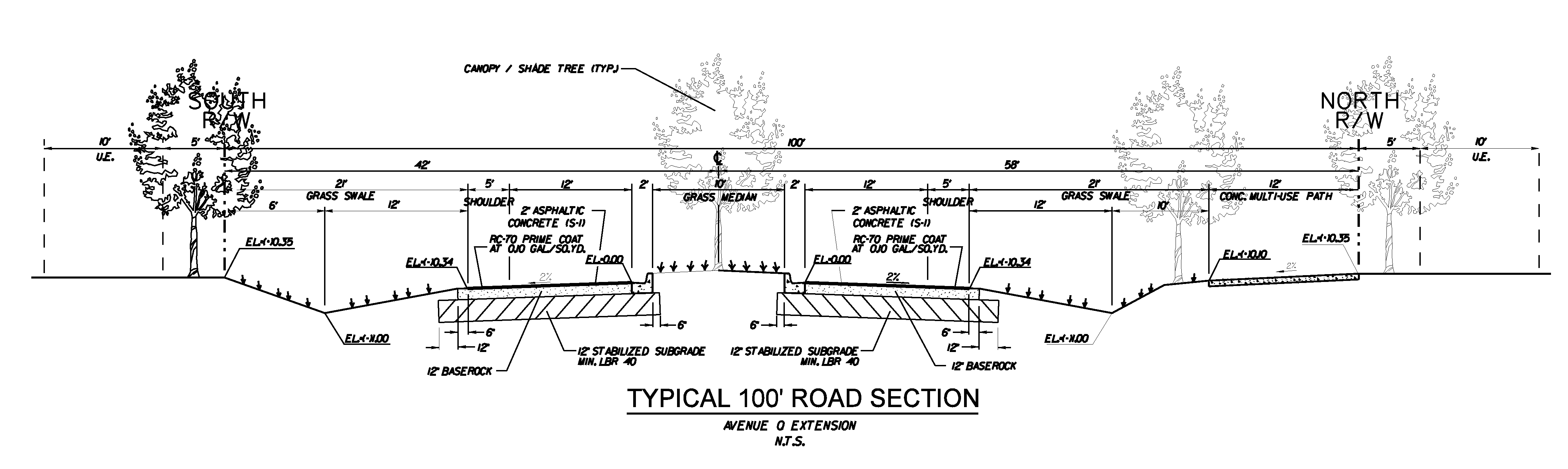
Street trees shall be placed on each side of the multiuse path, shall not be installed in a utilities right-of-way or a utilities easement or in a manner that their root systems may be adversely affected by work in a utilities easement so as to threaten the health of the trees. Street trees shall be placed so their canopies shall not interfere with any power line, and shall be placed so that a maximum shading effect is achieved along the entire length of the multiuse path. Utilities easements shall be placed in relation to the street trees in a manner that achieves these design standards and avoids damage to trees as a result of the installation and maintenance of permitted utilities.
3.
Road G from Kings Highway to Jenkins-Taylor Dairy Road and from Jenkins-Taylor Dairy Road to Road A, 80' Right-of-Way, with bicycle/pedestrian path. The Board of County Commissioners may authorize a modified roadway section as part of a Planned Development application, after receiving the recommendation of the Development Review Committee. Any proposed modifications shall consider the type and anticipated volume of vehicle, bicycle, and pedestrian movements as well as drainage and utility needs.
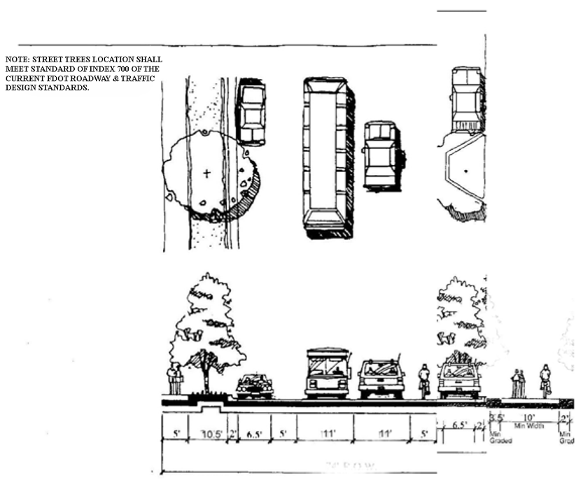
4.
Roads D and E where Road D is between Garner Court and Avenue M, and Road E is between Orange Avenue and Angle Road. The Board of County Commissioners may authorize a modified roadway section as part of a Planned Development application, after receiving the recommendation of the Development Review Committee. Any proposed modifications shall consider the type and anticipated volume of vehicle, bicycle, and pedestrian movements as well as drainage and utility needs.
5.
Road A and Selena Avenue/Mariah Circle extending Avenue D from Angle Road to Lamont Road/Johnson Pierce Road, and Johnson Pierce Road north to Road G. The Board of County Commissioners may authorize a modified roadway section as part of a Planned Development application, after receiving the recommendation of the Development Review Committee. Any proposed modifications shall consider the type and anticipated volume of vehicle, bicycle, and pedestrian movements as well as drainage and utility needs.
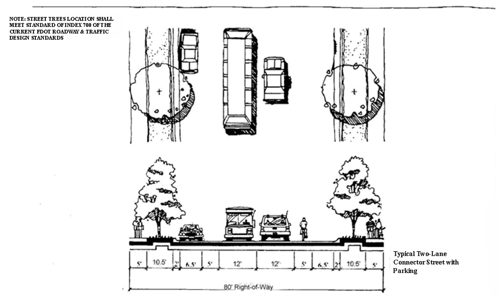
6.
Roads B, C, F, Metzger Road, Loop Road and any extension of Loop Road or other backage road, and 41st Street. The Board of County Commissioners may authorize a modified roadway section as part of a Planned Development application, after receiving the recommendation of the Development Review Committee. Any proposed modifications shall consider the type and anticipated volume of vehicle, bicycle, and pedestrian movements as well as drainage and utility needs.
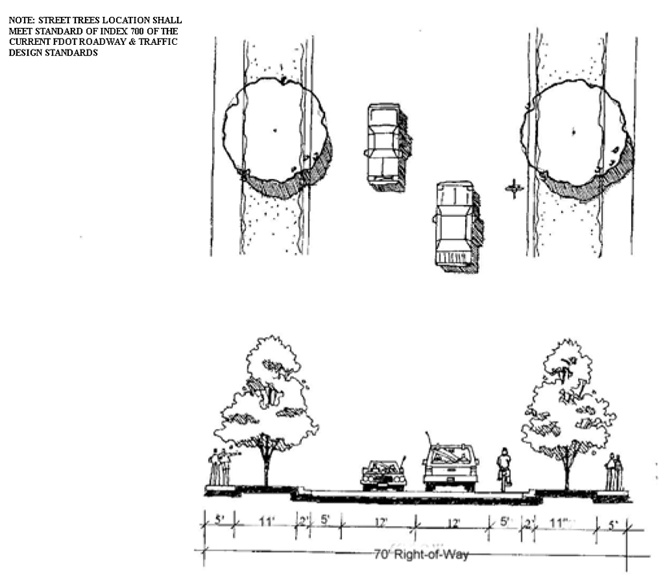
C.
Bicycle/Pedestrian multi-user trails shall be designed in accordance with the following minimum required cross sections and FDOT standards. The Board of County Commissioners may authorize a modified roadway section as part of a Planned Development application, after receiving the recommendation of the Development Review Committee. Any proposed modifications shall consider the type and anticipated volume of vehicle, bicycle, and pedestrian movements as well as drainage and utility needs.
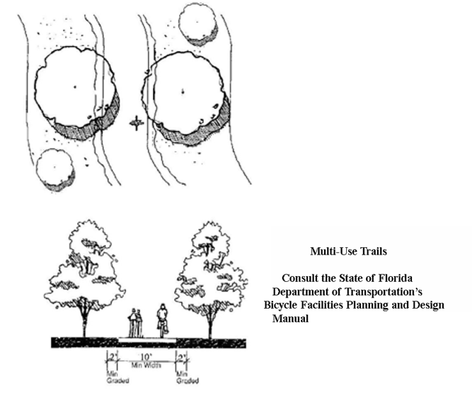
(Ord. No. 14-026, § A, 1-6-2015; Ord. No. 2022-31, § A, 11-15-2022; Ord. No. 2024-08, § 1, 2-20-2024)
4.12.04—4.12.09. - Reserved.
Editor's note— Ord. No. 14-026, § A, adopted January 6, 2015, repealed §§ 4.12.04—4.12.09 and derived from the 2009 Republication and Ord. No. 2013-19, Pt. A, 5-21-13.
4.12.10. - Right-of-Way Dedication Requirements.
The following roads shown on Map [A] shall be dedicated, built, and eligible for road impact fee credits in accordance with the requirements for dedication of right-of-way for roads on the Thoroughfare Network Right-of-Way Protection Plan in accordance with the requirements of Section 7.05.03(I) of this St. Lucie County Land Development Code, as it may be amended from time to time.
4.12.11. - Conflicts with other Sections or Chapters.
In the event of express conflict with any provision of the St. Lucie County Land Development Code the provisions of this Article shall prevail.