
San Miguel County Unincorporated
City Zoning Code
City Zoning Code
SECTION 5
12: - SUBDIVISION EXEMPTIONS
5-1201 - General
This section establishes standards for the following subdivision exemptions:
5-1202
Correction of Survey Errors;
5-1203
Lot Line Adjustments;
5-1204
Parcels for Essential Community Facilities;
5-1205
Reversion to Acreage Plats;
5-1206
Agricultural Lands Lot Split;
5-1207
Open Land Protection;
5-1208
Fully Developed Residential Property;
5-1209
Single Lot Split in an Existing Subdivision;
5-1210
Wright's Mesa Subdivision Exemption;
5-1211
West End;
5-1212
Wright's Mesa Open Land Protection;
5-1213
Wright's Mesa Essential Community Facilities & Parks; and
5-1214
Vacation of Lot Lines.
5-1202 - Correction of Survey Errors
A subdivision exemption to correct surveying or engineering errors may be permitted subject to compliance with standards in this section (refer to Sections 3-5 and 4-6 for procedures and submission contents).
5-1202A.
The correction shall be made to a recorded plat that has been approved by San Miguel County;
5-1202B.
The correction(s) increase(s) or do(es) not affect the degree of compliance with Code standards; and
5-1202C.
The revised final plat shall comply with the final plat submission contents of Section 4-5.
5-1202D.
Nature and Purpose
The revised final plat shall have a statement explaining the reason for the revised plat to be prepared and filed.
5-1203 - Lot Line Adjustments
A subdivision exemption to adjust a lot line between separately deeded adjacent parcels or lots may be permitted (refer to Section 3-5 and 4-6 for procedures and submission contents) provided that:
5-1203A.
The adjustment creates not more than the original number of lots or parcels.
5-1203B.
The purpose or effect of the lot line adjustment is not the creation of a new lot or parcel (that is, one substantially different in size or dimensions), or renders a previously buildable lot unbuildable.
5-1203C.
In the case of conforming lots and parcels, any resulting lot or parcel shall conform to the minimum requirements for area and width established by the provisions of the Code.
5-1203D.
In the case of a nonconforming size lot or parcels, any resulting lot or parcel shall not increase in nonconformity.
5-1203E.
The applicant shall prepare a subdivision exemption lot line adjustment map (final plat).
I.
The requirements for a final plat will vary according to whether all of the lots, tracts or streets in the application meet the definition of "Platted Subdivision" per C.R.S. 38-51-102(15).
II.
For an application that has all of the lots, tracts or streets that meet the definition of "Platted Subdivision" per C.R.S. 38-51-102(15), the applicant shall prepare a final plat in compliance with Sections 4-502, 4-503 and 4-504, and comply with the additional requirements in Section 5-1203 F.
III.
For an application that has one (1) or more of the lots, tracts or streets that does not meet the definition of "Platted Subdivision" per C.R.S. 38-51-102(15), the applicant shall prepare a final plat in compliance with the requirements in Sections 4-502 A through 4-502 I, inclusive; Section 4-504; Section 5-1203 F; and comply with the additional requirements of Section 5-1203 G.
5-1203F.
Lots, Tracts and Streets that Are a "Platted Subdivision" Per C.R.S. 38-51-102(15)
I.
Tract Border
The new agreed-upon common boundary lines of the final plat shall be designated by a heavy solid line and labeled as "Boundary Line by Agreement of Adjoiners" or similar language. The previous common boundary lines that are no longer applicable should be indicated by a less prominent dashed or background line type and labeled as "vacated lot line" or similar language. Such lines shall not interfere with the legibility of figures or other data.
II.
Lot Numbering
All lots or tracts of the final plat that are part of an approved and recorded plat in the office of the Clerk and Recorder shall be indicated with a new lot number that is a slight variation to the old lot number. For example, Lots 1 and 2 can be redesignated as Lots 1A and 2A.
III.
Streets
a.
All streets having a lot line adjustment on the final plat shall be named exactly with the same name as existed previous to the lot line adjustment.
b.
All County Roads that are within the legal description being finally platted shall be dedicated to San Miguel County on the final plat. All public roads within the legal description being finally platted shall dedicate an easement for public road right-of-way.
IV.
Monument Data
Monuments that marked the previous common boundary and are no longer applicable after the lot line adjustment is approved and recorded shall be tied to the survey with dimensions and be indicated on the plat as removed from the ground. Monuments so indicated shall be actually removed.
V.
Owner's Certificate (to be used in lieu of Section 4-503 A)
A certificate signed and acknowledged by all parties having any record title interest in the land described in the legal description per Section 4-502 L, consenting to the preparation and recordation of said plat, shall be worded substantially as follows:
Owner's Certificate
Know all persons by these presents:
That (name of owner(s) of record), being the owner(s) of the land described at Reception No. _______ in the office of the Clerk and Recorder, further described as follows:
(insert legal description of the first parcel, previous to the lot line adjustment)
That (name of owner(s) of record), being the owner(s) of the land described at Reception No. _______ in the office of the Clerk and Recorder, further described as follows:
(insert legal description of the second parcel, previous to the lot line adjustment),
(repeat as necessary for each owner)
under the name of (Title of final plat per Section 4-502 E, in capital letters), do hereby agree upon the property lines as set forth hereon and do further grant, sell and convey to the other owners such of their real property as may lie on the other party's side of the boundary lines set forth on this plat and do hereby agree that the boundary lines as shown on this plat are the boundary lines by agreement of adjoiners pursuant to the provisions of C.R.S. 38-44-112.
VI.
Licensed Surveyor (to be used in lieu of Section 4-503 C)
A certificate by the Colorado licensed surveyor responsible for the survey and final plat, to which shall be affixed the surveyor's official seal:
Land Surveyor's Certificate
I, (printed name of Land Surveyor, indicating firm affiliation, if any) being a Colorado Licensed Surveyor, do hereby certify that this plat and survey of (Title of final plat per Section 4-502 E, in capital letters) was made by me or under my responsible charge in compliance with the applicable provisions of the San Miguel County Land Use Code and C.R.S. Title 38, Article 51, and that both are true and accurate to the best of my knowledge and belief. I further certify that all monuments were set in the ground as required by San Miguel County Land Use Code Section 5-1203 and C.R.S. Article 51 of Title 38, and that all monuments were removed from the ground as required by San Miguel County Land Use Code Section 5-1203 F.III.
(signature)___________
P.L.S. No. ___ Date
VII.
Nature and Purpose
The final plat shall have a statement explaining the reason for the final plat to be prepared and filed.
5-1203G.
Lots, Tracts and Streets that Are Not a "Platted Subdivision" Per C.R.S. 38-51-102(15)
I.
Land Survey Plat
A complete land survey and monumentation of the final plat boundary for any of the lots, tracts or streets that meet the definition of "platted subdivision" per C.R.S. 38-51-102(15) is required, which shall include all information necessary to comply with the requirements of C.R.S. 38-51-106. A complete land survey and monumentation of the boundary for any of the lots, tracts or streets that do not meet the definition of "platted subdivision" per C.R.S. 38-51-102(15) is not required, and the survey of such lots, tracts or streets does not need to comply with the requirements of C.R.S. 38-51-106. A complete land survey and monumentation of the new agreed-upon boundary line is required. Final plats shall include all information listed in the requirements of C.R.S. 38-51-106 (a),(e),(g) (h) and (l).
II.
Legal Description
A legal description of the land to be final platted shall be indicated in the Owner's Certificate (see Section 5-1203 F.V). The description may utilize generally accepted methods to describe the land being final platted such as aliquot, proportional, metes and bounds, or lot, block and subdivision formats.
III.
Lot Numbering
All lots or tracts of the final plat which are part of an approved and recorded plat in the office of the Clerk and Recorder shall be indicated with a new lot number that is a slight variation to the old lot number. For example, Lots 1 and 2 can be redesignated as Lots 1A and 2A. Parcels that are not part of an approved and recorded plat in the office of the Clerk and Recorder shall be labeled with the owner's name and deed recording information. Patented mining claims shall also indicate the claim name and mineral survey number.
IV.
Monument Data
a.
The accurate location and description of all monuments, both found and set, which mark the boundaries of any of the lots, tracts or streets that meet the definition of "platted subdivision" per C.R.S. 38-51-102(15) shall be shown on the final plat. The accurate location and description of all monuments, both found and set, which mark the boundaries of the new agreed-upon common boundary lines shall be shown on the final plat, and all control monuments used in conducting the survey shall be shown.
b.
Monuments shall comply with the requirements pursuant to C.R.S. 38-51-104 and 38-51-105 and to Rules of the State Board of Registration for Professional Engineers and Professional Land Surveyors, and conform to the standards of Section 5-706 of the Land Use Code.
c.
Monuments shall be set at all corners, angle points, and points of curvature on the boundaries of any of the lots, tracts or streets that meet the definition of "platted subdivision" per C.R.S. 38-51-102(15), and at all corners, angle points, and points of curvature of the new agreed-upon boundary line of the final plat.
d.
Any conflicting boundary evidence for the boundaries of any of the lots, tracts or streets that meet the definition of "platted subdivision" per C.R.S. 38-51-102(15) shall be shown. Any conflicting boundary evidence for the terminus at each end of the new agreed-upon boundary lines shall be shown.
V.
Lot Dimensions
a.
Sufficient data must be shown to readily determine the dimensions of lots, tracts or streets that meet the definition of "platted subdivision" per C.R.S. 38-51-102(15), and for the new agreed-upon common boundary line with respect to each of the lots, tracts, parcels or streets being modified.
b.
Dimensions of lines shall be shown in feet and hundredths of a foot. All bearings and central angles shall be shown to the nearest second. The dimensions shown around the perimeter of all lots, tracts and streets that meet the definition of "platted subdivision" per C.R.S. 38-51-102(15) must close within a tolerance of 0.02 feet.
c.
New agreed-upon common boundary lines and boundary lines for lots, tracts or streets that meet the definition of "platted subdivision" per C.R.S. 38-51-102(15), must show ties to any controlling monuments used in the boundary survey.
d.
Sufficient data for all curves that are dimensioned shall be shown to enable establishment of curves on the ground. Such data shall include radius, central angle and arc length for each tangential circular curve. In addition, non-tangential circular curves that are dimensioned shall be indicated as such and shall also include the long chord bearing and chord length. Inclusion of a curve data chart is optional.
VI.
Easements
a.
For lots, tracts or streets that meet the definition of "platted subdivision" per C.R.S. 38-51-102(15), the final plat shall show the location, width and dimensions of all recorded easements to which such lots, tracts or streets are subject, and also show any apparent easements, not of record. For lots, tracts or streets that do not meet the definition of "platted subdivision" per C.R.S. 38-51-102(15), the final plat does not need to show recorded or apparent easements to which such lots, tracts or streets are subject.
b.
Apparent easements, not of record, which intersect the new agreed-upon common boundary line shall be noted on the plat.
c.
Easements shown that are recorded must be clearly labeled with a reference to the document of record.
d.
If an easement is being created by the final plat, proper language for the creation of such easement including the beneficiaries and purposes for said easement shall be set out in the Owner's Certificate.
e.
Easements shall be indicated with dashed or other broken line types, not as a solid line type similar to lot or boundary lines.
f.
Dimension and tie all easements that are being created by the final plat. Sufficient ties are required to definitely locate the easements with respect to each lot, tract or right-of-way on the final plat. Easement ties along the sidelines of lots must be shown in a manner that will not cause confusion with lot dimensions.
VII.
Certificates and Acknowledgements
At a minimum, the certificates and acknowledgements from Section 5-1203 F.V, VI and VII, and Section 4-503 B, D, F, G, H, I, L and J shall be required on the final plat, shall be placed on the first page of the final plat and shall be worded substantially as described in each Section.
5-1203H.
Waiver of Requirements
If unusual circumstances warrant, a waiver of any of the requirements of Sections 5-1203 E, 5-1203 F or 5-1203 G can be obtained if approved by the Planning Director and the County Surveyor.
5-1204 - Parcels for Essential Community Facilities
The subdivision of land for essential governmental and community facilities is exempt from the subdivision regulations of this Code, provided that development occurs in compliance with the standards in this Section and prepare a final plat in compliance with the requirements in Section 4-5. (Refer to Sections 3-5 for procedures and 4-6 submission contents).
5-1204A.
To qualify for an exemption the proposed use or activity must:
I.
Provide a basic or fundamental public service upon which the community is dependent for support;
II.
Be available to the general public;
III.
Serve primarily the local community; and
IV.
Provide facilities in response to growth, while not generating growth.
5-1204B.
Mitigation of Service Demands
An applicant for the exemption shall demonstrate the mitigation of demands for:
I.
Additional affordable housing;
II.
Transportation services and parking; and
III.
Basic services such as water supply, sewage treatment, fire and police protection and solid waste disposal.
5-1204C.
Mitigation of Environmental Impacts
An applicant shall demonstrate the development has negligible adverse impacts on:
I.
Air quality;
II.
Water, land and energy resources; and
III.
Scenic quality.
5-1205 - Reversion to Acreage Plats
Reversion to Acreage Plats are exempt from subdivision provided they are in compliance with the standard in this section (Refer to Sections 3-5 for procedures and 4-6 submission contents):
5-1205A.
The lots, tracts, parcels or streets being reverted to acreage will permanently be removed from the platted subdivision that it was a part of. All previous development rights associated with the parcel according to the previous subdivision will be extinguished, and the new parcel will have the development rights associated with one (1) parcel in the zone district to which it will revert. A reversion to acreage is permanent and cannot be undone at a later date.
5-1205B.
An applicant must prepare a final plat in compliance with the requirements in Section 4-5 and comply with the following additional requirements:
I.
Lot Numbering
(Replaces 4-502 M.) The lots, tracts, parcels or streets being reverted acreage shall indicate a new parcel name that is different than the former subdivision lot, tract, parcel or street name. The former subdivision lot, tract, parcel or street name shall also be indicated in parenthesis and designated as "former lot (or tract, parcel, street)".
II.
Streets
Any private streets that will become public roads upon being reverted to acreage, shall dedicate an easement for public road right-of-way.
5-1206 - Agricultural Land Lot Split
Land in the Forestry, Agriculture and Open (F) Zone District may be subdivided once to create one (1) single-family residential building lot, provided such development occurs in compliance with the standards in this section:
5-1206A.
The land must have been continuously held in the same ownership since April 6, 1972;
5-1206B.
The parcel to be created will not be less than two (2) acres in size;
5-1206C.
The fathering parcel has not been subdivided since April 6, 1972;
5-1206D.
The exemption parcel has a reasonable building site;
5-1206E.
The site will be served with electric power, an approved water system, waste disposal and a public access road at least thirty (30) feet in width;
5-1206F.
The fathering parcel contains at least seventy (70) acres;
5-1206G.
The parcel shall constitute a bona fide and ongoing agricultural operation; and
5-1206H.
The applicant has prepared a final plat in compliance with the requirements in Section 4-5.
5-1207 - Open Land Protection (OLP)
5-1207A.
Purpose and Intent
The purpose and intent of OLP is to provide landowners with an alternative way to obtain equity from their land and encourage a more compact form of development that retains rural character, scenic views, productive agricultural lands and biological diversity. OLP employs an expedited review process that is easier to use than the standard subdivision process. OLP encourages a pattern of development that retains San Miguel County's rural character by encouraging smaller lots in a concentrated pattern while maintaining in perpetuity the rest of the land in its open, natural and productive condition. OLP encourages the sensitive location of home sites and careful design of roads, structures and fences to protect important scenic rural landscapes, agricultural and ranching lands, riparian areas, wetlands, wild flora and critical wildlife habitats. Finally, OLP minimizes the cost of rural services to the County.
5-1207B.
Applicability
OLP is limited to single-family residential uses permitted in the Forestry, Agriculture and Open (F), and West End (WE) Zone Districts in San Miguel County and is an alternative to conventional 35-acre development. A minimum of seventy (70) acres is required for use of OLP. OLP shall not apply to any land already encumbered by any conservation easement or other permanent restriction prohibiting development or otherwise eliminating density.
5-1207C.
Allowed Density
I.
Allowed density is based upon the percentage of protected open space land set aside on the parcel. The more land that is kept open, the greater the allowed density bonus as follows:
II.
No fraction of a residential lot may be counted in the bonus calculation. For example, the minimum amount of land needed to obtain a lot bonus is seventy (70) acres if eighty percent (80%) or more of the land is protected, which would result in fifty-six (56) acres protected and one (1) bonus lot. The minimum amount of land needed to obtain a lot bonus with only sixty percent (60%) of the land protected is one hundred seventy-five (175) acres, which would result in one hundred five (105) acres protected and one (1) bonus lot.
III.
Caretaker units are permitted in OLP only if a central water and sewer system and/or water augmentation plan is used.
IV.
The total density of all residential units on a parcel, including caretaker units, shall not exceed two (2) units per thirty-five (35) acres.
5-1207D.
Review Standards
I.
The site plan and layout shall to the maximum extent feasible:
a.
Minimize development on open, exposed portions of the landscape;
b.
Locate development in one (1) or more compact area(s) and utilize a design character compatible with the rural landscape;
c.
Protect irrigated hay and pasture land;
d.
Protect wetlands, riparian areas, unique plant communities, critical wildlife habitat, and natural features and landmarks;
e.
Minimize development on ridgelines and in principal highway corridor view sheds;
f.
Minimize road and utility infrastructure and potential burden on County services;
g.
Minimize tree, vegetation and soil disturbance or removal and avoid scarring of hillsides with roads/utilities;
h.
Minimize visual and noise impacts on neighbors; and
i.
Demonstrate that any individual cluster greater than fifteen (15) units is compatible with the natural topography and landscape and will not cause adverse impacts on surrounding areas in accordance with 5-1002 B.
II.
The minimum lot size is two (2) acres unless a state approved community water supply system is utilized. In such cases, the Board of County Commissioners may establish a smaller minimum lot size and setbacks.
III.
A single open space parcel shall be designated. Such open space parcel may be owned by private landowner(s), a homeowners association, non-profit organization or government entity. Activities permitted by right on the open space parcel shall be limited to agricultural and ranching operations and associated structures, and non-commercial hiking, cross-country skiing, hunting, fishing, horseback riding and sleigh rides. The following commercial activities may be considered for a special use permit on the open space parcel pursuant to Land Use Code Section 5-10, and each permitted use would replace one (1) residential lot in the cluster: hiking, cross-country skiing, hunting, fishing, horseback riding, sleigh rides and associated shelters.
IV.
The application shall meet all basic water system, sewage system, access and survey requirements set forth in this Land Use Code.
V.
If a well water supply system is proposed, the application must comply with Sections 30-28-101, 30-28-401 et seq. and 37-92-602 C.R.S. (concerning water well permits in cluster developments), including demonstration of at least two-thirds contiguous open space.
VI.
Development of an OLP may be phased in accordance with an approved plan submitted by the applicant.
5-1207E.
Submittal Requirements
I.
In addition to the minimum contents of all Land Development Applications in Section 4-2, an applicant shall submit:
a.
A site plan, as required by Section 4-208, that identifies:
i.
Property boundaries;
ii.
Lot lines for developed parcels;
iii.
Open space parcel boundaries;
iv.
Existing structures;
v.
Roads and driveways that comply with the applicable standards of Section 5-5;
vi.
Site constraints including floodplains, streams, wetlands, slopes over thirty percent (30%), wildlife habitat, unique plant communities and irrigated lands; and (vii)building envelopes, if necessary to demonstrate compliance with applicable review standards.
b.
A final plat in compliance with the requirements in Section 4-5.
c.
Either plans for a well water supply and sewage disposal plan that complies with C.R.S. Sections 30-28-101, 30-28-401 et seq. and 37-92-602 or, if applicable, a community water supply system;
d.
Identification of the entity (entities) (private landowner(s), a homeowners association, non-profit organization or government entity) that will have legal responsibility for managing and maintaining private roads and the restricted open land parcels; and
e.
A copy of both a plat note and either a conservation easement, deed restriction, or other covenant that restricts development on the open space parcel and names San Miguel County as a beneficiary. The restriction shall apply in perpetuity; however, after a minimum of forty (40) years, the owner of the open space parcel may request through two-step Planning Commission and Board of County Commissioners review to remove or modify the restriction. The Board of Commissioners may only release the restriction upon a finding that the purposes of the restriction can no longer be fulfilled either due to Land Use Code and/or Master Plan amendments or to change in surrounding development patterns and the Planning Commission and the Board of Commissioners shall consider any testimony offered by homeowners in the vicinity of the subject parcel. If the restriction is released, use of the subject parcel shall be governed by all applicable County regulations for the underlying Zone District.
5-1207F.
Review Process
I.
Projects with four (4) or fewer lots shall be reviewed administratively and projects with five (5) or more lots will require a one-step Board of County Commissioners review.
a.
Administrative Review (four or fewer lots)
i.
Pre-application Conference Summary prior to submittal to review OLP concept and site-specific information;
ii.
Application may be referred to the County Road Superintendent, County Environmental Health Official, County Engineer, Colorado Division of Water Resources, Colorado Parks and Wildlife and/or other applicable agencies;
iii.
Notification by the applicant of all landowners within three hundred (300) feet of the subject property pursuant to Section 3-9; and
iv.
Planning Director action.
b.
One-Step Board of Commissioners Review (five or more lots)
i.
Pre-application Conference Summary (see above);
ii.
Application referred (see above);
iii.
Optional conceptual work session with the Board of County Commissioners and staff prior to applicant submitting engineering and survey drawings;
iv.
Notification of adjacent landowners; and
v.
Board of Commissioner review at a scheduled public meeting.
5-1208 - Fully Developed Residential Property
The Board of Commissioners may grant a subdivision exemption for the purpose of subdividing property already developed for residential uses to or in excess of the maximum density allowed under current zoning. Such exemptions may be granted regardless of whether development occurred under existing zoning or prior zoning, provided that the lots and uses are now nonconforming, and provided that the development was achieved legally, in conformance with zoning at the time of development and not for the purpose of avoiding subdivision or other land use regulations. The maximum number of lots that may be created by such exemption may not be greater than the total number of existing detached structures containing housing units on the property.
The applicant shall prepare a final plat in compliance with the requirements in Section 4-5.
5-1209 - Single-lot Split in an Existing Subdivision
The Board of Commissioners may grant a Subdivision Exemption for the purpose of splitting an individual lot in an existing County approved Subdivision and/or Planned Unit Development under which such lot was approved for multiple units. Such exemption may be granted only for the purpose of creating separate parcels; no change of zoning, use, density, mass and scale and/or other applicable lot restriction may be considered. The lot split must meet all basic water system, sewage system, access, survey and final plat requirements set forth in the Land Use Code.
The applicant shall prepare a final plat in compliance with the requirements in Section 4-5.
5-1210 - Wright's Mesa Subdivision Exemption
5-1210A.
Purpose
The Wright's Mesa Subdivision Exemption is intended to encourage and retain agriculture on Wright's Mesa by allowing a landowner to create a small parcel and home site for a family member or long-time employee, or to generate cash to finance an ongoing agricultural operation. The exemption provides an alternative to creating or dividing a 35-acre parcel from the larger agricultural or ranch parcel.
5-1210B.
Applicability
A person or landowner is entitled to one (1) exemption on a parcel from the San Miguel County Subdivision Regulations for the purpose of creating a lot for one (1) single-family residence and allowed accessory uses, provided the applicant demonstrates to the satisfaction of the Board of County Commissioners that the exemption is consistent with the purpose statement in 5-1210 A. and if applicable, the review standards in 5-1210. C.
I.
Such exemption may be granted by the BOCC through the one-step review process for parcels one hundred fifty (150) acres or greater in size with an existing single-family dwelling; or
II.
Such exemption shall be reviewed for compliance with the applicable standards through the two-step review process for parcels that are greater than thirty-seven (37) acres in size but less than one hundred fifty (150) acres in size.
5-1210C.
Review Standards
I.
The review standards for a subdivision exemption on parcels less than one hundred fifty (150) acres include the following:
a.
An existing single-family dwelling exists on the property;
b.
The proposed parcels may not be less than thirty-five (35) acres and two (2) acres, respectively; and the smaller proposed parcel shall not be larger than five (5) acres;
c.
The water supply for the new parcel shall be connected to and be served by a tap provided by the Norwood Water Commission;
d.
The new parcel shall be located within non-productive agricultural land (i.e., a dry land area);
e.
The proposed subdivision exemption will promote continued crop irrigation and/or viable agriculture;
f.
Neither of the parcels shall be dependent on water hauled from off-site;
g.
The dwelling on the new parcel shall be located within three hundred (300) feet of the dwelling on the original parcel; and
h.
The subdivision shall be consistent with the purpose and intent of the Wright's Mesa Subdivision Exemption.
II.
The review standards for a subdivision exemption on parcels one hundred fifty (150) acres or greater include the following:
a.
The smaller proposed parcel shall not be less than two (2) acres and shall not be larger than five (5) acres;
b.
The adequacy of water supply for the single-family residential use to be located on the new parcel shall be demonstrated;
c.
The new parcel shall be located within non-productive agricultural land (i.e., a dry land area);
d.
The proposed subdivision exemption will promote continued crop irrigation and/or viable agriculture;
e.
The subdivision shall be consistent with the purpose and intent of the Wright's Mesa Subdivision Exemption.
5.1210D.
Submittal Requirements
The application shall include a statement demonstrating the adequacy of the water supply for the single-family residential use to be located on the new parcel, and compliance with all applicable review standards. The applicant shall prepare a final plat in compliance with the requirements in Section 4-5.
5-1211 - West End
5-1211A.
Recognizing that the continued viability of agriculture hinges on a complex array of technical skills, long and intense periods of physical effort by entire families, and a high level of financial risk, and recognizing that the number of full-time farm and ranch families are declining resulting in the need for ranchers and farmers to hold additional jobs, with agriculture being practiced on smaller parcels, the Board of Commissioners may grant a Subdivision Exemption in the West End (WE) Zone District for the purpose of creating four (4) or fewer additional new parcels, each three (3) acres or larger, from a single original parcel. None of these parcels are eligible for further subdivision or subdivision exemption.
5-1211B.
The applicant shall prepare a final plat in compliance with the requirements in Section 4-5.
5-1211C.
The plat must include a note citing the guidelines listed in LUC Section 5-320 J.II.a, b and c.
5-1211D.
The applicant must show proof of adequate water supply.
5-1212 - Wright's Mesa Open Land Protection (WMOLP) Subdivision Exemption
5-1212A.
Purpose and Intent
The purpose and intent of the WMOLP subdivision exemption is to provide landowners in the WMRA zone district with an alternative way to obtain equity from their land and encourage a more compact form of development that retains rural character, scenic views, productive agricultural lands, and biological diversity. The WMOLP subdivision exemption employs an expedited review process that is easier to use than the standard subdivision process. This subdivision exemption encourages a pattern of development that retains the rural character of Wright's Mesa by encouraging smaller lots in a concentrated pattern while maintaining in perpetuity the rest of the land in its open, natural, and productive condition. The process is an alternative to conventional 35-acre development that is exempt from state and county subdivision regulations. It encourages the sensitive location of lots and home sites and careful design of roads, structures, and fences to protect important scenic landscapes, agricultural and ranching lands, riparian areas, wetlands, wild flora, and critical wildlife habitats.
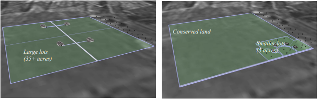
Above examples: (a) Standard 35-Acre subdivision with four 40-acre lots carved out of a 160-acre parcel, and (b) Amended OLP with four 5-acre lots within 160-acre parcel with 140 acres conserved. (Note: This example does not show the extra bonus lot.)
5-1212B.
Applicability
I.
The WMOLP subdivision exemption is limited to the WMRA zone district.
II.
A minimum of seventy (70) acres is required for use of this WMOLP subdivision exemption.
III.
This WMOLP subdivision exemption shall not apply to any land already any conservation easement or other permanent restriction prohibiting development or otherwise eliminating density.
IV.
The WMOLP subdivision exemption shall not apply for parcels located entirely within the Gunnison Sage-grouse Habitat Overlay or within the Wright's Mesa Source Water Protection Area Overlay.
5-1212C.
Allowed Density
I.
Allowed density is based on the percentage of protected open space land set aside on the parcel. The more land that is conserved, the greater the allowed lot bonus as follows.
II.
No fraction of a residential lot may be counted in the bonus calculation.
III.
Secondary dwelling units are permitted in WMOLP only if a central water and sewer system and/or water augmentation plan is used.
IV.
The total density of all residential units on a parcel, including secondary dwelling units, shall not exceed three (3) units per thirty-five (35) acres.
5-1212D.
Review Standards
I.
The site plan and layout shall, to the maximum extent feasible:
a.
Minimize development on open, exposed portions of the landscape;
b.
Locate development in one (1) or more compact area(s) and utilize a design character compatible with the rural landscape;
c.
Protect irrigated hay and pasture land;
d.
Protect wetlands, riparian areas, unique plant communities, critical wildlife habitat, and natural features, and landmarks;
e.
Minimize development on ridgelines and along Highway 145 in the view corridor;
f.
Minimize development in high fire hazard areas;
g.
Minimize road and utility infrastructure and potential burden on County services;
h.
Consolidate driveways to minimize driveway cuts along county roads;
i.
Minimize tree, vegetation, and soil disturbance or removal and avoid scarring of hillsides with roads/utilities;
j.
Minimize visual and noise impacts on neighbors; and
k.
Demonstrate that any individual cluster greater than ten (10) units is compatible with the natural topography and landscape and will not cause adverse impacts on surrounding areas.
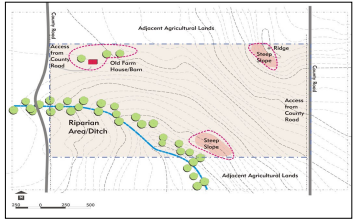
Sample site plan and layout showing compliance with the WMOLP subdivision exemption.
II.
The minimum lot size is two (2) acres unless Norwood water and sewer are utilized.
III.
A single open space parcel shall be designated. Such open space parcel maybe owned by private landowner(s), a homeowners association, non-profit organization or government entity. Activities permitted by right on the open space parcel shall be limited to agricultural and ranching operations and associated structures, and non-commercial outdoor recreation Special Use Permit activities may be considered on the open space parcel pursuant to the Table of Allowed Uses and general and use-specific standards.
IV.
The application shall meet all basic water system, sewage system, access and survey requirements set forth in this Land Use Code.
V.
If a well water supply system is proposed, the application must comply with C.R.S. Sections 30-28-101, 30-28-401 et seq., and 37-92-602 (concerning water well permits in cluster developments), including demonstration of at least two-thirds contiguous open space.
VI.
Development of a WMOLP may be phased in accordance with an approved plan submitted by the applicant.
5-1212E.
Submittal Requirements
I.
In addition to the minimum contents of all Land Development Applications in Section 4-2, an applicant shall submit:
a.
A site analysis map that identifies:
i.
Roads, trails, all apparent easements existing and recorded, and rights-of-way;
ii.
Topography (slopes over thirty percent (30%) and ridgelines);
iii.
Streams, floodplains, ditches, source water protection area, and wetlands;
iv.
Gunnison Sage-grouse habitat;
v.
Geologic hazard areas;
vi.
Irrigated lands;
vii.
Adjacent public lands;
viii.
Existing conservation easements or protected lands;
ix.
Adjacent property lot sizes, setbacks, and building sizes;
x.
Built features, including driveways, farm roads, buildings, fences, walks, barns or sheds, drainage fields, utilities and utility easements; and
xi.
Historically and culturally significant sites or structures.
b.
A site plan, as required by Section 4-208, that identifies:
i.
Property boundaries;
ii.
Lot lines for developed parcels;
iii.
Open space parcel boundaries;
iv.
Existing structures;
v.
Roads and driveways that comply with the applicable standards of Section 5-5;
vi.
Site constraints listed in subsection a above; and
vii.
Building envelopes, if necessary to demonstrate compliance with applicable review standards.
c.
An open space parcel map that includes:
i.
Contiguity with adjacent open lands, conservation areas, and agriculture lands;
ii.
Unique natural, historic, or cultural site features (including wildlife habitat area, watershed protection);
iii.
A minimum buffer of one hundred (100) feet between any residential structure and adjacent agricultural activities or open lands; and
iv.
A minimum buffer for residential lots of one hundred (100) feet along county roads or along Highway 145.
d.
Either plans for a well water supply and sewage disposal plan that complies with C.R.S. Sections 30-28-101, 30-28-401 et seq., and 37-92-602, or if applicable, a community water supply system;
e.
Identification of the entity (entities) (private landowner(s), a homeowners association, non-profit organization or government entity) that will have legal responsibility for managing and maintaining private roads and the restricted open land parcels; and
f.
A copy of both a plat note and either a conservation easement, deed restriction, or other covenant that restricts development on the open space parcel and names San Miguel County as a beneficiary. The restriction shall apply in perpetuity; however, after a minimum of forty (40) years, the owner of the open space parcel may request through two-step Planning Commission and Board of County Commissioners review to remove or modify the restriction. The Board of Commissioners may only release the restriction upon a finding that the purposes of the restriction can no longer be fulfilled either due to Land Use Code and/or Master Plan amendments or to change in surrounding development patterns and the Planning Commission and the Board of Commissioners shall consider any testimony offered by homeowners in the vicinity of the subject parcel. If the restriction is released, use of the subject parcel shall be governed by all applicable County regulations for the underlying Zone District.
g.
The applicant shall prepare a final plat in compliance with the requirements in Section 4-5.
5-1212F.
Review Process
I.
Projects with ten (10) or fewer lots shall be reviewed administratively, and projects with eleven (11) or more lots will require one-step Board of County Commissioners review.
a.
Administrative Review (10 or fewer lots)
i.
Pre-application Conference Summary prior to submittal to review WMOLP concept and site-specific information;
ii.
Application may be referred to the County Road Superintendent, County Environmental Health Official, County Engineer, Colorado Division of Water Resources, Colorado Parks and Wildlife and/or other applicable agencies;
iii.
Notification by the applicant of all landowners within three hundred (300) feet of the subject property pursuant to Section 3-9; and
iv.
Planning Director action.
b.
One-Step Board of Commissioners Review (more than 10 lots)
i.
Pre-application Conference Summary (see above);
ii.
Application referred (see above);
iii.
Optional conceptual work session with the Board of County Commissioners and staff prior to applicant submitting engineering and survey drawings;
iv.
Notification of adjacent landowners; and
v.
Board of Commissioner review at a scheduled public meeting.
5-1213 - Wright's Mesa Essential Community Facilities & Parks
A parcel thirty-five (35) acres in size, or larger, a portion of which is to be used for an Essential Community Facility, as defined in Section 5-319.2 K, is eligible for an exemption from the San Miguel County Subdivision Regulations for the purpose of creating and/or acquiring a less than 35-acre parcel for essential governmental and community services within the Norwood Master Plan Area as identified in the Wright's Mesa Master Plan. This Essential Community Facility Subdivision Exemption for property within the Norwood Master Plan Area may also allow the seller to retain the development rights on a fifteen (15) acre or larger parcel but less than 35-acre parcel, that is not the parcel on which the essential community facility is to be located, where San Miguel County recognizes such parcel of property for development purposes, zoning, and under Colorado law as if it were thirty-five (35) acres.
The subdivision of land for a Park, as defined in Article 6, is exempt from the San Miguel County Subdivision Regulations for the purpose of creating and/or acquiring a less than 35-acre parcel for a Park site. The minimum lot area for a Park in the WMRA Zone district shall be established through the One-step Special Use Permit Review for the proposed Park use.
The subdivision exemption for a WM Essential Community Facility or Park is subject to compliance with Section 3-5 procedures, preparation of a Subdivision Exemption Plat pursuant to Section 4-5, and the submission contents in Section 4-6.
5-1213A.
To qualify for a Wright's Mesa Essential Community Facilities & Park Subdivision Exemption the applicant must also apply for and obtain approval of the proposed Essential Community Facility or Park in accordance with the applicable Wright's Mesa Zone District Standard set forth in Land Use Code Section 5-319.2 Wright's Mesa Zone Districts and must meet the General Standards in 5-319.2 as well as the Use-Specific standards for the proposed use.
5-1213B.
The applicant shall prepare a final plat in compliance with the requirements in Section 4-5.
5-1214 - Vacation of Lot Lines
A subdivision exemption to vacate lot lines may be permitted subject to compliance with standards in this section.
5-1214A.
To vacate a lot line(s), two (2) or more lots, tracts, parcels or streets will permanently merge into one (1) parcel. All previous development rights for two (2) or more parcels will be extinguished, and the new parcel will have the development rights associated with one (1) parcel. A lot line vacation and merger of lots, tracts, parcels or streets is permanent and cannot be undone at a later date unless approved as a Subdivision pursuant to Section 3-7.
5-1214B.
To vacate a lot line(s), the lots, tracts, parcels or streets need to be in the exact same ownership name.
5-1214C.
To vacate lot lines, contiguity between the lots, tracts, parcels or streets being merged must exist with no gaps between them.
5-1214D.
Final Plat
I.
The requirements for a final plat will vary according to whether all of the lots, tracts or streets in the application meet the definition of "platted subdivision" per C.R.S. 38-51-102(15).
II.
For an application that has all of the lots, tracts or streets that meet the definition of "Platted Subdivision" per C.R.S. 38-51-102(15), the applicant shall prepare a final plat in compliance with Sections 4-502, 4-503 and 4-504, and comply with the additional requirements in Section 5-1214 E.
III.
For an application that has all of the lots, tracts or streets that do not meet the definition of "Platted Subdivision" per C.R.S. 38-51-102(15), the applicant shall prepare a final plat in compliance with the requirements in Sections 4-502 A through 4-502 I, inclusive; Section 4-503 A, B, D, E, F, G, H, and J; Section 4-504; Section 5-1214 E.I; Section 5-1214 E.III through 5-1214 E.VI, inclusive; and comply with the additional requirements of Section 5-1214 F.
5-1214E.
Lots, Tracts and Streets that Are a "Platted Subdivision" Per C.R.S. 38-51-102(15)
I.
Tract Border
The perimeter boundary lines of the new parcel shall be designated by a heavy solid line. The previous boundary lines which are being vacated and are no longer applicable, should be indicated by a less prominent dashed or background line type and labeled as "vacated lot line" or similar language. Such lines shall not interfere with the legibility of figures or other data.
II.
Lot Numbering
The new merged lots or tracts of the final plat which are part of an approved and recorded plat in the office of the Clerk and Recorder shall be indicated with a new lot number that is a slight variation to the old lot number. For example, the new lot created by the vacation of the common lot line between Lots 1 and 2 can be redesignated as Lot 1A. The former lot numbers shall be indicated in background text or parenthesis and labeled as "Former Lot ___."
III.
Streets
All streets having a lot line vacation on the final plat shall be named exactly with the same name as existed previous to the lot line vacation.
IV.
Monument Data
Monuments that marked the vacated lot line and are no longer applicable after the lot line vacation is approved and recorded, shall be tied to the survey with dimensions, indicated on the plat as removed from the ground and actually removed from the ground.
V.
Owner's Certificate
(Replaces Section 4-503 A.I) A certificate signed and acknowledged by all parties having any record title interest in the land described in the legal description per Section 4-502 L, consenting to the preparation and recordation of said plat, shall be worded substantially as follows:
Know all persons by these presents:
That (name of owner(s) of record), being the owner(s) of the land described at Reception No. _______ (or Book and page No.) in the office of the Clerk and Recorder, further described as follows:
(insert legal description of the first parcel, previous to the lot line vacation)
AND
(Insert legal description of the second parcel, previous to the lot line vacation),
(repeat as necessary for each parcel)
under the name of (Title of final plat per Section 4-502 E, in capital letters), has vacated the common parcel lines and merged the parcels as shown on this plat.
VI.
Licensed Surveyor
A certificate by the Colorado licensed surveyor responsible for the survey and final plat, to which shall be affixed the surveyor's official seal:
Land Surveyor's Certificate:
I, (printed name of Land Surveyor, indicating firm affiliation, if any) being a Colorado Licensed Surveyor, do hereby certify that this plat and survey of (Title of final plat per Section 4-502 E, in capital letters) was made by me or under my responsible charge in compliance with the applicable provisions of the San Miguel County Land Use Code and C.R.S. Title 38, Article 51, and that both are true and accurate to the best of my knowledge and belief. I further certify that all monuments were set in the ground as required by San Miguel County Land Use Code Section 5-1203 and Article 51 of Title 38, C.R.S. and that all monuments were removed from the ground as required by San Miguel County Land Use Code Section 5-1214 E.IV.
(signature)___________
P.L.S. No. _______ Date
5-1214F.
Lots, Tracts and Streets that Are Not a "Platted Subdivision" Per C.R.S. 38-51-102(15)
I.
Land Survey Plat
Final plats do not need to meet the requirements of a Land Survey Plat per C.R.S. 38-51-106, but shall include all information listed in the requirements of C.R.S. 38-51-106 (a),(e),(g),(h) and (l).
II.
Legal Description
A legal description of the land to be final platted, shall be indicated in the Owner's Certificate (see Section 5-1214 E.V). The description may utilize generally accepted methods to describe the land being final platted such as aliquot, proportional, metes and bounds, or lot, block and subdivision formats.
III.
Lot Numbering
Parcels that are not part of an approved and recorded plat in the office of the Clerk and Recorder shall be labeled with the owner's name and deed recording information. Patented mining claims shall also indicate the claim name and mineral survey number. The former lot numbers or designations shall be indicated in background text or parenthesis and labeled as "Former ___."
IV.
Monument Data
a.
Monuments are not required to be set around the perimeter boundary of the newly merged parcel(s).
b.
Monuments that demonstrate the contiguity of two (2) lots, tracts, parcels or streets may be required to show or clarify this situation.
c.
Monuments that marked the vacated lot line and are no longer applicable after the lot line vacation is approved and recorded, shall be indicated on the plat as removed from the ground, and actually removed from the ground.
V.
Lot Dimensions
a.
If needed, sufficient data must be shown to readily determine the contiguity of the lots, tracts, parcels or streets being merged. Measured dimensions of lines shall be shown in feet and hundredths of a foot. All measured bearings and central angles shall be shown to the nearest second.
b.
When available, record deed or survey plat dimensions shall be shown around the perimeter of each lot, tract, parcel or street being merged, with reference to the document of record. Unsurveyed aliquot parts of sections and other unusually large parcels may omit this requirement.
VI.
Easements
a.
Recorded and/or apparent easements are not required to be shown on the final plat. If the owner wishes not to show recorded and/or apparent easements on the final plat, a statement must be made on the final plat that indicates the owner did not want rights-of-way and easements shown.
b.
Recorded and apparent easements may be shown on the final plat, and if research for recorded rights-of-way and easements is done by someone other than the professional land surveyor who prepares the final plat, a statement is required which states the source from which such recorded rights-of-way and easements were obtained.
c.
Easements shown that are recorded must be clearly labeled with a reference to the document of record.
d.
Easements shall be indicated with dashed or other broken line types, not as a solid line type similar to lot or boundary lines.
VII.
Certificates and Acknowledgements
At a minimum, the certificates and acknowledgements from Section 5-1214 E.V and VI, and Section 4-503 A, B, D, F, G, H, J, and L shall be required on the final plat. The certificates and acknowledgements shall be placed on the first page of the final plat and shall be worded substantially as described in each Section.
5-1214G.
Waiver of Requirements
If unusual circumstances warrant, a waiver of any the requirements of Sections 5-1214 D, 5-1214 E or 5-1214 F can be obtained if approved by the Planning Director and the County Surveyor.