
San Miguel County Unincorporated
City Zoning Code
City Zoning Code
SECTION 5
5: - ROADS, HIGHWAYS, STREETS AND TRAILS
5-501 - Road Development Standards
This section establishes development standards for all public and private rights-of-way in San Miguel County, except non-residential uses in the Forestry, Agriculture and Open Zone District, and except for development in the HCA Zone District. Construction of new roadways and improvements to existing public roads in the HCA Zone District are prohibited. Driveways may be constructed in the HCA but they are subject to the development standards contained in Land Use Code Section 5-321. County Building Department and Planning Department Development Permit Review and County Road and Bridge Department Review are required for all Road Improvements, driveways, driveway improvements and Trails. This section is intended to maintain uniform road development throughout the County.
5-501A.
Applicability
The provisions herein shall apply to all construction and other work affecting rights-of-way in San Miguel County.
5-501B.
Exemption
The Board of County Commissioners may grant an exemption from any standard in Section 5-501 or 5-502, provided the Board finds such exemption will not adversely affect public health, safety and welfare.
5-501C.
Righ-of-Way Dedication
As a condition of the final approval of any development, the Board of County Commissioners shall require each developer to dedicate rights-of-way for public use on and along any and all existing County roads that traverse the development, and those dedicated rights-of-way shall meet all standards in this Section 5-5.
5-501D.
County Road Map
An official San Miguel County Road Map showing all roads accepted for maintenance by the County and their classifications, adopted by the Board of County Commissioners and available at the County Road and Bridge Department shall be updated annually.
5-501E.
Road Development Review and Permits
In addition to all applicable review processes established in Article 3, the County Engineer and County Road Superintendent shall review road development plans and conduct inspections to ensure adherence to the provisions of Section 5-5. A Permit from the Road and Bridge Department is required prior to performing any work within County Road right-of-way.
5-501F.
Road Classification
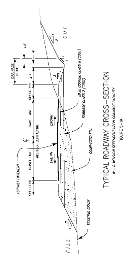
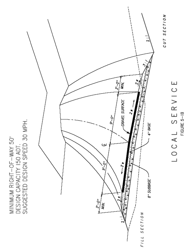
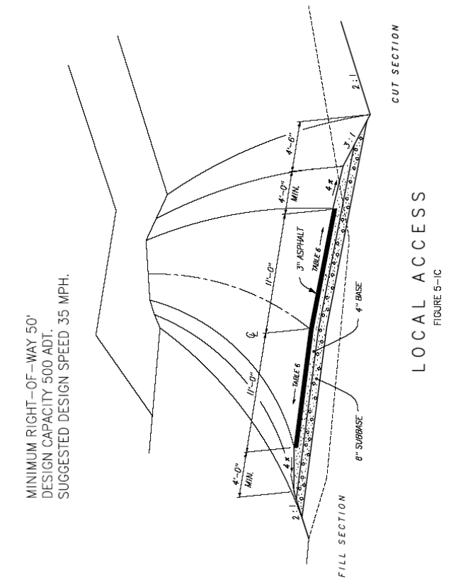
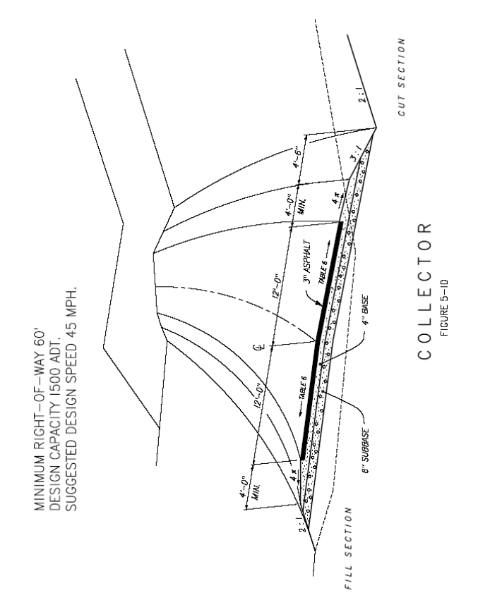
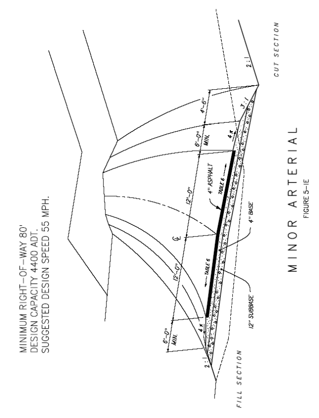
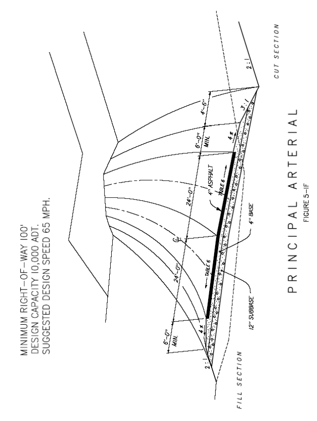
Roads are classified as follows (see Figures 5-1A through 5-1G):
I.
Local Service Road - not a subdivision road, serves isolated, primarily rural areas with few parcels and little potential for additional development; also serves Open Land Protection Subdivision Exemption developments (see Section 5-1207);
II.
Local Access Road - provides direct access from abutting properties to other roads;
III.
Collector - vicinity-wide continuous access road connecting local access roads to arterials;
IV.
Minor Arterial - links towns and other areas of concentrated development with intra-County service, and provides for relatively high overall travel speeds with minimum interference to through movement; and
V.
Principal Arterial - continuous access-controlled road that serves corridor movements with trip length and travel density characteristics indicative of statewide travel; principal arterials in the County typically are administered by the Colorado Department of Transportation (CDOT).
5-501G.
Design Capacities
The maximum allowable capacities for roads (expressed in Average Daily Traffic one-way trips) are:
I.
Principal Arterial - 10,000;
II.
Minor Arterial - 4,400;
III.
Collector - 1,500;
IV.
Local Access - 500;
V.
Local Service - 150.
5-501H.
Additional Submission Requirements
In addition to all applicable submission requirements specified in Article 4, any road development proposal, including addition to and/or realignment of existing roadway, relinquishment of State highway, and all road development components of a Sketch Plan submission shall include, pursuant to Section 5-502:
I.
Analysis of the population density to be served;
II.
Estimates of traffic volumes expected over a 20-year period;
III.
Proposed classifications and design speeds;
IV.
Preliminary alignments and road grades;
V.
A brief review of fiscal impact in relation to County road maintenance; and
VI.
Analysis of impacts to existing roadways and adjacent properties.
All detailed plans and specifications, including all road development components of a Preliminary Plan submission, shall be prepared and certified by a Professional Engineer registered in the State of Colorado, sufficiently detailed to facilitate review, and — when not related to a new subdivision — submitted for County Engineer and Road Superintendent review at least sixty (60) days prior to desired construction date. If construction doesn't commence within one (1) year following the applicable approval, detailed design must be re-submitted, and any amendments to Land Use code standards made in the interim shall apply. Alternately, a phasing schedule may be submitted for approval. All detailed plans and specifications, including all road development components of a Preliminary Plan submission, shall include:
VII.
Profiles for all roads, including existing and proposed sewer and water lines, showing grades; lengths of vertical curves; stationing and elevations of beginning and end of vertical curves and point of intersection of vertical curves; existing grade or ground lines by dashed line; culverts, structures, and other controls. All profile views shall be drawn to a scale of 1" = 50' horizontal, and 1" = 5' vertical on 24"x 36" sheets;
VIII.
A description of at least two (2) usable benchmarks within ½ mile; USGS or BLM benchmarks shall be used when possible;
IX.
Layout of road showing length of tangents and curves, widths of rights-of-way, slope lines demonstrating sufficient right-of-way width, stationing of beginning and end of curves, curve radii, delta angles, bearings, distances, centerline stationing at 100-foot intervals, dimensions of all road elements, curbs, gutters, utilities easements, and other structures, limits and inclination of cut and fill slopes with new and existing elevation contours, and location and size of culverts designating the type and gauge or strength classification and the estimated flow along with data assumed in estimating the flow;
X.
North arrow, scale, street names, drainage patterns, and typical road cross-sections;
XI.
Construction plans for all structures such as bridges, box culverts, and guardrails;
XII.
A statement defining scope and work period for each stage of construction and identifying party or parties responsible for construction; and
XIII.
Letters from utility companies, ditch companies, fire protection districts, and other interested parties or agencies involved stating their approval of any structure constructed within their right-of-way or that may influence their rights or interests.
5-501I.
Bonding Requirements
All proposed road development not bonded as part of subdivision approval (see Section 3-12) shall be bonded through an escrow account or uncancellable surety secured unto the County and acceptable to the County Attorney in one hundred twenty-five percent (125%) of the amount of the estimated construction cost as approved by the County Engineer. Bonds shall be forfeited if work is not completed in accordance with the approved plans and specifications, or if in the opinion of the County Engineer and/or Road Superintendent, work is not progressing satisfactorily. As logical units of work are completed and approved by the County Engineer, application may be made for partial release of bond.
5-501J.
Inspection of Work
During road construction, the project design engineer shall at the expense of the developer inspect the work of the contractor(s) involved, provide status reports to the County Engineer monthly or more frequently (as required by the County Engineer), and review and certify to the County Engineer work completed in conjunction with requests for partial release of bond under the Administrative Review Procedure established in Section 3-4. The County Engineer may at any time at the expense of the developer review work and/or request verification that work is proceeding in accordance with approved plans and specifications.
5-501K.
Upgrading Existing County Roads
Where an existing roadway is planned to serve a new development, the developer shall, at the developer's expense, upgrade the roadway to the minimum standards required by these regulations if the traffic volume projected pursuant to Section 5-501 G.II is greater than the capacity of the existing road.
5-501L.
Road Vacation
I.
Any person wishing to initiate the vacation and/or relocation of a County public roadway or right-of-way shall submit to the County Planning Department an application that includes, at a minimum, the following information:
a.
A complete and accurate legal description of the portion(s) of the roadway or right-of-way proposed for vacation;
b.
The reason for such vacation;
c.
Whether the roadway is to be relocated;
d.
The names and addresses of all owners of record whom own land adjacent to the roadway or right-of-way;
e.
The names and addresses of all utility companies, or other persons, with easements or other rights in or adjacent to the subject roadway or right-of-way; and
f.
A description as to whether the adjacent parcels will have access to a public road upon any such vacation, and if not, any other provision for reasonable access to a public road proposed by the applicant.
II.
The County may require the applicant to prepare plat maps and other legal documents for review and consideration by the Planning Commission, pursuant to C.R.S. 30-28-110(1)(d), before review by the Board of County Commissioners, which materials may be necessary to vacate the roadway or right-of-way and vest title to the vacated portions thereof.
5-502 - Road Design Standards
This section establishes roadway design standards intended for use by design engineers to ensure the health, safety, and welfare of County residents and to ensure that the County will not need to rectify inadequately designed and constructed facilities.
5-502A.
Design Criteria
Projection of future development and densities, estimates of future traffic volumes, appropriate classifications, design speeds, and terrain category must be determined prior to design of a new road (see also Section 5-501 G). Road classification and terrain category together shall determine the required geometric cross-section and maximum sustained grades, while design speed shall determine minimum or maximum standards for elements of alignment such as stopping and passing sight distances, radii of curvature, tangent lengths, and super elevation transition lengths.
5-502B.
Design Period
Roadway design shall be based on the projected needs twenty (20) years after construction. Projections of development over the design period shall be based on the San Miguel County Comprehensive Development Plan, existing or requested zoning as specified in the Land Use Code, existing land use, proximity to developed areas, historic growth, and other factors expected to influence development.
5-502C.
Projected Traffic Volumes
Figure 5-1, below, quantifies traffic generated by various types of development as expressed in average daily traffic (ADT) one-way trips. These per-unit ADT counts shall be applied to the projected development to formulate estimates of the design year traffic volumes. When per-unit ADT counts are not listed for a type of development, the developer shall propose per-unit ADT counts for approval by the County Engineer.
FIGURE 5-1
PER UNIT AVERAGE DAILY TRAFFIC (ADT)
Vehicle Trip Generation
5-502D.
Surfacing
All subdivision roads in the Telluride Air Quality Region, as described in Section 5-23 of this Code, shall be paved. Other roads may have gravel surface.
5-502E.
Right-of-Way Width
Minimum right-of-way widths are specified in Figures 5-1A through 5-1G. Additional right-of-way shall be provided for drainage improvements, cuts or fills, intersections, curb returns, snow storage and other road appurtenances as specified by the County Engineer.
5-502F.
Cul-de-Sacs
Cul-de-sacs shall be avoided wherever possible. Where cul-de-sacs are the only alternative, turnarounds shall be provided with a minimum road surface ninety (90) feet in diameter and a minimum right-of-way one hundred (100) feet in diameter. Adequate snow storage shall be provided at turnarounds. Cul-de-sac streets shall be no longer than six hundred (600) feet.
5-502G.
Frontage Roads
Where a subdivision abuts an existing road or highway, parallel service roads may be required, and right of access to the existing road or highway may be limited.
5-502H.
Curbs and Gutters
Concrete curbs and gutters constructed of Class B concrete (as defined by CDOT standards) shall be required along all roads in non-residential areas and along all roads in subdivisions with three (3) or more lots per acre. Standard vertical curbs shall be used on all returns at street intersections, and curb treatment shall be required at driveway entrances.
5-502I.
Sidewalks
Sidewalks constructed of Class B concrete eight-feet wide shall be required along all streets with non-residential uses. Sidewalks four-feet wide shall be required on both sides of all residential streets where population densities proposed exceed three (3) or more dwelling units per acre and where lot or building frontage is less than sixty-five (65) feet. Sidewalks may also be required through the center of long blocks, to connect cul-de-sac streets, and to provide access to schools, parks, playgrounds, rivers and/or other open space areas.
5-502J.
Route Corridor and Terrain Factors
The entire route corridor of a road shall be considered when establishing terrain factor. Most roads in the County are in mountainous terrain. Some shorter roads, such as those in subdivisions, may exist entirely in level terrain.
I.
Level terrain is where road sight distances, as governed by both horizontal and vertical restrictions, are generally long or could be made to be so without construction difficulty or major expense;
II.
Rolling terrain is where natural slopes consistently rise above and fall below the road grade line and where occasional steep slopes offer restriction to normal horizontal and vertical alignment; and
III.
Mountainous terrain is where longitudinal and transverse changes in ground elevation with respect to the road are abrupt and where the roadbed is obtained by frequent benching or side-hill excavation.
5-502K.
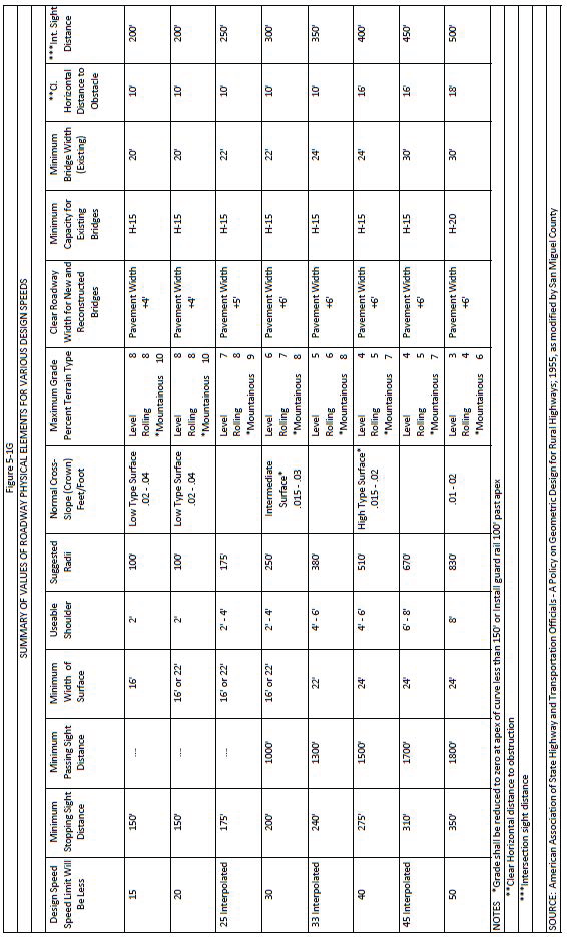
Design Speed
The selection of design speed is influenced principally by the terrain character, traffic volume, and economic considerations. The following table establishes appropriate ranges of design speeds for various conditions:
5-502L.
Grades
Road grades (expressed in percent) shall not exceed the following values:
Curves with centerline radii of less than two hundred fifty (250) feet shall not exceed eight percent (8%). Ten percent (10%) grades shall not be allowed for more than five hundred (500) linear feet of any one thousand (1000) linear feet.
5-502M.
Sight Distance
The following table establishes minimum required stopping sight distance and passing site distance. Criteria for measuring sight distance, both vertical and horizontal, are:
I.
For stopping sight distance, height of eye, 3.75 feet, and height of object, 0.5 feet; for passing sight distance, height of eye, 3.75 feet, and height of object, 4.5 feet.
5-502N.
Alignment
Alignment between control points shall achieve a standard commensurate with topography, terrain, design traffic, and reasonably obtainable right-of-way, as determined by the County Engineer. Sudden changes between curves of widely different radii or between long tangents and sharp curves shall be prohibited. Design shall accommodate passing opportunities wherever possible. Where crest vertical curves and horizontal curves occur at the same location, above-minimum sight distance design shall be required to assure that the horizontal curve is visible as drivers approach.
The following table establishes maximum curvature for different design speeds as dependent on maximum superelevation value:
5-502O.
Road Surface Classification
Road surfaces are classified as follows:
I.
Low type surfaces are those with surface treated earth surfaces and those with loose surfaces such as gravel;
II.
Intermediate type pavements are designed to retain smooth riding qualities and good non-skid properties in all weather under light roads and low traffic volumes; and
III.
High type pavements retain smooth riding qualities and good non-skid properties in all weather under heavy traffic volumes and loadings with little maintenance.
5-502P.
Traveled Way Crown
The following table establishes acceptable pavement or surfacing crown adequate to provide proper drainage:
5-502Q.
Superelevation
Superelevation runoff is the length of highway needed to accomplish the change in cross slope from a normal crown section to a fully superelevated section. For roads where snow and ice conditions prevail the superelevation shall not exceed 0.08 feet per foot. The following table establishes minimum lengths of runoff. Adjustments in design runoff lengths may be necessary, as determined by the County Engineer, for smooth riding, surface drainage, and good appearance.
5-502R.
Number of Lanes
The number of lanes shall accommodate the design volume. The majority of roads in San Miguel County will have two (2) lanes. Where more than two (2) lanes are warranted to accommodate design volumes, determinations of design shall be made as indicated in American Association of State Highway and Transportation Officials (AASHTO) Design Standards for Highways Other Than Freeways.
5-502S.
Width of Driving Surface, Shoulder and Roadway
The following table establishes minimum width of driving surface and of graded usable shoulder for various traffic volumes and design speeds. Graded shoulder width is measured from the edge of surfacing (pavement) to the point of intersection of shoulder slope and side slope. In mountainous terrain, with a minimum two-foot shoulder, the graded width of shoulder in cuts may be decreased two (2) feet if guardrail is installed. Guardrail shall not be closer than two (2) feet from the driving surface.
The minimum roadway width is the direct sum of the surfacing and graded shoulder widths shown below. Lanes shall be at least eleven (11) feet wide and shoulders two (2) feet wider than the minimum shown below.
5-502T.
Switchbacks
Switchbacks are not considered a good roadway design solution for gaining elevation, especially on hillsides steeper than twenty percent (20%) where switchbacks produce visual heavy impact. No switchback shall have a tangent less than ¼-mile from the last switchback. Grades on switchbacks shall be reduced to zero at the apex of the vertical curve on horizontal curves less than one hundred fifty (150) feet, and the horizontal curve shall not begin prior to the end of the vertical curve for these purposes.
5-502U.
Vertical Clearance
Vertical clearance at underpasses, power lines, streetlights, etc., shall be at least fifteen (15) feet over the entire roadway width.
5-502V.
Horizontal Clearance
On a road with an ADT volume of one thousand (1,000) or more and with a design speed of fifty (50) mph or greater, a clear roadside recovery area at least ten (10) to twenty (20) feet outside the shoulder shall be provided. Where the design speed exceeds twenty-five (25) mph, or ADT is less than one thousand (1,000), a clear roadside recovery area at least eight (8) to twelve (12) feet from the edge of the through traffic lane shall be provided. The clear roadside area shall be appropriately flat and rounded in cross-section design, except:
I.
In cut sections where fixed objects are located sufficiently up the cut slope such that little likelihood exists that they could be struck; and
II.
Where guardrail protection is provided.
The recovery area shall be clear of objects such as unyielding trees, unyielding sign supports, utility poles, unyielding light poles and all other fixed objects that might severely damage an out-of-control vehicle. To the extent feasible, where another highway or railroad passes over, the structure shall be designed so that the pier or abutment supports have lateral clearance as great as the clear roadside area on the approach road. Where it is not feasible to carry the approach roadway across an overpass or other bridge, an appropriately transitioned guardrail shall be provided and securely anchored to the bridge rail. At hazardous locations, such as the outside of a sharp curve on low fill, where guardrail is not provided, a much greater horizontal clearance shall be provided, as approved by the County Engineer. Minimum horizontal clearance to manmade objects, such as fences and power poles, shall be twenty (20) feet from centerline.
5-502W.
Intersection Design
Intersection design shall avoid steep-profile grades and ensure adequate approach sight distance. Intersections shall not be located on short crest vertical curves, just beyond short crest vertical curves, or on sharp horizontal curves. Where no practical alternative to such locations exists, cut slopes shall be flattened and horizontal and/or vertical curves lengthened to provide additional sight distance. Sufficient sight distance shall permit a passenger vehicle on the minor leg of an intersection to cross the traveled way without requiring approaching through traffic to slow down. A minimum of six (6) seconds shall be available to the driver crossing the through lanes. The following table establishes corner sight distance for each design speed:
*Corner sight distance measured from a point on the minor road at least 15 feet from the edge of the major road pavement and measured from a height of eye to 3.75 feet on the minor road to a height of 4.5 feet on the major road. See AASHTO Policy on Geometric Design of Rural Highways Figure VIII-5, Page 398. Intersections shall be designed with a 50-foot minimum corner radius of pavement or surfacing. Where turning volumes are significant, consideration shall be given to speed-change lanes and channelization. Intersection legs operating under STOP control shall be designed at as close to right angles as feasible. Intersections shall be at plus or minus two percent a minimum of 20 feet for each 10 miles per hour of design speed of the road, prior to the intersection for arterial and collection. In mountainous terrain for Local Access and Access Tracts, all grades shall flatten to 4 percent or less for at least 50 feet approaching intersections and at least 25 feet from cul-de-sacs.
5-502X.
Side Slopes
Cut and fill slopes shall be required as shown in Figures 5-1A through 5-1F. In unstable soils, flatter slopes may be required. Where heavy snowfall is expected, flatter slopes in cuts on the southern side of the roadway may be required to provide maximum sun exposure. Flatter slopes shall be used wherever possible to reduce erosion, to decrease maintenance costs, to facilitate plant growth, and to provide for safer operation.
Transition slopes shall be provided between adjoining cuts and fills. Where cut or fill slopes intersect the original ground surface, the cross-section shall be rounded to blend the slope into the natural ground surface. Any cut or fill slope steeper than 2:1 must be supported by an engineering report certifying the stability of the side slope. Any retaining structures used to stabilize cut or fill sections must be designed by a registered professional engineer.
Benching of side slopes shall be used sparingly and only where justified by sound engineering reasons, such as:
I.
Unstable material renders benching more economical than flattening;
II.
The need to intercept drainage in long and deep cuts; and
III.
The need to intercept and store loose material.
Where a cut or fill road, slope lies outside the road right-of-way, a slope easement shall be provided of sufficient width to permit slope maintenance.
5-502Y.
Structural Section
The roadway structural section shall be designed on the basis of a qualified engineer's analysis approved by the County Engineer. At a minimum, the structural section elements shall include asphalt, roadbase, and subbase of the depths shown in Figures 5-1A through 5-1F.
5-502Z.
Flexible Pavement Design
The California Bearing Ratio Method (CBR) and the Hveem Stabilometer Method may be used. Supporting test data and calculations shall accompany all requests for approval of a designed structural section.
I.
The Hveem Stabilometer Method procedure of the California DOT, or as outlined in the CDOT Roadway Design Manual, may be used. The specific regional factors for San Miguel County are:
The required factor used shall be the sum of the three (3) factors selected.
II.
The California Bearing Ratio Test shall be performed in accordance with the procedures outlined under AASHTO Designation T193-721.
Regardless of the pavement design method, special consideration shall be given for unusual conditions such as instability of fills and slopes, permeability, capillary and frost heave, elasticity, and permafrost.
5-502AA.
Drainage
The primary objective of drainage design is protection of County roads and property while minimizing possible flood damage to surrounding properties and structures. It should be emphasized that good drainage is one of the most important factors in road design. It preserves appearance as well as the level of road service, while minimizing maintenance costs. Culverts under all roads shall be designed to accommodate 25-year-frequency-storm run-off utilizing the maximum head, as determined by the upper-most ponding elevation chosen to prevent flood damage to upstream properties. Inlets and other facilities draining the road surface shall be designed to accommodate 10-year frequency storm run-off. All roads shall be designed to remain free of ponding.
All drainage installations shall be designed to permit free, unobstructed passage of debris and silt, or to provide for their deflection and/or collection at a point upstream in a manner that will not create an expensive maintenance problem. Settlement basins shall be provided when a silting problem may exist downstream. Modification of natural channels or transfer of run-off from one basin to another shall be prohibited, except where no reasonable alternative exists as determined by the County Engineer. The following methods may be used for estimating peak flows:
I.
Run-off from stream records;
II.
Soil Conservation Service Method, applicable to watersheds smaller than one thousand (1,000) acres, expresses run-off in terms of geographical position, drainage areas and land use (See CDOT Roadway Design Manual);
III.
Rational Method, applicable to watersheds smaller than two hundred (200) acres, uses the formula:
The following table establishes coefficients for the rational formula. Rainfall intensity is obtained from records of nearby weather stations, reduced to a graph showing rainfall intensity vs. rainfall duration for various recurrence intervals. Rainfall intensity is based on estimates of the acceptable frequency of occurrence and the time required for water to reach the outlet from the most remote point in the basin.
IV.
Culverts shall be located at each natural draw or watercourse, as conditions warrant, to prevent excessive accumulation of flow in roadside ditches or along toe of slope. Draws and watercourses shall be cleared of debris for a distance of one hundred (100) feet upstream from all culvert inlets, where such clearing doesn't conflict with the provisions of Section 5-22. Inverts at the inlet shall be elevated slightly above the normal flow line in steep or natural draws to avoid plugging by debris. Inlets shall not be elevated where ponding or backwater curves would cause stagnation or obstruct irrigation ditches.
The culvert shall slope downward in the direction of natural flow and be self-cleaning whenever possible. The outlet shall not discharge on unprotected fills or unstable material or at adverse angles to streams or open channels. Headwall, riprap, or other means of protection shall be required at inlets or outlets where erosion might occur. Velocities of flow in culverts shall be calculated using acceptable design charts or formulas. Where Manning's Equation is used, the following "n" values shall apply:
Corrugated metal pipe as specified by CDOT M 603-1 shall be used. Steel pipe shall be asphalt coated or paved where soils are corrosive or other conditions exist that may attack the steel. Aluminum and other pipe materials are not permitted for road culverts to be maintained by the County. Minimum diameter for round pipe shall be eighteen (18) inches. The minimum rise of arch pipes and box culverts shall be twelve (12) inches. When a battery of pipes is used, a clear spacing of ½ the pipe diameter (1-foot minimum, 4-foot maximum) must be provided between pipes.
V.
Open Channels and Ditches
Channels and ditches shall be designed to avoid roadside safety hazards. The minimum flow line slope shall be 0.2 percent if the channel is paved and 0.3 percent for channels or other materials. The following table establishes the maximum permissible velocities that determine maximum allowable slopes. Greater velocities of flow shall require appropriate channel protection as determined by the County Engineer. Manning's Equation shall be used to estimate velocities:
Where the channel is comprised of a combination of materials shown above, the maximum permissible velocity shall prevent undue scouring of finer materials or silting downstream.
VI.
Surface Drainage
Subgrades subject to poor drainage, underground seepage, or high-water table shall be adequately drained for roadbed stabilization. Drains shall be installed to prevent high ground water level from coming within four (4) feet of roadway pavement. Perforated pipe shall carry away collected water.
5-502BB.
Bridges
Bridges shall conform to CDOT requirements and specifications. Plans shall be prepared by a qualified structural engineer and shall be submitted to the County Engineer for review and approval. Clear deck width must accommodate the full width of the traveled lanes and shoulders of approach roads. Pedestrian walkways and railings shall be required as warranted. Flared approach railings shall be provided on the side opposing traffic flow. The waterway area shall accommodate a 100-year frequency storm. Where flood studies from the U.S. Army Corps of Engineers are available, bridges shall be designed to accommodate the "Standard Project Flood." A minimum of one (1) foot of freeboard shall be required. Additional freeboard shall be required when debris-laden flows are anticipated.
5-502CC.
Traffic Control Devices
All signs, striping, markers, delineators, signals, and other traffic control devices shall conform to the requirements of the Manual on Uniform Traffic Control Devices published by the U.S. DOT Federal Highway Administration. In new developments, all required street sign names, speed limit signs, stop signs and other traffic control devices shall be installed and paid for by the developer. Non-standard signs or other traffic control devices shall be subject to rigid State control, and approval by the County Engineer must be obtained for their use based on data to support the requests.
5-502DD.
Driveways
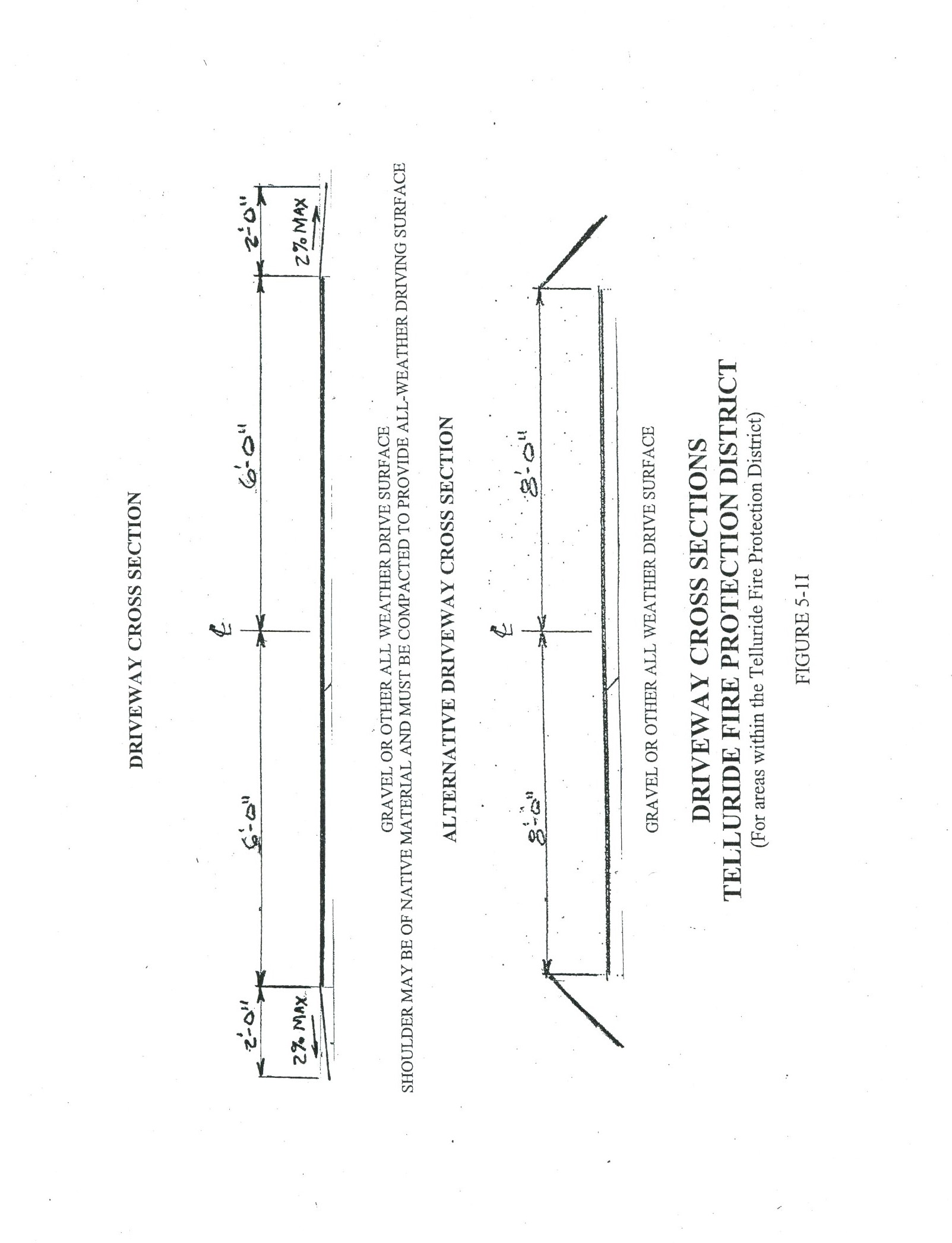
In addition to meeting the following standards, driveways must meet the minimum specifications set forth in Section 5-713 of this Code. Development of a driveway requires issuance of a Development Permit from the Planning Department and, if accessed directly from a County-maintained road, a Driveway Permit from the County Road and Bridge Department. These standards shall apply to all driveways within unincorporated San Miguel County, except in the West End (WE) and High Country Area (HCA) Zone Districts. All driveways serving one or two single-family residences shall have:
I.
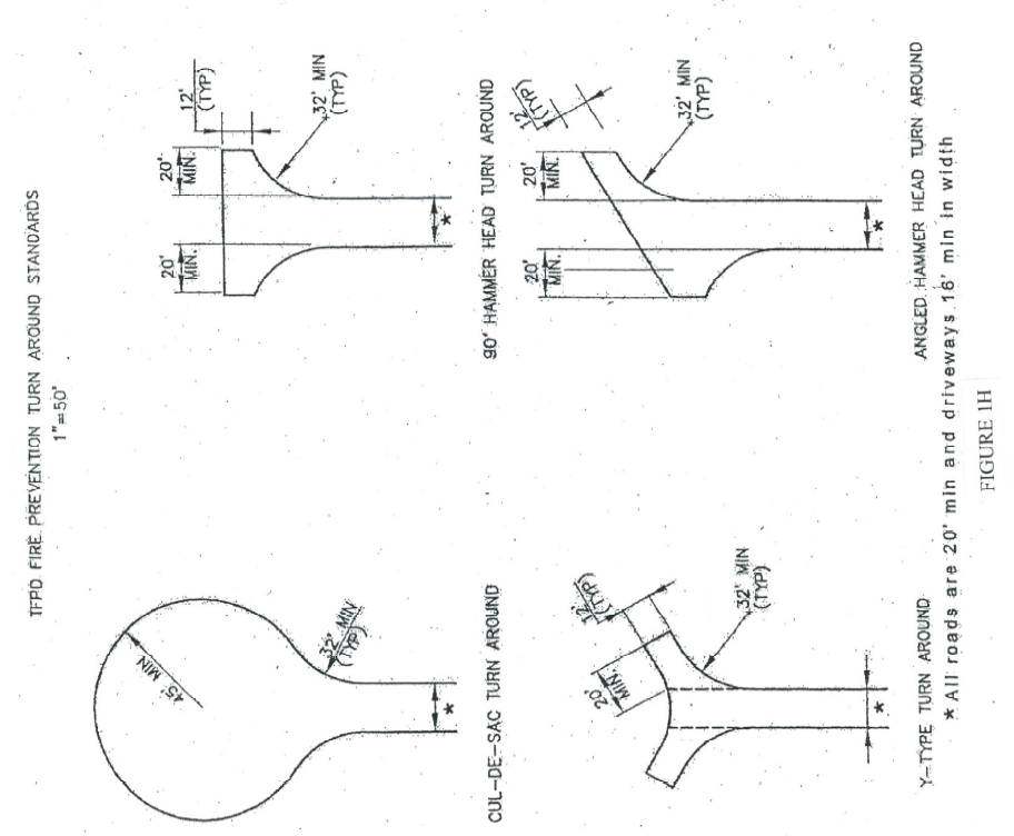
A driving surface of sixteen (16) feet or wider, which may include the shoulders on each side of the twelve (12) foot driving surface. If it is not practical or feasible to design and construct a sixteen (16)-foot wide driveway because of the location of the property, topography, drainage, non-negotiable grades, or if the improvement would require significant changes to the landscape, or other similar conditions, County staff may consider and administratively authorize a reduced driveway width subject to referral of the application to the applicable Fire Protection District. This authorization of a lesser driveway width may require installation of an approved automatic fire suppression system, driveway turnouts, and/or implementation of measures consistent with the International Fire Code regulations. The driveway must have an unobstructed height clearance of thirteen (13) feet six (6) inches. (See Figure 5-11)
A Single-family Residence shall have a maximum driveway width of twenty (20) feet.
A driveway serving two (2) Single-family Residences shall have a maximum width of twenty-eight (28) feet.
A driveway serving three (3) or more Single-family Residences shall meet road standards per Section 5-502.
II.
Interior radii of at least thirty-two (32) feet;
III.
A driveway opening at least sixteen (16) feet wide;
IV.
A normal grade not to exceed eight (8) percent and a transitional grade not to exceed ten (10) percent, and no center line grades greater than eight (8) percent for curves with radius less than two hundred fifty (250) feet. An exception to allow a maximum grade up to twelve (12) percent may be authorized by County staff with a referral of the application to the applicable Fire Protection District because of location on the property, topography resulting in extensive cut and fill or other similar conditions that make it impractical to achieve a normal and/or transitional grade. This authorization to allow a driveway to exceed normal and/or transitional grades may require installation of an approved automatic fire suppression system or other measures recommended by the applicable Fire Protection District.
V.
All entrances and exits located and constructed such that vehicles approaching or using them will be able to obtain adequate sight distance in both directions along the roadway necessary to maneuver safely and without interfering with roadway traffic;
VI.
An angle of approach from the adjacent roadway of between sixty (60) and ninety (90) degrees;
VII.
An entrance/exit approach grade that slopes downward and away from the road surface at the same rate as the normal shoulder slope, but in no case at more than four percent (4%) for a distance equal to the width of the shoulder, and in no case for less than fifteen (15) feet from the pavement edge;
VIII.
No features that interfere with the drainage system of the adjacent street or roadway. The developer shall pay for and install drainage structures that will become integral parts of the existing street or roadway drainage system, the dimensions of all which must be approved by the County Road Superintendent prior to installation;
X.
Curb treatment, as required in Section 5-502 H.; and
XI.
A turnaround if the driveway is longer than one hundred fifty (150) feet shall be constructed in accordance with Figure 5-1H.
XII.
Driveways shall be surfaced so as to provide all-weather driving capabilities.
Access to all other residential structures shall meet the standards described for roadways.
XIII.
For driveways that exceed the amounts listed herein, or for any site that contains geohazards that may be affected by the proposed driveway, engineered drawings and geotechnical reports and hazard reports shall be prepared by a Colorado-Licensed Professional Engineer ("P.E."). Limits are as follows:
a.
A grade in excess of six (6) percent; or
b.
A transitional grade in excess of eight (8) percent; or
c.
A length in excess of five hundred (500) feet; or
d.
Any modification of any dimensional standards in this Section.
XIV.
At completion of a driveway designed by an Engineer, a Record Letter sealed by a Colorado-Licensed Professional Engineer verifying that design conditions were met is required prior to final inspection and signoff of Development Permit by the Planning Department.
Access to all other residential structures shall meet the standards described for roadways.
5-502EE.
Landscaping
Revegetation and reforestation within road right-of-way shall be required utilizing native material, and shall be completed during the first planting season after construction. All areas disturbed by construction operations and not otherwise covered by structures or pavement shall be seeded, fertilized, mulched, planted, and otherwise treated to provide an established stand of native grass. Cut and fill slopes shall be treated to prevent erosion. Areas undisturbed by construction shall be left in their present vegetative state, except that thinning of trees may be required. Rights-of-way shall be cleared to the minimum width necessary to construct the roadway, provide for drainage, and provide adequate snow storage.
5-502FF.
Guardrail
Guardrail shall be installed on the outside of curves as required in this section or by the County Engineer to prevent accidents by delineating roadbed, reducing accident severity by deflecting vehicles into safer paths, and reducing the rate of deceleration in case of impending collisions with fixed objects. When guardrail is used in conjunction with roadside curb, the face of the guardrail shall be flush with the face of the curb regardless of shoulder width to prevent the take-off ramp effect, which may overturn a vehicle. When no curb is present, the face of the guardrail shall be flush with the edge of the shoulder.
I.
On curves requiring a reduction in approach speeds, any of the following conditions shall indicate that guardrail installation may be required on the outside of curves:
a.
Height of embankment exceeds ten (10) feet;
b.
Side slopes exceed 4:1;
c.
Shoulder or pavement widths are substandard;
d.
Roadside hazards exist.
II.
Whether on curves or tangents, guardrail may be required if a history of roadway accidents exists or if unusually high embankments or steep terrain give motorists a feeling of insecurity.
III.
In areas subject to dense fog or snow and ice conditions, or where traffic speed and volumes are high, guardrail may be required.
IV.
An obstruction or sudden constriction on width may require guardrail.
V.
An isolated sharp curve on a road otherwise built to higher standards may require guardrail.
VI.
Guardrail may be required at approaches to bridge piers, abutments, trees, or other obstructions.
VII.
Guardrail shall be placed at the ends of all bridges on the right of approaching traffic. Where pedestrians are expected to use a shoulder, a walkway shall be provided around the end of the guardrail outside the normal shoulder.
5-502GG.
Utilities
At least eighteen (18) inches of material shall cover all underground utilities beneath paved roadway, and poles shall be used jointly wherever practical. All utilities must be installed below existing and planned drainage structures, and all gas lines installed in non-paved rights-of-way shall be buried at least forty-eight (48) inches and outside the driving surface. Certain facilities may require additional right-of-way, as determined by the County Road Superintendent, paid for by the utility company and/or the developer. A sequence of installation from the deepest utility to the shallowest shall be required.
5-502HH.
Street Names, Addressing and Sign Locations
This section establishes land use standards for street names, addressing and sign locations adopted by San Miguel County (refer to Appendix B for standards). These Standards shall apply to all lands within the unincorporated areas of san Miguel County and any incorporated areas included through intergovernmental agreement.
(Res. No. 2024-54, 12-18-2024; Res. No. 2025-03, 2-5-2025)
5-503 - Alleys and Easements
5-503A.
Where Required
Alleys may be required in the rear of all prospective business property, except where topography makes the use of alleys impracticable.
5-503B.
Minimum Width
Alleys shall not be less than twenty (20) feet wide.
5-503C.
Alley Intersections
Where two (2) alleys intersect, ten-foot corner cut-offs measured along the produced property lines from the point of intersection shall be provided.
5-503D.
Public Utilities Easements
Public utility easements ten (10) feet wide may be required along the rear and sides of lots where necessary for the accommodation of public utility, drainage and/or sanitary facilities.
5-503E.
Pedestrian Ways
Pedestrian ways may be required across long blocks or where necessary to provide access to public areas.
5-504 - Road Acceptance
5-504A.
Road Acceptance Signs
When road construction begins, the subdivider or developer shall post at each entrance to the subdivision a sign that states that the roads within that subdivision have not been accepted by the County for maintenance. Such signs shall remain posted until the County accepts the roads for maintenance. The signs shall be obtained from the County at reasonable cost to the subdivider.
5-504B.
Subdivision Roads Acceptance
All of the standards in this section shall be met before subdivision roads will be accepted onto the County system for maintenance (snowplowing and grading). The Board shall determine road acceptance with no recommendation required from the Planning Commission.
I.
The County will only accept roads for maintenance when the costs incurred in providing the maintenance service are less than or equal to the revenues received into the Road and Bridge Fund and attributable to properties serviced by the road proposed for acceptance.
a.
Revenue shall mean, for the purpose of this section, the sum of the average County Highway User Tax Fund per mile and the total revenue from the Road and Bridge Mill Levy attributed to the property served by the road in question.
II.
All roads must be properly and legally dedicated to the public use for road purposes.
III.
All roads must connect with a County primary road, a County secondary road or a State maintained highway.
IV.
All roads must meet all County engineering specifications in force at the time of construction, including, but not limited to, right-of way width, roadway and shoulder width, roadway structural section, alignment, grade, adequate and proper drainage and other pertinent subdivision requirements.
V.
All required or desired underground utilities to be located within the improved portion of the road right-of-way, including laterals and services, shall be in place and complete prior to acceptance.
VI.
Acceptance of roads for County maintenance shall mean that the County will only remove snow and ice, maintain ditches, and repair paved roadways. The County will not be obligated as a result of having accepted a road or having agreed to "maintain" a road, to improve, reconstruct, resurface or rebuild roads, but, at the sole discretion of the Board of County Commissioners, the County may improve, reconstruct, resurface or rebuild a road or a portion thereof.
VII.
No road shall be accepted less than two (2) years after the completion of the road in question.
VIII.
The County will not accept roads from October 15th through May 15th of each year due to the fact that deficiencies noted in inspections cannot usually be corrected during this period.
IX.
The applicant shall provide all required information in verifiable form to San Miguel County and its staff.
X.
If a subdivision does not meet the standard for revenue set forth above, the Board may contract for a one-year term, subject to renewal upon mutual consent of the parties thereto, to provide maintenance with one (1) of the following entities:
a.
Homeowners Association. Such contract shall provide for payment to the County for the difference between the cost of the desired level of service (e.g., snowplowing, blading, graveling and new equipment acquisition) and the revenue received by the County attributable to properties serviced by roads within the subdivision.
b.
An Improvement District formed under C.R.S. 30-20-502, 30-20-601 or 30-20-701. Such contract shall provide for payment to the County of the costs of maintenance and improvements over and above revenues received.
c.
A metropolitan District formed under C.R.S. 32-3-101, where roads are included in the approved Service Plan.
XI.
If one (1) of the entities in Section 5-504 B.X fails to contract with the County, following notice to it that revenues received are less than the costs expended, the Board of County Commissioners shall immediately proceed to delete said roads from the County system pursuant to statute.
XII.
A resolution accepting the road onto the County road system may not be signed until an Improvement District is formed if the subdivision qualifies under Section 5-504 B.X.
5-505 - Highway Setbacks
5-505A.
General
This section of the Code designates scenic highways and major highways, minimum setbacks from the highway right-of-way, standards for setback reductions and standards for lawfully created structures located with-in the setbacks. The purpose of the increased setbacks from scenic and major highways is to preserve the scenic quality and undisturbed, natural beauty of land located contiguous to highways in San Miguel County.
5-505B.
Scenic and Major Highways
This section designates scenic highways and major highways. The official zoning map shall reflect the designations.
I.
Scenic Highways
The following sections of highways are scenic highways:
a.
State Highway 145 Spur from Society Turn to the Town of Telluride;
b.
State Highway 145 from Society Turn to Lizard Head Pass;
c.
State Highway 145 from Ellerdville to Norwood Hill; and
d.
State Highway 62 from Green Mountain Ranch to Dallas Divide.
II.
Major Highways
The following sections of highway are major highways:
a.
State Highway 145 from Society Turn to Sawpit; and
b.
State Highway 62 from Placerville (intersection of State Highways 62 and 145 to Green Mountain Ranch.
5-505C.
Setbacks for Scenic and Major Highways
This section establishes the setbacks from the right-of-way line for scenic and major highways designated in Section 5-505 B.
I.
Scenic Highways - two hundred (200) feet
II.
Major Highways - one hundred (100) feet
5-505D.
Setback Reductions
This section establishes standards to review requests to construct a principal building within the setbacks established by Section 5-505 C and standards for the construction of parking lots or accessory buildings within the established setbacks.
I.
Setback Reductions for Principal Buildings
The setbacks may be reduced pursuant to One-step Planning Commission Review if:
a.
An applicant demonstrates that due to existing topography and/or vegetation a proposed development site has minimal visibility from the relevant highway right-of-way;
b.
A previously approved subdivision lot or legal parcel is located entirely or substantially within the setbacks established by these regulations. In such a case a building envelope shall be established in the least visible and most reasonable location within the lot and shall necessitate such landscaping and design mitigation as deemed appropriate to preserve the scenic quality of the highway frontage;
c.
An applicant owning or controlling both sides of a given right-of-way demonstrates that the intent and purpose of the minimum setback standards could best be achieved by a decreased setback on one (1) side of the right-of-way in exchange for a corresponding increase in the setback on the other side of the right-of-way; or
d.
An applicant demonstrates that a specific proposal is consistent with the intent and purpose of the scenic corridor highway setbacks.
II.
Setback Reductions for Parking Lots and Accessory Buildings
The setbacks for parking lots and accessory buildings from the right-of-way may be reduced to one hundred (100) feet for Scenic Highways and fifty (50) feet for major highways pursuant to One-step Planning Commission Review, if as a result of proposed scenic quality mitigation techniques such as landscaping, screening or site planning, the visual quality of the scenic corridor can be maintained.
5-506 - Trails
5-506A.
Construction of Trails and Dedication of Trail Easements
A developer seeking final plat, rezoning, or any other site specific development approval shall be required by the Board of Commissioners to dedicate trail easements, pursuant to the East End Master Plan and the San Miguel County Comprehensive Development Plan, extending twenty-five (25) feet either side of the proposed trail centerline for construction and maintenance purposes and ten (10) feet either side of the proposed trail centerline for public use purposes. A developer seeking final plat or rezoning approval also must construct within two (2) years of the date of approval all trail segments required pursuant to the East End Master Plan and the San Miguel County Comprehensive Development Plan. The Board of County Commissioners, in its sole discretion, may accept an alternative right-of-way width based upon a site-specific request.
5-506B.
Trails Designed to Use
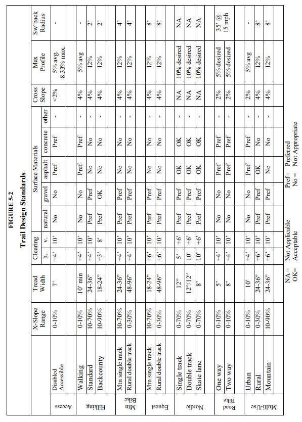
Trails in San Miguel County shall be designed specifically for hiking, bicycling, mountain bicycling, horseback riding, nordic skiing or any combination thereof. As a result, the Board of Commissioners may require any specific standards (including less restrictive standards) for a particular proposed trail, or section thereof, based on the design standards set forth in Figure 5-2 and the "Trail" definitions in Article 6.
(Res. No. 2024-54, 12-18-2024)