
Sandy Springs City Zoning Code
ARTICLE 10
- STREETS AND IMPROVEMENTS
Sec. 10.1.1. - Purpose and Intent
This Chapter is intended to serve the following purposes.
A.
To protect and promote the public health, safety, and general welfare.
B.
To provide a system for the subdividing of lands and the accurate recording of land titles.
C.
To provide assurance that lots shown on recorded subdivision plats are usable by the purchasers for their intended and permitted functions.
D.
To encourage economically sound and orderly land development in accordance with the policies and objectives of the City of Sandy Springs, Georgia, Comprehensive Plan.
E.
To assure the provision of required streets, utilities, and other facilities and services to new land developments in conformance with public improvement policies of the City.
F.
To assure adequate provision of safe and convenient traffic access and circulation, both vehicular and pedestrian, within new land developments and the surrounding City thoroughfares.
G.
To assure the provision of needed open spaces and public facility sites in new land developments through the dedication or reservation for purchase of land for public purposes.
H.
To assure equitable review and approval of all subdivision and site plans by providing uniform procedures and standards for the developer.
(Ord. No. 2023-12-24, § I(Att. A), 12-5-2023)
Sec. 10.1.2. - Complete Streets Policy
A.
This policy applies to all new construction and reconstruction of roadways within the limits of the City of Sandy Springs;
B.
Roadway projects should balance the transportation operational and safety needs of all users regardless of mode, for commercial and non-commercial travel, as well as access and mobility to adjacent land use;
C.
Roadway projects should consider the unique needs of vulnerable road users including pedestrians, bicyclists, persons using transit, persons with disabilities, older adults and youth;
D.
Roadway projects should make use of the latest and best design standards, policies, and guidelines;
E.
Complete Streets solutions shall be developed based on adopted standards (Division 10.4—Street Standards of the Development Code and Section 2—Street Framework and Mobility Maps: Typical Sections and Details of the Technical Manual) to fit within the context of the community, and these solutions shall be flexible so that the needs of the corridor can be met without wasting resources; and
F.
All departments shall collaborate to ensure the implementation of the policy through all public capital improvements and maintenance and private development projects.
(Ord. No. 2023-12-24, § I(Att. A), 12-5-2023)
Sec. 10.1.3. - Suitability of Land
A.
Land subject to flooding, improper drainage or erosion, and any land deemed to be unsuitable for development due to steep slopes, unsuitable soils or subsurface conditions, or similar conditions, must not be subjected to development for any uses as may continue such conditions or increase danger to health, safety, life, or property, unless steps are taken to eliminate or abate these conditions.
B.
Land within a proposed subdivision or development that is unsuitable for development must be:
1.
Incorporated into the buildable lots as excess land;
2.
Established as a conservation area, common area; or
3.
Legally disposed of in a manner which would prevent the potential sale or transfer of the lot as potentially buildable lot of record.
(Ord. No. 2023-12-24, § I(Att. A), 12-5-2023)
Sec. 10.2.1. - Lots
A.
Lots must conform to minimum requirements of the applicable zoning district.
B.
The size, shape, arrangement and orientation of every lot is subject to the approval of the Director for the type of development and use contemplated.
C.
Lots not served by public sewer or community sanitary sewage system or public water must meet the minimum dimension and area requirements of the Fulton County Health Department in addition to the minimum dimension and area requirements of this Development Code.
D.
Reserved.
E.
Each lot must have direct access to an abutting, existing public street, a street contained within the proposed subdivision, or follow the requirements of a Development Pattern (Div. 6.3). A connection through an approved private drive may be permitted by the Director.
F.
When subdividing land adjacent to or surrounding an existing or proposed lake, the lots abutting the lake must be drawn to the center of the lake, except when the lake is proposed for recreational or stormwater management purposes and will be contained on an individual lot of record and maintained by the homeowners' association.
(Ord. No. 2023-12-24, § I(Att. A), 12-5-2023)
Sec. 10.2.2. - Exempt Lots
Lots that do not comply with the requirements of the applicable zoning district are prohibited, except as follows:
A.
Signage, Landscape Features The creation of an unbuildable lot in a proposed subdivision for the exclusive purpose of subdivision identification signs or subdivision entrance landscape features is authorized only under the following circumstances (no waiver, exception or variance is allowed):
1.
The lot must be located at an entrance to the subdivision as an "island" in the right-of-way of a local or minor collector street;
2.
A mandatory property owners' association is required for the subdivision for ownership and maintenance of the lot as common area;
3.
Landscape planting within the right-of-way must comply with the Sandy Springs Technical Manual.
B.
Stormwater Management Facilities The creation of an un-buildable lot for the exclusive purpose of providing and maintaining a stormwater management facility is authorized.
C.
Private Streets The creation of an un-buildable lot for the exclusive purpose of providing and maintaining a private street is authorized.
D.
Conservation Areas The creation of an un-buildable lot for the exclusive purpose of conserving land from development is authorized and must be recorded as such.
E.
Common Areas The creation of an un-buildable lot, in common ownership, for the exclusive purpose of providing amenities such as swimming pools or outdoor amenity space is authorized.
(Ord. No. 2023-12-24, § I(Att. A), 12-5-2023)
Sec. 10.2.3. - Offers of Land Dedication
Where an applicant proposes the dedication of land to public use, and the Director or the appropriate agency finds that such land is neither required nor is it suitable for public use, the Director will require the rearrangement of lots to include such land in private ownership.
(Ord. No. 2023-12-24, § I(Att. A), 12-5-2023)
Sec. 10.2.4. - Public Dedication
A.
No land dedicated as a public street or any other public purpose will be opened or accepted, and no subdivision of land may be recorded before obtaining final plat approval from the Director.
B.
Approval must be entered in writing on the final plat by the Director.
C.
The Director is authorized to accept dedications of land and public facilities on behalf of the City and to cause such dedications to be recorded by the Clerk of Superior Court of Fulton County, subject to ratification by the City Council.
(Ord. No. 2023-12-24, § I(Att. A), 12-5-2023)
Sec. 10.2.5. - Transfer of Land Ownership
A.
The City will not recognize any transfer of title to land in the City by any person, firm, partnership, association, corporation, estate, trust, developer, subdivider or any other owner or agent and no building permit may be issued on said land, unless:
1.
Legal access to the land is provided to a public or private street or accessible shared or public open space approved under the terms of this Development Code; and at least 1 of the following conditions is met:
a.
The land existed as a single parcel of ownership, recorded as such in its entirety and present boundaries with the clerk of Superior Court of Fulton County prior to the effective date of the 2007 development/subdivision regulations and at the time of recording was in compliance with the zoning and subdivision regulations in effect at that time;
b.
The land is shown in its entirety and present boundaries on a final plat as approved (under this or any previous applicable ordinances or regulations) and duly recorded with the clerk of Superior Court of Fulton County;
c.
The land is shown in its entirety and present boundaries on a plat authorized by the Director and recorded with the Clerk of Superior Court of Fulton County pursuant to the ordinances governing subdivision exemptions contained in this Development Code; or
d.
The land is an aggregation of properties for land assembly purposes, and no building permit will be requested prior to the filing of an application for an issuance of a land disturbance permit, pursuant to this Development Code.
B.
No person, firm, partnership, association, corporation, estate, trust, developer, subdivider or any other owner or agent may transfer title to any property by reference to, exhibition of, or any other use of any map of plat illustrating the subdivision of land without a final plat of said land showing the property first having been duly approved under the procedures of this Development Code or any previously applicable ordinances or regulations and recorded with the clerk to Superior Court of Fulton County.
C.
The division of property by court order, including, but not limited to, judgments of foreclosure or consolidation and disbursement of existing lots by deed or other recorded instruments, are not be considered a subdivision for purposes of, and do not obviate the necessity for compliance with, this Development Code.
(Ord. No. 2023-12-24, § I(Att. A), 12-5-2023)
Sec. 10.2.6. - Survey Monuments
A.
At least 2 permanent monuments must be accurately set and established to tie with the City GIS monuments or as required by the Director.
B.
The monuments must consist of a permanent material such as steel, concrete, iron or stone. The monuments must be set so that the top is 6 inches above the ground level, unless otherwise approved by the Director.
C.
The accurate location, material and size of all existing monuments must be shown on the final plat, as well as the future location of monuments to be placed after street improvements have been completed.
(Ord. No. 2023-12-24, § I(Att. A), 12-5-2023)
Sec. 10.2.7. - Standard Details and Specifications
The Department maintains a set of standard details and specifications on file illustrating details of construction and design of streets, stormwater drainage facilities, site improvements and other elements related to the development of land in accordance with this Development Code and under the jurisdiction of the Department for consultation and distribution. These details and specifications are contained in the Sandy Springs Technical Manual.
(Ord. No. 2023-12-24, § I(Att. A), 12-5-2023)
Sec. 10.2.8. - Plan and Plat Specifications
The City's plan and plat specifications are contained in the Sandy Springs Technical Manual.
(Ord. No. 2023-12-24, § I(Att. A), 12-5-2023)
Sec. 10.2.9. - Open Space in River Corridor
Open space provided in projects located in the Chattahoochee River Corridor must meet the following requirements:
A.
Open space must be permanent and must remain in its natural state, undisturbed and unoccupied by any structures or impervious surfaces, including septic tanks and septic tank drain fields, and except for approved access or utility crossings.
B.
Pedestrian access in open space is subject to the review and approval of the Director.
C.
Buffers, floodplains and wetlands may be used as open space.
D.
Open space provided in a development must be owned and maintained by the property owner, or in the case of a subdivision, by a property owner's association. The association must be established prior to or concurrent with the recording of the final plat of the subdivision. The association bylaws must include all of the following provisions:
1.
Automatic (mandatory) membership of all purchasers of lots in the subdivision and their successors;
2.
Conditions and timing of transferring control of the association from the developer to the lot owners, which must not exceed 4 years from the date of recording of the final plat of the subdivision;
3.
Responsibility for maintenance, insurance and taxes;
4.
Sharing of the costs of maintenance among the lot owners with shares defined by the association bylaws;
5.
Authority to place liens on the real property of members who fail to pay their dues or assessments; and
6.
Prohibition on the dissolution of the association without the approval of the City Council.
E.
The property owner, or the property owner's association, is responsible for the maintenance of open space. Open space must be kept in reasonable order and condition and maintained free from refuse, junk and debris.
(Ord. No. 2023-12-24, § I(Att. A), 12-5-2023)
Sec. 10.2.10. - Addresses and Names
Addresses and names must meet the requirements set out in the Sandy Springs Technical Manual.
(Ord. No. 2023-12-24, § I(Att. A), 12-5-2023)
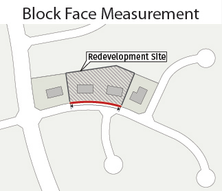
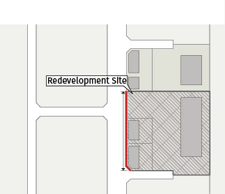
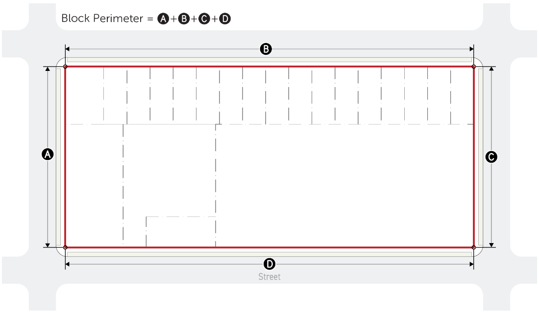
Sec. 10.3.1. - Blocks
A.
Maximum Block The block standards below are required for all subdivision and major land development permits for sites exceeding the Stated block face length. No block face or perimeter, when measured for the specific development, is allowed to exceed the thresholds of the following table, except as otherwise specified in this Section.
Connections to existing roads are required in all districts, except as described in Sec. 10.3.2 C.
B.
Block Measurement
1.
A block face is bounded by a public or private street (not including an alley).
2.
All public right-of-way or private easement proposed as part of a development must be improved with a street.
3.
Block face is measured along the edge of the property adjoining the public right-of-way or private easement.
4.
The Director may modify the block face requirements when steep slopes in excess of 35%, freeways, railways, waterways, tree protection areas, stream buffers, cemeteries, open space or easements would make the provision of a complete block infeasible. When block length is modified by the Director, bicycle and pedestrian connections must be provided in place of the required street.
5.
When a newly created street results in a new block face greater than the dimensions established under Sec 10.3.1 A, additional streets intersecting the new block face are required.
6.
Block perimeter is the total length measured along all lot lines abutting public or private streets.
(Ord. No. 2023-12-24, § I(Att. A), 12-5-2023)
Sec. 10.3.2. - Access Standards
A.
Required Access Improvements Every developer of lands within the jurisdiction of this Development Code must provide access improvements as required by this Development Code and other pertinent codes, ordinances, and regulations of the City. The improvements and associated lands must be provided at no cost to the City, and must be dedicated or otherwise transferred, as required, to the public in perpetuity and without covenant or reservation, except as otherwise provided in this Division.
B.
Type of Improvements If no new street is required per Sec. 10.3.1, Blocks, any development project of at least 3 acres in size, 100,000 square feet in gross floor area, whichever is less, or subject to Sec. 11.4.7. Preliminary Plan Approval must provide a street (and not a drive) through the site. The street type and frontage, if applicable, must be determined by the Director, based on the proposed use and layout.
C.
Access to Adjacent Properties No subdivision or development may be designed to completely eliminate street access to adjoining parcels of land. Every development must be designed to facilitate access to adjoining properties which are developed or anticipated to be developed in a manner substantially similar to the subject property.
1.
Exceptions
a.
In all districts, this requirement may be modified by the Director in cases of serious topographical hardship, dissimilar zoning which would create unacceptable land use conflicts between the 2 developments, or otherwise.
b.
In Protected Neighborhood Character Area zoning districts where a neighborhood street already exists and an extension or connection of said street to adjacent property, proposed for development or otherwise, would be to a road of collector or arterial classification, the street shall not be extended to connect to the collector or arterial road. Equally, if the development is proposed to be accessed from the collector or arterial road it shall not connect to the existing neighborhood street.
2.
Mitigation In all cases where the requirement for street access to adjacent properties is modified, prohibited, or waived by the Director as described in Sec. 10.3.2 C.1 above, bicycle and pedestrian connections must be provided in place of the otherwise required street.
D.
Cross-Access Easement In the RM- or RX- District, any Corridors & Nodes district or Perimeter Center district, the property owner must grant a cross-access easement as described in this Section to each adjoining property that is in the RM- or RX- district, any Corridors & Nodes district or Perimeter Center district. The purpose of the easement or inter-parcel access is to facilitate movement of residents and customers and their vehicles from location or establishment to another (lot to lot) without generating additional turning movements on a public street.
When required by this Section, cross-access easements must be recorded in the office of the Clerk of Superior Court, Fulton County, and reference to deed book and copy of the recorded easement provided to the Director.
1.
Access Easement Provisions
a.
The cross-access easement must permit vehicle access from the adjoining property to driveways and parking areas intended for customer or tenant use.
At a minimum, the easement shall meet the requirements of an alley as described in Sec. 10.4.13.
b.
On-site parking spaces may be restricted to use by the owner's customers and tenants only.
c.
Upon the availability of access to driveways and parking areas of the adjoining lot, the pavement or other surfacing of the owner's driveways and parking areas must be extended to the point of access on the property line.
d.
Where cross-access arrangements exist that predate the provisions of this ordinance, this access may not be blocked by any party,
2.
Location of Cross-Access Connections The location of vehicular connections across a property line should be mutually determined and constructed by both property owners, with priority given to the rear of the lot. In the case of coordination problems or any factors preventing construction of a cross-access connection, the Director will determine the location of the connection to be constructed by property owners.
3.
Stub When an abutting owner refuses in writing to allow construction of the cross-access circulation on their property, a stub for future cross-access must be provided as close as possible to the common property line.
4.
Relief
a.
The Director may grant relief from this cross-access requirement, in whole or in part, provided the relief is deemed reasonable due to 1 or more of the following:
i.
Topographic changes are too steep;
ii.
The presence of a stream or other natural features;
iii.
Site layout of developed properties;
iv.
Adjoining uses or their vehicles are incompatible; or
v.
Strict compliance would pose a safety hazard.
b.
When cross-access is waived by the Director, bicycle and pedestrian connections must be provided between abutting properties, except where there is a stream crossing greater than 15 feet in width that interferes with such access.
E.
Vehicular Access to Lots All lots must provide vehicular access directly from a public street along the frontage or along another property line that abuts a public street.
(Ord. No. 2023-12-24, § I(Att. A), 12-5-2023; Ord. No. 2025-09-22, § I, 9-16-2025)
Sec. 10.4.1. - General
A.
Improvements Along State Highways
1.
For any development that abuts a State highway or other right-of-way controlled by the State of Georgia, improvements to the roadway and the location and design of any street or driveway providing access from the State highway must comply with the standards and requirements of the Georgia Department of Transportation.
2.
An approved permit for proposed access or improvements is required by Georgia Department of Transportation and must be incorporated into the construction drawings for the project prior to the issuance of a Land Disturbance Permit.
(Ord. No. 2023-12-24, § I(Att. A), 12-5-2023)
Sec. 10.4.2. - Street Types
Streetscape improvements on all street frontages are required with major LDPs:
A.
On sites smaller than 2 acres;
B.
On sites at least 2 acres in size and with disturbance of at least 25% of the total site area;
C.
On sites at least 2 acres in size and less than 25% of the area disturbed, a determination will be made by the Director on which, if any, streetscape improvements will be required.
The 25% threshold is calculated as cumulative disturbance over the past 3 years.
For information on the requirements, see Div. 10.4.2.
A.
Applicability
1.
When a Preliminary Plat, Final Plat, or Major Land Disturbance Permit proposes the construction of a new street, the requirements of this Division apply.
2.
When constructing a public or private street or reconstructing an existing street, sidewalks, bicycle lanes, curb and gutter, street trees, landscape areas, and other applicable improvements must be installed and constructed in accordance with this Division and the Sandy Springs Technical Manual.
3.
Existing streets may continue serving existing development in their current configuration; however, they must not be extended or substantially rebuilt except in conformance with this Division.
4.
A Major Land Disturbance Permit triggers both required street and streetscape improvements. These required improvements may be waived where the Director determines that a City project for these improvements is underway. This waiver does not include a waiver of the obligation to provide the required street right-of-way.
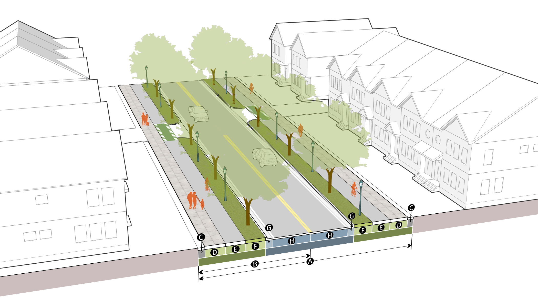
B.
Mobility Maps The City has created a series of maps included in the Sandy Springs Technical Manual that implement the Comprehensive Plan and Transportation Plan. The maps describe the required attributes for all streets throughout the City, including total right-of-way, lane width, sidewalk and sidewalk width, trails, bicycle facilities and pedestrian lighting. See also Appendix: City-wide Street Framework Map.
C.
Street Right-of-Way Width
1.
Street right-of-way or private easement width must be dedicated as specified in the Sandy Springs Technical Manual.
2.
Applicants must dedicate sufficient right-of-way to the City for streets and sidewalks. Generalized street right-of-way widths are illustrated in this Division. For further details, see the Sandy Springs Technical Manual.
3.
The Director may require turn lanes, and additional right-of-way beyond that shown in the applicable typical street cross-section to accommodate these lanes.
4.
City Projects do not need to dedicate right-of-way, and may be granted relief from this Division when deemed appropriate for the good of the community and general public, with the approval of the Director.
D.
Streets The streets included here describe a range of dimensions appropriate for each street type. A summary map is included in the Appendix. For additional details (including required dimensions and designations), see the Sandy Springs Technical Manual. City-initiated projects may differ from these typical sections.
1.
Type A: Two-Lane, No Parking.
2.
Type B: Two-Lane, Parking.
3.
Type C: Two-Lane, Median, No Parking.
4.
Type D: Two-Lane, Median, Parking.
5.
Type E: Four-Lane, Median, No Parking.
6.
Type F: Two-Lane, Residential.
7.
Roswell Road.
8.
Shared Street.
E.
Accessways Accessways are not considered streets. They cannot be used to meet the lot width requirements as required by Articles 2, 3, 4 and 5.
1.
Alley, Residential.
2.
Alley, Mixed Use.
3.
Pedestrian Passage.
4.
Multi-Use Trail.
5.
Commuter Trail.
F.
City Center Network The City Center has a specific set of typical street standards, which are included in the Sandy Springs Technical Manual.
G.
Perimeter Center Improvement Districts (PCIDs) Network In addition to the remaining requirements of this Division, all development located within the Perimeter Community Improvement District, regardless of the Sandy Springs zoning district applied, must conform to the Public Space Standards issued by the district, except where they are less stringent than the City's own requirements.
H.
Street, Pedestrian Lights and Landscaping Street, pedestrian lighting and landscaping requirements are set out in the Sandy Springs Technical Manual.
(Ord. No. 2023-12-24, § I(Att. A), 12-5-2023)
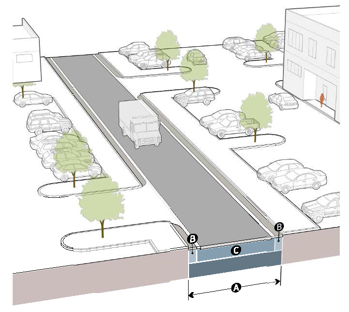
Sec. 10.4.3. - Two-Lane, No Parking
Type A
| Public Realm | ||
| Right-of-way, total | 62' to 88' min | |
| Right-of-way to centerline | 31' to 44' min | |
| Streetscape | ||
| Maintenance strip | 1' min | |
| Walkway width | 6' to 12' min | |
| Street tree planting zone* | 6' to 8' min | |
| Curb to Curb | ||
| Curb and gutter | ||
| Collector | 24" | |
| Arterial | 30" | |
| Bicycle facility | 5' to 8' min | |
| On-street parking |
Not
Required | |
| Travel lane | 11' to 12' | |
| *A reduced landscape strip of 2' may be allowed for existing single-family residential units within Protected Neighborhoods on streets classified as Collector or lower. | ||
(Ord. No. 2023-12-24, § I(Att. A), 12-5-2023)
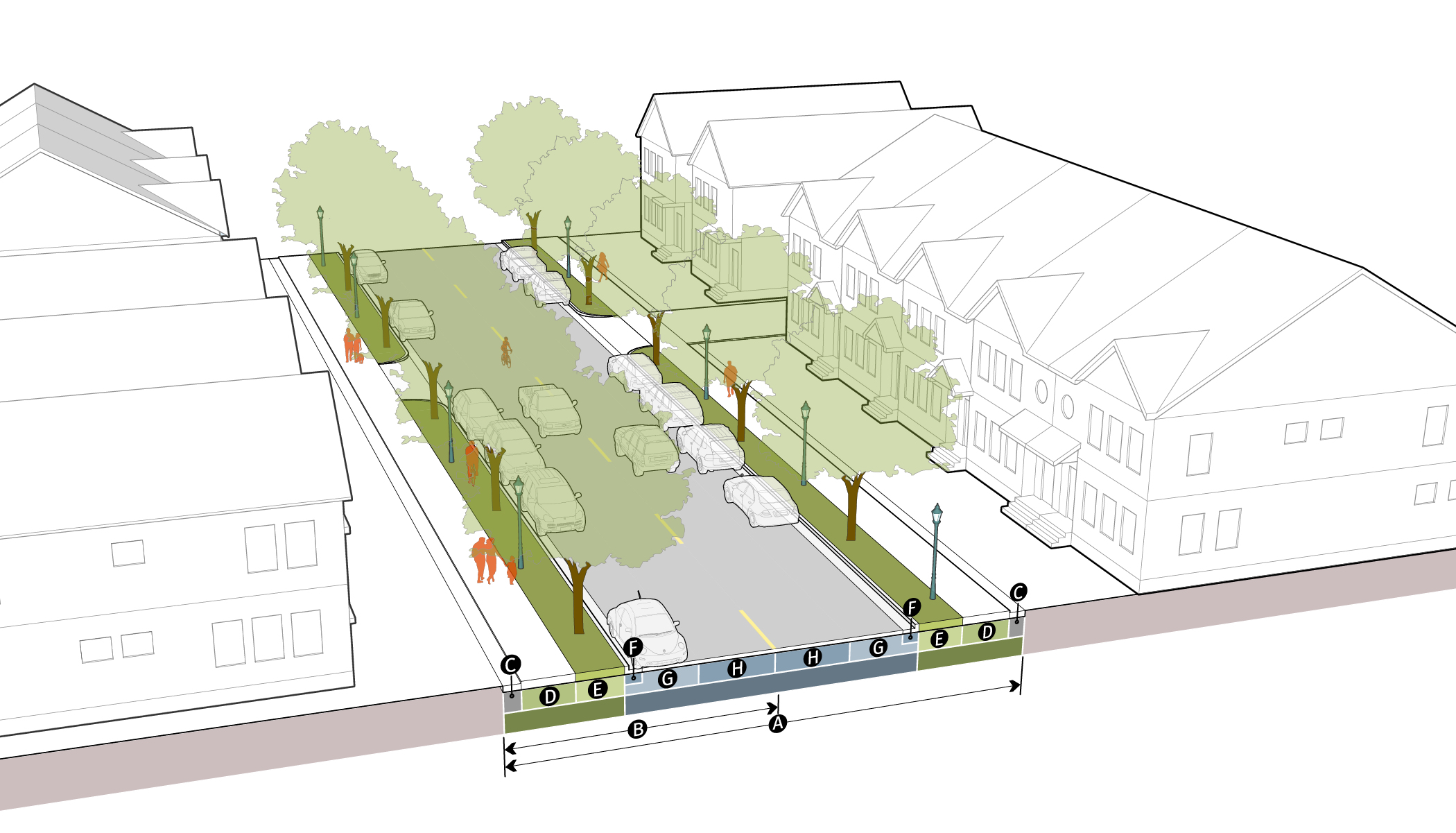
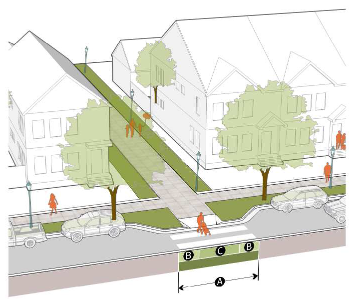
Sec. 10.4.4. - Two-Lane, Parking
Type B
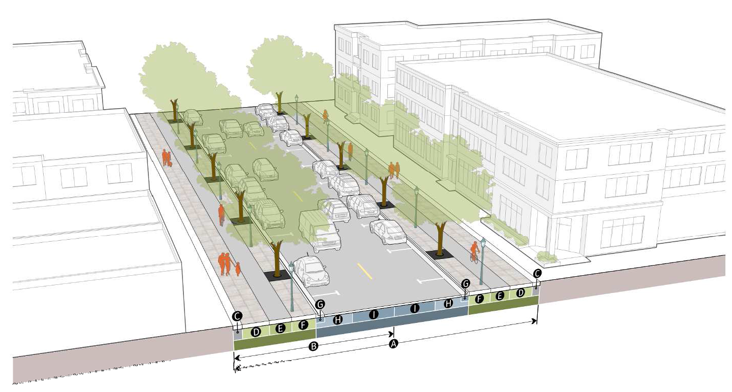
| Public Realm | ||
| Right-of-way, total | 80' to 96' min | |
| Right-of-way to centerline | 40' to 48' min | |
| Streetscape | ||
| Maintenance strip | 1' min | |
| Walkway width | 6' to 8' min | |
| Bicycle facility | 5' to 8' min | |
| Street tree planting zone* | 6' to 8' min | |
| Curb to Curb | ||
| Curb and gutter | ||
| Collector | 24" | |
| Arterial | 30" | |
| On-street parking | Required | |
| Parking lane width | 8' | |
| Travel lane | 12' | |
| *A reduced landscape strip of 2' may be allowed for existing single-family residential units within Protected Neighborhoods on streets classified as Collector or lower. | ||
(Ord. No. 2023-12-24, § I(Att. A), 12-5-2023)
Sec. 10.4.5. - Two-Lane, Median, No Parking
Type C
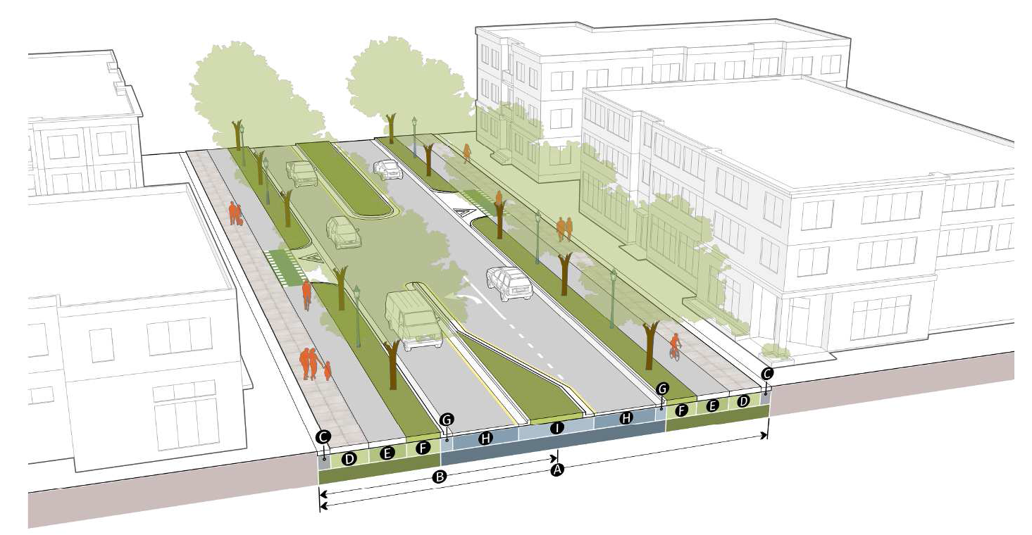
| Public Realm | ||
| Right-of-way, total | 76' to 98' min | |
| Right-of-way to centerline | 38' to 49' min | |
| Streetscape | ||
| Maintenance strip | 1' min | |
| Walkway width | 6' to 10' min | |
| Bicycle facility | 5' to 8' min | |
| Street tree planting zone | 6' to 8' min | |
| Curb to Curb | ||
| Curb and gutter | ||
| Collector | 24" | |
| Arterial | 30" | |
| On-street parking |
Not
Required | |
| Travel lane | 11' to 14' | |
|
Turn lane/median
(including curb and gutter) | 14' min. | |
(Ord. No. 2023-12-24, § I(Att. A), 12-5-2023)
Sec. 10.4.6. - Two-Lane, Median, Parking
Type D
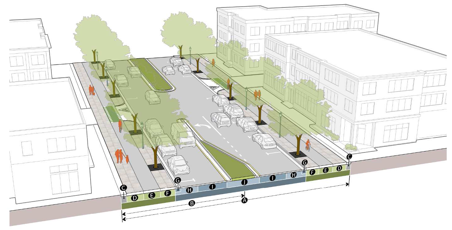
| Public Realm | ||
| Right-of-way, total | 94' to 114' min | |
| Right-of-way to centerline | 47' to 57' min | |
| Streetscape | ||
| Maintenance strip | 1' min | |
| Walkway width | 6' to 10' min | |
| Bicycle facility | 5' to 8' min | |
| Street tree planting zone | 6' to 8' min | |
| Curb to Curb | ||
| Curb and gutter | ||
| Collector | 24" | |
| Arterial | 30" | |
| On-street parking | Required | |
| Parking lane width | 8' | |
| Travel lane | 12' | |
|
Turn lane/median
(including curb and gutter) | 14' min. | |
(Ord. No. 2023-12-24, § I(Att. A), 12-5-2023)
Sec. 10.4.7. - Four-Lane, Median, No Parking
Type E
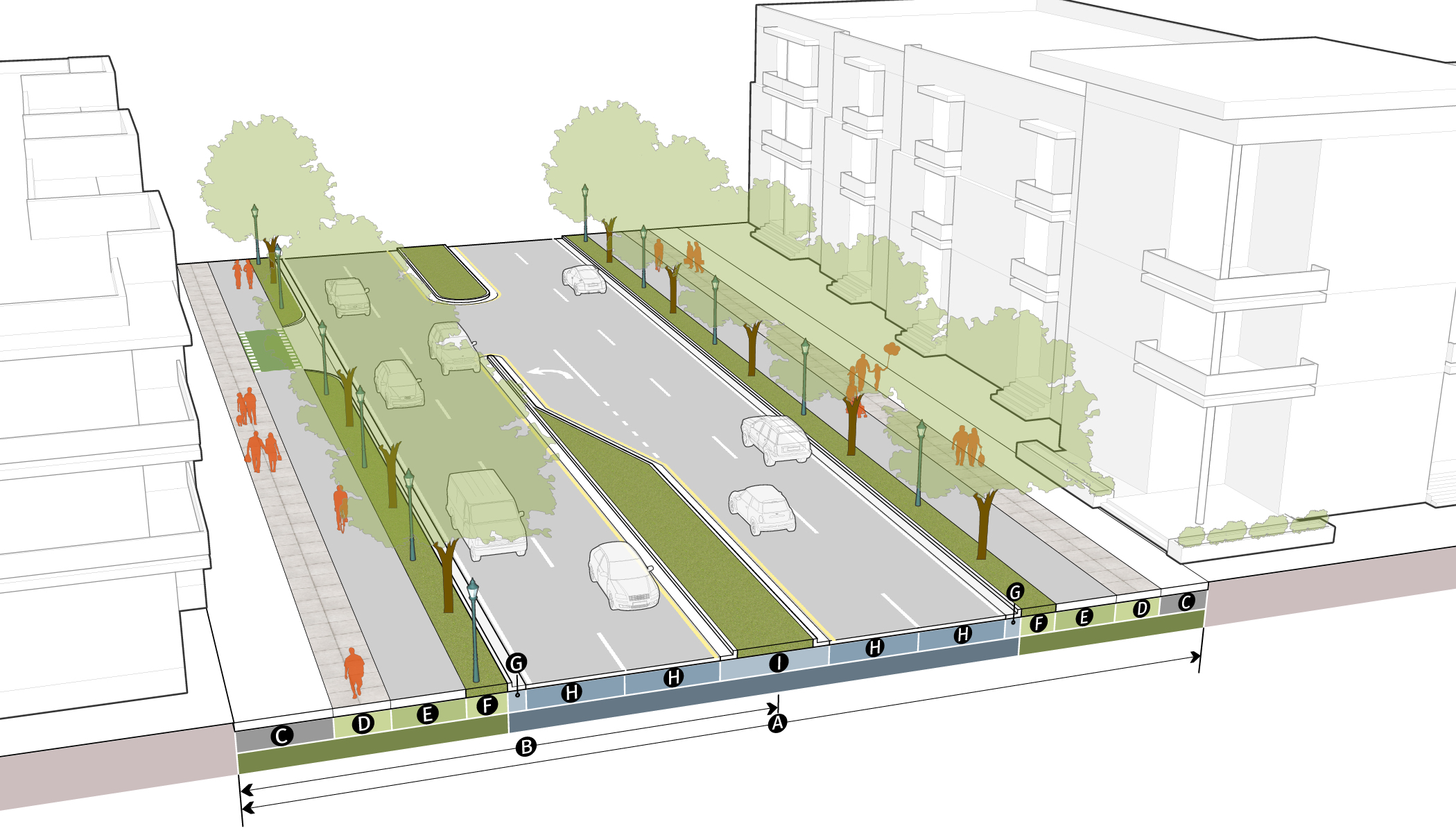
| Public Realm | ||
| Right-of-way, total | 105' to 134' min | |
| Right-of-way to centerline | 52.5' to 67' min | |
| Streetscape | ||
| Maintenance strip | 1' min | |
| Walkway width | 6' to 12' min | |
| Bicycle facility | 8' to 12' min | |
| Street tree planting zone | 6' to 8' min | |
| Curb to Curb | ||
| Curb and gutter | 30" | |
| On-street parking |
Not
Required | |
| Travel lane | 11' to 12' | |
| Turn lane/median | 14' min. | |
(Ord. No. 2023-12-24, § I(Att. A), 12-5-2023)
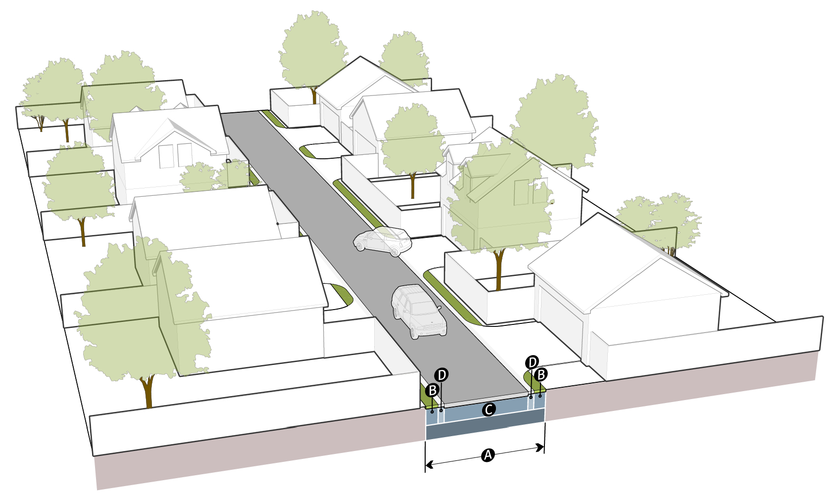
Sec. 10.4.8. - Two-Lane, Residential
Type F
| Public Realm | ||
| Right-of-way, total | 50' to 80' min | |
| Right-of-way to centerline | 25' to 40' min | |
| Streetscape | ||
| Maintenance strip | 1' min | |
| Walkway width | 6' min | |
| Street tree planting zone* | 6' min | |
| Curb to Curb | ||
| Curb and gutter | 24" | |
| Bicycle facility | 0' to 5' min | |
| On-street parking | Optional | |
|
Parking lane width
(if provided) | 8' | |
| Travel lane | 10' to 12' | |
| *A reduced landscape strip of 2' may be allowed for existing single-family residential units within Protected Neighborhoods on streets classified as Collector or lower. | ||
(Ord. No. 2023-12-24, § I(Att. A), 12-5-2023)
Sec. 10.4.9. - Roswell Road
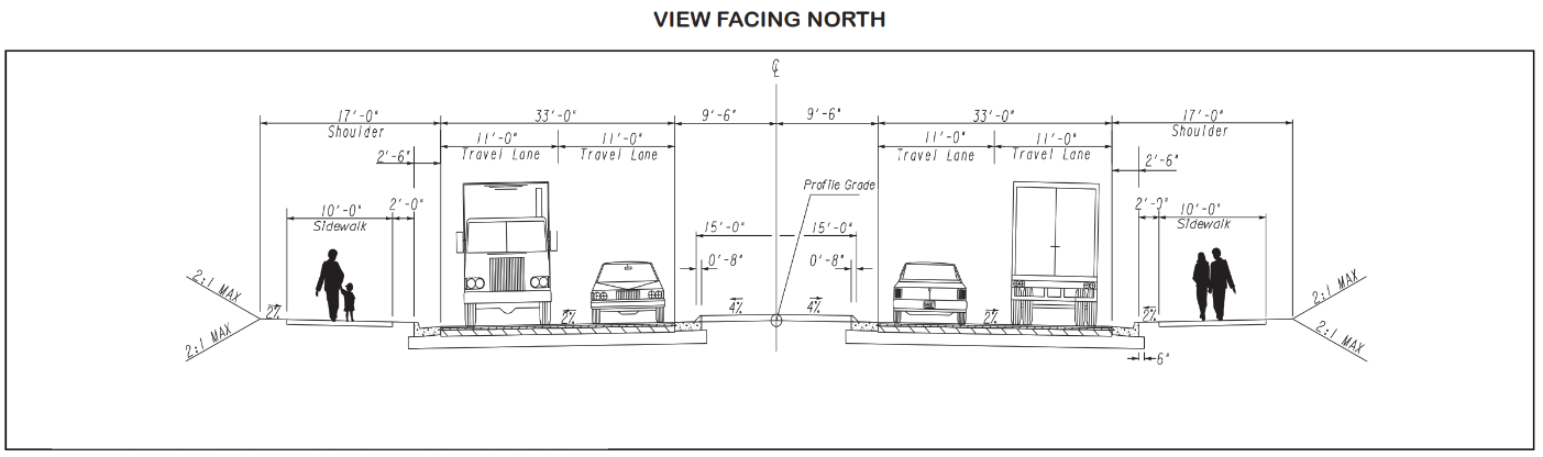
| Bicycle facility (reserved) | N/A | |
| Street tree planting zone | In Supplement Zone | |
| Curb to Curb | ||
| Curb and gutter | 30" | |
| On-street parking | Not Required | |
| Travel lane | 11' min | |
|
Turn lane/median
(including curb and gutter) | 15' min | |
(Ord. No. 2023-12-24, § I(Att. A), 12-5-2023)
Sec. 10.4.10. - Shared Street
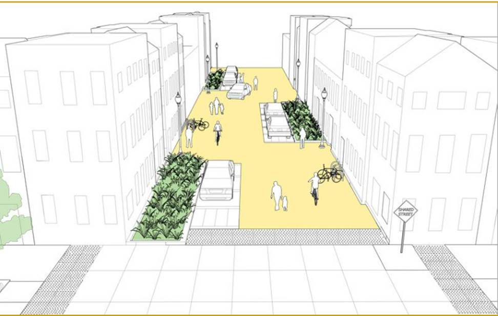
(Ord. No. 2023-12-24, § I(Att. A), 12-5-2023; Ord. No. 2025-09-22, § I, 9-16-2025)
Sec. 10.4.12. - Alley, Residential
| Public Realm | ||
| Right-of-way | 20' min | |
| Streetscape | ||
| Utility zone | 2' min | |
| Travelway | ||
| Lane Width | 14' | |
| Flush Curb | 1' min | |
(Ord. No. 2023-12-24, § I(Att. A), 12-5-2023)
Sec. 10.4.13. - Alley, Mixed Use
| Public Realm | ||
| Right-of-way | 26' min | |
| Streetscape | ||
| Utility zone | 2' min | |
| Travelway | ||
| Lane Width | 16' min | |
| Curb (unspecified) | — | |
(Ord. No. 2023-12-24, § I(Att. A), 12-5-2023)
Sec. 10.4.14. - Pedestrian Passage
| Public Realm | ||
| Right-of-way | 20' min | |
| Streetscape | ||
| Utility zone | 5' min | |
| Paved pedestrian zone | 6' min | |
| Walkway type | Sidewalk | |
(Ord. No. 2023-12-24, § I(Att. A), 12-5-2023)
Sec. 10.4.15. - Multi-Use Trail
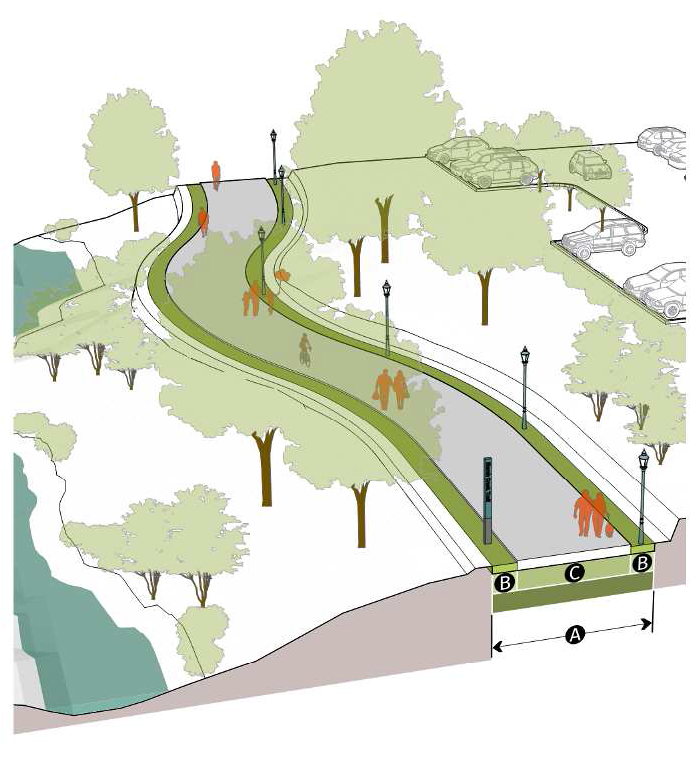
| Public Realm | ||
| Right-of-way | 20' min | |
| Streetscape | ||
| Utility zone | 4' min | |
| Paved pedestrian/bicycle zone | 12' min | |
| Walkway type | Pathway | |
(Ord. No. 2023-12-24, § I(Att. A), 12-5-2023)
Sec. 10.4.16. - Commuter Trail

| Public Realm | ||
| Right-of-way | 28' min | |
| Streetscape | ||
| Utility zone | 4' min | |
| Paved pedestrian/bicycle zone | 12' min | |
| Walkway type | Pathway | |
(Ord. No. 2023-12-24, § I(Att. A), 12-5-2023)
Sec. 10.4.17. - Alternative Streets
A.
Private Streets
1.
Private streets and accessways may be approved by the Director. Private streets must be platted as a separate lot. Such lots do not need to meet the zoning district dimensional requirements.
2.
Private streets and accessways must be designed and constructed to the roadway construction and right-of-way standards of the City, both aboveground and belowground, as contained in this Division and the Sandy Springs Technical Manual. The Director will determine the applicable street type per Sec. 10.4.2 D.
3.
Private streets are not dedicated to the public and will not be publicly maintained.
4.
In residential subdivisions where private streets are proposed, the Director may require a public street for cross-access connectivity to adjacent lots.
5.
Private streets must be maintained by a mandatory homeowners association and documents of incorporation must be submitted to the Director for review and approval prior to the recording of the final plat. Private streets must be clearly designated on the final plat.
B.
Gated Access Gated public or private streets are not allowed.
C.
Vehicular Access Easements Vehicular access may be provided from a public street indirectly via easement in any of the following circumstances:
1.
The property is not required to provide a minimum frontage by the applicable zoning district, provided that the easement must be in a location and the access driveway must have a width and alignment acceptable to the Fire Department and the Department.
2.
The property is a buildable lot of record, as defined in this Development Code, but does not meet the minimum frontage requirement of the applicable zoning district. The property must be served by an exclusive access easement which is limited to the provision of access to only 1 principal use or structure.
3.
The access easement serves a single-family residence on a lot that is otherwise a buildable lot of record, and is sharing a common driveway with no more than 2 other single-family residences.
4.
The access easement was lawfully established as such under the code or ordinances of the City, prior to the adoption of this Development Code.
5.
The access easement coincides with a private roadway approved under the code, ordinances, or regulations of the City. All new private roadways must be constructed to the roadway standards of this Article, and their ownership and maintenance responsibility by private parties. The access easement width must be the same as required for right-of-way on a similarly classified public road, for example, the easement on a local street within a residential subdivision must be the same width as the right-of-way for a public, local residential street.
(Ord. No. 2023-12-24, § I(Att. A), 12-5-2023)
Sec. 10.4.18. - Additional Street Standards
A.
Total Dwelling Units with Single Entrance
1.
A maximum of 50 residential dwelling units is allowed to be constructed with only 1 street outlet to an existing public street.
2.
A modified maximum may be approved by the Director, provided that alternative mitigation that ensures life safety is provided.
3.
A modified maximum may be approved by the Director where extreme topography prohibits an additional connection.
B.
Visibility at Intersections Where a driveway intersects a public or private right-of-way or where property abuts the intersection of 2 public or private rights-of-way, unobstructed sight distance must be provided at all times within the sight triangle area on the property adjacent to the intersection in order to ensure that safe and adequate sight distance is provided. For calculation of the appropriate sight triangle, see the Sandy Springs Technical Manual.
C.
Dead-End Streets
1.
General Dead-end streets are permitted only with the approval of the Director. Dead-end streets that exceed 150 feet in length must provide an adequate turn-around as approved by the Fire Marshal. Street length is measured from the end of the improved surface to the center of the intersection with the connecting street.
2.
Alternative Designs Alternative designs may be approved at the time of subdivision. Sample alternative designs are included in the Sandy Springs Technical Manual.
3.
Traffic Calming Measures Where existing residential streets are longer than 600 feet, traffic calming devices may be required by the Director. These measures may include green space, median islands, roundabouts and or other traffic calming devices. Any traffic calming must be consistent with the City's adopted traffic calming policy.
(Ord. No. 2023-12-24, § I(Att. A), 12-5-2023)
Sec. 10.5.1. - Sandy Springs Technical Manual
A.
The Sandy Springs Technical Manual contains improvement requirements, including but not limited to:
1.
Plan and Plat Specifications.
2.
Street Design and Construction Standards.
3.
Access and Driveway Spacing.
4.
Utilities and Easements.
5.
Grading and Drainage.
6.
Water Conservation.
(Ord. No. 2023-12-24, § I(Att. A), 12-5-2023)