
Sarasota County Unincorporated
City Zoning Code
City Zoning Code
ARTICLE 14
- 2050 PLAN REGULATIONS
Sec. 124-270.- Planned Economic Development (PED) District.
(a)
Purpose and Intent Statement. The Economic Development RMA shall be implemented through one of two forms, the existing suburban form or a new urban form as described herein. The purpose of the Planned Economic Development District (PED) is to provide neotraditional design standards for both Greenfield and redevelopment sites that will provide an efficient urban land use form and cost-effective delivery of urban services. The PED District is based on the key principles of urban-type development, which are connectivity, unity, mixed-use, balance, and pedestrian orientation. Connectivity within both newly formed development areas as well as infill sites demand that each site plan be formed and shaped by the context of that site - one size does not fit all. Each project shall be designed so that it offers a distinct alternative to the surrounding suburban development, where applicable, while it also connects with that suburban development.
(b)
General Provisions.
(1)
Legislative Findings. The following findings are hereby adopted as legislative findings by the Board:
a.
The Sarasota County Comprehensive Plan was amended to include additional goals, objectives, and policies to implement the Economic Development RMA.
b.
The boundaries of the RMA are delineated and adopted in the Sarasota County Comprehensive Plan through Figure RMA-1 as an overlay to the Sarasota County Future Land Use Map.
c.
The intent of the Planned Economic Development District is to encourage the reuse of vacant or underutilized commercial parcels located in the Economic Development RMA.
(2)
Purpose. The purpose of the Planned Economic Development District is to implement the requirements of Sarasota County Comprehensive Plan Amendment Sarasota 2050 Resource Management Area (RMA) System Comprehensive Plan Amendment RMA-1, Ordinance No. 2001-076.
(3)
Applicability. Developed and vacant parcels, with a ten-acre minimum size. Smaller individual parcels may be included if they are incorporated into a larger PED district of a ten-acre minimum size and otherwise have a future land use designation that qualifies for PED zoning. The PED District may be applied in: 1) the Economic Development Resource Management Area in Major Employment Centers or in Village I or larger Commercial Center designations, or 2) in any Resource Management Area where specifically authorized by Plan policy or Critical Area Plans. In addition to the standards and requirements provided herein, development within the Planned Economic Development District shall be required to meet all other applicable sections of the UDC. Where any provision of this Article is in conflict with any other standards or regulations within the UDC, the standards contained in this Article shall prevail.
(4)
Locational Standards. The use of a vacant parcel or the underutilized commercial parcels currently in suburban form is encouraged in the PED District. The anticipated mixed-use environment shall contain a significant amount of retail as determined through the CAP process and be located in a Commercial Center, on a Commercial Corridor, Mixed Use designation, or within a Major Employment Center (MEC) or a Major Employment Center/Interstate Regional Office Park (MEC/IROP). There shall be at least one adjacent major (collector or arterial) roadway and not be adjacent to any single-family residential uses of more than 35 percent of its perimeter. A single-family residential use that is separated from the proposed development by a roadway shall not be considered "adjacent" for the purpose of evaluating consistency with this standard.
(5)
Prior Zoning District Conformity. Where a lot, structure, or use exist lawfully under this UDC at the effective date of the adoption of a PED Rezoning, the lot, structure or use may be continued and shall be considered conforming so long as it remains otherwise lawful and consistent with the zoning district in effect prior to the adoption of the PED Rezoning. Subsequent improvements that maintain or enhance the lot, structure or use may be continued under the prior zoning district, so long as improvements are otherwise lawful. At such time as the lot, structure or use are developed or redeveloped inconsistent with the prior zoning district, such development must comply with the PED zoning in place.
(c)
Zoning Standards.
(1)
Density and Intensity. Successful urban form is dependent on a concentration of higher density residential and higher intensity nonresidential, resulting in less open space than typical in suburban design. Only parking, landscaping, civic open space, and circulation requirements shall limit building coverage. For development located within Community or Regional Commercial Centers as designated in the Comprehensive Plan, there shall be a maximum floor area ratio (FAR) of 1.2. The maximum FAR may be exceeded by 25 percent when conditions of Future Land Use Policy 2.9.2 of the Comprehensive Plan are met. For development located within Major Employment Centers as designated in the Comprehensive Plan, there shall be a maximum FAR of 1.0. The maximum FAR may be exceeded by 50 percent when conditions of Future Land Use Policy 2.7.6 of the Comprehensive Plan are met. The maximum residential density shall be 25 units per acre, and the height shall be determined pursuant to Section 124-270(f)(2) by a variable height structure utilizing block types. Additional height will be allowed when an applicant provides a mix of uses in the building and meets the compatibility requirements provided in Section 124-270(f)(5)e.8.
(2)
Mix of Uses. Every project will contain a mix of: (1) residential uses; (2) office and institutional uses; and (3) retail and service uses. Allowable uses are provided for in the PED use chart. The exact mix of uses shall be determined through the Critical Area Plan (CAP) process.
(3)
Civic Open Space. A civic open space provides internal open space refuge within a large-scale redevelopment site. A minimum of five percent of the site shall be converted to civic open space, which may be designed as a green, square, or plaza. The civic open space shall be located near the center of the site on a pedestrian-oriented street or the intersection of two pedestrian-oriented streets.
(d)
General District Standards. In order to promote efficient urban growth patterns, new development shall be organized to illustrate the intended development pattern within the PED based on the application of the prototypical block models as set forth in Section 124-270(f).
(e)
Permitted Uses. Permitted use descriptions and limitations are determined by the UDC, which descriptions and limitations are hereby adopted by this reference.
Table Notes:
1 Stormwater facilities may be located in a residential or open use district if located on public property with authorization or on property identified for that use within the applicable Critical Area Plan.
2 Movie theaters may be up to 85,000 sq. ft. in size.
3 Vehicle sales and leasing is permitted within the PED when completely enclosed in a building and otherwise consistent with all design standards provided in the zoning district as described herein.
4 Boat storage is permitted when completely enclosed in a building and otherwise consistent with all design standards provided in the zoning district as described herein. No outdoor dry storage of boats is permitted.
5
Light Industrial Use Standards:
(a) There shall be no outside display or storage of materials.
(b) Light Industrial uses shall not be located adjacent to "A" streets.
(c) Truck traffic shall be prohibited along "A" streets.
6 Subject to Section 124-139 "Live Work Unit".
7 Subject to Section 124-154 "Patient family accommodations".
8 Subject to being conducted within a completely enclosed building between 8:00 a.m. and 10:00 p.m., and after 10:00 p.m. as a Special Exception pursuant to Section 124-43.
9 Subject to being conducted between 8:00 a.m. and 10:00 p.m., and after 10:00 p.m. as a Special Exception pursuant to Section 124-43.
10 Subject to Section 124-140 "Restaurants".
11 Subject to Section 124-147 "Outdoor Animal Boarding".
12 Subject to Section 124-148 "Convenience store with Gas Pumps, Gas Stations".
13 Transient Accommodations that have more than 100 rooms may have a restaurant, bar, and shops for the retail sale of incidentals (i.e. flowers, sundries, books, jewelry, gifts, art and similar items), and barber or beauty shops when said uses are located within the main building.
14 Subject to Section 124-141 "Bed and Breakfasts".
15 Subject to compliance with Chapter 54, Article V and VI, Air and Sound Pollution and Noise of the County Code.
16 Sports Academy is a prohibited use within the Agricultural Reserve RMA, as described and depicted in the Comprehensive Plan, Figure RMA-1, Resource Management Area Map.
17 Pursuant to a Special Exception and Subject to Section 124-156 "Pet Resorts". The requirement for parcel frontage on an arterial or collector roadway shall not apply.
(f)
General Design Standards.
(1)
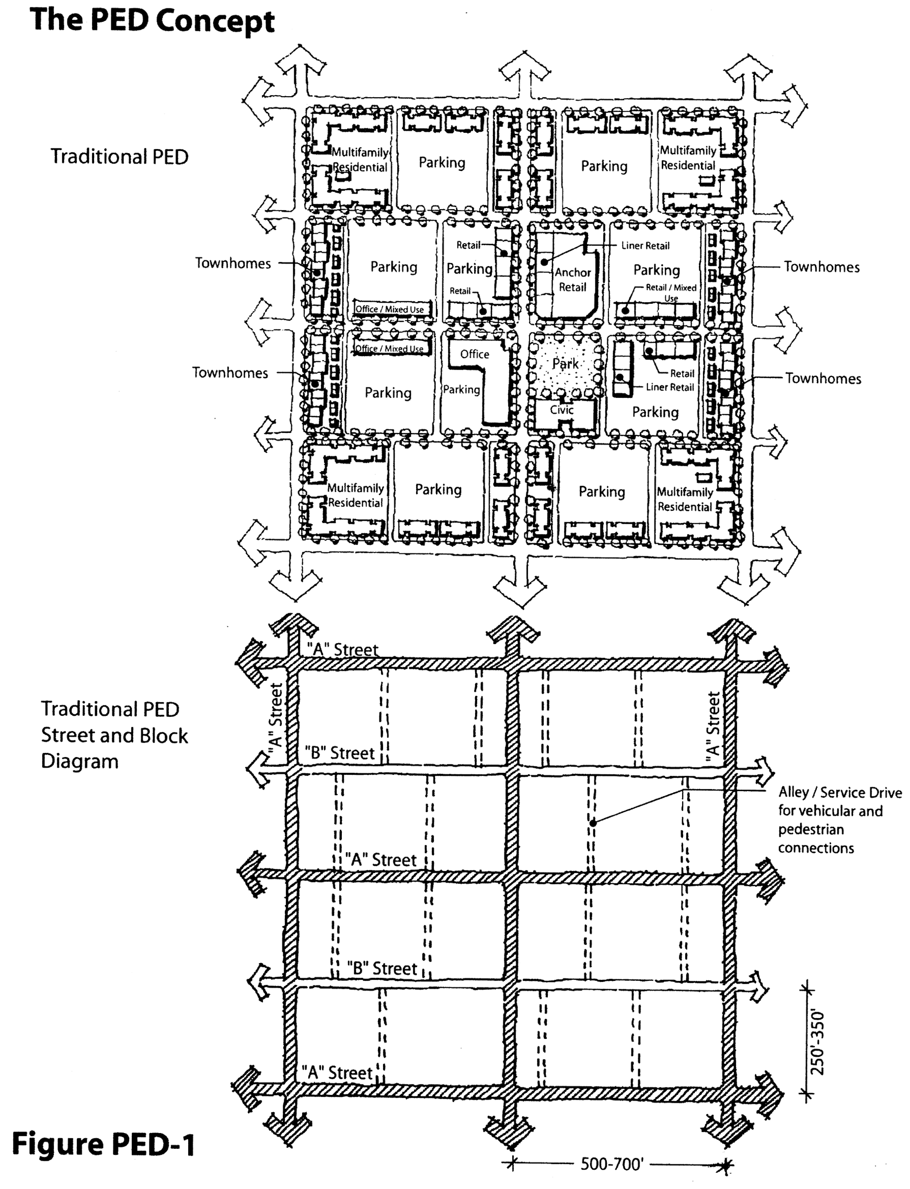
Development Block Structure. In order to promote efficient urban growth patterns, new development shall be organized to establish the intended development pattern within the PED based on the application of the prototypical block models. Development activity shall be modeled after the PED Prototype (Figure PED-1) and shall conform to the principles illustrated in one or more of the following development block types:
a.
Mixed Use Development Block with surface parking (Figure PED-2) and Mixed Use Development Block with structured parking (Figure PED-3). The Mixed Use Development Blocks are designed to accommodate a range of retail, office and mixed-use building types including "anchor" retail, "liner" retail, and "main street" retail buildings.
b.
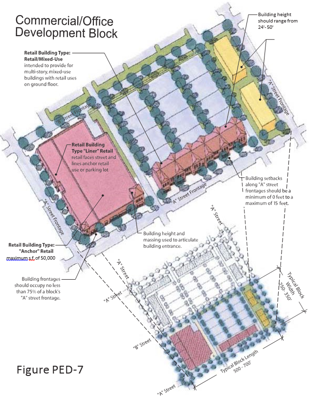
Commercial/Industrial/Office Block. The Commercial/Industrial/Office Block (Figure PED-7) is designed to accommodate a range of retail, industrial and office uses.
c.
Multifamily Development Block (Figure PED-4). The Multifamily Development Block is designed to accommodate a range of multifamily building types including apartment buildings, community residential homes, and nursing and extended care facilities.
d.
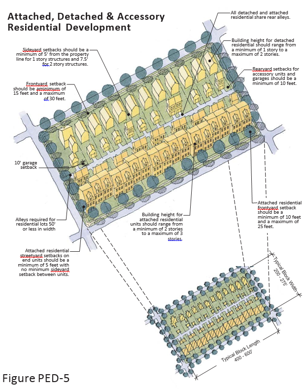
Attached, Detached and Accessory Residential Development Block (Figure PED-5). The Attached, Detached and Accessory Residential development block is designed to accommodate a range of residential building types including single-family residential homes, duplexes, triplexes, quadplexes and townhomes as well as accessory residential units.
(2)
Height. The maximum height of a building is measured to include parking within the structure.
(3)
Setbacks.
a.
Commercial/Industrial/Office Block (No Residential): Building setbacks along "A" Street frontages shall be a minimum of zero feet to a maximum of ten feet. Building setbacks along "B" streets shall be a minimum of zero feet to a maximum of 30 feet. Building setbacks along all existing collector and arterial street frontages shall be a minimum of 25 feet and a maximum of 80 feet.
b.
Mixed Use Development Blocks: Building setbacks along "A" Street frontages shall be a minimum of 0 feet to a maximum of 10 feet. Building setbacks along "B" streets shall be a minimum of 0 feet to a maximum of 30 feet. Building setbacks along all existing collector and arterial street frontages shall be a minimum of 25 feet and a maximum of 80 feet.
c.
Multifamily Development Blocks: Building setbacks along "A" Street frontages shall be a minimum of 0 feet to a maximum of 15 feet. Building setbacks along "B" streets shall be a minimum of 0 feet to a maximum of 30 feet. Building setbacks along all existing collector and arterial street frontages shall be a minimum of 25 feet and a maximum of 80 feet.
d.
Attached, Detached and Accessory Blocks:
(4)
Site Design Standards: Use of Prototypes. Permitted block types are described within a single-use prototype for illustrative purposes. Development applications for specific sites are required to assemble structures into mixed-use blocks or partial blocks, as appropriate, for the site. Each site plan shall be required to identify how the proposed development including buildings and structures are assembled within a context that conforms to the design standards for the block or partial block within which the building occurs.
(5)
General Development Block Standards.
a.
Block Size. Blocks shall be designed to be generally rectangular in shape except where topographic or other conditions require modification.
1.
For Mixed-use development and multifamily development, block length shall range from 500 to 700 feet including alleys that may bisect the block, and partial block width shall range from 225 to 350 feet. The block dimensions shall be measured from the street right-of-way to street right-of-way.
2.
For attached and detached residential uses block length shall range from 400 to 600 feet including alleys that may bisect the block, and partial block width shall range from 175 to 250 feet. The block dimensions shall be measured from the street right-of-way to street right-of-way.
b.
Designation of "A" Streets and "B" Streets. All newly constructed streets, excluding alleys, shall be designated as an "A" Street or a "B" Street.
1.
"A" Streets shall have building frontage (see Section 124-270(f)(5)e.1) requirements that place buildings close to the street and restrict parking and service uses along them.
2.
"B" Streets shall have no building frontage (see Section 124-270(f)(5)e.1) requirements. While "B" Streets are not intended to be primary pedestrian streets at a minimum they must include sidewalks and street trees in accordance with specified street design standards (see Section 124-270(g)(1)).
3.
"B" Streets may be designated by individual block faces; however, no block face shall be split by "A" Street and "B" Street designations.
c.
Off-Street Parking (Surface Parking Lots).
1.
Off-street surface parking lots must be located behind "A" Street frontage buildings and cannot front on any "A" Street.
2.
A maximum of two vehicular access/curb cuts to parking lots are allowed along "A" Street block faces, subject to Access Management agreements. Vehicular access/curb cuts are not allowed on any block face less than 350 feet. Vehicular access drives shall connect each parking lot with at least two separate streets.
3.
Surface parking lots shall not comprise more than 75 percent of any one block.
d.
Parking Garages. The Mixed Use and Multifamily Development Blocks are permitted to be constructed with structured parking as provided in the standards herein and represented by the Mixed Use Development Block (with structured parking) prototype. Perimeter landscaping for parking garages shall include five feet minimum planting area with palm trees or other trees acceptable to Sarasota County's Landscape Architect. Interior landscaping requirements for surface parking lots shall be met on parking garages by providing landscape planters or flower boxes around the exterior of the first three levels of the parking garage structure, such that the amount of landscaping shall be approximately equal to that required for interior landscaping for a surface parking lot of equal capacity. Structured parking decks shall be located behind "A" Street frontage buildings with vehicular access restricted to "B" Streets.
e.
General Site Design.
1.
Building Frontage. Mixed Use and Multifamily Development Blocks: Building frontages shall occupy no less than 75 percent of a block's "A" Street frontage.
2.
Form. Buildings shall form a consistent, distinct edge, spatially delineating the public street through maximum building setbacks that vary by no more than five feet from those of the adjacent building.
3.
Adjacent Building Types: Urban Form. Similar building types shall generally face across streets (e.g., detached single-family residential shall face detached single-family residential, attached single-family residential shall face attached single-family residential, and attached multifamily shall face attached multifamily). Dissimilar building types, when adjacent (e.g., attached single-family residential adjacent to multistory structure), shall abut at rear lot lines separated by a shared alley or service drive. Each of the following shall be considered dissimilar building types: detached single-family residential; detached nonresidential; attached single-family residential; and any multistory structure regardless of use.
4.
Solid Waste Storage Areas. See Section 124-123(a)(4), Requirements for Outdoor Refuse Collection and Refuse Storage Areas, for screening and location of solid waste storage areas.
5.
Fences. Shall be constructed of masonry, wood, vinyl or cast iron/metal. Fences located in required front yards shall be a maximum of four feet in height and fences located in required rear yards and side yards shall be a maximum of six feet in height. Chainlink fencing is prohibited.
6.
Open Storage. There shall be no open storage.
7.
Utilities. All utilities shall be located underground.
8.
Compatibility. The PED Master Development Plan may provide a mix of land uses as provided in Section 124-270(c)(2). The specific location of land uses within the PED District shall be established on the approved master plan.
i.
Internal Compatibility. The master development plan shall demonstrate compliance with the following characteristics:
a)
The land uses within the master development plan are arranged and designed in a complementary and compatible manner;
b)
Incompatible land uses are effectively buffered or otherwise protected to the extent necessary to insure full use and enjoyment of all property within the district;
c)
Vehicular circulation system throughout the master development plan directs traffic in an efficient, safe and nonintrusive manner; and
d)
The individual land use components of the master development plan are interconnected by safe and convenient pedestrian linkages.
ii.
External Compatibility. The master development plan shall include appropriate development order conditions that address external compatibility including adjacent buffers and screening such that the arrangement of land uses on site do not unreasonably impair the long-term use of properties adjoining the PED District as established by the master development plan.
a)
Lighting. See Section 124-126, Outdoor Lighting, for regulations relating to location, illumination and glare. A PED shall also control the effects of lights from automobiles or other sources. Where the site plan indicates potential adverse effects of parking or of other light sources on the lot on which the nonresidential use is to be located, such effects shall be prevented so that lights do not illuminate adjacent residential property below a height of five feet at the residential property line, or from shining into any residential window if there is to be nonresidential parking on the premises after dark.
b)
Setback. When a nonresidential or multifamily (apartment) use is abutting any residential property, there shall be an additional setback required for any yard of that use which is contiguous to the residential property, as follows:
1)
When any side of a structure equal to or less than 35 feet in height abuts residentially zoned property, that portion of the structure(s) shall be set back at a minimum 20 feet.
2)
The specific minimum setbacks and other compatibility requirements for structures greater than 35 feet in height shall be determined during the Rezoning process and shall become a condition of the Rezoning action. At a minimum, structures that are greater than 35 feet in height shall comply with the following building height requirements.
3)
Building Design. The side of the building that is facing or backing up to any residential development, must be treated with the same architectural design standards as the front of the building. Refer to Section 124-270(f)(5)i.3 and Section 124-270(f)(5)i.4.
f.
Screening. See Section 124-123, Service Function Areas, for requirements for screening of trash, recycling receptacles, loading docks, service areas, mechanical equipment, and other similar areas. Service function areas may not be located in the required buffer yard when Section 124-270(f)(5)e.8. (compatibility) applies.
g.
Signage. All nonresidential signage shall adhere to Section Article 11, Sign Regulations.
h.
Landscaping. Landscaping shall be provided as required in Section 124-122, Landscaping and Buffering, except as modified herein.
i.
General Building Design Standards.
1.
Building Orientation. A building's primary orientation shall be toward the street rather than the parking areas. The primary building entrances shall be visible and directly accessible from a public street. For the Mixed Use Development Block, building massing such as tower elements shall be used to call out the location of building entries.
2.
Public Entrance. Buildings that are open to the public shall have an entrance for pedestrians from the street to the building interior. This entrance shall be designed to be attractive and functionally be a distinctive and prominent element of the architectural design, and shall be open to the public during business hours. Buildings shall incorporate lighting and changes in mass, surface or finish to emphasize the entrances.
3.
Building Facade. Blank walls shall not occupy over 50 percent of a street-facing frontage and shall not exceed 20 linear feet without being interrupted by a window or entry. No more than 20 feet of horizontal distance of wall shall be provided without architectural relief for building walls and frontage walls facing the street. Buildings shall provide a foundation or base that extends from the ground to the bottom of the lower windowsills, that is distinguished from the building face by a change in volume or material. A clear visual division shall be maintained between the ground level floor and upper floors, which may include changes in volume or materials or other architectural detailing such as a belt course or cornice. The top of any building, including those with Greenroof Treatment Systems shall contain a distinctive finish consisting of a cornice or other architectural termination as described below; subsection 4, Additional Design Features.
4.
Additional Design Features. All buildings shall utilize at least three of the following design features to provide visual relief along all elevations of the building:
i.
Dormers.
ii.
Gables.
iii.
Recessed entries.
iv.
Covered porch entries.
v.
Cupolas.
vi.
Pillars or posts.
vii.
Bay window (minimum 12-inch projections).
viii.
Eaves (minimum six-inch projections).
ix.
Off-sets in building face or roof (minimum 16-inch trim).
x.
Repetitive windows with minimum four-inch trim.
5.
Storefront Character. Commercial and mixed-use buildings shall express a "storefront character." This guideline is met by providing all of the following architectural features along the building frontage as applicable:
i.
Corner building entrances on corner lots.
ii.
Regularly spaced and similar-shaped windows with window hoods or trim (all building stories).
iii.
Large display windows on the ground floor. All street-facing, park-facing and plaza-facing structures shall have windows covering a minimum of 40 percent and a maximum 80 percent of the ground floor of each storefront's linear frontage. Blank walls shall not occupy over 50 percent of a street-facing frontage and shall not exceed 20 linear feet without being interrupted by a window or entry. Mirrored glass, obscured glass and glass block cannot be used in meeting this requirement. Display windows may be used to meet this requirement, but must be transparent and shall not be painted or obscured by opaque panels.
6.
Corner Parcels. Ground floor retail uses that are located in nonresidential or mixed use structures and that are located on a corner parcel and have two "A" street frontages, shall provide either:
i.
Ground floor storefront display windows that shall cover a minimum of 40 percent and a maximum 80 percent of a storefront's linear frontage. Blank walls shall not occupy over 50 percent of a street-facing frontage and shall not exceed 20 linear feet without being interrupted by a window or entry; or
ii.
"Liner" retail uses. Liner retail buildings shall not be relieved of Building Facade requirements.
7.
Habitable Street Frontage. The first 20 feet of depth of the first floor of any multifamily structure's primary building frontage facing a street shall be constructed as habitable space (as opposed to garage or other storage space).
8.
Alternative Design Standards. A Planned Economic Development area may request to use alternative General Building Design Standards and architectural themes during the Rezoning process. Deviation from the architectural and design standards provided herein shall be specifically delineated by the applicant and approved by the County Commission and shall be incorporated as a binding condition of the Rezoning ordinance.
(6)
Specific Development Block Standards.
a.
Mixed Use Development Blocks.
1.
"Main Street" Retail. The Main Street Retail building type permits multistory, mixed-use buildings with retail and office uses on the ground floor.
2.
"Liner" Retail. The Liner Retail building type permits single-story retail uses along "A" Street frontages. Liner uses are one of two development options for corner parcels, subsection 124-270(f)(5)i.6.
3.
"Anchor" Retail. The Anchor Retail building type permits grocery stores and larger format retail within the retail development block. The maximum size of an "anchor" retail use is 50,000 square feet and up to 85,000 square feet for a movie theater. At least one building entrance shall face a public street and shall be articulated with additional height and massing.
4.
Transparency. All street-facing, park-facing and plaza-facing structures shall have windows covering a minimum of 40 percent and a maximum 80 percent of the ground floor of each storefront's linear frontage. Mirrored glass, obscured glass and glass block cannot be used in meeting this requirement. Display windows may be used to meet this requirement, but must be transparent and shall not be painted or obscured by opaque panels.
5.
Shelter. Buildings shall incorporate arcades, roofs, alcoves, porticos or awnings that protect pedestrians from the rain and sun.
6.
Setback Encroachment. Special architectural features, such as balconies, bay windows, arcades, awnings, etc. may project into front setbacks and public right-of-ways on streets provided they are eight feet above the sidewalk and leave a minimum five-foot wide unobstructed sidewalk. Support structures for these features shall be located such that they do not affect the clear sight triangle for travel lanes or the on-street parking. Prior to new encroachment into the public right-of-way, a Permit shall be obtained from the County Engineer.
b.
Multifamily Development Block. Street-facing ground floor parking, including garages, is not permitted on the first floor of a multifamily structure on an "A" street. Parking shall occur beneath the multifamily structure, within parking garages, or within surface lots that do not front on an "A" Street.
c.
Attached, Detached and Accessory Development Block. All residential development on lots that are less than 50 feet in width shall be served by rear alleys. Each alley shall connect with streets at both ends.
(7)
PED Prototype. The PED Prototype is a development model that illustrates a typical assemblage of permitted structure types within permitted block types and details the specific design standards for each structure type within the context of a block. The "prototypical" block is not intended to be used to regulate development and therefore does not address specific or individual conditions of each site.
(g)
Streets, Parking and Transportation Access.
(1)
Main Street Design.
a.
Internal Pedestrian-Oriented Main Street. The site shall contain at least one pedestrian-oriented street (also known as an "A" Street), as defined throughout these guidelines. The length shall be at least two blocks. The intersection of two streets that provide a pedestrian-orientation for at least one block provides for an internal site focal point.
b.
Internal Main Street Cross sections and Elements. New internal main streets shall be designed as pedestrian-oriented streets or streets that serve vehicular circulation but still serve pedestrians.
c.
Allowed Ranges for Internal "A" and "B" Streets.
1 Street furniture are those features associated with a street that are intended to enhance the street's physical character and use by pedestrians, such as benches, bus shelters, trash receptacles, planting containers, pedestrian lighting, kiosks, etc.
2 Three trees per every 100 linear foot.
(2)
Parking.
a.
Required Parking and Parking Reduction. All development shall meet the off-street parking requirements of the UDC. The location of the required spaces shall be within the redevelopment site, except when an alternative parking plan has been approved. All allowable alternative parking plans, including off-site, combined, shared, and valet parking, shall be encouraged and facilitated.
b.
On-Street Parking. The on-street parking spaces directly in front of businesses shall be counted toward required off-street parking requirements.
c.
Off-Street Parking Lot Design and Landscaping. Parking lots shall be located to the periphery of the site. A parking lot shall not be bordered by an "A" Street. Required parking landscape areas may be relocated to other portions of the parking lot provided that the tree canopy at five years is greater than or equal to the tree canopy resulting under Section 124-120 of this UDC and meets the intent of this section.
d.
Bicycle Facilities. See Section 124-120(p), Bicycle Parking Facilities, for regulations.
(3)
Pedestrian.
a.
Pedestrian Connectivity. Pedestrian connectivity within the site and to the surrounding pedestrian network is critical. Shorter block lengths and blocks with sidewalks provide the structure for pedestrian connectivity. Block lengths greater than 500 feet require mid-block crossings. Parking lots shall provide clearly marked and landscaped pedestrian-oriented crossings.
b.
Transit Accessibility. Since most large-scale redevelopment sites will be located on major roads that already have transit service or are likely to gain transit service, the development shall include transit stops with shelter, seating, trash receptacle, bicycle rack, and adequate lighting. The connections between the transit stops and the internal pedestrian network shall be paved and clearly marked.
c.
All pedestrian facilities shall comply with ADA and Florida Accessibility Code standards.
(h)
Environmental Factors. Intact and functioning environmental systems, such as waterways and wetland systems, shall be preserved/maintained through the site. The areas to be preserved shall be identified on the Master Land Use Plan and shall be evaluated by the County on a case-by-case basis to address the individual natural features of each site. The management guidelines shall be determined by applying the "Principles for Evaluating Development Proposals in Native Habitat," Element 1, Chapter 1 of the Comprehensive Plan. These objectives in order of priority are to: 1) protect listed species, 2) create/enhance connectivity, 3) protect native habitat and 4) restore native habitat. The relative size and functional value of each feature shall be assessed as a part of the site design process to determine the protection measures required. Based on an assessment of the quality and quantity of on-site natural resources, departures from the above prioritization are allowed.
Mixed-Use Development Block with Surface Parking
Mixed-Use Development Block with Structured Parking Option
Multifamily Development Block with Retail Anchor
Attached, Detached and Accessory Residential Development
Compatibility
Commercial/Office Development Block
(Ord. No. 2019-006, § 12, 4-23-2019; Ord. No. 2021-114, § 7, 3-8-2022)
Sec. 124-271. - Village, Hamlet and Settlement Area Regulations.
(a)
General Provisions.
(1)
Legislative Findings. The following findings are hereby adopted as legislative findings by the Board:
a.
The Comprehensive Plan was amended to include additional goals, objectives and policies to implement the Resource Management Area (RMA) System including the Village/Open Space RMA.
b.
The intent of the Village/Open Space RMA is to create an opportunity for a new form of development in Sarasota County to replace what has become known as Urban Sprawl. This new development pattern shall:
1.
Be formed around Neighborhoods that include a broad range of family sizes and incomes in a broad range of housing types, including Affordable Housing Units, which are integrated with commercial, office and Public/Civic uses;
2.
Support a fully connected system of streets and roads that encourages alternative means of transportation such as pedestrians, bicycle, and transit; and
3.
Integrate permanently dedicated Open Space, which is connected or added to the Greenway RMA where appropriate.
c.
The preferred development pattern within the Village/Open Space RMA shall be in the form of Villages and Hamlets.
d.
Development densities greater than those provided through the baseline future land use designations of Rural or Semi-Rural as approved on properties as of the effective date of Comprehensive Plan Amendment RMA-1 may only be achieved within the Village/Open Space RMA through the Transfer of Development Rights and density bonus programs, or other development incentive policies provided herein, or through Conservation Subdivisions where such opportunity for increased densities is provided in the Comprehensive Plan.
e.
The provision of affordable housing is deemed to be one of the objectives of the Village/Open Space RMA and a density bonus program is provided as one incentive for future development to provide affordable housing.
f.
The County supports development within the Urban/Suburban Settlement Area of the Future Urban Area that generally conforms to the development pattern and design of the Village/Open Space RMA.
(2)
Purpose. The purpose of the Village, Hamlet and Settlement Area Regulations is to implement the requirements of Sarasota County Comprehensive Plan Amendment Sarasota 2050 Resource Management Area (RMA) System Comprehensive Plan Amendment RMA-1, Ordinance No. 2001-076. The purpose of the Sarasota County Settlement Area Design Guidelines is to implement the requirements of Sarasota County Comprehensive Plan Amendment Sarasota 2050 Resource Management Area (RMA) System Comprehensive Plan Amendment RMA-1 and Future Land Use Policies 1.1.2 and 1.2.16 and Map 8-4, Settlement Area Land Use Map.
(3)
Applicability.
a.
Any application to rezone property within the Village/Open Space RMA to accommodate Village or Hamlet development or Urban/Suburban RMA to accommodate Settlement development is a voluntary action of the applicant. Except as otherwise provided herein, all development within the Village/Open Space RMA or Urban/Suburban RMA, as appropriate, that requests and receives approval of such a Rezoning, including but not limited to (to the extent permitted by law) development undertaken by agencies of local, regional, state, and federal government, shall be carried out in compliance with this UDC and consistent with the Comprehensive Plan.
b.
This requirement does not affect the right of a property owner to develop property within the Village/Open Space RMA or in the Future Urban Area in accordance with the future land use designation and zoning district density and use provisions effective on the property as of the effective date of the Comprehensive Plan Amendment RMA-1.
c.
In addition to the standards and requirements provided herein, development within the Hamlet Planned Development, Village Planned Development and Settlement Area Planned Development zoning districts shall be required to meet all other applicable sections of the UDC. Where any provision of Article 14 Village, Hamlet and Settlement Area Regulations, is in conflict with any other standards or regulations within the Sarasota UDC, the standards contained in this Article shall prevail.
(4)
Regulatory Structure.
a.
The Village and Hamlet Design Guidelines are implemented through specific design standards which reinforce a traditional form of development through two types of planned development zoning districts: Hamlet Planned Development (HPD) and Village Planned Development (VPD).
b.
The Sarasota County Settlement Area Design Guidelines are implemented through specific design standards, which reinforce a traditional form of development through the Settlement Area Planned Development zoning district (SAPD).
(b)
Hamlet Planned Development District (HPD) Zoning Standards.
(1)
Purpose and Intent Statement. The HPD District provides for detached residential uses, protected open space, Public/Civic uses and limited neighborhood type commercial. The district is not commercial in character. When rezoning to the HPD, Master Land Use Plans are binding. The HPD District is used to implement the Comprehensive Plan within those areas of Sarasota County shown as Hamlet Land Use within the Village/Open Space RMA on the Future Land Use Map Series, Figure RMA-3.
(2)
Description of Form. Hamlets are collections of rural homes and lots clustered together around a crossroads that may include small-scale commercial, Public/Civic buildings or shared amenities. An example illustration of this form is provided in Figure VOS-2.
(3)
General District Requirements.
a.
Residential Density.
1.
Hamlets are entitled to a base residential density of 0.29 dwelling units per acre of Developed Area. Additional density may be obtained only by transfer from sending zones under the Transfer of Development Rights program.
2.
Required Minimum Density within Developed Area: 0.4 du/gross acres of Developed Area.
3.
Maximum Density allowed within Developed Area: 1 du/gross acres of Developed Area.
These 'Residential Density' provisions follow the 2050 tenet that additional residential density beyond which has been identified above for a property is not granted without removing that density from another property to facilitate the protection of Open Space.
b.
Nonresidential. Commercial/Retail/Office Maximum Size: 10,000 gross leasable square feet.
c.
Open Space.
1.
A minimum open space of 60 percent is required. This open space shall be designated as Open Space on the Master Land Use Plan, and shall not contain individual residential lots, except that a caretaker residence in accordance with Section 124-271(e)(6)a.1.iii shall be permitted. Greenway RMA lands within a Hamlet Master Land Use Plan can satisfy all or part of the Open Space requirement provided that any Transfer of Development Rights that are created for transfer to Receiving Zones outside the Hamlet Master Land Use Plan are extinguished.
2.
Size and Location:
i.
Size: The minimum size of a Hamlet shall be determined through the Master Land Use Plan Process.
ii.
Maximum Size: 400 dwelling units.
iii.
Preferred Size: 50 to 150 dwelling units.
3.
Focal Point:
i.
Locational Requirements: Focal Points shall be located within a one-quarter mile radius or Walking Distance for the majority of the residences within a Hamlet.
ii.
Minimum Size: five acres.
d.
Mix of Uses. There is no required mix of uses.
e.
Hamlet Housing Types.
1.
Housing Types. For the purpose of determining compliance with the hamlet requirements for providing a range of Housing Types within neighborhoods and within each Hamlet, Housing Types are defined as follows:
i.
Estate House. A single-family residential housing unit that is provided on a lot with a minimum lot size of one acre.
ii.
Front-Loaded Detached Single-Family Residential: Type 1. A single-family residential detached unit provided on a residential lot less than one acre in size but greater than or equal to 10,000 square feet that has vehicular access from the front street by a driveway.
iii.
Front-Loaded Detached Single-Family Residential: Type 2. A single-family residential detached unit provided on a residential lot less than 10,000 square feet in size that has vehicular access from the front street by a driveway.
iv.
Rear-Loaded Detached Single-Family Residential. A single-family residential detached unit provided on a residential lot less than 10,000 square feet in size that has vehicular access from the rear of the house by an alley.
v.
Attached Residential (Single-Family). A single-family residential unit in the form of a townhouse, villa, or atrium house.
2.
Required Mix. Each Hamlet shall contain at least two different Housing Types as described above. No more than 70 percent of the housing units within a Hamlet shall be of one Housing Type.
(c)
Village Planned Development District (VPD) Zoning Standards.
(1)
Purpose and Intent Statement. The VPD District provides an area for coordinated mixed-use developments which include Neighborhoods, each comprised of a broad range of residential housing types, Neighborhood Centers, Recreational Space, schools, and Village Centers that includes residential, commercial, office, Public/Civic uses, and Public Space within a planned development. Each VPD District has appropriate perimeter buffering and Open Space that is achieved through the Transfer of Development Rights and density bonus programs, or through other development incentive policies provided herein. The variety of land uses available in this district will allow flexibility to respond to market demands and the needs of tenants and residents, which provides for a variety of physically and functionally integrated land uses. The VPD District allows residential uses, including multifamily residential communities or upper story and attached residential dwelling units, in order to promote live-work and mixed use opportunities. When rezoning to the VPD District, Master Land Use Plans are binding. The VPD District is used to implement the Comprehensive Plan within those areas of Sarasota County shown as Village Land Use within the Village/Open Space RMA on the Future Land Use Map Series, Figure RMA-3.
(2)
Description of Form. A Village is a collection of Neighborhoods that have been designed so that a majority of the housing units are within a walking distance or one-quarter mile radius of a Neighborhood Center. A Village shall be supported by a mixed-use Village Center (designed specifically to serve the daily and weekly retail, office, and Public/Civic use and services needs of Village residents), and the Village shall generally be surrounded by large expanses of Open Space that are designed to protect the character of the rural landscape and provide separation between the Village and existing low density rural development. An example illustration of this form is provided in Figure VOS-1.
Neighborhoods form the basic building block for development within the VPD. Neighborhoods are characterized by a mix of residential housing types that are distributed on a connected street system. The majority of housing units are within a walking distance or one-quarter mile radius of a Neighborhood Center.
(3)
General District Requirements.
a.
Residential Density.
1.
Villages are entitled to a base residential density of 0.29 dwelling units per acre of Developed Area. Additional density may be obtained by transfer from sending zones under the Transfer of Development Rights program, or by utilizing the Residential Dwelling Unit Incentive established by Section 124-271(c)(3)d.5.vii.
2.
Notwithstanding the foregoing, the Clark Road Properties and the McCann East 2400 Property will be entitled to a base residential density of two dwelling units per gross acre, including such portion of the Greenway RMA as is located with the Clark Road Properties or the McCann East 2400 Property. To achieve the required minimum residential density stated in Section 124-271(c)(3)a.2, the dwelling units to which the onsite Greenway RMA and required Open Space shall otherwise be entitled shall be transferred into the Developed Area of the property in accordance with an approved Master Land Use Plan Additional density may be obtained by transfer from sending zones under the Transfer of Development Rights program from Greenway RMA areas outside of either property subject to the density maximum set forth in Section 124-271(c)a.5.
a)
Within an approved VPD (Village Planned Development) located within the Clark Road Properties where remaining development rights exist, excess dwelling units, in whole or in part, may be sold or transferred to a third party, and resold or retransferred from time to time, for use in one or more other Villages developed or to be developed within the Clark Road Properties.
i.
The sale or transfer of such development rights shall be documented by an assignment of development rights, to be recorded in the public records of Sarasota County, Florida, and shall be deemed to sever the transferred development rights from the sending property in perpetuity.
ii.
The property from which the development rights have been sold or transferred shall be made subject to a recorded restrictive covenant in a form approved by Sarasota County documenting the reduced number of units to which the sending property shall be entitled as a result of the assignment.
iii.
Upon the holder of the development rights to those excess dwelling units selling or assigning them, in whole or in part, to the developer of a receiving property within the Clark Road Properties, that receiving property may develop at a density equal to the sum of two dwelling units per gross acre (including such portion of the Greenway RMA included within the Master Plan for the receiving property), plus the excess dwelling units so sold or assigned.
iv.
"Remaining development rights" are deemed to exist, for purposes of this subsection 2.a, when a property within the Clark Road Properties has not yet platted all of the units for which it has been entitled in a VPD rezone. The "excess dwelling units" are the difference, at the time of any transfer, of the units approved in the VPD rezone, minus the sum of the units previously platted plus any units previously transferred out of the property subject to that VPD rezone.
b)
Additional density may be obtained only by transfer from sending zones under the Transfer of Development Rights Program from Greenway RMA areas outside the Clark Road Properties, subject to the density maximum set forth in Section 124-271(c)(3)a.5. The development rights so transferred may only be used in accordance with Policy VOS 1.2 Village/Open Space RMA Framework, as modified by VOS Policy 2.1(d) for the Clark Road Properties, which establishes the general land use standards for development, and the receiving property shall remain subject to the density maximum set forth in Section 124-271(c)(3)a.5.
3.
Required Minimum Density within Developed Area: 3 du/Gross Developable Acre.
4.
Target Density: 6 du/Net Residential Acre.
5.
Maximum Density allowed within Developed Area: 5 du/Gross Developable Acre or, as an incentive to providing affordable housing, 6 du/Gross Developable Area if the additional units are sold or rented to families at or below 100 percent of the AMI for the County.
6.
Residential Density is calculated for the entire Developed Area and not for each individual neighborhood.
b.
Nonresidential.
1.
Village Center Commercial/Retail/Office.
Maximum Size: 300,000 gross leasable square feet; provided, however, that the Board may authorize additional non-residential square footage within a Village Center for a Village within the Clark Road Properties or the McCann East 2400 Property through the Rezoning and Master Land Use Plan upon the Board making either of the following determinations:
i.
such additional square footage is supported by the market analysis study required by and processed according to Section 124-271(c)(3)d.3.ii-iv; or
ii.
such additional square footage will provide for economic development activities intended to sustain a diverse and stable economic base, including but not limited to, office, light industrial, research laboratory, warehouse and freight movement, and wholesale trade.
Minimum Size: 50,000 gross leasable square feet (20,000 gross leasable square feet for Village Center within Clark Road Properties). Once a Village Master Land Use Plan has been approved for a Village Area (North, Central, South), the gross leasable square footage may be reduced within each additional contiguous Village Master Land Use Plan where the applicant demonstrates that the non-residential needs of the Villages will be served within the Villages in a manner consistent with the purposes of this UDC.
2.
Neighborhood Center Commercial/Retail/Office.
Maximum Size: 20,000 gross leasable square feet.
c.
Open Space. Minimum Open Space outside the Developed Area: Equal to or greater than the Developed Area. However, the minimum Open Space requirement of 50 percent may be reduced to 33 percent by the Board for a Master Land Use Plan in the Clark Road Properties provided that each of the following conditions is met:
1.
The Master Land Use Plan shall clearly demonstrate that the reduced amount of Open Space creates a net ecological benefit relative to that which would be provided by implementation of 50 percent Open Space.
2.
The required Open Space shall consist of a substantial connected network of Greenway RMA lands, native habitats, and other areas designated as Open Space along the east, south, and west perimeters of the Clark Road Properties. The network shall prioritize the protection of native habitats and shall maintain and enhance functional connections of these habitats to off-site environmental lands to facilitate wildlife movement within the network.
3.
The Master Land Use Plan shall include ecological enhancement of the Open Space network. Priority shall be given to enhancing the Open Space network along Cow Pen Slough and enhancing external connections to off-site environmental lands to facilitate wildlife movement. Stormwater management facilities, floodplain compensation, lakes, and wetland mitigation uses may be included within the Open Space network, including the Greenbelt portion of the Open Space, outside of existing native habitats so long as they contribute to the ecological value of the Open Space.
d.
Village—General.
1.
Village Size. The minimum size of a Village has been designed to be sufficient to support a public elementary school of 800-student enrollment.
Maximum Size: 3,000 acres of Developed Area.
Minimum Size: 1,000 acres of Developed Area if not adjacent to Urban Service Area Boundary (USB). Areas separated from the USB by I-75 or SR 72 are not considered adjacent to the USB.
Projects may be less than 1,000 acres of Developed Area, provided the first Rezoning and Master Land Use Plan for each of the North, Central, and South Village Areas as designated on Figure RMA-3, shall be of sufficient size to be deemed a Development of Regional Impact (DRI) under the standards of Section 380.06 of the Florida Statutes as they existed on January 1, 2014, and shall include the identification of:
i.
An elementary school site;
ii.
A mobility network that provides balanced options (i.e., bicycle, pedestrian, vehicles) with interconnectivity between the Village neighborhoods, the Village Center, and future connection points with the remaining portion of the area designated Village land use and adjacent properties that are not part of the first rezoning;
iii.
The location, size of the Village Center, and amount of residential and non-residential uses proposed within the Village Center;
iv.
The location and size of all open spaces, parks and recreation areas within the project which is the subject of the first rezoning.
All Rezoning and Master Land Use Plan approvals subsequent to the approval of the first Village within each of the North, Central, and South Village Areas shall adhere to the submittal requirements identified in Policy VOS2.5, and shall be designed and developed to coordinate land uses, including non-residential, infrastructure and environmental systems with the first Village Master Land Use Plan and other subsequent Village Master Land Use Plans. The Master Land Use Plan shall also indicate how roadway, bicycle and pedestrian connections to adjacent neighborhoods, other facilities in the area, and other areas designated Village land use will be accomplished within the Village. The first Village Master Land Use Plan shall not be subject to any additional conditions or modifications as a result of approvals pursuant to this subsection, except through the Rezoning process.
The above provisions of this Section 124-271(c)(3)d.1. do not release Village applications subsequent to the approval of the first Village Master Land Use Plan from any requirements set forth in this UDC, except for minimum size of Developed Area.
2.
Village Locational Requirements: The developed areas within a Village shall be located on the site in a manner that is compatible with the existing adjacent development patterns and that best meets the goals for connected open space and native habitat preservation.
3.
Village Land Use Mix by Phase: Residential to Nonresidential Uses.
i.
The residential to nonresidential land use mix shall be determined on a case-by-case basis, consistent with this UDC. The Village Center shall be designed specifically to provide sufficient non-residential uses to serve the daily and weekly retail/commercial, office, civic and government uses and services needs of Village residents. The extent to which one or more Neighborhood Centers in a Village also serves those needs shall be taken into account when determining the mix and size of the Village Center. The extent to which the non-residential uses within a 5 mile radius of the Developed Area of a Village within the Clark Road Properties or the McCann East 2400 Property also serves those needs shall be taken into account when determining the mix and phasing plan for that Village development.
ii.
Each applicant for a Village shall submit a market analysis study to determine the total amount of commercial/retail that is based upon a methodology consistent with the Commercial Classification System of the Future Land Use Chapter of the Comprehensive Plan for the determination of need for various sized Commercial Centers and a similar methodology for other nonresidential uses. The market analysis shall also include the following:
a)
An identification of the daily and weekly retail, office, and public/civic needs of the Village residents according to the residential land uses designated in the Master Land Use Plan;
b)
An assessment that demonstrates that the non-residential land uses designated in the Master Land Use Plan (together with those within a 5 mile radius of the Developed Area, for a Village within the Clark Road Properties or the McCann East 2400 Property, will be sufficient to serve those needs;
c)
An assessment which defines the mix of land uses which includes sufficient non-residential uses to provide for the daily needs of Village residents by phase or sub-phase of development (which non-residential uses may take into account those within a 5 mile radius of the Developed Area for a Village within the Clark Road Properties or the McCann East 2400 Property.
iii.
The methodology for the market analysis shall be submitted to County staff prior to or at the preapplication meeting and approved by County staff prior to the submittal of the Master Land Use Plan.
iv.
The market analysis study shall be reviewed as a part of the Master Land Use Plan approval process for the Rezoning of the property and by an independent advisor retained by the County at the expense of the applicant. If the market analysis study is found incorrect, insufficient or noncompliant in any regard by the independent advisor or otherwise by the Board, the analysis shall be rejected until revised to the satisfaction of the advisor and the Board.
v.
Notwithstanding the results of a market analysis study wherein the results would require a different phasing plan for nonresidential development, the phasing plan shall commit to providing the construction of the following:
1 Excludes schools. The school requirement is addressed through Fiscal Neutrality.
The phasing plan for a Village within the Clark Road Properties shall be determined as part of the Master Land Use Plan approval process on a case-by-case basis based on the market analysis described in Section 124-271(c)(3)d.3.ii and the table set forth above shall not apply.
4.
Village Housing Type Mix.
i.
Housing Types. For the purpose of determining compliance with the village requirements for providing a range of Housing Types within neighborhoods and within each Village, Housing Types are defined as follows:
a)
Estate House. A single-family residential detached housing unit that is provided on a lot with a minimum lot size of one acre.
b)
Front-Loaded Detached Single-Family Residential: Type 1. A single-family residential detached unit provided on a residential lot less than one acre but greater than or equal to 10,000 square feet in size that has vehicular access from the front street by a driveway.
c)
Front-Loaded Detached Single-Family Residential: Type 2. A single-family residential detached unit provided on a residential lot less than 10,000 square feet in size but greater than or equal to 6,000 square feet that has vehicular access from the front street by a driveway.
d)
Front-Loaded Detached Single-Family Residential: Type 3. A single-family residential detached unit provided on a residential lot less than less than 6,000 square feet in size that has vehicular access from the front street by a driveway.
e)
Rear-Loaded Detached Single-Family Residential. Type 1. A single-family residential detached unit provided on a residential lot less than 10,000 square feet in size but greater than or equal to 6,000 square feet that has vehicular access from the rear of the house by an alley.
f)
Rear-Loaded Detached Single-Family Residential: Type 2. A single-family residential detached unit provided on a residential lot less than less than 6,000 square feet in size that has vehicular access from the rear of the house by an alley.
g)
Attached Residential: Type 1. A residential unit in the form of a townhouse, villa, atrium house, two-family house, multiplex, or a duplex that is less than two stories in height.
h)
Attached Residential: Type 2. A residential unit in the form of a townhouse, villa, atrium house, two-family house, multiplex, or a duplex that is two stories or greater in height.
i)
Apartment: Type 1. The apartment building is a residential building accommodating several households.
j)
Apartment: Type 2. A collection of residential buildings, containing one or more units, on a single lot accommodating several households.
k)
Residential Over Nonresidential. A residential unit or units that are on the second story or higher of a building that has retail or office uses on its first floor.
l)
Live-Work Unit. An apartment unit that is integral with a commercial building. Only the owner, operator or an employee of the principal permitted use and the immediate family may occupy such units.
ii.
Required Mix. Each Village shall contain at least five of the 11 Housing Types as defined above. To provide a range of Housing Types within Neighborhoods, each Neighborhood shall contain at least three different Housing Types as described above, and no more than 75 percent of the housing units within a Neighborhood shall be of one Housing Type.
5.
Village Affordable Housing Incentives.
i.
Intent. It is the intent of the Village development to provide for a broad range of land uses and lifestyles to support residents of diverse ages, incomes, and family sizes, including incentivising housing that is affordable to residents at or below the median income for the County.
ii.
Provisions for Building Affordable Housing. When affordable housing units are constructed, the following standards shall apply:
a)
Two-thirds (⅔) of the affordable housing units provided within the Village shall be sold or rented to families at or below 80 percent of the Area Median Income (AMI) for the County, and one-sixth (⅙) of the affordable housing units provided within the Village shall be sold or rented to families at or below 100 percent of the AMI for the County and one-sixth (⅙) of the affordable housing units provided within the Village shall be sold or rented to families at or below 120 percent of the AMI for the County; or
b)
Any other methodology or program that, at a minimum, achieves these levels of housing affordability within a Village, and is approved by the Board.
iii.
Location and Design of Affordable Housing Units.
a)
The external design requirements for dwelling units, as viewed from public streets, shall not be relaxed for Affordable Housing Units.
b)
All affordable housing units shall be dispersed throughout the Village, and all residents of Affordable Housing Units shall have equal access to Village amenities.
c)
Each phase of development shall include some affordable housing units.
iv.
Income and Eligibility Standards.
a)
A home shall be deemed to be affordable when all housing costs (including Principal, Interest, Taxes and Insurance for homeownership or total rent for renters) do not exceed 30 percent of the gross income of the above income requirements based upon household size. The relationship of household size to each home shall be determined based upon the number of bedrooms that are provided to insure that the home is sufficiently sized to support an eligible household. The Board may grant an exception to the eligibility standards to permit up to 40 percent of the gross income to cover all housing costs if and when the 30-year conventional home loan interest rate reaches nine percent.
b)
The purchaser or leaseholder of each affordable housing unit shall be verified as income eligible by the Administrative Agency.
c)
Income from the following sources shall be considered for the purposes of income eligibility:
1)
Earned Income from wages, salaries, commissions, tips, and bonuses.
2)
Rental Income from investment properties.
3)
Income from pensions and retirement plans.
4)
Income from investments and securities.
d)
Income from the following sources shall not be considered for the purposes of income eligibility:
1)
Child Support.
2)
Social Security Income/Disability.
3)
Public Assistance (welfare benefits, food stamps).
4)
Earned Income Tax Credits.
5)
Social Security.
e)
All rental units that fulfill the development obligation for affordable housing shall require any new occupant of a dwelling unit to meet the above income eligibility requirements.
v.
Rental Units.
a)
Affordable Housing Units shall require the rental of a unit at an affordable price for a period of five years from the issuance of the Certificate of Occupancy. Within the first five years, the rental rates for Affordable Housing Units may only increase consistent with:
1)
The increase in cost of living since the unit was first rented as determined by the Consumer Price Index.
vi.
Administration.
a)
As a part of the Master Land Use Plan review process the applicant shall provide an affordable housing plan that identifies the number, location and phasing of affordable housing units. The plan shall also identify agency or organization responsible (Administrative Agency) for administration of the affordable housing plan including reporting the sale price or rental price for all affordable housing units and verification of income eligibility.
b)
The development order conditions of the Rezoning action shall include a requirement that an annual monitoring report be submitted to the County by the applicant or his/her successor regarding the affordable housing plan including the sale or rental of affordable units and their sale prices and rental rates, along with a statement that the developer has complied with the verification of income eligibility requirements. This annual report may be included as a part of the DRI annual monitoring report, where applicable.
vii.
Residential Dwelling Unit Incentive for Villages. As an incentive for providing housing that is affordable within Villages, the following incentive dwelling units shall be granted with the approval of a Master Land Use Plan.
a)
2.0 incentive dwelling units for every housing unit provided for a family at or below the 80 percent AMI.
b)
1.5 incentive dwelling unit for every housing unit provided for a family at or below the 100 percent AMI.
c)
1.0 incentive dwelling unit for every housing unit provided for a family at or below the 120 percent AMI.
The incentive units can be subtracted from the number of Development Rights that will be required from a Sending Zone. The TDR Table in a Master Land Use Plan will specify the incentive units in the calculations.
(4)
Village Center Requirements.
a.
Village Center Size. Maximum Size: 100 acres, provided, however, that the Board of County Commissioners may authorize additional acreage within a Village Center for a Village within the Clark Road Properties and the McCann East 2400 Property through the Master Land Use Plan upon the Board of County Commissioners making either of the following determinations:
1.
Such additional acreage is supported by the market analysis study required by and processed according to Section 124-271(c)(3)d.3.ii—iv; or
2.
Such additional acreage will provide for economic development activities intended to sustain a diverse and stable economic base, including but not limited to, office, light industrial, research laboratory, warehouse and freight movement, and wholesale trade.
b.
Village Center Locational Requirements. A Village Center is intended to serve the daily and weekly retail, office, civic, and government use and services needs of Village residents, and shall be located and designed so as to be easily accessible by all Village Residents.
1.
The Village Center shall be located within the Village in a manner that:
i.
Preserves the function, purpose, and integrity of the on-site natural resource and environmental systems to the maximum extent practicable.
ii.
Avoid disturbance to protected environmental features and native habitat areas as defined in Section 124-271(i)(3)e.
iii.
Recognizes and supports the development framework of the Comprehensive Plan that requires that the intensity of development and human use increase incrementally with the distance from the Greenway RMA.
iv.
Recognizes and supports the development framework of the Comprehensive Plan that requires that the Village Center includes a mix of uses that are specifically designed to meet the daily and weekly retail, office, civic, and government use and service needs.
v.
Impacts to wetlands within the Village Center may be permitted only when it is determined that the proposed wetland impact is unavoidable to achieve the public purpose as recognized in the Comprehensive Plan, Policy VOS 1.5 and only when the minimum wetland impact is proposed. Such approval does not eliminate the need to comply with the other wetland mitigation requirements of the Article 9 of the UDC, including the requirement for suitable mitigation.
vi.
Supports compact Village development, with interconnected streets that are designed to balance the needs of all modes of transportation; interfaces with adjacent Village neighborhoods and provides residents with safe and easy access to the Village Center that is designed with a pedestrian orientation.
c.
Village and Neighborhood Centers within the Clark Road Properties and McCann East 2400 Property. The Village Centers and Neighborhood Centers within the Clark Road Properties and the McCann East 2400 Property may be located at or near the perimeter of the Developed Area if integrated into the Village development, provided the Village Center and Neighborhood Centers are located and oriented so as to support compact Village development, with interconnected streets that are designed to balance the needs of all modes of transportation, designed to interface with adjacent Village neighborhoods and provide safe and pedestrian access to the Village Center and Neighborhood Centers.
d.
Number of Village Centers. There shall be no more than one Village Center within a Village unless the applicant can demonstrate that there is a market need for additional centers, and the centers meet all other location requirements.
e.
Village Center: Land Use Mix Requirements. The following table summarizes the mix requirements for a Village Center, as percentages of land area.
The mix requirements for a Village Center within the Clark Road Properties and the McCann East 2400 Property shall be determined on a case by case based on the market analysis described in Section 124-271(c)(3)d.3.ii, and the table set forth above shall not apply.
Note 1: After an initial Village Master Land Use Plan has been approved for a Village Area (North, Central, South), the gross leasable square footage and minimum land area percentage may be reduced or eliminated for each additional contiguous Village Master Land Use Plan within that Village Area where the applicant demonstrates that the non-residential needs of the Village will be served within that Village Area in a manner consistent with the purposes of this Article 14.
Note 2: The maximum percentage of Residential shall be allowed to increase by that amount of Commercial/Retail/Office allowed to be reduced pursuant to Note 1.
f.
Within the Master Land Use Plan, higher densities and intensities shall occur within the Village Center.
(5)
Neighborhood Requirements.
a.
Neighborhood Size. A neighborhood shall be sized such that the majority of housing units are within a walking distance or one-quarter mile radius of a Neighborhood Center.
Minimum Size: 40 acres of Developed Area
Maximum Size: 150 acres of Developed Area
The Board may reduce the required minimum size of a neighborhood during the review and approval of the Master Land Use Plan.
b.
Neighborhood Interconnection. Neighborhoods shall be connected by a system of interconnected streets that provides local public road connections between all adjacent parcels, and that is designed to discourage, and provide alternatives to, the use of the arterial roadway system.
c.
No Restricted Access to Neighborhoods. Access or perceived access into and through the Village neighborhoods shall not be restricted by gates or other security measures that would inhibit vehicular or pedestrian connectivity and accessibility, including guardhouses and gatehouses. This regulation does not prohibit entry features for Neighborhoods provided that they do not restrict vehicular access to any person.
d.
Neighborhood Center.
1.
Neighborhood Center Locational Requirements. Neighborhood Centers shall be located within a one-quarter mile radius or Walking Distance for the majority of the residences within the Neighborhood.
2.
Co-location of Neighborhood Centers. No more than two Neighborhood Centers may be located adjacent to one another. No more than 25 percent of the commercial/retail needs of a Village may be fulfilled by co-located Neighborhood Centers.
3.
Neighborhood Center Mix of Uses. Neighborhood Centers shall have a core which shall include a public/civic use and which may also include the following uses: parks, schools, public type facilities such as churches or community centers and small-scale Neighborhood Oriented Commercial Uses. The size of each Neighborhood Center shall be determined during the Master Land Use Plan process and shall be based upon the size of the Neighborhood and adequately sized to provide a public/civic focal point for the neighborhood.
4.
Maximum Size of an Individual Retail Use. The maximum size of an individual retail use within a Neighborhood Center is 10,000 square feet. The maximum size of an individual retail use within Neighborhood Centers that have been co-located is 20,000 square feet.
(d)
Settlement Area Planned Development District (SAPD) Zoning Standards.
(1)
Purpose and Intent Statement. The SAPD District provides an area for some lands within the Future Urban Area to provide for coordinated mixed-use developments which include at least one Neighborhood, each comprised of a broad range of residential housing types, Recreational Space, and Neighborhood Centers, and an option for a Village Center that includes residential, commercial, office, Public/Civic uses and Public Space within a planned development. In addition, the Settlement Area recognizes the close proximity of nonresidential uses and urban residential development that exists adjacent to each Settlement Area Development and will allow for some flexibility in standards, such as buffering.
The SAPD District allows residential uses, including multifamily residential communities or upper story and attached residential dwelling units, in order to promote live-work and mixed use opportunities. When rezoning to the SAPD District, Master Land Use Plans are binding.
(2)
Description of Form. The Settlement Area is required to be designed in the form of a village which is a collection of Neighborhoods that have been designed so that a majority of the housing units are within a walking distance or one-quarter mile radius of a Neighborhood Center. The Settlement Area may be supported by a mixed-use Village Center (designed specifically to serve the daily and weekly retail, office, and Public/Civic use and services needs of Settlement residents), or served by those uses within a maximum of five miles away from the Settlement Area.
Neighborhoods form the basic building block for development within the SAPD. Neighborhoods are characterized by a mix of residential housing types that are distributed on a connected street system. The majority of housing units are within a walking distance or one-quarter mile radius of a Neighborhood Center.
(3)
General District Requirements.
a.
Residential Density.
Minimum Density within Developed Area: 3 du/Gross Developable Acre.
Target Density: 6 du/Net Residential Acre.
Maximum Density within Developed Area: 5 du/Gross Developable Acre or, as an incentive to providing affordable housing, 6 du/Gross Developable Acre if the additional units are sold or rented to families at or below 100 percent of the AMI for the County.
1.
Residential Density is calculated for the entire development site and not for each individual neighborhood.
2.
To achieve the maximum residential density required for Settlement development, density shall be transferred from the Greenway RMA or from the required Open Space on site to the Developed Area.
3.
Settlements are entitled to develop a maximum of two dwelling units per gross acre if these units are transferred into the Developed Areas of the property in accordance with an approved Master Land Use Plan. Additional dwelling units may be developed if transferred under the Transfer of Development Rights program from the Greenway RMA.
b.
Nonresidential.
1.
Village Center: Commercial/Retail/Office. Any Settlement Area development that meets the minimum size requirements of 650 acres is permitted to have a Village Center.
Maximum Size: 150,000 gross leasable square feet.
Minimum Size: 50,000 gross leasable square feet.
2.
Neighborhood Center: Commercial/Retail/Office.
Maximum Size: 20,000 gross leasable square feet.
c.
Open Space. Settlement Area Development is required to meet a minimum requirement of 50 percent Open Space outside the Developed Area. The minimum open space requirement of 50 percent may be reduced to a minimum of 33 percent by the Board for a Master Land Use Plan in the Settlement Area that does not include a golf course as part of the Open Space.
d.
Settlement Area—General.
1.
Settlement Area Size. The size of the SAPD Master Land Use Plan within the Settlement Area shall be regulated through the Master Land Use Plan process.
2.
Perimeter Compatibility Buffer. Commercial and office development shall be buffered from adjacent zoning districts along the Master Land Use Plan Boundary of a Settlement Area Planned Development District with a buffer of opacity of 0.6. RMF-2 housing types, as shown in Section 124-130 of this UDC, shall be buffered from adjacent zoning districts along the Master Land Use Plan Boundary of a Settlement Area Planned Development District with a buffer of opacity of 0.3.
3.
Settlement Area Locational Requirements. The Developed Areas within a Settlement Area shall be located on the site that respects existing adjacent development patterns; permits the most density and intensity in areas that are most proximate to existing urban development; respects existing and environmental features on the site; and that best meets the goals for connected open space and native habitat preservation.
4.
Settlement Area Land Use Mix by Phase. Residential to Nonresidential Uses within an Optional Village Center.
i.
The residential to nonresidential land use mix shall be determined on a case-by-case basis. Each applicant for a Settlement Area that proposes retail commercial or office uses within an Optional Village Center shall submit a market analysis study to determine the total amount of commercial/retail that is based upon a methodology that is consistent with the Commercial Classification System of the Future Land Use Chapter of the Comprehensive Plan for the determination of need for various sized Commercial Centers and a similar methodology for other nonresidential uses. The market analysis shall also include the following:
a)
An identification of the daily and weekly retail, office, and public/civic needs of the Settlement residents according to the residential land uses designated in the Master Land Use Plan;
b)
An assessment that demonstrates that the nonresidential land uses designated in the Master Land Use Plan and those within a maximum of five miles of the Settlement Area will be sufficient to serve those needs;
c)
An assessment which defines the mix of land uses which includes sufficient nonresidential uses to provide for the daily needs of Settlement residents by phase or sub-phase of development.
ii.
The methodology for the market analysis shall be submitted to County staff prior to or at the preapplication meeting and approved by County staff prior to the submittal of the Master Land Use Plan.
iii.
The market analysis study shall be reviewed as a part of the Master Land Use Plan approval process for the Rezoning of the property and by an independent advisor retained by the County at the expense of the applicant. If the market analysis study is found incorrect, insufficient or noncompliant in any regard by the independent advisor or otherwise by the Board, the analysis shall be rejected until revised to the satisfaction of the advisor and the Board.
iv.
Notwithstanding the results of a market analysis study wherein the results would require a different phasing plan for nonresidential development, the phasing plan shall commit to the following unless demonstrated through the market analysis that the daily needs of the Settlement residents are satisfied by other existing nonresidential uses within a maximum five miles of the optional Village Center.
1 Excludes schools. The school requirement is addressed through Fiscal Neutrality.
5.
Settlement Area Housing Type Mix.
i.
Housing Types. For the purpose of determining compliance with the Settlement Area requirements for providing a broad range of Housing Types within neighborhoods, Housing Types are defined as follows:
a)
Estate House. A single-family residential detached housing unit that is provided on a lot with a minimum lot size of one acre.
b)
Front-Loaded Detached Single-Family Residential: Type 1. A single-family residential detached unit provided on a residential lot less than one acre but greater than or equal to 10,000 square feet in size that has vehicular access from the front street by a driveway.
c)
Front-Loaded Detached Single-Family Residential: Type 2. A single-family residential detached unit provided on a residential lot less than 10,000 square feet in size but greater than or equal to 6,000 square feet that has vehicular access from the front street by a driveway.
d)
Front-Loaded Detached Single-Family Residential: Type 3. A single-family residential detached unit provided on a residential lot less than less than 6,000 square feet in size that has vehicular access from the front street by a driveway.
e)
Rear-Loaded Detached Single-Family Residential: Type 1. A single-family residential detached unit provided on a residential lot less than 10,000 square feet in size but greater than or equal to 6,000 square feet that has vehicular access from the rear of the house by an alley.
f)
Rear-Loaded Detached Single-Family Residential: Type 2. A single-family residential detached unit provided on a residential lot less than less than 6,000 square feet in size that has vehicular access from the rear of the house by an alley.
g)
Attached Residential: Type 1. A residential unit in the form of a townhouse, villa, atrium house, two-family house, multiplex, or a duplex that is less than two stories in height.
h)
Attached Residential: Type 2. A residential unit in the form of a townhouse, villa, atrium house, two-family house, multiplex, or a duplex that is two stories or greater in height.
i)
Apartment. The apartment building is a residential building accommodating several households.
j)
Residential Over Nonresidential. A residential unit or units that are on the second story or higher of a building that has retail or office uses on its first floor.
k)
Live-Work Unit. An apartment unit that is integral with a commercial building. Only the owner, operator or an employee of the principal permitted use and the immediate family may occupy such units.
ii.
Required Mix. Each Settlement Area shall contain at least five of the 11 Housing Types as defined above. To provide a range of Housing Types within Neighborhoods, each Neighborhood shall contain at least three different Housing Types as described above, and no more than 75 percent of the housing units within a Neighborhood shall be of one Housing Type.
(4)
Village Center Requirements for the Settlement Area.
a.
Village Center Size.
Maximum Size: 100 acres.
b.
Village Center Locational Requirements. A Village Center is intended to serve the daily and weekly retail, office, civic, and government use and services needs of Village residents, and shall be located and designed so as to be easily accessible by all Village Residents.
1.
The Village Center shall be located within the Settlement in a manner that:
i.
Preserves and protects the function, purpose, and integrity of the on-site natural resource and environmental systems to the maximum extent practicable.
ii.
Avoids disturbance to protected environmental features and native habitat areas as described in Section 124-271(i)(3)e.
iii.
Recognizes and supports the development framework of the Comprehensive Plan that requires the Village Center to include a mix of uses that are specifically designed to meet the daily and weekly retail, office, civic, and government use and service needs.
iv.
Impacts to wetlands within the Village Center may be permitted only when it is determined that the proposed wetland impact is unavoidable to achieve the public purpose as recognized in the Comprehensive Plan, Policy VOS1.5 and only when the minimum wetland impact is proposed. Such approval does not eliminate the need to comply with the other wetland mitigation requirements of Article 9 of the UDC, including the requirement for suitable mitigation.
v.
Located and oriented so as to support compact Village development, with interconnected streets that are designed to balance the needs of all modes of transportation; interfaces with adjacent Village neighborhoods and provides residents with safe and easy access to the Village Center that is designed with a pedestrian orientation.
c.
Number of Village Centers. There shall be no more than one Village Center within a Settlement Area unless the applicant can demonstrate that there is a market need for additional centers, and the centers meet all other location requirements.
d.
Village Center Land Use Mix Requirements. The following table summarizes the mix requirements for a Village Center, as percentages of land area. Within the Settlement Area, the minimum requirements for a Village Center shall be evaluated within the context of other existing or permitted uses within close proximity to the proposed development and therefore may not be required within the Settlement Area.
1 Where existing uses are within five miles of a proposed settlement area development, the existing developed land may be counted toward the minimum mix requirements.
e.
Within the Master Land Use Plan, higher densities and intensities shall occur within the Village Center. This is not intended to conflict with the Settlement Area Locational Requirements, Section 124-271(d)(3)d.2.
(5)
Neighborhood Requirements.
a.
Neighborhood Size. A neighborhood shall be sized such that the majority of housing units are within a walking distance or one-quarter mile radius of a Neighborhood Center.
Minimum Size: 40 acres of Developed Area.
Maximum Size: 150 acres of Developed Area.
The Board may reduce the required minimum size of a neighborhood during the review and approval of the Master Land Use Plan.
b.
Neighborhood Interconnection. Neighborhoods shall be connected by a system of interconnected streets that provides local road connections between all adjacent parcels, and that is designed to discourage, and provide alternatives to, the use of the arterial roadway system.
c.
No Restricted Access to Neighborhoods. Access or perceived access into and through the neighborhoods shall not be restricted by gates or other security measures that would inhibit vehicular or pedestrian connectivity and accessibility, including guardhouses and gatehouses. This regulation does not prohibit entry features for Neighborhoods provided that they do not restrict vehicular access to any person.
d.
Neighborhood Center.
1.
Neighborhood Center Locational Requirements. Neighborhood Centers shall be located within a one-quarter mile radius or Walking Distance for the majority of the residences within the Neighborhood.
2.
Co-location of Neighborhood Centers. No more than two Neighborhood Centers may be located adjacent to one another. No more than 25 percent of the commercial/retail needs of a Settlement may be fulfilled by co-located Neighborhood Centers.
3.
Neighborhood Center Mix of Uses. Neighborhood Centers shall have a core which shall include a public/civic use and which may also include the following uses: parks, schools, public type facilities such as churches or community centers and small-scale Neighborhood Oriented Commercial Uses. The size of each Neighborhood Center shall be determined during the Master Land Use Plan process and shall be based upon the size of the Neighborhood and adequately sized to provide a public/civic focal point for the neighborhood.
4.
Maximum Size of an Individual Retail Use. The maximum size of an individual retail use within a Neighborhood Center is 10,000 square feet. The maximum size of an individual retail use within Neighborhood Centers that have been co-located is 20,000 square feet.
(e)
Permitted Uses. Permitted use descriptions and limitations are determined by the UDC, which descriptions are hereby adopted by this reference.
(1)
Use Table Key.
a.
Uses Permitted By Right (P). A "P" indicates that a use is allowed by right in the respective district/area. Such uses are subject to all other applicable requirements of this UDC.
b.
Limited Uses (L). An "L" indicates a use that will be permitted, provided that the use meets the additional standards in Section 124-72(a). Such uses are also subject to all other applicable requirements of the UDC.
c.
Existing Use/Building Only (E). An "E" indicates a use or building that is allowed only if that use/building is existing on the effective date of the Rezoning.
d.
Temporary Only (T). A "T" indicates a use that may be permitted on a temporary basis at the discretion of the County Commission within the boundaries of the Planned Development, but that must declare the following at the time of the Master Land Use Plan approval:
1.
A site plan showing the area(s) where the temporary uses(s) will occur, including the total number of acres to be utilized at each location; and
2.
A detailed description of the type of uses to be permitted; and
3.
The estimated duration for the temporary uses and a phasing plan for adjacent development contingent upon the cessation of such temporary uses.
e.
Uses Not Allowed. A blank cell in the use table indicates that a use is not allowed in the respective district.
(2)
Use Categories. Characteristics of the various use categories are located in Article 17, Definitions of the UDC. Accessory uses and structures are governed by Section 124-73 of the UDC. Temporary uses, unless otherwise specified herein, are governed by Section 124-74 of the UDC.
(3)
Standards. The "Standards" column on the use table is a cross-reference to any limited use standard in Section 124-72(a).
(4)
The following table indicates allowable uses for each of the three zoning districts by more specified "site review areas." The three zoning districts that are provided include: Village Planned Development (VPD), Settlement Area Planned Development (SAPD) and Hamlet Planned Development (HPD). The use table provides more detailed indication for allowable uses within the following site review areas:
VPD and SAPD Zoning Districts
a.
VPD-RES and SAPD-RES: Residential areas within Neighborhoods in Villages and Settlements Areas.
b.
VPD-NC and SAPD-NC: Neighborhood Centers within Villages and Settlement Areas.
c.
VPD-VC and SAPD-VC: Village Centers in Villages and Settlement Areas.
d.
VPD-OS and SAPD-OS: Open Space in Villages and Settlement Areas.
HPD Zoning Districts
a.
HPD-RES: Residential areas within Neighborhoods in Hamlets.
b.
HPD-FP: Focal Points in Hamlets.
c.
HPD-OS: Open Space in Hamlets.
(5)
Use Table. Footnote 1: Use Table also applies to the applicable Settlement Area Zoning District as defined in subsection (4) above.
1 Special use to be reviewed at the time of Master Land Use Plan
(6)
Limited Use Standards.
a.
Open Space Use Standards.
1.
Agriculture. All agricultural activities, except as otherwise prohibited, are permitted in accordance with the use table in Section 124-271(e)(5), subject to the following standards:
i.
New or expanded agricultural operations must adopt agricultural Best Management Practices that is verifiable and consistent with the most current policies developed by the appropriate and applicable State or Federal Agencies. The use and continuation of Agricultural Best Management Practices shall be verified during the Master Land Use Plan application process.
ii.
Additional Open Space limitations are further detailed in Section 124-271(e)(8).
iii.
One caretaker dwelling unit, not exceeding 2,000 square feet of floor area, for the residence of the owner, operator or resident caretaker of agricultural or conservation activity is permitted on agricultural open space of 160 acres or more. The number and location of the caretaker residences shall be consistent with and further the required Open Space Land Management Plan and shall count as a part of the overall residential development within the Master Land Use Plan and TDR evaluation.
2.
Keeping of Ponies and Horses. Within residential areas, the keeping of ponies and horses is restricted to residential lots of one acre or more.
b.
Residential Use Standards.
1.
Lot Line, Traditional, Patio, Villa or Atrium House. Lot line, traditional, patio, villa, and atrium housing types are permitted within Village Centers when they are constructed as attached housing types.
2.
Accessory Unit. Accessory units are housing units not greater than 500 square feet sharing utility connections and a lot with a principal building. It may or may not be a separate building. Accessory units are limited to one unit per lot, and are calculated as one-fourth of a dwelling unit for density purposes.
3.
Community Residential Home. Community residential homes are permitted in accordance with the use table in Section 124-271(e)(3), subject to the following standards:
i.
Community Residential Home, Six or Fewer Residents.
a)
Such homes shall not be located within a radius of 1,000 feet of another existing such home with six or fewer residents.
b)
The sponsoring agency or department shall notify the County at the time of home occupancy that the home is licensed by the Department of Children and Family Services.
c)
For the purpose of calculating residential density, a Community Residential Home with six or fewer residents shall count as one dwelling unit.
ii.
Community Residential Home, Seven to Fourteen Residents.
a)
Such homes shall not be located within a radius of 1,200 feet of another existing community residential home.
b)
Such homes shall not be located with a radius of 500 feet of an RSF district.
c)
For the purpose of calculating residential density, a Community Residential Home with seven to 14 residents shall be counted as provided in paragraph 4.i-iv, group living.
iii.
Community Residential Homes in General.
a)
Nothing in this section shall be deemed to affect the authority of any community residential home lawfully established prior to October 1, 1989, to continue to operate.
b)
Nothing in this section shall permit persons to occupy a community residential home who would constitute a direct threat to the health and safety of other persons.
c)
All distance requirements in paragraphs a) and b) above shall be measured from the nearest point of the existing community residential home to the nearest point of the proposed community residential home.
d)
No off-street parking area shall be located closer than 25 feet to any boundary line of the property.
e)
All other State and County regulations in regard to such establishment shall be met.
4.
Group Living. Group living is permitted in accordance with the use table in Section 124-271(e)(5), subject to the following standards:
i.
Each separate room or group of rooms designed or intended for use as a residence by an individual or family and having kitchen facilities shall be equal to one dwelling unit.
ii.
Each separate bedroom or bedroom and associated rooms containing two beds, designed or intended for use as a residence and not having kitchen facilities but having access to a common dining area, shall be equal to one-half dwelling unit.
iii.
Each separate bedroom or bedroom and associated rooms containing only one bed, designed or intended for use as a residence by an individual or couple and not having kitchen facilities but having access to a common dining area, shall be equal to one-fourth dwelling unit.
iv.
Where beds are provided for residents in the nature of a hospital or nursing home ward rooms, as opposed to residential dwelling units with three or more beds, each bed shall be equal to one-fourth dwelling unit.
v.
All other State and County regulations in regard to such establishments shall be met.
c.
Public and Civic Use Standards.
1.
The size of government facilities, in the Neighborhood Center is limited/regulated by the maximum block size standards permitted in the Neighborhood Centers.
2.
The size of a College or university in a Neighborhood Center is limited/regulated by the maximum block size standards permitted in the Neighborhood Centers.
3.
Major Utilities. Major utilities are permitted in accordance with the use table in Section 124-271(e)(5), subject to the following standards:
i.
No new water or sewer plant structures shall be located closer to any residential structure within the service area than one foot for each 2,000 gallons per day of the plant's treatment design capacity, provided the minimum setback shall be 150 feet and the maximum setback required shall be 500 feet. For purposes of this section, mobile and manufactured homes shall be considered residential structures.
ii.
The reuse of reclaimed water and land application of effluent shall meet the requirements of Chapter 62-610, Florida Administrative Code, which in addition to other criteria defines setback distances and minimum system size requirements.
iii.
Location of development in the vicinity of public utility wellheads shall be consistent with the Sarasota County Wellhead Protection Ordinance.
iv.
All major utility plant sites and polishing ponds shall be enclosed with a minimum six-foot high fence or wall.
v.
A landscaped buffer in accordance with a minimum opacity of 0.6 shall be provided on all nonstreet property lines.
vi.
All street frontages shall be landscaped in accordance with Section 124-122 of the UDC.
vii.
This paragraph shall not be deemed to permit the erection of structures for commercial activities such as sales of related merchandise, collection of bills or maintenance or storage yards in districts from which such activities would otherwise be prohibited.
viii.
Under this paragraph, where structures are involved, such structures shall conform to the maximum extent practicable to the character of the district as to architecture, and landscaping, including screening compatible with the district.
ix.
Vertical storage structures are expressly prohibited within the Open Space with the exception of water tanks that have a rural design in keeping with the rural character of the area and that are necessary to serve a public purpose.
x.
Regional stormwater facilities shall be permitted within Village Open Space areas of the Clark Road Properties, pursuant to Section 124-271(c)(3)c.3.
4.
Medical Facility. Medical facilities are permitted, provided that no facility in the Neighborhood Center is greater than 20,000 square feet in size.
5.
Neighborhood Resource Center. A neighborhood resource center is permitted in accordance with the use table in Section 124-271(e)(5) subject to the following standards:
i.
No vehicular access driveway to a local residential street shall be permitted.
ii.
Direct access to the site from an arterial roadway or collector roadway is required.
iii.
Operation of any retail sales component is not permitted between 7:00 p.m. and 8:00 a.m.
iv.
Retail sales component is an accessory use only to the principal use and building and shall not comprise more than 20 percent of floor area of the principal building and shall be depicted on the Site Development Plan to be submitted.
v.
Site Development Plan approval is required.
6.
Place of Worship. A place of worship is permitted in accordance with the use table in Section 124-271(e)(5), subject to the following standards:
i.
A place of worship may have accessory uses in accordance with Section 124-73(e) of the UDC.
ii.
A place of worship in the Village Residential, Neighborhood Center, Hamlet Residential and Hamlet Focal Point may not exceed 20,000 square feet in gross floor area.
7.
Social Service Institution. A social service institution is permitted in accordance with the use table in Section 124-271(e)(5), subject to the following standards:
i.
The facility shall be located on a parcel not less than two acres in size.
ii.
No structure shall be closer than 50 feet to any other residentially-zoned property.
iii.
This use shall be reviewed as a special use at the time of Master Land Use Plan submittal, subject to approval by the BCC.
8.
Vocational, trade or business school size is limited/regulated by the maximum block size permitted in the Neighborhood Center.
d.
Commercial Use Standards.
1.
Bed and Breakfast. A bed and breakfast is permitted in accordance with the use table in Section 124-271(e)(5), subject to the following standards:
i.
The building shall maintain a residential character, style and appearance.
ii.
The property shall meet the parking requirement of one on-site, off-street parking space for every guest unit plus one space for the manager. No variances from this requirement shall be permitted.
iii.
Use of the property for a bed and breakfast shall meet all applicable building and fire codes.
2.
Commercial Parking in Neighborhood Centers. Commercial parking is permitted within a Neighborhood Center limited to serve only those uses provided in that specific Neighborhood Center.
3.
Commercial Uses in Neighborhood Centers and Focal Points. Commercial uses are permitted within Neighborhood Centers in either Village or Settlement Areas and Hamlet Focal Points in accordance with the use table in Section 124-271(e)(5), subject to the following standards:
i.
The sum of commercial uses within a Neighborhood Center shall not exceed 20,000 square feet of gross floor area, and the sum of commercial uses within a Hamlet focal point shall not exceed 10,000 square feet of gross floor area.
ii.
Where two Neighborhood Centers are co-located as permitted in subsection 124-271(c)(5)d.2 and subsection 124-271(d)(5)d.2., the sum of the commercial uses shall not exceed 40,000 square feet.
iii.
The Commercial Uses are designed to specifically serve the needs of that Neighborhood or Hamlet.
iv.
The sum of commercial uses within a Hamlet Focal Point shall not exceed 10,000 square feet of gross floor area.
4.
Convenience Store with Gas Pumps, Gas Station. A convenience store with gas pumps or a gas station is permitted in accordance with the use table in Section 124-271(e)(5), subject to the following standards:
i.
No sign of any type, and no gasoline pump or tank shall be located within 25 feet from residential uses.
ii.
The main building shall conform to all street frontage setbacks required for the district.
iii.
Gasoline pumps, tanks, vents, pump islands, and pump island canopies shall not be located closer than 25 feet to any side or rear property line.
iv.
Gasoline pumps, tanks, and pump islands, may be located no closer than 20 feet to the street property line. Pump island canopies may be located no closer than 15 feet to the street right-of-way. If such 20-foot or 15-foot requirement, as the case may be, is closer than setback requirements for the district, such appurtenances shall be removed before the property is converted to a use other than a gas station.
v.
Freestanding vents are not permitted.
vi.
In VPD-NC and HPD-FC, a maximum of four pumping stations (serving up to four vehicles simultaneously, and no more) shall be permitted. A request for more than four pumping stations may be made at the time of Master Land Use Plan Submittal, subject to approval by the County Commission.
5.
Entertainment, Indoor or Outdoor. Indoor entertainment and outdoor entertainment are permitted in accordance with the use table in Section 124-271(e)(5), provided all entertainment activities shall be governed by the Chapter 54, Article VI, Noise of the County Code.
6.
Golf Course, Clubhouse, Yacht Club, Tennis Club, Country Club. A golf course, clubhouse, yacht club, tennis club, or country club is permitted in accordance with the use table in Section 124-271(e)(5), subject to the following standards:
i.
A Golf Course is not permitted within the Neighborhood Center or the Village Center.
ii.
All Golf Courses must be managed using Sarasota County's Best Management Practices for Golf Courses consistent with Section 124-255 of this UDC.
iii.
A Golf Course in a Hamlet is subject to the specialized location and buffer requirements of the HPD development order.
iv.
Clubhouses, yacht clubs and tennis clubs and related built facilities are not permitted in the Open Space.
7.
Restaurant. A restaurant is permitted in accordance with the use table in Section 124-271(e)(5), subject to the following standards:
i.
Outdoor dining shall be permitted between the hours of:
a)
6:00 a.m. and 2:00 a.m., Sunday through Saturday.
b)
6:00 a.m. and 2:00 a.m. in a Village Center, Sunday through Saturday.
ii.
Patrons shall be permitted to remain outdoors to complete meals and beverages served before the latest hours indicated above. Outdoor dining shall be prohibited at any other time.
8.
Transient Accommodations. Transient accommodations size limitation is limited/regulated by the maximum block size standards for Neighborhood Centers.
9.
Wilderness Camping. Wilderness camping is permitted in accordance with the use table in Section 124-271(e)(5), subject to the following standards:
i.
Utilities including but not limited to water, septic/sewer, and electricity may not be provided. Centralized dump station shall be provided.
ii.
Number of groups for overnight wilderness trips is limited to four.
iii.
Group size for overnight wilderness trips is limited to 12 people. Larger groups are not permitted. Affiliated groups may not combine to form a group of more than 12 people at any time, and must camp and travel at least one-half mile apart.
iv.
Fires are permitted only in designated fire rings.
v.
Pets, weapons, vehicles, bicycles, and other wheeled devices are not permitted on undeveloped trials, meadows, or in any undeveloped area.
vi.
Users are required to secure their food, garbage, and other scented items from wildlife 24 hours a day.
vii.
Users may not utilize a campsite for more than seven consecutive days within any 45-day period.
viii.
Users must protect riparian areas by camping at least 200 feet from lakes, streams, and rivers.
ix.
Recreational vehicles are prohibited.
10.
Micro-distillery. A micro-distillery shall also comply with the following additional standards:
i.
A micro-distillery establishment within a Village Center is limited to on-site distillation of spirits in quantities not to exceed 10,000 gallons per year.
ii.
A taproom (i.e. tasting room) that is ancillary to onsite distillation, where the public can purchase and/or consume alcoholic beverages as licensed and regulated by the State of Florida Department of Business and Professional Regulation, Division of Alcoholic Beverages and Tobacco, shall be permitted.
iii.
A restaurant that is ancillary to the on-site distillation of the micro-distillery shall be permitted.
iv.
Retail sales of alcohol produced onsite, or in collaboration offsite, that is ancillary to the on-site distillation shall be permitted.
v.
Limited retail sales of merchandise ancillary to the on-site distillation to the micro-distillery shall be permitted.
e.
Industrial Use Standards.
1.
Light Industrial Use Standards. Pursuant to Section 124-271(c)(3)c.1., light industrial uses may be permitted within Village Centers, where the Board determines that such uses will sustain a diverse and sustainable economic base, and subject to the following conditions:
i.
Uses shall be in compliance with Chapter 54, Article V, Air and Sound Pollution of the County Code.
ii.
Uses shall be in compliance with Chapter 54, Article VI, Noise of the County Code.
iii.
There shall be no outside display or storage of materials.
iv.
Light Industrial uses shall not be located adjacent to "A" streets.
v.
Truck traffic shall be prohibited along "A" streets.
vi.
The following light industrial uses identified in Section Article 17, Definitions are not permitted within the Clark Road Properties Village Centers: laundry, dry-cleaning and carpet cleaning plants, sheet metal shops, storage area used for manufacturing; and welding, machine and tool repair shop.
In addition to meeting the above conditions, warehouse and freight movement uses within a Village Center within the Clark Road Properties shall be subject to Special Exception approval consistent with Section 124-43 of the UDC.
2.
Wholesale Trade Use Standards. Pursuant to Section 124-271(c)(3)c.1. wholesale trade uses may be permitted within Village Centers, subject to a Special Exception approval consistent with Section 124-43 of the UDC, where the Board determines such uses will sustain a diverse and sustainable economic base, and subject to the following conditions:
i.
Uses shall be in compliance with Chapter 54, Article V, Air and Sound Pollution of the County Code.
ii.
Uses shall be in compliance with Chapter 54, Article VI, Noise of the County Code.
iii.
There shall be no outside display or storage of materials.
iv.
Wholesale trade uses shall not be located adjacent to "A" streets.
v.
The maximum size of Wholesale trade uses shall be 50,000 square feet, except within the Clark Road Properties, where the maximum may be greater by Special Exception.
vi.
Truck traffic shall be prohibited along "A" streets.
(7)
Temporary Uses.
a.
Outdoor Farmers Market. Outdoor Farmers Market is permitted as a temporary use on a Public Space, provided the activity is limited to two consecutive days in any given week between 7:00 a.m. and 7:00 p.m. Furthermore, although no Site Development Plan shall be required for on-site parking, permanent sanitary facilities meeting ADA requirements must be provided on-site. An outdoor farmers market must also meet any applicable requirements set forth by the U.S. Department of Agriculture.
(8)
Open Space Uses.
a.
Open Space Permitted Uses. The context sensitive design standards in Section 124-271(i)(3)e. must be met. Protected native habitat areas as described in Section 124-271(i)(3)e., within the Open Space, shall not be converted to other uses, but shall be maintained in their natural condition and managed to sustain or enhance their native function. These areas may be modified to restore the overall condition and natural functions of the features. Except as limited by paragraphs 2. and 4. below, permitted uses within Open Space may include the following:
1.
Publicly and privately owned open space and recreation areas, including bike paths and trails;
2.
Public and private natural areas and wildlife management areas;
3.
Existing Agricultural uses;
4.
Low-Intensity Agriculture;
5.
Agriculture that uses Best Management consistent with the most current policies developed by the appropriate and applicable State Agency;
6.
Golf courses that use Best Management Practices as adopted in Sarasota County Ordinance No. 2003-069;
7.
Regional stormwater facilities, however, a maximum of ten percent of the total open space requirements are permitted to be fulfilled by regional stormwater facilities; provided, however, the ten percent maximum shall not apply within the Clark Road Properties;
8.
Wetland mitigation areas;
9.
Linear Facilities within the Settlement Area or enhanced Linear Facilities that may be used for recreational purposes within Fruitville Road Properties or Hidden Creek;
10.
Existing Public Utilities within the Settlement Area or necessary to serve the immediate Settlement Area;
11.
Minor Utilities;
12.
Man-made lakes are permitted in the Open Space area when at least 25 percent of the shoreline is a public edge, and public access is allowed that is at least equivalent to the access provided to private landowners around the lake; provided, however, the public edge and public access conditions shall not apply within the Clark Road Properties provided any new lakes are outside of existing native habitats and contribute to the ecological value of the Open Space;
13.
Man-made lakes that are part of an otherwise permitted use (e.g., recreation area, etc.); and
14.
Lakes located outside the Developed Area of the Settlement Area Overlay.
b.
Open Space Prohibited Uses. The following uses are prohibited within the Open Space:
1.
Internal Subdivision Streets.
2.
Individual residential lots, except for caretaker residents in accordance with Section 124-271(e)(6)a.1.iii.
c.
Greenbelt Permitted Uses. The required Greenbelt shall serve as part of the required Open Space for a HPD and VPD. In addition to other permitted uses within the Open Space, wetland mitigation areas that do not involve the conversion of Native Habitat are also permitted within the Greenbelt. The Board at their discretion may also allow the specific active uses that are prohibited in paragraph d, greenbelt prohibited uses below, adjacent to the Developed Area, however, where such uses are allowed, the width of the Greenbelt shall be expanded to include these active uses as well as a minimum 500-foot wide section of Greenbelt located outside these active uses.
d.
Greenbelt Prohibited Uses. In addition to the prohibitions provided in paragraph b, the following uses are also prohibited within the Greenbelt, except pursuant to the last sentence of paragraph c. or Section 124-271(c)(3)c.3.:
1.
Golf Courses;
2.
Public and Private Parks;
3.
Potable Water Storage Facilities;
4.
Regional Stormwater Facilities; and
5.
New Agricultural uses other than Low-Intensity Agriculture.
e.
Lands ineligible to be counted as Open Space. Lands that are encumbered by a previously approved Conservation Easement or Declaration of Restrictive Covenant, as deemed appropriate by the County or any other previous development condition that preserves the site as open space in perpetuity where those encumbrances were not created through the VPD; HPD; or SAPD Rezoning process, are not eligible to be counted as open space unless the Board, in its sole discretion, determines that the land will be provided a greater level of protection through the VPD; HPD; or SAPD regulations including, but not limited to, the required Land Management Plan, and that such protection justifies the inclusion of some or all of the land as Open Space.
1.
Outdoor Display and Storage. Outdoor display of merchandise may be permitted within the Village Center, Neighborhood Center or Hamlet Focal Point when it is designed as a sidewalk display that helps to create a pedestrian friendly atmosphere. There shall be no other outside display or storage of merchandise or materials, except as a temporary use that is approved by the Administrator. Temporary uses shall be limited as follows:
i.
The duration of a temporary use is limited to 48 consecutive hours, and up to 15 events per year per location.
ii.
Motorized vehicle sales are not permitted as a temporary use.
(f)
Hamlet General Design Standards.
(1)
Height. Maximum Building Height: 35 feet.
(2)
Setbacks. Except as otherwise provided herein, all setbacks shall be consistent with Section 124-130 of the UDC.
(3)
Site Design Standards. Use of Prototypes. Permitted block types are described within a single-use prototype for illustrative purposes.
(4)
General Site Design Standards.
a.
Focal Point. Each Hamlet is required to have a Focal Point that is a minimum of five acres.
b.
Utilities. All internal subdivision utilities shall be located underground.
c.
Residential Development. The location of residential development lots shall be configured to meet the following standards in all material respects:
1.
Residential lots shall be arranged in a contiguous pattern and shall be clustered in such a way as to preserve the function, purpose, and integrity of the on-site natural resource and environmental systems to the maximum extent practicable.
2.
The location of residential development lots shall minimize disturbance to woodlands, wetlands, and other natural features.
3.
The location of residential development lots shall recognize and support the development framework of the Comprehensive Plan that requires that the intensity of development and human use increase incrementally with the distance from the Greenway RMA.
4.
The location of residential development lots shall protect and preserve the rural appearance of land when viewed from existing public roads and from abutting properties.
5.
Individual lots shall not be platted into the required Open Space.
(5)
Architectural and Design Standards.
a.
Intent. It is the intent of this section to preserve and promote the rural character of the areas within Hamlet Future Land Use through architectural and design standards.
b.
Standards for Nonresidential Development. All new nonresidential development within Hamlets shall comply with the following standards.
1.
Building Style: All new nonresidential development shall be harmonious with the pattern, proportions, and materials of surrounding rural structures, consistent with the provisions of this UDC. Buildings shall be two stories or less. Generally, all buildings shall have a simple frame detailing.
2.
Exterior Building Materials: All new nonresidential development shall have all exterior surfaces constructed in a manner set forth in this section. The intent of this section is not to regulate the structural materials used in constructing a building. Exterior building materials shall consist of, or accurately resemble, horizontal or vertical "board and batten" wood siding, stucco patterns or brick.
3.
Color Scheme: Nonresidential building exteriors shall remain neutral (unpainted wood or brick) or be painted to be compatible with the rural character of the Hamlet. For example, these colors would consist of low intensity colors that predominately exist in nature and include toned down or lower intensity shades such as, but not limited to, green, brown, or blue. Muted stains and varnish are also allowed. Wood trim, rafters, eaves, corner trim, window trim, brackets, fences and other supporting components shall also be painted in complementary natural colors. Standing seam metal roofs shall remain natural and unpainted unless the paint has been factory integrated into the metal roof material. No fluorescent or neon colors are allowed.
4.
Roof Design and Construction: Only sloped, hip or gable roofs shall be allowed. Buildings and structures shall incorporate sloped roofs with a minimum slope of 4:12. Flat roofs with a raised parapet are allowed. Unusual, undulating roof lines or crenellated/saw-toothed or battlement type parapets are not allowed. All roof materials shall be made of metal shingles, corrugated metal sheet, V-crimp metal sheet, standing seam metal sheet, or nonflammable wood-like shingles.
c.
Alternative Design Standards. A Hamlet may request to use alternative design standards and architectural themes during the Rezoning process. Deviation from the architectural and design standards provided herein shall be specifically delineated by the applicant and submitted to the County Commission for review and action. Upon approval by the County Commission, any such alternative design standards shall be incorporated as a binding condition of the Rezoning development order.
(6)
Hamlet Prototype. The Hamlet Prototype (Figure VOS-3) is a development model that illustrates a typical assemblage of permitted structure types within permitted block types. The "prototype" is not intended to be used to regulate development and therefore does not address specific or individual conditions of each site.
(g)
Village and Settlement Area General Design Standards.
(1)
Development Block Structure. In order to create a system of land subdivision and development which links one Neighborhood to another and to provide interconnected streets that are designed to balance the needs of all users, new development within the Neighborhood Centers and Village Centers shall be organized by development blocks to the maximum extent feasible given the topography and physical characteristics of each individual site. Flexibility to design each site to preserve on-site environmental resources and preservation areas is permitted through the development approval processes and the design criteria provided herein.
Development activity shall be modeled after the Village Center Prototype (Figure VOS-4), and the Traditional Neighborhood Prototype (Figure VOS-5) and shall conform in all material respects to the principles illustrated in one or more of the following development block types:
a.
Mixed Use Development Block with surface parking (Figure VOS-6) and Mixed Use Development Block with structured parking (Figure VOS-7). The Mixed Use Development Block accommodates a range of multifamily, retail, and mixed-use building types within the Village Center including "anchor" retail, "out-parcel" or "liner" retail, and "main street" retail buildings.
b.
Retail Development Block (Figure VOS-8). The Retail Development Block accommodates a range of multifamily residential, retail, and mixed-use buildings.
c.
Multifamily Development Block (Figure VOS-9). The Multifamily Development Block accommodates a range of multifamily building types including Multiplex, Apartments, community residential homes, housing for older persons, and nursing and extended care facilities.
d.
Attached, Detached and Accessory Unit Development Block. The Attached, Detached and Accessory Residential Development Block accommodates a range of residential building types including Single-Family Detached, Lot Line, Traditional, Patio, Villa, Atrium, Two-Family, Weak-Link Townhouse; Townhouse; Roof Deck Townhouse; Stacked Townhouse; Multiplex Units that are four units or less per structure as well as accessory residential units. (Due to the wide variety of permitted housing types and resulting standards, no prototypical illustration is provided for the Attached, Detached, Accessory Residential Development Block).
(2)
Height.
a.
Mixed Use Development Blocks and Retail Development Block. Building height shall range from a minimum of 24 feet (including parapet walls) for single-story buildings to a maximum height of (65 feet). The building height may be increased to a maximum of 70 feet when vehicular parking is provided within the building. The maximum height of a building is measured to include parking within the structure.
b.
Multifamily Development Block. Building height for a multifamily single use structure shall range from a minimum of 24 feet to a maximum height of 45 feet. The building height may be increased to a maximum of 65 feet when vehicular parking is provided within the building. The maximum height of a building is measured to include parking within the structure.
c.
Attached, Detached and Accessory Block (Detached Units). Building height for detached units shall range from a minimum of 18 feet (one story) to a maximum of 35 feet. Building height shall be further limited by the compatibility requirements of each individual site.
d.
Attached, Detached and Accessory Block (Attached Units). Building height for attached units shall range from a minimum of 24 feet (two stories) to a maximum of 35 feet. Building height shall be further limited by the compatibility requirements of each individual site.
e.
Exceptions. The County Commission may grant an exception to the maximum height on a case-by-case basis during the Master Land Use Plan review process based upon the following findings:
1.
The increased height would not be incompatible with adjacent uses.
2.
The applicant has demonstrated that the granting of the exception(s) does not adversely affect the ability of the Village development as a whole to meet the intent of the Village/Open Space RMA Principles as defined in Policy VOS 1.4 and the RMA Ideals as provided in Policy RMA1.1 of the Comprehensive Plan.
3.
For Settlement Areas, the applicant has demonstrated that the granting of the exception(s) does not adversely affect the ability of the Settlement Area development as a whole to meet the intent of the Urban/Suburban RMA Principles in Policy US4.2 and the RMA Ideas as provided in Policy RMA1.1 of the Comprehensive Plan.
(3)
Setbacks.
a.
Mixed Use Development Block and Retail Development Block.
1.
Building setbacks along "A" Street frontages shall be a minimum of 0 feet to a maximum of 15 feet. On arterial roadways, building setbacks along "A" Street frontages shall be a maximum of 25 feet.
2.
A nonresidential or mixed use structure is required to be located on a corner parcel at the intersection of two "A" streets and shall be set back a minimum of zero feet and a maximum of 15 feet for both the front and side yards.
3.
An increase in the maximum setback may be approved by the Sarasota 2050 Review Team for individual buildings that use the additional roadway setback space for pedestrian oriented uses such as outdoor dining and active merchandise display and sales as permitted in Section 124-271(e)(5).
b.
Multifamily Development Block.
1.
Building setbacks along "A" Street frontages shall be a minimum of zero feet to a maximum of 15 feet. On arterial roadways, building setbacks along "A" Street frontages shall be a maximum of 25 feet.
2.
Structures that are located on a corner parcel at the intersection of two "A" streets shall be set back a minimum of zero feet and a maximum of 15 feet for both the front and side yards.
c.
Attached, Detached and Accessory Block. Within a Village Center, street setbacks may be a minimum of zero. Except as otherwise provided herein, all setbacks shall be consistent with Section 124-130 of the UDC.
(4)
Site Design Standards.Use of Prototypes. Permitted block types are described within a single-use prototype for illustrative purposes. Development applications for specific sites are required to assemble structures into mixed-use blocks or half-blocks, as appropriate, for the site. Each site plan shall be required to identify how the proposed development including buildings and structures are assembled within a context that conforms in all material respects to the design standards for the block or half-block within which the building occurs.
(5)
General Development Block Standards. The method of internal connection and linkages for Neighborhood Centers and Village Centers shall be based upon a prototypical block, which represents an ideal development form. Blocks shall be designed to conform to a street pattern that is connected and may be in a gridiron, curvilinear, organic, radial, or any other style that provides internal connections and external linkages (See Figure 1, Section 124-71(h)(3)b.2).
a.
Block Size. The size, location, and placement of blocks shall respect natural features by recognizing the natural and environmental features of the area and incorporating the protection and preservation of these features as an amenity to the development, where such protection is required by county environmental regulations. The relative size and functional value of each feature shall be assessed as a part of the site design process to determine the protection measures required.
1.
For commercial, apartments, and mixed-use development, the range of the block length which is preferred shall be from 500 to 700 feet including alleys that may bisect the block, and the preferred half-block width shall range from 250 to 350 feet.
2.
For attached and detached residential uses, the range of the block length which is preferred, shall be from 400 to 600 feet including alleys that may bisect the block, and the preferred half-block width shall range from 200 to 300 feet.
3.
The impact to wetlands within the Village may be permitted on a case-by-case basis by the Board as part of the Master Land Use Plan review process. Such approval does not eliminate the need to comply with the other wetland mitigation requirements of Article 9 of the UDC, including the requirement for suitable mitigation.
b.
Designation of "A" Streets and "B" Streets.
1.
All streets within a Village Center, excluding alleys, shall be designated as an "A" Street or a "B" Street on the Master Land Use Plan.
2.
"A" Streets are intended to be the primary pedestrian-oriented streets that provide a mix of uses, promoting pedestrian activity, cycling, and transit. These streets have building frontage requirements that place buildings close to the street and restrict parking and service uses along them.
3.
"B" Streets are intended to provide vehicular and service access to development blocks. These streets have no building frontage requirements. While "B" Streets are not intended to be primary pedestrian streets, at a minimum they must include sidewalks and street trees in accordance with specified street design standards.
4.
In order to maximize the pedestrian friendly character of new development the lineal footage of "B" Streets shall not exceed 50 percent of the total linear length of all new streets.
5.
"B" Streets may be designated by individual block faces; however, no block face shall be split by "A" Street and "B" Street designations.
c.
General Site Design Standards.
1.
Village Center. A Village Center is intended to serve the daily and weekly retail, office, civic, and government use and services needs of Village residents, and shall be located so as to be easily accessible by all Village Residents.
i.
The Village Center shall be located within the Village in a manner that:
a)
Preserves the function, purpose, and integrity of the on-site natural resource and environmental systems to the maximum extent practicable.
b)
Minimizes disturbance to significant environmental features and native habitat areas.
c)
Recognizes and support the development framework of the Comprehensive Plan that requires that the intensity of development and human use increase incrementally with the distance from the Greenway RMA.
d)
Recognizes and supports the development framework of the Comprehensive Plan that requires that requires that the Village Center includes a mix of uses that are specifically designed to meet the daily and weekly retail, office, civic, and government use and service needs.
e)
Impacts to wetlands within the Village Center may be permitted only when it is determined that the proposed wetland impact is unavoidable to achieve the public purpose as recognized in the Comprehensive Plan, Policy VOS 1.5 and only when the minimum wetland impact is proposed. Such approval does not eliminate the need to comply with the other wetland mitigation requirements of Article 9 of the UDC, including the requirement for suitable mitigation.
f)
Supports compact Village development, with interconnected streets that are designed to balance the needs of all modes of transportation; interfaces with adjacent Village neighborhoods and provides residents with safe and easy access to the Village Center that is designed with a pedestrian orientation.
ii.
The optional Village Center within a Settlement Area shall be located within the Settlement Area in a manner consistent with the criteria provided under Section 124-271(d)(4)b.1. herein.
2.
Residential Development. The location of residential development lots shall be configured to meet the following standards in all material respects:
i.
Residential lots shall be arranged in a contiguous pattern and shall be clustered in such a way as to preserve the function, purpose, and integrity of the on-site natural resource and environmental systems to the maximum extent practicable.
ii.
The location of residential development lots shall minimize disturbance to woodlands, wetlands, and other natural features.
iii.
The location of residential development lots shall recognize and support the development framework of the Comprehensive Plan that requires that the intensity of development and human use increase incrementally with the distance from the Greenway RMA, if applicable.
iv.
The location of residential development lots shall protect and preserve the rural appearance of land when viewed from existing public roads and from abutting properties. Settlement Areas are excluded from this criterion since these areas are located immediately adjacent to the Urban Service Area.
v.
Individual lots shall not be platted into the required Open Space.
3.
Building Frontage. Building frontages shall occupy no less than 75 percent of a block's "A" Street frontage. On arterial roadways, building frontages shall occupy no less than 66 percent of a block's street frontage.
4.
Adjacent Building Types: Urban Form. Similar building types shall generally face across streets (e.g., detached residential shall face detached residential and attached residential shall face attached residential). Dissimilar building types, when adjacent (e.g., attached residential adjacent to multistory structure), shall abut at rear lot lines separated by a shared alley, service drive, or common wall. Each of the following shall be considered dissimilar building types: detached residential; detached nonresidential; attached residential; and any multistory structure greater than two stories regardless of use.
5.
Screening. Trash, recycling receptacles, loading docks, service areas, and other similar areas must be located in parking areas or in a location that is not visible from "A" Street frontages, and must be screened to minimize sound to and visibility from residences and to preclude visibility from adjacent streets. Service areas shall be screened by a masonry wall and landscape buffer. The wall shall be a minimum of six feet in height using architectural design, materials and colors that are consistent with those of the primary structure. The landscape buffer shall be a minimum of five feet in width and a minimum of three feet in height.
6.
Equipment Screening. Mechanical equipment at ground level shall be placed on the parking lot side of the building away from view from adjacent "A" Street frontage and shall be screened from view of any street by fencing, vegetation, or by being incorporated into a building. All loading, service and trash collection shall be accessed from "B" Streets.
7.
Rooftop Equipment. All rooftop mechanical equipment shall be integrated into the overall mass of a building by screening it behind parapets or by recessing it into roof structure.
8.
Reserved.
9.
Utilities. All internal subdivision utilities shall be located underground.
10.
Location of Highest Density. Within each Neighborhood, higher density residential housing types shall be located closer to the Neighborhood Center.
d.
Special Site Design Considerations/Block Configuration.
1.
Schools/Parks. Developments that incorporate or are adjacent to a school or a park site (including any stormwater facilities that are included with or adjacent to the school or park) that is larger than one-half acre in size shall configure the development blocks in such a manner as to create a "Public Edge Condition" between the school or park site and the development block(s).
A "Public Edge Condition" requires that the development blocks that are adjacent to the school or park site shall be designed such that a public street which forms the edge of the block shall be located between the school or park site and the lot(s) or building site(s) within the development block. The orientation of all of the primary structures on such lot(s) or site(s) shall be toward the street.
2.
Golf Courses. Golf courses using Best Management Practices pursuant to Section 124-255 may be designed to be located adjacent to a Neighborhood within the Open Space areas in which case they shall be treated as a "Private Edge Condition," or they may be integrated into the Neighborhood in which case they shall be treated as a "Public Edge Condition" for a minimum of 50 percent of the perimeter of the fairway/course. The public edge requirement shall be measured based upon the total perimeter of the areas within the neighborhood that are regulated under this standard and not each feature individually. Existing golf fairways/courses located outside and adjacent to either a Village or a Settlement Area are exempt from any "Public Edge Condition" requirements.
i.
Private Edge Condition. Development blocks that are adjacent to a golf course in a "Private Edge Condition" are permitted to have a single row of lots or building sites adjacent to the golf course.
ii.
Public Edge Condition. Development blocks that are adjacent to a golf course that require a "Public Edge Condition" shall be designed such that a public street or Multiuse Trail, which forms the edge of the block, shall be located between the golf course and the lot(s) or building site(s).
3.
Environmental Protection Area/On-site Water Bodies. Developments that incorporate, or are adjacent to, an area that is to be preserved as an environmental protection area or lake amenity shall be required to configure the development blocks in such a manner as to create a "Public Edge Condition" for a minimum of 25 percent of the perimeter of either the Environmental Protection Area(s) or the lake(s)/pond(s). This requirement shall be measured based upon the total perimeter of the areas on the Village or Settlement Area site that meet this criteria and not each feature individually. Provided, however, for development within the Clark Road Properties, the requirement for a Public Edge Condition shall not apply to an environmental protection area, or to a lake amenity if the lake amenity is outside of existing native habitats and contributes to the ecological value of the Open Space.
(6)
Architectural and Design Standards. These standards shall apply only to buildings fronting on "A" streets. All new nonresidential, mixed use, and apartment building development within the VPD and SAPD shall comply with the following standards.
a.
Public Entrance. Buildings that are open to the public shall have an entrance for pedestrians from the street to the building interior. This entrance shall be designed to be attractive and functionally be a distinctive and prominent element of the architectural design, and shall be open to the public during business hours.
b.
Building Facade. Blank walls shall not occupy more than 50 percent of a street-facing frontage and shall not exceed 20 linear feet without being interrupted by a window or entry. No more than 20 feet of horizontal distance of wall shall be provided without architectural relief for building walls and frontage walls facing the street. A clear visual division shall be maintained between the ground level floor and upper floors, which may include changes in volume or materials or other architectural detailing such as a belt course or cornice.
c.
Form. Buildings shall form a consistent, distinct edge, spatially delineating the public street and the private block interior.
d.
Building Orientation. A building's primary orientation shall be toward the street rather than the parking areas.
(7)
Specific Development Block Standards.
a.
Mixed Use Development Block and Retail Development Block.
1.
"Main Street" Retail. The Main Street Retail building type permits multistory, mixed-use buildings with retail uses on the ground floor.
2.
"Out-parcel" or "Liner" Retail. The Out-parcel or Liner Retail building type permits single-story retail uses along street frontages.
3.
"Anchor" Retail. The Anchor Retail building type permits grocery stores and larger format retail within the mixed-use commercial development block. The maximum size of an "anchor" retail use is 50,000 square feet. At least one building entrance shall face a public street and shall be articulated with additional height and massing.
4.
Transparency. All street-facing, park-facing, and plaza-facing structures shall have windows covering a minimum of 40 percent and a maximum of 80 percent of the ground floor of each storefront's linear frontage. Blank walls shall not occupy over 50 percent of a street-facing frontage and shall not exceed 20 linear feet without being interrupted by a window or entry. Mirrored glass, obscured glass, and glass block cannot be used in meeting this requirement. Display windows may be used to meet this requirement, but must be transparent and shall not be painted or obscured by opaque panels.
5.
Setback Encroachment. Special architectural features, such as balconies, bay windows, arcades, awnings, etc. may project into front setbacks and public right-of-ways on "A" or "B" Streets provided they are eight feet above the sidewalk and leave a minimum five-foot wide unobstructed sidewalk. Support structures for these features shall be located such that they do not affect the clear recovery zone for travel lanes or the on-street parking.
b.
Multifamily Development Block.
1.
Garages. Street-facing ground floor parking, including individual unit garages, is not permitted on the first floor of a multifamily structure on an "A" street. Parking shall occur within parking garages or within surface lots that do not front on an "A" Street. Driveways shall not have direct access onto an "A" or "B" street and shall only be accessed from an alley or interior parking courts.
c.
Attached, Detached and Accessory Residential Development Block.
1.
Access. All residential development on lots that have a lot width of 50 feet or less shall be served by rear alleys. Alleys and other streets shall be interconnected.
(8)
Village Prototypes. The Village Center and Neighborhood Prototypes are development models that illustrate a typical assemblage of permitted structure types within permitted block types and details the specific design standards for each structure type within the context of a block. The "prototypical" block is not intended to be used to regulate development and therefore does not address specific or individual conditions of each site.
(9)
Alternative Plans. As an alternative, an applicant may propose Village and Neighborhood Centers plans that may not meet the requirements of Section 124-271(g) and 124-271(h) regarding blocks, streets, building location and architectural design, nor follow the Neighborhood, Village Center or Development Block Prototypes. Alternative plans for Village and Neighborhood Centers may be approved by the Board at an advertised public hearing as outlined in Section 124-272(k)(5)a. of this UDC. Alternative plans must demonstrate consistency with the Goals, Objectives and Policies of RMA - Sarasota 2050, and the intent of the Village and Settlement Area General Design Standards that the Village and Neighborhood Centers, be pedestrian-oriented with multiple connections to surrounding neighborhoods and functioning public spaces that create an identifiable community center.
(h)
Transportation
(1)
Access and Circulation. The Access and Circulation requirements and design are required as per Section 120-121 of the UDC.
(2)
Parking. Parking and Loading requirements and design are required as per Section 124-120, of this UDC, as modified by the following for development within the Village, Settlement Area and Hamlet Planned Development Districts.
a.
Alleys. Vehicular parking shall be prohibited in alleys.
b.
Off-street Parking Ratios. The parking requirements contained in Section 124-120(g). Off-Street Parking Ratios shall not apply in the Neighborhood Center and Village Center. In lieu of said requirements, the following shall apply:
1.
Single-family, two-family, and multiple-family dwellings. Minimum of one off-street parking space for each dwelling unit. Tandem parking of two vehicles associated with an individual dwelling unit may be permitted.
2.
All other permitted or permissible uses.
i.
There shall be no off-street parking requirement for those uses that occupy a structure of less than 5,000 square feet in floor area.
ii.
For all other uses, the total quantity of required parking, as set forth in Section 124-120(g), Off-Street Parking Ratios, shall be reduced by up to 50 percent.
c.
Vehicular Parking Requirement Reduction Methods. The oversupply of vehicular surface parking area detracts from the pedestrian-orientation of the Villages. Vehicular parking requirements shall be reduced through the following methods, as applicable.
1.
On-Street Parking Credit: After calculating the required minimum required number of off-street vehicle parking spaces, on a one for one basis, credit for off-street parking spaces shall be given for each adjacent on-street parking space. When an extended parcel line splits an on-street parking space, that space shall be deducted from the parking requirements of the parcel that fronts the majority of the on-street parking space. On street types with parking on only one side, on-street parking spaces shall be evenly distributed among parcels on both sides of the street.
2.
Shared Parking: The Administrator or designee shall regularly determine whether the periods of peak usage of proximate buildings or uses are simultaneous with each other, and if not, shall require a shared parking joint use agreement, as provided in Section 124-120(k).
d.
Vehicular Parking Requirement Expansion Methods. Within the Village Centers, the Administrator may approve installation of more than the minimum required number of vehicular parking spaces in surface lots, up to 120 percent of the minimum required number of vehicular spaces as required in paragraph (2)b.2 above, if the property owner provides the site design amenities as described below. Since additional parking spaces in surface lots detract from the pedestrian and bicycle orientation of the Village Centers, the additional site design amenities seek to re-establish the balance. For the Administrator or designee to approve up to 120 percent of the minimum number of required vehicular parking spaces, 100 percent of landscaping required by Section 124-122(s) (Off-Street Vehicular Facility Landscaping Requirements) shall qualify as Florida Fancy grade as per "Grades and Standards for Nursery Plants," Florida Department of Agriculture and Consumer Services. In addition, where a landscaped area median between abutting tiers of parking is provided, one large tree shall be provided for each 40 lineal feet of such landscaped area. Required parking landscape areas may be relocated to other portions of the site, provided that the tree canopy at five years is greater than or equal to the tree canopy resulting under Section 124-120 of the UDC.
(3)
Mobility Standards.
a.
General Purposes.
1.
A highly interconnected street and pedestrian network is central to creating walkable Villages, Settlement Areas, and Hamlets and to minimizing automobile trip lengths.
2.
The streets within the Villages, Settlement Areas and Hamlets shall provide accessibility and mobility for those living and working in the area, those visiting the area, and those passing through the area.
3.
Streets shall be considered public outdoor rooms with structures on either side representing the walls, the paving surface and landscaping the floor, tree canopy the ceiling, and lighting, signage, and benches the furniture. Like public spaces, streets shall be designed to create rooms for public movement and gathering.
4.
Sarasota County hereby finds and determines that the following standards for street network connectivity, street widths and design, intersection design, and traffic calming measures will enhance the safety and efficiency of access to adjacent areas, while promoting pedestrian activity and transit utilization.
5.
Except as otherwise provided by this section, all transportation and mobility standards shall be in accordance with the UDC.
b.
Street Network Connectivity.
1.
External Connection Streets. Streets shall connect the Village Center and Hamlet Focal Point to adjacent collector and arterial roadways, as designated by the Comprehensive Plan. These connections shall number at least two. For the extent of all external connection streets, a sidewalk shall be included in the external connection street cross section or a multiuse trail shall run roughly parallel and within one-quarter mile of the external connection streets. External connection streets shall be located to minimize the environmental impact within the Greenbelt of a Village or Hamlet and Open Space and minimize crossings of a Greenway RMA to the extent practicable.
2.
Street Network Standards.
i.
The street network shall provide direct vehicular pathways between and among the Village Center and all Neighborhood Centers within a Village or Settlement Area, and between the Focal Point and Neighborhoods within the Hamlet.
ii.
Within Neighborhood Centers and Village Centers the street network shall be in a block pattern. The block length shall be up to 700 feet including alleys that may bisect the block. The ideal street pattern is internally connected and may be in a gridiron, curvilinear, organic, radial, or any other style that provides for internal connections and external linkages. Street network pattern types are illustrated in Figure 1 below.
iii.
Within Neighborhoods the following standards shall apply:
a)
The ideal street pattern is internally connected and may be in a gridiron, curvilinear, organic, radial, or any other style that provides for internal connections and external linkages. Street network pattern types are illustrated in Figure 1 below.
b)
The street network shall respect topography and physical characteristics, and thus the street network pattern may be modified due to topography, physical characteristics, or to protect designated environmental resources.
c)
Dead-end streets shall be prohibited except when necessary next to geographical features or at the edge of development. An individual neighborhood shall not be designed to include more than two dead-end streets or culs-de-sac. At the Neighborhood Plan stage, exceptions to the number of culs-de-sac may be considered if geographical features such as existing lakes and wetlands dictate that the use of culs-de-sac cause the least impact on the land and internal street connectivity. A dead-end street or cul-de-sac shall not exceed 1,000 feet in length. Turning radii of a cul-de-sac shall reflect the minimum required for 90-degree turns for emergency vehicles.
d)
An intersection shall occur on every street within the Neighborhood at least every 1,000 feet.
e)
The Neighborhood Center and Hamlet Focal Point should be located at the intersection of at least two streets. None of the streets shall terminate in a cul-de-sac within one block of the Neighborhood Center or the Hamlet Focal Point.
Figure 1: Street Network Design Patterns
3.
Pedestrian Network Standards.
i.
Within the Developed Area the following standards shall apply:
a)
The pedestrian network shall provide direct pedestrian and bicycle pathways between and among the Village Centers, all Neighborhood Centers, public and private schools, and Recreational Spaces greater than or equal to five acres in size within a Village or Settlement Area.
b)
The pedestrian network shall be in a connected block pattern throughout the Developed Area. Intersections of pedestrian facilities shall occur on every pedestrian facility every 500 feet at a minimum.
c)
The following elements qualify as a pedestrian facility and may form a side of a block: Continuous sidewalks along roadways, alleys less than or equal to 500 feet in length, pass-throughs located at mid-block locations or at cul-de-sac heads, boardwalks, and multiuse trails.
d)
The following elements do not qualify as pedestrian facilities and may not form a side of a block: Recreational or Open Space without a designated pedestrian or multiuse path, alleys greater than 500 feet in length, and trails, sidewalks, and boardwalks that dead-end.
e)
Pedestrian network standards may be modified under the following circumstances: Boardwalks crossing environmental areas are physically impractical due to required length, or Boardwalks crossing environmental areas prohibited due to avoidable impacts to wetlands or native habitat.
ii.
Within the Greenbelts required for Villages and Hamlets and Open Space Areas the following standards shall apply:
a)
Multiuse paths shall connect the pedestrian network within the Developed Area to multiuse paths and recreational facilities within the Greenbelts required for Villages and Hamlets and Open Space.
b)
When the Village, Settlement Area or Hamlet Master Land Use Plan area is adjacent to a public recreation area, multiuse paths shall be extended to that parcel boundary. The Board may waive this requirement following a request by the public agency that manages the public recreation area. The location and routing of multiuse paths shall not negatively impact wetlands and native habitat.
c.
Village and Settlement Area Street Design Standards.
1.
Support of Adjacent Land Uses: The choice of street cross sectional elements and minimum street design specifications shall provide safe and efficient access for vehicles, including transit, bicyclists, and pedestrians. First and foremost, street design shall be connected to and shall support the land uses that the street will serve. For example, narrower streets are appropriate for medium- to low-density residential areas, while wider streets with on-street parking or medians are appropriate for high-density residential, commercial, industrial, and mixed-use areas.
2.
Minimum Street Design Specifications: Within the Developed Area, all streets shall be designed in accordance with the following minimum specifications, as depicted in Characteristics of Village Street Types: Developed Area table and Figures VOS-12 through VOS-20, except as provided in paragraph 3. The minimum specifications for Lorraine Road (a 4-lane cross section) are provided in Figure VOS-10 and VOS-11). Within the Open Space and Greenbelt required for Villages and Hamlets, all streets shall be designed in accordance with the minimum specifications in Characteristics of Village Street Types: Open Space and Greenbelt table, and Figures VOS-18 through VOS-20. These street standards are hereby called the Village Street Standards, and lane widths and required rights-of-way are established herein. The numerous graphics included herein are intended to give clear direction as to the intent of the street cross section requirements. The graphic images are regulatory and are intended to supplement and clarify the written text. In the event a graphic image conflicts with written text, the written text shall prevail.
3.
Alternative Street Designs: Alternative street designs may be approved by the County Engineer where the design is found to be consistent with the intent of the zoning district and is found to further the design standards included herein.
1 Under circumstances of extreme constraint, including constraints of environmentally sensitive areas, the minimum pavement width for a multiuse trail of 12' may be reduced to 10'.
1 Under circumstances of extreme constraint, including constraints of environmentally sensitive areas, the minimum pavement width for a multiuse trail of 12' may be reduced to 10'.
4.
Design and Construction of the Street Network: Design and construction of the street network and the streets is limited by the following standards.
i.
Accessibility within the open space: Vehicular streets shall be limited within the Open Space, and shall be permitted only as required to serve permitted uses and where such connections are identified as a part of the adopted Comprehensive Plan, future roadway network.
ii.
Pedestrian and bicycle network shall access the edge of Open Space and may extend into Open Space if such network supports the intended functions of the Open Space.
iii.
Eighty-five percent of the Detached Residential Units within a Neighborhood shall be served by Lane or Lane with Parking.
iv.
Turning radii shall reflect the minimum required for 90-degree turns for WB40' design vehicles, assuming encroachment into the full next adjacent vehicular lane. Other standards, such as angles and lengths of tapers and stacking area length for left-turn lanes, are dependent on the expected mix and level of traffic and turning volumes.
v.
On streets with on-street parking (Avenue, Main Street, Lane with Parking), within every 125 linear feet of on-street parking, on-street parking shall cease and the curb shall extend to the travelway for a length of 25 feet, including tapers. The resulting bulb-out shall be landscaped with a street tree.
vi.
On all "A" Street block faces, there shall be a maximum of two access drives/curb cuts.
vii.
Regarding street design elements not specified in the Village Street Standards, final street design for all streets shall encourage pedestrian and bicycle safety and comfort through the application of minimum standards for vehicles.
viii.
The Village Street Standards are typical, and thus shall be modified to accommodate special circumstances. Such modifications shall be reviewed by all pertinent County departments (Planning and Development Services, Public Works, Emergency Services, Sheriff's Office, and Solid Waste) and shall be approved by the Planning and Development Services Director.
5.
Sidewalks and Other Pedestrian Walkways: Sidewalks and other pedestrian walkways shall meet the following minimum design standards.
i.
Sidewalk design shall comply with the Village and Settlement Area Street Standards, and shall be a minimum of five feet wide when not located on street curbs, and six feet wide when located on street curbs. Within 1,320 feet of a school site, sidewalks that lead to the school shall be seven feet in width and not located on street curbs. Sidewalk design shall comply with the Americans with Disabilities Act and Florida Accessibility Code standards. When Multiuse Trails are utilized to achieve pedestrian network standards, they shall comply with the Americans with Disabilities Act and Florida Accessibility Code standards.
ii.
As required in the typical Village and Settlement Area Street Standards, sidewalks are required on both sides of every street. The 14-foot sidewalk section provided is required for all zero foot front setback buildings, and available to all nonresidential parcels and residential parcels that are 60 feet wide or less. The entire 14-foot sidewalk area, except tree planting areas, shall be finished with an appropriate sidewalk pavement.
iii.
Sidewalks shall be well lit, using full cut-off light fixtures, and lighting shall meet the requirements and recommendations of the most current standards as adopted by the Illuminating Engineering Society of North America.
iv.
When pedestrian crossings are provided at midblock locations, raised crosswalks (or other traffic-calming measure(s) identified in this section) shall be located at all points where the pedestrian crossing traverses the lane of vehicle travel. When pedestrian crossings are provided at intersection locations, the requirements in Intersection Design and Traffic Calming shall be followed.
v.
Required parking buffers shall be five feet wide and located between the sidewalk and the parking area, drive aisle, or paved display area. The buffer shall be shrubs, a minimum of 20 inches in height at the time of planting, and be capable of attaining a height of two feet within one year and three feet within two years.
vi.
In special areas designed as permanent or occasional plaza areas, curbs between on-street parking and sidewalk are optional. Curbs are optional only in limited special areas, and on only the Main Street, Road, Lane with Parking, and Lane street types, and shall have design speeds of 25 mph or less.
vii.
The Sidewalk and pedestrian walkway standards are typical, and thus shall be modified to accommodate special circumstances. Such modifications shall be reviewed by all pertinent County departments (Planning and Development Services, Public Works, Emergency Services, Sheriff's Office, and Solid Waste) and shall be approved by the Planning and Development Services Director and County Engineer.
6.
Right-of-Way Landscaping.
i.
The Village and Settlement Area Street Standards denote appropriate locations for street trees and other landscaping. Parcels that front streets built to street cross section standards are exempt from Section 124-122(g), Street Buffers. Within the Village and Settlement Area Street buffer tree zones and landscaping areas, trees shall have a minimum 2" caliper trunk and be of Florida No. 1 grade as per "Grades and Standards for Nursery Plants," Florida Department of Agriculture and Consumer Services. All landscaping shall meet FDOT visibility standards.
ii.
Tree Spacing: For "A" Streets, one street tree shall be planted approximately 40 linear feet or frontage or fraction thereof. For "B" Streets and Residential Streets, one street tree shall be planted 40—60 feet on center. Street trees shall be planted a minimum of ten feet from any above ground utility, such as transformer pads and fire hydrants.
iii.
Tree Species: Certain tree species that are appropriate for street tree planting conditions shall be used. Each block face shall contain only one tree species, and both sides of each street shall be planted with the same species. The species shall vary from one area to the next creating a mix of species over the whole Village or Settlement Area. See Approved Plant List, Figure VOS-24.
iv.
Street trees shall be installed in tree pits with irrigation and sub-drainage as specified in Figure VOS-21, VOS-22 or VOS-23 or the equivalent.
v.
Traffic calming measures that create landscaping opportunities (Mid-Block Bulb-Outs, Gateways, Chicanes, and Mid-Block Yield Points) shall be landscaped. All landscaping design shall be in accordance with appropriate regulations of Section 124-122 and Figures VOS-21 through VOS-23 as modified for the design of the traffic calming measure. Modifications of these standards shall be reviewed by all pertinent County departments (Planning and Development Services, Public Works, Emergency Services) and shall be approved by the Planning and Development Services Directors and County Engineer. All landscaping shall meet FDOT visibility standards.
vi.
All streets shall be lit through decorative street lamps that are appropriate for surrounding architecture and conform to Sarasota County standards. Streetlights shall be between 15 feet and 24 feet in height. Silver cobra-headed and shoebox type fixtures shall be prohibited.
7.
Continuation of Street Pattern between Phases: The street layout of subsequent phases shall be connected with the street system of previous phases.
8.
Intersection Design: The design of intersections shall balance the needs of all street users, including pedestrians and bicyclists. Safe pedestrian crossings shall be included on every arterial and collector. In addition to the requirements within the Subdivision Regulations of Article 13, the following design features are required as applicable:
i.
Dedicated turning lanes:
a)
To promote mobility and accessibility, dedicated left-turn lanes shall be provided at all intersections on "A" Streets, where turn lane warrants are expected to be met or are required by the County Engineer. No left turns lanes are permitted on the Lane street type.
b)
On street types with medians (Avenue), the median shall be narrowed to allow the left-turn lane without disrupting on-street parking and bulb-outs.
c)
On street types without medians and with on-street parking (Main Street, Lane with Parking), on-street parking shall cease a safe distance from the intersection, and travel lanes shall shift to allow for a dedicated left-turn lane. See Figure 2 below.
d)
Double left-turn lanes and dedicated right-turn lanes shall be prohibited, except in extraordinary circumstances and with permission of the Planning and Development Services Director and County Engineer.
ii.
Bulb-outs: Bulb-outs are curb extensions at intersections that reduce roadway width curb to curb, depicted in Figure 2 below. Bulb-outs are encouraged where possible. At a safe distance from the intersection, on-street parking shall cease and the curb shall be extended to the travel lane.
a)
Medians: On street types with medians, Village Street Standards allow for a 10-foot median at intersections after a left-turn lane has been provided. Construction and landscaping of these medians shall provide a mid-intersection pedestrian refuge.
b)
Roundabouts: A roundabout is a raised circular structure constructed at a three-way or four-way intersection, depicted in Figure 2 below. Urban single lane roundabouts may be installed in all areas; mini-roundabouts may be constructed at intersections of Lane with Parking and Lanes only. Roundabout design shall comply with state and federal design guidelines such as the Federal Highway Administration's Roundabouts: An Informational Guide. Urban single lane roundabouts shall be designed to minimum WB40' standards.
c)
Raised Intersections: As described in Traffic Calming, each intersection of two "A" Streets within the Village Centers shall be designed and constructed as a Raised Intersection with textured pavement, regardless of traffic conditions. Other intersections within the Village Centers may also be designed as Raised Intersections.
iii.
The intersection design standards are typical, and thus shall be modified to accommodate special circumstances. Such modifications shall be reviewed by all pertinent County departments (Planning and Development Services, Public Works, Emergency Services, Sheriff's Office, and Solid Waste) and shall be approved by the Planning and Development Services Director and County Engineer.
9.
Alleys: Alleys may serve all uses within the Village Center. Alleys shall serve residential uses that have a lot width of 50 feet or less, and may serve any parcel. This standard supersedes the alley standards of all housing types. Street types that contain designated on-street parking (Avenue, Main Street, Lane with Parking) shall serve blocks that require an alley. When provided, Alleys shall be in accordance with the Alley Village Street Standard.
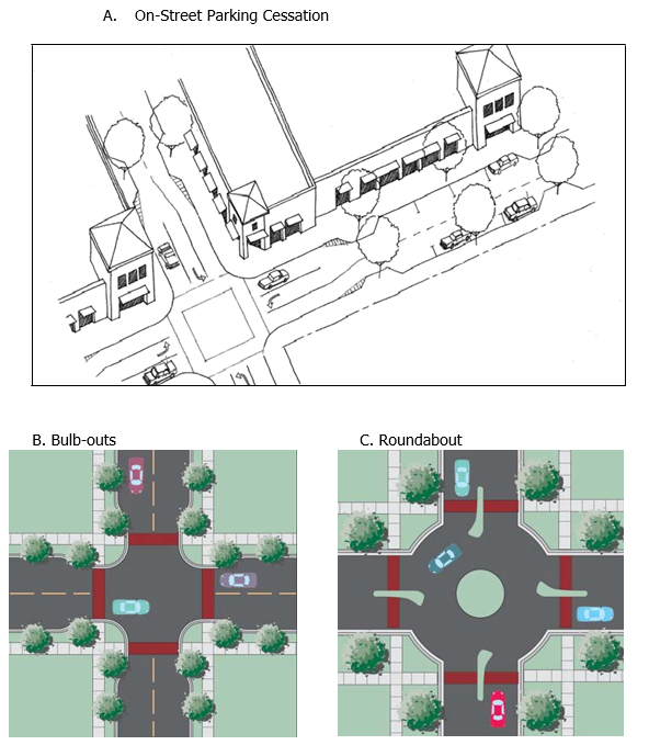
Figure 2: Intersection Design
10.
Street Standards for Promotion of Transit: Development within the VPD and SAPD shall allow for efficient transit service.
i.
Required Transit Facilities.
a)
Within each Village Center:
1)
Each Village Center shall be considered a major stop on the existing or future local transit network. Transit stop facilities, to the maximum extent feasible, shall be integrated into the design of the Village Center, centrally located and easily accessible for pedestrians walking to or from the surrounding neighborhoods.
2)
Each Village Center shall have a Park-and-Ride Facility, which shall include shelter, seating, trash receptacle, bicycle rack, adequate lighting, newspaper stand, landscaping, public telephone, bicycle storage, information kiosk with transit route information, bus bays, drinking fountain, bathrooms, and vehicular parking. The developer and representatives of SCAT shall choose the location and design of the Park-and-Ride Facility and the size of vehicular parking. The vehicular parking standards shall be consistent with the requirements of Section 124-120. The facility shall comply with all landscape and buffer requirements consistent with this Article herein. The construction of the park-and-ride facility shall not be required until bus service is available to the applicable village center.
b)
Within the Neighborhood Centers: Each Neighborhood Center shall have at least one transit accessory pad designed as a Primary Local Stop, which shall include shelter, transit route information, seating, trash receptacle, bicycle rack, and adequate lighting. The developer and representatives of SCAT shall choose the design of the transit shelter. If determined by the Planning and Development Services Director and SCAT that the public transit facilities are not needed for a Neighborhood Center, the Administrator or designee may waive the Primary Local Stop requirement.
ii.
The design of transit stops and connections shall be consistent with the pedestrian accessibility provisions contained in the Florida Accessibility Code (FAC) and Americans with Disabilities Act (ADA) requirements.
iii.
Transit stops shall be located on the street, and should be located near pedestrian, bicycle, and multiuse trail connections.
iv.
Connections between transit stops and sidewalks shall be paved. Connections between transit stops and main entry points for nearby nonresidential buildings and recreational areas shall be clearly marked.
v.
Corner radii: Turning radii shall reflect the minimum required for 90-degree turns for WB40' design vehicles, assuming encroachment into the full next adjacent vehicular lane.
11.
Traffic Calming: All streets within the VPD and SAPD shall be constructed and designed to encourage appropriate vehicle speeds and other driver behavior that promote the safety of pedestrians and bicyclists.
i.
Traffic calming measures described in the table below may be used to modify vehicle speeds and other driver behavior. An asterisk (*) means that the device is permitted, while a blank cell means that the device is not permitted.
ii.
Traffic calming measures may be incorporated into the Village Street Standards design, with the selection of appropriate measures matched to permissible Village Street Standards. Traffic calming shall be installed on streets with unsafe conditions for pedestrians, including street crossings longer than 40 feet without a pedestrian refuge, sidewalks that are narrower than five feet or absent, sidewalks directly adjacent to traffic with average speeds higher than the posted speed limit, any street with average traffic speeds higher than 125 percent of the posted speed limit, and other conditions deemed unsafe by the County Engineer.
iii.
The choice, design, and installation of traffic calming measures on any collector or arterial road shall be balanced with its regional vehicle traffic-carrying role.
iv.
The planning and installation of traffic calming measures shall respect the presence of driveways.
Table of Traffic Calming Measures
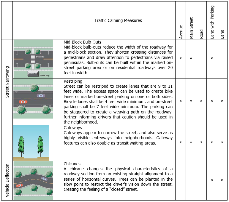
(4)
Hamlet Street Design Standards.
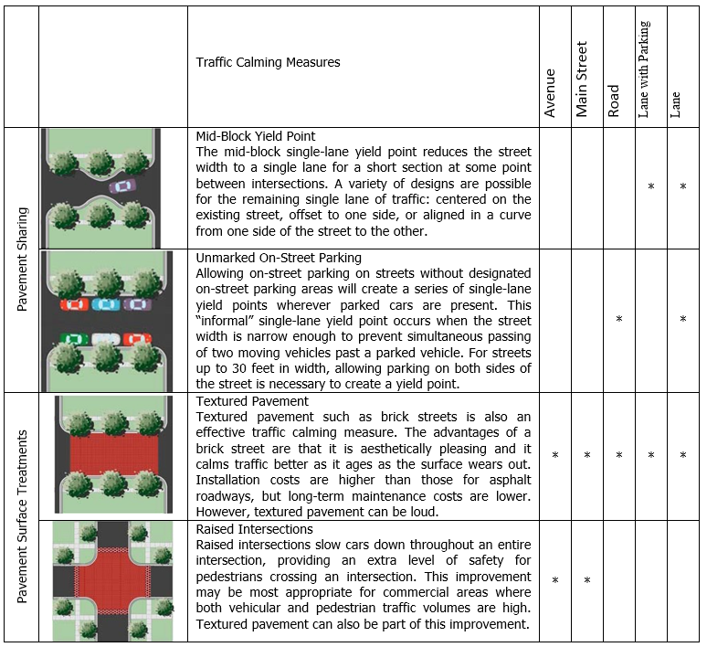
a.
Support of Rural Character: The choice of minimum street design specifications shall provide safe and efficient access for vehicles, bicyclists, and pedestrians. First and foremost, street design shall support the rural character of the Hamlet area. The projected average traffic volume for Hamlet uses and densities will limit the number of necessary travel lanes to two.
b.
Minimum Street Design Specifications: All streets shall be designed in accordance with the following minimum specifications, as depicted in the table below and Figures VOS-18 through VOS-20. These street standards are hereby called the Hamlet Street Standards and lane widths and required rights-of-way are established herein. The graphics included herein are intended to give clear direction as to the intent of the street cross section requirements. The graphic images are regulatory and are intended to supplement and clarify the written text. In the event a graphic image conflicts with written text, the written text shall prevail.
c.
Design and Construction of the Street Network: Design and construction of the street network and the streets is limited by the following standards.
1.
Road-Open Drainage and Multiuse Trail shall be permitted within the Open Space and Greenbelt.
2.
Lane-Open Drainage and Multiuse Trail shall be permitted within residential areas of the Developed Area.
3.
Accessibility within the Open Space: Internal vehicular streets shall be limited within the Open Space and shall be permitted only as required to serve permitted uses or where such connections are identified as a part of the adopted Comprehensive Plan future roadway network.
4.
Pedestrian and bicycle network shall access the edge of Open Space and may extend into Open Space if such network supports the intended functions of the Open Space.
5.
Turning radii shall reflect the minimum required for 90-degree turns for WB40' design vehicles, assuming encroachment into the full next adjacent vehicular lane. Other standards, such as angles and lengths of tapers and stacking area length for left-turn lanes, are dependent on the expected mix and level of traffic and turning volumes.
d.
Elements Not Specified: Regarding street design elements not specified in the Hamlet Street Standard, final street design for all streets shall encourage pedestrian and bicycle safety and comfort through the application of minimum standards for vehicles.
e.
Modification of Typical Standards: The Hamlet Street Standards are typical, and thus shall be modified to accommodate special circumstances. Such modifications shall be reviewed by all pertinent County departments (Planning and Development Services, Public Works, Emergency Services, Sheriff's Office, and Solid Waste) and the Planning and Development Services Director and County Engineer shall have the final right of approval.
f.
Sidewalks: Sidewalks shall be required on one side of the street within 1,320 feet of the Focal Point and in developed areas when parcels are less than one acre. Sidewalks are not required for interior streets with lots larger than one acre in size. Sidewalk design shall comply with the Hamlet Street Standards, and shall comply with the Americans with Disabilities Act and Florida Accessibility Code standards.
g.
Paving Materials: All roadways within Hamlets shall be surfaced with asphalt bituminous, concrete, or dustless material approved by the County Engineer, and maintained in a smooth, well-graded condition.
h.
Continuation of Street Pattern between Phases: The street layout of subsequent phases shall be coordinated with the street system of previous phases.
i.
Traffic Calming:
1.
All streets within Hamlets shall be constructed and designed to encourage vehicle speeds (such as 85 percent of the design speed) and other driver behavior that promote the safety of pedestrians and bicyclists. Traffic calming measures that modify vehicle speeds and other driver behavior and that support the rural character may be used to promote the pedestrian orientation within Hamlets.
2.
Developers shall coordinate with the County Engineer on the design and placement of traffic calming measures within Hamlets.
3.
Traffic calming on any collector or arterial road shall be balanced with its regional vehicle traffic-carrying role.
(i)
Environment.
(1)
General Environmental Protection. All development within the HPD, VPD and SAPD shall comply with the Article 9 of the UDC and the Comprehensive Plan.
(2)
Greenway Resource Management Area Designation.
a.
Lands designated as Greenway RMA that fall within the boundaries of a Village or Hamlet Master Land Use Plan shall not be developed or changed in use except in conformity with this UDC. On-site Greenway RMA may be counted toward the Open Space requirement for each Hamlet. On-site Greenway RMA may not be counted toward the Open Space requirement for any Village, except as follows:
1.
Alternative Greenway buffer configurations, which includes reconfigured Greenway buffers and ecologically enhanced Greenway buffers, consistent with paragraph g, Alternative Greenway Buffer Configurations or paragraph i, Alternative Greenway Buffer Configurations on the McCann East Property.
2.
Lands of High Ecological Value within the Greenway RMA subject to the following: Greenway RMA lands that are contiguous to a particular Village Area, either South Village Area, Central Village Area or North Village Area (as described in Policy VOS2.1(a) and as depicted on Figure RMA-3) that are Lands of High Ecological Value (HEV) as depicted on Map 1-10 of the Comprehensive Plan may be counted toward the Open Space requirement for a proposed Village Master Land Use Plan within that Village Area. The HEV Lands to be counted as Open Space need not be contiguous to the lands for the Village, but shall support the environmental goals of this Plan by preserving environmental features, connections, or functions. Utilization of HEV Lands as Open Space shall not alter the right to transfer development rights from such HEV Lands to Receiving Zones within the proposed Village; provided, however, any development rights that may be available for transfer to Receiving Zones outside the proposed Village from the HEV Lands so utilized shall be extinguished.
3.
That portion of any Greenway buffer where the existing condition is improved pasture or other agricultural lands not containing native habitat.
b.
Site by site field verification of the location of the on-site Greenway RMA shall be conducted as a part of the Master Land Use Plan process. Greenway RMA boundaries may be adjusted based upon field verification of the presence of any of the following Greenway components:
1.
All public lands;
2.
Myakka River channel and connected wetlands which includes the Myakka River Area as defined within the Myakka River Wild and Scenic Designation and Preservation Act (F.S. § 258.501);
3.
Existing preservation lands adjacent to the Myakka River System;
4.
Previously identified ecologically valuable lands adjacent to the Myakka River System;
5.
Myakka River Protection Zone;
6.
Named creeks and flow-ways, wetlands connected to those creeks and flow-ways, and an additional 550-foot buffer from the composite of these areas, or alternative greenway or buffer configurations that provide equivalent or greater net ecological benefit;
7.
Environmentally Sensitive Lands Protection Program (ESLPP), Protection Priority list of lands;
8.
High Ecological Value (HEV) lands as depicted in Map 1-10 of the Environment Chapter of the Comprehensive Plan; and
9.
100-year floodplain designated as "AE."
c.
The application and interpretation of these components are expressly defined within the "Greenway Resource Management Area Final Draft Support Document", dated September 14, 2001, which is adopted by reference for this purpose as if fully set forth verbatim herein.
d.
To the greatest extent practicable, crossings of the Greenway RMA by public facilities shall be avoided. Public facilities shall include roadways, water and sewer lines, transmission facilities and stormwater facilities.
e.
The installation of utilities underground may require the restoration of Native Habitat.
f.
For proposed development sites where regional wildlife corridors have been identified, the development shall be configured to provide for the maintenance or enhancement of native habitat to facilitate the continued use of the wildlife corridor. Existing and proposed crossing of wildlife corridors for facilities associated with the development shall be avoided. Unavoidable crossings must accommodate wildlife movement and be designed in accordance with the recommendations of the Florida Fish and Wildlife Conservation Commission. Wildlife crossing designs shall be submitted as a part of the Master Land Use Plan and approved by the Sarasota County Environmental Protection Division.
g.
Alternative Greenway Buffer Configurations. Comprehensive Plan Policy GS 1.1. requires that the Greenway RMA consist of named creeks and flow-ways, wetlands connected to those creeks and flow-ways, and an additional 550-foot buffer from the composite of these areas, or alternative Greenway buffer configurations that provide equivalent or greater net ecological benefit. Alternative configurations shall include one or both reconfigured Greenway buffers and ecologically enhanced Greenway buffers approved as part of a Master Land Use Plan pursuant to the following provisions:
1.
Reconfigured Greenway Buffers. That portion of a Greenway buffer reconfigured to connect with Publicly Owned Lands and Lands Protected for Preservation as depicted on Figure RMA-1, or Lands of High Ecological Value (HEV) as depicted on Map 1-10 of the Comprehensive Plan. Reconfiguration alternatives shall not be limited to the forgoing or to adjusting the boundaries of a given area of Greenway buffer, but may include adding Greenway buffer to other Greenway RMA, or other alternatives that provide equivalent or greater net ecological benefit.
2.
Ecologically Enhanced Greenway Buffers. That portion of a Greenway buffer reduced in width from the required 550 ft. width composed of improved pasture or other agricultural land that is ecologically enhanced to primarily consist of riparian forest. The Greenway buffer may also consist of wetland mitigation and floodplain compensation provided that habitat areas are not converted to other uses and wildlife movement is enhanced. Created riparian forest shall have overstory and understory vegetative cover similar to that found in pine flatwoods, xeric hammock, mesic hammock or other native forest habitat types. The Greenway buffer shall be planted to create a riparian forest where it does not exist. Created riparian forest shall be compatible with adjacent habitat cover and historical conditions. Planting densities for trees and shrubs will depend on the species and their potential height to meet the goal of habitat creation within 20 years of planting. Heights may be estimated based on performance of the individual species (or comparable species) in nearby areas on similar sites. For each phase of a development, plantings within the alternative buffer shall be installed prior to issuing a Certificate of Occupancy or Letter of Completion:
3.
Criteria for Alternative Greenway Buffer Configurations. Alternative Greenway buffer configurations shall meet all of the criteria contained herein:
i.
Any request for an alternative Greenway buffer configuration shall include the following in the application for the Master Land Use Plan:
a)
An analysis of the conditions of the existing Greenway RMA, including the items listed below. Field verification of the on-site Greenway RMA and alternative configurations shall be conducted with the Natural Resources Department.
b)
Location of existing native habitats, disturbed areas, and developed features.
c)
Quality of existing native habitat and disturbed area land cover within the Greenway RMA.
d)
Preliminary listed wildlife species survey.
ii.
A detailed description of the alternative design and configuration, which includes the following:
a)
A narrative that describes the composition, configuration, and any activities undertaken to increase the environmental value, function, and connectivity of the Greenway RMA.
b)
A Resource Management Plan, including proposed habitat management practices, restoration and enhancement activities, planting plans, passive recreational activities, and maintenance.
c)
A horizontal site plan showing the existing Greenway RMA and the alternative configuration.
d)
A cross-section plan showing the existing Greenway RMA and the alternative configuration.
iii.
Borrow pits shall not be located in that portion of Greenway buffer that is within 300 feet of named creeks and flow-ways and wetlands connected to those creeks and flow-ways.
iv.
Stormwater ponds shall make up no more than 40 percent of that portion of Greenway buffer that is within 300 feet of named creeks and flow-ways and wetlands connected to those creeks and flow-ways.
v.
In the event the alternative Greenway buffer is proposed to be reduced less than 300 feet in width, applicant shall mitigate within the on-site Greenway for the additional reduction to provide equivalent or greater net ecological benefit.
(3)
Open Space Standards.
a.
All open space shall be designated as Open Space on the Master Land Use Plan. Open space may not be included in an individual lot, except for caretaker residences in accordance with Section 124-271(e)(6)a.1.iii.
b.
Restrictive Covenant: Open Space shall be preserved in perpetuity through the use of a Restrictive Covenant. The Restrictive Covenant shall be in such form as is deemed acceptable by the County Attorney consistent with the terms and provisions of this UDC. In addition, the following criteria shall apply to the recording of the required Restrictive Covenant for Villages, Hamlets and Settlement Areas:
1.
Recording of Restrictive Covenant(s) for Villages: An initial Restrictive Covenant(s) shall be recorded for a minimum 1,000 acres of Open Space within the proposed Village, as reflected on the Master Land Use Plan for the property which is the minimum amount of open space required to support a Village Development. This 1,000 acres of Open Space will be the subject of the initial Restrictive Covenant(s) following the final approval of the Master Land Use Plan and prior to Construction Plan approval, and in compliance with Section 124-271(m)(7). As part of the approval of the Master Land Use Plan, the initial 1,000 acre Restrictive Covenant may be reduced to no less than 750 acres if it preserves, in order of priority, designated Greenways, native habitats in major wildlife corridors, other open space in major wildlife corridors, other native habitats, and other open space. The Restrictive Covenant(s) for the balance of the required Open Space as incrementally refined and precisely defined through the subsequent Neighborhood Plans and Subdivision or Site Development Plans shall be incrementally recorded at the time of each future Construction Plan approval and prior to commencement of construction of the particular subdivision, condominium, cooperative, rental project or village center. Furthermore, for a proposed Village within the Clark Road Properties or Fruitville Road Properties, the initial Restrictive Covenant(s) may be less than 750 acres but shall be at least 75 percent of the Open Space within the proposed Village development. In lieu of the above criteria, the area embraced by such Restrictive Covenant(s) shall be at least 75 percent of the Open Space as determined based upon the conditions of Section 124-271(c)(3).
2.
Recording of Restrictive Covenant(s) for Hamlets and Settlements: The initial Restrictive Covenant(s) for a Hamlet or Settlement shall include that portion of the required open space within the proposed Hamlet or Settlement that is necessary to support the first phase of development as reflected on the Master Land Use Plan and as further refined through the Neighborhood Plan process and shall be recorded at the time of construction plan approval and prior to commencement of construction. The Restrictive Covenant(s) for the balance of the required open space, as incrementally refined and precisely defined through the subsequent Neighborhood Plans and Subdivision or Site Development Plans shall be incrementally recorded at the time of each future Construction Plan approval and prior to commencement of construction of the particular subdivision, condominium, cooperative, rental project or phase of development.
c.
External Connectedness: Except as otherwise prioritized by paragraph 5, Context Sensitive Site Design, the Open Space shall be configured to create or add to a larger continuous network of interconnected open space including, particularly existing habitats, and opportunities for restoring native habitats. Whenever opportunities exist to create connections with existing or potential off-site open space, greenways or conservation systems on adjoining parcels or with existing or proposed local or regional recreational trails, such connections shall be provided. Opportunities for connections will be determined based upon the natural features of both the subject property and adjacent properties; the existence of connected natural systems, the existence of the Greenway RMA, the existence of a proposed local or regional trail, or the existence of other such features that would function and support the purpose and intent of the Village/Open Space RMA. Where the Open Space would further support critical linkages of either an existing or proposed local or regional recreational trail, such connection shall be made accessible to the public for such purpose.
The configuration of the Open Space shall be determined on a case-by-case basis to promote long-term conservation of native habitats which are connected to other areas of compatible land use with assurance of appropriate management in perpetuity. Nothing herein shall be construed to require a property owner to purchase or otherwise secure connections on lands outside of the boundaries of the Master Land Use Plan.
d.
Internal Connectedness: Open Space shall be configured to create continuous, connected and integrated Open Space within the Village, Settlement Area or Hamlet to the maximum extent practicable. Open Space shall still be considered connected if it is separated by a roadway or accessory amenity. The configuration of the open space shall be determined on a case-by-case basis to promote long-term conservation of native habitats which are connected to other areas of compatible land use with assurance of appropriate management in perpetuity. Nothing herein shall be construed to require a property owner to designate more than the minimum required open space in the fulfillment of this provision.
e.
Context Sensitive Site Design: The areas to be preserved shall be identified on the Master Land Use Plan and shall be evaluated by the County on a case-by-case basis to address the individual natural features of each site. The management guidelines shall be determined by applying the "Principles for Evaluating Development Proposals in Native Habitat," in the Comprehensive Plan. These objectives in order of priority are to: 1) protect listed species, 2) create/enhance connectivity, 3) protect native habitat and 4) restore native habitat. The relative size and functional value of each feature shall be assessed as a part of the site design process to determine the protection measures required. Based on an assessment of the quality and quantity of on-site natural resources, departures from the above prioritization are allowed. Additional types of allowable open space may be provided as a secondary priority including:
1.
Viewshed protection of existing and planned public roadways;
2.
Recreation; and
3.
Historic and Cultural Resource.
f.
Maintenance of Native Habitat: Protected native habitat areas as defined in paragraph e. above, within the Open Space, shall not be converted to other uses, but shall be maintained in their natural condition and managed to sustain or enhance their native function. These areas may be modified to restore the overall condition and natural functions of the features.
g.
Land Management Plan: A plan for the use and maintenance of the Open Space shall be submitted as a part of the Master Land Use Plan approval process and compliance with said plan shall become a condition of the development order for the Rezoning and a condition of the Restrictive Covenant. The Land Management Plan shall address the following:
1.
Ownership;
2.
Baseline environmental assessment of the Open Space;
3.
Detailed action plan for land management that addresses an initial 10-year timeframe. The Land Management Plan shall include a schedule and process for re-submitting a revised and updated Land Management Plan during the ninth or final year of the plan as an additional requirement for the biennial monitoring report for that year;
4.
Compatible with the County's Environmental Lands Master Land Management Plan when adopted;
5.
Specific Responsibilities for the regular and periodic operation and maintenance of Open Space by public or private entities including strategies for conservation or restoration of native habitats to assure connectivity of a network of native habitats in perpetuity;
6.
Incorporation of standards outlined in the National Fire Protection Association (NFPA) 1144 as reviewed by the authority having jurisdiction;
7.
Requirements for the submission of a bi-annual monitoring report to the County that includes conditions and methods for enforcement of obligations;
8.
If applicable, plans for restoration of native habitats; and
9.
A Fortuitous Finds Policy that clearly identifies the procedures if and when cultural resources are identified during the regular maintenance activities of the property. This policy shall be consistent with the Sarasota County Fortuitous Finds Policy contained within Chapter 66, Article III, Subsection 66-81 County Code and the Historic Preservation Chapter of the Comprehensive Plan.
h.
Access: Safe and convenient pedestrian access and access for maintenance purposes may be provided to the Open Space areas that are not used for agricultural purposes, when that access is not contrary to the goals of the Open Space uses.
i.
Alternative Greenway Buffer Configurations on the McCann East Property: Comprehensive Plan Policy GS 1.1. requires that the Greenway RMA consist of named creeks and flow-ways, wetlands connected to those creeks and flow-ways, and an additional 550-foot buffer from the composite of these areas, or alternative Greenway buffer configurations that provide equivalent or greater net ecological benefit. Alternative Greenway configurations on the McCann East Property shall include one or more of the following elements approved as part of a Master Land Use Plan pursuant to the following provisions:
1.
Reconfigured Greenway Buffers. That portion of a Greenway buffer reconfigured to connect with Publicly Owned Lands and Lands Protected for Preservation as depicted on Figure RMA-1, or Lands of High Ecological Value (HEV) as depicted on Map 1-10 of the Comprehensive Plan. Reconfiguration alternatives shall not be limited to the forgoing or to adjusting the boundaries of a given area of Greenway buffer, but may include adding Greenway buffer to other Greenway RMA, or other alternatives that provide equivalent or greater net ecological benefit.
2.
Ecologically Enhanced Greenway Buffers. Areas of a Greenway composed of pasture or other agricultural land may be reduced in width from the required 550 ft. width as an incentive for (a) restoration or enhancement of riparian (i.e., upland) forests or (b) creation, restoration or enhancement of wetland habitats within the McCann East Property Greenway.
(a)
Restored or enhanced riparian (i.e., upland) forest shall have overstory and understory vegetative cover similar to that found in pine flatwoods, xeric hammock, mesic hammock or other native forest habitat types. The Greenway buffer shall be planted to restore or enhance a riparian forest where it does not exist. Restored or enhanced riparian forest shall be compatible with adjacent habitat cover and historical conditions. Planting densities for trees and shrubs will depend on the species and their potential height to meet the goal of habitat creation within 20 years of planting. Heights may be estimated based on performance of the individual species (or comparable species) in nearby areas on similar sites. For each phase of a development, plantings within the alternative buffer shall be completed prior to issuing a Certificate of Occupancy or Letter of Completion.
(b)
Created, restored, or enhanced wetlands shall have characteristics typical of freshwater swamps, marshes or wet prairies, including but not limited to: topography; water depth and level fluctuation; and plant species density and composition. Wetland creation, restoration, or enhancement shall meet the goal of functional aquatic habitat creation within 10 years of planting. For each phase of a development, wetland creation, restoration, or enhancement shall be completed prior to issuing a Certificate of Occupancy or Letter of Completion.
3.
100-year floodplains other than those designated "AE". Areas of Greenway composed of pasture or other agricultural land may be reduced in width from the required 550 ft. width as an incentive for inclusion of areas designated as 100-year floodplain other than "AE" in the Alternative Greenway Buffer Configuration. Where 100-year floodplains other than those designated "AE" are included within the Alternative Greenway Buffer Configuration, the demonstration of resulting equivalent or greater net ecological benefit may include water quantity or quality benefits relative to existing baseline conditions in the drainage basin.
4.
Criteria for Alternative Greenway Buffer Configurations. Alternative Greenway buffer configurations on the McCann East Property shall meet all of the criteria contained herein:
i.
Any request for an alternative Greenway buffer configuration shall include the following in the application for the Master Land Use Plan:
a)
An analysis of the conditions of the existing Greenway RMA, including the items listed below. Field verification of the on-site Greenway RMA and alternative configurations shall be conducted with the Natural Resources Department.
b)
Location of existing native habitats, disturbed areas, and developed features.
c)
Quality of existing native habitat and disturbed area land cover within the Greenway RMA.
d)
Preliminary listed wildlife species survey.
ii.
A detailed description of the alternative design and configuration, which includes the following:
a)
A narrative that describes the composition, configuration, and any activities undertaken to increase the environmental value, function, and connectivity of the Greenway RMA.
b)
A Resource Management Plan, including proposed habitat management practices, restoration and enhancement activities, planting plans, passive recreational activities, and maintenance.
c)
A horizontal site plan showing the existing Greenway RMA and the alternative configuration.
d)
A cross-section plan showing the existing Greenway RMA and the alternative configuration.
iii.
Borrow pits shall not be located in that portion of Greenway buffer that is within 300 feet of named creeks and flow-ways and wetlands connected to those creeks and flow-ways.
iv.
Stormwater ponds shall make up no more than 40 percent of that portion of Greenway buffer that is within 300 feet of named creeks and flow-ways and wetlands connected to those creeks and flow-ways.
v.
The Greenway buffer may also consist of floodplain compensation provided that habitat areas are not converted to other uses and wildlife movement is enhanced.
vi.
In the event the alternative Greenway buffer is proposed to be reduced less than 300 feet in width, applicant shall mitigate within the on-site Greenway for the additional reduction to provide equivalent or greater net ecological benefit.
(j)
Landscaping, Buffering and Parks.
(1)
Special Buffer Requirements.
a.
Greenbelt.
1.
Intent. The purpose of establishing a Greenbelt around each Hamlet, and Village is to help define these as separate and compact communities.
2.
Greenbelt Requirements. Each applicant for development within the HPD and VPD shall identify on the Master Land Use Plan a Greenbelt that is a minimum of 500 feet wide around the perimeter of the Developed Area as part of the Open Space requirement for the development. The Greenbelt is required to preserve Native Habitats, supplements natural vegetation, and protects wildlife within the area. Where adjacent property has been designated on Figure RMA-3, Village/Open Space RMA Land Use Map as Village or Hamlet Land Use, the ordinance rezoning the property and the Master Land Use Plan shall designate the Greenbelt at the perimeter of the Developed Area.
The ordinance and Master Land Use Plan may include a notation that the portion of the Greenbelt that is located adjacent to other land designated for Village or Hamlet Land Use may be relocated to the perimeter of the adjacent property if that property is later added to the approved Village or Hamlet. If adjacent property designated for Village or Hamlet Land Use is later added to an approved Village or Hamlet, no Greenbelt shall be required between the originally approved Village or Hamlet development and the adjacent property being added. If ordinance and Master Land Use Plan provide that the Greenbelt is eligible for relocation, then the portion of the Greenbelt so designated shall not be used to meet the minimum Open Space requirements for the Village or Hamlet and the density assignment for such property shall assume that the portion of the Greenbelt so designated will be included as part of the Developed Area of the Village or Hamlet. The Greenbelt must be set aside in connection with the filing of any Subdivision Plat filed with respect to lands located nearest to the perimeter of the Developed Area unless the Greenbelt has been relocated, through the inclusion of adjacent lands into the Village or Hamlet, prior to the filing of such plat.
3.
Inclusion of the Greenway. Land within the Greenway RMA that is within the Master Land Use Plan may be used to satisfy the Greenbelt requirement. In the cases where Greenway RMA is used to satisfy the Greenbelt requirement, all Greenway RMA use standards apply.
4.
Exceptions to the Greenbelt Requirement. The Board shall not require a Greenbelt between the Developed Area of a Village and:
i.
I-75;
ii.
Land within the Urban Service Area Boundary;
iii.
The Economic Development RMA;
iv.
Municipalities; or
v.
Manatee County Boundary abutting the North Village only.
5.
Board Authorization required for Exceptions to the Greenbelt Requirement. The Board may authorize other exceptions to the requirement for a Greenbelt or to the minimum 500-foot width during the review and approval process for the Master Land Use Plan for either a Village or Hamlet development under the following conditions:
i.
Where the development proposed adjacent to the Rural Heritage/Estate RMA has the same density and form as the existing adjacent development; or
ii.
Where the existing adjacent homeowners within the Rural Heritage/Estate RMA have demonstrably anticipated more intense adjacent development through an instrument recorded in public land records; or
iii.
Where existing uses within or adjacent to the Rural Heritage/Estate RMA achieve the intended purpose of the Greenbelt in perpetuity, such as existing Buffers within the Rural Heritage/Estate RMA and existing utility corridors adjacent to the Rural Heritage/Estate RMA; or
iv.
Where adjacent Village/Open Space RMA designated property is appropriate for future Village development under 2050 Regulations, this exception shall include the following:
a)
A note will be added to the Master Land Use Plan indicating that the Greenbelt buffer will be relocated on the adjacent property if that property is added to the approved Village or is to be considered a future Village, with the details of the area included in the Neighborhood Plan for the area in question;
b)
Future connection points for the development shall be indicated on the Master Land Use Plan (at the rezoning stage) and on the individual neighborhood plans (at the Neighborhood Plan stage); and
c)
Housing types similar in scale to what could be constructed in Rural Heritage/Estate RMA shall be constructed in the event that the adjacent property is not developed in Village form. The range of potential housing types will be established at the Master Land Use Plan stage for the area in question and will be adopted in the form of a development order condition.
d)
For land within the Clark Road Properties, in lieu of the conditions described in paragraphs a)—c) the Board may authorize an exception upon finding:
1)
The uses proposed at the perimeter of the Village are compatible with existing uses adjacent to the Village boundary that is subject of the requested exception;
2)
The Open Space conditions in Section 124-271(c)(3)c. are met; and
3)
Interconnected bicycle, pedestrian, or multi-use connections are effectively provided between such Villages.
v.
Where adjacent Village/Open Space RMA designated property is under separate ownership, and where such property may not be appropriate for future Village development because it is not of sufficient size for a future Neighborhood or contains uses which are Rural Heritage/Estate RMA in nature. Where this exception is requested, such adjacent Village/Open Space RMA designated property may be treated as Rural Heritage/Estate RMA for the purpose of allowing the Board to consider an exception to the requirements for a Greenbelt as provided by, and consistent with, the conditions described in paragraphs i—iii.
vi.
Where a Village Center is approved to be located adjacent to the Greenbelt, the width of the Greenbelt between the Village Center and the adjacent roadway located at an outer edge of a Village Developed Area may be reduced. The approved width of the reduced Greenbelt is directly related to the amount of landscape buffer required. Wider Greenbelts will require less landscape plantings and opacity. Narrower Greenbelts will require more landscape plantings and opacity. The planting area shall be located closer to the Developed Area, as opposed to closer to the roadway, to ensure the maximum benefit of buffering the buildings or other undesirable views. See Table below for planting specifications.
However, if the Village Center edge located adjacent to the subject roadway meets the standards of an "A" Street, as described in Section 124-271(g), or is within the Clark Road Properties, Greenbelt landscape buffering is not required and only street buffers, as described in Section 124-122(g) are required. Any reduced Greenbelt configuration shall:
•
Protect the Greenway systems, including wildlife corridors; and
•
Avoid adverse impacts to adjacent publicly owned environmentally sensitive lands.
vii.
For land within the Clark Road Properties, where the development proposed is adjacent to Clark Road/ SR 72.
viii.
Greenbelt widths between multiple Hamlet Development Areas (DA) each may be 50 feet where adjacent Master Land Use Plans are approved simultaneously. Each of these adjacent Greenbelt widths may be averaged for that common length between the Hamlet DAs, however each Greenbelt width shall be no less than 30 feet as measured from the DA at any given point along the common length.
ix.
The Greenbelt requirements within the Fruitville Road Properties or Hidden Creek may be reduced or eliminated by the Board, as described in Policy VOS2.1.(e) and (f). The approved width of the reduced Greenbelt buffer will include landscape plantings based on the table above, "Greenbelt Requirements—Village Center Adjacent to Roadway."
b.
Protection of Roadway Character. All development within a HPD, or VPD Master Land Use Plan shall be designed to maintain open vistas and protect the integrity of the rural character of lands adjacent to Fruitville Road/SR 780 east of Dog Kennel Road, Verna/Myakka Road and Clark Road/SR 72 east/south of the Countryside Line. The required 500-foot Greenbelt setback shall be extended to 1,400 feet for Village development visible from Clark Road/SR 72 east/south of the Countryside Line.
(2)
Special Landscape Requirements.
a.
Landscape Requirements for Neighborhood Center and Village Center. The following landscaping requirements shall apply within the Neighborhood Center and Village Center and shall modify other applicable requirements of Section 124-122, Landscaping and Buffering:
1.
No Street Buffer and Project Boundary Buffer landscaping shall be required for commercial, office, industrial, and multifamily uses that are built on a block that conforms to the preferred block length and width. These areas shall follow the street planting guidelines as detailed in the table above.
2.
Where a building is located within five feet or less of a sidewalk or right-of-way line, no Street Buffer landscaping is required, however, this area shall be filled in with a decorative hard surface. Where a building is located more than five feet from a sidewalk or right-of-way the street landscaping shall occur within planters located within the front setback, one planter per 20 linear feet of storefront. The planters shall be filled with flowers, ground cover, and similar landscaping. Any pavement materials used shall comply with the pedestrian accessibility provisions contained in the Florida Accessibility Code (FAC) and Americans with Disabilities Act (ADA) requirements.
b.
Native Landscaping Requirements. Within a Village or Settlement Development, the use of native, drought-resistant vegetation shall be utilized for 80 percent of the required landscaped area for all non-recreational common areas and amenities, and 75 percent of the balance of the required landscape areas. The "required landscaped areas" include all areas covered by Section 124-122, Landscaping and Buffering. Within a Hamlet Development, the use of native, drought-resistant vegetation shall be utilized for 90 percent of the required landscape areas for all uses. A list of native plants is specified by the Florida Native Plant Society's "Native Plants for Landscaping Florida" or the Southwest Florida Water Management District's list. All invasive or nuisance species shall be removed from all developed areas and if replaced, replaced by native species.
c.
Water-Efficient Landscaping Regulations. It is the intent of this section to require resourceful landscape planning, installation or water-efficient irrigation and to encourage appropriate maintenance measures to promote conservation of water resources. The Water-Efficient Landscaping Regulations, Chapter 22. Article VI, Section 22-153 shall apply within the entirety of the HPD, VPD and SAPD.
d.
Nonresidential Service Function Area Screening. See Section 124-123.
e.
Mosquito Prevention. In order to prevent the proliferation of mosquitoes, developments shall design and manage landscape and stormwater areas to eliminate larval mosquito habitats to the greatest extent practicable. Sarasota County Mosquito Management Services shall review all Master Land Use Plans for best practices in mosquito prevention.
(3)
Outdoor Lighting. Outdoor lighting and design requirements shall be applied as per Section 124-126, Outdoor Lighting. Areas designated Village/Hamlet or Settlement land use are located in rural portions of the County. In order to reduce sky glow in these areas, the following table delineates lighting requirements for Village, Hamlet, and Settlement Area development. Total outdoor light output shall not exceed the limits in the table below. Seasonal decorations, permitted between Thanksgiving and 15 January, are not counted toward these limits; lighting used for external illumination of signs is counted, while lighting used for internal illumination of signs is not counted.
(4)
Public Space Standards.
a.
A minimum of five percent of the total land area of each Village Center shall be Public Spaces. Public Spaces shall take one or more of the following forms, and shall be located within a block.
1.
Green. A Public Space available for unstructured recreation, bounded on at least two sides by streets with facing buildings on all sides. A green is landscaped with lawns and trees, including existing or natural vegetation and paths and trails. The minimum size shall be one acre.
2.
Square. A Public Space located at the intersection of streets and bounded on at least two sides by streets with facing buildings on all sides. A square includes paved walks, lawns, trees, and ornamental structures such as fountains and gazebos. The minimum size shall be one-half acre, and the maximum size shall be five acres.
3.
Plaza. A Public Space at the intersection of streets devoted to civic purposes and temporary commercial activities, such as craft shows, farmers markets, etc. A plaza is surrounded by streets with facing buildings or may abut a civic structure with streets on the remaining sides and includes lawns, trees, walks, ornamental structures such as fountains and gazebos, buildings, and durable pavement for parking. The minimum size shall be one-half acre, and the maximum size shall be two acres.
(5)
Recreation Space Standards.
a.
Residential Level of Service Requirements.
1.
Residential development shall provide on-site parks at a rate of one acre per 47 dwelling units or fraction thereof. Each facility shall be no less than one-fourth acre in size. The acreage requirement includes necessary facilities, such as off-street parking. The specific size criteria for parks, the range of dwelling units that trigger park requirements and the number of parks required is provided in the table below. The facilities column represents the types of facilities found in each park classification for reference and not requirement. The developer may choose the additional required park facilities. Each required park, in the minimum number column, must be the maximum size criteria for that particular park classification. Side, rear, and front yards shall not be credited toward the fulfillment of this requirement.
2.
Locational Criteria: The majority of residential units shall be located within one-quarter mile or walking distance of a park.
3.
Joint use facilities. If the park is designed and built as a joint use facility, the park size may be reduced by ten percent. A Mini-Park and a Sports Complex may not form a joint use facility.
Source: Park classifications, general description, locational criteria, and size criteria were created by National Recreation and Park Association's Park, Recreation, Open Space and Greenway Guidelines.
** May substitute additional Community Parks with a sports complex with consent of the County.
b.
Maintenance. A Community Development District or other funding mechanism approved by the County shall maintain all parks.
c.
Stormwater Facilities. Any stormwater facility that is included within a park must be designed as an amenity without a fence and must be landscaped.
d.
Golf courses and associated clubhouses shall not qualify as Recreational Space.
(k)
Service Provision Standards.
(1)
Water and Sewer Service.
a.
Village developments require central water and wastewater services. These systems shall connect to County regional facilities. However, in circumstances where connecting to County regional wastewater or irrigation facilities is not feasible on an initial basis, as determined by the County, an interim utilities plan may be submitted as part of the Master Land Use Plan that guarantees connection to County regional facilities. Nothing herein shall be construed to prohibit the use of alternative water sources to off-set potable water demands, subject to the prior approval of the County. In evaluating an interim utilities plan, the County shall consider:
1.
Environmental impacts;
2.
The length of time the interim utilities plan will be in effect and the date connection with County regional systems will occur; and
3.
The County's growth management considerations.
i.
All central water and wastewater facilities, and related permits shall be owned by the County or by other local governments or governmental entities through appropriate interlocal agreements with the County.
b.
Hamlet developments require central water service, and may require central wastewater and irrigation water services depending on location, soil conditions, proximity to existing central services, and other related criteria. The criteria for determining when central wastewater services are required shall be based upon:
1.
The minimum lot sizes that are permitted in the development;
2.
The environmental impacts;
3.
The County's growth management considerations; and
4.
Hamlets being built without a water distribution system adequate to meet fire flows or fire hydrants shall be required to install dry hydrants in accordance to NFPA 1142 (Water Supplies for Suburban and Rural Fire Fighting). Dry hydrants must be installed no further than a 1,000 feet apart, be constructed in a manner that would meet the minimum water supply during the event of a fire, and be certified by an Engineer to with stand a 50-year drought.
Any on-site facilities will require approval by the Board. The design and construction of all facilities requires approval, inspection, and acceptance by the County. All central facilities, and all permits for central facilities, shall be owned by the County or by other local governments or governmental entities through appropriate interlocal agreements with the County.
(2)
Fire/Rescue Standards. The Fire/Rescue programmed level of service in the fifth year of the County's then current Capital Improvements Program is hereby adopted as the level of service standard for capital programming for the purposes of Fiscal Neutrality.
(3)
School Site. Village development shall be required to dedicate the required elementary school site(s) required to serve the Village which dedication shall be counted toward the requirement to meet fiscal neutrality. The dedication may include restrictions that limit the use of the property to the construction of a school. Dedication shall occur at the time of approval of the Neighborhood Plan for the neighborhood in which the school is designated on the Master Land Use Plan. The minimum size of an elementary school site shall be 20 acres. A Settlement Area under 1,000 acres is not subject to this requirement.
(l)
Signs.
(1)
General Standards. Sign standards help to create a unifying theme that reinforces the character of HPD, VPD or SAPD development and supports the design of the Neighborhoods, Village Centers, and Hamlets. These standards require signage to be compatible with the architecture of the building, including colors and materials, and limit the color of the on-site signs to no more than three colors. HPD, VPD and SAPD sign standards shall be in accordance with Section Article 11, Sign Regulations.
(2)
Permitted Signs.
a.
Types of signs allowed for residential and nonresidential uses:
* NOTE: In residential districts, this sign type is permitted for nonresidential uses only
(m)
Transfer of Development Rights.
(1)
Purpose. The purpose of the Transfer of Development Rights program, including the establishment of the TDR Bank, is to facilitate the implementation of the Village/Open Space Resource Management Area programs and the Urban/Suburban Resource Management Area Settlement Area through a voluntary, incentive-based program for preserving environmentally significant resources. This program is designed to supplement the Village, Settlement Area and Hamlet Design Standards by creating a system of incentives to guide future development to appropriate locations within the Village/Open Space Resource Management Area and to Settlement Areas in order to minimize the impact of development activity on the natural environment and to achieve important environmental objectives. Settlement Areas are entitled to develop a maximum of two dwelling units per gross acre if these units are transferred into the Developed Areas of the property in accordance with an approved Master Land Use Plan. Additional dwelling units may be developed if transferred under the Transfer of Development Rights program from the Greenway RMA. The TDR program allows a property owner to acquire development rights in order to achieve the permitted densities approved by the Comprehensive Plan for Village, Hamlet, or Settlement Area land use designations. These rights may be acquired by purchasing rights from the TDR Bank, or from a property owner with land in a designated Sending Zone. To transfer Development Rights from a Sending Site to a Receiving Site, an appropriate Restrictive Covenant shall be attached to the Sending Site and recorded in the Real Property Records of Sarasota County.
(2)
Establishment of Sending and Receiving Zones.
a.
Lands that are eligible to be designated as Sending Zones include lands that are held in private ownership as of July 10, 2002, within the Greenway RMA, Agricultural Reserve RMA and Rural Heritage/Estate RMA; and all lands within the Village/Open Space RMA. Lands that are eligible to be designated as Receiving Zones include the "Developed Area" as designated in the Master Land Use Plan for a Hamlet, Village or Settlement Area. The location of the eligible areas for Sending Zones and Receiving Zones are as shown on Figure RMA-3 of the Comprehensive Plan.
b.
Lands that have been protected by a Permit or development order condition, Conservation Easement or Declaration of Restrictive Covenant, as deemed appropriate by the County, mitigation easement, Subdivision Plat or any other instrument that protects the site from development, where such protections were not created through the VPD; HPD; or SAPD Rezoning process, are not eligible to be designated as a Sending Zone. Development rights available under the existing zoning of the property may be clustered on a VPD; HPD; or SAPD site within the Developed Area.
Lands that are a part of the TDR Bank as described in paragraph (3)b. are expressly excluded from this limitation, Density Rights for a Sending Site that is the subject of a Restrictive Covenant that explicitly conveys all present and future development rights to the County shall be determined through the application of the TDR Development Rights Table below if such Density Rights are transferred to the TDR Bank.
c.
Development Rights may be transferred only from designated Sending Sites to designated Receiving Sites or the TDR Bank. Transferable Development Rights may be transferred from one Sending Site to more than one Receiving Site and a Receiving Site may accept Development Rights from one or more Sending Sites.
d.
Each approved Master Land Use Plan shall designate all Sending Sites from which Development Rights are being transferred to the designated Receiving Site(s). The approved Master Land Use Plan shall also identify any required transfer of Development Rights from the TDR Bank to the Receiving Site(s).
e.
Once Development Rights are transferred from a Sending Site, they cannot be restored to that parcel.
(3)
Transfer of Development Rights Bank (TDR Bank).
a.
General. The purpose of this section is to authorize the establishment of a TDR Bank. The TDR Bank is hereby created in order to, among other things, facilitate the purchase and transfer of Development Rights as hereinafter provided and to maintain an inventory of those Development Rights purchased by Sarasota County.
b.
Establishment of Development Rights for the TDR Bank. Development Rights eligible for transfer to the TDR Bank shall be generated from Development Rights purchased by Sarasota County from designated Sending Zones after July 10, 2002, or from property purchased by the County from designated Sending Zones after July 10, 2002. The TDR Bank shall be maintained by the Director of the Planning and Development Services Department. Development Rights in the TDR Bank shall remain in the TDR Bank until sold by Sarasota County, the TDR Bank is dissolved, or the units are otherwise disposed of.
c.
The Application, Sale and Value of Development Rights. Sarasota County may sell Development Rights from the TDR Bank to property owners who meet the receiving criteria pursuant to paragraph (7).
1.
A property owner seeking to transfer Development Rights from the TDR Bank to a receiving Site must follow the procedure for approval of use of Transferable Development Rights pursuant to paragraph (7).
2.
The property owner must submit a draft Contract for Sale and Purchase of Development Rights as part of the application described in paragraph (7).
3.
The value and price of a Development Right shall be set by the Board. The Board may consider the following in establishing the price for Development Rights:
i.
The current market value of Development Rights.
ii.
A recommendation from the Planning and Development Services Department.
4.
TDR applications requesting TDR Development Rights from the TDR Bank shall use the price set by the Board.
d.
Annual Report. The Director of Planning and Development Services shall present an annual report to the Board which includes the number of Development Rights currently in the TDR Bank; the number of Development Rights available for sale; the number of Development Rights sold during the year; the purchase price per Development Right; recommendations for improving the TDR Program; and any other relevant information.
e.
Revenue from the Sale of TDRs. The revenue from the sale of Development Rights from the TDR Bank shall be allocated to the Environmentally Sensitive Lands Acquisition Program.
(4)
Development and Transfer Options in Sending Zones. The owner of a property located in a Sending Zone shall have the following options:
a.
On-Site Development. An owner may develop her or his property in compliance with all density limitations applicable to the property under County, State, and federal regulations, including those limitations that may be imposed as a condition of special permit procedures, environmental regulations, or other procedures or regulations during the application process.
b.
Transfer of Development Rights. An owner may transfer Development Rights appurtenant to his or her property to the TDR Bank or to the owner of any property located in a Receiving Zone.
1.
If all the Development Rights appurtenant to a Sending Site are transferred, the owner of the Sending Site shall retain title to the property and shall be required to record a Restrictive Covenant, prohibiting future development, except as provided in the Restrictive Covenant. Once the Development Rights are transferred, the Sending Zone parcel may only be used for Open Space Uses, or uses compatible with the Resource Management Area goals expressed in Policy TDR 1.6 of the Comprehensive Plan.
2.
If only a portion of the Development Rights appurtenant to a parcel of land are transferred, the landowner of the Sending Site shall retain title to the property, and shall be required to record a [Restrictive Covenant.], prohibiting future development, except as provided in the Restrictive Covenant. Once Development Rights are transferred, the portion of the parcel from which the rights have been transferred may only be used in perpetuity for uses described in the Restrictive Covenant or for Open Space Uses, or uses compatible with the Resource Management Area goals expressed in Policy TDR 1.6 of the Comprehensive Plan.
3.
The Developed Area of a Village shall be assigned Development Rights through the Master Land Use Plan Approval Process. No Restrictive Covenant shall be required to be placed upon such lands due to their designation as a Receiving Site.
4.
Development Rights may be severed from the Sending Site and transferred to the TDR Bank if the Development Rights are not to be transferred directly to a Receiving Site.
(5)
Calculation of Transferable Development Rights. The following assigned transfer rates implement Policy TDR 1.3 "Density Assignment for Sending Zones". These transfer rates reflect the incentive density range provided for by Policy TDR 1.3 from 0.0DU to 2.0DU per acre. Each listed category under 'Land Characteristics' have been assigned the higher values for existing natural habitat conditions within the Open Space area being protected pursuant to an approved Master Land Use Plan or those lands protected by the County in accordance with Policy TDR 1.2. Each listed category under 'Proposed Use of Land' have been assigned lower values for proposed uses of land within the Open Space area being protected pursuant to an approved Master Land Use Plan or those lands protected by the County in accordance with Policy TDR 1.2.
The Development Rights appurtenant to a particular parcel of land in a designated Sending Zone shall be determined according the following table:
The Development Rights appurtenant to a particular parcel of land in a designated Sending Zone as determined by the TDR Development Rights Table be augmented by the following special considerations subject to the qualifications and limitations below:
a.
In the event that the Sending Site would preserve, expand, or enhance a Greenway or create a connection between areas of the Greenway RMA, the number of Development Rights available for transfer from the Sending Site shall be increased by the number of units obtained by multiplying the total of units determined from the aforementioned Table by .10.
b.
In the event that the Sending Site would enhance or preserve a viewshed along Fruitville Road, Clark Road/SR 72, or Verna Road, the number of Development Rights available for transfer from the Sending Site shall be increased by the number of units obtained by multiplying the total of units determined from the aforementioned table by .05.
c.
In the event that the Receiving Site is contiguous to the Urban Service Area Boundary, the number of Development Rights available for transfer from the Sending Site shall be increased by the number of units obtained by multiplying the units determined from the aforementioned table by .05.
d.
In the event that the Receiving Site is contiguous to land designated as a Major Employment Center/Interstate Regional Office Park, the total number of Development Rights available for transfer from the Sending Site shall be increased by the number of units obtained by multiplying the units determined by from the aforementioned table by .05.
e.
In the event that a Sending Site does not qualify for any of the special considerations provided for in paragraphs a. through e. above, the number of Development Rights available for transfer from the Sending Site shall be the number of units determined from the aforementioned table.
f.
The number of Development Rights assigned to a Sending Site shall be reduced by one dwelling unit for every residential structure situated on the Sending Site at the time of the determination.
g.
All Development Rights shall be in whole numbers, no fractions shall be permitted. Any fractional unit shall be considered a whole unit if one-half or more of a whole unit and, if less than one-half unit, the fractional unit shall be dropped.
Notwithstanding any other provision of this section, the number of transferable Development Rights transferred from Sending Site(s) through:
1.
On-site transfers, with respect to Developed Areas and Open Space within an approved Village, shall not exceed two dwelling units per acre.
2.
Off-site transfers, with respect to Greenway RMA and Open Space properties located outside an approved Village, shall not exceed two dwelling units per acre.
3.
Transfers not made in connection with an approved Village, such as a transfer to the TDR Bank, shall not exceed two dwelling units per acre.
(6)
Use of Transferable Development Rights in Receiving Zones.
a.
For each one Development Right transferred, subject to the limitation for density limits and development standards, the owner of a parcel of land located in a Receiving Zone shall be permitted to build one additional dwelling unit on the property.
b.
Development Rights transferred to a property in a Receiving Zone through the Transfer of Development Rights Program shall be:
1.
According to the list of permitted uses in the base zoning district; and
2.
Compatible with the existing or proposed uses on the property.
c.
The resulting density of the property, after the addition of the transferred Development Rights, shall comply with the provisions of Article 14 with regard to Hamlets, Villages and Settlement Areas as the case may be.
d.
Approval of the gross residential density for the Village, Hamlet, or Settlement development shall be established at the time of the approval of the Rezoning application to the VPD, HPD, or SAPD zone district, but may subsequently be used only if the development follows and complies with the Goals, Objectives and Policies of RMA-Sarasota 2050 including, but not limited to, the preservation of Greenway/Open Space areas as the development proceeds and development permits are issued. No subsequent rezoning actions shall be required.
e.
The gross residential densities established at the VPD, HPD, or SAPD rezoning stage, however, shall be used only for and in the approved Village, Hamlet, or Settlement form of development, as defined in the Sarasota County 2050 Plan and reflected by the Master Land Use Plan. Development Order(s) for the Village Planned Development, Hamlet Planned Development and Settlement Planned Development and the Rezoning of the site to the VPD, HPD, or SAPD zone district shall specify the Sending and Receiving Zones as required in paragraph (2)d., above.
f.
No subsequent development permits shall be issued that allow commencement of construction of residential dwelling units within a Neighborhood or within a Village Center unless and until a Restrictive Covenant on that portion of the Sending Site(s) generating and supporting the residential dwelling units in a particular Neighborhood or Village Center is first recorded in the Public Records of Sarasota County, Florida.
(7)
Procedure for Approval of the Use of Transferable Development Rights.
a.
Land Management Plan for Sending Sites. A plan or plans for the use and maintenance of the Greenway and Open Space uses shall be prepared by the applicant and submitted as a part of the Master Land Use Plan approval process. The Land Management Plan(s) shall be and approved by the Board for Sending Sites prior to the recordation of the Restrictive Covenant and any Deed conveying Development Rights. For Hamlet, Village and Settlement Area Open Space, the Land Management Plan required in subsection 124-271(i)(3)g. shall be accepted for this purpose. For all other properties the Land Management Plan shall address the following:
1.
Ownership;
2.
Baseline environmental assessment of the Sending Site;
3.
Detailed action plan for land management that addresses an initial ten-year timeframe. The Land Management Plan shall include a schedule and process for re-submitting a revised and updated Land Management Plan during the ninth or final year of the plan as an additional requirement for the biennial monitoring report for that year;
4.
Consistency with the County's Environmental Lands Master Land Management Plan when adopted;
5.
Specific Responsibilities for the regular and periodic operation and maintenance of Sending Site by public or private entities including strategies for conservation or restoration of native habitats to assure connectivity of a network of native habitats in perpetuity;
6.
Incorporation of standards outlined in the National Fire Protection Association (NFPA) 1144 as reviewed by the authority having jurisdiction;
7.
Requirements for the submission of a biennial monitoring report to the County that includes conditions and methods for enforcement of obligations;
8.
If applicable, plans for restoration of native habitats; and
9.
A Fortuitous Finds Policy that clearly identifies the procedures if and when cultural resources are identified during the regular maintenance activities of the property. This policy shall be consistent with the Sarasota County Fortuitous Finds Policy contained within Chapter 66, Article III, Section 66-81 County Code and the Historic Preservation Chapter of the Comprehensive Plan.
b.
An Applicant for Approval of the Use of Transfer of Development Rights Shall Include:
1.
Evidence of ownership of all Sending Sites proposed to be used in the calculation of the total residential density on the Receiving Site; or
2.
A certification letter and evidence of the option to purchase Development Rights from the Sending Sites as required providing for the total residential density included in the development proposal; or
3.
Evidence of the option to purchase Development Rights held in the TDR Bank; and
4.
Legal descriptions of the Sending Sites and Receiving Site; and
5.
A report from a qualified firm identifying the number of acres of land by Land Characteristic or Proposed Use of Land in accordance with the TDR Development Rights Table above; and
6.
The Director of Planning and Development Services shall review the sending area application and make a determination of the number of Development Rights available for transfer from the Sending Site. As part of review of the application, the Director of Planning and Development Services shall complete a site investigation to ensure that the site qualifies as a Sending Site pursuant to paragraph (2) above.
c.
Restrictive Covenant, Title Recordation, Tax Assessment, and Restriction of Development Rights.
1.
A Development Right shall be transferred only upon recordation of a Restrictive Covenant or Deed in a form approved by the County. The Restrictive Covenant shall specify the number of Development Rights appurtenant to the Sending Site, the number of Development Rights sold or transferred, the allowable uses retained on the Sending Site, and contain a statement that the Sending Site or affected portion thereof may only be used in perpetuity for uses in accordance with Policy TDR1.6 of the Comprehensive Plan.
2.
All instruments implementing the Transfer of Development Rights for both Sending Sites and Receiving Sites shall be recorded in the Real Property Records of Sarasota County. The instrument evidencing such transfers shall specify the legal description of each site or sites.
3.
The County shall transmit to the County Property Appraiser for both the Sending Site and the Receiving Site all pertinent information required by the Appraiser to value, assess, and tax the respective sites at their fair market value, as enhanced or diminished by the Transfer of Development Rights.
4.
The landowner of the Sending Site shall, within the time limits established within the approved development order authorizing the Transfer of Development Rights to either Receiving Site or to the TDR bank, record a Restrictive Covenant on the Sending Site in the Real Property Records of Sarasota County. A certified copy of the recorded Covenant(s) shall be transmitted to the Administrator of the program.
5.
Development of a Neighborhood or Village Center using a Transfer of Development Rights shall not proceed until the Restrictive Covenant supporting the residential dwelling units in the Neighborhood or Village Center is recorded in the Real Property Records of Sarasota County.
6.
The Development Order shall contain a phasing plan that provides for the incremental recording of the Restrictive Covenant in the Public Records prior to the start of construction in a manner that ensures the protection of the Greenway/Open Space areas before any development of a Neighborhood or Village Center supported by such Greenway/Open Space areas occurs.
7.
No Subdivision or Site Development Plan shall proceed with construction authorization until the Restrictive Covenant on the Greenway/Open Space areas providing the development rights for the corresponding dwelling units in the particular developed area is recorded in the Public Records.
8.
The approved number of residential dwelling units in a Village, Hamlet, or Settlement are only appropriate for and may only be used for the approved Village, Hamlet, or Settlement form of development. The approved gross residential density shall not be used for any other form of development.
9.
The recording and use of Transfer of Development Rights totals, including Sending and Receiving Sites and developed areas and Greenway/Open Space areas and the relationship of developed areas and Greenway/Open Space areas to Sending and Receiving Sites, shall be reported in the Monitoring Report.
(8)
Administration of Transfer of Development Rights Program (TDR Program).
a.
General. Except as otherwise specified, the TDR Program shall be administered by the Director of the Planning and Development Services Department.
b.
Responsibilities. The Director of Planning and Development Services shall be responsible for:
1.
Establishing, administering and promoting the TDR Program;
2.
Establishing and administering the TDR Bank;
3.
Ensuring the orderly and expeditious processing of TDR applications under this section;
4.
Ensuring the contracts for sale and purchase of Development Rights are executed and all Deeds and Restrictive Covenants are filed in the Real Property Records for Sarasota County;
5.
Ensuring that the Property Appraiser's Office is notified of all TDRs;
6.
Ensuring that the Future Land Use Map is amended through a County initiated comprehensive plan amendment to reflect an appropriate land use designation for Sending Sites following recordation of the Restrictive Covenant or Deed of transfer; and
7.
Ensuring that all Development Rights acquired by the County through the purchase of Sending Sites or Development Rights are added to the TDR Bank.
c.
Accounting System. Planning and Development Services shall maintain an overall accounting system to monitor Development Rights availability and Development Rights Transfers in the TDR Program. The accounting system shall include both private Development Rights and Development Rights in the TDR Bank.
(n)
Fiscal Neutrality.
(1)
Intent. The intent of the Fiscal Neutrality requirement is to ensure that the costs of additional local government services and infrastructure that are built, expanded, improved or otherwise provided for any HPD, VPD and SAPD development or as a result of the additional demand on those services and infrastructure resulting from that development shall be funded by the owner of the approved development or owners of properties within the development.
(2)
Fiscal Neutrality Requirements.
a.
Prior to the approval of a Rezoning action on a Village Planned Development (VPD), Settlement Area Planned Development (SAPD), or a Hamlet Planned Development (HPD), the applicant shall demonstrate "Fiscal Neutrality" according to the procedures established herein. Where the property already is zoned VPD, SAPD, or HPD, the applicant shall not be required to revise or update a Fiscal Neutrality Plan if not required to do so by paragraph e below. This documentation of Fiscal Neutrality shall be submitted to the Board for review and action.
b.
"Fiscal Neutrality" is when a development will pay the full costs of all public facilities and services that are required to support the development and that are required to meet or exceed the level of service standards adopted by the County. This requirement includes the initial costs of all required infrastructure and the on-going costs for operations and maintenance.
c.
Fiscal Neutrality shall be determined for each development project on a case-by-case basis, considering the location, phasing, and development program of the project. Fiscal Neutrality analyses may include incentives to provide affordable housing.
d.
The facilities and services that are required to be analyzed for Fiscal Neutrality shall include:
1.
Both localized and Countywide impacts on County, City, State, and Federal transportation facilities (Note: the transportation related components shall be analyzed as a separate item from the remaining items);
2.
Public transit;
3.
Schools;
4.
Water supply and delivery;
5.
Sewage transmission and treatment;
6.
Solid waste;
7.
Storm and surface water management;
8.
Law enforcement;
9.
Fire and emergency management;
10.
Justice;
11.
General Government;
12.
Libraries;
13.
Parks and recreation; and
14.
Public hospitals.
e.
A Rezoning application for HPD, VPD, or SAPD from a different zoning district shall include a Fiscal Neutrality Plan demonstrating that the proposed development will be Fiscally Neutral. A stipulation shall be attached to all HPD, VPD, and SAPD zoning approvals requiring that the proposed development program (number of dwelling units, rooms, beds, or square feet, as applicable, generally by land use type) be in accordance with the development program outlined within the Fiscal Neutrality Plan. If the Fiscal Neutrality analysis submitted demonstrates that certain defined deviations from the development program will still maintain Fiscal Neutrality, the Fiscal Neutrality Plan may reflect the corresponding extent to which the development program may be altered without requiring revision or update of the Fiscal Neutrality Plan.
f.
Existing stipulations attached to the approval of property already zoned VPD, SAPD, or HPD may proceed as stipulated or shall be deemed satisfied with the application and approval of a Fiscal Neutrality Plan pursuant to this Section 124-271(n) as revised.
(3)
Fiscal Neutrality Plan: General Standards. The Fiscal Neutrality Plan shall include the following:
a.
Development Program and Land Sales Value Assumptions. The applicant shall submit an annual estimate of the development program and land sales value for each of the following components.
1.
Vacant Acreage/Open Space (acres).
2.
Single-Family—Low Range (dwelling units).
3.
Single-Family—Mid Range (dwelling units).
4.
Single-Family—High Range (dwelling units).
5.
Single-Family—Special (dwelling units).
6.
Multifamily—For Sale Condo (dwelling units).
7.
Multifamily—For Sale Townhouse (dwelling units).
8.
Multifamily—For Sale Other (dwelling units).
9.
Multifamily—Rental Apartments/Town Homes (dwelling units).
10.
Multifamily—ACLF/Nursing Home (number of beds).
11.
Multifamily—Rental Other (dwelling units).
12.
Total Residential (dwelling units).
13.
Projected persons per household by Type of dwelling unit.
14.
Projected Population.
15.
Vacant Commercial (acres).
16.
Office Nonprofessional (total square feet).
17.
Office Class A (total square feet).
18.
Office Medical/Professional (total square feet).
19.
Total Office (total square feet).
20.
Retail—Neighborhood (total square feet).
21.
Retail—Community (total square feet).
22.
Retail—Regional (total square feet).
23.
Total Retail (total square feet).
24.
Restaurant—Sit Down (total square feet).
25.
Restaurant—Fast Food/Drive thru (total square feet).
26.
Institutional/Government.
27.
Hotel (number of rooms).
28.
Vacant Industrial (acres).
29.
Industrial (total square feet).
30.
Warehouse (total square feet).
31.
Golf Course (total square feet).
32.
Golf Course (number of holes).
33.
Swim/Tennis Club (total square feet).
34.
Agriculture/Forestry (acres).
b.
Baseline Assumptions. The applicant shall prepare the baseline assumptions for the review of school facility needs and shall submit these assumptions to the School Board for review and action prior to the preparation of a Facility Assessment. The baseline assumptions shall include:
1.
Student Generation Rates by Housing Type.
2.
General Construction Cost Estimates for School Facilities within the Village.
c.
Facility Assessment. The applicant will prepare and include a facility assessment that includes an assessment of facility capacity and on-going operations and maintenance costs based upon:
1.
The level of service standards adopted in the Comprehensive Plan for each of the required services and facilities and which are consistent with the requirements of Chapter 94, Article VII, of the County Code pertaining to Concurrency Management.
2.
The additional level of service standard for Recreational Space, Schools, and Fire/Rescue Services that is required under these standards. (See Sections 124-271(j)(5), 124-271(k)(2), and 124-271(k)(3)
3.
For those services and facilities that do not have either an adopted level of service standard in the Comprehensive Plan or Chapter 94, Article VII, of the County Code pertaining to Concurrency Management or an alternate level of service standard adopted within the Village or Hamlet Planned Development District standards, the current delivered level of service for/within the urban area at the time of fiscal neutrality testing that is provided by the County or other applicable service provider for that facility or service is hereby adopted as the level of service standard for the purposes of Fiscal Neutrality.
d.
Capital Improvements Plan/Financing Program.
1.
The applicant will prepare and include a facilities or capital improvements plan and financing program that is designed to provide adequate facilities to serve the development in accordance with the level of service standards and to construct and maintain all required infrastructure. For off-site impacts, the total proportionate share cost of infrastructure shall be included.
2.
The Plan shall include reasonable estimates of the cost of such facilities, prepared by a civil engineer, registered in the state of Florida.
3.
The Plan shall include the methodology used to estimate the value of land for facility construction.
4.
All calculations of costs shall be based on current cost data.
5.
Fiscal Neutrality for funds that are not fungible (i.e., generally enterprise funds) shall be measured separately.
e.
Additional Facility Requirements.
1.
Parks, Schools, Stormwater. Land dedications that are identified as a part of a development approval as a means of meeting the requirements of Fiscal Neutrality, including any required easements, dedications or reservations shall have their property value established for the purpose of fiscal neutrality at the time of approval of the Master Land Use Plan.
f.
Financing Strategy. The applicant shall prepare and submit a financial strategy to construct and maintain all required infrastructure and all required services. Community Development Districts are the preferred financing technique for infrastructure needs. The financial strategy shall not result in any increase in taxes, assessments, fees or indebtedness upon the people of Sarasota County other than the property owners within the Village, Hamlet or Settlement Area as applicable due to the project.
(4)
Approval of Methodology.
a.
An applicant shall provide a determination of Fiscal Neutrality and a Fiscal Neutrality Plan based upon a methodology approved by the County specifically for use in Fiscal Neutrality Plans.
(5)
Administrative Procedures.
a.
The applicant shall submit the Fiscal Neutrality Plan including the estimates and calculations for school demands to the School Board for review and action prior to submission and review by the Board.
b.
Fiscal Neutrality Plans shall be reviewed and, if found fully correct, sufficient and compliant, certified by independent advisors retained by Sarasota County at the expense of the landowner, developer, or Community Development District prior to acceptance by the Board. If a Fiscal Neutrality Plan is found incorrect, insufficient or noncompliant in any material regard by the independent advisor or otherwise by the Board, the Plan shall be rejected until revised to the satisfaction of the advisor and the Board.
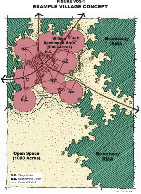
Example Village Concept
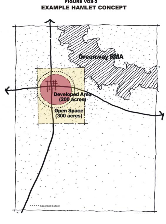
Example Hamlet Concept
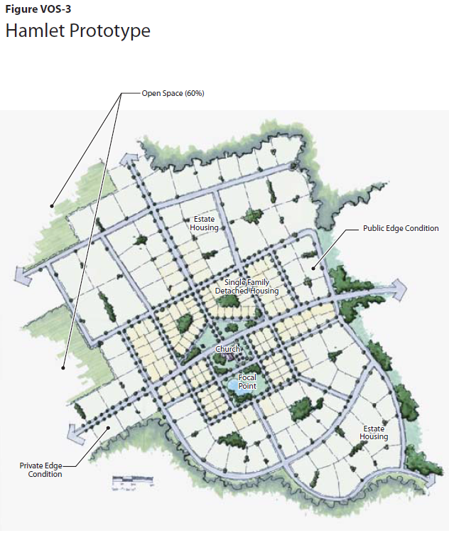
Hamlet Prototype
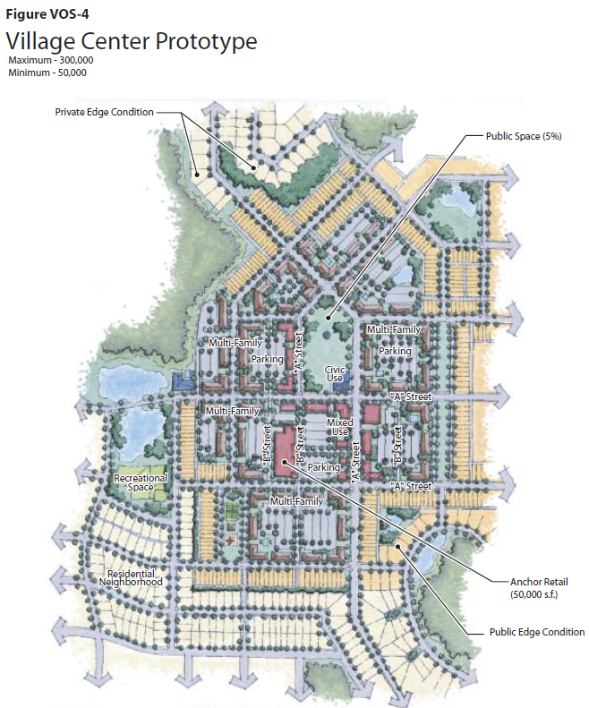
Village Center Prototype
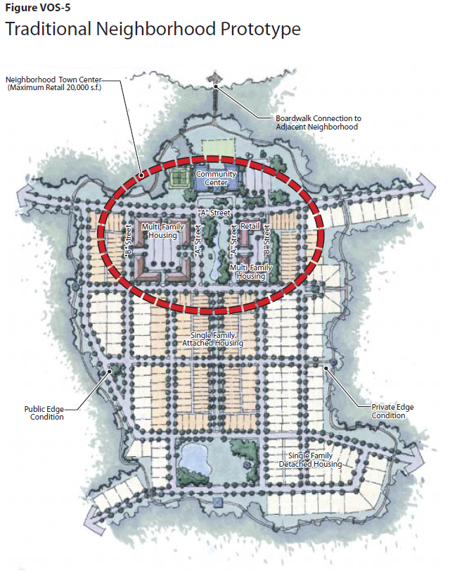
Traditional Neighborhood Prototype
Mixed-Use Commercial
Mixed-Use Development Block with Structured Parking Option
Retail Development Block
Multifamily Development Block with Retail Anchor
Lorraine Road
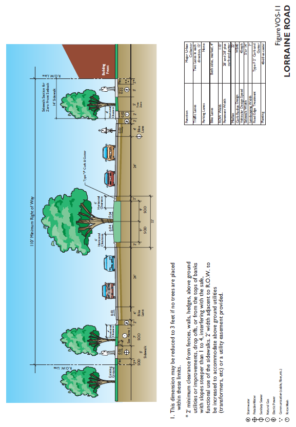
Lorraine Road
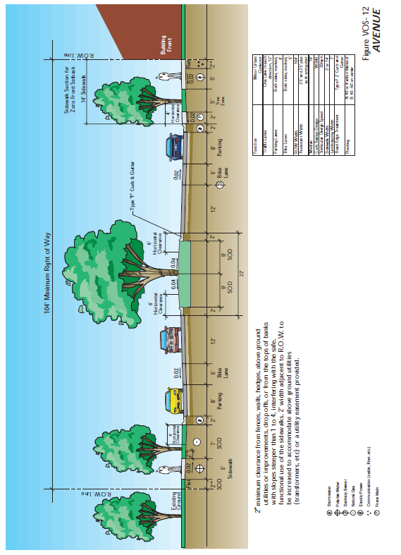
Avenue
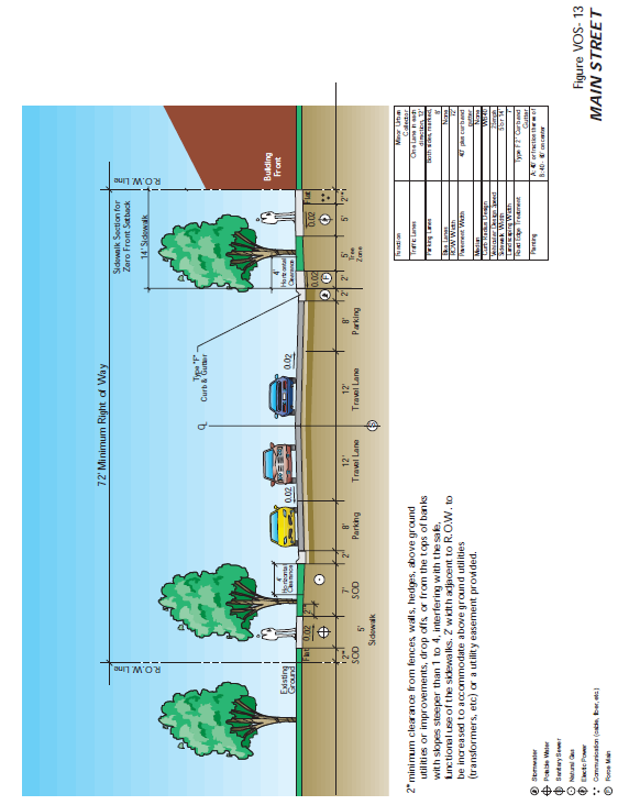
Main Street
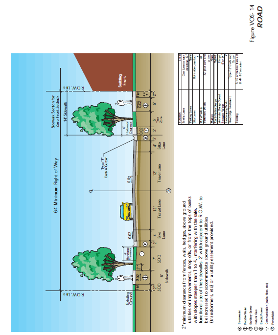
Road
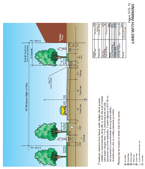
Lane with Parking
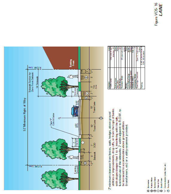
Lane
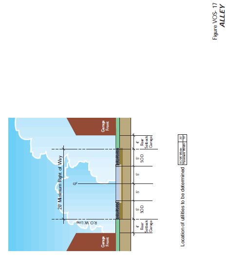
Alley
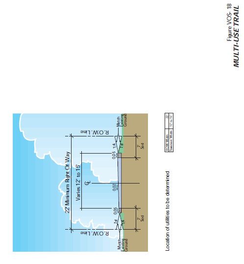
Multi-Use Trail
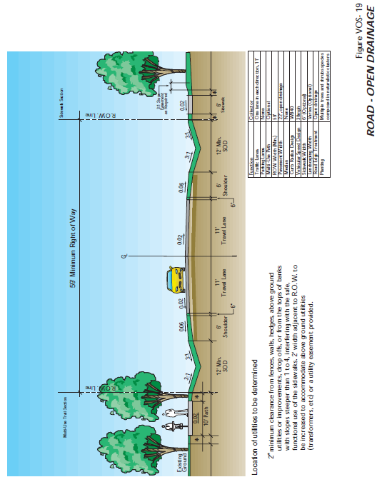
Road-Open Drainage

Lane-Open Drainage
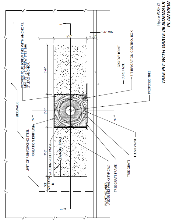
Tree Pit with Gate in Sidewalk Plan View
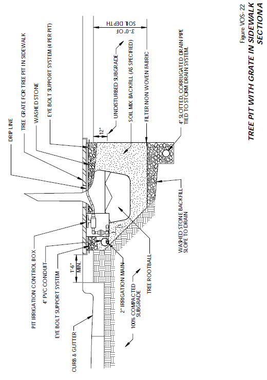
Tree Pit with Gate in Sidewalk Section A
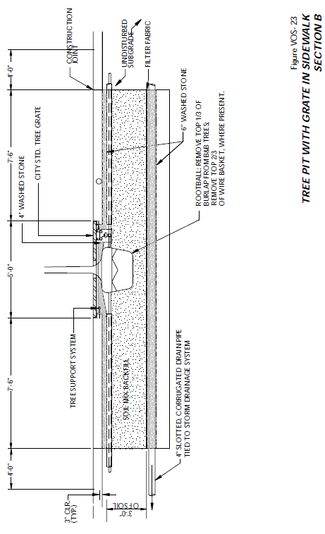
Tree Pit with Gate in Sidewalk Section B
VOS-24 PLANT LIST
SARASOTA COUNTY FORESTRY DIVISION
MASTER TREE LIST
(Ord. No. 2020-017, § 5, 7-8-2020; Ord. No. 2020-43, § 4, 1-13-2021; Ord. No. 2021-057, § 3, 11-15-2021; Ord. No. 2022-008, § 2, 3-29-2022; Ord. No. 2022-008(Revised), §§ 2—8, 7-12-2022; Ord. No. 2022-021, §§ 2, 3, 7-12-2022; Ord. No. 2022-016, § 4, 7-13-2022; Ord. No. 2022-104, § 2, 1-31-2023)
Sec. 124-272. - Application/Submittal Requirements.
(a)
Applicability. Except where otherwise noted, this section shall apply to applications for development approval pursuant to a Planned Economic Development (PED) District or a Village Planned Development (VPD), Hamlet Planned Development (HPD), or Settlement Area Planned Development (SAPD) District, or a Master Development Order for development approval pursuant to Section of this UDC.
(b)
Authority to File Applications. Applications shall be submitted to the Director of the Planning and Development Services Department, by the owner, any other person having a recognized interest in the land for which the development is proposed, or their authorized agent. Applications shall meet the ownership disclosure requirements of the County Charter.
(c)
Application Forms. The Director of the Planning and Development Services Department shall establish the application forms for development applications for a Planned Economic Development (PED) District as well as for a modified Critical Area Plan referred to in Section 124-272(n) of the UDC. A development application for a Village Planned Development (VPD), Hamlet Planned Development (HPD) or Settlement Area Planned Development (SAPD) District, or for a Master Development Order (MDO) pursuant to Section of this UDC for any portion of the Central Village Area or the McCann East 2400 Property within the South Village Area shall be submitted following the application requirements for a Development of Critical Concern (DOCC), or a Rezoning whichever procedure is applicable. All applications shall be submitted on the established forms.
(d)
Fees. The determination of fees, how fees are to be paid, and the procedure for refund of fees shall be established by the Sarasota County Fee Resolution the UDC.
(e)
Preapplication Conference. The procedure for preapplication conferences shall be as provided for in Section 124-37 of the UDC, for a proposed development to a Planned Economic Development (PED) District, or as provided for in Sarasota County Ordinance No. 89-077, codified in Chapter 94, Article VI, of the County Code for a DOCC submittal, for a proposed submittal to a Village Planned Development (VPD), Hamlet Planned Development (HPD), Settlement Area Planned Development (SAPD) District, or a Master Development order for any portion of the Central Village Planning Area or the McCann East 2400 Property within the South Village Area.
(f)
Submittal Requirements.
(1)
Planned Economic Development District (PED). An application for a proposed development to a Planned Economic Development (PED) District shall:
a.
Follow the application submission requirements as provided for in Section 124-36(c)(2)b. of the UDC; and
b.
Follow the modified CAP process as provided for in Section 124-272(n) of the UDC.
(2)
Village Planned Development (VPD) District, Hamlet Planned Development (HPD) District and Settlement Area Planned Development (SAPD) District. The Administrator shall establish the application forms for a Rezoning to Village Planned Development (VPD), Hamlet Planned Development (HPD), and Settlement Area Planned Development (SAPD) Districts. An application for a proposed development to a VPD, HPD or SAPD District shall contain, at a minimum, requirements shown in the table below. Detailed submittal requirements are found in the body of the applicable district standards.
(3)
Central Village Planning Area and McCann East 2400 Portion of the South Village Planning Area MDO Option. For development in the Central Village Planning Area or the McCann East 2400 Acre portion of the South Village Planning Area that contemplates more than one Village or Hamlet, an applicant may seek approval of a Master Development Order through the Development of Critical Concern (DOCC) process. The unit threshold for the development may exceed the current unit threshold for a DOCC in the DOCC Ordinance. The MDO acreage for the Central Village Planning Area shall be a minimum of 7,500 acres in size. A rezoning application will be processed for each Village or Hamlet. The MDO and Planned District rezoning for one or more Villages or Hamlets may be processed concurrently. The MDO will incorporate planning for the Greenway, as it is contiguous to the proposed development and being utilized for TDR purposes.
The table below details the submittal requirements for the MDO and subsequent VPD rezoning applications for the Central Village Planning Area and the McCann East 2400 portion of the South Village Planning Area. The Applicant shall arrange a required Pre-Application meeting to review the proposed development. Also, the Pre-Application meeting will be used to determine the questions to be addressed in the application to be filed, and to clarify such other matters that may maximize the efficiency of the review process. The detailed submittal requirements shall be established at the Pre-Application meeting, as well as through Methodology meetings that may be held with the individual Development Review Coordination members, as required. These requirements shall be generally consistent with the requirements set forth in the table below:
1. Listed Wildlife Observation Map F-3 Map, Wildlife Corridor Plan F-4 Map depicting Conceptual Wildlife Corridor/Crossing
2. Existing Native Habitat Map F-1 Map, Native Habitat Preservation, Alteration and Mitigation Plan F-2 Map
3. Existing Drainage Map G-1 Map
* Scope of what is to be included within Conceptual Plan or Preliminary Assessment to be determined through the Pre-Application meeting and Methodology meetings to be held for the MDO, as prescribed in Article VI Chapter 94 of the County Code for a DOCC submittal.
(g)
Review Procedure.
(1)
Planned Economic Development District (PED). The procedures for determination of sufficiency, preparation of staff report, scheduling and holding of public hearings, public notification, consideration of an application withdrawal, notification of decision, and examination and copying of applications, shall be as provided for in Sections 124-36(c) of the UDC, unless otherwise provided for in Article 14 of the UDC.
(2)
Village Planned Development (VPD), Hamlet Planned Development (HPD), and Settlement Area Planned Development (SAPD) Districts.
a.
Determination of Sufficiency. Within 15 days of receipt of the application for development approval, the Director of the Planning and Development Services Department shall determine if the application is complete and includes data in sufficient detail to evaluate the application to determine whether it complies with the appropriate substantive requirements of this UDC.
b.
The procedures for preparation of staff report, scheduling and holding of public hearings, public notification, consideration of an application withdrawal, notification of decision, examination and copying of applications, shall be as provided for in Sections 124-36(c) of this UDC, unless otherwise provided for in Article 14 of this UDC. The County Administrator shall ensure that a 2050 review team, consisting of county staff, reviews the application through all stages of review. That review shall include the Development of Regional Impact, zoning map amendment, Neighborhood or Village Center Plan, and Site Development Plan or Subdivision Plat stages of review.
(3)
Central Village Planning Area Master Development Order (MDO). A petition for a Master Development Order shall be processed pursuant to Chapter 94, Article VI of the County Code for the processing of a Development of Critical Concern (DOCC), unless otherwise provided for in Article 11 of these Zoning Regulations.
In addition to the requirements outlined in Chapter 94, Article VI of the County Code, the processing of a Master Development Order (MDO) shall be as follows:
a.
A standardized DOCC questionnaire shall serve as the basis for a submittal. The questionnaire establishes the framework for a cooperative planning effort between the developer and the regulatory agencies. A checklist shall be used at the pre-application stage to identify the applicable areas of the questionnaire that a developer needs to address in their submittal;
b.
Specific uses, densities and intensities, and the general location of uses are established at the Master Development Order development stage through the adoption of a Master Development Plan, which shall accompany the application for the MDO. Following any Master Development Plan approval through approval of an MDO, the applicant may file a Rezoning application for some or all of the related land to an HPD or VPD District. The MDO shall specify the information which must be submitted with an incremental rezoning application and shall identify the issues which can result in the denial of an incremental rezoning of one of the Villages or Hamlets contemplated by the MDO to VDP or HPD.
c.
All land included for purposes of development pursuant to an MDO shall be under the legal control of the applicant. Applicants requesting approval of the MDO shall present firm evidence of unified control of the entire area within the proposed development, together with a certificate of apparent ownership. The applicant shall state agreement to proceed with the proposed development according to the provisions of the Master Development Order and such conditions as may be attached to any incremental rezoning to the applicable district. All such agreements and evidence of unified control shall be examined by an attorney designated by the Board of County Commissioners and no proposed development shall be approved unless such agreements and evidence of unified control meet the requirements of this UDC.
d.
The MDO and accompanying Master Development Plan shall not be construed, in and of itself, as an agreement on the part of Sarasota County to exempt future development approvals or permits from zoning and land development regulations in effect at the time of issuance. Subsequent development approvals or permits shall comply with the regulations in effect at the time of development approval by Sarasota County; provided, however, that (i) once the MDO is approved, and subject to the conditions contained in the MDO, the approved uses and densities and intensities of use of the Master Development Plan approved by the MDO are not subject to downzoning, unit density reduction, intensity reduction, or other changes to the County Comprehensive Plan, unless the County can demonstrate that substantial changes in the conditions underlying the approval of the MDO have occurred.
e.
Any comprehensive plan amendments required for approval of the proposed Master Development Plan, or any change in such plan, may be initiated by the developer and must be considered by the Board at the same time as the application for Master Development Plan approval using the procedures provided for local plan amendments in § 163.3184. Florida Statutes, and applicable local ordinances, without regard to local limits on the frequency of consideration of amendments to the comprehensive plan. The Board must hear both the application for Master Development Plan approval or any proposed change therein and the comprehensive plan amendments at the same hearing. However, the Board must take action separately on the application for approval or the proposed change and on the comprehensive plan amendments.
f.
No development shall occur within a Master Development Plan area except as authorized by an incremental rezoning. The review of subsequent incremental rezoning applications shall be limited to compliance with generally applicable regulations and to that information specifically required, and those issues raised, by the Master Development Order, unless substantial changes in the conditions underlying the approval of the Master Development Order are demonstrated or the Master Development Order is shown to have been based on substantially inaccurate information.
(h)
Consideration of a Zoning Map Amendment (Rezoning).
(1)
A proposed development to a Planned Economic Development (PED) District shall be as provided for in Section 124-39 of this UDC, for the processing of a Rezoning application, unless otherwise provided for in Article 14 of this UDC.
(2)
In addition to the requirements outlined in Section 124-39 of this UDC, the processing of a Rezoning application to a Village Planned Development (VPD), Hamlet Planned Development (HPD), or Settlement Area Planned Development (SAPD) District shall be as follows:
a.
A standardized DRI questionnaire or DOCC questionnaire shall serve as the basis for a submittal. The questionnaire establishes the framework for a cooperative planning effort between the developer and the regulatory agencies. A checklist shall be used at the pre-application stage to identify the applicable areas of the questionnaire that a developer needs to address in their DRI submittal;
b.
Specific uses, densities and intensities, and the general location of uses are established at the rezoning stage. The location of the proposed uses is established through the adoption of a Master Land Use Plan. Applicants for rezoning to a HPD, VPD or SAPD District shall follow the Rezoning process outlined below:
1.
Master Land Use Plan. A Master Land Use Plan shall be filed, for which final rezoning approval may be granted. The Master Land Use Plan establishes the land use areas applicable to each portion of the HPD, VPD or SAPD District. The application shall identify the number, size and general location of neighborhoods, including the range of housing types, and the general location and size of the Village Center land uses, including the range of housing types and square footage range of commercial uses in a Village Center, Neighborhood Center, or Hamlet Focal Point.
(i)
Neighborhood Village Center Plan. Following any Master Land Use Plan approvals, the applicant shall file Neighborhood or Village Center Plans. The Neighborhood or Village Center Plans shall be consistent with the phasing plan and the market study included in the Master Land Use Plan. The Neighborhood or Village Center Plan shall also be in substantial compliance with the Master Land Use Plan.
(1)
The Neighborhood or Village Center Plan shall be reviewed for consistency with this UDC this UDC by the County Administrator through the designated 2050 review team. The County Administrator shall approve or deny the Neighborhood or Village Center Plan based upon the findings of the 2050 review team.
(2)
A decision of the County Administrator regarding Neighborhood or Village Center Plans shall be final, provided that the owner or applicant may, within 30 days of said decision, appeal to the Board for relief. Upon receipt of an appeal, the Board shall hold a public hearing. Notice of the public hearing shall be published in the newspaper of general circulation at least 15 days prior to the date of the public hearing. The Applicant shall be responsible for the cost of such publication. Thereafter, the Board may affirm, modify, or reverse the action of the County Administrator, and may make such determination as ought to be made, so long as such action conforms to the provisions of this Article, and to that end shall have the powers of the County Administrator from whom the appeal is taken.
(3)
The Neighborhood or Village Center Plan shall demonstrate compliance with the following:
(j)
Subdivision or Site Development Plan. Following the Neighborhood or Village Center Plan approval, the developer of a Village, Hamlet or Settlement Area shall be required to submit each development plan (Site Development or Subdivision Plan) in accordance with the appropriate requirements of Article 12 of the UDC. This approval phase shall insure compliance with the details of Village Planned Development (VPD), Hamlet Planned Development (HPD) or Settlement Area Planned Development (SAPD) Districts, and Subdivision or Site Development regulations as outlined in Articles 12 and 13 of the UDC. This approval phase shall regulate the specific physical aspects of the provision of necessary infrastructure, and shall provide a final tier of development review and approval. This phase shall include the most specific level of detail with regard to submittal requirements and development commitments.
(k)
Consideration as a Planned District. A proposed development to a Planned Economic Development (PED) District or to a Village Planned Development (VPD), Hamlet Planned Development (HPD) or Settlement Area Planned Development (SAPD) District shall comply with the following provisions:
(1)
Development Concept Plan/Master Land Use Plan. A Development Concept Plan shall accompany the application for a Planned Economic Development (PED) District. A Master Land Use Plan shall accompany the application for a Village Planned Development (VPD), Hamlet Planned Development (HPD) or Settlement Area Planned Development (SAPD) Districts, and is required for determination as to the internal relationships between or among uses and activities proposed and their supporting systems and facilities, and relation to surrounding uses, activities, systems and functions.
(2)
Unified Control. All land included for purpose of development as a Planned Economic Development (PED) District or a Village Planned Development (VPD), Hamlet Planned Development (HPD) or Settlement Area Planned Development (SAPD) District, shall be under the legal control of the applicant. Applicants requesting approval to one of these districts shall present firm evidence of unified control of the entire area within the proposed development, together with a certificate of apparent ownership and encumbrance with the opinion of counsel representing the applicant, establishing that the applicant has the unrestricted right to impose all of the covenants and conditions upon the land as are contemplated by the provisions of the UDC. The requirements for unified control and the agreement in the following subsection do not apply to County-initiated applications.
(3)
Agreement.
a.
The applicant shall state agreement to:
1.
Proceed with the proposed development according to the provisions of the UDC and such conditions as may be attached to any Rezoning to the applicable district;
2.
Provide agreements, contracts, deed restrictions, conservation easements or Declaration of Restrictive Covenant, as deemed appropriate by the County, and sureties acceptable to an attorney designated by the Board for completion of the development according to the approved plans; and maintenance of such areas, functions and facilities as are not to be provided, operated, or maintained at public expense; and
3.
Place covenants on the property to bind their successors in title to any commitments made under paragraphs 1. and 2. above.
b.
All such agreements and evidence of unified control shall be examined by an attorney designated by the Board and no proposed development shall be approved unless such agreements and evidence of unified control meet the requirements of the UDC.
c.
The Master Land Use Plan shall not be construed, in and of itself, as an agreement on the part of Sarasota County to exempt future development approvals or permits from this UDC in effect at the time of issuance. Subsequent development approvals or permits shall comply with the regulations in effect at the time of development approval by the County, provided, however, that a Master Land Use Plan may expressly grant a specific exemption as an integral component of the negotiated development agreement.
(4)
District Standards. In reaching recommendations on decisions as to the approval of a proposed application for Rezoning, the Planning Commission and the Board shall apply the district standards as outlined in this Article for a Village Planned Development (VPD), Hamlet Planned Development (HPD), or Settlement Area Planned Development (SAPD) proposal unless otherwise modified pursuant to Section paragraph (5) below of the UDC.
(5)
Modifications. It is the intent of this UDC and the Planned District regulations to encourage creativity and to create planned developments with innovative, creative, and compatible site-sensitive designs that protect the environment and effectively make use of the designated lands. To achieve such designs, the design and construction standards and requirements set out in these 2050 Plan Regulations and in any other UDC Regulations with the exception of sign regulations may be modified by the Board upon a satisfactory explanation by the Applicant of the need for and purpose of the modifications by the Applicant and upon demonstration by the Applicant that measures for mitigating any potential adverse impacts from the modifications will be taken; provided, however, that no such modifications shall modify or conflict with any of the Goals, Objectives or Policies of RMA-Sarasota 2050 contained in the Comprehensive Plan and the Village, Hamlet or Settlement Planned Development shall, in all cases, be consistent with those Goals, Objectives and Policies. The Planned Districts include: Planned Economic Development (PED), Village Planned Development (VPD), Hamlet Planned Development (HPD), and Settlement Area Planned Development District (SAPD).
Additionally, all modifications that are requested shall:
a.
Be indicated at the time of (a) filing the Rezoning application for the Planned District and the Master Land Use Plan or (b) filing of a Rezoning to amend an adopted Planned District or (c) filing the subsequent Neighborhood Plans, Subdivision or Site Development Plans. In all cases, such modifications may be approved only after a duly noticed public hearing on the proposed modifications has been held before the Board; provided, however, no public hearing before the Board shall be required for Administrative Adjustments authorized by the Section 124-46(c)(1)b. or for Administrative Variances authorized by Article 5 of the UDC;
b.
Be labeled and identified on the Binding Development Concept Plan (Master Land Use Plan) or the Binding Neighborhood Plan or the Subdivision Plat or Site Development Plan;
c.
Be accompanied by documentation demonstrating that the modification meets and furthers the intent of the particular 2050 Planned District being modified and is compatible with surrounding development;
d.
Demonstrate that any potential adverse impacts will be mitigated;
e.
Be consistent with and shall not modify or conflict with any of the Goals, Objectives or Policies of RMA-Sarasota 2050 contained in the Comprehensive Plan; and
f.
In the case of modifications requested during the Neighborhood Plan, Subdivision or Site Development Plan stage, be consistent in all material aspects with the previously approved Master Land Use Plan.
g.
In case of modifications requested during the rezoning stage for land subject to a Master Development Order, be consistent in all material respects with the previously approved Master Development Plan.
(l)
Planning Commission Findings and Recommendations. After the required public hearing, the Planning Commission may recommend to the Board that an application for a Master Development Order or a request to rezone a property to the Planned Economic Development (PED) District, or to a Village Planned Development (VPD), Hamlet Planned Development (HPD), or Settlement Area Planned Development (SAPD) District, be approved, approved with conditions or stipulations, or denied. In making their recommendation, the Planning Commission shall find that the plans, maps and documents submitted by the applicant and presented at the public hearing do or do not establish that the applicant has met the requirements of Section 124-39, applicable to the grant of Master Development Order approval or Rezoning generally, and in addition:
(1)
The requirements of unified control and agreement set out in and paragraphs (k)(2) and (k)(3) above of the UDC;
(2)
District standards set out in Section 124-270, relating to Planned Economic Development (PED) Districts or Section 124-271, relating to Village Planned Development (VPD), Hamlet Planned Development (HPD), or Settlement Area Planned Development (SAPD) Districts;
(3)
The tract for the proposed district is suitable in terms of its relationship to the County Comprehensive Plan and that the area surrounding the proposed development can continue to be developed in coordination and substantial compatibility with the district proposed; and
(4)
The desirable modifications of the general zoning or proposed district regulations, as applied to the particular case, justify such modification of regulations and meet to at least an equivalent degree, the regulations modified, based on the design and amenities incorporated in the Development Concept Plan or Master Land Use Plan.
(m)
Binding Nature of Approval. All terms, conditions, safeguards and stipulations made at the time of approval for a Planned Economic Development (PED) District or a Village Planned Development (VPD), Hamlet Planned Development (HPD), or Settlement Area Planned Development (SAPD) District, including the associated Development Concept Plan or Master Land Use Plan, as appropriate, shall be binding upon the applicant or any successors in interest. All stipulations shall be recorded in the deed records of Sarasota County. Deviations from approved Development Concept Plans or Master Land Use Plans or failure to comply with any term, condition, safeguard or stipulation shall constitute a violation of the UDC.
(n)
Development Subject to Developer's Concept Plan Provisions.
(1)
Development within a Planned Economic Development (PED) District. All development in a Planned Economic Development (PED) District shall be subject to the requirements of Section 124-53, Development Concept Plans, of the UDC.
(2)
Development within a Village Planned District (VPD), Hamlet Planned District (HPD), or Settlement Area Planned District (SAPD). All development in a VPD, HPD, or SAPD District shall be subject to the requirements of Section 124-53(b), 124-39(c), and 124-53(d) of the UDC.
(o)
Changes/Deviations from Approved Plans. Deviations of Neighborhood or Village Center Plans, preliminary plans, or Site Development Plans from Master Land Use Plans may be submitted under two categories: minor modification, or substantial modification.
(1)
Minor Modification. Changes in Neighborhood or Village Center Plans, Site Development, or Subdivision Plans which are in substantial compliance with the approved Development Concept Plan may be permitted by the Administrator with input from appropriate County staff, on application by the applicant or successors, but only upon making a finding that such changes are:
a.
In accord with the applicable regulations currently in effect; and
b.
In accord with all the terms, conditions, safeguards, and stipulations specified in the ordinance approving the VPD, HPD, or SAPD District.
(2)
Substantial Modification. A substantial modification shall be processed by the Planning and Development Services Department as a Rezoning request in accordance with this section.
a.
Notwithstanding Section 124-53 of the UDC, for VPD, HPD, and SAPD, the table below details the provisions to changes in an approved Master Land Use Plan.
b.
All requests for review of changes to an approved plan shall include the information required in the original application, a location drawing indicating the relationship of the portion of the original plan to be revised, if the revision does not include the entire original plan, and any concerning the lot, adjoining lots, or any other such information as may be essential for determining whether the provision of the district and this UDC are being observed. In addition, at the discretion of the Administrator, a drawing indicating the current property ownership within the entire district may be required.
(3)
Modifications Determined Not To Be Minor nor Substantial. A Neighborhood or Village Center Plan with modification(s) that is (are) determined to be neither Minor nor Substantial shall be processed by Planning and Development Services in accordance with Section 124-272(k)(5).
(p)
Modified CAP Procedure to a PED District.
(1)
Intent. The intent of the Modified Critical Area Plan is to ensure a high degree of citizen participation throughout the process and provide an opportunity for stakeholders in the designated area to participate.
(2)
Applicability. The modified Critical Area Plan (CAP) process shall serve as an additional procedure for reviewing and approving Planned Economic Development (PED) District applications. The purpose of this modified process is to help facilitate an expedited process, which allows for the adoption of a Land Use Plan map and concurrent approval of a proposed development within the Economic Development RMA.
(3)
General Elements.
a.
Provide an executive summary which outlines the vision and design of the development;
b.
Describe the objectives of the study;
c.
Provide a recommended Land Use Plan, and if appropriate, any conditions for development approval, which shall be met by, or imposed upon, development within the study area;
d.
Identify any applicable proposed capital improvement projects and community services that will be necessary, on or off site, to support future development within the study area and the method of funding and necessary time frame, as appropriate.
(4)
Specific Elements.
a.
The applicant shall provide a map, or series of maps, which illustrate the location of the proposed study area within the County, including political boundaries (e.g., county and municipal boundaries), current ownership patterns, parcel sizes, existing boundaries of the Study area and Impact area(s), and a legible, recent, full section aerial photograph (the most recent County Property Appraiser or Planning and Development Services Department aerial photograph or equivalent) with the boundaries of the Study area marked.
b.
When a new Land Use Plan is developed for a geographic area for which a Critical Area Plan or Corridor Plan has previously been adopted, the County shall ensure that the following requirements are met:
1.
The previously adopted plan shall be fully considered in developing the new plan;
2.
All persons involved in preparing the adopted plan will be invited to participate in the citizen participation program for preparing the new plan;
3.
Any conflicts between a proposed new plan and the previously adopted plan will be identified and fully explained during the public participation process and during deliberations of the Planning Commission and the Board;
4.
When a new plan is adopted, the Board shall take required actions, if any, to amend or replace the previously adopted plan;
5.
The Planning and Development Services Department shall transmit the application and supporting document to the Planning Commission;
6.
The Planning Commission shall review the new plan through the public hearing process as outlined in Sections 124-36(c) of this UDC;
7.
The recommendation of the Planning Commission shall be transmitted to the Board; and
8.
The Board shall hold a public hearing to take final action on the application upon review of the application and supporting documentation, and the recommendation of the Planning Commission.
c.
An applicant shall include the following information in their submittal:
1.
Enough of the surrounding area to demonstrate the relationship of the PED District to adjoining existing and planned uses. The plan must demonstrate compliance with the provisions in Section 124-270(f)(5)e.8, of this UDC, relating to Compatibility; and
2.
Any plan which requires more than 12 months to complete shall be constructed in phases substantially complete in themselves, and a phasing plan shall be submitted and approved as a part of the submittal.
d.
During its review, the Planning and Development Services Department shall distribute copies of the proposal to Development Review Coordination for study and comment. In considering the plan, the Planning and Development Services Department shall seek to determine that:
1.
There are special physical conditions or objectives of development which the proposal will satisfy to warrant a departure from the standard ordinance requirements;
2.
Resulting development will be consistent with the Comprehensive Plan and zoning objectives for the area;
3.
The plan can be completed within a reasonable period of time;
4.
The streets are adequate to support the anticipated traffic and the development will not overload the streets outside of the planned area;
5.
Proposed utility and drainage facilities are adequate for the population densities and type of development proposed;
6.
The parcel is suitable for the proposed use, considering its size, shape, location, topography, existence of improvements, and natural features;
7.
The proposed use will not alter the character of the surrounding area in a manner which substantially limits, impairs or prevents the use of surrounding properties for the permitted uses listed in the underlying district:
8.
The proposed use is timely, considering the adequacy of public facilities and services existing or planned for the area affected by the use: and
9.
Proposed uses which are not otherwise permitted in the underlying zoning district on the parcel are accessory uses within the entire development.
(Ord. No. 2019-006, § 12, 4-23-2019; Ord. No. 2022-008, § 2, 3-29-2022; Ord. No. 2022-008(Revised), §§ 9—11, 7-12-2022)