
Sarasota County Unincorporated
City Zoning Code
City Zoning Code
ARTICLE 17
- DEFINITIONS
Sec. 124-300.- Interpretation of Certain Words and Terms.
For the purpose of these Unified Development Code (UDC) regulations, certain terms or words used herein shall be interpreted as follows:
(a)
The word Person includes the words Individual, Firm, Partnership, Corporation, Association, Organization, Trust, Company, or any other legal entity.
(b)
The word Applicant includes any authorized agent of the applicant.
(c)
The present tense includes the future tense, the singular number includes the plural, and the plural number includes the singular.
(d)
The words Shall and Must are mandatory, and the words Should and May are permissive
(e)
And indicates that all connected items, conditions, provisions, or events apply; and Or indicates that one or more of the connected items, conditions, provisions, or events apply.
(f)
The word Lot includes the words Plot, Parcel, or Tract and means the least fractional part of subdivided lands having limited fixed boundaries, and an assigned number, letter, or other name through which it may be identified.
(g)
The words Used or Occupied includes the words Intended, Designed, or Arranged to be used or occupied.
(h)
The word Constructed includes the words Erected, Built, Installed, Altered, Rebuilt, Demolished, and Repaired.
(i)
The word Structure includes the word Building as well as other things constructed, erected, attached to something, or requiring construction or erection on, over, or above the ground or water.
(j)
The word Subdivider includes the word Developer.
(k)
The word Land includes the words Water, Marsh, or Swamp.
Sec. 124-301. - Technical and Non-Technical Terms.
Words and phrases shall be construed according to the common and approved usage of the language, but technical words and phrases that may have acquired a peculiar and appropriate meaning in law shall be construed and understood according to such meaning.
Sec. 124-302. - Undefined Terms.
Words or phrases not defined in this UDC shall be ascribed a meaning which they have in common usage, as defined by the standard Webster's Dictionary, and which gives this Code its most reasonable application in the context in which the word or phrase appears.
Sec. 124-303. - Definitions of Groupings of Various Districts.
(a)
Where the phrases "all open use districts," "open use districts," "zoned open use," or "open use zoned," or phraseology of similar intent are used in the UDC, the phrases shall be construed to include the following districts: OUC, OUA, OUR, and OUE.
(b)
Where the phrases "all residential districts," "residential districts," "zoned residentially," or "residentially zoned," or phraseology of similar intent are used in the UDC, the phrases shall be construed to include the following districts: OUE (lots of five acres of less in residential use only); RE-1,2,3; RSF-1,2,3,4; RMF-1,2,3,4; RC; RMH; FUD; FURRZ; HDRRZ; RRZ; and RSZ.
(c)
Where the phrases "commercial districts," "zoned commercially," "commercially zoned," "commercial zoning," or phraseology of similar intent are used in the UDC, the phrases shall be construed to include the following districts: CG; CHI; CI; CM; CN; OPI; and TR.
(d)
Where the phrases "industrial districts," "zoned industrially," "industrially zoned," "industrial zoning," or phraseology of similar intent are used in the UDC, the phrases shall be construed to include the following districts: ILW; IR; and PID.
(e)
Where the phrases "planned districts" is used in the UDC, the phrases shall be construed to include the following districts: PUD; PCD; CM/PD; OPI/PD; BRR/PD; and the 2050 Plan Districts including PED, VPD, HPD, and SAPD.
Sec. 124-304. - List of Acronyms.
(a)
The following summary represents the zoning district acronyms referenced throughout the Unified Development Code, with their district names.
(b)
The following represents acronyms that are referenced throughout the Unified Development Code.
ALF. Means Assisted Living Facility.
BMP's. Best Management Practices means the management or structural and non-structural practices recognized to be the most effective in reducing pollution.
DEO. Means the Florida Department of Economic Opportunity (formerly the Department of Community Affairs (DCA)).
F.A.C. Means Florida Administrative Code.
FDEP. Means the Florida Department of Environmental Protection, or its successor.
F.S. Means Florida Statutes.
NAICS. Means North American Industrial Classification System codes.
NPDES. Means the National Pollutant Discharge Elimination System Stormwater Program, created under the 1972 Clean Water Act, and delegated to the Florida Department of Environmental Protection. The program addresses pollution by regulating point source discharges to Waters of the United States.
UDC. The Sarasota County Unified Development Code.
Sec. 124-305. - Defined terms.
Except where specific definitions are used within a specific section of these regulations for the purpose of such sections, and irrespective of capitalization, the following terms, phrases, words, and their derivations shall have the meaning given herein when not inconsistent with the context:
"A" Street. The primary pedestrian-oriented streets within a PED District, Village Center, and a Neighborhood Center that provide a mix of uses, promoting pedestrian activity, cycling, and transit. These streets have building frontage requirements that place buildings close to the street and restrict off-street parking and service uses along them.
Abutting. Sharing a common property line. For the purposes of this definition, properties across an intervening right-of-way shall not be considered abutting.
Acceleration Lane. See Speed-Change Lane.
Access. A means of vehicular entry to or exit from a property to a public or private road.
Access Facility. A general term for the combination of the Access Point and Driveway.
Access Point. The location of the ingress/egress connection.
Accessory Dwelling Unit. See Dwelling Unit, Accessory.
Accessory Use or Structure. A use or structure of a nature customarily incidental and subordinate to the principal use or structure and unless otherwise provided, on the same premises. "On the same premises" with respect to accessory uses and structures shall be construed as meaning on the same lot or on a contiguous lot in the same ownership. Examples include, but are not limited to, swimming pools, spas, sheds, gazebos, etc. Where a building is structurally attached to the principal building, it shall be considered a part thereof, and not an accessory building.
Accessory Unit. See requirements in 2050 Regulations, Limited Use Standards, Section 124-271(e)(6)b.
Accessway. That area set aside on a site plan or plat for private street purposes or a path or route that provides pedestrian or vehicular access to a specific destination or property.
Adjacent Access Point. An adjoining access point which may be on either side of the roadway and either upstream or downstream of a proposed access point.
Adult Arcades (Gaming). Any establishment where the public is permitted or invited, which excludes minors by virtue of age, wherein any electrical; mechanical or electromechanical device which is adapted for use such that by the insertion of coin(s), token(s), or other method of payment, the device will allow an operator to play or operate the machine such that the device displays pictures, icons or other images which may, depending upon the displayed combination of pictures, icons or other images, allow the operator to obtain an item or items of value, including but not limited to money, objects coupons, certificates or the like. Examples of games included under this definition include "New Cherry", "Fruit Bonus", "Triple Jack", "Magical Odds", "Klondike", and "Reel of Fortune". Games such as pinball, mechanical grab machines and other similar games are not included. This shall not be construed to authorize video poker games, or any other game or machine that may be construed as a gambling device under Florida Law.
Adult Day Care. A facility, whether operated for profit or not, in which is provided through its ownership or management, for a part of a day, basic services to three or more persons who are 18 years of age or older, who are not related to the owner or operator by blood or marriage, and who require such services (See also Day Care and F.S. Ch. 429).
Adult Entertainment Establishment. An adult entertainment establishment is any business or commercial activity which, for any reason, excludes juveniles (persons under the age of 17) or, excludes juveniles except when accompanied by a parent or legal guardian (see Chapter 26, Article II of the County Code).
Advanced Wastewater Treatment (AWT). Wastewater treatment beyond the secondary or biological state that includes removal of nutrients which will provide an effluent product that:
(a)
Contains not more than the following concentrations, on a permitted annual basis:
(1)
Biochemical Oxygen Demand (CBOD 5 ) .....5 mg/l
(2)
Suspended Solids .....5 mg/l
(3)
Total Nitrogen, expressed as N .....3 mg/l
(4)
Total Phosphorus, expressed as P .....1 mg/l
(b)
Has received high-level disinfection, as defined by the FDEP.
In those waters where the concentrations of phosphorus have been shown not to be a limiting nutrient or a contaminant, the Florida Department of Environmental Protection (FDEP) may waive or alter the compliance levels of phosphorus until there is a demonstration that phosphorus is a limiting nutrient or a contaminant.
Affordability. Relative percentage of household income spent for rent or mortgage cost. Housing is generally considered to be "affordable" if it costs no more than 30 percent of household income. This includes taxes and insurance with the mortgages, and any other required fees.
Affordable Housing. Housing, regardless of tenure, which meets the "Affordability" definition for a household with an income of 80 percent or less of the Adjusted Median Income (AMI).
Affordable Housing Unit (2050). For the purpose of calculating density in the VOS RMA of Article 14, affordable housing is defined as a housing unit available for sale or rent that is affordable to a household earning 80 percent or less of the median household income for Sarasota County, as defined by HUD published data for a family of four.
Agriculture. Uses that create or preserve areas intended primarily for the raising of animals and crops, conservation, and the secondary industries associated with agricultural production.
Agricultural Best Management Practices. Best Management Practices for each agricultural activity that is verifiable and consistent with the most current policies developed by the appropriate and applicable State or Federal Agencies.
Alley. An alley is a public or approved private service roadway that affords a primary or secondary means of access to abutting property, normally located behind the building.
Alter or Alteration (Sign). This term shall include, but not be limited to, the addition of sign surface area, the changing or relocation of light source, or the relocation of a sign from one (1) position to another. This term shall include any and all structural changes in the sign, but shall not include the changing of copy on a sign which is designed as a changeable copy sign.
Alter or Alteration (Building or Structure). Alter or alteration shall mean any change in size, shape, occupancy, character, or use of a building or structure.
Alter or Alteration (Natural Features). Alter or alteration shall mean any physical change directly or indirectly affecting the size, hydrology, biological complexity or other characteristic of a regulated planted or natural feature including vegetation, wetlands, or other habitat.
Amusement Games (Arcades). Any establishment where the public is permitted or invited wherein any electrical; mechanical or electromechanical device which operates by means of the insertion of a coin and which by application of skill may entitle the person playing or operating the game or machine to receive points or coupons which may be exchanged for merchandise only, pursuant to F.S. § 546.10. This shall not be construed to authorize video poker games, or any other game of machine that may be construed as a gambling device under Florida Law.
Animal Boarding. The use of land for the purpose of boarding, selling, or breeding cats or dogs for compensation, or the keeping of more than 12 dogs or cats in combination for any purpose. This term shall not include a licensed animal hospital nor a Pet Resort.
Animal Shelters. A structure that is owned, operated or maintained by a public body, established humane society or other private or nonprofit organization used for the care of lost, abandoned or neglected pets.
Animals, Domestic. Any animal that has been bred or raised to live in or about the habitation of humans and is dependent on people for food and shelter. Animals that are normally considered household pets, including but not limited to dogs, cats, birds, fish and rabbits.
Animals, Exotic. Animals other than domestic animals that normally live in a state of nature (the wild), are not ordinarily tame or domesticated, and are maintained and housed in accordance with all local, state and federal laws and regulations. Exotic animals are permitted in districts as specifically set out in the UDC. Birds kept as household pets are considered domestic animals.
Animals, Farm, or Livestock, or Poultry. The keeping and raising of farm animals, livestock and poultry is permitted only as specifically set out in this UDC. These include any animals raised for food or product. In addition, they include the following, regardless of purpose:
(a)
All animals with hooves, either single or split;
(b)
All members of the ovine (sheep), bovine (cows and cattle), caprine (goats), equine (horses and ponies), and swine (pigs and hogs) families;
(c)
Emus, rheas, and ostriches; and
(d)
All poultry (chickens, roosters, turkeys, ducks, geese and the like).
The following animals are specifically excluded when they are not kept or raised for food or product:
(a)
Purebred miniature potbellied pigs.
Apartment. One or more rooms with a private bath and kitchen facilities comprising an independent, self-contained dwelling unit in a building containing three or more dwelling units. See Section 124-130, Housing Types.
Applicant. Any person or duly authorized representative or agent, who submits plans or an application through any County agency for the purpose of obtaining approval thereof.
Aquarium. A building which houses living aquatic animal and plant specimens for public viewing, providing science-based outreach and education to the general public and often affiliated with oceanographic research institutions.
Arcade. A continuous passageway parallel and open to a street, open space or building, covered over by a series of arches or vaults supported by columns that support permanent roofing, and accessible and open to the public.
Architectural relief. Decorative finish that will provide a visual break in building facade.
Arterial Street. A street designated as an arterial in the Comprehensive Plan (see Table 10-5. Future Transportation Plan Roads; Map 10-8 Year 2040 Future Thoroughfare Plan).
Articulation. A change in the depth of the building plane, roofline or height.
Assisted Living Facility (ALF). Any building or buildings, section or distinct part of a building, private home, boarding home, home for the aged, or other residential facility, whether operated for profit or not, which undertakes through its ownership or management to provide housing, meals, and one or more personal services for a period exceeding 24 hours to one or more adults who are not relatives of the owner or administrator (see F.S. Ch. 400). This includes nursing homes and convalescent homes.
Atrium House. See Section 124-130, Housing Types.
Auxiliary Lane. A full-width lane adjoining the travel way for parking, speed change, turning, storage for turning vehicles, weaving, or other purposes supplementary to through-traffic movement.
Average Annual Daily Traffic (AADT). The annual average number of vehicles using a road (in both directions) during a twenty-four (24) hour period, specified as the average annual daily traffic by the Florida Department of Transportation or Sarasota County depending on the roadway jurisdiction.
Aviary. A structure, enclosure, large cage or other place for keeping birds confined.
Awning. Temporary shelter supported entirely from the exterior wall of a building and composed of nonrigid materials (except for the supporting framework).
"B" Street. The secondary streets within a PED District, Village Center, and a Neighborhood Center that provide vehicular and service access to development blocks. These streets have no building frontage requirements. While "B" Streets are not intended to be primary pedestrian streets, at a minimum they must include sidewalks and street trees in accordance with specified street design standards.
Balcony. An open portion of an upper floor extending beyond a building's exterior wall that is not supported from below by vertical columns or piers.
Bar or Tavern. A bar or tavern is any establishment devoted primarily to the retailing and on-premises drinking of malt, vinous, or other alcoholic beverages, or any place where any sign visible from public ways exhibited or displayed indicating that alcoholic beverages are obtainable for consumption on the premises.
Bed and Breakfast. A transient accommodation that is a house, or portion thereof, where lodging rooms and meals are provided.
Benchmark (B.M.). A mark on a fixed and enduring object, indicating a particular elevation based on North American Vertical Datum of 1988 (NAVD-88).
Bicycle Lane. A portion of a roadway that has been designated by striping, signage, and pavement marking for the preferential or exclusive use of bicyclists.
Block. Includes "tier" or "group" and means a group of lots existing within well-defined and fixed boundaries, usually being an area bounded by streets or by a combination of streets and public land, railroad rights-of-way, water or other physical barriers and having an assigned number, letter, or other name through which it may be identified.
Block Faces. The building facades on one side of a block's street frontage.
Board. The Board of County Commissioners of Sarasota County.
Boarding House. A boarding house is an establishment with lodging for one or more persons in a group that does not constitute a single housekeeping unit, where meals are regularly prepared and served for compensation and where food is placed upon the table family style, without service or ordering of individual portions from a menu. A boarding house is intended to provide lodging accommodations for monthly periods or longer. Such accommodations are not considered transient.
Boat Livery. See Marina.
Bond. Form of surety or guaranty agreement which contains the promise of a third party to complete or pay for the cost of completion of a construction contract, a subdivider's agreement or developer's agreement, if the construction contractor, subdivider or applicant defaults, given to the Board that the promised improvement, construction, monitoring and maintenance will be completed as agreed to within a fixed period of time. The word "Bond" also includes escrow agreements and cashier's checks and may also function as a surety or guaranty of a warranty of required improvements for a fixed period of time.
Borrow Pit. An excavation area where material removed is dug and used at a location other than the site where the excavation has occurred. For the purposes of this definition, the excavation of materials associated with agricultural uses or for agricultural purposes, or the excavation of fill in conjunction with the development of land, including the platting of a subdivision, where construction plans have been approved, shall not be deemed to be a borrow pit.
Brewpub. An establishment where food, beer, and malt beverages are duly-licensed to be made on the premises where the beer produced on site is sold and/or consumed on site.
Buffer. Open spaces, landscaped areas, walls, berms, or any combination thereof used to physically separate or screen, one use or property from another so as to create open space or visually shield or block noise, lights, or other nuisances. See Section 124-122, Landscaping and Buffering. A buffer also refers to an area adjacent to a wetland or other habitat that protects the habitat from the adverse impacts of development.
Buffer (2050). An area reserved or designed to separate potentially incompatible land uses.
Buildable Area. Buildable area shall mean the portion of a lot remaining after minimum required setbacks and open space have been provided. Buildings may be placed in any part of the buildable area, but limitations on percent of the lot which may be covered by buildings may require open area within the buildable area.
Buildable Area (also, Buildable Land Area) (2050). The area within the boundary of a development or parcel excluding areas devoted to right-of-way, transmission power line easements, lakes, wetlands, or areas within the 100-year floodplain.
Building. Any structure, either temporary or permanent, having a roof impervious to water and supported by columns or walls, and used or built for the shelter or enclosure of persons, animals, chattels, or property of any kind. This definition shall include tents, awnings, cabanas, or vehicles situated on private property and serving in any way the function of a building but does not include screened enclosures not having a roof impervious to weather.
Building Coverage. The area of the lot that is covered by buildings, including both principal structures and accessory buildings. Building coverage does not include paved areas such as driveways, uncovered porches or patios, decks, swimming pools or pool cages, or roof overhangs of less than three feet.
Building Façade. An exterior wall of a building that is set along a frontage line.
Building Frontage. For purposes of computation of number and area of signs permitted on buildings, in cases where lineal feet of building frontage is a determinant, the frontage of a building shall be computed as nearly at ground level as computation of horizontal distance permits. In cases where this test is indeterminate or cannot be applied, as for instance where there is a diagonal corner entrance or where two sides of a building have entrances of equal importance and carry approximately equal volumes of pedestrian traffic, the Administrator shall select building frontage on the basis of interior layout of the building, traffic on adjacent streets, or other indicators available. Building frontage shall not include those portions of a structure not having a roof impervious to weather.
Building Frontage (2050). The linear length of a building facing a public street right-of-way, exclusive of alleys.
Building Height. The vertical distance from finished grade to the top of the highest roof beams on a flat or shed roof, to the deck level on a mansard roof and the average distance between the eaves and ridge level for gable, hip, and gambrel roofs. See Section 124-72(a), Measurement of Standards.
Building Line. Building line is the inside edge of any required yard.
Building Massing. The three-dimensional bulk of a structure: height, width, and depth.
Building Official. The designated Sarasota County administrator of building and construction codes and procedures, or authorized designee.
Building Orientation. The position in which the primary facade of a building is located on a block.
Building Site. Building site shall mean the lot or lots or portion of a lot or lots used for a structure, the total area of which lots is ascribed to the building or structure for compliance with this UDC.
Business Use Permit. The Business Use Permit is the last step for new commercial construction and allows for the business occupying the building or tenant space to open and conduct business. It is also required for any business moving into an existing commercial space or when there is a change of use or ownership to an existing business.
Caliper. The measure of the trunk diameter of a tree at six inches above the soil line.
Cannabis. Any plant or part of a plant of the genus Cannabis, whether growing or not; the seeds thereof; the resin or oil extracted from any part of the plant; and every compound, manufacture, salt, derivative, mixture, or preparation of the plant or its seeds, resin, or oil.
Cannabis Farm. Any property used in whole or in part for the growing or cultivation of Cannabis plants.
Carport. An accessory structure or portion of a principal structure, consisting of a roof and supporting members such as columns or beams, unenclosed from the ground to the roof on at least two sides, and designed or used for the storage of motor vehicles owned and used by the occupants of a building to which it is accessory.
Car Wash. Any building or premises or portions thereof used for washing cars, trucks or other similar vehicles.
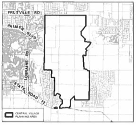
Central Village Planning Area. The portion of the properties within the area designated Village/Open Space and Greenway on Figure 9-5: RMA-1 Resource Management Areas which are south of Fruitville Road and north of Clark Road (aka State Road 72), which are within the portion of the Central Village Area depicted on the map below. Most of the property is generally referred to as the Hi-Hat Ranch.
Certificate of Occupancy (CO). The official certification issued by the County that a premise may be used or occupied pursuant to the State Building Codes.
Certify or Certification. The process or act by which a Professional Engineer registered in the state of Florida certifies that all reasonable and required inspections, tests, and physical measurements have been made and improvements are constructed in substantial compliance with plans authorized for construction and all governing development orders and regulations.
Change of Occupancy. A discontinuance of an existing use and the substitution of a use of a different kind or class. Change of occupancy is not intended to include a change of tenants or proprietors unless accompanied by a change in the type of use.
Channelized Intersection. An "at grade" intersection with painted islands, raised islands, or other devices for directing traffic into definite paths.
Charrette. A collaborative workshop that involves the public and multiple professional disciplines to create solutions to complex development problems.
Cistern. A low impact development technique that utilizes a closed reservoir or tank for storing rainwater for rainwater harvesting.
Civic Building. Civic buildings contain public or civic uses of special significance to residents, employees, or visitors. Civic buildings are used for the following purposes: community services, day care, education, government, places of worship, or social services. Civic buildings do not include retail buildings, residential buildings, or buildings with private offices.
Civic Space. Civic spaces are commonly owned open spaces that are strategically placed to serve a specialized community function. An urban civic space is for active use and may be configured as a formal green, square, plaza, park, playground, or community garden. A preserve civic space allows only passive recreational uses and may be a project boundary buffer or aboveground stormwater management area or a natural area worthy of preservation.
Clark Road Properties. The portion of the properties designated Village Land Use on RMA-3 Village/Open Space RMA Land Use Map in the Comprehensive Plan, which lie south of Clark Road, west of the centerline of Cow Pen Slough, east of the west section line of Sections 17, 20, 29 and 32, Township 37 South, Range 19 East (which is otherwise generally referred to as east of Ibis Street), and north of the south line of Township 37 South, Range 19 East (which is generally referred to as the south boundary line of the properties generally referred to as the LT Ranch and Indiantown Dairy).
To support the Village form of development within the Clark Road Properties and implement the incentives contained within Policy VOS2.1(d) of the Comprehensive Plan, optional, alternative VPD District Standards are provided within Section 124-271(c). In applying the VPD standards to the Clark Road Properties, one or more of the optional, alternative standards may be applied, in lieu of the related VPD standard. Any such optional, alternative VPD standards utilized by a Clark Road Properties landowner shall be identified by the land owner at the time of rezoning to VPD and shall be reflected on the Master Land Use Plan. The identified optional, alternative standards shall be applied by the Board in reviewing the requested rezoning to VPD. Such standards for Clark Road Properties Village Development are provided in:
(1)
Section 124-271(c)(3)a, pertaining to "Residential Density;"
(2)
Section 124-271(c)(3)b.1, pertaining to "Village Center Commercial/Retail/Office;"
(3)
Section 124-271(c)(3)c, pertaining to "Open Space;"
(4)
Section 124-271(c)(3)d.1, pertaining to "Location and Size of Villages;"
(5)
Section 124-271(c)(3)d.3, pertaining to "Residential and Nonresidential Village Center Land Use Mix;"
(6)
Section 124-271(c)(4), pertaining to "Village and Neighborhood Center Requirements;"
(7)
Section 124-271(c)(4)e, pertaining to "Village and Neighborhood Center Land Use Mix Requirements;"
(8)
Section 124-271(e)(5), pertaining to "Permitted Uses Within Village Centers;"
(9)
Section 124-271(e)(6)c.3.x, pertaining to "Regional Stormwater Facilities and Potable Water Storage Facilities;"
(10)
Section 124-271(e)(6)e, pertaining to "Industrial Uses;"
(11)
Section 124-271(e)(8), pertaining to "Regional Stormwater Facilities in Open Space;"
(12)
Section 124-271(g)(5)d.3, pertaining to "Exceptions to 'Public Edge';"
(13)
Section 124-271(i)(3)b.1, pertaining to "Required Minimum Open Space for First Village Development;"
(14)
Section 124-271(j)(1)a.5.iv, pertaining to "Greenbelt Exceptions;" and
(15)
Section 124-271(j)(1)a.5.vii, pertaining to "Special Buffer Requirements."
Clinic, Outpatient Medical or Dental. A medical or dental clinic is an establishment where patients, who are not lodged overnight, are admitted for examination and treatment by one person or a group of persons practicing any form of the healing arts, whether such persons be medical doctors, chiropractors, osteopaths, chiropodists, naturopaths, optometrists, dentists, or any such profession, the practice of which is regulated by the State of Florida. A public clinic is one operated by any governmental organization for the benefit of the general public. All other clinics are private clinics.
Club, Private. For the purpose of this UDC, private clubs shall pertain to and include those associations and organizations of a civic, fraternal or social character not operated or maintained for profit, and to which there is restricted public access or use. The term "private club" shall not include casinos, nightclubs, bottle clubs, or other establishments operated or maintained for profit.
Cluster Subdivision. A form of development that permits a reduction in lot area and bulk requirements, provided there is no increase in the number of lots permitted under the conventional subdivision or increase in the overall density of development, and the remaining land area is devoted to open space, active recreation, or preservation of environmentally sensitive areas. See Section 124-76(b)(2)g, RSF District Development Intensity.
Coastal High Hazard Area. Areas which include Federal Emergency Management Agency designated velocity zones, areas seaward of the coastal construction control line established by the Florida Department of Environmental Protection pursuant to F.S. Ch. 161; the Gulf Beach Setback Line (GBSL) pursuant to Chapter 54, Article XXII of the County Code; Barrier Island Pass Twenty-Year Hazard Line (PHL) pursuant to Chapter 54, Article XXII of the County Code; and inlets and areas of known or potential breach.
Collector Street. A street designated as a collector in the Comprehensive Plan (see Table 10-5. Future Transportation Plan Roads; Map 10-8 Year 2040 Future Thoroughfare Plan (Functional Classification).
Colonnade. Similar to an arcade but supported by vertical columns without arches.
Commercial Hunting and Trapping. Operating commercial game preserves, such as game retreats; and operating hunting preserves.
Commercial Radio and Television Receiving Dish. A dish antenna structure of any configuration whose purpose is to receive relay or transmit communication signals between another space or ground transmitter relay or receptor. A dish antenna structure which serves two or more dwelling units shall be deemed commercial for the purposes of these regulations. The inclusion of commercial radio and TV receiving dishes as a permitted use, with standards, in any zoning district is not intended to affect existing rights to install noncommercial dishes as permitted accessory uses within any zoning district.
Commercial Vehicles. A motor vehicle licensed by the state as a commercial vehicle. See Section 124-120(c) for restrictions.
Common Land or Area. Any parcel of land owned by, or used jointly for mutual benefit of more than one party (such as open space or recreational areas). A condominium association, homeowners' association, or similar organization shall be construed as being more than "one party" for the purposes of this definition.
Community Center, Private. A community structure, which may be a clubhouse, community building or other such shared facilities, with recreational facilities that may include a swimming pool, tennis courts and other similar recreational facilities, provided that the community center does not include golf courses, driving ranges or putting greens.
Community Development District (CDD). An independent special district established under Florida law to finance and manage the provision of community infrastructure and services. A CDD may impose taxes and assessments and issue bonds.
Community Housing. Community housing is defined as a housing unit available for sale or rent that is affordable to a household earning 120 percent or less of the median household income for Sarasota County.
Community Recreational Facility. A building or structure or group of buildings or structures owned or leased and operated by a charitable and not-for-profit organization holding an exemption from Federal Income Tax under Section 501(c)(3) of the Federal Internal Revenue code, or such comparable section of Federal Internal Revenue Code, which may be in force from time to time regulating exemptions from Federal Income Tax. A Community Recreational Facility provides community and recreation services, including but not limited to, child care services, after school care programs, summer camp programs, indoor and outdoor recreational services, fitness facilities, live stage production, museum, private club, career and life skills counseling, administrative offices, and accessory retail sales.
Community Residential Home. A dwelling unit licensed under F.S. Ch. 419 to serve clients of the Department of Elder Affairs, the Agency for Persons with Disabilities, the Department of Juvenile Justice, or the Department of Children and Family Services, which provides a living environment for up to 14 unrelated residents who operate as the functional equivalent of a family, including such supervision and care by supportive staff as may be necessary to meet the physical, emotional, and social needs of the residents. Resident means any of the following as defined in the Florida Statutes: a frail elder as defined in F.S. § 429.65; a person who has a handicap as defined in F.S. § 760.22(7)(a); a person who has a developmental disability as defined in F.S. § 393.063; a non-dangerous person who has a mental illness as defined in F.S. § 394.455; or a child who is found to be dependent as defined in F.S. §§ 39.01 or 984.03, or a child in need of services as defined in F.S. §§ 984.03 or 985.03.
Community Service. Uses of a public, nonprofit, or charitable nature providing ongoing education, training or counseling to the general public on a regular basis, without a residential component. Examples of Community Service uses include, but are not limited to, nonprofit community recreational facility, library, museum (NAICS 7121), neighborhood arts center or similar community facility (public), philanthropic institution, senior center, and union hall or youth-oriented community service.
Completely Enclosed Building. A building separated on all sides from adjacent open space, or from other buildings or other structures, by a permanent roof and by exterior walls or party walls, pierced only by windows and normal entrance or exit doors.
Composting Facility. A site or facility, excluding home composting areas and agricultural composting conducted as a farm use, which utilizes green feedstocks to produce a useful product through a managed process of controlled biological decomposition. Composting may include amendments beneficial to the composting process. Vermiculture and vermicomposting are considered composting facilities.
Comprehensive Plan. The official document including all of its associated elements and the Future Land Use Map, adopted by the Sarasota Board and filed with the Clerk of said Board, to guide decision-making related to the physical development of the county pursuant to Sarasota County requirements and State law.
Concurrency Management System. The procedures or process as set forth in County Ordinance No. 89-103, that the County utilizes to assure that development orders and permits when issued will not result in a reduction of the adopted level of service standards at the time that the space of development occurs.
Conservation or Conserve. Areas of native habitats set aside in perpetuity, other than those required to be preserved, consistent with the Principles for Evaluating Development Proposals in Native Habitats. Conservation areas often consist of native habitat that fulfill open space or other requirements.
Conservation Easement. A form of Restrictive Covenant used for the purpose of conserving an amenity (Native Habitat, Open Space) or function (water recharge, recreational access) while preserving in perpetuity the owner's prescriptive right(s) to the land for agriculture, residential or nonconsumptive use. Construction and operation of Linear Facilities and public utilities, including the Englewood Water District's Consumptive Use Permit are uses which shall be allowed on property which is subject to a Conservation Easement in the Settlement Area Overlay. A Conservation Easement may or may not convey public access.
Conservation Subdivision. A rural residential development where 50 percent or more of the land is designated as undivided, permanent Open Space. The remaining developable land is subdivided into buildable lots.
Constrained Parking Lot/Sites. A lot or site that is limited in size with regard to conformity to development standards beyond the property owners control, such as location of overhead power lines that would prohibit the placement of certain large trees within buffer areas and existing parking lots that do not meet current standards.
Construction, Actual. The commencement and continuous uninterrupted prosecution of construction pursuant to a permit which includes the permanent placement and fastening of materials to the land or structure for which the permit has been issued. Where demolition, excavation or removal of an existing structure has been substantially begun preparatory to new construction, such excavation, demolition, or removal shall be deemed to be actual construction, provided that work shall be continuously carried on until the completion of the new construction involved. Fill and the installation of the drainage facilities shall be considered a part of construction. Actual construction shall include only work begun under a valid building permit.
Construction Engineering Plan. See Plan, Construction Engineering.
Convalescent Home. See Assisted Living Facility.
Convenience Store. A small retail store which sells convenience items including, but not limited to food, which may include a limited amount of freshly prepared foods such as sandwiches and salads for off-premises consumption, beverages, tobacco products and similar products as its primary sales. A convenience store may include the sale of gasoline and diesel fuel but such sales shall be accessory to the primary sale of convenience goods.
Conventional Subdivision. A pattern of residential development that provides the majority of property owners with substantial yards on their own property. See Section 124-76(b)(2)g, RSF District Development Intensity.
Corner Clearance. At an intersecting street or highway, the dimension measured along the edge of the travel way between the intersection of the two right-of-way lines and the tangent projection of the nearest edge of driveway.
Country Club. Land area and buildings containing golf courses, recreational facilities, a clubhouse, and customary accessory uses, where membership is required.
Countryside Line. That line identified on the Comprehensive Plan Figure RMA-3 'Village/Open Space RMA Land Use Map' generally located along the eastern edge of those lands identified and depicted as Village Land Use.
County. Sarasota County, Florida.
County Administrator. The Sarasota County Administrator or duly authorized representative.
County Engineer. The Sarasota County Engineer or duly authorized representative.
County Park. A Public Beach Park, Public Natural Area, or Public Recreation Area as defined in Chapter 90, Article II, of the County Code.
County Roadway. A public road that is part of the County Roadway System, including municipal extensions of County Roadways and any proposed roads as yet unbuilt but designated as a part of the County Roadway System in the Future Thoroughfare Plan.
County Surveyor. The Sarasota County Surveyor or duly authorized representative.
Covered Parking. See Parking, Covered.
Critical Area Plans (CAPs). A comprehensive planning tool to plan for critical areas of concern and provide information for evaluating future development proposals in such areas to ensure consistency with the Comprehensive Plan. CAPs are small area plans that provide a bridge between the general characteristics of the Comprehensive Plan and the specific nature of development orders and permits issued pursuant to the County's Unified Development Code. See Chapter 94, Article II, of the Code.
Cul-De-Sac. A dead-end street terminated at the closed end by a circular vehicular turnaround so designated in the Comprehensive Plan (see Table 10-5. Future Transportation Plan Roads; Map 10-8 Year 2040 Future Thoroughfare Plan).
Cupola. A dome-shaped ornamental structure located on top of a larger roof or dome, often used as a lookout or to admit light or air. A cupola sits on top of and comprises a small part of the main roof, whether the main roof is a flat roof, a pitched roof, or a dome.
Current. As used herein, pertains to specifications, design standards and construction details in effect or as may be changed or amended from time to time. The term "current" shall be applied at the time of a development plan or plat is presented for acceptance or approval.
Day Care. Uses providing care, protection, and supervision for more than six children or adults on a regular basis away from their primary residence. Care is typically provided to a given individual for fewer than 18 hours each day, although the facility may be open 24 hours each day.
Day Care Facility. A facility that provides child care for more children than permitted in a Large Family Child Care Home and receives a payment, fee, or grant for any of the children receiving care, whenever operated, and whether or not operated for profit. The term does not include public and nonpublic schools, summer camps, bible schools, foster home, family day care homes or transient establishments which provide child care for their guests.
Day Facility. Any nonresidential facility which provides day services to developmentally disabled persons, pursuant to F.S. Ch. 393, as amended. Day service shall mean the care, protection, and supervision of a developmentally disabled person for a period of less than 24 hours a day on a regular basis which supplements for said person, in accordance with his or her individual needs, daily care, enrichment opportunities and health supervision.
Daylight Plane. An inclined plane, beginning at a stated height above grade at a side or rear property line, and extending into the site at a stated upward angle to the horizontal, which may limit the height or horizontal extent of structures at any specific point on the site where the daylight plane is more restrictive than the height limit or the minimum yard applicable at such point on the site. (See Section 124-72(a), Measurement of Standards).
Dead-End Street. A street having only one end open for vehicular access (i.e., there is only one way in/out for the development).
Debilitating Medical Condition. Cancer, glaucoma, positive status for human immunodeficiency virus (HIV), acquired immune deficiency syndrome (AIDS), hepatitis C, amyotrophic lateral sclerosis (ALS), Crohn's disease, Parkinson's disease, multiple sclerosis or other conditions for which a physician believes that the medical use of marijuana would likely outweigh the potential health risks for a patient.
Deceleration Lane. See Speed-Change Lane.
Density. The maximum number of residential dwelling units permitted per gross acre of land, except where Article 15 allows additional dwelling units on a nonconforming lot of record.
Density Credit. The amount of dwelling units assigned to a parcel after the application of all applicable density incentives; not related to how many dwelling units may be developed on that parcel.
Density Incentive. An increase in currently approved density provided by the applicable Sarasota County zoning district to a developer or landowner as an incentive to achieve a community objective.
Department of Economic Opportunity (DEO) Home. See Modular Home.
Design Speed. The speed to which a road is being or has been designed.
Designated Responsible Entities. Only the following entities qualify as designated responsible entities under the terms of this UDC:
(a)
Local governmental units including counties and municipalities; state and federal government agencies; active F.S. Ch. 298, drainage districts; drainage districts created by Special Act; F.S. Ch. 190, Community Developments Districts; the Southwest Florida Water Management District; or F.S. Ch. 170, special assessment districts. If the designated responsible entity is a governmental unit, prior to staff construction approval the applicant must supply written proof in the appropriate form by either letter or draft resolution outlining the terms and conditions under which the governmental entity will accept the operation and maintenance of all of the facility and related facilities, including lakes and easements.
(b)
Legally constituted communication, water, sewer, electrical or other public utilities.
(c)
Nonprofit corporations including homeowners' associations, property owners' associations, condominium owners' associations or master associations, meeting the standards specified in these regulations.
Detention with Biofiltration. A low impact development technique using a landscaped depression area to manage stormwater runoff with a separate inlet and outlet (underdrain). Depressions are often linear and may be connected in series. Storage volume recovery of the depression is through an underdrain system.
Developed Area.For the Village/Open Space RMA, Conservation Subdivisions, and the Urban/Suburban Settlement Area, that land area exclusive of Open Space identified and depicted on a Master Land Use Plan approved pursuant to Sarasota 2050 RMA Policy and Article 14 of the UDC.
Developer. Any person, individual, partnership, association, syndicate, firm, corporation, trust or legal entity engaged in developing or subdividing land under the terms of these regulations. The term "developer" is intended to include the term "subdivider," even though the persons involved in successive stages of a development project may vary.
Development. A subdivision of land or a site and development as defined by these regulations, a residential mobile home park, and any other construction, reconstruction, demolition conversion, structural alteration, relocation or enlargement of any structure, whether residential, commercial, industrial, office, professional, institution, or recreational. This term also includes any excavation, landfill, or land disturbance and any use or extension of the use of land. Habitats protected under the County Code shall remain protected during "development". Development shall also include all activities set forth in F.S. § 380.04.
Development Agreement. See F.S. § 163.3221.
Development Blocks or Blocks. A unit of development that is surrounded on all sides by "A" streets. Example dimensions: 500 feet to 700 feet in length by 500 feet to 700 feet in width.
Development Order. Any action granting, denying, or granting with conditions, an application for a development permit.
Development Permit. Any building permit, subdivision or other plat approval, Site Development Plan approval, rezoning, certification, special exception, variance, environmental permit or any other official action of Sarasota County or any other State [or] local government commission, board, agency, department or official having the effect of permitting development of land located within the geographic area subject to the provisions of this chapter. Development shall include all activities set forth in F.S. § 380.04.
Development Review Coordination. A staff level coordinated review process established by the Board with representatives from the County consisting of Health, Utilities, Planning and Development Services, Environmental Protection Division, Public Works, Parks, Recreation and Natural Resources, and others such as Historical Resources, Sarasota County Area Transit (SCAT), Emergency Services, and representatives of any other agencies as may be required by the County Administrator from time to time to provide individual comments upon development orders.
Development Rights. The amount of residential development permitted on a parcel of land under the applicable zoning. Development Rights are expressed as the maximum number of dwelling units per acre for parcels located in residential or open use zones. An interest in and the right to use and subdivide land for any and all residential, commercial, and industrial purpose and activities in accordance with the UDC and other regulations.
Directional Median Opening. An opening in a restrictive median that provides for specific movements and physically restricts other movements.
Disaster. Shall have the same meaning as set forth in Section 252.34, Florida Statutes, as amended.
Divided Roadway. A roadway with separation between traffic traveling in opposite directions. Separation may be provided by depressed dividing strips, raised medians, traffic islands, other physical separations, or other traffic control devices.
Dome. A hollow, flattened or raised hemispherical roof structure, often of masonry, which rests on a circular, square or polygonal base, it can be supported by columns or piers that transition to the dome through squinches or pendentives.
Drainage. The removal of surface water or groundwater from land by drains, grading, or other means. Drainage includes the control of runoff to minimize erosion and sedimentation during or after development and includes prevention or alleviation of flooding.
Drainage Basin. The area defined by topographic boundaries that contributes stormwater to a drainage system, estuarine waters, or oceanic waters, including all areas artificially added to the basin.
Drainage Plan. A plan for the discharge of stormwater from a "Subject Parcel" prepared, signed, and sealed by a Professional Engineer registered in the State of Florida.
Drive-Through or Drive-In. An establishment that by design, physical facilities, service, or by packaging procedures encourages or permits customers to receive services, or obtain goods while remaining in their motor vehicles.
Driveway. The travel way between the connection point and the development.
Driveway Angle. The angle of 90 degrees or less between the driveway centerline and the edge of the travel way.
Dude Ranch. A resort offering ranch activities such as riding and camping for the entertainment of overnight or daily visitors. The facility may include equipment rental and overnight accommodations. When not entertaining overnight guests a dude ranch is considered a working ranch.
Dwelling. Any building, or part thereof, occupied in whole or in part, as the residence or living quarters of one or more persons, permanently or temporarily, continuously or transiently, with cooking and sanitary facilities.
Dwelling, Multifamily. A building that contains three or more dwelling units. This definition includes a semi-attached townhouse, townhouse, roof-deck townhouse, stacked townhouse, multiplex or multifamily as set forth in Section 124-130.
Dwelling, Multiple Dwelling Use. For purposes of determining whether a lot is in multiple dwelling use, the following considerations shall apply:
(a)
Multiple dwelling uses may involve dwelling units intended to be rented and maintained under central ownership and management or cooperative apartments, condominiums, and the like.
(b)
Where an undivided lot contains more than one building and the buildings are not so located that lots and yards conforming to requirements for single-family, two-family, or multiple-family dwellings in the district could be provided, the lot shall be considered to be in multiple dwelling use if there are three or more dwelling units on the lot, even though the individual buildings may each contain less than three dwelling units.
(c)
Guest houses and servants' quarters shall not be considered as dwelling units in the computation of (b) above.
Dwelling, Single-Family. A building containing only one dwelling unit, to be occupied by one family. This definition includes a single-family detached house, lot line house, traditional house, patio house, villa house, or atrium house, as set forth in Section 124-130, and any manufactured home and modular home. For regulatory purposes, the term is not to be construed as including mobile homes, recreational vehicles, travel trailers, housing mounted on motor vehicles, tents, houseboats, or other forms of temporary or portable housing.
Dwelling, Two-Family. One building containing only two dwelling units. This definition includes a two-family house, as set forth in Section 124-130.
Dwelling Unit. A room or rooms connected together, constituting a separate, independent housekeeping establishment for a family, for owner occupancy or rental or lease, and physically separated from any other rooms or dwelling units which may be in the same structure and containing sleeping and sanitary facilities and one kitchen.
Dwelling Unit, Accessory. A dwelling unit either attached to a single-family principal dwelling or located on the same lot and having an independent means of access.
Easement. Any strip of land created by a subdivider for public or private utilities, drainage, sanitation, or other specified uses having limitations, the title to which shall remain in the name of the property owner, subject to the right of use designated in the reservation of the servitude.
Education Facilities. Public and private (Including charter or religious) schools at the primary, elementary, middle, junior high, or high school level that provide basic academic education. Also includes colleges and other institutions of higher learning that offer courses of general or specialized study leading to a degree usually in a campus setting.
Egress. A grant of property rights by the property owner to, or for use by, the public, a corporation, or another person or entity to use as an exit from a specific parcel of land.
Electronic Message Center—Sign. Any variable-message sign or portion of such a sign that utilizes interactive or computer-generated messages or any other electronic means of changing copy. These signs include displays using incandescent lamps, LEDs, LCDs, or a flipper matrix.
Emergency Access Road. An all-weather road twenty (20) feet wide with twelve (12) inch stabilized subgrade conforming to Article 18, Appendix F. Located in a thirty (30) foot wide easement that has been cleared of vegetation that would interfere with the use of the road. Profile of the road shall be above the one hundred (100) year flood elevation.
Emergency Medical Office. An establishment where patients, who are not lodged overnight, are admitted for examination and treatment by one or more physicians. An emergency medical clinic is not a doctor's office or a professional office.
Emergency Services. Emergency services include police, fire, rescue, or ambulance (but not funeral home) services whether operated by a government agency or by a quasi-public agency performing a public service.
Encroachment. Entering into adjacent area.
Entertainment. Entertainment shall include live vocalists, musicians, disc jockeys (whether speaking or not), comedians, karaoke, performers (paid or otherwise, including contestants) and the like, provided at a bar, restaurant, nightclub or other similar commercial establishment also providing food or beverages.
Entertainment, Indoor. Entertainment within a completely enclosed building with windows closed and doors opened only for purposes of normal ingress and egress.
Entertainment, Outdoor. Entertainment not within a completely enclosed building. This definition shall include any entertainment broadcast outside a completely enclosed building, or entertainment occurring when windows are open or doors are open for purposes other than normal ingress or egress.
Equivalent Dwelling Unit (EDU). The utilization of building space in such a manner as to have the potential of using two hundred fifty (250) gallons of potable water per day or generating two hundred (200) gallons of sewage per day.
Erected. The term "erected" includes built, constructed, reconstructed, moved upon, or any physical operation on the premises required for building. Excavation, fill, drainage, demolition of an existing structure, and the like shall be considered part of erection. (See Construction, Actual.)
Essential Services. Essential services are defined as services designed and operated to provide water, sewer, gas, telephone, electricity, cable television or communications to the general public by providers which have been approved and authorized according to laws having appropriate jurisdiction, and government facilities. Essential services are allowed in any zoning district subject to the requirements of state law and the County Code.
Evacuation Routes. Routes designated by County Emergency Management Authorities or the regional evacuation plan, for the movement of persons to safety in the event of a hurricane or other catastrophic event.
Exotic. A species introduced to Florida, purposefully or accidentally, from a natural range outside of Florida.
Façade, Primary. Any building frontage facing a public or private street.
Family. One or more persons living together as a single housekeeping unit and occupying a single dwelling unit. The term "family" shall not be construed to mean a fraternity, sorority, club, monastery or convent, or institutional group. The term may include community residential homes where the group operates as a single housekeeping unit. There shall be a rebuttable presumption that no family exists if there are more than six persons and any are unrelated by law, blood, adoption, marriage, domestic partnership, or are under a judicial order for foster care living together in the same dwelling unit. This presumption may be rebutted by demonstrating the existence of a single housekeeping unit to the Administrator as part of an application for a Written Interpretation pursuant to Section 124-45 of the UDC. Such demonstration may include a lease agreement, utility bills, and affidavits from the occupants. Any appeal of the Administrator's decision shall be made to the Board of Zoning Appeals in the same manner as any other Written Interpretation.
"Family" is a term used to regulate types of housing protected by the Fair Housing Act, which includes a requirement that homes providing care for the disabled and similar functions in a single housekeeping unit must be treated the same way as single-family residences. However, many other uses are regulated by this ordinance - see community residential home, group home, and social service institution, for example.
Family Day Care Home. An occupied residence in which child care is regularly provided for children from at least two unrelated families and which receives a payment, fee, or grant for any of the children receiving care, whether or not operated for profit. A family day care home shall be allowed to provide care for one of the following groups of children, which shall include those children under 13 years of age who are related to the caregiver:
A maximum of four children from birth to 12 months of age.
(a)
A maximum of three children from birth to 12 months of age, and other children, for a maximum total of six children.
(b)
A maximum of six preschool children if all are older than 12 months of age.
(c)
A maximum of ten children if no more than five are preschool age and, of those five, no more than two are under 12 months of age.
Farm/Produce Stand. A farm/produce stand provides a market for farmers, to retail their products directly to consumers. The principal use shall consist of farm products grown or raised on site. The sale of supplemental farm products grown or raised off-site is allowed. However, in no case shall all of the farm products be brought in from off site. The property upon which the farm stand is located shall have an Agricultural (Greenbelt) Classification issued by the Sarasota County Property Appraiser. To enhance the income of farmers the sale of value added products made from farm products grown or raised on site such as jam, juice, etc., are also allowed as part of the principal use.
FDOT. The Florida Department of Transportation.
Fences and Walls Height.The highest point above the finished grade on either side of the wall or fence.
Final Construction Engineering Plan. (See Plan, Final Construction Engineering.)
Final Letter (Letter of Acceptance). A written statement by the County Engineer that the warranty period has been completed and all required construction and improvements remain in satisfactory condition and are accepted for maintenance by the County.
Final Subdivision or Site Development Plan.(see Plan, Final Subdivision or Site Development.)
Finish. The final exterior material or treatment applied to a building such as brick, or stucco.
Fire Protection Clear Zone. That area surrounding a structure with a width determined by the Fire Marshal as necessary to protect a structure from wildfire.
Firing Range. An indoor or outdoor facility for the firing or shooting of rifles, shotguns or pistols or similar weapons.
First Letter (Certification of Completion). A written statement by the County Engineer that all construction or site development is in substantial conformance with the approved development plans, or plats; and that the warranty period will commence on the date of the letter.
Fiscal Neutrality/Fiscally Neutral. New development within the Village/Open Space RMA and Urban/Suburban Settlement Area is required to pay the full costs of all public facilities and services that are necessary to support the development and that are required to meet or exceed the level of service standards adopted by the County. This requirement includes the initial costs of all infrastructure including schools as well as on-going costs of maintenance. The terms Fiscal Neutrality and Fiscally Neutral are synonymous.
Fishing Camp. A resort facility for outdoor enthusiasts that serves as a base camp for fishing expeditions. The facility may include equipment rental and overnight accommodations.
Flag. Any fabric or other flexible material containing distinctive colors, patterns or symbols, designed to be flown from a flagpole or similar device.
Floodplain. Any land area inundated by flood events of various recurrence intervals as defined by the latest Federal Emergency Management Agency (FEMA) Flood Insurance Rate Map (FIRM), Sarasota County Basin Studies, or whichever data are, in the determination of the County, more accurate.
Floor Area. Except as may be otherwise indicated in relation to particular districts and uses, floor area shall be construed as the sum of the gross horizontal areas of the several floors of a building, measured from the exterior faces of the exterior walls or from the centerline of walls separating two buildings, and including outside decks or patios used for commercial purposes, including waiting areas. Unless otherwise indicated in these regulations, the following are excluded from the calculation of floor area: public corridors, common restrooms, attic areas with a headroom of less than seven feet, unenclosed stairways or fire escapes, enclosed stairways, elevator structures, cooling towers, areas devoted to air conditioning, ventilating or heating or other building machinery and equipment, parking structures, and basement space where the ceiling is not more than an average of 48 inches above the general finished and graded level of the adjacent portion of the lot.
Floor Area, Gross. Except as may be otherwise indicated in these regulations, gross floor area shall be construed as the sum of the gross horizontal areas of the several floors of a building, measured from the exterior faces of the exterior walls or from the centerline of walls separating two buildings, and including outside decks or patios used for commercial purposes.
Focal Point. An area of nonresidential development, higher-density residential development, Public Space, or Recreational Space greater than or equal to five acres within a Hamlet, or in a conventional subdivision larger than 30 acres within the RE-3 or RSF Districts, at least one percent of the gross area of the subdivision with a conventional subdivision in the RE-3 District that exceeds 30 acres. It shall contain at a minimum, a community use facility and should be specified at the time of Preliminary Plat.
Forked Creek Greenway. Includes the on-site Forked Creek main branch, any associated mesic hammocks and pine flatwoods that connect the ecological system, and any connected wetlands and the County's required wetland buffers.
Freeboard. An additional amount of height above the Base Flood Elevation used as a factor of safety in determining the elevation to which a structure's lowest floor or lowest horizontal structural member of the lowest floor, as applicable, must be elevated or floodproofed, as required by the Florida Building Code.
Frontage. The portion of the perimeter of a property that borders the road right-of-way. A property abutting multiple roadways will have more than one frontage for the purpose of the UDC.
Frontage, Building. See Building Frontage.
Frontage Percentage. The percentage of the width of a lot that is required to be occupied by its building's primary facade.
Fully Functional Access Point. A location of vehicular access (non-emergency only) that allows for both entry to and exit from a property to a public or private road.
Fully-Shielded Light Fixture. A lighting fixture constructed in such a manner that all light emitted by the fixture, either directly from the lamp or a diffusing element, or indirectly by reflection or refraction from any part of the luminaire, is projected below the horizontal plane as determined by photometric test or certified by the manufacturer. Any structural part of the light fixture providing this shielding must be permanently affixed.
Functional Area of Intersection. The area beyond the physical intersection of two controlled access facilities (stop controlled, signalized intersection, or roundabout) that comprises decision and maneuvering distance, plus any required vehicle storage length, and is protected through corner clearance standards and connection spacing standards.
Functional Classification. The classification system in the Comprehensive Plan that defines the intended level of mobility and access provided by a street.
Future Land Use Map. The future land use map contained in the adopted Comprehensive Plan.
Future Urban. The geographic area within unincorporated Sarasota County that is designated as the Future Urban Service Area on the Sarasota County Future Land Use Map.
Garage, Parking. A building or portion thereof, consisting of more than one level designed or used for temporary parking of motor vehicles.
Garage, Private. An accessory structure designed or used for inside parking of private passenger vehicles, recreational vehicles, or boats, by the occupants of the main building. A private garage attached to or a part of the main structure is to be considered part of the main building. An unattached private garage is to be considered as an accessory building.
Garage, Storage. A storage garage is a building or portion thereof designed and used exclusively for the storage of motor vehicles or boats, and within which temporary parking may also be permitted.
Garden Center. A retail center for the sale of plant material, landscape supply, hoses, wheelbarrows, pots, garden tools, or other garden supplies. A Garden Center can include outdoor areas or enclosed areas. A Garden Center is not a Plant Nursery and is not a Plant Nursery with Landscape Supply.
Golf Course. Any public or private area of land designed and used for playing or practicing the game of golf, including tees, fairways, greens, rough areas, and hazards as well as stand-alone driving ranges. A golf course will also include the following uses if they are accessory to the above uses: driving ranges, practice greens, clubhouses, and all facilities associated with the maintenance and daily operations of the above-referenced areas. Club facilities such as locker rooms, restaurants and lounges, pro shops, and other complementary uses are considered part of a golf course. Alternative learning facilities such as First Tee program with less than nine holes are excluded.
Golf Putting Course. A recreational facility in which a participant uses a golf ball and putter to traverse a course devoid of vertical structures.
Government Facilities. Offices, storage, maintenance, and other facilities for the operation of local, state, or federal government.
Grassing. When used in reference to golf courses means seeding, sodding or sprigging golf course tees, greens, fairways and roughs in preparation for play.
Greenbelt. A permanent Buffer surrounding the Developed Area of Villages and Hamlets.
Green Feedstocks. Yard debris, nontreated wood waste, vegetative food waste, produce waste, vegetative restaurant waste, vegetative food processor by-products, crop waste and livestock manure. For the purpose of these provisions, "nontreated wood waste" excludes wood waste treated with paint, varnish or other chemicals or preservatives.
Green Roof Treatment Systems. A low impact development technique using a roof area that includes at a minimum vegetation, media and a waterproof membrane. To receive water quality credit, it is specifically built with a cistern or water holding system from which irrigation is provided.
Greenway. A linear open space established along either a natural corridor, such as a riverfront, stream valley, or ridgeline, or over land along a railroad right-of-way converted to recreational use, a canal, a scenic road, or other route; any natural or landscaped course for pedestrian or bicycle passage; an open space connector linking parks, nature reserves, cultural features, or historic sites with each other and with populated areas.
Greenway RMA. A resource overlay as depicted in RMA-1, Resource Management Area Map. This RMA is designed to designate a network of riverine systems, floodplains, Native Habitats, storm surge areas and uplands as priority resources for the County in order to implement programs, which are designed to protect these lands in perpetuity.
Gross Developable Acre. The total number of acres within the boundary of a development area excluding wetlands and excluding Open Space external to the development.
Group Home. A facility licensed to serve clients of the Department of Elder Affairs, the Agency for Persons with Disabilities, the Department of Juvenile Justice, or the Department of Children and Family Services that provides a living environment for 15 or more unrelated residents, including such supervision and care by supportive staff as may be necessary to meet the physical, emotional, and social needs of the residents. Resident means any of the following as defined in the Florida Statutes: a frail elder as defined in F.S. § 429.65; a person who has a handicap as defined in F.S. § 760.22(7)(a); a person who has a developmental disability as defined in F.S. § 393.063; a non-dangerous person who has a mental illness as defined in F.S. § 394.455; or a child who is found to be dependent as defined in F.S. §§ 39.01 or 984.03, or a child in need of services as defined in F.S. §§ 984.03 or 985.03. (See also Community Residential Home.)
Group Living. All living arrangements where persons live in a group that is not a single housekeeping unit. Examples of Group Living uses include, but are not limited to, a group home, assisted living facility, nursing home, extended care facility, convalescent home, boarding house, rooming house, fraternity, sorority, orphanage (NAICS 72131), hospice, nursing or convalescent home (NAICS 62311), monastery, convent, residential assisted living facility without individual self-contained dwelling units. Tenancy is usually arranged on a monthly or longer basis. Generally, Group living structures have a common eating area for residents and the residents may receive care or training.
Guest House. A guest house is a dwelling unit in a building separate from and in addition to the principal residential building on a lot.
Guest Room. A room or suite of rooms in a transient accommodation that does not include a kitchen.
Habitable Space. All space in a structure for living, sleeping, eating or cooking. Screen enclosures, storage or utility space, and similar areas are not considered habitable space.
Half-blocks. A sub unit of a development block that is surrounded on three sides by "A" streets and on one side by "B" streets. Example dimensions 500 feet to 700 feet in length by 250 feet to 350 feet in width.
Hamlet. A future land use designation and zoning district within the Village/Open Space RMA that consists of rural homes clustered around a crossroads or small Public/Civic or commercial area (e.g., a church or Neighborhood store) and surrounded by a large expanse of protected Open Space.
Hamlet Planned District (HPD). A planned development zoning district that is used to implement the Comprehensive Plan within those areas of Sarasota County shown as Hamlet Land Use within the Village/Open Space RMA on Figure RMA-3 of the Future Land Use Map Series.
Heavy Industrial. Firms involved in research and development activities without light fabrication and assembly operations; limited industrial/manufacturing activities. The uses emphasize industrial businesses, and sale of heavier equipment. Factory production and industrial yards are located here. Sales to the general public are limited. Examples of Heavy Industrial uses include, but are not limited to, any use that is potentially dangerous, noxious or offensive to neighboring uses in the district or those who pass on public ways by reason of smoke, odor, noise, glare, fumes, gas, vibration, threat of fire or explosion, emission of particulate matter, interference with radio, television reception, radiation or any other likely cause, animal processing, packing, treating, and storage, livestock or poultry slaughtering, citrus concentrate plant, processing of food and related products, production of chemical, rubber, leather, clay, bone, paper, pulp, plastic, stone, or glass materials or products, production or fabrication of metals or metal products including enameling and galvanizing, sawmill (NAICS 311, 312, 321, 322, 324, 325, 326, 327, 331, 332, 333, 336, 337), bulk storage of flammable liquids, commercial feed lot, concrete batching and asphalt processing and manufacture, earth moving and heavy construction equipment.
Height of Building. See "Building Height" and Section 124-72(a), Measurement of Standards.
Height of Fences and Walls. See "Fences and Walls Height" and Section 124-72(a), Measurement of Standards.
High Intensity Agriculture. All agricultural uses not included in the definition of Low-Intensity Agriculture.
Historic Building. A Building that is listed or potentially eligible for listing in the National Register of Historic Places or the Local Register of Historic Places as defined in Chapter 66, Article III, Section 66-74 of the County Code. If such a building is relocated, and the relocation is approved by a Certificate of Appropriateness under Article III of Chapter 66, then the building retains its status as a Historic Building. Additions are also deemed to constitute part of a Historic Building if they are approved by a Certificate of Appropriateness.
Historic Preservation Officer. The official or office assigned by the County Administrator to make determinations as to compliance with the provisions of the Historic Preservation Incentive Overlay District (HPIOD) and Chapter 66, Article II of the County Code.
Historic Structure. Structures listed in the Sarasota County Local Register of Historic Places in accordance with Chapter 66, Article III of the County Code.
Home Based Business. Any use of a residential property, in whole or in part, for an occupation subordinate to the residential dwelling unit and which is clearly incidental to the use of the structure for residential purposes.
Horizontal Alignment. The combination of curved and tangent sections of the highway in the horizontal plane.
House of Worship. See Place of Worship.
Household Living. Residential occupancy of a dwelling unit by a household on a month-to-month or longer basis in structures with self-contained dwelling units, including kitchens.
Housing for Farm or Ranch Labor. An accessory structure or structures located on the same property as an active agricultural operation (see also Agriculture), used for the purpose of housing persons who derive all or part of their income from labor performed on the active agricultural operation.
Housing Type. See Section 124-130, Housing Types.
HUD-Code Home. A manufactured home built to the Manufactured Home Construction and Safety Standards (HUD Code) and displays a red certification label on the exterior of each transportable section. (see Manufactured Home)
Hunting Camp. A resort facility for outdoor enthusiasts that serves as a base camp for hunting or fishing expeditions. The facility may include equipment rental and overnight accommodations.
Identification Card. A document issued by the Department of Health that identifies a person who has a physician certification or a personal caregiver who is at least 21 years old and has agreed to assist with a qualifying patient's medical use of marijuana.
Impervious Surface. Impervious surfaces shall include all types of structures, plus swimming pools and pool decks, as well as concrete, asphalt, pavers, and other surfaces that substantially prevent water from penetrating into the ground. This does not include grass or other surfaces that allow water to substantially penetrate into the ground.
Improvements. Street pavement, sidewalk pavement, water and sewer mains including appurtenances, storm sewers, drainage facilities, street name and traffic control signs, monuments, landscaping and trees, street lighting, intersection signalization and other similar items.
Ingress. A grant of property rights by the property owner to, or for use by, the public, a corporation, or another person or entity to use as an entrance to a specific parcel of land.
Inside Radius. The inside or smaller curve radius on the edge of a driveway, used when the driveway angle is less than 65 degrees.
Integrated Pest Management (IPM). Means a decision-making process for managing pests that uses monitoring to determine pest injury levels and combines biological, cultural, physical, and chemical tools to minimize health, environmental and financial risks. IPM uses extensive knowledge about pests, such as infestation thresholds, life histories, environmental requirements and natural enemies to complement and facilitate biological and other natural control of pests. The method uses the least toxic agents or chemicals which are labeled to be specifically effective on a target pest or disease, only as a last resort to controlling pests.
Intersection. The general area where an access facility and a road or two or more roads or two access facilities join or cross.
Intersection Sight Distance. The clear sight distance areas to ensure that obstructions do not infringe on the sight lines needed by motorists, pedestrians, bicyclists, and others approaching intersections.
Invasive Exotic. An exotic species that not only has naturalized but is expanding on its own in Florida plant communities.
Invasive Species. For the purposes of these regulations, the listings of invasive species can be found in Chapter 54, Section 54-621, (Exotic Plants), of the County Code, state regulations (Chapters 5B-57.007 and 5B-64.011 of Florida Administrative Code), and the Florida Exotic Pest Plant Council's list of Category I and II invasive species as appropriate to this geographic region. In addition, the County reserves the right to develop additional lists of nonnative, nuisance and invasive species.
Kennel, Dog. See Animal Boarding.
Kitchen. An area within a structure used for preparation or cooking of food which contains a sink and a significant cooking appliance (electric/gas range with or without oven). In all districts, significant cooking appliances also shall include, but not be limited to: stoves, microwaves or other ovens, hot plates or cook tops. Significant cooking appliances shall not include grills for exterior use or any cooking appliances in an assisted living facility. Multiple appliances within a space occupied as a single household unit by the same family and not rented separately shall constitute one kitchen.
Land. Includes all ground surfaces, including structures on, above or below, water and wetlands.
Land Surveyor (Includes the titles Professional Land Surveyor and Professional Survey and Mapper). A person who is registered and licensed to engage in the practice of land surveying and mapping in the State of Florida pursuant to F.S. §§ 472.001 through 472.037.
Landscaping. Landscaping shall consist of, but not be limited to, grass, ground covers, shrubs, vines, hedges, trees, berms and complementary structural landscape architectural features such as rock, fountains, sculpture, decorative walls and tree wells. Where a landscaped buffer is required by this UDC, the use of only grass or ground covers shall not constitute a landscaped buffer (See also Section 124-122, Landscaping and Buffering).
Land-use. The purpose or activity for which land, or any structure thereon is designed, arranged or may be occupied or maintained.
Land-use Density. The number of units or square feet of a particular land-use permitted to be built, constructed, or placed on a defined parcel of land.
Lane. The portion of a roadway for the movements of a single line of vehicles not including the gutter or shoulder of the roadway.
Large Family Child Care Home. An occupied residence in which child care is regularly provided for children from at least two unrelated families, which receives a payment, fee, or grant for any of the children receiving care, whether or not operated for profit, and which has at least two full-time child care personnel on the premises during the hours of operation. One of the two full-time child care personnel must be the owner or occupant of the residence. A large family child care home must first have operated as a licensed family day care home for two years, with an operator who has had a child development associate credential or its equivalent for one year, before seeking licensure as a large family child care home. A large family child care home shall be allowed to provide care for one of the following groups of children, which shall include those children under 13 years of age who are related to the caregiver:
(a)
A maximum of eight children from birth to 24 months of age.
(b)
A maximum of 12 children, with no more than four children under 24 months of age.
Legal Access. A permanent public or private easement or a dedicated public right-of-way, or combination thereof, which provides subdivision residents, invitees, owners and public service providers with continuous, permanent rights of access between the subdivision and the County's connected arterial, collector and local roadway system. Where any road segment between the subdivision and the County's connected roadway system does not provide rights of access as provided herein, then legal access is not met.
Legal Lot of Record. A lot that is part of a documented subdivision, the description of which has been recorded in the Office of the Clerk of the Circuit Court, or a lot or parcel of land described by metes and bounds, the description of which has been recorded in the Office of the Clerk of the Circuit Court, consistent with and in compliance with this UDC in effect at the time of said recording.
Level I Mitigation. Creating wetlands at ratios of one to one for herbaceous wetland and two to one for wooded wetlands so that the plant diversity, wildlife habitat, topography and functions of the created wetland is similar to or better than the wetland that was impacted. More stringent success criteria are applied to achieve more rapid functional value than is achieved with Level II Mitigation. (See Article 9)
Level II Mitigation. Creating wetlands at ratios of two-to-one for herbaceous wetlands and four-to-one for wooded wetlands by planting native wetland species or applying muck obtained from an approved donor wetland such that the plant diversity, wildlife habitat, topography and functions of the created wetland may or may not be similar to those of a wetland that was impacted. Less stringent success criteria are applied in return for higher replacement ratios than are applied with Level I Mitigation. (See Article 9)
Level of Service. An indicator of the extent or degree of service provided by, or proposed to be provided by a facility, based on and related to the operational characteristics of the facility, as adopted levels of service standards are contained in the Comprehensive Plan.
Light Industrial Service. Firms engaged in the manufacturing, assembly, repair or servicing of industrial, business, or consumer machinery, equipment, products, or by-products mainly by providing centralized services for separate retail outlets. Contractors and building maintenance services and similar uses perform services off-site. Few customers, especially the general public, come to the site. Examples of Light Industrial Service uses include, but are not limited to, building, heating, plumbing, landscaping or electrical contractor and others who perform services off-site, but store equipment and materials or perform fabrication or similar work on-site (NAICS 232, 234, 235), bulk mailing service, large scale catering establishment, clothing or textile manufacturing, manufacture or assembly of equipment, instruments (including musical instruments), appliances, precision items electrical items, printing, publishing and lithography, production of artwork and toys, sign making (NAICS 313, 314, 315, 316, 323, 334, 335, 339), crematorium, janitorial and building maintenance service, exterminator, maintenance yard or facility (NAICS 56171, 56172, 56173, 56174), laundry, dry-cleaning and carpet cleaning plants (NAICS 81233), movie production facility (NAICS 51211), photo-finishing laboratory (NAICS 812921), repair of scientific or professional instruments, electric motors (NAICS 8112), research, testing, and development laboratory (NAICS 5417), sheet metal shop, soft drink bottling, storage area used for manufacturing, welding, machine, tool repair shop, woodworking, including cabinet makers and furniture manufacturing, Medical Marijuana Research or processing.
Limited Access Right-of-Way Line. A line delineating the limits of a road over which owners or occupants have no right of vehicular access, unless specifically authorized by a permit from the County Engineer or the Florida Department of Transportation, as appropriate.
Linear Facilities.The legal definition of Linear Facilities is set forth in F.S. § 704.06(11), and includes electric, telecommunication and other transmission and distribution lines and facilities, and public or private transportation corridors and related appurtenances. Linear facilities also include water distribution and sewer collection systems.
Liner Building. A building or portion of a building constructed in front of a parking garage, cinema, supermarket etc., to conceal large expanses of blank wall area and to face the street space with a facade that has ample doors and windows opening onto the sidewalk.
Liner Retail. Liner retail is defined as a building type designed to mask surface parking lots or anchor retail uses in order to provide building frontage along "A" streets, typically single story.
Listed Species. Any plant or animal listed as endangered, threatened, or species of special concern by the Florida Fish and Wildlife Conservation Commission or listed as endangered or threatened by the U.S. Fish and Wildlife Service. For the purposes of this definition, Listed Species also includes those birds afforded protection pursuant to the Bald and Golden Eagle Protection Act and the Migratory Bird Treaty Act.
Littoral Zone. That portion of any lake, borrow pit or pond measured from seasonal high-water elevation in water bodies where water elevation is not controlled by structures, or from the overflow elevation in water bodies where water elevation is controlled by structures, to a depth of three (3) feet. Littoral zones also include those areas in salt or brackish water (Gulf, bay, estuary) from the mean high-water elevation to a depth of three (3) feet.
Livestock Auction. A commercial establishment wherein livestock is collected for auctioning.
Live-Work Building. An attached or detached building that can accommodate permitted residential uses, commercial uses, or a combination of the two within individually occupied live-work units. All permitted uses may occupy any story of a live-work building.
Live Work Unit. A dwelling unit used jointly for commercial and residential purposes. Such buildings are typically originally constructed for commercial or industrial uses and subsequently converted for both living and work space uses; such as lofts. Typically, there is no separation between the living and working spaces. In residential structures, the maximum size of the work occupation shall not exceed 50% of the size of the dwelling unit based on county property records.
Living Area. The enclosed, commonly air-conditioned area of a dwelling unit.
Loading Space, Off-Street. Off-street loading space is space logically and conveniently located for pickups or deliveries or for loading or unloading, scaled to delivery vehicles expected to be used, and accessible to such vehicles when required off-street parking spaces are filled. (See also Section 124-120(o), Off-Street Loading.)
Lot. Includes tract or parcel and means the least fractional part of subdivided lands having limited fixed boundaries, and an assigned number, letter or other name through which it may be identified. In addition, for purposes of this UDC, a lot is a parcel of land of at least sufficient size to meet minimum UDC requirements for use, coverage, and area, and to provide such yards and other open spaces as are herein required (provided that certain nonconforming lots of record at the effective date of this UDC or their amendment are exempted from certain of its provisions under the terms of Section 124-283, Nonconforming Lots of Record). Such lot shall have frontage on a public street or on an approved private street, as set out in Section 124-121(a), and may consist of:
(a)
A single lot of record;
(b)
A portion of a lot of record;
(c)
A combination of complete lots of record, or complete lots of record and portions of lots of record, or of portions of lots of record.
(d)
A parcel of land described by metes and bounds; provided that in no case of division or combination shall any residual lot or parcel be created which does not meet the requirements of this UDC. (see Lot Types)
Lot Area. The total area within the lot lines of a lot, and shall be exclusive of public rights-of-way or private streets and all lands seaward of the mean high-water line, except as expressly provided for in Sections 124-76(a)(1)f, (2)f, (3)f and (4)f (See Section 124-72(a), Measurement of Standards.)
Lot Depth. Depth of a lot shall be considered to be the distance between the midpoints of straight lines connecting the foremost points of the side lot lines in front and the rearmost points of the side lot lines in the rear.
Lot Width. Width of a lot shall be considered to be the average distance between straight lines connecting front and rear lot lines at each side of the lot, measured as straight lines between the foremost points of the side lot lines in front (where they intersect with the street line) and the rear-most points of the side lot lines in the rear. (See Section 124-72(a), Measurement of Standards.)
Lot Line House. See Section 124-130, Housing Types.
Lot of Record. A lot of record is:
(a)
A lot which is part of a subdivision recorded in the office of the Clerk of the Circuit Court of Sarasota County; or
(b)
A lot or parcel described by metes and bounds.
Lot Types. The diagram which follows illustrates terminology used in the UDC with reference to corner lots, interior lots, reversed frontage lots, flag lots and through lots.
(a)
Corner lot, defined as a lot located at the intersection of two or more streets. A lot abutting on a curved street or streets shall be considered a corner lot if straight lines drawn from the foremost points of the side lot lines to the foremost point of the lot meet at an interior angle of less than 135 degrees.
(b)
Flag lot, defined as a lot or parcel which does not have direct frontage on a street and which has access to a street through an adjacent lot via an easement or private right-of-way.
(c)
Interior lot, defined as a lot other than a corner lot with only one frontage on a street.
(d)
Through lot, defined as a lot other than a corner lot with frontage on more than one street. Through lots abutting two streets may be referred to as double frontage lots.
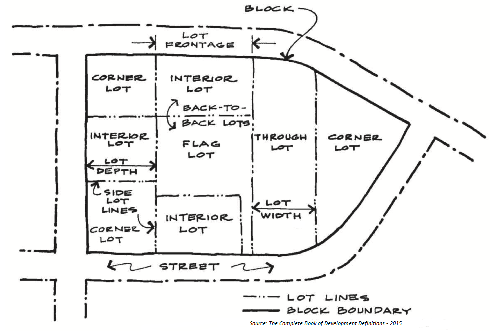
Lot Types
Low Impact Development (LID). A stormwater management approach that uses a suite of hydrologic controls (structural and non-structural) distributed throughout the site and integrated as a treatment train (i.e., in series) to replicate the natural hydrologic functioning of the landscape by infiltrating, filtering, storing, evaporating, and detaining stormwater runoff.
Low-Intensity Agriculture. Agriculture uses that are generally compatible with residential uses, and do not involve noise, odors, dust, chemical spraying and other activities generally incompatible with residential uses.
Lowest Floor (or reference level). The top surface of an enclosed area in a building (including basement) i.e. top of slab in concrete construction or top of wood flooring in wood frame construction. The term does not include the floor of a garage used for parking of vehicles or unfinished storage area provided such garage or storage area is constructed with openings, such as discontinuous foundation walls, parallel sheer walls, open lattice walls, breakaway walls, or combinations thereof.
Main Street (within a PED, Village Center). An "A" Street that serves as the primary nonresidential corridor for a Village Center.
Maintenance Facilities. When used in reference to golf courses means facilities associated with maintaining a golf course including but not limited to equipment wash facilities; chemical mixing, loading and storage facilities; fertilizer storage and mixing facilities; fueling and fuel storage facilities; and waste petroleum storage facilities.
Major Employment Center. Major Employment Centers (MECs) are designated on the Future Land Use Map to provide locations for employment and economic development opportunities. The uses typically found in the MECs include light industrial, manufacturing, warehousing, and office uses, and combinations of these uses.
Manufactured Home. A structure built on an integral chassis and designed to be used as a dwelling unit when connected to the required utilities, fabricated in an offsite manufacturing facility after June 15, 1976, in one or more sections, with each section bearing the HUD Code Seal certifying compliance with the Federal Manufactured Home Construction and Safety Standards Act, designed to be transported for installation or assembly at the building site. Also known as a "HUD-Code Home." This definition does not include recreational vehicle, mobile home or modular home.
Manufactured Home Park. The premises where manufactured or mobile homes are installed for non-transient living or sleeping purposes and where sites or lots are set aside or offered for lease or rent for use by mobile homes for living or sleeping purposes, including any land, building, structure or facility used by occupants of manufactured or mobile homes on such premises. This term shall also apply to condominium sale and ownership of manufactured or mobile home units in compliance with all applicable Florida Statutes.
Manufactured Home Site. A lot or parcel of ground within a manufactured home park, designated for the accommodation of not more than one manufactured or mobile home.
Manufactured Home Subdivision. The premises where manufactured homes are installed for non-transient living or sleeping purposes and where lots are set aside or offered for sale for use by manufactured homes for living or sleeping purposes in accordance with the UDC, including any land, building, structure, or facility used by occupants of manufactured homes on such premises. This term shall also apply to condominium sale and ownership of manufactured home units in compliance with all applicable Florida Statutes.
Marijuana. Has the meaning given Cannabis in this Article.
Marina or Boat Livery. A marina or boat livery is a commercial establishment with a waterfront location for the provision of: rental of covered or uncovered boat slips or dock space or dry storage space rental or sale of boats and boat motors, repair and maintenance of boats and boat motors, marine fuel and lubricants, bait and fishing equipment, on-shore restaurants, and small boat hauling or launching facilities. Marinas and boat liveries shall provide sewage pump-out facilities and employ adequate spill containment equipment if petroleum or other such products are sold on the premises. Such premises or site shall not include boat or motor manufacturing as an incidental use. A boat sales lot is not a marina or boat livery.
Mass. see Building Massing
Maximum Extent Practicable. No feasible or practical alternative exists and all possible efforts to comply with the regulation, or minimize potential adverse impacts have been undertaken. Economic considerations may be taken into account but cannot be the overriding factor in determining "maximum extent practicable".
McCann East 2400 Property. The portion of the properties designated Village Land Use on Figure 9-7; RMA-3; Village/Open Space RMA Land Use Map as outlined in the picture below, all of Sections 5 and 8, and those portions of Sections 6, 7, 17, and 18, all in Township 38 South, Range 19 East, Sarasota County, Florida lying easterly of State Road 93 (Interstate 75) AND A parcel of land lying and being in Section 20, Township 38 South, Range 19 East, Sarasota County, Florida.
Mean High Water Line. Mean high water line is the intersection of the tidal plane of mean high water with the shore as established. (See Florida Statutes Section 177.27).
Median. A portion of a divided roadway or divided driveway separating the travel ways for traffic flowing in opposite directions. A median can either be raised or flush.
Median Opening. A gap in a median provided for crossing and turning vehicles.
Medical Facilities. Uses providing medical or surgical care to patients; some uses may offer overnight care. Examples of Medical Facilities uses include, but are not limited to, blood plasma donation center, medical facility, medical or dental laboratory (NAICS 6214, 6215, 6216, 6219), hospital out-patient clinic (NAICS 6221), medical or dental office or chiropractor (NAICS 6211, 6212, 6213).
Medical Marijuana Dispensary. Any property where Cannabis is sold, purchased, delivered or dispensed for Medical Use. This definition shall include any cooperative effort by Personal Caregivers.
Medical Marijuana Research or Processing. Any property from which marijuana, Cannabis, Cannabis-based products, or Cannabis plants are researched or processed for conversion into a pill, oil, or other consumable product for Medical Use.
Medical Marijuana Treatment Center. An entity that acquires, cultivates, possesses, processes (including development of related products such as food, tinctures, aerosols, oils, or ointments), transfers, transports, sells, distributes, dispenses, or administers marijuana, products containing marijuana, related supplies, or educational materials to qualifying patients or their personal caregivers and is registered by the Department of Health.
Medical Use. The prescriptive use of any form of Cannabis through a Physician Certification to treat a Debilitating Medical Condition and the symptoms associated with that condition as authorized by State law.
Metes and Bounds. A legal description of a parcel of land, generally expressed in terms of distance from a well-marked point and follows the boundaries, using directions and distances around the tract, back to the place of beginning.
Microbrewery. An establishment where beer and malt beverages are duly-licensed to be made on the premises and then sold or distributed, and which produces less than 15,000 barrels (465,000 U.S. gallons) of beer per year.
Microdistillery. A duly-licensed establishment primarily engaged in on-site distillation of spirits in quantities not to exceed 75,000 gallons per year. The distillery operation processes the ingredients to make spirits by mashing, cooking, and fermenting. The micro-distillery operation does not include the production of any other alcoholic beverage.
Mining Activity. The term "mining activity" shall be defined as provided in Chapter 54, Article X, of the County Code.
Minor Modification. An amendment to an approved Master Land Use Plan that may be authorized by the Administrator, as long as they are in harmony with the originally approved plan and conform to those revisions described as a Minor Modification in Section 124-272(o) or to an approved Binding Development Concept Plan consistent with those revisions described in Section 124-53(c)(4).
Mitigation Areas. Areas that are created, restored, enhanced, or preserved, and maintained to compensate for habitat loss.
Mixed Use Building. The combination of either commercial or office and residential uses within a single building of two or more stories, wherein at least 50 percent of the floor area contains residential dwelling unit(s).
Mixed-Use Center. A concentration of non-residential and higher density residential land uses, with borders defined on the Resource Management Area Map.
Mobile Home. A structure built on an integral chassis and designed to be used as a dwelling unit when connected to the required utilities, fabricated in an offsite manufacturing facility before June 15, 1976, in one or more sections, designed to be transported for installation or assembly at the building site. Sections do not carry the HUD Code Seal. This definition does not include recreational vehicle, manufactured home or modular home.
Model Home. A residential structure used for demonstration and sales purposes, not occupied as a dwelling unit, and open to the public for inspection.
Modular Home. A structure designed to be used as a dwelling unit when connected to the required utilities that is in whole or in part manufactured at an offsite facility, built in accordance with F.S. Ch. 553, and regulated by Florida's Department of Economic Opportunity or its successor state agency, and assembled on-site. This definition does not include recreational vehicle, manufactured home or mobile home.
Motel, Motor Hotel or Motor Lodge. See Transient Accommodation.
MultiModal Transportation System. A network of transportation infrastructure that supports multiple modes of travel, including vehicles, transit, walking, and biking.
Multiplex. The multiplex is a series of three or more units, usually under single ownership, consolidated into a single structure (See Section 124-130, Housing Types.)
Myakka River Area. That corridor of land beneath and surrounding the Myakka River from river mile 7.5 to river mile 41.5, contained in Part III, F.S. § 258, together with a corridor of land including the maximum upland extent of wetland vegetation as determined by the Department of Environmental Protection pursuant to F.S. § 373, and Chapters 62-340, Florida Administrative Code.
Myakka River Native Vegetation. Plants that are indigenous to the Myakka River Protection Zone.
Myakka River Protection Zone. An upland buffer that extends 220 feet on each side of the Wild and Scenic segment of the Myakka River (from river mile 7.5 to river mile 41.5) measured from the landward edge of the Myakka River Area.
Myakka River System. As described in Section 2.0 "Resource Description and Assessment" and illustrated in Figure "The Myakka River Watershed" as contained in The Myakka Wild and Scenic River Management Plan, adopted September 2011, pursuant to F.S. § 258.501.
Native. A species whose natural range included Florida at the time of European contact (1500 AD).
Native Habitats. Those areas of Sarasota County described in the Habitat Inventory and Analysis section of the Comprehensive Plan, Environment Chapter, with the exception of Intensive Agricultural Areas and Developed Features.
Natural Areas Parks. Natural areas having few structures and consisting mostly of vegetation, and passive outdoor recreation areas. Examples of natural areas parks include, but are not limited to, nature preserve, game preserve, wildlife management area, refuge, wild animal sanctuary, or water conservation area (NAICS 71219). Natural areas parks also may contain incidental accessory uses such as parking, restroom, canoe/kayak launch, dock or pier (noncommercial), play equipment, or single residential unit for caretaker or security purposes, but the total developed area shall not exceed one percent of the property.
Naturalized Exotic. An exotic species that sustains itself outside cultivation (it is still exotic; it has not "become" native).
Neighborhood.Neighborhoods are characterized by mix of residential housing and neighborhood services that may include schools, parks, neighborhood shopping and houses of worship.
Neighborhood Center. The public core of a Neighborhood, which may be a combination of parks, schools, public type facilities such as churches or community centers and may include small-scale Neighborhood Oriented Commercial Uses.
Neighborhood Oriented Commercial Uses. Retail or office land uses that serve most of the daily needs of residents of the Neighborhood in which it is located.
Neighborhood Resource Center. A building or structure or groups of buildings or structures owned or leased and operated by a charity and not-for-profit organization designated as a 501(c)(3). A Neighborhood Resource Center provides community services including vocational assessment, referral, placement and training services, work experience training, child care services, career and life skills counseling and housing assistance. Consulting for other community services providers, use of the Neighborhood Resource Center as a neighborhood meeting facility, and the acceptance and resale of donated items is allowed. No on-premises rehabilitation or repair of donated items is allowed.
Net Improvement. The performance standard for the treatment of stormwater wherein the pollutant loads discharged from the existing land use of the project area are reduced.
Net Residential Acre. The number of acres within the boundary of a development area excluding areas devoted to Open Space, stormwater retention areas, wetlands, Recreational Space, parks and nonresidential development.
Nightclub. A nightclub shall mean a restaurant, dining room, bar, or other similar establishment providing food or beverages wherein entertainment is provided indoors for customers as a part of the commercial enterprise. This definition includes any activities approved by a special exception for a nightclub prior to October 27, 2003. See also the definition of Entertainment.
Nonconformities. See Article 15, Nonconformities.
Non-Medical Marijuana Sales. The purchase, sale, transfer or delivery of marijuana, Cannabis, Cannabis-based products or Cannabis plants when such sale, transfer or delivery is not associated with any medical purpose or use, whether or not such purchase, sale, transfer or delivery is lawful under federal or state law.
Non-Point Source Pollution. Means diffuse pollution sources without a single point of origin or introduced into a receiving stream not from a specific outlet. The pollutants are generally carried off the land by stormwater runoff.
Nonresidential Use. Office, Business, commercial, including retail uses, or light industrial uses.
Non-Restrictive Median. A median or painted centerline which does not provide a physical barrier between center traffic turning lanes or traffic lanes traveling in opposite directions. This includes highways with continuous center turn lanes and undivided highways.
Nuisance. A species that threatens native species' abundance or diversity or the stability of an ecosystem or ecosystem process by it aggressive growth habit.
Nursing Home or Extended Care Facility. See Assisted Living Facility.
Occupied. The term "occupied" includes arranged, designed, built, altered, converted to, or intended to be used or occupied.
Office. Activities conducted in an office setting and generally focusing on business, government, professional, medical or financial services. Examples of Office uses include, but are not limited to, advertising office, bank (with or without drive-thru), business management consulting, data processing, financial business such as lender, investment or brokerage house, collection agency, real estate or insurance agent, professional service such as lawyer, account, bookkeeper, engineer, architect, sales office, travel agency (NAICS 518, 52, 5312, 54 [except 54194], 55, 561), counseling in an office setting, government office, tv and radio studio, utility office, medical facilities.
Open Space. For the purpose of the UDC, open space shall be property under public or private ownership which is unoccupied or predominately unoccupied by buildings or other impervious surfaces and which is used for parks, recreation, agriculture, conservation, preservation of native habitat and other natural resources, surface water impoundment, historic, or scenic purposes.
Open Space (2050). For the Village/Open Space RMA, Conservation Subdivisions, and the Urban/Suburban Settlement Area, that land area exclusive of Developed Area identified and depicted on a Master Land Use Plan approved pursuant to Sarasota 2050 RMA Policy and Article 14 of the UDC.
Outdoor Display. The outdoor display of products actively available for sale for less than 24 hours a day. This definition does not include products in shipping boxes, crates, on pallets, or other shipping containers, which shall be considered outdoor storage.
Outdoor Farmers Market. An outdoor facility with or without a structure principally for the sale of produce, plants, and flowers. Value-added agricultural products such as honey or jam, along with hand-made craft items, may be sold, provided their sale is ancillary to the sale of produce, plants and flowers.
Outdoor Storage. The outdoor storage of products, whether for sale or as material for processes occurring on the site, generally for more than 24 hours a day. This definition expressly includes any products on pallets, in shipping containers or in crates.
Outparcel. A parcel of land, generally located on the perimeter of a larger parcel of commercial or industrial land and subordinate to the larger parcel for access, parking or drainage purposes. An outparcel does not have to be in the same ownership as the main parcel.
Outside Radius. The outside or larger curve radius on the edge of a driveway.
Owner. The person or entity having the right of legal title or beneficial interest in a lot or parcel of land. This person or entity may also be the developer.
Package or Liquor Store. A package store is a place where alcoholic beverages are dispensed or sold in containers for consumption off the premises.
Packing House. A packing house is a facility for packaging fruits or vegetables, but not including the packaging of citrus concentrate on the premises.
Pain Management Clinic. A privately-owned clinic, facility, or office, whatever its title, including, but not limited to, a "wellness center," "urgent care facility," or "detox center," which engages in pain management. This definition includes the following:
(a)
A pain management clinic must have at least one of the following characteristics:
(1)
It employs one or more physicians licensed under F.S. Ch. 458 or 459, who in single day issue more than 20 prescriptions of a controlled substance for the treatment of pain;
(2)
It holds itself out through advertising as being in business to prescribe or dispense a controlled substance for the treatment of pain;
(3)
It holds itself out through advertising as being in business to provide services for the treatment of pain wherein the services are accompanied with prescription of or dispensing of a controlled substance for the treatment of pain; or
(4)
It meets the definition of pain management clinic in F.S. § 458.3265.
(b)
A pain management clinic does not include any privately-owned clinic, medical facility or office which has at least one of the following characteristics:
(1)
It employs physicians, the majority of whom provide services in the clinic, facility, or office; primarily provide surgical services (excluding interventional pain management procedures that are invoiced or coded as surgical procedures) as measured over a one-month time period;
(2)
It is licensed as a facility pursuant to F.S. Ch. 395 (hospitals, etc.), excluding outpatient facilities that provide pain management services as outlined in subsection (a) above; or
(3)
It does not prescribe or dispense controlled substances for the treatment of pain.
Park. Any property used for recreation activities including, but not limited to, recreation facilities, sports facilities, beaches, trails and natural areas.
Park, Community. A park typically between 15 acres and 50 acres, that serves the needs of more than one neighborhood and provides a broad range of passive and semi-active recreational and social opportunities for youth and adults. (see Comprehensive Plan Vol. II, Parks, Preserves and Recreation).
Park, Signature/Specialized. A park typically between 50 acres and 100 or more acres, that serves an entire community and provides a broad range of unique passive and semi-active recreational and social opportunities for youth and adults. (see Comprehensive Plan Vol. II, Parks, Preserves and Recreation).
Park, Linear. A linear open space established along either a natural corridor, such as a riverfront or slough, or over land along a railroad right-of-way converted to recreational use, a canal, a scenic road, or other route; any natural or landscaped course for pedestrian or multi-modal passage; an open space connector linking parks, natural areas, cultural features, or historic sites with each other and with populated areas. A linear park may also facilitate the dispersal of plants and animals between habitats as a secondary function.
Park, Neighborhood. A park typically between 1 acre and 15 acres, that serves the population of a neighborhood, is generally accessible by bicycle or pedestrian ways, and provides a range of passive and semi-active recreational and social opportunities for youth and adults. Smaller sites with unique features may also qualify. (see Comprehensive Plan Vol. II, Parks, Preserves and Recreation).
Park, Regional. A large resource-based park or sports complex that serves a county, multi-county, or multi-city area across political jurisdictions. Examples include beaches, boat ramps, large athletic complexes, regional trails, and natural areas with unique features.
Parks and Open Areas. Uses focusing on natural areas having few structures and consisting mostly of vegetation, and passive or active outdoor recreation areas. Examples of Parks and Open Areas uses include, but are not limited to, botanical garden, nature preserve, recreational trail (NAICS 71231), game preserve, wildlife management area, refuge, wild animal sanctuary, water conservation area (NAICS 71219), reservoir, control structure, drainage well, water supply well and may also contain accessory uses such as canoe/kayak launch, community garden, concession stand, dock or pier (noncommercial), play equipment, recreational trails/boardwalks, research or similar lab facilities, single residential unit for caretaker or security purposes.
Parking, Commercial.Facilities that provide parking not accessory to a principal use, for which a fee may or may not be charged. Examples of Commercial Parking uses include, but are not limited to, mixed parking lot (partially accessory to a specific use, partly to rent for others), short-and long-term fee parking facility (NAICS 812930), including park-and-ride facilities.
Parking Space, Off-Street. A space, meeting the minimum design standards of Article 8 of the UDC, adequate for parking a standard size automobile with room for opening doors on both sides, together with properly related access to a public street or alley and maneuvering room.
Parking, Off-Street. Area located outside of any street right-of-way or easement and designed to accommodate the parking of domestic vehicles.
Parking, On-Street. Area located inside of any street right-of-way or easement and designed to accommodate the parking of domestic vehicles.
Passenger Terminal. Public or commercial facilities for the takeoff and landing of airplanes and helicopters, and terminals for taxi, rail or bus service. Examples of Passenger Terminal uses include, but are not limited to, airport, heliport (NAICS 481), bus passenger terminal, taxi dispatch center, train passenger terminal (NAICS 485), scenic and sight-seeing tour.
Patient Family Accommodations. A dwelling unit or other accommodation used as a dwelling unit or other place of human habitation with sleeping accommodations that is rented, leased or subleased for less than monthly periods for the exclusive use of patients and their family and friends. Monthly shall mean either a calendar month or 30 days.
Patio House. A single-family detached dwelling unit, similar to a lot line house, placed on a small lot. Due to the modest area of the lot, the rear yard is enclosed by a wall, while still preserving a narrow street yard. Where an alley is provided, all garage access must take place from the alley (see Section 124-130, Housing Types).
PCP. Means a permanent control point and shall be considered a reference monument as defined in F.S. Ch. 177.
Personal Caregiver. A person who is at least 21 years old who has agreed to assist with a qualifying patient's medical use of marijuana and has a caregiver identification card issued by the Department of Health. A personal caregiver may assist no more than five qualifying patients at one time. An employee of a hospice provider, nursing, or medical facility may serve as a personal caregiver to more than five qualifying patients as permitted by the Department of Health. Personal caregivers are prohibited from consuming marijuana obtained for the personal, medical use by the qualifying patient.
Pervious Pavement System. A low impact development technique using numerous types of alternative pavement systems (e.g., permeable pavers, pervious asphalt, and pervious concrete) that allows stormwater to infiltrate into a subsurface drainage system then into the parent soil.
Pervious Surface. A surface made of penetrable materials that allows water to infiltrate to the soil layer.
Pesticides. Fungicides, insecticides, nematicides, herbicides, algicides and any other chemicals used to control pests, weeds, or diseases.
Pet Resort. A facility offering specialized services for domesticated household pets such as day care, grooming, manicuring, bathing, clipping and styling, lodging, exercising, and/or training, including daily and/or overnight stays.
Physician. One educated, clinically experienced, and licensed to practice medicine in the State of Florida.
Physician Certification. When used in reference to medical marijuana, a written document signed by a physician, stating that in the physician's professional opinion, the patient suffers from a debilitating medical condition, that the potential benefits of the medical use of marijuana would likely outweigh the health risks for the patient, and for how long the physician recommends the medical use of marijuana for the patient. A physician certification may only be provided after the physician has conducted a physical examination of the patient and a full assessment of the patient's medical history.
Place of Worship. A building or structure, or groups of buildings or structures that by design, construction or use are intended for conducting organized religious services and associated accessory uses by religious institutions. A religious institution is a church, synagogue, ecclesiastical or denominational nonprofit corporation.
Plan, Conceptual. A general graphic and informational representation of a design proposal for a development phase or the entirety indicating existing and proposed uses, contours, lots, blocks, streets, structures, and other physical aspects of the land proposed for development.
Plan, Construction Best Management Practices. (Also known as, "Erosion and Sediment Control Plan.") Plans depicting structural or nonstructural pollution prevention measures as described in the most recent version of State of Florida Erosion and Sediment Control Designer and Reviewer Manual prepared by the Florida Department of Transportation and the Florida Department of Environmental Protection.
Plan, Construction Engineering. Plans and specifications, prepared with applicable documents submitted through the Subdivision or Site Development Plan approval process, for improvements such as; stormwater management, excavation and fill, bulkheads, sidewalks, paving and drainage plans, etc. Said plan must conform to an approved Subdivision or Site Development Plan.
Plan, Final Construction Engineering. Set of Construction Engineering Plans and specifications and Final Plat submitted through the Subdivision or Site Development Plan approval process. Said plan must conform to an approved Subdivision or Site Development Plan.
Plan, Final Subdivision or Site Development. Includes the plat to be recorded; final engineering plans, specifications and calculations; certification of improvements, as-built drawings, or performance guarantee; and other required certifications, bonds, agreements, approvals, and materials, for a development phase or the entirety of a parcel of land, meeting the requirements of the UDC.
Plan, Master. A graphic and informational representation of a specific design solution for the total area under unified control, designed and planned to be developed in a single operation by a series of prescheduled development phases, as in Planned Unit Development or Planned Industrial Development, showing the intended division or improvements of the property.
Plan, Residential Site. A plan, drawn to scale, for the development of the site which shows all proposed and existing structures, dimensions of all setbacks, all proposed changes in grade, direction of flow or surface drainage, and all existing and proposed features such as, but not limited to: driveways, drainage pipes, swales, culverts, patios and swimming pools.
Plan, Site. A scaled graphic and informational representation of a specific design solution for a development phase or the entirety on which is shown an area location map; existing and proposed topography, streams, rights-of-way, easements, structures, wooded areas and water bodies; provisions for ingress and egress; off-street parking, loading, refuse and service areas; necessary facilities and utilities; required yards, open spaces, and recreational uses and facilities; proposed landscaping, fencing, screening and buffering and provision for trees protected or required by County regulations; proposed signs and lighting; and any other information that may be necessary or reasonably required.
Plan, Subdivision or Site Development. A map or plan upon which is delineated development activities and other such information as may be required to depict all such information as may be required to depict all such activities and showing how it will impact the site and how such development is in compliance with all pertinent County ordinances, resolutions, and policies. Specifically, a plan submitted through the Subdivision or Site Development Plan approval process.
Planned Development. A planned development is a type of development that includes all of the following characteristics:
(a)
Is land under unified control, planned and developed as a whole in a single development operation or approved programmed series of development operations;
(b)
Includes principal and accessory uses and structures substantially related to the character of the development itself and the surrounding area of which it is a part;
(c)
Is developed according to comprehensive and detailed plans which include not only streets, utilities, lots, or building sites and the like, but also site plans, floor plans, and elevations for all buildings as intended to be located, constructed, used, and related to each other, and detailed plans for other uses and improvements on the land as related to the buildings; and
(d)
Includes a program for full provision maintenance, and operation of such areas, improvements, facilities, and services as will be for common use by some or all of the occupants of the planned development, but will not be provided, operated, or maintained at public expense.
Planning Director. The Director of the Planning and Development Services Department or designees.
Planting Strip. A grassed strip of land with a row of street trees that is located between a sidewalk and a travel or parking lane. In urban areas, planting strips are often replaced by street trees planted in tree pits, wells, or vaults that are recessed into a sidewalk that extends to the curb.
Plat. A map or drawing prepared under the direction of, signed and sealed by a Professional Surveyor and Mapper as defined, executed and recorded in the Office of the Clerk of the Circuit Court of Sarasota County in the manner authorized by laws regulating the platting of land in the State of Florida, Chapter 177, Part 1 Platting, and Sarasota County depicting the division of land into streets, lots, blocks, parcels, tracts, sites, or other divisions however designated, and includes the terms, when applicable, "replat". To "Plat" means, in whatever tense used, to divide or sub-divide lands into lots, blocks, parcels, tracts, sites, or other divisions however designated.
Playing Surface. All parts of the golf course within course boundaries where play occurs: tees, greens, fairways and roughs.
Plaza. A public space at the intersection of streets devoted to civic purposes and temporary commercial activities, such as craft shows, farmers markets, etc. A plaza is surrounded by streets with facing buildings and includes lawns, trees, walks, ornamental structures, buildings and durable pavement for parking.
Plot. See Lot.
Point Source Pollution. Any source of water or air pollution that constitutes a discernible, confined, and discrete point of discharge. For the purposes of the National Pollutant Discharge Elimination System, stormwater runoff from construction activity is considered to be a point source of discharge.
Porch. A porch is a roofed-over space, with the roof impervious to weather, attached to the outside of an exterior wall of a building, which has no enclosure other than the exterior walls of such building. Open mesh screening shall not be considered an enclosure.
Porte Cochere. A roofed porch or portico-like structure extending from the side entrance of a building over an adjacent driveway to shelter those getting in or out of vehicles. A porte cochere has no front or rear wall and differs from a carport in that it is not used to store parked vehicles.
Post-Disaster Temporary Dwelling. Shall mean a manufactured home, mobile home, or a recreational vehicle (RV) permitted pursuant to a disaster, as defined herein, meeting the criteria established under Temporary Use Permits.
Post Office. A facility designated or licensed by the federal government to sell U.S. postage stamps and U.S. postal products and accept mail and packages for delivery to addresses.
Pre-Engineered Metal Building System. Pre-engineered metal building system means a metal structure having an exterior finish guaranteed against rust for at least 20 years by the manufacturer, modularly designed to enable replication on a mass basis through standardized structural systems, the plans for which are signed and sealed by a Florida Registered Professional Engineer and meet the hurricane wind loading requirements and other applicable provisions of the Building Code for commercial buildings.
Preliminary Contamination Assessment Plan (PCAP) and Report (PCAR). A study plan and report specified by the Florida Department of Environmental Protection to assess potential contamination associated with landfills. Elements of PCAP/PCAR typically include a determination of the direction of groundwater flow, an assessment of on-site and downstream groundwater flow, an assessment of on-site and downstream groundwater and surface water quality and an assessment of landfill gases.
Preservation or Preserve. To set aside in perpetuity, areas of native habitat that must not be disturbed, in accordance with the Principles for Evaluating Development Proposals in Native Habitats in the Environment Chapter of the Comprehensive Plan.
Preservation or Preserve Trees. Those trees to be preserved as specified in a county Tree Permit pursuant to Chapter 54, Article XVIII, Trees Code, of the County Code.
Principle Entrance. Entrance of a structure in which a primary access point is provided.
Private Edge Condition.A development block that is permitted to create a single row of lots or building sites as an edge or boundary.
PRM (Permanent Reference Monument). A monument as defined in F.S. Ch. 177.
Prototype. A generalized development diagram that illustrates the basic design principles to be applied to actual development conditions.
Public/Civic. A class of land uses that includes the following Public and Civic Use Categories, as defined within this UDC: Community Services, Education Facilities, Government Facilities (limited to City, county, state or federal government office, Emergency services, fire, sheriff, or Post office) and Places of Worship.
Public Edge Condition.A requirement for development blocks to share a public street as a common edge or boundary.
Public Entrance. An exterior doorway primarily intended for public egress and ingress into a building.
Public Facilities. Public facilities shall mean major capital improvements, including but not limited to, transportation, sanitary sewer, solid waste, drainage, potable water, educational, parks and recreational, and health systems and facilities.
Public Space. Any publicly accessible square, plaza, or green, that is available for passive or active recreation.
Public Stormwater Management Facility. Those drainage systems indicated on the Sarasota County Drainage Canals Map (Cow Pen Slough, Vegetable Relief Channel, Big Slough Canal, Blackburn Canal, Alligator Canal, Drainage Canal No. 22, Main Canal No. 1, Sarasota-Fruitville Drainage District Canal, etc.), or as otherwise designated by the Board.
Qualifying Patient. A person who has been diagnosed to have a debilitating medical condition, who has a physician certification and a valid qualifying patient identification card. If the Department of Health does not begin issuing identification cards within nine months after the effective date of this section, then a valid physician certification will serve as a patient identification card in order to allow a person to become a "qualifying patient" until the Department of Health begins issuing identification cards.
Quonset Hut. A Quonset hut is any lightweight prefabricated or pre-engineered structure (i.e., corrugated steel, fiberglass, etc.) regardless of the design type or finish that may require assembly on site. Examples include, but are not limited to the following types:
 |  |
Receiving Site. Land located within a Receiving Zone, which has been designated in an approved Master Plan as land to which developed Development Rights may be transferred.
Receiving Zone.An overlay zoning district established by the County to which Development Rights can be transferred.
Recreation, Indoor. Generally commercial uses, varying in size, providing daily or regularly scheduled recreation-oriented activities in an indoor setting. Examples of Indoor Recreation uses include, but are not limited to, Adult Entertainment, bar or tavern (NAICS 7224), convention center, extreme sports such as paintball, BMX facility or skateboarding facility, gymnastic facility, martial arts facility, fitness gym, dance studio, indoor sports academy, pool hall (NAICS 71399), bowling alley (NAICS 71395), game arcade (NAICS 71321), indoor firing range (NAICS 713990), membership club or lodge (NAICS 8134), movie or other theatre (NAICS 512131, 7111).
Recreation, Outdoor. Generally commercial uses, varying in size, providing daily or regularly scheduled recreation-oriented activities. Such activities may take place wholly outdoors or within a number of outdoor structures. Examples of Outdoor Recreation uses include, but are not limited to, circus grounds (NAICS 71119), commercial hunting and trapping (NAICS 114210), drive-in theater (NAICS 512132), outdoor flea market, executive par-three golf course, extreme sports facility such as paintball, BMX facility or skateboarding facility, golf course, country club (NAICS 71391), outdoor recreation activity such as archery range, batting cage, golf driving range, mini-amusement park, miniature golf facility, outdoor firing range, swimming pool, tennis court, water park, riding academy or public stable (NAICS 71399), Polo club, recreational vehicle (RV) park, campground, commercial hunting or fishing camp, dude ranch (NAICS 7212), sports academy for active recreational or competitive sports, stadium or arena, dog or horse track, motor vehicle racing track or facility, Jai-alai fronton, commercial amphitheater, ballfield (NAICS 7112, 71131), tourist attraction (commercial), wilderness camping, winter quarters or training quarters.
Recreational Space. For the Village/Open Space RMA and the Urban/Suburban RMA Settlement Area, lands within the Developed Area of a Village, Settlement Area or Hamlet that are required to meet the recreational needs of residents.
Recreational Vehicle. A recreational vehicle-type unit primarily designed as temporary living quarters for recreational, camping or travel use, which either has its own motor power or is mounted on or drawn by another vehicle. Recreational vehicle-type units, when traveling on the public roadways of the State of Florida, must comply with the length and width provisions of F.S. § 316.515, as that section may hereafter be amended. As defined below, the basic entities are:
(a)
The "travel trailer," including a fifth-wheel travel trailer which is a vehicular portable unit, mounted on wheels of such a size or weight as not to require special highway movement permits, which are drawn by a motorized vehicle. It is primarily designed and constructed to provide temporary living quarters for recreational, camping or travel use. It has a body width of no more than eight and one-half feet and an overall body length of no more than 40 feet when factory-equipped for the road.
(b)
The "camping trailer," which is a vehicular portable unit mounted on wheels and constructed with collapsible partial sidewalls which fold for towing by another vehicle and unfold at the campsite to provide temporary living quarters for recreational camping or travel use.
(c)
The "truck camper," which is a truck equipped with a portable unit designed to be loaded onto or attached to the bed or chassis of the truck and constructed to provide temporary living quarters for recreational camping or travel use.
(d)
The "motor home," which is a vehicular unit which does not exceed 40 feet in length and the height and the width limitations provided in F.S. § 316.515, is a self-propelled motor vehicle and is primarily designed to provide temporary living quarters for recreational, camping or travel use.
(e)
The "private motor coach," which is a vehicular unit, which does not exceed the length, width and height limitations provided in F.S. § 316.515(9), is built on a self-propelled bus type chassis having no fewer than three load-bearing axles, and is primarily designed to provide temporary living quarters for recreational, camping or travel use.
(f)
The "van conversion," which is a vehicular unit which does not exceed the length and width limitations provided in F.S. § 316.515, is built on a self-propelled motor vehicle chassis, and is designed for recreation, camping and travel use.
(g)
The "park trailer," which is a transportable unit which has a body width not exceeding 14 feet and which is built on single chassis and is designed to provide seasonal or temporary living quarters when connected to utilities necessary for operation of installed fixtures and appliances. The total area of the unit in a setup mode, when measured from the exterior surface of the exterior stud walls at the level of maximum dimensions, not including any bay window, does not exceed 400 square feet, when constructed to ANSI A-119.5 standards, and 500 square feet when constructed to United States Department of Housing and Urban Development Standards. The length of a park trailer means the distance from the exterior of the front of the body (nearest to the drawbar and coupling mechanism) to the exterior of the rear of the body of the opposite end of the body), including any protrusions.
Recreational Vehicle Park/Campground. A place with six or more sites set aside and offered by a person or public body, for lease, rent or sale in any form to be occupied by recreational vehicles or tents utilized for sleeping or eating. The term also includes accessory buildings, sites set aside for group camping, and similar recreational facilities. A recreational vehicle park is not intended to be used for permanent, year-round occupancy and no recreational vehicle in any such park shall be occupied on a permanent basis. The terms campground, camping resort, RV resort, travel resort, and travel park or any variations of these terms, shall be considered synonymous with the term recreational vehicle park.
Redevelopment. Redevelopment is the construction, installation, replacement, reconstruction, alteration or other material change of a structure, impervious surface, drainage facility or part thereof on a previously developed site requiring a development order or permit.
Redevelopment Corridor. Land fronting certain roadways in the Urban Service Area, as defined in the Comprehensive Plan's Resource Management Area (RMA) definitions.
Regional brewery. A duly-licensed brewery with an annual beer production of between 15,000 and 6,000,000 barrels. A regional brewery may include a taproom as an accessory use.
Regional Stormwater Facility (relates to VPD, HPD, and SAPD Regulations only). A stormwater management facility located down gradient of a significant portion of a village or hamlet that treats or attenuates runoff from the developed area and potentially from additional off-site contributing areas. Such facilities must provide significant public benefit such as serving as an alternative irrigation source, providing treatment of runoff from lands not currently served by stormwater facilities, or providing relief to flooding. A maximum of ten percent of the total open space requirement is permitted to be fulfilled by regional stormwater facilities.
Rehabilitative Clinic. A rehabilitative clinic is an establishment where persons who are dependent on toxic substances, such as drugs or alcohol, are counseled in individual or group therapy sessions. Such establishments shall be licensed by the State of Florida and regulated by Florida Statute. Persons shall not be lodged overnight in rehabilitative clinics.
Repair and Maintenance, Sign. Work necessary to keep the sign, including the sign structure, in a good state of repair; but shall not include replacement of materials in the sign structure or any change to the graphics or message displayed.
Residential Character. The combination of qualities or features of a structure or area resulting in the perception that the structure or area is primarily used for the purpose of residential dwellings.
Residential Leasing Office. An on-site office offering exclusively the sale, leasing or rental of multifamily residential units located within that specific multifamily residential complex.
Residential Migrant Housing. A dwelling unit or dwelling units, which may be a single-family, multifamily, or mobile home, together with the land appertaining thereto, constructed, established, or furnished as an incident of employment on the same parcel of land as living quarters for seasonal, temporary, or migrant farmworkers whether or not rent is paid or reserved in connection with the use or occupancy of such premises. Any single-family or mobile home dwelling unit which is not adjacent to or contiguous with other residential migrant housing, and which is occupied by one migrant farmworker family, shall be excluded from this definition.
Residential Use. The use of land, buildings or structures for uses which include but are not limited to community residential facilities, dwelling units, fraternity and sorority houses, life care treatment facilities, private pleasure craft used as a residence, professional residential facilities and temporary living facilities.
Resource Extraction. Means industries, processes, procedures and techniques related to extraction of natural or other resources from the land.
Resource Management Area (RMA). Geographic area where voluntary alternative development forms are available to landowners. The RMAs function as an overlay to the adopted Future Land Use Map and do not affect the existing rights of property owners to develop their property as permitted under the Future Land Use Map or the UDC.
Resource Management Plan. Means a written document that addresses the manner in which the values and functions of native habitats designated as preservation or conservation areas within developments or on public lands will be maintained in perpetuity, and identifies the entity responsible for maintaining these habitats (see Article 9).
Restaurant. An establishment where food and drink are prepared, served and consumed primarily within the principal building.
Restrictive Covenants. Perpetual covenants restricting use of property for the purpose of maintaining open space, protecting native habitats, and reflecting any transfer of density, in order to assure compliance with the requirements of the Comprehensive Plan and County regulations. The Covenant shall be enforceable by the County and be in a form approved by the County Attorney.
Restrictive Median. The portion of a divided highway or divided driveway physically separating vehicular traffic traveling in opposite directions. Restrictive medians include physical barriers that prohibit movement of traffic across the median such as a concrete barrier, a raised concrete curb or island, and a grass or a swale median.
Retail Sales and Service. Companies or Individuals involved in the sale, lease, or rental of new or used products, or providing personal services or repair services to the general public. Examples of Retail Sales and Service uses include, but are not limited to, "Personal Service Oriented", to include animal grooming (NAICS 81291), animal hospital or veterinarian, with or without animal boarding (NAICS 54194), pet resort, athletic, tennis, swim or health club, art, music or photographic studio or classroom, dry-cleaning or laundry drop-off facility, laundromat (NAICS 81231, 81232), funeral home or mortuary, hair, nail, tanning, massage therapy and personal care service (NAICS 8121), photocopy, blueprint, package shipping and quick-sign service (NAICS 561439) psychic or medium, security service, taxidermist, urgent care or emergency medical office, repair oriented (appliance, bicycle, computer, jewelry, musical instrument, office equipment, radio, shoe, television or watch), tailor, millner upholsterer (NAICS 8112, 8114), locksmith (NAICS 561622), medical marijuana dispensaries.
Retreat Center. A private establishment consisting of a detached structure or structures located in a setting in which lodging units are offered to transients for compensation as the principal use, along with conference and meeting facilities, restaurant or banquet facilities, and recreational amenities.
Return Radius. The pavement radius of the arc between the edge of pavement of the access facility and the edge of pavement of the abutting road used to facilitate vehicular turning movements.
Rezoning. An amendment to the Official Zoning Map changing the classification of a parcel or parcels of land.
Riding Academy. An establishment where horses are boarded, cared for, shown or sold, and where instruction in riding, jumping and showing is offered, and where horses may be hired for recreational or therapeutic riding.
Right-In/Right-Out Access. An access located on a divided roadway with a continuous median prohibiting left-turn access into or out of the driveway.
Right-of-Way. Public or private land dedicated, deeded, used, or to be used for street, alley, walkway, boulevard, drainage facility, access for ingress and egress (except for residential ingress/egress easements for a single-family lot), or other purpose by the public, certain designated individuals, or governing bodies.
Road.See Street.
Roadway Level of Service (LOS). A qualitative measure describing operational conditions within a traffic stream. Level of service is based on factors such as speed and travel time, freedom to maneuver, traffic interruptions, comfort and convenience, and safety. Level of service designations range from A to F, with LOS A representing the best operating conditions and LOS F the worst.
Roof-Deck Townhouse. See Section 124-130, Housing Types.
Rooming House. A rooming house is an establishment where lodging only is provided for compensation for one or more persons in a group that does not constitute a single housekeeping unit. A rooming house is intended to provide lodging accommodations for monthly periods or longer. Such accommodations are not considered transient.
Rooming Unit. A room or group of rooms forming a single habitable unit, used or intended to be used for living and sleeping, but not for cooking or eating.
Rural Retreat Center. A building or structure, or group of buildings or structures located in areas designated as Rural on the Comprehensive Plan Future Land Use Map that are intended to be reserved in advance for conducting organized group meetings or events. Rural retreat centers may include meeting rooms, common dining facilities, overnight accommodations and an auditorium or sanctuary.
Sanitary Sewerage System, Central. A system designed for the collection, transmission, treatment, reuse distribution or disposal of wastewater with capacity of two thousand (2,000) gallons per day or more (includes pipes and ancillary equipment, lift stations, tanks, treatment plant, disposal system, effluent lines and all other appurtenances).
Sanitary Sewerage System, On-Site (including septic tanks). A system of piping, tanks or other facilities with a treatment capacity of less than two thousand (2,000) gallons per day.
Scenic and Sightseeing Tours. Scenic and sightseeing transportation on land. The services provided are local and involve same-day return to place of origin.
Secondary Treatment. Wastewater treated to a level that will achieve the effluent limitations as specified in current State legislation.
Self-Service Storage. Facilities providing separate storage areas for personal or business use designed to allow private access by the tenant for storing or removing personal property. Examples of Self-Service Storage uses include, but are not limited to, mini-warehouse, multistory enclosed storage facility, storage garage (NAICS 53113), with accessory uses such as outside storage of boats and campers, residential unit for security purposes (single unit) and rental of light or medium trucks.
Self-Service Storage (Enclosed). Facilities providing separate storage areas for personal or business use, designed specifically to be entirely enclosed. Self-service storage (enclosed) shall feature a design in which the facility is enclosed, climate-controlled, and exclusively internally accessed. No outdoor storage or exterior accessed storage space is permitted at a self-service storage (enclosed) facility. Accessory uses such as an accessory administrative office and residential unit for security purposes (single unit) are permitted.
Semi-Attached Townhouse. See Section 124-130, Housing Types.
Sending Site. A parcel of land located within a Sending Zone from which Development Rights may be transferred which is designated in an approved Master Plan.
Sending Zone. An overlay zoning district established by the County identifying land areas from which Development Rights can be transferred.
Service Function Area. An equipment area. Loading area or dock, trash collection area, trash compaction area, truck-parking area, recycling area, or other similar service function area.
Settlement Area. Those areas of Sarasota County shown as Settlement Area with the Urban/Suburban RMA on Map 8-1: RMA-1 Resource Management Areas, and Map 8-4: RMA-4 Settlement Area Land Use Map of the Future Land Use Map Series within the Comprehensive Plan. Settlement Area urban forms are limited to those lands between the existing USB and the Future USB on the FLUM.
Settlement. See Urban/Suburban Settlement.
Settlement Area Planned District (SAPD). A planned development zoning district that is used to implement the Comprehensive Plan within those areas of Sarasota County shown as Settlement Area within the Urban/Suburban RMA on Map 8-1: RMA-1 Resource Management Areas and Map 8-4: RMA-4 Settlement Area Land Use Map of the Future Land Use Map Series within the Comprehensive Plan.
Sexually Oriented Business Uses.
(a)
Adult Bookstores, Adult Video Stores, and Sexual Device Shops, as defined in Section 26-32 of the County Code, are permissible in only CG, CI and CSC zoned areas of unincorporated Sarasota County. No special exception is necessary.
(b)
Adult Motion Picture Theaters and Adult Motels, as defined in Section 26-32 of the County Code, are permissible by special exception in only CG, CI and CSC zoned areas of unincorporated Sarasota County.
(c)
Semi-Nude Model Studios, as defined in Section 26-32 of the County Code, are permissible in only CG and CI zoned areas of unincorporated Sarasota County. No special exception is necessary.
(d)
Adult Cabarets and Sexual Encounter Centers, as defined in Section 26-32 of the County Code, are permissible by special exception in only CG and CI zoned areas of unincorporated Sarasota County.
All Sexually Oriented Business uses shall comply with the licensing and other provisions of the Sexually Oriented Business Code, Chapter 26, Article II of the County Code.
Shade/Street Tree. A self-supporting woody plant, typically having a minimum height at maturity of at least 20 feet, planted primarily for its high crown of foliage.
Shallow Bioretention. A low impact development technique using shallow landscaped depressions with soils, mulch, and planted vegetation intended to capture, treat, and infiltrate stormwater runoff.
Shared Access. A single connection serving two or more adjoining lots or parcels. Also known as joint access.
Shoreline. The line where a body of water and the land meet, including, as applicable, the strip of land typically affected by the seasonally or tidally influenced rise and fall of water; see also Mean High Water Line.
Short Term Rental. Rental of a residential dwelling unit in an RMF District on the Barrier Islands for a period of less than 30 days. A short-term rental is not a transient accommodation.
Shoulder. The portion of the highway contiguous with the travel way for the accommodation of stopped vehicles and for emergency use.
Sight Distance. The distance visible to the driver of a passenger vehicle measured along the normal travel path of a roadway to a specified height above the roadway when the view is unobstructed by traffic.
Sign. Any device designed to inform or attract attention.
Sign Permit. A Sign Permit is a Building Permit issued for a sign.
Significant Historic Resources. Those properties that are listed as significant historic resources in accordance with Chapter 66, Article III, Section 66-74(a), of the County Code, and those included in the "Director's List of Significant Historic Resources in Sarasota County" in accordance with Chapter 66, Article III, Section 66-74(c).
Single-Family Detached House. See Section 124-130, Housing Types.
Single Housekeeping Unit. One person or two or more individuals living together sharing the entire dwelling unit and household responsibilities and activities which may include: (1) sharing expenses for food, rent, utilities or other household items; (2) sharing chores; (3) eating meals together; (4) participating in recreational activities together; and (5) having close social, economic, and psychological commitments to each other.
Site Development Plan. See Plan, Site Development.
Site Development Plan Approval. Approval granted by the County Administrator, or designated representative, authorizing site development in accordance with a map or plan upon which are delineated development activities in sufficient detail to indicate the impacts of the proposed development and whether the proposed development is in accordance with pertinent laws, ordinances, resolutions, and policies of the County.
Site Redevelopment Plan. A redevelopment plan is a graphic and narrative identification and description of proposed site and building improvements that are required by or relied upon by the standards contained in Section 124-129 of the UDC.
Social Services Institutions. Uses that primarily provide exclusive care and treatment of those with psychiatric, alcohol, or drug problems, and transient housing related to social service programs. Examples of Social Services Institutions uses include, but are not limited to, alternative- or post-incarceration facilities, neighborhood resource centers, rehabilitative clinic, social service facility soup kitchen, transient lodging or shelter for the homeless (NAICS 624, 6242).
Soils. Defined in the current United States Department of Agriculture, Natural Resources Conservation Service (NRCS), Soil Survey of Sarasota County, Florida.
Special Exception. A special exception is a use that would not be appropriate generally or without restriction throughout a zoning division or district but which if controlled as to number, area, location, or relation to the neighborhood, would promote the public health, safety, welfare, morals, order, comfort, convenience, appearance, prosperity, or the general welfare. Such uses may be permissible in a zoning classification or district as a special exception, if specific provision for such a special exception is made in the UDC.
Speculative Home (Spec Home). A new single-family dwelling unit that has been issued a building permit prior to Final Plat approval. This definition shall not include multi-family units, or model homes as a temporary use.
Speed-Change Lane. A separate lane for the purpose of enabling a vehicle entering or leaving a roadway to increase or decrease its speed to a rate at which it can more safely merge or diverge with through traffic. Acceleration and deceleration lanes are speed-change lanes.
Stable, Private. A stable where such horses are owned by the owners or occupants of the premises and are not kept for remuneration, hire, or sale.
Stable, Public. A public stable is a stable other than a private stable.
Stacked Townhouse. See Section 124-130, Housing Types.
State Roadway or State Maintained Roadway. A roadway maintained by the Florida Department of Transportation.
Stoop. A staircase on the facade of a building that leads either to a small unwalled entrance platform or directly to the main entry door.
Stopping Sight Distance. The distance assumed for design purposes that a vehicle traveling at the design speed can stop. It includes the distance traveled during driver perception and reaction times and the vehicle braking distances.
Storage Lane. An auxiliary lane added to a deceleration lane to store vehicles so as not to interfere with the through travel lanes.
Stormwater Management System. The appurtenances, facilities, and designed features of the property, which collect, convey, channel, hold, treat, detain or divert stormwater runoff. These systems may include low impact development techniques.
Story. The term "story" shall mean that part of a building contained between any floor and the floor or roof next above.
Street. A street is a public or approved private thoroughfare which affords the principal means of access to abutting property. A street includes any accessway such as a street, road, land, highway, avenue, boulevard, alley, parkway, viaduct, circle, court, terrace, place, or cul-de-sac, and also includes all of the land lying between the right-of-way lines as delineated on a plat showing such streets, whether improved or unimproved, but shall not include those accessways such as easements and rights-of-way intended solely for limited utility purposes, such as for electric power lines, gas lines, telephone lines, waterlines, drainage and sanitary sewers and easements of ingress or egress.
Street, Frontage. A street that runs parallel and adjacent to an arterial or collector street, which serves primarily to provide access to abutting property.
Street, Local. Those streets so designated in the Comprehensive Plan (see Table 10-5. Future Transportation Plan Roads; Map 10-8 Year 2040 Future Thoroughfare Plan) which generally provide access to abutting properties and possess relatively low traffic volumes, operating speeds and trip lengths and minimal through traffic movements.
Street, Major Arterial. Those streets so designated in the Comprehensive Plan (see Table 10-5. Future Transportation Plan Roads; Map 10-8 Year 2040 Future Thoroughfare Plan) which facilitate relatively long trip lengths at moderate to high operating speeds with somewhat limited access to adjacent properties, and which generally serve major centers of activity in urban areas and have the highest traffic volume corridors.
Street, Major Collector. Those streets so designated in the Comprehensive Plan (see Table 10-5. Future Transportation Plan Roads; Map 10-8 Year 2040 Future Thoroughfare Plan) which collect and distribute significant amounts of traffic between arterials, minor collectors and local roads at moderate to low operating speeds, and that provide for more accessibility to adjacent properties than arterials.
Street, Minor Arterial. Those streets so designated in the Comprehensive Plan (see Table 10-5. Future Transportation Plan Roads; Map 10-8 Year 2040 Future Thoroughfare Plan) which provide somewhat shorter trip lengths than major arterials and generally interconnect with and augment major arterial routes at moderate operating speeds, and allowing somewhat greater access to adjacent properties than major arterials.
Street, Minor Collector. Those streets so designated in the Comprehensive Plan (see Table 10-5. Future Transportation Plan Roads; Map 10-8 Year 2040 Future Thoroughfare Plan) which collect and distribute moderate amounts of traffic between arterials, major collectors and local roads at relatively low operating speeds with greater accessibility than major collectors.
Street, Private. Any street which has not been either dedicated for public use or accepted for ownership by the Board.
Street, Significant Local. Those streets so designated in the Comprehensive Plan (see Table 10-5. Future Transportation Plan Roads; Map 10-8 Year 2040 Future Thoroughfare Plan) which provide a limited mobility function. They serve the accessibility role of local roads but have traffic characteristics and a collection/distribution function of low volume collector roads. Typically, the roadways are residential subdivision streets that are characterized by higher volumes than local roads. Traffic volumes are high enough that traffic calming, traffic abatement, or additional or enhanced pedestrian and bicycle amenities may be needed to ensure the road can serve its local road function.
Street, Stub. A street having only one end open for vehicular traffic and the other terminated without a turnaround, intended to provide future access to adjacent property.
Street, Substandard. A street having neither a geometric nor structural capacity for the designation assigned.
Structure. Buildings as well as other things constructed or erected on the ground, attached to something having location on the ground, or requiring construction or erection on the ground.
Subdivider. (See Developer.)
Subdivision. The division of land into three or more lots, parcels, tracts, tiers, blocks, sites, units, or any other division of land; and includes establishment of new streets and alleys, additions, and resubdivisions; and, when appropriate to the context, relates to the process of subdividing or the lands or area subdivided.
Subdivision or Site Development Plan, Final. See Plan, Final Subdivision or Site Development.
Substantial Modification. An amendment to an approved Master Land Use Plan consistent with those revisions described in Section 124-272(o) or to an approved Binding Development Concept Plan consistent with those revisions described in Section 124-53(c)(4) as a substantial modification that shall require approval by the Board.
Surface. See Finish.
Survey. The orderly process of determining facts of size, shape, identity, geodetic location, or legal location by viewing and applying direct measurement of features on or near the earth's surface using field or image methods; further defined as follows according to the type of data obtained, the methods and instruments used, and the purpose(s) to be served:
(a)
As-Built Survey: A survey performed to obtain horizontal and vertical dimensional data so that constructed improvements may be located and delineated; also known as a Record Survey.
(b)
Boundary Survey: A survey, the primary purpose of which is to document the perimeters, or any one of them, of a parcel or tract of land by establishing or re-establishing corners, monuments, and boundary lines for the purposes of describing the parcel, locating fixed improvements on the parcel, dividing the parcel, or platting.
(c)
Condominium Survey: A survey performed pursuant to F.S. Ch. 718; includes a Boundary Survey.
(d)
Construction Layout Survey: The measurements made, prior to or while construction is in progress, to control elevation, configuration, and horizontal position and dimensions.
(e)
Control Survey: A survey, which provides horizontal or vertical position data for the support or control of subordinate surveys or for mapping.
(f)
Hydrographic Survey: A survey having as its principal purpose the determination of data relating to bodies of water, and which may consist of the determination of one (1) or several of the following classes of data: depth of water and configuration of bottom; directions and force of current; heights and times of water stages; and location of fixed objects for survey or navigation purposes.
(g)
Mean High Water Line Survey: A survey to document the mean high water line as defined in F.S. Chapter 177, Part II, Coastal Mapping Act.
(h)
Quantity Survey: A survey to obtain measurements of quantity.
(i)
Record Survey: A survey performed to obtain horizontal and vertical dimensional data so that constructed improvements may be located and delineated; also known as an As-Built Survey.
(j)
Right-of-Way Survey: A survey of a strip or area of land used or proposed to be used for the construction and maintenance, according to the designated use of: public or private way for travel; railroads, drainage or irrigation canals; and any other public or private utility purposes.
(k)
Specific or Special Purpose Survey: A survey performed for a purpose other than the purposes detailed in (a) through (j).
(l)
Topographic Survey: A survey of selected natural and artificial features of a part of the earth's surface to determine horizontal and vertical spatial relations.
Swale. Open shallow channels with low-lying vegetation covering the side slopes and bottom that collect and slowly convey runoff to downstream discharge points.
Taproom. A room that is ancillary to the production of beer at a brewery, microbrewery, and brewpub where the public can purchase and/or consume alcoholic beverages as licensed and regulated by the State of Florida Department of Business and Professional Regulation, Division of Alcoholic Beverages and Tobacco.
Thoroughfare Plan. The Future Thoroughfare Plan (as amended) adopted as part of the Comprehensive Plan.
Tourist Attraction. A natural or man-made feature or characteristic that travelers from outside of Sarasota County visit for pleasure or educational purposes.
Townhouse. See Section 124-130, Housing Types.
Traditional House. See Section 124-130, Housing Types.
Traffic Control Devices. All signs, signals, markings, and devices placed or erected by authority of a public body or official having jurisdiction for the purpose of regulating, warning, or guiding traffic.
Transfer of Development Rights. A means of transferring residential density authorized pursuant to these regulations from one parcel in an RSZ (Residential Sending Zone) District to another parcel in the RRZ (Residential Receiving Zone) District or HDRRZ (High Density Residential Receiving Zone) District; or from one parcel in a CSZ (Conservation Sending Zone) District to another parcel in the FUD (Future Urban Development) Overlay District or FURRZ (Future Urban Residential Receiving Zone) District. (See also Section 124-39(d)(3), Transfer of Development Rights.)
Transfer of Development Rights (TDR). The Transfer of Development Rights from one property to another, or a program established to facilitate that practice.
Transfer Permit. Transfer Permit means a permit issued by the Board authorizing the transfer of rights to develop a specified number of units from one parcel in an RSZ (Residential Sending Zone) District to another parcel in the RRZ (Residential Receiving Zone) District or HDRRZ (High Density Residential Receiving Zone) District; or from one parcel in a CSZ (Conservation Sending Zone) District to another parcel in the FUD (Future Urban Development) Overlay District or FURRZ (Future Urban Residential Receiving Zone) District.
Transferable Density. The amount of Development Rights intensity appurtenant to land designated as a Sending Site which are available for transfer to a designated Receiving Site.
Transient Accommodations. A transient accommodation means a dwelling unit or other accommodation used as a dwelling unit or other place of human habitation with sleeping accommodations (hereinafter collectively referred to as "an accommodation") which is rented, leased or sub leased for less than monthly periods or which is subject to time sharing pursuant to general law for less than monthly time share periods. "Monthly" shall mean either a calendar month or 30 days. Transient accommodations shall include hotels, motels, inn, extended-stay facility, bed and breakfasts, boatels or other similar uses. A transient accommodation shall be considered a residential use for density purposes. Each transient unit not having a kitchen shall be equal to ½ dwelling unit. Each transient unit having kitchen facilities shall be equal to one dwelling unit.
(a)
An accommodation is not a transient accommodation if it is rented, leased, or sub leased for monthly periods or longer.
(b)
An accommodation is not a transient accommodation if it is being rented or leased for less than monthly periods by the seller of the accommodation prior to his vacating the premises after sale to a purchaser.
(c)
An accommodation is not considered a transient accommodation if it is a dwelling unit, zoned RMF or RMF/SKOD, located on the Barrier Islands, and rented for periods of less than 30 days or a calendar month, whichever is less.
(d)
Transient Accommodations are allowed only in those zoning districts which list such uses as a permitted use or a special exception use.
(e)
Transient Accommodations within the BRR/PD District shall be measured and calculated pursuant to Section 124-101(b)(6).
Transmission Tower. See Chapter 118, Article II, of the County Code.
Transportation Impact Analysis. A comprehensive collection and analysis of all information necessary to accurately evaluate the effect and impact of traffic generated by a development on the current and future road network surrounding the development.
Travel-way. That portion of the right-of-way or accessway that is to be or has been improved and can be used by vehicles.
Truck Stop. A truck stop is an establishment where the principal use is primarily the refueling and servicing of trucks and tractor trailer rigs. Such establishments may have restaurants or snack bars and sleeping accommodations for the drivers of such over the road equipment and may provide facilities for the repair and maintenance of such equipment.
Turnaround.A facility located at the termination of road or accessway designed to allow vehicular traffic to reverse direction without leaving the travel surface or right-of-way. Turnarounds may include use of a cul-de-sac, T-turnaround, Y-turnaround, or hammerhead turnaround.
Turning Lane. An auxiliary lane, including tapered areas, primarily for the deceleration and queuing of vehicles leaving the through lanes.
Turning Movement. Vehicles making a designated turn.
Two-Family House. See Section 124-130, Housing Types.
Undesirable Vegetation. Exotic, Naturalized Exotic, Invasive Exotic, and Nuisance plant species as defined this section and listed in Section 124-122 of the UDC. Species listed in Section 124-122 that are removed from the latest edition of the Florida Exotic Pest Plant Council's List are no longer undesirable.
Undivided Roadway. A roadway without separation between traffic traveling in opposite directions.
Unified Development. Development submitted and approved containing two (2) or more parcels, units or uses; which has a master plan for common utilization of the infrastructure system. Said infrastructure system shall contain (but is not limited to) parking, stormwater retention, access, wastewater/water support facilities, open space/impervious area requirements and signage.
Unified Development Code. This Chapter (124) of the County Code.
Upper Story/Residential. Residential dwelling units located above other nonresidential uses.
Urban Development Form. A development pattern that is designed on grid using a system of blocks that are limited in width and length, that are framed by a street system that prioritizes pedestrian activity, and that has buildings and structures that form a consistent, distinct edge, spatially delineating the public street and the private block interior.
Urban Service Area. The area within the Urban Service Area Boundary as depicted on the Future Land Use Map where the County has planned, or is in the process of planning, for the facilities needed to support development including roads, sewage collection and water transmission lines, stormwater management facilities, schools and public libraries.
Urban Sprawl. The legal definition of Urban Sprawl is set forth in Rule 9-35.003(134), Florida Administrative Code.
Urban/Suburban Settlement. A future land use designation within the Urban/Suburban Settlement Area that consists of Neighborhoods connected to the existing Urban Service Area, and to one another, and surrounded by a large expanse of Open Space.
Urban/Suburban Settlement Area. Land in the Future Urban Area, adjacent to the Urban Service Area, which is eligible for development as Urban/Suburban Settlement.
Use. The term "use" shall mean the purpose for which land or water or a structure thereon is designated, arranged, or intended to be occupied or utilized or for which it is occupied or maintained. The use of land or water in the various zoning districts is governed by this UDC.
Use Category. The purpose or activity for which land or buildings are designed, arranged or intended, or for which buildings are occupied or maintained.
Use of Land or Water. The term "use of land or water" includes use of land, water surface, and land under water to the extent covered by zoning districts, and over which the County has jurisdiction.
Utilities. Public or private infrastructure serving a limited area with no on-site personnel (Minor Utility) or the general community and possibly having on-site personnel (Major Utility). Includes, but is not limited to, water, sewer, gas, electricity, telephone and cable television.
Utilities, Major. Major Utilities include public or private infrastructure serving the general community and possibly having on-site personnel. Examples of Major Utilities uses include, but are not limited to, aeration facilities, artesian well, electrical substation, electric or gas generation plant, filter bed, railroad right-of-way (new), transmission tower, waste treatment plant, water pumping facility, water tower or tank.
Utilities, Minor. Minor Utilities include public or private infrastructure serving a limited area with no on-site personnel. Examples of Minor Utilities uses include, but are not limited to, on-site stormwater retention or detention facility, neighborhood-serving telephone exchange, gas or electric installation, water and wastewater pump station or lift station.
Utility Director. The Director of the Sarasota County Public Utilities or his duly authorized representative.
Variance. A variance is a relaxation of the terms or development standards of this UDC. (See Section 124-44.)
Vegetation Removal. Any act by which vegetation is relocated, trimmed, poisoned, uprooted, disced, mowed, cut down, or in any other manner destroyed or altered.
Vehicle Sales and Service. Direct sales of and service to passenger vehicles, light and medium trucks, and other consumer motor vehicles such as motorcycles, boats, and recreational vehicles. Uses classified as Vehicle Service, General involve services provided while the customer waits, same day pick-up of the vehicle or customers leaving a vehicle on-site for less than 24 consecutive hours.
Vehicle Service, General. Vehicle service provided while the customer waits, same day pick-up of the vehicle or customers leaving a vehicle on-site for less than 24 consecutive hours. Such uses include quick lubrication facilities, battery sales and installation, auto detailing, minor scratch and dent repair, bedliner installation, provided such repair is within a completely enclosed building (no open service bays, doors, or windows); tire sales and mounting.
Vehicle Service, Intensive. Vehicle service to include alignment shops, auto body shop, auto upholstery shop, repair of cars, truck, RVs and boats, towing services.
Vertical Alignment. The profile of a highway, usually measured along its centerline.
Villa House. See Section 124-130, Housing Types.
Village. A future land use designation within the Village/Open Space RMA that consists of a collection of Neighborhoods around a Village Center, and surrounded by a large expanse of protected Open Space.
Village Area. That area depicted as 'Village Land Use' on Comprehensive Plan Chapter 8 'Figure RMA-3 Village/Open Space RMA Land Use Map'.
Village Area, North. That area depicted as 'Village Land Use' on Comprehensive Plan Chapter 8 'Figure RMA-3 Village/Open Space RMA Land Use Map' north of Fruitville Road.
Village Area, Central. That area depicted as 'Village Land Use' on Comprehensive Plan Chapter 8 'Figure RMA-3 Village/Open Space RMA Land Use Map' south of Fruitville Road and north of Clark Road (also known as State Road 72).
Village Area, South. That area depicted as 'Village Land Use' on Comprehensive Plan Chapter 8 'Figure RMA-3 Village/Open Space RMA Land Use Map' south of Clark Road (also known as State Road 72).
Village Center. A concentration of development within a Village that includes identified residential (refer to Section 124-271(g)(5)c.1, Permitted housing types), commercial, retail, office, Public Spaces and Public/Civic uses.
Village Planned District (VPD). A planned development zoning district that is used to implement the Comprehensive Plan within those areas of Sarasota County shown as Village Land Use within the Village/Open Space RMA on Figure RMA-3 of the Future Land Use Map Series.
Walking Distance. The distance a resident of average health and age may be expected to walk for the purposes served by the Neighborhood Center, considering the available sidewalks, streets and paths; conditions which enhance the walking experience, such as tree canopies, shade and visual interest, or which detract from it, provided that in no event shall "walking distance" exceed one-half mile of pedestrian travel.
Warehouse. A storage facility in which there is no merchandise for sale on site. The term warehouse does not include accessory storage associated with civic, commercial or industrial occupancies.
Warehouse and Freight Movement. Firms involved in the storage or movement of goods for themselves or other firms. Goods are generally delivered to other firms or the final consumer with little on-site sales activity to customers. Examples of Warehouse and Freight Movement uses include, but are not limited to, bulk storage, including nonflammable liquids, cold storage plants, including frozen food lockers, household moving and general freight storage, separate warehouse used by retail store such as furniture or appliance store (NAICS 48421, 4931), bus barn, commercial packing for fruits and vegetables (NAICS 15114), outdoor storage yard, parcel services (NAICS 4921) transfer and storage business where there are no individual storage areas or where employees are the primary movers of the goods to be stored or transferred.
Waste Related Service. Uses that receive solid or liquid wastes from others for transfer to another location and uses that collect sanitary wastes or that manufacture or produce goods or energy from the composting of organic material. Examples of Waste Related Service uses include, but are not limited to, animal waste processing, composting facilities, landfill, manufacture and production of goods from composting organic material, recyclable material storage, including construction material, recycling facility, solid or liquid waste transfer or composting.
Waterbody. A body of water including rivers, lakes, streams, springs, ponds, and all other natural bodies of water including tidal, fresh, brackish, and saline.
Watercourse. Any natural or artificial channel, ditch, canal, stream, river, creek, bay, waterway or wetland through which water flows in a definite direction, either continuously or intermittently, and that has a definite channel, bed, banks or other discernible boundary. Watercourse shall not include irrigation and drainage ditches constructed in the uplands which are thirty-five (35) square feet or less in total cross-section area and that normally have a water depth of three (3) feet or less, provided they are not in and do not directly connect to Outstanding Florida Waters, Class I Waters and Class II Waters.
Water Oriented. Uses that require direct access to navigable waters. Examples of Water Oriented uses include, but are not limited to, boat livery, dock or pier (commercial) (NAICS 48831), dry storage of boats, ferry/water taxi (NAICS 483212), marina (NAICS 71393) and wet storage of boats (commercial).
Water System, Central. A system for the production, treatment or distribution (including wells, new water lines, reject/disposal system if applicable, pumps, treatment plants, distribution pipes and other appurtenances) of water serving nine or more equivalent dwelling units. (See Chapter 126, Article II of the County Code).
Water System, Individual. A system for the production, treatment or distribution (including the water source, pumps, treatment system, distribution pipes and other appurtenances) of water serving eight or fewer equivalent dwelling units.
Wetlands. Those areas that are inundated by surface or ground water with a frequency sufficient to support and under normal circumstances do support a prevalence of vegetative or aquatic life that requires saturated or seasonally saturated soil conditions for growth and reproduction. (See also, F.A.C. 62-340)
Wetland Buffer. An upland area adjacent to a wetland consisting of native vegetation that protects the wetland from the adverse impacts of development.
Wholesale Trade. Firms involved in the sale, lease, or rent of products to Industrial, Institutional or commercial businesses only. The uses emphasize on-site sales or order-taking and often include display areas. Business may or may not be open to the general public, but sales to the general public are not permitted. Products may be picked up on-site or delivered to the customer. Examples of Wholesale Trade uses include, but are not limited to, mail-order house, sale or rental of machinery, equipment, heavy equipment, building materials, special trade tools, welding supplies, machine parts, electrical supplies, janitorial supplies, restaurant equipment, and store fixtures, water softening, commercial, wholesale of food, clothing, auto parts, and building hardware (NAICS 42).
Wild Animal Sanctuary. A parcel of land set aside for the protection, shelter and refuge of exotic animals or birds. A wild animal sanctuary shall not be used for commercial purposes.
Wilderness Camping. Camping without the provision of modern utilities such as water, septic/sewer and electricity.
Yard. A yard is a required open space, other than a court, unoccupied and unobstructed by any structure or portion of a structure from 30 inches above the general ground level of the graded lot upward; provided, however, that fences, walls, hedges, poles, posts, children's play equipment, and other customary yard accessories, ornaments, statuary and furniture may be permitted in any yard subject to height limitations and requirements limiting obstructions to visibility (see Section 124-72(a) Measurement of Standards).
Yard, Front. A space extending the full width of the lot between any building and the front lot line and measured perpendicular to the building at the closest point to the front lot line.
Yard, Rear. A space extending the full width of the lot between any building and the rear lot line and measured perpendicular to the building at the closest point to the rear lot line.
Yard, Side. A space extending from the front yard to the rear yard between the principal building and the side lot line, and measured perpendicular from the side lot line to the closest point of the principal building.
Yard, Waterfront. A waterfront yard is a yard required on waterfront property with depth measured from mean high water line. Waterfront property is hereby defined as property abutting on the Gulf of Mexico, bays, bayous, navigable streams, and on man created canals, lakes, or impounded reservoirs; provided, that such canals, lakes, or reservoirs shall not require waterfront yards.
Zoning Administrator. See Administrator of this Unified Development Code (UDC), Section 124-30.
Zoning Map Amendment. See Rezoning.
Zoning Regulations. Regulations pertaining to zoning, contained in the Sarasota County Unified Development Code (UDC), or the most current ordinance, which controls and regulates zoning for the unincorporated portion of Sarasota County.
Zoning Text Amendment. An amendment changing the uses or development standards of a zoning district.
(Ord. No. 2019-006, § 14, 4-23-2019; Ord. No. 2019-016, § 2, 5-21-2019; Ord. No. 2020-015, § 3, 6-3-2020; Ord. No. 2020-017, § 6, 6-3-2020; Ord. No. 2020-012, § 5, 7-8-2020; Ord. No. 2021-20, § 3, 8-24-2021; Ord. No. 2021-047, § 11, 10-27-2021; Ord. No. 2021-114, § 8, 3-8-2022; Ord. No. 2022-008, § 2, 3-29-2022; Ord. No. 2022-008(Revised), § 12, 7-12-2022; Ord. No. 2022-037, § 3, 8-30-2022; Ord. No. 2022-028, § 3, 8-30-2022; Ord. No. 2023-023, § 3, 10-24-2023; Ord. No. 2023-067, § 11, 2-21-2024; Ord. No. 2024-058, § 7, 10-23-2024; Ord. No. 2025-050, § 3, 1-27-2026)