
Savoy City Zoning Code
CHAPTER 16
02 - DISTRICT STANDARDS
16.02.001 - General provisions.
A.
Purpose. The purpose of this chapter is to establish the districts of the village, including their purpose, dimensional standards, and allowed encroachments, to:
1.
Implement the intent of this title and the comprehensive plan;
2.
Allow for orderly development; and
3.
Protect natural resources.
B.
Zoning map.
1.
The boundaries of the districts established in this chapter shall apply as established by the Village of Savoy Zoning Map. The original of this map shall be signed and dated by the village clerk.
2.
The map, and all notations, colors, dimensions, references, legends, and symbols shown thereon, shall be a part of this title as if fully described herein, and it shall be filed as part of this title with the village clerk.
3.
A reproduction of the map shall be available for public reference placed on file with the office of the village clerk and the community and economic development department (CED) director. Amendments that impact district boundary lines shall be made available for public reference in these offices.
4.
The Zoning Map of the Village of Savoy, Champaign County, Illinois, shall be corrected and brought up to date by March 31 of each year.
C.
Interpretation of Map and District Boundaries. The boundaries of the districts shall coincide with the centerlines of streets and alleys or with lot lines. The following rules shall govern the interpretation of district boundaries:
1.
If a boundary approximates the boundary line of a platted lot, the district boundary line shall be construed to be the lot line.
2.
If a boundary divides a platted lot, or unplatted or unsubdivided property, into distinct parts, the district boundary lines shown on the map shall be determined by the legal description or plat.
D.
Classification of Annexed Land. All land which may hereafter be incorporated into the zoning jurisdictional area of the village, whether through annexation or otherwise, shall automatically be classified from its present or most recent classification under the Champaign County Zoning Ordinance to a classification under the village UDO, unless a valid pre-annexation agreement in effect at the time of annexation provides otherwise or unless, after a public hearing, specific action by the board of trustees (BOT) of the village provides otherwise, according to the following table.
Table 16.02.001.D: Classification of Annexed Land
(Ord. No. 2025-O-03, § 10(Att. A), 2-12-25)
16.02.002 - Districts established.
A.
Residential Districts.
1.
R-1 - Low-density single-family residential district.
2.
R-2 - Moderate-density single-family residential district.
3.
R-3 - Mixed residential district.
4.
R-4 - Moderate-density multi-family residential district.
5.
R-5 - High-density multi-family residential district.
B.
Nonresidential and Mixed-Use Districts.
1.
C-1 - General commercial district.
2.
C-2 - Neighborhood commercial district.
3.
DT - Downtown district.
4.
I-1 - Light industrial district.
5.
I-2 - Heavy industrial district.
6.
RR - Railroad industrial district.
C.
Other Districts.
1.
AG-1 - Agricultural district.
2.
P-1 - Public uses and institutions district.
3.
PDL - Planned unit development legacy district.
(Ord. No. 2025-O-03, § 10(Att. A), 2-12-25)
16.02.003. - Purpose and intent of districts.
A.
R-1 Low-Density Single-Family Residential District.
1.
Purpose and Intent. The R-1 low-density single-family residential District is meant to provide areas for single-family detached dwellings set on large lots where community facilities can be made available. Infrastructure elements, including sidewalks and pedestrian-oriented lighting, are intended to be added to enhance the public realm.
2.
Bulk and Dimensional Standards. The bulk and dimensional standards for the R-1 low-density single-family residential district are established in Table 16.02.003.A.
Table 16.02.003.A: Bulk and Dimensional Standards
B.
R-2 Moderate-Density Single-Family Residential District.
1.
Purpose and Intent. The R-2 moderate-density single-family residential district is intended to provide areas for single-family detached dwellings on moderately-sized lots where community facilities can be made available. Public improvements, including sidewalks and pedestrian-oriented lighting, are intended to be added to enhance the public realm and ensure that neighborhoods are walkable.
2.
Bulk and Dimensional Standards. The bulk and dimensional standards for the R-2 moderate-density single-family residential district are established in Table 16.02.003.B.
Table 16.02.003.B: Bulk and Dimensional Standards
C.
R-3 Mixed Residential District.
1.
Purpose and Intent. The R-3 mixed residential district designates areas for single-family detached and duplex dwellings in locations where community facilities can be made available. Public improvements, including sidewalks and pedestrian-oriented lighting, are intended to be added to enhance the public realm and ensure that neighborhoods are walkable.
2.
Bulk and Dimensional Standards. The bulk and dimensional standards for the R-3 mixed residential district are established in Table 16.02.003.C.
Table 16.02.003.C: Bulk and Dimensional Standards
D.
R-4 Moderate-Density Multi-Family Residential District.
1.
Purpose and Intent. The R-4 moderate-density multi-family residential district provides areas for single-family attached housing, including duplexes and townhomes, multi-family dwellings, and other formats of housing where these uses are compatible with surrounding land uses and where community facilities can be made available. These single-family attached and multi-family uses are intended to be served with common features such as outdoor gathering spaces where possible. The design of single-family attached and multi-family dwellings is intended to be consistent with surrounding neighborhoods.
2.
Bulk and Dimensional Standards. The bulk and dimensional standards for the R-4 moderate-density multi-family residential district are established in Table 16.02.003.D.
Table 16.02.003.D: Bulk and Dimensional Standards
E.
R-5 High Density Multi-Family Residential District.
1.
Purpose and Intent. The R-5 high density multi-family residential district is intended to provide land for the development of multi-family dwellings at densities ranging between medium and high. Land in the R-5 district should be located in areas where community facilities can be made available.
2.
Bulk and Dimensional Standards. The bulk and dimensional standards for the R-5 high-density multi-family residential district are established in Table 16.02.003.E.
Table 16.02.003.E: Bulk and Dimensional Standards
F.
C-1 General Commercial District.
1.
Purpose and Intent. The C-1 general commercial district is intended to provide areas for a wide range of uses to residents of the area, including commercial service, retail, entertainment, and dining. A flexible mix of development scales is encouraged to be developed, including large-scale businesses and small community-serving establishments. Development should include internal pedestrian and vehicular circulation features that provide access for both pedestrians and motorists, as well as landscaping features that enhance the visual appeal of the environment.
2.
Bulk and Dimensional Standards. The bulk and dimensional standards for the C-1 general commercial district are established in Table 16.02.003.F.
Table 16.02.003.F: Bulk and Dimensional Standards
G.
C-2 Neighborhood Commercial District.
1.
Purpose and Intent. The C-2 neighborhood commercial district is intended to provide commercial areas for the convenience of adjacent residential areas and to permit such uses as are necessary to satisfy basic shopping needs. The scale of the district is intended to be compatible with surrounding land uses. Development should be located in areas where community facilities can be made available. Internal pedestrian and vehicular circulation features that provide access for both pedestrians and motorists should be included, as well as landscaping features that enhance the visual appeal of the environment.
2.
Bulk and Dimensional Standards. The bulk and dimensional standards for the C-2 neighborhood commercial district are established in Table 16.02.003.G.
Table 16.02.003.G: Bulk and Dimensional Standards
H.
DT Downtown District.
1.
Purpose and Intent. The DT downtown district is intended to facilitate the development of a pedestrian-oriented, mixed-use environment. New development and related improvements should include design and façade features that create a unique, inviting place. A mix of dining, entertainment, and retail uses is encouraged as well as residential uses in multi-family formats and in upper floors. Public gathering spaces should be incorporated and provided.
2.
Bulk and Dimensional Standards. The bulk and dimensional standards for the DT downtown district are established in Table 16.02.003.H.
Table 16.02.003.H: Bulk and Dimensional Standards
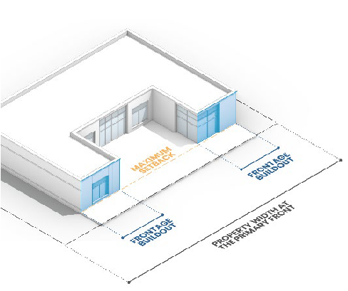
Figure 1 Frontage Buildout
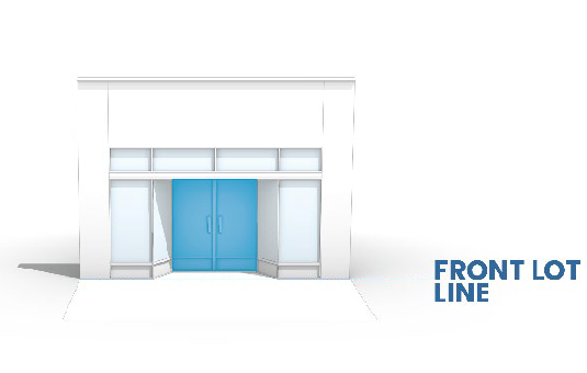
Figure 2 Zero Foot Front Yard Setback
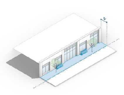
Figure 3 Five Foot Front Yard Setback with Activated Plaza Space
3.
Orientation, Siting, and Design Standards.
a.
Applicability. The standards of this section shall apply to all nonresidential and mixed-use development in the DT district.
b.
Building Siting. New development located at the corner of two streets shall be sited to connect or anchor the corner with prominent architectural features and site treatments.
c.
Building Orientation.
i
Primary Building Entrance. The primary building entrance of new development shall be oriented towards one of the following.
(A)
Option 1. The following streets are listed in priority order:
(a)
West Church Street/East Church Street;
(b)
Main Street; and
(c)
Other streets.
(B)
Option 2. In cases where the proposed development is oriented around a common green space, the primary building entrance shall be oriented towards the central green space.
ii
Secondary Building Entrance(s). If a lot has two street frontages, a secondary building entrance shall be provided along both streets.
iii
Common Green/Plaza Space. The development shall include a central common green or plaza space, integrated within the layout of the surrounding buildings.
d.
Location of Parking Areas Accessory to Principal Uses. Off-street parking areas accessory to primary uses shall be located to the rear of buildings only.
I.
I-1 Light Industrial District.
1.
Purpose and Intent. The I-1 light industrial district is intended to provide areas to accommodate light industrial uses that are conducted entirely within enclosed buildings and do not have the potential to generate substantial off-site impacts, such as noise, traffic, and visual concerns. Development is intended to occur in locations with necessary services and facilities while minimizing obtrusion on or by adjoining uses and districts.
2.
Bulk and Dimensional Standards. The bulk and dimensional standards for the I-1 light industrial district are established in Table 16.02.003.I.
Table 16.02.003.I: Bulk and Dimensional Standards
J.
I-2 Heavy Industrial District.
1.
Purpose and Intent. The I-2 heavy industrial district allows for the development of manufacturing uses that have the potential to generate moderate environmental effects in terms of noise, traffic, and visual impact on the community. Development in the I-2 district is intended to be located away from residential districts and pedestrian-oriented areas, such as the downtown district, in order to minimize obtrusion on or by adjoining uses and districts.
2.
Bulk and Dimensional Standards. The bulk and dimensional standards for the I-2 heavy industrial district are established in Table 16.02.003.J.
Table 16.02.003.J: Bulk and Dimensional Standards
K.
RR Railroad District.
1.
Purpose and Intent. The RR railroad district is established to accommodate specific railroad- and transportation-related uses permitted by special use only. Such uses would conform to the special requirements imposed by a limited leasable lot area of railroad right-of-way.
2.
Bulk and Dimensional Standards. The bulk and dimensional standards for the RR railroad industrial district are established in Table 16.02.003.K.
Table 16.02.003.K: Bulk and Dimensional Standards
L.
AG-1 Agricultural District.
1.
Purpose and Intent. The AG-1 agricultural district is meant to prevent scattered urban development within the community's rural lands and to preserve those lands that are used predominately used for farming. The district allows single-family detached development co-located on lots with agricultural uses to prevent a mixture of incompatible urban and rural uses.
2.
Bulk and Dimensional Standards. The bulk and dimensional standards for the AG-1 agricultural district are established in Table 16.02.003.L.
Table 16.02.003.L: Bulk and Dimensional Standards
M.
P-1 Public Uses and Institutions District.
1.
Purpose and Intent. The P-1 public uses and institutions district provides land for development of publicly owned and operated or nonprofit facilities including governmental offices, fraternal organizations, police and fire stations, educational facilities, religious institutions, and other nonprofit establishments. These facilities are intended to add to community services, and/or provide for recreational needs or educational requirements of residents of the area.
2.
Bulk and Dimensional Standards. The bulk and dimensional standards for the P-1 public uses and institutions district are established in Table 16.02.003.M.
Table 16.02.003.M: Bulk and Dimensional Standards
N.
PDL Planned Unit Development Legacy District.
1.
Purpose and Intent. The PDL planned unit development legacy district includes properties that have been previously zoned under a planned unit development (PUD) district and are governed by a unique set of regulations as set forth in the related PUD ordinance. Properties in the PDL district will continue to operate under the conditions of their specific PUD ordinance. No property may be rezoned into the PDL district after the effective date of this UDO.
(Ord. No. 2025-O-03, § 10(Att. A), 2-12-25)
16.02.004 - Encroachments, exceptions, and adjustments.
A.
Encroachments Into Required Yard Setbacks.
Table 16.02.004.A: Allowed Encroachments
B.
Yard Setback Adjustments. These provisions apply if thirty percent (30%) or more of the buildings on a block face have front yard setbacks that are different than those required by the district in which they are located.
1.
If a building is to be built on a lot or tract of land within one hundred (100) feet of existing buildings on both sides of the subject lot, the minimum front yard setback shall be the mean setbacks of the adjacent buildings or the required setback of the applicable district, whichever is less.
2.
If a building is to be built on a lot or tract of land within one hundred (100) feet of an existing building on one side of the subject lot only, the minimum front yard setback shall be the setback of the adjacent building or the required setback of the applicable district, whichever is less. These adjustments shall only be applicable to parcels located in the same zoning district.
3.
If the building is to be built on a lot or tract of land that is not within one hundred (100) feet of an existing building on either side of the subject lot, then the minimum front yard setback shall be the required setback of the applicable district.
4.
No setback adjustment pursuant to this section shall create a required front yard setback more than five feet less than that required by the applicable district.
C.
Height Exceptions.
1.
The following features shall be exempt from the building height standards of this section. However, these features are subject to the University of Illinois-Willard Airport clear zones approach surfaces according to the Division of Aeronautics and Federal Aviation Regulations.
a.
Chimneys;
b.
Elevator bulkheads;
c.
Stacks;
d.
Spires;
e.
Steeples;
f.
Wireless telecommunications facilities.
2.
Necessary mechanical devices and equipment appurtenant to the principal use of a building, and the housing for such devices and equipment.
(Ord. No. 2025-O-03, § 10(Att. A), 2-12-25)