
Savoy City Zoning Code
CHAPTER 16
06 - SUBDIVISION REGULATIONS
16.06.001 - Intent and purpose.
A.
Pursuant to the authority conferred by the Statutes of the State of Illinois, the objectives of these regulations are to:
1.
Provide for the orderly growth and harmonious development of the Village;
2.
Secure adequate traffic circulation by means of coordinated street systems with relation to major thoroughfares and streets adjoining subdivisions, public walkways, public facilities and other land uses;
3.
Achieve individual lots of reasonable utility and livability;
4.
Facilitate adequate provisions for recreational areas, open space, school sites, and other public ways and facilities;
5.
Provide guidance regarding the development process for new subdivisions including elements such as annexation, platting, administrative procedures, submittal requirements and general subdivision standards; and
6.
Provide for the further subdivision of tracts into smaller or larger parcels of land, and to provide administrative and review procedures for the attainment of these objectives to establish standards for the construction of public improvements.
B.
Installation of Required Improvements. All improvements required by this chapter shall be furnished and installed by the developer as part of a subdivision procedure as detailed in Chapter 16.08.
C.
Administrative Standards and Procedures. All administrative standards and procedures related to subdivisions are included in Chapter 16.08.
(Ord. No. 2025-O-03, § 10(Att. A), 2-12-25)
16.06.002 - Street design and improvements.
A.
Improvement Requirements. Required street design amenities and improvements shall be provided as specified in this section, in addition to any applicable requirements specified in the Village Manual of Practice (MOP). In determining the required improvements and their location, the village shall also consider applicable recommendations of the village's adopted bicycle and pedestrian plan and parks master plan.
1.
Bicycle Lanes.
a.
Easements for the installation of bicycle lanes shall be provided at least five feet in width.
b.
Bicycle lanes shall be delineated in accordance with NACTO standards.
2.
Shared Bicycle and Vehicle Lanes. Shared bicycle and vehicle lanes shall be delineated in accordance with NACTO standards.
3.
On-Street Parking.
a.
On-street parking spaces shall be parallel.
b.
On-street parking spaces shall have the following minimum and maximum dimensions:
i.
Width. Minimum of eight feet; maximum of ten (10) feet;
ii.
Length. Minimum of twenty-two (22) feet; maximum of twenty-five (25) feet.
c.
Dedicated and marked on-street parking spaces are required in nonresidential and mixed-use districts only.
4.
Parkways.
a.
Parkways shall be located between the back of curb and sidewalk.
b.
Parkways shall be at least eight feet in width.
5.
Street Trees.
a.
All street trees shall be planted within a required parkway as detailed in Subsection A.4. above.
b.
A minimum of one canopy tree shall be planted per every forty (40) linear feet of parkway.
c.
Where overhead utility line conflicts are present, a minimum of one understory tree shall be planted every twenty (20) feet.
d.
The spacing of trees shall take into consideration site-specific conditions and clear sight triangles as detailed in Section 16.04.009.
e.
Street trees shall be planted within four years of the beginning of active construction on the subdivision. In lieu of providing trees within this four-year timeline, the developer may elect to provide said new street tree plantings via the village, at the developer's up front expense through a per tree payment as set forth in the schedule of fees provided for in the village's Code of Ordinances, current at the time the development is approved.
6.
Sidewalks.
a.
All sidewalks shall be five feet in width.
b.
Where they do not already exist, sidewalks shall also be constructed along existing arterial streets that are adjacent to the subject subdivision.
c.
For up to four years from the date of the recording of a subdivision's final plat, sidewalks may be constructed by individual builders after the construction of the principal structure on each respective lot. The sidewalk contractor must be approved by the public works director.
d.
The developer must construct any remaining sidewalk within six months following the expiration of the four-year term articulated in the previous subsection.
7.
Streetlights.
a.
Streetlights are to coordinate with fire hydrant and intersection locations.
b.
Plans for the layout, design, and installation of streetlights, wiring, and all required excess facilities, including streetlights, poles, and all devices and materials to install streetlights, must be submitted to and approved by the public works director and the appropriate electrical utility prior to installation.
B.
Width Standards. Private streets or alleys shall not be permitted, except under special conditions as approved by the public works director.
1.
Minimum Right-of-Way and Pavement Dedication Requirements. Street networks and street types required for a given subdivision shall be justified by a traffic study prepared by a professional engineer as per the requirements of the MOP. Minimum dedicated street pavement and rights-of-way shall be as shown in Table 16.06.002.B.
Table 16.06.002.B. Right-of-Way and Pavement Widths
C.
Required Street Design Elements. Required street design elements shall be as established per street type in Table 16.06.002.B. The following key shall be used in the interpretation of Table 16.06.002.C.
1.
○ = required on both sides of a given street.
2.
● = required on one side of a given street.
3.
□ = required at the discretion of the village.
Table 16.06.002.C. Required Street Design Elements
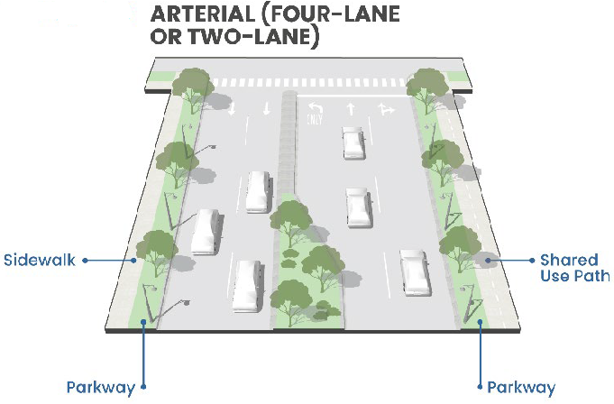
Figure 1 Required Street Design Elements—Arterial (Four-Lane or Two-Lane)
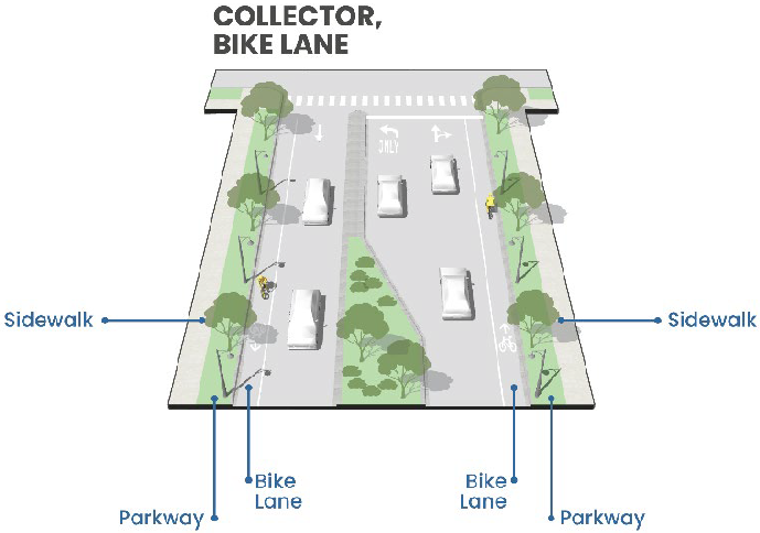
Figure 2 Required Street Design Elements—Collector, Bike Lane
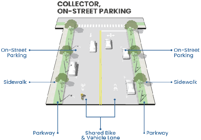
Figure 3 Required Street Design Elements—Collector, On-Street Parking
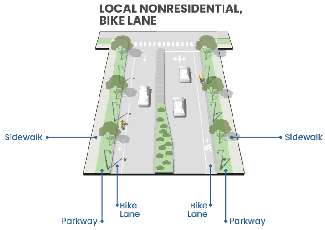
Figure 4 Required Street Design Elements—Nonresidential, Bike Lane
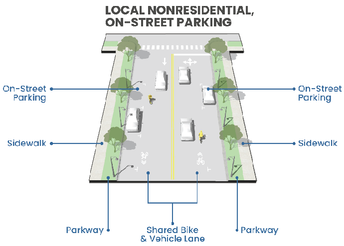
Figure 5 Required Street Design Elements—Local Nonresidential, On-Street Parking
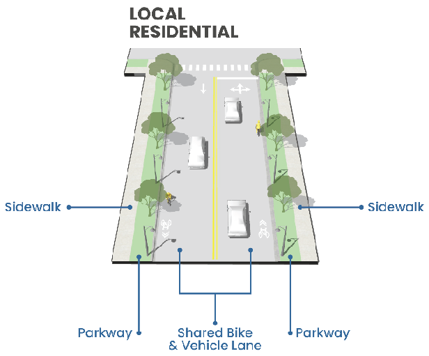
Figure 6 Required Street Design Elements—Local Residential
(Ord. No. 2025-O-03, § 10(Att. A), 2-12-25)
16.06.003 - Circulation and connectivity.
A.
Horizontal Curves. Horizontal curves in streets shall be permitted provided no curve shall be greater than that approved by the public works director as reasonably safe for traffic at the particular location of the curve.
B.
Street Jogs. Street jogs with centerline offsets of less than one hundred twenty-five (125) feet shall not be allowed unless necessitated due to site conditions or constraints as determined by the public works director.
C.
Tangent Lengths. Tangent segments on local and collector streets shall have a minimum length of one hundred (100) feet and a maximum length of five hundred (500) feet.
D.
Intersection Design. The intersection of two or more collector roads (including residential collectors) shall occur at a roundabout. The design details of the roundabout shall follow the most current IDOT Bureau of Local Roads and Streets Manual with a minimum inscribed circle diameter of sixty (60) feet.
E.
Street Naming.
1.
Proposed streets which align with or continue existing streets that are already named shall bear the name of such existing streets.
2.
In no case shall the name for new proposed streets duplicate existing street names irrespective of the use of the suffix street, avenue, road, boulevard, drive, place, or court, or an abbreviation thereof, or minor variations in spelling. The house numbering system plan shall be submitted to the public works director.
3.
Street names must be approved by CED staff. Input on street names from USPS and METCAD may be considered.
F.
Access. Access for future development of adjacent unplatted land shall be reserved at intervals of not more than one-quarter-mile.
G.
Blocks.
1.
Length. Blocks shall not be less than two hundred (200) feet nor more than eight hundred (800) feet in length except as the public works director considers desirable in order to secure efficient use of land or desired features of the street pattern.
2.
Pedestrian Crossing Required. In blocks six hundred (600) feet or more in length, the public works director may require a public crosswalk for pedestrian travel to extend entirely across the block at the location deemed necessary. The width of the concrete shall be five feet, and the crosswalk shall be located on a ten (10) foot easement. Roads intended to be owned and maintained by the Illinois Department of Transportation shall be exempt from this standard.
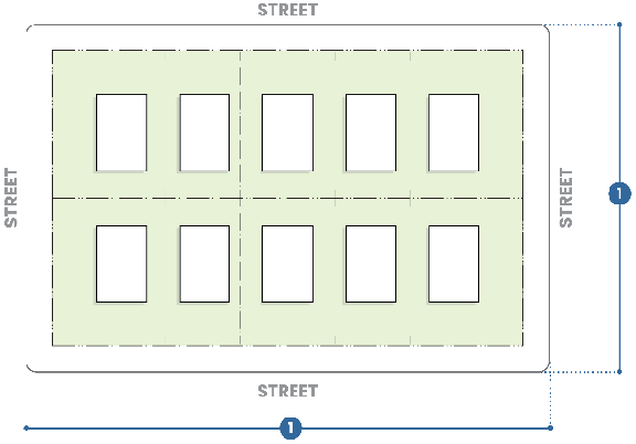
Figure 7 Block Length
H.
Cul-de-Sacs.
1.
Maximum Length. Cul-de-sacs shall have a maximum length of six hundred (600) feet measured from the centerline of the intersecting street to the center of the turnaround.
2.
Planning and Zoning Commission Exemption. The planning and zoning commission may grant an exemption to the maximum length standard when the commission deems the topography of the land being subdivided or the physical situation of that land makes such a restriction impractical.
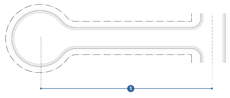
Figure 8 Cul-de-sac Length
I.
Street Stubs.
1.
In new developments, the developer shall terminate streets as stubs at the outer perimeter of the development based on the criteria below. If the street in question meets at least two of the criteria, then the street must be built to an appropriate collector street standard as delineated in Table 16.06.002.B:
a.
The street intersects directly with any street designated as an arterial street and provides access to an area with an overall density of ten (10) dwelling units per acre or provides access to more than one hundred fifty (150) dwelling units;
b.
The street by its general configuration, in relationship to the existing development of the area, functions as a collector;
c.
The street extends into an undeveloped area in such a manner as to function as a collector in the future; and
d.
The street serves as the primary access to a significant nonresidential, institutional, or recreational land as well as an access to a residential area of twenty (20) or more acres.
2.
Street stubs shall be clearly demarcated and identified for future street extension by street signage.
3.
All street stubs shall terminate with a turnaround for vehicles.
4.
All stub streets shall conform to the village's adopted version of the International Fire Code.
5.
The public works director may deem that the street stub is impractical due to topographic conditions, environmental constraints, property shape, or property accessibility.
J.
Connection to Adjacent Development. Where an existing street is adjacent to the subdivision, the subdivider shall improve half of the street to conform to the standards of the existing adjacent street. Where the existing street is under the jurisdiction of Champaign or Tolono Township, the public works director may waive the requirements for street improvements.
K.
Street Signs Required. Street signs shall be erected at each street intersection within the subdivision.
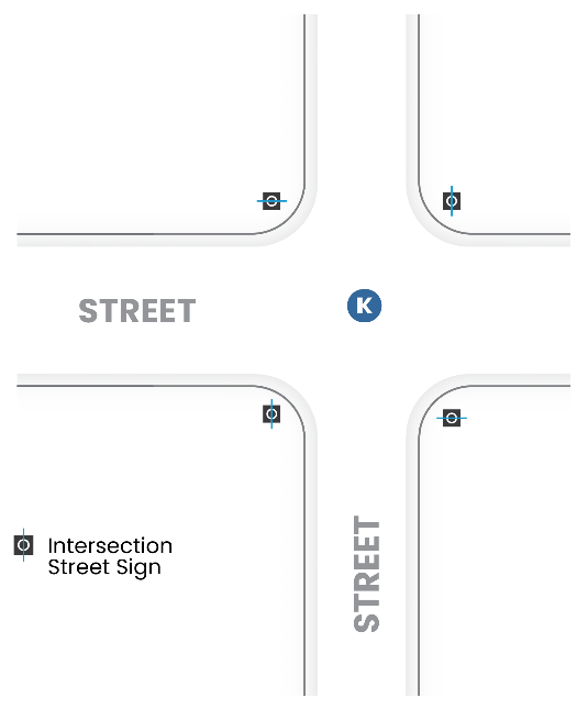
Figure 9 Street Signs
L.
Street Orientation.
1.
East-West Orientation. Developers are encouraged to provide more streets oriented east to west rather than north to south in residential subdivisions.
2.
Street Curvature. The maximum allowable tangent lengths shall be specified to enhance overall traffic safety. Long, wide and straight streets are discouraged in order to reduce vehicular speeding. The street geometry of a proposed subdivision shall be justified by traffic study and must be approved by the public works director.
M.
Location and Design of Alleys.
1.
Alleys Required. Alleys shall be provided for all lots or parcels intended for commercial or industrial and vehicle-related uses. The public works director may waive this requirement.
2.
Alleys Allowed. Alleys may be provided for lots intended for residential uses.
3.
Dead End Alleys Prohibited. No dead-end alleys will be permitted, except under special conditions as approved by public works director and planning and zoning commission.
4.
Private Alleys Prohibited. No private alleys will be permitted, except under special conditions as approved by public works director and planning and zoning commission.
5.
Connectivity Index.
a.
Intent and Purpose. A connectivity index shall be used to determine the adequacy of street layout design.
b.
Connectivity Calculation. A connectivity index is calculated as the ratio of the number of street links (defined as either road sections between intersections, or existing or future connections to adjacent development) in the subdivision street layout divided by the number of street nodes (defined as intersections internal to the subdivision or cul-de-sac turnarounds, but not including street stubs to adjacent development or intersections with existing streets). Connections formed via recreational trails shall qualify as one-half of a link.
c.
Minimum Connectivity Required. Streets within a subdivision shall have a minimum connectivity index measurement of one and four-tenths.
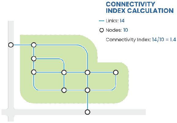
Figure 10 Connectivity Index
(Ord. No. 2025-O-03, § 10(Att. A), 2-12-25)
16.06.004 - Water, sewer, and stormwater.
A.
Applicability. Basic quality of life utilities shall be provided by the developer, including potable water, sanitary sewer services and stormwater drainage infrastructure. No building permit will be approved until these elements have been constructed and received approval from the public works director. The technical requirements for the design and construction of these infrastructure systems are as stipulated in the MOP.
B.
Design.
1.
The adequacy of the existing sanitary sewers to support the proposed development must first be determined by the subdivider. If the existing sewers are not adequate, it shall be the subdividers responsibility to find an outlet for the sanitary sewers. This work shall be done in cooperation within the public works director.
2.
All design calculations must be submitted to the public works director for approval.
3.
All new developments within the Village of Savoy and its one-half-mile extra-territorial jurisdiction (ETJ) shall be served by a sanitary sewer system tributary and connected to the Urbana and Champaign Sanitary District (UCSD) interceptor sewer system and downstream treatment facilities. As such, all new sanitary sewer systems must be approved by the village and UCSD. As per UCSD ordinances, all proposed developments within the village's ETJ must be annexed into UCSD's jurisdiction and either annexed into the village or have an approved development agreement with the village.
4.
Stand-alone septic systems for individual lots or other onsite treatment facilities for individual lots require a permit from the Champaign County Public Health District and are generally disallowed if a sanitary system is available nearby.
5.
All permits required must be obtained by the subdivider (i.e., Environmental Protection Agency Permit).
C.
All sanitary sewer work shall be done in accordance with the current standard specifications for water and sewer main construction in Illinois and the Environmental Protection Agency of the state of Illinois. Standards specific to the Village of Savoy are as stipulated in the MOP.
D.
Water Distribution System. All design, construction and testing shall be performed under Illinois American Water Company regulations except under special conditions as approved by the public works director.
E.
Review and Approval. The review and approval of sanitary sewer lines shall be as specified in the MOP and shall occur concurrently with the installation of stormwater infrastructure.
(Ord. No. 2025-O-03, § 10(Att. A), 2-12-25)
16.06.005 - Cluster development.
A.
Cluster Development Allowed. Cluster development is allowed in residential subdivisions in the R-1, R-2, and R-3 Districts to encourage and accommodate creative approaches to development that preserve sensitive natural areas.
B.
Required Conservation Area. A minimum of fifty percent (50%) of the total gross area of the development site shall be identified as a conservation area and placed in a conservation area easement where no development activity, with the exception of required open space activation or low impact infrastructure may occur. Routine maintenance and other measures to ensure public safety are permitted within the conservation area.
1.
Ownership and Maintenance.
a.
Required conservation area(s) shall be protected by a binding legal instrument that is recorded with the deed. The instrument shall be one of the following:
i.
A conservation easement in favor of either:
(A)
A land trust or similar conservation-oriented nonprofit organization with legal authority to accept such easements (the organization shall be bona fide and in perpetual existence and the conveyance instruments shall contain an appropriate provision for retransfer in the event the organization becomes unable to carry out its functions). If the entity accepting the easement is not the village or the county, then a third party right of enforcement favoring the village or the county shall be included in the easement; or
(B)
A governmental entity with an interest in pursuing goals compatible with the purposes of this section acceptable to the village or county, as appropriate.
ii.
A restrictive covenant for conservation purposes in favor of a governmental entity.
iii.
An equivalent legal tool that provides permanent protection, if approved by the village or county, as appropriate.
iv.
Dedication of the land to an established homeowner's association (with legal standing in the property) that accepts permanent maintenance responsibility.
b.
A metes and bounds description of the space to be preserved shall be recorded on the plat, in homeowner/property owner covenants, and on individual deeds when conservation area(s) are not held entirely in common.
c.
Conservation area(s) shall perpetually run with the development site and shall not be developed or separated from the development site at a later date, unless no development of any portion of the project which is benefited by or required to provide such open space has occurred and the entire area of the project is presented for a new construction drawing approval, final plat approval, or rezoning, the effect of which will be to nullify the prior approval.
2.
Primary Conservation Area. A minimum of seventy percent (70%) of the required conservation area shall consist of primary conservation areas. Primary conservation areas shall include:
a.
Riparian buffers along all perennial and intermittent streams;
b.
Wetlands and any provided or required buffers;
c.
Lakes, ponds, and other water bodies, excluding artificial stormwater management facilities;
d.
Areas at least five thousand (5,000) contiguous square feet in size with any natural slopes greater than twenty-five percent (25%);
e.
Areas with a concentration of trees with a diameter at breast height (dbh) of twenty (20) or greater to be preserved; and
f.
Stormwater management facilities engineered as bioretention areas or wetlands.
C.
Maximum Density per Acre. The maximum allowed gross density shall be:
1.
R-1 District. Four and one-half dwelling units per acre;
2.
R-2 District. Six dwelling units per acre; and
3.
R-3 District. Ten (10) dwelling units per acre.
D.
Allowed Uses. Allowed uses shall be as established in the governing base or overlay district.
E.
Conservation Design Dimensional Standards. The dimensional standards for conservation design applicable regardless of the base district designation are shown in Table 16.06.005.E.
Table 16.06.005.E: Conservation Design Dimensional Standards
F.
Conservation Design Process. The following shall be required for a subdivision proposal to be reviewed as a conservation design subdivision.
1.
Conservation Design and Improvements Plan Requirements.
a.
Step 1: Development Site Analysis Map.
i.
The applicant shall prepare a map of the development site and all land within five hundred (500) feet of the development site that identifies existing natural resources, including, but not limited to the resources detailed in Subsection b.2. The information required to be presented in the development site analysis may be produced primarily from existing sources in order to ensure the process is economical for the applicant.
ii.
The applicant shall prepare an accompanying narrative analysis of existing natural resources detailing their quality and environmental value.
iii.
The applicant shall submit the development site analysis map to the CED director for review.
b.
Step 2: Development Site Inspection. After receipt of the development site analysis map, the applicant shall schedule an inspection of the development site with CED staff. The applicant or applicant's representative shall be present at the development site inspection. The purpose of the development site inspection is to:
i.
Familiarize the CED director with the existing development site conditions and natural and historic features of the development site; and
ii.
Provide an opportunity to discuss development site concepts, including the general layout of conservation areas and potential locations for proposed structures, utilities, streets, and other development features. No official decision on the conservation design plan shall be made during the development site inspection.
c.
Step 3: Conservation Design and Improvements Plan. Based on the development site analysis map and the development site inspection, the applicant shall prepare:
i.
A conservation design map that depicts proposed conservation areas and development areas; and
ii.
A conservation design improvements plan including utilities, roadways, open space activation elements, other development features, buffers (if applicable), and lot lines in the proposed development areas.
2.
Conservation Design and Improvements Plan Review and Approval. Along with the subdivision plan, the applicant shall submit the conservation design and improvements plan to the CED director for review and approval in accordance with the purpose of conservation design.
3.
Final Plat. The final plat shall identify conservation areas as a conservation area easement.
(Ord. No. 2025-O-03, § 10(Att. A), 2-12-25)
16.06.006 - Architectural variety.
A.
Architectural Variety Standards.
1.
No new one-unit or duplex dwelling units shall be similar in appearance to any other one-unit or duplex dwelling units within three units on either side of the subject property or within any of the five units across the street from the subject property.
2.
On cul-de-sac turnarounds, no one-unit or duplex dwelling shall be similar in appearance to another dwelling on the turnaround.
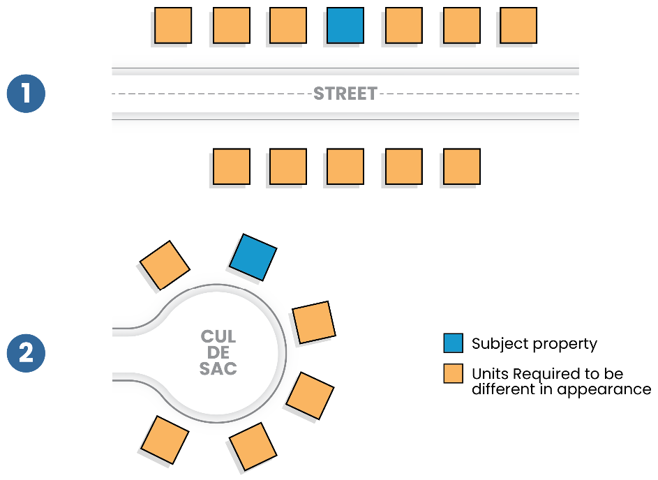
Figure 11 Architectural Variety Standards
B.
Similarity Standards. Any two dwelling units shall be considered similar in appearance if they are identical or nearly identical to one another in any three or more of the following characteristics:
1.
Roof type (gable, hip, mansard, gambrel, flat, or combination);
2.
Similar roof pitch at an angle of ten (10) degrees or less;
3.
Dimensions of the elevation (height and/or length) nearest the front lot line that vary twenty percent (20%) or less from the equivalent elevation on an adjacent lot shall constitute similarity, unless the facade articulation differs significantly between the buildings, in which case similarity shall not be determined solely by dimensions;
4.
Relative location and size of windows on the front elevation;
5.
Relative location and dimensions of garage door(s), if included on the front elevation; and
6.
Type(s) of exterior building cladding materials on the front elevation. The following differences in construction material shall be deemed sufficient to render buildings containing such changes and built on adjacent lots to be dissimilar:
a.
Four-inch exposure horizontal siding;
b.
Eight-inch exposure horizontal siding;
c.
Brick facing;
d.
Vertical siding;
e.
Stone facing;
f.
Stucco/staccato board and trim; and
g.
When materials are changed, the change must occur throughout the front facade or elevation for a minimum of one story in height.
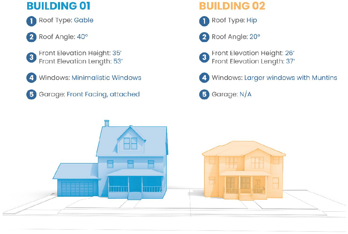
Figure 12 Architectural Variety Similarity Standards
(Ord. No. 2025-O-03, § 10(Att. A), 2-12-25)
16.06.007 - Public use space dedication requirements.
A.
Park Requirement and Population Table. The total requirement of space for parks, playgrounds, schools, or other public uses (referred to collectively as "public use space" or "public use amenities") shall be ten (10) acres of land per thousand (1,000) projected residents. To determine the projected number of residents in a subdivision, the CED director shall use the estimated number of dwelling units in the proposed subdivision as well as the average household or family size as established in the most recent American Community Survey for the Village of Savoy.
1.
In the event that the developer would be required to dedicate less than five acres of public use space, the CED director may determine:
a.
To accept the proposed land dedication;
b.
To accept a fee in lieu of the land dedication; or
c.
To accept the proposed dedication and acquire additional land from the owner to increase the area of the public use space to a more suitable threshold.
B.
Comprehensive and Parks Master Plan. Where a planned public amenity is recommended in the village's adopted comprehensive plan, parks master plan, or other adopted policy document, and the area is located in whole or in part within a proposed subdivision, the CED director may require the dedication of the area in whole or in part within the subdivision.
C.
Payment in Lieu. At the request of the developer and as approved by the village a payment in lieu of the land dedication required may be approved. The payment required in lieu of public use space shall be per the village's adopted fee schedule. The payments in lieu of public use space shall be held in trust solely for the acquisition of public use space which will be available to serve the needs of the residents of the subdivision.
D.
Acquisition of Areas to be Dedicated. The acquisition of the additional area needed for public use amenities shall be secured by the authority having jurisdiction. Arrangements for securing areas from the owner shall be made within a period not to exceed four months from the date the plat is approved by the board of trustees.
E.
Conditions of Ownership and Maintenance. When any private open space to be owned in common by multiple owners is proposed, the conditions of ownership and maintenance shall be approved by the board of trustees.
(Ord. No. 2025-O-03, § 10(Att. A), 2-12-25)