
Simi Valley City Zoning Code
CHAPTER 9
32 - Hillside Performance Standards
9-32.010 - Purpose
The City is situated among a series of major and minor hills. These hills constitute a significant natural topographical feature of the community because they are visible to all persons traveling the major highway arteries as well as to citizens residing in and around the City. The purposes of the performance standards set forth in this Article, therefore, are to implement those provisions of the General Plan as they relate to the preservation of hillside areas, the promotion of single-family, detached housing in hillside areas, the maintenance of open space, the retention of scenic and recreational resources of the City, and to further enhance the public health, safety, or welfare by regulating development in hillside areas.
(§ 5, Ord. 1085, eff. January 6, 2006)
9-32.020 - Applicability
Except as exempted in Section 9-32.040 of this Chapter, the performance standards set forth in this Article shall apply to any parcel or any portion of a parcel of land in any land use zone which is located outside of the valley floor boundary line as noted on the Development Map of the Valley Floor following this Article and made a part of this Article by this reference as Exhibits A and B. All principally and conditionally permitted uses in the underlying zone are likewise principally and conditionally permitted under these performance standards subject to the findings (Section 9-32.050 of this Article), and the application of the development standards (Section 9-32.100 of this Chapter) contained in this Article.
(§ 5, Ord. 1085, eff. January 6, 2006)
9-32.030 - Variances from Performance Standards
Variances from the terms of this Article shall be granted either pursuant to the procedures of Section 9-52.090 (Variances) or as part of a planned development permit, cluster development permit, special use permit, specific plan, or other entitlement provided the findings required by this Section are made prior to the approval of the project. Any variance granted shall be subject to the findings required by Section 9-52.090 (Variances), including, but not limited to, an express finding that the granting of the variance will serve the interests of preserving and protecting the public health, safety, or welfare.
(§ 5, Ord. 1085, eff. January 6, 2006)
9-32.040 - Exceptions
The performance standards set forth in this Article shall not apply to those specific developments or applications involving one or more of the following circumstances:
A.
Any approved permit, including, but not limited to, a specific plan, planned development permit, cluster development permit, vesting tentative map, tentative map, parcel map, special use permit, variance, sign variance, building permit, grading permit, encroachment permit, or other entitlement valid as of July 21, 1986. This shall include any such entitlement for which a minor modification is approved. However, prior to the Director approving or conditionally approving the minor modification, he shall submit the application to the Commission for a determination of whether the application meets the criteria of Section 9-52.030 (Administrative Adjustments) of this Code. If the Commission so determines, this exception shall apply to any such subsequently approved minor modification, unless the Director, or the Commission on appeal, or the Council on further appeal finds any modification to such entitlements to be a major modification of such a magnitude as to alter the original intent of the project approval;
B.
Any reapplication for a previously-approved planned development permit, tentative map, or any other entitlement valid as of July 21, 1986, where the failure of the project to proceed under the original entitlement is solely caused by the failure to obtain the necessary building permit allocations in spite of having filed a good faith application therefore and that such reapplication does not contain any modification to the original entitlement of such a magnitude as to alter the original intent of the project approval;
C.
The construction of a residential dwelling unit, or additions thereto, and accessory buildings on a legally subdivided, residentially-zoned parcel as of July 21, 1986, which does not involve grading for structures on visually prominent ridgelines or on land with a slope in excess of 20 percent or grading in excess of 1,000 cubic yards;
D.
Any parcel having only isolated land forms with slopes of 10 percent or greater which have a horizontal run of less than 100 feet and a vertical rise of less than 30 feet;
E.
Any parcel involving a sanitary landfill operation, landfill related gas recovery and collection systems, and ancillary electrical power generating and transportation facilities, as well as equipment storage, administrative facilities, and ancillary improvements related to a landfill, all of which are subject to government permits; provided, however, such exemption shall not apply to landfills which receive hazardous wastes as defined in Section 25117 of Title 22 of the California Administrative Code, as amended;
F.
Grading for agricultural purposes pursuant to a grading permit reviewed by the Commission following a duly-noticed public hearing;
G.
Lot line adjustments, lot mergers, or condominium conversions involving existing structures, issued pursuant to local ordinance;
H.
Fire breaks and fire roads required by the County Fire Department;
I.
Recreation trails for pedestrian or equestrian purposes constructed by or pursuant to the requirements of the Rancho Simi Recreation and Park District;
J.
A Specific Plan which includes a regional shopping center which provides at least 500,000 square feet of building area, a minimum of two major department stores of at least 100,000 square feet each, a predominantly-enclosed pedestrian mall, and which prohibits satellite buildings for fastfood restaurants;
K.
The construction of public works improvements, including, but not limited to, drainage channels, retention basins, water tanks, and pumping stations provided such facilities shall be landscaped and bermed so as to minimize their visibility from viewpoints from the valley floor as defined in Section 9-32.150(C)(2) of this Article;
L.
Public, quasi-public, nonprofit facilities of a recreational or educational nature, including, but not limited to, planetariums, observatories, and libraries, provided such facilities shall not be visible from viewpoints from the valley floor as defined in Section 9-32.150(C)(2) of this Article;
M.
The replacement or reconstruction of commercial, industrial, or residential structures existing prior to July 21, 1986, which were destroyed or damaged by fire, earthquake, or other natural disaster; and
N.
Cemeteries located within a Specific Plan area in which detailed standards for cemeteries have been adopted. The adopted standards must preclude any above grade improvements, including, but not limited to, headstones, on visually prominent ridgelines and areas in excess of 20 percent slope, except for below ground interments with memorial placards flush with the ground and private drives on slopes of up to 30 percent. Total area of interments and private drives in slopes of between 20 and 30 percent cannot exceed 10 percent of the total cemetery area.
(§ 5, Ord. 1085, eff. January 6, 2006)
9-32.050 - Findings
These findings constitute a further definition and implementation of those policies of the General Plan which relate to the preservation of hillside areas, the preservation of open space, and the protection of life and property in hillside areas subject to various natural and man-made hazards. In approving or conditionally approving any application for development subject to the performance standards set forth in this Article, the Director, the Commission, or the Council shall affirmatively find that all the following hillside development policies have been attained by the proposal. In denying any application for development subject to such performance standards, the Director, the Commission, or the Council on appeal shall state which of the following hillside development policies, if any, have not been attained. The manner in which the findings are listed is not to be construed as giving one finding priority over the other:
A.
General findings.
1.
That the natural topographic features of the hills surrounding the City have been respected and protected;
2.
That all development in the project has been kept from natural slope areas of 20 percent or greater, except as specifically authorized pursuant to Sections 9-32.030 and 9-32.110(A) of this Chapter;
3.
That all commercial and industrial development has been kept from natural slope areas of 10 percent to 20 percent, except as approved by the West End Specific Plan or any amendment thereto;
4.
That the overall density or intensity of land usage in all land use zones generally decreases as the slope increases; and
5.
That the view of the hills from the valley floor as well as the viewshed from the hills has been respected and maintained as defined in Section 9-32.140(C) (Design Standards) and Section 9-32.150 (Ridgeline Development Standards) of this Chapter.
B.
Development and design findings.
1.
That grading has been kept to an absolute minimum in order to maintain the natural character of the hillsides and that unavoidable grading complements natural land forms;
2.
That mass grading of large pads and excessive terracing has been avoided in residential land use zones and minimized in commercial and industrial use zones;
3.
That significant natural landmarks and other outstanding features have been retained in their natural state;
4.
That proposed residential development plans have utilized varying setbacks and heights for buildings, building techniques, building forms, and materials which ensure the compatibility of structures with the surrounding terrain and that proposed commercial and industrial development plans have utilized varying setbacks and heights for buildings, building techniques, building forms, materials, and colors which ensure the compatibility of structures with the surrounding terrain;
5.
That street and circulation design respects the natural contours of the land, minimizes grading requirements, and minimizes the percentage of land devoted to streets;
6.
That altered slopes will be re-landscaped with plants which are compatible with the project's soils, terrain, and micro-climate and which reduce the risk of fire, consistent with requirements for water conservation;
7.
That the project's design and construction complies with the development standards of Sections 9-32.110 (Grading Standards) through 9-32.180 (Procedures) of this Chapter; and
8.
That land graded for road right-of-way purposes through slopes not otherwise permitted to be graded pursuant to this Article does not include or permit the construction of an increased number of building pads other than those permitted within such parcel.
(§ 5, Ord. 1085, eff. January 6, 2006)
9-32.060 - Slope Calculation Procedure
A.
Slope calculations. For the purposes of the performance standards set forth in this Article, the following methods will be used to determine the slope of any land and the square footage or acreage within any slope category on land subject to the performance standards:
1.
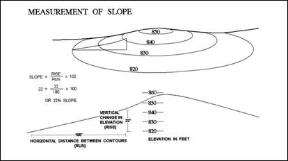
Definition of slope. Slope is defined as the relationship between the change in elevation (rise) of the land and the horizontal distance (run) over which that change in elevation occurs. The percent of any given slope is determined by dividing the rise by the run on the natural slope of land, multiplied by 100. See figure following Subsection (A)(2) of this Section.
2.
Slope map required. For the purpose of determining the amount and location of land falling into each slope category, the applicant shall submit to the Department of Environmental Services at the time of an application a base topographical map of the subject site prepared and signed by a registered civil engineer or licensed land surveyor. Such map shall have a scale of not less than one inch to 200 feet and a contour interval of not more than two feet, provided the contour interval may be 10 feet when the slope is more than 20 percent. Such base topographical map shall include all adjoining properties within 150 feet of the site boundaries. Slope bands in the range of zero to 10 percent, 10 percent to 15 percent, 15 percent to 20 percent, and 20 percent or greater shall include, or be accompanied by, a tabulation of the land area in each slope category specified in acres. The exact method for computing the percent slope and area by percent slope category should be sufficiently described and presented so that a review can readily be made.
3.
Slope mapping method.
a.
The percent slope of any particular piece of land shall be plotted on the map described in Subsection (A)(2) of this Section by dividing the vertical rise between the contours employed by the horizontal distance between the same contours, multiplied by 100. The minimum contour interval employed shall be two feet, and the maximum contour interval employed 10 feet, with the 10-foot interval being preferred.
b.
In preparing a slope map, isolated slope areas (that is, surrounded by a flatter or steeper slope category) with a horizontal run of less than 100 feet and a vertical rise of less than 30 feet shall be disregarded and the area thereof classified as being within the adjacent category. If the isolated slope area is adjacent to two or more slope categories, the isolated slope area shall be classified with the steepest adjacent slope category.
c.
In preparing a slope map, those portions of ravines, ridges, and terraces of less than 150 feet in width at their widest measurement which are in an area generally sloping at 20 percent slope or greater shall be regarded as being of 20 percent slope or greater and shall be included as part of the bordering 20 percent slope or greater band.
(§ 5, Ord. 1085, eff. January 6, 2006)
9-32.070 - Calculation of Total Allowable Dwelling Units
A.
Land areas included in calculations. The total allowable residential dwelling units shall be calculated based on the total land area within each slope category pursuant to Subsection A of Section 9-32.060 (Slope calculation procedures) of this Article. Except for the exclusions specified in Subsection C of this Section, all land areas, including group open space, park and recreation areas developed by the applicant and designed principally for use by the occupants of the proposal, lands dedicated to the Rancho Simi Recreation and Park District pursuant to the Parkland Dedication Ordinance, dedicated or otherwise reserved natural areas within the site, and lands within the proposed development required for new or expanded public rights-of-way for roadways may be included in the calculations of total allowable dwelling units if the land area is designated for residential development on the General Plan. Such areas shall be calculated as open space [one unit per 40 acres] if they are designated as Open Space on the General Plan.
B.
Land areas included in calculations but unbuildable. Isolated land areas shall be considered unbuildable but may be included in the calculations of allowable numbers of dwelling units (gross density) for the entire site being considered if:
1.
The provisions of Section 9-32.060(A)(3)(b) or (c) (Slope calculation procedures) of this Article or Subsection C of this Section do not apply; and
2.
A public roadway shall be constructed which traverses natural slopes in excess of 20 percent for more than 100 feet per dwelling unit requiring such access.
C.
Exceptions. Lands meeting any or all of the following criteria shall not be included in the calculation of total allowable dwelling units:
1.
All land areas, regardless of slope, which will be subject to inundation during a 100-year storm after development has occurred;
2.
All land which is in a geologic hazard area as defined in the Safety Element of the General Plan and for which no feasible mitigation measures are proposed consistent with the performance standards set forth in this Article; and
3.
All land which will lie within the easement or right-of-way boundaries of an open flood control channel after development has occurred.
D.
Residential dwelling unit calculations. Using the slope map described in Section 9-32.060(A) (Slope calculation procedure) of this Chapter, the maximum allowable number of units shall be calculated as follows:
TABLE 3-3 - MAXIMUM NUMBER OF DWELLINGS
E.
Transfer of dwelling unit allocations. Within a tentative map, Planned Development Permit, vested tentative map, or any other applicable entitlement, dwelling unit allocations within the applicable slope category may be utilized pursuant to Subsection D of this Section or may be transferred to other slope categories of less than 20 percent. Residential sites shall only be developed with single-family, detached units with a maximum density of seven units per acre, except for the following:
1.
Senior citizen housing;
2.
Residential projects located on a parcel not visible from viewpoints from the valley floor as defined in Section 9-32.150(C)(2) of this Chapter and containing at least 25 percent of the units which are affordable for low income and very low income households, as defined by the Housing Element of the General Plan (which, as of February, 1986, or as amended from time to time, was established for a family of four as an annual income of Sixteen Thousand Seven Hundred and No/100ths ($16,700.00) Dollars or less for very low and Twenty-Six Thousand Seven Hundred and No/100ths ($26,700.00) Dollars or less for low) and which do not exceed a maximum density of ten (10) units per gross acre, including density bonus and density transfer.
In no event shall the exceptions set forth in this Subsection exceed the 20 percent slope restrictions.
(§ 5, Ord. 1085, eff. January 6, 2006)
9-32.080 - Commercial and Industrial Development
The development of parcels within a commercial or industrial land use zone shall comply with all of the provisions of the underlying base and overlay zone and all provisions of the performance standards set forth in this Article, provided such development is limited to slopes of 10 percent or less, unless otherwise approved by the West End Specific Plan or any amendment thereto, in which case development shall be limited to slopes of 20 percent or less. In addition, the approval and development of two, two to five acre commercial developments north of the map boundary and one, two to five acre commercial development south of the boundary shall not be deemed prohibited by this Section provided such development is restricted to those area having slopes of 10 percent or less, and such developments will not be visible from viewpoints from the valley floor as defined by Section 9-32.150(C)(2) of this Article.
(§ 5, Ord. 1085, eff. January 6, 2006)
9-32.090 - Subdivisions of Land
In order to avoid the creation of undevelopable parcels of land, any subdivision of land proposed in areas falling wholly or partially under the provisions of the performance standards set forth in this Article shall not be divided in such a fashion as to preclude the reasonable use of any resulting parcel.
A.
Developable land may not be divided from land substantially undevelopable under the provisions of the performance standards, unless:
1.
The undevelopable parcel is to be held in common by the owner of the resulting developable parcel; or
2.
The undevelopable parcel is conveyed to and accepted by an appropriate public agency or other party (for example, homeowner's association) to be used for other residential purposes, such as, but not limited to, parks, flood control facilities, campgrounds, agriculture, or other uses consistent with the Open Space Element of the General Plan; and
3.
An open space easement over the undevelopable parcel specifying the allowable nonresidential, or, alternatively, the proscribed uses, is dedicated to the City or another appropriate public agency. Such an open space easement shall be conveyed subject to the provisions of Sections 51070 et seq. of the Government Code.
B.
If a parcel of land is proposed for division into two or more parcels, but with no cluster development permit or planned development permit for the whole original parcel, each parcel shall have a proportionate share of the total developable land or the total dwelling units allowable under the provisions of the performance standards, unless either Subsection (A)(1) or (2) of this Section has been satisfied.
(Example: If four lots are to be created from 40 acres, each approximately 10 acres in size, each lot shall have 25 percent of the developable land and/or 25 percent of the total units allowable on the original parcel.)
C.
Any parcel created pursuant to the provisions of the performance standards and entirely in 20 percent or greater slope, or designated as open space in the General Plan, shall be no less than 40 acres in size, unless Subsection (A)(1) or (2) of this Section pertains.
D.
Single parcels of land of record as of July 21, 1986, in a residential or open space land use zone on less than 40 acres shall be allowed a minimum of one dwelling unit, notwithstanding Section 9-32.070 of this Chapter.
E.
Land, otherwise developable under the provisions of the performance standards, is rendered undevelopable when the development which could be built on such land is transferred elsewhere on the parcel subject to the same development application, in such a case, the land rendered undevelopable shall be treated in a manner consistent with Subsection A of this Section.
(§ 5, Ord. 1085, eff. January 6, 2006)
9-32.100 - Development Standards
The purpose of this Section is to further define and describe the meaning of findings (Section 9-32.050 of this Chapter) and to implement the same. The following development standards are, therefore, the minimum criteria by which to evaluate the achievement of the findings (Section 9-32.050 of this Chapter) of the performance standards by any proposal, plan, or similar action subject to the provisions of the performance standards.
(§ 5, Ord. 1085, eff. January 6, 2006)
9-32.110 - Grading Standards
In addition to Chapter 70 of the Uniform Building Code, Chapter 7 of the Ventura County Land Development Manual, or any other applicable grading requirements, the following grading standards shall apply to all grading of land subject to the regulations of this Article (if more than 1,000 cubic yards):
A.
No manufactured slope shall exceed 30 feet in height, [except that slopes required for public streets may exceed 30 feet in height if no feasible alternative consistent with the findings (Section 9-1.1605 of this Article) exists]. The height of a manufactured slope shall include the height of any retaining wall constructed as an integral part of such slope.
B.
Where grading is necessary, the principles of contour grading shall be employed.
1.
Manufactured slopes shall be rounded and shaped to simulate the natural terrain.
2.
The toe and crest of any slope in excess of 10 feet vertical height, excepting the toe of any slope within 25 feet of a structure, shall be rounded with vertical curves of radii no less than five feet and designed in proportion to the total height of the slope.
3.
Any manufactured slope bank in excess of 30 feet vertical shall have variable gradients.
4.
Grading shall follow the natural topographic contours as much as possible.
5.
Where cut or fill slopes exceed 200 feet in horizontal length, the horizontal contours of the slope shall be curved in a continuous, undulating fashion with varying radii to reflect the natural terrain.
6.
Manufactured slopes shall blend with naturally occurring slopes at a radius compatible with the existing natural terrain.
7.
Grading on naturally occurring slopes of 20 percent grade or more which have a vertical height of more than 30 feet and a horizontal run of 100 feet or more shall not occur unless the grading becomes necessary and is specifically approved by the Commission or Council after making the findings. A detailed plan for slope stabilization shall be submitted by the applicant.
C.
No manufactured slope shall have a slope angle steeper than two horizontal to one vertical. Shallower slope angles may be required if detailed soils and geologic investigations indicate such.
D.
Manufactured slopes should be screened from view under or behind buildings or by intervening landscaping or natural topographic features.
E.
At the time of a formal application, a preliminary grading plan shall be submitted detailing the extent and nature of the proposed grading. Such a plan should include, but not be limited to:
1.
Preliminary cross sections detailing both the original and proposed ground surfaces with grades, slopes, and elevations noted;
2.
A preliminary soil stabilization report, including the proposed final ground cover, landscaping, and erosion control; and
3.
Erosion control measures to prevent soil loss when grading is in process.
(§ 5, Ord. 1085, eff. January 6, 2006)
9-32.120 - Drainage Standards
All proposed drainage facilities shall respect the natural (before development) hydrologic characteristics of the subject terrain, preserve major drainage channels in their natural state, and be designed in such a manner as to preserve the public health, safety, or welfare. The provisions of the following standards shall apply to all land subject to the regulations of this Article and shall be in addition to the provisions of the adopted version of the Uniform Building Code, Chapters 6 and 7 of the Ventura County Land Development Manual, or any other applicable drainage requirements:
A.
To the maximum feasible extent, all natural drainage courses serving major drainage areas and containing significant perennial vegetation which may constitute a significant wildlife habitat should remain in their natural state. Alterations to such drainage courses may be allowed if the application of this Section will result in upstream or downstream flooding hazards for which there is no other feasible means of mitigation consistent with the findings (Section 9-32.050 of this Chapter).
B.
In the event off-site drainage facilities will be required to handle increased runoff from any development subject to these regulations, interim drainage facilities which provide for no increase in peak runoff from a 10 year storm shall be constructed and maintained until such time as the permanent facilities are completed.
C.
The overall drainage system shall be completed and made operational at the earliest possible time during construction or shall otherwise be provided for in a manner acceptable to the City. If a development is to be phased, all downstream (including interim facilities within the project area or required interim off-site drainage facilities) elements of the approved drainage facilities will be completed or otherwise provided for in a manner acceptable to the City before the completion of the upstream phases.
D.
A drainage plan, including the text, maps, and diagrams, shall be submitted to the City as a part of any formal application for development under these regulations. The City Engineer in consultation with the Director, or their designees, shall review such submissions for completeness, adequacy, and conformance with the above and other applicable standards.
(§ 5, Ord. 1085, eff. January 6, 2006)
9-32.130 - Street Standards
The design of streets and the circulation pattern within any proposed project governed by the regulations of this Article shall be such as to minimize grading requirements; shall, to the maximum feasible extent, complement the natural contours of the land; shall serve to retain the natural features of the impacted hillsides; shall be designed in such a manner as to reduce street mileage to a minimum; and shall be as narrow as traffic generation and public safety will permit.
A.
Local street widths. The minimal street width in residential land use zones for local and cul-de-sac streets (those streets used primarily to serve abutting property) shall be 28 feet from curb facing to curb facing with a five foot improved shoulder on each side.
In order to encourage a rural feeling in residential land use zones of two units per acre or less, reduced street standards, including, but not limited to, reduction in minimum street width as set forth in this Subsection and the elimination of sidewalks and formal parkways will be allowed if the Director, in consultation with the City Engineer; or the Commission; or the Council determines that such will not be detrimental to the public health, safety, or welfare or that adequate alternative pedestrian circulation has been provided.
B.
Access roadway length. Where access to isolated land areas with less than 20 percent slope can be provided only by constructing a roadway traversing natural slopes in excess of 20 percent, such a roadway shall not traverse 20 percent slopes for more than a cumulative distance of 100 feet per dwelling unit requiring such access nor more than 200 feet per acre of commercial or industrial land of less than 20 percent slope.
C.
Special streets. Special streets, such as one-way streets, split level streets, and dead-end streets, shall be acceptable when their use is justified by detailed engineering studies submitted by the applicant, approved by the City Engineer in consultation with the Director, or their designees, and are found to be necessary for the full achievement of the findings of the performance standards (Section 9-32.050 of this Chapter).
The maximum centerline gradient for residential streets shall be no more than 10 percent, except at intersections or adjacent areas of transition where the gradient should be less than two percent.
D.
Applicability of the City of Simi Valley Road Standards. In all other respects, any proposed trafficway shall comply with the City of Simi Valley Road Standards. Exceptions to the City of Simi Valley Road Standards may be granted under the performance standards if the City Engineer, in consultation with the Director, or their designees; or the Commission; or the Council determines that the findings (Section 9-32.050 of this Article) of the performance standards serve to be furthered by such an exception.
(§ 5, Ord. 1085, eff. January 6, 2006)
9-32.140 - Design Standards
Applicants are encouraged to employ site planning and architectural techniques which implement the findings of the performance standards (Section 9-32.050 of this Chapter). In general, any proposed land use shall be planned and designed in such a fashion as to complement and preserve the hillside terrain as well as provide a safe living environment.
A.
Buildings.
1.
Those building styles and lot configurations which lend themselves to hillside development or those which are easily adapted to meet the special design and terrain requirements presented by hillside areas are encouraged. The intent is to encourage building methods as well as other land development methods in 10 percent to 20 percent slope areas which minimize terrain disruption and blend with the natural contours of the subject hillside terrain. The maximum height of any building constructed on land subject to the standards set forth in this Article shall be two stories or 35 feet, whichever is less.
2.
Buildings and grading should be planned in such a manner as to hide necessary grading under or behind buildings. An example of such a technique would be split level construction.
B.
Horse keeping. When horse keeping is proposed in areas subject to the provisions of this Chapter, such property should be buffered from non-horse keeping property as much as possible through intervening open space, arterial roads, landscaping, other appropriate design techniques, or lotting patterns which avoid common lot lines between horse keeping and non-horse keeping property.
C.
Viewshed. Views from land subject to the provisions of the performance standards should be respected through design.
1.
Living areas of dwelling units should be faced on to open, landscaped, or view areas.
2.
Dwelling units should be located in such a manner as to avoid interference with the view from other existing or proposed dwelling units.
(§ 5, Ord. 1085, eff. January 6, 2006)
9-32.150 - Ridge Line Development Standards
In order to implement the findings of the performance standards set forth in this Article, there shall be no development along visually prominent ridge lines in order to preserve the existing backdrop to the community and to maintain the open character of the visually prominent ridge lines surrounding the City. The purpose of this Section is to set forth standards for maintaining such ridge lines and their immediately adjacent slopes.
A.
Areas to remain undeveloped.
1.
Structures subject to the provisions of the performance standards shall not be constructed on top of any visually prominent ridge line as defined in Subsection (1) of Subsection C of this Section.
2.
No point on any structure subject to the provisions of the performance standards shall be closer to a visually prominent ridge line than 150 feet measured horizontally on a topographic map or 50 feet measured vertically on a cross section, whichever is more restrictive, except that this requirement shall not affect the location of structures to be placed at or below the lowest visible elevation of a visually prominent ridge line.
B.
Transfer of dwelling units. Allowed dwelling units may be transferred to another place on the subject parcel if such dwelling units could not be constructed due to the provisions of Subsection A of this Section. The place to which the subject dwelling units are transferred shall be buildable under the provisions of the performance standards.
C.
Definitions. The terms used in this Section shall have the following meanings:
1.
"Visually prominent ridge line" shall mean any hill location visible from the valley floor and subject to the provisions of the performance standards which location forms a part of the skyline visible from the valley floor or any hill location visible from the valley floor, the ground surface of which is seen as a distinct edge against a backdrop of land at least 300 feet horizontally behind it.
2.
"Visible from viewpoints from the valley floor" shall mean continuously visible for more than 1,000 feet along any of the following:
a.
The Simi Valley freeway between Kuehner Drive and Oak Park;
b.
Madera Road between the Simi Valley freeway and the East Valley Sheriff's Station;
c.
Tierra Rejada Road between the western City limit and Los Angeles Avenue; or
d.
Kuehner Drive between Katherine Road and the Simi Valley freeway.
D.
Maps on file. A map shall be kept on file with the Department of Environmental Services outlining visually prominent ridge lines to be used as a guide in complying with the provisions of this Section. If there should be a conflict between the written provisions of this Section or a detailed site analysis and the map, the written provisions shall control.
(§ 5, Ord. 1085, eff. January 6, 2006)
9-32.160 - Landscaping Standards
All hillside property subject to the performance standards set forth in this Article shall be landscaped in such a manner as to reduce fire hazards, stabilize cut/fill slopes, reduce erosion, retain moisture, and enhance the natural scenic beauty of the valley.
A.
Retention of vegetation. Wherever possible, well adapted drought resistant natural flora shall be retained.
B.
Major tree planting. The planting of major trees in areas to remain in natural open space should include, but not be limited to, the following native species:
1.
Juglans California hindsi (California Black Walnut);
2.
Platanus racemosa (California Sycamore);
3.
Quercus agrifolia (California Live Oak); and
4.
Quercus lobata (Valley Oak).
C.
Landscaping in developed areas. Landscaping in developed areas, such as in parkways or in group recreation areas, should be integrated with other elements of the proposal and comply with other guidelines for the preservation of natural topographic features, the view of ridge lines, and the preservation of vistas.
D.
Preliminary landscape plans. A preliminary or conceptual landscaping plan prepared by a registered landscape architect and acceptable to the Director shall be submitted at the time of an application. Such a plan shall outline all proposed planting in graded and non-graded areas, the means of irrigation, the proposed timing of the landscape installation, and the manner in which landscaping will be maintained. A precise landscape plan shall be submitted prior to the issuance of a grading permit.
E.
Landscape maintenance. Plans and proposed programs for the ongoing maintenance of landscaped areas shall be submitted at the time of an application. Such plans shall include, but not be limited to, the responsible parties or agencies, the nature and extent of each agency's and party's responsibility, and the financial arrangements for maintenance. The Director, or his designee, shall review such plans for completeness, adequacy, and conformance with applicable standards. The Director, or his designee, may waive such submissions in the event a determination is made that such submissions are not required due to the scope or scale of the subject application.
(§ 5, Ord. 1085, eff. January 6, 2006)
9-32.170 - Utilities and Sewer Facilities
A.
All public or private utilities and facilities proposed in areas subject to this Article shall be planned and constructed consistently with the appropriate provisions of this Article. The Commission or the Council shall review and comment on any such proposals prior to construction.
B.
The standards set forth in this Article shall not apply to necessary access roads which service such facilities or to utilities or facilities which will not be visible from the valley floor after construction.
(§ 5, Ord. 1085, eff. January 6, 2006)
9-32.180 - Procedures
The intent of this Section is to set forth the general procedures for applying the provisions of the performance standards set forth in this Article.
A.
Permits required. Land subject to the provisions of the performance standards shall comply with the permit requirements of the underlying base and overlay zones. Additionally, a development of four or fewer dwelling units or lots located in a residential land use zone shall obtain a planned development or cluster development permit if deviations pursuant to Section 9-32.030 of this Chapter are requested.
B.
Hearings, permits, appeals, revocations and expirations. Any application for a permit or other entitlement subject to the performance standards shall also be subject to the relevant provisions of Article 5 of this Development Code as they relate to hearings, permits, appeals, revocations, expirations, and other applicable procedural matters.
C.
Required technical reports. In any area proposed for development which falls under the jurisdiction of the performance standards, certain technical reports shall be required. Such reports will be used to determine the suitability of the subject site for development and suggest the special construction and design measures necessary to mitigate identified problems which may endanger the public health, safety, or welfare. Such reports shall be submitted at the time of an application.
1.
Soils engineering reports.
a.
A soils engineering report shall be submitted with each application for development under the requirements of the performance standards. The soils engineering report shall contain, but not be limited to, data regarding the nature, distribution, and strengths of existing soils, the potential for liquefaction, the degree of seismic hazard given the design earthquake contained in the Safety Element of the General Plan, conclusions and recommendations for grading procedures consistent with Section 9-32.110 (Grading standards) of this Chapter, design criteria for any identified corrective measures, and opinions and recommendations covering the adequacy of sites to be developed.
b.
Such investigations and reports shall be performed by a professional soils engineer registered with the State who is experienced in the practice of soil mechanics. Such reports shall be reviewed by the City Engineer in consultation with the Director, or their designees.
c.
Recommendations included in the report and reviewed by the City Engineer in consultation with the Director, or their designees, shall be incorporated into the application and all associated plans or maps.
2.
Geologic reports.
a.
A geology report shall be submitted with each application for development under the requirements of the performance standards. Such a report shall include, but not be limited to, the surface and subsurface geology of the site, conclusions and recommendations regarding the effect of geologic conditions on the proposed development, opinions and recommendations covering the adequacy of sites to be developed, and design criteria to mitigate any identified geologic hazard consistent with the performance standards.
b.
The investigation and report shall be completed by a professional geologist registered with the State who is experienced in the practice of engineering geology. Such reports shall be reviewed by the City Engineer in consultation with the Director, or their designees.
c.
Recommendations included in the report and reviewed by the City Engineer in consultation with the Director, or their designees, shall be incorporated into the subject application and all associated plans and maps.
3.
Hydrologic reports.
a.
A hydrology report shall be submitted with each application for development under the requirements of the performance standards. Such a report shall include, but not be limited to, the hydrologic conditions on the site, the location of any above or below ground springs, the location of all wells, possible on-site flood inundation, downstream flood hazards, the identification of natural drainage courses, conclusions and recommendations regarding the effect of hydrologic conditions on the proposed development, opinions and recommendations covering the adequacy of the sites to be developed, and design criteria to mitigate any identified hydrologic hazard consistent with these regulations.
b.
The investigation and report shall be completed by a registered civil engineer experienced in the science of hydrology and hydrologic investigation. Such reports shall be reviewed by the City Engineer in consultation with the Director or their designees.
c.
Recommendations included in the report and reviewed by the City Engineer in consultation with the Director, or their designees, shall be incorporated into the subject application and all associated plans and maps.
4.
Preliminary grading plans. A preliminary grading plan shall be incorporated in the application pursuant to Section 9-32.110 of this Chapter.
5.
Preliminary landscaping plans. A preliminary landscaping plan shall be incorporated in the application pursuant to Section 9-32.160 of this Chapter.
6.
Exceptions. Any or all of the reports required by this Section may be waived by the Director in consultation with the City Engineer, or their designees, under any of the following conditions:
a.
The existence of satisfactory reports covering the same subject matter on the same site, which reports have been completed not more than one year from the date of the latest application;
b.
If any or all of such reports are included as part of an environmental impact report or negative declaration, if either is required, or have been satisfactorily completed for the proposal on the site;
c.
The proposed development comprises four or fewer residential structures or lots; or
d.
The proposed development is comprised of one or more residential structures on a single parcel, wherein the minimum average amount of land per structure equals five acres or more, no structure is located on a 20 percent or greater slope, and grading of the land is less than 1,000 cubic yards.
Exhibit A
Development Map of the Valley Floor
Exhibit B
Development Map of the Valley Floor
(§ 5, Ord. 1085, eff. January 6, 2006)