
Simi Valley City Zoning Code
CHAPTER 9
28 - Overlay Zoning Districts*1
* Prior ordinance history: Ord. 1085, effective January 6, 2006.
9-28.010 - Purpose of Chapter
This Chapter regulates new and existing structures and land uses in the overlay zoning districts established by Section 9-20.020 (Zoning Districts Established). The provisions of this Chapter provide guidance for development in addition to the standards and regulations of the primary zoning districts, where important site, environmental, safety, compatibility, or design issues require particular attention in project planning.
(Amended during 3-07 supplement)
9-28.020 - Applicability of Overlay Zoning Districts
The provisions of this Chapter apply to proposed land uses and development in addition to all other applicable requirements of this Development Code. In the event of any perceived conflict between the provisions of this Chapter and any other provision of this Development Code, the most restrictive shall apply.
A.
Mapping of overlay districts. The applicability of any overlay zoning district to a specific site is shown by the overlay Zoning Map symbol established by Section 9-20.020 (Zoning Districts Established) being appended as a suffix to the symbol for the primary zoning district (for example, RMod-FC).
B.
Allowed land uses, permit requirements, and development standards. Except as may be otherwise provided for a specific overlay district:
1.
Any land use normally allowed in the primary zoning district by this Development Code may be allowed within an overlay district, subject to any additional requirements of the overlay district;
2.
Development and new land uses within an overlay district shall obtain the land use permits required by this Development Code for the primary zoning district; and
3.
Development and new land uses within an overlay district shall comply with all applicable requirements of the primary zoning district.
(Amended during 3-07 supplement)
9-28.030 - Animal (A, L, and H) Overlay Districts
A.
Purpose. The A (Farm Animal), L (Limited Farm Animal) and H (Horse) overlay zoning districts are intended to identify areas within the City where farm animals (for example, horses, cows, steers, bulls, pigs and swine, goats and sheep, bees, poultry and similar ground birds, rabbits and non-carnivorous fur-bearing animals, turkeys, and other birds) may be raised and maintained. These zones allow recognition of specific areas and developments within the City that are farm animal oriented because of their rural-like settings or common equestrian themes. These overlay zoning districts are intended to provide large discrete areas for the keeping of farm animals or horses only, that avoid the common incompatibility problems associated with animal keeping on isolated and dispersed parcels, and formally identify portions of the City that are intended to remain animal areas over the long term.
B.
Allowed land uses. Any land use normally allowed in the primary zoning district may be allowed within the A, L, and H overlay districts subject to the land use permit requirements of the primary district. Animal keeping shall comply with the standards in Section 9-44.060 (Animal Keeping).
C.
Development standards. Proposed development and new land uses within the A, L, and H overlay districts shall comply with all applicable requirements of the primary zoning district. Animal keeping shall comply with the standards in Section 9-44.060 (Animal Keeping).
(Amended during 3-07 supplement)
9-28.040 - Freeway Combining (FC) Overlay District
A.
Purpose. The FC (Freeway Combining) overlay zoning district is intended to regulate residential development along the freeway corridor in an effort to minimize the number of people impacted by the negative elements of the freeway. The FC overlay zone is established in recognition of the fact that residential development near the Simi Valley Freeway requires special consideration in construction and design. These special standards are meant to provide acoustic and visual protection for residents of dwellings to be constructed within the freeway impacted area as well as enhance the appearance of the freeway corridor through the City.
B.
Allowable land uses and permit requirements. Any land use normally allowed in the primary zoning district may be allowed within the FC overlay district subject to the land use permit requirements of the primary district. The following may also be allowed with Conditional Use Permit approval:
1.
Commercial recreation facilities - indoor;
2.
Commercial recreation facilities - outdoor; and
3.
Dinner house restaurants.
C.
Development standards. The following standards shall be implemented by the review authority primarily in terms of performance. The specific requirements for any particular property shall be determined by considering all of the information and the specific conditions which affect a particular site and mitigating those conditions to meet the following standards.
Proposed development shall incorporate building and site planning techniques to decrease noise and air pollution impacts on residential uses within the FC overlay district. Materials used and design for exterior walls, windows, doors, and other structural components shall be constructed and installed to achieve the maximum protection from freeway generated noise and air pollution.
1.
Exemption. The construction of one dwelling unit on a parcel that was legally recorded prior to July 21, 1986 shall not be required to meet the exterior noise standards of this Section.
2.
Acoustical report. Plans submitted to the City for proposed residential development shall include an acoustical report prepared and certified by a qualified engineer. The report shall include a noise survey indicating present and 2020 projected noise levels on the proposed building site. Data shall include noise levels at peak hour and late evening/early morning time periods. If the readings are averaged, a maximum one-hour averaging period shall be used. The noise sample data shall be approved by City staff to verify that representative noise sampling points have been included. Noise mitigation measures shall be included as part of the development plans. Noise attenuation measures shall be identified (e.g., barriers, landscaping, separation distance, walls, etc.) in addition to identification of the dBA reduction provided by each measure.
3.
Ambient noise levels. Ambient noise levels for new residential developments within the FC overlay district shall not exceed 60 dBA for exterior areas and 45 dBA for interior areas based on 2020 traffic projections.
4.
Soundproofing. Structural soundproofing shall be provided for dwelling units that are projected to have a higher interior noise level than 45 dBA in 2020. The amount and type of wall, roof, and window soundproofing shall be sufficient to maintain a maximum ambient noise level in living areas no greater than 45 dBA using projected 2020 traffic figures, with all windows, doors and other openings closed. Soundproofing techniques shall include the following:
a.
Where windows face the freeway or an access ramp, double-paned and double-strength windows, manufactured and installed to specifications that prevent any sound being generated by window vibration caused by heavy vehicle movement on the freeway;
b.
Acoustically designed doors, with gasketed stops and an integral drop seal;
c.
Insulation within the exterior walls of living areas that will provide a sufficiently high sound transmission class (STC) to lower the interior ambient noise level to 45 dBA;
d.
Special soundproofing insulation and design features within roofs and ceilings to meet the 45 dBA interior ambient noise level requirement; and
e.
Air conditioning to serve all living areas in all new dwellings within 250 feet of the freeway right-of-way. Dwellings beyond 250 feet but within 700 feet of the right-of-way shall be designed so that spaces for furnaces and utility ducts are large enough to accommodate the future installation of central air conditioning.
D.
Development guidelines.
1.
Landscape/wall buffering. Development adjacent to the freeway and freeway access ramps should provide decorative block walls, dense landscaping, and mounding/earth berms within a buffer strip where determined by the Review Authority to be appropriate, to ensure the maximum protection from freeway-generated noise and particulate emissions. The specific standards for landscape buffer strip widths, wall and planting heights, and other improvements should be determined during the City's development review process. Applicants and the City should coordinate landscape buffering plans with Caltrans. Applicants should also consult with the City's Landscape Architect regarding appropriate plant materials and planting locations.
2.
Project design. Site design and placement of dwelling units should consider noise impacts and views from the dwellings units to the freeway. Structures should be located on the site in a manner that will protect them from noise impacts and undesirable freeway views to the maximum extent feasible, as determined by the Review Authority based on substantial evidence provided by the Applicant. Noise sensitive rooms such as bedrooms should be located as far away from the freeway corridor as possible by placing nonresidential land uses such as parking lots, storage and utility areas adjacent to the freeway corridor. Applicants should cluster dwelling units where appropriate to create additional common open space to be used to increase the buffer between dwelling units and the freeway corridor.
(Amended during 3-07 supplement)
9-28.050 - Sexually Oriented Business (SB) Overlay District
A.
Limits of zone. The boundaries of the Sexually Oriented Business Overlay Zone shall be defined by the City's Official Zoning Map (See Section 9-20.030).
B.
Permitted Uses.
1.
Except as otherwise allowed by any underlying base zoning district within the Sexually Oriented Business Overlay Zone, only businesses which have a valid sexually oriented business regulatory permit and a Zoning Clearance may operate a sexually oriented business, as defined in Title 5, Chapter 8 (Sexually Oriented Businesses) of the Municipal Code. This zoning district does not permit or authorize any other use of land or premise, except as may be permitted by the underlying zoning, at such times and under such conditions so as to be consistent with the uses permitted in the Sexually Oriented Business Overlay Zone.
2.
Procedures and conditions for permits. Any person seeking to open and operate a sexually oriented business shall be in conformance with Title 5, Chapter 8 (Sexually Oriented Businesses).
C.
Buffer distance from Oak Park. No sexually oriented business shall be established or located within 500 feet of Oak Park. Measurement of distances shall be a straight line from the nearest property line of Oak Park to the primary entrance of the proposed sexually oriented business.
D.
Separation between sexually oriented businesses. No sexually oriented business shall be established or located within 500 feet of any other sexually oriented business. Measurement of distances shall be a straight line from the primary entrance of one sexually oriented business to the primary entrances of all other sexually oriented businesses.
E.
Application and review process.
1.
All sexually oriented businesses shall be required to submit a sexually oriented business site plan review application. The sexually oriented business site plan review is an administrative permit based on a ministerial decision by the Director of Environmental Services or his/her designee without a hearing. The sexually oriented business site plan review certifies that the proposed use of land or structure meets all the requirements of this Chapter and, if applicable, the conditions of any previously approved development permit for the site.
2.
Sexually oriented business site plan review applications shall be evaluated against all applicable commercial development standards identified in this Chapter.
3.
Commercial Planned Development Zone standards shall be used to determine lot area and coverage, setbacks, height, and landscape coverage.
4.
Parking shall be calculated based on the commercial uses of the property.
5.
All sexually oriented businesses shall be required to meet the above distance and separation requirements on the date an application is submitted. Once an application is submitted, any new application for a sexually oriented business shall meet the distance and separation requirements based on any existing sexually oriented business and any previously proposed sexually oriented business, for which an application is pending, but not yet approved.
6.
If all zoning ordinance requirements are met, the sexually oriented business site plan review application will be approved.
7.
Notwithstanding any other provisions of this Code, the ministerial decision on a sexually oriented business site plan review application is non-appealable.
(Amended during 3-07 supplement)
9-28.060 - Specific Plan (SP) Designation
The standards for any base zone may be modified by the addition of the Specific Plan (SP) designation. This designation indicates that the land is controlled by a formally adopted Specific Plan which may impose zoning or development standards that are more or less restrictive than those specified by the SVMC. In those cases, the applicable Specific Plan shall be consulted for development standards and other regulations which are different than those of the SVMC. Standards or regulations not addressed by the Specific Plan shall comply with the standards and regulations of the SVMC.
(Amended during 3-07 supplement)
9-28.070 - Tapo Area Planning Overlay (TAPO) and Los Angeles Avenue Planning Overlay (LAAPO) Districts
A.
Purpose.
1.
TAPO district. The TAPO zoning district is intended to encourage and facilitate the development of new commercial establishments and the redevelopment of existing commercial structures along both sides of Tapo Street between the 118 Freeway and Los Angeles Avenue. This zone is established as part of the Revitalization Plan for Tapo Street which is intended to promote investment in the renovation of the aging business district. The TAPO overlay prescribes the boundaries of the area within which a specialized set of design guidelines and a streamlined project review process shall apply. The goal is to achieve high quality, pedestrian-oriented development through innovative application of the design guidelines adopted separately by Council resolution. See Figure 2-2 for the boundaries of the TAPO District.
2.
LAAPO district. The purpose of the LAAPO zoning district is to encourage and facilitate the redevelopment of existing commercial structures along both sides of Los Angeles Avenue between approximately Erringer Road and Simi Village Drive, as defined by the Zoning Map (reference Section 9-20.030). This zone is established to promote investment in the renovation of this aging business district. The overlay zone prescribes the boundaries of the area within which a specialized set of development standards shall apply. The goal is to achieve high quality, pedestrian-oriented development through innovative application of the Citywide Design Guidelines. This zone in no way modifies the land uses permitted by the underlying zoning. See Figure 2-3 for the boundaries of the LAAPO District.
B.
Allowable land uses. Any land use normally allowed in the primary zoning district may be allowed within the TAPO and LAAPO overlay districts subject to the permit requirements of the primary zoning district, as modified by Subsection D.
C.
Application filing and review.
1.
Application contents. Applications for discretionary permits shall be prepared and filed in compliance with the requirements of Chapter 9-50 (Application Filing and Processing), subject to the following:
a.
The application shall include a written statement from the applicant explaining how the request complies with the applicable Design Guidelines, citing each guideline being implemented.
b.
For applications requesting financial assistance from the City under the applicable Facade Renovation Programs, the materials submitted shall also include an application in a form as specified by the City Manager.
2.
Review authority. The review authority for ministerial and discretionary permits for development or redevelopment within the TAPO and LAAPO overlay zone shall be as follows:
a.
The Commission shall review and decide permit applications for new development and for the large-scale redevelopment of existing projects;
b.
The Director shall review and decide permit applications for facade renovations and for similar small-scale exterior improvements to existing projects; and
c.
The Director shall review and decide ministerial permit applications for changes or improvements not requested or addressed in discretionary permits reviewed by either the Commission or the Director.
The Director shall determine what constitutes "large-scale redevelopment" and "small-scale exterior improvements." A request shall be deemed large-scale redevelopment if the application requires approval of a modification or requires approval of a Planned Development Permit, Conditional Use Permit, or Variance.
3.
Findings for approval. Permits for which the Commission is the review authority shall be processed in compliance with Article 5 (Land Use and Development Review Procedures), provided that discretionary permit approval shall require that the Commission first find that the proposed project complies with the Applicable Design Guidelines to the extent that the guidelines are applicable to the proposal and can be feasibly implemented.
D.
Development standards. All proposed development and redevelopment shall comply with the applicable Design Guidelines, and all other applicable provisions of this Development Code.
1.
TAPO district. The Tapo Street Area Design Guidelines shall be established by Council resolution, and may be amended from time to time. The standard building setbacks specified in Section 9-26.040 (Commercial and Industrial District General Development Standards) shall not apply within the boundaries of the TAPO district.
2.
LAAPO district. All discretionary and ministerial permits for or related to the development or redevelopment of property located within the LAAPO district shall be reviewed, as set forth herein, for compliance with the Citywide Design Guidelines, as adopted by the City Council. Within the LAAPO Zone, the following standards shall apply:
a.
Parking. The standard number of parking spaces specified in Section 9-34.060 may be reduced by up to 10 percent (to a maximum of 10 parking spaces) if pedestrian and vehicle interconnectivity is provided with at least one adjacent parcel, subject to the approval of the approving authority.
b.
Outdoor patio dining.
(1)
The front building setback for outdoor dining, including those with permanent covered structures, shall not apply within the boundaries of the overlay zone.
(2)
The standard number of parking spaces specified in Section 9-34.060 for outdoor dining in excess of 15 percent of the gross floor area will not be required, provided the outdoor patio dining does not exceed 50 percent of the gross floor area or 500 square feet.
(3)
Any outdoor dining, not including permanent covered structures, may be located in any enriched parkway, front or street side yard setback, and/or building landscape buffer, provided decorative tables/chairs, enhanced paving, and/or irrigated potted plants are incorporated, subject to the review of the approving authority.
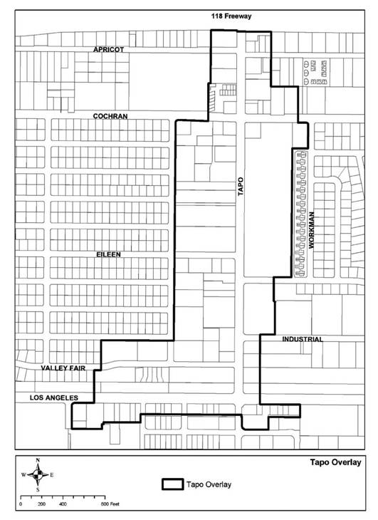
Figure 2-2. Boundaries of the TAPO District.
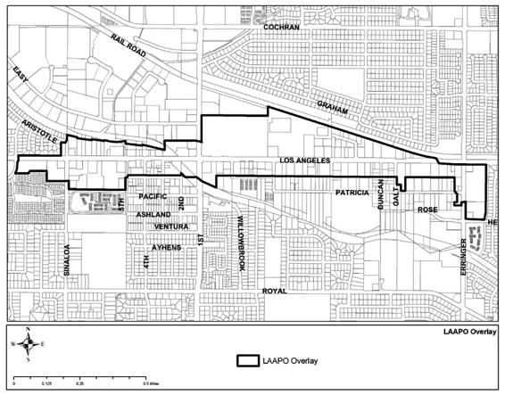
Figure 2-3. Boundaries of the LAAPO District.
(Amended during 3-07 supplement, as amended by § 4 (Exh. A), Ord. No. 1207, eff. March 28, 2013 and § 2(Exh. A), Ord. No. 1341, eff. July 14, 2022)
9-28.080 - Mixed-Use (MU) Overlay District
The purpose of the MU Overlay District designation is to create opportunities within the City to provide for a compatible mix of land uses, including residential, retail, and offices. The Mixed-Use Overlay allows properties to be developed with commercial retail or offices uses on the ground floor and housing on the second floor or above; a mix of differing land uses distributed horizontally on a site; or a single land use, as designated on the Community Subareas and Districts Maps (refer to Figures 2-4, 2-5, and 2-6). Mixed-Use developments strengthen the City's economic base, foster pedestrian-oriented activity, and reduce the need for automobile travel by providing a variety of goods, services, and jobs within walking distance of residences. The MU Overlay prescribes the boundaries of the area within which a specialized set of design standards and guidelines shall apply. The goal is to achieve high quality, pedestrian-oriented development through innovative application of the Citywide Design Guidelines, Residential Design Guidelines, and Landscape Design Guidelines. This zone in no way modifies the land uses permitted by the underlying zoning, except that properties that are developed for a mixture of commercial and residential uses (rather than a single-use development) must meet the standards for the Mixed-Use Overlay District, which are listed in Section 9-44.105. Single-use developments must meet development standards prescribed for that land use type (i.e., commercial retail development must meet all required commercial development standards).
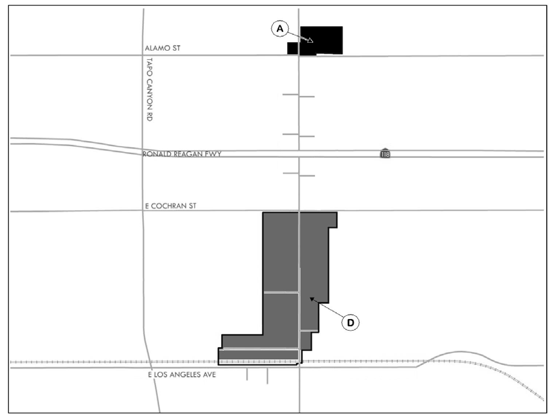
Figure 2-4, Tapo Street Corridor
Area A
• Vertical mixed-use development, with commercial on the ground floor and residential on the upper floors
• General Commercial
• Office Commercial
• Very High Density Residential
Area D
• Three-story vertical mixed-use development, with commercial and residential
• General Commercial
• Office Commercial
• Very High Density Residential
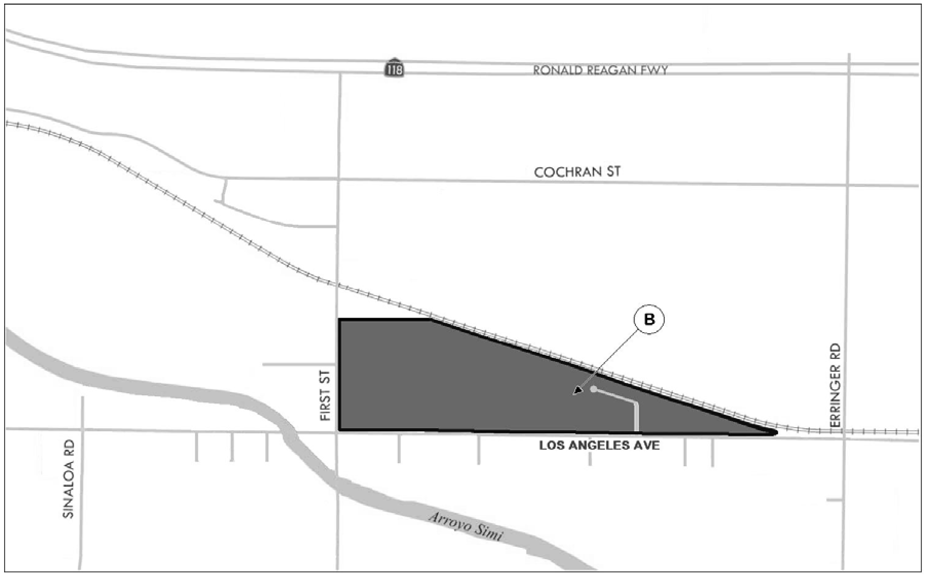
Figure 2-5, Los Angeles Avenue Area
Area B
• Vertical mixed-use development to include housing, commercial, and entertainment uses
• General Commercial
• Very High Density Residential
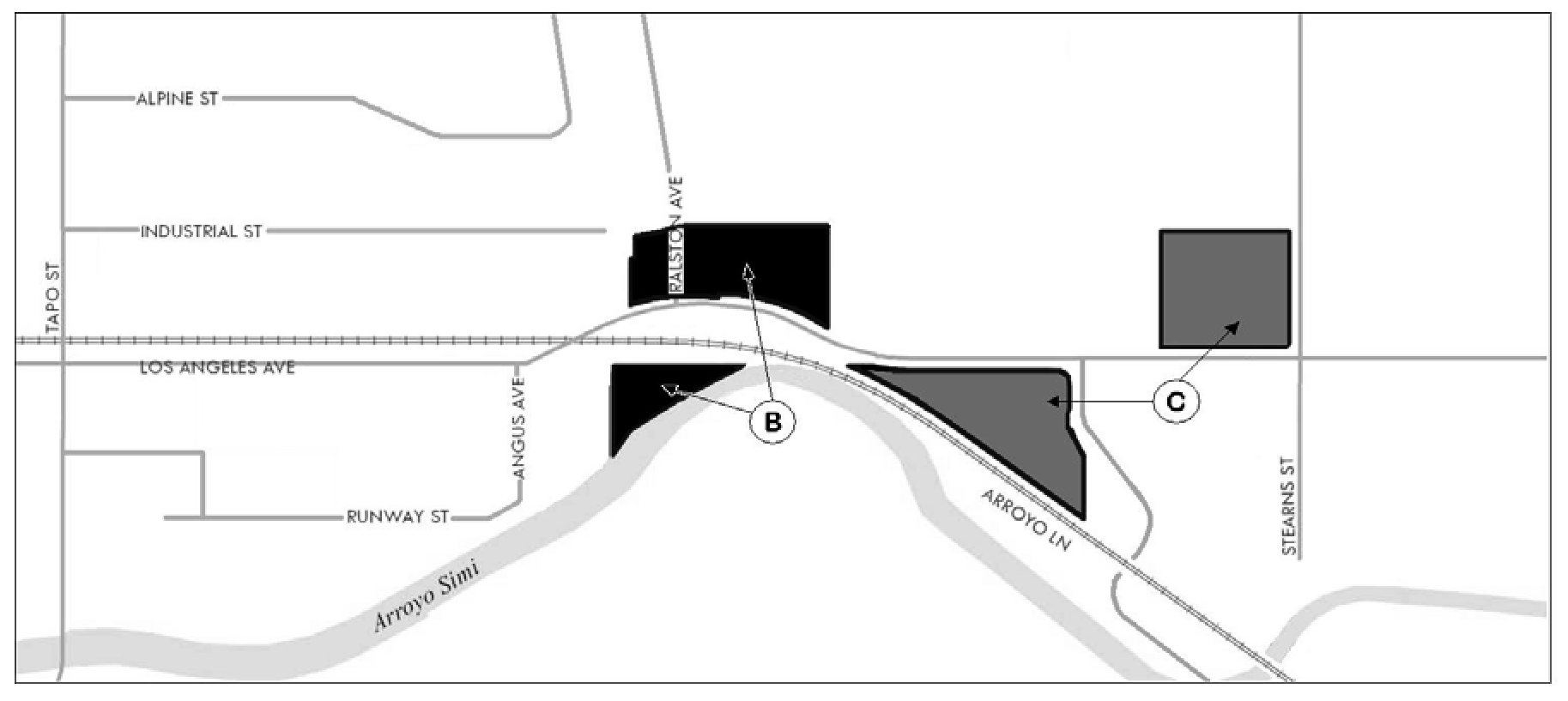
Figure 2-6, Los Angeles Avenue Transit-Oriented Development and Industrial Area
Area B
• Vertical mixed-use with residential located above ground floor retail or office uses
• General Commercial
Area C
• Vertical mixed-use development with residential located above ground floor retail or office uses
• General Commercial
• Commercial Office
(Amended during 3-07 supplement as amended by § 3 (Exh. B), Ord. No. 1192, eff. July 19, 2012 and § 3 (Exh. B), Ord. No. 1193, eff. July 19, 2012)
9-28.085 - Business Park (BP) Overlay District.
The purpose of the BP Overlay District is to provide the opportunity for business park development and office activities in campus environments within existing industrial areas of the City (see Figures 2-7, 2-8, 2-9, and 2-10). Development sites within this Overlay will be of varying sizes to accommodate both single and multiple user development and will provide flexibility for new development that meets the requirements for industrial or business park uses. Such uses include high performance manufacturing and assembly, administrative offices, laboratories, research and development facilities, and supporting services, such as financial services, and accessory retail uses and restaurants. Properties that are developed for business park uses (rather than the underlying industrial zone) must meet the standards for the Business Park Overlay District, which are listed in Sections 9-26.040 and 9-44.065.
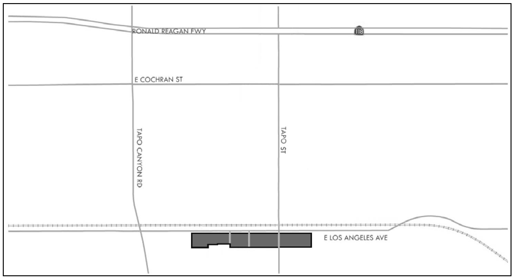
Figure 2-7, Tapo Street Corridor
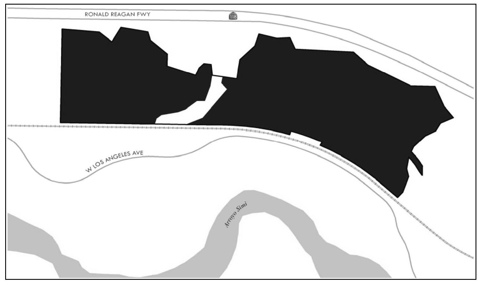
Figure 2-8, West End Specific Plan Area
Figure 2-9, Easy Street Industrial Area
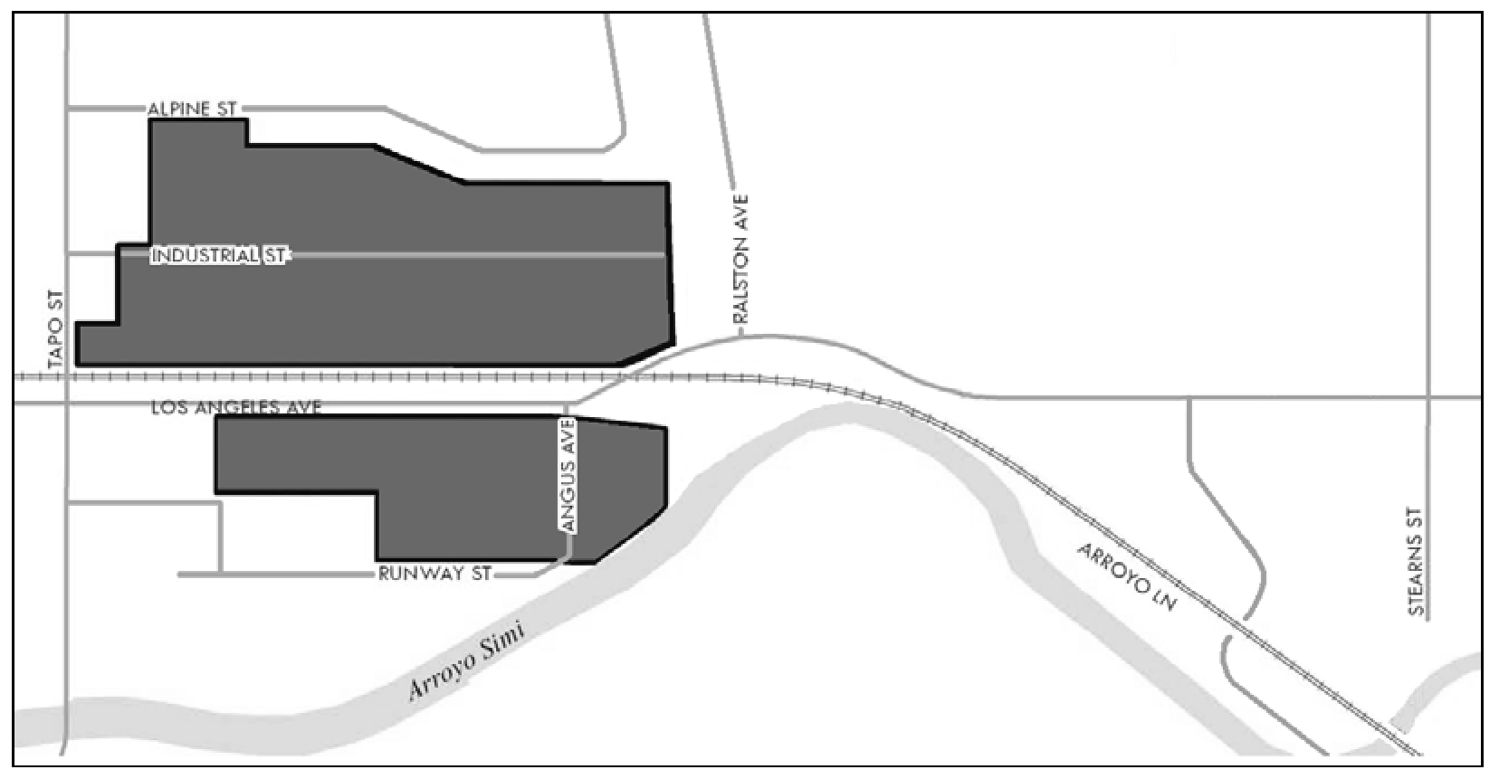
Figure 2-10, Los Angeles Avenue Transit-Oriented Development and Industrial Area
(§ 3 (Exh. B), Ord. No. 1193, eff. July 19, 2012)
9-28.090 - New Vehicle Dealer (NVD) Overlay District
A.
Limits of zone. The boundaries of the New Vehicle Dealer (NVD) Overlay District shall be defined by the City's Official Zoning Map (See Section 9-20.030).
B.
Purpose. The Purpose of the NVD Overlay District is to create an area within the City where new vehicle dealers, including new recreational vehicle dealers, may display signage and conduct promotional events beyond the currently adopted Development Code standards. Vehicle dealers are specialized retailers that rely heavily on nationwide product advertising and promotional events, which are often in excess of the City's Development Code standards. The NVD Overlay District relaxes architectural, signage, and temporary use standards to promote vehicle sales in the City and to allow dealers to remain competitive in the region.
C.
Allowed land uses and permit requirements/permitted uses. Any land use normally allowed in the primary zoning district may be allowed within the NVD Overlay District subject to the land use permit requirements of the primary district.
D.
Development standards. All land uses in the NVD Overlay District classified as new auto and vehicle sales or new recreational vehicle dealers must comply with all applicable provisions of this Development Code and the following provisions:
1.
Promotional activities. Promotional activities must comply with Subsection 9-52.080 (I)(5) (Limited sidewalk sales or displays, extensive promotional commercial activities, and holiday seasonal sales) with the following exceptions:
a.
Temporary Use Permits or fees shall not be required.
b.
There are no limits to the number of events or number of days that promotional activities may occur except under subsection c.
c.
The use of amplified music requires a Temporary Use Permit, which is subject to project conditions and the City's Noise Ordinance.
d.
Large balloons/inflatables may be displayed on the ground (not to exceed 30 feet in height). Signage may be attached to the balloons/inflatables.
2.
Temporary signage. Temporary signage must comply with SVMC Section 9-37.070, with the following exceptions:
a.
Temporary sign permits or fees are not required. There is no limit on temporary sign posting duration.
b.
There are no quantity limits to temporary signs.
c.
Freestanding and on-building temporary signs must be limited to 50 square feet, except up to three signs may be up to 300 square feet each.
d.
Temporary signs up to 12 square feet in size may be attached onto display vehicles. No more than one sign per vehicle is allowed.
e.
Temporary signs up to 24 square feet in size are allowed to be displayed on on-site light poles. No more than two signs per light pole are allowed. Signs must not be located in or above the public right-of-way, or be installed above the height of the light pole.
f.
Temporary signs up to 120 square feet in size may be attached to on-site light standards, streamers, vehicles, and fences, but may not be attached to landscaping (these signs count toward the three signs over 50 square feet in size allowed by subsection c. above).
g.
Temporary signs may be posted no closer than two feet of the property line/street right-of-way, except when these signs are on a parking light pole in which case they must be a least ten feet above grade and not higher than the light pole.
3.
Permanent signage. Permanent signage must comply with Section 9-37.060, with the following exceptions:
a.
For each allowed Monument Business Center Sign or Monument Individual Tenant Space Sign, the maximum sign height is 25 feet and the maximum sign size/area is 100 square feet.
b.
Each new vehicle dealership is allowed one freestanding Electronic Changeable Copy Sign in lieu of or incorporated into one of the allowed freestanding signs pursuant to SVMC Section 9-37.060. For Electronic Changeable Copy Signs fronting First Street, the maximum height shall be 16 feet and the total area allowed for electronic display shall be limited to 40 square feet. For signs abutting residential zones, the hours of operation are limited to 7:00 a.m. to 10:00 p.m. For all other locations of Electronic Changeable Copy Signs within the NVD Overlay District, the signs must be text only and comply with SVMC Section 9-37.050 (G) "Electronic changeable copy sign standards."
c.
The maximum brightness of Electronic Changeable Copy Signs must not exceed an illumination of 5,000 nits (candelas per square meter) during daylight hours, and must not exceed 500 nits between dusk to dawn, as measured from the sign's face at maximum brightness. The sign must be equipped with both a dimmer control and a photocell, which automatically adjusts the display's intensity according to ambient daylight conditions. Prior to the issuance of a sign permit, the applicant must provide written certification from the sign manufacturer that the light intensity has been factory pre-set not to exceed 5,000 nits and that the intensity level is protected from end-user manipulation as deemed appropriate by the Director.
4.
Corporate architecture. Appropriate corporate architecture is allowed in the NVD Overlay District, in order to promote corporate identities and to encourage regional competition with other dealers outside the area. By allowing vehicle dealer franchise designs, it increases the visibility of the NVD Overlay District and separates this area from the surrounding commercial areas.
(§ 3, Ord. 1129, eff. June 5, 2008 as amended by § 2 (Exh. A), Ord. No. 1194, eff. July 19, 2012, and § 2 (Exh. A), Ord. No. 1212, eff. May 9, 2013)
9-28.100 - Hospital-Medical (HM) Overlay District
A.
Limits of zone. The boundaries of the Hospital-Medical Overlay District shall be defined by the City's Official Zoning Map (Refer to SVMC Section 9-20.030).
B.
Purpose. The purpose of the Hospital-Medical Overlay District is to promote a medical campus setting by creating specific development standards for hospital and medical uses within the District's boundaries. This includes additional sign standards to convey directional information for locating the availability of routine and urgent medical services within the Simi Valley Hospital vicinity, thus promoting full-service hospital facilities and related medical services within the City of Simi Valley. In addition, the Hospital-Medical Overlay District provides standards for expanded parking locations, storage container setbacks, and buffering. The standards account for existing site conditions and restraints, as well as to facilitate future development potential.
C.
Allowed land uses and permit requirements/permitted uses. Any land use normally allowed in the primary zoning district is allowed within the Hospital-Medical Overlay District subject to the land use permit requirements of the primary district.
D.
Development standards. All land uses in the Hospital-Medical Overlay District must comply with all applicable provisions of this Development Code and the following provisions:
1.
Permanent signage. Permanent signage must comply with SVMC Section 9-37.060, with the following exceptions:
a.
For each parcel with a Planned Development or Conditional Use Permit, the maximum Monument Sign height is 10 feet and the maximum Monument Sign area is 40 square feet.
b.
The maximum number of Monument Signs for each parcel with a Planned Development or Conditional Use Permit is one per vehicular driveway from a street. Sign locations must be outside of traffic line-of-sight areas.
c.
In addition to the Ancillary Signs permitted in SVMC Section 9-37.060.B (Table 3-10), the main Hospital property (located at the northwest corner of Sycamore Drive and Jones Way) is permitted up to six additional Ancillary Signs with a maximum sign height of 7'-6" and a maximum sign area of 40 square feet each. Each other parcel with a Planned Development or Conditional Use Permit is permitted three additional Ancillary Signs with a maximum sign height of 7'-6" and a maximum sign area of 40 square feet each. Sign locations must be outside of traffic line-of-sight areas.
2.
Temporary signage:
a.
Temporary blade-type signs up to 12 square feet in area are allowed to be displayed on 25 percent of the parking lot light poles within the main hospital parking lot. No more than two signs per light pole are allowed. Signs must have horizontal support members. Signs must not be located in or above the public right-of-way, be installed above the top of the light pole, or strung between light poles, vehicles, or landscaping. Sign display is limited to a maximum of four, 60-day periods per calendar year and subject to approval of a Temporary Sign Permit.
b.
Two temporary banners up to 300 square feet each in sign area are allowed to be displayed on the main hospital building at 2975 Sycamore Drive. The location on the building and method of installation for each temporary banner is at the discretion of the Director of Environmental Services based upon the protection of the public health, safety, and welfare. This Subsection 9-28.100.D.2.b shall automatically expire on December 31, 2015, unless extended by the City Council.
3.
Electronic Changeable Copy Signs. The main Hospital is permitted one electronic changeable copy sign, with no animated motion, not to exceed 12 square feet in size. The sign must be located immediately adjacent to the main hospital emergency room entrance and must not be visible from any street.
4.
Location of parking. If the parcel(s) of the proposed use and the parking lot are under the same ownership, required and surplus off-street parking is permitted to be located on a parcel(s) contiguous to, or across a street from, the use to be served.
5.
Storage containers and screen walls within setback areas. Storage containers used primarily for storage of emergency supplies are permitted within the main Hospital service area as located within the 20-foot setback area on the south side of Avenida Simi, provided the containers are fully screened from Avenida Simi by a masonry wall. Decorative masonry screen walls not exceeding 10 feet in height are permitted within the setback area along the south side of Avenida Simi adjacent to the Hospital service area and memorial garden.
6.
Buffer requirements. The buffer requirement between residential-zoned properties and commercial-zoned Overlay District properties north of Avenida Simi is permitted to consist of a six-foot high wrought-iron/tubular-steel fence in lieu of the six-foot high masonry wall requirement, per Section 9-33.030.H, along the northern property line where there is a slope at least 10 feet higher than the adjacent building pad elevation. In lieu of Section 9-33.030.H.2, buffer trees may consist of one 24-inch box tree for each 150 square feet of required landscape buffer area.
(§ 3 (Exh. B), Ord. No. 1175, eff. September 8, 2011 and § 3 (Exh. A, Ord. No. 1237, eff. March 26, 2015)