
Stoughton City Zoning Code
ARTICLE 0
INTRODUCTION AND DEFINITIONS
Sec. 78-001.- Title.
This chapter shall be known, cited and referred to as the City of Stoughton Zoning Ordinance except as referred to herein, where it shall be known as "this chapter".
(Ord. No. 0-6-09, 6-23-2009)
Sec. 78-002. - Authority.
This chapter is enacted pursuant to the authority granted by the State of Wisconsin Statutes. Specific statutory references are provided within the body of this chapter solely as a means of assisting the reader. Such references are not to be considered as all inclusive and shall in no manner be construed so as to limit the application or interpretation of this chapter.
(Ord. No. 0-6-09, 6-23-2009)
State Law reference— Section 62.23(7), 62.231, 87.30 Wisconsin Statutes.
Sec. 78-003. - Legislative intent.
In enacting this chapter, special attention has been given to ensuring a direct relationship of these regulations to the City of Stoughton's Comprehensive Plan. The general intent of this chapter is to implement certain goals and objectives of the comprehensive plan which are best addressed through zoning approaches, as enabled by State of Wisconsin Statutes.
(Ord. No. 0-6-09, 6-23-2009)
Sec. 78-004. - Rationale and the appearance of ordinance text.
Rationale. Throughout this chapter, paragraphs labeled "Rationale" are included to ensure a complete understanding of the purpose and reasoning of the city in adopting that particular portion of this chapter. Each rationale is intended as an official statement of the legislative findings or purposes, and shall be treated in the same manner as other aspects of legislative history, and shall serve to guide the administrative and judicial interpretation of this chapter. The specific rationale expressed in each rationale section are not intended to be exhaustive, and other non-explicit rationale may also be applicable.
Appearance of ordinance text. The underlined, boldfaced, italicized, alternative point-sized, and/or capitalized typefaces used in this chapter are inserted only for convenience, and are in no way to be construed as part of the provisions of this chapter or as a limitation on the scope of the particular sections or subsections to which they refer.
(Ord. No. 0-6-09, 6-23-2009)
Sec. 78-005. - Purpose.
The overall purpose of this chapter is to implement the City of Stoughton Comprehensive Plan to the extent possible under zoning, as authorized by State of Wisconsin Statutes.
This chapter is designed to control and lessen congestion in the streets; to secure safety from fire, panic and other dangers; to promote health and the general welfare; to promote adequate light and air; to encourage the protection of groundwater resources; to prevent the overcrowding of land; to avoid undue concentration of population; to preserve, protect and promote property values; to facilitate the adequate provision of transportation, water, sewerage, schools, parks, and other public facilities; and to preserve burial sites as defined in s.157.70(1). State Law Reference: Section 62.23(7)(c), Wisconsin Statutes.
This chapter is adopted for the purpose of protecting the public health, safety, morals, comfort, convenience and general welfare by implementing certain goals and objectives of the comprehensive plan. Additional purposes of this chapter are specified throughout this chapter.
Rationale: In developing the specific regulations of this chapter, much effort has gone into balancing the goals and objectives of the comprehensive plan. The current status of this chapter and its components (including the official zoning map) represents the cohesive result of carefully considered plan implementation practices. Amendments to these provisions and/or the official zoning map shall seriously consider the effect of such changes on the interrelationships which exist within this chapter, and between this document, the comprehensive plan, and related long-range planning policies and programs. (See sections 78-902 and 78-903.)
(Ord. No. 0-6-09, 6-23-2009)
Sec. 78-006. - Severability and non-liability.
It is hereby declared to be the intention of the common council that the several provisions of this chapter are separable in accordance with the following:
(1)
If any court of competent jurisdiction shall adjudge any provision of this chapter to be invalid, such judgment shall not affect any other provisions of this chapter not specifically included in said judgment.
(2)
If any court of competent jurisdiction shall adjudge invalid the application of any portion of this chapter to a particular property, water, building, or structure, such judgment shall not affect the application of said provision to any other property, water, building, or structure not specifically included in said judgment.
(3)
If any requirement or limitation attached to an authorization given under this chapter is found invalid, it shall be presumed that the authorization would not have been granted without the requirement or limitation and, therefore, said authorization shall also be invalid.
(4)
The city does not guarantee, warrant or represent that only those areas designated as floodplain will be subject to periodic inundation and hereby asserts that there is no liability on the part of the city, its officers, employees, agents, or representatives for any flood damages, sanitation problems, or structural damages.
(Ord. No. 0-6-09, 6-23-2009)
Sec. 78-007. - Abrogation.
It is not intended that this chapter abrogate or interfere with any constitutionally protected vested right. It is also not intended that this chapter abrogate, repeal, annul, impair or interfere with any existing easements, covenants, deed restrictions, agreements, rules, regulations or permits previously adopted or issued pursuant to law.
(Ord. No. 0-6-09, 6-23-2009)
Sec. 78-008. - Rules of interpretation.
(1)
In their interpretation and application, the provisions of this chapter shall be held to be the minimum requirements for the promotion of the public health, safety, morals and welfare, and shall be liberally construed in favor of the city and shall not be construed to be a limitation or repeal of any other power now possessed by the City of Stoughton.
(2)
Where property is affected by the regulations imposed by any provision of this chapter and by other governmental regulations, the regulations which are more restrictive or which impose higher standards or requirements shall prevail. Regardless of any other provision of this chapter, no land shall be developed or used, and no structure erected or maintained in violation of any state or federal regulations. Where there are conflicts between or among regulations within this chapter, the regulations which are more restrictive or which impose higher standards or requirements shall prevail. In all instances, where there are conflicts between the text of this chapter and any Appendix of this chapter, the text shall prevail.
(3)
No structure, land, water or air shall hereafter be used and no structure or part thereof shall hereafter be located, erected, moved, reconstructed, extended, enlarged, converted or structurally altered without a building permit, except structures not requiring a building permit (swing set, clothesline, etc), and without full compliance with the provisions of this chapter and all other applicable local, county and state regulations.
(4)
Nothing herein contained shall require any changes in plans, construction, size or designated use of any building or part thereof, for which a building permit has been issued before the effective date of this chapter and the construction of which shall have been started within one year from the date of such permit.
(5)
Except as provided in this chapter, under provisions for Nonconforming Uses (Section 78-210), Nonconforming Developments (Section 78-310), Substandard Lots (Section 78-407), and Nonconforming Structures and Buildings (Section 78-408), no building, structure, development or premises shall be hereinafter used or occupied and no applicable permit granted, that does not conform to the requirements of this chapter.
(6)
In cases of mixed-occupancy or mixed-use, the regulations for each land use shall apply to the portion of the structure or land so occupied or so used.
(7)
Except for outlots authorized under the city's land division ordinance to contain permanently protected green space area, no yard or other open space shall be considered as providing a yard or open space for a building or structure on any other lot.
(Ord. No. 0-6-09, 6-23-2009)
Sec. 78-009. - Jurisdiction.
This chapter is applicable to all territory located within the corporate limits of the City of Stoughton.
(Ord. No. 0-6-09, 6-23-2009)
Sec. 78-010. - Re-enactment and repeal.
(1)
This chapter, in part, carries forward by re-enactment some of the provisions of the regulations governing zoning and related matters, being previously known collectively as the "Zoning Code", chapter 78 of the Code of Ordinances for the City of Stoughton, adopted prior to the effective date of this chapter. It is not the intention of this chapter to repeal, but rather to re-enact and continue in force such existing provisions so that all rights and liabilities that have accrued thereunder are preserved and may be enforced, unless explicitly surrendered by specific provisions of this chapter or altered by the official zoning map.
(2)
All provisions of chapter 78 of the City of Stoughton Code of Ordinances which are not re-enacted herein are hereby repealed.
(3)
The adoption of this chapter shall not adversely affect the city's right to prosecute any violation of the predecessor zoning ordinance provided the violation occurred while that chapter was in effect.
(Ord. No. 0-6-09, 6-23-2009)
Sec. 78-011. - Effective date.
All plans approved under previous zoning regulations shall be valid and may be used to obtain permits for a period of not more than one year after the effective date of this chapter, except where subject to developer's agreement provisions. This chapter shall become effective upon passage and posting according to law, following the date of repeal and re-enactment of the official zoning map.
(Ord. No. 0-6-09, 6-23-2009)
Sec. 78-012. - Introduction to word usage, abbreviations and definitions.
The purpose of sections 78-013 through 78-015 is to define words, terms and phrases contained in this chapter which are essential to the understanding, administration and enforcement of this chapter, and which are not part of common English usage.
(Ord. No. 0-6-09, 6-23-2009)
Sec. 78-013. - Word usage.
The interpretation of this chapter shall abide by the provisions and rules of this section, except where the context clearly requires otherwise, or where the result would clearly be inconsistent with the apparent intent of this chapter.
(1)
Words used or defined in one tense or form shall include other tenses and derivative forms.
(2)
Words in the singular number shall include the plural number, and words in the plural number shall include the single number.
(3)
The masculine gender shall include the feminine, and vice versa.
(4)
The words "shall", "must" and "will" are mandatory.
(5)
The words "may", "can" and "might" are permissive.
(6)
The word "person" includes individuals, firms, corporations, partnerships, associations, trusts, and any other legal entity.
(7)
The word "City" shall mean the City of Stoughton, Wisconsin.
(8)
The word "county" shall mean the County of Dane, Wisconsin.
(9)
The word "state" shall mean the State of Wisconsin.
(10)
The word "commission" shall mean the City of Stoughton Plan Commission.
(11)
The words "council" and "common council", shall refer to the City of Stoughton Common Council.
(12)
The word "board" shall mean the City of Stoughton Zoning Board of Appeals.
(13)
If there is any ambiguity between the text of this chapter and any caption, illustration, or table, the text shall control.
(Ord. No. 0-6-09, 6-23-2009)
Sec. 78-014. - Abbreviations.
The following abbreviations in this chapter are intended to have the following meanings:
(Ord. No. 0-6-09, 6-23-2009; Ord. No. 0-21-2024, § 1(Exh. A), 11-26-2024)
Sec. 78-015. - Definitions.
The following words, terms and phrases, wherever they occur in this chapter, shall have the meanings ascribed to them by this section. Definitions provided by this section include:
Abutting: Having a common border with, or being separated from such common border by an alley or easement.
Access: A means of providing vehicular or non-vehicular egress from or ingress to a property, highway, or private roadway.
Access, direct: A condition of immediate physical connection resulting from a highway, alley, or private road abutting a property.
Access, secondary: A means of providing vehicular or non-vehicular ingress to or egress from a property and a source other than a street or alley (e.g. easement, common driveway, etc.).
Access standards: See section 78-702.
Acre: 43,560 square feet.
Accessory residential unit: An accessory residential unit ("granny flat") is an accessory dwelling unit established in conjunction with and clearly subordinate to the principle dwelling unit on a single-family zoned lot. Accessory residential units are located at the rear of a lot, and are typically located above an attached or detached alley-loaded garage that serves the primary residence. Such units are not permitted in Stoughton.
Accessory use or structure: A use or structure subordinate to, and serving, the principal use or structure on the same lot and customarily incidental thereto. See subsection 78-202(3).
Active outdoor public recreational (land use): See subsection 78-206(3)(b).
Activity center: An area which is typified by a concentration of nonresidential and/or multi-family development.
Addition: Any new construction which increases the outside dimensions of a building.
Address and/or identification sign: Is an accessory wall sign containing only the name and/or address of the premises on which it is located. See subsection 78-814(7).
Adjacent: Abutting a separate lot.
Agricultural district: See subsection 78-105(1).
Agricultural land use(s): See subsection 78-206(2).
Agricultural services (land use): See subsection 78-206(2)(d).
Air pollution standards: See section 78-710.
Airport (land use): See subsection 78-206(6)(b).
Alley: A public or private right-of-way usually of reduced width as compared to a street, primarily intended to provide a secondary means of access to the side or rear of an abutting property fronting upon another street right-of-way and not for the use of through traffic.
Amendment of zoning regulations: See section 78-902.
Amendment of official zoning map: See section 78-903.
Animal unit: A measure which represents a common denominator for the purpose of defining a husbandry or intensive agricultural land use. The animal unit measure relates to the maximum carrying capacity of one acre of land and is related to the amount of feed various species consume, and the amount of waste they produce. The following table indicates the number of common farm species which comprise a single animal unit:
Animal Unit Table
Source: The Stockman's Handbook
Apartment: See subsection 78-206(1)(a)7.
Appeal: A means for obtaining review of a decision, determination, order, or failure to act pursuant to the terms of this chapter as expressly authorized by the provisions of section 78-912.
Arterial street: See Street, arterial.
Artisan studio: See subsection 78-206(4)(r).
Artwork: Means a sculpture, monument or structure erected solely for aesthetic purposes, which in no way identifies a product or business or is used for commercial purposes. See subsections 78-206(4)(r) and 78-803(2)(g).
Athletic scoreboard: A sign accessory to an athletic playing field and/or its associated fences and walls, used to report scores and often to promote businesses to viewers of the events, but not including signs placed on the exterior of such structures. See subsection 78-803(2)(g).
Average ground elevation: The average level of the finished surface of the ground adjacent to the exterior walls of a building or structure.
Awning: A shelter projecting from and supported by the exterior wall of a building, constructed of non-rigid materials on a supporting framework. See subsection 78-814(6).
Banner: A sign made of fabric or any non-rigid material with no enclosing framework. See subsection 78-810(1).
Base flood: The flood having a one percent chance of being equaled or exceeded in any given year. The 100-year flood.
Basement: A portion of a building located partly underground, but having one-half or less of its floor to ceiling height below the average grade of the adjoining ground.
Bed and breakfast establishment (land use): See subsection 78-206(4)(l).
Bedroom: A room in a residence marketed, designed, or otherwise likely to function primarily for sleeping.
Blanketing: The unreasonable obstruction of view of a sign caused by the placement of another sign.
Blanket variance: A variance which is automatically granted by a provision of this chapter in order to reduce the creation of legal nonconforming developments (see section 78-310 and section 78-408(9)).
Boarding house (land use): See subsection 78-206(4)(o).
Bufferyard: Any permitted combination of distance, vegetation, fencing and berming which results in a reduction of visual and other interaction with an adjoining property. See article VI.
Building: A structure having a roof and intended for the shelter, housing or enclosure of persons, animals or chattels.
Building, accessory: A building which:
(a)
Is subordinate to and serves a principal structure or a principal use;
(b)
Is subordinate in area, extent, and purpose to the principal structure or use served;
(c)
Is located on the same lot as the principal structure or use served except as otherwise expressly authorized by provisions of this chapter; and
(d)
Is customarily incidental to the principal structure or use. Any portion of a principal building devoted or intended to be devoted to an accessory use is not an accessory building.
Building coverage: The percentage of a lot covered by principal and accessory buildings, including all structures with a roof.
Building front: That exterior wall of a building which faces the front lot line of the lot.
Building height: The vertical distance from the average elevation of the finished grade along the front of the building to the highest point of a flat roof, or to the deck line of a mansard roof, or to the average height between the eave and ridge for gable, hip or gambrel roofs. Also applies to structures.
Building line: A line on a lot, generally parallel to a lot line or public or private road right-of-way line, located a sufficient distance from either to provide the minimum yards required by this chapter. The building line determines the area in which buildings are permitted subject to all applicable provisions of this chapter. This is also referred to as a "setback".
Building envelope: A component of a large development which conforms to the lot lines of developments which are not large developments, in that required minimum setback distances are measured from the building envelope line. (Refer to subsection(11))
Building, principal: A building in which is conducted, or in which is intended to be conducted, the main or principal use of the lot on which it is located.
Building separation: The narrowest distance between two buildings. See Minimum building separation.
Building size: The total gross floor area of a building. See Maximum building size.
Bulk (of a building): The combination of building height, size, and location on a lot.
Bulkhead line: A geographic line along a reach of navigable water that has been adopted by a municipal ordinance and approved by the department of natural resources pursuant to Section 30.11, Wisconsin Statutes, and which allows limited filling between this bulkhead line and the original ordinary high water mark, except where such filling is prohibited by the floodway provisions of this chapter.
Business district(s): See subsection 78-105(4).
Cafeteria, company (land use): See subsection 78-206(8)(d).
Caliper: A measurement of the size of a tree equal to the diameter of its trunk measurement four foot above natural grade. Used for trees in a nursery setting.
Campground (land use): See subsection 78-206(4)(n).
Candlepower: The amount of light that will illuminate a surface one-foot distant from a light source to an intensity of one foot-candle. Maximum (peak) candlepower is the largest amount of candlepower emitted by any lamp, light source, or luminaire.
Canopy (building): A rigid multisided structure covered with fabric, metal or other material and supported by a building at one or more points or extremities and by columns or posts embedded in the ground at other points or extremities. See subsection 78-206(4)(g) and subsection 78-810(7).
Canopy (freestanding): A rigid multisided structure covered with fabric, metal or other material and supported by columns or posts embedded in the ground. See subsection 78-206(4)(g) and subsection 78-810(7).
Caretaker's residence: A dwelling unit which is used exclusively by the owner, manager, or operator of a principal permitted use and which is located on the same parcel as the principal use. See subsection 78-206(8)(w).
Carport (land use): An open sided, roofed vehicle shelter, usually formed by extension of the roof from the side of a building that meets the building code. See subsection 78-206(8)(c).
Cellar: That portion of the building having more than one-half of the floor-to-ceiling height below the average grade of the adjoining ground.
Central Business (CB) District: See subsection 78-105(4)(c).
Certificate of occupancy: See section 78-909.
Clear cutting (land use): See subsection 78-206(2)(g).
Clerestory window: A window in which the lowest glassed area is a minimum of seven feet above the level of the floor located directly under the window.
Climax tree: A tree that would occupy the uppermost canopy of a forest in a natural ecological situation. These trees are often referred to as shade trees. Examples include hickory, oak, maple, etc. See subsection 78-610.
Collector street: See Street, collector.
Commercial animal boarding (land use): See subsection 78-206(4)(j).
Commercial indoor lodging (land use): See subsection 78-206(4)(k).
Commercial land use(s): See subsection 78-206(4).
Commercial vehicle: Any motor vehicle used for business or institutional purposes or having painted thereon or affixed thereto a sign identifying a business or institution or a principal product or service of a business or institution. Agricultural equipment used as part of a permitted agricultural principal use shall not be considered as a commercial vehicle.
Commercial wind energy system: A wind energy conversion system consisting of more than one wind turbine and tower, a wind energy conversion system which will be used primarily for off-site consumption of power or a wind energy system in excess of 60 kWh. See subsection 78-206(10)(b).
Community character: The impression which an area makes in regard to the type, intensity, density, quality, appearance, and age of development.
Community living arrangement (land use): See subsections 78-206(3)(g) through (i).
Company provided on-site recreation (land use): See subsection 78-206(8)(e).
Composting operation (land use): See subsection 78-206(5)(f).
Comprehensive plan: The Comprehensive Plan of the City of Stoughton, Wisconsin, and as subsequently amended.
Conditional use: A land use which requires a conditional use permit in order to develop. See subsection 78-202(2). See subsection 78-905 for applicable procedures.
Cone of depression: The area around a well, in which the water level has been lowered at least one-tenth of a foot by pumping of the well.
Construction materials standards: See section 78-716.
Construction sign: A sign indicating the name of the contractors, engineers, architect, financiers and related companies or products being used in construction on the lot. See subsection 78-811(1)(c).
Construction, start of: The installation of foundation footings and/or materials for road construction.
Contractor's on-site equipment storage (land use): See subsection 78-206(9)(d).
Contractor's project office (land use): See subsection 78-206(9)(c).
Conventional residential development: See subsection 78-206(1)(a).
Cultivation (land use): See subsection 78-206(2)(a).
Day care: See family day care home, intermediate day care home, or group day care center.
Deck: A structure that has no roof or walls and is considered part of a building or structure
Decorative water feature: Any manmade stream, fountain, waterfall, or other such water feature that contains water that flows or is sprayed into the air, constructed for decorative, scenic, or landscape purposes.
Dedication: The transfer of property interest from private to public ownership for a public purpose. The transfer may be of fee-simple interest or of a less than fee-simple interest, including an easement.
Density: A term used to describe the number of dwelling units per acre.
Developer: The legal or beneficial owner(s) of a lot or parcel of any land proposed for inclusion in a development, including an optionee or contract purchaser.
Development: The division of a parcel of land into two or more parcels; the construction, reconstruction, conversion, structural alteration, relocation, or enlargement of any buildings; any use or change in use of any buildings or land; any extension of any use of land; or any clearing, grading, or other movement of land, for which permission may be required pursuant to this chapter.
Development option(s): The type of residential or nonresidential development as categorized by the proportion of the site devoted to permanently protected green space.
Development pad: The area of land where site disruption will occur, including building areas, paved areas, yard and septic system areas, and other areas of non-native vegetation.
Directional sign: A sign which indicates only the name, direction, address, logo and/or distance of a business or activity. Directional signs may be located off-premises if erected by a government agency, nonresidential land use, or as a special event sign. Only those directional signs erected by a government agency may be located in a public right-of-way. See subsection 78-810(14).
Directly (internally) illuminated sign: A sign designed to give any artificial light directly through any transparent or translucent material from a source of light originating within or on such sign. See subsection 78-810(2).
Disposal land use(s): See subsection 78-206(5).
Distribution center (land use): See subsection 78-206(6)(d).
Drainage: The removal of surface water or groundwater from land by drains, grading, or other means. Drainage includes the control of runoff, to minimize erosion and sedimentation during and after development, and the means necessary for water supply preservation or prevention or alleviation of flooding.
Drainage structure (land use): See subsection 78-206(8)(r).
Dripline: Outer perimeter edge of a tree canopy as transferred perpendicularly to ground level.
Drive-in theater (land use): See subsection 78-206(4)(i).
Dryland access: A vehicular access route which is above the regional flood elevation and which connects land located in the floodplain to land which is outside the floodplain, such as a road with its surface above the regional flood elevation and wide enough to accommodate wheeled vehicles.
Duplex: See subsection 78-206(1)(a)2.
Dwelling: A building or one or more portions thereof, containing one or more dwelling units, but not including habitations provided in nonresidential uses such as lodging uses and commercial campgrounds.
Dwelling, attached: A dwelling joined to another dwelling at one or more sides by a shared wall or walls.
Dwelling, detached: A dwelling entirely surrounded by open space on the same lot.
Dwelling unit: A room or group of rooms, providing or intended to provide permanent living quarters for not more than one family.
Dwelling unit separation: The narrowest distance between two dwelling units. See Minimum dwelling unit separation.
Easement: Written authorization, recorded in the register of deeds' office, from a landowner authorizing another party to use any designated part of the land owner's property for a specified purpose.
Electromagnetic radiation standards: See subsection 78-712.
Electronic message unit sign: A sign the message of which may be changed by electronic process, including such messages as copy, art, graphics, time, date, temperature, weather or information concerning civic or charitable events or the advertising of products or services for sale on the premises. This also includes traveling or segmented message displays.
Elevated building: A non-basement building with its lowest floor elevated above the ground level by means of fill, solid foundation perimeter walls, pilings columns (post and piers), shear walls, or breakaway walls.
Encroachment: Any fill, structure, building, use, or development that advances beyond proper limits.
Environmental control facility: Any facility, temporary or permanent, which is reasonably expected to abate, reduce, or aid in the prevention, measurement, control or monitoring of noise, air, or water pollutants, solid waste or thermal pollution, radiation or other pollutants, including facilities installed principally to supplement or to replace existing property or equipment not meeting or allegedly not meeting acceptable pollution control standards or which are to be supplemented or replaced by other pollution control facilities.
Environs (of the City of Stoughton): Areas in which the City of Stoughton exercises extraterritorial powers.
Erosion: The detachment and movement of soil or rock fragments by water, wind, ice, and/or gravity.
Essential services: Facilities that are:
(a)
Owned or maintained by public utility companies or public agencies, and;
(b)
Located in public ways or in easements provided for the purpose, or on a customer's premises and not requiring a private right-of-way, and;
(c)
Reasonably necessary for the furnishing of adequate water, sewer, gas, electric, communication, or similar services to adjacent customers, and;
(d)
Not including any cross-country line on towers.
Exempt sign: A sign that does not require a permit application or fee. An exempt sign must meet the requirements of this article. See subsection 78-803(2).
Explosion standards: See subsection 78-713.
Exterior communication devices (land use): See subsection 78-206(8)(v).
Extraction use (land use): See subsection 78-206(7)(d).
Extraterritorial area: The area outside of the city limits in which the City of Stoughton may exercise extraterritorial powers of planning, land division, and/or zoning review.
Exurban Residential (ER-1) District: See subsection 78-105(2)(a).
Facade: The entire building front including the parapet.
Family: An individual or two or more persons, each related by blood, marriage or adoption or guardianship, living together as a single housekeeping unit; or a group of not more than four persons not so related, maintaining a common household in which bathrooms, kitchen facilities, and living quarters are shared.
Family day care home (land use): See subsection 78-206(8)(k).
Farm residence (land use): See subsection 78-206(8)(b).
Fees: See subsection 78-919.
Fencing standards: See section 78-718.
Filling (land use): See subsection 78-206(8)(s).
Fire standards: See subsection 78-713.
First habitable floor: The top surface above an unfinished basement, cellar, or crawl space that is intended for living quarters.
Five year time of travel (TOT): The recharge area upgradient of the cone of depression, the outer boundary of which it is determined or estimated that ground water and potential contaminants will take five years to reach a pumping well.
Flag: Any fabric, plastic or similar material containing distinctive colors, patterns, or symbols used as a symbol or emblem of any corporation, nation, organization of nations, state, city, or religious, fraternal, educational or civic organization displayed for noncommercial purposes. See subsection 78-803(2)(a).
Flashing sign: A directly or indirectly illuminated sign on which artificial light is not maintained stationary and constant in intensity and color at all times when in use. See subsection 78-810(3).
Flicker: The moving shadow created by sun shining on the rotating blades of the wind turbine. See subsection 78-206(10).
Floodplain and related topics: See section 78-503 and section 78-505.
Floodway: The floodway is the channel of a river or stream and those portions of the floodplain adjoining the channel required to carry the regional floodwaters.
Floor area: The sum of the gross horizontal areas of the several floors of a building including interior balconies, mezzanines, basements and attached accessory buildings, fitting rooms, stairs, escalators, unenclosed porches, detached accessory buildings utilized as dead storage, heating and utility rooms, inside off-street parking or loading space (decks are not included in this measurement). Measurements shall be made from the inside of the exterior walls and to the center of interior walls.
Floor area ratio (FAR): The ratio calculated by dividing the total floor area of all buildings on a site by the gross site area. See Maximum floor area ratio.
Foot-candle: A unit of illumination produced on a surface, all points of which are one foot from a uniform point source of one candle.
Freeboard: Represents a factor of safety usually expressed in terms of a certain amount of feet above a calculated flood level. Freeboard compensates for the many unknown factors that contribute to flood heights greater than the height calculated. These unknown factors may include, but are not limited to, ice jams, debris accumulation, wave action, obstruction of bridge openings and floodways, the effects of urbanization on the hydrology of the watershed, loss of flood storage areas due to development and the sedimentation of a river or stream bed.
Freestanding, ground or pole sign: A sign which is supported by structures or supports in or upon the ground and independent of support from any building. See subsection 78-814(4), and section 78-817, 78-818.
Freight terminal (land use): See subsection 78-206(6)(c).
Garage (residential): A detached accessory building or portion of the principal building, including a carport, which is used primarily for storing passenger vehicles, trailers or one truck of a rated capacity not in excess of 10,000 pounds. Garages do not include temporary enclosures. See subsection 78-206(8)(c).
Gas station: See in-vehicle sales or service.
General floor plans: A graphic representation of the anticipated utilization of the floor area within a building or structure, but not necessarily as detailed as construction plans.
General Industrial (GI) District: See subsection 78-105(5)(b).
General temporary outdoor sales (land use): See subsection 78-206(9)(a).
Glare: The brightness of a light source which causes eye discomfort.
Glare standards: See section 78-712.
Green space ratio (GSR): The percentage of the gross site area which is preserved as permanently protected green space. Green space ratio is calculated by dividing the area of permanently protected green space by the gross site area. See Minimum green space ratio.
Gross density: The result of dividing the number of dwelling units located on a site by the gross site area. See Maximum gross density.
Gross floor area: The total floor area on all levels of a building.
Gross site area (GSA): The total area of a site available for inclusion in calculations of the maximum permitted density or intensity of development.
Groundwater divide: A line on a water table on either side of which the water table slopes downward. It is analogous to a drainage divide between two drainage basins on a land surface.
Group day care center (land use): See subsection 78-206(4)(m).
Group sign: A freestanding sign displaying the collective name of a group of two or more uses such as the title of a shopping center, office park, or industrial park and its tenants. No sales or price information shall be permitted. Each use shall be considered a separate sign. See subsection 78-814(11).
Habitable buildings: Any building, or portion thereof used for human habitation.
Heat standards: See section 78-712.
Hearing notice: Publication or posting meeting the requirements of Chapter 985, Stats. Class 1 notice is the minimum required for appeals: Published once at least ten days before hearing. Class 2 notice is the minimum required for all zoning ordinances and amendments including map amendments: published twice, once each week consecutively, the last at least ten days before the hearing.
Heavy industrial (land use): See subsection 78-206(7)(b).
Heavy Industrial (HI) District: See subsection 78-105(5)(c).
Height of structure: See Building height.
Heliport (land use): See subsection 78-206(6)(b).
High flood damage potential: Any danger to human life or public health or the potential for any significant economic loss to a structure or its contents.
Holiday signs and decorations: Signs or other decorations and/or materials displayed during traditionally accepted civic, patriotic, or religious holidays. See subsection 78-803(2)(a).
Home occupation (land use): See subsection 78-206(8)(j).
Hotel: See Commercial indoor lodging.
Husbandry (land use): See subsection 78-206(2)(b).
Identification sign: A sign that carries only the name of the firm, major enterprise, institution or principal products offered for sale on the premises or a combination of these. See subsections 78-811(1) and 78-814(7).
Impervious surface: Areas designed and installed to prohibit infiltration of stormwater. Homes, buildings, and other structures, as well as concrete, brick, asphalt, and similar paved surfaces are considered impervious. Gravel areas and areas with "landscaped pavers" and "pervious pavement" which are intended for vehicular traffic are considered to be impervious.
Increase in regional flood height: A calculated upward rise in the regional flood elevation, equal or greater than 0.01 foot, resulting in comparison of existing conditions and proposed conditions which is directly attributable to manipulation of mathematical variables such as roughness factors, expansion and contraction coefficients and discharge.
Indirectly illuminated sign: A sign that is illuminated from a source outside of the actual sign. See subsection 78-810(2).
Indoor commercial entertainment (land use): See subsection 78-206(4)(h).
Indoor institutional (land use): See subsection 78-206(3)(c).
Indoor maintenance service (land use): See subsection 78-206(4)(e).
Indoor sales (land use): See subsection 78-206(4)(c).
Indoor sales accessory to light industrial use (land use): See subsection 78-206(8)(i).
Indoor service (land use): See subsection 78-206(4)(c).
Indoor storage (land use): See subsection 78-206(5)(a).
Indoor wholesaling (land use): See subsection 78-206(5)(a).
Industrial district(s): See subsection 78-102(5).
Industrial land use(s): See subsection 78-206(7).
Infill development: Development located in areas which are largely developed already.
Institutional (I) District: See subsection 78-105(6)(a).
Institutional land use(s): See subsection 78-206(3).
Institutional residential development: See subsection 78-206(3)(f).
Instructional sign: A sign that provides instruction to the public regarding the use of a facility and does not include brand names or information regarding product lines or services for advertising purposes. Examples of instructional signs include accepted credit cards, loading area locations, vending machine signs, warning and emergency signs, public and legal notices, no trespassing, public restroom, accessibility for the disabled signs and telephone signs.
Intensity: A term used to describe the amount of gross floor area or landscaped area, on a lot or site, compared to the gross area of the lot or site.
Intensive agricultural (land use): See subsection 78-206(2)(c).
Intermediate day care home (land use): See subsection 78-206(8)(l).
Interpretation: See section 78-911 for application procedures.
In-vehicle sales (land use): See subsection 78-206(4)(g).
In-vehicle sales as accessory use (land use): See subsection 78-206(8)(g).
In-vehicle service (land use): See subsection 78-206(4)(h).
In-vehicle service as accessory use (land use): See subsection 78-206(8)(g).
Junkyard (land use): See subsection 78-206(5)(d).
Kennel, private residential: Any residence housing more than three dogs and or cats (over six months of age). See subsection 78-206(8)(p).
Lakeshore: Those lands lying within the following distances from the ordinary high water mark of navigable waters: 1,000 feet from a lake, pond, or flowage; and 300 feet from a river or stream; or to a landward side of the floodplain, whichever distance is the greater. Lakeshores shall not include those lands adjacent to farm drainage ditches where (a) such lands are not adjacent to a navigable stream or river; (b) those parts of such drainage ditches adjacent to such lands were not navigable streams before ditching or had no previous stream history; and (c) such lands are maintained in non-structural agricultural use. See section 78-505.
Landscape point: See section 78-603.
Landscaped area: The area of a site which is planted and continually maintained in vegetation, including grasses, flowers, herbs, garden plants, native or introduced groundcovers, shrubs, bushes, and trees. Landscaped area includes the area located within planted and continually maintained landscaped planters.
Landscape surface area ratio (LSR): The percentage of the gross site area or lot area which is preserved as permanently protected landscaped area.
Land use: The type of development and/or activity occurring on a piece of property.
Large development: See subsection 78-205(11).
Lawn care (land use): See subsection 78-206(8)(t).
Light industrial (land use): See subsection 78-206(7)(a).
Light industrial incidental to indoor sales: See subsection 78-206(8)(i).
Lighting standards: See section 78-707.
Loading standards: See section 78-705.
Local collector street: See Street, collector.
Local residential street: See Street, local residential.
Local street: See Street, local.
Lot: A parcel of land that: (a) is undivided by any street or private road; (b) is occupied by, or designated to be developed for, one building or principal use; and (c) contains the accessory buildings or uses customarily incidental to such building, use, or development, including such open spaces and yards as designed and arranged or required by this chapter for such building, use, or development.
Lot area: The area contained within the property boundaries of a recorded lot.
Lot corner: A lot situated at the junction of and abutting on two or more intersection streets, or a lot at the point of deflection in alignment of a continuous street, the interior angle of which does not exceed 135 degrees.
Lot depth: The average distance between the front lot line and the rear lot line of a lot.
Lot frontage: Lot width measured at the street lot line. When a lot has more than one street lot line, lot width shall be measured, and the minimum lot width required by this chapter shall be provided at each such line.
Lot interior: A lot other than a corner lot.
Lot line: A lot line is the property line (including the vertical plane established by the line and the ground) bounding a lot except that where any portion of a lot extends into the public right-of-way or a proposed public right-of-way, the line of such public right-of-way shall be the lot line for applying this chapter.
Lot line, front: A lot line which abuts a public or private street right-of-way. In the case of a lot which has two of more street frontages, the lot line along the street from which the house is addressed shall be the front lot line.
Lot line, rear: In the case of rectangular or most trapezoidal shaped lots, that lot line which is parallel to and most distant from the front lot line of the lot. In the case of an irregular, triangular, or gore-shaped lot, a line 20 feet in length, entirely within the lot, parallel to and at the maximum possible distance from the front line shall be considered to be the rear lot line. In the case of lots which have frontage on more than one road or street, the rear lot line shall be selected by the property owner.
Lot line, side: Any boundary of a lot which is not a front lot line, a street side lot line, or a rear lot line.
Lot line, street side: Any lot line which abuts a public or private street right-of-way which is not the front lot line.
Lot of record: A platted lot or lot described in a certified survey map or in a metes and bounds description which has been approved by the city or by Dane County; and has been recorded in the office of the register of deeds.
Lot, through: A lot which has a pair of opposite lot lines abutting two substantially parallel streets (one or more of which may be a portion of a cul-de-sac). Except for through lots which abut an arterial or nonresidential collector street, through lots shall be prohibited under the provisions of this chapter.
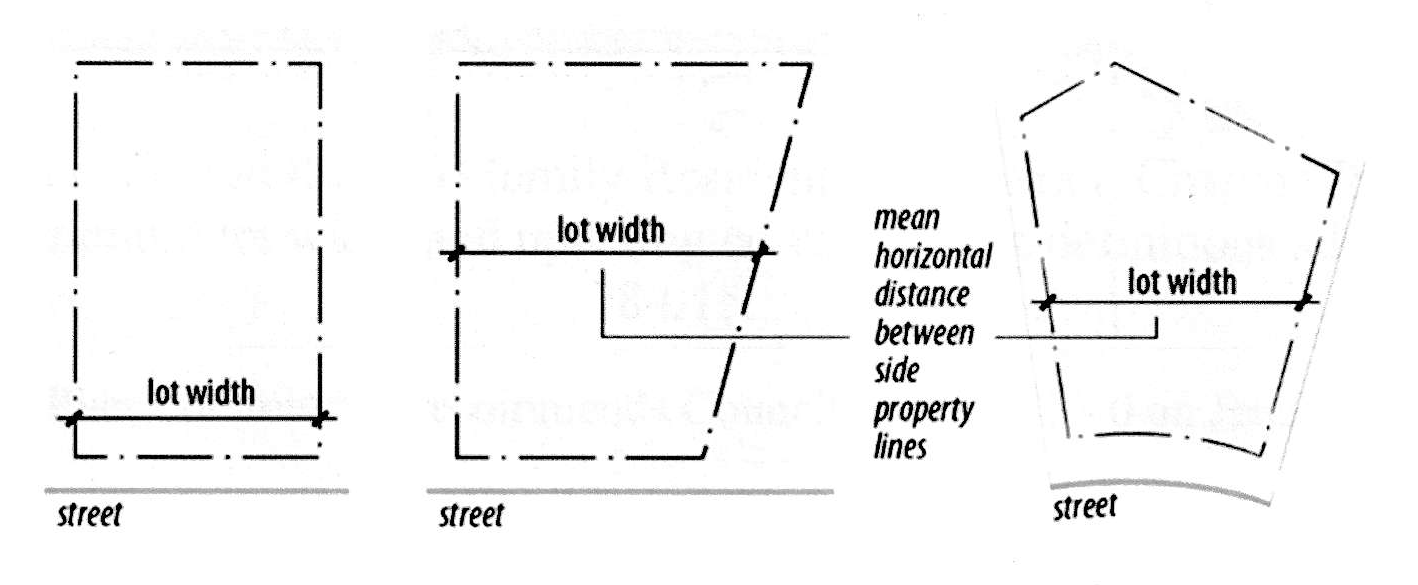
Lot width: The maximum horizontal distance between the side lot lines of a lot, measured parallel to the front lot lines and at the rear of the required front yard.
Lowest floor: The lowest enclosed floor (including basement). Any unfinished or flood resistant enclosure, usable solely for parking vehicles, building access or storage, in an area other than a basement area, is not considered a building's lowest floor, provided that such enclosed area is not built so as to render the structure in violation of the applicable non-elevation design requirements of this chapter.
Maintenance guarantee: A guarantee of facilities or work to either ensure the correction of any failures of any improvements required pursuant to this chapter or to maintain same.
Manufactured home: A type of housing unit that is largely assembled in factories and then transported to sites of use.
Marquee sign: A sign attached to and made part of a marquee. A marquee is defined as a permanent rooflike structure projecting beyond a building wall at an entrance to a building or extending along and projecting beyond the building's wall and generally designed and constructed to provide protection against weather.
Maximum accessory building coverage: The largest permitted area of all accessory buildings on a lot.
Maximum building size (MBS): The largest permitted total gross floor area a building may contain. See building size.
Maximum floor area ratio (FAR): The largest amount of floor area permitted on a lot. See floor area ratio.
Maximum gross density (MGD): The maximum number of dwelling units permitted per acre of gross site area. See gross density.
Maximum height: See building height.
Memorial sign: A sign, grave marker, memorial plaque, building marker or other remembrances of people or events that are cut into a masonry surface or made of bronze or similar material usually permanently embedded into a wall, structure or the ground and which are noncommercial in nature. See subsection 78-803(2)(c).
Migrant labor camp (land use): See subsection 78-206(8)(m).
Minimum building separation: The narrowest permitted building separation.
Minimum dwelling unit separation: The narrowest permitted dwelling unit separation.
Minimum floor elevation: The lowest elevation permissible for the construction, erection, or other placement of any floor, including a basement floor.
Minimum landscape surface ratio (LSR): The lowest permitted landscape surface ratio. See landscape surface ratio.
Minimum lot area (MLA): The minimum size lot permitted within the specified zoning district and development option.
Minimum lot width: The smallest permissible lot width for the applicable dwelling unit type or nonresidential development option.
Minimum setback: The narrowest distance permitted from a street, side, or rear property line to a structure.
Minimum site area (MSA): The minimum gross site area in which the specified development option may occur. See gross site area (GSA).
Mini-warehouse: See subsection 78-206(5)(c).
Minor structures: Structures not requiring a building permit (swing set, clothesline, etc.).
Mixed occupancy: A building which contains multiple independent businesses, offices, and/or residences.
Mixed use: Some combination of residential, commercial, industrial, office, institutional, or other land uses within a district or development.
Mobile food vending: See subsection 78-206(9)(j).
Mobile food vending at special events: See subsection 78-206(9)(k).
Mobile food vending vehicle: means a commercially manufactured, self-contained, movable motor vehicle or trailer in which food is cooked, wrapped, packaged, processed, or portioned for services, sale, or distribution. Mobile food vending vehicles do not include vehicles that are used solely to transport or deliver food or a common carrier regulated by the state or federal government.
Mobile food vendor: A person who owns a mobile food vending vehicle or who operates or conducts any activities from a mobile food vending vehicle.
Mobile home: See subsection 78-206(1)(a)(8).
Mobile home (land use): See subsection 78-206(1)(a)8.
Mobile home park residential development: See subsection 78-206(1)(e).
Mobile home residential subdivision: See subsection 78-206(1)(d).
Mobile home sales: See subsections 78-206(4)(d).
Mobile service support structure: See Wis. Stats. § 66.0404(1)(n).
Motel: See commercial indoor lodging.
Motor court: See commercial indoor lodging.
Motor freight terminal: See freight terminal.
Multiplex: See subsection 78-206(1)(a)6.
Natural resource protection overlay zoning districts: Zoning districts which primarily identify and regulate the disturbance of areas containing protected natural resources. See sections 78-503 through 78-512. See overlay zoning districts.
Navigable water: Lake Superior, Lake Michigan, all natural inland lakes within Wisconsin, and all rivers, streams, ponds, sloughs, flowages, and other waters within the territorial limits of this state, including the Wisconsin portion of boundary waters, which are navigable under the laws of this state. The Wisconsin Supreme Court has declared navigable all bodies of water with a bed differentiated from adjacent uplands and with levels of flow sufficient to support navigation by a recreational craft of the shallowest draft on an annually recurring basis. [Muench v. Public Service Commission, 261 Wis. 492 (1952), and DeGaynor and Co., Inc. v. Department of Natural Resources, 70 Wis. 2d 936 (1975)] For the purposes of this chapter, rivers and streams will be presumed to be navigable if they are designated as either continuous or intermittent waterways on the United States Geological Survey quadrangle maps until such time that the Wisconsin Department of Natural Resources has made a determination that the waterway is not, in fact, navigable.
Neighborhood Business (NB) District: See subsection 78-105(4)(b).
Neighborhood Office (NO) District: See subsection 78-105(3)(a).
Net developable area (NDA): The area of a site which may be disturbed by development activity. Net developable area is the result of subtracting required resource protection area (RPA) from the gross site area (GSA).
Noise standards: See section 78-709.
Nonconforming building or structure: Any building, or other structure, which was lawfully existing under ordinances or regulations preceding this chapter, but which would not conform to this chapter if the building or structure were to be erected under the provisions of this chapter.
Nonconforming development: A lawful development approved under ordinances or regulations preceding the effective date of this chapter, but which would not conform to this chapter if the development were to be created under the current provisions of this chapter. See section 78-310.
Nonconforming sign: A sign that does not conform to the regulations of this chapter. See section 78-807.
Nonconforming use: An active and actual use of land, buildings or structures which was lawfully existing prior to this chapter, which has continued as the same use to the present, and which does not comply with all the applicable regulations of this chapter. See section 78-210.
Nonresidential district(s): See subsection 78-105(1), (3)—(6).
Nonresidential land use(s): See subsection 78-206(2)—(7).
Noxious matter or materials: Material capable of causing injury to living organisms by chemical reaction, or is capable of causing detrimental effects on the physical or economic well-being of individuals.
Noxious materials standards: See section 78-714.
Nursery: Operation in which trees are raised as a crop to be replaced with more trees after harvesting. See subsection 78-206(2)(a).
Obstruction to flow: Any development which physically blocks the conveyance of floodwaters such that this development by itself or in conjunction with any future similar development will cause an increase in regional flood height.
Odor standards: See section 78-711.
Off-premises sign: A sign that directs attention to a business, commodity, service, commercial or noncommercial message, or entertainment conducted, sold or offered elsewhere than upon the lot where the sign is displayed. See subsection 78-810(14).
Office (land use): See subsection 78-206(4)(a).
Office district(s): See subsection 78-102(3).
Official map: The map adopted and designated by the city as being the "official map" pursuant to Section 66.23(6) Wis. Stats. which shows current and proposed municipal sites and rights of way. (See "Zoning map").
Official zoning map: The map adopted and designated by the city as being the "Official zoning map." See sections 78-103 and 78-104.
Off-site parking lot (land use): See subsection 78-206(6)(a).
On-premises sign: A sign that directs attention to a business or profession conducted, or to one principal commodity, service or entertainment sold or offered upon the premises where such sign is located or to which it is affixed.
On-site: Located on the lot in question, except in the context of on-site detention, when the term means within the boundaries of the development site as a whole.
On-site agricultural retail (land use): See subsection 78-206(2)(e).
On-site parking lot (land use): See subsection 78-206(8)(n).
On-site real estate sales office (land use): See subsection 78-206(9)(f).
Opacity: The degree to which vision is blocked by bufferyard. Opacity is the proportion of a bufferyard's vertical plane which obstructs views into an adjoining property.
Open sales lot: An unenclosed portion of a lot or lot of record where goods are displayed for sale, rent or trade.
Ordinary high water mark: The point on the bank or shore of a body of water up to which the presence and action of surface water is so continuous as to leave a distinctive mark such as by erosion, destruction or prevention of terrestrial vegetation, predominance of aquatic vegetation, or other easily recognized characteristics.
Other permanently protected green space: Permanently protected green space areas which are not constrained by one of the protected natural resources (wetlands, floodplains, steep slopes, lakeshores, and woodlands). Examples include portions of private lots, outlots, or parcels commonly held by a property owners' association which are deed restricted from site disruption.
Outdoor assembly (land use): See subsection 78-206(9)(b).
Outdoor commercial entertainment (land use): See subsection 78-206(4)(i).
Outdoor display (land use): See subsections 78-206(4)(d).
Outdoor display incidental to indoor sales (land use): See subsections 78-206(8)(f).
Outdoor institutional (land use): See subsection 78-206(3)(d).
Outdoor maintenance service (land use): See subsection 78-206(4)(f).
Outdoor storage (land use): See subsection 78-206(5)(b).
Outdoor storage of firewood standards: See subsection 78-723.
Outdoor wholesaling (land use): See subsection 78-206(5)(b).
Overlay Zoning District: A zoning district which imposes uniform restrictions on all properties within its area which are in addition to the restrictions specific to the standard zoning districts described in section 78-102, as well as the general restrictions of this chapter. See article V.
Owner: The person, persons, or entity having the right of legal title to a lot or parcel of land.
Pad, development: See Development pad.
Parapet: The extension of a false front or wall above the roofline.
Parcel: The area within the boundary lines of a lot.
Parking area pod: An area of parking spaces within a parking lot substantially separated from other areas of the parking lot by landscaped islands or medians. See subsection 78-604(3)(d).
Parking standards: See section 78-704.
Parking lot design standards: See subsection 78-704(6)(i).
Parking lot sign: A sign indicating only the conditions of use of a parking area such as cost, time open, availability, towing restrictions, ownership, type of vehicles allowed, etc. See subsection 78-812.
Parking requirements: See subsection 78-704(7).
Parking space design standards: See subsection 78-704(6)(g).
Passive outdoor public recreational (land use): See subsection 78-206(3)(a).
Penalty: See subsection 78-920(2).
Pennant: A sign made of fabric, plastic or similar material, which may or may not contain distinctive colors, patterns or symbols of a corporation or business, often in series, and usually mounted without a frame and hung from poles and structures to allow movement by air. Such attention-getting displays not specifically defined as a flag or banner are considered pennants. See subsection 78-810(1).
Performance guarantee: A financial guarantee to ensure that all improvements, facilities, or work required by this chapter will be completed in compliance with the chapter, regulations and the approved plans and specifications of a development.
Performance standard: Criterion established to control and limit the impacts generated by, or inherent in, uses of land or buildings. See article VII.
Peripheral setback: The distance between a structure and the boundary of a development option.
Permanently protected green space: An area in which site disruption and/or development is strictly limited. See section 78-205(4).
Permitted by right, use: See subsection 78-202(1).
Personal service(s) (land use): See subsection 78-206(4)(b).
Personal storage facility (land use): See subsection 78-206(5)(c).
Piers and wharfs: See subsection 78-206(11)(m).
Plan commission: The plan commission of the City of Stoughton. See also section 78-917.
Planned Business (PB) District: See subsection 78-105(4)(a).
Planned Development (PD_-_) District: See subsection 78-105(7)(a).
Planned Industrial (PI) District: See subsection 78-105(5)(a).
Planned Office (PO) District: See subsection 78-105(3)(b).
Planned unit development (PUD): A PUD is a designed grouping of varied and compatible land uses, such as housing, recreation, commercial, and industrial parks, all within one contained development or subdivision.
Pod: See Parking area pod.
Political sign: A sign erected in relation to an upcoming election or expressing political speech or viewpoints. See subsection 78-803(2)(a).
Porch: A covered platform, usually having a separate roof, at an entrance to a dwelling, or an open or enclosed gallery or room, which is not heated or cooled, that is attached to the outside of a building.
Portable sign: A sign not permanently attached to the ground that is designed to be moved from one location to another. See subsection 78-814(9).
Portable storage container: A portable, weather-resistant storage container designed and used for the temporary storage or shipment of materials, household goods, wares, or merchandise. See subsection 78-206(9)(i).
Principal building: See Building, principal.
Principal use: Any and all of the primary uses of a property, treated as a use permitted by right or as a conditional use (rather than as an accessory use or a temporary use) per subsection 78-206(1)—(7).
Private residential kennel (land use): See subsection 78-206(8)(p).
Private residential recreational facility (land use): See subsection 78-206(8)(o).
Private residential stable (land use): See subsection 78-206(8)(q).
Private sewage system: A sewage treatment and disposal system serving a single structure with a septic tank and soil absorption field located on the same parcel as the structure. This term also means an alternative sewage system approved by the department of industry, labor, and human relations including a substitute for the septic tank or soil absorption field, a holding tank, a system serving more than one structure, or a system located on a different parcel than the structure.
Professional service(s) (land use): See subsection 78-206(4)(b).
Prohibited sign: A sign that is not allowed to be erected within the corporate limits of the city.
Projecting sign: A sign that is attached to a wall of a building and projects more than 15 inches beyond such wall. See subsection 78-810(4).
Protected natural resources: Resources such as floodways, floodfringes, floodplain conservancy areas, wetlands, woodlands, steep slopes, and lakeshores, which are protected by the provisions of this chapter. See sections 78-503 through 78-512.
Public improvement: Any improvement, facility, or service, together with customary improvements and appurtenances thereto, necessary to provide for public needs such as: streets, roads, alleys or pedestrian walks or paths, storm sewers, flood control improvements, water supply and distribution facilities, sanitary sewage disposal and treatment, public utility and energy services.
Public services and utilities (land use): See subsection 78-206(3)(e).
Public sewer: Includes the City of Stoughton sewer system and other forms of sewer systems approved by the state department of natural resources and maintained by a public agency authorized to operate such systems.
Railroad right-of-way: A strip of land with tracks and auxiliary facilities for track operation, but not including freight depots or stations, loading platforms, train sheds, warehouses, car or locomotive shops, or car yards.
Real estate sign: A sign that is used to offer for sale, lease, or rent the property upon which the sign is placed. See subsection 78-811(2), 78-814(8).
Recharge area: An area in which water reaches the zone of saturation by surface infiltration. This encompasses all areas or features that supply groundwater recharge to a well.
Recorded lot: See Lot of record.
Recreational vehicle: A motorized wheeled vehicle used for camping or other recreational activities.
Relocatable building (land use): See subsection 78-206(9)(e).
Required resource protection area (RPA): The area of a site which may not be disturbed by development activity and which must also be reserved as permanently protected green space. Required resource protection area is the result of subtracting the net developable area (NDA) from the gross site area (GSA).
Residential collector street: A collector street serving primarily residential land uses which primarily serves to connect local residential streets to collector or arterial streets.
Residential district(s): See section 78-102.
Residential land use(s): See subsection 78-206(1).
Residentially zoned: A property located in a residential district per section 78-102.
Restrictive, more (less): A regulation imposed by this chapter is more (less) restrictive than another if it prohibits or limits development to a greater (lesser) extent or by means of more (less) detailed specifications.
Restaurant: See indoor commercial entertainment.
Restaurant, fast food: See in-vehicle sales and service.
Roof sign: A sign erected upon or over the roof or parapet of any building. See subsection 78-810(5).
Rural Holding (RH) District: See subsection 78-105(1)(a).
Salvage yard (land use): See subsection 78-206(5)(d).
Scale (of development): A term used to describe the gross floor area, height, or volume of a single structure or group of structures.
Sedimentation: The deposition of soil that has been transported from its site of origin by water, ice, wind, gravity, or other natural means as a result of erosion.
Selective cutting (land use): See subsection 78-206(2)(f).
Septic systems (land use): See subsection 78-206(8)(u).
Setback: The shortest distance between a building's or structure's exterior and the nearest point on the referenced lot line. See minimum setback.
Sexually-oriented use (land use): See subsection 78-206(4)(p).
Shadow: The outline created on the surrounding area by the sun shining on the wind energy system. See subsection 78-206(10).
Shopping center: See large development.
Shoreland and related topics: See section 78-506.
Shrub: A low-lying deciduous or evergreen plant. See section 78-610.
Sign: An emblem, name, identification, description or illustration that is affixed to or appears directly or indirectly upon a building, structure or piece of land and which directs attention to an object, product, place, activity, person, institution, organization or business. See also article IX for applicable procedures.
Sign, abandoned: A sign that has not been maintained in a manner which renders it legible. See subsection 78-807(5).
Sign, gross area of: The entire area within a single continuous perimeter enclosing the extreme limits of such sign and in no case passing through or between any adjacent elements of such sign. However, such perimeter shall not include any structural elements lying outside the limits of such sign and not forming an integral part of the display.
Sign, obsolete: A sign that is no longer being used in connection with an ongoing business because the business is discontinued. See subsection 78-807(6).
Signal receiving antenna (satellite dishes) standards: See subsection 78-721.
Single-family detached dwelling unit: See subsection 78-206(1)(a)1.
Single-family Residential-3 (SR-3) District: See subsection 78-105(2)(b).
Single-family Residential-4 (SR-4) District: See subsection 78-105(2)(c).
Single-family Residential-5 (SR-5) District: See subsection 78-105(2)(d).
Single-family Residential-6 (SR-6) District: See subsection 78-105(2)(e).
Site area: See Gross site area.
Site plan: See section 78-908. See also, section 78-908 for applicable procedures.
Skylight: A window or other paned area located on the ceiling or roof of a structure.
Small wind energy system: A wind energy conversion system consisting of a wind turbine, a tower and associated control or conversion electronics which will be used primarily to reduce on-site consumption of utility power. A small wind energy system shall not exceed a rated capacity of 60 kW. See subsection 78-206(10)(a).
Solar energy system: An energy system which converts solar energy to usable thermal, mechanical, chemical, or electrical energy. See subsection 78-206(10)(c).
Solid fence: Any fence which cannot be seen through. Such fences include basketweave fences, stockade fences, plank fences, and similar fences.
Standard zoning districts: Zoning districts which primarily regulate the use of land and intensity or density of such use. See sections 78-102, 78-103, and 78-105.
Stable, commercial: See commercial animal boarding.
Stable, private: See private residential stable.
Standard pavement width: Required pavement width per the City of Stoughton Land Division Ordinance in residential subdivisions on a street that allows parking or as otherwise determined by the director of planning and development.
Start of construction: The date the building permit is issued, provided the actual start of activity was within 365 calendar days of the permit date. The actual start of activity means either the first placement of permanent construction of a structure on the site such as the pouring of a slab or footings, the installation of piles, or the construction of columns. Permanent construction does not include land preparation, such as clearing, grading and filling; nor does it include the installation of streets and/or walkways; nor does it include excavation for basement, footings, piers, or foundations; nor does it include the erection of temporary forms; nor does it include the installation on the property of accessory buildings, such as garages or sheds not occupied as dwelling units or part of the main structure.
Steep slope: Steep slopes are areas which contain a gradient of 12 percent or greater, (equivalent to a ten-foot elevation change in a distance of 83 feet or less), as shown on environmental corridor map developed by the capitol area regional plan commission (CARPC) or from more accurate on-site survey.
Storage land use(s): See section 78-706.
Storage standards: See section 78-706.
Story: That portion of a building included between the surface of any floor and the surface of the floor next above; or if there is no floor above, the space between the floor and the ceiling next above. Neither a basement nor a cellar shall be counted as a story.
Street: Unless specifically designated otherwise by the city, any public or private way that is dedicated or permanently open to pedestrian and vehicular use, which is 24 feet or more in width if it exists at the time of enactment of this chapter or any such public right-of-way 60 feet or more in width when established after the effective date of this chapter, or otherwise by approved plat.
Street, arterial: A street which provides primary access to and through an area; in Stoughton, USH 51.
Street, collector: A street which disperses traffic throughout an area; in Stoughton, CTH A, B, and N, STH 138, Page Street, Kings Lynn Road, Roby Road, Jackson Street, Williams Drive, and Van Buren Street.
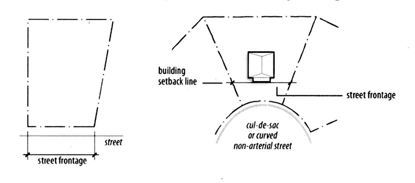
Street frontage: Street frontage is the lot line that runs lineal to the street. It is measured between the side property lines of a lot along the property line that abuts the street. For purposes of determining compliance with zoning district lot and building regulations, the frontage of a lot that abuts a cul-de-sac or similarly curved non-arterial street may be measured along the required setback line.
Street, local: A street which provides access to individual properties.
Street, local residential: A local street serving primarily to collect traffic originating directly from residential driveways and private residential courts and streets.
Street, residential collector: A collector street serving primarily residential land uses which primarily serves to connect local residential streets to collector or arterial streets.
Street line: See Lot line, front.
String of lights: Lighting used to enhance or decorate store fronts, displays or signage and associated only with decoration. See subsection 78-810(1).
Strip development: A pattern of land uses typified by nonresidential and/or multi-family development located along one or both sides of a street which is generally only one lot deep and which is characterized by many curb cuts, low green space ratios, low landscape surface ratios, high floor area ratios, and/or low quantities of landscaping.
Substandard lot: A lot of record which lawfully existed prior to this chapter, which would not conform to the applicable regulations if the lot were to be created under the current provisions of this chapter. See section 78-407.
Substantial improvement: Any structural repair, reconstruction, or improvement of a structure, the cost of which equals or exceeds 50 percent of the present equalized assessed value of the structure either before the improvement or repair is started, or if the structure has been damaged, and is being restored, before the damage occurred. The term does not, however, include either:
(a)
Any project to improve a structure to comply with existing state or local health, sanitary, or safety code specifications solely necessary to assure safe living conditions; and
(b)
Any alteration of a structure or site documented as deserving preservation by the Wisconsin State Historical Society, or listed on the National Register of Historic Places.
Ordinary maintenance repairs are not considered structural repairs, modifications or additions. Such ordinary maintenance repairs include internal and external painting, decorating, paneling, and the replacement of doors, windows, and other non-structural components. (For purposes of this definition, "substantial improvement" is considered to occur when the first alteration of any wall, ceiling, floor, or other structural part of the building commences, whether or not that alteration affects the external dimensions of the structure.)
Structure: Anything constructed or erected, the use of which requires a more or less permanent location on the ground, or attached to something having a permanent location on the ground, excepting public utility fixtures and appurtenances.
Swale: A linear depression in land running downhill or having a marked change in contour direction in which sheet runoff would collect and form a temporary watercourse.
Temporary sign: A sign intended to be displayed for a short period of time, including banners, pennants and decorative-type displays. See subsection 78-803(2)(f).
Temporary use: A land use which is present on a property for a limited and specified period of time. See subsection 78-206(9).
Temporary vehicle shelter: These structures are typically supported by poles, have a fabric roof and/or sides and are usually used to cover automobiles, boats, or recreational vehicles.
Total height: The distance measured from ground level to the blade extended at its highest point. See subsection 78-206(10).
Townhouse: See subsection 78-206(1)(a)5.
Toxic materials standards: See section 78-714.
Tower: The monopole or freestanding structure on which the wind turbine and accessory equipment are mounted. See subsection 78-206(10).
Traditional Neighborhood Development (TND): A development that exhibits several of the following characteristics: alleys, streets laid out in a grid system, buildings oriented to the street, front porches on houses, pedestrian-orientation, mixed land uses, and village squares or greens. The City of Stoughton regulates TNDs through the Planned Development process. See subsection 78-105(7)(a).
Transportation land use(s): See subsection 78-206(6).
Truck stop: See In-vehicle sales and service.
Twin house: See subsection 78-206(1)(a)3.
Two-flat house: See subsection 78-206(1)(a)4.
Two-family Residential-6 (TR-6) District: See subsection 78-105(2)(f).
Unnecessary hardship: The circumstance where special conditions affecting a particular property, which were not self-created, have made strict conformity with restrictions governing areas, setbacks, frontage, height or density unnecessarily burdensome or unreasonable in light of the purposes of the ordinance.
Upper story dwelling unit (land use): See subsection 78-206(8)(a).
Urban service area (USA): Those areas in and around existing communities which are most suitable for urban development and capable of being provided with a full range of urban services.
Urban services: Those additional public services normally provided or needed in urban areas, including public water supply and distribution systems, sanitary sewerage systems, higher levels of police and fire protection, solid waste collection, urban storm drainage systems, streets with curbs and gutters, street lighting, neighborhood facilities such as parks and schools, and urban transportation facilities such as sidewalks, taxi service, and mass transit.
Use: The purpose or activity for which land or any building thereon is designed, arranged, or intended, or for which it is occupied or maintained.
Use, accessory: See Accessory use.
Use, conditional: See Conditional use.
Use, principal: See Principal use.
Utility shed (land use): See subsection 78-206(8)(c).
Utility vehicle: A vehicle designed and used primarily for the transport of equipment and/or materials.
Variance: Permission to depart from the literal requirements of this chapter granted pursuant to section 78-910.
Vibration standards: See section 78-708.
Violation: See subsection 78-920(1).
Visibility standards: See section 78-703.
Visitor entrance: entrance to an industrial, institutional, or commercial use for customers and visitors.
Wall sign: A sign that is attached to a wall of a building and projects not more than 15 inches from such a wall. Exterior window signs are considered wall signage. See section 78-816.
Waste disposal facility (land use): See subsection 78-206(5)(e).
Waste materials standards: See section 78-715.
Well field: A piece of land used primarily for the purpose of locating wells to supply a municipal water system.
Wellhead Protection Overlay District: See section 78-512.
Wetland: An area that is saturated by surface water or groundwater, with vegetation adapted for life under those soil conditions.
Wind energy systems standards: See subsection 78-206(10).
Window sign: A sign located completely within an enclosed building and visible from a public way. See subsection 78-814(1)(f).
Wind turbine: The blades and associated mechanical and electrical conversion components mounted on top of the tower whose purpose is to convert kinetic energy of the wind into rotational energy used to generate electricity. See subsection 78-206(10).
Wisconsin Wetland Inventory Map: Maps prepared by the Wisconsin Department of Natural Resources.
Woodland: Woodlands are areas of trees whose combined canopies cover a minimum of 80 percent of an area of one acre or more, as shown on USGS 7.5 minute topographic maps for the City of Stoughton and its environs. See section 78-507. (EC Map from CARPC)
Working days: Monday, Tuesday, Wednesday, Thursday or Friday; excluding holidays recognized by the City of Stoughton.
Yard: A required open space on a lot, which is unoccupied and unobstructed by a structure from its lowest ground level to the sky, except as expressly permitted in this chapter. A yard shall extend along a lot line and at right angles to such lot line to a depth or width specified in the yard regulations for the district in which such lot is located.
Yard, front: A yard extending along the full width of the front lot line between side lot lines and extending from the abutting front street right-of-way line to a depth required in the yard regulations for the district in which such lot is located.
Yard, rear: A yard extending along the full width of the rear lot line between the side lot lines and extending toward the front lot line for a depth as specified in the yard regulations for the district in which such lot is located.
Yard, side: A yard extending along the side lot line between the front and rear yards, having a width as specified in the yard regulations for the district in which such lot is located.
Zero-lot line structure: A structure that is built on the property line such as a twin house (see subsection 78-206(1)(a)(3)), townhouse (see subsection 78-206(1)(a)(5)), or downtown residential unit (see subsection 78-206(8)(a)).
Zoning administrator: The person authorized and charged by the city with the administration of this chapter. See section 78-916.
Zoning board of appeals: See section 78-918.
Zoning district(s): See section 78-102.
Zoning district categories: See section 78-102.
Zoning map: See "Official zoning map", above and see section 78-103.
(Ord. No. 0-6-09, 6-23-2009; Memo. of 3-22-2010; Ord. No. 0-4-2011, § 1, 5-10-2011; Ord. No. 0-3-2012, § 20, 4-10-2012; Ord. No. 0-16-2012, § 1, 9-11-2012; Ord. No. 0-4-2015, § 1, 4-14-2015; Ord. No. 0-26-2020, 12-8-2020; Ord. No. 0-13-2021, § 1, 6-8-2021; Ord. No. 0-27-2022, §§ 1, 2, 11-15-2022; Ord. No. 0-21-2024, § 1(Exh. A), 11-26-2024; Ord. No. 0-03-2025, § 2, 2-11-2025)