
Stoughton City Zoning Code
ARTICLE V
- OVERLAY ZONING DISTRICTS
Sec. 78-501.- Purpose.
The purpose of this article is to set forth the requirements for the mandatory protection of natural resources and permanently protected green space areas within the jurisdiction of this chapter (see section 78-009). The provisions of this article interact closely with the provisions of subsection 78-206(10) (Natural resource disruption and required mitigation standards), section 78-303 (Required natural resources site evaluation), and sections 78-304 and 78-305 which provide residential and nonresidential development standards. Section 78-306 provides a complete overview of the interrelationship between the above-listed sections. In part, the provisions of this article are designed to ensure the implementation of the City of Stoughton Comprehensive Plan and State of Wisconsin Statutes 62.231 and 87.30.
(Ord. No. 0-6-09, 6-23-2009)
Sec. 78-502. - How to use this article.
This article contains the standards which govern the protection, disturbance, and mitigation of disruption of all natural resource and other permanently protected green space areas. The provisions of this article are intended to supplement those of the City of Stoughton, Dane County, the State of Wisconsin, and the Federal Government of the United States which pertain to natural resource protection. Prior to using the provisions of this article to determine the permitted disruption of such areas, the requirements provided below should be reviewed. This article recognizes the important and diverse benefits which natural resource features provide in terms of protecting the health, safety, and general welfare of the community. Each of the following sections is oriented to each natural resource type, and is designed to accomplish several objectives:
(1)
First, a definition of the natural resource is provided.
(2)
Second, the specific purposes of the protective regulations governing each resource type are provided.
(3)
Third, the required method of identifying and determining the boundaries of the natural resource area is given.
(4)
Fourth, mandatory protection requirements are identified.
NOTE: Protection requirements for specific land uses and natural resource types designed to minimize disruption of natural resource functions are presented in subsection 78-206(11).
(Ord. No. 0-6-09, 6-23-2009; Ord. No. 0-19-14, § 3, 8-26-2014)
Sec. 78-503. - Natural resource protection overlay zoning districts.
(1)
This chapter employs overlay zoning districts to identify and regulate areas in which natural resource protection requirements apply. Each type of natural resource regulated by this chapter is represented by an overlay zoning district bearing its name.
(2)
Natural Resource Protection Overlay Districts include:
(a)
Floodplain Overlay Districts
(b)
Shoreland-Wetland Overlay District
(c)
Lakeshore Overlay District
(d)
Woodland Overlay District
(e)
Wellhead Protection Overlay District
(f)
Shoreland Overlay District.
(Ord. No. 0-6-09, 6-23-2009; Ord. No. 0-4-2015, § 3, 4-14-2015)
Sec. 78-504. - Map of natural resource protection overlay districts.
Natural resource protection overlay zoning districts established by this chapter are shown on the official zoning map of the City of Stoughton, which together with all the explanatory material hereon, is hereby made part of this chapter.
(1)
Where an apparent discrepancy exists between the location of the outermost boundary of the floodfringe district or the floodplain district shown on the official zoning map and actual field conditions, the location shall be initially determined by the zoning administrator using the criteria described in subsections (2) and (3), below. Where the zoning administrator finds that there is a significant difference between the map and the actual field conditions, the map shall be amended using the procedures established in section 78-903. Disputes between the zoning administrator and the applicant over the location of the district boundary line shall be settled using the procedures outlined in subsection 78-912.
(2)
Where flood profiles exist, the location of the district boundary line shall be determined by the zoning administrator using both the scale appearing on the map and the elevations shown on the water surface profile of the regional flood. Where a discrepancy exists between the map, and actual field conditions, the regional flood elevations shall govern. A map amendment is required where there is a significant discrepancy between the map and actual field conditions. The zoning administrator shall have the authority to grant or deny a land use permit on the basis of a district boundary derived from the elevations shown on the water surface profile of the regional flood, whether or not a map amendment is required. The zoning administrator shall be responsible for initiating any map amendments required under this section within a reasonable period of time.
(3)
Where flood profiles do not exist, the location of the district boundary line shall be determined by the zoning administrator using the scale appearing on the map, visual on-site inspection and any available information provided by the department of natural resources. Where there is a significant difference between the map and actual field conditions, the map shall be amended. Where a map amendment has been approved by both the common council and the department of natural resources, the zoning administrator shall have the authority to grant or deny a land use permit.
(Ord. No. 0-6-09, 6-23-2009; Memo. of 3-22-2010; Ord. No. 0-4-2015, § 4, 4-14-2015)
Sec. 78-505. - Floodway, floodfringe, and floodplain overlay zoning districts.
See chapter 30: Floodplain Zoning.
(Ord. No. 0-6-09, 6-23-2009)
Sec. 78-506. - Shoreland-wetland overlay zoning district.
See chapter 31: Shoreland-Wetland Zoning.
(Ord. No. 01-09, § 1, 3-17-2009)
Sec. 78-510. - Lakeshore overlay zoning district.
(1)
Definition:Lakeshores are the land margins of navigable waters which are identified as "lakes and other water bodies" as shown on USGS 7.5 minute topographic maps for the City of Stoughton and its environs. Lakeshores are all areas within 100 feet of the ordinary high water mark of such features. Decorative water features shall not be considered "navigable waters" for the purposes of this section. This meaning of "lakeshores" shall remain distinct from the meaning of the term as employed by the State of Wisconsin Statutes and the DNR.
(2)
Purpose of Lakeshore Protection requirements: Lakeshores serve to protect land/water margins from erosion due to site disruption. Because of regular contact with wave action, currents, and runoff, such areas are highly susceptible to continuous, and in some cases, rapid erosion. Lakeshore protection also provides a natural vegetation buffer which serves to reduce water velocities and wave energy, and filters significant amounts of water-borne pollutants and sediments. Lakeshores also promote infiltration and groundwater recharging, and provide a unique habitat at the land/water margin.
(3)
Determination of lakeshore boundaries: General lakeshore boundaries are depicted on the official zoning map. Upon the proposal of development activity on any property which contains a lakeshore depicted on the official zoning map, the petitioner shall prepare a detailed site analysis per the requirements of subsection 78-908(3)(j). This analysis shall depict the location of all lakeshore areas on the subject property as related to the provisions of subsection (1), above.
(4)
Mandatory lakeshore protection requirements: Lakeshores shall remain in an undisturbed state except for the land uses permitted per the requirements in subsection 78-206(10).
(Ord. No. 0-6-09, 6-23-2009; Memo. of 3-22-2010)
Sec. 78-511. - Woodland overlay zoning district.
(1)
Definition: Woodlands are areas of trees whose combined canopies cover a minimum of 80 percent made up of healthy trees of varieties listed in section 78-611 of an area of one acre or more, as shown on air photos for the City of Stoughton and its environs.
(2)
Purpose of woodland protection requirements: Woodlands provide a wide variety of environmental functions. These include atmospheric benefits such as removing air-borne pollutants, carbon dioxide uptake, oxygen production, and evapotranspiration returns. Water quality benefits include substantial nutrient uptake rates (particularly for nitrogen and phosphorus) and surface runoff reduction in terms of both volumes and velocities. Woodlands provide unique wildlife habitats and food sources. Woodlands are excellent soil stabilizers, greatly reducing runoff-related soil erosion. Woodlands also serve to reduce wind velocities which further reduces soil erosion. Finally, under proper management techniques, woodlands serve as regenerative fuel sources.
(3)
Determination of woodland boundaries: General woodland boundaries are depicted on the official zoning map. Upon the proposal of development activity on any property which contains a woodland depicted on the official zoning map, the petitioner shall prepare a detailed site analysis per the requirements of subsection 78-908(3)(j). This analysis shall depict the location of all woodland areas on the subject property as related to the provisions of subsection (1), above.
(4)
Mandatory woodland protection requirements: Woodlands shall remain in an undisturbed state except for the land uses permitted per the requirements of subsection 78-206(10) and areas subject to the following mitigation requirements. Selective cutting operations are permitted by right in all woodland areas (per the requirements of subsection 78-206(2)(f)). Clear cutting is permitted as a conditional use in all woodland areas (per the requirements of subsection 78-206(2)(g)).
(Ord. No. 0-6-09, 6-23-2009; Memo. of 3-22-2010)
Sec. 78-512. - Wellhead protection overlay zoning district.
(1)
Purpose: The City of Stoughton depends exclusively on ground water for a safe drinking water supply. Certain land use practices and activities can seriously threaten or degrade ground water quality. The purpose of this ordinance is to institute land use regulations and restrictions to protect the city water supply and well fields, and to promote the public health, safety, and general welfare of the residents of the city. The restrictions imposed in this Section are in addition to those of the underlying zoning district or any other provisions of the zoning ordinance. This chapter is established per NR 811.16 of the Wisconsin Administrative Code.
(2)
Overlay zones: The regulations specified in this ordinance shall apply to lands designated on the map dated June 11, 1996, which complements the official zoning map. These lands are subject to land use and development restrictions because of their close proximity to the time of travel (TOT) areas and corresponding high threat of contamination. This area shall be known as the Groundwater Protection Area.
(3)
Land use regulations: The groundwater protection area land uses must minimally comply with the separation requirements specified in Wisconsin Code NR811.16 (4) (d). The following land use regulations are in addition to the land use regulations established for the underlying zoning district:
(a)
Permitted uses: The following uses are permitted uses within the groundwater protection area. Uses not listed in this subsection or in subsection (b) below are considered to be prohibited uses.
1.
Any existing use, even though listed as prohibited in subsection 78-512(3)(c), located within such areas to the extent that use currently exists on the effective date of the ordinance from which this section is derived, subject to the requirements for existing prohibited uses in section 78-210.
2.
Parks and playgrounds, provided there are no on-site waste disposal or fuel storage tank facilities.
3.
Wildlife areas.
4.
Non-motorized trail, such as biking, skiing, nature, and fitness trails.
5.
Sewered residential developments.
(b)
Conditional uses: The following uses may be allowed as a conditional use (per the requirements of section 78-905), providing adequate groundwater protections and monitoring measures are implemented:
1.
Nurseries for ornamental plants, greenhouses, and associated retail sales outlets.
(c)
Prohibited uses: Those uses declared to be prohibited have a high probability that such activities routinely associated with them (storage, use, and handling of potential pollutants) will cause groundwater contamination. Prohibited uses include, but are not limited to, the following uses within the groundwater protection area.
1.
Underground storage tanks of any size.
2.
Septage and/or sludge spreading.
3.
Animal waste landspreading.
4.
Animal waste facilities.
5.
Animal confinement facilities.
6.
Gas stations.
7.
Vehicle repair establishments, including auto body repair.
8.
Printing and duplicating businesses.
9.
Bus or truck terminals.
10.
Repair shops.
11.
Landfills or waste disposal facilities.
12.
Wastewater treatment facilities.
13.
Spray wastewater facilities.
14.
Junkyards or auto salvage yards.
15.
Bulk fertilizer and/or pesticide facilities.
16.
Asphalt products manufacturing.
17.
Dry cleaning businesses.
18.
Salt storage.
19.
Electroplating facilities.
20.
Exterminating businesses.
21.
Paint and coating manufacturing.
22.
Hazardous and/or toxic materials storage.
23.
Hazardous and/or toxic waste facilities.
24.
Radioactive waste facilities.
25.
Recycling facilities.
26.
Cemeteries.
(4)
Separation distances: The separation distances for particular land uses established by NR 811.16(4)(d) of the Wisconsin Administrative Code are hereby established.
(5)
Enforcement: Any person, firm, or corporation failing to comply with the provisions of this subsection shall forfeit a fee according to the city's current deposit schedule. Any person, firm, or corporation in default of payment of such forfeiture and costs shall have those costs added to their property as a lien against the property. Each day a violation continues shall constitute a separate offense.
Where any of the uses listed above in subsections (b) or (c) exist within the Groundwater Protection Overlay District on the effective date of this ordinance, such uses shall be treated as nonconforming uses and any expansion thereof shall be prohibited. However, owners of these facilities may be allowed to upgrade the facilities to facilitate or enhance groundwater protection with approval of the common council. The procedures and standards for obtaining a conditional use shall be applicable to any such approval.
(Ord. No. 0-6-09, 6-23-2009; Ord. No. 0-24-09, § 1, 12-22-2009; Memo. of 3-22-2010)
Sec. 78-517. - Reserved.
Editor's note— Ord. No. 0-09-2025, adopted Mar. 25, 2025, repealed § 78-517, which pertained to the downtown design overlay district, and derived from Ord. No. 0-24-2018, § 2, adopted Nov. 13, 2018.
Sec. 78-518. - Pocket neighborhood overlay district (PN-O).
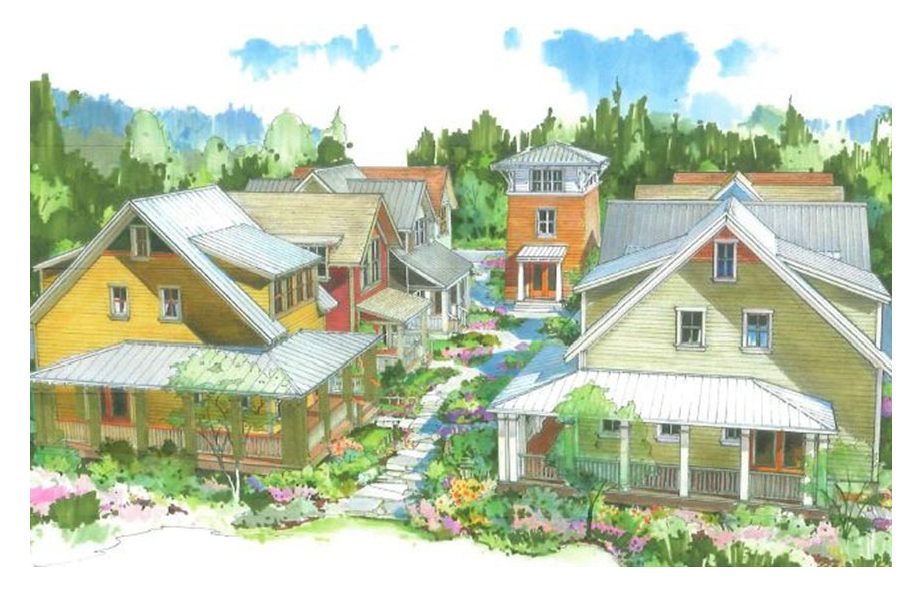
(1)
Purpose. The purpose of pocket neighborhood community development design is to:
(a)
Encourage a stronger sense of community and security among nearby neighbors, while preserving personal privacy;
(b)
Promote a variety of housing choices to meet the needs of a population diverse in age, income, household composition, and individual needs; especially small households with a maximum of two unrelated persons;
(c)
Encourage affordability, innovation, and variety in housing design and site development while ensuring compatibility with surrounding land uses;
(d)
Encourage the creation of more usable open space for residents of the development through flexibility in density and lot standards;
(e)
Maximize resident- and pedestrian-oriented outdoor spaces and minimize the impact of automobile traffic and parking;
(f)
Provide a more compact residential development pattern that encourages sensitivity toward natural landscape features, preserves open space, and offers economies in the provision of utilities and public services;
(g)
To provide for, and in some instances require, a more compact residential development pattern that encourages sensitivity toward natural landscape features, preserves open space, and offers economies in the provision of utilities and public services.
(2)
Definitions. In this section, the following terms have the following meanings:
Common open space: The central space used by all occupants of a pocket neighborhood cluster. The common area may include ponds, wetlands, streams, and sensitive area buffers on slopes of ten percent or less and developed and maintained so it is usable for active or passive recreation activities.
Pocket neighborhood cluster or cluster: A clustered group of four to 12 dwellings oriented around a common open space.
Pocket neighborhood community development: Multiple pocket neighborhood clusters and porch-fronted dwellings amalgamated into a larger, coherent pedestrian-oriented development.
(3)
Development configuration.
(a)
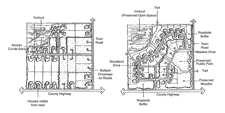
The development configuration of a pocket neighborhood community development shall be pocket neighborhood clusters or cluster development. A cluster development is a residential subdivision or condominium plat in which the lots are allowed to be smaller (in area and width). Smaller lot sizes within a cluster subdivision or condominium plat allow for a corresponding increase in common open space. Conventional subdivision (left) as compared to cluster subdivision (right).
(b)
Configurations may be street-oriented porch-front dwellings with access alleyway parking, and carriage and live-work dwellings along access alleyways. Where there is no reasonable alternative, dwellings may have driveways located off of streets, provided all conditions of this chapter are met.
(4)
Approval procedure. Approval of cluster subdivision or condominium plat shall follow the general procedures for subdivisions, except that the plan commission may approve waivers and exceptions to such requirements as provided in this section. Cluster developments are allowed in all zoning districts in which residential development is allowed by right, subject to compliance with this section.
The final design will need to follow section 78-908, site plan review and approval procedures.
(5)
Permitted uses. Permitted uses in the residential pocket neighborhood overlay district include:
(a)
One-family detached dwellings.
(b)
Two-family dwelling units.
(c)
Rowhouses or townhouses.
(d)
Community buildings.
(e)
Temporary real estate sales offices. Real estate sales offices, subject to the following requirements:
1.
May only be placed within a major subdivision with 20 or more lots;
2.
Shall occupy a maximum of one building within any major subdivision;
3.
Shall be a temporary use to be removed or converted to a permitted use in the district no later than 90 days from the date when 90 percent of the lots or units within the subdivision or development are initially sold or leased, or five years from the date of initial establishment of the use, whichever comes first;
4.
Shall not exceed 750 square feet in floor area devoted to the sales office and related uses open to the public;
5.
Shall be compatible in character, materials, placement, and design with other existing and planned buildings within the subdivision;
6.
Signage shall be in accordance with standards for conditional uses in the district, per article VIII of this chapter.
(f)
Vehicle community parking area or garages.
(g)
Home occupations/professional home offices for non-retail goods and services (defined in this district as businesses that do not require customer access).
(h)
A non-family household shall be limited to two unrelated persons.
(4)
Conditional uses. Conditional uses in the district include:
(a)
Public and semipublic uses, including public and private schools; churches and religious institutions; government facilities; active recreational parks; museums, public transportation terminals, and similar uses.
(5)
Lot area. The minimum lot area to develop is one acre per phase. The aggregate number and sizes of lots must be adequate to meet all required density limits as established in the underlying zoning district in which the cluster development is located. Minimum four dwellings; maximum 12 dwellings per cluster.
(6)
Yard requirements. Minimum yard requirements in the district are as follows:
(a)
Property adjacent to the development site: ten feet.
(b)
Adjacent buildings: ten feet except for setbacks from the accessory structures may be five feet, provided fire separation requirements are met.
(c)
Front yard: ten feet to porches; in a pocket neighborhood cluster, the front yard shall be the side facing the common open space. Where a dwelling in a cluster also has a face to the street, it shall be considered as a front yard.
(d)
Side yard: five feet, except setbacks for attached dwellings may be zero feet, provided fire separation requirements are met. Street yard shall be ten feet.
(e)
Rear yard: ten feet, provided that privacy between dwellings is maintained.
(7)
Lot coverage.
(a)
Reviewed by engineering staff and approval by the planning department and/or the plan commission shall be required.
(b)
The principles and standards set forth in the city erosion control and stormwater management requirements policy which includes the stormwater management ordinance and the city's construction site control ordinance, shall be used by the property owner and staff for drafting and reviewing stormwater management plans.
(8)
Building height. Maximum building height follows the underlying zoning district requirements.
(9)
Design parameters.
(a)
Pocket neighborhood size. Each cluster shall contain a minimum of four and a maximum of 12 dwellings located on no less than one acre per cluster.
(b)
Common open space in pocket neighborhood clusters.
1.
Intent. Open space that is commonly owned and managed by all residents of a pocket neighborhood is a key feature in fostering community. The common open space must be adequately sized and centrally located with individual dwelling entrances oriented towards the open space.
2.
Size. A minimum of 400 square feet per dwelling unit of common open space is required in each pocket neighborhood cluster. Buildings serving all residents in a pocket neighborhood cluster may be included in the required area.
3.
Parking areas, yard setbacks, spaces between buildings of 15 feet or less in width, private open space, and driveways do not qualify as common open space.
4.
Proximity to common open space. At least 75 percent of the dwelling units of a pocket neighborhood cluster shall abut a common open space; and all of the dwelling units shall be within 60 feet walking distance measured from the nearest entrance of the dwelling along the shortest safe walking route to the nearest point of the common open space. The common open space shall have dwellings abutting at least two sides.
(10)
Private open space.
(a)
Intent. A sense of community requires the right balance of personal privacy. Private open space is an essential component of this balance. A 'front' yard creates a buffer between public and private spaces, while a 'side' or 'back' yard offers increased seclusion.
(b)
Location. Private open space shall separate the main entrance to the dwelling from the common open space or street by a hedge or fence not to exceed 36 inches in height. Private open space may be located in the side and rear yards as well.
(c)
Size. Each dwelling shall have a minimum of 200 square feet of usable private open space, with no dimension less than ten feet. Such open space requirements may be met with a combination of front, side or rear yard locations.
(11)
Front porch.
(a)
Intent. A covered front porch is a key element in fostering neighborly connections, providing a human scale to a dwelling, and offering surveillance of public space. Its placement, size, relation to interior and public spaces, and the height of railings are all factors in achieving these intents.
(b)
Location. Every dwelling shall have a covered entry porch oriented toward the common open space or street. This porch shall be open on at least two sides, and it shall not be enclosed.
(c)
Size. The covered porch shall be greater than 70 square feet in area, with a minimum of dimension of six feet.
(d)
Use. Front porches are intended as supplementary living space, as shelter from the weather and for entering and exiting the dwelling. Front porches shall not be used as storage spaces.
(12)
Street-facing facades.
(a)
Intent. The facades of buildings facing the street contribute to the neighborhood by including attractive design details such as windows, front doors and porches, siding and trim.
(b)
All street-facing facades shall include one or more of the following:
1.
Porches;
2.
Windows, including bay windows;
3.
Dormers;
4.
Changes in exterior siding material or paint color; or
5.
Building modulation with a depth measuring at least one foot.
(13)
Privacy between dwellings.
(a)
Dwellings shall be designed so that no window peers into the living space of adjacent dwellings closer than 30 feet apart. This may be accomplished by:
1.
'Nesting' dwellings with open and closed sides: the open side may have windows facing its own side or rear yard, while the closed side may have high windows, translucent windows, or skylights to bring in ample light while preserving privacy;
2.
Zero lot line dwellings (duplex or rowhouses) with no side windows;
(b)
The side yard of a dwelling may be fully usable to the face of the neighboring building through landscape easements or other means.
(14)
Community buildings and elements.
(a)
Intent. Common buildings and shared elements are direct amenities of living in a pocket neighborhood. Beyond these benefits, these common facilities foster connections among neighbors and strengthen their sense of community.
(b)
The pocket neighborhood shall have a homeowners association (HOA) outlining the responsibility for the maintenance and use of the common area.
(c)
Every pocket neighborhood cluster shall contain at least two of the following elements shared and managed by residents of that cluster:
1.
Barbeque, pizza oven, campfire circle, or outdoor terrace;
2.
Picnic shelter;
3.
Tool and general storage shed;
4.
Heated commons building, with optional bathroom and kitchenette, for meetings, card games, movie nights, potlucks, exercise, etc.; or
5.
Kitchen garden or flower garden.
(d)
The larger pocket neighborhood community development may include more significant common buildings or elements for the benefit of all the residents of the community, including those listed above, and/or such facilities as:
1.
Woodworking shop;
2.
Community kitchen/dining room, living room, library;
3.
Childcare room and/or playground; or
4.
Community garden.
(15)
Parking.
(a)
Parking areas must be located so their visual presence is minimized, and associated noise or other impacts do not intrude into public spaces.
(b)
Parking requirements:
1.
Dwellings between 800—999 square feet: 1.5 spaces per unit.
2.
Dwellings over 1,000 square feet: two spaces per unit.
(c)
Parking requirements shall be considered on the scale of the overall development, rather than on a lot-by-lot basis. Parking requirements may be met onsite on residential lots, along access alleyways, and/or along streets as parallel parking.
(d)
Each dwelling shall have one parking space attached to the dwelling unit; all other parking shall be located within 150 feet of the entry door.
(e)
Detached garages serving multiple dwellings shall be located off of an access alleyway, and limited to five single-car bays.
(16)
Storage.
(a)
Intent. Every household has storage needs for items such as bicycles, camping gear, hand tools, snow tires, suitcases and the like.
(b)
Every dwelling shall have a minimum of 40 square feet of covered storage space outside the heated living area. This space may be located in a garage if it does not preclude vehicle parking, or in a storage shed.
(17)
Refuse and recycling.
(a)
Intent. Garbage and recycling is a necessary element in residential living. Storage of these containers shall be located so their visual and odorous impact on adjacent properties is minimized.
(b)
Refuse and recycling containers shall be screened from view by landscaping or architectural screening, and shall not be located in the front setback area, or where smells may be offensive to adjacent properties.
(18)
Fences.
(a)
Intent. Fences can define and express personal space, and add to the quality of public space; but fences can also be offensive barriers.
(b)
Fence height requirements.
1.
Front yard: maximum 36 inches; 24 inches recommended;
2.
Side yard: maximum 36 inches from property line to face of dwelling, and maximum 72 inches behind the face of dwelling;
3.
Rear yard: maximum 72 inches.
(19)
Pedestrian network. Pocket neighborhood community developments shall provide a network of pedestrian pathways, including sidewalks along at least one side of streets, mid-block walkways, and shared local streets and access alleyways. Connections to the wider neighborhood shall be made where appropriate and allowed. All such pathways shall be accessible by the general public, except that walkways into and through the Pocket Neighborhood clusters may be limited to residents and their guests.
(20)
The applicant shall prove to the city that there will be a suitable legally-binding system in place, such as homeowner association agreements, to ensure proper maintenance and funding of shared facilities, such as shared parking areas, common open spaces, alleys and other improvements.
(Ord. No. 0-23-2025, § 1(Exh. A), 6-24-2025)
Sec. 78-519. - Community gateway and corridor design overlay zoning district.
(1)
Purpose. This district is intended to implement the urban design recommendations of the comprehensive plan by requiring that development located at and around the most important entrances to the community has a character which recognizes the city's adopted objectives of establishing an attractive and high-quality image. It is also intended to enhance the economic redevelopment potential of the USH 51 corridor throughout the city, the STH 138 corridor within the city limits, and the CTH N corridor on the east side of the city. As emphasized by the Plan, this district is designed to forward both aesthetic, historic preservation, and economic development objectives of the city by controlling the site design and appearance of development within the district in a manner which is consistent with sound land use, urban design, and economic development principles. The application of these standards will ensure long-term progress and broad participation toward these principles.
(2)
Boundaries: Reserved.
(3)
Standards: Reserved.
(Ord. No. 0-6-09, 6-23-2009)