
Teton County Unincorporated
City Zoning Code
City Zoning Code
ARTICLE 9
DEFINITIONS
Division 9.1.- Purpose
The purpose of this Article is to provide rules of construction and definitions for words, terms, and phrases important to the application of these LDRs and that require clarification beyond the definitions in a common dictionary.
(1/1/15)
9.2.1. - Purpose.
The purpose of this Division is to provide clear and consistent rules of construction for words, terms, and phrases necessary for the application of these LDRs.
(1/1/15)
9.2.2. - Word Usage.
The provisions and rules of this Division shall be observed and applied when interpreting these LDRs, except when the context clearly requires otherwise.
A.
The words "shall" or "must" are mandatory, which means that the referenced action or standard is required.
B.
The word "may" is permissive, which means that the referenced action or standard is optional.
C.
The word "should" is permissive but directory, which means that the referenced action or standard is strongly encouraged.
D.
Words used or defined in one tense or form shall include other tenses and derivative forms.
E.
Words in the singular number shall include the plural number, and words in the plural number shall include the singular number.
F.
The masculine gender shall include the feminine, and the feminine gender shall include the masculine.
G.
The word "person" includes individuals, firms, corporations, associations, trusts, and any other similar entities.
H.
The word "Town" shall mean Town of Jackson, Wyoming.
I.
The word "County" shall mean Teton County, Wyoming.
J.
The phrase "Comprehensive Plan" shall mean the Jackson/Teton County Comprehensive Plan. It includes all text and all accompanying maps, charts, and explanatory materials adopted as part of the Jackson/Teton County Comprehensive Plan and any amendments thereto.
K.
The word "Attorney" or "County Attorney" shall mean the Teton County Attorney.
L.
The words "Building Code" shall mean all codes adopted in the Building Code Resolution.
M.
The word "Council" or "Town Council" shall mean the Town of Jackson Town Council.
N.
The words "Planning and Zoning Commission" or "Planning Commission" shall mean the Teton County Planning and Zoning Commission.
O.
The words "Planning Department" or "County Planning Department" shall mean the Teton County Planning Department.
P.
The words "County Clerk" shall mean the Teton County Clerk.
Q.
The word "State" shall mean the State of Wyoming.
R.
The words "County Commissioners" or the phrase "Board of County Commissioners" shall mean the Teton County Board of County Commissioners.
S.
The words "Planning Director" or "County Planning Director" shall mean the Teton County Planning Director or designee.
T.
The word "Staff" shall mean the staff of the Teton County Planning Department.
U.
The words "County Engineer" shall mean the Teton County Engineer or designee.
V.
The words "Building Official" shall mean the Teton County Building official or designee.
W.
The words "Housing Director" shall mean the Jackson/Teton County Affordable Housing Director.
X.
The words "Housing Department" shall mean the Jackson/Teton County Affordable Housing Department.
(7/18/18)
9.3.1. - Purpose.
The purpose of this Division is to provide abbreviations for terms and phrases that are commonly used in these LDRs.
(1/1/15)
9.3.2. - Common Abbreviations.
The abbreviations provided below have the following meanings:
(5/1/25)
9.4.1. - Purpose.
The purpose of this Division is to provide clear and consistent rules of measurement for development requirements and standards in these LDRs.
(1/1/15)
9.4.2. - Timing.
A.
Counting Days. The time within which an act is to be done shall be computed by excluding the first and including the last day; if the last day is a Saturday, Sunday or legal holiday observed by the County, that day shall be excluded. The end of a day shall be 5:00 p.m., local time.
1.
The word "day" shall mean one calendar day, unless otherwise stated in these LDRs.
2.
The word "week" shall mean seven days.
3.
The word "month" shall mean a calendar month.
4.
The word "year" shall mean a calendar year.
(1/1/15)
9.4.3. - Calculations.
A.
Rounding. Calculations shall not be rounded. Fractional results of calculations shall be interpreted as set forth in this Section.
B.
Maximums. Unless stated otherwise for a specific provision of these LDRs, maximum limits shall only allow the whole number result of a calculation.
EXAMPLE:A calculation of maximum density yielding 3.8 dwelling units shall permit a maximum of three dwelling units.
C.
Minimums. Unless stated otherwise for a specific provision of these LDRs, minimum requirements shall require the next whole number.
EXAMPLE:A parking requirement of 7.8 spaces shall require eight spaces.
(1/1/15)
9.4.4. - Site Area.
A.
Gross Site Area. Gross site area is the area of the lot of record or site as determined by a certified boundary survey.
1.
Noncontiguous Sites. The gross site area may equal the total area of two or more noncontiguous sites provided the following standards are met:
a.
The location of development that results from the transfer of density/intensity from one noncontiguous site to another shall be consistent with areas designated for development in the Comprehensive Plan;
b.
Infrastructure shall be available, or can be constructed, to sufficiently serve the proposed development; and
c.
Open space that results from the transfer of density/intensity from one noncontiguous site to another shall accomplish the objectives of open space preservation described in these LDRs and the Comprehensive Plan.
B.
Base Site Area. Base site area is used to calculate many of the fundamental requirements of the LDRs, such as density, landscape surface ratio, and floor area ratio. Base site area is equal to gross site area minus the following:
1.
All land within existing road easements and public road rights-of-way;
2.
All land between levees or banks of rivers and streams;
3.
All land within lakes or ponds, when the sum of the surface area of the ponds and/or lakes exceeds one acre;
4.
All land which has been previously committed as permanent open space in accordance with the standards of these or prior LDRs; and
5.
Fifty percent of land with natural slopes greater than 30%.
C.
Adjusted Site Area. Adjusted site area is used to calculate maximum site development and lot coverage. Adjusted site area is gross site area minus the following:
1.
All land within existing vehicular access easements;
2.
All land between levees or banks of rivers and streams; and
3.
All land within lakes or ponds, when the sum of the surface area of the ponds and/or lakes exceeds one acre.
D.
Minimum Site Area. Minimum site area is the minimum gross site area or minimum base site area, as specified, required to permit a use or development option. On sites in more than one zone, the entire site may be used to meet minimum site area requirements in either zone. On sites with multiple uses or development options, the entire site may be used to meet minimum site area requirements for each use or development option.
(4/1/16)
9.4.5. - Floor Area.
Floor area is the area of all floors interior to an enclosed building that have at least five feet of clearance between floor and ceiling. Floor area shall be measured to the exterior face of the structural members of the wall. Roofed architectural recesses and open covered porches are not considered interior to the building. A building with at least 50% of its perimeter open to the outside shall not be considered enclosed.
(1/1/15)
9.4.6. - Density/Intensity.
The following standards shall apply to the calculation of maximum density, maximum floor area, minimum landscape surface area, and maximum site development.
A.
General.
1.
Split Zoning. On sites in multiple zones, calculations shall be based on the base site area, or gross site area in character zones (Division 2.2, Division 3.2), in each zone.
2.
Mixed Use. On sites with multiple uses, the base site area, or gross site area in character zones (Division 2.2, Division 3.2), shall be prorated to determine the allowed density/intensity of each use.
EXAMPLE:On a base site area of 30,000 square feet with an FAR of 0.3 for a single family unit, a 3,000-square foot single family unit would occupy 10,000 square feet of the base site area (3.000/.3 = 10,000), leaving 20,000 square feet of base site area left to calculate the remaining maximum floor area for other uses on the property.
B.
Maximum Density. Unless stated otherwise for a specific provision of these LDRs, density is calculated by dividing the number of units by the base site area, or gross site area in character zones (Division 2.2, Division 3.2).
EXAMPLE:Three units on 35 acres of base site area is a density of 0.086 units/acre (3/35 = .086).
C.
Maximum Floor Area.
1.
The maximum floor area (see Section 9.4.5 for definition of Floor Area) allowed on a site shall be the maximum gross floor area not including basement floor area, as defined in Section 9.5.1(B).
2.
The site area used to calculate maximum floor area shall be:
a.
Gross Site Area in Character Zones (Division 2.2 & Division 3.2); and
b.
Base Site Area in Legacy Zones (Division 2.3 & Division 3.3).
3.
Unless otherwise defined in these LDRs, the maximum allowed floor area above grade is calculated by multiplying the allowed floor area ratio (FAR) by the applicable site area. Inversely, FAR is calculated by dividing the gross floor area above grade by the applicable site area.
EXAMPLE:On a site area of 24,000 square feet a building with 8,000 square feet of gross floor area where 2,000 square feet was in the basement would have an FAR of .25 ((8,000-2,000)/24,000 = .25).
D.
Landscape Surface Ratio (LSR)/Minimum Landscape Surface Area. The landscape surface ratio (LSR) is calculated by dividing the landscape surface area by the base site area, or gross site area in character zones (Division 2.2, Division 3.2). However, for properties that include private or public road easements, no site development within the road easement shall count against the required LSR.
EXAMPLE:A property that has 6,000 square feet of landscape surface area and a base site area of 24,000 square feet has an LSR of .25 (6,000/24,000 = .25). Unless otherwise defined in these LDRs, the minimum required amount of landscape surface area is calculated by multiplying the required LSR by the base site area (see Section 9.5(L) for definition of Landscape Surface Area). Facilities specifically permitted in Section 5.5.3, public and neighborhood pathways, and flood control levees are excluded from landscape surface ratio and minimum landscape surface area calculations.
E.
Site Development Ratio (SDR)/Maximum Site Development. The site development ratio (SDR) is calculated by dividing the site development by the adjusted site area, or gross site area in character zones (Division 2.2, Division 3.2). However, for properties that include private or public road easements, no site development within the road easement shall count against the maximum site development allowance.
EXAMPLE:A property that has 12,000 square feet of site development and an adjusted site area of 24,000 square feet has an SDR of .5 (12,000/24,000 = .5). Unless otherwise defined in these LDRs, the maximum allowed site development is calculated by multiplying the required SDR by the adjusted site area (see Section 9.5.1(S) for definition of Site Development).
F.
Minimum Lot Size. Minimum lot size means the required minimum gross site area of a newly created lot of record, including remnant parcels.
(1/23/23)
9.4.7. - Maximum Scale of Development.
A.
Use. Calculation of the maximum scale of an individual instance of a use shall include basement floor area unless otherwise stated for a specific provision of these LDRs.
B.
Building. Calculation of the maximum scale of an individual building shall exclude basement floor area unless otherwise stated for a specific provision of these LDRs.
(1/1/15)
9.4.8. - Setback.
A setback is a measure of the shortest horizontal distance between a physical development or use and the feature from which it is being set back.
A.
Setback Runs Parallel to Feature. A required setback shall be applied parallel to the length of the feature from which the setback is required.
B.
Minimum Setback. Unless otherwise defined in these LDRs, a setback shall be the minimum distance between a physical development or use and a certain feature.
C.
Street Setback. A street setback shall be measured to any road right-of-way, roadway, vehicular access easement, additional width required for right-of-way purpose as established in the Teton County Transportation Master Plan, or property line from which access is taken.
D.
Driveway Setback. The minimum setback from a driveway easement shall be five feet, but shall not reduce the side or rear yard setback as measured to a lot line.
E.
Side Setback. A side setback shall be measured to any side lot line.
F.
Rear Setback. A rear setback shall be measured to any rear lot line.
G.
Site Development Setback Exemption. Site development setbacks shall not apply from a lot line to a road or driveway when the lot line is within an easement and properties on both sides of the lot line benefit from the easement.
(1/4/21)
9.4.9. - Height.
A.
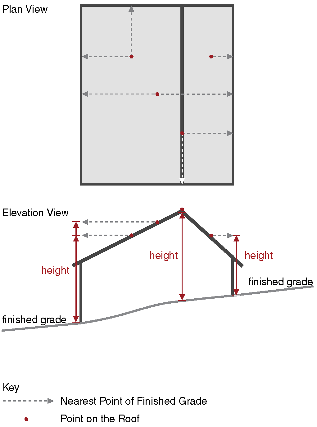
Height of Any Point. The height of a building or structure is the vertical dimension measured from any point on the exterior of the building or structure to the nearest point of finished grade.
EXAMPLE:In the diagram below the nearest point of finished grade is indicated by the white or gray arrows. Note the examples of points that are equidistant to finished grade on two sides of the house; height of such a point will be determined by the lower finished grade.
B.
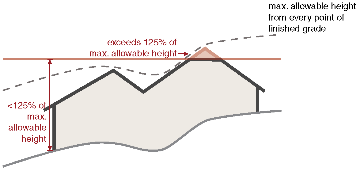
Overall Height of a Stepped Structure. In addition, on a sloped site where the height of the structure is stepped up the slope, the vertical dimension measured from the overall highest point of the building or structure to the overall lowest point of finished grade adjacent to the structure shall not exceed 125% of the maximum allowable height, measured from any point as described in Section 9.4.9(A). A stepped structure shall also comply with height at any point as described above in Section 9.4.9(A).
EXAMPLE:The diagram below shows a stepped structure that is compliant with maximum allowable height, as measured from any point on the roof, but is in violation of the overall height limit for a stepped structure (125% of the maximum allowable height, as measured from the highest point of the building to the lowest point of finished grade). Both measurements of height apply.
C.
Exceptions. No part of any building or structure may exceed the maximum allowable height except for the following:
1.
Chimneys, vents, and roof-top mechanical equipment such as HVAC systems, provided that the maximum height is not exceeded by more than four feet; or
2.
Antenna used for the reception of television broadcast signals.
(1/23/23)
9.4.10. - Lot Line.
A lot line is a line bounding a lot of record which divides one lot of record from another lot of record or from a street.
A.
Street Lot Line. Street lot line means a lot line contiguous with a road right-of-way or roadway.
B.
Front Lot Line. Front lot line means the street lot line or the lot line across which access is taken.
C.
Rear Lot Line. Rear lot line means a lot line opposite a street or front lot line. A nonrectangular lot of record or lot of record with multiple street lot lines may not have a rear lot line or may have multiple rear lot lines.
1.
Rear Lot Line Designation. On sites with multiple frontages, the Planning Director may apply the rear setback to lot lines opposite the frontages as applicable. The remaining lot lines shall receive side setbacks.
D.
Side Lot Line. Side lot line means any lot line other than a street, front, or rear lot line.
(1/4/21)
9.4.11. - Street Facade.
Section number reserved, standards only apply in Town.
(1/1/17)
9.4.12. - Stepback.
Section number reserved, standards only apply in Town.
(1/1/17)
9.4.13. - Story Height.
Section number reserved, standards only apply in Town.
(1/1/17)
9.4.14. - Transparency.
Section number reserved, standards only apply in Town.
(1/1/17)
9.4.15. - Blank Wall Area.
Section number reserved, standards only apply in Town.
(1/1/17)
9.4.16. - Pedestrian Access.
Section number reserved, standards only apply in Town.
(1/1/17)
9.4.17. - Yard.
A.
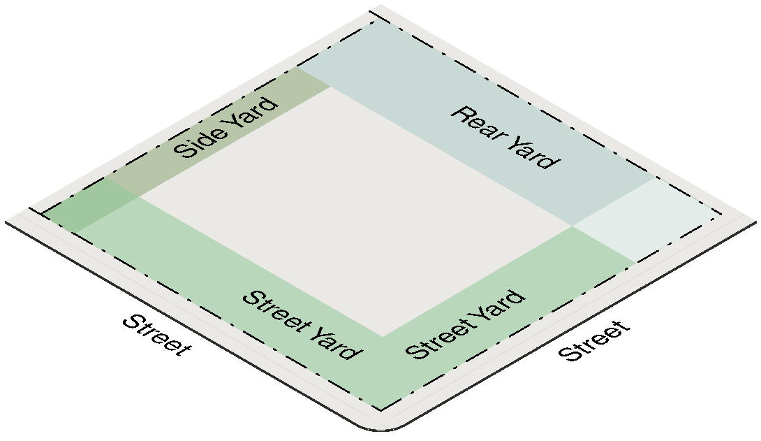
Street Yard. Street yard means the area between a road right-of-way, roadway, vehicular access easement, additional width required for right-of-way purpose as established in the Teton County Transportation Master Plan, or lot line from which access is taken and the minimum street setback extending the full length of the right-of-way, roadway, easement, or lot line. The street yard may overlap with a side or rear yard. Where yards overlap, the standards for each yard apply.
B.
Rear Yard. Rear yard means the area between the rear lot line and the minimum rear setback extending the length of the rear lot line. The rear yard may overlap with a street or side yard. Where yards overlap, the standards for each yard apply.
C.
Side Yard. Side yard means the area between the side lot line and the minimum side setback extending the length of the side lot line. The side yard may overlap with a street or rear yard. Where yards overlap, the standards for each yard apply.
(1/4/21)
9.5.1. - Definitions.
When used in these LDRs, the following terms shall have the following meanings:
A
Accessory Residential Unit. See Section 6.1.11(B).
Accessory Structure. An accessory structure is a separate structure that is secondary and subordinate to another structure on the same property.
Accessory Use. See Section 6.1.2(B.3).
Adaptive Controls. Adaptive means mechanical or electronic devices, when used in the context of outdoor lighting systems, intended to actively regulate the switching, duration, and/or intensity of light emitted by such systems. Examples of adaptive controls include timers, dimmers and motion-sensing switches.
Adjoining. See "Contiguous."
Adjusted Site Area. See Section 9.4.4(C).
Affordable Housing Unit. An affordable housing unit is a unit subject to an Affordable Ownership or Affordable Rental deed restriction as defined in the Housing Department Rules and Regulations.
Affordable Workforce Housing Unit. Affordable workforce housing is workforce housing that costs 30% or less of the occupant household's gross income. When used in reference to a requirement to provide affordable workforce housing, the standards for the units required to be provided are established by Division 6.3. See also "affordable housing unit" and "workforce housing unit," which are specific types of deed-restricted units.
Agriculture. See Section 6.1.3(B).
Alley. An access way, no more than 30 feet wide, which provides a means of public access to contiguous property that is not intended for general traffic circulation.
Amusement Use. See Section 6.1.7(B).
Antenna. Any apparatus used for the transmission and/or reception of radio frequency energy, including, but not limited to, omni-directional antenna (whip), directional antenna (panel), microcell, and parabolic antenna (dish). Antenna does not include support structures, utility structures, or towers.
Antenna Array. A single or group of antenna elements and associated mounting hardware, transmission lines, or other appurtenances which share a common attachment device such as a mounting frame or mounting support structure for the sole purpose of transmitting or receiving electromagnetic waves.
Antenna Support Structure. A structure that is primarily constructed for the purpose of holding antennas but on which one or more antennas may be mounted, including buildings, water tanks, pole signs, billboards, church steeples, and electric power transmission towers.
Apartment. See Section 6.1.4(D).
Arterial Road. See "Road, Arterial."
Assembly. See Section 6.1.8(B).
Attached Single-Family Unit. See Section 6.1.4(C).
Aviation. See Section 6.1.10(E).
Awning. Awning means a roof-like cover that projects from and is supported by the wall of a building for the purpose of shielding a doorway or window from the elements.
(7/18/18)
B
Bank (Stream/River/Ditch). Bank means the natural or man-made slope immediately bordering the channel of a river, stream, or creek containing and/or confining the normal water flow. See also "Top of Bank."
Banked unit. A residential unit, on which a deed restriction approved by the Housing Department has been voluntarily placed, which may be utilized within 20 years of placement of the restriction as required housing for employee generating development.
Bar. See Section 6.1.6(E).
Base Site Area. See Section 9.4.4(B).
Base Station. A structure or electronic equipment utilized by a wireless communication provider(s) for the transmission and reception of radio signals which is not on or part of a tower.
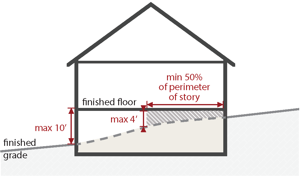
Basement. A basement is any story for which the finish floor of the story above is less than four feet above finished grade for at least 50% of the perimeter of the story and at no point greater than ten feet above finished grade.
Bed and Breakfast. See Section 6.1.11(C).
Bedroom. Bedroom means a room, including a den or unfinished room, in a dwelling unit that is marketed and designed for sleeping, or otherwise has potential to function primarily for sleeping.
Berm. Berm means a man-made landform, typically built as an earth mound, located so as to screen a structure or property from view and/or to provide sound relief from a nearby road.
Breakpoint Technology. The engineering design of a monopole wherein a specified point on the monopole is designed to have stresses concentrated so that the point is at least 5% more susceptible to failure than any other point along the monopole so that in the event of a structural failure of the monopole, the failure will occur at the breakpoint rather than at the base plate, anchor bolts, or any other point on the monopole.
Buffer (Natural Resource). The area between a natural resource and the minimum natural resource setback extending the full length of the natural resource.
Building. Building means any structure having a roof supported by columns or walls; any enclosed structure, including tarpaulin structures, designed or used for the housing or enclosure of persons, animals, chattels, or property of any kind; or any attached appurtenance thereto, but not including an advertising sign board, fence, tepee, tent, or similar type of temporary structure.
Building Envelope. A building envelope means the area of a lot of record within which all physical development shall occur.
Building Footprint. The building footprint is the area of the foundation; eaves, overhangs, decks, cantilevers and other projections are not included.
Bulk. Bulk is a spatial dimension of magnitude and refers to the scale, height, floor area, and footprint of a building.
(1/4/21)
C
Caliper. The diameter of a tree trunk measured 4.5 feet above the natural grade at the base of the tree.
Campground. See Section 6.1.5(D).
Camping Unit. Camping Units include recreational vehicles, campers, trailers, motorhomes, tents, yurts, tepees, or other shelter that is not certified under the International Residential or Building Code or by HUD. Camping Unit does not include Mobile Homes certified by HUD.
Canopy. Canopy means the uppermost spreading branchy layer of trees. Canopy also means an ornamental roof-like structure, cantilevered or supported by posts or pillars and having open sides.
Canopy Tree. Canopy tree means a deciduous shade or specimen tree, such as aspen, cottonwood, golden willow, or ash.
Changeable Copy Sign (Manual). See "Sign, Changeable Copy."
Christmas Tree Sales. See Section 6.1.12(B).
Cluster Development. The consolidation of development in order to minimize fragmentation of habitats.
Collector Road. See "Road, Collector."
Collocation. The mounting or installation of an antenna or antennas on an existing tower, building, or structure with existing communications equipment for the purpose of transmitting and/or receiving radio frequency signals for communications purposes.
Collocation (Small Wireless Facilities). The mounting or installation of an antenna or antennas on an existing pole, tower, building, or structure for the purpose of transmitting and/or receiving radio frequency signals for communications purposes.
Combined Antenna. An antenna or an antenna array designed and utilized to provide services for single or multiple wireless providers utilizing more than one frequency band or spectrum, for the same or similar type of services.
Commercial. See Section 6.1.6.
Commercial Air Tour. A commercial air tour is any flight conducted for compensation or hire in a powered aircraft where the purpose of the flight is sightseeing.
Common Open Area. Common open area means land within or related to a development which is designed or intended for the common active or passive use and enjoyment of the residents of the development. Common open area shall include: (a) land which is not individually owned and is not dedicated for public use for streets and other similar common facilities, or (b) land which is individually owned, provided it is located outside of an identified building envelope and has been located adjacent to and made a part of other common open areas, to the maximum extent possible, to form a continuous area of open space. Common open area may include such complimentary structures and improvements as are necessary and appropriate for its intended use, provided that fences shall not be installed so as to divide individual and common open areas from one another.
Concealed. A tower, ancillary structure, base station or equipment compound that is not readily identifiable as such, and is designed to be aesthetically compatible with existing and proposed building(s) and uses on a site. There are two types of concealed facilities: 1) Antenna Attachments, including painted antenna and feed lines to match the color of a building or structure, faux windows, dormers or other architectural features that blend with an existing or proposed building or structure and 2) Freestanding. Freestanding concealed towers usually have a secondary, obvious function, which may include church steeple, windmill, bell tower, clock tower, light stanchion, flagpole with or without a flag, or tree.
Conditional Use. See Section 6.1.1(C).
Condominium. Condominium means an estate in real property consisting of an undivided interest in common in a portion of a lot of record together with a separate interest in space in a building on such real property.
Conservation Area. A conservation area is land under conservation easement that meets the standards of Division 7.3.
Conservation Easement. A conservation easement is an agreement between a landowner and a land trust or government that invests in the land trust or government the power to constrain the landowner's rights to use and develop the land in order to achieve identified conservation purposes such as preservation of habitat, scenery, or agriculture. A conservation easement is a permanent interest in real property that runs with the land.
Construction Sign. See "Sign, Construction."
Contiguous. Contiguous means having a common border with.
Conventional Lodging. See Section 6.1.5(B).
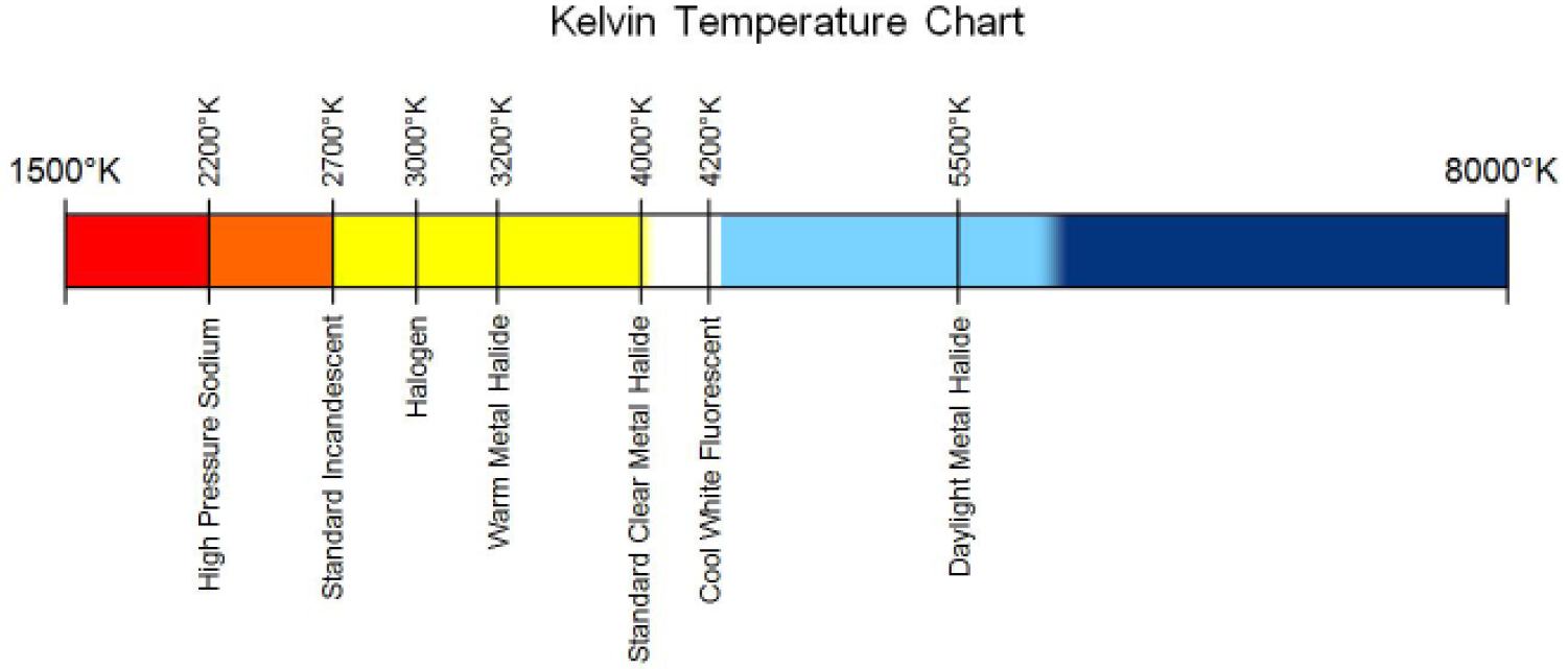
Correlated Color Temperature. Correlated color temperature indicates the 'warmth' or the 'coolness' of a light's appearance (see image below). Color temperature is generally indicated on light bulb packaging. Specifically, correlated color temperature is defined as the absolute temperature of a blackbody radiator whose chromaticity most nearly resembles that of the light source.
Crucial Range. Wyoming Game and Fish Department designates crucial range for big game species as: "Crucial range can describe any particular seasonal range or habitat component (often winter or winter/year-long) but describes that component which has been documented as the determining factor in a population's ability to maintain itself at a certain level over the long term." (WGFD.2015.Standardized Definitions for Seasonal Wildlife Ranges). WGFD Crucial Range layer can be found on the WGFD website or the Teton County GIS maps.
Cut Slope. Cut slope means any slope surface in soil or bedrock material created by man by the removal of soil or bedrock materials below the natural land surface.
(5/1/25)
D
Daycare. See Section 6.1.8(C).
Daycare, Family Home. See Section 6.1.11(F).
Daycare, Home Center. See Section 6.1.11(G).
Dedication. Dedication means the transfer of property interests by the owner to another person. The transfer may be of fee simple interest or of a less than fee simple interest, including an easement. Dedication is not complete unless the party to which the interest is dedicated accepts the dedication.
Density. See Section 9.4.6(B).
Detached Single-Family Unit. See Section 6.1.4(B).
Detention Basin. A detention basin is a covered or uncovered reservoir designed to hold an excessive accumulation of stormwater or snowmelt so as to reduce peak flow in a stormwater or snowmelt drainage system.
Developed Recreation. See Section 6.1.7(D).
Developer. Developer means a recognized legal or beneficial owner of a lot of record proposed for inclusion in a development or use, including a lessee, optionee, or contract purchaser.
Development. Development means any physical development, development option or subdivision. Development does not mean use if the use does not require any physical development or development option.
Development Area. A development area is a contiguous area in which all physical development, utilities, and non-native landscaping is located. Driveways and utility lines may extend out of a development area to provide access to the development area.
Development Option. A development option is any division of a lot of record into two or more lots of record; adjustment of the boundaries of lots of record; entitlement of uses or densities not allowed through approval of only a physical development permit and/or use permit; and any other approval that changes the allowed physical development or use of a site.
Disposal. See Section 6.1.9(D).
Ditch, Irrigation. See "Irrigation Ditch."
Dormitory. See Section 6.1.4(F).
Drainage. Drainage means the removal of surface water or groundwater from land by drains, grading, or other means. Drainage, sometimes referred to in terms of stormwater management, also includes the control of runoff to minimize erosion and sedimentation during and after development, and includes the means necessary for water supply preservation or prevention or alleviation of flooding.
Drainageway. A drainageway is a watercourse identified by the presence of an intermittent flow, or a swale whose drainage area is a minimum of five acres.
Drive-In Facility. See Section 6.1.11(H).
Driveway. Driveway means a private fire apparatus access way serving four or fewer dwelling units, including accessory residential units, or no more than two non-residential lots.
Dude Ranch. See Section 6.1.3(E).
Dwelling Unit. A dwelling unit is a unit used residentially and is also known as a residential unit. See Section 6.1.4 for a definition of residential use.
(8/1/25)
E
Earth Sheltered Design. Earth sheltered design means a building whose mass is built fully or partly below the land surface, or which sits above natural grade but has been covered with earth so that at least 50% of the perimeter of the building is concealed from view.
Easement. Easement means a less than fee interest in land, which provides a person other than the owner of the land certain rights over that land, or any designated part of that land, for the purposes specified.
Education. See Section 6.1.8(C).
Eligible Support Structure. An existing tower or base station as defined herein.
Emergency Work. Work which must be performed immediately to save lives or to protect improved property, public health and safety, or to avert or lessen the threat of a major disaster.
Employee Generating Development. Employee generating development is a new building or use not currently in existence, as further defined by Section 6.3.2(A). It is a term describing development that requires provision of affordable workforce housing pursuant to Division 6.3, unless exempt in that Division.
Employee Housing. 1) A unit subject to an Employee Housing restriction as defined in the Housing Department Rules and Regulations, such units were required by Division 6.3 as it existed prior to July 18, 2018. 2) A unit occupied by an employee of a business on the site.
Equipment Cabinet. Any structure above the base flood elevation including cabinets, shelters, pedestals, and other similar structures and used exclusively to contain radio or other equipment necessary for the transmission or reception of wireless communications signals.
Equipment Compound. The fenced-in area surrounding the ground-based wireless communications facility including the areas inside or under a tower's framework and ancillary structures such as equipment necessary to operate the antenna on the structure that is above the base flood elevation including cabinets, shelters, pedestals, and other similar structures.
Erosion. Erosion means the detachment and movement of soil, sediment, or rock fragments by water, wind, ice, and/or gravity.
Excavation. Excavation means any act by which organic matter, earth, sand, gravel, rock, or any other similar material is cut into, dug, quarried, uncovered, removed, displaced, relocated or bulldozed, as well as the resulting conditions.
Existing Use or Development. Existing use or development means any use or development of a site, which is located on the site at a given point in time, whether or not the use or development conforms with the provisions of these LDRs.
(1/23/23)
F
Facade. A facade is a building's elevation, as viewed in a single plane parallel to a referenced lot line.
Facade Width. Facade width is the linear width of the building elevation, measured in a single plane parallel to the referenced lot line.
Face, Building. See "Building Face."
Fair Market Value. The price that land will bring in a competitive and open market under all conditions of fair sale, the buyer and seller each prudently knowledgeable, and assuming the price is not affected by undue stimulus.
Family. Family means one or more individuals related by blood, marriage, adoption, or guardianship, or not more than six individuals not so related, occupying a dwelling unit and living as a single housekeeping unit.
Family Home Daycare. See Section 6.1.11(F).
Farm Stand. See Section 6.1.12(E).
Fascia. Fascia means a band located at the top edge of a building, but below the actual roofline and above the building wall. Fascia material is typically of a different type than either the actual roof or the building wall.
Fault Line. Fault line means all geologic faults indicated on the Geological Quadrangle Maps covering Teton County, published by the U.S. Geological Survey.
Feed Lines. Cables used as the interconnecting media between the transmission/receiving base station and the antenna.
Fill. Fill means rock, soil, sand, gravel, or other earth material deposited by man, whether submerged or not, which is commonly used for leveling, back-filling, or otherwise preparing a site for development or construction.
Fill Slope. Fill slope means the surface of the outward margins or sides of a fill.
Finished Grade. See "Grade, Finished."
Flag. Flag means a device generally made of flexible materials, such as cloth, paper, or plastic, displayed individually on poles or as groups on poles, strings, or wires.
Flashing Sign. See "Sign, Flashing."
Flood. See Teton County Floodplain Management Resolution.
Floodplain. See Teton County Floodplain Management Resolution.
Floor Area. See Section 9.4.5.
Floor Area, Gross. See "Gross Floor Area."
Floor Area, Habitable. See "Habitable Floor Area."
Floor Area Ratio. See Section 9.4.6(C).
Flush-Mounted. Any antenna or antenna array attached directly to the face of the support structure or building in a manner that permits mechanical beam tilting if necessary but such that no portion of the antenna extends above the height of the support structure or building.
Foot-candle. A foot-candle is a non-SI unit of illuminance or light intensity. The foot-candle is defined as the intensity of one lumen of light falling with uniform distribution on a surface with an area of one square foot.
Front Yard. Street yard. See Section 9.4.17(A).
Frontage. Frontage means a lot line contiguous with a road right-of-way or roadway, (synonymous with "Lot Line, Street").
Fully Shielded. Fully shielded means an outdoor luminaire constructed so that in its installed position all of the light emitted by the luminaire is projected below the horizontal plane passing through the lowest light-emitting part of the luminaire. Examples of Unshielded (Prohibited) and Fully Shielded (Allowed) lights and luminaires limiting light to the horizontal plane can be found in Section 5.3.1(B).
(1/4/21)
G
Garage. Garage means a building or floor area within a building intended to be used for the parking or storage of motor vehicles.
Glare. Glare means lighting entering the eye directly from luminaires or indirectly from reflective surfaces that causes visual discomfort or reduced visibility.
Grade, Finished. Finished grade means the final elevation of the ground surface after physical development that has been permitted pursuant to these LDRs. The term "finished grade" may also mean natural grade when no terrain alteration is proposed, or where otherwise applicable. Fill which is not necessary to achieve positive drainage or slope stabilization, or which is otherwise proposed clearly to manipulate the measurement of another standard of these LDRs, shall not be considered finished grade.
Grade, Natural. Natural grade means the elevation of the ground surface in its natural state before physical development.
Gradient. Gradient means the steepness, in terms of angle from the horizontal or in terms of percent, of a slope measured in a prescribed direction up or down the slope. For a road, the gradient is measured as the steepness along the centerline.
Gravel Extraction and Processing. See Section 6.1.9(F).
Gravel Extraction and Processing, Temporary. See Section 6.1.12(F).
Gross Floor Area. Gross floor area is the total of all habitable and non-habitable floor area in a structure on all levels. Gross floor area includes basements, and partial levels such as lofts, mezzanines, and interior balconies. It also includes foyers, hallways, restrooms, storage, and other common areas within a building.
Gross Site Area. See Section 9.4.4(A).
Groundwater. Groundwater means any water, including hot water and geothermal steam, under the surface of the land.
Group Home. See Section 6.1.4(G).
Guest Ranch. See Section 6.1.3(E).
(1/1/17)
H
Habitable Floor Area. Habitable floor area is the floor area that can be used for living purposes, usually having access to heat, plumbing, and electricity. Habitable floor area includes studios, exercise rooms, offices, and similar spaces. It also includes foyers, hallways, restrooms, storage, and other common areas within a building. Habitable floor area does not include barns, garages, or unfinished attic space.
Heavy Industry. See Section 6.1.9(C).
Heavy Retail/Service. See Section 6.1.6(F).
Height, Building. See Section 9.4.9.
Home Business. See Section 6.1.11(E).
Home Daycare Center. See Section 6.1.11(G).
Home Occupation. See Section 6.1.11(D).
(1/1/17)
I
Illuminating Engineering Society (IES). Illuminating Engineering Society or IES means an industry-supported, nonprofit learned society headquartered at 120 Wall Street, New York City, New York, recognized as an authoritative body on the science and application of lighting that publishes and promotes recommended practices for a variety of specific lighting applications.
Impervious Surface. Impervious surfaces mean a surface which does not absorb water.
EXAMPLE:Examples of impervious surfaces include, but not are not limited to: buildings (including roofed areas but excluding eaves that over-hang a pervious surface), structures, parking areas, loading areas, driveways, roads, sidewalks, and any areas of concrete, asphalt, or significantly compacted material which prevents water absorption.
Incidental Use. See Section 6.1.2(B.2).
Industrial Use. See Section 6.1.9.
Industry, Heavy. See Section 6.1.9(C).
Industry, Light. See Section 6.1.9(B).
Infrastructure. Infrastructure means public facilities necessary to serve development, including, but not limited to roads, potable water supply facilities, sewage disposal facilities, drainage facilities, electric facilities, natural gas facilities, telephone facilities and cable television facilities.
Initial lumens. The number of lumens of light emitted by a luminaire when the lamp is new, not accounting for any depreciation due to the age of the lamp or environmental conditions that may be detrimental to its performance.
Institutional Use. See Section 6.1.8.
Internally illuminated. Internally illuminated refers to any sign or display, whether on- or off-premises, consisting of (1) translucent surfaces whose message is designed to be made visible by means of lamps or other light sources concealed within such surfaces; or (2) a sign whose content is made visible by means of luminous elements under active electronic control and therefore subject to alteration in order to vary the color, content and/or brightness of the message displayed.
Intersection. An intersection is a point where two or more vehicular accesses converge, or when a single approach begins or ends at another roadway.
Irrigation Ditch. An irrigation ditch is a man-made ditch constructed for the purpose of land irrigation. Irrigation ditches shall not include naturally formed drainageways.
(8/1/25)
J
Junkyard. See Section 6.1.9(E).
(1/1/15)
K
Kitchen. A kitchen is a room or portion of a room devoted to the preparation or cooking of food for a person or a family living independently of any other family, which contains a sink and a stove or oven powered by either natural gas, propane or 220-V electric hook-up. A wet bar, consisting of no more than a refrigerator, sink, and microwave, or similar facility that is a homeowner convenience and is not intended to function as the cooking facility for a separate dwelling unit shall not be considered a kitchen facility.
(1/1/15)
L
Land. Land means all land or water surfaces, whether public or private, including lots of record or other ownership categories and all rights—surface, subsurface, or air—that may be attached or detached from the land.
Land Disturbing Activity. A land disturbing activity is any manmade change to the land surface, including removing vegetative cover, excavating, filling, and grading. The tending of gardens and agricultural activities are not land disturbing activity.
Landscape Surface Area. Landscape surface area is the area of a site that is covered by natural vegetation, trees, or landscaped areas such as turf grass, planted trees and shrubs, mulch, or xeriscape. Any area of a site meeting the definition of site development is not landscape surface area.
Landscape Surface Ratio. See Section 9.4.6(D).
Landscaping, Required. Required landscaping includes required landscape surface area and required plant units.
Light Industry. See Section 6.1.9(B).
Light Trespass. Light trespass means a condition in which artificial light emitted from a luminaire on one property, not inclusive of light incidentally scattered or reflected from adjacent surfaces, is directed in such a manner that is directly shining on adjacent property. For the purposes of this chapter, light trespass is declared to be a form of public nuisance. See Section 5.3.1(B) for an illustration of light trespass.
Livestock. Horses, mules and asses, rabbits, llamas, cattle, swine, sheep, goats, poultry, or other animals generally used for food or in the production of food or fiber, working animals and guard animals actively engaged in the protection or management of livestock. Bison are considered livestock unless otherwise designated by the Wyoming Livestock Board and the Wyoming Game and Fish Commission, per Wyo. Stat. § 23-1-102.
Loading Area or Space. The portion of a site developed for the loading or unloading of motor vehicles or trailers, including loading berths, aisles, access drives, and related landscaped areas.
Local Road. See "Road, Local."
Lodging. See Section 6.1.5.
Lot. An area of land that is shown on a duly approved and recorded subdivision map.
Lot Area. Lot area means the gross site area of a lot of record.
Lot Line. See Section 9.4.10.
Lot of Record. Any validly recorded platted lot, parcel, or tract of land for which the deed is on record with the Teton County Clerk, and which complied with all applicable laws, ordinances, and regulations on the date of its creation.
Lot Size, Minimum. See Section 9.4.6(F).
Lumen. Lumen is a measure of light emission. Lumen measurements are commonly indicated on light bulb packaging. Specifically, a lumen is the amount of light emitted per second in a unit solid angle of one steradian from a uniform source of one candela.
Luminaire. Luminaire means a complete lighting fixture, consisting of a lamp, or lamps and ballast(s) (when applicable), together with the parts designed to distribute the light from the fixture (i.e., reflector, lens, diffuser), to position and protect the fixture, and to connect the fixture to the power supply.
Luminance. Luminance is the amount of light that passes through, is emitted, or reflected, from a particular area, and that falls within a given solid angle. Luminance is a measure of light emitted by or from a surface. The SI unit of luminance is candela per square meter (cd/m2), also known as a "nit."
(1/23/23)
M
Maintenance (Sign). Sign maintenance means the cleaning, painting, repair, or replacement of defective parts of a sign in a manner that does not change or alter the basic copy design, or structure of the sign.
Maximum. See Section 9.4.3(B).
Maximum Extent Practicable. Maximum extent practicable means no feasible or practical alternative exists, as determined by Staff, and all possible efforts to comply with the LDRs and minimize potential harmful or adverse impacts have been undertaken by the applicant. Economic considerations may be taken into account but shall not be the overriding factor determining "maximum extent practicable."
Mean High Water. Mean high water means the average of the elevation achieved each year by the water level of a water course during the month of June. Mean high water should not to be construed as a flood elevation.
Minimum. See Section 9.4.3(C).
Minimum Site Area. See Section 9.4.4(D).
Mini-Storage Warehouse. See Section 6.1.6(G).
Mobile Home. See Section 6.1.4(E).
Mobile Home Park. See Section 7.1.4.
(1/1/17)
N
Native Species. Native species means vegetation which is indigenous to, and is commonly found in, landscapes in the Town of Jackson and Teton County which have never been disturbed. A list of native species is available at the Planning Department.
Natural Grade. See "Grade, Natural."
Natural Topographic Break. Natural topographic break means any naturally occurring change in relief on land such as a mound, knoll, hill, bank, ridge, or terrace, or an area sloping away from a flat grade, which creates a recessed area capable of screening development.
Neon Sign. See "Sign, Neon."
Neutral Host Antenna. A small wireless facility using an antenna or an antenna array designed and utilized to provide services for more than one wireless provider, or a single wireless provider utilizing more than one frequency band or spectrum, for the same or similar type of services.
Non-Concealed. A wireless communications facility that has not been treated, camouflaged, or disguised to blend with the setting and is readily identifiable.
Nonconforming or Nonconformity. See Division 1.9.
Nursery. See Section 6.1.6(H).
(1/4/21)
O
Office. See Section 6.1.6(B).
Off-Site. Located neither on the land that is the subject of the application nor on a contiguous portion of a street or other right-of-way.
On-Site. Located on the land that is the subject of the application.
Open Space (Use). See Section 6.1.2.
Outdoor Recreation. See Section 6.1.3.
Outfitter. See Section 6.1.7(E).
(4/1/16)
P
Parcel. Parcel means unplatted property that is described by metes and bounds, or any public land surveys, or aliquot parts, or lot or tract designations not recognized as lawfully platted.
Parking (Use). See Section 6.1.10(B).
Parking Lot. Parking lot means four or more adjacent parking spaces.
Pathway. Pathway means a facility designed for non-motorized travel intended for the use of bicyclists, pedestrians, equestrians, and cross-country skiers.
Pavement. Pavement shall be concrete, grasscrete, paving blocks, asphalt, or another all-weather surface other than gravel.
Performance Bond. Performance bond means a financial guarantee to ensure that all improvements, facilities, or work required by these LDRs will be completed in compliance with these LDRs, and the approved plans and specifications of a development.
Person. Person means an individual or group of individuals, corporation, partnership, association, municipality, or state agency.
Personal Wireless Service. Commercial mobile services, unlicensed wireless services, and common carrier wireless exchange access services as defined in the Telecommunications Act of 1996.
Physical Development. Physical development means any of the following activities that alter the natural character of the land or for which a permit may be required pursuant to the LDRs: the construction, reconstruction, conversion, structural alteration, relocation, or enlargement of any structure, fence, wall, or other site development; any grading, clearing, excavation, dredging, filling or other movement of land; any mining, paving, or drilling operations; or the storage, deposition, or excavation of materials. Physical development does not include the use of land that does not involve any of the above listed activities.
Planned Residential Development, Complete Neighborhood (CN). See Section 7.1.6.
Planned Residential Development, Rural. See Section 7.1.2.
Plat. Plat means the legally recorded drawing depicting the subdivision of land into two or more lots.
Pole. A pole, such as a utility, lighting, traffic, or similar pole made of wood, concrete, metal or other material.
Primary Use. See Section 6.1.2(B.4).
Principal Use. See Section 6.1.2(B.1).
Public Sanitary Sewer. See "Wastewater Treatment System, Public."
Public Water Supply. See "Water Supply, Public."
(1/23/23)
R
Ranch Compound. Ranch compound means a cluster of structures built in traditional ranch forms commonly found on ranches in Teton County.
Real Estate Sales Office. See Section 6.1.12(C).
Recorded. Recorded means formally indexed and abstracted in the official records of the Teton County Clerk. Recorded does not include documents that are merely filed.
Required Landscaping. See "Landscaping, Required."
Residential. See Section 6.1.4.
Residential Street. Residential street means a local road serving residential uses.
Restaurant. See Section 6.1.6(E).
Retail (Use). See Section 6.1.6(C).
Riding Arena. An open space specifically designed and constructed to be used for horse training exercises and activities such as horseback riding and jumping.
River. See Section 5.1.1.
Road, Arterial. Arterial road means a road, which is intended to provide for travel between or within communities or to and from collector roads. Access is controlled so that only significant land uses may take direct access to these streets. For the purposes of these LDRs, arterial roads are identified as arterials on the Official Town County Highway Map.
Road, Collector. Collector road means a road, which is intended to connect local roads to arterial roads.
Road, Local. Local road means a road, which is intended to provide access to contiguous lands.
Runoff. Runoff means the rainfall, snowmelt, or irrigation water flowing over the ground surface.
(1/23/23)
S
Scale of Building, Maximum. See Section 9.4.7(B).
Scale of Use, Maximum. See Section 9.4.7(A).
Search Ring. A geographic area designated by a wireless provider or operator for a new base station, produced in accordance with generally accepted principles of wireless engineering.
Sedimentation. Sedimentation means the deposition of soil that has been transported from its site of origin by water, ice, wind, gravity, or other natural means as a result of erosion.
Service. See Section 6.1.6(D).
Setback. See Section 9.4.8.
Shelter, Temporary. See Section 6.1.12(D).
Short-Term Rental Unit. See Section 6.1.5(C).
Sign. Sign means any object, device, display, structure, or part thereof, situated outdoors or indoors, which is used to advertise, identify, display, direct, or attract attention to an object, person, institution, organization, business, religious group, product service, event, or location by any means including words, letters, figures, designs, symbols, fixtures, colors, illumination, or projected images. Signs do not include merchandise and pictures or models of products or services incorporated in a window display, works of art which in no way identify a product, or score boards located on athletic fields. See Division 5.6 for standards applicable to Signs.
Site. Site means the entire area of the land on which a use or development is existing or proposed. A site may be a portion of a lot of record or may include multiple lots of record.
Site Area, Adjusted. See Section 9.4.4(C).
Site Area, Base. See Section 9.4.4(B).
Site Area, Gross. See Section 9.4.4(A).
Site Area, Minimum. See Section 9.4.4(D).
Site Development. Site development is the area of the site that is physically developed; it is generally the inverse of landscape surface area. Site development includes the area of the site that is covered by buildings, structures, impervious surfaces, porches, decks, terraces, patios, driveways, walkways, parking areas, and regularly disturbed areas such as corrals, outdoor storage, and stockpiles. Site development does not include cultivation of the soil for agricultural use.
Site Development, Maximum. See Section 9.4.6(E).
Skyline. Skyline means the visual line at which the earth or vegetation and the sky appear to meet. It is typically viewed as the top, crest, or peak of a ridge, hillside, or butte.
Slope. Slope means the relationship of the change in the vertical measurement to the change in the horizontal measurement, usually written as a ratio or a percentage.
Slope, Natural. See "Grade, Natural."
Small Wastewater Treatment System. See "Wastewater Treatment System, Small."
Small Wireless Facility. See Section 6.1.10(D).
Special Use. See Section 6.1.1(D).
Stream. See Section 5.1.1.
Structure. Structure means any building, bridge, fence, pole, tower, deck, liquid storage tank, gazebo, pier, dam, culvert, satellite dish, personal wireless telecommunication facilities, standalone entry gate, or other construction or erection greater than four feet in height.
Subdivision. Subdivision means any division of a building, plat, or lot of record into two or more parts by means of platting in accordance with the procedures and standards of Section 8.5.3 or exempt land division in accordance with the procedures and standards of Section 8.5.4. Subdivision includes a division of a building or lot of record for purposes of creating condominiums or townhomes.
Subdivision Improvement. Subdivision improvement means any improvement, facility, or service, together with customary improvements and appurtenances thereto, necessary to provide for the needs of the subdivision such as: streets, alleys, pedestrian walks or paths, storm sewers, flood control improvements, water supply and distribution facilities, sanitary sewage disposal and treatment, utility and energy services.
Suitable Habitat. The term suitable describes "habitat where the natural resources needed by a particular species are likely to be present" (EcoConnect, 2018. Focal Species Habitat Mapping for Teton County, WY Report Addendum). Suitable habitat found within designated "crucial range" is of importance to the species survival and representative of the crucial habitats found within designated crucial range lands. The majority of the time, the species of concern will be ungulates such as mule deer, moose and elk. However, there may be instances when other species are represented by crucial ranges Suitable habitat includes a GIS layer within the Teton County GIS maps.
Swale. Swale means a linear depression in the land's surface in which sheet runoff would collect and form a temporary watercourse. A swale with a drainage area of five acres or more is considered a drainageway.
(5/1/25)
T
Temporary Gravel Extraction and Processing. See Section 6.1.12(F).
Temporary Shelter. See Section 6.1.12(D).
Temporary Use. See Section 6.1.2(B.5).
Thread Channel. A line running through the low point of a river or stream with running water.
Tiered Natural Resources Overlay.
a.
Base Tier — Areas mapped within the Base Tier are those with less habitat types and/or habitats that support fewer focal species. These areas tend to have more development present and contain fewer habitat types if undeveloped.
b.
Mid Tier — Areas mapped within the Mid Tier are those with a moderate number of habitat types and/or habitats that some of the focal species depend on. These areas tend to have less development present or are often only a few habitat types if undeveloped.
c.
High Tier — Areas mapped within the High Tier are those with multiple habitat types and/or habitats that support multiple focal species. These areas tend to have less development present, are usually near water or contain water and have multiple habitat types if undeveloped.
Time-Share Ownership. Time-share ownership means ownership of a unit in which purchase is for interval ownership with ownership conveyed by deed/license.
Top of Bank. The elevation of the top of bank shall be determined by the observed high water mark, or one foot above the maximum discharge elevation of an outlet control structure that controls the water elevation of a body of water.
Tour Operator. See Section 6.1.7(E).
Tower (Communications). A structure that is built for the sole or primary purpose of supporting equipment for the transmission and/or reception of radio frequency signals or other wireless communications or meteorological device, and usually consisting of an antenna or antenna array, transmission cables, equipment cabinets, and their associated facilities, including, but not limited to, monopoles, lattice towers, guyed towers, and self-supporting towers, and not including poles.
Tower Base. The foundation, usually concrete, on which the tower and other support equipment are situated. For measurement calculations, the tower base is that point on the foundation reached by dropping a perpendicular from the geometric center of the tower.
Tower Height. The vertical distance measured from finished grade to the highest point of the tower, including any antenna or other equipment affixed thereto.
Tower Site. The current boundaries of the leased or owned property surrounding the tower and any access or utility easements currently related to the site.
Townhouse. Townhouse means a single-family unit, including the ground beneath the unit, with a single unit going from ground to roof.
(5/1/25)
U
Unlicensed Wireless Services. Unlicensed wireless service means the offering of telecommunications services using duly authorized devices which do not require individual licenses, but does not mean the provision of direct-to-home satellite services.
Unstable Soil. Unstable soil means soil subject to slippage, creep, landslide, avalanche, bedrock slump, talus, rockfall, colluvium, and lacustrine deposits, either at the surface or overlain by other deposits, or subject to other movements as indicated by the Land Stability Maps of Teton County, site specific geotechnical reconnaissance studies, or any other technically competent source.
Urban Cluster Development. See Section 7.1.3.
Use. See Section 6.1.2(A).
Use, Accessory. See Section 6.1.2(B.3).
Use, Conditional. See Section 6.1.1(C).
Use, Incidental. See Section 6.1.2(B.2).
Use, Primary. See Section 6.1.2(B.4).
Use, Principal. See Section 6.1.2(B.1).
Use, Special. See Section 6.1.1(D).
Use, Temporary. See Section 6.1.2(B.5).
Utility Facility. See Section 6.1.10(C).
(1/1/15)
W
Wastewater Treatment System, Community. Community wastewater treatment system means a privately owned and operated system, other than a municipal sewage treatment plant, for the collection and treatment of wastewater generated by the dwelling units and accessory uses in a development.
Wastewater Treatment System, Public. Public wastewater treatment system (or sanitary sewer) means a wastewater disposal system, other than small wastewater treatment system, approved by the State, County, or Town, and maintained by a public or private agency authorized to operate such system.
Wastewater Treatment System, Small. Small wastewater treatment system means a sewage system, disposal system, or treatment works having simple hydrologic and engineering needs which is intended for wastes originating from a single residential unit serving no more than four families, or which distributes 2,000 gallons or less of domestic sewage per day.
Water Supply, Public. Public water supply means a water supply being distributed by 20 or more service connections used to furnish water for human consumption either in preparing foods or beverages for inhabitants of residences or for the use of business establishments. A public water supply includes the source, treatment system, distribution system, service connections, finished water storage, and pumping stations.
Wildlife. All wild mammals, birds, fish, amphibians, reptiles, crustaceans and mollusks, and wild bison designated by the Wyoming Game and Fish Commission and the Wyoming Livestock Board within Wyoming, per Wyo. Stat. § 23-1-101.
Wireless Communication Facilities. See Section 6.1.10(D).
Workforce Housing. Workforce housing is market and deed-restricted housing occupied by people working locally who would otherwise commute from outside the community. See also "workforce housing unit," which is a specific type of deed-restricted unit.
Workforce Housing Unit. A workforce housing unit is a unit subject to a Workforce Ownership or Workforce Rental deed restriction as defined in the Housing Department Rules and Regulations. See also "workforce housing," which is the broader definition of the concept of workforce housing as it is used in the Jackson/Teton County Comprehensive Plan.
(1/23/23)
Y
Yard. See Section 9.4.17.
Yard, Front. Street yard. See Section 9.4.17(A).
(1/4/21)

