
Teton County Unincorporated
City Zoning Code
City Zoning Code
ARTICLE 7
DEVELOPMENT OPTION AND SUBDIVISION STANDARDS APPLICABLE IN ALL ZONES
Division 7.2. - Subdivision Standards
This Division contains the development standards required for subdivision, such as requirements for new roads, water and sewer infrastructure, utilities, parks, and other physical improvements necessary to safely serve newly subdivided property and minimize impacts on existing community services and infrastructure. See Section 8.5.3 for the procedure to subdivide property.
Division 7.4. - Reserved
Division number reserved, original Division deleted.
(7/18/18)
7.1.1. - Development Options Schedule.
The tables below establish the development options allowed in each zone. The standards for each development option are established in this Division. The density and intensity requirements for each development option are located in the standards for the zone, found in Articles 2—4. The thresholds for permitting allowed development options are also established by zone.
(4/19/22)
7.1.2. - Rural Area Planned Residential Development (Rural PRD).
A.
Intent.
1.
Purpose. The purpose of the Rural PRD is to encourage conservation of open space and clustering of development by granting more density in exchange for clustering and permanently conserved open space. The goal of the Rural PRD is to provide a rural area landowner with a subdivision option that is better for wildlife, scenery, and/or agriculture than just selling individual 35-acre tracts.
2.
Location. Each Rural PRD includes a conservation area and one or more development areas that are entirely outside the conservation area. The Rural PRD is the appropriate tool when locating both the conservation area and clustered development area(s) in a rural area of the community, as identified in the Illustration of Our Vision chapter of the Comprehensive Plan.
3.
Comprehensive Plan. The Rural PRD is primarily based on the Comprehensive Plan direction of Policy 1.4.c.
4.
Applicable Zones. The Rural PRD may be used in the R-1, R-2, WHB, and R-TC zones.
B.
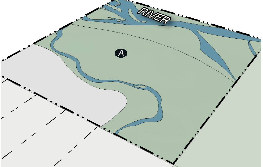
Required Conservation Area. The conservation area shall meet the standards of Division 7.3 in addition to the standards of this Section.
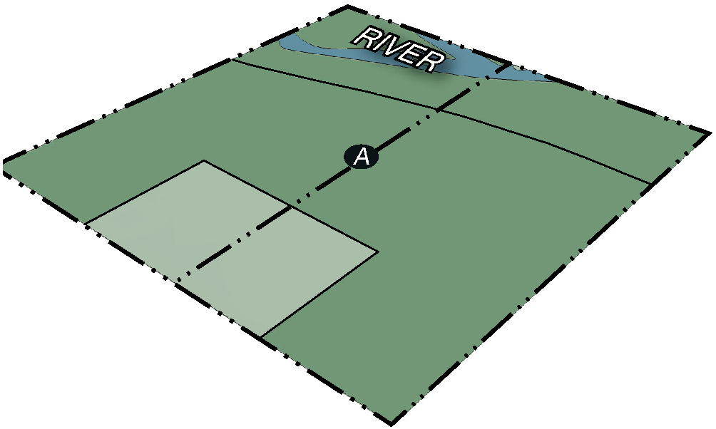
| 1. Scale | ||
 | ||
| Minimum Gross Site Area | ||
| Conservation area GSA (min) | Greater of: |  |
| Conservation area GSA | 49 ac | |
| PRD GSA in conservation area | OR 70% | |
2.
Conservation Value. At least one of the conservation values listed below shall be a protected conservation value identified pursuant to Section 7.3.2(A).
a.
Wildlife
b.
Scenic
c.
Agriculture
3.
Noncontiguous PRD. The site of a Rural PRD may be noncontiguous pursuant to the rules for measurement in Section 9.4.4.
4.
Already Conserved Land. Land already under conservation easement shall not count toward the calculation of allowed dwelling units per PRD GSA in Subsection C.1 unless the dwelling units are already allowed by the conservation easement.
EXAMPLE:A 1970s conservation easement reserves two three-acre homesites on 55 acres. The base R1 zoning does not allow two units without approval of a PRD. The existing conservation easement may be used in a PRD application for the two units allowed by the easement, but may not be used to propose more than two units.
C.
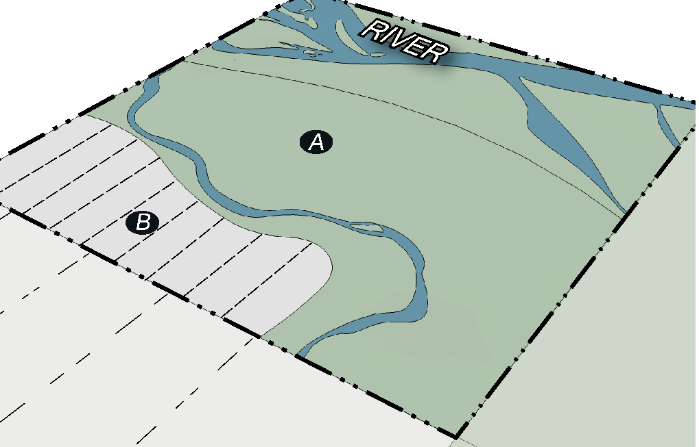
Development Area Standards. Nothing in this Section shall preclude the permanent reduction, through conservation easement, of the development potential allowed in a development area.
| 1. Scale | ||
 | ||
| Development Area | ||
| Development Area (max) | Lesser of: |  |
| Development Area GSA | PRD GSA minus 49 ac. | |
| PRD GSA in development area | OR 30% | |
| # of development areas : PRD GSA (max) | 1 : 70 ac | |
| Dwelling units : PRD GSA (max) | 3 : 35 ac | |
| Dwelling Unit Within a Rural PRD | ||
| Floor area (max) | 10,000 sf | |
| Site Development (max) | 25,410 sf | |
| Lot Within a Rural PRD | ||
| Street setback (min) | ||
| Public Road | 50' | |
| Private Road | 30' | |
| Non-street setback (min) | ||
| Structure | 30' | |
| Site Development | 15' | |
EXAMPLE:A Rural PRD on 100 acres would require a minimum of 70 acres of conservation area and be allowed a maximum of 30 acres of development area (30:70 = 3:7). Eight principal residential units (3 * 100/35 = 8.57) would be allowed in the development area.
2.
Location. The development area shall be located adjacent to existing development when existing development abuts the Rural PRD site, unless better protection of the conservation value(s) would be achieved in another location.
3.
Access Across Conservation Area. Access to a development area that crosses a conservation area shall be counted as conservation area in calculation of the maximum development area.
4.
Physical Development Standards. Except as modified in this Section, the physical development standards applicable in the zone shall apply in a Rural PRD development area.
5.
Use Standards. Except as modified in this Section, the use standards applicable in the zone shall apply in a Rural PRD development area.
a.
Allowed Uses. In addition to the uses allowed in the zone of the Rural PRD, on lots in the development area of a Rural PRD all residential uses are allowed.
EXAMPLE:The eight units allowed in the previous example could be any combination of residential uses defined in Section 6.1.4 so long as each unit has only one kitchen.
b.
Maximum Scale of Residential Use. A residential unit shall not exceed 8,000 square feet of habitable floor area.
6.
Development Option Standards. Except as modified in this subsection, the development option and subdivision standards applicable in the zone shall apply in a Rural PRD development area.
a.
Condominium/Townhouse. Condominium or townhouse subdivision is a permitted subdivision option as part of a Rural PRD.
b.
Density Allowed Without Subdivision. The density allowed by a Rural PRD does not have to be subdivided into separate lots. However, approval of a Development Plan for a Rural PRD shall vest subdivision of the allowed density once the conservation easement is recorded.
(4/19/22)
7.1.3. - Urban Cluster Development (UCD).
Section number reserved, standards only apply in Town.
(1/1/15)
7.1.4. - Mobile Home Park.
Mobile Home Parks shall meet the following standards. Mobile Home Parks may be proposed in the MHP-TC or as a Planned Residential Development. Existing Mobile Home Parks proposed for expansion or redevelopment in the MHP-TC zone, shall only be required to comply with Section 7.1.4(A).
A.
Existing Mobile Home Parks in the MHP-TC. Existing mobile home parks within the MHP-TC zone shall be allowed to continue, expand, and redevelop, provided the standards in this Subsection are met.
1.
Density. The number of units in an existing mobile home park in the MHP-TC shall not be limited.
2.
Area. Each mobile home within an expansion area or redeveloped park shall have a lot or pad land area that equals or exceeds the average size of a mobile home lot or pad in the existing mobile home park, not including open space areas clearly heretofore undeveloped. Land that typically serves as yard area between mobile homes shall be included in the existing land area per individual mobile homes, unless the area between two particular mobile homes is clearly in excess of the average, to the extent that another mobile home could be located there.
3.
Impervious Surface. The impervious coverage per mobile home lot or pad in the expansion area or redeveloped park shall be equal to or less than the average amount of impervious coverage per mobile home lot or pad in the existing park.
4.
Yards. Each mobile home within the expansion area or redeveloped park shall have yards that equal or exceed the average yards for the mobile homes in the existing park. Street, side, and rear yards in the expansion area or redeveloped park shall equal or exceed the average street, side, and rear yards respectively.
B.
General Mobile Home Park Dimensional Requirements.
1.
Area Requirements. A lot for a single wide unit shall be at least 3,300 square feet in area and a lot for a double wide unit shall be at least 5,000 square feet in area if common recreational open area is provided pursuant to this Section. If no common recreational open area is to be provided, the above stated area requirements shall be increased to 3,800 and 5,500 square feet respectively.
2.
Replacement of Single Unit Lot with Doublewide Unit. If any lot in a Mobile Home Park is initially designed to accommodate a single unit, it shall not be replaced by a doublewide unit unless all applicable setbacks and spacing between units are met, and the stand is modified to accept the double wide unit.
3.
Side to Side Spacing. There shall be a minimum 20 feet side-to-side spacing between units.
4.
End to Side Spacing. There shall be a minimum 15 feet end-to-side spacing between units.
5.
End to End Spacing. There shall be a minimum ten feet end-to-end spacing between units.
6.
Contiguous to Other Lot of Record. On any lot in a Mobile Home Park site which is contiguous to another lot of record not in the Mobile Home Park, the unit shall be set back a minimum of 25 feet from the boundary line contiguous to the other lot of record.
7.
Contiguous to Internal Streets. A unit shall be set back a minimum of 25 feet from an internal street or road.
8.
Additions and Alterations. Any additions or alterations made to a mobile home unit, including porches, awnings, and overhangs, shall not exceed an area of 160 square feet, shall be set back a minimum distance of 15 feet from an adjacent mobile home, conform in color with the existing unit, and be of suitable material.
9.
Limits of Mobile Home Space. The limits of each mobile home space shall be marked on the ground with monuments placed at each corner.
10.
Adequate Support for Placement. The area of the mobile home stand shall be improved to provide adequate support for the placement of the mobile home.
11.
Skirting. Skirting of mobile homes is mandatory and shall be accomplished within 60 days of placement and installation of the mobile home.
12.
Height. Mobile homes, including any additions, shall not exceed 18 feet in height.
13.
Accessory Structures. Accessory structures, such as storage buildings, shall not exceed one story or 15 feet in height, whichever is greater.
14.
Storage Buildings. Storage buildings and structures may be provided adjacent to individual mobile homes to accommodate seasonal equipment, outdoor furniture, and other large or bulky possessions not normally stored within the mobile home unit. Such structures shall not be used as a living unit and shall not exceed 250 square feet of space.
C.
Access, Traffic Circulation, and Parking.
1.
Internal Streets. Internal streets and walkways within the mobile home park shall be privately owned, built, and maintained, and shall be designed for safe and convenient access to all stands and parking spaces, and to facilities for common use of Mobile Home Park residents.
2.
Internal Streets to Each Stand. An internal street shall be provided to each stand. The street shall be a minimum of 24 feet in width. The internal street shall be continuous and connect with other streets in the Mobile Home park or with public streets or shall be provided with a cul-de-sac having an outside roadway diameter of at least 100 feet, and a street property line diameter of at least 125 feet. No cul-de-sac shall exceed 500 feet in length.
3.
Drives. All drives, including the private access to the site, shall be surfaced with a minimum of four inches of crushed aggregate.
4.
Parking Lot. The common parking lot or guest parking lot shall be surfaced with a minimum of four inches of crushed aggregate.
5.
Lot. Each mobile home lot shall be provided with two parking spaces thereon.
6.
Guest Parking Space. A minimum of one guest parking space shall be maintained for every three mobile home lots for the purpose of guest parking. No mobile home lot shall be more than 300 feet from such guest parking lot.
7.
Internal Streets. Internal streets shall be maintained free of cracks, holes, and other hazards.
8.
Street Intersections. Street intersections generally shall be at right angles for a distance of 75 feet from the point of intersection of the centerlines of intersecting streets; a right angle shall be maintained as nearly as possible with consideration for topography and the Mobile Home Park design. There shall be no intersections of streets at angles of less that 60 degrees.
9.
Intersecting Streets Form Jog. Where the centerlines of intersecting streets are offset to form a jog, the minimum distance between the centerlines of the offset intersecting streets shall be 100 feet.
10.
Alignment and Grade of Streets Adapted to Topography. The alignment and grades of all internal streets shall be properly adapted to the topography of the Mobile Home Park and shall provide for safety of traffic and pedestrian movement, satisfactory surface and groundwater drainage, and the proper functioning of sanitary and storm sewer systems.
11.
Access to Public Street. A Mobile Home Park shall have an entrance drive from a public street or highway and access to individual homes shall be from the internal roadway.
12.
Entrance in Relation to Public Street Intersection. Mobile Home Park entrance drives shall not be located closer than 150 feet to intersections of public streets or highways. The entrance drive shall be at least 30 feet in width, except that the minimum width shall be at least 40 feet if the drive is divided by a landscaped median.
13.
Right-of-Way for Public Street. Where a public street is planned, a 60-foot right-of-way shall be maintained.
D.
Common Recreational Open Area Standards. Mobile Home Parks shall comply with the standards below:
1.
Common Recreational Open Area. A minimum of 300 square feet of recreational open area per mobile home unit shall be provided on portions of the Mobile Home Park site, which are free from hazards that are incompatible with the purposes of recreational areas. The common recreational open area shall be located so as to minimize hazards to users from traffic and drivers and shall be located so as to be conveniently accessible to all residents of the Mobile Home Park.
2.
Permitted Uses. Common recreational open area shall not include drives, parking areas, storage areas, service areas, or areas required for setbacks, but may include playgrounds, swimming pools, tennis courts, pathways, and other outdoor recreation facilities.
3.
Location and Minimum Size. The common recreational open area shall be provided in one or more locations within the Mobile Home Park, unless the individual lots meet the larger lot sizes as stated in this Section. The minimum size of each required common recreational open area, if applicable, shall be 5,000 square feet.
4.
Maintenance. Maintenance of common recreational open area shall be the responsibility of the manager.
5.
Landscaping. All common recreational open area and other common open area shall be landscaped.
E.
Landscaping Standards.
1.
Setbacks and Landscaping. Where a Mobile Home Park is contiguous to a public street, there shall be a minimum setback of 25 feet from the right-of-way line that shall be landscaped in accordance with the requirements of Division 5.5.
2.
Landscape Area. There shall be a landscape area of ten feet along all other boundaries to be landscaped according to the requirements of Division 5.5.
F.
Landscaping of Unpaved Areas. Unpaved areas between mobile homes shall be landscaped with lawns or other appropriate ground cover, and shall be maintained.
1.
Watering Systems. Sprinklers, hose bibs, or other suitable types of watering systems shall be provided for all landscaped open spaces.
2.
Hose Bibs. Each mobile home space shall be provided with hose bibs.
G.
Maintenance. Maintenance of all landscaping, except that on individual mobile home spaces, shall be the responsibility of the management in rental Mobile Home Parks.
H.
Water and Sewer Connections. If a proposed Mobile Home Park will generate over 2,000 gallons of wastewater per day, or require over 2,000 gallons of water per day, as determined by the County Engineer, approval is required from the Wyoming Department of Environmental Quality. If the wastewater generated or water required will be less than 2,000 gallons per day, approval of the County Engineer is required.
(1/4/21)
7.1.5. - Floor Area Option.
A.
Intent.
1.
Purpose. The purpose of the Floor Area Option is to achieve conservation and stewardship of rural parcels on which landscape level clustering is not achievable, or whose owners are willing to relinquish subdivision rights in exchange for additional floor area. The intent of the Floor Area Option is that the stewardship, permanence, and additional limitations on development and use of the conservation area are of greater benefit to the conservation goals of the community than the impacts of the additional floor area.
2.
Location. The Floor Area Option is primarily intended for use on properties that cannot be subdivided but are large enough to provide conservation value to the community.
3.
Comprehensive Plan. The Floor Area Option is primarily based on the Comprehensive Plan direction of Policy 1.4.c.
4.
Applicable Zones. The Floor Area Option may be used in the R-1, R-2, WHB, and R-TC zones.
B.
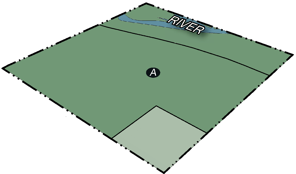
Required Conservation Area. The conservation area shall meet the standards of Division 7.3 in addition to the standards of this Section.
| 1. Scale | ||
 | ||
| Minimum Gross Site Area | ||
| Project GSA (min) | 35 ac | |
| GSA in conservation area (min) | 90% | |
2.
Conservation Value. At least one of the conservation values listed below shall be a protected conservation value identified pursuant to Section 7.3.2(A).
a.
Wildlife
b.
Scenic
c.
Agriculture
3.
Noncontiguous Floor Area Option. The site of a Floor Area Option may be noncontiguous pursuant to the rules for measurement in Section 9.4.4.
4.
Development Area Included. The reserved development area may be included in the conservation easement, as determined by the holder of the conservation easement. However, the standards of Division 7.3 shall only apply outside of the development area. Allowances within the development area are established in Subsection C.
5.
Already Conserved Land. Land already under conservation easement shall not count toward the calculation of additional floor area or ARUs per GSA in Subsection C.1 unless the development is already allowed by the conservation easement.
EXAMPLE:A 1970s conservation easement reserves a 8,000 sf home and 5,000 sf guesthouse on 55 acres. The base R1 zoning does not allow the reserved development without approval of a Floor Area Option. The existing conservation easement may be used in a Floor Area Option application for the development reserved by the easement, but may not be used to propose additional development.
C.
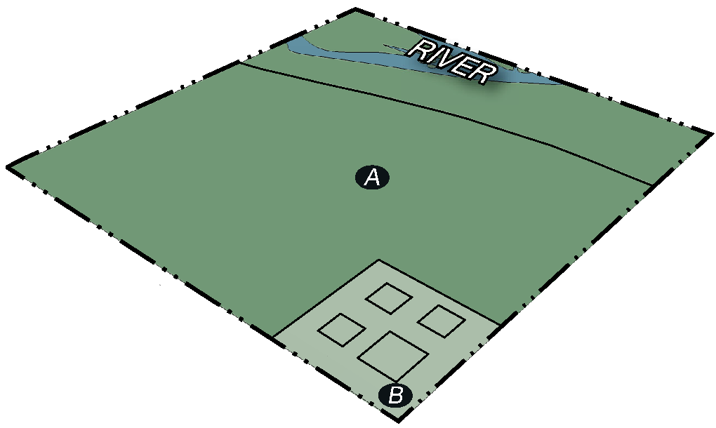
Development Area Standards. Nothing in this Section shall preclude the permanent reduction, through conservation easement, of the development potential allowed in a development area.
| 1. Scale | ||||
 | ||||
| Development Area | ||||
| GSA in development area (max) | 10% | | ||
| Development area GSA : Conservation area GSA (max) | 1 : 9 | | : | |
| Additional Floor Area | ||||
| Additional floor area (max) | 10,000 sf per 35 ac GSA | (C.3.a) | ||
| Additional ARUs | ||||
| Additional ARUs (max) | 2 ARUs per 35 ac GSA | (C.4.b) | ||
EXAMPLE.A 40-acre site utilizing a Floor Area Option can reserve a maximum of four acres in development area (40 * 10% = 4, 4:36 = 1:9).
2.
Access Across Conservation Area. Access to a development area that crosses a conservation area shall be counted as conservation area in calculation of the maximum development area.
3.
Physical Development Allowance. Except as modified in this Section, the physical development standards applicable in the zone shall apply to the Floor Area Option development.
a.
Additional Floor Area. Allowed additional floor area is in addition to the floor area allowed on the site in the absence of an approved Floor Area Option.
EXAMPLE.A 40-acre site in the R-2 zone is allowed 13,000 sf of floor area by-right. With approval of a Floor Area Option the same site would be allowed 24,428 sf (13,000 + 10,000*40/35).
b.
Construction. Best practices shall be utilized to minimize the impact of construction within the development area on the protected conservation value(s) of the conservation area.
4.
Use Allowance. Except as modified in this Section, the use standards applicable in the zone shall apply to the Floor Area Option development.
a.
Conditional Use of Additional Floor Area. The amount of additional floor area that can be used by a conditional use shall be established through the CUP in order to consistently limit intensity through the use and development option permits.
b.
Additional Accessory Residential Units. Allowed additional ARUs are in addition to the ARUs allowed on the site in the absence of an approved Floor Area Option. However, all ARUs on a site with an approved Floor Area Option shall be subject to the following standards:
i.
The maximum scale of an ARU, including basement, shall be 5,000 square feet of gross floor area.
ii.
The floor area of an ARU in a Floor Area Option shall not be included in the maximum scale of the detached single-family unit to which it is accessory.
EXAMPLE.A 40-acre site in the R-2 zone is allowed one ARU, which may not exceed 1,000 sf, within an allowance of 13,000 sf of gross floor area of which 8,000 may be habitable. With approval of a Floor Area Option the same site would be allowed 3 ARUs (1 + 2*40/35), none of which may exceed 5,000 sf, within an allowance of 24,428 sf of gross floor area.
5.
Development Option Standards. Except as modified in this Section, the development option standards applicable in the zone shall apply to the Floor Area Option development.
6.
Affordable Workforce Housing. An ARU greater than 2,500 sf of habitable floor shall be subject to the affordable workforce housing requirements of a Detached Single-family unit (unrestricted) of Division 6.3.
(1/23/23)
7.1.6. - Complete Neighborhood Planned Residential Development (CN-PRD).
A.
Intent.
1.
Purpose. The purpose of the CN-PRD is to encourage conservation and preservation of rural areas of the community in exchange for additional development in complete neighborhood areas identified as appropriate for growth. The goal of the CN-PRD is to provide a conservation incentive that conserves rural areas while also reducing the amount of development potential in those areas.
2.
Location. Each CN-PRD contains a rural area that includes the required conservation area and may also include reserved rural development areas. Each CN-PRD also contains one or more development areas in a complete neighborhood. Rural areas and complete neighborhoods are identified in the Illustration of Our Vision chapter of the Comprehensive Plan.
3.
Comprehensive Plan. The CN-PRD is primarily based on the Comprehensive Plan direction of Policies 1.4.a. and 1.4.c.
4.
Applicable Zones. The CN-PRD may be used in the R-1, R-2, WHB, R-TC, S-TC, and PR zones as further defined in this Section.
B.
Required Conservation Area. The conservation area shall meet the standards of Division 7.3 in addition to the standards of this Section.
| 1. Scale | ||
 | ||
| Minimum Gross Site Area | ||
| Rural GSA (min) | ||
| East of Teton Range (JH) | 105 ac | |
| West of Teton Range (Alta) | 70 ac | |
| Rural GSA in conservation area (min) | 90% | |
2.
Location. The conservation area shall be located in the R-1, R-2, or R-TC zone.
3.
Noncontiguous PRD. The conservation area may be noncontiguous pursuant to the rules for measurement in Section 9.4.4.
4.
Conservation Value. At least one of the conservation values listed below shall be a protected conservation value identified pursuant to Section 7.3.2(A).
a.
Wildlife
b.
Scenic
c.
Agriculture
5.
Already Conserved Land. Land already under conservation easement shall not count toward the calculation of allowed CN dwelling units per Rural GSA in Subsection D.1; and shall not count toward the calculation of allowed Rural dwelling units per Rural GSA in Subsection C.1 unless the dwelling units are already allowed by the conservation easement.
C.
Reserved Rural Development Area. The following standards apply to development areas reserved within the rural area of a CN-PRD. Nothing in this Section shall preclude the permanent reduction, through conservation easement, of the development potential allowed in a development area.
| 1. Scale | ||||
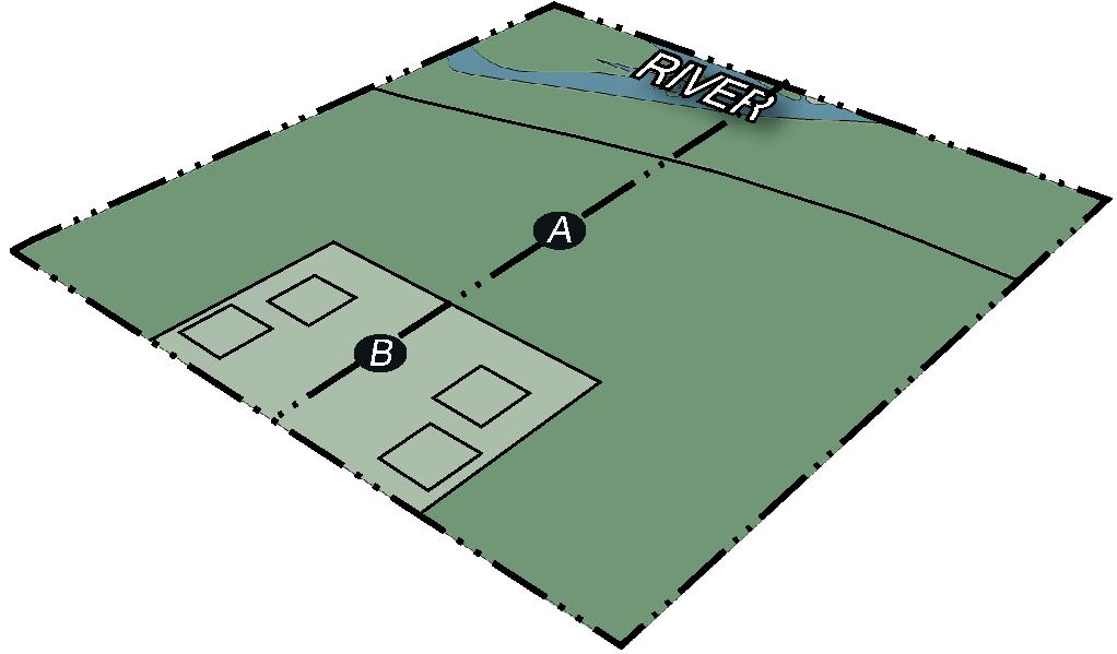 | ||||
| Reserved Rural Development Areas | ||||
| Rural GSA in development area (max) | 10% | | ||
|
Rural development area
GSA : Conservation area GSA (max) | 1 : 9 | | : | |
|
Detached single-family unit :
Rural GSA (max) | 1 du : 35 ac | |||
EXAMPLE.A CN-PRD with 665 acres of rural area could reserve a maximum of 66.5 acres of development area (665 * 10% = 66.5) for development of a maximum of 19 units (665/35 = 19) in the rural area.
2.
Access Across Conservation Area. Access to a development area that crosses a conservation area shall be counted as conservation area in calculation of the maximum rural development area.
3.
Development Areas Included in Easement. Any development area reserved in the rural area may be included in the conservation easement, as determined by the holder of the conservation easement. However, the standards of Division 7.3 shall only apply outside of the reserved rural development area.
4.
Clustering. Development areas do not have to be on the same lot of record, but shall be located to maximize the conservation value of the conservation area as a whole.
EXAMPLE.The 19 units from the previous example could be distributed among 19 lots of record, or all included within a single lot of record. The location of the reserved development areas would be designed as a whole to provide better functioning conservation area than development of each of the 19 units individually; however this does not necessarily mean that all development areas must be contiguous.
5.
Physical Development Allowance. The physical development standards applicable in the zone shall apply in a reserved rural development area.
6.
Use Allowance. Except as modified in this subsection, the use standards applicable in the zone shall apply in a reserved rural development area.
a.
Allowed Uses. Allowed uses in a reserved rural development area are listed in this subsection; all other uses are prohibited.
i.
Agriculture
ii.
Detached Single-Family Unit
iii.
Accessory Residential Unit
iv.
Home Occupation
EXAMPLE.Each of the 19 units from the previous examples would be allowed accessory residential unit and home occupation uses consistent with the standards of the zone, but other accessory uses otherwise allowed in the zone would be prohibited.
7.
Development Option Standards. Except as modified in this Section, the development option and subdivision standards applicable in the zone shall apply to the reserved development area.
a.
Timing of Affordable Workforce Housing. The housing required by Division 6.3 shall not be required prior to development of the reserved rural development area, but shall be fulfilled in full at the time the complete neighborhood development area is developed.
D.
Complete Neighborhood Development Area. The following standards apply to development areas located in a complete neighborhood as part of a CN-PRD.
| 1. Scale of CN Development Area | ||||
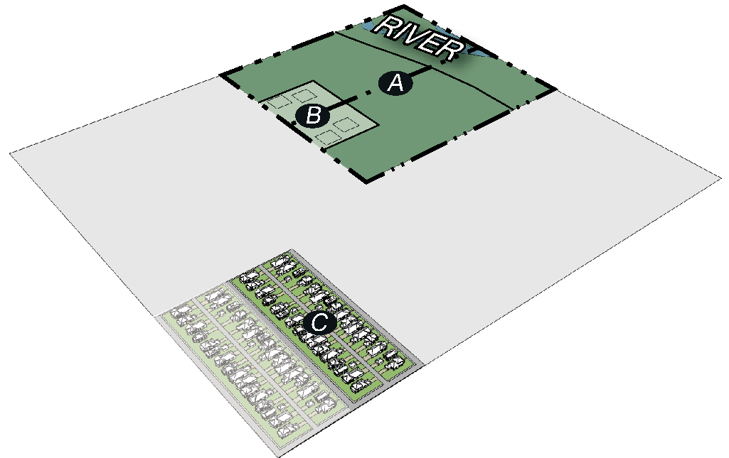 | ||||
| Complete Neighborhood Development Areas | ||||
|
CN development area
GSA : Rural GSA (max) | 1 : 19 |  | : | |
| CN dwelling units : Rural GSA (max) | 1 du : 4.375 ac | |||
2.
Additional Density. The density allowed in the complete neighborhood development area shall be in addition to the base density allowed in the complete neighborhood development area.
EXAMPLE.A CN-PRD with 665 acres of rural area could identify a maximum of 35 acres in a complete neighborhood (665/19 = 35) for development of a maximum of 152 units (665/4.375 = 152) in addition to the units allowed in the complete neighborhood by base zoning.
3.
Location. The complete neighborhood development area shall be located in an area identified in the Illustration of Our Vision chapter of the Comprehensive Plan as a Stable or Transitional subarea.
4.
Assurance. Concurrent with the recording of the conservation easement for the conservation area of the CN-PRD, the additional density to be located in a complete neighborhood by approval of the CN-PRD shall be described and quantified in a notarized document signed by the Planning Director and recorded with the County Clerk. Upon recordation of such document the development rights identified therein shall become vested.
E.
Sketch Plan. The Sketch Plan application required for a CN-PRD shall meet the following standards.
1.
Conservation Design. It shall include conceptual design of the conservation area, including the location of any reserved rural development areas.
2.
Development Area Location. It shall identify the boundaries of the complete neighborhood development area.
3.
Density. It shall identify the density assigned to the development area(s) as a result of the CN-PRD.
4.
CN Development Area Design. It may, but does not have to, include conceptual design of the complete neighborhood development area.
a.
If it does not, a separate Sketch Plan for the complete neighborhood development area shall be required prior to submittal of a Development Plan for that area.
b.
Whenever the Sketch Plan application for development of the complete neighborhood development area is submitted it shall meet the following standards.
i.
The applicant shall concurrently propose a rezone of the development area, pursuant to Section 8.7.2, to a zone that currently exists in the Town or County or a new zone proposed pursuant to Section 8.7.1 as an amendment to the text of the LDRs.
ii.
Future physical development, use, development options, and subdivision in the complete neighborhood development area will be reviewed subject to the standards of the proposed zone. The zone shall be consistent with the density of the complete neighborhood development area.
(4/19/22)
7.2.1. - Subdivision Types Schedule.
The tables below establish the subdivision types allowed in each zone. The standards for all subdivisions and each subdivision type are established in this Division. The density and intensity requirements for each subdivision type are located in the standards for the zone, found in Articles 2—4. The thresholds for permitting allowed subdivision are also established by zone.
(4/19/22)
7.2.2. - Standards Applicable to All Subdivision.
All subdivision shall comply with the following standards.
A.
Subdivision Improvements.
1.
Developer Responsibility. The construction of the following improvements shall be the responsibility of the developer and shall be provided for in a Subdivision Improvements Agreement, which shall be approved with each plat. The Subdivision Improvements Agreement shall be provided in a manner which is consistent with adopted standards. No improvements shall be made until required plans, profiles, and specifications are submitted and approved for the following:
a.
Roads, streets, alleys, sidewalks, and pathways, in accordance with the adopted standards;
b.
Street signs and street lights;
c.
Community wastewater treatment system or connection to an existing community wastewater treatment system, if proposed;
d.
Community water supply, storage and distribution system or connection to an existing community water supply system, if proposed;
e.
Water supply for firefighting purposes;
f.
A storm drainage system and/or irrigation system, as required;
g.
Utilities, such as telephone, cable TV, electric and gas services. All utilities shall be installed underground. Where applicable, utilities shall be in place prior to street or alley surfacing. Aboveground facilities necessary to serve underground facilities, other installation of peripheral overhead electrical transmission and distribution feeder lines, or other installation of either temporary or peripheral overhead communications, distance, trunk or feeder lines may be allowed;
h.
Permanent reference monuments and monument boxes;
i.
Park improvements to include parking, lawns, sprinkler/watering systems, and landscaping; and
j.
Landscaping, screening, and parks improvements.
2.
Permits Required. No construction of required improvements shall commence until after approval of all required physical development permits.
3.
Installation. The time specified for the completion of the required improvements shall not exceed 12 months from the date the subdivision was approved or as specified in a phasing plan reviewed and approved by as part of the plat application.
4.
Professional Engineer. All improvements shall be designed by a professional engineer licensed to do such work in the State of Wyoming.
5.
Oversize and Off-Site Improvements. The Board of County Commissioners may require installation and construction of utilities, pavement and other land improvements in excess of subdivision design needs, to assure adequate service to future development areas. Such oversize improvement requirements shall be determined by the Board of County Commissioners. Such requirements shall be subject to the following standards:
a.
The subdivider shall be required to pay for only that part of the construction costs for the arterial streets, trunk sewers or water lines that are necessitated by and are serving the proposed subdivision, as determined by the County Engineer. The County Engineer and subdivider shall mutually establish a proportionally distributed cost sharing arrangement that considers other persons who will benefit from such oversized improvements constructed to ultimately service the surrounding area.
b.
If streets or utilities are not available or adequate for services at the boundary of a proposed subdivision, the subdivider may be required to obtain necessary easements or rights-of-way and construct and pay for any extensions necessary to connect the proposed subdivision to adequate utility lines.
6.
Certificate of Completion and Release of Responsibility.
a.
Prior to Acceptance. The County shall not have any responsibility with respect to any road, or other improvement, notwithstanding the use of the same by the public, unless the road or other improvement has been formally accepted by the County in the manner required by law.
b.
Request for Certification. Upon completion of the improvements, the subdivider may request, in writing, a certificate of completion and release of responsibility from the Planning Director.
c.
Responsibility to Maintain. Upon issuance of the certificate and release, all responsibility for the improvements shall be assumed by the maintaining party.
d.
Record Drawings. Prior to the approval of any completed improvements, record drawings and specifications for streets, water, sewer, drainage, and other facilities must be submitted to the County Engineer. The plans shall be submitted on 24 inches by 36 inches mylar and shall be accompanied by two sets of prints. The plans shall show the detailed location of all utilities including service lines to lots. A permanent benchmark shall be described on each sheet. The plans shall also be submitted electronically utilizing Autocad® or a compatible dxf format file.
e.
Certification. The following certification by the project engineer shall appear on the face of the record drawings:
I certify that these plans were prepared under my direct supervision and control, that they accurately represent the referred to improvements as they have been constructed in the field, and that the improvements as installed conform to the requirements of the Department of Environmental Quality, the State Highway Department, Teton County, and other applicable agencies.
Engineer __________________
Wyoming P.E. No. __________________
(1/1/15)
7.2.3. - Land Division Standards.
All divisions of land shall comply with the standards of this Section in addition to the standards applicable to all subdivision. Except that, condominium and townhouse subdivisions shall be subject to the standards of Section 7.2.4.
(1/1/15)
7.2.4. - Condominium and Townhouse Subdivisions.
Condominium and townhouse subdivisions shall comply with the following standards in addition to the standards applicable to all subdivision.
A.
Final Plat Required. Condominium and townhouse subdivisions shall require approval of a Subdivision Plat pursuant to Section 8.5.3.
B.
Site Compliance. Conformity of the physical development and use of a lot of record to be subdivided into townhouse or condominium lots will continue to be determined based on the boundary of the site to be subdivided, not the boundaries of the resultant townhouse lots or condominium units.
C.
Townhouse Subdivision. Townhouse subdivision is the subdivision of land around the base of a unit that is intended to separate ownership of the units in a development while still retaining the character of a single, integrated development. A Townhouse subdivision shall be exempt from the minimum lot size requirement if the following standards are met.
1.
Common Element Interest Required. A lot of record may be subdivided into lots of less than the minimum lot size for the zone if each resultant lot retains an undivided interest in common elements of the lot of record.
2.
Maximum Lot Size. A townhouse lot shall not exceed 125% of the area of footprint of the approved unit.
3.
Building Official Review. The building official shall review and approve the proposed location of the townhouse lots.
(1/1/15)
7.3.1. - Purpose and Applicability.
A.
Purpose and Intent. The purpose of this Division is to establish standards for required conservation areas. The intent is to prioritize the use of certain best practices to ensure that a required conservation area achieves the community's goals for ecosystem stewardship identified in the Comprehensive Plan.
B.
Applicability. This Division shall apply to any physical development, use, or development option that requires a conservation area.
C.
Coordination. The prospective conservation easement holder should be involved in the process of conservation value identification and establishment of baseline inventory so that the conservation area configuration and inventory meets the needs of the easement holder as well as the requirements of these LDRs.
EXAMPLE:The land trust that will hold the conservation easement for a conservation area with wildlife value should be involved in the EA pre-application conference and alternatives analysis to ensure the habitat inventory and development area location meets its requirements as well as the standards of these LDRs.
(4/1/16)
7.3.2. - Conservation Value Identification.
A.
Conservation Values. Any of the conservation values listed below that are present in the conservation area shall be identified and protected by the conservation easement recorded pursuant to Section 7.3.4.
a.
Wildlife. Where wildlife habitats identified by Section 5.2.1 or Section 5.1.1 exist, protection of wildlife, wildlife habitat, and wildlife permeability shall be a conservation value.
b.
Scenic. Where scenic vistas identified by Section 5.3.2 exist, protection of those scenic vistas shall be a conservation value.
c.
Agriculture. Where active agriculture exists, protection of agricultural use of the site shall be a conservation value.
d.
Recreation/Access. If no other conservation value exists on the site, provision of public access and recreation shall be a conservation value. Granting of public access to a conservation area is not required when public access is not a protected conservation value. Recreation value alone can not be used to utilize the conservation development option.
B.
Baseline Inventory. A baseline inventory of the conditions, features, and characteristics that define each of the identified conservation values shall be established. The baseline inventory shall be established by submittal of one of the following studies for each conservation value identified; however the options of this Subsection do not exempt analysis required by these LDRs. The study establishing the baseline inventory shall be submitted as part of the application requiring a conservation area.
1.
Wildlife Values. When wildlife is a conservation value:
a.
The Natural Resources Assessment required by Section 8.2.2; OR
b.
A habitat inventory as described in Section 8.2.2, prepared by an environmental professional.
2.
Scenic Values. When scenic is a conservation value:
a.
The visual resource analysis required by Section 5.3.2(D); OR
b.
A visual resource analysis volunteered by that applicant prepared pursuant to Section 5.3.2(F).
3.
Other Value. When agriculture or recreation/access is a conservation value: a baseline analysis of the values of the conservation area provided by the applicant.
(5/1/25)
7.3.3. - Conservation Area Configuration.
A.
Conservation Value Prioritization.
1.
When configuring a required conservation area, the identified conservation values shall be prioritized in the order listed in Section 7.3.2(A) with wildlife as the highest priority.
2.
The prioritization of values used to configure a required conservation area is not required to be included or enforced in the conservation easement recorded pursuant to Section 7.3.4.
B.
Configuration. A conservation area, and the associated development areas, shall be configured to meet the following standards.
1.
Configuration. The perimeter to area ratio of the conservation area shall be minimized to avoid decreased conservation value because the conservation area is small, isolated, fragmented, and/or extends into a development area.
2.
Conservation on Multiple Lots. A conservation area may cover multiple parcels or lots of record. In such a case, the conservation area on each parcel or lot of record shall meet the following standards:
a.
It shall be large enough to contribute to the conservation value of the conservation area.
b.
Contiguous parcels making up a conservation area shall not be separated by fencing or otherwise visually or functionally separated, except as may naturally occur or as permitted by the reserved uses set forth in the conservation easement.
c.
The reserved use provisions in the conservation easement shall be based upon the conservation values identified and shall not vary solely according to parcel or ownership boundaries.
3.
Clustering. Development areas should not to be surrounded by conservation area on all sides, and should be located adjacent to existing development if possible. Where possible, access should not cross conservation area.
EXAMPLE:A square development area located adjacent to a developed neighboring property so only three sides border the conservation area, is an obvious example of a regular shape that is not entirely surrounded and provides a clean delineation between development area and conservation area. A star shaped development area would have five fingers extending into the conservation area with no possibility of avoiding the conservation area surrounding the entire development area while also bringing five fingers of conservation area into the development area, which would limit the conservation value of those portions of the conservation area. The star shaped development area adds three times more perimeter to the conservation area than the square shaped development area.
C.
Connect Conservation Areas. The following criteria shall be considered in the configuration of the conservation area.
1.
Connection to any adjacent, existing conservation areas.
2.
The protection of the protected conservation value(s) identified in Section 7.3.2(A).
3.
Potential value that might result from future conservation of adjacent property.
EXAMPLE:A property with value as a north-south migration corridor is subject to a development option that requires conservation area. To the north is a property under conservation easement, to the south is a property that is not. In configuring the required conservation area the applicant shall consider: connection to the existing conservation easement, maximization of the wildlife value and the migration corridor, and linking that corridor to the point on the south boundary that best facilitates wildlife movement should the property to the south be placed under conservation easement in the future.
D.
Deviation.
1.
Applicability. Deviation from the following standards is permitted to meet the standards of this Section in order to allow improved landscape level conservation across property lines.
a.
Division 5.1. General Environmental Standards
b.
Division 5.2. Environmental Standards Applicable in Specific Areas
c.
Subsection 7.3.3(B), Configuration
2.
Process. The deviation shall be approved through the Administrative Adjustment process identified in Section 8.8.1.
(4/1/16)
7.3.4. - Conservation Area Allowances.
A.
Stewardship and Restoration. Stewardship and restoration that enhances the conservation value(s) of the conservation area shall be allowed in the reasonable discretion of the grantee of the conservation easement or as expressly reserved in the conservation easement.
B.
Consistent with Conservation Value. Any physical development, use, development option, or subdivision allowed in a conservation area shall be consistent with the protected conservation value(s) identified for the conservation area.
1.
Physical Development.
a.
Construction Schedule. Physical development activities that are allowed in the conservation area shall be scheduled to limit impacts to the protected conservation value(s) of the conservation area.
b.
Limit Temporary Impacts. Physical impacts from temporary physical development or use shall be avoided to the extent practical through use of areas planned for permanent physical development or use. A temporary impact that cannot be avoided shall be restored consistent with the protected conservation value(s) of the conservation area.
EXAMPLE:Construction access across a conservation area to a development area shall follow the planned permanent access, rather than a secondary or alternate route. However, where burying of utilities cannot be accomplished under an area of permanent development the temporary physical development shall be reclaimed to the native state that existed prior to the disturbance.
2.
Use.
a.
Existing Conditional Use. Review of a proposed conservation area on the site of an existing conditional use may include review of the Conditional Use Permit to evaluate the cumulative impact of all permitted uses and development options on the site's open space as compared to the use of the site at its base residential density.
b.
Wildlife. When wildlife is a protected conservation value the following shall be considered.
i.
Domestic Pets. The impact of domestic pets on wildlife.
ii.
Chemical Use. Limited chemical use in order to minimize unnecessary and negative side effects on wildlife. This shall not be read to restrict the use of chemicals in support of agriculture or control of noxious weeds.
iii.
Motorized Vehicles. The effects on wildlife in determining off-road use of motorized vehicles.
c.
Grazing. Grazing shall be managed to maintain vegetation for wildlife foraging and avoid overgrazing.
d.
Recreation. Recreation shall be managed to be consistent with, and reduce impacts to, the protected conservation value(s).
(4/1/16)
7.3.5. - Record of Conservation Area Restriction.
The physical development, use, develop options, and subdivision of a required conservation area shall be restricted in perpetuity by a conservation easement, within the meaning of the Wyoming Uniform Conservation Easement Act (Wyo. Stat. § 34-1-201, et seq.), recorded with the County Clerk, and enforceable by a 'qualified organization' within the meaning of Internal Revenue Code section 170(h)(3). The conservation easement may be in such format as the qualified organization and the landowner may agree, provided that the following restrictions and provisions are included in the conservation easement:
A.
A legal description of the conservation area.
B.
Reference to the approved development permit and the additional development potential received.
C.
Statement of the protected conservation value(s) of the conservation area and any secondary conservation values; as well as the public benefit provided by the conservation area.
D.
An inventory of the conservation area conditions, features, and characteristics contributing to the identified conservation values.
E.
The affirmative right of the Grantee to conduct active monitoring of conservation values to ensure those values are successfully protected and maintained over time and to enforce those restrictions when necessary.
F.
Specification of the physical development, use, development options, and subdivision allowed in the conservation area; which shall comply with these LDRs, but may be less permissive.
G.
Prohibition of all physical development, use, development options, and subdivision not specifically allowed in the conservation area; and specification of other rights relinquished by the restriction.
H.
Grantor notice to the Planning Director of any amendment to the conservation easement.
(1/4/21)
7.5.1. - Development Exactions.
Section number reserved, original Section deleted.
(1/6/20)
7.5.2. - Park Exactions.
A.
Purpose and Findings.
1.
Purpose. The purpose of the Park Exaction is to ensure that new subdivisions include adequate land for parks and recreation in order to maintain the parks and recreation level of service in the community as growth occurs.
2.
Legislative Finding of Impact and Benefit.
a.
Parks and recreation services benefit the health of the environment and the community. Parks protect natural resources in developed areas and recreational services are important to the physical health of community members of all ages.
b.
In addition, the community has adopted a policy to provide public recreation opportunities on Town and County lands as way to reduce the impact of growth on surrounding federal lands with greater habitat and scenic value.
c.
Parks and recreation level of service is commonly measured by acres of parks per capita.
i.
The national median for communities with a population between 20,000 and 49,999 is 9.6 acres of parks per 1,000 residents. (2019 NRPA Agency Performance Review)
ii.
In 2016, the Jackson/Teton County community has 7.0 acres of parks per 1,000 residents.
d.
As growth occurs, population grows. From 2002 to 2018 the annual growth rate for residential units in Jackson and Teton County was 1.6%. Over that same period the population of Teton County grew at an annual growth rate of 1.4%, mirroring the growth in development.
e.
If acres of park land do not grow as population grows, parks and recreation level of service will decrease.
f.
As a result, the Board of County Commissioners finds that new residential development in Teton County needs to include land for new parks and hereby adopts this park exaction.
B.
Applicability. The requirements of this Section shall apply to any new lot of record that allows residential use.
1.
Includes.
a.
A new platted lot that allows residential use.
b.
An existing residential unit platted as a townhouse or condominium unit, for which an exaction has not already been provided.
c.
Construction of one or more residential units on a lot of record that was created through exempt land division.
2.
Does Not Include.
a.
Construction of one or more residential units on a lot of record created prior the adoption of a mandatory land dedication.
b.
Construction of one or more residential units on a lot of record for which a mandatory land dedication has already been provided.
c.
Boundary Adjustment (Section 8.5.5) that does not result in any new lots of record.
d.
New lots of record with voluntary Affordable Housing or Workforce Housing deed restrictions as defined by the Housing Department Rules and Regulations.
EXAMPLE:A parcel that was created prior to 1978 is subdivided into three lots—the exaction applies to the two new lots being created, but not the pre-existing lot of record. An apartment building is built on an existing, conforming lot of record—no exaction applies because no subdivision is proposed. An existing apartment building is condominiumized—the exaction is applied to each condominium unit. A lot of record is created through exempt land division—the exaction for the lot is due at the time of building permit unless the exaction is paid at the time of exempt land division.
C.
Requirement. Each applicable subdivision in Teton County, as defined in Section 7.5.2(B) above, shall provide land to Teton County in an amount equal to 0.02 acres per new lot of record.
EXAMPLE:A subdivision creating 50 new lots of record shall dedicate one acre to Teton County (50 × 0.02 = 1)
1.
General Formula. The General Formula that yields the requirement is based on the Teton County target level of service and the average number of residents per dwelling unit constructed in Teton County.
a.
Teton County Level of Service. The median amount of parks per capita for a community the size of Jackson/Teton County is 9.6 acres per 1,000 residents. Teton County has maintained a target level of service of nine acres per 1,000 residents since at least 1986.
b.
Residents Per Dwelling Unit. The U.S. Census estimates that were 12,510 residents in the unincorporated County in 2017. The Planning Department counts 5,648 dwelling units in the unincorporated County in 2017.
c.
Calculation. Based on the above factors the requirement is calculated according to the below table.
2.
Update. The inputs into the general formula should be updated at least every five years.
3.
Independent Calculation. An independent calculation may be submitted that provides alternate values for either component of the general formula. The independent calculation may be approved by the Board of County Commissioners in a public hearing if the alternate values:
a.
Utilize verifiable local data and generally recognized principles and methods of impact analysis; and
b.
Rely on characteristics of the project type rather than the specific project.
D.
Provision and Use of Requirement.
1.
Dedication of Land. The first priority for fulfilling the requirement of this Section is the dedication of land.
a.
Identification. The land to be dedicated for parks shall be identified in the Development Plan application for any subdivision to which this Section applies.
b.
Criteria. The proposed dedication shall meet the following criteria. If the criteria cannot be met anywhere on the site, a fee-in-lieu of dedication shall be required pursuant to Subsection D.2, below.
i.
Size. The proposed dedication shall be at least one acre, unless otherwise found by the Board of County Commissioners to implement the Parks and Recreation Strategic Plan. The applicant shall be allowed to provide a dedication of less than one acre through payment of an in-lieu fee pursuant to Subsection D.2, below.
ii.
Suitability. The proposed dedication shall not include private yards, streets, parking areas not intended for park use, streetscape or landscape buffers, median strips, major utility easements over 30 feet wide, oil or gas well sites or setbacks, stormwater detention or water quality ponds deeper than five feet or with slopes steeper than 5:1, mine shafts or associated setbacks.
iii.
Infrastructure. Dedicated land shall be ready for development with roads, water supply, sewage disposal, telephone, electricity, gas (if available), and other basic services as applicable provided to the property line or guaranteed pursuant to Section 8.2.11. In no event shall the services be provided more than one year after the date of conveyance of the land to the County.
c.
Acceptance. The land shall be acceptable to Teton County at the discretion of Teton County.
i.
County Review. The Board of County Commissioners shall review acceptability on the basis of compatibility with the Comprehensive Plan and Parks and Recreation Strategic Plan.
ii.
Suitability. Where there is concern about the suitability of soils or other site conditions to support parks and recreation facilities, a report shall be prepared by a consultant deemed qualified by the County, at the applicant's expense, stipulating whether the land is suitable for the type of construction contemplated and stating any special construction techniques that will be necessary.
d.
Dedication. The land shall be dedicated to Teton County.
i.
Timing. The dedication shall occur at the time the subdivision Plat is recorded.
ii.
Conveyance. The conveyance shall utilize the County deed template.
iii.
Clear Title. Land conveyed shall have clear title, physical and legal access, and be free of any liens.
2.
Payment of In-Lieu Fee. Where land meeting the requirements of Subsection D.1 cannot be provided as part of a subdivision, a fee-in-lieu of land dedication shall be paid.
a.
Amount. The fee-in-lieu shall be equal to the required acreage multiplied by the median, per-acre, market land value (not including improvements) most recently established by the Teton County Assessor for private land in Teton County. The median, per-acre, market land value shall be available in the Teton County Planning Department.
b.
Timing.
i.
Subdivision. In the case of a subdivision, the in-lieu fee shall be calculated and paid at the time the Plat is recorded.
ii.
Nonconforming Lot. In the case of a lot of record created nonconforming to this Section, the in-lieu fee shall be calculated and paid at the time the first building permit on the property is issued.
c.
Use of Fee.
i.
Fund. Collected in-lieu fees shall be immediately deposited into an interest-bearing fund specifically designated for the requirements of this Section.
ii.
Refund of Fee.
a)
Unused Fees. An in-lieu fee that is not used by Teton County within seven years of collection shall be refunded upon request by the current owner of the lot for which the fee was paid. Notwithstanding, if the County earmarks the fees for expenditure on a specific project, the Board of County Commissioners may extend the time period by three additional years. Fees shall be considered used on a first-paid, first-used basis. The request shall be provided in writing to the Planning Director within one year of the end of the seventh year.
b)
Expired Approval. An in-lieu fee paid for an approval which has expired shall be refunded upon request by the current owner of the lot for which the fee was paid. The request shall be provided in writing to the Planning Director within three months of the expiration.
3.
Credit for a Private Park. Where private open space for park and recreational purposes is provided in a proposed subdivision, and such space is to be privately owned and maintained by the future residents of the subdivision, the acreage of such areas may be credited against the requirement of this Section, if the Board of County Commissioners determines that such a credit is in the public interest.
4.
Use of Dedication. The land or fee shall be used by Teton County for necessary parks and recreation facilities, which may include, but are not limited to, parks, recreation facilities, parks and recreation maintenance facilities, trails, pathways, and open space.
(1/23/23)
7.5.3. - School Exactions.
A.
Purpose and Findings.
1.
Purpose. The purpose of the School Exaction is to ensure that new subdivisions include adequate land for the provision of public education so that the level of service provided by Teton County School District can be maintained.
2.
Legislative Finding of Impact and Benefit.
a.
Enrollment in Teton County School District has grown as the number of dwelling units in Teton County has grown. Since at least 2002, enrollment in Teton County School District has grown at the same annual rate (1.6%) as the number of dwelling units in Teton County (1.6%).
b.
An increase in students requires an increase in school capacity. Teton County School District schools have capacity limits. As enrollment grows, schools have to expand to provide additional capacity.
c.
As a result, the growth in the number of dwelling units in Teton County has necessitated growth in school capacity. Continued growth will necessitate additional school capacity.
d.
Additional school capacity requires land dedicated to school function, which includes, but is not limited to, school buildings, support facilities, open space and recreation areas, and housing for employees and their families.
e.
With only one School District in Teton County any school land in Teton County benefits the entire School District. A new elementary school in one part of the School District frees capacity in other parts of the School District, benefiting the new development regardless of the development's location. Similarly, a centralized middle or high school benefits a development regardless of its location within the School District.
f.
As a result, the Board of County Commissioners finds that new development in Teton County needs to include land for new schools, and hereby adopts this school exaction.
B.
Applicability. The requirements of this Section shall apply to any new lot of record that allows residential use.
1.
Includes:
a.
A new platted lot that allows residential use.
b.
An existing residential unit platted as a townhouse or condominium unit, for which an exaction has not been provided.
c.
Construction of one or more residential units on a lot of record that was created through exempt land division.
2.
Does Not Include:
a.
Construction of one or more residential units on a lot of record created prior the adoption of a mandatory land dedication.
b.
Construction of one or more residential units on a lot of record for which a mandatory land dedication has already been provided.
c.
Boundary Adjustment (Section 8.5.5) that does not result in any new lots of record.
d.
New lots of record with voluntary Affordable Housing or Workforce Housing deed restrictions as defined by the Housing Department Rules and Regulations.
EXAMPLE:A parcel that was created prior to 1978 is subdivided into three lots—the exaction applies to the two new lots being created, but not the pre-existing lot of record. An apartment building is built on an existing, conforming lot of record—no exaction applies because no subdivision is proposed. An existing apartment building is condominiumized—the exaction is applied to each condominium unit. A lot of record is created through exempt land division—the exaction for the lot is due at the time of building permit unless the exaction is paid at the time of exempt land division.
C.
Requirement. Each applicable subdivision in Teton County, as defined in Section 7.5.2(B) above, shall provide land to Teton County School District in an amount equal to 0.01 acres per new lot of record.
EXAMPLE:A subdivision creating 50 new lots of record shall dedicate 0.5 acres to Teton County School District (50 × 0.01 = 0.5).
1.
General Formula. The General Formula that yields the requirement is based on Teton County School District configuration, acres per school established in the Wyoming School Facilities Commission, School Design Guidelines, February 2010 (or as amended), and school aged children per dwelling unit, as defined below.
a.
School Configuration. Teton County School District uses a school configuration that relies on geographically distributed elementary schools and centralized middle and high schools.
b.
Acres Per School. The Wyoming Schools Facility Commission has established the following general site size requirements.
i.
Elementary School. Four acres plus one acre for every 100 students.
ii.
Middle School. Ten acres plus one acre for every 100 students.
iii.
High School. Twenty acres plus one acre for every 100 students.
c.
School Children Per Dwelling Unit. Of the 2,862 students enrolled in Teton County School District in 2017, 1,457 lived in Town and 1,405 lived in unincorporated Teton County. In 2017, Teton County reported 5,648 dwelling units in unincorporated Teton County. 1,405/5,648=0.25 students per dwelling unit.
d.
Calculation. Based on the above factors the requirement is calculated according to the below table.
2.
Update. The inputs into the general formula should be updated at least every five years.
3.
Independent Calculation. An independent calculation may be submitted that provides alternate values for any of the three components of the general formula. The independent calculation may be approved by the Board of County Commissioners in a public hearing if the alternate values:
a.
Utilize verifiable local data and generally recognized principles and methods of impact analysis; and
b.
Rely on characteristics of the project type rather than the specific project.
D.
Provision and Use of Requirement.
1.
Dedication of Land. The first priority for fulfilling the requirement of this Section is the dedication of land.
a.
Identification. The land to be dedicated for schools shall be identified in the Development Plan application for any subdivision to which this Section applies.
b.
Criteria. The proposed dedication shall meet the following criteria. If the criteria cannot be met anywhere on the site, a fee-in-lieu of dedication shall be required pursuant to Section D.2, below.
i.
Size. The proposed dedication shall be at least one acre, unless otherwise found acceptable by the Teton County School District. The applicant shall be allowed to provide a dedication of less than one acre through payment of an in-lieu fee pursuant to Section D.2, below.
ii.
Infrastructure. Dedicated land shall be ready for development with roads, water supply, sewage disposal, telephone, electricity, gas (if available), and other basic services as applicable provided to the property line or guaranteed pursuant to Section 8.2.11. In no event shall the services be provided more than one year after the date of conveyance of the land to the County.
c.
Acceptance. The land shall be acceptable to both Teton County and the Teton County School District. Acceptability to each jurisdiction shall be at the discretion of that jurisdiction.
i.
County Review. The Board of County Commissioners shall review acceptability on the basis of compatibility with the Comprehensive Plan.
ii.
School District Review. The Teton County School District shall review acceptability on the basis of the utility of the land for School District function.
iii.
Suitability. Where there is concern about the suitability of soils or other site conditions to support School District functions, a report shall be prepared by a consultant deemed qualified by the County and School District, at the applicant's expense, stipulating whether the land is suitable for the type of construction contemplated and stating any special construction techniques that will be necessary.
d.
Dedication. The land shall be dedicated to Teton County School District.
i.
Timing. The dedication shall occur at the time the subdivision Plat is recorded.
ii.
Conveyance. The conveyance shall of a form acceptable to Teton County School District.
iii.
Clear Title. Land conveyed shall have clear title, physical and legal access, and be free of any liens.
2.
Payment of In-Lieu Fee. Where land meeting the requirements of Section D.1 cannot be provided as part of a subdivision, a fee-in-lieu of land dedication shall be paid.
a.
Amount. The fee-in-lieu shall be equal to the required acreage multiplied by the median, per-acre, market land value (not including improvements) most recently established by the Teton County Assessor for private land in Teton County. The median, per-acre, market land value shall be available in the Teton County Planning Department.
b.
Timing.
i.
Subdivision. In the case of a subdivision the in-lieu fee shall be calculated and paid at the time the Plat is recorded.
ii.
Nonconforming Lot. In the case of a lot of record created nonconforming to this Section, the in-lieu fee shall be calculated and paid at the time the first building permit on the property is issued.
c.
Use of Fee.
i.
Fund. In-lieu fees shall be collected by Teton County and immediately deposited into an interest-bearing fund specifically designated for the requirements of this Section.
ii.
Distribution. Teton County shall distribute the fees from the fund to Teton County School District within 30 days of receipt of a request. The request shall be submitted to the County Commissioners' Administrator and shall be approved if it is for a school facilities project, as defined below in Section D.3.
iii.
Refund of Fee.
a)
Unused Fees. An in-lieu fee that is not requested by Teton County School District within seven years of collection shall be refunded upon request by the current owner of the lot for which the fee was paid. Notwithstanding, if the Teton County School District earmarks the fees for expenditure on a specific project, the Board of County Commissioners may extend the time period by three additional years. Fees shall be considered used on a first-paid, first-used basis. The request shall be provided in writing to the Planning Director within one year of the end of the seventh year.
b)
Expired Approval. An in-lieu fee paid for an approval which has expired shall be refunded upon request by the current owner of the lot for which the fee was paid. The request shall be provided in writing to the Planning Director within three months of the expiration.
3.
Use of Dedication. The land or fee shall be used by the School District for necessary school facilities, which may include, but are not limited to, school buildings, support facilities, open space and recreation areas, and housing for employees and their families.
a.
Housing Restriction. If the School District uses dedicated land or funds for housing, the housing shall have a deed restriction that limits occupancy to School District employees and their families. The deed restriction may also allow the School District to allow occupancy by other members of the Teton County workforce as defined by the Housing Department Rules and Regulations.
(1/6/20)
7.6.1. - Purpose, Authority, and Applicability.
A.
Purpose. The purpose of this Division is to control access to public roadways in a manner that maintains the safety, capacity, and function of the roadway, ensure adequate fire protection measures, and to provide standards for transportation facilities, including roads, streets, alleys, driveways, access easements, bridges, or pathways.
B.
Authority. Any additional standards listed herein as derived from the Fire Protection Resolution for New Subdivisions are authorized by Wyo. Stat. §§ 18-5-201 and 18-5-301, 1977, as amended, and based on the International Fire Code and the International Wildland-Urban Interface Code as adopted by Teton County, and other nationally recognized fire protection standards, such as those standards promulgated by the National Fire Protection Association.
C.
Applicability. The standards in Division 7.6 are applicable to any new Subdivision and the development or redevelopment of new Transportation Facilities on existing lots of records, including those created through an Exempt Land Division.
(8/1/25)
7.6.2. - Access to Roads, Streets and Highways.
Direct vehicular access to collector and arterial roads shall be limited to ensure that the congestion created by turning movements is reduced to a minimum. All development shall meet the following standards:
A.
Residential Uses. Lots of record for individual detached single-family units shall take direct access to or from local residential streets and may take direct access to a collector or arterial road only if no other access options exist, and only if the developer is unable to provide a street for access to a public or private local residential street, due to site limitations such as but not limited to topography and sight distances.
B.
Other Residential Development. Other residential development of higher density shall take direct access to collector or arterial streets to avoid infiltration of lower density neighborhoods where available.
C.
Nonresidential Uses. All nonresidential uses shall take primary access from a parking circulation aisle or drives designed to provide internal circulation within the development or for several lots of record.
1.
Direct Primary Access to Local Street. Direct primary access to a local residential street is prohibited for nonresidential uses.
2.
Direct Primary Access to Arterial or Collector Road. Nonresidential uses shall be permitted direct primary access to arterial or collector roads (except as provided in Section 7.6.2(D)).
D.
Traffic Study Required if More than One Access Point. In instances where more than one access point is requested on any one collector or arterial road, a traffic study shall be required to demonstrate the minimum number needed. The minimum number is all that shall be permitted.
E.
More than One Access Point/Designate "Right Turn Only," Wherever Possible. When more than one access point exists for a development, at least one exit shall contain a "right turn only" lane, when traffic patterns and the design layout allow it.
F.
Additional Fire Access. The Fire Marshal may require more than one fire apparatus access road where the potential for impairment of a single road by vehicle congestion, condition of terrain, climatic conditions or other factors could limit access.
(8/1/25)
7.6.3. - Streets, Alleys, and Easements.
Section number reserved, standards only apply in Town.
(1/1/15)
7.6.4. - Street, Road, Driveway, and Bridge Standards.
A.
Purposes. These standards are enacted to protect and promote the public health, safety and welfare, to protect Teton County's priceless environmental quality and scenic beauty, and to maintain and promote the efficient, cost-effective and safe movement of persons and goods in Teton County. The requirements and procedures herein are intended to regulate and control the design and improvement of subdivisions, transportation routes, recreational pathways, and other development in the County in order to achieve the following purposes:
1.
Conformance with Highway Improvement Plans. To ensure conformance and coordination of land subdivision and other development with the highway improvement plans of the County and its municipalities, the State of Wyoming and federal land management agencies.
2.
Establish Standards. To encourage well-planned land subdivision and other development by establishing adequate standards for design and improvement of roadways and other pedestrian and vehicular movement systems. However, standards for transportation facilities shall not be used to justify the maximum density or intensity of a development. The achievable density or intensity shall be determined by other standards in these LDR and then the appropriate road shall be designed to serve the achievable density or intensity.
3.
Adequate Access. To ensure adequate access to all properties for fire, police and other vital services.
4.
Cost/Benefit of Facilities. To ensure a fair and just distribution of the costs and benefits of roadways and other pedestrian and vehicular movement systems within the County.
5.
Protect the Ecosystem. To locate and design transportation facilities that are sensitive to the environmental context in which they are located and which minimize impact to natural resources, wildlife and wildlife habitat.
B.
Jurisdiction. The territorial jurisdiction of these standards and regulations shall include all of the unincorporated lands within Teton County, Wyoming other than National Park, National Forest, National Elk Refuge lands or other lands not under County jurisdiction for the purposes of zoning regulation.
C.
Interpretation.
1.
The standards and regulations of this Section shall be interpreted and applied to create context sensitive designs for transportation facilities that will protect the natural and wildlife resources regulated by Division 5.1, Division 5.2, and Division 5.3, and avoid natural hazards regulated by Division 5.4. To accommodate context sensitive transportation facilities, these standards and regulations provide flexibility to the Teton County Engineer to grant exceptions to minimize environmental and wildlife impacts while providing for safe and functional movement of vehicles and nonmotorized travelers.
2.
The Teton County Engineer may grant exceptions to the standards and regulations contained in this Section pursuant to Section 8.8.1 when the exceptions allow a transportation facility appropriately scaled to the transportation demand of a proposed development or accommodate a context sensitive design that protects the natural and wildlife resources that are regulated by these regulations, provided the exceptions do not materially compromise public safety. In granting an exception the County Engineer must consider the following minimum criteria:
a.
Potential land uses and traffic volumes to be served by the road at build-out; and
b.
Compatibility with adjacent roadway sections; and
c.
Effect on non-motorized facility users; and
d.
Cumulative effect if an exception to more than one standard is requested; and
e.
Effect of the exception on the safety of residents, motorists and non-motorists; and
f.
Effect on level of service; and
g.
Accident data; and
h.
Protection of the natural and wildlife resources regulated pursuant to Division 5.1, Division 5.2, and Division 5.3 and the natural hazards regulated by Division 5.4; and
i.
Potential mitigation measures (including but not limited to, vehicle turn-outs, warning signs, mirrors at curves, guard rails, mandatory plowing or maintenance contracts, etc.) to address excepted standards or regulations; and
j.
Comparative cost of required standard or regulation versus exception request; and
k.
Minimum requirements for fire protection and fire apparatus access.
3.
Based on the Natural Resources Assessment, the County Engineer may require exceptions, and applications for development permits may request exceptions for the County Engineer's review. The County Engineer shall document all exception requests in an Exception Report, which shall include a description of the exception request and relevant standards and regulations, the County Engineer's determination, any required mitigation, and the basis for the Engineer's decision. All exception requests from the applicant shall be stamped by a registered Wyoming professional engineer and approved by the County Engineer. The County Engineer shall seek comment from the Teton County Road & Levee Manager, Fire Marshal and Planning Director in determining whether to grant or deny the exception request. The County Engineer shall distribute all completed Exception Reports to the Teton County Road & Levee Manager, Fire Marshal, the Planning and Building Services Director, and the applicant.
4.
The County Engineer's approval of an exception shall establish the standards to which a transportation facility shall be designed and constructed for the subject development.
5.
These standards and regulations shall apply to all roads within Teton County's jurisdiction. No standard or regulation of this Section is intended to repeal, abrogate, annul, impair or interfere with any existing resolution of the County, provided that where any standard or regulation of this Section imposes more stringent regulations, requirements or limitations than are imposed by any other resolution of Teton County or any statute of the State of Wyoming, then the standards and regulations of this Section shall govern.
D.
Functional Classification.
1.
All streets and roads in the unincorporated portions of Teton County shall be classified by functional type. Such classification shall establish a hierarchy, which separates roads by function and intensity of use in order to achieve safety and efficiency in road layout and design. In addition, a road of any classification may be designated by the Board of County Commissioners as a "Scenic Road" on the basis of its particular value to the County due to the scenic nature of its route, of the adjacent lands, or of views from the roadway. Such designation shall be by amendment of the Transportation Master Plan Map.
2.
As defined in these regulations and the typical A.D.T. in Section 7.6.4(K.1), the functional class hierarchy applicable in Teton County shall consist of the following road types:
a.
Arterial
b.
Major Collector
c.
Minor Collector
d.
Major Local
e.
Minor Local
i.
A Minor Local Roadway is a vehicular access serving at least five or more residential units, including accessory residential units, or as otherwise classified by the County Engineer per the anticipated traffic values.
f.
Driveway Access
i.
A Driveway shall only serve four or fewer residential units, including accessory residential units, or no more than two non-residential lots.
E.
Transportation Master Plan Map. The County Engineer shall maintain an official map and supporting documents describing the location, functional class, right-of-way width and applicable standards of all existing and proposed roads, roadway corridors, equestrian trails, and pathways in the County. Such map and supporting documents are considered to be a part of these regulations. Any new location for a federal, state, county, or local road, scenic road, highway corridor, equestrian trail, or bikeway not indicated on the map as of the date of these regulations, except for proposed streets, equestrian trails, and pathways within approved subdivisions or other projects, or roads on federal or state lands, shall require adoption by the Board of County Commissioners pursuant to the requirements for amendments specified in these LDRs.
F.
Jurisdiction and Maintenance Responsibilities. Nothing in the above Transportation Master Plan Map shall imply acceptance by Teton County for maintenance or other purposes of any road or street. Such acceptance shall be established only in accordance with Wyoming statutory procedures for adoption or vacation of County roads. Where a highway proposed for adoption as a County road does not meet the structural or right-of-way standards applicable to its classification, such adoption may or may not be conditional upon its improvement to meet those standards, at the discretion of the Board of County Commissioners.
1.
Acceptance of Collectors. It shall, however, be the policy of Teton County to give primary consideration for acceptance and maintenance to those roads classed as major and minor collectors.
2.
Acceptance for Specific Need/Benefit. Arterials and most major collectors are the responsibility of the Wyoming Department of Transportation. Roads on federal lands may or may not be the responsibility of the appropriate federal agency. Local roads are normally the responsibility of developers, private citizens, homeowners' associations or special districts. The County may, at its option and by official action, accept or provide maintenance on such streets where a specific county need or benefit is shown.
G.
General Standards. The following general standards shall govern the layout of transportation facilities:
1.
Compatible with Transportation Master Plan. Road, bicycle, equestrian, and pedestrian facilities and circulation patterns shall be compatible with the Teton County Transportation Master Plan.
2.
Functional Class. Plans shall be designed and constructed in accordance with the standards of this Section.
3.
Safety. Road layout and design shall provide for the safety of motorists, bicyclists, pedestrians, equestrians and residents of contiguous properties.
4.
Rural Roadway Level of Service. Rural roadways shall be designed to function at level of Service D at buildout within any development, or at 20 years from construction for other roads.
5.
Urban Roadway Level of Service. Urban roadways shall be designed to function at level of Service D at buildout within any development, or at 20 years from construction for other roads.
6.
Minimize Length. Plans shall minimize the overall length of both County and non-County roads while adequately providing for necessary traffic movements.
7.
Access for Emergency/Service Vehicles. All dwellings and other structures shall be accessible by emergency and service vehicles.
8.
Separate Types of Traffic. Pedestrian, bicycle, equestrian and vehicular traffic shall be separated where desirable for safety.
9.
Limit Through Traffic. Through traffic shall be limited on residential streets.
10.
Minimize Environmental Impact. Transportation facilities shall be located and designed to minimize cuts, fills, excessive runoff concentrations or other environmental impacts and shall follow natural contours wherever possible. Proposed retaining walls shall comply with Section 5.1.7.
11.
Avoid Natural Hazard Areas. Transportation facilities shall not be constructed in ten-year flood areas, on steep or naturally unstable slopes, in avalanche paths or in other hazardous areas except where no alternative is feasible.
12.
Minimize Impact on Wildlife. Transportation facilities shall be designed to minimize impacts on wildlife, significant wildlife habitat or migration routes. Alternative alignments and/or designs may be required and analyzed for transportation facilities that would impact the wildlife resources regulated by Division 5.2. Proposed retaining walls shall comply with Section 5.1.7.
13.
Minimize Impact on Agriculture. Roads shall be designed to accommodate ranching activities and stock driveways.
14.
Mass Transportation Facilities. Bus stops and shelters shall be located to take advantage of existing parking opportunities.
15.
Context Sensitive Design. A proposed transportation facility that will impact the natural and wildlife resources regulated by Division 5.1, Division 5.2, scenic resources identified in Division 5.3, or will involve natural hazards regulated by Division 5.4, shall be located and designed to minimize impact to their natural context. Minimizing impacts and avoiding hazards that are described in Section 7.6.4(G.10) through (G.13), shall be a priority in locating and designing the facility to create the least impact while serving the needs of the proposed development. The County Engineer's authority to grant exceptions to Street and Road Standards as permitted by Section 7.6.4(C), may be used to achieve context sensitive designs.
EXAMPLE:Context sensitive design may consider single lane road with pull outs versus two lanes, reduced lane widths or curve radii, steeper road grade for short distances, and retaining walls versus sloping hillside.
16.
Coordinated Review. As part of the PRC process, an application for a transportation facility that will impact the natural or wildlife resources regulated by Division 5.1, the Mid- or High-Tiers of the NRO, or involve natural hazards regulated by Division 5.4, shall receive a coordinated review by the Planning, Engineering and Fire Departments for the purpose of identifying a context sensitive location and design that create the least impact on the resources or hazards.
H.
Subdivision Development Street Design.
1.
AASHTO. In order to ensure safety, efficiency, residential quality, lower housing costs, and environmental protection, and to avoid over design and the confusing network of undifferentiated street types commonly found in subdivisions, all development street systems shall be laid out in accordance with generally accepted standards of the American Association of State Highway and Transportation Officials (AASHTO).
2.
Arrangement. The arrangement of streets in new developments shall make provision for the continuation of the existing streets in adjoining areas (or their proper protection where adjoining land is not subdivided or developed) insofar as such may be deemed necessary by the County Commissioners.
3.
No Unnecessary Hardship. The street arrangement shall be such as to cause no unnecessary hardship to owners of adjoining properties when they develop their land and seek to provide convenient access to it.
4.
Platting. Any right-of-way for arterials, major collectors, and minor collectors shall not be included within private lots, but shall be platted as a separate entity.
5.
Gated Communities. The Fire Marshal may require additional fire protection in accordance with the standards of this Section, and/or Section 7.7.2 where structures within a subdivision are accessed through security gates.
I.
Traffic Impact Study. Proposed subdivisions or other developments which will generate more than 1,000 vehicle trips per day shall conduct a traffic impact study to determine any need for additional acceleration, deceleration, traffic, or turning lanes, signalization, or other roadway improvements on roads affected by the development. The traffic impact study shall be reviewed by the Planning Director, the County Engineer, and the County Road & Levee Manager and will normally include current traffic counts, projected subdivision or development traffic generation, County traffic projections for roads affected by the subdivision or development, calculated capacity of existing and proposed roadways, calculation of intersection capacities and warrants for signalization, turn lanes, channelization, etc., estimates of bicycle and pedestrian movements, and other similar elements as required by the Planning Director.
J.
Design Traffic Volumes. Where average daily traffic (ADT) is referenced in this Section, traffic volumes for State and County roads shall be as described in information maintained by the Planning Director. For existing and proposed roads, ADT shall be calculated using rates derived from "Trip Generation" by the Institute of Transportation Engineers and "Trip Generation Intensity Factors" developed by the Arizona Department of Transportation and the Federal Highway Administration.
1.
Best Available Information for Trip Generation. Where proposed uses are not included in these references or more recent information is available, traffic generation shall be determined by the County Engineer based on the best available information.
2.
Trip Generation for Residential Uses. For residential uses the following trip generation factors are to be used per dwelling unit:
K.
Minimum Design Standards.
1.
All roads under County jurisdiction shall conform to the standards described in the table below.
* Minimum Design Speed. Except where specified otherwise in this Section, geo-metric design features shall at a minimum be consistent with the design speeds listed in the table in Section 7.6.4(N) for the appropriate terrain type, except that, unless specified otherwise by the Board of County Commissioners, design speed for designated scenic roads may be reduced by ten mph.
** Additional widening on the inside of sharp curves with significant elevation change may be required. Additional width equal to 400 divided by the curve radius in feet is recommended.
*** In accordance with AASHTO requirements.
2.
Driveway Design. Driveways shall be provided when any portion of an exterior wall of the first story of a building is located more than 150 feet from a fire apparatus access road. Driveways under County jurisdiction shall meet the following requirements:
a.
Driveway Width.
i.
When serving 1-2 dwelling units, including accessory residential units, or a single non-residential lot, the minimum width of drive surface of a private drive shall be not less than 12 feet.
ii.
When serving 3-4 dwelling units, including accessory residential units, or two non-residential lots, the minimum width of drive surface of a private drive shall be not less than 16 feet.
b.
Driveway Easement Width.
i.
Driveway easements, when necessary for crossing private properties, that serve 1-2 dwelling units, including accessory residential units, or a single non-residential lot, shall have a minimum width of 20 feet.
ii.
Driveway easements, when necessary for serving 3-4 dwelling units, including accessory residential units, or two non-residential lots, shall have a minimum width of 30 feet.
c.
Turn Radius. The minimum turn radius shall be 50 feet on the center line.
d.
Turnarounds. Driveways which are over 150 feet in length shall include turnarounds. Turnarounds may consist of cul-de-sacs with a minimum diameter of 90 feet, Hammerhead Tee, Wye, or Dog Leg each with legs not less than 40 feet measured to center line. The width of legs shall be not less than 12 feet.
i.
Turnaround location and quantity shall be based on structure locations and access design and shall be approved by the Fire Marshal.
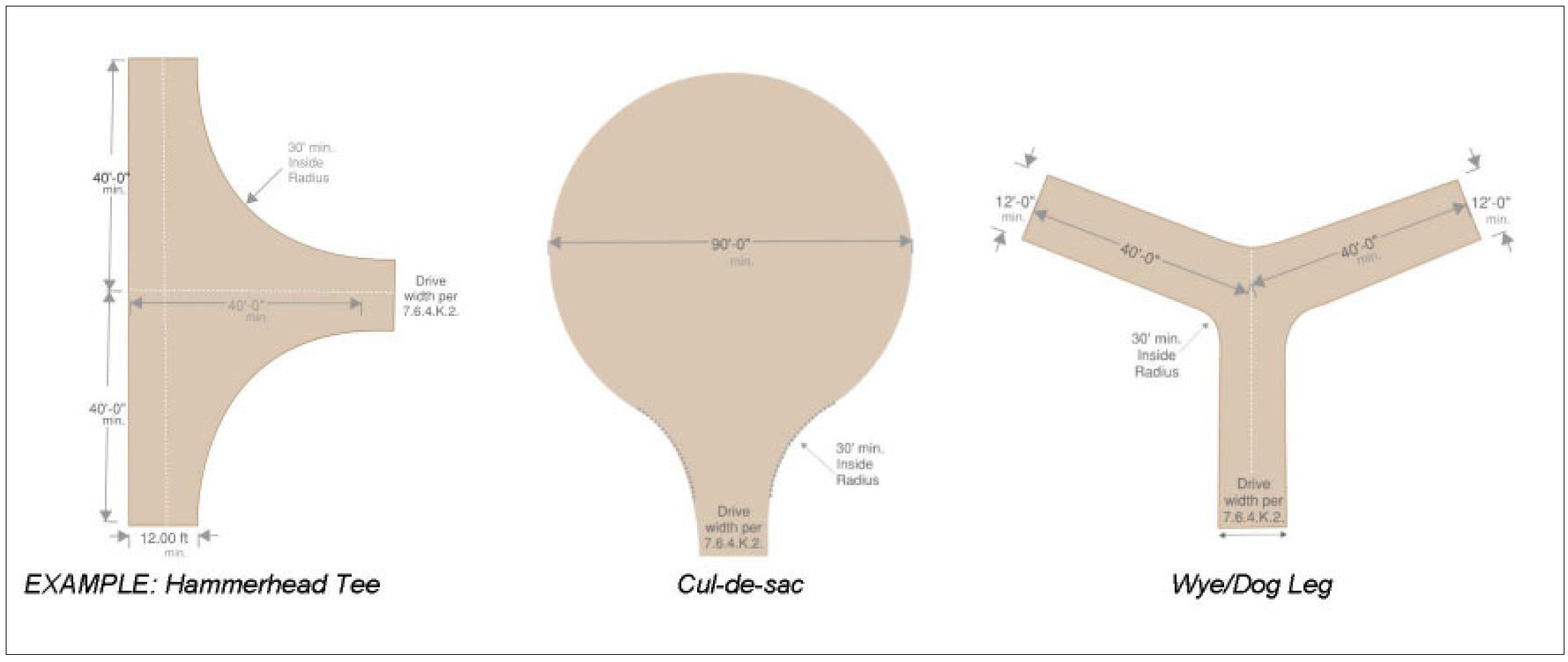
e.
Turnouts. Driveways, which are both over 200 feet in length and less than 20 feet in width, shall include turnouts in addition to turnarounds. Driveway turnouts shall be an all-weather surface at least ten feet wide and 30 feet long.
i.
Turnout location, quantity, and spacing shall be based on topography, sight lines, and access design, and shall be approved by the Fire Marshal.
3.
Intersection Separation.
a.
Minimum Separation. The following minimum separations between intersections of two or more vehicular access, including private roads and driveways, shall be met by any new access proposed for construction.
b.
Driveway Separation. Where the above minimum intersection separation for driveways cannot be met due to site constraints, lot size, or existing conditions outside of a property owners' control, a lesser separation may be approved by the County Engineer.
i.
Use Shared Access First. When multiple individual approaches are proposed or exist that do not meet the minimum intersection separation, the use of a shared access with neighboring properties, if present, is the preferred method for accessing new development.
ii.
Limit to Number of Driveways. Where the intersection separation cannot be achieved, and shared access is not available, each lot of record will be limited to a single vehicular approach to the roadway.
L.
Cul-De-Sac or Dead-End Streets.
1.
Cul-de-sac streets shall be designed to permit future access to other land ownerships where practical, and be designed and located with safety considerations in mind.
2.
All cul-de-sacs shall have a terminus consisting of a minimum outside radius of 45 feet, or a Hammerhead "T", Wye, or "Dog Leg" layout having 60-foot long legs. The width of legs shall be not less than 20 feet.
3.
In steep or mountainous terrain, where excessive grading would result from a full-sized cul-de-sac, the Hammerhead "T" or "Dog Leg" legs may be reduced to 45 feet in length with the approval of the Teton County Engineer and Fire Marshal.
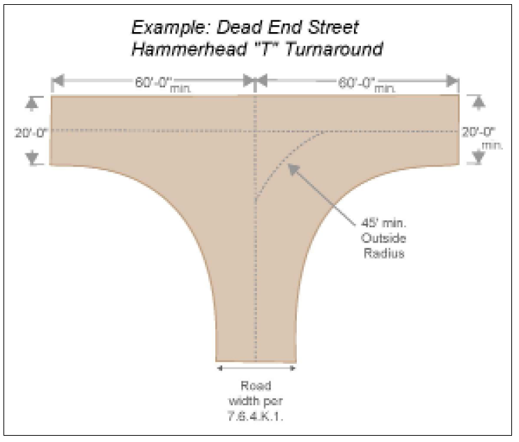
M.
Half-Streets. Half-streets along a development boundary or within any part of a development shall not be permitted. The full right-of-way and pavement width of all classes of streets shall always be provided, except where an arterial or collector road is shown on the Highway Master Plan Map along a property boundary. In such case, minimum half-street right-of-way shall be 60 feet or one-half the required right-of-way, whichever is greater.
N.
Vehicular Access Design Standards. All roads and streets, and driveways where specified, in Teton County shall be designed and constructed in accordance with the following policies and standards. Where standards are not specified, the current standards of the American Association of State Highway and Transportation Officials (AASHTO) shall be followed.
1.
Urban Road Design. Roads located within Complete Neighborhood character districts of the Comprehensive Plan may be required to include urban elements, such as sidewalks, bus stops, and curb extensions, as determined appropriate by the Planning Director or Board of County Commissioners. Those within one mile of the Town of Jackson shall conform with standards specified by the Town of Jackson if directed by the Town Planning Director.
2.
Grades. Maximum grades for any design speed shall be those described in the table below.
* Flat terrain refers to those lands within ten-year flood plains, and with slopes of less than 10%.
** Rolling terrain refers to those lands with slopes from 10% to 15%.
*** Mountainous terrain refers to those lands on steep or naturally unstable hillsides, and lands with slopes in excess of 15%.
For Major and Minor Local Roads, grades may be increased to 150% of the values shown above for a distance not to exceed 500 feet.
a.
Where sustained grades exceed 10% for roads or driveways, special fire protection may be required by the Fire Marshal as listed below. For the purpose of this Section, a sustained grade of 10% may include sections not to exceed 15% for not more than 200 feet, provided those sections in excess of 10% are not on curves with radii of less than 100 feet. This Section shall not apply to access to agricultural buildings or detached garages with no living space.
i.
Protection of all occupancies by an automatic sprinkler system installed in accordance with the most recently adopted International Fire Code; or
ii.
Other forms of special fire protection, given sufficient documentation is presented to substantiate an equivalent level of protection is proposed and approved by the Fire Marshal.
3.
Alignment. Switchback roads in mountainous terrain may be constructed with radii certified, by a registered Wyoming Civil Engineer, as meeting the minimum requirements of the projected traffic on the road.
4.
Super-Elevation. Super-elevation shall not exceed 0.08 feet per foot.
5.
Surface Types. The surface shall be an all-weather type capable of supporting the imposed loads of fire apparatus. For each functional road class, the surface types specified in the table above in Section 7.6.4(K.1), shall be the minimum requirements. Pavement structure shall be designed by a registered Wyoming Civil Engineer based upon expected traffic loads and existing soil conditions.
6.
Traffic Control Devices. Signs, pavement and other markings, and traffic signal controls shall be required in accordance with the "Manual on Uniform Traffic Control Devices for Streets and Highways" (MUTCD-FHWA).
7.
Structures. Bridges, culverts, walls, tunnels, and other structures shall be designed and certified by a registered Wyoming Civil Engineer as meeting the minimum requirements for the intended use, traffic load, and soil conditions. The burden of proof of the adequacy of such standards shall rest with the applicant for any development or subdivision permit.
a.
Bridge Permits, per Section 8.3.6, are required for any vehicular bridges, or bridges in or over the floodplain.
b.
Bridges shall be engineered to support the imposed loads of the largest fire apparatus which may use it and shall meet the minimum design requirements of the AASHTO Standard Specification for Highway Bridges, Standard LRFD-93.
c.
All bridges shall have a sign/plaque installed at the bridge entrance(s) displaying the vehicle weight limit. The sign must be legible and clearly visible to drivers/vehicles as they access the bridge.
d.
The minimum drive surface of a bridge shall be not less than 14 feet.
e.
Single Lane Bridges. Single lane bridges may be constructed on roads having a total projected ADT ≤ 250 for all development, including adjacent undeveloped land, that may reasonably be expected to be accessed by the bridge; and as long as the design is safe, considering such factors as sight distance and approach gradient.
8.
Drainage. Culverts or bridges of adequate strength shall be installed whenever natural drainages are crossed or no less often than 750 feet to transfer water to the downhill side of a road section. They shall be sized to pass the floodwaters of a storm having a two-year frequency. The minimum culvert size is 18 inches. Crossings of natural drainages shall be designed and constructed to provide for the natural passage of fish when deemed appropriate by the Planning Director or County Engineer.
a.
Maintain Irrigation Flow. All stream and/or ditch crossings must be designed and constructed so as to not restrict irrigation flow to any degree.
b.
Conformance with LDRs. All drainage, erosion control and grading items shall be conducted in accordance with these LDRs.
9.
Access Approaches. Approaches to County roads shall have a roadbed width of not less than 20 feet and a minimum radius at the shoulders of 15 feet. They shall have the same type of pavement as the County road being accessed from the right-of-way line to the shoulder of the County road. Appropriate culvert pipe shall be placed under the approach as directed by the County Road & Levee Manager. In all other respects approaches shall conform with the applicable standards of the current version of the Wyoming Department of Transportation's "Rules and Regulations for Access Driveways to Wyoming State Highways."
10.
Street Name Signs. Street name signs shall be installed at all intersections within, and entrances into, any development. Name signs at these locations shall be placed at least seven feet above the ground, with the street names parallel to their respective streets. The letters shall be clearly readable and at least four inches in height for street names, and two inches in height for compass and street abbreviations. Street signs for each street shall be readable from both sides.
11.
Road Location Within Easement. Roadways shall be designed so that the road is constructed at least eight feet from the edge of the easement.
12.
Security Gates. The installation of security gates across a fire apparatus access (including driveways) shall receive an approved permit by the Fire Marshal. Where security gates are installed, they shall have an approved means of emergency operation. The security gates and the emergency operation shall be maintained operational at all times.
13.
Fire Lanes. A fire lane is a road or other passageway developed to allow the passage of fire apparatus. A fire lane is not necessarily intended for vehicular traffic other than fire apparatus. Fire lanes may be required in close proximity to structures where access may be difficult due to traffic congestion, size of the building, proximity of other structures, etc. Fire lanes required by the Fire Department shall meet the following requirements in addition to the currently adopted International Fire Code:
a.
Fire lanes shall be not less than 20 feet in width.
b.
Fire lanes shall be posted with signs approved by the Fire Marshal that prohibit parking within the required width of the lane.
c.
The minimum distance from the closest edge of the fire lane to the structure shall be approved by the Fire Marshal based on the structure's square footage, height, and proximity to exposures.
14.
Vertical Clearance. The unobstructed height for any fire apparatus access (including driveways) shall be not less than 13 feet 6 inches.
O.
Plans and Specifications, Alternatives.
1.
In addition to any County requirements for materials to accompany applications for development permits, subdivision permits or similar County approvals, plans and specifications for pathways or for roads other than private drives, prepared by a registered Wyoming Civil Engineer, shall be submitted to the Planning Director for review prior to construction. The technical specifications shall be those specified in this Division. If no applicable standards are established by this Division, the plans and specifications shall be designed and certified by a registered Wyoming Civil Engineer as meeting the minimum requirement of the intended use. The burden of proof of the adequacy of such standards shall rest with the applicant and final determination shall be by the Board of County Commissioners.
2.
Plans shall include typical cross-sections, plan and profile sheets, cross-section sheets indicating sections appropriately spaced in consideration of the gradient of the roadway, pavement design, calculations, and drainage plans.
3.
Potential alternative locations, alignments, or designs, or the demonstration of the absence of such alternatives, shall be submitted by the applicant for transportation facilities proposed to impact the natural or wildlife resources regulated by Division 5.1, the Mid- to High-Tiers of the NRO, or involve natural hazards regulated by Division 5.4. Alternatives also may be identified by staff or other PRC reviewers. For purposes of a comprehensive discussion of potential alternatives, if the essential access provisions of Section 5.1.1(D.3) or 5.1.1(B.3) are engaged, a neighborhood meeting as described in Section 8.2.3, Neighborhood Meeting, may be required by the Planning Director or County Engineer.
P.
Inspections. For subdivisions or other developments, the following inspections shall be required by County officials during construction:
1.
Plan Inspection. A field review of the proposed roadway or bikeway when completed plans are available, prior to construction (review of development permit for construction).
2.
Staking Inspection. A field review of slope staking, at least every 200 feet, prior to clearing and/or grading.
3.
Grading and Drainage Inspection. A field review of grading operation and drainage installation prior to placement of any sub-base material. Check measurements shall be made of cross-section dimensions and drainage structures and soil compaction may be checked.
4.
Pavement Inspection. A field review of pavement placement. Shall include check measurements of depths and widths.
5.
Final Construction Inspection. A field review when all items are completed.
Q.
Maintenance. Most state and federal highways are maintained by the Wyoming Department of Transportation. Other roads within National Parks and Forests are maintained by the appropriate federal agency in accord with their adopted standards and practice. Roads accepted as County roads may be maintained by the County. Otherwise, maintenance of subdivision or other roads shall be the responsibility of private individuals, homeowners' associations, improvement districts or similar entities.
(8/1/25)
7.6.5. - Easements and Right-of-Way Dedication.
A.
Road and Pathway Rights-of-Way. In any project requiring a permit, required rights-of-way for any arterial, major collector, or Pathway shown on the Transportation Master Plan Map and supporting documents, insofar as they may lie on or adjacent to the site of the proposed subdivision or development shall be dedicated to Teton County or to the State of Wyoming, as appropriate, for use as County or State roads, highways or pathways, based on the amount of demand created by the proposed development. Easement requirements beyond that demand must be acquired by the appropriate agency. Width of the required rights-of-way shall be as described in the table in Section 7.6.4, and on the Transportation Master Plan Map and other supporting documents. This requirement shall include dedication of any required additional rights-of-way for existing State or County roads lying within or adjacent to the site.
1.
Required Dedication. Where the site of a subdivision or other development is contiguous to or contains an existing or proposed arterial indicated on the Transportation Master Plan Map, the Board of County Commissioners may require dedication of additional right-of-way, to provide for access streets, bus stop or shelter locations, planting screens, walls, berms or other elements which may be necessary for adequate protection of residential properties or to afford separation of local and through traffic. The extent of participation in the easement by the developer or landowner will be determined by the demands created by proposed development.
2.
Form of Dedication. Dedication of rights-of-way for County roads or pathways shall be in fee simple by a separate general warranty deed or quitclaim deed (when approved by the Board), by dedication on a recorded subdivision plat, or by a recorded easement, as required by the Board of County Commissioners.
3.
Dedication for State Highways. Dedication of rights-of-way for State highways shall be in a form determined by the Wyoming Department of Transportation. In lieu of dedication to the State of Wyoming for such highways, the Board of County Commissioners may approve the dedication of such required rights-of-way to Teton County, in conformance with the requirements above for dedication of County roads, for future transfer to the State of Wyoming as required.
4.
Timing of Dedication. Dedication of any required rights-of-way shall be completed prior to Subdivision Plat signature for any subdivision, or to issuance of the permit for any other project. However, for any permit for the master plan of a Planned Unit Development for which subdivision plats have not yet been approved or where the Board of County Commissioners determines that immediate dedication of right-of-way is not required or would disrupt continuation of agricultural activities, the required right-of-way may be set aside in a formal reservation for future dedication, including an accurate survey description of the required lands, to be recorded with the Clerk of Teton County. Where such a reservation has been recorded, it shall be binding on all future owners of the underlying property and shall so state. Such reserved right-of-way shall be dedicated to the County or State as described above upon application for Subdivision Plat signature for any subdivision including or adjacent to the right-of-way, upon the approval of any permit for construction activity on the site (other than such activity undertaken for agricultural or flood control purposes), upon its change of use from agricultural to any other use, or upon a finding by the Board of County Commissioners that the reserved right-of-way is required by the County or State for road or bikeway construction purposes.
B.
Nonroad Transportation Easements. Easements provided in any subdivision or other development shall be in accordance with the following:
1.
Emergency Access Easements. Emergency access easements shall be provided on all private streets or roads and other emergency vehicle lanes. Adequacy of such areas shall be determined by the Teton County Sheriff and the Fire Marshal.
2.
Cut and Fill Easements. Cut and fill easements shall be provided when street or road cuts and fills are not within a street or road right-of-way.
3.
Sidewalk or Walkway Easements. Sidewalk or walkway easements may be required to be provided when pedestrian facilities are not within a dedicated street right-of-way. Minimum easement width shall be six feet, though wider easements are encouraged to allow for landscaping, walkway curvature and an enhanced visual experience for pedestrians.
4.
Pathway Easements. Pathway easements shall be provided when such facilities, when required, are not proposed to be located within a dedicated road right-of-way. Minimum easement width shall be 12 feet, though wider easements are encouraged in order to enhance the recreational experience of the user and facilitate maintenance. The amount of participation by the developer or landowner in the easement will be determined by the demand created by the proposed development.
5.
Cattle Drive Easements. Where movement of cattle is necessary, particularly from summer range on National Forest and National Park property to private holdings in Teton County, and motor vehicle traffic levels are such that cattle movement cannot be done safely on road rights-of-way or will seriously disrupt motor vehicle traffic, cattle path easements shall be provided. Except where the Board of Commissioners has determined that such an easement shall be obtained or maintained by the County, such easements will be to private individuals or corporations and be maintained by them. Width shall be as determined by the fee simple landowner and the holder of the easement.
6.
Other Easements. Other easements shall be provided as required by the Board to the extent that the proposed development creates a demand for such easements.
C.
Easement Location. Easements shall be properly located or monumented in accordance with applicable Wyoming Statutes.
D.
Construction Responsibility. Except as required otherwise by this Division, all improvements located in, on, over or under an easement shall be constructed by the appropriate entity responsible for the improvements. The underlying fee simple property owner shall not interrupt or in any way interfere with the lawful construction of improvements within the easement.
E.
Maintenance Responsibility. Other than County, State or Federal road easements, all easements shall be maintained by the underlying fee simple property owner and all improvements located in, on, over or under easements shall be maintained by the applicable or designated agency.
1.
No Interference. Other improvements provided by the fee simple property owner shall not interrupt or in any way interfere with the designated and continued use and maintenance of the easements and improvements located thereon.
2.
County Maintenance. Except for designated County roads, Teton County shall not be responsible for maintenance of easements and/or improvements thereon, unless otherwise approved by the Board of County Commissioners.
(8/1/25)
7.6.6. - Clear View of Intersecting Streets.
No signs or other obstructions shall be permitted to be located in road rights-of-way and in the clear zones as indicated below, except required essential traffic control signs.
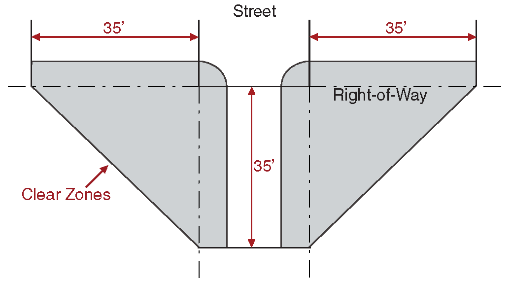
(1/1/15)
7.7.1. - Purpose.
The design, layout and construction of utilities shall conform with the standards of this Division. The standards for design, construction, specifications, and inspection of improvements, as prescribed in this Division, shall be in addition to the standards established by other County Departments.
(1/1/15)
7.7.2. - Water Supply.
A.
Potable Water Supply.
1.
Public Water Supply Reasonably Accessible. Where an approved public water supply is reasonably accessible or procurable, the applicant shall make application to the appropriate authority to connect to such water supply. If approval is granted, the applicant shall connect to the system and install water lines to make the water supply available to each lot of record within the development at its property line.
2.
Water Supply Not Accessible. Where an approved public water supply is not reasonably accessible or procurable, the applicant shall, at the discretion of the Board of County Commissioners, either:
a.
Install Central Water Supply System. Install a central water supply system and water lines to the lot line of each lot of record from wells or other approved sources in accord with the State Department of Environmental Quality, and with the approval of the County and the State Engineer, or
b.
Evidence Water Supply Available to Each Lot of Record. Submit evidence satisfactory to the County Engineer that an adequate water supply meeting all State and County requirements is otherwise available to each lot of record in the proposed development, such as by an individual well.
B.
Fire Fighting Water Supply or Fire Hydrants.
1.
Applicability. A year-round source for firefighting purposes shall be provided by the developer for new commercial subdivisions and new residential subdivisions with three or more residential lots.
2.
Authority. All systems shall be subject to review and approval by the Fire Marshal prior to installation and shall meet the required Wyoming Department of Environmental Quality standards.
3.
Water Source Options.
a.
Subdivisions with three to ten residential lots shall provide a water source in the form of:
i.
A central main system with hydrants; or
ii.
One fire well with pump, hydrant and reliable power source; or
iii.
Storage tank with hydrant; or
iv.
Another type suitable for year-round use, approved by the Fire Marshal.
b.
Subdivisions with 11 to 29 residential lots shall provide a water source in the form of:
i.
A central main system with hydrants; or
ii.
At least two fire wells with pump, hydrant and reliable power source.
iii.
Except where average densities are 1 dwelling unit to > 3 acres the following water sources are also permitted:
a)
Storage tank with hydrant; or
b)
Another type suitable for year-round use, approved by the Fire Marshal.
c.
Subdivisions of 30 or more residential lots shall provide a water source in the form of a central system with hydrants.
i.
Except where average densities are 1 unit to >3 acres the following water sources are also permitted:
a)
Fire wells with pumps, hydrants and reliable power source; or
b)
Storage tanks with hydrants; or
c)
Another type suitable for year-round use approved by the Fire Marshal.
ii.
Where fire wells or storage tanks are used, a minimum of two sources shall be provided for the first 30 lots and one additional source per each 15 lots over 30, or fraction thereof.
d.
Special Provisions. In all residential subdivisions, except those with commercial areas, regardless of densities, the water source requirements may be reduced provided all structures within the subdivision are protected by an approved automatic sprinkler system. When water source requirements are reduced by use of sprinkler provisions, the minimum number and type of sources shall be determined based upon road system design, topography, exposure protection requirements, densities, travel distance to established water sources, etc., and shall be subject to Fire Marshal approval. In no circumstance may the water source requirements be reduced to less than 500 gallons per minute.
e.
Commercial subdivisions or residential subdivisions with commercial areas shall provide a firefighting water supply based upon the type of businesses present, type of construction, size of the buildings, proximity to exposures, fire flow requirements, access, etc. Each system will be reviewed to the specific hazard and may necessitate upgrading existing systems to provide adequate supply when changes of use occur.
f.
Open water ponds shall not be permitted as a type of new firefighting water supply in any circumstance.
4.
Water Source System Designs. All required water supply systems shall be subject to Fire Department permit approval and shall meet the design requirements of nationally recognized standards and shall be installed to meet said standards with the following as minimum requirements:
a.
Central Mains with Hydrants.
i.
A central hydrant system shall be capable of providing a minimum of 1,000 gallons per minute (gpm) for not less than two hours at a residual pressure of 20 pounds per square inch (psi). Systems may provide 500 gpm for not less than two hours at a residual pressure of 20 psi when installed in subdivisions where all residential occupancies are protected by approved automatic residential sprinkler systems.
ii.
System mains shall be not less than six inches for looped lines, eight inches for dead end lines, subject to engineered hydraulic analysis. Hydrants shall be serviced by a branch line not less than six inches in diameter with a gate valve located on the branch line. Main size may be down-sized accordingly based on system demand when all residential occupancies are protected by approved automatic residential sprinkler systems.
iii.
Hydrants shall be dry barrel type with two 2½-inch outlets and one 4½-inch outlet, all with National Standard Thread.
iv.
Hydrants shall be located adjacent to roadways, preferably on corners, with the 4½-inch outlet facing the road. Hydrants shall be placed no further than ten feet from the edge of the roadway surface.
v.
Hydrants shall be spaced not more than 500 feet apart.
a)
Except that where subdivision densities are 1 dwelling unit to >3 acres, hydrants may be spaced up to 1,000 feet apart.
b.
Fire Wells.
i.
Fire wells shall be capable of supplying a minimum of 500 gallons per minute (gpm) for not less than two hours at a residual pressure of not less than 20 psi. Fire pumps shall be automatic on-demand and shall be provided with a reliable power source, which may include utility power, on-site emergency generator, engine driven pumps, or other approved system.
ii.
One hydrant shall be provided with a minimum of two 2½-inch male outlets with National Standard Thread.
c.
Storage Tank with Hydrant. Storage tanks shall be sized to provide the minimum required fire flow for not less than two hours. Tanks may be underground, surface, or elevated where allowed, and may consist of one or multiple tanks. One hydrant shall be provided with a minimum of one 4½-inch NST male thread outlet for underground tanks or two 2½-inch outlets for surface or elevated tanks, each with National Standard Thread.
5.
Developer Responsibility to Provide Binding Documentation. It shall be the responsibility of the developer to construct the adequate water supply and provide the system design information to Teton County to allow for the review and approval by the Fire Marshal.
a.
When a developer proposes to down-grade the water supply system by use of sprinkler systems throughout the subdivision, and this method is approved by the Fire Marshal, adequate documentation shall be provided by the developer to ensure minimum requirements will be met in the future. The form of such documentation shall include notes on a subdivision plat, or an equivalent deed restriction that is recorded in the Teton County Clerks records.
(8/1/15)
7.7.3. - Sanitary Sewer Systems.
A.
Public Sanitary Sewer System Available. Where a public sanitary sewer system is located within 500 feet, and legal access is obtainable, the applicant shall connect to such sanitary sewer system and provide adequate connection lines to the property line of each lot of record.
B.
Public Sanitary Sewer Not Reasonably Available. Where a public sanitary sewer is not located within 500 feet, the applicant shall install sewage disposal facilities, or lot owners shall install individual septic tanks and sewage disposal systems for each lot of record, which shall be approved by the County Sanitarian. The applicant shall furnish to the satisfaction of the County Sanitarian or State Department of Environmental Quality a report of percolation, groundwater and soils tests; these tests shall be performed in sufficient numbers and completed on the land by a licensed engineer or land surveyor indicating that a sufficient number of soils tests with results have been made in separate test holes spaced uniformly over proposed absorption field sites, and that the results of such tests indicate that percolation rates and high groundwater levels are adequate to permit the installation of the proposed type of soil absorption system without creating sanitation or pollution problems. The use of individual sewage disposal systems shall be subject to review, inspection of construction and approval of construction by the County Sanitarian. See the Teton County Small Wastewater Facilities Resolution for permit requirements and design standards.
(1/1/15)
7.7.4. - Irrigation Ditch Systems and Design.
A.
Surface Water Rights. If there are surface water rights appurtenant to the lands to be subdivided, the developer shall provide evidence that the requirements of Wyo. Stat. § 18-5-306(a)(12), 1977, as amended will be complied with.
B.
Irrigation Water. If irrigation water is to be made available in a development, it shall be the responsibility of the developer to install an approved delivery system. Such a system shall meet minimum delivery requirements for the development and shall encompass the control of wastewater, drainage water and surface water resulting from irrigation, and protect and deliver the water rights of others using the same water source. The irrigation delivery system shall be approved by the State Engineer. The irrigation system/ditches also shall be approved by the County Sanitarian as to how it affects the operation of individual sewage disposal systems on lots of record in the immediate and adjacent areas of the development.
C.
Restriction of Methods. The County may restrict the methods of irrigation to be employed in order to prevent an artificial and detrimental rise of the groundwater table under the subdivided land or adjacent lands.
D.
Setbacks.
1.
Intent. Setbacks from irrigation ditches shall provide for the maintenance of ditches while also protecting water quality and promoting agriculturally related scenic resources and wildlife habitat.
2.
General. Physical Development, including architectural projections, shall be set back a minimum of 15 feet from the top of bank of all open irrigation ditches and the centerline of all piped irrigation ditches; notwithstanding, adequate access for maintenance of the ditch shall be provided to the organized or un-organized ditch company, or any water rights owner on the ditch.
3.
Exceptions. The following types of physical development are exempt from the 15-foot irrigation ditch setback. Notwithstanding, the requirements of all state statutes applicable to irrigation ditches shall be satisfied.
a.
Maintenance of the Ditch. Maintenance of the ditch by the organized or un-organized ditch company, or any water rights owner on the ditch.
b.
Private Lateral. Development along a lateral that has no downstream users and terminates on the property being developed.
c.
Pipeline in Existing Easement. Development along a piped ditch, when the piped ditch is within a maintenance easement existing as of September 24, 2007. Notwithstanding, the physical development shall not occur within that easement.
d.
Essential Access. Ditch crossings for essential access are permitted provided that they do not obstruct the maintenance of the ditch, or historic flow of the ditch.
e.
Agriculture. Non-structural, agricultural development may encroach into the ditch setback.
f.
At Grade Paths and Roads. An at grade path or road may encroach upon demonstration to the satisfaction of the Planning Director that:
i.
It will not obstruct maintenance of the ditch;
ii.
It will not adversely impact the water quality in the irrigation ditch or irrigation system within which the irrigation ditch is a part;
iii.
It will not cause any change in the hydrology of neighboring lands; and
iv.
It will not cause safety problems for those persons using the proposed path or road.
4.
Note on Development Plan/Subdivision Plat. Required setbacks from ditches shall be noted on the Development Plan and/or Subdivision Plat.
E.
Irrigation Ditch Alteration. The following standards apply for any alteration of an irrigation ditch. This includes moving the irrigation ditch, enclosing the irrigation ditch, or causing any other change in the characteristics of the irrigation ditch. Notwithstanding, ditch alteration for agricultural purposes and alteration of a lateral that has no downstream water rights and terminates on the property of the alteration shall be exempt from the requirements of this Subsection.
1.
Consultation with Water Commissioner. An applicant proposing to alter a ditch shall provide evidence that the proposed alteration has been presented to the local Water Commissioner for the district in which the alteration is proposed.
2.
Grading Permit Required. A Grading and Erosion Control Permit prepared pursuant to Division 5.7 is required for all ditch alterations. The permit application shall be prepared by a professional engineer registered in the State of Wyoming or by both a land surveyor and a landscape architect registered in the State of Wyoming.
3.
Restriction of Methods. The County may restrict the methods of irrigation to be employed in order to prevent an artificial and detrimental rise of the groundwater table under the lands of the alteration or adjacent lands.
4.
Setback from Edge of Ditches. The top of bank of all altered open ditches and the centerline of all altered piped ditches shall be set back a minimum of 15 feet from all property lines and conform to all other setback standards.
(1/1/15)
7.7.5. - Other Utilities.
A.
Buried Utilities Required. All utilities shall be installed underground. Any relocation of existing utilities shall be buried.
B.
Easements. Where utilities are not provided within a dedicated road right-of-way, easements of not less than 30 feet shall be provided for accommodating water lines, sanitary sewers and stormwater drainage. Minimum width of easements for power lines, telephone lines, and other utilities shall be 15 feet.
C.
Levees.
1.
Sprinkler Systems Prohibited. Installation of sprinkler systems or other pressurized lines within the County easement for levees operated and maintained by the County or the United States Army Corps of Engineers shall be prohibited.
2.
Permitting of Modifications to Levee Structure. Modification of levee structures, such as culverts, fences, gates, wildlife crossings/paths, plantings, or other features which require alteration of levees operated and maintained by the United States Army Corps of Engineers (USACE) must be permitted through the Walla Walla District, USACE, prior to any construction, pursuant to 33 U.S.C. 408. Modification of non-federal levees operated and maintained by the County, must be approved by the County Public Works Department with input from the USACE.
(8/1/25)
7.7.6. - Fuel Storage Tanks.
Section number reserved, standards only apply in Town.
(1/1/15)
7.8.1. - Intent.
This Division establishes incentives for the development of workforce housing. Because not every landowner will use the incentives, this Division manages growth by limiting the actual (rather than a projected) use of the incentives. Section 7.8.2 establishes the limit on the cumulative use of the incentives over time.
(4/19/22)
7.8.2. - Cumulative Limit on Incentives.
Use of an incentive in this Division is prohibited if the application would increase the amount of residential development allowed in the Town and County above the amount allowed and planned for since 1994.
A.
The amount of residential development allowed in the Town and County is reported annually in the Jackson/Teton County Comprehensive Plan Indicator Report. Current and past Indicator Reports can be found at www.jacksontetonplan.com.
B.
A residential unit shall be added to the amount of residential development allowed in the Town and County upon its initial approval using an incentive in this Division.
C.
A residential unit approved using an incentive in this Division shall be subtracted from the amount of residential development allowed in the Town and County upon expiration, revocation, or extinguishment of the approval.
(4/19/22)
7.8.3. - Deed Restricted Housing Exemption.
Section number reserved, standards only apply in Town.
(4/19/22)
7.8.4. - Workforce Housing Floor Area Bonus.
Section number reserved, standards only apply in Town.
(4/19/22)

