
Teton County Unincorporated
City Zoning Code
City Zoning Code
ARTICLE 5
PHYSICAL DEVELOPMENT STANDARDS APPLICABLE IN ALL ZONES
Division 5.1.- General Environmental Standards
The purpose of this Division is to maintain healthy populations of native species and preserve and enhance water and air quality. Wildlife and natural resources are an essential component of the character of the community.
Division 5.2. - Environmental Standards
A.
Purpose. The purpose of this Division is to "maintain healthy populations of all native species and preserve the ability of future generations to enjoy the quality natural, scenic, and agricultural resources that largely define our community character" (Chapter 1 of the Joint Jackson and Teton County Comprehensive Plan). This guiding principle shall be achieved through the preservation and enhancement of aquatic, wetland, and terrestrial habitat quality and quantity and by maintaining and restoring healthy populations of all native species. For future generations to enjoy the ecosystem that exists today, the community must manage our impacts to wildlife, the natural resources on which wildlife depend, their aquatic and terrestrial habitats, and wildlife's ability to move through and use these habitats. The prevalence of wildlife and other natural resources central to our ecological, social, and economic character requires a functional and healthy ecosystem. This Division protects all natural resources including native species and habitats.
B.
Intent. The intent of this Division is to first avoid, then minimize and mitigate impacts from development to habitats identified through the Natural Resources Assessments process (Section 8.2.2). Allowed impacts are intended to cause the least impact to the natural resources present on the site and in the vicinity. Least impact is defined as avoidance and then minimization of impact to natural resources to the greatest extent practicable.
Habitat Protections. Terrestrial and aquatic habitats (inclusive of riparian) provide wildlife with forage, shelter and permeability through human development and use areas throughout the year. With the intention to preserve and protect terrestrial and aquatic habitats for wildlife, this Division protects and minimizes impacts to natural resources and protects habitats from fragmentation, thereby maintaining connectivity, natural resources, and habitats across the landscape.
The Jackson/Teton County Comprehensive Plan (2020) "Policy 1.1.b Protect wildlife from the impacts of development directs that a tiered system of protection should be established so that the most critical habitat and movement corridors receive the highest level of protection and site-specific study." The Tiered Natural Resources Overlay fulfills this directive.
C.
Tiered Natural Resources Overlay (NRO).
1.
Establishment of the Tiered Natural Resources Overlay Map. There is hereby established the Tiered Natural Resources Overlay Map, which shall overlay all zones established by these LDRs. All lands within Teton County are within the Tiered Natural Resources Overlay. If any land is omitted from the map, it shall be considered as being within the Mid Tier for the purposes of these Land Development Regulations. Lands owned by government entities shall be subject to the NRO processes in these Land Development Regulations in accordance with Section 1.5.3, Application to Government Entities. It is important to emphasize that these are tiers and that all habitat within Teton County, WY, has habitat value to some species of wildlife. These tiers were developed based on suitable habitats of focal species (EcoConnect, 2018). The following are the tiers included in the NRO map.
a.
Base Tier — Areas mapped within the Base Tier are those with fewer habitat types and/or habitats that support fewer focal species. These areas tend to have more development present and if undeveloped contain fewer habitat types.
b.
Mid Tier — Areas mapped within the Mid Tier are those with a moderate number of habitat types and/or habitats that some of the focal species depend on. These areas tend to have less development present or if undeveloped only have a few habitat types.
c.
High Tier — Areas mapped within the High Tier are those with multiple habitat types and/or habitats that support multiple focal species. These areas tend to have less development present, are usually near water or contain water, or if undeveloped have multiple habitat types.
2.
Protected Natural Resources. Protected Natural Resources are assessed through the Natural Resources Assessments process (Section 8.2.2) and are protected in the Base-, Mid-, and High-Tier. The abundance of natural resources in the Base Tier areas of the Tiered NRO are expected to be less than on Mid- and High-Tiered areas thereby allowing for a systematic gradation of natural resource assessments between and within subject properties.
(5/1/25)
Division 5.3. - Scenic Standards
The purpose of this Division is to maintain the scenic resources of the community. Scenic resources, natural landforms, and dark skies are vital to the community's natural character. Mountains moraines, meadows, and other natural viewsheds provide residents and guests with a constant reminder of their location within the Greater Yellowstone Ecosystem. Interruption of these natural forms by the built environment detracts from Teton County's scenic character and should be avoided.
Division 5.4. - Natural Hazard Protection Standards
The purpose of this Division is to limit development in naturally hazardous areas. Development in hazardous areas threatens the health, safety and welfare of human inhabitants. Steep slopes, poor soils, avalanche chutes, floodplains, dense forest and areas along fault lines offer unique opportunities for interaction with the environment, but when natural events do occur in these areas the results can be disastrous.
Division 5.8. - Design Guidelines—Reserved
Division number reserved, standards only apply in Town.
(1/1/15)
5.1.1. - Waterbody and Wetland Protection Standards.
A.
Purpose. This Section establishes the protection standards for waterbodies and wetlands. In order to protect the environment as a whole from potential negative impacts caused by physical development and use that may affect these resources or their functions, this Section limits physical development and use on and within a certain distance of these resources.
B.
Findings. Waterbodies and wetlands provide critical functions in controlling flood waters, providing wildlife habitat, cleansing the water resources, and contributing to the special scenic quality of Teton County.
C.
Applicability. The requirements of this Section shall apply to all lots of record. See Division 1.6 of these Land Development Regulations for relationship between regulations.
D.
Protected Resources.
1.
Waterbodies. Waterbodies are natural features (i.e., rivers, streams, lakes) that convey or contain surface water.
a.
River. River means the Snake River, the Gros Ventre River, the Hoback River, or the Buffalo Fork River.
i.
Natural Channel. A natural channel is a perennial, intermittent or ephemeral watercourse, with defined bed, banks and ordinary high-water mark.
EXAMPLE:A natural channel of the Snake River was cut off from its natural source by the levee, however groundwater surfaces and flows through the historic channel seasonally during the spring. The applicable setback from the channel would be that of an intermittent stream.
b.
Stream. Stream means a body of water flowing through a defined bed or channel that is neither one of the four named rivers nor an irrigation ditch. A stream may be perennial, intermittent, or ephemeral.
i.
Stream Types.
a)
Perennial Stream. A perennial stream conveys water year-round.
EXAMPLE:Fish Creek and Flat Creek are perennial streams.
b)
Intermittent Stream. An intermittent stream conveys water seasonally on an annual basis.
EXAMPLE:A foothill stream that flows each spring during snow-melt, but is dry each fall is an intermittent stream e.g., Jensen Creek.
c)
Ephemeral Stream. An ephemeral stream flows only briefly during and following a period of rainfall, or other event, in the immediate locality and that does not occur annually.
EXAMPLE:A low angle stream that flows during periods of rapid snow-melt, which do not occur seasonally, but occur often enough to create a perceptible ordinary high-water mark is an ephemeral stream e.g., Timber Gulch Creek in Wilson Canyon. A manmade channel to convey stormwater, such as a bioswale, gutter, or borrow ditch is not an ephemeral stream. Ephemeral stream setbacks are intended to reduce flood risk.
c.
Natural Lake/Pond. A natural lake/pond means a body of standing water, which was created by natural processes.
d.
Irrigation Ditch. Any man-made channel utilized to convey irrigation water diverted from any manmade or natural water source, for the specific purpose of, and/or as a direct result of, beneficial use and as adjudicated by the State Engineers Office. Surface waters in an irrigation ditch can be controlled through a headgate or other man-made structure.
2.
Wetlands. Wetlands are areas that are inundated or saturated by surface or ground water at a frequency and duration sufficient to support, and that under normal circumstances do support, a prevalence of vegetation typically adapted for life in saturated soil conditions. Identification of wetlands shall be according to the 1987 Corps of Engineers Wetlands Delineation Manual, and the 2010 Western Mountain, Valleys, and Coast Regional Supplement. These regulations shall protect all natural wetlands regardless of size or classification by federal or other regulatory bodies. This definition excludes irrigation induced wetlands.
E.
No Development, Setbacks/Buffers Required. Due to the risk of severe negative impacts on the community at large if waterbodies and wetlands are wholly or partially developed, and the necessity to protect the natural functions of these resources, physical development and use of these resources is prohibited in most cases and a setback/buffer is required. Demonstration of compliance with wetland standards must be provided by a qualified professional certified in wetland delineations through a recognized, professional certification program such as the Society of Wetland Scientist Professional Certification Program.
1.
Development and Use Prohibited. Physical development and use in waterbodies and wetlands is prohibited except for essential facilities as specified below.
2.
Setback/Buffer Required. All physical development and use is required to be setback from specified resources as follows:
a.
Rivers. 150 feet. The river setback shall apply from the ordinary high-water mark of the Snake River, Gros Ventre River, Hoback River, and Buffalo Fork River. Where a levee is in place the river setback shall be measured from the top of the levee on the river side.
i.
Natural Channel. The river setback shall apply to a natural channel of one of the rivers listed in a above.
ii.
Remnant Channel. The river setback shall not apply to a channel that no longer has a natural source from the river. The setback applicable to such a channel shall be one of the stream setback types.
b.
Streams. Along streams, physical development and use shall be located out of the following setback/buffer area.
i.
Perennial Stream. 100 feet.
ii.
Intermittent Stream. 100 feet.
iii.
Ephemeral Stream. 30 feet.
c.
Natural Lake/Pond. 100 feet. Adjacent to natural lakes or ponds, physical development and use shall be located out of the setback/buffer area.
d.
Wetlands. 50 feet. Adjacent to wetlands, physical development and use shall be located out of the setback/buffer area.
e.
Irrigation Ditch. 15 feet (see Section 7.7.4. Irrigation Ditch Systems and Design). Adjacent to irrigation ditches, physical development and use shall be located out of the setback/buffer area.
f.
Measurement. Setbacks shall be measured from the ordinary high water mark or top of bank, whichever is farthest from the thread of the watercourse or the center of the waterbody.
g.
Buffer. The area protected by the setback is the "buffer" and shall remain free from physical development and use. Mowing of vegetation, parking, open storage of vehicles, storage of refuse, or storage of any other material shall be prohibited in the buffer. Terrain disturbance for bona fide agricultural purposes as defined in Section 6.1.3(B), flood protection, wildlife habitat enhancement, or public pathways are permitted in the buffer upon receipt of applicable permits.
3.
Development of Essential Facilities.
a.
Waterbodies. Certain water dependent uses, bona fide stream restoration and enhancement, and essential road or utility crossings must be located in or adjacent to waterbodies. These may be permitted within the setback/buffer area provided all physical development meet the following requirements and shall be minimized to the greatest extent possible.
i.
Flood Control, Irrigation, or Essential Crossings. Only physical development that is essential to flood control or irrigation, bona fide stream restoration and enhancement, or essential road or utility crossings shall be permitted.
a)
Essential Crossings. Infrastructure that is deemed essential may be located in, across, or adjacent to a water body if there is not practicable alternative. It is not required that the subject road or utility cross within and then out of the waterbody setback for it to be deemed an essential crossing. Crossing means traversing within the natural resource setback/buffer boundary line.
ii.
Not for Human Habitation. Structures shall not be intended or designed for human habitation.
iii.
Minimize Negative Impacts on Wildlife. All physical development and use shall be designed to minimize negative impacts on wildlife.
b.
Wetlands. Wetlands may be physically developed or used under the following circumstances. Notwithstanding, receipt of a local permit does not absolve an applicant from obtaining all other State or Federal permits necessary to develop wetlands.
i.
High-Intensity Use Degraded Wetland/Wetland Agriculture-Induced. Where the intensity of adjoining use(s) cause the retained wetlands to become degraded habitats and the wetland area is suitable for physical development or use due to planning, location, and other factors, or where the wetland is induced by irrigation.
ii.
Necessary to Reshape Wetland to Provide Building Site and/or Access. Where, due to the shape of the parcel or lot of record and its interaction with topography, it is necessary to reshape the wetland boundary to provide a building envelope, filling up to 5% of the wetland on the parcel or lot of record, not to exceed 0.5 acre, may be permitted.
iii.
Essential Crossings When No Alternate Site. Essential utility and road crossings shall be permitted to impact wetlands where it is demonstrated that the proposed crossings cannot be practically located without impacting wetlands.
(5/1/25)
5.1.2. - Wildlife Friendly Fencing.
A.
Findings. Fencing is a structural element that can create an impediment for wildlife movement, resulting in both injuries and death to wildlife and damage to the fencing. The purpose of wildlife friendly fencing is to ease wildlife passage to the habitats that sustain them and reduce incidents of injury and mortality. Wildlife friendly fencing allows wildlife to jump over and pass under more easily, reduces the chance of entanglement, and may incorporate openings or wildlife passes. It also includes consideration of topography and placement, such as to allow free and safe passage around special purpose or barrier fencing.
B.
Applicability.
1.
Repair or replacement of nonconforming fencing that does not meet the standards of Section 5.1.2 is permissible under the following standards:
a.
One time repair of 25% or less of the total linear fence perimeter of each enclosure being repaired;
b.
Approval of a Special Purpose Fence Permit as outlined in Section 5.1.2(D).
2.
Exemptions for Wildlife Friendly Fencing outlined in Section 5.1.2:
a.
Fences associated with agricultural use on sites meeting all of the following:
i.
Sites of 70 acres or more and meeting the standards in Section 6.1.3(B); and
ii.
Sites containing agriculture as assessed by the Teton County Assessor; and
iii.
Exempt fencing per this Section is used only for agricultural purposes on the site as defined herein.
b.
Fences built for riding arenas. Riding arenas shall have 12 foot wide gates at two ends that must remain open to allow wildlife movement when arena is not in use;
c.
Fences erected for exclusionary purposes of small areas such as hotwire around automatic trout feeders, apiaries, vegetable gardens, composting areas, haystacks, livestock feed storage, chicken yards, refuse facilities, recycling containers, dumpsters, ornamental landscaping areas directly adjacent to structures, safety fencing for a swimming pool and a single dog run not exceeding 200 square feet adjacent to a structure, and safety fencing not exceeding 800 square feet for yards directly adjacent and attached to a residence. See Section 5.1.3. Wildlife Feeding for small exclusionary fencing.
d.
Fences constructed for the containment of livestock which have been approved through a special purpose fence permit. Temporary, movable, single strand visible electric tape for livestock is permissible and is considered wildlife friendly.
e.
Fences erected to secure a construction site with an approved and active construction permit.
f.
Fencing constructed as a requirement of an approved habitat mitigation plan for protection of sensitive habitat areas which are temporary until establishment. Large areas requiring protective landscape fencing shall include pass through areas for wildlife such as drop downs and gaps to allow wildlife movement through the area.
C.
Fencing Design. Fencing materials and design shall comply with the following standards:
1.
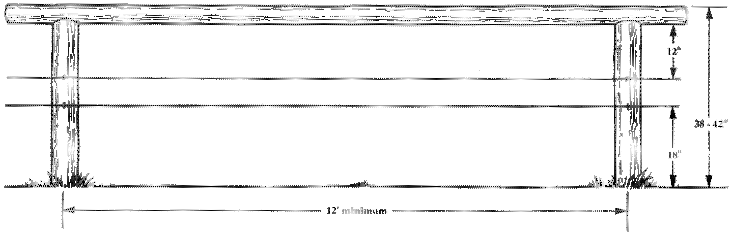
Measurements. The top rail for purposes other than livestock control, shall be no higher than 38 inches above the ground. The top rail for livestock control shall be no higher than 42 inches above the ground. There shall be no more than three horizontal strands/rails permitted. These heights allow wild ungulates (deer, elk, moose, antelope) to jump over more easily. Spacing between the top pole/rail and adjacent wire shall be at least 12 inches. The distance between the bottom wire/rail and the ground shall be no less than 18 inches. The spacing of fence posts shall be a minimum of 12-foot centers unless topography prohibits this spacing. The posts may have extra height to allow for any necessary lower or raising of the top rail.
2.
Materials. Wood (or similar highly visible solid material) top poles, and either wood rails or wire strands are permitted as horizontal elements in fencing, however bare wire shall not be used as the top most horizontal strand (PVC coated wire is permissible). When using wire, the middle or bottom wire strands shall be smooth or twisted wire. Barbed wire may be used in the middle strand when necessary to control livestock. Barbed wire is prohibited in the top and bottom strands of the fence.
3.
Double Fences. The spacing between parallel fencing (regardless of ownership) shall be at least 30 feet as to not create a trap for wildlife.
4.
New buck and rail or buck and wire fencing is prohibited unless approved by the Planning Director through a Special Purpose Fencing Exemption.
5.
Land disturbance and vegetation clearing for fence installation and repair shall be the minimum necessary to install fence posts and allow installation of fence materials. Any land disturbance shall comply with the requirements of Division 5.7 of the Land Development Regulations.
6.
Fencing adjacent to a swale, gully, or other topographic feature shall be designed to allow wildlife to safely cross. In these instances, the fence shall require a minimum eight-foot clear area between the fence and the animal landing/takeoff area.
7.
Fences shall not be placed in such a manner as to block the natural funneling of wildlife through canyons and areas such as swales, gullies, ridges, canals, streams or other topographic features.
D.
Special Purpose Fencing. Notwithstanding the provisions of this Section, the Planning Director may exempt individual special purpose fencing from this Section, provided the fencing meets the below standards. The applicant shall provide a written explanation for how the proposal qualifies for a special purpose fencing request based on the information in this Section.
EXAMPLE:Examples of special purpose fencing which are not otherwise exempt under Section 5.1.2(B) include fencing for dog kennels, certain types of non-exempt agricultural style fencing (such as bull enclosure, pig pens, sheep enclosure, fencing for winter livestock feeding sites, and fencing for 4-H projects), fencing for mitigation sites, fencing for restoration areas, and landscape for decorative fencing.
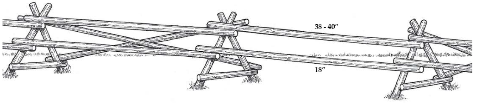
Buck and Rail Fencing—Special Purpose Only
1.
Smallest Area. The special purpose fencing shall encompass the smallest area necessary to achieve the purpose.
2.
Specific Design. The applicant shall demonstrate that the special purpose fencing is constructed for a particular use and requires a specific design to accomplish the purpose of the fence.
3.
Height in Yards. Special purpose fencing located in a street yard shall not exceed four feet in height. Special purpose fencing located in a side or rear yard shall not exceed six feet in height.
4.
Setback. Special purpose fencing is not subject to a setback from property lines.
5.
Rocky or Wet Soil. Buck and rail may be approved when the applicant demonstrates necessity due to rocky or wet soil. Buck and rail fencing shall not exceed 38 inches in height for landscape, or 40 inches in height for livestock, to allow wildlife movement. All buck and rail fencing permitted under this Section shall comply with the design shown in the figure below with sections which are single sided, with no rub rail, braces on the bucks, and comply with the design requirements of Section 5.1.2(C) above.
6.
The Planning Director shall consider other mitigation practices demonstrating improved wildlife passage such as drop down horizontal elements, open gates and other practices recommended by Wyoming Game and Fish Department or as included in the latest edition of the "Wyoming Landowner's Handbook to Fences and Wildlife: Practical Tips for Fencing with Wildlife in Mind" by Christine Paige, Wyoming Wildlife Foundation, Laramie.
7.
Long expanses of special purpose fencing which is 120 feet or longer shall include drop down or gaps to allow for wildlife passage through the area as approved by the Planning Director in the permit (except for areas approved for livestock containment).
8.
Landscape fencing (including any temporary landscape fencing) shall be of a sturdy material such as wire (non-plastic) and shall be properly maintained as to not allow wildlife entanglement.
9.
All standards for natural resource protection and wildlife movement as recommended by the Planning Director shall be recorded in the permit.
(12/8/21)
5.1.3. - Wild Animal Feeding.
A.
Findings. The feeding of wildlife, as defined by Wyo. Stat. § 23-1-101 by humans creates one or more of the following risks:
1.
Attracts ungulates to residential areas, which poses a significant threat to human and domestic animal safety and can increase the incidence of wildlife-vehicle collision;
2.
Attracts large predators to residential areas, which poses a significant threat to human life or domestic animals;
3.
Promotes unnaturally high concentrations of animals, which in turn:
a.
Increases the potential for disease transmission,
b.
Promotes overuse of certain habitats,
c.
Disrupts natural animal migration;
4.
Promotes unnatural wildlife behavior, such as the frequenting of residential areas and coming into harmful or threatening situations with humans, and resulting in habituated nuisance animals, and, in some cases, these animals must, be relocated or destroyed, and;
5.
Detracts from the wild spirit of the animals.
B.
Purpose and Intent. The purpose of this Section is to prevent and mitigate conflicts between humans and wildlife in Teton County by establishing wildlife feeding and bear-attractant standards for residential and nonresidential uses. The intent of this Section is to protect and promote the public health, safety and welfare of the public and wildlife by:
1.
Reducing the attraction of ungulates to residential areas, and thereby lessening the significant threat to the safety of humans and domestic animals;
2.
Reducing the attraction of large predators to residential areas, and thereby lessening the significant threat to the safety of humans and domestic animals;
3.
Reducing unnaturally high concentrations of animals, thereby lessening the potential for disease transmission, the overuse of certain habitats, the disruption of natural animal migration, wildlife vehicle collisions, and the habituation of wild animals;
4.
Discouraging unnatural wildlife behavior, thereby reducing the number of nuisance animals that have to be relocated or destroyed when they frequent residential areas or otherwise come into harmful or threatening contact with humans and domestic animals; and
5.
Respecting the wild behaviors of the animals' nature.
C.
Prohibitions.
1.
Supplemental Feeding Prohibited. No person shall provide supplemental feed to wildlife, unless specifically authorized by an agency of either the State of Wyoming or the United States of America. Supplemental feed includes any human food, pet food, hay, forage product or supplement, grain, honey, seed or birdseed, salt or mineral licks, or other supplemental feed made available to wildlife.
2.
Wildlife Attractants prohibited. No person shall allow for the unintentional attraction and feeding of wildlife by allowing access to attractants on their property, including pet food, garbage, seed or birdseed, or other attractant made available to wildlife.
3.
Ornamental (non harvested for food), non-native fruit bearing trees (including crabapples and cherries) shall not be planted. Existing ornamental, non-native fruit bearing trees shall be managed to prohibit large mammals from obtaining food rewards, and therefore, shall be either properly fenced and/or maintained with complete harvesting as soon as fruit is available. All exclusionary fencing shall be properly maintained and comply with the requirements of Section 5.1.2 for exclusionary fencing.
4.
Bird Feeders. No person shall install or keep a bird feeder on their property, unless the bird feeder is inaccessible to any wildlife other than birds.
5.
In the event any property and/or service area associated with the property shall be found to contain any wildlife attractant(s) not otherwise specified in the foregoing standards, the attractant(s) shall be removed or secured consistent with the foregoing standards within 15 days notice unless an alternate time frame is agreed to with the County Code Enforcement Officer.
D.
Exemptions.
1.
The normal feeding of livestock and/or the practice of raising crops and crop aftermath, including hay, alfalfa and grains, produced, harvested, stored or fed to domestic livestock in accordance with normal agricultural practices as defined in Section 6.1.3(B). There is a presumption that on land taxed as agricultural land, that the alleged feeding is exempt from this regulation; or
2.
The cultivation of a lawn and/or garden, and/or the provision of birdfeeders in compliance with Section 5.1.3(C.4) in which the bird food is made unavailable to any wildlife except birds.
E.
Bear-Resistant Standards.
1.
Bear-Resistant Trash Container Required. Beginning 7/1/2022, all trash shall be properly stored in a certified bear-resistant self-locking container or dumpster.
a.
A self-locking bear-resistant container or dumpster is one that has passed the Interagency Grizzly Bear Committee (IGBC) and has successfully passed the testing program at the time of purchase. A list of certified bear-resistant containers and dumpsters and the manufacturers that produce these products is available in the Teton County Planning and Building Services Department and at this website, http://igbconline.org/bear-resistant-products/.
b.
If trash is transferred from the property to the trash transfer station or landfill directly by the property owner or property lessee, trash may be stored in another container as long as the container is stored in a bear-resistant building or enclosure at all times while on the property.
c.
All trash receptacles at construction sites for trash that includes food, food wrappers, or other bear attractants shall be bear-resistant. Containers shall be kept closed and latched at all times. Non-bear-resistant dumpsters or trailer may be used to store construction trash that does not contain bear-attractants, as per LDR Section 6.4.2(B)(4).
d.
A certified bear resistant self locking container or dumpster shall be kept in good working order and shall not be altered outside the original manufacturers specifications in place when the container received its certification.
2.
Bear-Resistant Building, Enclosure, and Fencing Requirements.
a.
The following attractants shall be stored exclusively inside bear-resistant buildings, fencing, or enclosures.
i.
Grease storage containers and stored foods for nonresidential food/drink preparation and service;
ii.
All backyard chicken operations including chicken food storage;
iii.
Apiaries;
iv.
Food compost containers or piles;
v.
Livestock and fish food;
vi.
Commercial dumpster, if not in self locking certified bear resistant dumpster.
b.
A bear-resistant building or enclosure is one that consists of and/or contains:
i.
A framed building, fencing or enclosure with hard sides and a roof constructed of hard wood, non-reflective metal or other like product reasonably designed and manufactured to withstand an intrusion by a bear; or
ii.
Chain-link fencing that is fully enclosed including the top being fully covered; or
iii.
Functional and maintained electric fencing designed to exclude bears; or
iv.
A combination of the above; and
v.
Functional, maintained self-latching doors and gates, or doors and gates with locks.
EXAMPLE:Examples of bear-resistant enclosures include, but are not limited to, garages, metal sheds, houses, and electrified fencing designed to exclude bears or any other building designed and constructed to prevent access by bears.
(1/23/23)
5.1.4. - Air Quality.
Protection of clean air resources is a goal of the County, in order to protect the public health, welfare and general safety of the residents, the visibility in the valley and the scenic beauty of Teton County.
A.
Particulate Matter. For the purposes of this Section, particulate matter is any material other than water, which is suspended in or discharged into the atmosphere in finely divided form as a liquid or solid capable of being airborne or gasborne, including dust. All uses shall conform with the following standards:
1.
Emission Rate of Particulate Matter and Dust/General. No emissions shall exceed the allowances set forth by the U.S. Environmental Protection Agency or WYDEQ, or any other State or Federal agency having jurisdiction to limit emissions. In case of conflict, the most restrictive requirement shall govern.
2.
Ameliorate Possibility of Particulate Matter Becoming Windborne. Emission of particulate matter from materials or products subject to becoming windborne shall be kept to a minimum by landscaping, paving, wetting, or other means as to render the surface wind resistant.
3.
Applicable to Temporary Construction Operation. Temporary construction operations shall be subject to the requirements of this Section.
B.
Toxic and Noxious Matter. For the purposes of this Section, toxic and noxious matter is any solid, liquid, or gaseous matter, including but not limited to, gases, vapors, dusts, fumes, and mists, containing properties which, by chemical means, are inherently harmful and likely to destroy life or impair health, or are capable of causing injury to the well-being of persons or damage to property. All uses shall conform with the following standards:
1.
Ambient Air Quality Standards. The ambient air quality standards of the Wyoming Department of Environmental Quality, the U.S. Environmental Protection Agency, or any other state or federal agency having jurisdiction, shall limit the release of airborne toxic and noxious materials. In case of conflict, the most restrictive requirements shall govern.
2.
Toxic Materials Not Included in Ambient Air Quality Standards. No emissions of toxic gases or matter shall result in any hazard to human life or health or to wildlife. The Planning Director may request that an applicant submit a statement from the Wyoming Department of Public Health that the proposed levels of toxic matter to be released will not result in any hazard to human life or health or to wildlife.
C.
Smoke Emissions. All uses shall conform with the following standards:
1.
Maximum Smoke Emission. Smoke emission from any chimney, stack, vent, opening, or combustion process, or any alterations or additions to uses or structures with existing point sources, shall meet U.S. Environmental Protection Agency source regulations designed to eliminate smoke problems.
2.
Exemptions. The provisions above shall not apply in the case of an equipment breakdown which makes compliance not reasonably possible, and shall not apply to home fireplaces, barbecues, and burning incidental to agricultural operations and sanitary landfill operations.
D.
Odorous Matter. The emissions of odorous gases or matter in such quantities as to be readily detectable, without special instruments, at any point beyond the site omitting the odor, is prohibited. Odorous matter includes, but is not limited to, odors from the accumulation of decayed matter, trash, rubbish-garbage, and manure from domestic animals and fowl, all of which is perceptible beyond the site boundary line(s) of the property where the accumulation is located. Agricultural operations meeting the standards for exemption in Section 6.1.3(B) shall be exempt as specifically related to manure from domestic animals and fowl.
(7/19/16)
5.1.5. - Water Quality.
Section reserved for future standards.
(1/1/15)
5.1.6. - Manmade Features.
A.
Purpose. The purpose of this Section is to establish design standards for the creation of manmade waterbodies, landforms, and other habitat features in order to ensure that manmade features:
1.
Preserve and enhance water quality (Principle 1.2 of the Comprehensive Plan);
2.
Protect wildlife from the impacts of development (Principle 1.1 of the Comprehensive Plan); and
3.
Appear to be naturally occurring and are consistent with surrounding features (Principle 1.3 of the Comprehensive Plan).
B.
Applicability. This Section is applicable to any manmade feature, whether proposed voluntarily or required by these LDRs, and regardless of whether creation of the feature requires a physical development permit.
1.
This Section shall apply to new features and alterations to existing features, whether the existing features are natural or manmade.
2.
Alteration of a nonconforming manmade feature that does not meet the standards of this Section shall be subject to the requirements of Section 1.9.2, Nonconforming Physical Development.
3.
In addition to this Section, all standards of the LDRs pertaining to gravel extraction (Section 6.1.9(F) or Section 6.1.12(F)) and grading, erosion control, and stormwater management (Division 5.7) shall apply.
C.
Manmade Waterbodies.
1.
Intent. The intent of this subsection is to preserve and enhance water quality and protect wildlife when a manmade waterbody is created.
2.
Waterbody Purpose. A manmade waterbody shall serve at least one of the following purposes.
a.
Agriculture. The manmade waterbody is part of an agricultural operation.
b.
Fire Suppression. The manmade waterbody is approved by the Fire Marshal as necessary and required for fire suppression.
c.
Habitat. The manmade waterbody provides wildlife habitat pursuant to the standards of this Section.
d.
Ornamental Water Feature. The manmade waterbody is part of the architectural design of the site.
3.
All Manmade Waterbodies. The following standards shall apply to all manmade waterbodies.
a.
Airport Proximity. No manmade waterbody shall be located within 10,000 feet of the Jackson Hole Airport runway.
b.
Location. A manmade waterbody shall meet all natural resource setbacks and the site development setbacks for the site.
4.
Ponds. In addition to the standards applicable to all manmade waterbodies, manmade ponds shall be subject to the following standards.
a.
Exempt Ponds. The following ponds are exempt from the standards specific to ponds.
i.
Agricultural Pond. A pond that is part of an agricultural operation meeting the standards for exemption in Section 6.1.3(B).
ii.
Stormwater Management Pond. A pond that is verified by the County Engineer to have the sole purpose of stormwater management.
b.
Location. The pond shall be located at least 50 feet from any building.
i.
Maintenance, alteration, expansion, and replacement of a lawfully established building located closer than 50 feet from a lawfully established manmade pond shall comply with Section 1.9.2(B) except that:
a)
If the expansion cannot be located 50 feet from the manmade pond, the expansion shall be located no closer to the manmade pond than the closest point of the existing building; and
b)
The applicant shall mitigate additional impacts to the 50 foot buffer at a ratio of two square feet of mitigation to one square foot of impact.
ii.
Maintenance, alteration, expansion, and replacement of a lawfully established manmade pond located closer than 50 feet from a lawfully established building shall comply with Section 1.9.2(B).
c.
Buffer Establishment.
i.
A 50 foot buffer of native vegetation shall be planted along the shoreline for the purpose of protecting the water quality and the habitat value of the pond.
ii.
Riparian access shall be allowed for a maximum of 10% of the shoreline.
d.
Well-Fed Ponds. Water from a well used to fill a pond shall be pretreated through a wetland prior to entering the pond.
e.
Outfall. The pond shall not outfall into a river, stream, or ditch unless the outfall is designed to meet the following standards.
i.
The outfall shall draw from a minimum depth of four feet.
ii.
The outfall shall discharge through a wetland sized to accommodate the nutrient load of the pond and volume of the outfall.
f.
Winter-Safe Aerators. If installed in a pond an aerator shall meet the following standards.
i.
An aerator shall be turned off from December 1 through April 15.
ii.
An aerator shall be located so that the bubble trail from the aerator reaches the shoreline.
g.
Non-Plastic Liner. If lined, the pond liner shall not include plastic material.
h.
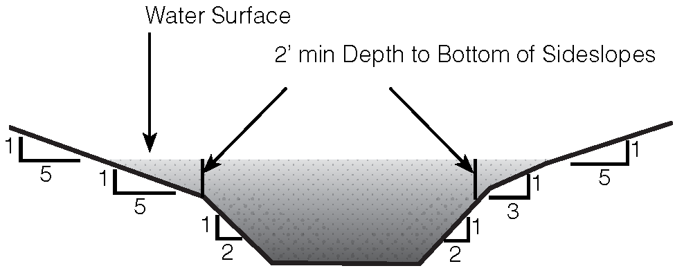
Pond Side Slopes.
i.
15 Foot Shoreline Transition. The slope from the shoreline to upland areas shall be no steeper than 5 (horizontal) : 1 (vertical) for at least 15 feet from the ordinary high water mark toward the upland area.
ii.
First Two Feet of Pond Depth. Side slopes into the pond necessary to reach a depth of two feet shall be designed and maintained to the following standards.
a)
At least 50% of the shoreline length of the pond and any island shall have side slopes that are no steeper than 5:1.
b)
All other side slopes shall be no steeper than 3:1.
c)
Side slopes shall receive a minimum of six inches of topsoil.
iii.
Deeper Than Two Feet. At a depth of greater than two feet, side slopes shall be no steeper than 2:1.
iv.
Supplemental Water Supply. A supplemental water supply, e.g., water from the Snake River or any other watercourse and conveyed irrigation ditches, shall be developed, if necessary, to stabilize water levels and prevent steeper grades from becoming exposed.
i.
Habitat Pond. In addition to the standards above, a habitat pond shall meet the following standards.
i.
NRO and NRA Apply. A habitat pond located in the High-Tier of the NRO shall be subject to the standards of Section 5.2.1 and Section 8.2.2, regardless of zone.
ii.
Shallows. Sufficient shallows to allow the pond to effectively function as wildlife habitat shall be provided. The design shall be reviewed, at the applicant's expense, by a wildlife biologist to ensure that shallows are designed to provide safe and functional wildlife habitat, including but not limited to the following goals:
a)
Ensuring safe ungulate ingress and egress.
b)
Planting of the aquatic bench with vegetation preferred by native waterfowl, fish, ungulates, amphibians and reptiles.
5.
Ornamental Water Feature. In addition to the standards applicable to all manmade waterbodies, an ornamental water feature shall meet all of the following standards.
a.
The entire feature shall be within 50 feet of a building on the site.
b.
The feature shall be a maximum of two feet deep.
c.
The area of the feature shall be a maximum of 1,000 square feet.
d.
The feature shall be lined.
e.
The feature shall not outfall into a river, stream, or ditch.
f.
If installed in a feature, an aerator shall be turned off from December 1 through April 15.
g.
The area of the feature shall be considered site development unless the feature is used to harvest rainwater for reuse on site as irrigation.
D.
Manmade Landforms.
1.
Intent. Manmade landforms are used to screen a structure, absorb sound, or reuse excavated material on site. The intent of this subsection is to establish standards to ensure that manmade landforms do not negatively impact wildlife, appear to be naturally occurring, and are consistent with surrounding features. It is the intent that compliance with this subsection constitutes conformance to general natural landforms (Section 5.7.2(A.4)) and minimization of cut and fill (Section 5.7.2(A.9)).
2.
Berm. A berm that is four feet in height or greater shall meet the following standards.
a.
Location.
i.
A berm shall meet all natural resource setbacks.
ii.
A berm shall meet side and rear site development setbacks for the site (however, a berm shall not be considered site development).
iii.
A berm shall have a street setback of five feet for a road classified by the County Engineer as major local or greater.
b.
Outward Slope. The ends of the berm and side of the berm facing out of the property shall meet the following standards.
i.
SRO. Inside the SRO a berm shall have an outward slope no steeper than 20:1.
ii.
Outside the SRO.
a)
A berm facing a side or rear lot line shall have an outward slope no steeper than 5 (horizontal) : 1 (vertical) slope.
b)
A berm facing a front lot line shall have an outward slope no steeper than 2 (horizontal) : 1 (vertical) slope.
c.
Maximum Height. The maximum height of a berm at any point, as measured from the nearest point of natural grade to the top of the crown of the berm, shall be six feet; except that the following berms shall not exceed ten feet.
i.
A berm in the street yard; or
ii.
A berm in the R-1, R-2, or R-TC zones.
d.
Undulation. Berms shall be shaped to emulate natural undulation in terrain rather than appear monolithic, pyramidal, or extruded. In addition, a berm facing a side or rear lot line shall meet the following standards.
i.
The berm height shall not exceed four feet for a continuous berm facade width of greater than 100 feet.
ii.
If the overall berm facade width exceeds 100 feet, at least 25% of the berm facade width shall have a height no greater than four feet.
e.
Vegetation. A berm shall be vegetated pursuant to Section 5.5.4(B).
f.
Fencing. Fencing is prohibited on a berm.
g.
NRO and NRA Apply. A berm located in the High-Tier of the NRO shall be subject to the standards of Section 5.2.1 and Section 8.2.2, regardless of zone.
h.
Exemptions.
i.
Site development setbacks and outward slope standards shall not apply upon mutual application by adjacent land owners.
ii.
This Section shall not apply to temporary stockpiles.
(5/1/25)
5.1.7. - Retaining Walls.
A.
Purpose. Retaining walls are structural elements that can create impediments for wildlife movement, restricting wildlife's ability to move between the seasonal and daily habitats that sustain them. The purpose of this Section is to create retaining walls that permit wildlife movement between these habitats. These standards require openings in tall, long walls allowing wildlife to move freely around the impediments.
B.
Applicability.
1.
This Section applies to all retaining walls including walls that are voluntarily proposed by an applicant or landowner and walls required by these LDRs, regardless of whether a retaining wall is a stand-alone construction project or part of a larger development.
2.
All retaining walls shall comply with Section 5.7.2(B), Grading Standards.
3.
The County Engineer may exempt a retaining wall from all or a portion of this Section pursuant to Section 8.8.1, Administrative Adjustment. Requests for exemptions shall meet at least one of the following criteria:
a.
Protection of Natural Resources. The exemption is necessary to protect natural resources and avoid an environmental detriment that would be greater than the benefit provided by full compliance with these standards. A written report by a qualified environmental professional is required to justify the exemption request. The County Engineer may require that the report includes alternatives and/or mitigation that achieve the greatest overall benefit for both wildlife movement and the natural resources to be protected; or
b.
Public Facility. The retaining wall is part of a public transportation facility proposed by a governmental agency or an emergency response; or
c.
Length. Adjustments to the length standards of Section 5.1.7(C) may be adjusted up to 20% to accommodate site specific conditions; or
d.
Avoid Hazards. The exemption is necessary to avoid a natural hazard area (on steep or naturally unstable slopes, in avalanche paths or in other hazardous areas) where meeting the standards of this Section would otherwise pose a danger to public health and safety.
4.
Review. Requests for exemptions from this Section shall be sent to the Wyoming Game and Fish Department for review.
C.
Length. A retaining wall shall be the shortest height and length to achieve its purpose. If a retaining wall is unable to be separated into sections 120 linear feet or less, then it shall feature a staggered design per Section 5.1.7(D.1).
D.
Design Standards.
1.
Staggered Wall Design Standards. A staggered design may be required by the County Engineer regardless of length to improve wildlife permeability.
a.
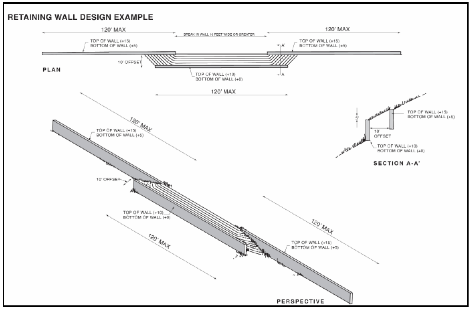
In the event that an area of over 120 linear feet requires a retaining wall, the design shall include as many breaks in the retaining wall as is feasible, but at minimum one break for every 120 linear feet of wall. Each break shall be at least ten feet wide.
b.
A staggered retaining wall stepped down a slope shall maintain a horizontal separation between walls that is no less than ten feet.
c.
Breaks in the retaining wall, and the separation between staggered retaining walls, shall be revegetated with Teton County native vegetation.
d.
If retaining walls are required on both sides of a roadway or driveway, breaks in the retaining walls on the opposites sides shall be aligned across from or near one another to the greatest extent practical.
e.
See the illustration below for an example of a plan and elevation of a staggered retaining wall.
2.
Materials.
a.
Retaining walls shall be constructed of solid material with a solid top designed to prevent wildlife limbs from being entrapped.
b.
Material that could cause an animal to be trapped or entangled shall be prohibited.
c.
Wire used in a gabion wall or similar design shall be designed and maintained to avoid loose or gaping wire that may entangle an ungulate or other wildlife.
d.
Gabion walls shall be topped with a solid material like wood or stone.
e.
Any material determined to be hazardous to wildlife by a qualified wildlife biologist and/or Wyoming Game and Fish shall be prohibited.
3.
Land Disturbance and Vegetation Clearing. Land disturbance and vegetation clearing for retaining wall construction and/or repair shall be the minimum necessary to construct or repair the retaining wall or accomplish the staggered wall design. Any land disturbance shall be revegetated and maintained with native vegetation similar to the surrounding vegetative cover types and shall comply with the requirements of Division 5.7.
(5/1/25)
5.2.1. - Natural Resources Overlay (NRO), Tiered Habitat Protection Standards.
A.
Applicability. The requirements of this Section shall apply to all lots of record, unless exempted below. When conflicts exist between the NRO and SRO, the standards of this Section shall have priority and be achieved to the maximum extent practicable.
1.
Zone Specific. A zone-specific standard exempts it from this Division.
2.
Agricultural Operations. Agricultural operations and uses meeting the standards for exemption outlined in Section 6.1.3(B) shall be exempt from the standards of this Section.
3.
Land in Conservation Easement. Land protected by a conservation easement where proposed development density is equal to or less than one house per 70 acres and the total acreage subject to the easement is 320 acres or more, shall be exempt from the standards of this Section, except that Subsections B.3 and B.4 shall apply.
B.
Protected Natural Resources. Applies in all Tiers.
1.
Waterbodies and Wetlands (Section 5.1.1).
2.
Species with Special Federal and State Protections. Protection and process requirements from Endangered Species Act, Bald and Golden Eagle Protection Act (1940), most recent Wyoming Governor's Sage Grouse Executive Order, and other pertinent federal or state species protections on private lands shall be complied with.
3.
Trumpeter Swan Nesting and Winter Habitat. Trumpeter swan nesting habitat is the area around, inclusive of waterbody and wetland vegetation, a nest created by a trumpeter swan and are generally found on islands or in extensive stands of emergent vegetation. For the purposes of these LDRs, a known trumpeter swan nest shall be an active trumpeter swan nest. Trumpeter Swan Winter Habitat generally consists of water areas of palustrine-aquatic bed and unconsolidated shore and bottoms, with soft, sub-surface substrates of greater than two inches in depth, winter water depths of less than 4.3 feet, watercourse channels of 50 feet in width or more, and banks with little or no shrubbery or tree cover and gradual slopes.
4.
Bald Eagle Nesting and Winter Habitat. Bald eagle nesting areas generally occur in mixed aged, multi-storied stands of trees with old-growth attributes, where there are trees suitable for perching. These stands of trees are often located near foraging opportunities such as waterbodies and watercourses. A bald eagle nest is a nest created or used by a bald eagle and is generally located in one of the largest trees in the stand. For the purpose of these LDRs, bald eagle nests are inclusive of occupied, active, and inactive nests. An occupied nest is one in which evidence (such as fresh nest material, droppings, feathers, or prey remains in or below the nest, or the birds themselves) indicates that a pair of eagles is present. An active nest is an occupied nest in which eggs have been laid or young eagles are present, indicating that the mated pair are actively attempting to produce young. An inactive nest is one which occurs within the nesting territory but shows no evidence of occupation and shall be documented as inactive for five consecutive seasons to no longer be considered an established nest. Bald eagle crucial winter habitat consists of the bald eagle nesting area, defined as the nest tree and its associated buffer and bald eagle perch and roost sites along the Snake River corridor. Additionally, during times of freezing water surfaces and heavy snow, crucial ungulate winter ranges also serve as bald eagle crucial winter habitat as bald eagles forage on ungulate and livestock carrion.
5.
Intact Terrestrial Habitat Patches. Intact terrestrial habitat patches are connected areas of similar overstory vegetation species (e.g., ordinal rank) inclusive of riparian, forest, shrub, grassland and previously disturbed areas. Intact habitat/vegetation patches are central to preserving and protecting the area's wildlife species. The intent of habitat patch regulations is to limit/minimize fragmentation of habitat patches from development, maximize existing and remaining patch size, minimize patch edge (created by development) and resulting edge effects, and promote clustering of development both on-site as well as within the vicinity. Intact patches are central to preserving and protecting the area's wildlife species.
a.
Ordinal Rank. Intact, naturally occurring (not inclusive of landscaping) habitat patches will be assigned an ordinal rank based on overstory composition. If a patch must be impacted by proposed development, impacts to higher ordinal rank patch types should be first avoided and then minimized based on the areas available for development on the property. Impacts shall be mitigated per Section 5.2.2, Habitat Mitigation, Restoration and Enhancement standards. Habitat patches shall be protected in the order specified below.
i.
An ordinal ranking number is given for each group of resources, ten being the highest, or most important to preserve, and one being the lowest or best option for locating any site disturbance that must impact habitat patches. Existing development is given an ordinal rank of zero. Replacing existing development with new development, located within the impact area of existing development does not constitute an impact and is considered avoidance. For the purposes of these regulations, in areas of mixed species, overstory is defined as greater than or equal to 25% canopy coverage.
1)
Ordinal Rank by Patch Overstory Species.
ii.
Patches with Mixed Overstory Species. Patches of habitat containing a mix of overstory species shall be classified as either:
a)
The higher ordinal ranking overstory type; or
EXAMPLE:An aspen stand with blue spruce encroachment would be ranked as deciduous (ordinal rank = 8)
b)
The ordinal rank of the overstory type with greater than 50% composition of the stand.
6.
Wyoming Game and Fish Department (WGFD) Crucial Range and Focal Species Suitable Habitat. Not all lands within WGFD designated crucial wildlife range are crucial habitat for the subject species. "Suitable habitat" (Division 9.5) found within designated "crucial range" (Division 9.5) is of importance to species survival and representative of the crucial habitats found within designated crucial range. The majority of the time, the species of concern will be ungulates such as mule deer, moose and elk. However, there may be instances when other species are represented by crucial ranges. A refinement process overlapping these two GIS layers will determine natural resource areas that development should avoid on a property.
7.
Wildlife Movement Corridors. Landscape permeability that allows for wildlife movement corridors, inclusive of local, short-distance and long-distance migrations, are essential to maintaining viable wildlife populations. Wyoming Migration Corridor Executive Order 2020-1 (MCEO) constitutes Wyoming's state-wide strategy for maintaining migration corridor functionality. As of September 20, 2024, one designated migration corridor (Sublette mule deer) and two identified migration corridors (Upper Wind River mule deer and Sublette pronghorn) overlap in Teton County. The MCEO states that these migration corridors are essential to the maintenance of viable mule deer and antelope populations.
For the purposes of these regulations, current and future migration corridors both designated and identified by WGFD are protected natural resources. Additionally, local, short-distance and long-distance migration corridors documented and/or published by state or federal wildlife professionals are protected natural resources. Designing development to protect and promote landscape permeability for wildlife is essential to maintaining viable wildlife populations both locally and state-wide.
Development within these wildlife movement corridors and development located within one-half mile of an existing or planned wildlife crossing location shall prioritize wildlife permeability through the property and vicinity in the development design. The applicant shall not install development impermeable to wildlife unless no alternative is available and the development is for essential facilities.
C.
Setbacks/Buffer Requirements.
1.
Trumpeter Swan Habitat Setback Required. There shall be no development or use within 300 feet of Trumpeter Swan winter habitat or nest.
2.
Bald Eagle Nesting Habitat Setback Required. Physical development, use, development option, or subdivision shall be prohibited within a radius of 660 feet of a Bald Eagle nest. This setback/buffer may be administratively varied by the Planning Director only under the following circumstances:
a.
Temporary Activities. Temporary activities (including, but not limited to, the use of loud machinery, temporary gravel extraction, grading, wildland/urban interface mitigation, habitat enhancement, and on-going agricultural activities) outside of the nesting period, defined as February 1st through August 15th may be permitted within the setback/buffer. If the temporary activity requires removal of vegetation, roost trees, or nest trees, screening shall be preserved. Screening is defined as vegetation that shields line of sight to the nest. A qualified wildlife biologist shall identify the vegetation to be preserved prior to initiating temporary activity.
b.
Nest Not Visible. Where the nest would not be visible from the proposed physical development, use, development option, or subdivision, it may be permitted within the setback/buffer under the following circumstances:
i.
If it can be demonstrated by a qualified professional that locating the physical development, use, development option, or subdivision outside of the 660 foot setback/buffer is not practical, then the setback may be reduced to no less than 330 feet.
ii.
If the proposed physical development, use, development option, or subdivision is an alteration, expansion or addition to an existing use or structure, the proposed development may be within the 660 foot setback/buffer but no closer than the existing physical development, use, development option, or subdivision to be altered, expanded or added to.
iii.
When the 660 foot setback/buffer is reduced, the following standards shall apply:
a)
Residential and nonresidential lots of record within the 660 foot setback/buffer shall not be increased.
b)
The proposed physical development, use, development option, or subdivision activity shall be conducted outside the bald eagle nesting period, defined as February 1st through August 15th.
c.
Nest Visible. Where the nest would be visible from the proposed physical development, use, development option, or subdivision, development within the setback/buffer may be permitted only if the following standards are met:
i.
If it can be demonstrated that locating the physical development, use, development option, or subdivision outside of the 660 foot setback/buffer is not practicable then it shall not be closer to the nest than existing similar physical developments, uses, development options, or subdivisions within 660 feet of the nest. Under no circumstances shall the physical development, use, development option, or subdivision be closer than 330 feet; or if the proposed physical development, use, development option, or subdivision is an alteration expansion or addition, it may be within the 660 foot setback/buffer of the nest but no closer than the existing physical development, use, development option, or subdivision to be altered, expanded or added to; and
ii.
Residential and nonresidential lots of record within the 660 foot setback/buffer shall not be increased; and
iii.
The proposed physical development, use, development option, or subdivision within 660-foot setback/buffer shall be screened with trees to shield the line of site to the nest; and
iv.
All physical development, use, development option, or subdivision activity shall be conducted outside the bald eagle nesting period, defined as February 1st through August 15th.
d.
Exemptions. The Bald Eagle standards do not apply where a bald eagle nest is established subsequent to initiating land disturbing activities pursuant to an approved permit for the specific physical development proposed within the 660-foot setback.
D.
Base Tier Natural Resource Protection.
1.
Applicability. This Section shall apply when:
a.
The entirety of the subject property is within the Base Tier of the Tiered Natural Resources Overlay; or
b.
The proposed limits of any disturbance related to development (including any road or utility improvements) are entirely located within the Base Tier of the Tiered Natural Resources Overlay and a site-level preliminary analysis indicates this is the least impactful location; or
c.
The limits of land disturbance or use (including temporary use) are within an area of existing development and do not expand the area of existing development.
2.
Location. The standards of Section 5.1.1 Waterbody and Wetland Protection Standards and Section 5.2.1(C) Setback/Buffer Requirements apply at all levels of Natural Resource Protections. Beyond the requirements of Sections 5.1.1 and 5.2.1(C), there are no additional location requirements for development based on natural resources present on the property. While not a requirement, it is recommended to avoid and minimize fragmentation of large patches of naturally occurring vegetation.
3.
Process. A Desktop Checklist shall be prepared and submitted per the requirements in Section 8.2.2.
4.
Crucial Range and Suitable Habitat. Where applicable, the Desktop Checklist shall include overlaying the Wyoming Game and Fish Department Crucial Range for big game species, wildlife movement corridors and existing and planned wildlife crossings map layers in addition to the focal species suitable habitat layers for Mule Deer, Elk, and Moose (as defined in Section 9.5.1) to further inform the location of any land disturbance.
E.
Mid Tier Natural Resources Protection.
1.
Applicability. This Section shall apply when:
a.
The subject property is completely located within the Mid Tier of the Tiered Natural Resources Overlay; or,
b.
The subject property is located partially within the Base Tier and partially within the Mid Tier and the proposed limits of disturbance related to the use or development are unknown; or,
c.
The proposed limits of any disturbance related to development (including any road or utility improvements) are entirely located within the Mid Tier of the Tiered Natural Resources Overlay and a site-level preliminary analysis presented at the Pre-Application Conference indicates this is the least impactful location; or,
d.
The areas of land disturbance or use are within the development area designated by a recorded conservation easement.
2.
Location. The limits of land use or disturbance shall be located in the lowest ordinal ranked habitat patch(es) in a manner that creates the least amount of habitat fragmentation as listed in the ordinal ranking shown in Section 5.2.1(B.5.a).
a.
The limits of land disturbance may be located in a patch without the lowest value if:
i.
It is clustering near existing development; or
ii.
Section 5.1.3 Water Quality Protections prohibits the location; or
iii.
Federal or State protections of a species prohibits the location; or
iv.
A natural hazard identified in Division 5.4 (Slopes, Unstable Soils, Faults, Floodplains, Wildland Urban Interface) prohibits the location; or
v.
Fully within a previously, County-approved building envelope, or other restriction outside of these LDRs that was put in place prior to May 1, 2025; or
vi.
A Natural Resources Environmental Analysis is completed pursuant to the standards of Section 8.2.2(E.3), in which case the Section 5.2.1(F), High Tier Protections, inclusive of an Alternatives Analysis, shall apply.
3.
Fragmentation. Fragmentation is the breaking up of continuous habitats by development. Avoiding and minimizing fragmentation of a habitat patch is central to the goal of maximizing existing and remaining patch size, minimizing patch edge, and resulting edge effects caused by development, while also clustering development both on-site as well as within the context of the neighboring vicinity. The avoidance and minimization of fragmentation caused by development shall be quantified for patch overstories with an ordinal rank of four and above by comparing existing conditions and proposed conditions based on the four criteria below. For the purpose of this Section of the LDRs similar species means those of similar ordinal rank.
a.
Number of Existing Patches. Number of existing habitat patches categorized as defined in Section 5.2.1(B.5).
b.
Habitat Patch Size. Size of each habitat patch (e.g., acres) inclusive of patch areas that extend beyond the property boundary (see Section 5.2.1(D—F) [Base-, Mid- and High-Tier NR Protection] for further guidance);
c.
Edge Length. The length of edge adjacent to development on the property (the linear distance of the boundary between habitat patches and human development inclusive of driveways); and
d.
Perimeter Area Ratio. Perimeter to area ratio is the total edge to patch area ratio (e.g., feet: square feet) of the patches to be affected by proposed development.
4.
Process. An Environmental Review shall be prepared per the requirements in Section 8.2.2.
5.
Crucial Range and Suitable Habitat. The Natural Resources Environmental Review shall include overlaying the Wyoming Game and Fish Department Crucial Range for big game species, the wildlife movement corridors, and existing and planned wildlife crossings map layers in addition to the focal species suitable habitat layers for Mule Deer, Elk, and Moose (as defined in Section 9.5.1) to further inform the location of any land disturbance.
6.
Required Mitigation. Impacts to natural resources shall be mitigated pursuant to Section 5.2.2(B).
F.
High Tier Natural Resources Protection.
1.
Applicability. This Section shall apply when:
a.
The subject property is completely located within the High Tier of the Tiered Natural Resources Overlay; or,
b.
The subject property is partially located within the High Tier and partially located within a lower tier of the Tiered Natural Resources Overlay and the proposed limits of disturbance are unknown; or,
c.
The proposed limits of any disturbance related to the use or development (including any road or utility improvements) are entirely or partially located within the High Tier of the Tiered Natural Resources Overlay.
2.
Location. A land disturbance or use shall be located in the lowest ordinal ranked habitat patch(es) in a manner that creates the least amount of habitat fragmentation.
a.
Minimization of Impact. The impact of development and use shall be minimized by locating the development or use where it has the least impact to natural resources.
b.
Crucial Range and Suitable Habitat. The environmental analysis shall include overlaying the Wyoming Game and Fish Department Crucial Range for big game species, wildlife movement corridors, and existing and planned wildlife crossings map layers in addition to the focal species suitable habitat layers for Mule Deer, Elk, and Moose (as defined in Section 9.5.1) to further inform the location of any land disturbance.
c.
Cluster Development. Development and uses shall be clustered to avoid fragmentation and dispersed development across the property. Clustering adjacent to existing or approved development on neighboring properties as appropriate is encouraged. For the purposes of these LDRs, the term clustering is defined as the consolidation of development in order to minimize fragmentation of habitats.
d.
Single Development Area. A parcel or lot of record developed subject to this Section shall only have one development area or shall demonstrate that alternative proposed development areas minimize impacts to high ordinal ranking habitats.
3.
Fragmentation. Fragmentation is the breaking up of continuous habitats by development. Avoiding and minimizing fragmentation of a habitat patch is central to the goal of maximizing existing and remaining patch size and minimizing patch edge and resulting edge effects caused by development, while also clustering development both on-site as well as within the context of the neighboring vicinity. The avoidance and minimization of fragmentation caused by development shall be quantified for patch overstories with an ordinal rank of four and above by comparing existing conditions and proposed conditions based on the four criteria below. For the purpose of this Section of the LDRs similar species means those of similar ordinal rank.
a.
Number of Existing Patches. Number of existing habitat patches categorized as defined in Section 5.2.1(B.5).
b.
Habitat Patch Size. Size of each habitat patch (e.g., acres) inclusive of patch areas that extend beyond the property boundary (see Section 5.2.1(D—F) [Base-, Mid- and High-Tier NR Protection] for further guidance);
c.
Edge Length. The length of edge adjacent to development on the property (the linear distance of the boundary between habitat patches and human development inclusive of driveways); and
d.
Perimeter Area Ratio. Perimeter to area ratio is the total edge to patch area ratio (e.g., feet: square feet) of the patches to be affected by proposed development.
4.
Required Mitigation. Impacts to natural resources shall be mitigated pursuant to Section 5.2.2(B).
5.
Process. An Environmental Analysis shall be prepared per the requirements in Section 8.2.2.
(5/1/25)
5.2.2. - Habitat Mitigation, Restoration and Enhancement.
A.
Purpose. The purpose and intent of the habitat mitigation, restoration, and enhancement protection standards are to distinguish between projects initiated as a requirement of development impacts, projects initiated to improve an area of previously degraded habitat, and projects intended to enhance existing natural resources.
Habitat mitigation is the replacement and augmentation of natural resources lost to development. Habitat restoration is the process of returning a disturbed site to the previous natural state. Habitat enhancement is a stand-alone project intended to improve the existing natural resources and habitat. For all three project types, the proposed resulting natural resources shall be the same as previously found at that site or that of a higher ordinal rank cover type.
B.
Habitat Mitigation Standards.
1.
Definition.
a.
Mitigation is required when protected natural resources are negatively impacted and/or removed because of development or use. Mitigation shall restore and/or enhance pre-existing native habitats through vegetative cover type planting(s) of native species.
i.
Landscaping with non-native species is not habitat mitigation.
2.
Applicability. This Section shall apply to any habitat mitigation required by this Division.
a.
Amount. The amount of required mitigation is established based on the following:
i.
Mitigation for New Impact. Vegetative cover type planting(s) required for mitigation shall be calculated based on new impacts to natural resources; existing approved disturbance shall not be included in the mitigation calculation. Vegetative cover types of an ordinal ranking of four and above shall be mitigated.
ii.
Mitigation Calculation. For every one unit (e.g., square foot or acre) of habitat within the limits of a land disturbance or use, two corresponding units of vegetative cover type planting(s) shall be provided.
b.
Location. Habitat Mitigation shall not be proposed within 50 feet of a structural component of either existing or proposed development and shall not be allowed within a lawn or ornamental landscaped area.
c.
Terrestrial Natural Resources Exemption. Terrestrial natural resources are defined as non-wetland cover types. The following shall be exempt from mitigation requirement:
i.
When a development area impacts less than 200 square feet of terrestrial natural resources.
ii.
Within the Base Tier Natural Resource Protections, no mitigation is required for terrestrial natural resources.
3.
Double Mitigation for Violation. Double mitigation is required for unpermitted impacts (Division 8.9). When violations occur, both mitigation as well as reclamation of the original site may be required. A mitigation plan shall be prepared in accordance with Section 5.2.2(B.7).
4.
Maintain or Increase Ordinal Ranking. Required mitigation shall maintain or improve the ordinal ranking of the natural resources impacted by development pursuant to the standards below.
a.
Ordinal ranking of natural resources is determined by Section 5.2.1(B.5.a).
b.
Mitigation shall increase the size of an existing habitat patch(es) or replace those impacted at the rate noted in Section 5.2.2(B.2) or 5.2.2(B.3).
c.
If possible, mitigation shall be designed to reduce the edge to area ratio of the habitat patch being enlarged.
EXAMPLE:Mitigation with aspen trees is proposed and there is an option to increase the size of an existing aspen stand versus plant aspen elsewhere on the property. The mitigation that increases the size of the existing stand should be prioritized.
d.
Mitigation shall be designed to be naturally viable. Naturally viable is defined as the ability to persist in a healthy state without maintenance such as watering or fencing. Naturally viable may be determined based on the avoidance of pressures from other species such as growth above the browse height or a percent cover. Mitigation may require temporary irrigation and/or fencing in order to establish the plantings.
5.
Wetland Impacts Require Mitigation. When wetlands that are not irrigation induced are impacted in accordance with this Section, the following mitigation standards shall apply.
a.
All Practical Measures to Reduce Impact. It shall be demonstrated that reasonable project modification measures have been taken to reduce wetland loss and degradation.
b.
On-Site Mitigation Wherever Practicable. On-site mitigation shall be provided wherever practicable. Where it is demonstrated that on-site mitigation is not practicable, off-site mitigation shall be permitted. All mitigation shall be at a ratio of two units (e.g., square feet or acre) of new wetland for every one unit of wetland impacted. The new wetlands shall restore lost wetland functions and values. A wetland scientist or other professional with experience in wetland creation shall prepare the Mitigation Plan, pursuant to Section 5.2.2(B.7).
c.
Encroachment into the Buffer. Encroachment into the buffer is permitted in accordance with this Section and does not require wetland mitigation for impacts to the buffer.
d.
Wetland Replanting. The new wetland area shall be planted with a hydrophytic mix of native seeds in suitable areas, wetland plants, and suitable seed bank soils. A wetlands scientist, or other professional with experience in wetland creation, shall certify the planting plan.
e.
Persistence. It shall be demonstrated that the created or restored wetland will achieve long term success without human intervention such as watering or fencing.
f.
Buffer. Buffers in accordance with this Section shall be provided around wetlands that are created pursuant to Section 5.1.1(E).
6.
Preferred Method. Mitigation required by this Division shall be provided by one or a combination of the methods identified below. The methods are listed in order of priority, and the highest priority method shall be used unless it is impractical, or the mitigation requirement specifies a different method. Alternate methods such as augmenting existing habitat shall be considered on a case-by-case basis.
a.
On-Site, In-Kind. Replacement of the naturally occurring habitats or vegetative cover types impacted by the proposed development on site, in an area of existing lesser quality or degraded habitat or vegetative cover type, shall be the preferred method.
b.
On-Site, Out-of-Kind. If the developer can demonstrate that it is not practical to create the habitats or vegetative cover types impacted, then creation of habitats or vegetative cover types other than what is impacted shall be allowed on site if the applicant can demonstrate that greater environmental benefits would be provided. Creation of a higher-ranking cover type, as listed in Section 5.2.1(B.5.a) may be one of several acceptable methods of demonstrating greater environmental benefit.
c.
Off-Site, In-Kind, Private Land. Off site mitigation/habitat enhancement shall only be allowed if on-site conditions do not favor successful establishment of the required habitats or vegetative cover types (improper soil conditions, hydrology, etc.), or if the habitats or vegetative cover types created would be isolated or impaired by the effects of neighboring development. All off-site mitigation/habitat enhancement efforts shall be located as close to the impacted site as practicable while still replacing lost habitat functions. In addition, off-site mitigation/habitat enhancement efforts proposed under this option shall be located on private land encumbered by a conservation easement to ensure that the created habitats or vegetative cover types are not converted into developed areas in the future. If the proposed mitigation/habitat enhancement site is not currently encumbered by a conservation easement, a new conservation easement, that meets the standards of Section 7.3.5. Record of Conservation Area Restriction, and which is acceptable to an organization qualified to hold and enforce conservation easements, would meet this requirement. If offsite mitigation/habitat enhancement is proposed, the applicant shall be responsible for obtaining written agreement from the owner of the proposed off-site property to allow the proposed mitigation/habitat enhancement efforts to occur.
d.
Off-Site, Out-of-Kind, Private Land. The same criteria outlined in Section 5.2.2(B.6.c) for offsite, in-kind, private land shall apply, with the addition that the creation of habitats or vegetative cover types other than what is impacted shall be allowed off-site if the applicant can demonstrate that greater environmental benefits would be provided. Creation of a higher-ranking cover type, as listed in Section 5.2.1(B.5.a) may be one of several acceptable methods of demonstrating greater environmental benefit.
7.
Habitat Mitigation Plan.
a.
An application that requires mitigation pursuant to this Division shall include a Habitat Mitigation Plan.
b.
The Habitat Mitigation Plan shall be prepared by a qualified environmental professional as defined by Section 8.2.2(G).
c.
The Habitat Mitigation Plan shall:
i.
Quantify the amount of habitat impacted by ordinal ranking; and
ii.
Calculate the required vegetative cover types planting(s) required for mitigation; and
iii.
Detail the method, species, plant origin, location, and design of the proposed vegetative cover types planting(s); and
iv.
If applicable, detail why a higher priority mitigation method is impractical; and
v.
Include the monitoring plan and metrics for determining successful natural viability of native plants; and
vi.
Estimate the cost of installing and maintaining the vegetative cover types planting(s) until such time as it is naturally viable. A performance bond for the installation and maintenance of the mitigation may be required pursuant to Section 8.2.11; and
vii.
If vegetative cover types planting(s) are proposed to be located in existing habitats deemed degraded, the plan shall document how the existing habitat patch meets the definition of degraded. For these purposes, the definition of degraded means that the area is unable to support the species which would naturally be present.
d.
Habitat Mitigation Monitoring Reports. Landowners or their agents are required to provide habitat mitigation, and shall develop quantifiable goals and objectives by which to measure mitigation success over the course of three years. Landowners shall monitor the success of the mitigation for three years post completion of the mitigation work and submit a monitoring report to the County after the third year for certification. Documentation of annual monitoring visits and progress shall be maintained by the landowner and available upon request by Planning Director. In the case of a mitigation project that is not naturally viable (e.g., has not met its success criteria) within the three-year timeframe, monitoring and adaptive management shall continue at the discretion of the Planning Director. The Planning Director may require the submittal of annual monitoring reports if deemed appropriate. Performance bonds will not be released until habitat mitigation is established.
C.
Habitat Restoration Standards.
1.
Definition.
a.
Habitat Restoration. Habitat restoration is the process of returning a site to the previous natural state or that of a higher ordinal rank cover type. Habitat restoration may be required by the Planning Director when neither habitat mitigation nor habitat enhancement are appropriate.
2.
Restoration Standards. To be considered habitat restoration, a project shall meet the following standards.
a.
Existing Site Degraded. The existing site is degraded, meaning it is not currently supporting the species that would naturally be present.
b.
Return to Natural State. The project shall be designed to establish a defined, historical state in a manner that emulates the function, diversity and dynamics of the specific natural resource. Projects shall be designed to move a degraded natural resource toward higher functional complexity that characterizes an intact system.
c.
Stream Restoration. Stream restoration projects must follow the minimum WYDEQ Clean Water Act Section 401 Certification, Best Management Practices, and monitoring standards. A stream restoration project must demonstrate functional lift pursuant to the WY Stream Quantification Tool.
d.
Habitat Restoration Reports. Applicants proposing to provide habitat restoration(s) shall develop quantifiable goals and objectives by which to measure restoration success. Landowners shall monitor the success of the habitat restoration(s) post project completion and submit a monitoring report to the County after completion. The length of time for which monitoring is required will be determined by the Planning Director based on the project criteria. Documentation of monitoring visits and progress shall be maintained by the landowner or agent and made available upon request by Planning Director. In the case of a habitat restoration project that is not naturally viable (e.g., has not met its success criteria) within the determined timeframe, monitoring and adaptive management shall continue at the discretion of the Planning Director. The Planning Director may require annual monitoring reports if deemed appropriate.
D.
Habitat Enhancement Standards.
1.
Definition.
a.
Habitat Enhancement is the creation and/or expansion of aquatic, wetland, riparian and terrestrial habitat types identified by cover type that maintains or improves the ordinal ranking relative to the cover types impacted and present in the enhancement project location pursuant to the requirements of this Section. Habitat enhancement projects are stand-alone projects intended to improve the existing natural resources and habitat and are not required mitigation.
2.
Habitat Enhancement Standards. To be considered habitat enhancement, a project must meet the following standards:
a.
Existing Site. The existing site is degraded or functioning at a sub-optimal level. This means that the site is unable to support the species that would naturally be present or could be improved to provide a higher level of habitat functionality.
b.
Enhancement to a Natural State. The project shall be designed to establish a defined natural state in a manner that emulates the function, diversity and dynamics of the specific natural resource. Projects shall be designed to move a degraded or sub-optimal natural resource toward higher functional complexity characterizing an intact system.
c.
Stream Enhancement. Stream enhancement projects shall follow the minimum WYDEQ Clean Water Act Section 401 Certification, Best Management Practices, and monitoring standards. A stream enhancement project shall demonstrate functional lift. One option for demonstrating functional lift is through the use of the WY Stream Quantification Tool (USACE 2018).
d.
Habitat Enhancement Monitoring Reports. Applicants proposing to provide habitat enhancement(s) shall develop quantifiable goals and objectives by which to measure enhancement success. Landowners shall monitor the success of the habitat enhancement(s) three years post project completion and submit a monitoring report to the Planning Director after the third year for certification. Documentation of monitoring visits and progress shall be maintained by the landowner or agent and made available upon request by the Planning Director. In the case of a habitat enhancement project that is not naturally viable (e.g., has not met its success criteria) within the three-year timeframe, monitoring and adaptive management will continue at the discretion of the Planning Director. County Planning may require annual monitoring reports if deemed appropriate.
(5/1/25)
5.3.1. - Exterior Lighting Standards.
The purpose of this Section is to allow necessary and reasonable lighting of public and private property for the safety, security, and convenience of occupants and the general public, while eliminating or reducing the nuisance and hazards of light pollution, including, but not limited to: glare, light trespass, sky glow, energy waste, and negative impacts on the nocturnal environment.
A.
Applicability. All exterior lighting, unless exempted below, shall comply with the regulations set forth in this Section. This includes, but is not limited to: lighting attached to structures, poles, the earth, or any other location.
1.
Exempt Lighting.
a.
Open flame gas lamps.
b.
Flagpole lighting that is shielded and directed downward from the top of the flagpole, and that does not exceed 75 lumens per linear foot of pole height above grade or does not exceed 100 lumens per square foot of flag surface when unfolded, whichever is less. Unshielded lights are permitted provided each luminaire is less than 600 lumens and complies with the maximum lumens per site for unshielded lights.
c.
Underwater lighting in swimming pools and other water features.
d.
Temporary lighting used by qualified personnel or the general public during emergency conditions to save life, limb, or property from imminent peril.
e.
Lighting solely for signs (lighting for signs is regulated by Division 5.6).
f.
Lighting used primarily for agricultural purposes meeting the standards for exemption in Section 6.1.3(B).
g.
Lighting employed during repairs of roads, utilities, and similar infrastructure, including unshielded lighting, provided that the greatest reasonable effort is made to avoid glare on drivers on any roadway or highway.
h.
Any form of lighting whose use is mandated or otherwise governed by any legal jurisdiction other than that of Teton County.
i.
Temporary lighting as conditioned by the Planning Director.
j.
Lighting required by Teton County Building Codes.
k.
Lighting determined necessary by the Planning Director to preserve public safety.
B.
Standards.
1.
Fully Shielded Light Fixtures. Lighting sources shall be fully shielded. Any structural part of the luminaire providing full shielding shall be attached. Light fixtures that project light above the horizontal plane of the fixture may only be used where the architecture of the building restricts light emitted above the horizontal plane. Examples of Unshielded (Prohibited) and Fully Shielded (Allowed) lights and luminaires limiting light to the horizontal plane are shown below.
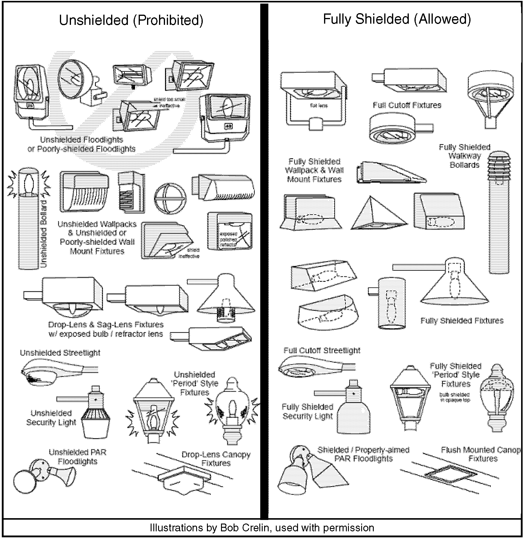
2.
Total Exterior Light Output. Total exterior light output for light fixtures on a site shall not exceed the limits shown in the table below.
a.
These lumen limits are upper limits and not a design goal; the design goal should be the lowest levels of lighting possible.
b.
Individuals with visual impairments and organizations that primarily serve individuals with visual impairments (e.g., retirement communities, hospices, and hospitals) may use up to four times the illumination allowed by this Section.
3.
Light Color. Correlated color temperature of any exterior light source shall not exceed 3,000 Kelvin.
EXAMPLE:Many light bulb manufacturers include correlated color temperature on packaging. Where packaging does not indicate light color in Kelvins, it is often indicated in descriptive terms. Lights with a "cool" quality typically exceed 3,000 Kelvin in color temperature. Light bulbs that create a more "warm" tone are typically under 3,000 K.
4.
Light Trespass. No luminaire installed within Teton County limits shall create conditions of light trespass.
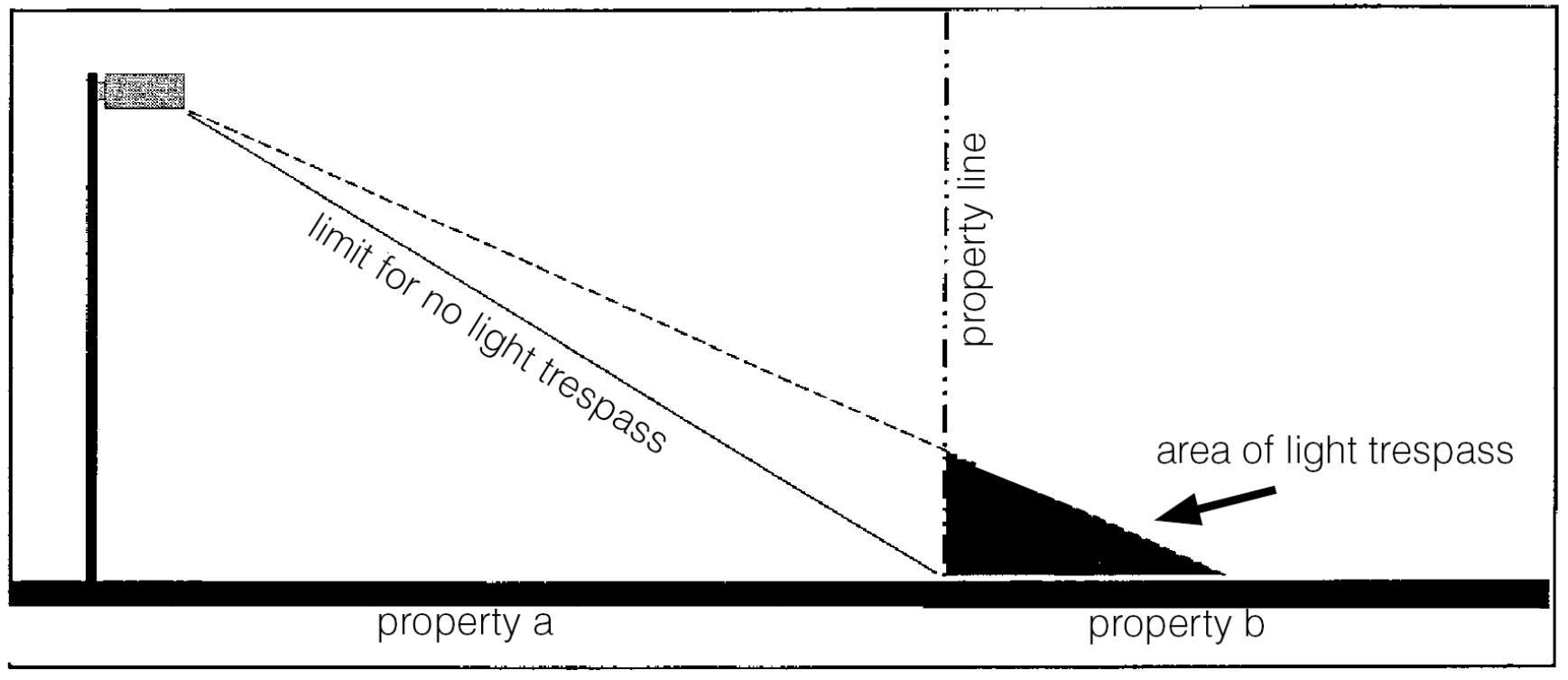
5.
Maximum Pole Height of Light Fixture.
6.
Controls. All nonresidential lighting fixtures shall employ automatic lighting controls that extinguish exterior lighting when sufficient daylight is available. Such controls include, but are not limited to: timers, wireless remote monitoring with turn on/off capabilities, photo sensitive light controls, photoelectric switches, astronomic time switches or equivalent functions from a programmable lighting controller, building automation system or lighting energy management system, all with battery or similar backup power or device.
a.
Exceptions:
i.
Lighting under canopies.
7.
Lighting Reduction. After 12:00 a.m. nonresidential sites shall extinguish or reduce their total exterior lighting by at least 30%.
a.
Exceptions:
i.
Motion activated lighting, provided that the equipment is set and maintained such that lighting is extinguished within five minutes of a triggering event.
ii.
Lighting governed by a conditional use permit in which times of operation are specifically identified.
iii.
When the exterior lighting consists of only one luminaire.
8.
Publicly Owned Lighting.
a.
Implementation. Publicly owned lighting should be implemented in a conservative manner, typically when necessary for appropriate visibility, safety, and outdoor enjoyment. Conformity with the best available technology for lighting usage should be prioritized. Excessive lighting should be avoided to the greatest extent possible.
b.
Curfew. All lighting not adaptively controlled mut be fully extinguished by 10:00 p.m., or within one hour of the end of occupancy of the structure or area to be lit, whichever is later.
c.
Adaptive Controlling. All new installations of outdoor lighting on public properties and rights-of-way must be regulated with adaptive controls such that the lighting of areas is restricted of times, places and amounts required for safe occupancy.
9.
Outdoor Sports Lighting. The following provisions shall apply exclusively to facilities built to host outdoor athletic events, such as stadiums, ball diamonds, playing fields, outdoor rinks, rodeo grounds, and tennis courts.
a.
Purpose. Field lighting shall be provided exclusively for illumination of the surface of play and adjacent viewing stands, and not for any other application, such as lighting a parking lot.
b.
Class of Play. The design and installation of lighting for outdoor sports and similar activities shall follow the illuminance and uniformity guidelines of the IES according the appropriate class of play.
c.
Shielding. Outdoor sports lighting shall be exempt from the general shielding requirement of this Section, although site plans must demonstrate that shielding is implemented to the greatest practical extent.
d.
Illuminance Levels. Illuminance levels provided by outdoor sports lighting systems shall be adjustable according to task, allowing IES-recommended values during active play as well as for lower output during other times, such as when field maintenance is being actively performed.
e.
Curfew. All outdoor sports lighting must be extinguished by 10:00 p.m. or within one hour of the end of active play, whichever is later. The outdoor sports lighting system shall be fitted with mechanical or electronic timers to prevent lights being left on accidentally overnight be enabling to be automatically extinguished.
f.
Off-Site Impacts. Impacts of outdoor sports lighting to any other properties shall be limited to the greatest practical extent possible. The maintained vertical illuminance at the property line shall not exceed one foot-candle at any time.
C.
Prohibited Lighting. The following lighting systems are prohibited from being installed or used.
1.
Flickering or Flashing Lights. No flickering or flashing lights shall be permitted.
2.
Searchlights. No searchlights, laser lights, aerial lasers, or holograms are permitted.
3.
Strings of Lights. Strings or strands of lights used to highlight a sign, perimeter of a sign, a tree or any vegetation, or any portion of a building are not permitted, except for decorative lighting displayed between October 25 and January 15.
4.
Lighting in which any single luminaire exceeds 20,000 initial lumens.
D.
Complex Uses.
1.
Complex uses such as special events, construction sites, parking structures, urban parks, theme and amusement parks, ornamental and architectural lighting of bridges, public monuments, statuary and public buildings, correctional facilities, and industrial sites all have unique requirements for nighttime visibility and often have limited hours of operation. They shall be exempted from the above standards of this Section, if the below standards are met or if their lighting has been approved via issuance of a Conditional Use Permit or Special Event Certificate of Compliance.
2.
Maximum Height. Exterior luminaires shall not exceed a maximum post height of 60 feet.
3.
Fully Shielded. Each luminaire shall be fully shielded in either its orientation or by landscaping to prohibit glare and light trespass to adjacent residential property and must be installed and maintained with minimum aiming angles of 25 degrees downward from the horizontal.
4.
Lights Extinguished. Lights shall be extinguished by 10:00 p.m. or at the conclusion of the event, whichever is later. Lighting is not allowed to remain on overnight. Such lighting shall be fitted with mechanical or electronic timers to prevent lights being left on accidentally overnight by enabling them to be automatically extinguished.
5.
Maximum Lumens. Overall site illumination for a complex use shall not exceed a total of 550,000 lumens.
(7/1/26)
(Amendment No. 2025-0002, 4-7-26)
5.3.2. - Scenic Resources Overlay (SRO) Standards.
A.
Purpose. The purpose of the Scenic Resources Overlay (SRO) is to preserve and maintain the County's most frequently viewed scenic resources that are important to both its character and economy. This is done through the establishment of several Scenic Areas within the SRO, within which the location, design, and landscaping of physical development and use is regulated to maintain and/or complement the County's important scenic resources.
B.
Establishment of the SRO. To protect important scenic resources, which are frequently seen from State highways, Spring Gulch Road, South Park Loop Road and Alta County Road, and which set an image of the rural and western ranching heritage of the County the Scenic Resources Overlay (SRO) is established.
1.
Foregrounds. The Scenic Resources Overlay (SRO) includes the foreground of the scenic areas described below. Foreground is the open area immediately adjacent to the public road that extends back to where there is either a distinct topographic change, such as the edge of a hillside or butte, or a drop in elevation toward a river bottom, or where dense vegetation screens views to areas behind the vegetation. The foreground provides the setting for views to distant mountain ranges and valley buttes.
2.
Skylines. The Scenic Resources Overlay (SRO) includes all butte and hillside skylines as viewed from state highways, Spring Gulch Road, South Park Loop Road and Alta County Road. The skyline is the visual line at which the earth or vegetation and the sky appear to meet. The skyline is typically viewed as the top of a ridge, hillside, or butte.
3.
Map of the SRO Scenic Areas. The foregrounds and skylines included in the Scenic Resources Overlay (SRO) are generally organized into the following Scenic Areas. These Scenic Areas are generally described below and mapped on the Official Zoning Map. Butte and hillside skylines as viewed from state highways, Spring Gulch Road, South Park Loop Road and Alta County Road are still included in the SRO even if they are not mapped on the Official Zoning Map or included in one of following Scenic Areas.
a.
Moose-Wilson Road Scenic Area. The Moose-Wilson Road Scenic Area extends along the eastern and western side of Moose-Wilson Road from Lake Creek to Grand Teton National Park. It is an important County-wide scenic resource because of the vistas it offers of the Teton, Gros Ventre, and Snake River mountain ranges, and of the West Gros Ventre Butte, which frames the area's broad and open meadows.
b.
Highway 22 Scenic Area. The Highway 22 Scenic Area consists of four distinct areas. They are described below.
i.
Trail Creek Ranch. The Trail Creek Ranch portion of the Highway 22 Scenic Area extends along the north and south sides of Highway 22, from the lower reaches of Teton Pass to the western edge of Wilson. It is an important County-wide scenic resource because of the panoramic views of Teton County that it provides as well as setting the western entry to Wilson, defining Wilson as a unique and special place.
ii.
Wilson Approach. The Wilson Approach portion of the Highway 22 Scenic Area extends from the eastern edge of Wilson along the north side of Highway 22 to Highway 390 and along the south side of Highway 22 to Green Lane. It is an important County-wide scenic resource because of its broad open meadows and the unobstructed views provided to surrounding mountains, which create a dramatic sense of arrival to Wilson.
iii.
Walton Ranch/Skyline Ranch. The Walton Ranch/Skyline Ranch portion of the Highway 22 Scenic Area extends along the northern and southern portion of the Highway 22 Scenic Area from the Wilson Snake River Bridge to the West Gros Ventre Butte. The Walton Ranch portion is an important County-wide scenic resource because it provides one of the most frequently experienced vistas of meadows and pasture backed by the Teton mountain range. The Skyline Ranch portion is an important County-wide scenic resource because it provides an open space setting for views to the Snake River range.
iv.
West Gros Ventre Butte/Antelope Butte. The West Gros Ventre Butte/Antelope Butte portion of the Highway 22 Scenic Area extends along both sides of Highway 22, and includes all of the West Gros Ventre Butte on the north and all of Boyles Hill, the Indian Springs, Brown and Poodle Ranches, and Antelope Butte on the south. The views encompass imposing steep sided buttes which rise abruptly from the foreground and long views across open meadows to the Snake River range on the south.
c.
Spring Gulch Road Scenic Area. The Spring Gulch Road Scenic Area extends along the eastern and western sides of Spring Gulch Road from Highway 22 to the Gros Ventre River and includes the East Gros Ventre Butte. It is an important County-wide scenic resource because it provides a combination of scenic quality and traditional western character in a location proximate to the Town.
d.
Highway 89 Scenic Area. The Highway 89 Scenic Area consists of three distinct areas. They are described below.
i.
Broadway and North Highway 89 Scenic Area. The Broadway and North Highway 89 Scenic Area extends along the western boundary of the Town of Jackson from South Park Loop road on the south to the Grand Teton National Park boundary on the north, and includes all of Boyles Hill and the East Gros Ventre Butte. Views from the public roads, including Spring Gulch Road, are of the steep sided butte in the immediate foreground which provide a backdrop to the urban development of the Town of Jackson, the flat expanses of the Elk Refuge, the pastures of Spring Gulch as well as glimpses of the Teton Range in notches of the ridgelines.
ii.
South Highway 89 Scenic Area. The South Highway 89 Scenic Area extends along the western side of South Highway 89 from the State of Wyoming Elk Feeding Area and Game Creek County Road, where the road rises to provide an initial sense of entry into the Jackson area to High School Road. The eastern side of South Highway 89 also is included for a distance of 1.3 miles south from High School Road. The northern and southern portions of the South Highway 89 Scenic Area are split to exclude the Rafter J subdivision, and the South Park Commercial zones. The South Highway 89 Scenic Area is an important County-wide scenic resource because of the powerful image it projects of the community with its exceptionally broad meadows and panoramic views to Rendezvous Bowl and the Snake River range. The meadows are dotted with existing development, including both ranch compounds and residential developments at varying densities, but the meadows' exceptional breadth and the location of the meadows below the highway preserves the open feel of the area and the background views.
iii.
Snake River Canyon Scenic Area. The Snake River Canyon Scenic Area extends along both sides of South Highway 89 from the northern South Park Bridge to the County line and encompasses those areas which are at approximately the same or a higher elevation than the highway. More specifically, this scenic area includes the western side of South Highway 89 from the northern bridge to the U.S. Forest Service boundary, land east of the Highway between the Snake River and Old Henry's Road, and land west of Hoback Junction on both sides of the Highway, but excluding Deer Creek and Palmer Creek subdivisions. The Scenic Area provides views of the Snake River, the east slopes of Munger Mountain and the Teton, Gros Ventre, Wyoming and Snake River Mountain ranges.
e.
South Park Loop Scenic Area. The South Park Loop Road Scenic Area extends along the eastern and western sides of South Park Loop Road, from the South Park Ranches subdivision to High School Road and includes Hufsmith Hill. It provides an important County-wide scenic resource because the road corridor is framed by cottonwood trees planted along irrigation ditches which line the road. The scenic quality of this area is dependent upon the preservation of the cottonwood corridor, which helps to filter views to development in the adjoining hay meadows. These meadows provide foreground settings to views of Rendezvous Bowl and the Snake River range.
f.
Hoback Canyon Scenic Area. The Hoback Canyon Scenic Area extends along both sides of Highway 191 beginning at the west line of the Gilgrease Foundation property, approximately one mile east of Hoback Junction, to the County line and encompasses those areas which are at approximately the same or a higher elevation than the highway. The scenic area provides views of the Gros Ventre and Wyoming mountain ranges and the Hoback River.
g.
Teton Canyon Scenic Area. The Teton Canyon Scenic Area extends along the south side of Alta Road from Lake Nolo to the boundary with the Targhee National Forest. It is an important County-wide scenic resource because the broad, open meadow of its foreground is framed by a dense vegetative border, which provides the setting for vistas to the west side of the Teton range. The entire Teton Canyon Scenic Area also establishes a segment of the entry image for visitors driving or biking through Alta to Grand Targhee Resort.
h.
Buffalo Valley Scenic Area. The Buffalo Valley Scenic Area extends along the northern and southern sides of US 26/287 from Moran to the Blackrock ranger station. It is an important County-wide scenic resource because it provides a classic mountain valley setting framed by the Teton range. The Buffalo Valley Scenic Area provides monumental views of the entire Teton range, as viewed across very broad, open meadows dotted with small ranch buildings. These vistas foreshadow the views which are again encountered within Grand Teton National Park, thereby integrating the Buffalo Valley Scenic Area with the image of the National Park.
C.
Findings for the SRO.
1.
An essential component of the physical environment for which Teton County is internationally known is the scenic vistas of jagged mountains rising from broad, open meadows, which set an image of the County's rural and western ranching heritage. These scenic resources are important to both the County and Town because they serve as a cornerstone to the local economy by attracting tourists and other visitors. The scenic resources which are instrumental in the creation of the County's unique character are the vistas to the Teton, Gros Ventre, Wyoming and Snake River mountain ranges that are frequently seen by residents and travelers across wide pastures and meadows from the major public roads that enter the Town of Jackson, Wilson, Grand Teton National Park, Teton Village, Alta, and Teton Pass.
D.
Applicability.
1.
Foreground Standards. All physical development, use, development options, and subdivision within the foreground of the Scenic Areas described above shall comply with the foreground standards of Section 5.3.2(G).
2.
Development in Skyline. All physical development, use, development options, and subdivision within the Skyline of the SRO shall comply with the skyline standards of Section 5.3.2(H).
3.
Exemptions:
a.
NC-TC, NR-1, and R-3 Zone. All physical development, use, and development options, except new subdivisions, within the NC-TC, NR-1, and R-3 zone, shall be exempt from the foreground standards of Section 5.3.2(G).
b.
Remodeling or Expansion of Existing Structures. Remodeling or expansion of structures that existed prior to May 9, 1994, shall be exempt from the foreground standards of Section 5.3.2(G).
c.
Agricultural Operations. Agricultural operations and uses meeting the standards for exemption in Section 6.1.3(B) shall be exempt from all standards of this Section.
d.
Land in Conservation Easement. Land protected by a conservation easement where proposed development density is equal to or less than one house per 70 acres and the total acreage subject to the easement is 320 acres or more, shall be exempt from the foreground standards of Section 5.3.2(G).
E.
Impact on SRO.
1.
The base site area shall not be reduced because a portion of a lot of record is located within the SRO.
2.
When conflicts exist between the NRO and SRO, the standards of Section 5.2.1 shall have priority and be achieved to the maximum extent practicable. The requirements of this Section shall receive second priority.
F.
Visual Resource Analysis.
1.
If a proposed physical development, use, development option, or subdivision is in the SRO, the application shall contain a visual analysis narrative, provide a photographic simulation or other comparable visual analysis of the proposed development, depict the boundaries of the SRO, compare the visual impacts of alternative site designs, if any, and include plans identifying how the proposal complies with the standards of this Section.
2.
A visual resource analysis shall demonstrate and document for review the visual impact of the proposed development on surrounding designated scenic corridors and viewpoints. The analysis shall show, in accurate perspective format, what portions of the proposed development are visible from various points along the scenic corridor or from critical viewpoints. Multiple perspectives may be required along scenic corridors to accurately reflect the appearance of the development as the viewpoint is moved along the corridor.
3.
For development which is shown to be visible from the designated corridors or viewpoints, the analysis shall demonstrate, in accurate perspective format, the measures proposed to blend the development into the context of the setting. The setting shall include the view frame of the picture when viewing the development from a particular viewpoint and will typically include the backdrop of natural topography, existing vegetation as well as surrounding vegetation and structures. Development features which shall be shown to be compatible with the setting include: bulk and scale of buildings, building and roof forms, texture of materials used on the buildings, colors, and proposed plantings for screening.
G.
Foreground Standards. All physical development, use, development options, and subdivision within the foreground of the Scenic Areas described above shall comply with the following standards.
1.
General Location of Structures. Physical development, use, development options, and subdivision in the foreground shall be sited in one or a combination of the following locations: (1) at the rear edge of the foreground at the back of an open meadow or pasture; (2) at the side edges of the foreground where there is an open meadow or pasture; (3) behind an existing stand of vegetation; (4) behind or built into a change in natural topography; or (5) within a pasture or meadow, clustered in the form of a ranch compound, or adjacent to or integrated into an existing ranch compound. Standards for each of these locations are as follows.
a.
Rear Edge of Foreground Behind Meadow or Pasture. When located at the rear of the foreground at the back of an open meadow or pasture, the physical development, use, development options, and subdivision shall comply with the following standards.
i.
Distance. It shall be located at the greatest possible distance from the major public road and, where applicable, it shall be located adjacent to existing development.
ii.
Edge of Meadow or Pasture. It shall be located along the rear edge of the meadow or pasture, where the meadow or pasture meets the toe of the hillside, or on a relatively less steep, lower hillside area behind the meadow.
iii.
Separate Areas. It shall be located so as to separate areas of physical development or use from natural areas and pastures and to preserve open space in the largest continuous pieces possible.
iv.
Supplementary Vegetation. Where it is located within 1,320 feet of a State Highway or County designated scenic road, native vegetation shall be planted to mimic either the existing species composition and pattern of growth or, traditional farm and ranchstead planting patterns of the American west. To accomplish these goals the Planning Director will be at liberty to vary the requirements of Section 5.5.3(E). As with all proposed planting in Teton County, applicants are strongly advised to use endemic plant materials and consider their relative attractiveness to wildlife.
b.
Side Edges of the Foreground Where There Is an Open Meadow or Pasture. When a physical development, use, development option, or subdivision is located at the side edges of the foreground where there is an open meadow or pasture, it shall comply with the following standards.
i.
Separate Areas. It shall be located so as to separate areas of physical development or use from natural areas and pastures and to preserve open space in the largest continuous pieces possible.
ii.
Supplementary Vegetation. Where it is located within 1,320 feet of a State Highway or County designated scenic road, native vegetation shall be planted to mimic either the existing species composition and pattern of growth or, traditional farm and ranchstead planting patterns of the American west. To accomplish these goals the Planning Director will be at liberty to vary the requirements of Section 5.5.3(E). As with all proposed planting in Teton County, applicants are strongly advised to use endemic plant materials and consider their relative attractiveness to wildlife.
c.
Behind Existing Stand of Vegetation. When located in the foreground behind an existing stand of vegetation, including vegetation which has grown naturally on the site and vegetation planted as an agricultural wind row, the physical development, use, development option, or subdivision shall comply with the following standards.
i.
Scale. The scale of the physical development, use, development option, or subdivision shall not interrupt or obscure the existing occurring stand of vegetation behind which it is located.
ii.
Supplementary Vegetation. Where natural vegetation does not adequately screen the physical development, use, development option, or subdivision as determined by the visual analysis, native vegetation shall be planted to augment the existing vegetation and maintain the visual integrity of the view shed.
iii.
Preservation of Existing Vegetation. Existing vegetation shall be preserved to the maximum extent practicable.
d.
Behind or Built into Natural Topographic Break. When located in the foreground behind a natural topographic break or built into the natural topography in an earth-sheltered design, physical development, use, development option, or subdivision shall comply with the following standards.
i.
Scale. Scale and height shall be subordinate to the natural change in topography.
ii.
Earth Moving. Earth moving may be used to the minimum extent necessary to extend a naturally occurring topographic change and screen the physical development, use, development option, or subdivision, but not to create a new, man-made landform.
e.
Ranch Compound Within Irrigated Pasture or Meadows. When physical development, use, development option, or subdivision is located within an irrigated pasture or meadow in the form of a ranch compound or adjacent to or integrated into an existing ranch compound, it shall comply with the following standards.
i.
Not Preclude View of Designated Vistas. It shall not entirely preclude views from the public road to the rear portions of the foreground.
ii.
Clustered Design. It shall consist of a cluster design.
iii.
Vegetation. Native vegetation shall be planted to mimic either the existing species composition and pattern of growth or, traditional farm and ranchstead planting patterns of the American west. To accomplish these goals the Planning Director will be at liberty to vary the requirements of Section 5.5.3(E). As with all proposed planting in Teton County, applicants are strongly advised to use endemic plant materials and consider their relative attractiveness to wildlife.
2.
Exceptions to General Location of Structures. If it is demonstrated that the maximum amount of density/intensity allowed for the land has been located pursuant to the general location of structures standards above, the remaining density/intensity allowed for the land shall be located at other locations, subject to the following standards:
a.
Along Front Edge of Meadow or Pasture. To the extent practicable, it shall be located along the front edge of the meadow or pasture. To the extent possible, it should be located in proximity to similarly situated development on adjacent lands.
b.
Maintain Contiguous Open Space. It shall be located so as to maintain the largest amount of contiguous open space practicable, in relation to the scenic view being regulated.
c.
Screening. The physical development, use, development option, or subdivision shall be screened with native vegetation planted to mimic either the existing species composition and pattern of growth or, traditional farm and ranchstead planting patterns of the American west. To accomplish these goals the Planning Director will be at liberty to vary the requirements of Section 5.5.3(E). As with all proposed planting in Teton County, applicants are strongly advised to use endemic plant materials and consider their relative attractiveness to wildlife.
3.
Exterior of Structures.
a.
Earth Tone Materials. The exterior of all physical development, except that located and designed in the form of a ranch compound, shall be built or painted with indigenous earth tone materials.
b.
Traditional Ranch Colors. The exterior of a ranch compound shall be built or painted with indigenous earth tone materials, or shall be painted or stained using local, traditional ranch colors, which shall include shades of red or brown. Paints or stains which simulate weathered barn wood also shall be permitted.
4.
Roof Materials.
a.
Color that of Surrounding Natural Features. The color of all roofs shall be similar to the colors of surrounding vegetation or land features.
b.
Treat Reflective Materials. Reflective roof materials shall not be used, unless the materials are treated to eliminate reflection.
5.
Earth Moving and Berms.
a.
Earth Moving for Earth Sheltering. The creation of man-made land forms is prohibited in the foreground, except that earth moving may be used in the design of a structure located along a hillside, to the extent it is necessary to create an earth sheltered design, built into and mimicking the natural topography of the land.
b.
Berms. Berms may be used to screen structures located within a meadow or pasture provided the side of the berm exposed to critical views from designated scenic roads is no steeper than 20 (horizontal) : 1 (vertical). Berms may be used to screen structures located in undulating terrain provided the berm meets the standards of Section 5.1.6 and is designed to appear as a naturally occurring extension of the existing topography. Berms must be planted to replicate the surrounding plant communities.
c.
Revegetation of Disturbed Areas. Lands disturbed by earth moving or berms shall be revegetated using native species which are already growing on or near the site. Top soil shall be stock piled and placed on disturbed areas. Irrigation shall be provided to the revegetated areas if it is necessary to ensure survival of native species planted.
6.
Roads and Driveways.
a.
Avoid Dividing Meadows and Pastures. To the maximum extent practicable, roads and driveways shall be located to skirt the edge of and avoid dividing meadows and pastures. Roads and driveways shall take advantage of the screening potential of natural topography and existing vegetation. Existing roads and driveways shall be used where practical. To enhance screening, ditches may be dug parallel to roads or driveways, and a row of cottonwood trees may be planted along the roads or driveways.
b.
Soft Edges. To the maximum extent practicable, roads and driveways located around the edge of or in meadows shall be laid out with soft, curving edges and shall avoid straight line corridors which are incongruous with the natural setting.
H.
Skyline Standards. The following standards shall apply to physical development, use, development options, and subdivisions within the Skyline of all buttes and hillsides viewed from state highways, Spring Gulch Road, South Park Loop Road and Alta County Road.
1.
Skyline Penetration Prohibited. Physical development shall not penetrate the Skyline on buttes and hillsides, as viewed from State highways, Spring Gulch Road, South Park Loop Road and Alta County, except in the case of an existing lot of record where there is no other siting alternative that complies with the standards of these LDRs.
2.
Mitigation of Necessary Skyline Penetration. In the case of an existing lot of record where no other siting alternative is available that complies with the standards of these LDRs, physical development may penetrate the Skyline on hillsides and buttes by complying with the following standards.
a.
Pursue Variation of Regulations First. Attempts shall first be made to obtain variance of other regulations, such as setbacks, that would enable the proposed physical development to comply with the skyline penetration prohibition.
b.
Height. The height of physical development shall not exceed 20 feet above original grade.
c.
Mass. The mass of the physical development shall be designed so as to be broken into distinct, smaller forms, which may involve repeating similar forms at a more modest scale, breaking facades and roof lines into smaller segments, or stepping the building mass into the hillside. To the maximum extent practicable, buildings shall be placed down the hill or cut into the slope to minimize the skyline penetration.
d.
Form. The form of the physical development, particularly its roof form, shall re-create the natural form of the hillside or butte. If the natural form of a butte top Skyline that is being penetrated is flat, the building shall have a flat roof form. If the natural form of a hillside Skyline is rounded or jagged, the building shall use a hipped or similar roof form.
e.
Exterior of Structure. The exterior of all physical development shall be built or painted with earth tone materials or colors.
f.
Roof Materials. The color of all roofs shall be the color of surrounding vegetation or land features. Reflective roof materials shall not be used, unless the materials are treated to eliminate reflection.
g.
Earth Moving. Physical development shall minimize the need for earth moving or disturbance to the maximum extent practicable. Earth moving on a slope to create a flat platform on which development is placed shall be prohibited. Areas disturbed for earth moving shall be revegetated using native species which are already growing on or near the site. Topsoil shall be stock piled and placed on disturbed areas. Provision shall be made for irrigation, if it is necessary to ensure survival of the indigenous species planted.
h.
Landscape Screening. Physical development shall be located so as to preserve, to the maximum extent practicable, existing vegetation which may help to screen its appearance. Native species shall be planted to supplement existing vegetation. Native species shall be selected from "Landscape Plant Material from the Teton County Area," a copy of which is available at the Planning Department. Native species shall be planted so as to screen at least 50% of the physical development within three years of its occupancy, as measured during the summer.
(5/3/21)
5.4.1. - Steep Slopes.
A.
Slopes in Excess of 30%. No physical development shall be permitted on natural slopes in excess of 30%.
B.
Exceptions:
1.
Manmade Slopes. Physical development on manmade slopes is permitted, provided that the proposed finish grade complies with all other applicable standards of these LDRs.
2.
Small Slopes. Physical development of isolated slopes that cover less than 1,000 square feet and have less than ten feet of elevation change is permitted.
3.
Essential Access. Physical development of steep slopes is permitted to provide essential access for vehicles and/or utilities when no other alternative access exists. Where no alternative access is available, impact to the steep slope shall be minimized. There shall be consideration of alternative development sites to reduce the linear impact of the driveway, road and/or utility access. Where retaining walls are necessary to provide essential access, compliance with Section 5.1.7 is also required.
(5/1/25)
5.4.2. - Unstable Soils.
No physical development, use, development option, or subdivision shall be permitted on unstable soil as determined by the County Engineer except under the following conditions:
A.
Potential for Movement Only in Shallow Surface Area that Can Be Controlled. When the potential for soil movement is only in a shallow surface area and risk to the physical development can be prevented with appropriate anchoring to a solid substrate; or
B.
Instability Limited. The instability is limited to localized slumpage at cuts or foundations and appropriate revegetation, drainage, and structural devices can prevent increased instability; and
C.
Not in an Avalanche Chute. The proposed developed area is not in an avalanche chute.
(1/1/15)
5.4.3. - Faults.
A.
Comply with Building Code for Seismic Zone 3. All structures shall comply with the currently adopted Building Code for Seismic Zone 3. The County Engineer may require a report from a geotechnical engineer registered in the State of Wyoming if the proposed physical development is within 200 feet of a fault line and the County Engineer considers that the proposed physical development creates a dangerous situation.
B.
Notification on Development Plan/Final Plat. On lots of record where a fault line exists according to fault line maps for the area, a note shall be placed on all development plans and plats stating that a Seismic Zone 3 fault line potentially subject to movement exists on the lot of record.
(1/1/15)
5.4.4. - Floodplains.
All physical development within the floodplain shall comply with the Teton County Floodplain Management Resolution. In the event of a discrepancy in regulation between the Floodplain Management Resolution and these LDRs, the more stringent regulation shall control.
(1/1/15)
5.4.5. - Wildland Urban Interface.
See the Teton County Fire Protection Resolution for wildland urban interface design standards that apply to physical development, use, development options, and subdivision as defined by these LDRs.
(1/1/15)
5.5.1. - Purpose.
A.
General Purpose. The purpose of these landscaping standards is to assist in maintaining the character of the zones by providing minimum planting, buffering, and screening around and within physical development. Landscape surface area and/or plant units are required for both residential and nonresidential use based upon the zone in which the use is located.
(1/1/15)
5.5.2. - Landscape Plan.
A.
General. A landscape plan shall be submitted for review, along with the appropriate application for a physical development permit for all physical development except:
1.
Detached Single-Family Units. Detached single-family units shall be exempted from the provisions of this Section, but shall be landscaped in accordance with the remaining standards of this Division.
2.
Administrative Permit. The Planning Director may exempt building permit, grading permit, basic use permit, and minor development plan applications from the provisions of this Section, if sufficient information demonstrating compliance with the provisions of this Division is provided in a landscaping statement.
B.
Standards. The landscape plan shall comply with the following standards.
1.
Landscape Architect Required. A landscape plan shall be prepared by a landscape architect registered in the State of Wyoming.
2.
Approval and Bond Required. Prior to issuance of any physical development permit that requires a landscape plan, a performance bond for completion of the approved landscape plan shall be submitted to the Planning Director pursuant to Section 8.2.11.
C.
Requirements of Landscape Plan. The landscape plan shall include the following elements.
1.
Mapping of Existing Vegetation. A map identifying all deciduous trees of three inches in caliper or greater, and all coniferous trees of three inches in caliper or greater, within an area proposed for clearing and within 25 feet of any area to be cleared. In addition, all trees or shrubs proposed to be retained and counted towards complying with the landscaping standards of this Division shall be mapped. This mapping requirement may be combined with the mapping completed pursuant to Section 8.2.2.
2.
Calculation to Determine Required Landscaping. A summary of all calculations used to determine the total amount of landscaping required.
3.
Plant Schedule. A plant schedule, identifying symbols, quantity, size, and type of all proposed landscaping and existing vegetation that is proposed for credit.
4.
Planting Plan. The planting plan shall indicate the location of all proposed landscaping and existing landscaping that is proposed for credit.
5.
Irrigation Statement. An irrigation statement describing how plant material will be irrigated for a minimum two-year period or until plant establishment.
6.
Erosion Control. A description of how erosion is to be controlled on-site, both permanently and during construction.
7.
Cost Estimates. Cost estimates to implement the landscape plan.
(1/1/15)
5.5.3. - Required Plant Units.
A.
General.
1.
Sum of All Requirements. The plant units required shall be the sum of all of the plant units prescribed by the standards of this Section.
EXAMPLE:A nonresidential development with a parking lot shall provide the plant units required for the nonresidential development and the plant units required for the parking lot.
2.
Measurement. One plant unit shall be the minimum amount provided by any development; fractional plant units of one-half or more shall be treated as a requirement of one plant unit.
3.
Credit for Existing Vegetation. Retention of existing vegetation is encouraged. Any retained existing plant material which satisfies, or with five years of growth would satisfy, the required plant units shall be counted towards satisfying the required plant units.
B.
Requirements.
1.
Use or development of a site shall require provision of the following number of plant units.
2.
Location of Plant Units in Single-Family Subdivisions. For residential development within single-family subdivisions, the plant unit required per dwelling unit shall be located on each lot of record.
C.
Parking Lot Requirements.
1.
General. All parking lots shall comply with the plant unit requirements in the table below.
2.
Existing Trees Can Be Counted. Existing trees that can be preserved by leaving the area under their canopy substantially undisturbed shall count towards the plant unit requirement for parking lots.
3.
Landscape Objectives. The primary objectives of parking lot plant units shall be:
a.
To avoid large, unbroken expanses of asphalt;
b.
To screen or soften parked vehicles as viewed from off site;
c.
To provide attractive, pleasing streetscapes; and
d.
To better define and organize vehicular and pedestrian spaces.
D.
Loading Area Requirement. Two plant units per loading bay shall be provided.
E.
Standard Plant Unit. This Section describes a standard landscaping element called a "plant unit." It serves as a basic measure of plant material.
1.
Standard Plant Units. Three standard plant unit alternatives are identified in the table below. Any one or a combination of the alternatives may be used. Some of the alternatives, however, may be required upon review of the proposed landscape plan.
EXAMPLE:Where year-round screening is needed, Alternative C may be required. Plant sizes given are minimums. All plant units shall be in scale with the development proposed, and shall be of adequate installed size to clearly achieve the purpose of the required plant units (e.g., screening, buffering, softening of structural mass, community character enhancement).
2.
Plant Guidelines. The following plant types are provided as guidelines:
a.
3-Inch Caliper Canopy Tree - Cottonwood or Aspen.
b.
6 to 8-Foot Large Shrub or Multi-Stem Trees - Chokecherry or Amur Maple.
c.
#5 Container Shrub - Dogwood or Willow.
d.
8-Foot Evergreen - Spruce.
3.
Alternative to Standard Plant Units. The Planning Director may relieve an applicant from the standard plant units pursuant to Section 8.8.1 if it can be demonstrated that:
a.
The design intent of the proposed project is compromised by the use of the standard plant units; and
b.
The alternative proposed meets the objectives of softening and integrating the project into the existing landscape.
4.
Substitutions for Standard Plant Units. The following substitutions in plant units may be made where it is demonstrated that the substitution achieves the objectives of the standard plant unit for which it is being substituted; or the objectives of the requirement are achieved but additional plant units are required.
a.
Movable Planters. Ten square feet of permanent or movable planters containing flowers, flowering shrubs or similar vegetation may be substituted for four #5 container shrubs. Notwithstanding, moveable planters shall not be substituted for required landscaping in parking lots.
b.
Bench. One bench seating at least two people, or a similar seating arrangement, may be substituted for one canopy tree.
c.
Bike Rack. One bike rack designed to accommodate at least six bikes may be substituted for one canopy tree.
(4/19/2022)
5.5.4. - General Landscaping Standards.
A.
Vegetation Required. All landscaped areas proposed for vegetation shall be planted with lawn, pasture, or native groundcover unless such vegetation is already fully established. Once landscaped, landscape areas shall be maintained to support plant life.
B.
Plant Materials.
1.
Approved Plant Material. Plant material shall not be invasive as designated by the noxious weeds and pests list maintained by the Teton County Weed and Pest Control District and shall not be a noxious weed that appears on the designated list under the Wyoming Weed and Pest Control Act of 1973.
a.
Wyoming Seed Law. All seed used for site revegetation or restoration must be used in accordance with Wyo. Stat. §§ 11-12-101—11-12-125, certified as weed free, and acquired through a dealer licensed by the Wyoming Department of Agriculture.
b.
Wyoming Nursery Stock Law. All nursery stock used for site revegetation or restoration must be used in accordance with Wyo. Stat. §§ 11-9-101—11-9-109, accompanied by a valid health certificate, and acquired through a dealer licensed by the Wyoming Department of Agriculture.
2.
Native Vegetation. Native groundcover shall be used beyond 200 feet of a building. All plant material should be native vegetation, which duplicates adjacent plant communities both in species composition and spatial distribution patterns.
EXAMPLE:Landscaping placed on a hillside or slope should consist of plant material that is typically found on a similar hillside or slope. Similarly, landscaping plant material placed in a floodplain or drainageway should be native vegetation that is generally found in a similar floodplain or drainageway. Further, the use of native vegetation should acknowledge the relative attractiveness of certain plant species to wildlife. Responsive planting designs should therefore position plants, which are palatable to wildlife in areas where browsing damage will not affect the screening or ornamental qualities of the planting plan.
C.
Removal of Existing Vegetation Prohibited. Removal of specimen trees of three-inch caliper or greater, and removal of shrub stands and rows with an average height of three feet or greater is prohibited in the AC-TC, AR-TC, PRD, MHP-TC, OP-TC, BP-TC, BC-TC, and S zones except in accordance with an approved landscape plan. Removal of dead, diseased, or damaged trees and shrubs which are a potential hazard to life and property may be approved by the Planning Director. In addition, vegetation may be removed to meet fuel reduction mitigation measures required by the Fire Marshal.
D.
Use of Landscaped Areas. No portion of a site required to be landscaped shall be used for the parking of vehicles or for open storage of any kind.
E.
Open Space Standards. All areas of required open space that are presently covered with natural vegetation and are to remain undisturbed shall not be required to be landscaped. Areas of open space that have been disturbed, except those to be used as sports fields and other areas that are to be paved, must be restored to prior conditions, as much as feasible. In addition, adequate ground cover shall be provided so that no landscaped ground areas are exposed to erosion. Noxious weeds appearing on the designated list under the Wyoming Weed and Pest Control Act of 1973 shall be controlled.
(1/1/17)
5.5.5. - Installation and Maintenance.
A.
Irrigation. Landscape surface areas and plant units that cannot naturally be provided with adequate moisture for the types of plants installed shall be equipped with an irrigation system.
B.
Phasing. Landscape plans and the installation of required plant materials may be phased consistent with the development phasing approved for a project.
C.
Required Time for Completion. All landscaping shall be in place prior to occupancy. The Planning Director may allow occupancy without required landscaping in place if the landscaping will be in place within one year. In such cases the Planning Director may require submittal of a bond or other financial surety pursuant to Section 8.2.11 for installation of the landscaping.
D.
Maintenance. All landscaping required by these LDRs shall be maintained. Maintenance shall include control of those noxious weeds that appear on the designated list under the Wyoming Weed and Pest Control Act of 1973. Maintenance shall be the responsibility of the landowner, and shall be carried out regularly so that the intent and integrity of the required landscaping is preserved. If any plant materials die or are damaged, they shall be replaced by the landowner.
(1/1/15)
5.6.1. - Town Sign Standards.
Section number reserved, standards only apply in Town.
(1/1/15)
5.6.2. - County Sign Standards.
A.
Purpose. The purpose of this Section is to allow for the reasonable display of signage to identify and advertise products, services, and business establishments for the information and convenience of the general public. This Section sets forth standards and criteria for the fabrication, erection, and use of signs, symbols, markings, and other advertising devices in Teton County. These standards and criteria are designed to protect and promote the public health, safety, and general welfare of persons within the community. They are also designed to aid in the development and promotion of business and industry by providing sign regulations which encourage aesthetic creativity, effectiveness, and flexibility in the display and use of signs, while protecting and enhancing community character as described in the Jackson/Teton County Comprehensive Plan.
B.
Applicability.
1.
Sign Permit. No person shall erect, alter, or relocate any sign without first obtaining a Sign Permit and meeting the standards set forth in this Section. Signs conforming to the requirements of this Section which identify a seasonal business may be removed for the seasons during which the business is not in operation, and may be reinstalled without a new sign permit.
2.
Maintenance and Repainting Exempt. The repainting, changing of parts, and maintenance of signs located on the site shall not be deemed alterations requiring a Sign Permit, except for nonconforming signs as set forth in Section 1.9.5.
3.
Exempted Signs. The following signs are not regulated by this Section and do not require a Sign Permit:
a.
Traffic Signs. All signs erected in a public right-of-way by a public agency or in a private road right-of-way for controlling or directing traffic.
b.
Political Signs.
c.
Time and Temperature Signs. The moving or changing portion of time and/or temperature signs allowed pursuant to Subsection C.3.c, providing they are kept in good repair at all times and providing that any sign containing such features conforms with all other requirements of this Code.
d.
Governmental Flags. Official governmental flags of the United States, State of Wyoming, the County, or the Town and which are properly displayed, provided they do not exceed 20 square feet each, and further provided they are not mounted on a roof or atop other signs. One corporate flag may be displayed along with a proper display of any or all of the official flags listed in this paragraph, provided it does not exceed 20 square feet. Flags may be illuminated provided that such lighting is shielded and directed downward from the top of the flagpole and that does not exceed 75 lumens per linear foot of pole height above grade or does not exceed 100 lumens per square foot of flag surface when unfolded, whichever is less.
e.
Private Warning Signs. Private warning signs provided they do not exceed three square feet and comply with the lighting provisions in Subsection F.3.c.
f.
Signs on Vehicles. Signs in or upon a vehicle, provided the vehicle is not left standing in conspicuous places and used primarily as an advertising device.
g.
Construction Signs. Construction signs announcing the construction of a building or project naming owners, contractors, subcontractors and architects not to exceed one sign of 24 square feet for each street frontage of the building or project and shall not be illuminated.
h.
Historical Signs. Historical signs for sites and/or structures designated by the Board of County Commissioners as having historical significance to the County, provided that they are not illuminated.
i.
Guidance Signs. Guidance and other informational signs authorized by the Wyoming Department of Transportation or other governmental agency.
j.
Business Signs. No more than one Open/Closed and one Vacancy/No Vacancy sign, one hours of operation sign, and one credit card acceptance sign, not to exceed a total of three square feet in area, displayed for each business. Open/Closed and Vacancy/No Vacancy signs may be illuminated only during necessary and usual business hours. Hotels and other lodging facilities may illuminate these signs through the night, as well as gas stations and other businesses that rely on over-night signage to communicate with passersby about being open. Other business signs shall not be illuminated.
k.
Noncommercial Signs. Signs that contain noncommercial messages that do not advertise a product or service, provided they do not exceed 20 square feet in area and are not illuminated.
l.
Statuary and Sculptures. Freestanding statuary and sculptures which are considered to be works of art and which are placed on private property clearly for the benefit and interest of the general public. Statuary and sculpture may be illuminated subject to the condition in Subsection F.3.c.
m.
Mural. Murals when depicted on the sides or rear of a building or storefront, provided that the mural has no connection or advertising context to any business conducted or any product or service offered therein. Murals may be illuminated subject to the conditions in Subsection F.3.c.
n.
Real Estate Signs. Signs of real estate companies or private individuals announcing a property for sale, rent, or lease, provided that no such sign exceeds six square feet, and shall not be illuminated, and that only one sign per property per street frontage is displayed.
o.
Gate or Arch Sign. A gate or arch sign situated over the primary entry of a subdivision or agricultural operation in the R-1, R-2, or R-TC; provided that the sign face does not exceed eight square feet and that the sign provides a clearance of at least 13.5 feet from the driving surface. Gate and arch signs may be illuminated subject tot he conditions in Subsection F.3.c.
p.
Minor Residential Signs. Wall signs not to exceed one square foot in area that identify the occupants or owners of a residential property. Larger residential signs shall comply with the provisions of this Division.
q.
Be Bear Aware Signs. Signs cautioning proper storage of attractants, garbage, etc., for the purpose of raising awareness and maintaining human safety in areas possessing moderate and high risks of bear conflicts.
r.
Posted Notice. Notice of a meeting or hearing that meets the standards of Section 8.2.14(C.4).
C.
Allowable Signage.
1.
Allowable Signage by Zone.
a.
R-TC Zone.
i.
Nonresidential Uses. Each freestanding nonresidential building or complex of buildings is allowed one rustic freestanding sign, not to exceed 16 square feet in area or ten feet in height.
ii.
Residential Uses. One unlighted rustic freestanding sign not to exceed four feet in height; or, one unlighted wall sign, neither of which may exceed four square feet in area, identifying the owner and/or the name of the property is allowed.
iii.
Home Occupations/Businesses. One unlighted wall sign, which may not exceed two square feet, identifying legal home occupations shall be allowed.
b.
S-TC and NC-TC Zones.
i.
Nonresidential Uses. Each freestanding building or complex of buildings is allowed one rustic freestanding sign not to exceed six feet in height and 12 square feet in area, or, one wall sign not to exceed 12 square feet in area.
ii.
Residential Uses.
a)
Three Acres or More. For a residential use on a lot of record of three acres or more, one unlighted rustic freestanding sign not to exceed four feet in height and four square feet in area; or, one unlighted wall sign, not to exceed four square feet in area, identifying the owner and/or name of the property is allowed.
b)
Less than Three Acres. For a residential use on a lot of record less than three acres, one unlighted wall sign identifying the name of the owner and/or property, not to exceed three square feet, is allowed.
iii.
Home Occupations/Businesses. One unlighted wall sign not to exceed two square feet, is allowed.
c.
Auto Urban Residential-County (AR-TC), Auto Urban Commercial-County (AC-TC), Wilson Commercial (WC), Business Park-County (BP-TC), Office Professional-County (OP-TC), and Business Conservation-County (BC-TC).
i.
Nonresidential Uses. For nonresidential uses in the AR-TC, AC-TC, WC, BP-TC, OP-TC, and BC-TC zones, signage is permitted according to the following standards.
a)
Freestanding Signs. Each freestanding building or complex of buildings is allowed one rustic freestanding sign at the primary entrance or street frontage, not to exceed eight feet in height. The maximum area of the sign shall be one square foot for each linear foot of building facing the street, not to exceed 40 square feet.
b)
Wall Signs. Each freestanding building or storefront is allowed one wall sign per street frontage which shall not exceed one square foot per two linear feet of building facing the street, to a maximum area of 24 square feet per sign.
c)
Monument or Entry Sign. Each freestanding building or complex, having a primary or secondary entry from a street other than the street which it faces, shall be allowed one entry sign per entrance, not to exceed four feet in height, nor six square feet in area.
ii.
Residential Uses.
a)
Less than Eight Units. One unlighted wall sign identifying the name of the owner and/or property, not to exceed three square feet is permitted.
b)
Eight Units or More. One rustic freestanding project identification sign not to exceed six feet in height and six square feet in area; or, one wall sign not to exceed six square feet in area is permitted.
iii.
Home Occupations/Businesses. One unlighted wall sign not to exceed two square feet in area is allowed.
2.
Window Signs. Signs displayed in windows of buildings or storefronts are permitted. The number of signs and their total area does not count toward the total allowable signage per zone, nor is a Sign Permit required for their display, provided the following standards are met:
a.
Size Limit. Window signage may occupy no more than 25% of the area of the window in which it is displayed. In no event shall window signage exceed 16 square feet in any one window.
b.
Prohibited Features of Window Signs. No window sign, or any other sign within a building or structure, shall flash, rotate, or be mechanically or electronically animated in any way so as to be visible from outside of the building or structure.
3.
Special Purpose Signs.
a.
Changeable Copy Signs.
i.
Reader-board or changeable copy signs are permitted to be displayed by the following types of businesses.
a)
Theaters. Motion picture theaters and play-houses.
b)
Convention Facilities with Liquor Licenses. Businesses with convention facilities, and which qualify for resort liquor licenses under the Statutes of the State of Wyoming.
c)
Fuel Stations. Businesses which sell motor fuels at retail dispensed from pumps on premises.
ii.
Changeable copy signs may be either freestanding signs or wall signs, as permitted in the zone. The area of any changeable copy sign in its entirety shall conform to the allowable signage for the zone. Only one changeable copy sign per eligible business establishment is permitted.
iii.
Except for fuel stations, changeable copy signs shall not be illuminated. Changeable copy signs at fuel stations shall use only internal illumination methods and they shall advertise only the prices of fuels dispensed. Luminance levels of such signs shall not exceed 100 nits.
b.
Movie Poster Signs. Motion picture theaters and retail stores whose primary business is the sale and/or rental of pre-recorded video tape and/or discs to the general public shall be permitted to display a maximum of two movie poster signs. Movie posters must be displayed in a display case which must be permanently affixed to the wall of the building or storefront. Movie posters shall not be affixed directly to a wall as a temporary sign. Movie poster display cases may be lighted, and shall not exceed 12 square feet in area. The area of any movie poster sign conforming to this Section shall not count toward the total signage allowed by zone.
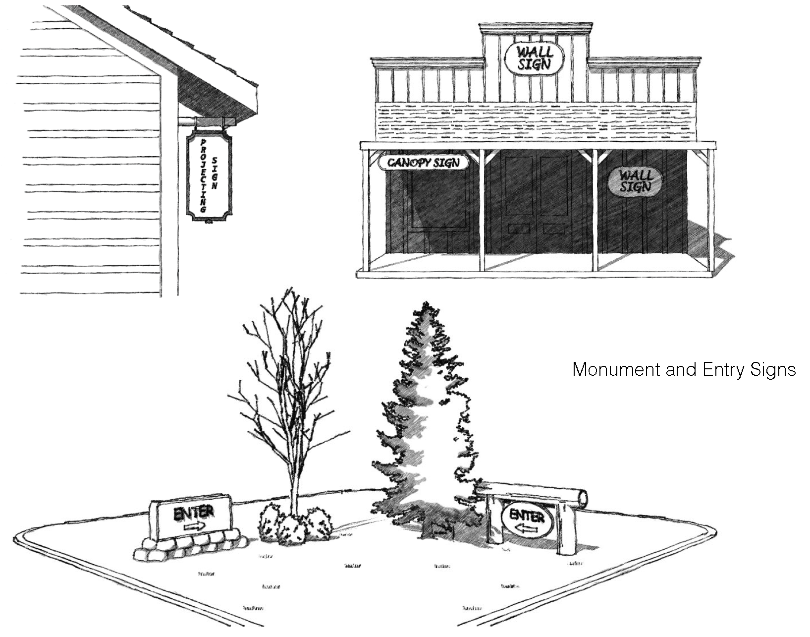
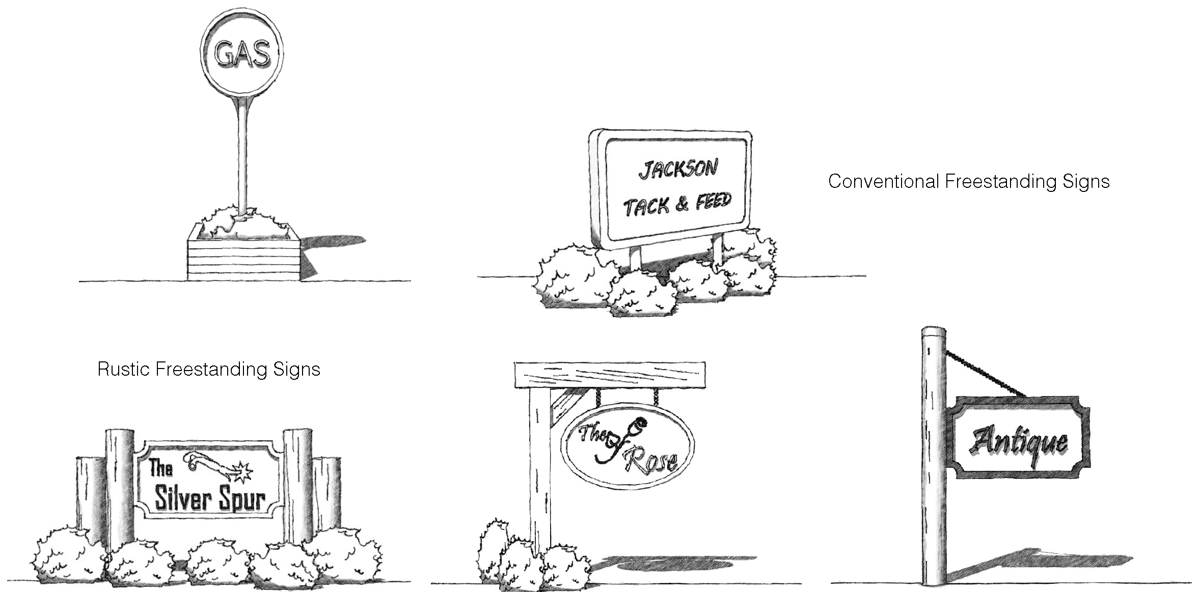
c.
Time and Temperature Displays. Banks, savings and loan associations, and credit unions are permitted, in addition to signage permitted by zone, to display the correct time and air temperature for the information of the general public. Time and temperature displays are limited to one per eligible business establishment, and the moveable/changeable area of the display may not exceed 12 square feet. Time and temperature displays may be affixed to either freestanding or wall signs, as permitted by zone. Time and temperature displays shall be illuminated using only internal illumination methods and luminance levels shall not exceed 100 nits.
4.
Temporary Uses. Signage for the temporary uses and for one-time grand openings, is permitted subject to the conditions and limitations stated herein. All signs require a Sign Permit issued by the Planning Director. Unless otherwise specified, signs must be removed immediately upon the discontinuance of the temporary use or event.
a.
Christmas Tree Sales. One freestanding sign, not to exceed six feet in height, or one wall sign, or one banner per sales lot is permitted, not to exceed eight square feet in area.
b.
Contractors and Real Estate Sales Offices. In addition to the construction sign(s) exempt from this Section, one wall sign affixed to the office and not to exceed three square feet is permitted.
c.
Public Interest Event. One freestanding sign not to exceed six feet in height, or one banner is permitted, neither of which may exceed 12 square feet in area. The sign or banner must be displayed on the site of the event. Up to two off-premises directional signs not to exceed six square feet each are also permitted. Signs may be displayed up to 14 days prior to the event.
d.
Special Event. One freestanding sign not to exceed six feet in height, or one banner, neither of which may exceed 12 square feet in area, is permitted per street frontage at the site of the event. Signs may be displayed up to 14 days prior to the event.
e.
Shelters. Shelters are permitted signage according to the allowable signage by zone, for residential uses in the zone in which the shelter is located.
f.
Farm Stands. Farm stands are permitted one temporary sign or banner, not to exceed six feet in area, or, signage permanently painted on, or affixed to, a vehicle may substitute for the sign or banner.
g.
Grand Openings. On a one-time basis, a business establishment shall be permitted one banner not to exceed 12 square feet, to be displayed for a period of not more than 14 calendar days.
5.
Optional and Alternative Signs.
a.
Freestanding Signs. When the architecture of a building or complex and/or the character of the immediate area are such that a rustic freestanding sign is clearly incompatible, the Planning Director may allow a conventional freestanding sign as an alternative, provided the alternative sign meets all material and display standards.
b.
Canopy Signs. Canopy signs may be substituted for wall signs, subject to approval by the Planning Director, and a Master Signage Plan if applicable. Any canopy sign must have a minimum vertical clearance of seven and one-half feet from any walking surface.
c.
Projecting Signs. Projecting signs that are perpendicular to a building may be substituted for wall signs, subject to approval by the Planning Director, and a Master Signage Plan if applicable. No sign face of a projecting sign may project more than four feet from the wall to which it is mounted. Any projecting sign must have a minimum vertical clearance of seven and one-half feet from any walking surface.
D.
Prohibited Signs. The following signs and types of signs are prohibited in all zones in Teton County.
1.
Moving Signs. Flashing, blinking, fluttering, undulating, swinging, rotating, or otherwise moving signs, pennants, balloons, holograms, light beams, or other decorations, except time and/or temperature signs as permitted in Subsection B.3.c.
2.
Moving Appurtenances. Moving mechanical or electrical appurtenances attached to a sign or otherwise intended to attract attention to a sign.
3.
Rotating Beacon Lights. Rotating beacon lights.
4.
Inflatable Signs. Inflatable advertising devices or signs.
5.
Portable Signs. Changeable copy trailer or portable signs, either fixed or moveable.
6.
Changeable Copy Signs. Changeable copy signs except as permitted in Subsection C.3.a.
7.
Banners. Banners, except as explicitly permitted by this Section.
8.
Off-Site Signs. All off-site, off-premises, and directional signs that advertise businesses, establishments, activities, facilities, goods, products, or services not made, produced, sold, or present on the premises or site where the sign is installed and maintained are prohibited. Those signs placed by governmental agencies for the use and benefit of a concessionaire on the concession land shall not be deemed or construed to be off-premises signs.
9.
Signs on Motor Vehicles. No person shall park any motor vehicle or trailer on public or private property so as to be seen from the public right-of-way that has attached thereto or located thereon any sign for the purpose of advertising a product or directing people to a business activity.
10.
Neon Signs. Neon signs or valances unless inside a building or in a window and not to exceed four square feet, except as exempted from this Section.
11.
Internally Illuminated Signs. Signs with internal illumination of any type.
12.
Strings of Lights. Strings, banks, or rows of lights used to outline or highlight a building or portion of a building, except as holiday decorations from Nov. 15 through Jan. 10.
13.
Other Temporary Signs. Any other device in the form of a sign which is of a temporary nature, or mobile, and not permanently affixed to a building or an upright support affixed firmly to the ground, except as permitted under Subsection C.4.
E.
Master Signage Plan. The number, sizes, and types of signs allowed by this Section are based upon the number and sizes of freestanding buildings, storefronts, and complexes of buildings. A Master Signage Plan may be required by the Planning Director to ensure compliance with the standards and requirements of this Section when multiple signs are allowed, and/or multiple tenants, businesses, or other entities occupy a single building or site.
1.
Approval of Master Signage Plan. The Master Signage Plan is subject to approval by the Planning Director, and once approved, all individual Sign Permits shall comply therewith.
2.
Requirements. Each Master Signage Plan shall clearly indicate the location, size, type of each sign on the property, and whether each sign is to be illuminated, as well as the distribution of allowed signage among multiple tenants, businesses, or entities within a building or complex.
3.
Adjustments to Number of Wall Signs Permitted. Subject to an approved Master Signage Plan, the number of wall signs may be increased in order to allow signage for each tenant, business, or other entity occupying a single building or storefront. In no event shall the wall sign area be increased beyond the allowable signage by zone.
4.
Optional Signs. When optional signs are proposed pursuant to Subsection C.5, a Master Signage Plan shall clearly indicate where substitutions are proposed and that all applicable standards are met.
F.
Sign Material and Display Standards.
1.
Sign Materials. Any and all materials used to construct signs, supports, or fasteners shall conform to the following standards:
a.
Permitted Materials Generally. Signs may be constructed of painted, stained, or carved wood, or an approved wood substitute; brick or stone; glass; metal or metallic leaf which is rust resistant, painted or anodized, or otherwise treated to prevent reflective glare.
b.
Permitted Support Structure Materials. Exposed metal support structures for signs including, but not limited to, posts, poles, and sign sides or edges, but which shall not be construed to include metal connecting devices such as, but not limited to, straps, chains, bolts, eye bolts, sleeves or collars used for connecting one structure or assemblage to another structure or sign, must be faced or covered with wood or stone or such other material as may be approved by the Planning Director as a reasonable, natural textured substitute.
c.
Rustic Freestanding Signs. Rustic freestanding signs shall be constructed of carved and/or sand blasted wood. Letters may be raised or carved and may be painted. Supports shall be of rough-hewn posts or logs, or finished logs. Fasteners may be of wrought iron, chain, or angle iron, and must be of a weathered bronze, rust, or black finish, and must be non-reflective.
2.
Sign Area. The area of a sign shall be the measurement of the face of the sign that is designed to present a message or attract attention, exclusive of structural support members. The area of the sign face shall be the area of the smallest standard geometric shape, or the sum total of the areas of more than one standard geometric shape, that encompasses the sign face. Two sided signs shall be permitted provided that neither side exceeds the maximum allowed area and the two faces are back to back and are at no point farther than two feet from one another. Otherwise, the area of all faces shall be included in determining the area of the sign.
3.
Display Standards. The display of all signs regulated by this Division shall conform to the standards of this Section. Illustrated prototypes of all types of signs permitted by this Division are shown below.
a.
No Obstruction Permitted. No sign shall obstruct a clear view to and from traffic along any street right-of-way, entrance, or exit as required by Section 7.6.6.
b.
No Projection Within Right-of-Way. No signs, except traffic signs and similar regulatory notices, shall be allowed to project or be located within public right-of-way lines.
c.
Lighting. Signs may be unlighted or lighted externally, unless otherwise indicated in the allowable signage by zone, subject to the following conditions:
i.
Lighting shall be designed, located, shielded, and directed in such a manner that the light source is fixed and is not directly visible from, and does not cast glare or direct light upon any adjacent public right-of-way, surrounding property, residential property or motorist's vision.
ii.
At the Planning Director's discretion, any proposed external lighting application may be required to submit professional Engineering and/or Architect plans and photometric maps depicting the types of lighting to be used.
iii.
Light sources shall be extinguished completely after 10:00 p.m. or at the end of usual business hours, whichever is later, and remain off until one hour before sunrise. This excludes businesses that are open 24 hours per day and rely on over-night signage to communicate with passerby about being open.
iv.
The illuminated surface area of an individual sign shall not exceed 200 square feet.
d.
Wall Signs Mounted on Parapets. A wall sign mounted on a parapet wall shall be mounted six inches or more below the top of the parapet wall.
e.
No Imitation of Traffic Signs. Signs shall not resemble, imitate, or approximate the shape, size, form, or color of traffic signs, signals, or devices. Signs shall not obstruct or interfere with the effectiveness of traffic signs, signals, or devices, nor be lighted in a way that can cause glare or impair driver visibility upon roads.
f.
No Prevention of Ingress/Egress. Signs shall not be erected, relocated, or maintained in such a way that prevents free ingress or egress from any door, window, or fire escape, and no sign shall be attached to a standpipe or fire escape.
g.
No Mounting on Natural Features. No signs shall be painted or mounted on trees. No land form or natural land feature (rocks, cliff faces, etc.) may be defaced for purposes of displaying a sign.
h.
Height and Clearance. All signs shall meet the following regulations relating to height and clearance from the ground, or from a walking or driving surface as applicable.
i.
Measurement of Freestanding Sign Height. The height of a freestanding sign shall be measured vertically from the highest point of the sign to the ground below, except that vertical supports of a rustic freestanding sign may extend above the maximum allowed height by not more than six inches.
ii.
Clearance. The clearance of a projecting freestanding, wall, canopy, or fascia sign shall be measured from the lowest edge of the overhang to the driving or walking surface below.
i.
Freestanding Sign Setback. Any rustic freestanding sign, entry sign, or monument sign shall be set back a minimum of two feet from any property line.
j.
Landscaping. The ground area around the base of all freestanding signs shall be landscaped in accordance with the requirements of these LDRs (see Division 5.5). The Planning Director, however, may exempt some freestanding signs from this standard where it is demonstrated that the landscaping would unduly interfere with pedestrian or vehicular traffic, interfere with traffic visibility, or for other reasons be impractical, for example, on a boardwalk.
k.
No Street Frontage. When a freestanding building, complex, or storefront does not face a public street or approved private road, and is accessed via a pedestrian area or common parking and drive area, the linear feet of building or storefront facing the pedestrian area or common parking and drive area shall substitute for purposes of determining allowable signage.
G.
Sign Construction Standards. Signs and sign structures shall be designed and constructed to resist wind and seismic forces as specified in the currently adopted building code. A building permit for the sign structure may be required. If there is any indication that the proposed structure may not resist wind, seismic forces, or other loads or stresses, a Wyoming registered engineer's certification on the sign's structural plans shall be required.
H.
Dangerous or Defective Signs.
1.
Removal or Repair by Owner. Any sign, which is in a dangerous or defective condition, shall be removed or repaired by the owner of the premises or the owner of the sign. Upon failure of the owner to remove or repair a dangerous or defective sign, the Planning Director shall proceed pursuant to Division 8.9.
2.
Removal by Planning Director. The Planning Director shall cause the removal of any sign that endangers the public safety or a sign for which no Sign Permit has been issued.
3.
Cost of Removal. The costs associated with the removal of a sign by the Planning Director shall be paid by the owner of the property on which the sign was located. If the cost is not paid within a reasonable time, the unpaid balance shall be considered a lien against the property. The cost of removal shall include any and all incidental expenses incurred in connection with the removal of the sign.
(10/6/22)
5.7.1. - Purpose and Applicability.
A.
Purpose. It has been determined that runoff from construction sites carries a significant amount of sediment and other pollutants to the waters of the State of Wyoming and the County. Therefore, it is the purpose of this Division to preserve natural resources; to protect the quality of the waters of the State of Wyoming and the County; and to protect and promote the health, safety, and welfare of the people to the extent practicable by minimizing the amount of sediment and other pollutants carried by runoff or discharged from construction sites to lakes, streams, and wetlands. In addition, this Division is also intended to protect the health, safety and welfare of the citizens of the County from geologic hazards which may result through improper grading practices. Invasive Species standards are intended to maintain the character and function of native habitat by reducing the spread of noxious weeds and introduction of other invasive species through grading and revegetation practices.
B.
Applicability. This Division shall apply to all land disturbing activity and all excavations unless explicitly exempted. Agriculture meeting the standards for exemption in Section 6.1.3(B) is not considered a land disturbing activity, unless it disturbs natural slopes of 30% or greater.
EXAMPLE:Examples of land disturbing activities include, but are not limited to, grading, topsoil removal, filling, road or drive cutting, altering or enlargement of a stream or channel, removal of streambed materials, channel clearing, ditching, drain tile laying, dredging, lagoon construction, soil and water conservation structures, and the extraction or placement of rock, sand, or gravel. Grading permits shall be reviewed and approved pursuant to Section 8.3.4. Also refer to the Teton Conservation District's Stormwater Pollution Prevention Plan Guide.
C.
Varied Standards for Levee Construction and Maintenance. The standards of this Division may be varied as necessary to allow for construction and maintenance of flood control structures, such as levees.
D.
Grading Permit Required. A grading permit shall be submitted to describe the site grading, erosion controls, and stormwater management that will be used to meet the requirements of this Division. A grading permit is required for all land disturbing activities unless explicitly exempted. There are two levels of grading permit.
1.
Statement Level Grading Permit. The purpose of the statement level grading permit is to allow the County Engineer to review land disturbances that, while small in area, may impact other landowners and the environment. A statement level grading permit application for a ditch alteration shall be prepared by a professional engineer registered in the State of Wyoming or by both a land surveyor and landscape architect registered in the State of Wyoming in accordance with Section 7.7.4(D).
2.
Plan Level Grading Permit. All plan level grading permit applications shall be prepared by a professional engineer or landscape architect registered in the State of Wyoming. Prior to submittal of a plan level grading permit the applicant shall have a pre-application conference pursuant to Section 8.2.1. A plan level grading permit application for a ditch alteration shall be prepared by a professional engineer registered in the State of Wyoming or by both a land surveyor and landscape architect registered in the State of Wyoming in accordance with Section 7.7.4(D).
3.
Geotechnical Report. A geotechnical report shall be submitted with a plan level grading permit application for construction sites with existing slopes greater than 30% or when considered necessary by the County Engineer in consideration of soil type and stability and the proposed structure; the report may be waived by the County Engineer, when applicable. The report shall be prepared by a professional engineer registered in the State of Wyoming.
4.
Required Permit. The table below establishes the type of grading permit required for various grading proposals. The required permit shall be the most rigorous requirement that applies to the proposal.
EXAMPLE:A proposal that would result in 41% impervious surface coverage or more requires a Grading Plan regardless of the amount of disturbance or slope.
5.
Permit Exemptions. Grading proposals listed below or in the table above shall be exempt from the requirements to obtain a Grading Permit; however, all activities shall comply with the standards of this Division regardless of whether or not a permit is required. Exemptions do not apply to ditch alterations, which are required to meet the standards of Section 7.7.4(D).
a.
Agricultural Activities. Earthmoving operations occurring on natural slopes that are less than 30% and which meet the standards for exemption in Section 6.1.3(B.2.d).
b.
Emergency Work. A grading permit is not required prior to earthmoving operations occurring as emergency flood control measures, emergency installation of temporary retaining walls in response to landslides, or other instances of emergency work necessary to protect from imminent threat to public safety; however, an after-the-fact grading permit application is required as soon as reasonably practicable to document the grading completed. If the work is determined to not meet the Land Development Regulations, it may have to be modified or removed to become permittable.
6.
Stormwater Management Plan. Regardless of the grading permit requirement or exemption, the County Engineer may require submittal of a stormwater management plan, prepared by an engineer or landscape architect licensed in the State of Wyoming, if it is necessary to determine compliance with Section 5.7.4. The stormwater management plan shall be approved by the County Engineer prior to any physical development.
(5/1/25)
5.7.2. - Grading Standards.
A.
General Standards. The following general standards shall be met before a grading permit is issued.
1.
Avoid Risk of Landslides. The grading shall avoid the risk of landslides or other forms of slope failure, rock-falls, and avalanches.
2.
Not Significantly Increase Rate of Stormwater or Snowmelt Runoff. The grading shall not significantly change the rate of stormwater or snowmelt runoff, and shall avoid or minimize the erosion of natural or constructed slopes and sediment accumulation in natural drainage channels or watercourses.
3.
Not Significantly Alter Drainage Patterns. The grading shall not significantly alter natural drainage patterns.
4.
Conforms to General Natural Forms. The grading shall preserve and conform to the general natural form and contours of the land surface.
5.
Preserves Natural or Established Vegetation. The grading shall be designed to preserve natural or established vegetation as much as is practically possible. Where retaining walls longer than 120 continuous linear feet are necessary for development, compliance with Section 5.1.7 is required.
6.
Provides for Revegetation. The affected site area shall be revegetated as is necessary for the stabilization of disturbed surfaces with the exception of areas covered by impervious surfaces and/or structures. Revegetation plans should contain components as identified in Teton County Weed and Pest District's Revegetation Guide (www.tcweed.org/Revegetation.php).
7.
Allows Most Rapid Possible Recovery of Disturbed Lands. The grading shall allow for the most rapid possible recovery of disturbed lands to natural or introduced vegetation.
8.
Stabilizes Slope. The revegetation shall stabilize the slope and shall be compatible with native vegetation.
9.
Minimizes Cut and Fill. The plan shall minimize cut and fill on a site. An application for a grading and erosion control permit shall be denied if it is determined that its issuance would result in excessive cutting and filling and that the intended structure or use would be feasible with less alteration of the natural terrain. Where retaining walls longer than 120 continuous linear feet are necessary for development, including constructing a transportation facility, additional grading shall be permitted to allow for wildlife permeability and to comply with the standards of Section 5.1.7.
10.
Discovery of Historic or Prehistoric Ruins and Monuments. Whenever during excavation there are uncovered, or become apparent, any historic or prehistoric ruins or monuments not previously accounted for in the issuance of a permit, all work in the immediate area shall cease until the Wyoming State Archaeologist determines what precautions shall be taken to preserve the historic or prehistoric artifacts.
11.
Maintenance and Repair Measures. All graded surfaces, sedimentation basins, and other control measures necessary to meet the requirements of this Section shall be maintained by the applicant, landowner, or subsequent landowner during the period of land disturbance and land development of the site in a satisfactory manner to ensure adequate protection from erosion and to prevent nuisance conditions. Nuisance conditions include, but are not limited to, the tracking of dirt and mud onto public streets, and fugitive dust. Should any dredging or soil removal occur for the construction of temporary sedimentation basins or other control measures, such areas shall be restored when the temporary sedimentation basin or other control measures are removed.
12.
Invasive Species Management. An Invasive Species Management Plan is required to be submitted as part of any Grading Permit application. The purpose of the Invasive Species Management Plan is to assist in maintaining the character and function of native habitat helping to reduce the spread of noxious weeds as defined in Wyo. Stat. §§ 11-5-101—11-5-119, and introduction of other invasive species through grading and revegetation practices (also see Wyo. Stat. §§ 11-9-101—11-9-109 and Wyo. Stat. §§ 11-12-101—11-12-125). Noxious weeds and other invasive species require prevention or control during all phases of construction to limit severe and costly infestations in the future.
a.
The Invasive Species Management Plan shall include pre-construction, active construction, and post-construction integrated control elements.
b.
Teton County Weed and Pest will review and approve a plan prepared by the applicant, or will prepare the Plan for a site given advance notice.
c.
Plans should include components identified in Teton County Weed and Pest District's Invasive Species Management publication https://www.tcweed.org/programs/plants/land-development-regulations
13.
Natural Resources Assessment. Grading shall not occur unless a natural resources assessment has been approved. An application that proposes grading may be elevated per Section 8.2.9(C).
B.
Grading Standards. All grading activities shall meet the following technical standards.
1.
Removal of Organic Materials. Fill areas shall be properly prepared by removing organic materials, such as vegetation and rubbish, and any other material which is detrimental to the proper compaction of the site or not otherwise conducive to the stability of the site.
2.
Site Vegetation Removal and Revegetation. The removal of existing vegetation shall not occur more than 30 days prior to the commencement of grading, and permanent revegetation shall be commenced as soon as practical after the completion of grading. Site specific native seed mixtures shall be used to revegetate all disturbed areas with the exception of lawn and landscaped areas. Mulching shall be used in order to assure vegetation growth.
3.
Topsoil, Stripping, Stockpiling, and Redistribution. The existing topsoil shall be stripped and stockpiled on site for redistribution over the completed final grade.
4.
Retaining Walls and Facings. All retaining walls or facings with a total vertical projection in excess of four feet shall be designed as structural members keyed into stable foundations capable of sustaining the design loads, and shall be designed by a professional engineer registered in the State of Wyoming.
5.
Compaction on Structural Load Bearing Areas of the Site. Fills on structural load bearing areas or roadways shall be compacted to at least 95% of maximum density, as determined by the American Association of State Highway and Transportation Officials (AASHTO T99, most recent edition) and/or the American Society of Testing Materials (ASTM D698, most recent edition), or to the compaction level deemed necessary by a Wyoming registered professional engineer, considering the types of soil, groundwater infiltration and percolation, degree of slope, exposure, and other factors pertaining to slope stability.
6.
Interceptor Ditches. Interceptor ditches shall be provided above all cut slopes greater than five feet, with a drainage area of 13,000 square feet, unless deemed unnecessary by the County Engineer taking into account vegetation, soil type, total drainage area, topography and potential rain and snow fall. Interceptor ditches may also be required when the drainage area is less than 13,000 square feet at the discretion of the County Engineer in consideration of the factors listed above. The intercepted water shall be conveyed to a stable channel or natural drainageway with adequate capacity to carry the flow.
7.
Fill Slopes near Roads. On roads, fill slopes shall not be located where the base of the slope is within 15 feet horizontally of the top of an exterior or planned cut slope, except at road switchbacks.
8.
Cut and Fill Within Site Boundaries. The tops and toes of cut and fill slopes shall be within the property lines of the proposal, and outside of right-of-way lines and vehicular access easements. Where adjacent landowners agree to waive this requirement for all or a portion of their common boundary, an easement for the grading activity, maintenance activity and the final grading configuration shall be required for each lot of record affected. A copy of the easement(s) shall be submitted for staff review as a part of the grading approval process. Permanent easement(s) shall be recorded by the Teton County Clerk and recorded against the subject lots of record.
9.
Borrowing for Fill Prohibited. Except for existing quarries, borrowing for fill shall be prohibited unless the fill material is obtained from a cut authorized by the issuance of a grading and erosion control permit obtained for some purpose other than to produce fill material.
10.
Cut and Fill Slopes. Cut and fill slopes shall be graded to a slope no steeper than 2:1, or 50%, to allow for permanent revegetation or landscaping unless a retaining wall is used or a steeper slope is approved by the County Engineer. The County Engineer may require the submission of a detailed engineering report and analysis prepared by a registered State of Wyoming professional engineer relative to the safety of such cuts and fills, if necessary considering soil type, soil stability, and any proposed structures.
(5/1/25)
5.7.3. - Erosion Control Standards.
A.
Erosion Control. Erosion is to be controlled on-site, both permanently and during construction to reduce erosion and attendant pollution.
B.
Design Criteria, Standards, and Specifications for Erosion Control Measures. The following standards shall apply to all grading activities during land disturbance.
1.
Site Dewatering. Water pumped from the site shall be treated by temporary sedimentation basins, grit chambers, sand filters, up-slope chambers, hydro-cyclones, swirl concentrators, filter fences, or other appropriate controls as determined by the County Engineer. Water may not be discharged in a manner that causes erosion of the site or receiving channels. All required State discharge permits for discharging to surface waters or groundwaters shall be obtained and applicable State requirements met prior to discharge.
2.
Waste and Material Disposal. All waste and unused building materials (including garbage, debris, cleaning wastes, wastewater, toxic materials, or hazardous materials) shall be properly disposed and not allowed to be carried by runoff into a receiving channel, basin, or storm sewer system. No on-site burial of construction wastes or unused materials is allowed.
3.
Drain Inlet Protection. All storm drain inlets shall be protected with a straw bale, filter fabric, or equivalent barrier.
4.
Site Erosion Control. The following criteria apply only to land development or land disturbing activities that result in runoff leaving the site:
a.
Channelized runoff from adjacent areas passing through the site shall be diverted around disturbed areas, if practical. Otherwise, the channel shall be protected as described in this Section. Sheet flow runoff from adjacent areas greater than 13,000 square feet shall also be diverted around disturbed areas unless shown to have non-scouring velocities. Diverted runoff shall be conveyed in a manner that will not erode the conveyance and receiving channels.
b.
All activities on the site shall be conducted in logical sequence to minimize the area of bare soil exposed at any one time.
c.
Runoff from the entire disturbed area on the site shall be controlled by filter fences, straw bales, or equivalent control measures placed along all side slope and down slope sides of the site. If a channel or area of concentrated runoff passes through the site, filter fences shall be placed along the channel edges to reduce sediment reaching the channel.
(1/1/15)
5.7.4. - Stormwater Management Standards.
A.
General Provisions.
1.
Limitation of the Amount of Stormwater Runoff. No physical development, use, development option, or subdivision shall cause adjacent landowners, water courses, channels, or conduits to receive stormwater runoff from the proposed development site at a higher peak flow rate or at higher velocities than would have resulted from the same storm event occurring over the site of the proposed development, use, or subdivision with the land in its previous condition. The range of storms considered shall be the one year through 100 year event.
2.
Limitation of the Velocity of Stormwater Runoff. Stormwater runoff shall be managed so that the velocity of flow does not cause scour or erosion. (Reference the most recent edition of the U.S. Soil Conservation Service Handbook, "Water Management and Sediment Control for Urbanizing Areas.")
3.
Stormwater Detention Basins Required. Detention basins or equivalent management facilities shall be provided within the development in order to properly limit surface runoff as set forth under this Section.
4.
Timing of Stormwater Management Facility Construction. Where the physical development, use, development option, or subdivision of a site could result in danger to persons, land, or wildlife due to runoff during construction, the facilities for stormwater runoff control shall be constructed prior to any earth moving or drainage construction on the site.
5.
Location. All stormwater management facilities shall be constructed within the confines of the proposed physical development, use, development option, or subdivision, except in the case of approved regional stormwater detention facilities.
6.
Drainageways. The following standards shall apply to all drainageways.
a.
Preserve and Use Natural Surface Drainage System, When Possible. Retention of surface drainage in drainageways is encouraged. Natural drainageways shall be preserved and used, wherever feasible, for a natural surface drainage system.
b.
Design to Slow Time of Surface Water Concentration. The drainage shall be designed to slow the time of surface water concentration on the site and retain maximum infiltration into the ground.
c.
Design as Grassed Swales, Wetlands, or Mesic Grasslands. Where flows permit, the channels shall be designed as grassed swales, wetlands, or mesic grasslands encouraging sheet flow.
d.
Natural Edges Using Plant Materials. All wet basin retention ponds shall be designed to have natural edges using approved native plant materials from the lists provided in the office of the Planning Director.
e.
Restore Disturbed Area to Natural State. Any disturbed areas shall be restored to a natural state including revegetation. The proposed restoration plan, which shall include a schedule, shall be designed by a landscape architect registered in the State of Wyoming.
f.
Contact County Engineer. Prior to construction, improvement or alteration of drainageways, the County Engineer must be contacted and apprised in writing of the intended activity.
B.
Design Requirements for Stormwater Management Facilities.
1.
Storage Capacity. All stormwater storage facilities shall be designed with sufficient capacity to maintain a post-development runoff rate that is equal to or lower than the pre-development runoff rate. The stormwater storage facilities shall be designed for the range of storms from the one year through 100 year storm events.
2.
Design Regulations. All stormwater management facilities and improvements required by this Section shall comply with the following standards:
a.
Method of Calculation. The "rational method" shall be used to calculate peak flow rates. The "modified-rational method" shall be used to calculate volumetric requirements for drainage areas of ten acres or less. The "Soil Conservation Service method" shall be used to calculate volumetric requirements when the drainage area is more than ten acres. Intensity, duration, frequency data included in the table below shall be used. Calculations for sites known to have greater precipitation shall increase these figures by an appropriate amount. Data 20% greater shall be used for the Teton Village area.
b.
Outlet Control Structures. Outlet control structures shall be designed as simply as possible and shall operate automatically. They shall be designed to limit discharges into existing or planned downstream channels or conduits so as not to exceed the runoff of the site in its previous condition.
c.
Spillway. Emergency overflow facilities shall be provided unless inflow is controlled to divert flows when the basin is at capacity.
d.
Dry Bottom Basin. For basins designed without permanent pools:
i.
Interior Drainage. Provisions must be made to facilitate interior drainage to include providing natural grades to outlet structures, longitudinal and transverse grades to perimeter drainage facilities, or the installation of subsurface drains.
ii.
Multi-Purpose Features. Dry bottom basins may be designed to serve secondary purposes for recreation, open space, or other types of use, which will not be adversely affected by occasional or intermittent flooding.
e.
Wet Basins. Wet basins shall not be considered for river, stream, or lake bank buffer protection. Wet basins require a Reservoir Permit from the State Engineer's Office. For basins designed with permanent pools:
i.
Depth for Fish. If fish are anticipated at least one-quarter of the area of the permanent pool must have a minimum depth of ten feet.
ii.
Facilities for Emptying. For emergency purposes, cleaning, or shoreline maintenance facilities shall be provided, or plans prepared, for the use of auxiliary equipment to permit emptying and drainage.
iii.
Safety Considerations. Public access to wet basins shall be restricted by appropriately designed and constructed perimeter fences or other approved safety provisions. If access is not restricted, the wet basin shall be constructed as depicted below within approach slopes of at least 6:1 horizontal to vertical, but not more than 4:1 sloping toward the basin. A ledge shall be of non-erosive material with a slope of 10:1 or flatter. The ledge shall be 4—6 feet wide and slope gently toward the shore to prevent people or objects from sliding into deep water. There shall be a freeboard of no less than 12 inches above the high-water elevation on all retention basins. Alternate designs for side slopes may be considered under special circumstances where good engineering practice is demonstrated. The below illustration presents this concept.
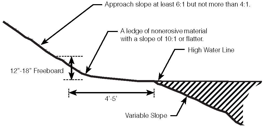
f.
Cleaning of Basins. Basins shall be designed to allow periodic cleaning and removal of sediments. Sediment traps shall be designed to permit periodic cleaning and maintenance.
g.
Parking Lot Storage. Paved parking lots may be designed to provide temporary detention storage of stormwater on a portion of their surfaces. Depths of storage shall not exceed six inches.
h.
Pollution Abatement. Where a physical development, use, development option, or subdivision will cause the introduction of new pollutants into the runoff water, adequate provision shall be made for the storage, treatment, and removal of such pollutants.
3.
Inspection of Facilities. The developer's engineer or landscape architect shall be required to inspect all drainage facilities under construction and certify their compliance with approved plans. In addition the County Engineer, or the County Engineer's designated representative, may inspect all drainage facilities while under construction and after completion of construction to ensure that stormwater control facilities are being properly maintained and provided that such inspections shall be conducted during normal weekday working hours. In addition, the County may install hydrological measuring devices in drainage facilities within any development. When facilities are not constructed according to approved plans, the County has the explicit authority to compel compliance and require correction of any situation which is not according to the approved plans.
(1/1/15)

