
Washington City Zoning Code
ARTICLE XV
SPECIAL DISTRICTS
Sec. 40-385.- Interchange Overlay Districts.
(a)
Title. This section shall be known and may be cited as the Interchange Overlay District Ordinance of the City of Washington.
(b)
Authority. The State General Statutes permit municipalities to establish overlay districts (G.S. 160D-703).
(c)
Findings.
(1)
Highway interchanges and the areas that surround them are magnets for development. Traditionally, lands near interchanges on limited-access highways generate stronger development interest and command high prices. These lands tend to be developed quickly for high revenue-producing activities. In some cases, developers attempt to maximize return on investment with little consideration to the long-term impact of their development on the surrounding community. Since the interchange areas are key gateways to the community, design considerations in the area are critically important. The area surrounding the interchanges should be subject to an overlay district that creates site design, architecture, signage, parking, landscaping, and lighting standards more stringent than in other areas of the community.
(2)
The City Council finds that the interchange areas subject to regulation by this section have specific development pressures and unique conditions that are not found elsewhere in the city. These unique conditions of greater traffic counts and more intensive development pressures justify regulation in specific areas of the city that would not be justifiable in other areas of the city, due to the absence of such conditions.
(d)
Purpose and intent. The purpose of this section is to encourage managed, sensible interchange development by providing protective measures that promote safety, minimize the impact to the natural environment, and promote highway beautification. This section is intended to ensure that new development will be compatible with respect to design, signage, lighting, screening, and access points. It is not meant to recommend or dictate specific land uses within the area regulated. Rather, it is intended to ensure that, if development does occur within the area, it will meet a minimum set of standards. This section is also intended to help developments within the interchange area maintain their initial appeal by protecting them from potential adjacent substandard development.
(e)
Exemptions. The Interchange Overlay Districts Guidelines shall not apply to single-family residential dwellings.
(f)
Definitions. The following words, terms, and phrases, when used in this section, shall have the meanings ascribed to them in this subsection, except where the context clearly indicates a different meaning:
Access management means the systematic control of the location, spacing, design, and operation of driveways, median openings, interchanges, and street connections to a roadway.
Access road means a public or private or private one-way or two-way road for ingress or egress. Such access roads may be of various types, including frontage roads, rear access roads, or cul-de-sacs.
Interchange access road means the highest order road serving an interchange and providing access to the highway bypass.
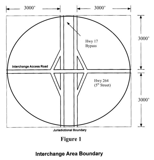
Interchange overlay area means an area, consisting of a six thousand foot (6,000') circle, having a radius of three thousand feet (3,000') measured from the center point of the highway bypass interchange. Specifically, the interchange area extends 3,000 feet from the outer right-of-way boundary of the highway bypass and the interchange access road, as defined (see Figure 1).
Interchange overlay district. Interchange zoning controls are added to the standard zoning requirements of the underlying district (commercial, residential, etc.). The property and any improvements are subject to both the standard zoning regulations and the overlay restrictions. Overlay requirements may address any issues of concern.
Monument sign means a freestanding sign having the appearance of a solid base of construction materials such as brick, stucco, stonework, textured wood, tile or textured concrete materials compatible with the materials of the primary structure on the subject property.
Pedestal sign means a three-dimensional, self-supporting, base-mounted freestanding sign, consisting of two (2) or more sides extending up from the base, and upon which a message is painted or posted. A pedestal sign may also consist of a base-mounted cylindrical structure upon which a message is painted or posted
Setback means the minimum distance by which any building or improvement must be separated from a right-of-way boundary. Building setbacks are required distances from the street, right-of-way line, property lines, and building lines within which development or construction is permitted.
Sign means a presentation of letters, numbers, figures, pictures, emblems, insignia, lines or colors, or any combination thereof displayed for the purpose of information, direction or identification or to advertise or promote a business service, activity, interest or product or any otherwise lawful noncommercial use.
Traffic impact analysis or TIA, commonly referred to as a "Traffic Impact Statement," is used to determine and describe how traffic generated by new or altered land uses will be served by the existing relevant road network and what adjustments must be made to maintain the same or similar level of service.
(g)
Applicability. This section shall apply within the interchange area boundary, as defined by this section, surrounding the intersections of US Highway 17 Bypass and West Fifth Street (US Hwy 264) and US Highway 17 Bypass and Carolina Avenue (Highway 17 Business). The development of any nonresidential property of any size, type, or density within the boundaries of the Interchange Overlay Districts shall comply with the standards set forth herein. More specifically, no building or structure shall be erected or undergo a major expansion (50 percent or more of the original or replacement value) for any purpose except in accordance with the requirements set forth herein except as allowed in this section.
(h)
Permitted uses. This section permits all uses in the Interchange Overlay Zoning Districts, as listed as follows, in appendix 1. The uses listed shall be allowed only within the respective districts as specified herein.
(i)
Site plan approval required. No zoning permit or building permit shall be issued by the Department of Planning and Development for a building, structure, or any improvement within the interchange overlay area boundary as defined by this section, unless the land use or building conforms to the requirements of this section. All development subject to the provisions of this section is required to submit a complete site plan consistent with the requirements of article XVIII of this chapter. In addition to the minimum requirements found in article XVIII of this chapter, the site plan shall include and meet the requirements of the Interchange Overlay Districts. All proposed development activities located in the Interchange Overlay Districts shall be reviewed and approved by the City Planning Board.
(j)
Building design standards.
(1)
Purpose. The standards in this section will provide consistency to the development character, thereby enabling the longterm preservation of property values and the promotion of economic development. A design framework should build on the city's architectural precedents, and convey the spirit of the city's history. All proposed development to be located within the interchange area boundaries shall meet the requirements of this section.
(2)
Type of construction. Manufactured, mobile, metal, and nonresidential modular units shall be prohibited, except for temporary use during construction or for storage of materials during construction. No generic franchise architecture is permitted unless the development is contextual to its surroundings in design and materials.
(3)
Building materials.
a.
Exterior building materials should consist of decorative split-block masonry, brick, stone, wood, fiber-cement siding, or textured stucco. No more than 60 percent of the facade of any principal building facing the street should be of glass or reflective material.
b.
The use of smooth vinyl, unpainted cinder-block walls, or metal paneling shall be prohibited, except when used on exterior walls not facing or visible from public roads or access ways.
(4)
Building orientation. Principal buildings shall be oriented with their main entrance toward the street or access drives.
(5)
Street walls and facades. Long continuous building walls are discouraged and no commercial, office, or institutional uses shall have a blank wall greater than 35 feet in length that may be visible from the public roadway. Industrial uses shall have a blank wall no greater than 60 feet in length. The use of masonry, belt courses of a different color and texture, projecting cornice, projecting canopy, windows and doors, decorative tile work, columns, building wall offsets such as projections, recesses, or other architectural elements as approved by the Planning Board that meet the intent of this section may be incorporated into these walls.
(6)
Building height. The maximum building height for any commercial, industrial or office development shall be forty-five feet (45').
(7)
Roof pitch. Flat roofs or roof pitches less than 3:12 shall include a cornice trim along the tops of walls, roof line offsets, and/or the use of a parapet wall to avoid the appearance of strip development and create a prominent edge.
(8)
Mechanical equipment. Mechanical or HVAC equipment shall not be installed at ground level along any portion of a building facing a state or city maintained street or internal access way unless such location is necessitated by the nature and design of the building. A solid fence or wall or landscaping shall screen any ground level mechanical equipment. All rooftop equipment shall be screened from public view in a manner consistent with the building design or compatible in appearance with roofing materials.
(9)
Loading and service areas. Loading and service areas should be designed out of view from public roads. Dumpsters or trash-handling areas shall always be screened from adjacent properties and public view with a minimum six-foot high solid wooden fence or solid (and finished) masonry wall with a solid closeable gate. No chain link fencing may be used to comply with any part of this section.
(10)
Accessory uses. Any accessory buildings and enclosures, whether attached or detached from the main building, shall be of similar compatible design and materials.
(k)
Access management and parking.
(1)
Purpose. Over time, if not carefully thought through, numerous entryways can contribute to difficult turning situations and often times lead to unsafe conditions. It is therefore the intent of this section to limit the number of access points that are permitted onto the interchange access road. These controlled access points will enable more careful design of turning movements, resulting in safer conditions.
(2)
Access from highways. Access points along the interchange access roads to developments (such as curb cuts and driveways) shall be minimized. Prior to submission to the city for review, all plans for vehicular access to new development from the interchange access road shall be submitted to and approved by the state DOT if a state route, or the City Public Works Director, if a city road.
a.
Two driveways are the maximum number of driveways allowed per street frontage for any parcel, tract or development, including access to any and all properties designated as outparcels or to be leased or sold for future development.
b.
No access point shall be allowed within ten feet of the side property line of any property or development except where a mutual access agreement exists between adjoining owners.
c.
All parcels containing more than one driveway must maintain a minimum of 100 feet of separation between them.
d.
Shared driveways are permitted and recommended.
e.
Vehicular and pedestrian access between adjoining lots is mandatory. Location and specifications for the interior lot access points shall be determined during Planning Board review. If at the time of construction the adjacent lot or lots are not being developed, the developer must provide stubouts to the adjacent lots. These stubouts will be located in accordance with the Planning Board's recommendation and provide for future access.
(3)
Traffic impact analysis (TIA). A traffic impact analysis shall be submitted to, and approved by the Planning Board under the following conditions:
a.
When the proposed development creates a major site plan review.
b.
At the request of the Planning Board when the proposed development is expected to significantly impact the vehicular movement on the interchange access roads within the overlay districts.
c.
Typically, the following developments are considered major and would normally require a traffic impact analysis:
1.
55,000 square feet retail.
2.
300 single family homes.
3.
250,000 square feet office.
4.
400,000 square feet industrial.
5.
350 room hotel.
(4)
Parking. Parking areas should be designed in a manner to provide safe and efficient circulation of traffic and provide safe access ways for pedestrians to travel vehicles to buildings.
a.
Parking areas shall be located to the side or rear of the building when a development fronts on major roads. When parking is placed in front of the building due to physical constraints, screening shall be provided through decorative walls or fences, bushes, shrubs, or small trees that limit the view of the parking area but do not necessarily screen visibility to the building.
b.
When feasible, all parking areas should be designed to allow linkages to adjacent developments to promote efficient traffic flow and encourage shared parking areas to reduce the use of land for parking.
(l)
Dimensional requirements. All residentially zoned property shall be developed in accordance with the standards set forth in the underlying zoning districts. In addition, all nonresidential property shall be developed according to the following:
(1)
The minimum building setback in the Interchange Overlay Districts shall be as follows:
a.
From any street or access road right-of-way, 30 feet. This street setback requirement applies to all accessory structures, including gasoline pumps, underground tanks, canopies and other similar structures located on a zoning lot that adjoins an arterial or collector street as designated by the county.
b.
From interior lot line adjoining nonresidential property, 10 feet.
c.
From interior lot line adjoining residential property, 50 feet.
d.
From any access easement, 15 feet.
(2)
The Planning Board may consider an application for a reduction in building setback requirements and may reduce the minimum building setback requirements by as much as 20 percent upon making a finding that the proposed reduction of those requirements:
a.
Will not substantially defeat the purposes for which those requirements were established;
b.
Is necessitated by the configuration and/or topography of the land which would make it impractical to comply with the minimum setback requirements;
c.
Is no greater than is necessary to allow for reasonable development of the property;
d.
Will not adversely affect the value of adjoining or abutting property.
(m)
Landscaping and bufferyard requirements. The landscaping and buffer regulations and guidelines are intended to assist property owners in the development of an attractive streetscape. All development within the Interchange Overlay Districts shall conform to the landscaping standards of article VII of this chapter and the following:
(1)
Landscaping plan. A landscape plan showing all landscaping required under this section for any development within the interchange area boundary shall be required to be approved by the City Planning Board. No occupancy of any development shall take place until the landscaping has been installed in accordance with the approved landscaping plan. When the occupancy of a structure is desired prior to the completion of the required landscaping, a Certificate of Occupancy may be issued only if the owner or his designated agent provides to the city a form of surety in favor of the City in an amount equal to the costs of the remaining plants, related materials and installation costs. The City Attorney shall approve all sureties and related documents as to form. Should an acceptable surety be provided, then all required landscaping shall be installed and approved by the first planting season following issuance of Certificate of Occupancy or the surety shall be forfeited to the city. Landscaping shall be maintained permanently by the lot owner, and any plant material that does not live shall be replaced within one year.
(2)
Tree requirement. All lots abutting the interchange access road shall provide a minimum of one tree for each 40 linear feet of road frontage. All trees required shall be located within 20 feet of the back of the curb. They can either be randomly or evenly spaced. All required trees planted within the setback shall be of a shade-type variety with a minimum caliper of two and one-half (2 1/2)inches at planting and an expected height at maturity of at least thirty (30) feet.
(3)
Parking lot landscaping. Interiors of parking lots shall contain tree planting areas for every ten parking spaces. Planting islands within parking areas shall contain an area no less than 160 square feet per tree with a minimum width of eight (8) feet (excluding curb), and shall be underlain by a minimum of two feet of suitable planting soil free of construction debris. The area should include one shade tree and be designed to minimize damage to trees by parking or moving vehicles. The remaining area shall be landscaped with plantings (bushes, shrubs, flower beds). A vegetative strip of at least ten (10) feet in width shall be maintained at the perimeter of parking areas. A minimum of one (1) large tree per fifty (50) feet should line the parking areas. Grass, shrubs, bushes, pedestrian amenities, decorative walls and fences, and sidewalks may be placed in this area.
(4)
Automatic underground irrigation system. An automatic underground irrigation system is required to support all required landscaping
(n)
Utilities. All on-site utilities should be located underground unless technical restrictions exist for not doing so. When utilities must be located above ground, provisions shall be made to significantly reduce the visual impact of the utility from the public road right-of-way. Junction boxes, transformers, and other structures essential to utility service which, due to their function, are required to be located above-ground, shall be screened from view of public rights-of-way.
(1)
Transformers, utility pads, and telephone boxes shall be appropriately screened with walls and/or plant materials when viewed from the public right-of-way. Screening materials shall not limit access for maintenance purposes by utility companies.
(2)
The enclosure for above ground backflow prevention devices shall be constructed of materials compatible with the architectural materials used for the building. If pre-fabricated fiberglass enclosures are used, they shall be appropriately screened from view by walls and/or plant materials.
(o)
Signs
(1)
Purpose. These sign standards were developed to regulate the size, location, type, quantity, and quality of sign elements with the Interchange Overlay Districts. Signage should be compatible and consistent with the design features of the primary structure.
(2)
Regulations. All signs proposed, installed, or replaced within the interchange area boundary after the effective date of the ordinance from which this section is derived shall conform to the standards set forth herein.
(3)
Freestanding signs. Only one freestanding sign shall be permitted per lot or per street frontage. Freestanding signs associated with commercial and/or office uses shall be monument or pedestal style signs. Signage shall be setback a minimum of five feet from all road rights-of-way.
a.
Monument signs. Monument signs shall conform to the following standards:
1.
The color of the base and the materials enclosing the base of a monument sign shall be consistent with the exterior color and materials of the building(s) on the property unless otherwise required by design standards specified elsewhere within this chapter.
2.
The maximum height of a monument sign is 12 feet from the finished grade.
3.
The total area of any one monument sign face shall not exceed 32 square feet
4.
Landscaping shall be installed around the base of the monument sign.
5.
Only freestanding monument style signs are permitted for multi-tenant commercial/office development.
b.
Tower or pedestal signs. Tower or pedestal signs shall conform to the following standards:
1.
The maximum height for a tower or pedestal sign is 20 feet from the finished grade.
2.
The maximum area of a tower or pedestal sign shall not exceed 100 square feet.
(4)
Building signs. Building signs shall follow the standards of the underlying zoning district, except as noted below:
a.
Wall signs shall be no more than twenty (20) percent of the area of the wall of which the sign is a part of or to what each sign is attached.
b.
Wall mounted signs within multi-tenant buildings or complexes shall be uniform in the type of construction materials used, size, shape and method to support the sign.
c.
Wall signs attached to the building shall be individual letters and surface mounted.
d.
Signs shall not be boxed with internal lighting and attached to the building. Signage painted or printed directly on the wall surface is not allowed.
(5)
The total sign area of all signage on any one (1) lot shall not exceed two hundred (200) square feet. A double-faced sign shall be considered a single sign. However, signage designed for pedestrian viewing only, such as under canopy signage or small directional signs, shall not be included in calculating the maximum allowable sign area per lot.
(6)
Roof signs shall not be permitted.
(7)
No flashing, blinking, fluctuating, or otherwise changing light source may be permitted, with the exception of signs providing time, temperature, and LED static gas price signs.
(p)
Exterior lighting.
(1)
Purpose. The intention of this subsection is to enable the city to avoid the distracting glare that too often comes with new development.
(2)
Cut-off fixtures. All outdoor lighting fixtures, including without limitation, ground, pole, and building-mounted fixtures and canopy lighting shall be of a design and type containing shields, reflectors, fracture panels or recessed light sources such that the cutoff angle is less than ninety (90) degrees. For purposes herein, the cutoff angle is that angle formed by a line drawn from the direction of light rays at the light source and a line perpendicular to the ground from the light source above which no light is permitted.
(3)
Illumination of neighboring residential properties prohibited. Lighting shall not illuminate neighboring residential properties.
(4)
Illumination of public roadways prohibited. Lighting shall not be directed towards or illuminate the public roadways.
(5)
Height. Lighting fixtures shall have a maximum height of twenty-five (25) feet, except that lighting used for outdoor recreational use shall not exceed eighty (80) feet in height.
(6)
On-site lighting. On-site lighting may be used to accent architectural elements and provide safety and security on pedestrian walkways, at building entrances, and public areas between buildings, but shall not be used to illuminate entire portions of buildings.
(7)
Individual site lighting. Individual site lighting standards shall blend with the architectural character of the building.
(q)
Site elements. The intent of these standards is to create a visually attractive and inviting streetscape for residents and visitors to the area.
(1)
Sidewalks shall be provided in commercial, institutional, office, and industrial areas along both sides of the street. Sidewalks shall be constructed from property line to property line. On corner lots, sidewalks shall be installed along both streets. Sidewalks shall be constructed consistent with the specifications of the city.
(2)
Sidewalks shall connect the public street sidewalks to the main entrances to businesses and other buildings on the site.
(3)
Outparcels shall be connected to each other and to the main shopping area by pedestrian walkways and/or bike access.
(4)
The use of colored concrete, brick paving, or other decorative pavement internal to the site is encouraged.
(5)
On-site stormwater management facility ponds shall be attractively landscaped. Should a storm water management pond be enclosed, chain link fencing is prohibited, unless, such fencing shall be green or black vinyl coated.
(6)
All telephones, vending machines, or other machines dispensing merchandise or products, on private property shall be confined to a space built into the building or buildings, or enclosed in a separate structure compatible with the main building's architecture. These areas are to be designed with the safety of the user in mind.
(r)
Administration and variances. This section shall be administered and enforced by the Department of Planning and Development. The Board of Adjustment, as established by this chapter, may upon application by the property owner consider and grant variances to the strict requirements set forth in this section to alleviate undue hardship that may be created by unusual physical or topographic conditions of a site, thus providing reasonable relief.
INTERCHANGE OVERLAY DISTRICT GUIDELINES
APPENDIX 1
PERMITTED AND SPECIAL USES
(Ord. No. 08-7, § 1(27-161), 10-20-2008; Ord. No. 21-3, § 1(Att.), 6-14-2021; Ord. No. 24-1, § 10, 5-13-2024)
Sec. 40-386. - Historic District and Commission.
(a)
Intent. The purpose of this district is to promote and provide for land use activities which will reflect the heritage of the district through the cultural, educational, architectural and economic elements of the district.
(b)
Commission designated. The State authorizes cities to safeguard the heritage of the city by preserving any historic site therein that embodies important elements of its cultural, social, economic, political, archaeological, or architectural history and to promote the use and conservation of such site for the education, pleasure, and enrichment of the residents of the city, county, and state as a whole. Pursuant to North Carolina General Statutes, chapter 160D, section 303 (G.S. ch. 160D-303), and the provisions of this chapter, the City Council designates a commission to be known as the Washington Historic Preservation Commission.
(c)
Qualification of members; terms, appointments, and general duties.
(1)
Effective February 11, 2002, the Commission shall consist of seven (7) members appointed by the City Council in accordance with the provisions of section 2-531(a). All members shall reside within the city limits. In addition, all members shall have demonstrated special interest, experience or education in history, architecture, archaeology or related fields. The Commission shall serve without compensation except that they may be reimbursed for actual expenses incident to the performance of their duties within the limits of any funds available to the Commission.
(2)
Commission members shall serve overlapping terms of three (3) years.
(3)
The Commission shall select from among its members a chairperson and vice-chairperson who shall be elected annually by the Commissioners.
(4)
Upon its first formal meeting, and prior to performing any duties under this article or under chapter 160D, section 303 of the North Carolina General Statutes (G.S. ch. 160D-303), the Commission shall adopt rules of procedure governing the Commission's actions in accordance with the provisions of section 2-532 which are not governed by this article or the General Statutes. The Commission shall also adopt principles and standards for new construction, alterations, additions, moving, and demolition of designated historic landmarks and properties in historic districts. The standards may be amended by the Historic Preservation Commission. All standards and amendments shall be subject to approval by the City Council.
(5)
All Commission members shall, before entering their duties, qualify by taking an oath of office as required by G.S. 160A-61.
(d)
Attendance at meetings. Unexcused absences are subject to the provisions of section 2-531(b). The Council shall act within sixty (60) days to fill vacancies on the Commission. Absence due to sickness, death in the family or other emergencies of like nature shall be recognized as approved absences and shall not affect the member's status on the Commission, except that in the event of a long illness or any other such cause for prolonged absence, the member shall be replaced.
(e)
Meetings. The Commission shall establish a meeting time and shall meet at least quarterly and more often as it shall determine and require. Members of the Historical Commission shall not vote on any advisory or legislative decision regarding a development regulation where the outcome of the matter being considered is reasonably likely to have a direct, substantial, and readily identifiable financial impact on the member.
(f)
Minutes. The Commission shall keep permanent minutes of all its meetings, which shall be a public record. The minutes shall record attendance of Commission members and the Commission's resolutions, findings, recommendations and actions.
(g)
Receipt of gifts and authority to acquire historic properties. The City Council shall have the right to accept gifts and donations in the name of the city for historic preservation purposes. It is authorized to make appropriations to the Commission in any amount necessary for the expenses of the operation of the Commission, and acquisition, restoration, preservation, operation, and management of historic buildings, structures, sites, areas, or objects designated as historic landmarks or within designated historic districts, or of land on which such buildings or structures are located, or to which they may be removed.
(h)
Role of the Council. The designation of a historic landmark or district shall be effective through the adoption of an ordinance by the City Council. No landmark or district shall be recommended for designation unless it is deemed to be of special significance in terms of its historical, prehistorical, architectural or cultural importance, and to possess integrity of design, setting, workmanship, materials, feeling and/or association. The landmark or district must lie within the planning and zoning jurisdiction of the city.
(i)
Overlay district established; boundaries; permitted uses. An overlay district is hereby established to overlap with other zoning districts established by this Code. The boundaries of the historic district are established as indicated on the Official Zoning Map of the city, which is on file for public inspection in the office of the Department of Planning and Development. All uses permitted within zoning districts established by the city, whether by permitted use or by special use, shall be permitted within this overlay district according to procedures established by this section. No historic district shall be designated until:
(1)
An investigation and report describing the significance of the buildings, structures, features, sites or surroundings, included in any such proposed district, and a description of the boundaries of such district has been prepared; and
(2)
The Department of Cultural Resources, acting through the State Historic Preservation Officer or his designee, shall have made an analysis of and recommendations concerning such report and description of proposed boundaries. Failure of the Department to submit its written analysis and recommendations to the City Council within thirty (30) calendar days after a written request for such analysis has been received by the Department of Cultural Resources shall relieve the municipality of any responsibility for awaiting such analysis, and said Council may at any time thereafter take any necessary action to adopt or amend its zoning chapter.
(3)
The City Council may also, in its discretion, refer the report and the proposed boundaries to any other interested body for its recommendation prior to taking action to amend this chapter. With respect to any changes in the boundaries of such district subsequent to its initial establishment, or the creation of additional districts within the jurisdiction, the investigative studies and reports required by subsection (1) of this section shall be prepared by the Commission and shall be referred to the local planning agency for its review and comment according to procedures set forth in this chapter. Changes in the boundaries of an initial district or proposal for additional districts shall also be submitted to the Department of Cultural Resources in accordance with the provisions of subsection (i)(2) of this section. Upon receipt of these reports and recommendations the city may proceed in the same manner as would otherwise be required for the adoption or amendment of any appropriate zoning chapter provisions.
(j)
Designation of landmarks. Upon complying with the landmark designation procedures as set forth in this article, the City Council may adopt and from time to time amend or repeal an ordinance designating one (1) or more historic landmarks.
(1)
No property shall be recommended for designation as a landmark unless it is deemed and found by the Commission to be of special significance in terms of its historical, prehistorical, architectural or cultural importance and to possess integrity of design, setting, workmanship, materials, feeling and/or association.
(2)
The ordinance shall describe each property designated in the ordinance, the name of the owner of the property, those elements of the property that are integral to its historical, architectural, or prehistorical value, including the land areas of the property so designated and any other information the City Council deems necessary. For each building, structure, site, area or object so designated as a historic landmark, the ordinance shall require that the waiting period set forth in part 3C of the General Statutes (G.S. pt. 3C) be observed prior to its demolition. For each designated landmark, the ordinance may also provide for a suitable sign on the property indicating that the property has been so designated. If the owner consents, the sign shall be placed upon the property. If an owner objects, the sign shall be placed on a nearby public right-of-way.
(k)
Required landmark designation procedures. As a guide for the identification and evaluation of landmarks, the Commission shall undertake at the earliest possible time and consistent with the resources available to it an inventory of properties of historical, architectural, prehistorical and cultural significance within its jurisdiction. Such inventories and any additions or revisions thereof shall be submitted as expeditiously as possible to the Division of Archives and History. No ordinance designating a historic building, structure, site, area or object as a landmark nor any amendment thereto may be adopted, nor may any property be accepted or acquired by the Commission or the City Council, until all of the following procedural steps have been taken:
(1)
The Historic Preservation Commission shall prepare and adopt rules of procedure, and prepare and adopt principles and standards, not inconsistent with this part, for altering, restoring, moving, or demolishing properties designated as landmarks.
(2)
The Commission shall make or cause to be made an investigation and report on the historic, architectural, prehistorical, educational or cultural significance of each building, structure, site, area or object proposed for designation or acquisition. Such investigation or report shall be forwarded to the Division of Archives and History, North Carolina Department of Cultural Resources.
(3)
The Department of Cultural Resources, acting through the State Historic Preservation Officer shall either upon request of the department or at the initiative of the Historic Preservation Commission be given an opportunity to review and comment upon the substance and effect of the designation of any landmark pursuant to this part. Any comments shall be provided in writing. If the department does not submit its comments or recommendation in connection with any designation within thirty (30) days following its receipt of the investigation and report of the Commission, the Commission and the City Council shall be relieved of any responsibility to consider such comments.
(4)
The Historic Preservation Commission and the City Council shall hold a joint public hearing or separate public hearings on the proposed ordinance. Reasonable notice of the time and place thereof shall be given. All meetings of the Commission shall be open to the public in accordance with the North Carolina Open Meetings Law.
(5)
Following the joint public hearing or separate public hearings, the City Council may adopt the ordinance as proposed, adopt the ordinance with any amendments it deems necessary, or reject the proposed ordinance.
(6)
Upon adoption of the ordinance, the owners and occupants of each designated landmark shall be given written notification of such ordinance and all amendments thereto shall be filed by the Commission in the office of the Register of Deeds of the county in which the landmark are located, and the copy shall be made available for public inspection at any reasonable time. Each designated landmark shall be indexed according to the name of the owner of the property in the grantee and grantor indexes in the Register of Deeds office, and the Commission shall pay a reasonable fee for filing and indexing. A second copy of the ordinance and all amendments thereto shall be given the city Building Inspector. The fact that a building, structure, site, area, or object has been designated a landmark shall be clearly indicated on all tax maps maintained by the city for such period as the designation remains in effect.
(7)
Upon the adoption of the landmarks ordinance or any amendment thereto, it shall be the duty of the Commission to give notice thereof to the tax supervisor of the county in which the property is located. The designation and any recorded restrictions upon the property limiting its use for preservation purposes shall be considered by the tax supervisor appraising it for tax purposes.
(l)
Powers of the Commission. The Commission shall be authorized within the planning and zoning jurisdiction of the city to:
(1)
Undertake an inventory of properties of historical, prehistorical, architectural and/or cultural significance;
(2)
Recommend to the City Council structures, buildings, sites, areas or objects to be designated by ordinance as "historic landmarks" and areas to be designated by ordinance as "historic districts";
(3)
Acquire by any lawful means the fee or any lesser included interest, including options to purchase, to any such properties designated as landmarks, to hold, manage, preserve, restore and improve the same, and to exchange or dispose of the property by public or private sale, lease or otherwise, subject to covenants or other legally binding restrictions which will secure appropriate rights of public access and promote the preservation of the property;
(4)
Restore, preserve and operate historic properties;
(5)
Recommend to the City Council that designation of any area as a historic district or part thereof of any building, structure, site, area or object as a historic landmark be revoked or removed;
(6)
Conduct an educational program with respect to historic landmarks and district within its jurisdiction;
(7)
Cooperate with the state, federal and local government in pursuance of the purpose of this article; to offer or request assistance, aid, guidance or advice concerning matters under its purview or of mutual interest. The City Council or the Commission, when authorized by the Council, may contract with the state or the United States of America, or any agency of either, or with any other organization provided the terms are not inconsistent with state or federal law;
(8)
Enter, solely in performance of its official duties and only at reasonable times, upon private lands for examination or survey thereof. However, no member, employee, or agent of the Commission may enter any private building or structure without express consent of the owner or occupant thereof;
(9)
Prepare and recommend the official adoption of a preservation element as part of the city's comprehensive plan;
(10)
Review and act upon proposals for alterations, demolition, or new construction within historic districts, or for the alteration or demolition of designated landmarks pursuant to this section;
(11)
Negotiate at any time with the owner of a building, structure, site, area or object for its acquisition or its preservation when such action is reasonable, necessary or appropriate; and
(12)
Approve all design plans and sketches so to ensure that they meet the standards of the Downtown Washington Facade Improvement Grant Program as established by the City Council.
(m)
Certificate of appropriateness—required. From and after August 14, 1978, no exterior architectural features of any building or structure shall be altered, restored, erected, or moved within the district until a certificate of appropriateness is issued by the Historic Preservation Commission, or under special circumstances, its staff person. For the purposes of this article, the term "exterior features" shall include the architectural style, general design, and general arrangement of the exterior of a building or other structure, including the kind and texture of the building material, the size and scale of the building, and the type and style of all windows, doors, light fixtures, signs, and other appurtenant features. Such exterior features may, at the discretion of the City Council, include historic signs; color; and significant landscape, archaeological, and natural features of the area.
(1)
Except as provided in subsection (m)(2) of this section, the Commission shall have no jurisdiction over the interior arrangement and shall take no action under this section except to prevent the construction, reconstruction, alteration, restoration, moving, or demolition of buildings, structures, appurtenant features, or other significant features in the district or of the landmark which would be incongruous with the special character of the landmark or district.
(2)
Notwithstanding subsection (m)(1) of this section, the jurisdiction of the Commission over interior space shall be limited to specific interior features of architectural, artistic or historical significance in publicly owned landmarks; and of privately owned historic landmarks for which consent for interior review has been given by the owner. Said consent of any owner for interior review shall bind future owners and/or successors in title, provided such consent has been filed in the office of the Register of Deeds of the county and indexed according to the name of the owner and the specific nature of the Commission's jurisdiction over the interior. All of the provisions of this article are applicable to the construction, alteration, moving, and demolition by the state, its political subdivisions, agencies and instrumentalities, provided however that they shall not apply to interiors of buildings or structures owned by the state. The state and its agencies shall have a right of appeal to the North Carolina Historical Commission or any successor agency assuming it responsibilities under G.S. 121-12(a) from any decision of the local Commission. The decision of the North Carolina Historical Commission shall be binding upon both the state and the Historic Preservation Commission.
(3)
The city and all public utility companies shall be required to obtain a certificate of appropriateness prior to initiating work in a historic district for any changes in the character of street paving sidewalks, trees, utility installations, lighting, walls, fences, structures and buildings on property, easements or streets owned or franchised by the city or public utility companies.
(n)
Certificate of appropriateness—Requirements for issuance An application for a certificate of appropriateness shall be obtained from and when completed, filed with the responsible staff person.
(o)
Certificate of appropriateness—Application contents. The application shall, in accordance with the Commission's Rules of Procedure, contain data that is reasonably necessary to determine the nature of the application. An application for a certificate of appropriateness shall not be considered complete until all required data has been submitted. Applications shall be considered by the Commission at its next regular meeting, provided the applications have been filed, complete in form and content, at least fifteen (15) calendar days before the regularly scheduled meeting of the Commission. Otherwise, they shall be deferred until the next meeting or considered at a special called meeting of the Commission. Nothing shall prevent the applicant from filing with the application additional relevant information bearing on the application.
(p)
Notification of Commission and affected property owners. Upon receipt of an application the responsible staff person shall notify the Commission at least seven (7) days before the regularly scheduled meeting. Prior to any action taken on a certificate of appropriateness application, the owners of any property likely to be materially affected by the application shall be notified in writing, and the applicant and such owners shall be given an opportunity to be heard.
(q)
Public hearing. When an application is presented to the Commission, an evidentiary public hearing shall be held and quasi-judicial procedures shall be followed. All meetings of the Commission shall be open to the public, in accordance with the North Carolina Open Meetings Law, chapter 143, article 33C of the General Statutes (G.S. ch. 143, art. 33C).
(r)
Action on an application. The action on an application shall be approval, approval with amendments, or denial.
(1)
Prior to any final action on an application, the review criteria in subsection (m) of this section shall be used to make findings of fact indicating the extent to which the application is or is not congruous with the historic aspects of the district or landmark.
(2)
All applications for certificates of appropriateness shall be reviewed and acted upon within a reasonable time as defined by the Rules of Procedure, and not exceeding ninety (90) days from the date the application is filed. As part of its review procedure the Commission may view the premises and seek the advice of the Department of Cultural Resources or other such experts as it may deem necessary under the circumstances.
(s)
Appeals. An appeal may be taken to the Board of Adjustment from the Commission's action in granting or denying any certificate, which appeal:
(1)
May be taken by any aggrieved party;
(2)
Shall be taken within thirty (30) days of the decision by the Commission. In the absence of evidence to the contrary, notice pursuant to G.S. 160D-403(b) given by first class mail shall be deemed received on the third business day following the deposit of the notice for mailing with the United States Postal Service; and
(3)
Shall be in the nature of certiorari. Any appeal from the Board of Adjustment's decision in any such case shall be heard by the Superior Court of the county.
(t)
Submission of new applications. If a certificate of appropriateness is denied, a new application affecting the same property may be submitted only if substantial change is made in plans for the proposed construction, reconstruction, alteration, restoration, or moving.
(u)
Review criteria for certificates of appropriateness. To provide reasonable standards to assist in the review of the application for a certificate of appropriateness, the Commission shall take into account the following elements to ensure that they are consistent with the historic or visual character or characteristics of the district:
(1)
The height and width of the building in relation to the height and width of adjacent, opposite and surrounding buildings.
(2)
The setbacks and placement of the building in relation to the setback of adjacent, opposite and surrounding buildings.
(3)
Exterior construction materials, including textures, but not to include color.
(4)
Architectural detailing such as lintels, cornices, brick bond and foundation materials.
(5)
Roof shapes, forms and materials.
(6)
Proportions, shapes, positions and locations, patterns and sizes of any elements of fenestration.
(7)
General form and proportions of buildings and structures.
(8)
Appurtenant fixtures and other features such as lighting and fencing.
It is the intention of these regulations to ensure, so far as possible, that buildings or structure shall be in harmony with other buildings or structures located herein. It is not the intent of these regulations to require the reconstruction or restoration of individual or original buildings.
(v)
Minor works. A certificate of appropriateness application, when determined to involve a minor work, may be reviewed and approved by the responsible staff person in the Department of Planning and Development, according to specific review criteria and standards. The term "minor works" is defined as those exterior changes that do not involve substantial alterations, additions, or removals that could impair the integrity of the property and/or the district as a whole. Such minor works shall be limited to those listed in the Commission's Rules of Procedure. No application involving a minor work may be denied without the formal action of the Commission.
(w)
Certain changes not prohibited. Nothing in this article shall be construed to prevent the ordinary maintenance or repair of any exterior architectural feature of a historic landmark or in a historic district which does not involve a change in design, materials, or outer appearance thereof, nor to prevent the construction, reconstruction, alteration, restoration, or demolition of any such feature which the Building Inspector or similar official shall certify is required by the public safety because of an unsafe or dangerous condition. Nothing herein shall be construed to prevent a property owner from making any use of his property not prohibited by other statutes, ordinances, or regulations. Nothing in this article shall be construed to prevent the maintenance or, in the event of an emergency, the immediate restoration of any existing above-ground utility structure without approval by the Commission.
(x)
Conflict with other laws. Whenever any ordinance adopted for the designation of landmarks or districts requires a longer waiting period or imposes higher standards with respect to a designated landmark or district than are established under any other statute, charter provision, or regulation, this article shall govern. Whenever the provisions of any other statute, charter provision or regulation require a longer waiting period or impose higher standards than are established under this article, such other statute, charter provision, ordinance, or regulation shall govern.
(y)
Enforcement and remedies. Compliance with the terms of the certificate of appropriateness shall be enforced by the responsible staff person. Failure to comply with the certificate of appropriateness shall be a violation of this chapter and is punishable according to established procedures and penalties for such violations.
(1)
A certificate of appropriateness shall expire one (1) year after the date of issuance if the work authorized by the certificate has not commenced.
(2)
If after commencement, the work is discontinued for a period of six (6) months the permit shall immediately expire.
(3)
No work authorized by any certificate which has expired shall thereafter be performed until a new certificate has been secured.
In case any building, structure, site area or object designated as a historic landmark or located within a historic district established pursuant to this article is about to be demolished whether as a result of deliberate neglect or otherwise, materially altered, remodeled, removed or destroyed, except in compliance with this article, the city, the Commission, or other party aggrieved by such action may institute any appropriate action or proceeding to prevent such unlawful demolition, destruction, material alteration, remodeling or removal, to restrain, correct or abate such violation, or to prevent any illegal act or conduct with respect to such a building, structure, site, area or object. Such remedies shall be in addition to any others authorized for violation of a municipal ordinance.
(z)
Delay in demolition of landmarks and buildings.
(1)
An application for a certificate of appropriateness authorizing the demolition or destruction of a designated landmark or a building, structure, or site within the district may not be denied, except as provided in subsection (z)(3) of this section. However, the effective date of such a certificate may be delayed for a period of up to three hundred sixty-five (365) days from the date of approval. The maximum period of delay authorized by this section shall be reduced by the Commission where it finds that the owner would suffer extreme hardship or be permanently deprived of all beneficial use of or return from such property by virtue of the delay. During such period the Commission shall negotiate with the owner and with any other parties in an effort to find a means of preserving the building or site. If the Commission finds that a building or site within the historic district has no special significance or value toward maintaining the character of the district, it shall waive all or part of such period and authorize earlier demolition or removal. If the Commission has voted to recommend designation of a property as a landmark or designation of an area as a district, and final designation has not been made by the City Council, the demolition or destruction of any building, site or structure located on the property of the proposed landmark or in the propose district may be delayed by the Commission for a period of up to three hundred sixty-five (365) days or until the City Council takes final action on the designation, whichever occurs first.
(2)
The City Council may enact an ordinance to prevent the demolition by neglect of any designated landmark or any building or structure within an established historic district. Such ordinance shall provide appropriate safeguards to protect property owners from undue economic hardship.
(3)
An application for a certificate of appropriateness authorizing the demolition or destruction of a building, site, or structure determined by the State Historic Preservation Officer as having statewide significance, as defined in the criteria of the National Register of Historic Places, may be denied, except where the Commission finds that the owner would suffer extreme hardship or be permanently deprived of all beneficial use or return by virtue of the denial.
(Code 1993, § 27-162; Ord. No. 02-3, 2-11-2002; Ord. No. 02-22, 11-11-2002; Ord. No. 03-04, 2-10-2003; Ord. No. 21-3, § 1(Att.), 6-14-2021)
Cross reference— Removal of members, § 2-531(b).
Sec. 40-387. - Prevention of demolition by neglect of buildings and structures in the historic district.
(a)
Definitions. The following words, terms, and phrases, when used in this section, shall have the meanings ascribed to them in this subsection, except where the context clearly indicates a different meaning:
Certificate of appropriateness shall mean a certificate issued by the Historic Preservation Commission certifying that the changes proposed to a structure located within the historic district meet the historic design standards.
Historical significance shall mean a structure located within the historic district determined by inventory to have been constructed during the period of significance of the historic district and that possesses historic integrity.
Historic district shall mean an area established by the city through zoning that has local historical significance. Properties within this area must meet local design standards.
Historic Preservation Commission or Commission shall mean the Commission established by the city to protect and preserve local historical resources. The Commission evaluates the appropriateness of exterior changes to buildings and new construction proposed for properties located within the historic district.
Demolition by neglect shall mean and include the failure by the owner or such other person who may have legal possession, custody, and control of any building or structure (including walls, fences, light fixtures, steps, pavement, paths, or any other appurtenant feature), either designated as an historic landmark or found to have historical significance, to keep the exterior features free of decay, deterioration, and structural defects, in order to ensure that the same shall be preserved. The term "demolition by neglect" shall also include the failure of such owner, or other person having such legal possession, custody, and/or control, to repair, upon written request by the city, such exterior features as are found to be deteriorating, or to correct any condition contributing to deterioration, including, but not limited to, the following defined and prohibited conditions of neglect and defects:
(1)
Deterioration of exterior walls, foundations, or other vertical supports that cause leaning, sagging, splitting, listing, or buckling.
(2)
Deterioration of flooring or floor supports, roofs, or other horizontal members that cause leaning, sagging, splitting, listing, or buckling.
(3)
Deterioration of external chimneys causing leaning, sagging, splitting, listing, or buckling.
(4)
Deterioration or crumbling of exterior plasters or mortars.
(5)
Ineffective waterproofing of exterior walls, roofs, and foundations, including broken windows or doors.
(6)
Defective protection or lack of weather protection for exterior walls and roof coverings, including lack of paint, or weathering due to lack of paint and/or other protective coverings.
(7)
Rotting, holes, and other forms of decay.
(8)
Deterioration of exterior stairs, porches, handrails, window and door frames, cornices, entablatures, wall facings, and architectural details that causes the delamination, instability, loss of shape and form, or crumbling.
(9)
Heaving, subsidence, or cracking of sidewalks, steps or pathways.
(10)
Deterioration of fences, gates, and/or accessory structures.
(11)
Deterioration of any exterior feature so as to create, or permit the creation of, any hazardous or unsafe conditions to life, health, or other property.
Planning director shall mean and include the duly appointed Director of Planning and Development of the city, his designee, or his agent.
(b)
Applicability.
(1)
In order to promote the purposes of the historic district, this section requires the owners of certain historic properties to maintain their properties and not allow them to fall into a state of disrepair constituting demolition by neglect. The requirements of this section are applicable only to properties located in the historic district.
(2)
The planning director, upon his own motion or upon the petition of the Commission, may require the correction of deterioration, making of repairs, or the remedy of any condition constituting demolition by neglect to any historic landmark or structure located within the historic district so that such structure or landmark shall be preserved and protected in accordance with the purposes of the historic district.
(c)
Procedures for hearing.
(1)
Whenever the Planning Director receives a petition or other sufficient information to believe a property including structure is undergoing or constitutes demolition by neglect, the Planning Director shall, if the preliminary investigation discloses a basis for such charges, within seven days issue and cause to be served upon the owner and such other persons who may have legal possession, custody, and control thereof, a complaint stating the charges and containing a notice that a hearing will be held before the Commission at the Commission's regular meeting place, at a fixed date and time not less than 30 days after the serving of such complaint; that the owner and parties in interest shall be given the right to answer such charges and to give testimony at the place and time established in the complaint. The purpose of the hearing is for the Commission to receive evidence, determine if the property is undergoing or constitutes demolition by neglect, and, if so, issue an order to remedy the same. At this hearing, the owner or party in interest will also be allowed the opportunity to present a claim of undue economic hardship as provided hereinafter.
(2)
If, after such notice and hearing, the Commission determines that the property including structure is undergoing or constitutes demolition by neglect according to the standards hereinabove and does not find undue economic hardship as provided for hereinafter, it shall cause the Planning Director to prepare and serve upon the owner and parties in interest a written order including findings of fact in support of its determinations and order to repair, within the time specified by the Commission, those elements deteriorating, contributing to deterioration, deteriorated, or otherwise undergoing or constituting demolition by neglect. Said order shall serve as a certificate of appropriateness for such repair consistent with its terms.
(d)
Safeguards from undue economic hardship.
(1)
When a claim of undue economic hardship is made owing to the effects of this section, the owner and parties in interest shall present the information provided under subsection (d)(2) of this section to the Commission. The Commission may require that an owner and parties in interest furnish such additional information as is relevant to its determination of undue economic hardship. The Commission may direct staff to furnish additional information that the Commission believes is relevant. The Commission shall also state which form of financial proof it deems relevant and necessary to a particular case. In the event that any of the required information is not reasonably available to the owner and parties in interest or cannot be obtained by the owner, the owner shall describe the reasons why such information cannot be obtained.
(2)
When a claim of undue economic hardship is made owing to the effects of this section, the owner and parties in interest must provide evidence during the hearing upon the claim, describing the circumstances or hardship.
a.
The minimum evidence shall include for all properties:
1.
Nature of ownership (individual, business, or nonprofit) or legal possession, custody and control.
2.
Financial resources of the owner and parties in interest.
3.
Estimated costs of repairs.
4.
Assessed value of land and improvements (existing).
5.
Real estate taxes for the previous two years.
6.
Amount paid for the property, date of purchase, and party from whom purchased, including a description of the relationship between the owner and the person from whom the property was purchased, or other means of acquisition of title, such as by gift or by inheritance.
7.
Annual debt service, if any, for the previous two years.
8.
Any listing of the property for sale or for rent, the price asked, and offers received, if any.
9.
Any financial or practical circumstance deemed relevant by the owner or parties in interest.
b.
In addition, for all income producing properties, the owner and parties in interest must also provide the following:
1.
Annual gross income from the property for the previous two years.
2.
Itemized operating and maintenance expenses for the previous two years, including proof that adequate and competent management procedures were followed.
3.
Annual cash flow, if any, for the previous two years.
(3)
No later than the close of the second meeting of the Commission following the Commission's hearing on the claim, the Commission shall cause to be made a finding of undue or no undue economic hardship and shall enter the reasons for such finding into the official record.
(4)
In the event of a finding of undue economic hardship, the finding shall be accompanied by a recommended plan to relieve the economic hardship. This plan may include, but is not limited to, the following: property tax relief as may be allowed under state law; loans or grants from the city, county, or other public, private, or nonprofit sources; acquisition by purchase or eminent domain; building code modifications; changes in applicable zoning regulations; or obtaining a variance proving sufficient to mitigate the undue economic hardship. The Commission shall report such finding and the recommended plan to the Planning Director. The Planning Director shall cause to be issued an order for such property to be repaired within the time specified according to the provisions of the recommended plan which shall serve as a certificate of appropriateness for such repair consistent with its terms.
(e)
Stay of proceedings. An approved Certificate of Appropriateness and arrangements to bring the property into compliance agreed upon by the property owner and other parties of interest and the Commission will stay all proceedings under this section so long as progress, as determined in the sole discretion of the Commission, is made consistent with the terms of the Certificate of Appropriateness.
(f)
Remedies.
(1)
lf the owner of said property fails to comply with an order to repair issued hereunder, the owner shall be subject to such remedies and penalties as may be provided for by state law and/or sections 40-581 through 40-584.
(2)
Any notice or order served hereunder shall satisfy the notice requirement for issuance of a civil penalty under section 40-582.
(3)
Protective action. The Commission may order that a building be secured temporarily by boarding up, temporary reinforcement or other appropriate measures and that an intrusion alarm system and fire detection system be installed and actively monitored by connection to a licensed alarm company which remains in ready contact with the Police and Fire Departments.
(4)
Administrative fees.
a.
No administrative fees shall be charged for the first inspection following an order to repair in order to ascertain compliance with any notices or orders issued hereunder. For each inspection, beginning with the second inspection, an administrative fee shall be assessed as written.
b.
In addition to any other charge, any owner of a building or structure designated as an historic landmark or found to have historical significance located within the historic district shall be subject to the administrative fee, upon any additional hearings hereunder disclosing defects defined in this section within the same 12-month period beginning on the date of the violation and ending on the same date in the following year. The property may also be assessed any costs incurred in obtaining service including legal publication of notice of compliant charges, hearing notice and findings of fact and orders related to the dwelling.
(5)
Order of Abatement. In addition to any other remedy provided for hereunder, the Commission may apply for and the Court may enter an Order of Abatement. An Order of Abatement may direct that improvements or repairs be made, or that any other action be taken that is necessary to bring the property into compliance with this section. Whenever the party is cited for contempt by the Court and/or the Commission executed the Order of Abatement, the Commission and/or City shall have a lien, in the nature of a mechanic's and materialman's, on the property for the cost of executing the Order of Abatement.
(g)
Methods of service. Complaints or orders issued by the Planning Director or his designee shall be served upon persons either personally or by registered or certified mail. If the whereabouts of such person(s) is/are unknown, the same cannot be ascertained by the Planning Director in the exercise of reasonable diligence, the Planning Director makes an affidavit to that effect and in said affidavit affirms the steps taken to determine and locate the person(s) of interest, then the serving of such complaint or order may be made by publishing the same once each week for two successive weeks in a newspaper generally circulated within the City. Where such service is by publication, a notice of the pending proceedings shall also be posted in a conspicuous place on the premises thereby affected.
(h)
Appeals. Findings and orders made by the Planning Director or his designee or by the Commission may be appealed to the Board of Adjustment. To perfect such an appeal, the application must be filed by an aggrieved party with the Board of Adjustment within ten days following receipt of the order for repair of the property or other determination. Appeals shall be in the nature of certiorari.
(i)
Other city powers. Nothing contained within this section shall diminish the city's power to declare a building to be unsafe or a violation of the minimum housing code.
(Ord. No. 06-23, § 1(27-162.1), 11-14-2006; Ord. No. 21-3, § 1(Att.), 6-14-2021)