
Waukegan City Zoning Code
SECTION 7
- SUBDIVISION DEVELOPMENT STANDARDS
7.01 - General Provisions
A.
Purpose. The purpose of this Section is to regulate the orderly, planned, efficient, and economical subdivision and development of land; to establish a comprehensible street system that facilitates all modes of travel; to supply water, sewage disposal, and other utilities; to provide stormwater management; to meet the goals of the City's Comprehensive Plan and the other land use policies of the City, and to promote public health, safety, and welfare.
B.
Applicability. The provisions of this Section apply to all parcels of land being subdivided within the corporate limits of the City and unincorporated parcels located within 1.5 miles of the City corporate boundaries that are under the City's subdivision jurisdiction pursuant to Section 11-13-1 of the Illinois Municipal Code (65 ILCS 5/11-13-1).
C.
Subdivision Applications. Applications for the subdivision of land must be submitted in accordance with Section 3 (Annexation and Subdivision Application Approval Procedures). The existing and proposed public improvements on the subject property to be subdivided must conform to, and be properly related to, the proposals shown in the Comprehensive Plan and the capital budget and program of the City.
D.
Conservation Features Inventory. A conservation features inventory is required for any subdivision of previously undeveloped land or land previously in agricultural use to determine whether the subdivision must follow conservation subdivision design in accordance with Section 7.03 (Conservation and Cluster Subdivision Design).
E.
Special Flood Hazard Area Review.
1.
Known Flood Hazards. The Zoning Administrator will take known flood hazards into account in all official actions related to subdivisions and must consult, with the City Engineer, the most recent Special Flood Hazard Area maps and data for any areas being considered for subdivision.
2.
Drainage of Surface Waters. Plats for new subdivisions must include a signed statement by a professional engineer that the plat accounts for changes in the drainage of surface waters in accordance with the Plat Act (765 ILCS 205). Plats for new subdivisions must include the following:
a.
The boundary of the Special Flood Hazard Area.
b.
The boundary of the floodway shown on the Special Flood Hazard Area maps.
c.
Easements dedicated to the City for channel maintenance purposes.
d.
The base flood elevation for each building site.
3.
Engineering Plans. Engineering plans for the development in the Special Flood Hazard Area must be reviewed by the City Engineer to ensure that they comply with this Section.
F.
Unsuitable Land. No land may be subdivided for residential use which is determined by the Planning and Zoning Commission and City Council, after investigation by the Zoning Administrator and City Engineer, to be unsuitable for such use due to the presence of flooding, wetlands, adverse topography, aircraft noise, environmental sensitivity, or any other feature likely to be harmful to the health, safety, or welfare of the future residents of the proposed subdivision or the City in general unless sufficient site improvements can be implemented. The Planning and Zoning Commission may recommend, when it deems it necessary for the health, safety, and welfare of the present and future populations of the area, and necessary to the conservation of water, drainage, and sanitary facilities, that the City Council prohibit the subdivision of any portion of the subject property that lies within the floodplain of any stream or drainage course, as identified by the City's Code of Ordinances (see Chapter 6, Article IV. Flood Damage and Prevention Control). These floodplain areas must be preserved from any and all destruction or damaging resulting from clearing, grading, or dumping of earth, waste material, or stumps, except upon the recommendation of the Planning and Zoning Commission and approval of the City Council. The Engineering Department will maintain an up-to-date map of Waukegan's area of subdivision approval jurisdiction indicating all areas identified as potentially unsuitable for subdividing. This map will be maintained by the City Engineer.
7.02 - Subdivision Design and Layout
A.
Applicability. The following subdivision design and layout requirements apply to all subdivisions.
B.
Blocks.
1.
Block Configuration. The shape of a block must be generally rectangular when feasible, but may vary based on topography, natural features, or other site constraints if a rectangular layout would create an undue hardship. Blocks must be two lots deep when feasible. Residential blocks must have sufficient width to provide for two tiers of lots of appropriate depths. Variances to the prescribed block width are permitted in blocks adjacent to arterial roads, railroads, public open spaces, or waterways.
2.
Block Length and Size.
a.
Residential Blocks. The maximum block length is 800 feet. The minimum block length is 300 feet. The maximum block perimeter is 2,400 feet. Refer to Figure 7.02-1 Maximum Block Length and Size. Wherever practicable, blocks along arterial roads and collector streets may not be less than 1,000 feet in length.
b.
Non-Residential Blocks. Non-residential blocks designed for business, commercial, or industrial uses must have a length and width suitable to the proposed use. Sidewalks or pedestrian pathways may be required by the Planning and Zoning Commission in accordance with the design guidelines contained in the Compendium of Specifications for Development.
Figure 7.02-1 Maximum Block Length and Size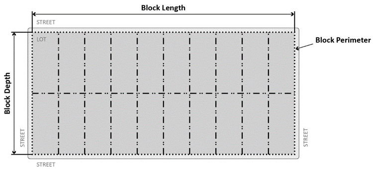
C.
Lots.
1.
Lot Dimensions. All lots of record must be developed to meet the applicable zoning district requirements, including lot area, lot width, building height, impervious coverage, and setbacks, established in Section 8 (Zoning District Regulations). In general, the size, shape, and orientation of lots must be appropriate for the location of the subdivision and for the type of development and use contemplated.
2.
Lot Configuration. The shape of a lot should be rectangular wherever feasible, but may vary based on topography, natural features, or site constraints if a rectangular layout would create an undue hardship. Lots at the end of culs-de-sac or one-way streets may flare out from the front lot line to capture available land.
a.
Additional Depth Required. Residential lots that front on collector streets must be platted with a minimum of 15 feet extra depth to permit generous distances between the buildings and trafficways. Where residential lots front on arterial roads, the minimum building setback line must be increased by an additional 15 feet. Business, commercial, or industrial buildings in residential blocks must be provided with setbacks at least equal to the average setback of the residential properties in that block.
b.
Lot Frontage. Every lot must front on, or have direct access to, an improved public street. Lots with access only to private drives or streets are permitted only with the expressed approval of the Planning and Zoning Commission, and only where adequate fire lanes are provided.
c.
Lot Drainage. Lots must be laid out or graded to provide positive drainage away from all buildings, and individual lot drainage must be coordinated with the general storm drainage pattern for the area. Drainage must be designed to avoid concentration of storm water drainage from any lot to onto adjacent lots.
3.
Lot Shape. Interior side lot lines must be perpendicular to the right-of-way to the extent practical.
4.
Side Lot Lines. Side lot lines must be at right angles or radial to street lines.
5.
Corner Lots. Corner lots in residential subdivisions will have two front yard lot lines, one for each yard that is adjacent to a street, which must provide for extra width to permit appropriate building setback from, and orientation to, both streets. Lots on major street intersections must have a radius of not less than 15 feet at the street corner. On business lots, a straight line segment may be substituted for the circular arc.
6.
Through Lots. The creation of through lots by subdivision, which are also commonly referred to as double-frontage lots, is prohibited; provided, however, that the subdivision of an existing through lot resulting in a new through lot may be permitted to provide separation of the residential development from arterial or collector streets, or to overcome topography constraints.
7.
Reversed Corner Lots. The creation of new reversed corner lots is prohibited unless it is necessary to provide separation of residential development from arterial or collector streets, or to overcome topographic constraints.
8.
Flag Lots. The creation of new flag lots by subdivision is prohibited.
9.
Lots Adjacent to Arterial and Collector Streets.
a.
For lots with a rear lot line adjacent to an arterial or collector street, a minimum of ten feet of landscaping must be provided along the rear lot line.
b.
For lots with a front lot line adjacent to an arterial or collector street, a minimum of 15 feet of landscaping must be provided along the front lot line.
c.
Where a subdivision borders on or contains an existing or proposed arterial road, the Planning and Zoning Commission may require that access to such arterial road be limited by one of the following means:
(1)
The subdivision of lots oriented with a rear yard facing the arterial road and frontage on a parallel local street; no vehicular access can be provided to the arterial road from the lots and a strip of land along the rear property line of such lots, with a width determined by the City Engineer, shall be dedicated to the City as a public right-of-way.
(2)
The establishment of a marginal-access or service road that is separated from the arterial road by a planting or grass strip and having access to the arterial road at suitable points.
(3)
Minimizing the number of residential or local streets entering an arterial road.
(4)
The establishment of a series of culs-de-sac, U-shaped streets, or short loops entered from and designed generally at right angles to, such as a parallel street, with the rear lines of their terminal lots backing onto the arterial road. This type of access could only be provided if no other options are feasible.
10.
Lot Orientation. Lot orientation along an east-west longitudinal axis is recommended for increased energy efficiency.
11.
Parking and Loading Provisions. Depth and width of lots reserved or laid out for business, commercial, or industrial purposes must provide sufficient room for the off-street parking and loading facilities required for the development contemplated, as established in other parts of this Ordinance.
D.
Bicycle and Pedestrian Connectivity.
1.
Connections to Adjacent Systems. New subdivisions must connect to all adjacent planned or existing pedestrian, bicycle, and multi-use paths, and trail systems. Paths and trails must be dedicated or platted in easements to ensure public access.
2.
Minimum Connections. New subdivisions must provide connections to existing bicycle or pedestrian paths at a minimum of every 800 feet along blocks that are adjacent to developable land.
3.
Mid-Block Pedestrian Access. For all blocks longer than 800 feet, mid-block pedestrian access must be provided to adjacent parallel public rights-of-way via a public easement located between lots as close to the center of the block as feasible. This access easement must meet the standard for pedestrian crossings connection in Section 7.04.A.3 (Disconnected Streets). Refer to Figure 7.02-2 Required Mid-Block Pedestrian Access.
Figure 7.02-2 Required Mid-Block Pedestrian Access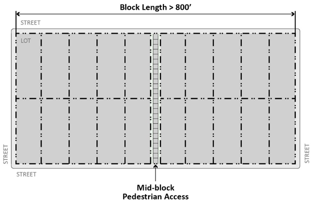
4.
Internal Circulation. An internal circulation system must provide pedestrian and bicycle paths within and adjacent to the development.
5.
Additional Connections. The City may require the inclusion of additional bicycle and pedestrian connections for subdivisions that could be expected to generate higher than average bicycle or pedestrian traffic, such as in the vicinity of schools, playgrounds, parks, shopping areas, or other uses.
7.03 - Conservation and Cluster Subdivision Design
A.
Applicability. The provisions of this Section apply to subdivisions that are developed through conservation or cluster design. See Figure 7.03-1 Standard Development Compared to Conservation and Cluster Subdivision Design.
1.
Conservation Subdivision Design. Conservation subdivision design is required if a conservation features inventory indicates that 20 percent or more of the total land area of a subdivision contains significant natural resources. Conservation subdivision design is a process that requires a fixed percentage of open space as platted on the final plat of subdivision to be conserved while allowing for an increase in the density of lots in a development as compared to conventional subdivision design. Conservation subdivision design is intended to promote environmentally sensitive development, preserve common open space, and achieve a balance between well-designed neighborhoods and natural resource protection.
2.
Cluster Subdivision Design. Cluster subdivision design is an optional subdivision process. A conservation features inventory may be utilized in the planning and design of a cluster subdivision but is not required. Cluster subdivision design is a process that allows for groupings of smaller lots that do not increase the overall density of a development as compared to conventional subdivision layout. Cluster subdivision design is intended to promote environmentally sensitive development, preserve common open space, and achieve a balance between well-designed neighborhoods and natural resource protection. Cluster subdivision design may be restricted to certain zoning districts.
| Figure 7.03-1 Standard Development Compared to Conservation and Cluster Subdivision Design | |
|---|---|
| Standard Development | Conservation and Cluster |
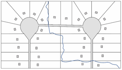 | 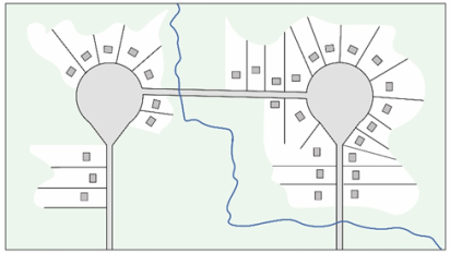 |
B.
Conservation Features Inventory Required. A conservation features inventory (CFI) must be conducted by any application seeking to subdivide any previously undeveloped land or land previously in agricultural use. The CFI must be submitted by the applicant to the Zoning Administrator prior to the submission of the preliminary plat. Significant natural resources that must be included in the conservation features inventory include, but are not limited to, water bodies, floodplains, wetlands, remnant prairies, sensitive aquifer recharge areas, and oak groves, heritage trees, savannas, forests, and threatened or endangered species of flora and fauna located on the subject property.
C.
Conservation Subdivision Design Standards.
1.
Location. Conservation subdivisions are permitted in the R1, R2, R3, L1, L2, and L3 Districts.
2.
Density. A conservation subdivision may include lot sizes of up to 50 percent less than the minimum lot size established in Section 8 (Zoning District Regulations) in the R2 District. Minimum lot sizes may be reduced by up to 25 percent in the R3 District. Minimum lot sizes may not be reduced in the R1, L1, L2, and L3 districts.
3.
Bulk and Setback Standards. Conservation subdivisions in the R2, and R3 Districts are exempt from the minimum lot area and lot width standards of the zoning district where they are located. The building height, and setback standards of the R3 District apply to all conservation subdivisions.
4.
Required Common Open Space. Residential lots in conservation subdivisions must be organized around and provide access to common open space. No less than 40 percent of the land area in a conservation subdivision may be maintained as active or passive common open space in accordance with 7.03.E (Common Open Space).
5.
Conservation Elements.
a.
The subdivision must be configured to protect areas of conservation value identified in the CFI.
b.
The subdivision must be located and oriented to minimize negative impacts on the natural, scenic, and cultural resources of the site.
c.
Downstream impacts of the subdivision must be minimized through the provision and maintenance of adequate on-site stormwater management.
d.
Contiguous areas of undisturbed or restored habitat must be preserved to create corridors for the movement of wildlife and natural resources. Fragmentation and clear-cutting of woodland areas and other natural ecosystems are prohibited.
e.
The subdivision may be required to preserve scenic natural views, including scenic views from roadways.
6.
Residential Lot Configuration. Residential dwellings must be configured in clustered groups of up to 30 dwelling units. Groups of residential lots must be located no less than 150 feet apart, as measured from lot line to lot line. The groups of residential lots must be separated by greenbelts or other natural features. Development is not permitted within these separation areas, but these areas may include pedestrian, bicycle, and multi-use paths, and trail systems.
D.
Cluster Design Standards.
1.
Minimum Subdivision Size. The minimum area of the cluster subdivision is five acres.
2.
Location. Cluster subdivision is only permitted in the R2 and R3 Districts.
3.
Density. A cluster subdivision may include lot sizes of up to 50 percent less than the minimum lot size established in Section 8 (Zoning District Regulations) in the R2 District. Minimum lot sizes can be reduced by up to 25 percent in the R3 District.
4.
Bulk and Setback Standards. Cluster subdivisions are exempt from the minimum lot area and lot width standards of the zoning district where they are located. The building height, impervious coverage, and setback standards of the R3 District apply to all cluster subdivisions, regardless of the zoning district they are located in.
5.
Required Common Open Space. Residential lots in cluster subdivisions must be organized around and provide access to common open space. No less than 25 percent of the land area in a conservation subdivision may be maintained as active or passive common open space in accordance with 7.03.E (Common Open Space).
E.
Common Open Space.
1.
Common Open Space Types. Required common open space must be accessible to the residents of the development. The common open space must also be available to the general public during daylight hours. The open space must be platted as a single lot and restricted from future development via easement, restrictive covenant, or other legally binding record. The following types of common open space are permitted:
a.
Natural water bodies, wetlands, and conservation areas. However, no more than 20 percent of the common open space may consist of water bodies, wetlands, or floodplains.
b.
Detention and retention areas designed as wetlands or natural water features with native vegetation.
c.
Hiking trails and greenways connecting open space areas.
d.
Parks, playgrounds, and recreational facilities, such as ball courts and swimming pools. No more than 30 percent of the common open space may be used for structures for recreational facilities.
e.
Botanical gardens, greenhouses, native plantings, and community gardens.
f.
Agricultural uses, including the reuse of existing barns or silos located on site.
2.
Not Considered Common Open Space. The following portions of conservation or cluster subdivision may not be counted towards common open space requirements:
a.
Yards on individual lots.
b.
Public rights-of-way.
c.
Off-street parking and loading areas.
d.
Golf courses.
3.
Management Plan. A management plan must be submitted for all common open space, including any detention and retention ponds serving more than one property. The designated common open space must be owned and managed by one or more of the following entities and the management plan must meet the standards for each type of plan.
a.
Homeowners Association.
(1)
The developer must provide the City with a description of the association, proof of incorporation, its bylaws, a declaration of covenants, easements, or restrictions, or similar documents regulating the use of the property and establishing procedures for maintaining the common open space. The documents must include a description of how control of the association will be transferred from the developer to the homeowners. Any documents amended after their initial approval must be placed on file with the City Clerk and Zoning Administrator.
(2)
Maintenance and insurance of common open space must be the responsibility of the association. All maintenance and operational obligations of the association with regard to the common open space will be memorialized in the declaration of the subdivision or another legal instrument approved by the City's corporation counsel and suitable for recordation against the subdivision property. The declaration will provide that in the event that the association fails to perform necessary maintenance of the common open space or allows nuisance conditions to persist on the common open space, the City will have the right, after providing notice and an opportunity to cure, to enter upon the common open space and any adjacent lots, to conduct the maintenance and to lien to subdivision property, including all lots for any costs incurred. The association's documentation must be recorded with the final plat of subdivision in accordance with Section 3.03 (Subdivision Applications). Updated documents must be recorded and provided to the City Clerk and Zoning Administrator.
b.
Public or Private Conservation Organization. With the permission of the City, the developer may transfer ownership of the common open space, or easements over the common open space, to a public or private conservation organization in accordance with the following standards.
(1)
The organization must be a well-established conservation organization whose corporate purpose is to conserve open space and/or natural resource areas.
(2)
Any transfer of ownership must include provisions to allow the conservation organization to return the common open space to the property owners in the event that the organization becomes unable to carry out its responsibilities.
(3)
The organization taking ownership of the common open space must execute a maintenance agreement for the common open space in a format that is acceptable to the City's corporation counsel.
(4)
Private Ownership. With the permission of the City, an individual may maintain the common open space as provided by a conservation easement.
If the need for such action is identified, the City may initiate a discussion about alternative management options.
4.
Unmaintained or Mismanaged Open Space. Open spaces are subject to City of Waukegan property maintenance standards enforcement. And the City's right to enter upon the property to conduct maintenance and repairs to abate nuisance conditions.
7.04 - Street Standards for Subdivisions
A.
Street Design Standards for All Street Types.
1.
Design and Arrangement.
a.
A grid layout of interconnected streets is encouraged. The network of streets must form an interconnected grid pattern and provide for the continuation of existing streets into new subdivisions. Culs-de-sac, U-shaped streets, dead-ends, and curvilinear street design must be avoided unless necessary from the topography, natural features, or other site conditions. All non-grid street layouts must follow the requirements of Section 7.04.A.4 (Disconnected Streets).
b.
All streets must be integrated with the existing and proposed system of thoroughfares and dedicated rights-of-way as established on the official City (or street classification system) Map and on any current city streets or thoroughfare plan.
c.
All thoroughfares must be related to special traffic generators such as industries, business districts, schools, churches, and shopping centers; to population densities; and to pattern of existing and proposed land use.
d.
Local and collector streets must be laid out to conform as much as possible to the topography, to discourage use by through traffic, to permit efficient drainage and utility systems, and to require the minimum number of streets necessary to provide convenient and safe access to all occupied lots within the subdivision.
e.
Proposed streets must be extended to the boundary lines of the tract to be subdivided, unless prevented by topography or other physical conditions, or unless in the opinion of the Planning and Zoning Commission, such extension is not necessary or desirable for the coordination of the layout of the subdivision with the existing layout or the most advantageous future development of adjacent tracts.
f.
In business and industrial subdivisions, the streets and other accessways must be planned in connection with the grouping of buildings, location of rail facilities, and the provision of alleys, truck loading and maneuvering areas, and walking and parking areas to minimize conflict of movement between the various types of traffic, including pedestrian.
g.
With approval of the City Engineer, local and collector streets may have seamless curbs with level roadway and pedestrian paths. Streets of this design must be slightly crowned to shed stormwater and must incorporate landscape islands and bioswales for stormwater detention and traffic calming. Bollards or decorative paving may also be used to separate pedestrian and vehicular traffic.
2.
Railroads and Highways (Freeways, Expressways). Railroad rights-of-way and limited-access highways, that impact the subdivision of adjoining lands, must be treated as follows:
a.
In residential districts, a buffer strip at least 45 feet in width, in addition to the normal depth of the lot required in the district, must be provided adjacent to the railroad right-of-way or limited-access highway. This strip must be part of platted lots and must be designated on the plat as follows: "This strip is reserved for the planting of trees, shrubs, and other vegetation by the owner. The placement of structures hereon is prohibited."
b.
In districts zoned for business, commercial or industrial uses, the nearest street extending parallel or approximately parallel to an active railroad right-of-way must, wherever practicable, be a sufficient distance therefrom to ensure suitable depth for commercial or industrial sites.
c.
Streets parallel to the railroad, when intersecting a street which crosses the railroad at grade, must be located no less than 150 feet from the railroad right-of- way, measured from the edge of pavement. The distance must take into account the minimum distance required for the construction of future grade separations and provide sufficient distance to construct appropriate approach gradients.
3.
Disconnected Streets.
a.
Cul-de-Sac or Dead-End Streets. Cul-de-sac or dead-end streets are discouraged and are allowed only when approved by the Zoning Administrator in consultation with the City Engineer. Culs-de-sac or dead-end streets may be allowed due to site constraints such as topography, natural features, railroad tracks, or raised highways. Culs-de-sac or dead-end streets must provide pedestrian and bicyclist access according to the following standards.
(1)
A cul-de-sac or dead-end street serving fewer than 25 dwelling units may not exceed 800 feet in length. Culs-de-sac serving 25 or more dwelling units may not exceed 500 feet in length.
(2)
For residential subdivisions, the diameter of a cul-de-sac turnaround (measured at the outside right-of-way) must be 100 feet or more. Pavement diameter of a cul-de-sac turnaround must be 80 feet or more.
(3)
For non-residential subdivisions, the diameter of a cul-de-sac turnaround (measured at the outside right-of-way) must be 120 feet or more. Pavement diameter of the cul-de-sac turnaround must be 100 feet or more. If a center island is provided, the diameter of the island must be 20 feet or less.
(4)
Pedestrian and Bicycle Access: Culs-de-sac must provide pedestrian and bicyclist access along a public easement located between lots of record when the center point of the cul-de-sac is within 350 feet of a street or another cul-de-sac. Refer to Figure 7.04-1 (Pedestrian Connection from Cul-de-Sac).
(5)
The public easement must be a minimum of 20 feet wide.
(6)
The public easement must include a lighted multi-use path with a minimum width of 10 feet that is constructed of a permanent surface approved by the Zoning Administrator in consultation with the City Engineer and include permanent features to prevent automobile use, such as bollards, on any end that meets vehicular traffic.
(7)
Maintenance responsibility for the easement must be designated in the final plat of subdivision.
Figure 7.04-1 Pedestrian Connection from Cul-de-Sac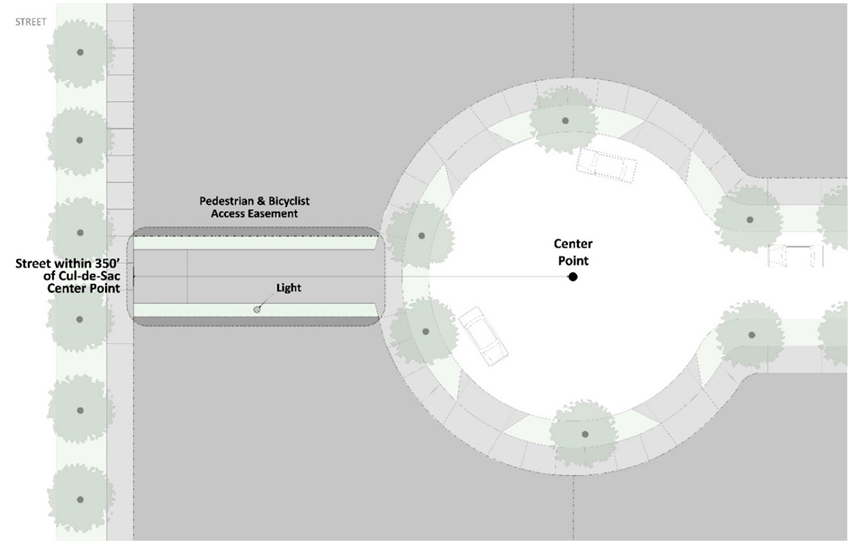
b.
Stub Streets. Stub streets must be extended to the boundary line of the subdivision to provide for future street connections with adjacent parcels upon their development.
c.
Half Streets. Half streets are prohibited unless otherwise approved by the Zoning Administrator in consultation with the City Engineer. Street systems in new subdivisions must be platted to establish streets with the full, required right-of-way. Where an existing half-street is adjacent to a new subdivision, the other half of the street must be dedicated by the subdivider. Where a new subdivision is adjacent to an existing street of inadequate right-of-way width, additional right-of-way width may be required to be dedicated by the subdivider to meet the requirements of this section.
4.
Intersection Design and Alignment.
a.
Alignment of New Streets. New streets must be aligned with existing streets when feasible to form intersections.
b.
Number of Streets. No more than two streets may intersect at any point unless specifically approved by the Planning and Zoning Commission.
c.
Angle of Intersection. Streets must be aligned to intersect at right angles whenever possible. A proposed intersection of two new streets at an angle of less than 75 degrees is prohibited.
d.
Centerline Offsets. The centerlines of intersections must be offset by a minimum distance of 150 feet, see Figure 7.04-2 Centerline Offsets. Proposed new intersections along one side of an existing street must, wherever practicable, coincide with any existing intersections on the opposite side of such street. Street jogs with center-line offsets of less than 150 feet are not permitted, except where the intersected street has separated dual drives without median breaks at either intersection. Where streets intersect major streets, their alignment must be continuous.
Figure 7.04-2 Centerline Offsets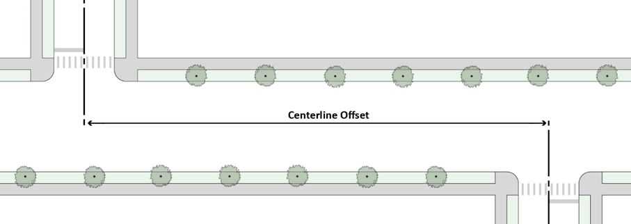
e.
For sight distance, alignment of curved streets, curb radius, minimum grade, earth bank, and cross slope requirements, refer to the Compendium of Specifications for Development.
5.
Alleys.
a.
Alleys must be provided in all business, commercial and industrial districts, except that the Zoning Administrator, in consultation with the City Engineer, may waive this requirement for fire lanes where other definite and suitable provision is made for service access such as off-street loading and parking, fire suppression, police surveillance, consistent with, and adequate for, the uses proposed, and in accordance with the provisions of this Ordinance.
b.
Dead-end alleys are generally prohibited, and crooked and "T" alleys are discouraged. Where dead-end alleys are unavoidable, they must be provided with adequate turnaround facilities at the dead end.
c.
Alleys are prohibited in residential subdivisions with a density less than six dwelling units per acre. Where deemed necessary for access to off-street parking or loading areas or for municipal services, alleys may be approved in higher density residential subdivisions.
d.
Alleys in nonresidential areas must have a minimum width of 24 feet. Alleys in residential areas must have a minimum width of 20 feet.
6.
Crosswalks.
a.
Location. Crosswalks are required at all intersections.
b.
Dimensions. Crosswalks must be a minimum of six feet in width per Manual on Uniform Traffic Control Devices (MUTCD) standards.
c.
Markings. Crosswalks must be highly visible with painted markings and/or textured or colored pavement, in accordance with MUTCD standards.
d.
Pedestrian Crossing Distances. Crosswalks with a crossing distance of 38 feet or more must include median pedestrian refuge areas, curb extensions, or other acceptable pedestrian facilities in the right-of-way to improve pedestrian safety by reducing the crossing distance. Refer to Figure 7.04-4 Pedestrian Crossing Distances.
e.
Raised Crosswalks/Speed Tables. Crosswalks of local streets with two or fewer car travel lanes that are ten or more feet from the intersection must be raised to the level of the sidewalk to prioritize pedestrian safety. Pavement markings on the incline area must be included in each direction of travel. This requirement may be waived by the City Engineer to prevent stormwater drainage or traffic management issues. Stoplight intersections and bus routes are exempt from this requirement.
Figure 7.04-4 Pedestrian Crossing Distances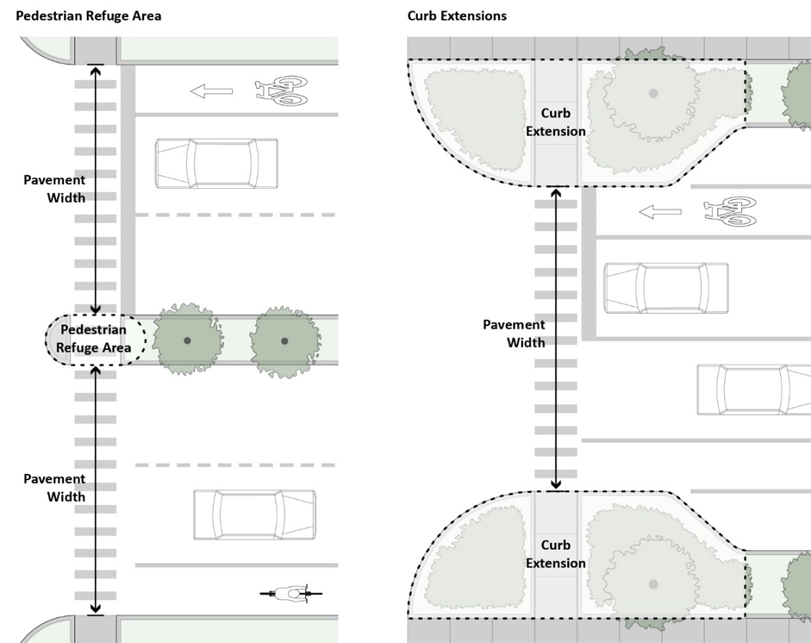
7.
Medians.
a.
Landscaping. Landscape elements within a median must be covered with living plant material. Acceptable plants include shade trees, ornamental trees, shrubs, low-growing evergreens, perennials, and native and no-mow grasses. Sod is allowed but discouraged. Species must be heat, drought, and salt tolerant.
b.
Visibility. Any plant material located within a median, with the exception of trees approved by the City Engineer, may not be taller than 2.5 feet at mature height.
c.
Median Pedestrian Refuge. At any intersection requiring a pedestrian to cross more than three vehicle lanes, a median pedestrian refuge must be installed to provide adequate pedestrian safety. The pedestrian refuge cut-through or ramp must be the same width as the crosswalk. Refer to Figure 7.04-5 Median Pedestrian Refuge Design.
d.
Emergency Vehicle Cross Path. When required by the Fire Department, angled paving must be incorporated 20 feet from the edge of the intersection to allow emergency vehicles to cross the median in the event of traffic at the intersection.
Figure 7.04-5 Median Pedestrian Refuge Design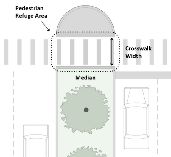
8.
Curb Extensions. Curb extensions must be installed at the intersections of all street types that contain an on-street parking lane adjacent to the curb, to support pedestrian safety. Curb extensions may contain landscaped bioretention cells to facilitate stormwater infiltration and meet the requirements of Section 7.04.D.4 (Parkways and Stormwater Management Facilities).
9.
Accessible Ramps and Warning Panels. Accessible ramps and warning panels are required where all sidewalks or trails terminate at a crosswalk or curb, per the Americans with Disabilities Act or any more stringent state requirement. Two ramps per corner at intersecting streets are required and must be oriented perpendicular to traffic. ADA-compliant pedestrian call buttons are required at all signalized intersections.
10.
Curbs and Gutters. The dimensions and materials of all curbs and gutters must comply with standards established by the City's Engineering Division.
B.
Street Type Design Standards.
1.
General Standards for Street Types. New streets within subdivisions will be configured as a street type that meets the requirements of the General Standards for Street Types according to the Compendium of Specifications for Development. The Zoning Administrator, in consultation with the City Engineer, may require modifications to the street type standards depending on the unique characteristics of the site. Typical street elements are part of either the vehicle realm or the pedestrian realm. Refer to Figure 7.04-6 Typical Right-of-Way Elements.
Figure 7.04-6 Typical Right-of-Way Elements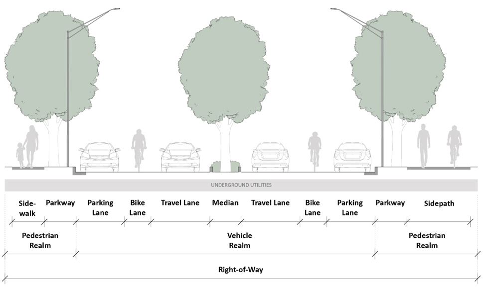
2.
Bicycle Lanes. New streets in subdivisions must include on-street or off-street bicycle facilities in conformance with the City's Complete Streets Policy and relevant planning documents. Three types of on-street bicycle facilities are permitted, and one type of off-street bicycle facility is permitted. The option that promotes the highest level of pedestrian safety possible must be implemented. Designs other than those specified in this Ordinance may be considered. Refer to Figure 7.04-7 Bicycle Lanes for examples.
a.
Dedicated Bicycle Lane. Dedicated bicycle lanes are on-street striped lanes outside the outermost vehicular travel lanes. Dedicated bicycle lanes must be located on one or both sides of the street and must be a minimum of four feet wide with a one-foot buffer per lane. Dedicated bicycle lanes must incorporate a buffer from vehicle traffic via concrete curbs or flexposts. Where vehicles must cross the designated bicycle lane, green piano-style street paint must be incorporated, and the buffer must be removed for the width of the vehicle crossing.
b.
Designated Shared Lane. Designated shared lanes are on-street lanes that are shared by vehicles and bicycles. Designated shared lanes must be a minimum of 14 feet wide to accommodate both vehicles and bicycles. On two-way streets, a designated shared lane is required in both directions. Designated shared lanes must be indicated by shared lane markings or "sharrows".
c.
Shared Lane. Shared lanes are on-street facilities that do not have dedicated bicycle lanes or designated shared lanes, but that allow bicycles to comfortably share lanes with vehicular traffic due to the speed and configuration of the street. Speed limits may not exceed 20 miles per hour on shared lane roads.
d.
Sidepath. Sidepaths are off-street facilities that are shared by pedestrians and bicyclists. Sidepaths function like a sidewalk but are wide enough to accommodate pedestrians and bicyclists simultaneously. Sidepaths are required on both sides of the street and must be a minimum of 10 feet wide. At the Zoning Administrator's discretion, a sidepath may be located on only one side of the street provided the sidepath is a minimum of 12 feet wide.
Figure 7.04-7 Bicycle Lanes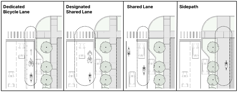
3.
Street Trees. Street trees must be installed in public rights-of-way in accordance with Section 11.04 (Street Trees).
4.
Parkways and Stormwater Management Facilities. Stormwater management facilities approved by the City Engineer must be integrated within the parkway of all street types to help clean and infiltrate stormwater runoff (refer to Figure 7.04-8 Bioswale Design, Figure 7.04-9 Bioretention Planter Design, and Figure 7.04-10 Bioretention Curb Extension Design).
a.
Bioswales, bioretention planters, or other stormwater management best management practices are encouraged to be installed within all new parkways.
b.
Bioretention cells may be included within curb extensions for all street types when a parking lane is adjacent to the parkway. Bioretention cells may extend into the parkway.
Figure 7.04-8 Bioswale Design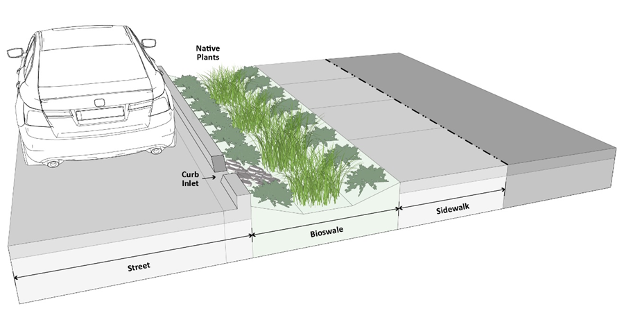
Figure 7.04-9 Bioretention Planter Design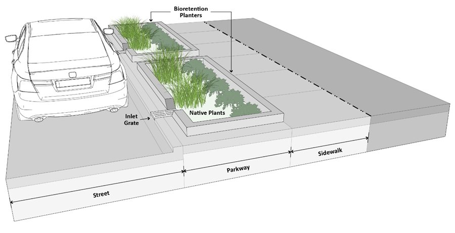
Figure 7.04-10 Bioretention Curb Extension Design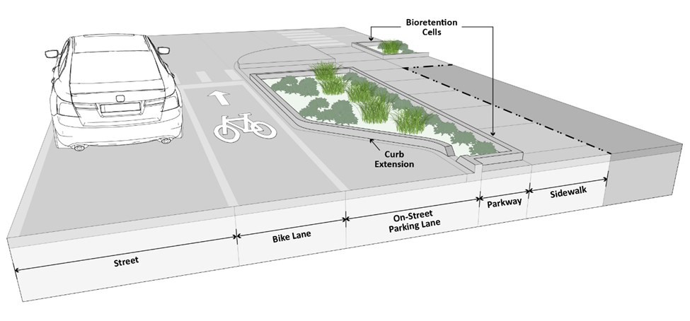
7.05 - Required Public Improvements
Required public improvements must be provided in accordance with the City of Waukegan Engineering Department's Compendium of Specification for Development.
7.06 - Cash and Land Donations
A.
Applicability. The requirements of this Section apply to new subdivisions and new planned unit developments to provide for the City's needs for various facilities and services, such as public schools, parks, street maintenance, and police and fire protection. Recognizing that Waukegan Park District and Waukegan Community Unit School District 60 are separate entities, their jurisdiction to require and collect land or fee contributions from developers shall prevail.
1.
Land Donation. The Planning and Zoning Commission and/or City Council may require that land be reserved for school purposes or for parks, playgrounds, or other recreational purposes, or for other public improvements purposes, in locations designated on the current City of Waukegan Comprehensive Plan or otherwise where such reservations would be appropriate. Each such reservation must be of suitable size, dimension, topography, and general character, and must have adequate road access for the particular purposes envisioned by the Planning and Zoning Commission and/or City Council. The area must be shown and marked on the plat "Reserved for Park and/or Recreation Purposes" or "Reserved for School Purposes" or "Reserved for Future Fire Stations" etc. The developer must dedicate all school or recreation areas or other public improvement areas to the City or the respective District as a condition of final subdivision plat approval.
2.
Cash-in-Lieu Donation. The City Council, acting on the recommendation of the Planning and Zoning Commission after receiving the plat review comments of the City or respective district, and in those instances where either the proposed subdivision is too small to solely support the planned improvement or facility or such facility would benefit a much larger area of the city, may require the applicant to deposit with the city or the district a cash payment in lieu of land dedication.
B.
Ultimate Population Per Dwelling Unit. The ultimate population density generated by a subdivision or planned unit development will be calculated using the projections set forth in Table 7.06-1 Ultimate Population Per Dwelling Unit.
C.
Park Site Donation.
1.
General Provisions.
a.
Conveyance of Land. Required land donations must be provided per Section 7.06.A.1 (Land Donation).
b.
Cash in-Lieu Donations. Required cash donations must be provided per Section 7.06.A.2 (Cash-in-Lieu Donation).
c.
Phasing. The improvement of all donated park land sites must be completed by the developer prior to the issuance of certificates of occupancy for more than 20 percent of the dwelling units planned to be constructed in the development.
2.
Park Land Donation Calculation.
a.
Park Acreage Requirement. The amount of park land required is determined by the ultimate density of the proposed development. For parks, 10 acres of park land per 1,000 residents must be donated.
b.
Land Donation Formula. The amount of park land to be donated is determined by the following formula.
i.
The total number of units for each dwelling type to be built is multiplied by the corresponding population density in Table 7.06-1 Ultimate Population Per Dwelling Unit.
ii.
The product for each dwelling type is added to calculate the ultimate population of the development. The ultimate population for all dwelling units is then divided by 1,000.
iii.
The result of such division is then multiplied by 10 to determine total acreage needed for park land donation.
3.
Criteria for Required Park Land Donation.
a.
Site Criteria. The location of the park land donation must be suitable for the purposes for which it is intended. Wetlands, floodplains, detention areas, stormwater retention basins, and areas of steep slope are not considered suitable park land and cannot be counted as a land donation. The proposed donation site must be an integral component of the neighborhood, rather than left over parcels, and must be safely and conveniently accessible to pedestrians and cyclists.
b.
General Uses. The required park land donations may only be improved with play lots, mini parks, neighborhood parks, and community parks in accordance with Table 7.06-2 Types of Parks.
c.
Location. Parks established pursuant to a land donation must be located no less than 1,320 feet (equivalent of ¼ mile) from every lot in the subdivision, as measured by walking distance, so parks are accessible to the surrounding neighborhood. The City retains final selection and approval authority for all park site locations. This range may be extended up to 0.75 miles for community parks.
d.
Compatibility with Current Plans. The City's Comprehensive Plan and its other land use policies will guide the location of park sites. Land donation will only be accepted in instances where a developer owns land in reasonable proximity to a planned park site. In all other cases, the payment of the cash-in-lieu of land donation is required.
e.
Condition of Donated Land. Donated land must be in a condition ready for development as parkland including proper site drainage and curb and gutter treatment in a manner consistent with the rest of the development. Donated land may not contain hazardous or toxic materials or must be remediated to residential standards. Original topsoil and vegetative cover must either remain undisturbed or the site must be prepared in a manner consistent with the standards of the applicable park district.
4.
Park Land Donation Substitutions.
a.
Cash-in-Lieu. If it is determined by the Zoning Administrator that park land would be more appropriately located off-site, per the requirements of Section 7.04.A.2 (Cash-in-Lieu Donation), the City may agree to accept cash-in-lieu of donation.
b.
Off-Site Park Land Donations. Off-site park land may provide credit for up to a maximum of 50 percent of the total required park land donation provided that such land is accessible to the community, and advances City goals to naturalize flood-prone properties, transition to passive recreation use, or increase conservation areas.
c.
Park Improvements Credit. The City Council may recognize existing or proposed park improvements as equal to or greater than the value of the improvement fees required in this Section and may credit the development's total required park contribution with the value of such site improvements.
d.
Private Parks. Private parks may provide credit for up to a maximum of up to 25 percent of the total park land donation, provided that such land is determined to be of equivalent value to public park land and that the park is available by right to all residents of the development. Private parks are only eligible for credit when they are open to the public from 8:00 a.m. to 8:00 p.m.
D.
School Site Donation.
1.
General Provisions.
a.
Conveyance of Land. Required land donations must be provided per Section 7.06.A.1 (Land Donation).
b.
Cash Donations. Required cash donations must be provided per Section 7.06.A.2 (Cash-in-Lieu Donation).
2.
School Land Donation Calculation.
a.
School Classifications and Size of School Site. School classifications and the size of school locations within the City must be determined in accordance with the criteria shown in Table 7.06-3 School Classifications and Size. The criteria provided is consistent with the Illinois Office of Education Standards, as adopted by the Illinois State Board of Education.
b.
Land Donation Formula. The ultimate number of students generated by a subdivision or planned unit development have a direct impact on the amount of land required for school sites. The following formula determines how many acres are required to be donated.
(1)
The total number of units for each dwelling type to be built is multiplied by the corresponding population density in Table 7.06-1 Ultimate Population Per Dwelling Unit.
(2)
Use the resulting projections for students and Table 7.06-3 School Classifications and Size to establish the ratio of projected students to the required acreage for school sites for each school classification.
E.
Reservation of Additional Land for Parks and Schools. In situations where the City's Comprehensive Plan and the other land use policies of the City call for a larger park or school site than the amount calculated by the requirements of this Section, the land needed must be reserved for purchase by the City or other public body designated by the City. The purchase will be set at the average fair market value of the land, as determined by the City, provided that the agreement for land acquisition is made no later than one year after final plat approval. The failure of the City or other public body to reach an agreement for land acquisition within one year of final plat approval will terminate the reservation and release said property for future development in accordance with this Ordinance.
F.
Conveyance of Land Donation.
1.
Title. All land donations for park, school or other municipal or public purpose must be conveyed to the City, school district, the Waukegan Park District, or other public body following the recording of a final plat or approval of a planned unit development agreement.
2.
Conveyance Requirements. Each deed or other instrument conveying land must be accompanied by:
a.
A written commitment issued by a title insurer licensed to do business in Illinois to insure the title to such real estate in an amount equal to its value. The written commitment will be subject to current real estate taxes, covenants, conditions, and restrictions.
b.
A current boundary line survey, certified to the City by a licensed Illinois Land Surveyor.
c.
An assessment plat and tax division petition in a form acceptable to the appropriate county authorities so that the land can be assigned its own property index number.
d.
A phase one environmental study prepared by an environmental consultant assuring the City that there are no hazardous or toxic materials on the property as defined in federal, state, or local laws.
3.
Acceptance of Dedicated Land for Public Use. When a final plat of subdivision has been approved by the City Council and all other required approvals are obtained and the plat is recorded, that approval constitutes acceptance for the purpose designated on the plat of all lands shown on the plat as dedicated to the public, including street dedications. Whenever a preliminary plat includes a proposed dedication of land to public use and the Planning and Zoning Commission finds that such land is not required or not suitable for public use, the Planning and Zoning Commission may recommend that the City Council either refuse to approve such dedication or require the rearrangement of lots in the proposed subdivision to include such land.
4.
Maintenance. Maintenance of the land reserved for a park, school, municipal, or other public purpose is the responsibility of the developer of the property from the date that it is conveyed until ownership is transferred or the property is sold. Failure of the developer to maintain the property will result in relinquishing all rights to the property, subject to statutory law governing conveyances of municipal real estate.
G.
Cash Donations.
1.
Establishment of Fees.
a.
Determination of In-Lieu Fee Amounts. The cash contribution in lieu of land is determined by multiplying the acreage demand for a given development by the average fair market value for land acquisition.
b.
Determination of Fair Market Value. The cash contributions in lieu of land is based on the fair market value of subdivided land that otherwise would have been donated as park or school sites. The average fair market value for acquiring improved land in the City is $90,000.00 per acre as of the date of adoption of this Ordinance. The fair market value will be adjusted upward at an annual rate of 3 percent.
2.
Criteria for Requiring a Contribution in Lieu of Land Donation.
a.
Unsuitability Determination. The determination that available land is unsuitable for a park or school site will be made by the City after inspecting the land and receiving the recommendation of the public agency, whether the Waukegan Park District or local school district affected.
b.
Small or Otherwise Inappropriate Sites. In cases where a development is small and the resulting site would be inappropriate for a park or school, the City will require the developer to pay a cash contribution in lieu of land donation.
3.
Donation of Both Land and Cash-In-Lieu of Land. Situations where a required donation of both land and a cash-in-lieu donation will be determined by the City as follows.
a.
A portion of the land to be developed is proposed as the location for a park or school site. The portion of the land within the subdivision that is within the park or school site must be donated as an appropriate site and a cash contribution is required in lieu of any additional land that is required.
b.
A part of the designated park or school site has already been acquired and only a small portion of land is needed from the development to complete the site. The remaining portion is required by donation, and a cash contribution in lieu of the land is required.
c.
A certain park or school site will be donated, and the rest of the required park or school site acreage would be unsuitable for a park or school. In this case, the cash must be contributed in lieu of the rest of the required school or park site acreage.
4.
Time and Manner of Payment. The amount of cash-in-lieu donation will be determined by the City at the time of final plat or planned unit development approval. It must be recognized that the dedication of land or cash-in-lieu donation, required for public improvements and services as established in this subsection, may not be confused with, or substituted wholly or in part for, the standard required improvements specified in City of Waukegan Engineering Department's Compendium of Specifications for Development.
a.
Schools. Such payment must be placed in a School Improvement Fund to be established by the district and must be used by the appropriate school district for the construction of new schools or the improvement of existing facilities, including acquisition costs. Such deposit must be used for facilities that will actually be available to, and benefit the persons in said district, as agreed by the subdivider and the school board in prior agreement.
b.
Parks. Such payment must be placed in a Parks and Recreational Improvement Fund established by the Waukegan Park District and must be used by the district for the development or improvement of parks and recreational facilities, including any acquisition costs. Such deposit must be used for facilities that will actually be available to and benefit the persons in said district.
c.
Other Public Improvements. Such payment must be placed in the appropriate corporate fund account, and will be used by the City of Waukegan for the development or improvement of firefighting, protection, public health and security services and facilities, traffic signals, or other roadway or other traffic movement improvements, and other public improvements necessitated by or for the benefit of, the City
5.
Cash Donations for Special Districts.
a.
Deposit and Distribution. Cash contributions for non-City services must be deposited with the City and subsequently distributed to special districts upon written request by the applicable district. The amount of the contribution will be determined by the City in consultation with the district. The funds will be used by the district in which the funds were collected to improve facilities, equipment, or operations.
b.
Indemnification. By accepting land and/or cash, the special district must indemnify the City in writing against any loss, cost, or expense designated for the district.
c.
Reimbursement. By accepting land and/or cash, the special district must reimburse the City for all expenses incurred in obtaining the land and/or cash required by this Section. The payment must be made to the City no later than 30 days after the district's receipt of the land and/or cash, or receipt of an invoice from the City, whichever occurs later.
(Ord. No. 25-O-03, § 2(Exh. A), 1-6-25)
7.07 - Subdivisions Created by Successive Divisions
Whenever a parcel of land is subdivided into lots containing one or more acres, and there are indications that such lots will eventually be subdivided into smaller building sites, the Planning and Zoning Commission may require that such parcels of land be divided to allow for the future opening of streets and the ultimate extension of adjacent streets. Easements providing for the future opening and extension of such streets may be made a requirement of the plat.