
Weber County Unincorporated
City Zoning Code
City Zoning Code
CHAPTER 104
29 Ogden Valley Destination And Recreation Resort Zone DRR-1
Sec 104-29-1 Purpose And Intent
The purpose of this chapter is to provide flexible development standards to resorts that are dedicated to preserving open space and creating extraordinary recreational resort experiences while promoting the goals and objectives of the Ogden Valley general plan. It is intended to benefit the residents of the county and the resorts through its ability to preserve the valley's rural character, by utilizing a mechanism that allows landowners to voluntarily transfer development rights to areas that are more suitable for growth when compared to sensitive land areas such as wildlife habitats, hazardous hillsides or prime agricultural parcels. Resorts within an approved destination and recreation resort zone shall, by and large, enhance and diversify quality public recreational opportunities, contribute to the surrounding community's well-being and overall, instill a sense of stewardship for the land.
(Ord. of 1956, § 44-1; Ord. No. 2016-4, Exh. B2, 5-24-2016)
Sec 104-29-2 Development Standards
- General design and layout. A destination and recreation resort shall have a general design that concentrates a mixture of recreational, commercial and residential uses within and immediately adjacent to a village core which is surrounded by open landscapes and wildlife habitats. Areas outside of the village core may include recreational and resort supporting uses/facilities and intermittently dispersed/clustered employee, single-family and multifamily dwellings.
- Minimum area. The minimum area requirement for a Destination and recreation resort shall be 1,000 contiguous acres located within the Ogden Valley. The resort area may be made up of multiple property owners making application under one contiguous and cohesive plan including lands under contract or agreement with a local, state or federal agency. Lands under such contract or agreement shall not count towards the minimum area requirement.
- Maximum permitted units. Current zoning is not considered when determining the maximum number of dwelling units allowed within a destination and recreation resort zone. The maximum number of units allowed within the zone (resort) shall be dependent upon; (1) an applicant's willingness to acquire and/or transfer development rights to the resort; (2) an applicant's desire to accrue additional discretionary units in the form of transfer incentive matching units (TIMUs) and/or density bonus units (DBUs); and (3) an applicant's ability to demonstrate a substantial public benefit and exhibit an exceptional vision and development plan superior to that allowed by current or conventional zoning.
- The preservation of open space and the maintenance of the Ogden Valley's rural character and its natural systems are very important goals, therefore, it shall be required that an applicant make an initial transfer of development rights, to the resort, from elsewhere within the valley. This initial transfer will establish a base number of units, referred to as transferred base units (TBUs), that may be used in a request to receive additional transfer incentive matching units (TIMUs) and/or density bonus units (DBUs). These units, requested in addition to the TBUs, are an alternative source of development rights and are considered to be performance based units that may be awarded through a resort's voluntary participation in the transfer incentive and bonus unit options listed below. These options are intended to provide flexibility and the voluntary means of increasing resort development rights through thoughtful and effective mitigation of resort development impacts and supporting Ogden Valley community interests and objectives as specifically referred to in the Ogden Valley general plan. To be eligible to receive TIMUs and/or DBUs, the units transferred to the resort shall be from an elevation of 6,200 feet and below unless located within an important wildlife habitat area and/or ridgeline area as defined by the Weber County Zoning Ordinance. Units transferred from an elevation above of 6,200 feet are permitted; however, those units, excepting those located with an important wildlife area and/or ridgeline area, shall not be eligible to receive TIMUs and/or DBUs. Refer to sections 104-29-3, 104-29-4 and 104-29-5 of this chapter for transferable development right eligibility and procedures for calculating and transferring units to a destination and recreation resort zone.
- In the event that a previously approved master planned resort makes application to become (or makes application to amend) a destination and recreation resort zone, the resort may retain the remaining dwelling unit rights associated with a previously approved and executed zoning development agreement given that the resort can meet all other requirements of this chapter and demonstrate a substantial public benefit while exhibiting an exceptional vision and development plan superior to that allowed by current or conventional zoning. If a previously approved master planned resort chooses to increase densities beyond what remains as part of a previously approved and executed zoning development agreement, the resort shall be obligated to acquire and incorporate additional contiguous acreage into its boundary and/or acquire additional density in the form of transferable development rights, transfer incentive matching units and/or density bonus units.
- Density related to additional acreage, brought into the resort, shall be calculated in conformance with the standards found in section 104-29-4, with the exception of those in subsections 104-29-4(a)(6) and (7).
- Density related to additional acreage, brought into the resort, which is the subject of a previously approved master plan, zoning development agreement and/or other agreement with Weber County, relating to (or calculating) density, shall be calculated consistent with terms and conditions set forth in the previously approved master plan or agreement. Other (density and non-density) terms and conditions may, at the discretion of the Ogden Valley Planning Commission and Weber County Commission, be altered, modified or otherwise amended and included in any rezone approval in order to promote the health, safety and welfare of the residents of Weber County.
- Density related to transferable development rights shall be calculated in conformance with the standards found in sections 104-29-3 through 104-29-6.
- Transfer incentive matching units. Each transferred base unit (TBU) that qualifies to receive transfer incentive matching units shall only be applied to one of the following six categories:
- For every unit transferred to a resort from a parcel within the Shoreline (S-1) Zone and/or other parcels located in between Pineview Reservoir and the main roadway (Highways 158, 166, 39, and 2200 North Street) surrounding the Reservoir, Weber County may match that number at a rate ranging from 0.0—2.0 units to each transferred unit depending upon the percentage of units transferred as shown in the table below. To be eligible to receive the matching units associated with these parcels, the transferring parcel shall be configured as it was prior to the 2005 adoption of the Ogden Valley General Plan Recreation Element and shall be subject to the following table:
Percentage of Units Transferred from Parcel Match Less than 40% 0.0 40% to 55% 1.25 56% to 70% 1.5 71% to 85% 1.75 86% to 100% 2.0 - For every unit transferred to a resort from a CVR-1 Zone located adjacent to the shoreline of Pineview Reservoir, Weber County may match that number at a rate of three units to each transferred unit. To be eligible to receive the matching units associated with these parcels, the following two conditions must be met:
- All units, except one unit for every five acres within the parcel, shall be transferred.
- The subject CVR-1 parcel shall be configured as it was prior to the 2005 adoption of the Ogden Valley General Plan Recreation Element.
- For every unit (including those above an elevation above 6,200 feet) transferred to a resort from an area within the important wildlife area, as shown on the adopted Ogden Valley Sensitive Lands Map, Weber County may match that number at a rate of 2.0 units to each transferred unit.
- For every unit (including those above an elevation above 6,200 feet) transferred to a resort from an area within a ridge line area that skylines as viewed from any scenic corridor at a distance of less than 2.5 miles, (as described in the adopted Ogden Valley Sensitive Lands Ordinance), Weber County may match that number at a rate of 2.0 units to each transferred unit.
- For every unit transferred to a resort from an area not previously listed but lying below an elevation of 5,500 feet, Weber County may match that number at a rate of 1.5 units to each transferred unit.
- For every unit transferred to a resort from any other areas within Ogden Valley, with the exception of units transferred from an elevation of 6,200 feet and above, Weber County may match that number at a rate of 1.0 unit to each transferred unit.
- For every unit transferred to a resort from a parcel within the Shoreline (S-1) Zone and/or other parcels located in between Pineview Reservoir and the main roadway (Highways 158, 166, 39, and 2200 North Street) surrounding the Reservoir, Weber County may match that number at a rate ranging from 0.0—2.0 units to each transferred unit depending upon the percentage of units transferred as shown in the table below. To be eligible to receive the matching units associated with these parcels, the transferring parcel shall be configured as it was prior to the 2005 adoption of the Ogden Valley General Plan Recreation Element and shall be subject to the following table:
- Density bonus units. Any bonus units awarded by Weber County shall be calculated by multiplying the total of all TBUs plus the number of transfer incentive units earned, by a bonus percentage that is based upon an accumulation of each of the listed bonus options. The maximum bonus percentage shall not exceed 60 percent.
- Develop a resort that can demonstrate (based upon substantial evidence and by means of a professional and empirical study) how it meets the purpose and intent of this chapter (e.g., utilize sustainable design practices that mitigate development impacts, preserve open space and convey a sense of stewardship for the land, contribute to the surrounding community's character and economic well-being, diversify and enhance quality public recreational opportunities); up to a ten percent bonus may be granted.
- Develop a resort that can demonstrate, (based upon substantial evidence and by means of a professionally prepared traffic impact analysis) that, due to proposed transferring of development rights to the resort, an 80 percent reduction in (potential) future traffic congestion throughout the Ogden Valley and/or at key intersections such as the SR39/SR158 (spillway) intersection, SR158/Highway 162 (Eden four-way stop) intersection and the SR39/Highway 166 (Huntsville Crossroads) intersection will occur; up to a ten percent bonus may be granted.
- For an additional ten percent or more of conservation open space preserved within the resort in excess of the minimum required by this chapter; up to a one-time maximum of five percent bonus may be granted.
- Provide a developed and (public land agency) approved access to public lands; up to a five percent bonus may be granted.
- Preservation of an Ogden Valley agricultural parcel (within or outside of the resort boundary) through the recordation of an agricultural preservation easement and agricultural preservation plan proposed by the developer and approved by Weber County in consultation with the Utah State Agriculture Extension Office; up to a ten percent bonus may be granted for parcels containing 50 acres of more; however; a 20 percent bonus may be granted for preserving an agricultural parcel containing 100 acres or more.
- Preservation of an Ogden Valley historical site (within or outside of the resort boundary) through the recordation of a historical preservation easement and historical preservation plan proposed by the developer and approved by Weber County in consultation the Utah State Historic Preservation Office; up to a 20 percent bonus may be granted.
- Establishment, promotion and implementation of an innovative program or project that substantially furthers Ogden Valley community interests and objectives as specifically referred to in the Ogden Valley general plan; up to a 30 percent bonus may be granted.
- Donation and/or permanent preservation of a site determined to be desirable and necessary, to a local sewer, cemetery or other district, for the perpetual location and operation of a public facility; up to a five percent bonus may be granted.
- Donation and/or permanent preservation of a site determined to be desirable and necessary, to a local park or other county-approved entity, for the perpetual location and operation of a public cultural or recreational facility; up to a 20 percent bonus may be granted.
- [Calculating maximum permitted units.] The following formula demonstrates how to calculate the maximum permitted units at a destination and recreation resort:
Applicant's initial Transfer of Base Units (TBUs)
+ Transfer Incentive Matching Units (TIMUs) Awarded by Weber County
× Density Bonus Unit (DBUs) Percentage Awarded by Weber County
________________________________________________________
= Maximum Permitted Units- The maximum number of permitted units shall diminish as development occurs at a rate of one unit per one residential lot/unit developed and a rate of one unit for every 5,000 square feet of commercial space developed. Commercial area within hotel lobbies and conference rooms/facilities are excluded from this calculation.
- Buffer area. A buffer area, approved by the Ogden Valley Planning Commission, shall be provided at the perimeter of the resort boundary where commercial and/or multifamily buildings and associated parking are proposed to lie within close proximity to lands that are not a part of the resort, except where at the location of the use the developer (as defined in the applicable zoning development agreement) owns at least 200 feet of property extending from the resort boundary or where the developer has received approval from the owner of any property within 200 feet of the resort boundary. The following minimum standards shall apply:
- DRR-1 Zone abutting zones that allow residential uses with area requirements of one unit per three acres or larger: A minimum width of 200 feet with an additional ten feet of buffer for every one foot that a resort building exceeds the height of 35 feet.
- DRR-1 Zone abutting zones that allow residential uses with area requirements of less than one unit per three acres: A minimum width of 100 feet with an additional ten feet of buffer for every one foot that a resort building exceeds the height of 35 feet.
- DRR-1 Zone abutting commercial zones or zones that allow multifamily dwellings: No buffer required.
- No buffer area is required at or around a resort's interior lot or parcel boundaries or where a resort shares a common boundary with a local, state or federal agency that has entered into a contract or agreement for the use of adjacent local, state or federal lands.
- Site development standards.
(1) Minimum lot area a. Single-family residential/main building None b. Two, three, four and multi-family, commercial and mixed use structure None c. Public utility substation As provided in Section 108-10-2: Site development standards for public utility substation or structure d. Other As otherwise required by the Uniform Land Use Ordinance of Weber County (2) Minimum lot width a. Single-family residential/main building None b. Two, three, four and multi-family, commercial and mixed use structure None c. Public utility substation As provided in Section 108-10-2: Site development standards for public utility substation or structure d. Other As otherwise required by the Uniform Land Use Ordinance of Weber County (3) Site setbacks. Setbacks shall apply for the following specific uses: a. Front yard 1. Single, two, three and four-family dwelling None (0 feet) 2. Accessory building related to the above None (0 feet) 3. Multifamily, commercial and mixed use structure None (0 feet) 4. Accessory building related to the above None (0 feet) 5. Public utility substation As provided in Section 108-10-2: Site development standards for public utility substation or structure 6. Other As otherwise required by the Uniform Land Use Ordinance of Weber County b. Side yard 1. Single, two, three and four-family dwelling 5 feet 2. Accessory building 8 feet, except 3 feet when located at least 10 feet from the rear of the dwelling 3. Multifamily, commercial and mixed use structure None (0 feet); except where a destination and recreation resort parcel sides on an existing parcel in a commercial zone, lying outside of the destination and recreation resort zone. In this situation, the destination and recreation resort multifamily, commercial and/or mixed use structure(s) shall be setback in a manner that meets the requirements for the zone in which the adjacent parcel is located. 4. Accessory building None (0 feet); exception is the same as above 5. Public utility substation As provided in Section 108-10-2: Site development standards for public utility substation or structure 6. Other As otherwise required by the Uniform Land Use Ordinance of Weber County c. Rear yard 1. Single, two, three and four-family dwelling 10 feet 2. Accessory building 3 feet, except 8 feet where accessory building rears on side yard of a lot that lies adjacent to a corner lot 3. Multifamily, commercial and mixed use structure None (0 feet); except where a destination and recreation resort parcel rears on an existing parcel in a commercial zone lying outside of the destination and recreation resort zone. In this situation, the destination and recreation resort multifamily, commercial and/or mixed use structure(s) shall be setback in a manner that meets the requirements for the zone in which the adjacent parcel is located. 4. Accessory building None (0 feet); exception is the same as above 5. Public utility substation As provided in Section 108-10-2: Site development standards for public utility substation or structure 6. Other As otherwise required by the Uniform Land Use Ordinance of Weber County (4) Maximum building height a. Single, two, three and four-family dwelling 35 feet b. Multifamily, commercial and mixed use structure 55 feet at elevations lower than 6,200 feet above sea level. 75 feet at elevations of at least 6,200 feet above sea level. c. Public utility substation 35 feet, unless otherwise provided in Section 108-7-5: Exceptions to height limitations d. Other As otherwise required by the Uniform Land Use Ordinance of Weber County - Open space. A minimum of 60 percent of the net developable acreage, owned by the resort and located within the destination and recreation resort zone, shall be designated as open space. A portion of that open space shall consist of conservation open space in an amount equal to or greater than 30 percent of the resort's net developable acreage. The area designated as conservation open space shall be encumbered by an irrevocable conservation easement meeting the general/applicable requirements described in section 104-29-6 of this chapter and shall be granted prior to beginning any construction within an overall subdivision phase. The minimum number of acres encumbered by each easement shall be equal to or greater than the number of acres involved in each subdivision phase until the total number, of required conservation open space acres, is met. Areas dedicated (platted and recorded) as open space within residential and nonresidential subdivisions may count towards the minimum open space requirement.
- Alternative development standards. After recommendation from the planning commission, the county commission may approve alternative development standards than those found in this section provided the alternative standards are part of a legislatively approved development agreement with a master plan and assist with the implementation of the agreement or master plan.
(Ord. of 1956, § 44-2; Ord. No. 2016-4, Exh. B2, 5-24-2016; Ord. No. 2017-2, Exh. A1, 1-24-2017; Ord. No. 2017-11, Exh. A, 5-9-2017; Ord. No. 2018-6, Exh. A, 5-8-2018)
Amended by Ord. 2021-6 on 3/23/2021
Sec 104-29-3 Transferable Development Right (TDR) Eligibility
Real transfer from parcels contiguous or noncontiguous to the resort and not included as part of DRR-1 Zone. A landowner may transfer development rights from any lot of record or described parcel of land that is contiguous or noncontiguous to the resort and meets or exceeds the minimum (single-family dwelling) area requirement for the zone in which it located. A landowner may also transfer development rights from any parcel that has been described in a document (e.g., deed, sales contract or survey) and subsequently recorded in the office of the Weber County Recorder in between January 1, 1966 and June 30, 1992. This parcel must have complied with the zoning requirements in effect at the time of its creation but not necessarily undergone or successfully completed the county subdivision process. Development rights transferred from parcels, as described above, shall be considered eligible to receive TIMUs and DBUs as described in section 104-29-2(c) (Maximum permitted units). A resort that transfers development rights shall do so by conforming to the requirements of this chapter and shall finalize and record all necessary transfers (for a particular phase or part thereof) prior to submitting any application for subdivision or plan approval for any site within the destination and recreation resort zone.
- At the discretion of the resort, development rights required to be transferred in order to establish an initial number of transferred base units (TBUs), as described in section 104-29-2(c) (Maximum permitted units), may be acquired through a purchase of real property or through private negotiation and purchase of transferable development rights only.
- Refer to section 104-29-4 (Calculating transferable density) for transferable density calculation requirements. Refer to section 104-29-5 (Transferable development right procedure) and section 104-29-6 (Transferable development right easement) for procedural and content requirements relating to a transfer of development right easement.
(Ord. of 1956, § 44-3)
Sec 104-29-4 Calculating Transferable Density
- Transferable density calculation for real transfers. Except for the circumstances and/or conditions listed below, every lot of record; and every described parcel of land exceeding the minimum (single-family dwelling) area requirement, for the zone in which it is located; and every parcel/lot that has been described in a deed, sales contract or survey that was recorded in the office of the county recorder, in between January 1, 1966, and June 30, 1992, and met the zoning requirements in effect at the time of its creation but has not necessarily undergone and successfully completed the county subdivision process shall be granted transferable development rights based upon the parcel/lot's record description/area and current or other applicable zoning. Transferable development rights shall be excepted from and/or not granted to the following:
- Areas within a described parcel of land containing slopes of 40 percent or greater in forest zones and 30 percent or greater in all other zones.
- Areas within a described parcel of land and/or proposed irrevocable transfer of development right easement (ITDRE) reserved for future development or designated as a reserved future development area (RFDA) on an approved transferable development right site plan.
- Areas within a described parcel of land or lot of record restricted by conservation easement or similar instrument restricting residential or commercial development.
- Areas or tracts of land owned by federal government and/or state government agencies.
- Areas or tracts of land lying outside of the Ogden Valley area as defined by the Ogden Valley general plan, recreation element project area map adopted December 27, 2005 (OVGPRE; Figure 1, pg 4).
- Lot of record subject to the payment of fees for operation and/or maintenance of common areas, open space, amenities and/or private facilities.
- Fractional and/or noncontiguous portions of a lot of record or parcel of land that does not meet or fully exceed the minimum (single-family dwelling) area requirement for the zone in which it is located.
- The following provides an example of calculating the development rights associated with a typical parcel of land that exceeds the minimum (single-family dwelling) area requirement.
(Ord. of 1956, § 44-4)
Sec 104-29-5 Transferable Development Right Procedure
- Real transfer from parcels contiguous or noncontiguous to the resort but not included as part of DRR-1 Zone. At the discretion of the resort, development rights required to be transferred in order to establish an initial number of transferred base units (TBUs), as described in section 104-29-2(c) (Maximum permitted units), may be acquired through a purchase of real property or through private negotiation and purchase of transferable development rights only. In either situation, the property owner or his representative who wishes to transfer development rights shall complete the following:
- Registration. A property owner or his representative who is interested in transferring development rights from their property shall register to do so by declaring his intent and desire, to transfer development rights, on an official county request to register transferrable development rights form. The transferrable development right register shall be maintained by the county planning division and shall be made available to any resort upon request.
- Certification request. A property owner or his representative who has chosen/agreed to make a real transfer of development rights to a proposed DRR-1 Zone shall obtain an Ogden Valley certificate of transferable development rights by providing the county planning division with the following:
- Payment of a certification fee.
- Complete county request to certify transferrable development rights form.
- Map of the property in the form of a county recorder's plat or record of survey map filed in accordance with USC 17-23-17.
- Legal description, including total acreage, as it appears in the county recorder's office or as it is described on a record of survey map on file in the county surveyor's office.
- Transferable development right site plan, drawn to a scale no smaller than 100 feet to one inch, that demonstrates the location and dimensions of all important features including, but not limited to, reserved future development right areas, water bodies or courses, easements and buildings within the subject parcel (transferring parcel) of land.
- Slope analysis, performed by a professionally licensed engineer or land surveyor, that identifies developable acreage as described in the section 106-2-9 of this Land Use Code. This requirement may be waived by the county engineer upon finding that the subject parcel of land (transferring parcel) is not affected by steep terrain as defined in section 106-2-9.
- Preliminary title report demonstrating that the subject parcel of land (transferring parcel) has clear title; or a preliminary title report identifying any interested party making claim to the property and/or any beneficiary of an easement or encumbrance that exists in the form of a mortgage, deed of trust or other instrument that either secures the property and its unrestricted value as collateral or restricts development in any manner.
- Title report summary letter prepared by the property owner or his representative who has chosen/agreed to make a real transfer of development rights to a proposed DRR-1 Zone. The letter shall, in the form of an outline, list all interested parties and provide contact information and details describing interest and/or encumbrance types and order of subordination if applicable.
- Subordination agreement, provided by each and all interested parties with rightful claims and/or beneficiaries of existing encumbrances, that clearly states that the interested party and/or beneficiary acknowledges and agrees to a subordinate position to the grantee of an irrevocable transfer of development right easement (ITDRE) and the enforcement of its terms. The letter shall also clearly state that the interested party and/or beneficiary, by exercising any right granted to them under a mortgage, deed of trust or other instrument, cannot and will not modify, extinguish or affect the grantee's right to enforce the terms of the ITDRE.
- Proposed transfer of development right easement meeting the requirements of section 104-848.
- Proposed transfer of development rights deed.
- Certification. The county planning division, after consideration of all relevant information, shall issue a certificate of transferable development rights, based on an official request and its conformance to the standards of this chapter. The certificate shall state the number of transferable development rights approved and available for transfer and shall be valid for a period of time not to exceed 60 days from the date of issuance.
- Transfer. Prior to the expiration of a certificate of transferable development rights and prior to or at the time of application for a specific land use (e.g., subdivision or site plan approval) within a destination and recreation resort zone, all transfer documents, including an approved transfer of development rights deed and an approved transfer of development right easement, shall be executed by appropriated signature and recordation in the office of the county recorder. Recording of the transfer of development rights deed and a transfer of development right easement shall constitute a complete transfer, therefore, enabling resort land use applications to be accepted and processed through the county planning division.
(Ord. of 1956, § 44-5)
Sec 104-29-6 Transferable Development Right Easement
Irrevocable transfer of development right conservation easement. To ensure consistency and the perpetual protection and preservation of a parcel's conservation values, a parcel that is the subject of a proposed development right transfer shall be encumbered by an irrevocable transfer of development right conservation easement that meets the requirements described in section 57-18-1 et seq. of Utah Code and consists of but is not be limited to the following content and/or requirements:
- Title/form.
- The easement shall be entitled as an "Irrevocable Transfer of Development Rights (TDR) Conservation Easement."
- The easement shall be in a form considered appropriate and acceptable to the office of the Weber County recorder.
- Grantor/grantee. The easement shall name Weber County and one other qualified conservation organization, which is authorized to hold interest in real property, as the grantees. The qualified conservation organization, named as grantee, shall meet the requirements described in section 57-18-3 of Utah Code and shall require the approval of the county.
- Recital. The easement shall recite and explain all matters of fact, including a parcel/boundary description, which are necessary to make the transaction intelligible.
- Nature of easement. The easement shall explain its perpetual, irrevocable, inheritable and assignable nature.
- Purpose.
- The easement shall explain its purpose in terms of how it is intended to protect, preserve, enable the creation or continuation of an anticipated use and prevent certain conditions or uses upon the land that may diminish its open space qualities.
- It shall be acknowledged, within this section, that the above "statements of purpose" are intended to be a substantive provision of the easement and that any ambiguity or uncertainty regarding the application of the terms of the easement will be resolved so as to further its purpose.
- Permitted uses and activities.
- The easement shall list the property rights that have been retained by the grantor, including the right to allow or restrict public access, and shall acknowledge that these rights are consistent with the applicable zoning for the area in which the parcel is located.
- In the event that a residential development right has been retained on the subject parcel (transferring parcel), a statement shall be made, within this section, which explains the remaining number and type of development rights associated with the parcel. An exhibit shall also be referenced, within this section, which restricts and graphically demonstrates the general location of any future development.
- Prohibited uses and activities. The easement shall list the property rights that have been voluntarily relinquished by the grantor and acknowledge that any exclusion does not constitute an approved use or imply that uses may be inconsistent with the applicable zoning for the area in which the parcel is located.
- Water rights.
- Agricultural parcels, when the subject of an irrevocable transfer of development rights (TDR) conservation easement, shall maintain a sufficient right to water in order to preserve agricultural production, therefore, it shall be required that the easement state that the grantor is legally prohibited from conveying, transferring, encumbering, leasing or otherwise separating or changing any historic water use on the parcel.
- In the event that an agricultural parcel requires flexibility in its use of water to protect historic water rights, the grantor may make such statement that will allow the temporary lease of water rights for a period of time not to exceed two years. Such statement shall acknowledge that the temporary lease will conform to all state requirements and will not permanently separate any historic water right from the agricultural parcel. Such statement shall also acknowledge that the grantees of the easement shall be notified prior to entering into any short-term water lease.
- Monitoring and enforcement.
- The easement shall state that the grantee will have the right to enforce the terms of the easement by entering the property, provided that an advance notice of 24 hours is provided to the grantor, for the purpose of inspecting the property for suspected/reported violations. Additionally, it shall state that the grantee shall have the right to enter the property at least once a year, at a mutually agreed time for the purpose of inspection and compliance monitoring regardless of whether grantee has reason to believe that a violation of the easement exists. In order to establish a monitoring baseline, an exhibit shall also be referenced, within this section, which inventories, graphically demonstrates and photo documents relevant features and the existing condition of the parcel.
- For the purposes of correcting any violation, condition or circumstance that is not consistent with the terms of the easement, it shall be stated that the grantee or assigns may, at their discretion, use any available legal or equitable remedy to secure and restore compliance with the standards set forth in the easement. Legal and/or equitable remedies may include but not be limited to injunctive relief, entering the property to perform restorative activities and/or recorded lien.
- Termination and extinguishment. The easement shall state under which conditions and/or circumstances that the easement could be terminated. These conditions may include but not be limited to grantee consent, court action or eminent domain.
- Subordination. Prior to granting the easement the grantor shall submit a title report and certify, within this section, that the subject parcel of land (transferring parcel) has clear title and is not encumbered by a mortgage, deed of trust or other instrument securing the property and its unrestricted value as collateral. If the subject property (transferring parcel) has been encumbered by a mortgage, deed of trust or other instrument that has secured the property and its unrestricted value as collateral, the grantor shall declare all encumbrances, within this section, and reference an exhibit, provided by any and all beneficiaries, that acknowledges and agrees to their subordinate position as it relates to the easement and the enforcement of its terms. The agreement/exhibit shall also clearly state that the beneficiary, by exercising any right granted to them under a mortgage, deed of trust or other instrument, cannot and will not modify, extinguish or affect the grantee's right to enforce the terms of the easement.
- Costs and liabilities. The easement shall state that the grantor will continue to be responsible for and bear all costs and liabilities of any kind related to ownership, operation, upkeep and maintenance of the subject property (transferring parcel).
- Conveyance or transfer of property. The easement shall state that any document intended to transfer or convey the subject property (or any interest in the subject property) will specifically refer to the easement and disclose its perpetual nature and the fact that it runs with the land. It shall also state that any failure to comply with this requirement shall not adversely affect the grantee's right to enforce the terms of the easement in any way.
- General provisions. This section shall describe provisions for but not limited to easement amendments, controlling law and interpretation.
(Ord. of 1956, § 44-6)
Sec 104-29-7 Seasonal Workforce Housing
- Seasonal workforce housing. A seasonal workforce housing plan shall be incorporated into the overall resort in order to provide a socially, economically and environmentally responsible development. To balance neighborhoods and promote a sense of community between visitors and working residents, the resort shall locate a majority of seasonal workforce housing units within the resort or on property that is contiguous to the resort (and properly zoned for seasonal workforce housing) and offer a total number of units at a rate that meets or exceeds the following requirements based on the land use categories and calculations below:
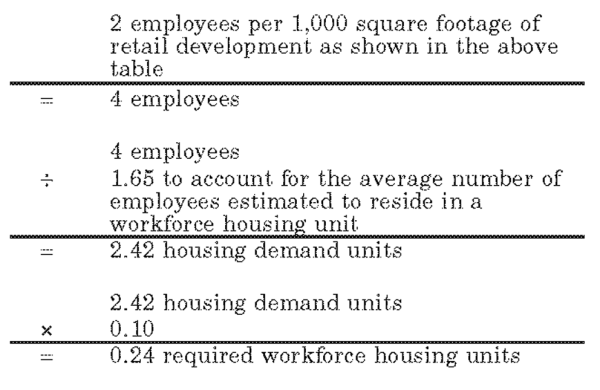
- A specific development site that proposes a land use that requires the resort developer to project the full-time equivalent employee (FTEE) generation, shall divide the FTEE by 1.65 to account for the average number of seasonal employees estimated to reside in a seasonal workforce housing unit. This number equals the seasonal employee housing demand. The seasonal employee housing demand shall then be multiplied by ten percent to calculate the required number of seasonal workforce housing units. Fractional housing units shall be rounded up to the nearest whole unit.
- A specific development site that has an assigned employee generation value shall use that value to establish a FTEEs generated. The number of FTEEs shall then be divided by 1.65 to account for the average number of seasonal employees estimated to reside in a seasonal workforce housing unit. This number equals the seasonal employee housing demand. The seasonal employee housing demand shall then be multiplied by ten percent to calculate the required number of seasonal workforce housing unit(s). Fractional housing units shall be rounded up to the nearest whole unit.
Seasonal Workforce Housing
for the Ogden Valley Destination and Recreation Resort Zone by Land UseDevelopment/Land Use Category Employee Generation Value (FTEE) Resort operations To be projected by resort Hotel, condo-tel & timeshare, etc. To be projected by resort Restaurant and drinking establishment 3.5 per 1,000 sf finished floor space Retail 2 per 1,000 sf finished floor space Commercial amusement and indoor/outdoor recreation 3 per 1,000 sf finished floor space
- Housing type. Workforce housing may consist of structures such as; single-, two-, three- and four-family dwellings, multifamily dwellings and rental units. Rental units may be apartments, dormitories, boardinghouses and/or residence halls.
- Housing affordability. An annual report shall be generated and presented to the county planning staff that outlines a previous year's employment level, workforce housing need, housing type/availability and occupancy. The report shall also outline the methods guaranteeing perpetual affordability and the rental and/or mortgage payments as they relate to housing types. Housing payments, including utilities, shall not exceed 30 percent of the upper valley moderate income as defined in the county moderate income housing plan.
- Density and affordable workforce housing. Any increases in density caused by the development of workforce housing requirements shall be in addition to the allowable density approved at the time of the DRR-1 Zone application.
(Ord. of 1956, § 44-7; Ord. No. 2016-4, Exh. B2, 5-24-2016)
Sec 104-29-8 Land Uses
Use | Permitted (P)
Conditional (C) | |
| Residential Uses | ||
| Single-family dwelling; including not more than two lockout sleeping rooms per dwelling | P | |
| Two-family dwelling (aka Duplex) | P | |
| Three-family dwelling | P | |
| Four-family dwelling | P | |
| Multi-family dwelling | P | |
| Recreation lodge | P | |
| Condominium dwelling unit and/or condominium rental apartment (condo-tel); including not more than two lockout sleeping rooms per unit or apartment. | P | |
| Private residence club | P | |
| Townhome | P | |
| Residential facility for persons with a disability meeting the requirements of section 108-7-13 | P | |
| Timeshare/fractional ownership unit | P | |
| Hotel | P | |
| Bed and breakfast dwelling/B&B inn/B&B hotel | P | |
| Accessory dwelling unit | P | |
| Workforce housing/dormitory/residence hall | P | |
| Hostel | P | |
| Campground (public or private tent/RV); meeting the requirements of the Forest Campground Ordinance of Weber County | P | |
| Short-term rental, pursuant to Title 108, Chapter 11. | P | |
| Commercial Uses | ||
| Bank/financial institution | P | |
| Bakery | P | |
| Drinking establishment | P | |
| Grocer/neighborhood market | P | |
| Delicatessen | P | |
| Boutique (gift, flower, antique, clothing, jewelry) | P | |
| Fueling station/gas station | P | |
| Conference/education center | P | |
| Wellness center (i.e., spa, fitness, etc.) | P | |
| Art gallery and studios | P | |
| Book store | P | |
| Beauty/barber shop | P | |
| Short-term vendor | P | |
| Package liquor Store | P | |
| Private club | P | |
| Restaurant; excluding drive-thru window | P | |
| Sporting goods/clothing store; including rental | P | |
| Other Uses | ||
| Arts theater and performance facility/auditorium/amphitheater | P | |
| Agriculture | P | |
| Childcare facilities | P | |
| Church/place of worship | P | |
| Clinic/medical facility | P | |
| Community center | P | |
| Developed recreation facility (i.e., swimming, golf course, ice skating, skate park, playground, tubing hill, tennis, etc.) | P | |
| Dude ranch; including horse rental | P | |
| Equestrian center | P | |
| Gun club/skeet/sporting clay | C | |
| Heliport, subject to the following standards: | C | |
| 1. | A heliport must be located at an elevation of at least 6,200 feet above sea level. | |
| 2. | A heliport must be located at least 200 feet from any resort boundary, except where the developer (as defined in the applicable zoning development agreement) owns at least 200 feet of property extending from the resort boundary at the planned location of the heliport or where the developer has received approval from the owner of any property within 200 feet of the resort boundary at the planned location of the heliport. The planning commission may grant exceptions to the setback requirement if it can be demonstrated that locating the heliport closer than 200 feet to the resort boundary provides a more beneficial situation for purposes of safety, noise abatement, access, or other valid reasons as determined by the planning commission. | |
| 3. | The heliport landing surface must be dust-proof and free from obstructions. | |
| 4. | Prior to issuance of a conditional use permit for a heliport, written approval from the Federal Aviation Administration (FAA) is required, if necessary. | |
| Home occupation; with no visiting clientele | P | |
| Home occupation; with visiting clientele | C | |
| Horses for private use, provided that not more than two are kept for each one acre of land exclusively devoted to the keeping of horses | P | |
| Trails (nordic, hiking, biking, equestrian) | P | |
| Laundromat | P | |
| Museums | P | |
| Nordic center | P | |
| Office; professional and resort administrative | P | |
| Office supply/shipping service | P | |
| Parking areas and structures | P | |
| Parks and playgrounds | P | |
| Pharmacy | P | |
| Public building | P | |
| Public utility substation and structure | C | |
| Real estate office | P | |
| Recreation centers | P | |
| Recreation vehicle storage | P | |
| School; public or private school having a similar curriculum as a public school | P | |
| Ski area and associated facilities; including lifts | P | |
| Ski lodge and associated services | P | |
| Small wind energy system; meeting the requirements of section 108-7-24 | C | |
| Solar energy installation; meeting the requirements of section 108-7-27 | P | |
| Telecommunications tower | C | |
| Yurt | P | |
| Cluster subdivision excluding bonus density; meeting the requirements of title 108, chapter 3 | P | |
| Welcome/information center | P | |
| Wastewater treatment facility; meeting the requirements of the state division of water quality | C | |
| Water pumping plants and reservoirs | C | |
| Accessory dwelling unit; accounting for one dwelling unit at a rate of 1:1 | P | |
| Greenhouse, nursery, or farm | P | |
| Transit facility | P | |
| Second kitchen | P | |
| Corral, stable, or building for keeping of animals or fowl | P | |
| Household pets | P | |
| Private stable | P | |
| Educational facility | P | |
| Liquor, wine, and beer manufacturing, bottling, blending, distilling, packaging, sales, and related activities | P | |
| Temporary building or use incidental to construction work. Such building shall be removed upon completion or abandonment of construction work | P | |
| Grazing and pasturing animals | P | |
| Detached lockouts | P | |
| Accessory building incidental to the use of a main building; main building designed or used to accommodate the main use to which the premises are devoted; and accessory uses customarily incidental to a main use | P | |
(Ord. No. 2012-1, § 4, 1-3-2012; Ord. No. 2015-7, Exh. A, 5-5-2015; Ord. No. 2016-4, Exh. B2, 5-24-2016)
Amended by Ord. 2020-27 on 12/22/2020
Amended by Ord. 2021-6 on 3/23/2021
Amended by Ord. 2023-01 on 1/10/2023
Sec 104-29-9 Second Kitchen
A kitchen covenant shall not be required when constructing less than three kitchens in a dwelling or condominium unit.
(Ord. No. 2016-4, Exh. B2, 5-24-2016)
Sec 104-29-10 Miscellaneous Improvements
"Miscellaneous improvements" means:
- Improvements with a height less than six feet such as walkways, steps, patios, decks, exterior railings, and similar exterior dwelling improvements;
- Exterior landscaping décor such as a planter, landscape curbing, or any other similar exterior landscaping décor or improvements;
- Hot tubs, barbeques, grills, firepits, firebowls, patio heaters, benches, picnic tables, and hammocks. In addition, without reference to height, overhangs, eves, decks, stairs, access ramps, and retaining walls that are connected or attached to the structure shall constitute "miscellaneous improvements." Miscellaneous improvements are permitted outside of the building envelope. Notwithstanding the foregoing, miscellaneous improvements on lots subject to hillside review (pursuant to chapter 14) or other supplementary review, are subject to hillside review or other supplementary reviews.
(Ord. No. 2016-4, Exh. B2, 5-24-2016)