
Wheat Ridge City Zoning Code
ARTICLE I
- DEVELOPMENT REVIEW
Sec. 26-101.- Name.
Chapter 26 of the Code of Laws of the City of Wheat Ridge shall hereinafter be known as the "Zoning Code of the City of Wheat Ridge, Colorado," or the "zoning code," "this Code" or "this chapter."
(Ord. No. 2001-1215, § 1, 2-26-01)
Sec. 26-102. - Intent and purpose.
The intent and purpose of the zoning code of the City of Wheat Ridge is to encourage the most appropriate use of land throughout the city to ensure a logical growth of the various physical elements of the city; to lessen congestion in the streets and to facilitate the adequate provision of transportation within and through the city; to secure safety from fire, panic and other dangers; to provide adequate light and air to the residents, structures and properties within the city; to improve housing standards; to conserve property values; to facilitate adequate provision for water, sewage, schools, parks and other public improvements; to protect against poor or inadequate drainage or flood conditions and poor geologic conditions; and in general to promote the health, safety and welfare of the citizens and residents of the City of Wheat Ridge. It is further the intent of this zoning code to preserve the right of citizens to participate in the making of decisions which affect their properties while preserving, to the maximum lawful extent, the legislative and quasi-judicial discretion of the elected representatives of the City of Wheat Ridge.
(Ord. No. 2001-1215, § 1, 2-26-01)
Sec. 26-103. - Site development review process.
A.
All site development within the city shall be required to follow the procedures and satisfy the requirements set out below prior to development. "Site development," as used in this chapter, is a general and inclusive term, and is defined in section 26-123. The developer is required to attend in person or by authorized representative, all meetings at which the project is considered, unless otherwise notified by the community development department. The use of property may not be substantially changed, and buildings or other substantial structures may not be constructed, erected, moved or substantially altered except in accordance with and pursuant to one (1) or more of the approvals listed in the review process chart. Clearing, grading, filling or excavation may be commenced subject to the approvals required in this chapter and pursuant to section 26-623.
B.
All site development must also obtain building and construction permits pursuant to the uniform codes adopted by the city, and must comply with all other applicable sections contained within this chapter and chapter 5. All applications for building permits, exclusive of single detached and duplex dwellings, shall comply with the applicable standards set forth in the Architectural and Site Design Manual and the Streetscape Design Manual.
C.
In addition to the requirements of this chapter, the provisions of section 5.1.1 of the Wheat Ridge Home Rule Charter, pertaining to building height and density limitations, apply.
D.
All applications for approval of site development pursuant to this chapter shall be accompanied by proof of ownership by the applicant of the subject property. Such proof may take the form of a recorded deed, a title commitment, or a power of attorney from the owner(s) where an agent acts on their behalf. In the case of application for special use permits, both the owner of the property and proposed special use must join in the application.
E.
All site development that includes new water use in an amount more than that used by fifty (50) single-unit dwelling equivalents shall provide, concurrently with the first application for any of the approvals listed in the review process chart, section 26-106, evidence that the water supply proposed to serve the development will be sufficient in terms of quality, quantity, dependability and availability to provide a supply of water for the type of development proposed, which may include reasonable conservation measures and water demand management measures to account for hydrologic variability. The city's determination as to whether the proposed water supply is adequate to serve the proposed development shall be based upon: (i) evidence that the development will be served by a public water supply entity currently providing treated water service within the city, which district has been operating within the city for no less than ten (10) years prior to the date of application for approval of the site development; (ii) if requested by the city, a letter from the state engineer commenting on such documentation; (iii) whether the applicant has paid to a water supply entity (as defined in C.R.S. § 29-20-302) a fee or charge for the purpose of acquiring water for or expanding or constructing the infrastructure to serve the proposed development; and (iv) any other information deemed relevant by the city, including, without limitation, any information required to be submitted by the applicant pursuant to this chapter or state statutes. The city shall not approve such development application unless it finds, in its sole discretion and after considering the application and all of the information provided, that the applicant has satisfactorily demonstrated that the proposed water supply will be adequate. The city shall make its determination concerning adequate water supply only once during the development permit approval process unless the water demands or supply of the specific project for which the development permit is sought are materially changed.
(Ord. No. 2001-1215, § 1, 2-26-01; Ord. No. 1299, § 1, 7-14-03; Ord. No. 1323, § 1, 5-10-04; Ord. No. 1383, § 1, 5-14-07; Ord. No. 1436, § 1, 3-23-09; Ord. No. 1481, § 4, 3-28-11; Ord. No. 1744, § 25(Exh. 1), 7-11-22)
Sec. 26-104. - Preapplication conference.
Prior to the formal submittal of any request for approval to proceed with site development, an informal preapplication conference shall be held between the applicant and the community development department staff. This conference will serve to acquaint the applicant with the requirements of this chapter and to allow staff to become familiar with the applicant's development intent and design philosophy. A schematic site plan and building concept drawings will aid in discussion at this conference; however applicants are encouraged not to prepare detailed designs which might require extensive revision as a result of the preapplication conference. An applicant should bring the following information in a brief summary:
•
General project concept and information, including the location of the project and a written description of the proposal.
•
Specific uses proposed, and intensity of use proposed (floor area and parking demand).
•
Proposed construction timing.
•
General concepts concerning building size and exterior materials and site plan concepts.
•
An exterior materials package including roof material and color, wall treatment, glass and glazing.
•
A site plan drawing depicting the location of existing and proposed buildings, the location of property lines, setback lines and build-to lines, circulation concepts, landscaping, the location of loading areas, and the location and size of all parking areas, lighting, and signs.
(Ord. No. 2001-1215, § 1, 2-26-01; Ord. No. 1288, §§ 1, 2, 5-12-03; Ord. No. 1471, § 2, 9-13-10)
Sec. 26-105. - Review process.
A.
All site developments must be reviewed and approved in accordance with the review process and standards set forth in this article. The following chart establishes the required review steps applicable to different forms of site development. Applicants seeking site development approval should refer to the chart to determine which one (1) or more "approval requested" under the left-hand column of the chart applies to the proposed site development. The required stages of review for such approval are shown on the lines to the right. Submission requirements and the specific review process for each stage are set out in detail in the balance of this chapter under the appropriate headings. Unless otherwise indicated, amendment or modification of prior site development approval shall follow the procedure for review of the original application. Notwithstanding § 31-23-215, C.R.S., the planning commission is not required to act on any application (including subdivisions) until sixty (60) days following the first public meeting or public hearing.
B.
In the event the planning commission or city department with jurisdiction recommends denial of the application at any stage, the applicant may choose to proceed to the next stage of review or may resubmit the application at the first stage. In the event the review stage is before the city council, the application may not be further processed following a denial. If, in the opinion of the community development department, a submittal at any stage of review is incomplete, the matter shall be removed from the agenda and not further processed until deemed complete.
C.
The planning commission, city council, board of adjustment or community development staff may require at any stage of review of any site development, submission of any plan, study, survey or other information, in addition to that specified in this chapter, and at the applicant's expense, as such body may determine necessary to enable it to review and act upon the application in order to determine whether the application complies with the requirements of this chapter.
(Ord. No. 2001-1215, § 1, 2-26-01; Ord. No. 1288, §§ 1, 2, 5-12-03)
Sec. 26-106. - Review process chart.
1 Reserved.
2 Right of protest applies: See section 5-10 of the Home Rule Charter and Code subsection 26-112.C.7.
3 If four (4) or more buildings are proposed, planning commission review is required.
4 A pre-application may not be required based on the complexity of the project.
5 Neighborhood meetings for mixed use concept plan applications are required only for sites of ten (10) acres in size or larger.
6 City council review is required for a specific development plan only if ODP and SDP applications are submitted concurrently. Planning commission is the final authority for an SDP submitted separate from and subsequent to ODP approval.
7 Planning commission review of SDP amendments only required in some circumstances. Refer to section 26-307.
8 City council review for special use permits is only required upon appeal by an applicant of a decision of denial by the community development director, or the receipt of an objection by adjacent property owners. Refer to section 26-114.
9 Planning commission review for planned building group only required in some circumstances. Refer to section 26-116.
10 If reviewed administratively, appeal to PC. If reviewed by PC, appeal to Jefferson County District Court.
11 If reviewed administratively, appeal to PC. If reviewed by PC, appeal to CC.
Key:
PC: Planning commission CC: City council
BOA: Board of adjustment X: Meeting required
H: Public hearing required A: Administrative review
URPC: Urban Renewal Plan compliance required: If "A" is noted, administrative review; if "URA" is noted, review by Wheat Ridge Urban Renewal Authority is required — see section 26-226.
BCAB: Building Code Advisory Board
AQA: Administrative review for Qualifying Affordable Housing Project
(Ord. No. 2001-1215, § 1, 2-26-01; Ord. No. 1244, § 1, 2-11-02; Ord. No. 1251, § 1, 6-10-02; Ord. No. 1291, § 2, 5-27-03; Ord. No. 1316, § 2, 1-12-04; Ord. No. 1352, § 5, 9-26-05; Ord. No. 1383, § 7, 5-14-07; Ord. No. 1430, § 4, 2-23-09; Ord. No. 1471, § 3, 9-13-10; Ord. No. 1515, § 3, 7-9-12; Ord. No. 1547, § 4, 4-28-14; Ord. No. 1673, § 2, 9-23-19; Ord. No. 1716, § 4, 7-12-21; Ord. No. 1774, § 3, 9-11-23; Ord. No. 1814, § 2, 1-27-25; Ord. No. 1838, § 1, 3-23-26)
Sec. 26-107. - Expiration of development approval; reapplications.
A.
Any approval of site development shall expire and become null and void if:
(1)
For variances, a building permit is not issued within one hundred eighty (180) days from the date it was granted. See section 26-115.4.
(2)
If an approved special use ceases operation for any reason for a period of one (1) year, the special use permit shall be deemed expired, unless otherwise provided in the permit itself.
For administrative special use site development approvals, the community development director shall decide whether the zoning and/or permitted use of the property shall revert to that in place prior to the expired approval. For special uses approved through a public hearing process, a public hearing before the city council shall be held to confirm whether the permitted use of the property shall revert to that in place prior to the expired approval.
(3)
Except as otherwise provided herein, every building permit issued shall expire one hundred and eighty (180) days after issuance. The building official is authorized to grant, in writing, one (1) or more extensions of time, for periods of not more than one hundred and eighty (180) days each. The extension shall be requested in writing and justifiable cause demonstrated. The extension shall be granted if it is demonstrated that the extension will assist or expedite the completion in a timely manner. Any denial of an extension may be appealed to the director of community development.
B.
After site development approval has expired, no work shall be commenced until the developer has received new approval pursuant to the procedures set forth in this chapter.
C.
A new application for substantially the same development process may not be refiled for one (1) year after denial.
(Ord. No. 2001-1215, § 1, 2-26-01; Ord. No. 1321, § 1, 4-12-04; Ord. No. 1360, § 3, 6-12-06; Ord. No. 1430, § 4, 2-23-09)
Sec. 26-108. - Site development review fees.
A.
Procedure for payment. At the time the application for site development is first submitted to the city, and prior to any review, the applicant shall pay to the city the fee necessary to cover the administrative and review costs for each project requiring review. The amount of the fee shall be established by the community development department and kept on file in the office of the city clerk.
B.
Supplemental fees. Applications for site developments of large scale, complexity, or which are likely to produce substantial onsite or offsite physical, social or economic impacts may require special review by engineering, technical, scientific and other expert personnel not normally employed on a regular basis by the city. In the judgment of the community development director such independent expert review and analysis shall be added to the application fees contained herein and charged to the applicant. Payment of such supplemental fees by the applicant to the city shall be a precondition for the granting of all permits or approvals requested by the applicant and requiring independent expert review or analysis. In addition, applications for proposed land use changes requiring legally mandated State of Colorado agency reviews by agencies charging fees for such review services shall be assessed supplemental fees in the amount of such charges incurred by the city. Such supplemental fees shall be paid by the applicant to the billing agency as a precondition for the granting of all required permits and approvals.
C.
Lien on property. If the city incurs costs beyond the amount deposited with the city and the applicant does not pay those costs within thirty (30) days after written notice from the city, the city shall be entitled to a lien for those costs on the land being developed, which lien may be perfected and foreclosed in the same manner as provided in § 31-20-105 or § 38-22-101, et seq., C.R.S.
(Ord. No. 2001-1215, § 1, 2-26-01; Ord. No. 1288, §§ 1, 2, 5-12-03; Ord. No. 1547, § 5, 4-28-14)
Sec. 26-109. - Public hearing notice and procedure.
A.
Pre-application neighborhood meeting. Prior to submitting any application, for approval which requires a neighborhood meeting under the provisions of section 26-106, Review process chart, an applicant shall be required to do the following:
1.
Applicant shall, by first class mail or by pamphlet or flyer personally delivered, notify all property owners and occupants within one thousand (1,000) feet of the area subject to the land use application of a meeting to be held, at a time and place selected by the applicant but reasonably convenient both to the applicant and those property owners and occupants notified, for the purpose of allowing the applicant to present to said parties the nature, character and extent of the action requested by the applicant, and further to allow said parties to give input to the applicant regarding said proposal.
2.
The intent of the neighborhood meeting is to give adequate opportunity for applicants, property owners, and occupants to give and receive input regarding proposed projects prior to their formal submission so that the projects are carefully designed and conceived to be compatible with surrounding neighborhoods. It is not the intent of the city council to require formal agreements between applicants and property owners or occupants prior to submission of applications, nor is any applicant to be denied the right to proceed to any required or permitted hearings regarding such application because no agreement is reached. Rather, the city council by this subsection is encouraging reasonable, honest, good faith communication between property owners, occupants and applicants, and vice versa.
3.
No application shall be accepted by the city's staff until applicant has certified by affidavit that he has complied with the provisions of this subsection A.
B.
Published notice. At least ten (10) days prior to any public hearing for a specific site or development which requires approval by the planning commission, board of adjustment or city council, the director of community development shall cause to be published, on the city's website and in the legal section of a newspaper of general circulation within the city, a notice of public hearing. The notice shall specify the kind of action requested; the hearing authority; the time, date and location of hearing; and the location of the parcel under consideration by street address. A legal description of the parcel under consideration shall also be specified in the notice published on the city's website. Notwithstanding the above, any action which requires approval by passage of an ordinance by city council shall be subject to the regular ordinance approval process, which includes a first reading of the ordinance by city council at a regular meeting where no testimony is allowed. Then, if passed upon first reading, council establishes the time and date of the public hearing and the city clerk shall cause the proposed ordinance to be published in a form and manner as described above.
C.
Posted notice. At least fifteen (15) days prior to any public hearing for a specific site development which requires approval by the planning commission, board of adjustment or city council, the director of community development shall cause to be prepared, and the applicant shall post, one (1) or more signs (as determined by table 1 below) upon the property under consideration for approval which provides notice of the kind of action requested; the hearing authority; the time, date and location of hearing; and the location of the parcel under consideration by address or approximate address. The sign(s) shall be posted within the property boundaries, shall be affixed to a flat surface, shall measure at a minimum twenty-two (22) inches in height by twenty-eight (28) inches in width, shall be elevated a minimum of thirty (30) inches from the ground (however, not more than six (6) feet above ground), shall be visible from the street without any obstructions, shall be legible and displayed for fifteen (15) days prior to the public hearing. The sign(s) shall be maintained in good condition by the applicant throughout the fifteen-day posting period. The sign(s) shall be removed within seventy-two (72) hours from the date the public hearing is concluded. The fact that a property was not continuously posted the full fifteen (15) days may not, at the discretion of the hearing authority, constitute grounds for continuance where the applicant can show that a good faith effort to meet this posting requirement was made.
Posted notice shall be located on all street frontages of the subject property, and the number of signs required to be posted on each frontage shall be based on the frontage length and based on the parcel configuration of the subject property as shown in table 1:
Table 1. Number of Required Posting Signs
D.
Letter notice. At least fifteen (15) days prior to any public hearing which requires notification by letter, the director of community development shall cause to be sent, by first class mail, a letter to adjacent property owners and occupants within one thousand (1,000) feet of the property under consideration and to property owners and occupants of property included within the area under consideration. As an exception, the mailing radius for applications heard before the board of adjustment per section 26-115 shall be six hundred (600) feet. The letters shall specify the kind of action requested; the hearing authority; the time, date and location of hearing; and the location of the parcel under consideration by address or approximate address. Failure of a property owner or occupant to receive a mailed notice will not necessitate the delay of a hearing by the hearing authority and shall not be regarded as constituting inadequate notice.
E.
Public hearing rules:
1.
Postponements: After a public hearing has been legally noticed, only one (1) postponement by the applicant may be allowed by the planning commission, board of adjustment or city council. Upon the second request for postponement, the planning commission, board of adjustment or city council shall have the authority, which they may exercise at their discretion, to dismiss the application. Notice for a postponed hearing shall be provided in the manner outlined above, however such notice is not required to meet the time requirements.
2.
Rehearing requests: No application shall be submitted to or accepted by the planning commission, board of adjustment or city council (whichever is the final hearing authority) if any previous application for the same or substantially similar request for the same property or portion of property has been denied during the preceding twelve (12) months. The twelve-month time limitation contained herein shall commence on the date of any final determination of denial by the planning commission, board of adjustment, city council or a court of record, whichever is later.
The twelve-month time limitation specified in this section shall be strictly adhered to except upon a finding by the final hearing authority, after evidence presented by the applicant, that a major change in physical conditions and circumstances warrants an earlier hearing. "Major change in physical conditions and circumstances" shall, for the purposes of this section, mean a significant modification in the character and nature of the proposed development or use, and shall be reflected in the intensity of the use, the external effects on adjacent properties or such other factors as may be determined by the planning commission, board of adjustment and/or the city council.
An exception to the twelve-month rehearing period may be allowed where the applicant or a member of the final hearing authority who voted with the prevailing side requests a rehearing on the same application no later than at the next regular or special meeting. The granting of a rehearing shall be by majority vote and shall be based upon the submittal of new evidence which could not have been, with due diligence, presented at the previous hearing on the application.
3.
Quasi-judicial matters: Any application which involves the use and/or development of a specific parcel of land, as opposed to a city-initiated large area or city-wide proposal, is considered a quasi-judicial matter. Therefore, applicants, opponents and proponents are prohibited from making ex parte contact (that is, contact outside of the public hearing forum) with any member of the decisionmaking authority.
4.
Continued hearings: In the event a public hearing is opened and continued to a specific date, notice of that date shall be provided in the manner outlined above, however such notice is not required to meet the time requirements.
F.
Public notice time requirements. Unless otherwise provided in the Code of Laws, public notice time requirements include the day the notice is posted, appears in the newspaper, or is received by a recipient, and shall also include the day of the public hearing. By way of example, a public hearing advertised in a Thursday newspaper, which requires a fifteen-day notice, is eligible for hearing no sooner than the second subsequent Thursday.
(Ord. No. 2001-1215, § 1, 2-26-01; Ord. No. 1288, §§ 1, 2, 5-12-03; Ord. No. 1356, § 1, 4-14-06; Ord. No. 1548, §§ 1—3, 4-28-14; Ord. No. 1694, §§ 1, 2, 7-27-20; Ord. No. 1698, §§ 1, 2, 10-12-20; Ord. No. 1725, §§ 1, 2, 11-8-21; Ord. No. 1791, § 1, 2, 4-22-24)
Sec. 26-110. - Public dedications and improvements; security.
A.
Public dedications and improvements may be required in connection with several types of site development applications. The requirements of sections 26-413, 26-414, 26-415, 26-417, and 26-418, pertaining to public improvements and the dedication of streets, parks, and public sites, shall apply to any site development application, including those not requiring subdivision review.
B.
Wadsworth Boulevard Corridor Plan adopted.
1.
The Wadsworth Boulevard Corridor Plan (hereinafter, for purposes of this section, the "plan"), dated May 12, 1999, and prepared by RNL Design, is hereby adopted as a regulation. All "site development," as that term is defined at section 26-123 of this Code, shall, if proposed to be located within the area covered by the plan, comply with the requirements of the plan and of this section and their included and referenced appendices and regulations. Such compliance shall be in addition to, and not in lieu of, other requirements of this Code of Laws, including without limitation sections 5-45 (public improvements) and 26-224 (design manuals). In the event of conflict among or between the plan and such section on their included and referenced appendices and regulations, the more stringent requirement shall control.
2.
Regulations authorized. The community development and public works directors are hereby authorized to promulgate regulations for the further implementation of the elements of the plan, as appropriate. All such regulations shall be guided by and consistent with the purposes, goals and requirements of the plan. Such regulations, when so promulgated, shall be fully enforceable as permitted by this section.
3.
Copies on file. The director of community development shall maintain copies of the plan on file in his or her office for public inspection, copying and/or purchase.
C.
Reimbursement for public improvements. Where a property exists adjacent to an unimproved or unconstructed street right-of-way or drainageway, the applicant for site development of such property shall be responsible for construction of public improvements to that street, right-of-way, or drainageway, including an engineered roadway design, paving, curb, gutter, sidewalk, and storm water detention and conveyance facilities. The city may require, as a condition of and at the time of site development approval of adjacent properties benefited by such public improvements, that the applicant or applicants for site development initially paying for such public improvements be reimbursed by the applicant for subsequent site development, consistent with the degree to which the adjacent development is benefited by such public improvements. Such reimbursement shall be on a pro rata basis determined in a reimbursement agreement entered into between the city and the initial developer.
(Ord. No. 2001-1215, § 1, 2-26-01; Ord. No. 1266, § 1, 2, 9-23-02; Ord. No. 1288, §§ 1, 2, 5-12-03; Ord. No. 1315, § 1, 12-8-03; Ord. No. 1481, § 5, 3-28-11; Ord. No. 1547, § 6, 4-28-14)
Sec. 26-111. - Site plan review.
A.
Application. The requirements of this section apply to site development on property for which the use proposed is a use by right, is other than a single-unit dwelling or two-unit dwelling, and for which planned development district approval is not sought. The requirements for site plans required in planned development zone districts are found in those district regulations. This section establishes the purpose, graphic and informational requirements for site development review required in instances other than planned development districts, including all site development within any mixed-use district established in article XI or article XIV.
B.
Purpose. The site plan review process provides site relationship and architectural information for decisionmakers to consider in deciding upon applications for use and development. It is intended to illustrate site design elements, architectural character and consideration of engineering issues to the extent that the potential character and possible impacts are more clearly definable. It can provide the basis for building permit review, certificate of occupancy review, and future zoning enforcement. The plan will be part of the case file and record.
C.
Preapplication conference. Prior to any building permit or site plan application the applicant must participate in a preapplication conference, as described in section 26-104.
D.
Site plan application requirements. All applications shall include at a minimum the following information. Additional information may be requested by the planning and/or engineering divisions at the preapplication conference.
1.
Site plan.
a.
The site plan shall be prepared in a twenty-four (24) × thirty-six (36) inch format.
b.
Vicinity map.
c.
The boundary of the site described in bearings and distances and existing and proposed lot lines.
d.
Legal description of the site matching the certified survey.
e.
Signed surveyor's certification.
f.
Scale and north arrow.
g.
Date of map preparation and name and address of person who prepared map.
h.
Location of one-hundred-year floodplain, if applicable.
i.
Existing and proposed contours at two-foot intervals.
j.
Location of all existing and proposed:
(1)
Fences, walls or screen plantings and their type and height;
(2)
Exterior lighting, location, height and type;
(3)
Signs, including type, height and size;
(4)
Open space, landscaping and special buffers, including type and coverage;
(5)
Parking and loading areas, accessible parking areas, and electric vehicle (EV) parking spaces;
(6)
Easements and rights-of-way;
(7)
Drainage ways, pond areas, ditches, irrigation canals, lakes and streams, if applicable;
(8)
Buildings to be developed or retained on the site, including possible use, height, size, floor area, setback dimensions and type of construction;
(9)
Existing and proposed streets, both adjacent and within the site, including names, widths, location of centerlines, acceleration/deceleration lanes;
(10)
Curbs, gutters, sidewalks, bike paths;
(11)
Location of trash containers and method of screening, if any;
(12)
Areas to be used for outside work areas, storage or display and method of screening, if any.
k.
Adjoining property lot lines, buildings, access, parking, so that development compatibility can be determined.
l.
Other information which shall be in written or tabular form, including:
(1)
Statement of proposed zoning and any conditions;
(2)
Statement of proposed uses;
(3)
Site data (numeric and percentage) in tabular form, including:
•
Total area of property, gross and net;
•
Building coverage;
•
Landscape coverage;
•
Total lot coverage by all structures and paving;
•
Number of parking spaces required and provided;
•
Gross floor area; and
•
Number of residential units and density (if applicable).
m.
In addition to the information included on the site plan document, the following supportive information may be required in hard copy, in electronic file format, or both:
(1)
Final Drainage Report and Plan;
(2)
Elevations and perspective drawings;
(3)
Traffic Impact Report;
(4)
Civil construction plans;
(5)
Stormwater Management Plan (SWMP);
(6)
Stormwater Operations and Maintenance Manual (O&M Manual).
2.
Architectural elevations.
a.
Architectural elevations shall be prepared in a twenty-four (24) × thirty-six (36) inch format;
b.
Detailed elevations for each façade of proposed building(s), clearly labeled;
c.
Notes indicating all proposed materials and colors;
d.
Depictions and labeling of all transparent areas;
e.
Labeled dimensions of building height floor-to-floor heights, and building width;
f.
Elevations for any accessory appurtenance such as trash enclosures, with materials clearly labeled.
3.
Landscape plan. Landscape plans shall conform to the requirements of section 26-502, in addition to:
a.
Location and dimensions of all open space areas, including minimum required usable open space for site development within a mixed use zone district;
b.
Table showing open space or landscape area required and provided, including required and provided usable open space for site development within a mixed use zone district.
4.
Streetscape plan.
a.
Where streetscape improvements are required per the Streetscape Design Manual (refer to section 26-224), a streetscape plan, the requirements of which are outlined in the Streetscape Design Manual, shall also be required.
(Ord. No. 2001-1215, § 1, 2-26-01; Ord. No. 1288, §§ 1, 2, 5-12-03; Ord. No. 1471, § 4, 9-13-10; Ord. No. 1481, § 6, 3-28-11; Ord. No. 1503, § 2, 10-10-11; Ord. No. 1683, § 14, 1-27-20; Ord. No. 1744, § 25(Exh. 1), 7-11-22; Ord. No. 1774, § 4, 9-11-23; Ord. No. 1789, § 1, 2-26-24; Ord. No. 1801, § 2, 8-26-24; Ord. No. 1814, § 3, 1-27-25)
Sec. 26-112. - Private rezoning.
A.
Purpose. A change of any zone district as shown on the official zoning map is permitted only when it promotes the general welfare of the community and is consistent with the criteria for review as listed in section 26-112.E below. The final decision on a change of zone expressly rests in the exercise of the discretion of the city council, and all applicants are advised there is no right to a change of zone of property. In some cases a change of zone is necessary to correct a manifest error in the existing zone classification. A manifest error includes, but is not limited to, one (1) or more of the following:
1.
Mapping errors, including incorrect boundary location or incorrect zone designation, or
2.
Ordinance errors including incorrect zone designation, legal description error or typographical errors.
B.
Applicability.
1.
The requirements of this section shall be applicable within the municipal boundaries of the City of Wheat Ridge and to any areas that are proposed to be annexed to the city where one (1) of the following is proposed:
a.
Change of zone of a parcel of land from one (1) zone district classification to another zone district. This includes an application for private rezoning within or to any mixed use, industrial-employment, public facilities, or conservation district; as well as a rezoning within or to any residential or agricultural zone district for properties up to and including one (1) acres in size.
b.
Change of the conditions of an existing zone district where those conditions were specifically established by a previous rezoning ordinance.
2.
All applications for a zone change shall be to a planned development district where any one (1) of the following conditions exists. Article II of this chapter should be consulted for planned development requirements and procedures.
a.
An application for a zone change to any commercial district, with the exception of a rezoning to any mixed use district or to the industrial-employment district, for properties of any size.
b.
An application for a zone change to any residential or agricultural district for property over one (1) acre in size, or for which an applicant owns adjacent property which, taken together with the property that is the subject of the application, totals more than one (1) acre.
C.
Review procedure:
1.
Preapplication conference. Prior to submitting any application for a change of zone, the applicant must participate in a preapplication conference, as described in section 26-104.
2.
Neighborhood meeting. After the preapplication conference, but prior to submitting any application for a change of zone, the applicant shall be required to hold a neighborhood meeting in accordance with section 26-109 A.
3.
Application filing. A zone change application shall be submitted to the community development department. Staff will review the application for completeness in accordance with the submittal requirements in subsection D below. If staff determines the application is not complete, it will be returned to the applicant and not further processed until the incomplete items have been supplied.
4.
Review and referral. Upon receipt of a complete application packet the community development department shall proceed with the following process:
a.
Staff will review the application and refer the application to affected departments and agencies for review and comment. The applicant must address all comments and resubmit relevant documents. This may occur several times before scheduling a public hearing to ensure that all comments have been addressed.
b.
After the review period, staff will give notice of scheduled public hearings on the application, with notice by publication, letter and site posting in the manner provided in section 26-109.
c.
Staff will prepare a written report to the planning commission which evaluates the proposal, makes findings, and makes recommendations using the review criteria set forth below in subsection E.
5.
Planning commission review. The planning commission shall hear and consider any evidence or statement presented by the applicant, city staff, or by any person in attendance at a public hearing. The planning commission shall then make a recommendation to city council to approve, approve with conditions, or deny the application, basing its recommendation upon the facts presented in the public hearing in consideration of the criteria for review as specified in subsection E below.
6.
City council review. City council shall review and decide upon all requests for change of zone, upon recommendation of the planning commission. The city council shall approve, approve with conditions, or deny the application. An approved change of zone may only be approved by passage of an ordinance following the city's standard ordinance adoption procedures, including a first reading and public hearing. City council, in addition to consideration of the planning commission recommendation, shall hear the evidence and testimony presented at the public hearing and either approve, approve with conditions, or deny the ordinance. City council shall base its decision upon all evidence presented, with due consideration of the criteria for review.
7.
In the event of a legal protest against such change of zone, under the procedure set forth in section 5-10 of the home rule charter, a zone change shall not be approved except by the favorable vote of three-fourths (¾) of the entire city council. The written protest to such change shall be submitted to the city council no later than the hearing on the proposed rezoning ordinance. The procedure shall be as follows:
a.
All protests must be submitted prior to the commencement of the public hearing.
b.
In the event that a letter of protest is submitted prior to first reading of the ordinance for a change of zone, and such protest has been determined by the community development staff to meet the required property ownership and area requirements of Charter 5.10, the hearing shall be conducted on the originally scheduled date for second reading of the ordinance. If a protest is submitted after first reading of the ordinance, the hearing shall be opened with no testimony taken and shall thereupon automatically be continued to the next regular business meeting of the council. Notice of such continued hearings shall be made consistent with the provisions for continued hearings in section 26-109.
c.
Prior to 5:00 p.m. on the next regular business day following the day upon which the protest was submitted, the community development staff shall review the protest to confirm the signers thereof as owners of the required property ownership and area requirements of Charter 5.10 and shall promptly inform the signers of that determination.
d.
If the community development staff determines the protest does not meet the required property ownership and area requirements of Charter 5.10, the signers of the protest may amend the protest at any time prior to the commencement of the continued public hearing.
e.
At the continued public hearing, only the original protest, or the original protest, amended as permitted by this section (the "amended protest") will be considered for purposes of determining the proper council voting requirements on the matter.
f.
If the amended protest is timely submitted before the commencement of the continued public hearing, the community development staff shall review the amended protest to confirm the signers thereof as owners of the required property and its compliance with the area requirements of Charter 5.10.
g.
If necessary, the mayor shall declare a recess to enable the community development staff to perform their review.
h.
If the community development staff determines the protest does not meet the owner or area requirements of Charter 5.10, the hearing may be conducted and closed, and the council may act without the three-quarters (¾) majority voting requirement.
i.
If the community development staff determines the protest meets the owner and area requirements of Charter 5.10, the hearing shall be conducted and closed and the council may act, subject to the three-quarters (¾) majority requirement of Charter 5.10.
j.
The protest area and owner requirements of Charter 5.10, which provide, in pertinent part: in the event of a protest against such changes signed by the owners of twenty (20) percent or more of the area:
(1)
Of the property included within the proposed change; or
(2)
Of those immediately adjacent to the rear or any side of the property, extending one hundred (100) feet from the property; or
(3)
Of those directly opposite across the street from the property, extending one hundred (100) feet from the street frontage of such opposite property.
Shall extend to those property owners within one hundred (100) feet of the subject property, including those located diagonally adjacent to the corners of the subject property, as illustrated in figure 26-112.1.
k.
A protest, once filed and determined by the community development staff to comply with the owner and area requirements of Charter 5.10, may be rescinded only in a written instrument, signed by the same person(s) as the protest, and presented to the city clerk prior to closing of the public hearing.
l.
The community development department shall provide written guidelines to the public on procedures for protest.
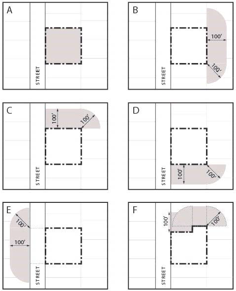
Figure 26-112.1—Protest area. Images A-F illustrate the property area requirements of Charter 5.10 and subsection 26-112.C.7: a) property included within the proposed change; b) property within one hundred (100) feet extending from the rear of the subject site; c and d) property within one hundred (100) feet extending from any side of the subject site; e) property directly opposite across the street from the property extending 100 feet from the street frontage opposite the subject site. Image F illustrates the property area requirement as applied to an irregular side lot line.
D.
Application contents. A complete application for a zone change request shall include:
1.
Complete and notarized application form.
2.
Appropriate fee.
3.
Proof of ownership, such as copies of deeds or title commitments.
4.
Written authorization from property owner(s) where an agent acts on behalf of the owner(s).
5.
Certified boundary and improvement survey.
6.
Approved legal description in electronic file format.
7.
Mineral rights certification form.
8.
A written description of the zone change request. The narrative should include sufficient detail to convey the full intent of the applicant and a justification of why the zone change is appropriate. The narrative should address:
a.
Need for the change of zone.
b.
Present and future effect on the existing zone districts, development and physical character of the surrounding area.
c.
Access to the area, traffic patterns and impact of the requested zone on these factors.
d.
Availability of utilities.
e.
Present and future effect on public facilities and services, such as fire, police, water, sanitation, roadways, parks, schools, etc.
f.
A discussion of the relationship between the proposal and adopted plans and/or policies of the city.
E.
Criteria for review. The planning commission and city council shall base its decision in consideration of the extent to which the applicant demonstrates the following criteria have been met:
1.
The change of zone promotes the health, safety, and general welfare of the community and will not result in a significant adverse effect on the surrounding area; and
2.
Adequate infrastructure/facilities are available to serve the types of uses allowed by the change of zone, or the applicant will upgrade and provide such where they do not exist or are under capacity; and
3.
At least one (1) of the following conditions exists:
a.
The change of zone is in conformance, or will bring the property into conformance with, the City of Wheat Ridge comprehensive plan goals, objectives and policies, and other city-approved policies or plans for the area.
b.
The existing zone classification currently recorded on the official zoning maps of the City of Wheat Ridge is in error.
c.
A change of character in the area has occurred or is occurring to such a degree that it is in the public interest to encourage redevelopment of the area or to recognize the changing character of the area.
d.
The proposed rezoning is necessary in order to provide for a community need that was not anticipated at the time of the adoption of the City of Wheat Ridge comprehensive plan.
F.
Recordation. All approved zoning ordinances shall be recorded with the Jefferson County Clerk and Recorder by the city clerk within thirty (30) days of the effective date of such ordinance.
G.
Assessment of comprehensive plan. Planning commission and city council shall periodically perform an assessment of zoning decisions to consider modification of the comprehensive plan future land use map if zone changes are made which differ significantly from the designation on the map. If zone changes are denied when in conformance with the designation on the future land use map, modifications to the map shall also be considered.
(Ord. No. 2001-1215, § 1, 2-26-01; Ord. No. 1288, §§ 1, 2, 5-12-03; Ord. No. 1299, § 2, 7-14-03; Ord. No. 1352, § 2, 9-26-05; Ord. No. 1383, § 2, 5-14-2007; Ord. No. 1470, § 1, 8-23-10; Ord. No. 1471, § 5, 9-13-10; Ord. No. 1515, § 2, 7-9-12; Ord. No. 1523, § 1, 10-8-12; Ord. No. 1673, § 1, 9-23-19; Ord. No. 1694, § 3, 7-27-20)
Sec. 26-113. - City-initiated rezoning.
A.
Applicability. This rezoning procedure applies to rezonings initiated by city council. Applications for city initiated rezonings may be made with or without consent from affected property owners. City initiated rezonings may be to any zone district. In the event of a city-initiated zone change to a planned development district, the procedures in article III shall be followed, excluding the required authorization from property owners. In the event of a city-initiated amendment to a planned development district the procedures set forth in section 26-307 shall be followed, excluding the required authorization from property owners.
B.
Procedure and notice:
1.
General. The city council may, at a regular or special meeting, initiate this rezoning procedure by adoption of a resolution setting forth the general area of the proposed rezoning, stating the intended purpose and objectives to be achieved by the rezoning, and referring the matter to the planning commission for a public hearing and recommendation.
a.
Prior to any public hearing before the planning commission, the city shall be required to hold a neighborhood meeting according to the requirements of section 26-109A. (See section 26-109 A. for requirements.)
b.
City-wide rezoning: Where a city-wide or comprehensive rezoning has been initiated by the council, notice shall include publication of a public hearing notice in a newspaper of general circulation at least fifteen (15) days prior to the date of the public hearing, which notice shall include a description of the proposed rezoning and a map which illustrates the geographic extent of the proposed rezoning.
c.
All other city-initiated rezonings: A city-initiated rezoning shall, in addition to the newspaper notice required by subsection b. above, be noticed by first class mail sent to all property owners and occupants included within the area to be rezoned at least fifteen (15) days prior to the date of public hearing.
2.
Planning commission action. The planning commission shall hear and consider any evidence or statement presented by city staff or by any person in attendance at the hearing. The planning commission shall make a recommendation to city council to approve, approve with modifications or deny the rezoning proposal. The commission's recommendation shall be based upon the facts presented in the public hearing in consideration of the criteria for review specified in subsection 26-112D.
3.
City council action. Upon receipt of the planning commission's recommendation, the city council shall hold a public hearing on the proposal. The hearing conducted on second reading of the proposed rezoning ordinance shall satisfy this requirement. Notice of the hearing shall be the same as for the planning commission hearing; however, publication of the ordinance on first reading, together with any required map, shall meet the newspaper publication requirement. The city council, in addition to consideration of the planning commission record, shall hear additional evidence and testimony presented and either approve, approve with modifications, or reject the ordinance. The city council shall base its decision upon all evidence presented, with due consideration of the criteria for review set forth under subsection 26-112.D.
In the event of a legal protest against such change of zone, under the procedure set forth in section 5-10 of the home rule charter, a zone change shall not be approved except by the favorable vote of three-fourths (¾) of the entire city council. The written protest to such change shall be submitted to the city council no later than the hearing on the proposed rezoning ordinance. The procedure at Code subsection 26-112.C.7 shall be followed.
(Ord. No. 2001-1215, § 1, 2-26-01; Ord. No. 1316, § 2, 1-12-04; Ord. No. 1434, § 1, 3-9-09; Ord. No. 1515, § 4, 7-9-12; Ord. No. 1673, § 3, 9-23-19; Ord. No. 1725, § 3, 11-8-21)
Sec. 26-114. - Special uses.
A.
Purpose. Special uses are discretionary uses which, if properly designed, developed, operated and maintained, may be approved for any specific location within a zone district wherein the special use is enumerated. The primary issues to be addressed are those related to justification of need and special design and operational considerations which mitigate potential detrimental impacts of a special use on surrounding land uses, the street system, or public services or facilities. In order to protect the public interest, a special use may be approved, approved with modifications or denied. Previously approved special use permits may be revoked pursuant to subsection F.
B.
Applicability. The requirements of this subsection shall apply to all uses listed as "special uses" within the provisions set forth for any particular zone district. Review of a special use application for an electrically charged fence is permitted in the zone districts listed in article 2 of this chapter, and in addition thereto, the planned commercial district (PCD) and the planned industrial district (PID).
C.
Application form and review procedures:
1.
Special use applications shall be originated only by the prospective owner of the proposed special use, with written approval of the fee owner of the property in cases where the owner of the property is different than the owner of the proposed special use.
2.
Prior to submittal of an application for a special use, the applicant shall be required to hold a neighborhood input meeting according to the requirements of section 26-109.A. (See section 26-109.A for requirements.)
3.
Reserved.
4.
All applications shall also be accompanied by a site plan and additional written information in sufficient detail to convey the full intent of the applicant in developing, operating and maintaining the special use. The site development plan shall meet the minimum requirements outlined in section 26-111.C.
5.
Upon receipt of a complete application packet, the community development department shall proceed with the following process:
a.
Refer the application to affected public agencies for review and comment, if applicable.
b.
After acceptance and review, the community development director shall notify adjacent property owners and occupants by letter notice and posting of the site for ten (10) days that a special use is requested for the property.
c.
If no written objection to the proposed special use is received and the community development director finds that the proposed special use meets the criteria set forth in subsection D below, the community development director is authorized to approve the special use. Any objections must be directly related to the concerns regarding the request. General objections regarding existing land use conditions or issues not related to the request will not be considered grounds for objection. The community development director is further authorized to impose conditions or stipulations upon the special use, which may include physical design as well as operational and maintenance considerations, in addition to standard development and use regulations which apply within a particular zone district or for a similar "permitted use." Such conditions or stipulations may be imposed in order to ensure compliance with the criteria for review, which, if not complied with, shall be grounds for revocation of the special use pursuant to the procedures outlined in [subsection] F.
d.
The community development director shall decide whether the particular special use is dependent upon design, management or operational aspects such that it be a personal grant of use to the owner of the special use and not a grant which transfers with the affected property, and, in that connection, the community development director shall decide whether the special use:
(1)
Runs with the land in perpetuity; or
(2)
Is personal to the applicant and may or may not be inherited; and/or
(3)
Shall be granted only for a defined period, after which time the special use shall expire unless renewed subject to all of the requirements of this section.
e.
If a written objection is received, or if the community development director finds that one or more of the criteria set forth in subsection D below for a special use are not met, or if the applicant objects to conditions of approval by the community development director, the community development director shall forward the request to the city council at a public hearing. Notice of said hearing shall be as provided in section 26-109.
D.
Criteria for review. The community development director or city council shall base its decision in consideration of the extent to which the applicant demonstrates the following criteria have been met:
[1.]
The special use will not have a detrimental effect upon the general health, welfare, safety and convenience of persons residing or working in the neighborhood.
[2.]
The special use will not create or contribute to blight in the neighborhood by virtue of physical or operational characteristics.
[3.]
The special use will not create adverse impacts greater than allowed under existing zoning for the property.
[4.]
The special use will not result in undue traffic congestion or traffic hazards, or unsafe parking, loading, service or internal traffic conflicts to the detriment of persons whether on or off the site.
[5.]
The property is appropriately designed, including setbacks, heights, parking, bulk, buffering, screening and landscaping, so as to be in harmony and compatible with the character of the surrounding areas and neighborhood, especially with adjacent properties.
[6.]
The special use will not overburden the capacities of the existing streets, utilities, parks, schools and other public facilities and services.
[7.]
There is a history of compliance by the applicant and/or property owner with Code requirements and prior conditions, if any, regarding the subject property.
[8.]
The application is in substantial compliance with the applicable standards set forth in the Architectural and Site Design Manual.
9.
The proposed special use promotes goals and outcomes from applicable portions of the city's comprehensive plan and any subarea plan applicable to the subject property.
E.
City council review. City council shall review and decide upon all requests for special uses upon receipt of an objection by adjacent property owners or upon appeal by an applicant of a decision of denial by the community development director or of the conditions of approval by the community development director. Notice of public hearing shall be in the manner provided in section 26-109.
1.
Council may impose conditions or stipulations upon the special use, which may include physical design as well as operational and maintenance considerations, in addition to standard development and use regulations which apply within a particular zone district or for a similar "permitted use." Such conditions or stipulations may be imposed in order to ensure compliance with the criteria for review, which, if not complied with, shall be grounds for revocation of the special use pursuant to procedures outlined in [subsection] F.
2.
City council, shall hear additional evidence and testimony presented, and either approve, approve with conditions, or deny the special use, its decision being based upon all evidence presented, with due consideration of the criteria for review.
3.
Grant of use.
The city council shall also decide if the special use is dependent upon design, management or operational aspects such that it be a personal grant of use to the owner of the special use and not a grant which transfers with the affected property, and, in that connection, the city council shall decide whether the special use:
(1)
Runs with the land in perpetuity; or
(2)
Is personal to the applicant and may or may not be inherited; and/or
(3)
Shall be granted only for a defined period, after which time the special use shall expire unless renewed subject to all of the requirements of this section.
F.
Enforcement. All conditions and stipulations imposed by the community development director or city council shall be maintained during the entire term of the special use. If at any time the stipulations or conditions are not adhered to or are found to have been materially altered in scope, application or design, the director of community development shall investigate and, if appropriate, initiate revocation proceedings which shall include the following:
1.
Notice of violation following procedures as set forth, in sections 26-1005 or 26-1006 of this Code.
2.
Upon a finding of noncompliance after the prescribed correction date, the community development director shall schedule a revocation hearing before the city council. The purpose of the revocation hearing shall be for the city council to hear evidence concerning the nature and extent of the alleged noncompliance with the conditions of the special use permit. The council shall have the power, upon good cause being shown, to cancel or revoke the previously issued special use permit, to require certain corrective measures to be taken, and/or to direct the city's agents to enter upon the premises and take corrective measures required by the city council, and to modify the conditions which apply to the special use permit.
G.
Term.
1.
A special use permit is valid so long as the conditions of approval are maintained by the applicant unless a specific time limit for the use or development is set forth as part of the permit approval by the community development director or city council. Except as otherwise provided herein, if an approved special use ceases operation for any reason for a period of one (1) year, the special use permit shall be deemed expired, unless otherwise provided in the permit itself. If an approved special use for a medical marijuana center, retail marijuana store, hotel as defined by section 11-561, or collocated center and store ceases operation for any reason for a period of six (6) months, the special use permit shall be deemed expired, unless otherwise provided in the permit itself.
2.
If the conditions of a special use permit become the responsibility of a person or entity other than the applicant, the community development department shall be notified in writing, identifying the new person or entity responsible for maintaining the conditions of the permit. Until such notice is received, the applicant shall remain responsible for maintaining those conditions. The notice shall be attached to the permit on file with the community development department. A special use permit for a medical marijuana center, a retail marijuana store, a hotel as defined by section 11-561, or a collocated center and store may be transferred to a person or entity other than the original applicant only upon the review and approval of the community development director. It shall be the burden of the proposed new permit holder to demonstrate that its continuation of the special use shall meet the special use review criteria set forth in section 26-114.D.
H.
Nonconforming special uses. Notwithstanding the provisions of section 26-120, any special use which is nonconforming to the provisions of this section by way of not having received approval of a special use permit under prior rules and procedures shall be allowed to continue. Any expansion, addition, or site modification shall require a special use review. All other provisions of section 26-120 shall apply.
(Ord. No. 2001-1215, § 1, 2-26-01; Ord. No. 1288, §§ 1, 2, 5-12-03; Ord. No. 1291, § 1, 5-27-03; Ord. No. 1299, § 2, 7-14-03; Ord. No. 1316, § 3, 1-12-04; Ord. No. 1383, § 3, 5-14-07; Ord. No. 1563, § 10, 1-26-15; Ord. No. 1647, § 1, 6-25-18; Ord. No. 1648, § 2, 6-25-18; Ord. No. 1725, § 4, 11-8-21; Ord. No. 1771, § 4, 8-28-23)
Sec. 26-115. - Variance/temporary permits/interpretations.
A.
Purpose. Where it is desired to gain relief from the strict application of any provision of this chapter or to seek an interpretation of the provisions or associated official maps, appeal to the appropriate authority as described below shall be made in accordance with the requirements relating to the specific type of appeal. Where a public hearing is required, notification shall occur by newspaper publication, posting, and letter as prescribed in section 26-109.
B.
Application requirements. All requests for a variance, temporary permit or interpretation, as described herein, shall be made by the filing of an application, together with the required fee and supporting documentation.
1.
Where a request covered within this subsection is made a part of another administrative process, then both fees shall be imposed.
2.
Documentation required:
a.
Copy of the deed for the property.
b.
Power of attorney if the applicant is not the owner of the property.
c.
Property survey if the request involves relationship of structure(s) to lot lines or lot area.
d.
Reasons for filing an appeal or variance request. Requests for variances must include a brief description of the evidence supporting the conditions under which a variance can be granted as found in subsection C.4 hereof.
e.
A "to scale" site plan.
f.
Architectural elevations for any new structures.
g.
Posting certification (to be submitted at the hearing to the clerk).
h.
Other information which the applicant, the director of community development or the hearing authority determines is necessary in order to adequately evaluate the application.
C.
Variances:
1.
Administrative variances fifty (50) percent or less: The director of community development is empowered to decide upon applications for administrative variances from the strict application of any of the "development standards" pertaining to zone districts in article II and sections 26-501 (off-street parking), and Table 3 of 26-502 E (landscaping requirements by use), and 26-502 E. (screening, buffers, and transitions), and 26-603 (fencing), and subsection 26-646 B. (development standards for ADUs) and article VII (signage) of this chapter, which apply through the various zone district regulations and in other situations which may be specifically authorized in the various sections, without requirement of a public hearing, under the following conditions:
a.
The variance does not exceed fifty (50) percent of the minimum or maximum standard; and
b.
The director of community development finds that a majority of the criteria as set forth in subsection C.4. hereof, are substantially complied with and support the request; and
c.
The director of community development has notified adjacent property owners and occupants by letter notice and posting of the site for at least ten (10) days prior to rendering the decision, and that no objections have been received during such ten-day period. Any objections must be received in writing and be directly related to concerns regarding the request. General objections regarding existing land use conditions or issues not related to the request will not be considered grounds for objection.
d.
That no additional dwelling units would result from approval of such variance, other than an accessory dwelling unit.
e.
In no instance shall the community development director hear or grant a variance as to use or as to an activity or development which is prohibited by this chapter nor shall the limitations of Charter section 5.10.1 be exceeded.
2.
Administrative variance appeals: A decision by the community development director to deny an administrative variance or any conditions of approval imposed by the community development director may be appealed to the board of adjustment and shall follow procedures in accordance with section 2-61. A written appeal shall be submitted by the applicant to the community development department within ten (10) days of such administrative decision.
3.
Variances of more than fifty (50) percent: The board of adjustment is empowered to hold public hearings to hear and decide only upon appeals for variances from the strict application of the development standards pertaining to zone districts in article II, sections 26-501, table 3 of 26-502 E, 26-502 E, 26-603, 26-625, article VII of this chapter, variances beyond the administrative adjustment threshold from the table in section 26-1117, and variances beyond the administrative adjustment threshold for quantitative standards described in table 6 of section 26-1416.
4.
Variances and waivers for subdivision applications. The planning commission is empowered to hold public hearings to hear and decide upon subdivision applications which include variance or waiver requests as described in section 26-409 and defined herein as type II subdivisions.
5.
Criteria for review: The community development director, board of adjustment, planning commission or city council shall base its decision in consideration of the extent to which the applicant demonstrates a majority of the following criteria have been met:
a.
The property in question would not yield a reasonable return in use, service or income if permitted to be used only under the conditions allowed by regulation for the district in which it is located.
b.
The variance would not alter the essential character of the locality.
c.
The applicant is proposing a substantial investment in the property with this application, which would not be possible without the variance.
d.
The particular physical surrounding, shape or topographical condition of the specific property involved results in a particular and unique hardship (upon the owner) as distinguished from a mere inconvenience if the strict letter of the regulations were carried out.
e.
The alleged difficulty or hardship has not been created by any person presently having an interest in the property.
f.
The granting of the variance would not be detrimental to the public welfare or injurious to other property or improvements in the neighborhood in which the property is located, by, among other things, substantially or permanently impairing the appropriate use or development of adjacent property, impairing the adequate supply of light and air to adjacent property, substantially increasing the congestion in public streets or increasing the danger of fire or endangering the public safety, or substantially diminishing or impairing property values within the neighborhood.
g.
The unusual circumstances or conditions necessitating the variance request are present in the neighborhood and are not unique to the property.
h.
Granting of the variance would result in a reasonable accommodation of a person with disabilities.
i.
The application is in substantial compliance with the applicable standards set forth in the Architectural and Site Design Manual.
6.
Expiration: Any variance granted by the board of adjustment or director of community development shall automatically expire within one hundred eighty (180) days of the date it was granted, or within such other time as the board of adjustment or director of community development may prescribe, unless a building permit for the variance is obtained within such period of time. If the building permit expires, the variance shall expire at the same time. Extensions of time may be granted by the community development director for good cause shown, but only if an application for the extension is made prior to the expiration of the variance.
D.
Temporary permit for uses, buildings, signs and nonoperative vehicles.
1.
General. Temporary permits for uses, buildings and signs may be permitted subject to the following restrictions:
a.
No application will be accepted for a temporary use, building or sign which has previously been denied by planning commission or city council.
b.
The temporary use, building or sign shall be consistent with the character and intent of the zone district in which the use, building or sign is proposed and shall otherwise meet all development regulations for that zone district.
c.
The approval of any temporary use, building or sign shall not be transferable or assignable to any other landowner, tenant, lessee or occupant.
2.
One-month temporary permit: The director of community development is empowered to decide upon applications for temporary buildings, uses or signs which would not otherwise be permitted in a particular district, without requirement of a public hearing, under the following conditions:
a.
The duration of the building, use or sign shall not exceed one (1) month;
b.
No other temporary permit has been issued within the previous one (1) year for the same or similar building, use or sign on the same premises;
c.
The director of community development shall determine that the "findings of fact," as set forth below are substantially complied with;
d.
The director of community development has notified adjacent property owners and occupants in a form and manner as required for variances as set forth in section 26-109 and has received no objections. Any objections must be received in writing and be directly related to concerns regarding the request. General objections regarding existing land use conditions or issues not related to the request will not be considered grounds for objection;
e.
The owner or owner's agent approves in writing of the proposed temporary building, use or sign.
If all of the conditions above are met, the director of community development may issue a one-month temporary permit; however, if they are not met, the director must deny the permit. The applicant may appeal a denial to the board of adjustment.
An applicant may request renewal of a temporary permit for thirty (30) days. The zoning administrator may approve a renewal request only upon finding that the use, building or sign has complied with the findings of fact set forth for the original approval. Up to two (2) renewal requests may be requested by the applicant and approved by the director of community development.
3.
One-year temporary permit for buildings or signs:
a.
The board of adjustment is empowered to hold a public hearing to decide upon requests for temporary buildings or signs. The board may approve a temporary permit for no longer than one (1) year per application.
b.
Only one (1) such permit may be approved per year for a particular site. No renewals of one-year permits or new permits for substantially the same building or sign shall be allowed.
c.
In the event a city project necessitates the relocation of a use, the board of adjustment may approve such temporary use for a specified time period upon finding that a legitimate public purpose is served by granting the temporary use, in addition to the findings of fact required below for thirty-day temporary uses.
4.
When hearing and deciding requests for temporary permits, director of community development or the board of adjustment shall base its decision in consideration of the following findings of fact:
FINDINGS OF FACT: The proposed temporary building or sign:
a.
Will not have a detrimental effect upon the general health, welfare, safety and convenience of persons residing or working in the neighborhood of the proposed use; and
b.
Will not adversely affect the adequate light and air, nor cause significant air, water or noise pollution, or cause drainage problems for the general area; and
c.
Will not result in undue traffic congestion or traffic hazards, or unsafe parking, loading, service or internal traffic conflicts to the detriment of persons whether on or off the site; and
d.
Will be appropriately designed, including setbacks, heights, parking, bulk, buffering, screening and landscaping, so as to be in harmony and compatible with character of the surrounding areas and neighborhood, especially with adjacent properties; and
e.
Will not overburden the capacities of the existing streets, utilities, parks, schools, and other public facilities and services.
5.
Temporary nonoperative vehicle permits.
a.
The board of adjustment is empowered to hold public hearings to decide upon requests for temporary permits for nonoperative vehicles.
b.
"Nonoperative" as applied to this ordinance shall be defined consistent with the definition provided in section 15-4 of the Nuisance Code.
c.
The board may approve a temporary permit for no longer than one (1) year per application. Each and every vehicle proposed for restoration shall be considered a separate application. A single extension for up to one (1) year for each vehicle may be granted by the Board of Adjustment through a public hearing process. Extension requests for each vehicle will require a separate application for each vehicle. No renewals beyond the one-year extension will be allowed.
d.
In addition to the application requirements listed in section 26-115 B., the applicant shall provide the following additional information:
1.
VIN number for the vehicle being restored.
2.
Anticipated time for restoration.
3.
Site plan showing location of vehicle storage, type of parking surface, method of screening.
e.
When hearing and deciding requests for temporary nonoperative vehicle permits, the board of adjustment shall base its decision in consideration of the following findings of fact.
FINDINGS OF FACT: The proposed temporary nonoperative vehicle permit:
1.
Will not alter the character of the locality; and
2.
Will not contribute to blight in the neighborhood; and
3.
Will be adequately screened from adjacent properties and public streets; and
4.
Will not create environmental hazards (use of paint, body work, welding, ground contamination).
The board of adjustment may also take into consideration the history of compliance, or of zoning violations by the applicant and any other factors relevant to the specific application.
f.
The board of adjustment may impose conditions to ensure compliance with the criteria for review. These conditions may include, among others, length of permit, and limitations on scope of restoration (i.e. type of work—no body work or painting). Violations of the conditions imposed shall be grounds for revocation of the temporary nonoperative vehicle permit.
g.
Any temporary nonoperative vehicle permit shall not be transferable or assignable to any other landowner, tenant, lessee or occupant.
h.
The approval of a temporary nonoperative vehicle permit shall not be construed to mean that restoration of such vehicle is an allowed home occupation pursuant to section 26-613 of the zoning and development code.
E.
Interpretations. The board of adjustment is empowered to hold public hearings to decide upon requests for interpretation of certain of the provisions of this chapter in such a way as to carry out their intent and purpose. Any such request must be filed within thirty (30) days of the city decision interpreting the relevant code provision. This authority shall extend only to the following:
1.
The basic intent and purpose of words, phrases or paragraphs as applied to a specific proposal or instance.
2.
Use of property as an "other similar use;" however in no instance shall the board make an interpretation that a particular use may be permitted in a zone district where that use is specifically enumerated in a higher; that is more intensive, zone district.
3.
Administrative decisions taken by the city engineer following final approval by the planning commission or city council, as appropriate, may be appealed to the board, which is empowered to reverse or modify such decisions, in whole or in part, upon a showing by the applicant that the effect of the director's decision would impose a particular and unique hardship upon the owner of the subject property, as distinguished from mere inconvenience, and which hardship has not been created by any person presently having an interest in the subject property.
F.
Appeals. Appeal of any decision of the board of adjustment or city council which either grants or denies applications for variances, temporary permits, or interpretations may be made by the applicant, the city council or any aggrieved party to district court within thirty (30) days of the decision. Appeal of any such decision of the planning commission may be made by the applicant, or any aggrieved party to the city council within ten (10) working days of the decision.
(Ord. No. 2001-1215, § 1, 2-26-01; Ord. No. 1286, § 1, 4-28-03; Ord. No. 1288, §§ 1, 2, 5-12-03; Ord. No. 1298, § 1, 7-14-03; Ord. No. 1383, § 3, 5-14-07; Ord. No. 1497, § 1, 9-12-11; Ord. No. 1547, § 7, 4-28-14; Ord. No. 1548, § 4, 4-28-14; Ord. No. 1683, § 15, 1-27-20; Ord. No. 1721, § 1, 9-27-21; Ord. No. 1725, §§ 5, 6, 11-8-21; Ord. No. 1744, § 1, 7-11-22; Ord. No. 1757, § 1, 3-13-23; Ord. No. 1774, § 5, 9-11-23; Ord. No. 1801, § 3, 8-26-24; Ord. No. 1814, § 4, 1-27-25)
Sec. 26-116. - Planned building groups (PBG).
A.
Purpose. The primary purpose of this provision is to allow flexibility and diversification in the location of structures and the design and land use of a lot held under single or common ownership by permitting more than one (1) main structure to be constructed thereon. It promotes better overall utilization of a building site by promoting improved vehicular and pedestrian circulation and access, more efficient layout of parking and a better overall landscape and architectural design scheme for the total site, while at the same time ensuring adequate standards relating to public health, safety, welfare and convenience in the use and occupancy of buildings and facilities in planning building groups.
B.
Scope and limitations. The procedures and provisions set forth in this section shall be applicable to all zone districts except planned development zone districts and mixed use zone districts, as those district regulations provide for multiple main structures on a lot under different procedures and provisions. It is not intended for this provision to be used to circumvent the requirements of the zoning ordinance for lot perimeter setbacks, lot size, lot coverage, residential density or any other provisions of the zoning ordinance except the requirement that only one (1) main building is permitted on one (1) lot. It also shall not be construed to waive any provisions of the subdivision regulations. Any subsequent division of a lot developed in accordance with the provisions set forth herein shall be required to meet all subdivision requirements.
C.
Application procedures. All applications for planned building groups shall be filed with the department of community development by the owner of the entire land area to be included and shall be accompanied by the appropriate application fee, adequate proof of ownership, a certified survey of the parcel, and a site plan under section 26-111.
D.
Review procedures:
1.
Administrative review: The director of community development shall have the authority to review and approve, approve with modifications, or deny applications for planned building groups for no more than four (4) main structures on a single lot or parcel, except in the R-1 series, R-2 series and A-1 zone districts, or for any qualifying affordable housing project application (as defined in section 26-123). Applications for more than four (4) main structures or more than one (1) main structure in the R-1 series, R-2 series and A-1 zone districts, and appeals by the applicant of the director of community development's decision, shall be forwarded to the planning commission for review. In reviewing such applications, the director of community development shall consider the standards for approval set forth below and shall have the authority to establish necessary conditions and limitations to carry out the intent of this section.
2.
Planning commission review: The planning commission shall review all applications for planned building groups which exceed administrative review authority or upon applicant appeal of an administrative decision. Such application shall be heard at public hearings, with notification by neighborhood meeting, newspaper, letter and posting set forth in section 26-109. The decision by the planning commission shall be considered final. Appeal from a decision of the planning commission shall be to the Jefferson County District Court as specified in the Colorado Rules of Civil Procedures.
3.
Standards for review: The director of community development and/or planning commission shall have the right to approve, establish necessary conditions and limitations in approving, or deny an application for a planned building group; provided, that the following standards shall be applied in such approval, denial or in establishing such conditions and limitations. The community development director or planning commission shall base its decision in consideration of the extent to which the applicant demonstrates the following criteria have been met:
a.
The proposed plan complies with the zoning and development code and is not contrary to the general welfare of the immediate neighborhood and economic prosperity of the city.
b.
The application is in substantial compliance with the applicable standards set forth in the Architectural and Site Design Manual.
E.
Recording of planned building group plans. All approved planned building group plans, including all conditions and limitation stated thereon, shall be recorded in the office of the Jefferson County Clerk and Recorder as an "official development plan," and no building or site preparation permits shall be issued on property subject to such plan until such plan has been duly recorded. All planned building group plans, together with associated recording fees, must be submitted to staff within sixty (60) days of the approval date, otherwise such approval may be reconsidered. The face of the plan will include the following:
Declaration of Planned Building Group
WHEREAS, ___________ (Insert name of all applicant(s) and owner(s)) have submitted a planned building group Plan for the City of Wheat Ridge's approval pursuant to Wheat Ridge Code of Laws, for the land area legally described as: ___________ (Insert legal description of entire land area to be covered by the planned building group); and
WHEREAS, the City of Wheat Ridge has approved said plan on ________ (Insert date of approval)
NOW, THEREFORE, upon final approval of the planned building group by the City of Wheat Ridge, this declaration is notice to prospective purchasers of the land area and to all others that it is the subject of a planned building group and that said plan and the ordinances relating thereto are binding on subsequent purchasers, successors and assigns unless the plan is abandoned, amended or withdrawn in writing and duly recorded and shall limit the construction, use and operation of all land and structures included within such plans to all conditions and limitations set forth in such plans and ordinances.
___________
Name of Owner(s)
___________
Community development Director
The foregoing instrument was acknowledged before me this ________ day of ________ AD ________, by ________ (Name of all applicant(s)/owner(s)).
Witness by hand and official seal.
My Commission Expires: ________
___________
Notary Public
Seal
F.
Amendment or withdrawal of recorded planned building groups. Pursuant to the same procedure and subject to the same limitations and requirements by which such plans were originally approved and recorded, planned building group plans may be amended or withdrawn, either partially or completely, if all land and structures remaining under such plans can be made to comply with all conditions and limitations of such plans and all land and structures withdrawn from such plans can be made to comply with all regulations and ordinances of the City of Wheat Ridge unrelated to any special plan hereunder. Planned building group plans which have been approved by the planning commission may have minor administrative adjustments or changes approved by the director of community development, provided that such adjustments or changes will not cause any of the following to occur:
1.
A change in the character of the development;
2.
An increase in the intensity of use;
3.
A reduction in the originally approved separations or distances between buildings;
4.
Any change which would create problems for circulation, safety or with utilities;
5.
An increase of the external effects on adjacent property;
6.
A reduction in the originally approved setbacks from property lines which would violate the minimum setback requirements of the underlying zone;
7.
An increase in total floor area or of the ground covered by structures;
8.
A reduction in the ratio of off-street parking and loading space to gross floor area in structures; or
9.
An increase in approved residential densities.
Any amendments to recorded planned building group plans, whether amended administratively or by action of the planning commission, shall be recorded with the Jefferson County Clerk and Recorder in the same manner as the originally approved and recorded plan. Any withdrawal or partial withdrawal of an approved and recorded plan shall be certified by the recordation of a "declaration of withdrawal" of a planned building group.
G.
Subdivision of land subject to planned building group plan. Where it is desired to subdivide a parcel of land, exclusive of condominium subdivision, which is either currently subject to, or is proposed to be subject to, the provisions of a planned building group plan, all requirements of the underlying zone district shall apply, except that setback from interior lot lines (that is lot lines not abutting public streets or abutting adjacent separately owned property) may be less than normally required if approved at the time of subdivision approval. In addition, any land or facilities used in common, such as, but not limited to drainage facilities and areas, common parking areas, ingress/egress drives, and landscaping or open space areas, shall be reserved by easement, or other acceptable instrument, for the continued right of common use of these areas or facilities. Maintenance of any such areas or facilities shall be the responsibility of the owner of each individual lot wherein such common area or facility lies, except that other property maintenance agreements may be acceptable if approved by the city attorney.
H.
It is the intent of this section that subdivision review may be carried out simultaneously with the review of planned building group plans permitted herein. All requirements of the subdivision regulations, in addition to those of a planned building group plan, must be satisfied if there are any parcel divisions created, or if there are any dedications for streets or other public purposes. In cases where subdivision requirements are to be met as described herein, the applicant must submit separate sheet(s) in addition to the planned building group plan.
(Ord. No. 2001-1215, § 1, 2-26-01; Ord. No. 1288, §§ 1, 2, 5-12-03; Ord. No. 1352, § 3, 9-26-05; Ord. No. 1383, § 5, 5-14-07; Ord. No. 1471, § 6, 9-13-10; Ord. No. 1547, § 8, 4-28-14; Ord. No. 1838, § 2, 3-23-26)
Sec. 26-117. - Development on multiple parcels or lots (consolidation plat or deed).
A.
Requirement for consolidation plat. When a development requires the aggregation or consolidation of two (2) or more lots or parcels of land or portions thereof in order to accommodate such development, such shall be considered a development lot. Prior to issuance of a building permit in such instances, the owner shall file a consolidation plat. All requirements of the subdivision regulations must be satisfied.
B.
Property merger covenant. Nonconforming lots of record may be merged as a condition of a permit or other development approval by a property merger covenant, in lieu of a consolidation plat. A property merger covenant may be used by an owner of two (2) or more adjacent lots which contain an existing residential use or are vacant and residentially zoned, prior to obtaining a building permit for the following types of development: an accessory structure on the property, an addition to the existing structure, or development of one (1) new single-unit or duplex dwelling and customary accessory structures.
The covenant shall ensure that the property be held as one (1) parcel and shall restrict any portion from being sold separately. The covenant shall be in a form approved by the city attorney, recorded in the office of the Jefferson County Clerk and Recorder, and shall run with the land. The community development director shall have the authority to execute any such covenant and any release of the covenant on behalf of the city.
C.
All consolidation plats for multi-unit dwelling development shall be accompanied by a site plan, as set forth by section 26-111.
D.
Lots or parcels of land which are included in the Residential-3 (R-3) or Residential-3A (R-3A) zones and which are individually substandard for multi-unit or single-unit attached development, but which would meet the lot size and width requirement for single-unit or two-unit development, shall not be consolidated for the purpose of multi-unit or single-unit attached residential development unless the predominant adjacent land use is multi-unit or single-unit attached development of a similar density.
(Ord. No. 2001-1215, § 1, 2-26-01; Ord. No. 1547, § 9, 4-28-14; Ord. No. 1744, § 25(Exh. 1), 7-11-22; Ord. No. 1762, §§ 1, 2, 5-22-23; Ord. No. 1824, § 1, 6-23-25)
Sec. 26-118. - Right-of-way vacations.
Street right-of-way vacations can occur by ordinance or by final plat and can be initiated by either the City of Wheat Ridge or by a private party.
A.
Vacation by plat. When a right-of-way is being vacated as part of the platting process it shall be graphically shown and shall be designated as being "hereby vacated by this plat." The document for vacation in this instance shall follow the form and content of a final plat in accordance with article IV. All submittal requirements of the platting process shall be provided by the applicant. When a right-of-way was previously dedicated by a plat, it shall be vacated by plat.
B.
Vacation by ordinance. Applications for vacation by ordinance may be originated by the City of Wheat Ridge or by a private property owner. When a right-of-way was previously dedicated by separate instrument, it can be vacated by ordinance or by plat. If a city-initiated vacation, the city shall prepare a legal description of the right-of-way proposed to be vacated attached to an administrative process application signed by the mayor of the City of Wheat Ridge or his or her representative. The filing fee in this instance shall be waived. The city will provide all other supplemental information required to process the city-initiated application. If a private party is applying for the vacation, he or she will be responsible for the preparation and submittal of an application package including the following items:
1.
Legal description of the proposed right-of-way to be vacated prepared, signed and sealed by a land surveyor registered in the State of Colorado.
2.
Name and mailing address of the original, recorded conveyance document.
3.
Name and addresses of all property owners adjacent to or otherwise affected by the vacation.
4.
A completed application form provided by the department of community development with the appropriate fee.
5.
Additional written information in sufficient detail to convey the full intent of the applicant requesting the vacation.
C.
Processing the application. Upon receipt of a complete application, the department of community development shall proceed with the following process:
1.
Refer the application to affected public agencies, city departments and utilities for review and comment.
2.
After acceptance and review, staff will give notice of a scheduled public hearing on the application by the planning commission with notice by publication, letter and site posting in the manner provided in section 26-109B, C and D.
3.
Prepare a written report to the planning commission which evaluates the proposal, makes findings, and recommendations using the review criteria set forth below.
D.
Criteria for review. Before a street right-of-way vacation is approved, the applicant shall show and city council shall make the following determinations:
1.
That the proposed vacation will not leave any adjoining land without access to an established public right-of-way.
2.
That the proposed vacation is in conformity with the most recently enacted goals and policies of the transportation section of the current comprehensive plan of the City of Wheat Ridge.
3.
That the proposed vacation will not have a negative impact on the infrastructure of the City of Wheat Ridge.
4.
That adequate easements have been reserved for use and/or maintenance by the city or other utility agencies.
E.
Planning commission review. Planning commission shall hear and consider any evidence or statement presented by the applicant, city staff, or by any person in attendance at the hearing. The planning commission shall then make a recommendation to city council to approve, approve with conditions or deny the application, basing its recommendations on the facts presented in the public hearing as applied to the criteria for review as specified in subsection D., hereof. Planning commission may recommend conditions or stipulations, which may include use limitations or operational stipulations such as reservation of utility easements or access easements.
F.
City council review. City council shall review and decide upon all requests for right-of-way vacations, upon recommendation of planning commission for approval, approval with conditions of denial. Vacations shall be approved by passage of an ordinance, following the city's standard ordinance adoption procedures, or by final plat approval in which case a separate ordinance is not required. Notice of public hearing shall be by publication, letter and site posting in the manner provided in subsection C., hereof. City council in addition to consideration of the planning commission record shall hear additional evidence and testimony presented and either approve, approve with modifications, or deny the ordinance. City council shall base its decision upon all evidence presented, with due consideration of the criteria for review as set forth under subsection D., hereof. A three-fourths (¾) (super-majority) vote of city council is required to vacate right-of-way.
G.
Recordation. All approved vacation ordinances or plats with street vacations shall be recorded with the Jefferson County Clerk and Recorder by the city within sixty (60) days of the effective date of such ordinance or plat approval.
H.
Vesting of title. When a right-of-way is vacated, title to the vacated right-of-way shall vest with adjacent property owners or the original grantor or its successors-in-interest as provided by C.R.S. § 43-23-01, et seq.
(Ord. No. 2001-1215, § 1, 2-26-01; Ord. No. 1288, §§ 1, 2, 5-12-03; Ord. No. 1352, § 4, 9-26-05; Ord. No. 1547, § 10, 4-28-14; Ord. No. 1683, § 16, 1-27-20; Ord. No. 1774, § 6, 9-11-23)
Sec. 26-119. - Interpretation of zoning district boundaries.
A.
Purpose. The purpose of this section is to provide flexibility for the utilization of properties that contain uncertain or multiple zoning district boundaries. The city recognizes that these properties may present a challenge for physical improvements. The intent is to accommodate adjustments and corrections to the official zoning map that are minor in nature and that may result in physical improvements to property.
B.
Zoning district boundaries uncertain. Where uncertainty exists as to the boundaries of zoning districts as shown on the official zoning map, the following shall apply:
1.
Boundaries indicated as approximately following the centerline of streets, highways, or alleys shall be construed to follow such centerlines.
2.
Boundaries indicated as approximately following platted lot lines shall be construed as following such lot lines.
3.
Boundaries indicated as approximately following city limits shall be construed as following city limits.
4.
Boundaries indicated as approximately following railroad lines shall be construed to be midway between the main tracks.
5.
Boundaries indicated as approximately following shorelines shall be construed to follow such shorelines. Boundaries indicated as approximately following the centerlines of streams, rivers, canals, lakes, or other bodies of water shall be construed to follow such centerlines. In the event of a natural change in the shoreline or centerline, the district boundary shall be construed as moving with the actual shoreline or centerline. In the event of a change directly or indirectly the result of human actions, the district boundary shall not be construed as following the new shoreline or centerline.
6.
Boundaries indicated as parallel to or extensions of features indicated in subsections 1. through 5. shall be so construed. Distances not specifically indicated on the official zoning map shall be determined by the legal description as contained in a rezoning ordinance or resolution adopted by the city council, or, if the zoning pre-dates the adoption of Ordinance No. 98, adopted on May 2, 1972, shall be determined by measurement of the official zoning map currently in effect.
7.
Where physical or cultural features existing on the ground are different than those shown on the official zoning map, or in other circumstances not covered by this section, the community development director shall interpret the district boundaries in accordance with procedures set forth in subsection 26-119E.
8.
Boundaries indicated as approximately following section lines or division lines of sections (i.e. quarter-section lines) shall be construed to follow such land lines.
C.
Lot line adjustments and right-of-way vacations.
1.
A zoning district boundary shown on the official zoning map as approximately following a property line shall be construed as following the property line as it actually existed at the time the zoning district boundary was established. If, subsequent to the establishment of the zoning district boundary, a property line is moved as a result of a legally performed property line adjustment pursuant to articles I and IV of this chapter, as applicable (including right-of-way dedications and vacations), the zoning district boundary line shall be construed as moving simultaneously with the property line if the community development director determines that each of the following apply:
a.
The property line adjustment is minor in nature;
b.
The corresponding adjustment in the zoning is consistent with the goals, objectives and intent of the comprehensive plan; and
c.
The adjustment is consistent with the general zoning pattern in the area.
2.
If the above requisite conditions are satisfied, the community development director may direct that the official zoning map be adjusted pursuant to subsection E below. If any of these conditions are not satisfied the zoning district boundary may only be moved pursuant to the rezoning process set forth in section 26-112.
D.
Lots with two or more zoning districts. Where a zoning district boundary line divides a lot that has single ownership at the time of the passage of section 26-119 of this Code, zoning and use of the lot shall be governed by one of the following provisions, as elected by the community development director. (See figure 26-119.1.):
1.
The lot shall be considered to be in the zoning district in which the majority of the land area of the lot falls, provided that the lower intensity zone district is utilized in accordance with figure 26-119.2 and the zone district to be utilized is consistent with the Comprehensive Plan at the sole discretion of the community development director or until such time as a rezoning is sought pursuant to section 26-112 of this Code; or
2.
Each portion of that lot so divided may be used in conformity with and subject to the regulations applicable to the district in which it is located; or
3.
The community development director may make an administrative adjustment to the official zoning map in accordance with the procedures set forth in subsection 26-119 E. below.
4.
Properties under one ownership that exceed one (1) acre in size may only be used in accordance with subsection 2 above.
E.
Administrative and minor adjustments to the official zoning map. Where the zoning district boundary cannot be interpreted in accordance with subsections B. through D. above, the community development director may make an administrative adjustment in accordance with this subsection E.
1.
Procedure for administrative adjustments. An application for an adjustment to the official zoning map may be made to or initiated by the community development director. The community development director may administratively amend the official zoning map under the following conditions:
a.
The adjustment does not extend the zone district boundary more than 50 feet;
b.
The property subject to the adjustment does not exceed one (1) acre in size;
c.
The adjustment is consistent with and does not violate this Code, the City Charter, the comprehensive plan, or any other applicable rules and regulations of the city; and
d.
The community development director has notified adjacent property owners and occupants by letter notice and posting of the site at least ten (10) days prior to rendering his decision, and that no objections have been received during such ten-day period. Any objections must be received in writing and be directly related to the proposed boundary adjustment. General objections regarding existing land use conditions or issues unrelated to the boundary adjustment will not be considered valid objections for purposes of this provision.
e.
If the community development director initiates an administrative adjustment, the procedures set forth in subsections a.—d. above shall be followed after the following conditions are satisfied:
i.
The community development director shall notify the current property owner by certified mail of the adjustment; and
ii.
If within thirty (30) days of said notice the owner fails to submit a written protest to the adjustment, the director is authorized to initiate the adjustment in accordance with subsections a-d above.
f.
Fees for administrative adjustments shall be equal to those for administrative variances as set forth in the city's fee schedule.
2.
Appeals.
a.
Appeals of the community development director's decisions and interpretations under this section may be taken to city council by the subject property owner or an adjacent property owner. A written appeal must be received by the community development department within ten (10) days of issuance of the appealed decision.
b.
The city council shall conduct a public hearing on the appeal. Notice of the hearing shall be given in the manner provided in section 26-109. Council shall hear additional evidence and testimony presented and affirm, reverse or modify the community development director's decision or interpretation after considering the applicable criteria and standards.
3.
Minor corrections. The community development director may, from time to time, make minor corrections to the official zoning map as set forth below:
a.
Subdivisions. Corrections to name of subdivisions, locations of lot lines and boundary lines, location and names of streets and alleys and railroads.
b.
Base map. Corrections to watercourse locations or names, location or names of lakes, names or location of street or railroads.
c.
Zoning information. Corrections to names of planned developments, case numbers, and closure of zone districts in accordance with the most recent record of zoning action where there is no zoning line separation between two (2) different zone districts.
d.
Verifiable errors. Where a verifiable error is discovered in the zone classification of any particular parcel as displayed on the official zoning map, or as represented in a rezoning ordinance, the community development director shall notify the current property owner by certified mail of the error and shall inform the owner of the intent to correct the error based upon the record of the last rezoning action. The director shall also notify city council of the proposed correction by memorandum, including documentation which supports the corrective action. If within thirty (30) days of the date of notice to the property owner, he or she fails to submit a written protest to the correction, the director may correct the error and shall publish a legal notice of the correction. However, if the owner does file a written protest, a rezoning action shall be initiated. The rezoning action shall be subject to the provisions of section 26-112 except that no fee shall be assessed.
e.
Miscellaneous corrections. At any time minor corrections to the official zoning map which do not affect the zoning of any parcel may be made with the approval of the community development director and with a note added under the "revisions" box on said map, indicating that an "administrative correction" has been made, a case file shall be created with a case number assigned for each correction, with information contained in the file which gives the location and nature of the correction.
(Ord. No. 1430, § 1, 2-23-09; Ord. No. 1725, § 7, 11-8-21)
Editor's note— Ord. No. 1430, § 1, adopted February 23, 2009, amended section 26-119, in its entirety to read as herein set out. Formerly, section 26-119 pertained to zoning and mapping corrections, and derived from Ord. No. 2001-1215, § 1, adopted February 26, 2001 and Ord. No. 1288, §§ 1, 2, adopted May 12, 2003.
Sec. 26-120. - Nonconforming lots, uses and structures.
A.
Scope and intent.
1.
Within the districts created by the adoption of this zoning code, or by the adoption of amendments, there may exist lots, structures or uses of land and structures which were legal prior to the time of the adoption or amendment of this chapter but which are now prohibited or regulated. It is the intent of this chapter to permit these nonconformities to continue until they are voluntarily removed, or until they are amortized, but not to encourage their survival. It is further intended that these nonconformities will not be enlarged, expanded, or extended, nor will they be used as grounds for adding other uses or structures prohibited in the district. In cases where a nonconformity constitutes an eminent public safety hazard or threat, the nonconforming situation may be ordered corrected or removed.
2.
Any building or structure for which a building permit has been issued or a use of land or structure for which a use permit has been granted prior to the effective date of enactment or amendment of this chapter which created the nonconformity may be completed and used in accordance with the plans, specifications and permit on which the building or use permit was granted, if construction in the case of a building, or occupancy in the case of use, is commenced within sixty (60) days after the issuance of the permit and diligently carried to completion or occupancy.
B.
Nonconforming lots of record. In any district in which single-unit dwellings are permitted, a single-unit dwelling and customary accessory buildings may be erected on any single lot of record, provided that the lot is in separate ownership and not of continuous frontage with other lots under the same ownership. This provision shall apply even though the lot fails to meet the requirements of the district in which it is located for the area, width, or both; provided however that the requirements for the district for setbacks and building coverage for new development shall be met.
If two (2) or more lots or combinations of lots and portions of lots with continuous frontage in single ownership are of record, and part or all of the lots do not meet the requirements of the district in which they are located as to minimum area or frontage or both, the lands shall be considered to be an undivided parcel and no portion of the parcel shall be sold or used in a manner which diminishes compliance with minimum lot width and area requirements. A property merger covenant as described in section 26-117 B. shall be submitted as part of a building permit application for development of single-unit or duplex dwellings and customary accessory buildings on nonconforming lots of record in single ownership.
C.
Nonconforming structures and uses. Where a structure or use lawfully existed at the time of the adoption or amendment of this chapter which could not be built or maintained under the current requirements of this chapter because of lot area, lot coverage, required yards or the location of the structure on the lot, such structure or use may be continued so long as it remains otherwise lawful, subject to the following.
1.
Any single- or two-unit dwelling structure or customary accessory structure may be enlarged, altered or added to provided that all lot coverage requirements of the zoning district in which the structure is located are met, and provided that the enlargement, alteration or addition does not increase the extent of nonconforming setbacks by encroaching beyond the existing setback line. The residential bulk plane standards set forth in subsection 26-642 A. shall apply to any enlargement, alteration, or addition of or to both the primary structure and any accessory structures to the primary structure. In addition, no enlargement, alteration or addition which extends within the nonconforming area shall result in the development of any additional dwelling units, with the exception of an accessory dwelling unit.
2.
If any structure or nonconforming portion thereof is demolished or reconstructed by the owner to an extent of more than fifty (50) percent of its replacement cost, it shall not be reconstructed except in conformity with the applicable provisions of this chapter.
3.
If any structure should for any reason be moved from its location at the time of adoption or amendment of this chapter, it shall conform to the provisions of the district in which it is located after it is moved.
4.
No existing structure devoted to a use not permitted by this chapter in the district in which located shall be enlarged, extended, constructed, reconstructed, moved or structurally altered except in changing the use of the structure to a use permitted in the district in which it is located.
5.
Any nonconforming use may be extended throughout any part of the building which was designed or arranged for such use at the time of adoption or amendment of this chapter, but no such use shall be extended to occupy any land outside such building. In addition, no such use shall be extended to any portion of the property outside of any building which was not used for said nonconforming use at the time of the adoption or amendment of this chapter creating said nonconforming use.
6.
Except as otherwise provided herein, whenever any nonconforming use of a structure, or land, or a structure and land in combination is discontinued for twelve (12) consecutive months the structure, or structure and premises in combination shall not thereafter be devoted to a use not permitted in the district in which is located. Nonconforming medical marijuana establishment uses and retail marijuana establishment uses may not resume in the same location after such nonconforming use has been discontinued for a period of six (6) consecutive months. Nonconforming residential structures and uses are exempt from the provisions of this subparagraph. Rezoning or special use permit applications for properties which are nonconforming uses at the time of application, and where these applications are intended to bring the nonconforming use into use conformance, shall not be charged application fees or be required to reimburse the city for direct expenses related to the application review process.
7.
Setback encroachments for accessory buildings may be allowed where the principal structure encroaches into required setbacks in accordance with section 26-625.
8.
A nonconforming structure, or a structure that contains a nonconforming use that has been involuntarily damaged in whole or in part by fire, flood, wind or other calamity may be restored to its original size and scope, provided such work is in compliance with all technical codes adopted under Chapter 5, article III of this Code. Restoration work shall commence within six (6) months of the damage occurring and shall be completed within twelve (12) months of the date on which the restoration commenced.
9.
No use or structure originally nonconforming which is rendered conforming may be returned to its nonconforming use or form.
D.
Repairs and maintenance. On any nonconforming structure or portion of a structure containing a nonconforming use, work may be done during any one-year period on ordinary repairs, or on repair and replacement of nonbearing wall fixtures, wiring or plumbing; provided that the cubic content existing when it became nonconforming is not increased. If a nonconforming structure or portion of a structure devoted to a nonconforming use becomes physically unsafe or unlawful due to lack of repairs and maintenance, and it is declared by the director of community development to be unsafe or unlawful by reason of physical condition, it shall not thereafter be restored, rebuilt or repaired except in conformity with the regulations of the district in which it is located. Nothing in this chapter shall be deemed to prevent the strengthening or restoring to a safe condition of any building or part thereof declared to be unsafe by any official charged with protection of the public safety.
E.
Exceptions.
1.
Government actions. Whenever the City of Wheat Ridge or the State of Colorado shall, through a purchase, condemnation or a required dedication of land for street widening or extension purposes, cause any lot, structure or use maintained upon that lot to become nonconforming in the areas of setback, area of lot, or parking and landscape requirements, the existing lot, structure or use, which would otherwise become nonconforming, shall be considered conforming, subject to the following:
a.
The nonconformity that was created by street right-of-way widening or extension was not anticipated by adopted plans which were in effect as of the date of commencement of the original construction or use; and
b.
Any nonconformity other than those created by the above-described governmental action, and which existed prior to the date of the governmental action, shall be considered a nonconformity which is subject to the remaining provisions of this section.
2.
Variances and waivers. Any lot or structure which is granted a variance or waiver in accordance with section 26-115 shall not be deemed a nonconforming lot or structure.
3.
Private roadways. Dwellings or other structures existing in the City of Wheat Ridge on private roads or legally recorded easements shall not be considered to be nonconforming by virtue of such cases.
F.
Miscellaneous nonconformities. Existing uses and/or developed lands which are nonconforming due to ingress/egress, landscaping, parking, signage or public improvements may be continued notwithstanding the provisions of subsections C. and D., above; provided, however, that any reconstruction, enlargement or addition meets the specific nonconforming provisions related to the particular nonconformity as specified in the appropriate section. (See section 26-501 for parking and ingress/egress; section 26-502 for landscaping; article VII for signs; and section 26-110 for public improvements.)
(Ord. No. 2001-1215, § 1, 2-26-01; Ord. No. 1288, §§ 1, 2, 5-12-03; Ord. No. 1448, § 1, 8-24-09; Ord. No. 1471, § 7, 9-13-10; Ord. No. 1563, § 13, 1-26-15; Ord. No. 1613, § 2, 11-21-16; Ord. No. 1744, §§ 2, 25(Exh. 1), 7-11-22; Ord. No. 1762, § 3, 5-22-23)
Editor's note— Temporary Ord. No. 1602 amended §§ 26-120, 26-123, 26-208, and 26-611 for 90 days starting on its adoption date of August 22, 2016. Ord. No. 1613 replaced it on a permanent basis to amend the Code.
Sec. 26-121. - Vested property rights.
A.
Purpose. Pursuant to the provisions of Article XX, Section 6 of the Constitution of the State of Colorado, the electors of the city have adopted a Home Rule Charter. The law is, and has for many years been, clear and certain that adoption of a Home Rule Charter vests the citizens of a home rule city, and the legislative body thereof, with the power and authority to enact legislation on matters of purely local concern, which legislation preempts and supersedes state legislation as to those matters of purely local concern. Zoning is and has on numerous occasions been declared and confirmed by the Colorado Supreme Court as being a matter of purely local concern. The purpose of this section is to state the intent of the City of Wheat Ridge to guard jealously its rights and powers as a home rule city to enact local zoning regulations which supersede and preempt state legislation in the area of zoning.
B.
Vested rights. The City of Wheat Ridge is aware of C.R.S. § 24-68-101, et seq. The City of Wheat Ridge rejects the assertion that the subject matter of that statute is "a matter of statewide concern," and, therefore, determines that the provisions of C.R.S. § 24-68-101, et seq. are expressly superseded and preempted within the City of Wheat Ridge by the provisions of this section.
C.
Creation of vested rights. No vested right is created within the City of Wheat Ridge by the approval of any application for zoning or rezoning, site plan, consolidation plan, subdivision plan or plat, planned building group, or an outline or specific development plan. Rather, a vested property right shall be created if, after a building, grading or fill permit has been lawfully issued, the successful applicant, owner or permit holder (expressly provided that approval has been granted and/or a permit has been issued in compliance with all applicable laws, rules and regulations, and not based upon a "misrepresentation of fact or a mutual mistake of fact") has taken lawful, reasonable and substantial steps, and has incurred lawful, reasonable and substantial expenses, in justifiable reliance upon the approval or permit. The intent of this provision is to adopt the common law of estoppel in pais as that doctrine existed on June 30, 1987, as the law of vested property rights within the City of Wheat Ridge.
D.
Notice concerning vested rights. Ordinances approving requests for zoning/rezoning of property, and ordinances, resolutions or motions approving plans, plats, site plans or any other required submission, shall contain the following statement:
"Approval of this (ordinance, plan, plat, etc.,) does not create a vested property right. Vested property rights may only arise and accrue pursuant to the provisions of section 26-121 of the Code of Laws of the City of Wheat Ridge."
(Ord. No. 2001-1215, § 1, 2-26-01; Ord. No. 1515, § 5, 7-9-12)
Sec. 26-122. - Zoning code amendments.
A.
Requests or proposals for amendments. Requests or proposals to amend this Code may be initiated by city council, the mayor, planning commission, board of adjustment, the city attorney, the city manager, or the director of community development.
Any proposal to amend the zoning code shall be referred to the planning commission and shall be scheduled for hearing within thirty (30) days of its referral and a recommendation to approve, to modify, or to deny the proposal shall be rendered by the planning commission within sixty (60) days of such referral. Failure to make a recommendation to city council within sixty (60) days shall be deemed a recommendation for approval without comments. Any other party requesting or suggesting amendments shall make application to the planning commission for consideration on a future agenda as a study matter.
B.
Planning commission hearing: A public hearing shall be scheduled before the planning commission and the planning commission shall hear and make recommendation to city council upon all proposals to amend the zoning code. Notice of the public hearing shall be by a notice published in a newspaper of general circulation at least seven (7) days prior to said hearing.
C.
City council hearing: All amendments to the zoning code shall be approved only by the passage of an ordinance. The ordinance shall specify those provisions which are being enacted, repealed, modified otherwise changed. After passage upon first reading, a notice of public hearing, together with the council bill, shall be published in a newspaper of general circulation, no less than seven (7) days prior to a public hearing before city council. Council shall hold a public hearing on all requests and proposals recommended to it by the planning commission, and shall approve, approve with modifications, or deny the request or proposal.
(Ord. No. 2001-1215, § 1, 2-26-01; Ord. No. 1288, §§ 1, 2, 5-12-03)
Sec. 26-123. - Definitions.
For the purpose of this zoning code, and as used or referred to in other sections, chapters or articles of the Wheat Ridge Code of Laws, unless specifically defined otherwise, the following words and terms are defined as follows. Words used in the present tense include the future; words in the singular number include the plural, and words in the plural number include the singular; the word "building" includes the word "structure" and the word "shall" is mandatory and not directory. Any word or term used in this chapter not specifically defined below shall be interpreted as that word is defined elsewhere in the Wheat Ridge Code of Laws, or if not defined elsewhere in the Code of Laws, as defined in Colorado Revised Statutes, or if not defined in the statutes, as defined in Webster's Dictionary.
Accessory dwelling unit. A dwelling unit located on the same lot with a single detached dwelling and subordinate in size and purpose to the primary dwelling.
Accessory dwelling unit, attached. An accessory dwelling unit that is a distinctly separate unit from the primary dwelling unit but is physically attached to or is integrated within the same structure as the primary dwelling unit, including a basement, addition, floor, or portion of a floor.
Accessory dwelling unit, detached. An accessory dwelling unit that is located within an accessory structure on the same lot as the primary dwelling unit.
Agricultural operation. A purpose related to the production, harvest, exhibition, marketing, transportation, processing or manufacture of agricultural products by a natural person who cultivates, plants, propagates or nurtures the agricultural products.
Amenity zone. The portion of the streetscape between the back of curb and sidewalk. The amenity zone may be hardscaped or landscaped and provides a buffer between the sidewalk or parking area and street. The amenity zone is the location for streetlights, pedestrian lights, street trees, street amenities and furniture, and utilities.
Animal daycare facility. A facility licensed by the State of Colorado and the City of Wheat Ridge Police Department where animals may be groomed, trained, exercised, and/or socialized.
Auto service, repair and maintenance shops, major. Tire recapping, major mechanical repair shops, body work and painting, engine repair, and transmission repair. This term does not include any such use primarily for service, repair or maintenance truck-tractors or semi-trailers.
Auto service, repair and maintenance shops, minor. Auto detail shops, tune-up shops, upholstery shops, radiator repair shops, lubrications service, sound system shops, and alignment services.
Automobile and light-duty truck sales and rental lots. Use of a parcel of land, either with or without structures, for the purpose of offering for sale, rent or lease, more than one (1) automobile or light-duty truck parked upon a parcel of land at any time, or where more than three (3) such vehicles are offered for sale, rent or lease within a twelve-month period.
Automobile storage yard. Any lot, plot, parcel of land or contiguous parcels of land used for the purpose of storing damaged, wrecked, inoperable or impounded automobiles. The aforesaid use shall not include scrap metals, processing yards, automobile dismantling yards or junk yards.
Bail bonds business. A business whose primary purpose is to act as a surety to secure the presence of an accused person at a court proceeding in a criminal matter.
Base plane. The horizontal plane which is generally parallel to a property's existing grade from which building height and bulk plane are measured.
Bed and breakfast rooms. A subordinate use of a single detached dwelling which offers sleeping rooms for overnight transient occupancy, wherein there are no cooking facilities located within the sleeping rooms; where, however, meals may be prepared by the resident owner in the dwelling kitchen and taken in a common dining room (see section 26-608). "Bed and breakfast" means rooms accessory to a single detached dwelling primary use.
Boat. A craft designed to float upon water with or without passengers or motorized propulsion.
Body art. The practice of physical body adornment by establishments or artists utilizing, but not limited to, the techniques of body piercing, tattooing, branding, sculpting, and scarification. This definition does not include practices conducted under the supervision of a physician licensed to practice medicine under Colorado law nor piercing of the outer perimeter of the ear by means of sterilized stud-and-clasp ear piercing systems.
Body art establishment. Any location, whether temporary or permanent, where the practices of body art are performed.
Building. A structure having a roof supported by columns or walls.
Building, accessory. A subordinate building or portion of a main building the use of which is incidental to that of the main building or use on the same lot. These accessory buildings shall include, but are not limited to, private storage sheds, detached garages, detached carports, detached accessory dwelling units, membrane structures that meet current building code requirements, chicken coops, gazebos, greenhouses and barns. An urban garden use may but is not required to have a main building. Except for urban garden uses, an accessory building must be clearly subordinate to a main building located on the same lot and an accessory structure shall not be located on a vacant lot devoid of a main building.
Building code. The Uniform Building Code (UBC), as adopted by the City of Wheat Ridge, and as amended from time to time.
Building contractor's service shop. Carpenters, painters, roofers, electricians, plumbers, heating and air conditioning contractors, and similar uses which do not use heavy equipment in the business but do have vehicles, tools, machinery and supplies used in the business stored upon the premises, either inside or outside, and where some custom work may occur upon the premises.
Building coverage. The portion of percentage of the total lot area which is covered by the main or accessory buildings.
Building envelope. The three-dimensional space within which a structure is permitted to be built on a lot and which is defined by regulations governing building setbacks, maximum height, and bulk plane, by other regulations, or any combination thereof.
Building height. The vertical distance measured from the average elevation of the finished grade of the building to the highest point of the roof surface if a flat roof, or to the deckline of a mansard roof, or to the mean height level between eaves and ridge for a gable, hip, gambrel or other roof (see figure 26-123.1 at the end of this section). The height of a stepped or terraced building is the maximum height of any segment of the building. The building height limitations established herein shall not apply to the following: church steeples, silos, decorative domes and cupolas not used for human occupancy or any commercial, business or industrial use, nor to windmills, chimneys, ventilations, transmission towers, solar heating and cooling devices, or necessary mechanical appurtenances normally carried above the roofline.
Building, main. The building housing the principal (primary and most important) use(s) permitted for the lot upon which it is located, and provided that to be classified as one (1) main building the total structure shall have a continuous roof and must share a common wall of at least five (5) feet in length.
Bulk plane. The angled plane which extends from a set height above each property line and constrains the permitted building envelope.
Change of use. Any use which substantially differs from the previous use of a building or land.
Church. An establishment for the conduct of religious activities, including accessory housing. This term includes the terms temple, seminary, retreat, monastery and similar terms.
Club or lodge, private. An association of persons for the promotion of some nonprofit common object, such as literature, science, politics or good fellowship, meeting periodically, limited to members, within a building having not more than one-third (⅓) of the 'gross floor area' used for residential occupancy. Examples: Elks, Masons, Kiwanis, etc.
Commercial use. An activity which is carried out for monetary gain, or the use of real or personal property, including vehicles, in such activity.
Commercial vehicle. Any vehicle utilized with or as a part of a commercial venture.
Condominium. A building or group of buildings in which units are owned individually and the structure, common areas and facilities are owned by all of the owners on a proportional, undivided basis.
Confinement facility. A publicly or privately owned or operated facility or building used for the short-term or long-term confinement, incarceration or holding of persons upon order of any law enforcement entity, court of competent jurisdiction or the Colorado Department of Corrections. Confinement facilities shall include, without limitation, jails, prisons, correctional institutions, halfway houses, and any other similar facility. Confinement facilities shall not include residences to which an individual is confined pursuant to electronic detection, group homes otherwise authorized by the city's zoning code to which juvenile offenders are sentenced and residential treatment facilities which are otherwise permitted within the city. Except for any holding facilities which are a part of a building owned or used by the city and which are controlled and utilized solely and exclusively by the Wheat Ridge Police Department, confinement facilities are a prohibited use within any zone district within the city. Confinement facilities are hereby expressly excluded from the definitions of public buildings/use, public facility, governmental building, or quasi-governmental building as those phrases variously appear in this chapter.
Congregate care home. See residential group homes.
Cul-de-sac. A non-through or dead-end local street with special features (e.g.: bulb) for the turning around of vehicles. (See figure 26-123.2 at the end of this section.)
Cul-de-sac lot. A parcel of land that is designed to be occupied by a main building and accessory buildings, which attaches to the turnaround feature of a dead-end street.
Cul-de-sac lot width. A cul-de-sac lot will have at least thirty (30) feet of street frontage. The average width of this lot shall be equal to the minimum required frontage of standard lots within any given zone district. (See figure 26-123.3 at the end of this section.)
Day care center, large. A facility licensed by the State of Colorado which provides care of children with or without compensation, for sixteen (16) or more children, including preschools.
Day care center, small. A facility licensed by the State of Colorado, which is used exclusively for the purpose of providing care, with or without compensation, for five (5) to fifteen (15) children, including preschools.
Day care home, large. A home which is licensed under the State of Colorado and which provides care, with or without compensation, for seven (7) to twelve (12) children, from twenty-four (24) months to sixteen (16) years of age, including the caretaker's children, not attending full-day school, such as a day care, preschool, day nursery or child care service.
Day care home, small. A home which is licensed under the State of Colorado and which provides care, with or without compensation, for not more than six (6) children under the age of sixteen (16), including the caretaker's children, not attending full-day school, such as a day care, preschool, day nursery or child care service.
Dumpster. A receptacle used for the collection of trash.
Dwarf goats. Dwarf goats generally weigh between forty (40) and seventy-five (75) pounds and include breeds known commonly as Nigerian Dwarf and African Pygmy.
Dwelling, duplex. A building containing two (2) separate primary dwelling units attached by one (1) or more common walls either in a stacked configuration or side-by-side configuration. Also referred to as two-unit dwelling.
Dwelling, live/work. A dwelling unit or sleeping unit in which a significant portion of the space includes a nonresidential use that is operated by the tenant, in compliance with the applicable building code definition and regulations of live/work.
Dwelling, multi-unit. A building containing three (3) or more dwelling units where each unit is attached to the other units, also referred to as a condominium or apartment.
Dwelling, single-attached. Three (3) or more dwelling units where each unit is attached to other units by party walls, and where habitable spaces of different units are arranged side-by-side, rather than a stacked configuration. This can include, but is not limited to, townhouses with individual exterior entrances, also referred to as single-unit attached, townhouse, or row house.
Dwelling, single detached. A single dwelling unit in a single building not attached to other buildings other than those accessory to the dwelling. Also referred to as single-unit dwelling.
Dwelling unit. A building or any portion of a building designed for occupancy as complete, independent living quarters for one (1) or more persons, having direct access from the outside of the building or through a common hall, and having living, sleeping, kitchen and sanitary facilities for the exclusive use of the occupants.
Dwelling unit, deed-restricted affordable. A dwelling unit required to be used as affordable housing for income-qualified residents for a specified number of years pursuant to a restrictive covenant. This term shall include, but not be limited to, HUD multi-unit housing and low-income housing tax credit project authorized by applicable law.
Easement. A grant by a property owner for use of land for designated purposes by another person or agency, public or private. Easements may be granted by a recorded real estate documents or on a recorded plat.
Eating establishment. An establishment where food and beverages are prepared and sold to the public, which may include accessory alcohol production.
Electrically charged fence. A fence not exceeding nine (9) feet in height which is constructed for the purpose of carrying and supporting wires which are electrically charged so as to deter unauthorized persons from climbing on or over such fence, which fence shall be erected in association with other perimeter fencing, and which may be permitted only as a special use under section 26-114 where necessitated by a demonstrated need for heightened security due to the nature of the use surrounded by the fence, based upon such circumstances as excessive criminal or theft activity and the like.
Electric vehicle charging station (EVCS). A public or private parking space served by battery charging station equipment which has as its primary purpose the transfer of electric energy (by conductive or inductive means) to a battery or other energy storage device in an electric vehicle (EV), also referred to as an EVCS installed space.
Electric vehicle charging station (EVCS), retail. A grouping of multiple EVCSs accessible to the public as a primary use of a property, and which may provide electricity to customers for a fee. The property may also contain another primary use such as a convenience store.
Electric vehicle (EV) parking space. Any marked parking space that identifies the use to be exclusively for the parking of an electric vehicle.
Energy production, renewable. A facility that generates energy from renewable sources including solar, wind, and geothermal. The energy may be used on-site or sold for use off-site.
Family. One (1) or more persons related by blood, marriage, adoption, or legal custody plus domestic servants employed for service on the premises, or a group of not more than three (3) persons who need not be so related living together as a single housekeeping unit. Four (4) or five (5) unrelated people sixty (60) years of age or over.
Farmers' market. A publicly or privately operated, open-air establishment where primarily agricultural products such as raw vegetables, fruits, herbs, flowers, plants, nuts, honey and eggs are sold. Any non-agricultural product sold at a farmers' market must have been created by the vendor selling the item.
Farming. The cultivation of land, including ranching for raising of livestock only, unless otherwise herein specifically provided.
Flex space. A structure that allows for any combination of office, warehouse, manufacturing, assembly or light industrial operations.
Foster care home. A foster care home, as defined by C.R.S. § 26-6-102(4.5), as existing or hereafter amended, that is properly licensed or certified by the state of Colorado, Jefferson County, or any of its designees, as a foster care home. The age of a child placed in a foster care home may not exceed eighteen (18) years or, in the case of a child placed in foster care by court order prior to his or her eighteenth birthday, twenty-one (21) years.
Garage, private. An accessory building or an accessory portion of a main building designed for the shelter or storage of motor vehicles owned or operated by the occupants of the main building only.
Garage, public. A garage, other than a private garage, used for the housing or care of motor vehicles, or where such vehicles are equipped for operation, repaired or kept for remuneration, hire or sale.
Group home, residential. A residential facility for children, the elderly or persons unable to care for themselves that also meets the definition of a group home, congregate care home or nursing home provided under residential group homes in this section.
Hardscape. Exterior ground surface areas covered with concrete, pavers, brick, stone or a similar surface and not intended for vehicular use.
Healing center. A medical office that: (i) engages in the activities and provides the services of a "healing center" providing "natural medicine services" as both terms are defined in the Colorado Natural Medicine Health Act of 2022, CRS 12-170-101 et seq., as amended and the Colorado Natural Medicine Code, CRS 44-50-101 et seq., as amended; and (ii) that has been licensed by the state of Colorado pursuant to those statutes.
Heavy equipment. Motorized or non-motorized construction equipment of six thousand (6,000) pounds or more empty weight.
Highway, state. A road designated in the manner provided by law as a state highway or a right-of-way or parcel of real property owned by the state, or a governmental subdivision thereof, as a part of projected road to be constructed and designated as a state highway in the future.
Home occupation. The use of a portion of a dwelling or accessory structure for commercial or business activities customarily conducted in the home or based in the home and conducted off-premises and which are incidental to the primary use as a home or residence. (See section 26-613.)
Hospital. An institution providing health services for patients suffering from illness, disease, injury, deformation and other abnormal physical or mental conditions, including as an integral part of the institution such related facilities as inpatient and outpatient care, laboratories, training facilities, central service facilities and staff offices.
Hotel/motel. A building containing guest rooms for transient occupancy in which lodging for compensation is provided, with or without meals, for a period of less than thirty (30) consecutive days.
Household pets. Animals or fowl ordinarily permitted in the house and kept for company or pleasure, such as dogs, cats and canaries, but not including a sufficient number of dogs to constitute a kennel, as defined in this section.
Inspector. The chief building inspector of the City of Wheat Ridge, his deputies and authorized representatives.
Junk. Scrap brass, scrap copper, scrap iron, scrap lead, scrap tin, scrap zinc and all other scrap metals and their alloys, and bones, rags, used cloth, used rope, used rubber, used tinfoil, used bottles, old or used machinery of any type, used tools, used appliances, used fixtures, used utensils, used lumber, used boxes or crates (fabricated of any material), used pipe or pipe fittings, used conduit or conduit fittings, used automobiles in non-operative condition, used tires and other manufactured goods that are so worn, deteriorated or obsolete as to make then unusable in their existing condition.
Junk/inoperable vehicles. A motor vehicle, recreation vehicle, boat, trailer or mobile home not legally operable, or occupiable, in the case of a mobile home, due to a lack of legal requirements, such as a current safety inspection sticker, license plates or registration, or not capable of being operated due to mechanical deficiencies, or partially dismantled condition, or not capable of being occupied due to building code violations or deficiencies.
Junk yard. An open area, which may or may not be fully or partially enclosed by a fence or wall, where any waste, junk, used or second hand materials are bought, sold, exchanged, stored, baled, packed, disassembled or handled, including, but not limited to, scrap iron and other metals, paper, rags, rubber tires and bottles. A "junk yard" also includes an auto wrecking yard or the storage or keeping of one (1) or more inoperative motor vehicles (except where otherwise specifically permitted), but does not include such uses established entirely within enclosed buildings. A legally existing "auto storage yard," as defined herein, shall not be considered a "junk yard."
Kennel. Any building, structure or open space devoted in its entirety, or in part, to the raising, boarding or harboring of four (4) or more adult dogs and/or five (5) or more cats.
Laboratory. A building or a portion of a building devoted to the basic or applied study in science, or the testing and analysis of chemicals, drugs, explosives, minerals, etc.
Laboratory, medical or dental. A building or portion of a building devoted to the use of providing bacteriological, biological, medical, x-ray, pathological and similar analytical or diagnostic services to doctors or dentists and where no fabrication is conducted on the premises, except the custom fabrication of dentures.
Landscape nursery. Any land used to raise trees, shrubs, flowers and other plants for sale or for transplanting.
Landscaping. A combination of living material (such as trees, shrubs, perennials, grasses, groundcovers, vines, annual flowers, turf or seeded areas, and food gardens), non-living material (such as mulch, stone, boulders, pavers, patios, plazas, and courtyards; hard surface sport courts; permeable artificial turf surfaces, and unplanted areas of a xeric landscape), natural features (land and water forms), and structural features (such as benches, fountains, art, and screen walls).
Livestock. Domestic animals of types customarily raised or kept on farms or ranches for profit or other productive purposes.
Lot. A parcel of land occupied or designed to be occupied by a main building and the accessory buildings or uses customarily incidental to such main building including the open spaces required by this zoning code and such open spaces as are arranged and designed to be used in connection with such buildings. A lot may or may not be the land shown as a lot on a duly recorded plat.
Lot, corner. A lot of which at least two (2) adjacent sides abut for their full length upon a street.
Lot coverage. The percentage of a lot or parcel that is covered by main buildings, accessory structures and/or paving.
Lot, flag. A lot which is situated such that the front lot line does not abut a public street. Primary access is by a private or privately shared drive leading to a street. The front lot line of a flag lot is that property line most parallel to the street from which access is gained.
Lot, interior. A lot other than a corner lot.
Lot, irregular. A lot where there is no discernible side or rear lot line. The director of community development shall designate side and rear lot lines on irregular lots for the purpose of establishing setback requirements, based upon overall lot configuration and with regard to adjacent properties.
Lot line, front. The common boundary line between an interior lot (other than a through lot) and a street; or the common boundary line between a corner lot (other than a through lot) and that street toward which the principal or usual entrance to the main building situated on such lot more nearly faces; or the common boundary line between a through lot and an adjacent street toward which the principal or usual entrance to the main building situated on such lot most nearly faces. The front lot line of a flag lot shall be determined by the lot line parallel with the nearest street from which access is obtained.
Lot line, rear. That boundary line of a lot which is most nearly opposite the front lot line of such lot, other than a through lot.
Lot line, side. Any boundary line of a lot, other than a front lot line or rear lot line.
Lot, through. An interior lot abutting on more than one (1) street or a corner lot abutting on more than two (2) streets.
Machine shop, commercial. A building containing equipment and machinery for the repair and/or modification of small engines and motors, automobile engines and parts, where there is no outside storage or work being done, and where the total floor area of a building used as a commercial machine shop does not exceed five thousand (5,000) square feet.
Machine shop, industrial. A building containing equipment and machinery for the repair and/or modification of large engines (such as heavy equipment or truck tractor engines) and large electric motors, metal goods fabrication, welding and grinding, tool making, and similar industrial operations.
Manufactured home. A single-unit or accessory dwelling which is partially or entirely manufactured in a factory; is not less than twenty-four (24) feet in width and thirty-six (36) feet in length, is installed on an engineered, permanent foundation; has brick, wood or cosmetically equivalent exterior siding and a pitched roof, and is certified pursuant to the National Manufactured Housing Construction and Safety Standards Act of 1974, 42 U.S.C. 5401 et seq., as amended, and is built for the Colorado climate and snow loads according to the Department of Housing and Urban Development standards established under the provisions of 42 U.S.C. 5401 et seq.
Manufacturing, heavy. The production, assembly, fabrication or manufacture of products primarily from extracted or raw materials, including the bulk storage and handling of such materials. This term includes but is not limited to motor vehicle manufacturing, concrete manufacturing, and chemical manufacturing.
Manufacturing, processing, assembly, or light industrial operations. The production, primarily from previously prepared materials, of finished products or parts, including processing, fabrication, assembly, treatment, and packaging of such products, including incidental storage, sales, and distribution of such products.
Medical marijuana center. Medical marijuana center has the meaning provided in article XII of chapter 11 of this Code.
Medical marijuana-infused products manufacturer. Medical marijuana-infused products manufacturer has the meaning provided in article XII of chapter 11 of this Code.
Microbrewery. A facility that produces no more than fifteen thousand (15,000) barrels per year of fermented malt or malt liquor beverages on site.
Microdistillery. A facility that produces no more than fifteen thousand (15,000) gallons per year of spirituous beverages on site.
Microwinery. A facility that produces no more than one hundred thousand (100,000) gallons per year of vinous beverages on site.
Mobile home. A moveable residential dwelling unit designed to be transportable after fabrication on its own wheels, attached wheels, or low boy, suitable for year-round occupancy, and containing a flush toilet, sleeping accommodations, a tub or shower bath, kitchen facilities, plumbing and electrical connections provided for attachment to appropriate external systems. Presectionalized, modular or prefab housing which does not meet the definition of a "manufactured home," as defined herein, and which does not otherwise meet the city's building code shall be regarded as a mobile home. A mobile home which meets the city's building code and which is placed on a permanent foundation is controlled by applicable ordinances to the same extent as dwelling units constructed in the conventional manner.
Mobile home lot. A plot of ground within a mobile home park designed for the accommodation of one (1) mobile home.
Mobile home park. A parcel of land which has been planned and improved for the placement of mobile homes for residential use.
Mobile home/recreation vehicle park service building. A substantial permanent building providing toilet facilities for men and women, laundry facilities, and/or other facilities for use in common by the occupants of mobile home and/or recreational coach parks.
Mobile home stand. That part of an individual lot which has been reserved for the placement of the mobile home appurtenant structure or addition.
Motel. A subtype of hotel where guest rooms are accessed from exterior hallways and entries.
Motor fueling station. A retail establishment, also referred to as a gas or service station, at which vehicles are serviced, especially with fuel, oil, air and water, and where ancillary minor repair, maintenance or replacement of electrical or mechanical devices may be obtained. This service shall not include tire recapping, body painting or repair.
Museum. A nonprofit, noncommercial establishment operated as a repository for a collection of nature, scientific or literary curiosities, or objects of interest, or works of art, not including the regular sale or distribution of the objects collected.
Optional premises cultivation operation. Optional premises cultivation operation has the meaning provided in article XII of chapter 11 of this Code.
Outdoor amusement facilities. Any outdoor commercial enterprise primarily devoted to providing rides, recreation, games or other amusements.
Outdoor flea market. Any outdoor area which is characterized by the temporary or permanent occupancy by several individuals, groups and/or families for the sale or barter of secondhand or handcrafted articles. Occupancy for this purpose is typically, but not necessarily limited to, weekends. For purpose of this Chapter, the terms "swap shop" and "swap meet" are deemed synonymous with the term "outdoor flea market." Outdoor flea markets are not permitted in any zone district in the City of Wheat Ridge. This definition does not include legally licensed garage sales.
Owners' association. A community association which is organized within a development in which individual owners share common interests and responsibilities for common and/or limited public open space, landscaping, tracts, or facilities and which shall have the authority to raise revenue and own real property. "Owners' association" includes homeowners' associations, property owners' associations, and special districts or metropolitan districts.
Owners' association declaration or agreement. A declaration or agreement signed by or on behalf of an owners' association for the purposes of establishing the rights and responsibilities of the association with respect to a development and the owners and real property contained therein.
Pawn shop. A commercial establishment where a pawnbroker, as defined by Colorado Revised Statutes, regularly conducts the business of making contracts for purchase or purchase transactions.
Person. Any individual, firm, trust, partnership, public or private association or corporation.
Porch, unenclosed. A porch which is open to the atmosphere on at least two (2) sides.
Premises. A general term meaning part or all of any lot or part or all of any building or structure or group of buildings or structures located thereon.
Private communications towers, antennas and devices. Noncommercial communications towers, antennas and devices owned by individuals for personal noncommercial use.
Produce stand. A temporary structure at which agricultural products such as raw vegetables, fruits, herbs, flowers, plants, nuts, honey and eggs are sold. Value-added agricultural products, which are made from raw agricultural products grown, raised, or produced on-site, such as jams, jellies, oils, vinegars, and cheeses, may also be sold at produce stands. Products sold at produce stands must have been primarily grown, raised, or produced on the same property where the stand is located.
Psychic advisor. The term includes, but is not limited to, fortune tellers, palm readers, tarot card readers, astrologers, clairvoyants, dream interpreters, and persons providing similar or related services, not to include licensed or registered psychotherapists as defined by state statutes.
Public building/use. Any building or land held, used or controlled exclusively for public purposes by any department or branch of government, state, county or municipality without reference to the ownership of the building or of the realty upon which it is situated.
Public facility. Any facility, improvement or service, which is essential to the general public, such as, but not limited to public utilities, energy, drainage or similar services, provided by the City of Wheat Ridge, a special district or a public utility.
Qualifying affordable housing project. A building or development containing at least fifty (50) percent or more affordable dwelling units meeting income and other applicable regulations pursuant to state law, including but not limited to C.R.S. 29-32-101 and 29-32-105, as amended.
Recreational equipment. Play apparatus such as swing sets, pools, hot tubs, play houses, goals, nets, ramps, trampolines and similar equipment or structures designed for private recreational uses and which may or may not have a permanent location on the ground. This excludes at-grade courts, such as for basketball or racquet sports.
Recreational facility, commercial. A recreation facility operated as a business and open to the public for a fee.
Recreational facility, public. A recreation facility operated by a governmental agency and open to the public.
Recreational vehicle. A vehicle, such as a recreational trailer, tent camper trailer, pickup truck shell, truck camper, travel trailer, motor home or other vehicle with or without motive power, designed and/or constructed to travel or to attach to a motorized vehicle for the purpose of travel on the public thoroughfare and originally intended and designed for human habitation.
Recreational vehicle, personal. A vehicle, with or without motive power, used in recreational pursuits designed for use by one (1) or two (2) persons, including such vehicles as snowmobiles, all-terrain vehicles, personal water craft, boats, off-road motorcycles, and other similar motorized or non-motorized devices.
Recreational vehicle park. Any area or tract of land where lots are rented or held out for rent to one (1) or more owners or users or recreational vehicles for a temporary time not to exceed three (3) months.
Recreational vehicle space. A plot of ground within a recreational vehicle park designated and intended for the accommodation of one (1) recreational vehicle.
Recycling center. A facility at which recoverable resources, such as newspapers, magazines, glass, metal cans, plastic materials, tires, grass and leaves, and similar items (but not municipal waste, medical waste, or hazardous waste) are collected, stored, flattened, crushed, bundled or separated by grade or type, compacted, baled, or packaged for shipment to others for the manufacture of new projects. This does not include the recycling of motor vehicle parts.
Recycling collection dumpster: A receptacle located on commercial, public or quasi-public property used by the community for the deposit of materials to be recycled. The materials being recycled can include, but not be limited to, newspapers, aluminum, glass and plastic containers, laser and inkjet cartridges, copier cartridges and telephone books. Recycling collection dumpsters must be clearly labeled with the type of materials allowed for deposit, the company or organization name and contact telephone number.
Recycling collection station. An establishment engaged in collecting recyclable items such as newspapers, magazines, glass, metal cans, plastic materials, tires, grass and leaves, and similar items (but not municipal waste, medical waste, or hazardous waste) for the purpose of resource recovery.
Recycling plant. A facility where recoverable resources, such as newspapers, magazines, glass, metal, steel scrap, rubber, metal cans, plastic materials, tires, grass and leaves, and similar items (but not municipal waste, medical waste, or hazardous waste) and/or other products are recycled and treated to return such products to a condition in which they may again be used for production or for retail or wholesale trade.
Residential group homes.
(a)
Group home for children: A facility licensed by the Jefferson County or State Department of Human Services as a residential child care facility or specialized group facility, as defined by and pursuant to Article 6 of Title 26, Colorado Revised Statutes, as existing or hereafter amended. The age of a child placed in a group home for children may not exceed eighteen (18) years or, in the case of a child placed in a group home by court order prior to his or her eighteenth birthday, twenty-one (21) years. Group homes for children do not include facilities for the placement of children operated directly by the division of youth corrections of the Colorado Department of Human Services, the mental health division of the Colorado Department of Human Services, or the alcohol and drug abuse division of the Colorado Department of Public Health and Environment, even if licensed by Jefferson County Department of Human Services. See section 26-612. A group home for children shall not include more than one (1) person required to register as a sex offender pursuant to § 18-3-412.5, C.R.S., as amended.
(b)
Group home for elderly persons: A residential facility for the exclusive use of persons sixty (60) years of age or older who do not need skilled and intermediate care, plus live-in staff persons employed in the care and supervision of such elderly persons.
(c)
Congregate care home: A residential facility established for the exclusive use of elderly persons, sixty (60) years or older, where intermediate nursing care may or may not be available, and where living and sleeping quarters are provided for individuals or couples; where, however, kitchen facilities are not provided. Meals are prepared by a central kitchen and may be served in a central dining room or taken in the living quarters.
(d)
Nursing home: A state-licensed health care facility which provides essential care on a twenty-four (24) hour basis by medical professionals to provide short-term convalescent or rehabilitative care or long-term care to individuals who, by reason of advanced age, chronic illness or infirmity, are unable to care for themselves.
(e)
Group home for the disabled: A residential facility for the exclusive use of persons who are handicapped as defined in Title VIII of the Civil Rights Act of 1968, as amended by the Fair Housing Amendments Act of 1988, or disabled persons as defined by C.R.S. § 24-34-301 and such additional necessary persons employed in the care and supervision of such handicapped or disabled persons. "Handicap" and "disability" have the same legal meaning. A group home for the disabled shall not include more than one (1) person required to register as a sex offender pursuant to C.R.S § 18-3-412.5, as amended. Residential group homes for disabled persons, particularly as they relate to recovering (not presently using) alcoholics and persons with drug addictions, may also be known as group home living arrangements.
Residential health care facility. A residential facility intended for the care of the infirm or aged, where medical attention is provided as a continual benefit.
Retail marijuana cultivation facility. The premises at which a person operates a business as described in Article XIII of Chapter 11 of this Code and C.R.S. § 12-43.4-403.
Retail marijuana products manufacturer. The premises at which a person operates a business as described in Article XIII of Chapter 11 of this Code and C.R.S. § 12-43.4-404.
Retail marijuana store. The premises at which a person operates a business as described in Article XIII of Chapter 11 of this Code and C.R.S. § 12-43.4-402.
Retail marijuana testing facility. The premises at which a person operates a business as described in Article XIII of Chapter 11 of this Code and C.R.S. § 12-43.4-405.
Rooming house and boardinghouse. A building containing a single dwelling unit and three (3) to fifteen (15) guest rooms, where lodging is provided, with or without meals, for compensation. Compensation may include money, services or other things of value.
Sanitary landfill. Any property used for permanent disposal by abandonment, discarding, dumping, reduction, burial, incineration, or any other means, and for whatever purpose, of garbage, trash, refuse, waste material of any kind, junk, discarded machinery, vehicles or parts thereof. The deposition of earth materials such as soil, rock, sand, broken asphalt or concrete, and similar clean fill materials is not considered under this definition; however, it is regulated under article VI.
School, private. Any private or parochial school for any grades between kindergarten and twelfth that is not a public school and that is either accredited by the Colorado Department of Education or recognized by and in good standing with the Colorado Department of Education. This term shall not include day camps or trade or business schools.
School, public. Any school that derives its support, in whole or part, from moneys raised by a general state, county, or district tax and that is accredited by the Colorado Department of Education. A public school shall also include a school that operates under a charter contract entered into pursuant to the provisions of C.R.S., Tit. 22, Art. 30.5.
Self-storage facility. A structure or structures which are divided into multiple small storage units which may have at-grade loading and where each unit does not exceed five hundred (500) square feet, and where each unit is rented or may be sold as condominium storage space.
Semi-trailer. Any wheeled vehicle, without motive power, which is designed to be used in conjunction with a truck-tractor so that some part of its own weight and that of its cargo load rests upon or is carried by such truck-tractor and which is generally and commonly used to carry and transport property over the public highways.
Setback line, front. A line parallel with a front lot line of a lot, tangent to that part of a building situated on such lot (other than an open fire escape or stairway, a chimney or a one-story unenclosed porch) which is closest to such side lot line and intersecting two (2) other lot lines of such lot.
Setback line, front cul-de-sac. A line concentrically parallel to the right-of-way line of the street on the cul-de-sac (bulb) and a line parallel to and a minimum as required from the right-of-way line of the remainder of the cul-de-sac. On cul-de-sac lots, the board of adjustment may not issue a variance for use of the land between the cul-de-sac front setback line and the cul-de-sac right-of-way line depicted.
Setback line, rear. A line parallel with a rear lot line of a lot, tangent to that part of a building situated on such lot which is closest to such side lot line and intersecting two (2) other lot lines of such lot. In instances where rear setbacks are based on the number of stories, the setback shall be measured from a line parallel with the applicable lot line to the closest point of the additional story. (See figure 26-123.1 at the end of this section).
Setback line, side. A line parallel with a side lot line of a lot, tangent to that part of a building situated on such lot which is closest to such side lot line and intersecting two (2) other lot lines of such lot. In instances where rear setbacks are based on the number of stories, the setback shall be measured from a line parallel with the applicable lot line to the closest point of the additional story. (See figure 26-123.1 at the end of this section).
Short-term rental. A dwelling unit or portion thereof used for lodging accommodations for transient occupancy, for compensation, for a period of less than thirty (30) consecutive days.
Short-term rental host. Any person or persons, as defined in this section, who have ownership, possession or control of the premises or its operation as a short-term rental, whether as owner, co-owner, occupant, tenant or agent of any of the same.
Sight distance triangle. The corner area within a corner lot that is adjacent to both right-of-way frontages, or the area where a driveway intersects a street, where it is required that obstruction to view be minimized.
Site development. All construction and improvements on any parcel, lot or tract of property within the city and on any structure (other than normal maintenance or repair allowed for nonconforming uses), including but not limited to substantial clearing, grading, filling or excavation, streets and roads, drainage, utilities, parking lots and structures, landscaping, building, building additions or alterations, parking lot lights, street lights, signs and erection or moving of structures. Site development also includes all those activities listed under "approvals sought" in the review process chart, section 26-106. The planning department shall have authority to determine whether an activity constitutes site development within the meaning of this section. Such determination may be appealed to the board of adjustment.
Social club. A business whose sole, exclusive, or principal service provided is the leasing of space to persons or groups for private events such as parties or fundraisers. Social clubs do not include liquor licensed establishments, private clubs or lodges, hotels, public and private schools, colleges or universities, or churches.
Start of construction. Substantial improvement and generally means the date the building permit was issued, provided that the actual start of construction, repair, reconstruction, placement or other improvement was within one hundred eighty (180) days of the permit date. The actual start means the first placement of permanent construction of a structure on a site, such as the pouring of slab or footings, the installation of piles, the construction of columns or any work beyond the stage of excavation, or the placement of a manufactured home on a foundation. Permanent construction does not include land preparation, such as clearing, grading and filling; nor does it include the installation of streets and/or walkways; nor does it include excavation for a basement, footings, piers or foundations or the erection of temporary forms; nor does it include the installation on the property of accessory buildings, such as garages or sheds not occupied as dwelling units or not part of the main structure.
Streetscape. The sidewalk, amenity zone, and other improvements typically located in the right-of-way between the curb and the property line. In some cases, streetscapes may be adjacent to a private street or within public easements adjacent to the right-of-way.
Story. That portion of a building included between the upper surface of any floor and the upper surface of the floor next above, except that the topmost story shall be that portion of a building included between the upper surface of the topmost floor and ceiling or roof above. If the finished floor level directly above a usable or unused underfloor space is more than six (6) feet above grade, as defined herein, for more than fifty (50) percent of the total perimeter or is more than twelve (12) feet above grade, as defined herein, at any point, such usable or unused underfloor space shall be considered as a story. (See figure 26-123.1 and the end of this section.) Notwithstanding the above, where the term "story" is used in the various zone districts for the purpose of determining setback from perimeter lot lines for nonresidential buildings, each twelve (12) feet of building height shall be considered a story, and for residential buildings, each ten (10) feet of building height shall be considered a story For the purpose of determining setback requirements based upon this definition of "story," building height shall be measured from average grade of a building to the highest point of the building.
Street. A dedicated public thoroughfare for vehicular traffic in accordance with the requirements as set forth in article IV.
Structure. Anything constructed or erected, the use of which requires a more or less permanent location on the ground, but not including earthworks, ditches, canals, dams, reservoirs, pipelines, telephone or telegraph or electric power lines or poles, walks, driveways or curbs.
Structural alterations. Any change in the supporting members of a building such as bearing walls, columns, beams or girders, floor joists or roof joists.
Studio. A building or portion of a building used as a place of work by an artist, photographer or artisan, or used for radio or television broadcasting.
Substance abuse clinic. A clinic, office or other facility which exclusively provides outpatient or residential treatment for substance abuse which may involve in whole or in part, the dispensation of medication or other controlled substances as part of addiction therapy or management, excluding clinics operated in association with a medical practice for other purposes.
Swimming pool. A tank of water either above or below grade level in which the depth of water exceeds two (2) feet in depth and which the express purpose of the tank is for swimming. Swimming pools shall not include wading pools under two (2) feet in depth, fish ponds, hot tubs or other similar items.
Tap room. A use associated with and on the same premises as a microbrewery, a microdistillery, or a microwinery facility which sells and serves alcohol beverages for consumption on the licensed premises, sells alcohol beverages in sealed containers for consumption off the premises, or both.
Tavern. Any establishment selling by the drink fermented malt beverages or malt, vinous or spirituous liquors, as defined by the Colorado Revised Statutes.
Theater. A building or part of a building devoted to showing motion pictures or for dramatic, musical, operatic or live performances for admission, to which money is received and no audience participation or meal service is allowed.
Trailer. Any wheeled vehicle, without motive power, which is designed to be used in conjunction with a motor vehicle other than a truck-tractor so that some part of its own weight and that of its cargo load rests upon or is carried by the motor vehicle. The term includes but is not limited to cargo trailers, flatbed trailers and utility trailers.
Tow service. An establishment that provides for the removal and temporary storage of vehicles but does not include disposal, salvage, disassembly or accessory storage of inoperable vehicles.
Truck-tractor. Any motor vehicle which is generally and commonly designed and used to draw a semi-trailer and its cargo load over the public highways.
Urban garden. An area of land formally managed, organized, and maintained by an individual or group of individuals to grow and harvest food crops and/or non-food ornamental crops, such as flowers. Urban gardens may be divided into separate plots for cultivation by one (1) or more individuals or may be maintained and cultivated collectively. Urban garden examples include community gardens, where crops are consumed or donated, market gardens, where crops are sold for profit, and community-supported agriculture (CSA), where crops are sold or donated for shareholder consumption.
Vehicle travel lane. All roads, driveways and parking areas within a mobile home and/or recreational vehicle park.
Veterinary hospital. A place where animals or pets of all types are given medical or surgical treatment. Use as a kennel shall be limited to short-time boarding and shall only be incidental to such hospital use and need not be enclosed within the main building.
Veterinary hospital (small animal, enclosed). A place where small animals or pets (dogs, cats, birds and the like) are given medical or surgical treatment. Use as a kennel shall be limited to short-time boarding and shall only be incidental to such hospital use. All uses shall be enclosed within a soundproof building which emits no objectionable odor.
Warehouse. A building or part of a building the primary use of which is the deposit and safekeeping of goods, wares and merchandise, which in the regular course of commercial dealing and trade are to be again removed or reshipped.
Width of lot. The shortest distance between any two (2) lot lines of a lot which are intersected by the same minimum front setback line, measured from either of such points of intersection.
Wholesale. A sale by a wholesaler to retail merchants, jobbers, dealers or other wholesaler for resale. The term does not include a sale by a wholesaler to users or consumers not for resale.
Yard. An open space on the same lot with a building, unoccupied and unobstructed from the ground upward except as otherwise provided herein.
Yard, front. That portion of a lot lying between a public street and nearest parallel front setback line of such lot.
Yard, rear. That portion of a lot lying between the rear lot line and the rear setback line of such lot.
Yard, side. That portion of a lot lying between a side lot line and the nearest parallel side setback line of such lot.
Building height, story, and grade
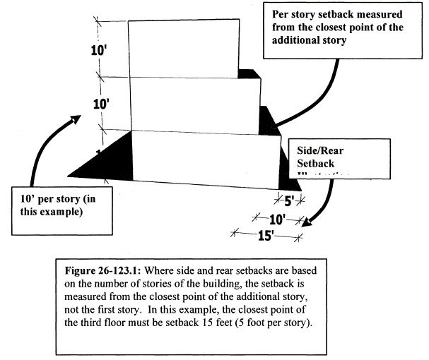
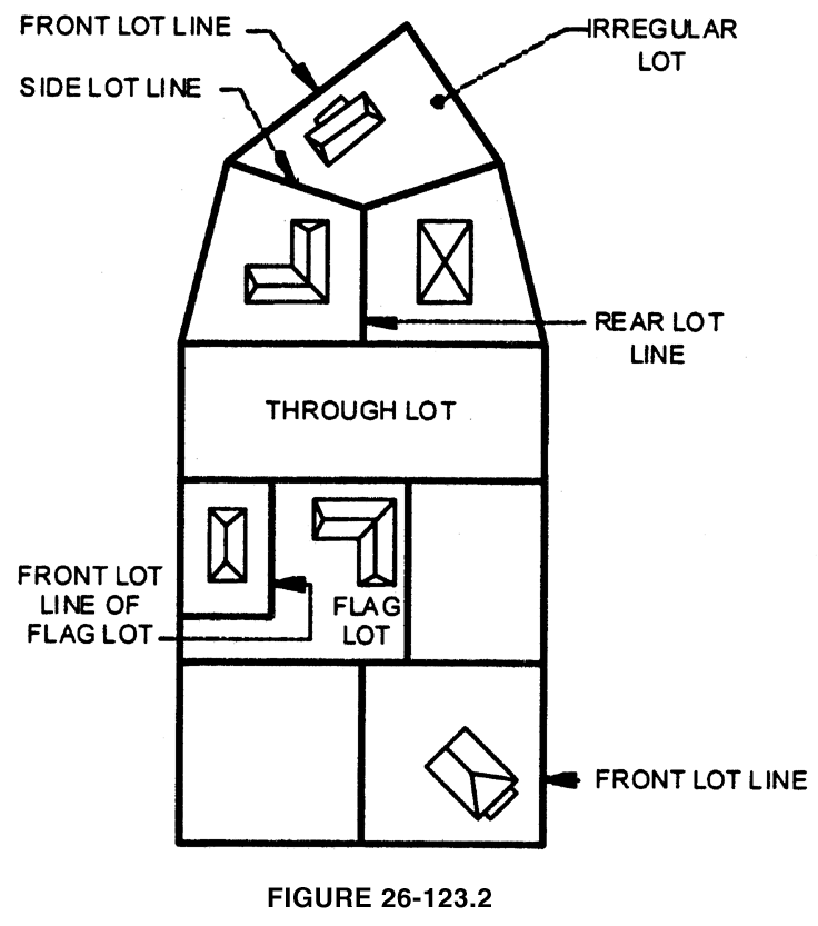
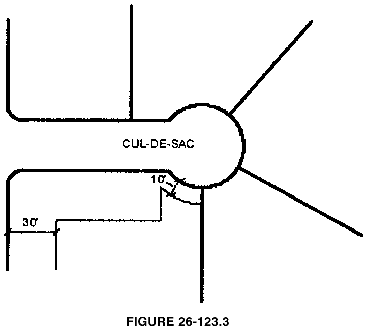
(Ord. No. 2001-1215, § 1, 2-26-01; Ord. No. 1265, § 1, 9-23-02; Ord. No. 1271, § 1, 12-10-02; Ord. No. 1273, § 1, 1-13-03; Ord. No. 1274, § 1, 1-13-03; Ord. No. 1284, § 1, 4-28-03; Ord. No. 1288, §§ 1, 2, 5-12-03; Ord. No. 1301, § 1, 7-28-03; Ord. No. 1302, §§ 1—3, 7-28-03; Ord. No. 1313, § 10, 10-27-03; Ord. No. 1318, § 2, 3-22-04; Ord. No. 1387, § 1, 6-11-07; Ord. No. 1413, § 1, 6-9-08; Ord. No. 1448, § 3, 8-24-09; Ord. No. 1479, § 3, 3-14-11; Ord. No. 1491, §§ 1, 2, 5-23-11; Ord. No. 1523, §§ 2, 3, 10-8-12; Ord. No. 1524, §§ 1, 2, 10-8-12; Ord. No. 1543, § 3, 10-14-13; Ord. No. 1552, § 3, 7-14-14; Ord. No. 1607, § 1, 9-12-16; Ord. No. 1612, § 2, 11-14-16; Ord. No. 1613, § 3, 11-21-16; Ord. No. 1617, § 1, 4-10-17; Ord. No. 1648, § 1, 6-25-18; Ord. No. 1670, § 1, 6-24-19; Ord. No. 1684, §§ 1—3, 2-10-20; Ord. No. 1696, § 6, 8-24-20; Ord. No. 1709, § 4, 2-22-21; Ord. No. 1721, § 2, 9-27-21; Ord. No. 1744, §§ 3, 25(Exh. 1), 7-11-22; Ord. No. 1760, § 1, 5-8-23; Ord. No. 1762, § 4, 5-22-23; Ord. No. 1768, § 1, 6-28-23; Ord. No. 1789, § 2, 2-26-24; Ord. No. 1801, § 4, 8-26-24; Ord. No. 1802, § 4, 8-26-24; Ord. No. 1812, § 1, 1-13-25; Ord. No. 1814, § 5, 1-27-25; Ord. No. 1823, § 1, 5-12-25; Ord. No. 1824, § 2, 6-23-25; Ord. No. 1838, § 3, 3-23-26)
Note— See editor's note to § 26-120.