
Wheat Ridge City Zoning Code
ARTICLE VII
SIGN CODE
Sec. 26-701.- Intent and purpose.
The intent and purpose of this article is:
A.
To protect the public from signs which are structurally unsafe;
B.
To promote traffic safety and the free movement of traffic, and protect the public from the hazardous conditions which result from signs that obscure or distract the vision of motorists, bicyclists and pedestrians;
C.
To facilitate easy, safe and pleasant communication between people and their surroundings;
D.
To conserve the character and economic value of buildings and neighborhoods;
E.
To provide a balance between legitimate identification and advertising needs and the visual discord which signs sometimes cause, and to provide a sense of balance or proportion between a sign and the building or property which it serves;
F.
To encourage the erection of signs which are legible in their surroundings and compatible with the visual character of the surrounding; and
G.
To ensure that adequate and effective advertising signage opportunities exist within a regulatory framework which protects the constitutionally guaranteed right of free speech.
H.
It is not the intent of these regulations to prohibit or unreasonably regulate or to require permits for the legitimate display of traditional holiday season decorations; provided, however, that such decorations or displays are installed and maintained in a safe manner.
(Ord. No. 2001-1215, § 1, 2-26-01; Ord. No. 1396, § 1, 7-23-07; Ord. No. 1641, § 1, 4-23-18)
Sec. 26-702. - Definitions.
For the purposes of this article, the following words and phrases shall have the meanings respectively ascribed to them by this section:
Animated sign. A sign or parts thereof, which revolve, whirl, twirl or utilize motion, mechanical or actual, in a horizontal or vertical plane or both. The only animated type of signs that are permitted are barber shop poles.
Arcade sign. Any sign projecting beneath and attached to the underside of any balcony, canopy, awning or other structural overhang or passageway.
Artistic mural or sculpture. A freestanding statue or sculpture or a graphic illustration or design, or an architectural design or relief applied directly to or incorporated within a wall of a building, which does not advertise or promote a particular business, service or "branded" product.
Awning. A shelter supported entirely from the exterior wall of a building and/or a type which can be retracted against the face of the supporting building.
Balloon or inflatable sign. Any sign consisting of material intended to be filled with air or helium, or have air blown through in order to create a visual attraction; this is inclusive of air dancers, inflatable caricatures, all types and sizes of balloons, and similar devices.
Banner. A sign or advertising display constructed of cloth, canvas, fabric or other light material that is mounted with no enclosing framework intended to be displayed for a short period of time.
Barber shop poles. A sign with a striped interior which may or may not rotate, which is traditionally utilized to signify the presence of an establishment within which the practice of barbering is engaged or carried out.
Billboard. Any sign in excess of fifty (50) square feet in size oriented to the interstate highway utilized to advertise a product or service that is not produced or conducted on the same property as the sign.
Blade sign. A sign which is affixed to any building, wall or structure and which extends beyond the building wall more than fifteen (15) inches.
Building front. The exterior wall(s) of a building facing a public street or streets or other public right-of-way other than alleys, or one (1) exterior wall containing the primary entrance to the building if not directly facing upon a public street.
Canopy sign. A sign mounted to a roof-like structure serving the purpose of protecting vehicles and/or pedestrians and which may be freestanding or attached to a building, is provided with supports, and is open on three (3) sides if attached and on all sides if freestanding.
Changeable copy sign. A sign, either illuminated or nonilluminated, which is designed so that the message or any part of the message may be periodically changed, either mechanically or electronically, however, where a change in message occurs no sooner than every eight (8) seconds. This includes signs that utilize computer-generated messages or some other electronic means of changing copy, including displays using incandescent lamps, LEDs, LCDs or a flipper matrix. Messages shall be static and a change in message shall be instantaneous.
Development. A single lot, parcel or tract of land or portions or combinations of lots, parcels or tracts of land which are held in single or common ownership and which exist as a distinct functional entity. Multi-use and multi-tenant buildings and multiple building complexes which are held in singular or common ownership, either by individual, corporation, partnership or other legally recognized entity, shall be considered a "development" for the purpose of signage.
Directional sign. A freestanding or wall-type sign, not located within public street right-of-way, providing necessary directional information to motor vehicle operators or pedestrians, such as entrance, exit, parking limitations or location of onsite buildings or facilities. Directional signs shall be clearly incidental to the primary signage on a property, in both height and sign area.
Erect. To build, construct, attach, hang, place, suspend, affix, relocate or reconstruct any sign or sign-supporting structure.
Flashing sign. A sign that is illuminated with intermittent lighting, animated lighting or with varying intensities including a moving light or lights. Flashing signs are prohibited.
Flag. Any fabric or other flexible material attached to or designed to be flown from a flagpole or similar device.
Freestanding sign. A sign that is permanent and self-supporting, being nondependent on support from a building or other structure, including signs placed upon fences or nonsupporting walls. This includes pole-mounted or monument signs.
Illuminated sign. A sign that is illuminated with constant intensities of light of a non-varying nature. There are three (3) types of illuminated lights as follows:
A.
Direct. Lighting by means of an unshielded light source which is effectively visible as a part of the sign. Neon lighting is considered direct lighting.
B.
Indirect. Lighting which illuminates the front of a sign or the entire building façade upon which the sign is displayed, the source of the light being shielded from public view and from surrounding properties. Indirect illumination does not include lighting which is primarily used for purposes other than sign illumination, such as parking lot lighting.
C.
Internal. Lighting by means of a light source which is within a sign having a translucent background and which silhouettes opaque letters or designs, or lighting within or behind letters or designs which are themselves made of translucent or opaque material.
Lot. A tract, building site, parcel or portion of land separated from other parcels or portions by description, as on a subdivision plat of record or survey map or by metes and bounds, for the purpose of sale, lease or use.
Major interior drive. A drive aisle located on private property which connects two (2) public streets or provides access to two (2) or more parcels of land or developments. Where the regulations allow "one sign per major interior drive," the intent is that the sign allowed is placed upon or facing the major interior drive, unless specifically otherwise permitted.
Nonconforming sign. A sign which does not conform with the regulations set forth in this article, but which did meet the requirements of the regulations existing at the date of its erection.
Off-premise sign. A commercial sign advertising a land use, business, product or service not located or available as the primary business, product or service upon the premises whereon the sign is located.
Painted sign. A sign that is painted directly onto the exterior surface of a building, wall or structure.
Pennant, streamer, and other similar devices. A sign made of flexible materials intended to create a visual attraction through movement. This is inclusive of flutter flags.
Portable sign. Any sign which is supported by one (1) or more uprights or braces upon the ground and which is of portable design, such as A-frame or pedestal style signs.
Public sign. A sign that is required by federal, state or local law or ordinance, or is deemed necessary for public information.
Revolving sign. A sign utilizing an axis point to pivot the sign surface.
Roof sign. A sign erected, constructed and maintained above the eaves and attached to the roof of a building.
Sign. Any object or device or part thereof situated outdoors or indoors, viewed from outdoors by the general public, and which object or device or the effect produced thereby is used to advertise, announce, identify, declare, demonstrate, display, instruct, direct or attract attention by means including, but not limited to, words, letters, figures, designs, fixtures, colors, motion, illumination, sound or projecting images.
Sign permit. A building permit issued for the erection, construction, enlargement, alteration, repair, relocation, improvement, removal, conversion or demolition of any sign issued pursuant to the building code of the city or this sign code.
Sign setback. The total distance between the property line and the leading edge of the sign face.
Sign structure. Any supports, uprights, braces or framework of a sign which does not include any portion of the sign message.
Signs carried by persons. Any sign, which is carried or worn by any person, typically in or along the right-of-way for the purpose of attracting and directing traffic to a particular place of business.
Street frontage. For the purpose of signage, frontage upon a street is obtained by ownership, easement or leasehold only if used for vehicular access to the property, or if not used for vehicular access, only if such street frontage is at least fifty (50) feet in width. Where the regulations allow "one sign per street frontage," the intent is that the sign allowed is placed upon or facing the street, unless specifically otherwise permitted.
Sign oriented to a drive-through lane. A freestanding or wall-mounted sign, oriented predominantly towards a drive-through or drive-up lane, which is clearly incidental to the primary signage on a property, in both height and sign area.
Size of sign. When two (2) identical sign faces are placed back to back so that both faces cannot be viewed from any point at the same time, and are part of the same sign structure, the sign area shall be computed as the measurement of one (1) of the two (2) faces. For a sign which is framed, outlined, painted or otherwise prepared and intended to provide a background for a sign display, the area and dimensions shall include the entire portion within such background or frame. For a sign comprised of individual letters, figures or elements on a wall of a building or surface of a structure, the area and dimensions of the sign shall encompass a regular geometric shape (rectangle, circle, trapezoid, triangle, etc.) or a combination of regular geometric shapes, which form or approximate the perimeter of all elements in the display, the frame and any applied background that is not part of the architecture of the building or structure. When separate elements are organized to form a single sign but are separated by open space, the sign are and dimensions shall be calculated by determining the geometric form, or the combination of forms, which comprises all of the display areas, including the space between different elements. For a freestanding sign, the sign area shall include the frame, if any, but shall not include the pole or other structural support unless such pole or structural support is internally illuminated or otherwise so designed to constitute a display, or part of a display device. Architectural features that are either part of the building or part of a freestanding structure, and not an integral part of the sign, and which may consist of landscaping, building, or structural forms completing the site in general shall also not be in the sign area.
Temporary sign. Any sign, banner, pennant, balloon, inflatable, portable sign, yard sign or other outdoor advertising sign constructed of light fabric, cardboard, wallboard, plywood, sheet metal, paper or other light materials, with or without a frame, intended or designed to be displayed for a limited period of time.
Three-dimensional (3D) signs. Any sign, which by virtue of its shape, design, and location of copy provides advertisement in a three dimensional manner and is distinctly different from an artistic sculpture, wall sign, or blade sign.
Traffic and regulatory signs. Signs, signals or markings placed or erected by federal, state or local authority for the purpose of regulating, warning or guiding traffic.
Unlawful sign. Any sign or outdoor advertising device erected in the absence of a permit required by this article, or in violation of any of the limitations, prohibitions or requirements of this article.
Unsafe sign. Any sign or advertising structure found unsafe or insecure or creating a hazard or menace to the public safety, health and welfare.
Wall sign. A sign constructed of durable materials or painted and which is permanently affixed to an exterior surface of any building, wall or structure and which does not extend more than fifteen (15) inches beyond the building wall, except that signage placed upon marquees, canopies or awnings shall be considered as wall signs.
Window or door sign. Any sign or decal affixed to, painted on, applied to, or hanging within twelve (12) inches of the interior of a window and that can be seen through the window from the exterior of the structure, but excludes merchandise included in a window display.
Yard sign. Temporary, ground-mounted, portable sign constructed of paper, vinyl, plastic, wood, metal or other comparable material, and designed or intended to be displayed for a limited period of time.
(Ord. No. 2001-1215, § 1, 2-26-01; Ord. No. 1396, § 1, 7-23-07; Ord. No. 1463, § 1, 6-28-10; Ord. No. 1641, § 2, 4-23-18)
Sec. 26-703. - Enforcement and penalties.
Enforcement and penalties shall be in accordance with those provisions set forth in article X. In addition to any remedies set forth in section 26-1004 et seq., specific authority is granted to the enforcement officer to remove, or have removed, the following signs:
A.
Unsafe signs and temporary signs found by an enforcement officer to be located within city right-of-way or in violation of sight triangle requirements shall be removed by such enforcement officer with no requirement of notice.
B.
Signs which are prohibited pursuant to this article may be removed after posting of a notice at least twenty-four (24) hours prior to removal upon the premises where such sign(s) is located.
C.
In the discretion of the enforcement officer a sign which is otherwise not in compliance with this article may be removed upon sixty (60) days prior notice.
(Ord No. 2001-1215, § 1, 2-26-01; Ord. No. 1396, § 1, 7-23-07; Ord. No. 1641, § 3, 4-23-18)
Sec. 26-704. - Contractor's license required.
A.
No person shall engage in the business of installing, altering or repairing any sign within the corporate limits of the city unless he is the holder of a currently valid, city sign contractor's license, except for those signs exempt from permit.
B.
The city shall have the power to suspend or revoke the license of any holder of a sign license issued pursuant to this article, in accordance with the provisions as set forth in the building code. (See chapter 5 of this Code of Laws for related provisions.)
(Ord. No. 2001-1215, § 1, 2-26-01; Ord. No. 1396, § 1, 7-23-07)
Sec. 26-705. - Permit required.
A.
No sign or modification to an existing sign shall be erected, placed or displayed outdoors within the city limits until a permit for such sign has been issued by the city, unless such sign is exempt from a permit in accordance with this sign code.
B.
An application, accompanied by a "to scale" drawing, for each separate sign permit shall be made to the department of community development on a form supplied by the department. Such applications shall set forth the name and address of the applicant; the location where such sign is to be erected or located; the name, phone number and address of the owner of the property; the size, height, type and general description of such proposed sign, including the materials of which it is constructed, the sign contractor's name, phone number and address and such other pertinent information required or deemed necessary by the department to determine the sign's safety and conformance to this article. A "to scale" plot plan of the lot or parcel shall accompany the application and shall show the location of the proposed sign and the location, type and size of other signs which exist upon the lot. The community development director may require additional submission information in connection with a specific application.
C.
The mere application for a sign permit does not assure that a permit will be issued; therefore, it is advised that signs not be fabricated, constructed or purchased prior to issuance of a sign permit.
D.
Fees for the erection of signs are assessed as part of building permit review and issuance. Permit fees and city use tax will be waived where a nonconforming sign is removed and replaced by a sign conforming with these regulations.
E.
The property owner, principal lessee, or authorized agent of the platted or otherwise recognized as legally developable parcel on which the sign will be located shall be the same person applying for the sign permit. Documentation shall accompany the permit for verification.
F.
A copy change with no modifications to the sign structure, support, cabinets, electricity, or other features shall be exempt from building permit.
(Ord. No. 2001-1215, § 1, 2-26-01; Ord. No. 1396, § 1, 7-23-07; Ord. No. 1547, § 15, 4-28-14; Ord. No. 1641, § 4, 4-23-18)
Sec. 26-706. - Nonconforming signs.
A.
Nonconforming signs. A lawful sign existing on the effective date of the ordinance from which this article is derived may be continued, although such sign does not conform to the provisions of this article, subject to the following provisions:
1.
Relocation, or replacement of a nonconforming sign is not permitted unless such sign is brought into conformance with this article. Enlargement or extension of a nonconforming sign is permitted so long as the nonconformity is not increased. Rebuilding or reconstructing a nonconforming sign is permitted only if the rebuilding or reconstruction is limited to installing a new sign cabinet on an existing support structure. Installing a new sign cabinet together with a new support structure shall constitute replacement of the nonconforming sign and shall require conformance with this article.
2.
In the event the use of a nonconforming sign is discontinued for a period of sixty (60) consecutive days, the nonconforming sign shall thereafter conform to the provisions of the zoning district in which it is located or be removed. For the purpose of this section, the term "discontinued" shall apply to uses which customarily operate on a continuous basis versus a seasonal basis.
3.
A nonconforming sign that is destroyed or damaged more than fifty (50) percent of its replacement cost voluntarily or due to natural causes may not be reconstructed except in accordance with the provisions of this article; however, any sign destroyed or damaged to any extent by vandalism may be rebuilt to its original state within six (6) months or otherwise it must be reconstructed in conformance with this article.
4.
Normal maintenance which does not require modification of the sign structure, supports or members shall be permitted. A face change is considered normal maintenance.
5.
In order to provide an incentive for removal of nonconforming signs, permit fees and city use tax will be waived where a nonconforming sign is removed and replaced by a sign conforming with these regulations.
B.
Discontinued business, etc. Whenever a use of land and/or building using an identification sign is discontinued, except for seasonal uses pursuant to subsection A.2., above, the sign shall be removed or obscured by the person owning the property within thirty (30) days after the discontinuance of such use. Any such sign which is nonconforming to these regulations and which is not used to advertise an active business within sixty (60) days of discontinuance shall be removed or otherwise brought into compliance.
C.
Nonconforming electronic changeable copy signs. Such signs which are made nonconforming by the adoption of ordinance no. 1641 shall be brought into conformance with the requirements of this article on or before May 11, 2019.
(Ord. No. 2001-1215, § 1, 2-26-01; Ord. No. 1396, § 1, 7-23-07; Ord. No. 1641, § 5, 4-23-18)
Sec. 26-707. - General provisions/performance standards.
A.
Sight distance triangle.
1.
No sign is allowed which would violate the sight distance triangle requirements of section 26-603 B.
2.
At signalized intersections, where both streets are collectors and/or arterials, the required sight distance shall be governed by the standards set forth in the most current edition of the policy on geometric design of highways and streets, published by the American Association of State Highway and Transportation Officials (AASHTO).
B.
Location of signs.
1.
All signs allowed by this article, except billboards, public signs, and signs permitted under the criteria in section 26-708 E. must be owned by the property/building owner, or principal lessee of the property/building on which the sign is placed.
C.
Streets and rights-of-way.
1.
No sign shall be erected in such a location as to interfere with motor vehicle or pedestrian traffic.
2.
No sign is allowed in or above the public right-of-way, with the exception of:
a.
Signs on bus benches and shelters pursuant to article IV of chapter 21;
b.
Public, traffic, regulatory, or licensed sign; and
c.
Signs permitted under the criteria in section 26-708 E.
3.
For temporary signs, where it is difficult to determine the public right-of-way boundary due to lack of curb, gutter and/or sidewalk, or survey markers, such boundaries shall be presumed to be ten (10) feet from the edge of pavement or back of curb. Where a sidewalk exists, such boundaries shall be presumed to be two (2) feet from outside edge of sidewalk.
4.
Attachment of any sign to utility poles or other poles or structures within public right-of-way is prohibited, except as approved by the public works director pursuant to this article.
D.
Interference.
1.
No sign is allowed which employs a lighting or control mechanism which causes radio, radar, cellular telephone or television interference.
2.
No sign is allowed which, even though in general conformance with the standards and requirements of this sign code, is judged by the chief of police, community development director and public works director as a dangerous sign due to interference with a traffic control device by being in direct line between the control device and oncoming traffic or otherwise in visual competition with a traffic control device.
3.
No sign is allowed which may be construed as a traffic sign or signal or which may be confusing to motorists or mistaken as a traffic signal.
E.
Compliance with building codes.
1.
No sign shall be erected, constructed or maintained which obstructs or is attached to any fire escape, window, door or opening used as a means of egress or ingress or for firefighting purposes, or is placed which interferes with any opening required for light or ventilation.
2.
No sign is permitted which is structurally unsafe as determined by the chief building official, based upon criteria established in the adopted building codes.
3.
The design of all sign structure members and foundation shall conform to the requirements of the building code relative to allowable stresses, materials and engineering standards. Loads, both vertical and horizontal, shall not produce stresses exceeding those specified in the building code, and material construction shall be of the quality and grade required by the building code. All signs and structures shall be designed and constructed to meet the adopted building and electrical codes.
F.
Outside display.
1.
Notwithstanding the provisions of section 26-631, any merchandise displayed outside of a building in such a way as to attract attention when viewed by the general public by placement upon a pole, a fence, a platform, roof or other similar device or structure shall be considered a sign and is prohibited. This shall not, however, be construed to prohibit merchandise customarily stored outside of buildings and placed upon shelves or tables, such as automobiles, campers, boats, plant materials, produce or lumber.
G.
Illumination.
1.
All illuminated signage shall comply with section 26-503 of the zoning and development code.
2.
Signs within one hundred (100) feet of a residential structure, may be lighted indirectly or internally.
3.
Signs over one hundred (100) feet from a residential structure, may use any type of lighting source, except search or flashing lights, provided that they are shaded, shielded or directed so that the light shall not adversely affect surrounding premises or interfere with safe vision on public or private roadways, including highways.
4.
All direct and indirect lighting sources shall be downcast to reduce glare, sky glow and light pollution.
5.
In the MU-N district, illuminated signs are encouraged to be turned off when businesses are not in operation.
6.
Internally illuminated, translucent signs should have the typography lighter than the sign background. Opaque sign faces with internally-illuminated translucent typography or internally-illuminated individual channel letter with translucent faces are acceptable.
7.
Sign lighting should be consistent with the lighting of building elements and storefront lighting.
8.
It is encouraged that sign faces be of darker hue with light colored text to prevent light glare emitted at night.
9.
The nighttime illumination of changeable copy signs shall conform with the following criteria:
a.
Illumination measurement methods shall be consistent with established city policy.
b.
Illumination limits. The difference between the off and solid-message measurements using the measurement criteria shall not exceed 0.3 footcandles at night.
c.
Dimming capabilities. All permitted changeable copy signs shall be equipped with a sensor or other device that automatically determines the ambient illumination and programmed to automatically determines the ambient illumination and programmed to automatically dim according to the ambient light conditions, or that can be adjusted to comply with the 0.3 footcandle measurements.
H.
Maintenance. Any sign, including temporary signs that becomes discolored, ragged, shredded, detached, etc., shall be removed or repaired.
(Ord. No. 2001-1215, § 1, 2-26-01; Ord. No. 1396, § 1, 7-23-07; Ord. No. 1463, § 2, 6-28-10; Ord. No. 1641, § 6, 4-23-18; Ord. No. 1683, § 33, 1-27-20)
Sec. 26-708. - Miscellaneous provisions.
A.
Building addresses.
1.
House or building address number signs shall be consistent with section 26-639 of the Code and established city policy.
B.
Signs located on bus benches and bus stop shelters.
1.
Signs located on bus benches shall be in conformance with section 21-124 of the Code.
2.
Signs located on a bus stop shelter shall be in conformance with section 21-151 of the Code. Such signs shall be limited to two (2) faces per shelter with a maximum of twenty-four (24) square feet per face.
C.
Home occupations.
1.
Home occupations must comply with section 26-613 of the Municipal Code.
2.
Residential units with an approved home occupation business license through the city, are allowed one (1) freestanding or wall-mounted non-illuminated sign.
D.
Master sign plan.
1.
The planning commission may approve a master sign plan for any existing or proposed commercial, mixed use, or industrial development of at least two (2) acres or more in size which is under unified control either by ownership, legal association or leasehold.
2.
The intent and purpose is to encourage well-planned and designed signage within a large multiple building or multiple use complex which expresses unification and integration by elements of architectural style, size, color, placement and lighting. An additional purpose is to encourage the elimination of existing nonconforming signs. The planning commission may grant as a bonus for well-designed plans additional signs and/or up to a fifty (50) percent increase in maximum square footage for each sign, and/or may permit signs in locations other than normally permitted, based upon a finding that the proposed master sign plan substantially meets the intent and purpose of this subsection relating to unification and integration of signage.
3.
Once approved at a public hearing by planning commission, all master sign plans shall be recorded with the Jefferson County Recorder's Office and shall constitute a covenant and must be complied with by all owners, proprietors, lessees or assigns, whether current or future. No substantial variation from the plan shall be permitted without planning commission approval. Noticing requirements for a master sign plan process shall follow the procedures outlined in section 26-109.
E.
Signs in the right-of-way.
1.
The community development director and public works director may jointly approve freestanding signs which are otherwise permitted to advertise a property, to be located in the public right-of-way immediately adjacent to that property, subject to all of the following criteria:
a.
There are no viable alternative locations on the subject property;
b.
The sign is for a property with commercial, industrial-employment, mixed use, or planned development zoning;
c.
The sign will be within right-of-way that is immediately adjacent to the subject property;
d.
The sign is not in the right-of-way of a state highway;
e.
There are no immediate plans for widening the street as identified in the five-year capital investment program (CIP) or planning documents;
f.
The sign is not for a site being completely redeveloped with new construction, in which case the proposed design should incorporate the sign on site;
g.
No underground utilities, except for electricity, exist in the proposed location for the sign;
h.
The sign does not obstruct the sidewalk or vehicular traffic;
i.
The sign complies with sight distance triangle requirements per section 26-603 B.;
j.
The sign is not a pole sign; and
k.
The sign must be in lieu of a freestanding sign otherwise located only on the immediately adjacent property for which sign is permitted.
2.
Signs that meet the above criteria shall obtain a sign permit through the community development department and a right-of-way use permit through the department of public works.
3.
Notwithstanding section 26-115, the decision of the community development director and public works director to grant or deny a permit under this subsection F. shall be the final decision of the city, appealable only to the district court.
F.
Signs in mixed use zone districts. Signs in any mixed use zone district must also comply with requirements in section 26-1113, or section 26-1412 for the MU-LLC zone district.
G.
Signs for marijuana-related businesses. No permanent or temporary sign associated with a marijuana-related business licensed pursuant to articles XII and/or XIII of chapter 11 may be installed or located until reviewed and approved by the city. See sections 11-296, 11-306, 11-406 and 11-417.
(Ord. No. 2001-1215, § 1, 2-26-01; Ord. No. 1396, § 1, 7-23-07; Ord. No. 1463, § 3, 6-28-10; Ord. No. 1471, § 10, 9-13-10; Ord. No. 1547, § 16, 4-28-14; Ord. No. 1563, § 11, 1-26-15; Ord. No. 1641, § 7, 4-23-18; Ord. No. 1814, § 13, 1-27-25)
Sec. 26-709. - Permitted sign types.
A.
A summary of sign types addressed in this article are listed in the following tables. The tables identify if signs are permitted (P), not permitted (NP), or permitted in limited (L) circumstances, based on the land use of the property upon which a sign is located.
B.
For the purposes of this article only, the following definitions shall apply:
1.
Low density residential. Land use category for determining allowable signage, both permanent and temporary, for single detached and duplex dwellings.
2.
Multi-unit residential. Land use category for determining allowable signage, both permanent and temporary, for residential uses with three (3) or more attached dwelling units, including single-unit attached dwelling uses.
3.
Nonresidential. Land use category for determining allowable signage, both permanent and temporary, for all commercial, industrial, and other nonresidential uses.
C.
Permanent signs. For signs that are permitted (P or L), additional standards are found in section 26-710.
Table 1. Permanent Signs by Land Use
D.
Temporary signs. For signs that are permitted (P or L), additional standards are found in section 26-711.
Table 2. Temporary Signs by Land Use
(Ord. No. 2001-1215, § 1, 2-26-01; Ord. No. 1396, § 1, 7-23-07; Ord. No. 1463, § 4, 6-28-10; Ord. No. 1491, § 8, 5-23-11; Ord. No. 1547, § 17, 4-28-14; Ord. No. 1641, § 8, 4-23-18; Ord. No. 1744, § 25(Exh. 1), 7-11-22; Ord. No. 1824, § 17, 6-23-25)
Sec. 26-710. - Permanent sign standards.
A.
General.
1.
Where a property is eligible for a permanent sign based on section 26-709, the standards of this section shall apply.
2.
Building permits are required for all permanent signs.
3.
Residential zone districts include the entire residential series (R-1, R-1A, R-1B, R-1C, R-2, R-2A, R-3, R-3A, PRD), agricultural series (A-1, A-2), and public facilities (PF).
4.
Nonresidential zone districts include the entire commercial series (NC, RC, C-1, C-2), mixed use series (MU-C, MU-C TOD, MU-C interstate, MU-N, MU-LLC), industrial employment (I-E), and planned developments including PCD, PID, PHD, and PMUD.
5.
With the exception of billboards permitted under section 26-712, no permanent sign shall be erected or maintained upon a lot, tract, or parcel devoid of an established primary use.
B.
Address numbers.
1.
Must be compliant with section 26-639 of the Code.
2.
Must be compliant with established city policies regarding addressing.
C.
Arcade signs.
1.
Definition: Any sign projecting beneath and attached to the underside of any balcony, canopy, awning or other structural overhang or passageway.
2.
Maximum number: one (1) per business.
3.
Maximum size: four (4) square feet.
4.
Height: minimum height above street frontage or sidewalk level is seem (7) feet.
5.
Location: may not extend above the bottom of eave, balcony, canopy, awning or other structural overhang or passageway to which it is affixed. Can extend into right-of-way with an approved right-of-way permit.
D.
Barber shop poles.
1.
Definition: A sign with a striped interior which may or may not rotate, which is traditionally utilized to signify the presence an establishment within which the practice of barbering is engaged or carried out.
2.
Maximum number: one (1) per street frontage or major interior drive.
3.
Height: pole height cannot exceed five (5) feet in total, may not exceed height of building to which it is attached.
4.
Location: must be wall mounted. May extend into the right-of-way with an approved right-of-way permit.
E.
Blade signs.
1.
Definition: a sign which is affixed to any building, wall or structure and which extends beyond the building wall more than fifteen (15) inches. Projection shall extend no more than forty-eight (48) inches away from the structure to which the sign is attached.
2.
Maximum number: one (1) per street frontage or business.
3.
Maximum size:
a.
For two-dimensional (2D) signs: one (1) square foot for each one (1) foot of height of the building wall to which the sign is to be attached.
b.
For three-dimensional (3D) signs, as defined in subsection 26-702, 1.75 cubic feet for each one (1) foot of height of the building wall to which the sign is to be attached.
4.
Height:
a.
May not extend above the top of the wall or parapet; not to be roof mounted.
b.
Minimum height clearance seven (7) feet above street frontage or sidewalk.
5.
Location: may extend into the right-of-way with an approved right-of-way permit.
6.
Additional standards:
a.
Blade signs are encouraged in the traditional overlay areas, as defined by the architectural and site design manual.
b.
Wall signs and blade signs are allowed on the same wall.
c.
Blade signs should not be located closer than twenty-five (25) feet apart unless the signs work together to make a unified and compatible design or the sign group is integral to the building architecture, reinforcing a significant building feature such as a primary entry.
d.
The structural support of projecting signs shall be integrated into the design of the sign, either by being simple and inconspicuous, or by being creative in the use of structural elements, lighting, color and materials.
F.
Canopy signs.
1.
Definition: a sign mounted to a roof-like structure serving the purpose of protecting vehicles and/or pedestrians and which may be freestanding or attached to a building, is provided with supports, and is open on three (3) sides if attached and on all sides if freestanding.
2.
Maximum number: one (1) per street frontage or major interior drive.
3.
Maximum size: canopy signs may use up to fifty (50) percent of the allowed wall sign allowance, the size of the canopy sign is to be subtracted from the allowable wall signage.
G.
Changeable copy signs.
1.
Definition: a sign, either illuminated or nonilluminated, which is designed so that the message or any part of the message may be periodically changed, either mechanically or electronically, however, where a change in message occurs no sooner than every eight (8) seconds. This includes signs that utilize computer-generated messages or some other electronic means of changing copy, including displays using incandescent lamps, electronic message centers (EMCs), LEDs, LCDs or a flipper matrix. Messages shall be static and a change in message shall be instantaneous.
2.
Prohibition: changeable copy signs are not be permitted in the MU-N district or the MU-C TOD sub-district.
3.
Maximum number: one (1) per street frontage, but no more than two (2) per development.
4.
Maximum size:
a.
In residential zone districts, a maximum of thirty (32) square feet per sign.
b.
In nonresidential zone districts, the freestanding and wall signage size regulations (subsections 26-710 J. and 26-710 L.) apply.
5.
Height:
a.
In residential zone districts, a maximum of seven (7) feet.
b.
In nonresidential zone districts, freestanding and wall signage height regulations (subsections 26-710 J. and 26-710 L.) apply.
6.
Location: for freestanding changeable copy signs, the minimum setback is five (5) feet from any property line.
7.
The time lapse between the change in information shall not be less than eight (8) seconds.
H.
Directional signs.
1.
Definition: a freestanding or wall-type sign, not located within the public street right-of-way, providing necessary directional information to motor vehicle operators or pedestrians, such as entrance, exit, parking limitations or location of onsite buildings or facilities. Directional signs shall be clearly incidental to the primary signage on a property, in both height and sign area.
2.
Maximum number: no limit.
3.
Maximum size: four (4) square feet per side.
4.
Height: If freestanding, shall not exceed thirty-six (36) inches in height if within a required sight distance triangle, or forty-eight (48) inches where outside of a sight distance triangle.
I.
Flag.
1.
Definition: any fabric or other flexible material attached to or designed to be flown from a flagpole or similar device.
2.
Maximum flagpole height of thirty-five (35) feet.
J.
Freestanding signs.
1.
Definition: a sign that is permanent and self-supporting, being nondependent on support from a building or other structure, including signs placed upon fences or nonsupporting walls. This includes pole-mounted or monument signs.
2.
Owner authorization required: building permit applications for single tenant signs on multitenant properties shall include property owner authorization with the building permit application.
3.
Design:
a.
For new development or total redevelopment new pole signs shall not be allowed, unless the development is located within one-quarter (¼) mile of the interstate and a highway-oriented sign is proposed.
b.
The base of a freestanding monument sign shall be consistent with the materials of the building with which it is associated.
c.
For new development or total redevelopment, all freestanding signs shall be placed within landscaped areas.
d.
When not associated with new development or total redevelopment, pole signs are permitted, but strongly discouraged.
4.
Multiple signs: where multiple freestanding signs are permitted pursuant to this section, the following standards shall apply:
a.
Where two (2) freestanding signs are permitted by virtue of multiple street frontages, each permitted sign shall be allowed to have the maximum square footage allowed as noted in this subsection. In addition, the sign area allowed may be transferred from one (1) sign to another; provided, that no freestanding sign shall exceed four hundred (400) square feet in area.
b.
Where multiple signs are permitted because of multiple street frontages, the signs may be erected on the same street frontage.
c.
For double-faced signs, each sign face can have the maximum square footage allowed.
5.
For low density residential uses:
a.
Not permitted, except for as allowed by the home occupation regulations.
6.
For multi-unit dwelling uses, including single-unit attached dwellings:
a.
Maximum number: One (1) per street frontage, not to exceed two (2).
b.
Maximum size: thirty-two (32) square feet.
c.
Minimum setback: five (5) feet from any property line.
d.
Maximum height: seven (7) feet.
7.
For nonresidential uses in residential zone districts:
a.
Maximum number: one (1) per street frontage, not to exceed 2.
b.
Maximum size: thirty-two (32) square feet.
c.
Minimum setback: five (5) feet from any property line.
d.
Maximum height: seven (7) feet.
8.
For nonresidential uses in nonresidential zone districts:
a.
Maximum number: one (1) per street frontage, not to exceed two (2).
b.
Maximum size: based upon table 3 below.
c.
Minimum setback: based upon height and adjacent zoning:
(1)
Ten (10) feet if adjacent to residentially zoned properties.
(2)
Five (5) feet from ROW if under seven (7) feet tall.
(3)
Ten (10) feet from ROW if seven—fifteen feet in height.
(4)
Thirty (30) feet for signs over fifteen (15) feet in height.
d.
Maximum height: based upon zoning and location:
(1)
Seven (7) feet in all mixed use zone districts.
(2)
Fifty (50) feet for retail and service businesses within one quarter (¼) mile of an interstate highway measured from the property line.
(3)
Fifteen (15) feet for all other freestanding signs.
Table 3. Maximum sign area for freestanding signs for NONRESIDENTIAL uses in nonresidential zone districts
9.
Home occupations:
a.
Must be in compliance with section 26-613 of the Municipal Code.
b.
Must have an approved business license through the city.
c.
Permitted one (1) non-illuminated sign not to exceed two (2) square feet in size.
10.
3D signs: three-dimensional (3D) signs, as defined in section 26-702, are permitted the sign allowances listed in this subsection multiplied by one and seventy-five one-hundredths (1.75), as measured in cubic feet.
K.
Sign oriented to a drive-through lane.
1.
Definition: a freestanding or wall-mounted sign, oriented predominantly towards a drive-through or drive-up lane, which is clearly incidental to the primary signage on a property, in both height and sign area.
2.
Maximum size: thirty-five (35) square feet per drive-through lane
3.
Maximum height: six (6) feet
4.
Additional standards
a.
May be illuminated by internal lighting only.
b.
Must be screened from the right-of-way such that signs do not violate subsection 26-707 D.
L.
Traffic control or regulatory signs.
1.
Definition: signs, signals or markings placed or erected by federal, state or local authority of the purpose of regulating, warning or guiding traffic
2.
Location: may be placed by the federal, state or local authority within the public right-of-way.
M.
Wall or painted signs.
1.
Definition: a sign constructed of durable materials which is permanently affixed to an exterior surface of any building, wall or structure or painted directly on the exterior surface of a building, wall or structure which does not extend more than fifteen (15) inches beyond the building wall, except that signage placed upon marquees, canopies or awnings shall be considered wall signs.
2.
Maximum size:
a.
Total size for any single or combined wall sign is no larger than one (1) square foot for every linear foot of the side of the building to which it is affixed.
3.
Location:
a.
Signs may only be affixed to walls which face public streets or major interior drives, as determined by the community development director
b.
For buildings with flat roofs, wall signs shall not extend above the top of the parapet or mansard, and if placed upon a parapet or mansard shall not extend more than three (3) feet above the deck line.
c.
For uses which have a rear entry or delivery door, one (1) nonilluminated wall sign not to exceed four (4) square feet per tenant is permitted.
4.
Other: signs affixed to canopies shall be considered wall signs and shall be calculated based upon the length of the wall to which they are attached or adjacent.
5.
Home occupations:
a.
Must be in compliance with section 26-613 of the Municipal Code.
b.
Must have an approved business license through the city.
c.
Permitted one (1) non-illuminated sign not to exceed two (2) square feet in size.
6.
Additional standards:
a.
Building wall signs shall complement the building's architecture and fit within the architectural features of the façade so they do not overlap windows or columns.
N.
Window or door signs.
1.
Definition: any sign or decal affixed to, painted on, applied to, or hanging within twelve (12) inches of the interior of a window and that can be seen through the window from the exterior of the structure, but excludes merchandise included in a window display.
2.
Maximum size: sign shall not obstruct more than twenty-five (25) percent of the door or window area
3.
Additional standards:
a.
The material, installation and/or size of window or door signs shall not negatively affect compliance with the transparency standards established in article XI, mixed use zone districts and in the architectural and site design manual.
b.
The interior application of a solid, dark color on back of house windows shall not be considered window or door signs and shall be permitted.
(Ord. No. 2001-1215, § 1, 2-26-01; Ord. No. 1396, § 1, 7-23-07; Ord. No. 1463, § 5, 6-28-10; Ord. No. 1471, § 11, 9-13-10; Ord. No. 1491, § 9, 5-23-11; Ord. No. 1523, § 10, 10-8-12; Ord. No. 1547, § 18, 4-28-14; Ord. No. 1641, § 9, 4-23-18; Ord. No. 1744, § 25(Exh. 1), 7-11-22; Ord. No. 1814, § 14, 1-27-25; Ord. No. 1824, § 18, 6-23-25)
Sec. 26-711. - Temporary sign standards.
A.
General.
1.
Where a property is eligible for a temporary sign based on section 26-709, the standards of this section shall apply.
2.
Maximum number:
a.
One (1) temporary sign per business may be placed on eligible property at any given time.
b.
This limitation on maximum number of temporary signs shall take effect on May 11, 2019.
3.
Illumination of temporary signs is prohibited.
4.
Temporary signs do not require building permits.
B.
Balloon or inflatable.
1.
Definition: any sign consisting of material intended to be filled with air or helium, or have air blown through in order to create a visual attraction; this is inclusive of air dancers, inflatables caricatures, all types and sizes of balloons, and similar devices.
2.
Height: cannot exceed twenty-five (25) feet above existing grade.
3.
Location: may not be located within the public right-of-way.
4.
Additional standards:
a.
Shall be securely anchored or attached so as to prevent dislocation, entanglement or encroachment onto adjacent properties or public streets, or undue hazard to motorists or pedestrians. Roof mounting is not permitted.
b.
Notwithstanding any other provision of this article, balloon or inflatable signs may be maintained for no longer than thirty (30) consecutive days within any calendar year.
C.
Banner.
1.
Definition: a sign or advertising display constructed of cloth, canvas, fabric or other light material that is mounted with no enclosing framework intended to be displayed for a short period of time.
2.
Maximum size: Total size for any single or combined banners affixed to a wall based on one-half (1/2) the allowance for wall signs.
3.
Location: may be placed upon a building wall but shall not be attached to fencing, landscaping, freestanding posts or utility poles. Banners may be placed only on walls facing a public street or major interior drive.
4.
Other: shall be securely anchored or attached so as to prevent dislocation, entanglement or encroachment onto adjacent properties or public streets, or undue hazard to motorists or pedestrians.
D.
Pennant, streamer, and other similar device.
1.
Definition: a sign made of flexible materials intended to create a visual attraction through movement. This is inclusive of flutter flags.
2.
Location: shall be securely anchored or attached so as to prevent dislocation, entanglement or encroachment onto adjacent properties or public streets, or undue hazard to motorists or pedestrians.
F.
Portable.
1.
Definition: any sign which is supported by one (1) or more uprights or braces upon the ground and which is of portable design, such as A-frame or pedestal style signs.
2.
Maximum size: Six (6) square feet per side per sign.
3.
Setback:
a.
Five (5) feet from any street right-of-way line if taller than thirty-six (36) inches.
b.
Two (2) feet from any street right-of-way line if thirty-six (36) inches or less in height.
4.
Location:
a.
May be located on a sidewalk within private property, provided that adequate clearance exists to meet ADA requirements.
b.
Must be anchored to the ground or weighted sufficiently to prevent movement by wind.
c.
May not be located outside when business is closed.
G.
Signs carried by persons.
1.
Definition: any sign, which is carried or worn by any person, typically in or along the right-of-way for the purpose of attracting and directing traffic to a particular place of business.
2.
Maximum size: six (6) square feet per side.
3.
Location: permitted along any public right-of-way, provided there is no negative impact to vehicular, bicycle, or pedestrian safety as determined by the director of public works, community development director or chief of police or their designee. Signs shall be limited to the exterior edges of the right-of-way, and completely outside of the vehicular and bicycle travel lanes. Shall be located behind the outermost curb and gutter, not impede pedestrian traffic, and are completely prohibited to be stationed in any median, island, or other refuge within the right-of-way.
H.
Yard—Small.
1.
Definition: a temporary, ground-mounted, portable sign constructed of paper, vinyl, plastic, wood, metal or other comparable material, and designed or intended to be displayed for a limited period of time.
2.
Maximum number:
a.
For all nonresidential uses: limit of one (1) per business.
b.
For all residential uses: no limit.
3.
Maximum size: shall not exceed four (4) square feet in size per sign.
4.
Location: shall not be placed within city right-of-way or municipally owned property.
I.
Yard—Large.
1.
Definition: a temporary, ground-mounted, portable sign constructed of paper, vinyl, plastic, wood, metal or other comparable material, and designed or intended to be displayed for a limited period of time.
2.
Maximum number: one (1) per street frontage or major interior drive, not to exceed two (2).
3.
Maximum size:
a.
For low density residential uses and multi-unit dwellings (three—nine units): nine (9) square feet.
b.
For multi-unit dwellings (ten (10) plus units): thirty-two (32) square feet.
c.
For nonresidential uses: thirty-two 32 square feet.
4.
Minimum setback: five (5) feet.
5.
Maximum height: shall not exceed seven (7) feet in height.
6.
Location: allowed only on properties with active listings for sale or for rent, or on properties with active building permits. Also allowed for urban gardens.
(Ord. No. 1641, § 10, 4-23-18; Ord. No. 1683, § 34, 1-27-20; Ord. No. 1744, § 25(Exh. 1), 7-11-22)
Editor's note— Ord. No. 1641, § 10, adopted April 23, 2018, added a new § 26-711, renumbering the old § 26-711 as 26-712. The historic notation remains with the affected provisions.
Sec. 26-712. - Billboards; specifications and regulations.
A.
General provisions.
1.
Intent. The intent of this section is as follows:
a.
To prohibit new billboards within the city;
b.
To honor the rights of existing billboard owners;
c.
To provide minimum standards and a process for maintenance and replacement; and
d.
To provide a process for abandoning billboards.
2.
Billboard district. For the purpose of this section, the city has one (1) billboard district, as shown on the official billboard zoning map of the city and incorporated herein, as shown below as the shaded area.
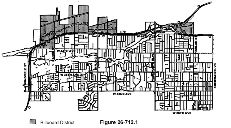
Official Billboard Zoning Map
3.
State approval required. Billboard structures are allowed in the city as provided by this section; provided that any billboard proposed to be rebuilt or replaced within six hundred sixty (660) feet of the right-of-way line of any state or federal highway requires approval by the state in writing and that such written approval is made available to the department of community development.
4.
No existing billboard may be rebuilt or replaced except in conformance with these regulations.
B.
Maximum number of billboards permitted.
1.
On and after December 13, 2023, the maximum number of allowed billboards within the city is fifteen (15).
2.
When a billboard is fully abandoned, as described in subsection F., below, the maximum number of billboards within the city shall automatically be reduced accordingly.
C.
Design standards.
1.
Roof-mounted billboards are not allowed.
2.
Changeable copy billboard signs are not allowed.
3.
Billboards shall be located within two hundred and fifty (250) feet of a highway, excluding on- and off-ramps, as measured radially from the leading edge of the billboard to the closest edge of the highway right-of-way line.
4.
Structure setbacks shall be as required for a principal structure in the zoning district where the billboard is located and shall be measured perpendicularly from the property line to the leading edge of the billboard or structure, whichever is closest.
5.
All replacement billboards shall be of the pedestal type, unless prohibited by soil conditions as certified by a professional engineer. As used herein, "pedestal" type signs are freestanding signs supported by one (1) or more columns, poles, or support structures.
6.
The maximum sign face size for a single-sided, two-sided, or V-shaped sign with an angle of less than sixty (60) degrees shall not exceed seven hundred fifty (750) square feet per sign face. For V-shaped signs with greater than a 60-degree angle, the combined size of both sign faces shall not exceed seven hundred fifty (750) square feet, and the total length of both sign faces shall not exceed six (6) times the height of the sign face.
7.
The maximum height to the highest point of the billboard shall not exceed thirty-two (32) feet.
D.
Maintenance.
1.
Billboards shall be maintained in a neat and safe condition.
2.
When, in the opinion of the chief building official, the safety of an existing billboard is questionable, the billboard owner shall, within thirty (30) days of notification of the same from the chief building official, either remove the billboard or furnish a certificate from a Colorado-registered professional engineer with a specialization in civil, structural, or mechanical engineering certifying to its safety.
3.
In the event the requested certificate is provided and approved by the chief building official, no further action is necessary.
4.
In the event the certificate is not provided, or if provided, is deemed by the chief building official to be insufficient, the billboard owner shall have an additional thirty (30) days to provide a revised certificate or remove the billboard.
5.
In the event the certificate is not amended to the satisfaction of the chief building official, or the billboard is not removed, the billboard shall be deemed abandoned, and the city may proceed with administrative enforcement under article V of chapter 2 of the Code of Laws and/or prosecution in the municipal court under sections 1-5 and 1-6 of the Code of Laws.
E.
Temporary removal and replacement.
1.
A billboard may be temporarily removed and replaced under the following conditions:
a.
The owner of the billboard or the property upon which it is located has filed written notice of its intent to temporarily remove the billboard with the community development director, which notice shall include the purpose for the temporary removal and a projected timeline to replace the billboard;
b.
The billboard is proposed to be removed to perform structural upgrades or modifications or for a similar purpose approved by the community development director;
c.
The billboard will be relocated on the same property in substantially the same location, as determined by the community development director in their sole discretion;
d.
The time the billboard is removed shall not exceed one hundred eighty (180) days;
e.
The community development director has issued written approval of the temporary removal; and
f.
All required building permits, licenses, or other approvals necessary to lawfully remove the billboard have been obtained prior to removal.
2.
Failure to comply with any of the conditions under which temporary removal is permitted under subsection E.1., above, shall be considered abandonment.
F.
Abandonment.
1.
A billboard may be deemed fully abandoned if one (1) of the following occurs:
a.
The owner of the billboard or the property owner upon which the sign is located files written notice of its intent to abandon the billboard with the community development director. It shall be unlawful for an owner to fail to remove a billboard as specified in a notice of intent to abandon filed hereunder. A billboard existing after the date of its abandonment shall be and is hereby declared a nuisance, as defined by section 15-4 of this Code, and shall be subject to the abatement and other enforcement remedies and penalties set forth under article II of chapter 15 of this Code;
b.
Following notice from the city based on failure of the billboard owner to adequately maintain the sign pursuant to subsection D., above; or
c.
Removal without following the temporary removal and replacement process outlined in subsection E., above.
(Ord. No. 2001-1215, § 1, 2-26-01; Ord. No. 1288, §§ 1, 2, 5-12-03; Ord. No. 1610, § 1, 10-10-16; Ord. No. 1641, § 11, 4-23-18; Ord. No. 1780, § 1, 11-27-23)
Editor's note— See note to § 26-711.