
American Falls City Zoning Code
CHAPTER 10
- AIRPORT SAFETY OVERLAY
Sec. 9-10-1.- Intent.
The purpose of the Airport Safety Overlay District (ASOD) is to provide for the safety of aircraft pilots and passengers and protect a substantial investment of public funds by assuring that land development and construction activities within the ASOD are compatible with the safe continued use of the American Falls Airport.
(1992 Development Code; Code 2011, § 11-10-1)
Sec. 9-10-2. - Height limitation zones.
This overlay zoning district is composed of several height limitation zones, which include all land lying beneath the approach surfaces, transitional surfaces, horizontal surfaces, and conical surfaces appurtenant to the American Falls Airport. These zones are shown on a supplement to the official zoning map established by section 9-3-3. An area located in more than one of these zones is considered to be in the zone with the more restrictive height limitation.
(1)
Utility runway visual approach zone. The inner edge of the approach zone coincides with the width of the primary surface and is 250 feet wide. The approach zone expands uniformly outward to a width of 1,250 feet at a horizontal distance of 5,040 feet from the end of the primary surface. Its centerline is the continuation of the centerline of the runway.
(2)
Transitional zones. The transitional zones are the areas beneath the transitional surfaces described in section 9-10-3(2).
(3)
Horizontal zone. The horizontal zone is established by swinging arcs of 5,000 feet from the center of each end of the primary surface and connecting the adjacent arcs by drawing lines tangent to those arcs. The horizontal zone does not include the approach and transitional zones.
(4)
Conical zone. The conical zone is the area that commences at the outer edge of the horizontal zone and extends outward a horizontal distance of 4,000 feet.
(1992 Development Code; Code 2011, § 11-10-2)
Sec. 9-10-3. - Height limitations.
Except as provided in subsection (5) of this section or by variance, no structure or tree shall be allowed to exceed the height limitations established herein.
(1)
Utility runway visual approach surface. Slopes 20 feet outward for each foot upward beginning at the end of and at the same elevation as the primary surface and extending to a horizontal distance of 5,000 feet along the extended runway centerline.
(2)
Transitional surface. Slopes seven feet outward for each foot upward beginning at the sides of and at the same elevation as the primary surface and the approach surface, and extending to a height of 150 feet above the airport elevation. In addition, there is transitional sloping seven feet outward for each foot upward beginning at the sides of and at the same elevation as the approach surface, and extending to where they intersect the conical surface.
(3)
Horizontal zone. 150 feet above the airport elevation.
(4)
Conical zone. Slopes 20 feet outward for each foot upward beginning at the edge of the horizontal zone and at 150 feet above the airport elevation, and extending to a height of 350 feet above the airport elevation.
(5)
Exception from height limitations. Nothing in this chapter shall prohibit the construction or maintenance of any structure of 35 feet or less in height, or the growth of any tree to a height up to 35 feet above the surface of the land, except in the approach zones.
(1992 Development Code; Code 2011, § 11-10-3)
Sec. 9-10-4. - Use restrictions.
No use shall create electrical interference with navigational signals or radio communication between the airport and aircraft, make it difficult for pilots to distinguish between airport lights and other lights, result in glare in the eyes of pilots using the airport, impair visibility in the vicinity of the airport, create bird strike hazards, or in any way endanger or interfere with the operation of aircraft. Note that this performance standard applies throughout the city.
(1992 Development Code; Code 2011, § 11-10-4)
Sec. 9-10-5. - Nonconforming uses; additional regulations.
Nonconforming uses and buildings are regulated by the provisions of section 9-1-25 and, within this overlay district, the following additional requirements:
(1)
Nonconforming uses, which may include trees, shall be required to permit the installation, operation, and maintenance of any markers and/or lights the county deems necessary to indicate their presence to the operators of aircraft. Such markers and lights shall be installed, operated, and maintained at the expense of the county.
(2)
The repair and, under specified circumstances, replacement of nonconforming uses and buildings is permitted by section 9-1-25, but no nonconforming use, building, or tree shall be permitted to become a greater hazard to air navigation than it was on the effective date of the ordinance from which this title is derived.
(1992 Development Code; Code 2011, § 11-10-5)
Sec. 9-10-6. - Permits; additional requirements.
Permit requirements for development activity are established in chapter 2 of this title. Within the ASOD, permit requirements shall be expanded to include the planting of any tree with a growth habit of more than 35 feet and the construction of any building or structure that is more than 35 feet in height and is exempted from the requirement for a permit by section 9-2-4 (this includes agricultural outbuildings and similar accessory structures).
(1992 Development Code; Code 2011, § 11-10-6)
Sec. 9-10-7. - Variances.
The variance procedure is described in section 9-2-35. Any application for a variance of the height limitations established for the ASOD shall be accompanied by a determination from the federal aviation administration as to the effect of the proposal on the operation of air navigation facilities and the safe, efficient use of navigable airspace.
(1992 Development Code; Code 2011, § 11-10-7)
Sec. 9-10-8. - Obstruction marking and lighting.
The approval of any application for a permit or variance within the ASOD may be conditioned on the installation, operation, and maintenance, at the owner's expense, of the markings and/or lights necessary to indicate the presence of an obstruction to aircraft operators.
(1992 Development Code; Code 2011, § 11-10-8)
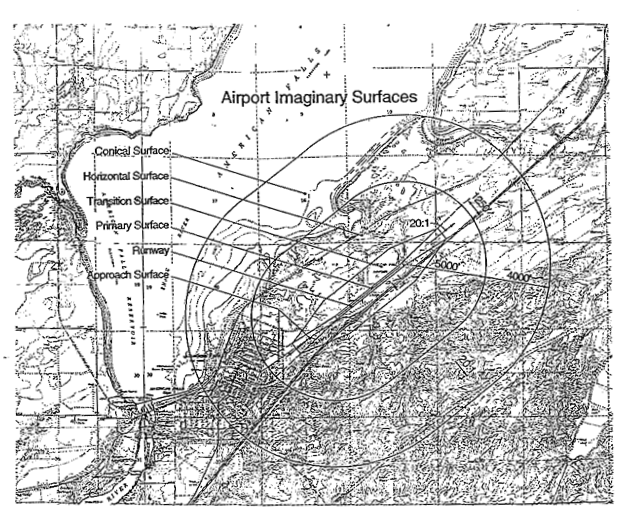
Sec. 9-10-9. - Airport imaginary surfaces.
The following is a graphic showing the airport imaginary surfaces:
(1992 Development Code; Code 2011, § 11-10-9)