
American Falls City Zoning Code
CHAPTER 3
- ZONING DISTRICTS, MAP AND REGULATIONS
Sec. 9-3-1.- Intent.
This chapter creates zoning districts and overlay districts for use in the city and adopts an official map of those districts. It also provides rules for the interpretation of zoning district boundaries.
(1992 Development Code; Code 2011, § 11-3-1)
Sec. 9-3-2. - Zoning districts.
(a)
The following zoning districts are established to implement the comprehensive plan:
(1)
Residence Zone, Class A;
(2)
Residence Zone, Class B;
(3)
Core Commercial;
(4)
Highway Commercial;
(5)
Light Industrial; and
(6)
Heavy Industrial.
(b)
Implementation of the comprehensive plan also requires the establishment of airport safety and floodplain overlay districts.
(1992 Development Code; Code 2011, § 11-3-2)
Sec. 9-3-3. - Official zoning map.
The official zoning map of the city is adopted, by reference, as part of this title. A dated copy of said map shall be maintained for public inspection at the office of the administrator.
(1992 Development Code; Code 2011, § 11-3-3)
Sec. 9-3-4. - Zoning district boundaries.
Zoning district boundaries shall be as shown on the official zoning map of the city, but any person who disputes the location of a zoning district boundary, as interpreted by the administrator, may request review of the administrator's decision using the appeals procedure of section 9-2-56.
(1992 Development Code; Code 2011, § 11-3-4)
Sec. 9-3-5. - Zoning district regulations.
The following chapters of this title establish the purpose of each zoning district, describe the uses permitted in each district upon approval of a development permit, and describe the uses permitted in each zoning district after public review for compliance with the applicable performance standards and approval of a special use permit. These chapters also establish specifications and performance standards for each zoning district.
(1992 Development Code; Code 2011, § 11-3-5)
Sec. 9-3-6. - Map.
The following is the future land use/zoning map of the city:
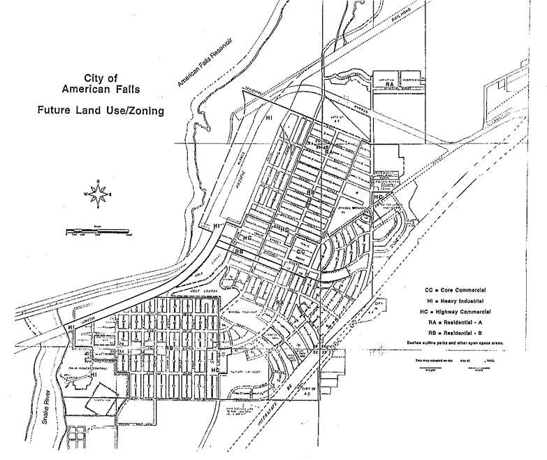
(1992 Development Code; Code 2011, § 11-3-6)