
Beaufort County Unincorporated
City Zoning Code
City Zoning Code
ARTICLE 10
- Definitions
10.1.10 - A Definitions
Access. An area designated as a way for vehicles and pedestrians to enter or leave a property to a public or private street or alley.
Access Easement. A portion of a property used for access to another property and shown on a plat by a recorded easement declaration.
Accessory Structure. A structure physically detached from, secondary and incidental to, and commonly associated with a primary structure and/or use on the same site (see Division 4.2). Accessory Use. A subordinate use of a building, structure or lot that is customarily incidental to a principal use located on the same lot (see Division 4.2).
Addition (to an existing building). Any walled and/or roofed expansion to the perimeter of a building connected by a common load-bearing wall other than a firewall.
Advertise or Advertisement. Any form of public announcement intended to aid directly or indirectly, in the sale, use or promotion of a product, commodity, service, activity or entertainment.
ACI (Aggregate Caliper Inch). A measure of the total combined number of inches of existing and proposed trees used to meet landscaping requirements. Caliper inch sizes for individual proposed trees are measured as indicated in the American Standard for Nursery Stock (ANSI 260.1-2004). Caliper inch sizes for existing trees are measured in diameter at breast height (DBH).
AICUZ (Air Installations Compatible Use Zone). The area surrounding MCAS—Beaufort as identified on the Zoning Map (Airport Overlay District/MCAS—Beaufort).
Ancillary Structure/Ancillary Building. See Accessory Structure.
Apartment House. See Section 5.1.120 (Building Type Standards).
Aquaculture. The cultivation of aquatic animals and plants, especially fish, shellfish, and seaweed, in natural or controlled marine or freshwater environments; underwater agriculture.
Arcade. A covered walkway with habitable space above often encroaching into the right-of-way (see Section 5.2.140).
Archaeological Resources. As defined in the Archaeological Resources Protection Act of 1979 (16 USC 470aa—470mm) Section (1): The term "archaeological resource" means any material remains of past human life that are of archaeological interest. Such determination shall include, but not be limited to: pottery, basketry, bottles, weapons, weapon projectiles, tools, structures or portions of structures, pit houses, rock paintings, rock carvings, intaglios, graves, human skeletal materials, or any portion or piece of the foregoing items. Nonfossilized and fossilized paleontological specimens, or any portion or piece thereof, shall not be considered archaeological resources, under this definition, unless found in an archaeological context. No item shall be treated as an archaeological resource under this definition unless such item is at least 100 years of age.
Archaeological Site. The area of the development identified as being listed in or having the potential for listing in the National Register of Historic Places. Effect and adverse effect mean as follows:
1.
Effect means an undertaking has an effect on a historic resource when the undertaking may alter the characteristics of the resource that may qualify the resource for inclusion in the National Register of Historic Places.
2.
Adverse effect means an undertaking in which the effect on a historic resource may diminish the integrity of the property's location, design, setting, materials, workmanship, feeling, or association.
Architectural Features. Exterior building elements intended to provide ornamentation to the building massing, including, but not limited to: eaves, cornices, bay windows, window and door surrounds, light fixtures, canopies, and balconies.
Awning Sign. Signs that are painted, screen printed, or appliquéd on an awning. (See Section 5.6.80).
10.1.20 - B Definitions
Base Site Area. An area of land calculated by subtracting various land areas from the gross site area of a lot. See Section 6.1.40.F (General Review Standards).
Baseline Density. The maximum density allowed on a receiving area property under baseline zoning and applicable overlay districts without participation in the Transfer of Development Rights (TDR) program (see Division 2:10).
Baseline Zoning. The zoning in effect on a receiving area property as of June 13, 2011. This term is specifically applied to the Transfer of Development Rights (TDR) Program (see Division 2:10).
Berm. An elongated earthen mound typically designed or constructed on a site to separate, screen, or buffer adjacent uses.
Buffer, Perimeter. An area of land along the perimeter of a development site that contains any combination of vegetative materials, berms, fences, and walls, and provides separation and screening to minimize potential adverse impacts between the development and dissimilar development on abutting property.
Buffer, River. An area of land along tidal waters or tidal wetlands extending inland 50 feet from the OCRM critical line. See also Critical Line.
Building Envelope. The area on a lot on which a structure can be erected as permitted by the front, side yard, and rear yard setbacks of the applicable zoning district.
Building Type. A structure defined by its combination of configuration, disposition and function.
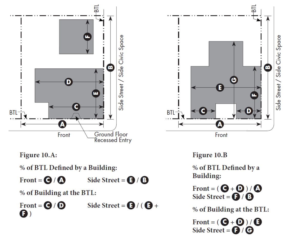
Build-to Line (BTL). A line parallel to a property line or right-of-way where a building facade must be placed. The BTL may appear graphically on the regulating plan or be stated as a dimension from the property line or right-of-way. Figures 10.A and 10.B depict how to calculate the % of BTL Defined by a Building and % of Building at the BTL as may be required in the Building Form Standards. Minor deviations from the BTL are allowed for architectural features, recessed entries, and recessed balconies and do not count against the calculations of % of BTL Defined by a building or Building at the BTL.
10.1.30 - C Definitions
Caliper. Caliper - Diameter of the trunk measured six inches above the ground for trees up to and including four-inch diameter, and measured 12 inches above the ground for larger trees. This measurement is used for nursery-grown trees.
Canopy Tree. A tree that has an expected height at maturity greater than 30 feet and produces significant shade because it has a crown that is oval, round, vase-shaped, or umbrella-shaped.
Carriage House. This Building Type is a secondary accessory structure typically located at the rear of a lot. This structure typically provides either a small residential unit, home office space, or other small commercial or service use that may be above a garage or at ground level. This Building Type is important for providing affordable housing opportunities and incubating small businesses within walkable neighborhoods. Multiple Carriage Houses can be utilized to organize Family Compounds and Farmsteads. (See Section 5.1.40).
Cash in-lieu. The fee rate established by Beaufort County that can be paid for increased density on a receiving area property above baseline zoning.
Ceiling Height, Ground Floor. Height from finished floor to finished ceiling of primary rooms on the ground floor, not including secondary rooms such as bathrooms, closets, utility rooms and storage spaces.
Ceiling Height, Upper Floor(s). Height from finished floor to finished ceiling of primary rooms on the floor(s) above the ground floor, not including secondary rooms such as bathrooms, closets, utility rooms and storage spaces.
Changeable Copy Sign. A sign or portion thereof on which the copy or symbols change either through mechanical or electronic means, or manually through placement of letters or symbols on a panel mounted in or on a track system.
Charrette. A multiple-day collaborative design and planning workshop held on-site and inclusive of all affected stakeholders.
Chicanes. A means of slowing traffic through street design where alternating curb extensions create an S shaped curve in the street. They are categorized as horizontal deflectors - as opposed to vertical deflectors like speed bumps.
Civic. A term defining not-for-profit organizations that are dedicated to arts, culture, education, religious activities, recreation, government, transit, and public parking facilities.
Civic Building. A structure operated by governmental or not-for-profit organizations and limited to civic and related uses.
Civic Space. Civic space is a type of open space that is easily accessible and dedicated for public use or for common use of residents of a private community. Civic spaces generally do not include lands set aside for natural resource preservation, buffers, and stormwater management unless these lands are available for common use by the public or the residents of the community and that have amenities that encourage the use of these lands.
Commercial. A term defining workplace, office and retail uses collectively.
Commercial Billboard Sign. (Also known as an off-premises sign.) A sign utilized for advertising a commercial establishment, activity, product, service or entertainment which is located, sold, produced, manufactured, available or furnished at a place other than on the property on which said sign is located. For purposes of this Division, noncommercial message are never off-premises.
Commercial Message. Any sign wording, logo, or other representation or image that directly or indirectly names, advertises, or calls attention to a business, product, service, sale or sales event or other commercial activity.
Common Yard. A private frontage type where the main facade of the building has a large planted setback from the frontage line providing a buffer from the higher-speed thoroughfares. The front yard created remains unfenced and is visually continuous with adjacent yards, supporting a common landscape and working in conjunction with the other private frontages (See Section 5.2.40).
Common Courtyard. An entry court, forecourt or courtyard shared by multiple residential units or commercial spaces.
Community Garden. A civic/open space designed as a grouping of garden plots that are available to nearby residents for small-scale cultivation (see Division 2.8).
Community Park. A moderate sized civic/open space available for unstructured recreation and a limited amount of structured recreation (see Division 2.8).
Conditional Use. A use that is permitted in a zone subject to the standards specified for that use being met, as determined by the Director.
Critical Line. A line that is currently delineated by the South Carolina Office of Ocean and Coastal Resource Management (OCRM) or its successor that separates upland areas from coastal waters, tidelands and marshes.
Critical Root Zone (CRZ). An area surrounding a tree, both above and below ground, with a radius of 1.5 feet for every inch in trunk DBH.
Critical Root Zone, Structural (SCRZ). Similar to a Critical Root Zone, but with a smaller radius (see Section 5.11.90). Significant risk of catastrophic tree failure exists if roots within this area are damaged or destroyed.
10.1.40 - D Definitions
DBH (Diameter at Breast Height). The diameter (in inches) of the trunk of a tree (or, for multiple trunk trees, the aggregate diameters of the multiple trunks) measured 4 ½ feet from the existing grade at the base of the tree. This measurement is used for existing trees.
Day-Night Average Noise Level (Ldn). A measure for quantifying noise exposure based on the weighted sound level average over a 24-hour time period, with a ten decibel penalty applied to nighttime (10:00 p.m. to 7:00 a.m.) sound levels.
Decibel (dB). A unit of measure describing the loudness of sound.
Density, Gross. A measurement of intensity defined as the total number of dwelling units on a property divided by the Base Site Area, expressed as units per acre.
Depth, Ground-Floor Commercial Space. The distance from the street-facing facade to the rear interior wall of the ground-floor space available to a commercial tenant.
Development. This term includes the following:
1.
All construction, modification, or use of any lot, parcel, building or structure.
2.
All disturbances of land surfaces of 10,000 square feet or greater, including removal of vegetation, excavation, filling, and grading.
3.
Any subdivision of a parcel or tract of land into two or more lots, parcels, or pieces for the purpose, whether immediate or future, of sale or transfer of title.
Digital Display. The portion of a sign made up on internally illuminated components capable of changing the display or message periodically. Digital displays may include, but not be limited to, LCD, LED, or plasma displays.
Directional Sign. A wall-mounted or freestanding sign placed within 30 feet of an entrance to, or exit from, an establishment or parking location. (See Section 5.6.90).
Director. The Community Development Director or his or her duly appointed designee (see Section 7.5.60 for specific duties and responsibilities).
Diseased Trees. Those trees that may constitute a hazard to life and property or harbor insects or disease which represent a potential threat to other trees as determined by a Certified Arborist.
Dooryard. A private frontage type where the frontage line is defined by a low wall or hedge and the main facade of the building is set back a small distance creating a small dooryard. The dooryard may be raised, sunken, or at grade and is intended for ground floor residential in flex zones, live/ work, and small commercial uses (see Section 5.2.100).
Duplex. This Building Type is a small to medium-sized structure that consists of two side-by-side or two stacked dwelling units, both facing the street. This Type has the appearance of a medium to large single-family home and is appropriately scaled to fit within primarily single-family neighborhoods or medium-density neighborhoods (see Section 5.1.90).
Dwelling. A building, or portion thereof, used as a place of residence, containing living, sleeping, cooking, and sanitary facilities, excluding commercial lodging facilities.
10.1.50 - E Definitions
Easement. A portion of a property subject to an agreement between the property owner and another party that grants the other party the right to make limited use of that portion of the property for a specified purpose.
Electronic Changeable Copy Sign. A type of changeable copy sign on which the copy or symbols change automatically through electrical or electronic means.
Encroachment. Any architectural feature, structure or structural element, such as a gallery, fence, garden wall, porch, stoop, balcony, bay window, terrace or deck, that breaks the plane of a vertical or horizontal regulatory limit extending into a setback, beyond the build-to-line, into the public frontage, or above a height limit.
Entablature. The assemblage of horizontal moldings and bands supported by and located immediately above the columns of Classical buildings or similar structural supports in non-Classical buildings.
Estate House. This Building Type is a large detached structure on a large lot that incorporates one unit. It is typically located within a primarily single-family residential neighborhood in a more rural setting (see Section 5.1.50).
10.1.60 - F Definitions
Facade. The vertical surface of a building.
Facade Zone. The area between the minimum and maximum setback lines.
Family. Any number of individuals legally related through blood, marriage, adoption, or guardianship, including individuals placed for foster care by an authorized agency, or up to four unrelated individuals living and cooking together and functioning as a single housekeeping unit.
Family Compound. A form of traditional rural development that allows additional family dwelling units on, and/or subdivisions of, a single parcel of land owned by the same family for at least 50 years.
Finish Level, Ground Floor. Height difference between the ground floor finished floor of residential or commercial space, excluding lobbies and common-use areas, and the adjacent public walk. In the case of a loading dock frontage that serves as the public right-of-way, the floor finish level is the height of the walk above the adjacent street.
Flag. Any sign printed or painted on cloth, plastic, canvas, or other like material attached to a pole or staff and anchored along only one edge or supported or anchored at only two corners.
Flex Space. A room or group of internally connected rooms designed to accommodate an evolution of use over time in response to an evolving market demand. Typically designed to accommodate future commercial uses, while accommodating less intense short-term uses, such as residential or live/work, until the full commercial demand has been established.
Flood Hazard Area. The area designated by the Federal Flood Insurance Administration on official flood hazard area maps that is subject to a one percent or greater chance of flooding in any given year.
Floor Area, Gross. See Gross Floor Area.
Floor Area Ratio (FAR). A measure of the allowable size of building area on a lot compared to the size of the lot. The FAR is calculated by dividing the Gross Floor Area by the Base Site Area.
Forecourt. A private frontage type where the main facade of the building is at or near the frontage line and a small percentage is set back, creating a small court space (see Section 5.2.90).
Forest, Maritime. An indigenous forest community within close proximity to tidally influenced salt marshes and/or open water, also known as the South Atlantic Inland Maritime Forest, which is characterized by a canopy dominated by live oak, swamp laurel oak, southern magnolia, and cabbage palm.
Forest, Mixed Upland, Young. An area or stand of trees whose total combined canopy covers an area of one acre or more composed of canopies of trees having a DBH of less than 18 inches covering at least 60 percent of the area. This forest type is characterized as being southern mixed hardwood, beech-magnolia hammock, mesic oak-hickory, pine flatwoods (southeastern coastal plain subzeric longleaf pine), spruce-pine-mixed hardwood, and pine-saw palmetto flatwood communities. Pine plantations are not included.
Forest, Mixed Upland, Mature. An area or stand of trees whose total combined canopy covers an area of one acre or more composed of canopies of trees having a DBH of at least 18 inches or greater covering at least 75 percent of the area. Also, any stand or grove of trees consisting of eight or more individual trees having a DBH of at least 18 inches whose combined canopies cover at least 50 percent of the area encompassed by the grove. This forest type is characterized as being southern mixed hardwood, beech-magnolia hammock, mesic oak-hickory, pine flatwoods (southeastern coastal plain subzeric longleaf pine), spruce-pine-mixed hardwood, and pine-saw palmetto flatwood communities. Pine plantations are not included.
Formally Disposed. Composed in a formal arrangement, in a regular, classical, and typically symmetrical manner.
Freestanding Signs: Freestanding signs encompass a variety of signs that are not attached to a building and have an integral support structure. Three varieties include: Freestanding, Monument and Pole (see Section 5.6.120).
Front. The primary frontage(s) of a lot, determined as follows:
1.
For lots with frontages along multiple thoroughfares, the frontage along the thoroughfare that is part of the lot's address will always be the Front. All other frontages may be considered to be side street frontages.
2.
For lots with frontages along a thoroughfare and a civic space, the Front may be the frontage along either the thoroughfare or the civic space, or both frontages may be treated as Fronts, with the following exception: the frontage along certain Civic Spaces may be required to be a Front, as per the standards in Division 2.7 (Civic and Open Space Types).
3.
For lots with a frontage along either a thoroughfare or a Civic Space, but not both, that frontage is the Front.
4.
Frontages along alleys, service drives, and parking drives may never be a front.
Frontage. A strip or extent of land abutting a thoroughfare, civic space or other public right-of-way.
1.
Private Frontage. The area between the curb of the public right-of-way and the front or side façade (see Division 5.2).
2.
Public Frontage. The area between the curb of the vehicular lanes and the frontage line (see Section 2.9.70).
Frontage Line. The property line(s) of a lot fronting a thoroughfare or other public way, or a civic space.
Frontage Type. The way in which a building engages the public realm. See Division 5.2 (Frontage Type Standards).
10.1.70 - G Definitions
Gallery. A private frontage type where the main facade of the building is at the frontage line and the gallery element overlaps the sidewalk. This Type is intended for buildings with ground-floor commercial uses and may be one or two stories (see Section 5.2.130).
Garage. A structure, or part thereof, used or intended to be used for the parking and storage of motor vehicles.
Grand Tree. An existing, exceptionally large tree as follows:
1.
Live Oak (Quercus Virginiana), Black Walnut (Juglans Nigra), or Longleaf Pine (Pinus Palustris) equal to or greater than a diameter of 24 inches DBH;
2.
Loblolly Pine (Pinus Taeda), Slash Pine (Pinus Ellitoi), and Shortleaf Pine (Pinus Echinata) equal to or greater than a diameter of 36 inches DBH;
3.
All other non-invasive species of trees, not defined above, equal to or greater than a diameter of 30 inches DBH.
Green. A small civic/open space usually found in a residential area that is available for unstructured and limited amounts of structured recreation (see Division 2.8).
Greenway. A linear open space that may follow natural corridors providing unstructured and limited amounts of structured recreation (see Division 2.8).
Ground Cover. Low-growing plants that grow in a spreading fashion to form a more or less solid mat of vegetation, generally planted to provide decorative landscaping or permeable cover for bare earth that prevents soil erosion.
Gross Floor Area (GFA). The sum of the total horizontal areas of a building. The measurement of gross floor area is computed by applying the following criteria:
1.
The horizontal square footage is measured from the outside face of all exterior walls.
2.
Cellars, basements, attics, covered or uncovered porches, balconies and decks, enclosed storage or mechanical areas, mezzanines and similar structures shall be included as GFA wherever at least seven feet are provided between the finished floor and the ceiling.
3.
No deduction shall apply for horizontal areas void of actual floor space; for example, elevator shafts and stairwells. The protected upper floors of open atriums and foyers shall not be included.
Gross Site Area. All land and water area contained within the surveyed boundaries of a lot or parcel.
10.1.80 - H Definitions
Hedge. A group of shrubs planted in line or in groups that forms a compact, dense, living barrier that demarcates an area from on-site or off-site views.
Height.
1.
Overall. Overall building height shall be measured vertically from the natural grade or finished grade adjacent to the building exterior to the average height of the highest roof surface, excluding chimneys, cupolas, and spires.
2.
Eave/Parapet. Building height to eave/parapet shall be measured from the eave or top of parapet to natural grade or finished grade at the lowest point adjacent to the building exterior, whichever yields the greatest height.
Historic Resources. According to the National Historic Preservation Act of 1966, as amended through 1992 (16 USC 470 et seq.) Section 101(a)(1)(A): The Secretary of the Interior is authorized to expand and maintain a National Register of Historic Places composed of districts, sites, buildings, structures, and objects significant in American history, architecture, archaeology, engineering, and culture. Criteria set forth by the Secretary of the Interior states that any district, site, building, structure, or object that is at least 50 years of age and is significant in American history, architecture, archaeology, engineering, and culture may be considered for inclusion on the National Register of Historic Places.
10.1.90 - I Definitions
Illumination. A source of any artificial or reflected light, either directly from a source of light incorporated in, or indirectly from an artificial source.
Impervious Surface. A surface that has been compacted or covered with a layer of material so that it is highly resistant to infiltration by water. It includes, but is not limited to, surfaces such as compacted clay, as well as most conventionally surfaced streets, roofs, sidewalks, parking lots, patios, swimming pool decks, and other similar structures.
Incidental Sales. Sales that are ancillary to the owner's primary business activity.
Industrial/Agricultural Building. This Building Type is a medium to large structure that accommodates retail, light industrial, agricultural and mixed uses that are too large to be appropriately housed in a residential building type. This Building Type is typically located on the edge of the commercial core within a rural crossroads or hamlet place type. The design and massing of this Building Type find their precedent in the vernacular packing sheds, barns, and warehouses of the Lowcountry (see Section 5.1.140).
Infill. Development or redevelopment of land that has been bypassed, remained vacant, or is underused in an otherwise developed area.
Intensive Level Archaeological Survey. A survey that will be based on a systematic approach to the entire tract, usually at 100-foot intervals, that are differentiated between having high or low potential for containing archaeological and historic resources. Topography and soil types are also taken into consideration to help determine the areas of high and low potential. In addition, subsurface activities such as shovel tests are done, unless surface exposure is evident, and the materials are sifted. All of the findings, as well as a determination of eligible sites, are compiled into a final report.
Internal Illumination. A light source that is concealed or contained within the sign and becomes visible in darkness through a translucent surface. Digital displays and signs incorporating neon lighting shall not be considered internal illumination for the purpose of this Code.
Invasive Species. An introduced species (also called "non-indigenous" or "non-native") that adversely affects the natural habitat it invades by dominating and choking out indigenous species.
10.1.100 - J Definitions
No specialized terms beginning with the letter J are defined at this time.
10.1.110 - K Definitions
No specialized terms beginning with the letter K are defined at this time.
10.1.120 - L Definitions
Landscape Strip, Perimeter. Vegetative material associated with the perimeter landscaping required for a parking lot area.
Landscape Wall Sign. A sign attached to a freestanding wall that forms a perimeter or buffer for a landscape feature (see Section 5.6.100).
Ldn. See Day-Night Average Noise Level.
Liner Building. An occupiable structure specifically designed to mask a parking lot or a parking structure from a frontage.
Live/Work Unit. An integrated housing unit and working space in a structure that has been designed or structurally modified to accommodate joint residential occupancy and work activity, which may accommodate a substantial commercial component with employees and walk-in trade.
Lot. An area designated as a separate and distinct parcel of land on a subdivision plat or deed as recorded with the Beaufort County Register of Deeds office.
Lot Coverage. The portion of a lot, expressed as a percentage, that is covered by any and all buildings including accessory buildings, excepting paved areas, uncovered parking areas, single level unenclosed covered parking areas (unless the roof space is used for any use or activity), unenclosed covered walkways, driveways, walks, porches, terraces, swimming pools, and landscape areas.
Lot of Record. A lot that existed prior to the date of adoption of this Development Code.
10.1.130 - M Definitions
Main Street Mixed-Use Building. A Building Type which consists of a small- to medium-sized structure, typically attached, intended to provide a vertical mix of uses with ground-floor commercial, service, or retail uses and upper-floor commercial, service, or residential uses. Smaller versions of this Type include live/work units (see Section 5.1.130).
Mansion Apartment. A Building Type which consists of a medium-sized structure with three to six side-by-side and/or stacked dwelling units, typically with one shared entry or individual entries along the front. This Type has the appearance of a medium-sized family home and is appropriately scaled to fit in sparingly within primarily single-family neighborhoods or into medium-density neighborhoods (see Section 5.1.110).
Manufactured Home. A single family dwelling unit fabricated in an off-site manufacturing facility for installation at the building site, bearing a seal certifying that it was built in compliance with the Federal Manufactured Home Construction and Safety Standards Act of 1974, as amended.
Mariculture. Cultivation of marine organisms in their natural habitats, usually for commercial purposes.
Maritime Forest. See Forest, Maritime.
Marquee Sign. Marquee signs are vertical signs that are located either along the face where they project perpendicular to the facade; or at the corner of the building where they project at 45-degree angles (see Section 5.6.110).
Memorandum of Agreement. An agreement between the County and the applicant to avoid, reduce, or mitigate adverse effects on archaeological and historic properties, or to accept each effect in the public interest.
Mitigation. Measures taken to lessen the adverse impacts of a proposed land use or land disturbance activity.
Mixed Upland Forest. See Forest, Mixed Upland.
Mixed-Use. Multiple functions within the same building or the same general area through superimposition or within the same area through adjacency.
Mixed-Use Project. A development that combines both commercial and residential uses on the same site, typically with the commercial uses occupying the ground floor street frontage and the residential uses above.
Mobile Home. See Manufactured Home.
10.1.140 - N Definitions
National Register of Historic Places. The list of districts, sites, buildings, structures and objects significant in American history, architecture, archaeology, engineering, and culture, maintained by the Secretary of the Interior under authority of the National Historic Preservation Act.
Naturally Disposed. A preservation of the existing natural condition or a composition of elements arranged as they would appear in nature, with irregular shapes and asymmetry.
Neckdowns. Curb extensions at street intersections that reduce the roadway width from curb to curb. Neckdowns shorten crossing distances for pedestrians and tighten the curb radii at the corners therefore reducing the speeds of turning vehicles.
Neon Sign. A sign illuminated by a neon tube, or other visible light-emanating gas tube.
Noncommercial Message. Any message on a sign that is not a commercial message.
Nonconformities. Land, structures, lots, signs, and other site features that were established before this Development Code was adopted or amended, and that do not conform to its terms and requirements. Nonconformities may be either legal or illegal.
1.
Legal Nonconformities. Those nonconformities that were properly permitted and legally established but that no longer comply with the applicable provisions of this Development Code.
2.
Illegal Nonconformities. Those nonconformities that were neither properly permitted nor legally established and that do not comply with the applicable provisions of this Development Code.
10.1.150 - O Definitions
OCRM Critical Line. See "Critical Line."
Off-Premises Sign (Also known as a commercial billboard sign). A sign utilized for advertising a commercial establishment, activity, product, service or entertainment which is located, sold, produced, manufactured, available or furnished at a place other than on the property of which said sign is located. For purposes of this Division, noncommercial messages are never off-premises.
On-Premises Sign. A sign utilized for advertising a commercial establishment, activity, product, service or entertainment which is located, sold, produced, manufactured, available or furnished on the property on which said sign is located.
Open Space. Land not covered by lots, buildings, accessory structures, driveways, parking areas, or impervious surfaces.
Overstory Tree. See "Canopy Tree."
10.1.160 - P Definitions
Parcel. See Lot.
Passive Recreation. Recreation requiring little or no physical exertion focusing on the enjoyment of one's natural surroundings. In determining appropriate recreational uses of passive parks, the promotion and development of resource-based activities such as fishing, camping, hunting, boating, gardening, bicycling, nature studies, horse-back riding, visiting historic sites, hiking, etc., shall be the predominate measure for passive park utilization.
Peak Hour. A one-hour period of time, usually occurring during the morning or evening commute periods, when traffic volume is at its highest.
Pedestrian Shed. An area centered on a major destination. Its size is limited by an average distance that may be traversed at an easy walking pace in a given amount of time from its center to its edge. Pedestrian sheds are useful for planning walkable areas. See Section 2.3.50 (Pedestrian Sheds).
Permanent Sign. Any one of the types of sign specifically listed within this Development Code as a permitted sign, excluding "temporary signs," and which is installed and maintained in a fixed location for an indefinite period of time.
Permitted Use. A use that is allowed in a zone without the need for special administrative review and approval upon satisfaction of the standards and requirements of this Development Code.
Planting Strip. Areas intended for the placement of vegetation within the interior of parking lot areas or along street right-of-way edges, typically between the back of the curb and the inside edge of the sidewalk.
Plaza. A civic/open space designed for civic purposes and commercial activities in the more urban Transect Zones, generally paved and spatially defined by building frontages (see Division 2.8).
Playground. An open space designed and equipped for the recreation of children. A Playground may include an open shelter. Playgrounds may be included within other civic spaces (see Division 2.8).
Pocket Park. A small open space available for informal activities in close proximity to neighborhood residences (see Division 2.8).
Pocket Plaza. A small formal open space available for civic purposes and commercial activities. Pocket Plazas are typically hardscaped (see Division 2.8).
Porch. See Division 5.2 (Private Frontage Standards).
1.
Projecting Porch. A porch which is open on three sides and all habitable space is located behind the setback line (see Section 5.2.50).
2.
Engaged Porch. A porch which has two adjacent sides of the porch that are engaged to the building while the other two sides are open (see Section 5.2.60).
3.
Side Yard Porch. A porch located on the side of the principle building with its front side in line with the front façade of the building (see Section 5.2.70).
Primary Dune. The major front dune immediately behind the beach.
Principal Use. The primary purpose for which a lot is occupied and/or used.
Projecting Sign. Projecting signs mount perpendicular to a building's facade. These signs are small, pedestrian scaled, and easily read from both sides (see Section 5.6.130).
10.1.170 - Q Definitions
Qualified Personnel. Professional consultants meeting the criteria set forth by the Secretary of the Interior, as well as the state historic preservation office and published in their Guidelines and Standards for Archaeological Investigation.
10.1.180 - R Definitions
Regional Park. For the purposes of this Code, an open space of at least 75 acres available for structured and unstructured recreation (see Division 2.8).
Residential. Premises used primarily for human habitation.
Right-of-way. An area of land not part of a lot that is dedicated for public or private use to accommodate a transportation system and necessary public utility infrastructure, including but not limited to water lines, sewer lines, power lines and gas lines.
River Buffer. See "Buffer, River."
Rookery. A vegetated area used by a colony of birds for nesting and rearing their young.
10.1.190 - S Definitions
Security Quarter. A dwelling unit associated with a nonresidential use in a nonresidential zone which is occupied by one or more employees who reside on-site and oversee or manage the operation or provide care, protection, or security for the property.
Setback. The mandatory clear distance between a property line and a structure.
Shared Parking. Any parking spaces assigned to more than one user, where different persons utilizing the spaces are unlikely to need the spaces at the same time of day.
Shopfront. A private frontage type where the main facade of the building is at or near the frontage line with an at-grade entrance along the public way (see Section 5.2.110).
Shrub. A woody plant, smaller than a tree, consisting of several small stems emerging from the ground, or small branches near the ground. Shrubs may be deciduous or evergreen.
Sidewalk Sign. A temporary, moveable sign type that may be used to announce daily specials, sales, or point to shops off the sidewalk (see Section 5.6.140).
Sign. Any device, structure, fixture, painting, emblem, or visual that uses words, graphics, colors, illumination, symbols, numbers, or letters for the purpose of communicating a message. Sign includes the sign faces as well as any sign supporting structure.
Significant Resources. Historic resources listed in or eligible for listing in the National Register of Historic Places.
Small Lot House. This Building Type is a small, detached structure on a small lot that incorporates one unit. It is typically located within a primarily single-family neighborhood in a walkable urban setting, potentially near a neighborhood main street (see Section 5.1.70).
Small Wind Energy System. Equipment that converts and then stores or transfers energy from the wind into usable forms of energy that is used primarily to reduce on-site consumption of utility power. Equipment includes any base, blade, foundation, generator, nacelle, rotor, tower, transformer, vane, wire, inverter, batteries or other component used in the system.
Solar Energy Equipment. Items including, but not limited to solar panels lines pumps, batteries, and mounting brackets framing around foundations used for, or intended to be used for, the collection of solar energy in connection with a building on residential municipal or commercial properties. Solar energy equipment, and its use, is accessory to the principal use of the property
Special Use. A use that may be permitted within a zone upon approval of a special use permit by the Zoning Board of Appeals (ZBOA). See Section 7.2.130 (Special Use Permits).
Specified Anatomical Areas. Those portions of the human body less than completely and opaquely covered including the human genitals and pubic region, buttocks, and female breasts below a point immediately above the top of the areola, and the human male genitals in a discernibly turgid state, even if completely and opaquely covered.
Specified Sexual Activities. Includes human genitals in a state of sexual stimulation or arousal; acts of human masturbation, sexual intercourse or sodomy; fondling or other erotic touching of human genitals, public region, buttock, or female breast.
Specimen Tree.
1.
Understory trees as follows: dogwood, redbud, and southern magnolia greater than four inches dbh.
2.
Canopy trees as follows: American holly, bald cypress, beech, black oak, black tupelo, cedar, hickory, live oak, palmetto, pecan, southern red oak, sycamore, or walnut with a dbh of greater than 16 inches dbh.
3.
All other non-invasive trees with a dbh of 24 inches or greater.
Sports Complex. A regional scaled open space that consolidates heavily programmed athletic fields and associated facilities (see Division 2.8).
Square. An Open Space available for unstructured recreation and civic purposes. A Square is spatially defined by building Frontages. Its landscape shall consist of paths, lawns and trees, formally disposed (see Division 2.8).
Storefront. The portion of a frontage composed of the display window and/or entrance and its components, including windows, doors, transoms and sill pane, that is inserted into various frontage types, such as a shopfront or gallery, to accommodate retail uses.
Stoop. A private frontage type where the Facade is aligned close to the frontage line with the first story elevated from the sidewalk sufficiently to secure privacy for the windows. The entrance is usually an exterior stair and landing (see Section 5.2.80).
Story. An above-grade habitable floor level within a building.
1.
Half. A conditioned space that rests primarily underneath the slope of the roof, usually having dormer windows.
Street Tree. A tree that is located within the public frontage.
Structural Critical Root Zone (SCRZ). See Critical Root Zone, Structural.
Structure. Anything constructed or erected, the use of which requires attachment to the ground, attachment to something located on the ground, or placement on the ground.
Structure, Principal. A structure in which is conducted the primary use of the lot on which the structure is situated.
Stub-out. A short road segment that is constructed to and terminates at a parcel line, and that is intended to serve current and future development by providing road connectivity between adjacent developments.
Suspended Signs. Suspended signs mount to the underside of beams or ceilings of a porch, gallery, arcade, breezeway or similar covered area. These signs are small, pedestrian scaled, and easily read from both sides (see Section 5.6.150).
Subdivision. The division of a lot, tract, or parcel of land by any means into two or more lots, tracts, parcels or other divisions of land for the purpose, whether immediate or future, of lease, transfer of ownership, or building development.
10.1.200 - T Definitions
Tandem Parking. A parking space deep enough to allow two cars to park, one behind the other. TDR. Transfer of Development Rights.
1.
Bank. An intermediary authorized by Beaufort County to act on its behalf in the TDR program.
2.
Certificate. The official document issued by the county identifying the number of TDRs owned by the holder of the TDR certificate.
3.
Intermediary. Any individual or group, other than a sending area landowner or receiving area developer, which buys and sells TDRs.
4.
Option. The option of a receiving area property owner to increase density above baseline zoning through participation in the TDR program.
5.
Program. The rules and requirements of this article for the transfer of development rights from sending areas to receiving areas.
6.
Receiving Area. Properties on which upzonings trigger the establishment of the TDR overlay district.
7.
Sending Area. Areas within unincorporated Beaufort County that are eligible to sell TDRs.
Temporary Parking Lots. Parking lots that are not permanent, are only intended to fulfill a short-term need, and ultimately will be replaced by a permanent building or structure. Temporary Parking lots are not subject to the parking location regulations and liner requirements for above grade parking in the building form standards, but must comply with all landscaping standards.
Terrace. A private frontage type where the main facade is at or near the frontage line with an elevated terrace providing public circulation along the facade. This Type can be used to provide at-grade access while accommodating a grade change (see Section 5.2.120).
Townhouse. A building type consisting of a small to medium-sized attached structure with three or more dwelling units placed side-by-side. This Type is typically located within medium-density neighborhoods or in a location that transitions from a primarily single-family neighborhood into a neighborhood main street (see Section 5.1.100).
Traffic Control Device. Any device used as a traffic control device and described and identified in the Manual on Uniform Traffic Control Devices approved by the Federal Highway Administration as the National Standard and as may be revised from time to time. A traffic control device includes those signs that are classified and defined by their function as regulatory signs (that give notice of traffic or parking laws or regulations), warning signs (that give notice of a situation that might not readily be apparent or that poses a threat of serious injury (e.g. gas line, high voltage, condemned building, etc.) or that provides a warning of a violation of law (e.g. no trespassing, no hunting allowed, etc.), and guide signs (that show route designations, directions, distances, services, points of interest, and other geographical recreational, or cultural information).
Transect. A cross-section of the environment showing a range of different habitats. The rural-to-urban transect of the human environment is divided into multiple transect zones that describe the physical form and character of a place according to the intensity of its land use and urbanism.
Transect Zone. Transect Zones are zoning districts that primarily focus on mixed-use, walkable areas of the County and range in function and density from primarily residential areas with a mix of building types (e.g. T3 Hamlet Neighborhood), to medium density neighborhoods and other commercial and retail areas (e.g. T4-Hamlet Center). See Division 3.2 (Transect Zones).
Transit Station. A lot or structure used for the purpose of parking, loading and unloading freight and passengers from train or bus transportation. May include parking facilities and other commercial amenities to service transit passengers.
Transit Stop. A location where buses stop to load and unload passengers. A transit stop may or may not include a shelter or a pullout.
Tree, Deciduous. A tree that drops its foliage annually before becoming dormant.
Tree, Evergreen. A tree with foliage that is not dropped, or that remains green throughout the year.
Tree, Shade. See Canopy Tree.
Tree, Street. See Street Tree.
10.1.210 - U Definitions
Understory Tree. A tree that has an expected height at maturity of no greater than 30 feet.
Utilities. Installations or facilities or means for furnishing to the public, electricity, gas, steam, communications, water, drainage, sewage disposal, or flood control, irrespective of whether such facilities or means are underground or above ground; utilities may be owned and operated by any person, firm, corporation, municipal department or board, duly appointed by state or municipal regulations. Utility or utilities as used herein may also refer to such persons, firms, corporations, departments, or boards.
10.1.220 - V Definitions
Vegetation, Native. Any indigenous tree, shrub, ground cover or other plant adapted to the soil, climatic, and hydrographic conditions occurring on the site.
Village House. A building type consisting of a medium-sized detached structure on a medium-sized lot that incorporates one unit. It is typically located within a primarily single-family residential neighborhood in a walkable urban setting, potentially near a neighborhood main street (see Division 5.1.60).
10.1.230 - W Definitions
Wall Sign. A sign that is flat against the facade of a building consisting of individual cut letters applied directly to the building or painted directly on the surface of the building (see Section 5.6.160).
Wall Mural Sign. A sign that is flat against the building facade and is located on a secondary facade, typically along a side street, alley, or passageway. These signs are typically painted directly on the building and contain a combination of text and graphic elements (see Section 5.6.170).
Window Sign. Window signs are professionally painted consisting of individual letters and designs, gold leaf individual letters and designs, applied directly on the inside of a window (see Section 5.6.180).
10.1.240 - X Definitions
No specialized terms beginning with the letter X are defined at this time.
10.1.250 - Y Definitions
Yard Sign. Yard signs are signs mounted on a porch or in a yard between the public ROW and the building façade (see Section 5.6.190).
10.1.260 - Z Definitions
No specialized terms beginning with the letter Z are defined at this time.