
Beaufort County Unincorporated
City Zoning Code
City Zoning Code
Appendix A
- Community Preservation Districts
A.1.10 - Purpose
The 1997 Beaufort County Comprehensive Plan recognized that there were many unique, unincorporated communities in the County that faced varying degrees of growth pressure. These communities range from well-established rural crossroads to suburban areas on the fringes of municipalities. During the comprehensive planning process, residents were concerned that the individual qualities of their communities would be compromised in the "broad-brushed" countywide planning process. Therefore, the Comprehensive Plan identified "Community Preservation" areas that would be individually targeted for more detailed community plans that would lead to customized land use and development standards.
The Community Preservation Districts in Appendix A are a result of citizen-driven, community-based planning processes. They were originally adopted as part of the Zoning and Development Standards Ordinance. Appendix A incorporates the Community Preservation Districts as part of the Beaufort County Community Development Code (CDC) with the purpose of preserving the intent, language, use definitions and development standards that were formulated through the community planning processes to guide the future growth and development of the local communities.
A.1.20 - Relationship to the Community Development Code
Each of the Community Preservation Districts were originally drafted and adopted under the Zoning Development Standards Ordinance (ZDSO). Therefore, many of the standards (e.g. parking, signage, roads, landscaping, and natural resources) applicable to the CP districts were located in the body of that ordinance and are now replaced by the standards in the Beaufort County Community Development Code. Table A.1.20 provides a listing of each of the relevant articles and sections of the CDC and their applicability to the CP districts. Articles, divisions or sections listed at "applicable" may have some standards that are supplemented or superseded by the standards within the individual CP districts. Articles, divisions, or sections listed as "not applicable" do not apply to CP districts unless a specific standard or definition is referenced in this Appendix.
1 Applies only to sending and receiving areas located within CP districts.
(Ord. No. 2022/48, Exh. A, 12-12-22)
A.1.30 - Studies and Reports
Some uses within the Community Preservation Districts require special studies and reports to be submitted as part of an application for a conditional or special use.
A.
Community impact statement (CIS).
1.
Requirements. Where required by this Appendix, a community impact statement (CIS) shall be submitted as part of the application. The CIS consists of at least four separate assessments. One or all of the assessments shall be required for certain development applications, as required by this Appendix. The four assessments include the following:
a)
Area impact assessment (AIA).
b)
Environmental impact assessment (EIA).
c)
Traffic impact assessment (TIA) (Article 6, Division 6.3)
d)
Archaeological and historic impact assessment (AHIA)
2.
Approval criteria. The purpose of the CIS is to (i) determine if alternatives would avoid the adverse impacts, (ii) determine that the plan selected minimizes the impact, and (iii) identify mitigation measures that would offset the impacts. The following standards shall determine the approval, denial, or recommended conditions:
a)
The developer must establish a need for the use that requires this review.
b)
The site or plan that best avoids impacts and is feasible shall be approved. Failure to achieve this objective shall be the basis for denial.
c)
The plans shall clearly minimize any adverse impacts. The alternative plan with the least impact shall be a condition of approval.
d)
Mitigation shall be required that minimizes or offsets all adverse impacts.
B.
Area impact assessment (AIA). Where required by this Appendix, an area impact assessment (AIA) shall be conducted and submitted as part of the application. The AIA report includes several different studies or assessments that may be required separately for certain developments. The following shall be part of the AIA:
1.
Fire/police/EMS. Expected annual number of responses for the proposed development, based on statistics describing similar types of development, which already exist. Letters from appropriate agencies to determine the adequacy of current law enforcement, emergency medical service, and fire facilities to serve the project. All improvements needed to maintain an adequate level of service shall be identified.
2.
Population. Expected number of employees (construction, as well as permanent); amount of increase in number of residents and type of housing product associated with proposed development.
3.
Land use compatibility. Relationship of the proposed development with surrounding land uses, including a description of surrounding land uses, as well as the anticipated impacts upon them.
4.
Economic impact/benefits. Provide anticipated revenues to the county and the school board, as well as estimated dollar amount of wages and salaries to employees.
5.
School impact. Provide an estimate of preschool and school age children to be generated by the project and an analysis of the ability of the public school system to absorb the increase. The analysis will provide data on school facility capacity, existing enrollments, cumulative projections of new students, impacts on facilities, support staff, and added cost to the school district.
6.
Facilities impact. Provide an analysis of public water, sewer, and recreational facilities available or needed to serve the proposed development Should existing facilities be determined inadequate to serve the proposed development, the remedies, either expected or proposed by the applicant, shall be indicated together with the estimated costs for such additional facilities.
C.
Environmental impact assessment (EIA). Where required by this Appendix, an environmental impact assessment (EIA) shall be conducted and submitted as part of the application. The EIA report includes several different studies or assessments that may be required separately for certain developments. The following shall be part of the EIA:
1.
Impacts to air quality due to construction and continued operations must be detailed, along with impacts to noise levels. If the proposed development will produce, or require the storage of hazardous or toxic material on site, the EIA shall include containment plans and disaster mitigation plans in compliance with SCDHEC.
2.
Alternative designs or locations on the site shall be considered to determine that the proposed use minimizes the potential for adverse ecological impacts.
3.
Identify any environmental impacts on adjoining land uses or communities, or on users of public or private roads.
4.
Through an environmental analysis, identify existing natural conditions, any increased risks of flooding, groundwater depletion, water pollution, soil instability, or safety risks to site users.
5.
Inventory of federal and state threatened and endangered plant and animal species, as well as candidates for such designation, on site and within 500 feet of the site. Determine the proposed development's impacts, and identify any mitigation.
D.
Traffic Impact Analysis (TIA): Requirements for a TIA are in (Article 6, Division 6.3)
E.
Archeological and historic impact assessment (AHIA). Where required by this chapter, an archaeological and historic impact assessment (AHIA) shall be conducted and submitted as part of the application. The following shall be part of the AHIA:
1.
A determination in the form of a written statement from the county historic preservation planner as to the archaeological or historical significance of the property.
2.
If required, an intensive level archaeological survey.
3.
If required, historic resource documentation according to state historic preservation office standards.
4.
If required, an approved mitigation plan.
5.
Inventory of federal, state, or local identified irreplaceable historical, archaeological or paleontological resources on site and within 500 feet of the proposed site; determine the proposed development's impact on the resources and identify any mitigation.
A.1.40 - Accessory Uses and Structures
Table 4.2.20.A (Table of Permitted Accessory Uses), lists what types of accessory uses, structures, and activities are allowed in each of the Community Preservation districts. Unless an accessory use is specifically addressed in a Community Preservation district, the standards in Article 4, Division 4.2 shall apply.
P = Permitted Subject to the Additional Requirements — = Not Allowed
A.2.10 - Purpose
The purpose of the Lady's Island Community Preservation District (LICP) is to maintain or improve the livability and character of existing residential neighborhoods; to encourage infill of available lands; to provide a choice of housing types and to accommodate housing types which will relate well with existing neighborhood character, scale and density. The intent of the LICP is to guide residential development in such a manner as to encourage and plan for the availability of public services and infrastructure. Certain structures and uses serving governmental, religious or recreational needs of such areas are permitted by special use subject to restrictions and requirements intended to preserve and protect residential neighborhood. It is the express purpose of this district to exclude all commercial buildings and structures, whether operated for profit or otherwise, except home uses specifically provided for, if they conform to the provisions of this section. Multifamily and higher density development shall be located so that the provision of appropriate urban services will be physically and economically facilitated.
A.2.20 - Applicability
The LICP District requirements apply to all uses within the LICP boundaries. The Beaufort County Community Development Code shall apply to all development within the LICP District, unless expressly exempted or otherwise provided for in this section.
A.2.30 - District Boundaries
The LICP District standards apply only to the LICP. The delineation of areas, which fall under the LICP zoning designation, is outlined on the official zoning map of Beaufort County.
A.2.40 - Permitted Activities
The permitted uses are primarily residential. Limited nonresidential uses are allowed generally subject to the special use process. Uses not listed are prohibited. The following are descriptions of permitted uses, permitted accessory uses and structures for the LICP District:
(Ord. No. 2017/24, 10-9-17; Memo of 3-14-22; Ord. No. 2022/19, 3-28-22)
A.2.50 - Conditional and Special Use Standards
This section describes the standards governing conditional and special uses as designated in Table A.3.40.A of this division. These standards are in addition to other standards required elsewhere in the Beaufort County Community Development Code (CDC), but supersede the conditional, special use, and accessory use standards in Article 4 of the CDC.
A.
Local Utility
1.
Reports/studies required. All applications for this use shall include an Area Impact Assessment (A.1.30.B), Environmental Impact Assessment (A.1.30C), and an Archaeological and Historic Impact Assessment (A.1.30.E).
2.
In considering an application for a special use permit, the zoning board of appeals shall consider the justification for the location of the proposed utility service and any alternative locations which may be available. Utility agencies shall submit service radii or other locational criteria that demonstrate the need to place facilities in this district.
3.
Additional buffers. The required perimeter buffer shall be increased by ten feet along common boundaries with residential uses or zones.
4.
Screening and buffering consistent with Article 5, Division 5.8 of the CDC shall be required, unless specifically modified as part of the approved conditional or special use permit.
5.
The minimum lot size may be reduced as part of approval of the special use permit provided all setback and perimeter buffer requirements are met and all other dimensional requirements are achieved.
6.
Outdoor storage of materials and equipment, except during construction of the utility facility, shall be prohibited, unless specifically requested and approved as part of the special use permit. Outdoor storage areas shall comply with the screening provisions contained in Article 5, Division 5.8 of the CDC.
B.
Outdoor Recreation
1.
Any outdoor activity area, swimming pool, or ball field or court, which adjoins a residential use, shall be landscaped in accordance with Article 5, Division 5.8 of the CDC.
2.
Where nighttime lighting of such areas is proposed large evergreen trees shall be required in a location appropriate to screen adjoining residences. Any such nighttime lighting shall be constructed in accordance with the standards for a residential district contained in Article 5, Division 5.7 of the CDC. Exterior lighting shall be compatible with the surrounding neighborhood.
3.
Additional buffers. The required perimeter buffer shall be increased by 30 feet along common boundaries with residential uses or zones.
4.
Access shall be provided through frontage on an arterial or collector street, unless the DRT finds that access to an adjoining local street is safer, and provides improved design, benefiting the county.
5.
Applicants must clearly demonstrate that the use will be compatible with the neighborhood, particularly with regard to traffic circulation, parking, and appearance. The scale, massing, and building design should be compatible with the surrounding neighborhood.
6.
The hours of operation may be restricted through the special use permit.
C.
Religious Establishments (large)
1.
Reports/studies required. All applications for this use shall include a traffic impact analysis (Article 6, Division 6.3).
2.
Access shall be provided through frontage on an arterial or collector street, unless the Director finds that access to an adjoining local street is safer, and provides improved design, benefitting the county.
3.
It is the intent of this section to ensure that lots used for assembly and worship uses are large enough to accommodate future expansions, and to maintain the desired character of the surrounding community. Thus, a minimum lot size of at least ten acres shall be required.
D.
Religious Establishments (small)
1.
Reports/studies required. All applications for this use shall include a traffic impact analysis (Article 6, Division 6.3).
2.
There shall be no minimum lot size.
3.
Access shall be provided through frontage on an arterial or collector street, unless the Director finds that access to an adjoining local street is safer, and provides improved design, benefitting the county.
E.
Commercial Communications Towers
1.
Commercial communication towers are restricted to the expansion or replacement of an existing tower.
2.
Commercial communication towers are subject to the standards listed in Article 4, Section 4.1.320.
F.
Home Uses: Under certain unique circumstances, small-scaled nonresidential activity may be an appropriate use within residential areas. The standards and procedure for establishing such uses are intended to limit the scope and nature of such uses and insure compatibility with the adjoining properties.
1.
Home Occupation
a)
Home occupations shall be clearly incidental and secondary to the use of the dwelling for residential purposes and shall not change its character as a residence. The use of colors, materials, construction, lighting, or other means inconsistent with a residential use shall be prohibited.
b)
There shall be no outside storage of goods, products, equipment, or other materials associated with the home occupation, nor shall these materials be stored inside an accessory structure. No toxic, explosive, flammable, radioactive, or other hazardous materials used in conjunction with the home occupation shall be used or stored on the site.
c)
The maximum floor area permitted for a home occupation shall be 25 percent of the finished floor area of the dwelling unit. Storage of goods or products shall not exceed 5 percent of the finished floor area.
d)
The street address of the home occupation may be used in advertisements.
e)
No sign may be placed on the property advertising the home occupation.
f)
The type and volume of traffic generated by a home occupation shall be consistent with the traffic generation characteristics of other dwellings in the area. Any need for parking generated by the conduct of such home occupation shall be met off the street and other than in a required front yard.
g)
Additional parking is limited to two pervious parking spaces.
h)
The home occupation shall not involve the storage of commercial vehicles or the use of such vehicles for delivery of goods or material to or from the premises.
2.
Home Business
a)
Home businesses shall be clearly incidental and secondary to the use of the dwelling for residential purposes and shall not change its character as a residence. The use of colors, materials, construction, lighting, or other means inconsistent with a residential use shall be prohibited.
b)
There shall be no outside storage of goods, products, equipment, or other materials associated with the home business.
c)
The type and volume of traffic generated by a home business shall be consistent with the traffic generation characteristics of other dwellings in the area.
G.
Schools
1.
Access. High schools, colleges and professional schools shall have frontage on a collector or arterial and shall be required to take access to such streets unless the county engineer believes local streets are safer in the particular conditions of the site and roads.
2.
Reports/studies required. All applications for this use shall include a community impact statement (A.1.30.A).
H.
Multifamily Uses
1.
Mansion apartments and apartment houses are limited to sites within one mile from the centerline of the intersection of Sea Island Parkway (US 21) and Sams Point Road.
2.
All applications for this use shall include a community impact statement, which includes a statement from the applicant illustrating how the features and design of the planned project adds to the area sense of community.
3.
Required perimeter buffers shall be increased by 15 feet in width.
4.
Site design should create a sense of "community" which includes:
a.
An internal vehicular circulation system reflective of grid system, as opposed to a looped system.
b.
Buildings sited with front entrances and porches oriented towards streets, plazas and parks, rather than clustered around parking lots.
c.
Parking lots located behind buildings or screened from view from internal streets, unless it is deemed appropriate to use a parking lot as a buffer from an arterial street.
d.
Walkways that connect all buildings with parking areas, clubhouses, and sidewalks along adjoining streets, as well as neighboring stores offices, and transit stops.
e.
Access to transit stops and neighborhood retail centers.
f.
Providing a clear delineation between the public and private spaces within the development.
5.
Landscaping, screening, setbacks, gradual transition of intensity or use type, and other site design approaches shall be used to create a transition between different types of off-site uses.
I.
Traditional Community Plans.
1.
Traditional Community Plans are limited to sites within two miles from the centerline of the intersection of Sea Island Parkway (US 21) and Sams Point Road. Traditional Community Plans in which more than 30 percent of the residential units are mansion apartments or apartment houses are limited to sites within one mile from the centerline of the intersection of Sea Island Parkway (US 21) and Sams Point Road.
2.
Traditional Community Plans shall follow the standards of Article 2, Division 2.3.
3.
Only Infill-scale and Neighborhood-scale Traditional Community Plans are permitted as defined in Article 2, Section 2.3.40.
4.
Land uses are limited to those listed in Table A.2.40.A and shall be configured in the Traditional Community Plan according to Table 2.3.60 (Required Allocation Mix of Transect Zones).
4.
Where located adjacent to single-family dwellings, the design and appearance of multifamily dwellings must have similar massing, height, roof pitch and architectural features. Multifamily uses shall be consistent with surrounding neighborhood character.
5.
All applications for this use shall include a community impact statement, which includes a statement from the applicant illustrating how the features and design of the planned project adds to the area sense of community.
J.
Accessory Dwelling: This use is limited to 50 percent of the floor area of the primary structure.
K.
Construction Staging or Plant.
1.
Reports/studies required. All applications for this use shall include a community impact statement (A.1.30.A).
2.
If any one adjoining land use or district is residential, hours of operation shall be limited to 8:00 a.m. to 8:00 p.m. In all other instances, hours of operation shall be limited to 6:00 a.m. to 10:00 p.m.
3.
Prior to receiving a development permit, the applicant shall provide a written agreement and advance surety in the amount of 100 percent of the estimated site restoration costs (to be determined by the Director) to ensure complete site restoration upon the project's conclusion.
4.
Prior to receiving a development permit, the applicant shall provide a written agreement and advance surety in the amount of 100 percent of the estimated road restoration/replacement costs (to be determined by the county engineer) to ensure roads will be reconstructed to their original or improved condition upon the project's conclusion.
L.
Community Residence not part of a Traditional Community Plan.
1.
Minimum Site Area: 5.0 acres
2.
Maximum Height: 35 feet
3.
Adjoining Buffers: LICP = 50 feet. All other districts = 20 feet. Road ROWs = 50 feet
4.
Adjoining Setbacks: LICP = 50 feet. All other district = 20 feet. Road ROWs = 50 feet
5.
Community Residences are limited to site within one and one-half miles from the centerline of the intersection of Sea Island Parkway (US 21) and Sams Point Road/Lady's Island Drive.
M.
Single-family detached, single-family cluster, and duplexes.
1.
Major Subdivisions:
a.
With public sewer. Major subdivisions (see Subsection 6.1.30.B) with public sewer shall have a maximum gross density of two dwelling units per acre and a minimum site area of one acre, as per Table A.2.60.A.
b.
Without public sewer. Major subdivisions without public sewer shall have a maximum gross density of one dwelling unit per two acres.
2.
Minor Subdivisions (see Subsection 6.1.30.A) without internal streets and served by public sewer shall have a minimum site area of one-half acre, as per Table A.2.60.A.
3.
Single-family clusters (see Table A.3.40.A) and duplexes (see Subsection 5.1.90) are required to be served by public sewer.
A.2.60 - Development Standards
A.3.10 - Purpose
The purpose of the Lady's Island Expanded Home Business District (LIEHB) is to provide areas that are conducive to the establishment and convenience of small-scale office, service and civic uses. The LIEHB is a mixed-use district, which also allows a variety of residential land uses including single-family detached, duplex, townhouse, and multifamily. This district includes incentives for mixed-use sites and structures, involving residential uses, in order to help maintain the residential fabric of the corridor. Nonresidential uses in the LIEHB are required to blend into the residential character of the area. The permitted office, service and civic activities tend to produce relatively low volume traffic and may maintain compatibility with nearby residential uses. Compatibility is further accomplished by limiting building size and scale; strict architectural and land use controls; excluding commercial retail uses; beneficent buffer and setback standards; encouraging home uses; and establishing development standards that reflect present patterns.
A.3.20 - Applicability
The LIEHB District requirements apply to all uses within the LIEHB boundaries. The Beaufort County Community Development Code shall apply to all development within the LIEHB District, unless expressly exempted or otherwise provided for in this section.
A.3.30 - District Boundaries
The LIEHB shall be delineated as follows:
A.
The LIEHB District shall extend no further than 500 feet from the centerline of Sam's Point Road. The LIEHB District shall include the parcels contiguous to Sam's Point Road and extending no further on each side than 500 feet from the centerline (a point midway between all lanes) of Sam's Point Road. In the event that the LIEHB zoning district boundary line divides a parcel held in single ownership, each part of the parcel shall be used in conformity with the regulations established for that district in which each part is located.
B.
Direct access to Sam's Point Road is required to eliminate potential traffic impacts to residential streets.
C.
Additional curb cuts within the LIEHB are allowed as permitted by SCDOT.
A.3.40 - Permitted Activities
The permitted, conditional, and special uses are listed in Table A.3.40.A. A use not listed in Table A.3.40.A may be permitted by the Director provided it is determined to be substantially similar to a listed use and complies with the purpose established for the LIEHB District. All other uses are prohibited.
A.3.50 - Conditional and Special Use Standards
This section describes the standards governing conditional and special uses as designated in Table A.3.40.A of this division. These standards are in addition to other standards required elsewhere in the Beaufort County Community Development Code (CDC), but supersede the conditional, special use, and accessory use standards in Article 4 of the CDC.
A.
Day care, Commercial.
1.
All applications for this use shall include a traffic impact analysis (Article 6, Division 6.3).
2.
This use shall have a minimum lot area of 20,000 square feet, or 1,000 square feet per person (staff and customers).
B.
Gas-convenience marts.
1.
Fuel pumps shall be located behind the front line of the primary structure. The zoning administrator may grant exceptions because of the shallow depth of a parcel, the location of specimen trees, or other similar circumstances.
2.
Any canopy over the fuel pumps shall be considered a structure and shall meet the setback requirements for principal structures.
3.
Any canopy over the fuel pumps shall have the same roof shape and exterior materials as the primary structure. Pitched roofs are encouraged.
4.
To limit light trespass, the sides of the canopy must extend a minimum of six inches lower than the light fixtures.
5.
The scale, massing, and building design should be compatible with the surrounding commercial uses, including the fuel canopy. The canopy should have architectural features such as a pitched roof, shingles, and/or clapboard siding to blend the canopy with the residential surroundings. The standard architectural designs of regional or national businesses shall be modified to be compatible with the scale, massing, and design of the area.
6.
The principal structure shall be oriented toward the street.
7.
The gross floor area of the principal structure shall not exceed 4,000 square feet.
8.
The street elevation of the principal structure shall have at least one street-oriented entrance, and contain the principal windows of the gasoline station.
9.
The zoning administrator may require a traffic impact analysis (Article 6, Division 6.3) to be provided by the applicant. Such analysis may include, but not be limited to, the proposed traffic flows, sight visibility for emerging vehicles, and other public safety factors.
10.
Parking shall be located to the rear of the building unless impracticable due to the shallow depth of the parcel, the location of specimen trees, or other similar circumstances.
11.
Lighting shall be kept hidden inside a canopy so as not to be visible from off-site. Any free standing lighting fixtures shall be reduced in height to 15 feet if the use adjoins a residential district.
12.
The car wash entrance shall not be oriented toward the public right-of-way.
C.
Local utility.
1.
All applications for this use shall include an area impact assessment, environmental impact assessment, and an archaeological and historic impact assessment.
2.
In considering an application for a special use permit, the zoning board of adjustment shall consider the justification for the location of the proposed utility service and any alternative locations which may be available. Utility agencies shall submit service radii or other location criteria that demonstrate the need to place facilities in this district.
3.
The required perimeter buffer shall be increased by ten feet along common boundaries with residential uses or zones.
4.
Screening and buffering consistent with Article 5, Division 5.8 shall be required, unless specifically modified as part of the approved conditional or special use permit.
5.
The minimum lot size may be reduced as part of approval of the special use permit provided all setback and perimeter buffer requirements are met and all other dimensional requirements are achieved.
6.
Outdoor storage of materials and equipment, except during construction of the utility facility, shall be prohibited, unless specifically requested and approved as part of the special use permit. Outdoor storage areas shall comply with the screening provisions contained in Article 5, Division 5.8.
D.
Religious establishments (large).
1.
All applications for this use shall include a traffic impact analysis (Article 6, Division 6.3).
2.
Access shall be provided through frontage on an arterial or collector street, unless the Director finds that access to an adjoining local street is safer, and provides improved design, benefiting the county.
3.
A minimum lot size of at least ten acres shall be required to ensure that lots used for religious establishments are large enough to accommodate future expansions, and to maintain the desired character of the surrounding community.
E.
Residential uses in general.
1.
Residential development may only be subdivided and built at the rate of two dwelling units per acre.
2.
All residential uses, including affordable housing projects, within the EHB district may only receive subdivision approvals for sites subdivided at two units per acre.
F.
Multifamily Uses.
1.
Mansion apartments and apartment houses are limited to sites within one mile from the centerline of the intersection of Sea Island Parkway (US 21) and Sams Point Road.
2.
All applications for this use shall include a community impact statement, which includes a statement from the applicant illustrating how the features and design of the planned project adds to the area sense of community.
3.
Required perimeter buffers shall be increased by 15 feet in width.
4.
Site design should create a sense of "community" which includes:
a.
An internal vehicular circulation system reflective of grid system, as opposed to a looped system.
b.
Buildings sited with front entrances and porches oriented towards streets, plazas and parks, rather than clustered around parking lots.
c.
Parking lots located behind buildings or screened from view from internal streets, unless it is deemed appropriate to use a parking lot as a buffer from an arterial street.
d.
Walkways that connect all buildings with parking areas, clubhouses, and sidewalks along adjoining streets, as well as neighboring stores offices, and transit stops.
e.
Access to transit stops and neighborhood retail centers.
f.
Providing a clear delineation between the public and private spaces within the development.
5.
Landscaping, screening, setbacks, gradual transition of intensity or use type, and other site design approaches shall be used to create a transition between different types of off-site uses.
G.
Traditional Community Plans.
1.
Traditional Community Plans are limited to sites within two miles from the centerline of the intersection of Sea Island Parkway (US 21) and Sams Point Road. Traditional Community Plans in which more than 30 percent of the residential units are mansion apartments or apartment houses are limited to sites within one mile from the centerline of the intersection of Sea Island Parkway (US 21) and Sams Point Road.
2.
Traditional Community Plans shall follow the standards of Article 2, Division 2.3
3.
Only Infill-scale and Neighborhood-scale Traditional Community Plans are permitted.
4.
Land uses are limited to those listed in Table A.3.40.A and shall be configured in the Traditional Community Plan according to Table 2.3.60 (Required Allocation Mix of Transect Zones).
5.
Where located adjacent to single-family dwellings, the design and appearance of multifamily dwellings must have similar massing, height, roof pitch and architectural features. Multifamily uses shall be consistent with surrounding neighborhood character.
6.
All applications for this use shall include a community impact statement, which includes a statement from the applicant illustrating how the features and design of the planned project adds to the area sense of community.
[H.]
Home-based business.
1.
The regulations for home-based businesses in this zoning district supersede the ordinances for home businesses and home occupations found in Article 4 of the Community Development Code.
2.
The owner of the home-based business shall reside on the property or immediately adjacent thereto.
3.
Home-based businesses shall be clearly incidental and secondary to the dwelling and shall not change its character or use as a residence.
4.
The use of colors, materials, construction, lighting, or other means inconsistent with a residential use shall be prohibited.
5.
Customer/client visits shall be limited to the hours between 6:00 A.M. and 9:00 P.M.
6.
The following uses are specifically not allowed:
a.
Restaurants, bars or clubs.
b.
Adult entertainment.
c.
Mortuaries and funeral parlors
d.
Repair of appliances, engines, motor vehicles and motorcycles.
e.
Tattooing and body piercing.
f.
Trucking companies.
7.
The equipment used by the home-based business and the operations of the home-based business shall not:
a.
Create any vibrations, heat, glare, dust, odors or smoke discernible at the property lines.
b.
Create any electrical, magnetic or other interference off the premises.
c.
Use, store and/or dispose of toxic, explosive, flammable, or other hazardous materials except as directed by the manufacturer, EPA, fire officials, county public works, or other agencies.
8.
Outside storage of goods, products, equipment, or other materials associated with the home-based business shall be screened from view.
9.
Outside displays of products are not permitted.
10.
Outdoor trash receptacles or dumpsters are limited to one per business and must be screened from view.
11.
Sign regulations in Article 5, Division 5.6 apply.
12.
The type and volume of traffic generated by a home-based business shall be consistent with the traffic generation characteristics of other dwellings in the area.
13.
All parking must be on-site.
14.
On-site employment of up to three unrelated individuals, including independent contractors operating from the facility but not including farm workers, is permitted.
[I.]
Construction staging or plant.
1.
All applications for this use shall include a community impact statement.
2.
If any one adjoining land use or district is residential, hours of operation shall be limited to 8:00 a.m. to 8:00 p.m. In all other instances, hours of operation shall be limited to 6:00 a.m. to 10:00 p.m.
3.
Prior to receiving a development permit, the applicant shall provide a written agreement and advance surety in the amount of 100 percent of the estimated site restoration costs (to be determined by the Director) to ensure complete site restoration upon the project's conclusion.
4.
Prior to receiving a development permit, the applicant shall provide a written agreement and advance surety in the amount of 100 percent of the estimated road restoration/replacement costs (to be determined by the county engineer) to ensure roads will be reconstructed to their original or improved condition upon the project's conclusion.
J.
Single-family detached, single-family cluster, and duplexes.
1.
Major Subdivisions:
a.
With public sewer. Major subdivisions (see Subsection 6.1.30.B) with public sewer shall have a maximum gross density of two dwelling units per acre and a minimum site area of one acre, as per Table A.3.60.A.
b.
Without public sewer. Major subdivisions without public sewer shall have a maximum gross density of one dwelling unit per two acres.
2.
Minor Subdivisions (see Subsection 6.1.30.A) without internal streets and served by public sewer shall have a minimum site area of one-half acre, as per Table A.3.60.A.
3.
Single-family clusters (see Table A.3.40.A) and duplexes (see Subsection 5.1.90) are required to be served by public sewer.
A.3.60 - Development Standards
A.3.70 - Additional Development Standards
A.
The width of thoroughfare buffers (see Article 5, Section 5.8.50) for existing lots of record will be measured as follows:
1.
Existing lots with a total depth from the highway right-of-way of less than 500 feet will be measured at ten percent of the depth of the lot.
2.
Existing lots with a total depth from the highway right-of-way of less than 250 feet will be no less than 25 feet.
B.
Street tree spacing shall be a minimum of one tree per 50 feet of right-of-way.
C.
Exterior lighting shall meet the standards of Article 5, Division 5.7.
A.4.10 - Purpose
These districts are designed to provide for uses to serve recurring household needs and personal service requirements of the occupants of nearby residential areas in a manner that encourages community interaction. The permitted commercial functions are those which provide for regular local shopping and are frequented by customers. In addition to the commercial activities, certain office and institutional activities are permitted. These districts are characteristically small and widely distributed throughout the Lady's Island Community Preservation Area for convenient access. The LINAC shall be located near or at road intersections and shall provide easy access to residential development. The principal purpose of the LINAC is to encourage orderly and incremental commercial development in clusters in an effort to prevent strip commercial development. The bulk regulations and buffer standards are established to provide for maximum compatibility between the activities permitted and adjacent residential uses. The LINAC area should include open spaces such as a small squares, pocket parks, community parks, and greenbelts. The establishment of a new district of this nature must be preceded by the development of residential areas capable of supporting the activities proposed.
A.4.20 - Applicability
The LINAC District requirements apply to all uses within the LINAC boundaries. The Beaufort County Community Development Code shall apply to all development within the LINAC District, unless expressly exempted or otherwise provided for in this section.
A.4.30 - District Boundaries
The LINAC District standards apply only to the Lady's Island Community Preservation Area. The delineation of areas, which fall under the LINAC zoning designation, is outlined on the official zoning map of Beaufort County. Where the LINAC zoning district boundary divides a parcel creating a split zoned parcel, the LINAC boundary shall be construed to extend no more than 500 feet from the road right-of-way.
A.4.40 - Permitted Activities
The permitted uses are listed in Table A.3.40. A use not listed in Table A.3.40 may be permitted by the Director provided it is determined to be substantially similar to a listed use and complies with the purpose established for the LINAC District. All other uses are prohibited.
(Ord. No. 2022/19, 3-28-22)
A.4.50 - Conditional and Special Use Standards
This section describes the standards governing conditional and special uses as designated in Table A.4.40 of this division. These standards are in addition to other standards required elsewhere in the Beaufort County Community Development Code (CDC), but supersede the conditional, special use, and accessory use standards in Article 4 of the CDC.
Uses designated as "C" in the use table, are permitted uses, however, require additional standards from the by-right provisions. Uses designated as "S" in the table are special uses, require more stringent standards, and must be considered and approved by the zoning board of appeals (ZBOA). If a conditional or special use is proposed as part of a subdivision or land development, the site plan must so designate their locations. The standards for each use may vary by zoning district.
A.
Gas-Convenience Marts
1.
Fuel pumps shall be located behind the front line of the primary structure. The zoning administrator may grant exceptions because of the shallow depth of a parcel, the location of existing mature trees, or other similar circumstances.
2.
Any canopy over the fuel pumps shall be considered a structure and shall meet the setback requirements for principal structures.
3.
Any canopy over the fuel pumps shall have the same roof shape and exterior materials as the primary structure. Pitched roofs are encouraged.
4.
The scale, massing, and building design should be compatible with the surrounding commercial uses, including the fuel canopy. The canopy should have architectural features such as a pitched roof, shingles, and/or clapboard siding to blend the canopy with the residential surroundings. The standard architectural designs of regional or national businesses shall be modified to be compatible with the scale, massing, and design of the area.
5.
The principal structure shall be oriented toward the street.
6.
The portion of the principal structure dedicated to sales-related uses shall not exceed 2,500 square feet.
7.
The street elevation of the principal structure shall have at least one street-oriented entrance, and contain the principal windows of the gasoline station.
8.
The Director may require a Traffic Impact Analysis (Article 6, Division 6.3)to be provided by the applicant. Such analysis may include, but not be limited to, the proposed traffic flows, sight visibility for emerging vehicles, and other public safety factors.
9.
Parking shall be located behind the front building line unless impracticable due to the shallow depth of the parcel, the location of existing mature trees, or other similar circumstances.
10.
Lighting should be kept hidden inside a canopy so as not to be visible from off-site. Any free standing lighting fixtures shall be reduced in height to 15 feet if the use adjoins a residential district.
11.
Car wash entrances shall not be oriented toward the public right-of-way.
B.
Quick Service Oil, Tune-up, Brake and Muffler Shops
1.
All vehicles stored on the premises in excess of 72 hours shall be placed in a storage yard.
2.
The exterior display or storage of new or used automobile parts is prohibited.
3.
The storage or display of motor vehicles shall not be visible from the public road right-of-way.
4.
Bay doors to the garage shall not be oriented toward the public right-of-way. They shall face the rear of the site.
C.
Food Stores
1.
The massing of food stores shall be de-emphasized in a variety of ways, including the use of projecting and recessed sections, to reduce their apparent overall bulk and scale. Such breaks in their facades and roofline shall occur not more frequently than every 30 feet nor less than every 50 feet.
2.
A food store shall contain design elements that create a transition to the human scale (mass, height and length of primary facade) particularly within the build-to zone.
3.
If a development is larger than its adjacent physical context, the design shall also provide transitional scaled elements at the perimeter to integrate it with its surroundings. The proposed building shall respect the scale of those buildings located adjacent properties and where desirable, serve as an orderly transition to a different scale.
4.
Reports/studies required. All applications for this use shall include a community impact statement (A.1.30.A).
D.
Delicatessens and Restaurants: Restaurants shall be permitted to operate outdoor cafes on sidewalks, including areas within the public right-of-way and in courtyards, provided that pedestrian circulation and access to store entrances shall not be impaired. The following standards shall apply to outdoor eating areas:
1.
To allow for pedestrian circulation, a minimum width of five feet of sidewalk between the curb and the entrance to the establishment shall be maintained free of tables, chairs, or other obstacles.
2.
Planters, posts with ropes, or other removable enclosures are encouraged and shall be used as a way of defining the area occupied by the cafe.
3.
Extended awnings, canopies, or large umbrellas shall be permitted if located to provide shade.
4.
Outdoor trash receptacles shall be provided.
5.
Mobile extensions, decks, patios and areas covered by extended awnings and canopies shall not be included in the calculation of floor area or building footprint.
E.
Religious Establishments (Small)
1.
Reports/studies required. All applications for this use shall include a traffic impact analysis (Article 6, Division 6.3).
2.
There shall be no minimum lot size.
3.
Access shall be provided through frontage on an arterial or collector street, unless the Director finds that access to an adjoining local street is safer, and provides improved design, benefitting the county.
F.
Storage Uses: The purpose of these guidelines is to ensure that the function, quality, and appearance of proposed storage development are compatible when considered in the context of the surrounding area.
1.
A 50-foot vegetated perimeter buffer of 100 percent opacity shall be required on the entire length of all property boundaries adjoining a residential use.
2.
The outdoor storage of automobiles and automobile parts are prohibited.
3.
Service areas should occur away from public streets, parks, plazas and residential areas. If located adjacent to residential uses or public streets, all service areas such as ground and roof equipment, loading areas and trash enclosures shall be totally screened.
4.
Where function necessitates a basic, box-like building form, the facades of these buildings shall be substantially setback and screened from public view as an alternative to furnishing quality architecture. Appropriate screening includes other buildings, vine-covered walls or fences, trellises, and dense landscaping or some combination of these measures reaching a height of six feet.
5.
Storage uses shall not have frontage on arterial or collector streets. This use is limited to low visibility sites and locations with the NAC. The access to storage use shall be from the developer's interior street.
6.
No security fencing, security gate, or other obstruction to vehicle access shall be permitted in areas visible from public rights-of-way.
7.
Door openings for storage units shall face the interior of the site unless impracticable.
8.
Height of the light poles shall be appropriate for the project and the surrounding environment. Height of poles shall not exceed the height of the tallest building. When adjacent to residential uses, the height of poles adjacent to residences shall not exceed eight feet. Lighting fixtures shall incorporate cut-off shields to minimize off-site impacts.
9.
The site shall be designed to mitigate potential environmental and natural resource impact.
10.
Storage of toxic, hazardous, flammable, explosive or noxious materials is prohibited.
11.
Reports/studies required: All applicants for this use shall include an area impact assessment (A.1.30.B).
G.
Light Manufacturing
1.
All manufacturing, processing, and packaging operations shall occur within an enclosed building. No outdoor storage is permitted.
2.
Outdoor loading areas shall be located to the side or rear of the principal structure. Loading and unloading of goods and supplies shall not interfere with the on-site circulation of vehicles and pedestrians.
A.4.60 - Development Standards
A.4.70 - Additional Development Standards
A.
Placement
1.
A build-to-zone of five to 48 feet from the road right-of-way is established for sites along Springfield, Middle and Brickyard Roads. In view of the possibility of future roadway widening, additional area may be voluntarily set aside as a future right-of-way and utilized as the right-of-way line for development purposes. The zone allows primary buildings to be sited within an area 43 feet deep. Primary buildings may be sited as close as five feet from the road right-of-way but no further than 48 feet from the right-of-way. Additional primary buildings may be built on the site provided that this requirement has been met. The Director may grant minor exceptions because of the location of existing mature trees, utility lines or other similar circumstances. The road right-of-way may include a voluntary easement reserved for future road widening. Such easements shall be recorded and identified on all development proposals. A voluntary easement reserved for future road widening shall serve as an extended vegetative perimeter buffer. The area of such an easement must be subtracted to calculate the site's base site area.
2.
Primary buildings in combination with roadside stands, courtyards or pedestrian corridors, developed at the build-to-zone shall define a minimum of 70 percent of the street lot line (measured horizontally). Primary buildings shall define a minimum of 55 percent of the street lot line. Service stations may be developed to define no less than 50 percent of the street frontage
3.
3,500 square feet maximum building footprint, except for food stores and hardware stores which are limited to 20,000 square feet of total floor area. The maximum building footprint limitation does not apply to churches and institutional uses.
4.
A functional entrance is to be located at the front of the building.
5.
40 percent minimum fenestration of the facade and of wall visible from the road right-of-way.
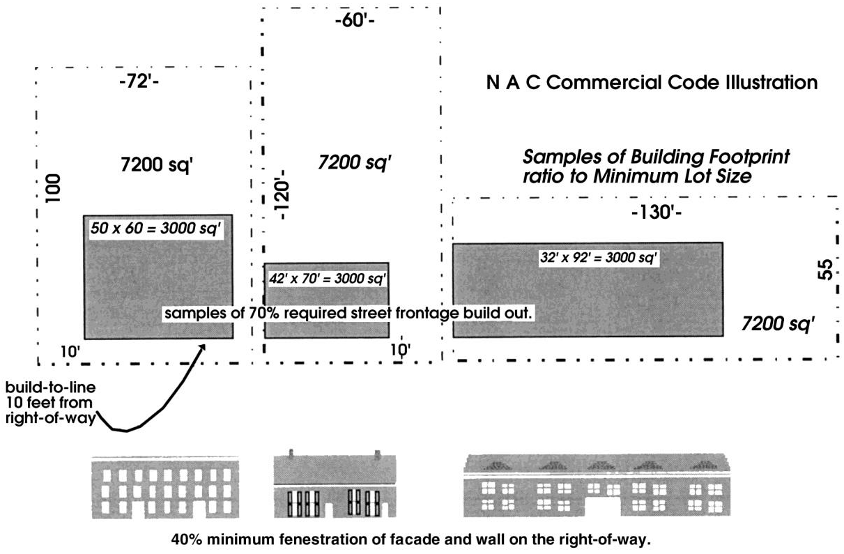
Figure A.3.70.A: Neighborhood Activity Center Commercial Code Illustration
B.
Height: No building or structure shall exceed a height of 35 feet or two stories. Building height is determined from the vertical distance as measured from the lowest ground elevation on the building to the highest point on the building. The height limitations shall not apply to church spires, belfries, flagpoles, monuments, cupolas, domes, ornamental towers, nor to observation towers not intended for human occupancy, water towers, chimneys, parapet walls smokestacks, conveyors and derricks.
C.
Parking: The parking provisions of Article 5, Division 5.5 of the Beaufort County Community Development Code shall apply, except that the maximum off-street parking for commercial retail is determined at a ratio of three parking spaces per thousand square feet of building space.
1.
One row of parking is allowed within the street yard, not to exceed 18 parking spaces (three groups of six spaces). A landscaped peninsula shall separate each group of parking spaces.
2.
Parking lots within the side yard are discouraged. Where unavoidable, side yard parking shall be limited to 44 feet in width (measured along the street line), and shall be screened from the roadway.
3.
Alleys are recommended.
4.
Buildings, trees, hedges or low walls (less than 3½ feet) must screen parking lots from public rights-of-way.
5.
Corner lot parking lots are prohibited.
6.
Clearly delineated pedestrian paths to, from and across parking lots are required.
D.
Signs: The sign provisions of Article 5, Division 5.6 of the Beaufort County Community Development Code shall apply.
E.
Sidewalk Displays: Mobile extensions or sidewalk displays are permitted directly in front of an establishment, if at least five feet is maintained for adequate and uncluttered pedestrian access.
F.
Lighting: Exterior lighting shall meet the standards of Article 5, Division 5.7.
A.5.10 - Purpose
The Lady's Island Professional Office District (LIPO) purpose is to encourage the formulation and continuance of a compatible and economically healthy environment for professional and service uses which benefit from being located in close proximity to each other. The LIPO is intended for low to moderate scale office, service and civic uses, which require a location accessible to a major arterial [street]. It is also the intent of this district to provide areas for limited business uses which, because of their intensity, may have negative impacts on residential areas or may conflict with the character and purpose of other commercial districts. The permitted uses are similar to those that exist at the intersection of Rue Dubois and Lady's Island Parkway, where office and service uses have clearly set a pattern for future development. Due to the nature of the activities permitted within the LIPO, the district is limited to properties along Lady's Island Parkway (802) or collector roads, not indicated as "residential collectors" as shown on the Lady's Island Road Classification Map. Development within this district characteristically occupies a greater site area than those permitted in the Sam's Point Business District, because they are intended to serve a greater population and to offer a wider range of services. This district is intended for application at select locations within the community preservation area along Lady's Island Parkway. The orientation and expansion of this district should occur as an increase in depth at the intersection of Rue Dubois, rather than as a strip-like extension along Lady's Island Parkway.
A.5.20 - Applicability
The LIPO requirements apply to all uses within the LIPO boundaries. The Beaufort County Community Development Code shall apply to all development within the LIPO District, unless expressly exempted or otherwise provided for in this section.
A.5.30 - District Boundaries
The LIPO standards apply only to the Lady's Island Community Preservation Area and occur mainly along Lady's Island Parkway. The delineation of areas, which fall under the LIPO zoning designation, is outlined on the official zoning map of Beaufort County.
A.5.40 - Permitted Activities
The permitted uses are restricted to professional office, services, institutional and limited business uses. Uses not listed are prohibited. The following are descriptions of permitted uses, permitted accessory uses and structures for LIPO:
(Ord. No. 2022/19, 3-28-22)
A.5.50 - Conditional and Special Use Standards
This section describes the standards governing conditional and special uses as designated in the use table in this division. These standards are in addition to other standards required elsewhere in the Beaufort County Community Development Code (CDC), but supersede the conditional, special use, and accessory use standards in Article 4 of the CDC.
Uses designated as "C" in the use table, are permitted uses, however, require additional standards from the by-right provisions. Uses designated as "S" in the table are special uses, require more stringent standards, and must be considered and approved by the zoning board of appeals (ZBOA). If a conditional or special use is proposed as part of a subdivision or land development, the site plan must so designate their locations. The standards for each use may vary by zoning district.
A.
Institutional Residential
1.
Reports/studies required. All applications for this use shall include an area impact assessment.
2.
Perimeter Buffers. Adequate perimeter buffers shall be included and maintained as part of the design, according to Article 5, Division 5.8 of the CDC and Table A.5.60.D of this division.
3.
Parking. All parking shall be located to the side and rear of the proposed use.
4.
Compatibility. In cases where there is no review by the Design Review Board, the Director shall determine compatibility of architecture design with the surrounding community.
B.
Schools
1.
Reports/studies required. All applications for this use shall include a community impact statement (A.1.30.A).
2.
Access. High schools, colleges and professional schools shall have frontage on a collector or arterial and shall be required to take access to such streets unless the county engineer believes local streets are safer in the particular conditions of the site and roads.
C.
Auto Repair and Service (Quick service oil, tune-up, brake and muffler shops and general auto repair and gasoline service stations with repair bays or facilities.)
1.
All vehicles stored on the premises in excess of 72 hours shall be placed in a storage yard.
2.
The exterior display or storage of new or used automobile parts is prohibited.
3.
The storage or display of motor vehicles shall not be visible from the public road right-of-way.
4.
Bay doors to the garage shall not be oriented toward the public right-of-way. They shall face the rear of the site.
D.
Commercial Amusement
1.
Reports/studies required. All applications for this use shall include a community impact statement (A.1.30.A).
2.
Any outdoor activity area, swimming pool, or ball field or court, which adjoins a residential use, shall be landscaped in accordance with Article 5, Division 5.8 of the CDC.
3.
Where nighttime lighting of such areas is proposed, large evergreen trees shall be required in a location appropriate to screen adjoining residences. Any such nighttime lighting shall be constructed in accordance with the standards for a residential district contained in Article 5, Division 5.7 of the CDC. Exterior lighting shall be compatible with the surrounding neighborhood.
4.
Additional buffers. The required perimeter buffer shall be increased by 40 feet along common boundaries with residential uses or zones.
5.
Access shall be provided through frontage on an arterial or collector street, unless the Director finds that access to an adjoining local street is safer, and provides improved design, benefiting the county.
6.
Applicants must clearly demonstrate that the use will be compatible with the neighborhood, particularly with regard to traffic circulation, parking, and appearance. The scale, massing, and building design should be compatible with the surrounding neighborhood. During review of the facility, the Director and/or ZBOA may prohibit landscaping or design that is unnatural or incompatible for surrounding properties or communities in terms of the materials or other design features.
7.
Closing hours and lighting shall be limited to 11:00 p.m. Facilities seeking to remain open after this time must apply for and receive approval of a special use permit.
E.
Religious Establishments (Large)
1.
Reports/studies required. All applications for this use shall include a traffic impact analysis (Article 6, Division 6.3).
2.
Access shall be provided through frontage on an arterial or collector street, unless the Director finds that access to an adjoining local street is safer, and provides improved design, benefiting the county.
3.
It is the intent of this section to ensure that lots used for religious establishments are large enough to accommodate future expansions, and to maintain the desired character of the surrounding community. Thus, a minimum lot size of at least five acres shall be required.
F.
Local Utility
1.
Reports/studies required. All applications for this use shall include an area impact assessment (A.1.30.B), environmental impact assessment (A.1.30.C), and an archaeological and historic impact assessment (A.1.30.E).
2.
In considering an application for a special use permit, the zoning board of appeals shall consider the justification for the location of the proposed utility service and any alternative locations which may be available. Utility agencies shall submit service radii or other locational criteria that demonstrate the need to place facilities in this district.
3.
Additional buffers. The required perimeter buffer shall be increased by ten feet along common boundaries with residential uses or zones.
4.
Screening and buffering consistent with Article 5, Division 5.8 of the CDC shall be required, unless specifically modified as part of the approved conditional or special use permit.
5.
The minimum lot size may be reduced as part of approval of the special use permit provided all setback and perimeter buffer requirements are met and all other dimensional requirements are achieved.
6.
Outdoor storage of materials and equipment, except during construction of the utility facility, shall be prohibited, unless specifically requested and approved as part of the special use permit. Outdoor storage areas shall comply with the screening provisions contained in Article 5, Division 5.8 of the CDC.
G.
Accessory Dwelling: This use is limited to 50 percent of the floor area of the primary structure.
H.
Construction Staging or Plant
1.
Reports/studies required. All applications for this use shall include a community impact statement (A.1.30.A).
2.
If any one adjoining land use or district is residential, hours of operation shall be limited to 8:00 a.m. to 8:00 p.m. In all other instances, hours of operation shall be limited to 6:00 a.m. to 10:00 p.m.
3.
Prior to receiving a development permit, the applicant shall provide a written agreement and advance surety in the amount of 100 percent of the estimated site restoration costs (to be determined by the Director) to ensure complete site
4.
Prior to receiving a development permit, the applicant shall provide a written agreement and advance surety in the amount of 100 percent of the estimated road restoration/replacement costs (to be determined by the county engineer) to ensure roads will be reconstructed to their original or improved condition upon the project's conclusion.
A.5.60 - Development Standards
A.5.70 - Additional Development Standards
A.
Height: No building or structure shall exceed a height of two stories. Building height is determined from the vertical distance as measured from the lowest ground elevation on the building to the highest point on the building. The height limitations shall not apply to church spires, belfries, flagpoles, monuments, cupolas, domes, ornamental towers, nor to observation towers not intended for human occupancy, water towers, chimneys, parapet walls smokestacks, conveyors, derricks, nor to necessary mechanical roof appurtenances.
B.
Parking: The parking provisions of Article 5, Division 5.5 of the Beaufort County Community Development Code shall apply.
C.
Signs: The sign provisions of Article 5, Division 5.6 of the Beaufort County Community Development Code shall apply.
D.
Landscaping, Buffers and Illumination Standards: The landscaping and buffer standards of Article 5, Division 5.8 shall apply to all development within the POD. Exterior lighting shall comply with Article 5, Division 5.7.
A.6.10 - Purpose
The purpose of the Dale Community Preservation (DCP) zoning district is to maintain or improve the livability and character of existing residential neighborhoods; to encourage infill of available lands and to accommodate housing types which will relate well with existing neighborhood character, scale and density. Certain structures and uses serving governmental, religious or recreational needs of such areas are permitted by special or conditional use subject to restrictions and requirements intended to preserve and protect residential neighborhood. Home uses are specifically provided for, if they conform to the provisions of this section. Multifamily and the planned residential option are limited to areas south of, but not along, Keans Neck Road. The housing types permitted within the Dale CP area are limited to single-family and duplexes, except within a planned development.
A.6.20 - Applicability
The DCP requirements apply to all uses within the DCP boundaries. The Beaufort County Community Development Code shall apply to all development within the DCP District, unless expressly exempted or otherwise provided for in this section.
A.6.30 - District Boundaries
The DCP zoning standards apply only to the Dale Community Preservation Area. The delineation of areas, which fall under the DCP zoning designation, is outlined on the Official Zoning Map of Beaufort County.
A.6.40 - Permitted Activities
The permitted uses are primarily residential. Limited nonresidential uses are allowed generally subject to the special or conditional use process. Uses not listed are prohibited. The following are descriptions of permitted uses, permitted accessory uses and structures for the Dale CP District:
(Ord. No. 2025/02, 1-27-25)
A.5.50 - Conditional and Special Use Standards
This section describes the standards governing conditional and special uses as designated in Table A.6.40. These standards are in addition to other standards required elsewhere in the Beaufort County Community Development Code (CDC), but supersede the conditional, special use, and accessory use standards in Article 4 of the CDC. New uses within the Dale CP area shall be consistent with surrounding neighborhood character in size, scale and architecture.
Uses designated as "C" in the use table, are permitted uses, however, require additional standards from the by-right provisions. Uses designated as "S" in the table are special uses, require more stringent standards, and must be considered and approved by the Zoning Board of Appeals (ZBOA). If a conditional or special use is proposed as part of a subdivision or land development, the site plan must so designate their locations. The standards for each use may vary by zoning district.
A.
Local Utility
1.
Reports/studies required. All applications for this use shall include an Area Impact Assessment (A.1.30.B), Environmental Impact Assessment (A.1.30.C), and an Archaeological and Historic Impact Assessment (A.1.30.E).
2.
In considering an application for a special use permit, the zoning board of adjustment shall consider the justification for the location of the proposed utility service and any alternative locations which may be available. Utility agencies shall submit service radii or other locational criteria that demonstrate the need to place facilities in this district.
3.
Additional buffers. The required perimeter buffer shall be increased by ten feet along common boundaries with residential uses or zones.
4.
Screening and buffering consistent with Article 5, Division 5.8 of the CDC shall be required, unless specifically modified as part of the approved conditional or special use permit.
5.
The minimum lot size may be reduced as part of approval of the special use permit provided all setback and perimeter buffer requirements are met and all other dimensional requirements are achieved.
6.
Outdoor storage of materials and equipment, except during construction of the utility facility, shall be prohibited, unless specifically requested and approved as part of the special use permit. Outdoor storage areas shall comply with the screening provisions contained in Article 5, Division 5.8 of the CDC.
B.
Outdoor Recreation
1.
Any outdoor activity area, swimming pool, or ball field or court, which adjoins a residential use, shall be landscaped in accordance with Article 5, Division 5.8 of the CDC.
2.
Where nighttime lighting of such areas is proposed, large evergreen trees shall be required in a location appropriate to screen adjoining residences. Any such nighttime lighting shall be constructed in accordance with the standards for a residential district contained in Article 5, Division 5.7 of the CDC. Exterior lighting shall be compatible with the surrounding neighborhood.
3.
Additional buffers. The required perimeter buffer shall be increased by 30 feet along common boundaries with residential uses or zones.
4.
Access shall be provided through frontage on an arterial or collector street, unless the Director finds that access to an adjoining local street is safer, and provides improved design, benefiting the county.
5.
Applicants must clearly demonstrate that the use will be compatible with the neighborhood, particularly with regard to traffic circulation, parking, and appearance. The scale, massing, and building design should be compatible with the surrounding neighborhood.
6.
The hours of operation may be restricted through the special use permit.
C.
Religious Establishments (large)
1.
Reports/studies required. All applications for this use shall include a community impact statement.
2.
Access shall be provided through frontage on an arterial or collector street, unless the Director finds that access to an adjoining local street is safer, and provides improved design, benefiting the county.
3.
It is the intent of this section to ensure that lots used for assembly and worship uses are large enough to accommodate future expansions, and to maintain the desired character of the surrounding community. Thus, a minimum lot size of at least ten acres shall be required.
D.
Religious Establishments (small)
1.
Reports/studies required. All applications for this use shall include a traffic impact analysis (Article 6, Division 6.3).
2.
There shall be no minimum lot size.
3.
Access shall be provided through frontage on an arterial or collector street, unless the Director finds that access to an adjoining local street is safer, and provides improved design, benefitting the county.
E.
Schools
1.
Access. High schools, colleges and professional schools shall have frontage on a collector or arterial and shall be required to take access to such streets unless the county engineer believes local streets are safer in the particular conditions of the site and roads.
2.
Reports/studies required. All applications for this use shall include a community impact statement (A.1.30.A).
F.
Forestry
1.
A forestry plan shall be submitted that demonstrates that the intended forestry activities will not adversely affect flood hazard, river buffer and specimen tree protection requirements of Article 5, Section 5.11.100 of the CDC. In determining this, the Director shall review the type of cutting, and site plan for the activity.
2.
Perimeter buffers of 50 feet along adjoining streets and districts shall be retained. Where no existing perimeter buffer is present in the required 50-foot area, the location of the perimeter buffer may require being placed further inward of the property line. Excessive cutting of the perimeter buffer shall result in the area having to be replanted as a Type "E" perimeter buffer per the requirements in Article 5, Division 5.8, Table 5.8.90.D of the CDC.
3.
All State of South Carolina standards for BMPs, buffers and reforestation practices shall be adhered to.
4.
The landowner shall retain a minimum of at least 25 overstory trees per acre after final harvest, not including the required buffer. The landowner shall immediately pursue planned natural regeneration methods, whereby between four to 12 seed harvesting trees are left uncut, or 20 to 30 shelterwood harvesting trees are left uncut. Either method is acceptable as long as the required buffer is provided, and the method recognized by the State of South Carolina for responsible forestry practices.
5.
Timber harvesting, as defined by the South Carolina Forestry Association shall only require that notice be provided to the Director of intended activity, prior to commencement of the activity.
G.
Adult Day Care
1.
Reports/studies required. All applications for this use shall include an area impact analysis (A.1.30.B).
2.
Access shall be provided through frontage on an arterial road, unless the Director finds that access to an adjoining local street is safer, and provides improved design, benefitting the county.
3.
This use is limited to 18 adults.
H.
Road Side Stands
1.
No permanent structures may be utilized; only temporary pavilions may be utilized for transient merchant operations. All facilities used shall be self-contained and mobile or portable.
2.
Any and all signs to be utilized on-site must conform to Article 5, Division 5.6 and shall be deemed to be temporary and not a structure, and must be removed upon expiration of the temporary use permit or upon vacation of the site. A sign permit, if required, must be obtained before issuance of a temporary use permit.
3.
Within ten days from the cessation the use, all items related to the operation shall be removed from the site.
4.
No operations within road easements shall be permitted.
I.
Home Uses: Under certain unique circumstances, small-scaled nonresidential activity may be an appropriate use within residential areas. The standards and procedure for establishing such uses are intended to limit the scope and nature of such uses and insure compatibility with the adjoining properties.
1.
Home Occupation
a)
Home occupations shall be clearly incidental and secondary to the use of the dwelling for residential purposes and shall not change its character as a residence. The use of colors, materials, construction, lighting, or other means inconsistent with a residential use shall be prohibited.
b)
There shall be no outside storage of goods, products, equipment, or other materials associated with the home occupation, nor shall these materials be stored inside an accessory structure. No toxic, explosive, flammable, radioactive, or other hazardous materials used in conjunction with the home occupation shall be used, or stored on the site.
c)
The maximum floor area permitted for a home occupation shall be 25 percent of the finished floor area of the dwelling unit. Storage of goods or products shall not exceed 5 percent of the finished floor area.
d)
The street address of the home occupation may be used in advertisements.
e)
No sign may be placed on the property advertising the home occupation.
f)
The type and volume of traffic generated by a home occupation shall be consistent with the traffic generation characteristics of other dwellings in the area.
2.
Home Business
a)
Home business shall be clearly incidental and secondary to the use of the dwelling for residential purposes and shall not change its character as a residence. The use of colors, materials, construction, lighting, or other means inconsistent with a residential use shall be prohibited.
b)
There shall be no outside storage of goods, products, equipment, or other materials associated with the home business.
c)
The type and volume of traffic generated by a home business shall be consistent with the traffic generation characteristics of other dwellings in the area.
3.
Cottage Industry
a)
This use shall not exceed 20 percent of the total site area.
b)
A 50-foot perimeter buffer of 100 percent opacity shall be required on the entire length of all property boundaries adjoining a residential district.
c)
Five acres shall be required for this use.
J.
Planned Residential
1.
This option is limited to sites to the south of, but not along Keans Neck Road. Planned residential in which more than 30 percent of the residential units are mansion apartments are prohibited.
2.
Multifamily structures are limited to two stories in height and six units per building.
3.
Where located adjacent to single-family dwellings, the design and appearance of multifamily dwellings must have similar massing, height, roof pitch and architectural features. Multifamily uses shall be consistent with surrounding neighborhood character.
4.
Required perimeter buffers shall be increased by 15 feet in width.
5.
All applications for this use shall include a community impact statement (A.1.30.A), which includes a statement from the applicant illustrating how the features and design of the planned project adds to the area sense of community.
6.
Site design should create a sense of "community" which includes:
7.
An internal vehicular circulation system reflective of grid system, as opposed to a looped system;
8.
Buildings sited with front entrances and porches oriented towards streets, plazas and parks, rather than clustered around parking lots;
9.
Parking lots located behind buildings or screened from view from internal streets, unless it is deemed appropriate to use a parking lot as a buffer from an arterial street;
10.
Walkways that connect all buildings with parking areas, clubhouses, and sidewalks along adjoining streets, as well as neighboring stores offices, and transit stops;
11.
Access to transit stops and neighborhood retail centers; and
12.
Providing a clear delineation between the public and private space within the development.
K.
Accessory Dwelling: This use is limited to 50 percent of the floor area of the primary structure.
L.
Construction Staging or Plant
1.
Reports/studies required. All applications for this use shall include a community impact statement (A.1.30.A).
2.
If any one adjoining land use or district is residential, hours of operation shall be limited to 8:00 a.m. to 8:00 p.m. In all other instances, hours of operation shall be limited to 6:00 a.m. to 10:00 p.m.
3.
Prior to receiving a development permit, the applicant shall provide a written agreement and advance surety in the amount of 100 percent of the estimated site restoration costs (to be determined by the Director) to ensure complete site restoration upon the project's conclusion.
4.
Prior to receiving a development permit, the applicant shall provide a written agreement and advance surety in the amount of 100 percent of the estimated road restoration/replacement costs (to be determined by the county engineer) to ensure roads will be reconstructed to their original or improved condition upon the project's conclusion.
A.6.60 - Development Standards
A.7.10 - Purpose
The Dale Mixed Use District is designed to provide for uses to serve recurring household needs and personal service requirements of the Dale community in a manner that encourages community interaction. The corridor stretches from the Albany Store to Davis Elementary School and includes a mix of commercial, institutional and residential uses. Higher intensity commercial and institutional uses are encouraged at both Kean's Neck intersection with Kinloch Road and Community Center Road. The uses and services that may be located in this corridor will be limited in scale and function. Commercial retail, office, and civic establishments located within this district should provide residents within the Dale community with convenient access to necessary goods, groceries, and other essential items and services rather than attract users from other parts of the county.
It is anticipated that locating small retail and service establishments in close proximity to residential land uses will encourage pedestrian activity and otherwise reduce the number and length of automobile trips, as well as provide increased convenience to all users. The corridor is to remain a pedestrian oriented trade area, where drive through facilities and franchise architecture is prohibited.
Commercial establishments may be limited in size as well as in vehicular access and parking opportunities to assure compatibility with surrounding residential areas. It is further intended that substantial buffering and other design techniques shall be used to prevent negative impacts on nearby or adjacent residential land uses.
A.7.20 - Applicability
The Dale Mixed Use District requirements apply to all uses within the DMU boundaries. The Beaufort County Community Development Code shall apply to all development within this district, unless expressly exempted or otherwise provided for in this section.
A.7.30 - District Boundaries
The DMU standards apply only to the Dale Community Preservation Area. The delineation of areas, which fall under the DMU zoning designation, is outlined on the official zoning map of Beaufort County. Where the DMU zoning district boundary divides a parcel creating a split zoned parcel, the DMU boundary shall be construed to extend no more than 500 feet from the road right-of-way or 500 feet from a road right-of way intersection.
A.7.40 - Permitted Activities
The permitted uses are restricted to residential uses and consumer-oriented businesses catering primarily to the needs of the local population. For the purpose of this section, the allowable uses in the DMU zoning district and are controlled by the land use development standards of this section, the Beaufort County Comprehensive plan, the CDC, and the chart of permitted uses (Table A.7.40). The following are descriptions of permitted uses, permitted accessory uses and structures for DMU districts:
(Ord. No. 2025/02, 1-27-25)
A.7.50 - Conditional and Special Use Standards
This section describes the standards governing conditional and special uses as designated in Table A.7.40. These standards are in addition to other standards required elsewhere in the Beaufort County Community Development Code (CDC), but supersede the conditional, special use, and accessory use standards in Article 4 of the CDC. New uses within the DMU shall be consistent with surrounding neighborhood character in size, scale and architecture.
Uses designated as "P" in the use table are permitted uses. Uses designated as "C" in the use table, are permitted uses; however, require additional standards from the by-right provisions. Uses designated as "S" in the table are special uses, require more stringent standards, and must be considered and approved by the zoning board of appeals (ZBOA). If a conditional or special use is proposed as part of a subdivision or land development, the site plan must so designate their locations. The standards for each use may vary by zoning district.
A.
Gas-convenience Marts
1.
Fuel pumps shall be located behind the front line of the primary structure. The Director may grant exceptions because of the shallow depth of a parcel, the location of specimen trees, or other similar circumstances.
2.
Any canopy over the fuel pumps shall be considered a structure and shall meet the setback requirements for principal structures.
3.
Any canopy over the fuel pumps shall have the same roof shape and exterior materials as the primary structure. Pitched roofs are encouraged.
4.
The scale, massing, and building design should be compatible with the surrounding commercial uses, including the fuel canopy. The canopy should have architectural features such as a pitched roof, shingles, and/or clapboard siding to blend the canopy with the residential surroundings. The standard architectural designs of regional or national businesses shall be modified to be compatible with the scale, massing, and design of the area.
5.
The principal structure shall be oriented toward the street.
6.
The portion of the principal structure dedicated to sales-related uses shall not exceed 2,500 square feet.
7.
The street elevation of the principal structure shall have at least one street-oriented entrance, and contain the principal windows of the gasoline station.
8.
The Director may require a traffic impact analysis to be provided by the applicant. Such analysis may include, but not be limited to, the proposed traffic flows, sight visibility for emerging vehicles, and other public safety factors.
9.
Parking shall be located to the rear of the building unless impracticable due to the shallow depth of the parcel, the location of specimen trees, or other similar circumstances.
10.
Lighting shall be kept hidden inside a canopy so as not to be visible from off-site. Any free standing lighting fixtures shall be reduced in height to 15 feet if the use adjoins a residential district.
11.
The car wash entrance shall not be oriented toward the public right-of-way.
B.
Quick Service Oil, Tune-up, Brake and Muffler Shops
1.
All vehicles stored on the premises in excess of 72 hours shall be placed in a storage yard.
2.
The exterior display or storage of new or used automobile parts is prohibited.
3.
The storage or display of motor vehicles shall not be visible from the public road right-of-way.
4.
Bay doors to the garage shall not be oriented toward the public right-of-way. They shall face the rear of the site.
C.
Recreational Institutional
1.
Any outdoor activity area, swimming pool, or ball field or court, which adjoins a residential use, shall be landscaped in accordance with Article 5, Division 5.8 of the CDC.
2.
Where nighttime lighting of such areas is proposed large evergreen trees shall be required in a location appropriate to screen adjoining residences. Any such nighttime lighting shall be constructed in accordance with the standards for a residential district contained in Article 5, Division 5.7 of the CDC. Exterior lighting shall be compatible with the surrounding neighborhood.
3.
Additional buffers. The required perimeter buffer shall be increased by 30 feet along common boundaries with residential uses or zones.
4.
Access shall be provided through frontage on an arterial or collector street, unless the Director finds that access to an adjoining local street is safer, and provides improved design, benefiting the County.
5.
Applicants must clearly demonstrate that the use will be compatible with the neighborhood, particularly with regard to traffic circulation, parking, and appearance. The scale, massing, and building design should be compatible with the surrounding neighborhood.
6.
The hours of operation may be restricted through the special use permit.
D.
Residential Storage Facility
1.
Reports/studies required. All applications for this use shall include an area impact assessment (A.1.30.B) and a traffic impact assessment (Article 6, Division 6.3).
2.
This use is limited to low visibility sites.
3.
No security fencing, security gate, or other obstruction to vehicle access shall be permitted in areas visible from public right-of-ways.
4.
Door openings for rental units shall face the interior of the site unless impracticable.
5.
The roof shape and materials shall be compatible with the design and materials of neighboring buildings.
6.
Views of residential storage from public rights-of-way shall be buffered with vegetative material.
7.
Additional buffers. An additional 20 feet of perimeter buffer width shall be provided on all lot sides.
8.
Storage of toxic, hazardous, flammable, explosive or noxious materials is prohibited.
9.
Only personal household goods shall be stored in such facilities.
E.
Banquet Hall
1.
Reports/studies required. All applications for this use shall include a community impact statement (A.1.30.A).
2.
Access shall be provided through frontage on an arterial or collector street, unless the Director finds that access to an adjoining local street is safer, and provides improved design, benefiting the county.
F.
Religious Establishments (Large)
1.
Reports/studies required. All applications for this use shall include a community impact statement (A.1.30.A).
2.
Access shall be provided through frontage on an arterial or collector street, unless the Director finds that access to an adjoining local street is safer, and provides improved design, benefiting the County.
G.
Religious Establishments (Small)
1.
Reports/studies required. All applications for this use shall include a traffic impact analysis (Article 6, Division 6.3).
2.
There shall be no minimum lot size.
3.
Access shall be provided through frontage on an arterial or collector street, unless the Director finds that access to an adjoining local street is safer, and provides improved design, benefitting the county.
H.
Adult Day Care
1.
Reports/studies required. All applications for this use shall include an area impact analysis (A.1.30.B).
2.
Access shall be provided through frontage on an arterial road, unless the Director finds that access to an adjoining local street is safer, and provides improved design, benefitting the County.
3.
This use is limited to 18 adults.
I.
Road Side Stands
1.
No permanent structures may be utilized; only temporary pavilions may be utilized for transient merchant operations. All facilities used shall be self-contained and mobile or portable.
2.
Any and all signs to be utilized on-site must conform to Article 5, Division 5.6 and shall be deemed to be temporary and not a structure, and must be removed upon expiration of the temporary use permit or upon vacation of the site. A sign permit, if required, must be obtained before issuance of a temporary use permit.
3.
Within ten days from the cessation the use, all items related to the operation shall be removed from the site.
4.
No operations within road easements shall be permitted.
J.
Home Uses: Under certain unique circumstances, small-scaled nonresidential activity may be an appropriate use within residential areas. The standards and procedure for establishing such uses are intended to limit the scope and nature of such uses and insure compatibility with the adjoining properties.
1.
Home Occupation
a)
Home occupations shall be clearly incidental and secondary to the use of the dwelling for residential purposes and shall not change its character as a residence. The use of colors, materials, construction, lighting, or other means inconsistent with a residential use shall be prohibited.
b)
There shall be no outside storage of goods, products, equipment, or other materials associated with the home occupation, nor shall these materials be stored inside an accessory structure. No toxic, explosive, flammable, radioactive, or other hazardous materials used in conjunction with the home occupation shall be used, or stored on the site.
c)
The maximum floor area permitted for a home occupation shall be 25 percent of the finished floor area of the dwelling unit. Storage of goods or products shall not exceed 5 percent of the finished floor area.
d)
The street address of the home occupation may be used in advertisements.
e)
No sign may be placed on the property advertising the home occupation.
f)
The type and volume of traffic generated by a home occupation shall be consistent with the traffic generation characteristics of other dwellings in the area.
2.
Home Business
a)
Home businesses shall be clearly incidental and secondary to the use of the dwelling for residential purposes and shall not change its character as a residence. The use of colors, materials, construction, lighting, or other means inconsistent with a residential use shall be prohibited.
b)
There shall be no outside storage of goods, products, equipment, or other materials associated with the home business.
c)
The type and volume of traffic generated by a home business shall be consistent with the traffic generation characteristics of other dwellings in the area.
3.
Cottage Industry
a)
This use shall not exceed 20 percent of the total site area.
b)
A 50-foot perimeter buffer of 100 percent opacity shall be required on the entire length of all property boundaries adjoining a residential district.
c)
Five acres shall be required for this use.
K.
Accessory Dwelling: This use is limited to 50 percent of the floor area (heated) of the primary structure.
L.
Commercial Communication Towers: This use must comply with the standards set forth in Article 4, Division 4.1.320 of the CDC.
A.7.60 - Development Standards
A.7.70 - Additional Development Standards
A.
Placement: Nonresidential building size shall be limited to 2,000 square feet except for institutional uses, banquet halls, and commercial day care. For institutional use, it is preferable to construct a cluster of buildings instead of one large building or to vary the height of various parts of a single building to make it appear less monumental.
B.
Height
1.
Building height is determined from the vertical distance as measured from the lowest ground elevation on the building to the highest point on the building.
2.
Building height shall not exceed 35 feet and buildings are limited to two stories.
3.
The height limitations shall not apply to church spires, belfries, flagpoles, monuments, cupolas, domes, ornamental towers, nor to observation towers not intended for human occupancy, water towers, chimneys, parapet walls smokestacks, conveyors and derricks.
C.
Parking: The parking provisions of Article 5, Division 5.5 of the Beaufort County Community Development Code shall apply, except that the maximum off-street parking, for retail and service uses is determined at a ratio of three parking spaces per thousand square feet of building space.
1.
All off-street parking must be to the rear or side. Parking lots in side yards are discouraged. Where unavoidable they shall be limited to 44 feet, and shall be screened from the road right-of-way.
2.
Alleys are recommended.
3.
Buildings, trees, hedges or low walls (less than 3½ feet) must screen parking lots from public rights-of-way.
4.
Corner lot parking lots are prohibited.
5.
Clearly delineated pedestrian paths to, from and across parking lots are required.
D.
Landscaping, Buffers and Illumination Standards: The landscaping and buffer standards of Article 5, Division 5.8 shall apply to all development within the POD. Exterior lighting shall comply with Article 5, Division 5.7.
E.
Sidewalk Displays: Mobile extensions or sidewalk displays are permitted directly in front of an establishment, if at least five feet is maintained for adequate and uncluttered pedestrian access.
F.
Sign Standards: The sign provisions of Article 5, Division 5.6 of the Beaufort County Community Development Code shall apply unless otherwise specified. The standards and requirements contained in this section shall apply to all uses within the DMD.
1.
On-Premises Wall Signs
a)
Wall signs shall generally be placed within an informational band immediately above the storefront.
b)
Wall signs shall not project more than 15 inches from the building surface.
c)
Wall signs shall not have an aggregate area of more than one square foot for each linear foot of building face parallel to the street lot line, or 10 percent of the walls area to which it is attached, whichever is less.
d)
Where more than one sign is attached to the same wall, the sum of the area of all of the signs shall not exceed the total sign size permitted per wall.
e)
Wall signs shall not extend higher than the eave line or top of the parapet wall.
f)
Wall signs may only be illuminated with steady, stationary, shielded light source directed solely onto the sign.
g)
Multiple wall signs advertising several occupants of the same building or building complex shall be of uniform design and shall be of the same material.
2.
On-Premises Projecting Signs
a)
Projecting signs shall be constructed of wood, with carved, painted, or applied metal lettering and symbols.
b)
The total area of such projecting signs, measured on one face, shall not exceed eight square feet.
c)
Such signs shall be hung at right angles to the building.
d)
Such signs shall have a minimum clearance of eight feet.
3.
Freestanding Signs
a)
One freestanding sign may also be placed in front of a building. The sign shall be set back at least ten feet from the street right-of-way.
b)
Such signs shall have a maximum height of seven feet and a maximum area of 24 square feet. If the property is located beyond a one-quarter (¼) mile radius of the intersection of Keans Neck Road and Kinloch Road, and the principal structure is setback a minimum of 50 feet from the road right-of-way, the maximum height of the sign is increased to 10 feet and the maximum area is increased to 40 square feet.
c)
The sign shall be constructed of wood, stucco, tabby, brick, or painted metal and shall be externally illuminated with the exception of LED message boards as allowed in Section 5.6.30 (General Sign Requirements). In those instances, an LED message board is limited to one-half (½) of the sign area.
G.
Accessory and Miscellaneous Use Standards: The standards in Table A.7.70.G below supersede general standards of Article 4, Division 4.2 of the CDC.
A.8.10 - Purpose
The Seabrook-Stuart Point (SSPR) area consist of rural residential communities with a mix of single-family residential development, woodlands, farm fields, churches, and areas of significant historic and cultural value. This residential zone offers the benefits of a rural lifestyle, while still maintaining access to employment, schools, social and cultural activities. There are, however, environmental and social impacts from these developments that must be carefully managed. The purpose of this district is to provide for low density, single-family detached residential development in areas of existing residential development, together with facilities and accessory uses normally compatible with rural residential surroundings and, at the same time, to permit agricultural uses, to preserve open spaces and to retain a semirural residential character without the maintenance of farm size acreage.
The Seabrook-Stuart Point Residential Zone accommodates residential and nonresidential development that is strictly limited in area and compatible with the rural character. This district encourages the development and maintenance of rural single-family detached residential living combined with limited agricultural and nonresidential activities. Large lot sizes or cluster developments are recommended to maintain the low-density rural character and provide sufficient open space to ensure that the various principal uses are kept at a level of compatible land use intensity. The nonresidential uses and structures are those that are designed to serve the recreational, educational, civic, religious, and social needs of the community in a manner that maintains the rural character and minimizes conflicts with agricultural uses. Limited commercial uses are allowed in historic structures as a tool for preservation.
Planned developments are permitted in an effort to maintain properly coordinated open spaces, floodplains, wooded tracts, reduced street distances and to encourage the perpetuation of farming activity. Planned development principles are included to help maintain and retain the rural character. This concept concentrates small pockets of development, with a consistent rural scale and appearance, in specific locations so that larger agricultural, open space, or environmentally sensitive areas can be preserved. Buffers standards are included to prevent conflict with adjacent agricultural or nonresidential uses.
The Seabrook-Stuart Point Residential Zone allows greater flexibility for certain requirements pertaining to farming and rural activities. It is the intent of the Seabrook-Stuart Point Residential zone to provide opportunities for those whose lifestyles include farming activities to locate in such a district.
A.8.20 - Applicability
The Seabrook-Stuart Point Residential Zone requirements apply to all uses within the SSPR Residential Zone boundaries. The Beaufort County Community Development Code shall apply to all development within this District, unless expressly exempted or otherwise provided for in this section. The boundaries of the SSPR Residential Zone shall serve as a growth boundary, beyond which rezoning to the SSPR designation is not encouraged. The development and architectural design standards of the SSPR shall supersede the development standards of the CDC.
A.8.30 - District Boundaries
The SSPR standards apply only to the Seabrook-Stuart Point Residential District. The delineation of areas, which fall under the SSPR zoning designation, is outlined on the Official Zoning Map of Beaufort County. Where the SSPR zoning district boundary divides a parcel creating a split zoned parcel, the SSPR boundary shall be construed to extend no more than 500 feet from the road right-of-way.
A.8.40 - Permitted Activities
The permitted uses are restricted to residential uses and to those nonresidential uses that are designed to serve the recreational, educational, civic, religious, and social needs of the community. For the purpose of this section, the allowable uses in the SSPR zoning district are controlled by the land use development standards of this section, the Beaufort County Comprehensive Plan, the CDC, and the chart of permitted uses (Table A.7.40). Home uses such as family day care, home occupation and cottage industry are allowed and these home uses are permitted to conduct limited retail sales. Historic sites are allowed limited commercial uses, subject to Article 5, Division 5.10 and this section. The Manufactured Home Community standards in Article 2, Division 2.5 of the CDC shall not be applicable within the Seabrook and Stuart Point Community Preservation Districts. Uses not listed are prohibited. The following are descriptions of permitted uses, accessory uses and structures for SSPR districts:
A.8.50 - Conditional and Special Use Standards
This section describes the standards governing conditional and special uses as designated in Table A.7.40. These standards are in addition to other standards required elsewhere in the Beaufort County Community Development Code (CDC), and supersede the conditional, special use, and accessory use standards in Article 4 of the CDC. New uses within the SSPR zoning district shall be consistent with the surrounding neighborhood character in size, scale and architecture.
Uses designated as "C" in the use table are permitted uses that require additional standards from the by-right provisions. Uses designated as "S" in the table are special uses, require more stringent standards and must be considered and approved by the zoning board of appeals (ZBOA). If a conditional or special use is proposed as part of a subdivision or land development, the site plan must so designate their locations.
A.
Agriculture: Additional vegetative buffering shall be required whenever the use is within 100 feet of a developed residential lot. The buffer width adjacent to a residential use shall be increased to a minimum of 50 feet.
B.
Agriculture Support Services: This use is limited to sites with frontage and access from Highway 21.
C.
Public Service: Reports/studies required: All applications for this use shall include an area impact analysis (A.1.30.B)
D.
Schools
1.
Access: Schools, colleges and professional schools shall have frontage on a collector or arterial roads and shall be required to take access to such streets unless the county engineer believes local streets are safer in the particular conditions of the site and roads.
2.
Reports/studies required: All applications for this use shall include a community impact statement (A.1.30.A).
E.
Recreational Institutional
1.
Landscaping: Any outdoor activity area, swimming pool, ball field, or court that adjoins a residential use shall be landscaped in accordance with Article 5, Division 5.8 of the CDC.
2.
Lighting: Where exterior nighttime lighting of such areas is proposed, large evergreen trees shall be required in a location appropriate to screen adjoining residences. Any such nighttime lighting shall be constructed in accordance with the standards for a residential district contained in Article 5, Division 5.7 of the CDC. Exterior lighting shall be compatible with the surrounding neighborhood.
3.
Additional buffers: The required perimeter buffer shall be increased by 30 feet along common boundaries with residential uses or zones.
4.
Access shall be provided through frontage on an arterial or collector road, unless the Director finds that access to an adjoining local road is safer, and provides improved design, benefiting the county.
5.
Compatibility: Applicants must clearly demonstrate that the use will be compatible with the neighborhood, particularly with regard to traffic circulation, parking, and appearance. The scale, massing, and building design should be compatible with the surrounding neighborhood.
6.
Hours of operation may be restricted through the special use permit.
F.
Religious Establishments
1.
Reports/studies required: All applications for this use exceeding 10,000 square feet shall include a traffic impact analysis (Article 6, Division 6.3).
2.
There shall be no minimum lot size.
3.
Access shall be provided through frontage on an arterial or collector street, unless the Director finds that access to an adjoining local street is safer and provides improved design benefitting the County.
G.
Adult Day Care
1.
Reports/studies required: All applications for this use shall include an area impact analysis (A.1.30.B)
2.
Access shall be provided through frontage on an arterial road, unless the Director finds that access to an adjoining local road is safer, and provides improved design, benefitting the county.
3.
This use is limited to 18 adults.
H.
Historic Sites: Commercial uses within historic sites are limited to the standards of Article 5, Division 5.10 of the CDC.
I.
Retail Plant Nurseries: This use is limited to sites with frontage and access from Highway 21.
J.
Roadside Stands
1.
No permanent structures may be utilized; only temporary pavilions may be utilized for transient merchant operations. All facilities used shall be self-contained and mobile or portable.
2.
Any and all signs to be utilized on-site must conform to the SSP Mixed Use District sign regulations, shall be deemed to be temporary and not a structure, and must be removed when vacating the site. A sign permit, if required, must be obtained before issuance of a use permit.
3.
Within ten days from the cessation of operation the use and all items related to the operation shall be removed from the site.
4.
No operations within road rights-of-way shall be permitted.
5.
Roadside stands shall not exceed 300 square feet and shall be set back at least 15 feet from roadways.
6.
This use shall meet the off-street parking requirements for roadside stands provided in Article 5, Division 5.5 of the CDC, except that paved parking shall not be required.
K.
Planned Community: See Division A.8.80.
L.
Accessory Dwelling: This use is limited to 50 percent of the heated floor area of the primary structure.
M.
Home Uses: Under certain unique circumstances, small-scaled nonresidential activity may be an appropriate use within residential areas. The standards and procedure for establishing such uses are intended to limit the scope and nature of such uses and insure compatibility with the adjoining properties.
1.
Home Occupation
a)
Home occupations shall be clearly incidental and secondary to the use of the dwelling for residential purposes and shall not change its character as a residence. The use of colors, materials, construction, lighting, or other means inconsistent with a residential use shall be prohibited.
b)
There shall be no outside storage of goods, products, equipment, or other materials associated with the home occupation, nor shall these materials be stored inside an accessory structure. No toxic, explosive, flammable, radioactive, or other hazardous materials used in conjunction with the home occupation shall be used, or stored on the site.
c)
The maximum floor area permitted for a home occupation shall be 25 percent of the finished floor area of the dwelling unit. Storage of goods or products shall not exceed 5 percent of the finished floor area.
d)
The street address of the home occupation may be used in advertisements.
e)
No sign may be placed on the property advertising the home occupation.
f)
The type and volume of traffic generated by a home occupation shall be consistent with the traffic generation characteristics of other dwellings in the area.
2.
Home Business
a)
Home business shall be clearly incidental and secondary to the use of the dwelling for residential purposes and shall not change its character as a residence. The use of colors, materials, construction, lighting, or other means inconsistent with a residential use shall be prohibited.
b)
There shall be no outside storage of goods, products, equipment, or other materials associated with the home business.
c)
The type and volume of traffic generated by a home business shall be consistent with the traffic generation characteristics of other dwellings in the area.
3.
Cottage Industry
a)
This use shall not exceed 20 percent of the total site area.
b)
A 50-foot perimeter buffer of 100 percent capacity shall be required on the entire length of all property boundaries adjoining a residential district.
c)
Five acres shall be required for this use.
A.8.60 - Development Standards
A.8.70 - Additional Development Standards
A.
Placement: Building size shall be limited to a maximum building footprint of 2,500 square feet except for historic sites, institutional, educational and residential uses. For institutional use, it is preferable to construct a cluster of buildings instead of one large building or to vary the height of various parts of a single building to make it appear less monumental.
B.
Height:
1.
All structures, residential or commercial, shall have a maximum height of 35 feet 0 inches above the base flood elevation.
2.
All structures, residential or commercial, shall be a maximum of two stories.
3.
Height limitations shall not apply to church spires, belfries, flagpoles, monuments, cupolas, domes, ornamental towers, observation towers not intended for human occupancy, water towers, chimneys, parapet walls smokestacks, conveyors, derricks, and necessary mechanical roof appurtenances.
C.
Parking
1.
The parking provisions of Article 5, Division 5.5 of the Beaufort County Community Development Code shall apply.
2.
Off street parking is not permitted within the front yard. Parking lots in side yards are discouraged. Where unavoidable they shall be limited to 44 feet in width along the road, and shall be screened from the road right-of-way.
3.
Buildings, trees or hedges must screen parking lots from public right-of-ways.
D.
Landscaping, Buffers and Illumination Standards: The landscaping and buffer standards of Article 5, Division 5.8 shall apply to all development within the POD. Exterior lighting shall comply with Article 5, Division 5.7.
E.
Sign Standards: The sign provisions of Article 5, Division 5.6 of the Beaufort County CDC shall apply unless otherwise specified. The sign standards and requirements contained within the SSP Mixed Use District section shall apply to all commercial uses within the SSP Residential District.
A.8.80 - Planned Community Standards
A development that consists of two or more of the following housing types: single-family, single-family lot line, village houses, patio houses, atrium houses, townhouses of several types, duplexes and apartments. Such developments shall be master planned. A planned community allows for undefined densities and a mix of housing types, including limited multifamily uses. However, attention to the character and impact of planned developments is essential to ensure that development fits the existing context and gains community acceptance.
A.
Purpose
1.
Encourage the development of large tracts of land as planned neighborhoods, communities or developments.
2.
Encourage flexible and creative concepts in site planning.
3.
Preserve the natural amenities of the land by encouraging scenic and open areas.
4.
Provide an efficient use of land that could result in small networks of utilities and streets.
5.
Provide an environment of stable character compatible with the surrounding area.
6.
Provide an environment that encourages nonvehicular circulation.
B.
Minimum Lot Size and Setback Requirements: None, subject to compliance with applicable standards for sewage disposal and provision of water.
C.
Where Permitted: Planned communities are permitted within the Seabrook-Stuart Point Residential District on sites 35 acres or greater that are within one-half a mile from the boundary of the Whale Branch Middle or Elementary School.
D.
Size Limit and Affordable Housing Provision: Planned Community sites are limited to a maximum of 100 dwelling units per site. An additional 30 affordable housing units may be permitted providing the following:
1.
The affordable units are built with a local, state, or federal subsidy, or a private nonprofit sponsor for persons or families earning less than 80 percent of median income;
2.
Income eligibility of residents shall be reviewed and approved by the housing authority to ensure they meet state and federal requirements. Where there are no state or federal funds or programs involved, the housing authority shall review the pro forma to ensure the eligibility requirements match the cost reduction provided by the bonus.
3.
These units may be sold subject to agreements that limit appreciation and that require the units to be sold to people eligible for such units. Appreciation shall be geared to the percentage increase in assessed value in the development.
4.
The units shall be located in a random fashion throughout the development, and mixed in such a way that they blend with the character of the community. In multifamily developments, the designated units shall be mixed throughout the buildings.
5.
Exterior materials, details, style, landscaping, and other elements of the units that are visible shall be identical to those of the other units in the development.
E.
Permitted Uses: Nonresidential uses are limited to those permitted within the zoning district (Table A.8.40). A variety housing types are permitted. Housing types are categorized as the following: Estate House (Article 5, Section 5.2.50), Village House (Article 5, Division 5.2.60), Duplexes (Article 5, Division 5.2.90, and Mansion Apartments (Article 5, Division 5.2.110) with no more than 4 units per building. While multifamily is permitted, the majority of multifamily units are expected to occur in mixed-use structures or commercial apartments above nonresidential uses. All other multifamily and single-family attached housing shall be in structures designed to appear to be large, single-family structures. Multifamily buildings are limited to four residential units. Multifamily structures should be dispersed among the other residential uses rather than concentrated in a designated area. Institutional uses, such as churches or schools, are permitted in the residential areas. They may also be permitted in the commercial areas.
F.
Dwelling Unit Mix Requirements: All planned and community developments shall meet the mix requirements regarding the number of different dwelling unit types that must be provided. The mix provides a variety of housing types to meet all residents' needs. If the development is to be phased, each phase shall contain a share of the largest unit types generally proportional to the percentage of the total dwelling units. Where more unit types are provided than required, the developer may determine the percentage of those types to be provided.
G.
Block Requirements: Where environmental conditions, site size and shape permit, the site should be developed using a grid or other formal pattern. Large developments (more than 30 units) shall be broken up into smaller development units that mimic block patterns of traditional neighborhoods. Blocks shall be limited to four acres.
H.
Vehicular Access: The vehicular access to units should be via alleys. This permits the rather narrow building fronts to be free from driveways and garage doors. Where this is impossible, the following shall be used to reduce the impact of driveways and garages (Figure A.8.80.H):
Figure A.8.80.H: Vehicular Garage Access
1.
Garages located to the side and rear with a driveway of no more than ten feet in width providing access.
2.
Side load front garages shall be used on at least 40 percent of lots where the garage is not to the rear of the lot.
3.
Hourglass driveway design with one additional street tree per driveway shall be used on all front-loading garages.
I.
New Streets: New streets shall be interconnected in clear direct and understandable patterns. New streets should connect to existing streets wherever possible. Larger-scale developments (more than 30 units) are required to provide stub streets to adjacent undeveloped or underdeveloped sites. Dead end streets and curved streets are appropriate in response to natural resources. Cul-de-sacs should be avoided. The Director may adjust the road standards if such changes would allow for narrow street profiles and for the use of traffic calming devices to create safer, more comfortable pedestrian and bicycling environments.
J.
Common Open Space and Resources Protection: At least 33 percent of the property shown on the site shall be preserved as common open space. Of that area, at least half shall be designed as contiguous common open space. Where a planned development abuts a body of water, a usable portion of the shoreline, as well as reasonable access to it, shall be a part of the common open space.
K.
Open Space Uses: The common open space shall be useable for low-intensity recreation, agriculture or other passive outdoor living purposes and for preserving the natural features of the site. The uses permitted shall be in accordance with Article 2, Division 2.8 and Article 5, Section 5.11.110 of the CDC.
L.
Commercial Use Requirements: Commercial uses in planned communities shall be limited to the following locations:
1.
Along existing arterial and collector streets bordering the planned community.
2.
In the interior of a planned community beyond the 75-foot wide transitional use area.
3.
Commercial uses shall not locate on existing local roads that border a planned community.
M.
Transitional Use Zone: A 75-foot wide transitional use zone shall be established along the boundaries of the planned community, except for where the planned community fronts an arterial or collector road. Two options are available for the transitional use zone.
1.
The transitional use zone can be planted as a vegetative buffer at 70 percent opacity and counted toward the open space requirement.
2.
Single family residential lots meeting the minimum lot width, lot size, and setback requirements established in the Seabrook-Stuart Point district.
N.
Traffic Circulation and Connectivity:
1.
Traffic circulation and connectivity: Planned communities shall provide connectivity to neighboring subdivisions. Where possible, planned communities shall provide a means of ingress and egress on two different existing streets.
2.
Pedestrian walkways: Planned communities shall provide pedestrian linkages between residential lots and active open spaces and other community amenities.
3.
Nonresidential uses within planned communities shall incorporate shared automobile access, internal automobile and pedestrian circulation, and automobile and pedestrian linkages to the residential uses within the planned community as well as the existing residential uses and roads.
O.
Building Height: Buildings are limited to 35 feet and two stories. The height of buildings on the perimeter of the development should be compatible with surrounding residential uses. Taller buildings should be concentrated in the interior of the project.
P.
Building Separation: A minimum distance of 12 feet shall separate all buildings. This standard requires buildings to be separated to ensure light, air and privacy.
Q.
Site Landscaping: Proposed developments shall comply with the required minimum level of landscaping for yards along streets, building foundations and parking areas contained in Article 5, Division 5.8 of the CDC. This standard pertains to multifamily and nonresidential uses.
R.
Compatibility with Single-family Residences: Special attention shall be given to the perimeter of projects when adjacent to single-family residence or zoning districts. Housing types from the perimeter of the project to its interior should transition from the most compatible to the least compatible; the most compatible being single-family homes decreasing in compatibility from patio homes to zero lot line to duplexes to town house and then to apartments.
S.
Architectural Guidelines:
1.
Compatibility for multifamily uses may be achieved through techniques such as the repetition of roof lines, the use of similar proportions in building mass, similar relationships to the street, similar window and door patterns or through the use of building materials similar to those existing within the community.
2.
Units should be designed with vertical and horizontal offsets to break up rooflines and define private outdoor areas. Large, blank walls should be avoided. Windows and projecting wall surfaces should be used to break up larger wall surfaces and establish visual interest.
3.
Duplexes and attached houses on corner lots can be designed so each unit is oriented towards a different street. This gives the structure the overall appearance of a single-family unit when viewed from either street. Each unit of a duplex or attached house should have its address, front door, driveway, and parking area or garage oriented to a separate street frontage.
4.
When located adjacent to single-family dwellings, the design and appearance of multifamily dwellings should have similar massing, height, and roof pitch. Architectural features, such as front porches and architectural embellishments such as shutters and dormers, are recommended to create the appearance of single-family dwellings.
5.
Garages must be integrated with the building design or sited so as to avoid long monotonous rows of garage doors and building walls. Garages shall be oriented so that they do not visually dominate the building facade or the streetscape. Side or rear entry garages are encouraged. When front-entry garages are provided, the garage shall be recessed at least 12 feet behind the building facade.
T.
Review Process: In order to achieve compatible rural design and preserve the most sensitive natural resources, the pre-application conference will focus heavily on resource protection and site design. At the pre-application review process the Director will review maps and aerial maps and/or the suggested plan and offer recommendations on the following basic issues: circulation, extent or degree of modification from existing requirements and standards, and the relationship to adjacent development, site design and the design and location of required open space. A preliminary determination based upon the pre-application conference does not assure approval of the plan. A favorable pre-application conference will, however, provide petitioner with an indication as to how to proceed for concept approval. All applications for this use shall include a community impact study (A.1.30.A)
A.9.10 - Purpose
This district is designed to provide for uses to serve recurring household needs and personal service requirements of the occupants of nearby residential areas in a manner that encourages community interaction. The permitted commercial functions are those which provide for regular local shopping and are frequented by customers. In addition to the commercial activities, certain office and institutional activities are permitted. The principal purpose of this district is to encourage orderly and incremental commercial development in clusters in an effort to prevent strip commercial development. This district is characteristically small to limit strip commercial.
The bulk regulations and buffer standards are established to provide for maximum compatibility between the activities permitted and adjacent residential uses. This district encourages small-scale commercial uses and should include open spaces such as community parks, greenbelts and generous buffers.
Commercial uses should be of a size, scale, and type that will serve people who currently travel nearby roads; but not of a size, scale, and type that will generate a substantial amount of additional traffic. To preserve the rural character of the community, the footprint (the building footprint is that portion of a lot which, when viewed directly from above, is or would be covered by a building or any part of a building, excluding porches, balconies and decks) of new buildings (this excludes supermarkets) visible from the street can be no larger than 5,000 square feet, excluding porches. Building height can be no greater than two stories. Franchise architecture is prohibited.
The establishment of a new or expanded district of this nature must be preceded by the development of residential areas capable of supporting the activities proposed.
A.9.20 - Applicability
The SSPMU District requirements apply to all uses within the SSPMU boundaries. The Beaufort County Community Development Code shall apply to all development within the SSPMU District, unless expressly exempted or otherwise provided for in this section. The development and architectural design standards of the Seabrook/Stuart Point Mixed Use District shall supersede the development standards of the CDC.
A.9.30 - District Boundaries
The SSPMU District standards apply only to the Seabrook/Stuart Point Community Preservation Area. The delineation of areas, which fall under the SSPMU zoning designation, is outlined on the official zoning map of Beaufort County. Where the SSPMU zoning district boundary divides a parcel creating a split zoned parcel, the SSPMU boundary shall be construed to extend no more than 500 feet from the road right-of-way.
A.9.40 - Permitted Activities
The permitted uses are restricted to consumer-oriented businesses catering primarily to the needs of the local population. The following are descriptions of permitted uses, permitted accessory uses and structures for SSPMU District:
A.9.50 - Conditional and Special Use Standards
This section describes the standards governing conditional and special uses as designated in Table A.8.40. Beaufort County Community Development Code (CDC), and supersede the conditional, special use, and accessory use standards in Article 4 of the CDC.
Uses designated as "C" in the use table are permitted uses, however, require additional standards from the by-right provisions. Uses designated as "S" in the use table are special uses that require more stringent standards, and must be considered and approved by the zoning board of appeals (ZBOA). If a conditional or special use is proposed as part of a subdivision or land development, the site plan must so designate their locations. The standards for each use may vary by zoning district.
A.
Local Utility
1.
Reports/studies required: All applications for this use shall include an area impact assessment (A.1.30.B), environmental impact assessment (A.1.30.C), and an archaeological and historic impact assessment (A.1.30.E).
2.
In considering an application for a special use permit, the zoning board of appeals shall consider the justification for the location of the proposed utility service and any alternative locations which may be available. Utility agencies shall submit service radii or other locational criteria that demonstrate the need to place facilities in this district.
3.
Additional buffers: The required perimeter buffer shall be increased by ten feet along common boundaries with residential uses or zones.
4.
Screening and buffering consistent with the CDC shall be required, unless specifically modified as part of the approved conditional or special use permit.
5.
The minimum lot size may be reduced as part of approval of the special use permit provided all setback and perimeter buffer requirements are met and all other dimensional requirements are achieved.
6.
Outdoor storage of materials and equipment, except during construction of the utility facility, shall be prohibited, unless specifically requested and approved as part of the special use permit. Outdoor storage areas shall comply with the screening provisions contained in Article 5, Division 5.8 of the CDC.
B.
Gas-Convenience Marts and Service Stations
1.
All structures (canopy, carwash, and other accessory uses) shall incorporate consistent architectural details and design elements.
2.
Canopy supports shall be visually proportioned to the massing of the canopies and be incorporated into the design of the canopy and main building.
3.
Car washes are permitted, although special consideration should be given to architecturally blend with the main building.
4.
Fuel pumps shall be located behind the front line of the primary structure. The zoning administrator may grant exceptions because of the shallow depth of a parcel, the location of existing mature trees, or other similar circumstances.
5.
Any canopy over the fuel pumps shall be considered a structure and shall meet the setback requirements for principal structures.
6.
Any canopy over the fuel pumps shall have the same roof shape and exterior materials as the primary structure. Pitched roofs are encouraged.
7.
The scale, massing, and building design should be compatible with the surrounding commercial uses, including the fuel canopy. The canopy should have architectural features such as a pitched roof, shingles, and/or clapboard siding to blend the canopy with the residential surroundings. The standard architectural designs of regional or national businesses shall be modified to be compatible with the scale, massing, and design of the area.
8.
The principal structure shall be oriented toward the street.
9.
The portion of the principal structure dedicated to sales-related uses shall not exceed 2,500 square feet.
10.
The street elevation of the principal structure shall have at least one street-oriented entrance, and contain the principal windows of the gasoline station.
11.
The Director may require a traffic analysis to be provided by the applicant. Such analysis may include, but not be limited to, the proposed traffic flows, sight visibility for emerging vehicles, and other public safety factors.
12.
Parking shall be located behind the front building line unless impracticable due to the shallow depth of the parcel, the location of existing mature trees, or other similar circumstances.
13.
Lighting shall be kept hidden inside a canopy so as not to be visible from off-site. Any free standing lighting fixtures shall be reduced in height to 15 feet if the use adjoins a residential district.
14.
Service bay doors shall not be oriented toward the public right-of-way. They shall face the rear of the site.
15.
This use shall be located no closer to one another than three miles along an arterial road as classified on the Beaufort County Road Function Classification Map.
C.
Quick Service Oil, Tune-up, Brake and Muffler Shops and General Auto Repairs
1.
All vehicles stored on the premises in excess of 72 hours shall be placed in a storage yard.
2.
The exterior display or storage of new or used automobile parts is prohibited.
3.
The storage or display of motor vehicles shall not be visible from the public road right-of-way.
4.
Bay doors to the garage shall not be oriented toward the public right-of-way. They shall face the rear of the site.
D.
Food Stores: Reports/studies required: All applications for this use shall include a community impact statement (A.1.30.A).
E.
Delicatessens and Restaurants: Restaurants shall be permitted to operate outdoor cafes on sidewalks, including areas within the public right-of-way and in courtyards, provided that pedestrian circulation and access to store entrances shall not be impaired. The following standards shall apply to outdoor eating areas:
1.
To allow for pedestrian circulation, a minimum width of five feet of sidewalk between the curb and the entrance to the establishment shall be maintained free of tables, chairs, or other obstacles.
2.
Planters, posts with ropes, or other removable enclosures are encouraged and shall be used as a way of defining the area occupied by the cafe.
3.
Extended awnings, canopies, or large umbrellas shall be permitted if located to provide shade.
4.
Outdoor trash receptacles shall be provided.
5.
Mobile extensions, decks, patios and areas covered by extended awnings and canopies shall not be included in the calculation of floor area or building footprint.
F.
Commercial, Retail, Neighborhood: This use is limited to 3,000 square feet, except for hardware stores which are limited to 9,000 square feet.
G.
Religious Establishments (small):
1.
Reports/studies required: All applications for this use shall include a traffic impact analysis (Article 6, Division 6.3).
2.
There shall be no minimum lot size.
3.
Access shall be provided through frontage on an arterial or collector street, unless the Director finds that access to an adjoining local street is safer, and provides improved design, benefiting the county.
H.
Educational Services:
1.
Reports/studies required: All applications for this use shall include an area impact analysis (A.1.30.B).
2.
This use is limited to a 10,000-square foot-building footprint.
I.
Bed and Breakfasts:
1.
Use standards: Any bed and breakfast use shall have a maximum of six rental rooms. Meals may be served only to registered guests.
2.
Signs: Bed and breakfast uses are limited to five square feet of total sign area. Such signs must be constructed of wood or other durable non-plastic materials.
3.
Parking: Bed and breakfast uses must provide for all parking off-road, which shall be screened from adjoining land uses by hedges and canopy trees. The Director may permit on-road parking to be substituted upon determining that the street can accommodate the parking and the provision of off-street parking would be detrimental to the area's appearance.
J.
Duplexes:
1.
Where located adjacent to single-family dwellings, the design and appearance of a duplex must have similar massing, height, roof pitch and architectural features. Duplexes shall be consistent with surrounding neighborhood character.
2.
Required perimeter buffers shall be increased by 15 feet in width.
3.
Duplexes are subject to the design standards of the Seabrook/Stuart Point Mixed Use District.
A.9.60 - Development Standards
A.9.70 - Additional Development Standards
A.
Architectural Guidelines:
1.
General Guidelines:
a)
Architectural styles should be compatible with architectural styles that exemplify the unique character of the Lowcountry region and conform to general standards of architectural quality. It is not the intention of these guidelines to create replicas or imitations of historic structures, rather, to create new development that "feels" as if it belongs in this area.
b)
The same level of architectural integrity shall be applied to all four elevations of any building.
c)
Building materials not specified below will be permitted on a case-by-case basis if the application of such materials is incorporated in an architecturally sound design and otherwise meets the objectives of this section.
d)
The following general provisions apply to all nonresidential building types. Through these guidelines the Seabrook-Stuart Point Community Preservation District strives to achieve an overall harmony of design and place. It is not to be inferred that buildings must look alike to achieve a harmony of style. Harmony of style can be created through proper considerations of scale, proportion, detail, materials, color, site planning and landscaping.
e)
Building designs shall be scaled, massed, and articulated appropriately as to their location and use. Structures shall be limited to two full floors, and any structure larger than 5,000 square feet shall be broken into more than one mass in an attempt to reduce the visual impact.
f)
Site and building design shall emphasize pedestrian needs and develop creative approaches to improving pedestrian interest, access and enjoyment. All buildings shall have a functional entrance at the front elevation.
g)
The sequence of continuous pedestrian activity shall not be interrupted. Blank walls and other "dead" or dull spaces at the street level shall be avoided. Visually interesting activities at the sidewalk edge shall be maintained and/or established to engage pedestrian interest. A wall can be articulated with a change in fenestration, material, a water table, pilasters, or even a trellis attached to the wall to grow plants.
h)
Frontage design and signage locations shall be coordinated with streetscape landscaping and street trees.
i)
Pedestrian open spaces such as covered walkways, porches, arcades, courtyards and plazas are encouraged, as well as the development of open and attractive passageways between buildings and blocks.
j)
Commercial structures should be designed to be compatible with buildings of residential size, scale, character, and materials.
k)
Commercial development may not exceed a scale that will threaten the existing neighborhood fabric.
l)
Forty percent minimum fenestration of the facade and wall visible from the road right-of-way.
2.
Roofs:
a)
General requirements: Applied or incomplete mansard roofs, flat flush soffit returns on gabled ends, pork chops and long unarticulated roofs are not permitted. Exposed rafter ends or tails at overhangs are strongly recommended.
b)
Pitch: Pitched roofs, covering the main body of the building, shall have a minimum pitch of 5:12. Secondary roofs may have a lesser pitch. These minimum pitches are general, and each building shall dictate its roof based on proportion, scale, style and overall building aesthetics.
c)
Materials: Permitted roof materials include copper, metal (raised seam, galvanized metal, corrugated metal), shingles (wood, slate, multilayered asphalt, metal, fiberglass) and clay tile.
d)
Configuration of materials: Maximum spacing of raised seam metal roofs shall be 24 inches. Panel ends shall be exposed at the overhang. Shingles may be square, rectangular, fish scale, or shield. Seam height and type shall be appropriate for the scale and type of structure.
3.
Building Walls:
a)
General requirements: Building elevations fronting the street or the waterfront shall have minimum fenestration (door and window) coverage of 50 percent on the first story and 30 percent for the second level. Structures using wood siding and details may be reviewed more leniently. (This is due to the inherent articulation of the material/process.) Long, unarticulated or blank facades are not permitted.
b)
Configuration of materials: The width of wood, cement fiber siding, and other materials shall conform to traditional or historic uses that these materials are meant to emulate. Stucco surfaces shall be fine sand float or medium sand float according to the Portland Cement Association.
4.
Windows and Doors:
a)
General requirements: Rectangular windows facing the street shall have a vertical orientation.
b)
Materials: Windows and doors may use framing material of wood, aluminum, copper, and vinyl clad wood. Windows fronting the streets or the waterfront shall use transparent, non-reflective and non-tinted materials.
c)
Window and door types: Casement and single and double-hung windows are encouraged. Fixed-frame windows shall have a maximum surface area of 36 square feet. Windows with muttons shall have true divided lights or simulated divided lights. Aluminum storefront windows are allowed. Snap-on muntins are not permitted.
5.
Colors: Predominant color design shall be compatible with Lowcountry or coastal vernacular palette which include traditional historic colors, earth tones (green, tans, light browns and terra cotta), grays, pale primary and secondary colors (with less than 50 percent color value), white and cream tones, and oxblood red. Accent color design (i.e. black, dark blue, grays, and other dark, primary colors) may be used on a limited basis as part of an architectural motif, at the discretion of the Director and/or the Design Review Board.
6.
Other Architectural Features:
a)
Columns: Permitted materials for columns include wood (painted or natural), cast iron, synthetic, concrete with smooth finish, or tabby finish. Columns may be square or round, hollow or solid with a minimum nominal width or nominal diameter of six inches. Maximum column spacing shall be no greater than the height of the columns.
b)
Accessory buildings and uses: The design of accessory buildings shall reflect and coordinate with the general style of architecture inherent in the primary structure for the proposed development. These structures should be designed to be secondary outdoor usable areas and play equipment shall be reviewed for compatible and attractive design that is integrated with the main building architecture or sufficient screening.
c)
Fences and walls: Unscreened chain-link fences or woven metal fences are not permitted. Permitted materials for walls are brick, concrete masonry units with stucco, or reinforced concrete with stucco. Permitted materials for fences are wood, brick lattice, synthetic, and wrought iron.
d)
Shutters: Individual shutters, if utilized, shall be real, operable, and cover the entire window when closed. Wood shutters are preferred, although synthetic shutters may be approved at the discretion of the corridor review board.
e)
Pedestrian paving: Paving materials shall consist of brick, stone, gravel, wood, concrete, or oyster shell aggregate concrete. Asphalt is allowed, but not preferred.
B.
Landscaping and Buffer Standards: In addition to the following landscaping requirements, the landscaping standards outlined in Article 5, Division 5.8 of the CDC shall apply to all developments in this district. All landscaping required by this section, and approved as part of an application for development, shall be maintained in healthy condition by the property owner. Plant material used for installation shall conform to the standards established by the American Association of Nurserymen in the "American Standards for Nursery Stock" provisions. Landscaping requirements of this ordinance shall not interfere with fire and life safety standards contained in this ordinance.
1.
Installation requirements: Installation and maintenance of landscaping materials shall adhere to the standards of the Article 5, Section 5.8.30 and Section 5.8.110.
2.
Existing plant material counted: The use of existing vegetation and plant species native to the Lowcountry is strongly encouraged, and shall be counted toward the landscaping requirement. This indigenous plant material also makes required maintenance easier and prolongs plant life.
3.
Landscaping along street frontage: Planters, window boxes, hanging plants and potted plants are strongly encouraged along front elevations of buildings.
4.
Foundation buffers: A three-foot wide landscaped buffer is required between the side and rear elevations of the building and parking areas, driving areas, and sidewalks. Foundation buffers are not required in loading areas and drive-through facility areas.
5.
Parking lot planting requirements: The parking lot planting requirements outlined in the landscaping section of Article 5, Division 5.8.80 of the CDC shall apply to the Seabrook/Stuart Point Community Preservation District.
C.
Signage Standards: The sign provisions of Article 5, Division 5.6 of the Beaufort County Community Development Code shall apply unless otherwise specified. The standards and requirements contained in this section shall apply to all uses within the Seabrook/Stuart Mixed Use District.
1.
On-premises wall signs:
a)
Wall signs shall generally be placed within an informational band immediately above the storefront.
b)
Wall signs shall not project more than 15 inches from the building surface.
c)
Wall signs shall not have an aggregate area of more than one square foot for each linear foot of building face parallel to the street lot line, or ten percent of the wall area to which it is attached, whichever is less.
d)
Where more than one sign is attached to the same wall, the sum of the area of all of the signs shall not exceed the total sign size permitted per wall.
e)
Wall signs shall not extend higher than the eave line or the top of the parapet wall.
f)
Wall signs may only be externally illuminated with a steady, stationary, shielded light source directed solely onto the sign.
g)
Multiple wall signs advertising several occupants of the same building or building complex shall be of uniform design and shall be of the same material.
h)
Directory type signs are encouraged for buildings with multiple tenants or businesses.
2.
On-premises projecting signs:
a)
Projecting signs shall be constructed of wood, with carved, painted, or applied metal lettering and symbols.
b)
The total area of such projecting signs, measured on one face, shall not exceed eight square feet.
c)
Such signs shall be hung at right angles to the building.
d)
Such signs shall have a minimum clearance of eight feet.
3.
Free standing signs:
a)
One freestanding sign may also be placed in front of a building. The sign shall be set back at least five feet from the street right-of-way.
b)
Such signs shall have a maximum height of six feet and a maximum area of six square feet.
c)
The sign shall be constructed of wood or painted metal and shall be externally illuminated.
d)
Sign structures shall be of masonry with smooth stucco or tabby finish, painted or natural wood, or synthetic materials.
e)
Sign design should be appropriate to the architectural expression and aesthetics of the building which it belongs.
D.
Lighting Standards: The illumination standards of Article 5, Division 5.7 of the Beaufort County Community Development Code shall apply in addition to the following standards:
E.
Parking Standards:
1.
The parking provisions of the Article 5, Division 5.5 of the Beaufort County Community Development Ordinance shall apply, except that the maximum off street parking for retail and service uses is determined at a ratio of three parking spaces per thousand square feet of building space.
2.
All off-street parking must be to the rear or side. Parking lots in side yards are discouraged. Where unavoidable they shall be limited to 44 feet in width along the street, and shall be screened from the road right-of-way.
3.
Alleys are recommended.
4.
Buildings, trees, hedges or low walls (less than 3½ feet) must screen parking lots from public right-of-ways.
5.
Corner lot parking lots are prohibited.
6.
Clearly delineated pedestrian paths to, from and across parking lots are required.
7.
Parking areas are not to appear as large paved areas. Sufficient planting/preservation of trees and native vegetation shall be a guiding force in the design process. These areas should be more usable, livable, and pedestrian friendly.
F.
Additional Standards for Historic Structures:
1.
The Seabrook/ Stuart Point Community Preservation Area has one main area of historic interest, Old Seabrook. This area originally served the people of Seabrook and the railroad that ran through it. The buildings in this area are in decay, but are still viable for restoration and re-use.
2.
If redeveloped or restored, the goal of this historic area is to create a low impact area that will not negatively affect the surrounding neighborhoods.
3.
The minimum parking requirements may be reduced by the Director.
4.
The restoration process in this area should leave these buildings with the same overall architectural presence they had historically.
5.
New structures, if allowed in this area, must be of similar architectural style, massing, materials, and scale. The Beaufort County Historic Preservation Review Board will review these qualities and deem what is appropriate, architecturally as well as siting and overall presence.
6.
If rejuvenated, this historic area should become geared toward the pedestrian.
7.
The use of planters, outdoor seating areas, trash receptacles, trellises, and other features that provide interest to pedestrians is strongly encouraged between the buildings and on the street.
G.
Additional Standards for Specific Building Types
1.
Drive-through windows: Drive-through elements shall be architecturally integrated into the building, rather than appearing to be applied or "stuck-on" to the building. Drive-through elements shall not be located on the street side of the building and shall be inconspicuous. Safe sight distances for pedestrians and automobile traffic must be maintained where drive-through window traffic exits onto the street. Drive-through amenities are limited to one lane and one window per business/location.
2.
Franchise architecture: Franchise/corporate entities are permitted within the Seabrook/Stuart Point Community Preservation Districts; however, franchise architecture is prohibited on the exterior of structures.
3.
Prefabricated buildings: Metal buildings are not prohibited, but special consideration should be placed on scale, mass, fenestration, and materials. All of the design/material issues set forth in this document shall be applicable.
4.
Height:
a)
All structures residential or commercial shall have a maximum height of 35 feet 0 inches above the base flood elevation.
b)
All structures residential or commercial shall be a maximum of two stories.
c)
Height limitations shall not apply to church spires, belfries, flagpoles, monuments, cupolas, domes, ornamental towers, nor to observation towers not intended for human occupancy, water towers, chimneys, parapet walls smokestacks, conveyors, derricks, nor to necessary mechanical roof appurtenances.
H.
Accessory and Miscellaneous Use Standards: The standards in the table below apply to truck and heavy equipment storage.
I.
Sidewalk Displays: Mobile extensions or sidewalk displays are permitted directly in front of an establishment, if at least five feet is maintained for adequate and uncluttered pedestrian access.
A.10.10 - Purpose
The purpose of the Buckingham Landing Community Preservation District (BLCP) is to conserve the existing residential neighborhood and to improve the quality of life and public safety for their residents.
A.10.20 - Applicability
The Buckingham Landing Community Preservation District requirements apply to all uses within the BLCP boundaries. The Beaufort County Community Development Code shall apply to all development within this district, unless expressly exempted or otherwise provided for in this section.
A.10.30 - District Boundaries
The delineation of areas that fall under the BLCP zoning designation is outlined on the Official Zoning Map of Beaufort County. BLCP standards and requirements apply to all uses within the BLCP boundaries and only those within the BLCP boundaries.
A.10.40 - Permitted Activities
The permitted uses in the BLCP are primarily residential. Table A.10.40 includes descriptions of permitted uses for the BLCP District. Uses not listed are prohibited.
A.10.50 - Conditional and Special Use Standards
This section describes the standards governing the conditional and special uses designated in Table 1. These standards are in addition to other standards required Beaufort County Community Development Code (CDC), but supersede the conditional, special use, and accessory use standards in Article 4 of the CDC. New uses within the BLCP shall be consistent with surrounding neighborhood character in size, scale and architecture.
A.
Duplex: When located adjacent to single-family dwellings, the design and appearance of a duplex must have similar massing, height, roof pitch and architectural features.
B.
Accessory dwelling unit:
1.
The regulations for accessory dwelling units in this zoning district supersede the ordinances for accessory dwelling units found in Article 4 of the Beaufort County Community Development Code.
2.
The property owner must occupy the principal unit as his/her permanent or seasonal residence.
3.
No more than one accessory dwelling unit is permitted per lot.
4.
An accessory dwelling unit may be rented or leased, but not sold.
5.
An attached dwelling unit shall be designed to maintain the architectural design (facade, roof pitch, siding and windows) of the principle unit. An unattached dwelling unit shall maintain the design and character of the principle dwelling unit.
6.
An accessory dwelling unit may be located above a garage.
7.
One additional off-street parking space shall be provided on-site.
C.
Bed and breakfast:
1.
One sign is permitted per bed and breakfast (this number is not to be interpreted as one sign per room). Signs must be constructed of solid wood or other durable, non-plastic materials and cannot exceed four square feet in size.
2.
Parking must be off-street and screened from adjoining properties.
3.
If newly constructed for use as a bed and breakfast, the building must be compatible with the neighborhood, preferably using traditional or "Lowcountry" design.
4.
A ten-foot wide planted buffer is required within the setback.
D.
Home-based business:
1.
The regulations for home-based businesses in this zoning district supersede the ordinances for home businesses and home occupations found in the Beaufort County Community Development Code.
2.
The owner of the home-based business shall reside on the property or immediately adjacent thereto.
3.
Home-based businesses shall be clearly incidental and secondary to the dwelling and shall not change its character or use as a residence.
4.
The use of colors, materials, construction, lighting, or other means inconsistent with a residential use shall be prohibited.
5.
Customer/client visits shall be limited to the hours between 6:00 A.M. and 9:00 P.M.
6.
The following uses are specifically not allowed:
a)
Restaurants, bars or clubs.
b)
Adult entertainment.
c)
Mortuaries and funeral parlors.
d)
Repair of appliances, small engines, motor vehicles and motorcycles.
e)
Tattooing and body piercing.
f)
Trucking companies.
7.
The equipment used by the home-based business and the operations of the home-based business shall not:
a)
Create any vibrations, heat, glare, dust, odors or smoke discernable at the property lines.
b)
Create any electrical, magnetic or other interference off the premises.
c)
Use, store and/or dispose of toxic, explosive, flammable, or other hazardous materials except as directed by the manufacturer, EPA, fire officials, county public works, or other agencies.
8.
Outside storage of goods, products, equipment, or other materials associated with the home-based business shall be screened from view.
9.
Outside displays of products are not permitted.
10.
Outdoor trash receptacles or dumpsters are limited to one per business and must be screened from view.
11.
One sign no larger than four square feet in area may be placed on the property.
12.
The type and volume of traffic generated by a home-based business shall be consistent with the traffic generation characteristics of other dwellings in the area.
13.
Additional parking for a home-based business may be provided, but is limited to two on-site, off-road parking spaces behind all required setbacks and buffers. If paved, parking spaces must be constructed of pervious materials.
14.
On-site employment of up to three unrelated individuals, including independent contractors operating from the facility but not including farm workers, is permitted.
A.10.60 - Development Standards
Development standards address how a land use is situated on a parcel. In addition to the following standards, the development standards of the Beaufort County ZDSO shall apply.
A.
Lot and Building Standards:
B.
Open Space: Residential construction must leave a minimum of ten percent of the lot as pervious open space. The ten percent shall not include land area within required setbacks.
C.
Planting Requirements: A minimum of two trees (new or existing) are required on all lots.
D.
River Buffer Requirements: River buffer requirements included in Article 5, Section 5.11.60 of the CDC shall apply to affected lots.
E.
Parking: There shall be no on-street or on right-of-way or off-premises parking permitted in the district. Excluding property owners' vehicles, a maximum of four cars may be temporarily parked on a single lot. Driveways may be placed in setbacks.
F.
Fences:
1.
All fences shall measure no more than six feet in height.
2.
No fences shall be constructed of, or include in its construction, barbed wire or discarded materials.
3.
Plastic weaving strips on chain link fences are not permitted.
4.
The finished side of the fence shall face outward with mounting poles located on the inside of the fence.
5.
Planting vegetative buffers along fences is encouraged.
A.11.10 - Purpose
The Beaufort County Comprehensive Plan sets forth that the county shall "preserve communities… that help create a sense of place in the county as important places to live, work and play," through the tool of Community Preservation districts. Coosaw and Judge Islands together form a unique community with a recognizable character.
The following standards for Coosaw Island Rural and Coosaw Island Rural Residential were structured to replicate the standards of Rural and Rural Residential as they existed under the Beaufort County Zoning and Development Standards Ordinance. These standards shall apply to Coosaw and Judge Islands until such time as a Community Preservation Committee is constituted and sets long term standards for the islands.
A.11.20 - Applicability
The Coosaw Island Rural and Rural Residential District requirements apply to all uses within their boundaries. The Beaufort County Zoning and Development Standards Ordinance (ZDSO) shall apply to all development within these districts, unless expressly exempted or otherwise provided for in this section.
A.11.30 - District Boundaries
The delineation of areas that fall under the Coosaw Island Rural and Rural Residential designations is outlined on the official zoning map of Beaufort County. The Coosaw standards and requirements apply to all uses within the Coosaw boundaries and only those within the Coosaw boundaries.
A.11.40 - Permitted Activities
The permitted uses in the CIR are primarily residential. Table A.11.40 includes descriptions of permitted uses for the CIR and CIRR Districts.
A.11.50 - Conditional and Special Use Standards
This section describes the standards governing the conditional and special uses of the Coosaw Island Rural and Rural Residential districts designated in Table A.11.40 of Appendix A. These standards are in addition to other standards required elsewhere in the Beaufort County CDC.
A.
Clearcutting: When clearcutting does not include bona fide forestry practices, approval for clearcutting shall be issued only under one of the following conditions:
1.
A 50-foot forested buffer shall remain along all street frontages. Absence of the required existing buffer shall preclude any site from being approved for this use.
2.
As part of a site plan or subdivision with an approved resource protection plan.
3.
When a site capacity analysis is submitted along with an environmental impact assessment demonstrating that this chapter's standards are met, and a record of the property's original conditions is filed with the planning department.
4.
If an owner clear cuts all or any portion of his or her property under the claim of good faith forestry practice, and then seeks a development permit for any portion of the property within one year of the clear cut, a rebutable presumption shall arise that the clear cut was done in anticipation of future development and the permit denied. Any person seeking to rebut the presumptions shall have the burden of proving their claim by clear and convincing evidence.
B.
Farmsteads and Farmworker Housing: Farmworker housing is allowed as an accessory use on farmsteads for semi-permanent use by farm workers, consistent with state and federal regulations.
C.
Commercial Stables:
1.
Additional buffering shall be required whenever the use is within 100 feet of a developed residential lot. The buffer width shall be increased to a minimum of 15 feet.
2.
The minimum site area shall be five acres.
3.
A five-foot-high fence is required around paddock areas.
4.
Reports/studies required. All applications for this use shall include an area impact assessment (A.1.30.B).
D.
Planned Community:
1.
Planned residential uses shall only contain single-family and duplex dwellings. All other multifamily uses are not permitted.
2.
Reports/studies required. All applications for this use shall include a community impact statement.
E.
Manufactured Home Community: Manufactured Home Communities are limited to a gross density of 2 dwelling units per acre and shall comply with the standards in Article 2, Division 2.5.
F.
Accessory Dwelling Unit:
1.
The ADU shall comply with all of the required setbacks and open space ratios of the underlying zoning district.
2.
Only one ADU may be created per principal dwelling.
3.
The property owner, who shall include titleholders and contract purchasers, must occupy the principal unit as their permanent or seasonal residence.
4.
The ADU shall be no more than 800 square feet or less than 300 square feet. In no case shall an ADU be more than 40 percent of the principal dwelling's total floor area,
5.
The ADU shall be designed to maintain the architectural design, style, appearance and character of the principal dwelling as a single-family residence. If an ADU extends beyond the current footprint or existing height of the principal dwelling, or is part of a detached garage, such an addition must be consistent with the facade, roof pitch, siding and windows of the principal dwelling.
6.
One off-street parking space, in addition to that which is provided for the existing single-family dwellings, shall be provided for the ADU.
7.
Accessory dwelling units may be located no more than 50 feet from the principal dwelling unit.
G.
Home Occupation:
1.
Home occupations shall be clearly incidental and secondary to the use of the dwelling for residential purposes and shall not change its character as a residence. The use of colors, materials, construction, lighting, or other means inconsistent with a residential use shall be prohibited.
2.
There shall be no outside storage of goods, products, equipment, or other materials associated with the home occupation, nor shall these materials be stored inside an accessory structure. No toxic, explosive, flammable, radioactive, or other hazardous materials used in conjunction with the home occupation shall be used, or stored on the site.
3.
The maximum floor area permitted for a home occupation shall be 25 percent of the finished floor area of the dwelling unit. Storage of goods or products shall not exceed five percent of the finished floor area.
4.
The street address of the home occupation may be used in advertisements.
5.
No sign may be placed on the property advertising the home occupation.
6.
The type and volume of traffic generated by a home occupation shall be consistent with the traffic generation characteristics of other dwellings in the area. Any need for parking generated by the conduct of such home occupation shall be met off the street and other than in a required front yard.
7.
Additional parking is limited to two pervious parking spaces.
8.
The home occupation shall not involve the storage of commercial vehicles or the use of such vehicles for delivery of goods or material to or from the premises.
9.
Adult uses, body branding, body piercing, or tattoo facilities are specifically not allowed as home occupations:
H.
Home Business:
1.
Uses that comply with all of the standards of this section will be permitted as home businesses unless specifically prohibited.
2.
The following uses are specifically not allowed as home businesses:
a)
Any type of repair, rental, sales or assembly of vehicles or equipment with internal combustion engines (such as outboard marine engines, lawn mowers, etc.) or any other work related to automobiles and their parts;
b)
Any type of repair, rental or sales of large appliances (such as washing machines, dryers and refrigerators, etc.);
c)
Restaurants and bars;
d)
Animal boarding facilities (such as kennels, animal hospitals, commercial stables, etc.);
e)
Commercial lodging;
f)
Adult entertainment;
g)
Medical offices and clinics;
h)
Body branding, body piercing, or tattoo facilities.
3.
The operator of a home business shall own and reside on the property or reside immediately adjacent thereto.
4.
The home business shall be clearly incidental and secondary to the property's use for residential purposes. No more than 1,000 square feet of an accessory structure(s), such as a garage, may be used for the home business. No alterations shall be made to the external appearance of any principal or accessory structure or of the property that changes the character of the site from residential to nonresidential.
5.
All storage areas for equipment and supplies associated with the home business shall be completely screened from view with a wood fence and/or landscaping. Storage of hazardous substances, other than substances of a type and quantity customarily associated with a home or hobby, is prohibited.
6.
No home business or equipment used in connection with a home business may cause odor, vibration, noise, or electrical interference that is perceptible beyond the lot line of the property upon which the home business is conducted. Outdoor light fixtures, if any, shall be cut-off fixtures mounted in such a manner that the cone of light is not directed at any property line.
7.
The sale of products grown, made or repaired on site is permitted. In addition, incidental retail sales are allowed in connection with a permitted home business (for example, a beautician may sell hair products to customers). No outdoor display of products for sale is permitted. This requirement does not apply to roadside stands.
8.
One nonilluminated sign not more than 12 square feet in area may be placed on the property to advertise the business.
9.
Traffic generated by the home business must not negatively impact the safety, ambiance and characteristics of the neighborhood. The increase to existing traffic created by the home business shall not exceed 20 trips per day.
10.
Only one vehicle used by the operator for business use, shall be permitted with the home business.
I.
Cottage Industry:
1.
Ten acres shall be required for this use unless otherwise approved through a special use permit.
2.
Uses shall be limited to boat, small engine (e.g. lawnmowers) and farm equipment repair services and all light industrial uses except the following: mini-warehouses, recreational equipment and heavy truck rental, and heavy truck, recreational vehicle and mobile home sales.
3.
Only incidental retail sales are permitted.
4.
Buildings associated with the cottage industry may not exceed 5,000 square feet of combined floor space.
5.
All operations associated with the cottage industry, including buildings, work areas, and outdoor storage areas, shall be completely screened from adjoining residential uses and districts with a 100-foot wide perimeter buffer providing 100 percent opacity.
6.
Cottage industries shall have direct access to a paved arterial or collector road.
7.
One nonilluminated sign not more than 12 square feet in area may be placed on the property to advertise the business.
8.
There shall be no perceptible increase in noise, odor, vibration or electrical interference beyond the property line as a result of the cottage industry. Outdoor light fixtures, if any, shall be cut-off fixtures mounted in such a manner that the cone of light is not directed at any property line.
9.
Hours of operation shall be limited to between 7:00 a.m. and 7:00 p.m., Monday through Saturday.
10.
The operator of a cottage industry shall own and reside on the property or immediately adjacent thereto.
11.
All repair work on internal combustion engines must be performed within an enclosed structure.
12.
All boats/trailers and farm equipment, if applicable, associated with a repair business must be currently licensed and registered. Salvage operations are prohibited as part of a cottage industry.
13.
Cottage industries shall meet the minimum landscape surface ratio of .85. All buildings, work areas, and outside storage areas must be shown on the site plan and shall be considered non-landscaped areas in the in the LSR calculation for the site.
J.
Assembly and Worship, Large:
1.
Size. Large assembly and worship are 15,000 square feet or greater and/or with a school.
2.
Reports/studies required. All applications for this use shall include a traffic impact analysis (Article 6, Division 6.3).
3.
It is the intent of this chapter to ensure that lots used for assembly and worship uses are large enough to accommodate future expansions and to maintain the desired character of the surrounding community. Thus, a minimum lot size of at least ten acres shall be required.
K.
Assembly and Worship, Small:
1.
Size. Small assembly and worship uses are less than 15,000 square feet, with or without a school.
2.
There shall be no minimum lot size for this use.
L.
Schools:
1.
Access. High schools, colleges and professional schools shall have frontage on a collector or arterial street and shall be required to take access to such streets unless the county engineer believes local streets are safer in the particular conditions of the site and roads.
2.
The school shall serve the district and surrounding rural areas.
3.
Reports/studies required. All applications for this use shall include a community impact statement (A.1.30.A).
M.
Day care, commercial:
1.
This use shall have a minimum lot area of 20,000 square feet, or 1,000 square feet per person (staff and customers).
2.
Reports/studies required. All applications for this use shall include a traffic impact analysis (Article 6, Division 6.3).
N.
Public services: The minimum landscaped surface ratio (LSR) for this use shall be 0.70.
O.
Recreational institutional:
1.
Reports/studies required. All applications for recreational institutional uses shall include a traffic impact analysis (Article 6, Division 6.3).
2.
The minimum site area shall be three acres.
P.
Bed and breakfast:
1.
Use standards. Any bed and breakfast use shall have a maximum of eight rental rooms. Meals may be served only to registered guests.
2.
Signs. Bed and breakfast uses are limited to five square feet total sign area. Such signs must be constructed of wood or other durable nonplastic materials.
3.
Parking. Bed and breakfast uses must provide for all parking off street, which shall be screened from adjoining land uses by hedges and canopy trees. The Director may permit on-street parking to be substituted upon determining that the street can accommodate the parking and the provision of off-street parking would be detrimental to the area's appearance.
4.
Building type. The applicable reviewing body shall ensure the building is in character with its neighborhood in style and appearance.
5.
The minimum site area shall be three acres.
Q.
Commercial retail, traditional shop:
1.
The maximum allowable size for new traditional shop uses shall be 1,500 square feet total.
2.
No traditional shop use shall be located within a one-half mile radius from another traditional shop use.
3.
The buildings shall have pitched roofs in keeping with that of the local community character. Franchise architecture shall be prohibited.
4.
Natural landscaping shall be preserved to the fullest extent possible. Every effort shall be made to preserve existing, significant trees.
5.
Traditional shops shall include typical staple products for resale such as grocery items and household supplies. Gasoline sales are not permitted.
6.
The minimum site area shall be three acres.
R.
Campground:
1.
This use shall have a minimum of 100 feet of buffer on all sides.
2.
A camp store and entertainment area is permitted as part of the campground provided it is not advertised off site and does not exceed 3,000 square feet per every 200 camping spaces.
3.
Camping sites shall be at least 1,600 square feet. If the area is forested at the time of development, trees shall be left between all campsites. If the area is not forested, at least two trees shall be planted between each site.
4.
Reports/studies required. Applications for this use shall require a community impact statement (A.1.30.A).
5.
The minimum site area shall be ten acres.
S.
Resort:
1.
The minimum site area shall be ten acres. Where a golf course is involved, 250 acres shall be the minimum site area.
2.
Height. No resort shall exceed 35 feet in height or three stories, whichever is lower.
3.
Reports/studies required. Applications for resort uses in this district shall include a community impact statement (A.1.30.A).
T.
Ecotourism:
1.
Applications for this use shall include a site plan whose design incorporates the building, structures and amenities into the natural and scenic qualities of the area, in a complimentary fashion. An operational plan for the overall design and intent of the proposed use shall indicate that the use will enhance the ecotourism experience of intended users in regard to the related wilderness setting, interpretive educational programs, wildlife viewing opportunities, outdoor activities, parks/protected areas, and/or cultural experience.
2.
The maximum floor area ratio for each development shall be 0.1.
3.
An open space ratio of 85 percent shall be required for the entire property.
4.
Impervious surface shall not exceed eight percent for the entire property.
5.
There shall be a three-acre minimum site size for this use.
6.
Lodging restriction. Lodgings are permitted with this use and include cabins, inns, bed and breakfasts, ranches, historic properties and small hotels. Hotel uses shall be limited to no more than 50 units per development, eight units per building, and a maximum height of two stories.
7.
Operators of ecotourism uses shall adhere to the stewardship, research and educational principles promoted by The Ecotourism Society (TES).
8.
Reports/studies required. All applications for this use shall include a community impact statement (A.1.30.A).
U.
Golf course:
1.
All golf courses shall be designed to meet the Stormwater Standards in Article 5, Division 5.12.
2.
Reports/studies required. All applications for this use shall include a community impact statement (A.1.30.A).
V.
Commercial Communication Towers: See standards for Wireless Communication Facility in Article 4, Section 4.1.320.
W.
Convenience center:
1.
Only residential and office wastes shall be accepted by this use. Commercial, industrial, auto or machinery generated waste shall not be accepted.
2.
The use shall have either an additional 25 feet of forested buffer or an eight-foot wall landscaped with one canopy tree per 50 feet around the entire property. If the adjoining property is residential, both shall be required.
3.
Cut off lighting fixture will be used only. If the adjoining property is residential, the height of the pole shall not exceed 15 feet from the top of finished grade level.
4.
Report/studies required. All application for this use shall require a community impact statement consisting of area impact assessment, environmental impact statement, traffic impact statement, archaeological and historic impact statement.
5.
The minimum site area shall be five acres. The minimum landscape surface ratio (LSR) shall be 0.60.
X.
Airfields:
1.
The airport shall control all land within accident potential zones either by fee simple or aviation easements that ensure no residential, religious, school, commercial lodging, office, or other use that would concentrate people are permitted.
2.
Areas above the 75 Ldn footprint shall be controlled as required in section appendix F.
3.
The county shall impose airport overlay zoning on all land within the 65 Ldn footprint, as delineated on the official county airport overlay district map. No residential structures shall be located within the 75 Ldn footprint projected for the airport.
4.
None of these subsections are intended to encroach on existing residential communities. If an airport expansion occurs, documentation shall be provided to demonstrate that facility planners have studied the impact on all affected communities.
5.
All applications for this use shall include a community impact statement, as well as an airport master plan.
Y.
Utilities, Regional:
1.
The site shall have an additional buffer of at least 100 feet.
2.
There shall be no minimum site area as long as the perimeter buffer requirement is adhered to.
3.
The application shall demonstrate no adverse consequences to adjoining land or the state's waters.
4.
Lighting. All structures 150 feet or taller shall be lighted. Lighting shall be in accordance with Federal Aviation Administration (FAA) Advisory Circular AC 70/7460-1K (and all future updates) and FAA Advisory Circular AC 150/5345-43E (and all future updates) and shall be red flashing strobe lights (L-864) at night and medium intensity flashing white lights (L-865) during daylight and twilight use unless otherwise required by the FAA. Except as provided for in subsection 106-1363(b), all structures legally existing prior to the adoption of this amendment [Ord. No. 2007/1] shall have nine months from the effective date of this amendment [Ord. No. 2007/1] to comply with this subsection.
5.
Exceptions. Lighting set forth in subsection (a) above will not be required for structures located in a regional utility corridor. However, all structures 150 feet or taller located in a regional utility corridor shall be fitted with orange aviation marker balls installed along the static wire located between the structures, in accordance with applicable industry standards. All structures legally existing prior to the adoption of this amendment [Ord. No. 2007/1] shall have nine months from the effective date of this amendment [Ord. No. 2007/1] to comply with this subsection.
6.
Reports/studies required. All applications for this use shall include an area impact assessment, environmental impact assessment and archaeological and historic impact assessment.
Z.
Roadside stands:
1.
Roadside stands may only be permitted on private property. The written permission of the property owner shall be required prior to issuance of a permit for a roadside stand.
2.
Minimum setbacks shall be 15 feet from any property line.
3.
Signage shall meet the standards of Article 5, Division 5.6.60). No off-premise signs shall be permitted. Signs shall be removed when the roadside stand is removed.
4.
In addition to produce, roadside stands may also sell products such as flowers, firewood, and seafood.
5.
The applicant shall be required to obtain a driveway encroachment permit from the SCDOT or the Beaufort County Engineering Division (as appropriate). Vehicle parking shall be accommodated without interfering with the safe flow of traffic on adjacent roads.
6.
Permits for roadside stands shall be valid for one year. Permits may be re-issued to a roadside stand in the same location on an annual basis.
7.
All display stands, shelters, etc. associated with a roadside stand shall be temporary and moveable. No permanent structures shall be permitted as part of a roadside stand.
AA.
Miscellaneous outdoor sales:
1.
No such use shall be closer than 15 feet from any public road right-of-way.
2.
Each company or property and all associated franchises and/or divisions are permitted three limited use permits per year. Each conditional use permit shall terminate after 72 hours from permit approval.
BB.
Public interest and special events:
1.
The activity shall be permitted only during hours when the facility's parking would not be used for the primary use's high traffic generation activities.
2.
Such uses shall not be held on a property more than two times per year.
3.
Such uses shall be limited to seven consecutive days.
4.
Applicants must provide a written communication from the sheriff's department indicating adequate provisions have been made for special traffic personnel, as deemed necessary by the police department.
5.
As part of the application, the applicant must provide written approval from SCDHEC regarding sanitary provisions, and that adequate provisions have been made.
6.
Prior to receiving a conditional use permit, the applicant must provide a written communication from the building inspector indicating adequate provisions have been made for electric and lighting facilities. The safety and welfare of the public will be evaluated prior to approval of any permit.
7.
Hours of operation shall be permitted between 8:00 a.m. to 11:00 p.m. for outdoor events, and 7:00 a.m. until 12:00 midnight for indoor events. In no case shall noise levels exceed 70 decibels for receiving residential districts.
8.
The applicant shall provide surety for complete restoration of the site upon the event's conclusion, before issuance of the conditional use permit can be provided.
9.
Any violation of these requirements before or during the event shall result in the conditional use permit being revoked.
A.11.60 - Development Standards
Development standards address how a land use is situated on a parcel. In addition to the following standards, the development standards of the Beaufort County Community Development Code shall apply.
A.12.10 - Purpose
The purpose of the Sheldon-Big Estate Community Preservation (SBECP) zoning district is to maintain or improve the livability and character of existing residential neighborhoods; to encourage infill of available lands and to accommodate housing types which will relate well with existing neighborhood character, scale and density.
A.12.20 - Applicability
The SBECP requirements apply to all uses within the SBECP boundaries. The Beaufort County Community Development Code shall apply to all development within the SBECP District, unless expressly exempted or otherwise provided for in this section.
A.12.30 - District Boundaries
The SBECP zoning standards apply only to the Sheldon-Big Estate Community Preservation Area. The delineation of areas, which fall under the SBECP zoning designation, is outlined on the Official Zoning Map of Beaufort County.
A.12.40 - Permitted Activities
The permitted uses are primarily residential. Limited nonresidential uses are allowed generally subject to the special or conditional use process. Uses not listed are prohibited. The following are descriptions of permitted uses, permitted accessory uses and structures for the Sheldon-Big Estate Community Preservation District:
B.
Table A.12.40.B lists the conditional and special uses that are permitted only in areas of the Sheldon-Big Estate Community Preservation district that were zoned commercial in the 1990 Zoning and Development Standards Ordinance.
A.12.50 - Conditional and Special Use Standards
This section describes the standards governing conditional and special uses as designated in Table A.12.40.A and A.12.40.B. The following standards supersede the conditional, special use, and accessory use standards in Article 4 of the CDC.
Uses designated as "C" in the use table are permitted uses, however, require additional standards from the by-right provisions. Uses designated as "S" in the use table are special uses that require more stringent standards, and must be considered and approved by the zoning board of appeals (ZBOA). If a conditional or special use is proposed as part of a subdivision or land development, the site plan must so designate their locations. The standards for each use may vary by zoning district.
A.
Agriculture.
1.
All existing farm uses shall be exempt from the standards of this chapter.
2.
All commercial livestock and poultry operations utilizing four acres or more shall include an environmental impact assessment (Section A.1.30.C).
B.
Clearcutting. Clearcutting is generally not permitted other than for bona-fide forestry practices. When clearcutting does not include forestry, approval for clearcutting shall require a 50-foot forested buffer along all street frontages and adjacent residential uses. Absence of the required existing buffer shall preclude any site from being approved for this use.
C.
Commercial stables.
1.
Additional buffering shall be required whenever the use is within 100 feet of a developed residential lot. The buffer width shall be increased to a minimum of 15 feet.
2.
Minimum site area: five acres.
3.
A five-foot-high fence is required around paddock areas.
4.
All applications for this use shall include an area impact assessment.
D.
Planned Residential.
1.
Planned residential uses shall only contain single-family and duplex dwellings. All other multifamily uses are not permitted.
2.
Where located adjacent to single-family dwellings, the design and appearance of multifamily dwellings must have similar massing, height, roof pitch and architectural features. Multifamily uses shall be consistent with surrounding neighborhood character.
3.
Required perimeter buffers shall be increased by 15 feet in width.
4.
All applications for this use shall include a community impact statement, which includes a statement from the applicant illustrating how the features and design of the planned project adds to the area sense of community.
5.
Site design should create a sense of community which includes:
a.
An internal vehicular circulation system reflective of grid system, as opposed to a looped system.
b.
Buildings sited with front entrances and porches oriented towards streets, plazas and parks, rather than clustered around parking lots.
c.
Parking lots located behind buildings or screened from view from internal streets, unless it is deemed appropriate to use a parking lot as a buffer from an arterial street.
d.
Walkways that connect all buildings with parking areas, clubhouses, and sidewalks along adjoining streets, as well as neighboring stores offices, and transit stops.
e.
Access to transit stops and neighborhood retail centers.
f.
Providing a clear delineation between the public and private space within the development.
E.
Accessory dwelling units. Accessory dwelling units are limited to a maximum of 50 percent of the primary building's floor area (heated). This use is limited to one bedroom.
F.
Manufactured Home Community: Manufactured Home Communities are limited to a gross density of 2 dwelling units per acre and shall comply with the standards in Article 2, Division 2.5.
G.
Home occupation.
1.
Home occupations shall be clearly incidental and secondary to the use of the dwelling for residential purposes and shall not change its character as a residence. The use of colors, materials, construction, lighting, or other means inconsistent with a residential use shall be prohibited.
2.
There shall be no outside storage of goods, products, equipment, or other materials associated with the home occupation, nor shall these materials be stored inside an accessory structure. No toxic, explosive, flammable, radioactive, or other hazardous materials used in conjunction with the home occupation shall be used, or stored on the site.
3.
The maximum floor area permitted for a home occupation shall be 25 percent of the finished floor area of the dwelling unit. Storage of goods or products shall not exceed five percent of the finished floor area.
4.
The street address of the home occupation may be used in advertisements.
5.
No sign may be placed on the property advertising the home occupation.
6.
The type and volume of traffic generated by a home occupation shall be consistent with the traffic generation characteristics of other dwellings in the area. Any need for parking generated by the conduct of such home occupation shall be met off the street and other than in a required front yard.
7.
Additional parking is limited to two pervious parking spaces.
8.
The home occupation shall not involve the storage of commercial vehicles or the use of such vehicles for delivery of goods or material to or from the premises.
9.
The following uses are specifically not allowed as a home occupation: Adult uses; body branding, body piercing or tattoo facilities.
H.
Home business.
1.
Home business shall be clearly incidental and secondary to the use of the dwelling for residential purposes and shall not change its character as a residence. The use of colors, materials, construction, lighting, or other means inconsistent with a residential use shall be prohibited.
2.
There shall be no outside storage of goods, products, equipment, or other materials associated with the home business.
3.
The type and volume of traffic generated by a home business shall be consistent with the traffic generation characteristics of other dwellings in the area.
4.
The following uses are specifically not allowed as a home business: Adult uses; body branding, body piercing or tattoo facilities.
I.
Assembly and worship, large.
1.
Access shall be provided through frontage on an arterial or collector street, unless the DRT finds that access to an adjoining local street is safer, and provides improved design, benefiting the county.
2.
A minimum lot size of ten acres shall be required when a school is involved.
3.
All applications for this use shall include a traffic impact analysis (Article 6, Division 6.3).
J.
Schools. This subsection applies to elementary, middle schools, high schools and colleges and professional schools which shall be governed by the following:
1.
Access: High schools, colleges and professional schools shall have frontage on a collector or arterial and shall be required to take access to such streets unless the county engineer believes local streets are safer in the particular conditions of the site and roads.
2.
The school shall serve the district and surrounding rural areas.
3.
All applications for this use shall include a community impact statement (Section A.130.A).
K.
Day care, commercial.
1.
Minimum area: minimum lot area of 20,000 square feet, or 1,000 square feet per person (staff and customers).
2.
All applications for this use shall include a traffic impact analysis (Article 6, Division 6.3).
L.
Utilities, local. Utility agencies shall submit service radii or other locational criteria that demonstrate the need to place facilities in this district. The facilities shall be designed to serve that district and surrounding, more rural zoning districts, but not adjoining more intensely zoned districts.
M.
Bed and breakfast.
1.
This use is limited to areas zoned commercial under the 1990 Zoning and Development Standards Ordinance.
2.
Use standards. Any bed and breakfast use shall have a maximum of eight rental rooms. Meals may be served only to registered guests.
3.
Signs. Bed and breakfast uses are limited to five square feet total sign area. Such signs must be constructed of wood or other durable nonplastic materials.
4.
Parking. Bed and breakfast uses must provide for all parking off street, this includes guest, resident and employee parking, which shall be screened from adjoining land uses by hedges and canopy trees. The DRT may permit on-street parking to be substituted upon determining that the street can accommodate the parking and the provision of off-street parking would be detrimental to the area's appearance.
5.
Building type. The applicable reviewing body shall ensure the building is in character with its neighborhood in style and appearance.
N.
Commercial retail, neighborhood.
1.
This use is limited to areas zoned commercial under the 1990 Zoning and Development Standards Ordinance.
2.
The use shall be limited to individual buildings or lease space in larger structures of no more than 3,000 square feet, with the exception of grocery stores, which are limited to 10,000 square feet.
3.
The buildings shall have pitched roofs in keeping with that of the local community character. The use shall also be consistent with surrounding community character in size, scale and architecture. Franchise architecture shall be prohibited.
4.
Natural landscaping shall be preserved to the fullest extent possible. Every effort shall be made to preserve existing, significant trees.
5.
The use shall have access to a collector or arterial road.
6.
All applications for this use shall include a traffic impact analysis (Article 6, Division 6.3).
O.
Commercial retail, traditional shop. The following standards shall apply to all new traditional shop uses:
1.
This use is limited to areas zoned commercial under the 1990 Zoning and Development Standards Ordinance.
2.
The maximum allowable size for new traditional shop uses shall be 1,500 square feet total.
3.
No traditional shop use shall be located within a one-half-mile radius from another traditional shop use.
4.
The buildings shall have pitched roofs in keeping with that of the local community character. Franchise architecture shall be prohibited.
5.
Natural landscaping shall be preserved to the fullest extent possible. Every effort shall be made to preserve existing, significant trees.
6.
Traditional shops shall include typical staple products for resale such as grocery items and household supplies. Gasoline sales are not permitted.
P.
Office.
1.
This use is limited to areas zoned commercial under the 1990 Zoning and Development Standards Ordinance.
2.
This use shall be located only on an arterial or collector road.
3.
Perimeter Buffers. Adequate perimeter buffers shall be included and maintained as part of the design.
4.
Compatibility. In cases where there is no review by a corridor review board, the DRT shall determine compatibility of architecture design with the surrounding community.
5.
All applications for this use shall include a traffic impact analysis (Article 6, Division 6.3).
Q.
Restaurant.
1.
This use is limited to areas zoned commercial under the 1990 Zoning and Development Standards Ordinance.
2.
Additional buffers. Where the adjoining land is zoned or used for residential, the buffer shall be increased by 15 feet.
3.
The maximum allowable size for new restaurants shall be 3,000 square feet total.
4.
All applications for this use shall include a traffic impact analysis (Article 6, Division 6.3).
R.
Services.
1.
This use is limited to areas zoned commercial under the 1990 Zoning and Development Standards Ordinance.
2.
Additional buffers. Where the adjoining land is zoned or used for residential, the buffer shall be increased by 15 feet.
3.
At the discretion of the Director, all applications for this use shall include a traffic impact analysis (Article 6, Division 6.3).
S.
Mixed uses.
1.
This use is limited to areas zoned commercial under the 1990 Zoning and Development Standards Ordinance.
2.
Mixed use buildings shall have a minimum of 25 percent residential floor area.
3.
A mixed use building, or a group of buildings in a mixed use development, oriented to a pedestrian precinct, may have the minimum residential component reduced to 15 percent where a major portion of the floor area is a large public structure, such as a museum, that occupies at least 40 percent of the total floor area.
4.
Residential uses shall provide outdoor areas greater than or equal to 120 square feet per unit, or the equivalent using one or a combination of the following methods:
a.
Balconies or roof gardens; and/or
b.
Parks or parkways with a minimum of 20,000 square feet of lawn area located within the development; and/or
c.
Paved pedestrian precincts, which may count for no more than 25 percent of the requirement.
5.
All applications for this use shall include a traffic impact analysis (Article 6, Division 6.3), community impact statement (Section A.1.30.A) and resource protection plan.
T.
Residential storage facility.
1.
This use is limited to areas zoned commercial under the 1990 Zoning and Development Standards Ordinance.
2.
The site shall have a minimum lot depth of 250 feet.
3.
Rear yard setback requirements may be reduced to ten feet or to the requirements of the buffer yard, whichever is greater.
4.
Building placement and site design shall ensure that the use is not visible from arterial or collector roads. The use shall be located to the rear of permitted commercial uses.
5.
Where the adjoining land is zoned or used for residential, the buffer shall be increased by 15 feet.
6.
All applications for this use shall include a traffic impact analysis (Article 6, Division 6.3).
U.
Commercial amusement, indoor.
1.
The use shall take access from a collector or arterial road.
2.
The maximum allowable size for new or expanded uses shall be 12,000 square feet total.
3.
All applications for this use shall include a community impact statement (Section A.1.30.A).
V.
Commercial communication towers.
1.
Commercial communication towers are restricted to the expansion or replacement of an existing tower.
2.
See standards listed in Article 4, Section 4.1.320.
W.
Construction staging or plant.
1.
No such use shall be located within 500 feet of an adjoining residential zoning district.
2.
If any one adjoining land use or zone is residential, hours of operation shall be limited to 8:00 a.m. to 8:00 p.m. In all other instances, hours of operation shall be limited to 6:00 a.m. to 10:00 p.m.
3.
Prior to receiving a development permit, the applicant shall provide a written agreement and advance surety in the amount of 100 percent of the estimated site restoration costs (to be determined by the Director) to ensure complete site restoration upon the project's conclusion.
4.
Prior to receiving a development permit, the applicant shall provide a written agreement and advance surety in the amount of 100 percent of the estimated road restoration/replacement costs (to be determined by the county engineer) to ensure roads will be reconstructed to their original or improved condition upon the project's conclusion.
5.
All applications for this use shall include an environmental impact assessment and a traffic impact analysis (Article 6, Division 6.3).
X.
Public interest and special events.
1.
Public interest or special events in stadiums or public parks shall be regulated by the county and are not limited by this subsection.
2.
All other public interest and special events shall meet the following standards:
a.
All such uses shall be held on land occupied by the organization benefiting from the proposed activity, or on a site owned by another party who has agreed to host the event. The activity shall be permitted only during hours when the facility's parking would not be used for the primary use's high traffic generation activities.
b.
Such uses shall not be held on a property more than two times per year.
1)
Such uses shall be limited to four successive days.
2)
If deemed necessary by the police department, special traffic personnel shall control property access. As part of the application, the applicant must provide a written communication from the police department indicating adequate provisions have been made.
3)
As part of the application, the applicant must provide written approval from SCDHEC regarding sanitary provisions, and that adequate provisions have been made.
4)
Prior to receiving a use permit, the applicant must provide a written communication from the building inspector indicating adequate provisions have been made for electric and lighting facilities. The safety and welfare of the public will be evaluated prior to approval of a use permit.
5)
Hours of operation shall be permitted between 8:00 a.m. to 11:00 p.m. for outdoor events, and 7:00 a.m. until 12:00 midnight for indoor events. In no case, shall noise levels exceed 70 decibels for receiving residential districts.
6)
The applicant shall provide surety for complete restoration of the site upon the event's conclusion, before issuance of a use permit can be provided.
c.
Any violation of these requirements before or during the event shall result in the use permit being revoked.
Y.
Temporary sales.
1.
No such use shall be closer than 15 feet from any public road right-of-way.
2.
Each company or property and all associated franchises and/or divisions are permitted three limited use permits per year. Each use permit shall terminate after 72 hours from initiation of the use.
A.12.60 - Development Standards
A.13.10 - Purpose
The May River Community Preservation District (MRCP) is intended to promote low intensity rural development patterns comprised primarily of residential uses; while encouraging and allowing more urban development to locate outside the district at either end of the corridor.
A.13.20 - Applicability
The May River Community Preservation District requirements apply to all uses within the May River CP District boundaries. The Beaufort County Community Development Code (CDC) shall apply to all development in this district, unless expressly exempted or otherwise provided for in this section. When in conflict, the development and architectural design standards of the district shall supersede the development standards of the CDC.
A.13.30 - District Boundaries
The delineation of areas that fall under the May River Community Preservation District zoning designation are outlined on the official zoning map of Beaufort County.
A.13.40 - Permitted Activities
The permitted uses in the May River Community Preservation District are primarily residential. Table A.13.40 includes descriptions of permitted uses for the MRCP district. Uses not listed in Table A.13.40 are prohibited. Permitted uses are indicated with a "P." These uses are permitted as a matter of right subject to all performance standards. Conditional uses ("C") are permitted only if all the limiting criteria for that use, as listed in Section A.13.50 are met. The limitations listed in Section A.13.50 supersede any and all limitations for that use that are included in Article 4 of the CDC. The Director shall issue final approval of conditional uses. Special uses ("S") are permitted only by approval of the zoning board of appeals (ZBOA). A special use must conform to any conditional use criteria listed for that use as well as the ZBOA review criteria included in Article 7, Division 7.2.130 of the CDC. Not all properties may meet the conditional and/or special use requirements, thus sites upon which the use could be built may be limited. If a conditional or special use is proposed as part of a subdivision or land development, the site plan must designate their locations.
A.13.50 - Conditional and Special Use Standards
This section describes the standards governing the conditional and special uses designated in Table A.13.40. These standards are in addition to other standards required elsewhere in the Beaufort County Community Development Code (CDC), but supersede the conditional and special use standards in Article 4, division 2 of the CDC. New uses within the MRCPD shall be consistent with surrounding neighborhood character in size, scale and architecture. Some of the uses listed below include the statement, "The Director may require one or more impacts analyses." These analyses include, but are not conditional to: a community impact statement (Section A.1.30.A), an area impact assessment (Section A.1.30.B), an environmental impact assessment (Section A.1.30.C), a traffic impact analysis (Article 6, Division 6.3) and/or an archaeological and historic impact assessment (Section A.1.30.D). The Director may also request additional data or reports from the applicant.
A.
Commercial stables.
1.
Additional buffering shall be required whenever the use is within 100 feet of a developed residential lot. The buffer shall be increased to a minimum of 50 percent of the required setback.
2.
The minimum site area shall be five acres.
3.
A five-foot-high fence is required around paddock areas.
4.
Reports/studies required. All applications for this use shall include an area impact assessment (Section A.1.30.B).
B.
Single Family Traditional Cluster.
1.
This use is limited to areas located north of May River Road (SC 46)
2.
Dwellings shall be arranged in a traditional close pattern (see A.13.80.I). A traditional close pattern shall have a minimum of four dwellings and maximum of six dwellings.
3.
A minimum of 50 percent of the required open space shall remain entirely undisturbed.
4.
Porches may encroach 10 into the street yard setback.
C.
Outbuildings (residential and nonresidential).
1.
Residential outbuildings:
a.
Shall be permitted on the north side of May River Road only.
b.
Front setback: Minimum 20 feet behind front face of primary building.
c.
Side setback: Ten feet minimum.
d.
Rear setback: Three feet minimum with rear access lane, ten feet without.
e.
Only one residential outbuilding may be created per principal dwelling.
f.
The property owner for a lot with a residential outbuilding must hold title to, and occupy the principal unit as their permanent or seasonal residence.
g.
The livable space of residential outbuildings (heated).
h.
Residential outbuildings may be located no more than 50 feet from the principal dwelling unit.
i.
Residential outbuildings may be rented or leased and shall not count towards the density of the lot.
j.
Usable space (heated space) shall not exceed 950 square feet or 35 percent of the principal dwelling's total floor area.
k.
The outbuilding shall be designed to maintain the architectural design, style, appearance and character of the principal dwelling as a single-family residence. The outbuilding shall be consistent with the facade, roof pitch, siding and windows of the principal dwelling.
2.
Nonresidential outbuildings:
a.
Are permitted on both sides of May River Road.
b.
Shall not exceed 35 percent of the principal dwelling's total floor area. However, outbuildings on lots of more than two acres whose main function involves the storage of goods shall not be limited by size.
c.
Side setback: Ten feet minimum.
d.
Rear setback: Ten feet minimum.
e.
Front setback: Minimum 20 feet behind front face of primary building.
f.
The outbuilding shall be designed to maintain the architectural design, style, appearance and character of the principal dwelling as a single-family residence. The outbuilding shall be consistent with the facade, roof pitch, siding and windows of the principal dwelling.
D.
Guest houses.
1.
Guest houses shall be permitted South of May River Road.
2.
A guest house shall be subordinate to the principal dwelling and be for use by the property owner and his/her guests only.
3.
A guest house is deemed to be a part of the main property owner's "compound" and is not intended to be subdivided for other uses. They shall adhere to the front, rear, and side setbacks listed for the principle structure.
4.
A guest house is for use by the property owner and his/her family and guests only. They shall not be leased or rented, and must gain their access from the driveway of the principal house.
5.
Lots that are two to five acres in size are permitted one guest house, not to exceed 2,000 square feet. Lots that are more than five acres in size are permitted one or more guest houses; however, the total square footage of all guest dwellings (houses) may not exceed 75 percent of the square footage of the principal house. Furthermore, the total square footage of all guest houses (when added together) may not exceed 5,000 square feet.
6.
Nothing herein shall prevent the construction of a guest house prior to the construction of the principal dwelling.
7.
Manufactured (i.e., mobile) homes shall not be permitted to be used as guest houses.
E.
Home occupation.
1.
Home occupations shall be clearly incidental and secondary to the dwelling and shall not change its character or use as a residence.
2.
The owner of the home occupation shall reside on the property, in the residence.
3.
The maximum floor area permitted for home occupations shall be 25 percent of the finished floor area of the dwelling unit. This shall include any area used for indoor storage.
4.
There shall be no outside storage of goods, products, equipment, or other materials associated with the home occupation.
5.
No toxic, explosive, flammable, radioactive, or other hazardous materials shall be used or stored in conjunction with a home occupation.
6.
No outdoor trash receptacles or dumpsters over 55 gallons in capacity shall be permitted.
7.
Signage is limited to ten square feet (see signage below).
8.
The type and volume of traffic generated by a home occupation shall be consistent with the traffic generation characteristics of other dwellings in the area. The home occupation shall not negatively affect the safety, ambience or character of the neighborhood in any way.
9.
Additional parking for a home occupation is limited to two parking spaces constructed of pervious materials.
F.
Bed and breakfast.
1.
The Director may require one or more impacts analyses.
2.
Bed and breakfast signs are limited to ten square feet total sign area (see signage below).
3.
Parking shall be off-street and located behind the principal structure. If a physical constraint prohibits rear-loaded parking for a structure that fronts an arterial road or collector road, the Director or Design Review Board may approve side loaded parking. If the structure fronts a local road, both side loaded and on-street parking shall be permitted if the design maintains the character of the area and safety is adequately addressed.
4.
Off-street parking must be screened from adjoining land uses by hedges and canopy trees.
5.
If newly constructed for use as a bed and breakfast, the building must be compatible with the neighborhood, preferably using traditional or "Lowcountry" architectural design.
(Ord. No. 2022/28, 6-13-22)
A.13.60 - Development Standards Specific to North Side of May River Road
A.13.70 - Development Standards Specific to South Side of May River Road
A.13.80 - Design Standards
A.
Block and street requirements. On the north side of May River Road (neighborhood and traditional cluster) the site shall be developed using a grid, modified grid, or cottage close pattern. Cul-de-sacs, pipe stems and dead ends shall not be permitted unless the natural conditions prohibit more traditional patterns and means of connectivity. Blocks shall be limited to a perimeter of 3,500 feet in a neighborhood and 2,500 feet in a traditional cluster.

Figure A.13.80.A: The grid or modified grid; and the cul-de-sac and pipestem.
B.
Vehicular access (single-family subdivision and single-family traditional cluster). Garages shall be located to the side and rear or as part of an outbuilding. The driveway access shall be no more than ten feet in width. At a minimum, 50 percent of the driveway shall be comprised of pervious surface. Front-loading garages shall be detached and set back a minimum of 20 feet behind the front face of the primary building.
C.
New streets. New streets shall connect to existing streets wherever possible. Larger-scale developments (more than ten units) are required to provide stub streets to adjacent undeveloped or underdeveloped sites. The DRT may adjust the road standards if such changes would allow for a more rural, narrow street character.
D.
Open space (single-family subdivision and single-family traditional cluster).
1.
A minimum of 35 percent of the property required to meet the OSR shall be designed as contiguous common space. Such space may be passive or active and is intended to provide green infrastructure, serve as a gathering place, or provide agricultural resources for the larger community. Where a single-family subdivision abuts a body of water, a usable portion of the shoreline, as well as reasonable access to it, shall be a part of the common open space.
2.
Common space uses. The common open space shall be useable for low-intensity recreation (path or trail), gathering (fire pit, bench swing, playground), agriculture (community garden) or other passive outdoor living purposes and for preserving the natural features of the site. The uses permitted shall be in accordance with Article 2, Division 2.8 of the CDC.
E.
Lighting. Lighting shall meet the standards in Article 5, Division 5.7 of the CDC.
F.
Signage. Signage shall convey a rural character and be approved by the Design Review Board. Signage shall meet the standards of Article 5, Division 5.6 of the CDC.
G.
Fencing. All fencing shall be split rail (two, three, or four rails) and maintained in its natural condition, or painted white, Charleston green, or black (see below). Living fences composed of wood and wire shall be allowed and encouraged both in neighborhoods and in lieu of privacy fences. Chain link, metal, or so called "privacy" fences are prohibited. Picket fences, while filled with character, are more indicative of urban or suburban housing districts. They are prohibited in the May River Road Corridor Overlay. Fencing within the May River Road Corridor Overlay shall be split rail as approved by the JCRB.
H.
Entry.
1.
Private gatehouses or entryways shall be prohibited along May River Road, and all collector and local roads. Entry shall be addressed via a break in the fencing or landscape, a small hanging sign, and possibly a light post.
2.
Those neighborhoods requesting additional entry ornamentation shall locate the ornamentation at least 150 feet from the centerline of the access road. All entry features shall be in keeping with the rural nature of the preservation district, and if located within 500 feet of the right-of-way of May River Road, shall be approved by the Design Review Board.
I.
Traditional Close Pattern. Dwellings in traditional single-family clusters shall be arranged in a traditional close pattern. A traditional close pattern shall have a minimum of four dwellings and maximum of six dwellings.
Figure A.13.80.1: The Single Family Traditional Cluster in the form of a traditional
cottage close.
J.
Buffers. Buffers shall meet the requirements in Article 5, Division 5.8 of the CDC. In addition, a majority of buffer vegetation shall be comprised of indigenous plantings that shall not require watering.
K.
Lots Fronting May River. Lots that abut the May River or tributaries shall be treated as if they front the River. In this case the setback from the OCRM Critical line shall be in addition to the front setback for the lot, and the Rear Setback from the rear lot line shall serve as the Rear Setback. In the case of conflict, the OCRM setback shall supersede any other setback, ensuring that every lot is buildable. The first 50 ft of the OCRM Critical Line setback shall remain in a natural state. If a lot extends from May River Road to the May River or tributaries then the principle structure may front whichever corridor is desired. If the principle structure fronts the river or a tidal creek, any Outbuildings or Guest Cottages shall locate on the landward side of the main residence.
L.
Height. Building height shall be measured in number of Stories, excluding Attics Appurtenances and raised basements and/or the lowest ground elevation to the eave or roof deck. A Story constitutes the portion of a building or structure between the upper surface of a floor and the lower surface of the ceiling or exposed roof next above. Each mezzanine that exceeds the percentage of floor area for a mezzanine defined in the South Carolina Building Code is counted as a story for the purposes of measuring height. Each story used exclusively for parking vehicles is also counted as a story.