Zoneomics Logo
search icon

Beaufort County Unincorporated
City Zoning Code

ARTICLE 3

- Specific to Zones

3.1.10 - Purpose

This Division establishes the zones applied to property within the County and adopts the County's Zoning Map.

3.1.20 - Establishment of Zones

A.

Zoning Map. The County Council hereby adopts the Beaufort County Zoning Map (hereafter referred to as the "Zoning Map"), which is on file with the Department. See Division 1.5 (Official Zoning Map). The Zoning Map is hereby incorporated into this Development Code by reference as though it were fully included here.

B.

Zones Established. Beaufort County shall be divided into transect zones, conventional zones and overlay zones that implement the Comprehensive Plan. The zones in this Division are hereby established, and shall be shown on the Zoning Map.

C.

Interpretation of Zone Boundaries. Where uncertainty exists as to the boundaries of any of the zones shown on the Zoning Map or maps, the Planning Commission, upon written application, shall determine the location of such boundaries on said Zoning Map or maps and forward its recommendation to County Council as a Map Amendment in accordance Section 7.3.40. In cases where staff determines that an error has been made, there shall be no cost to any citizen who requests the correct the error. All dedicated public streets within the County shall be zoned.

3.1.30 - Transect Zones

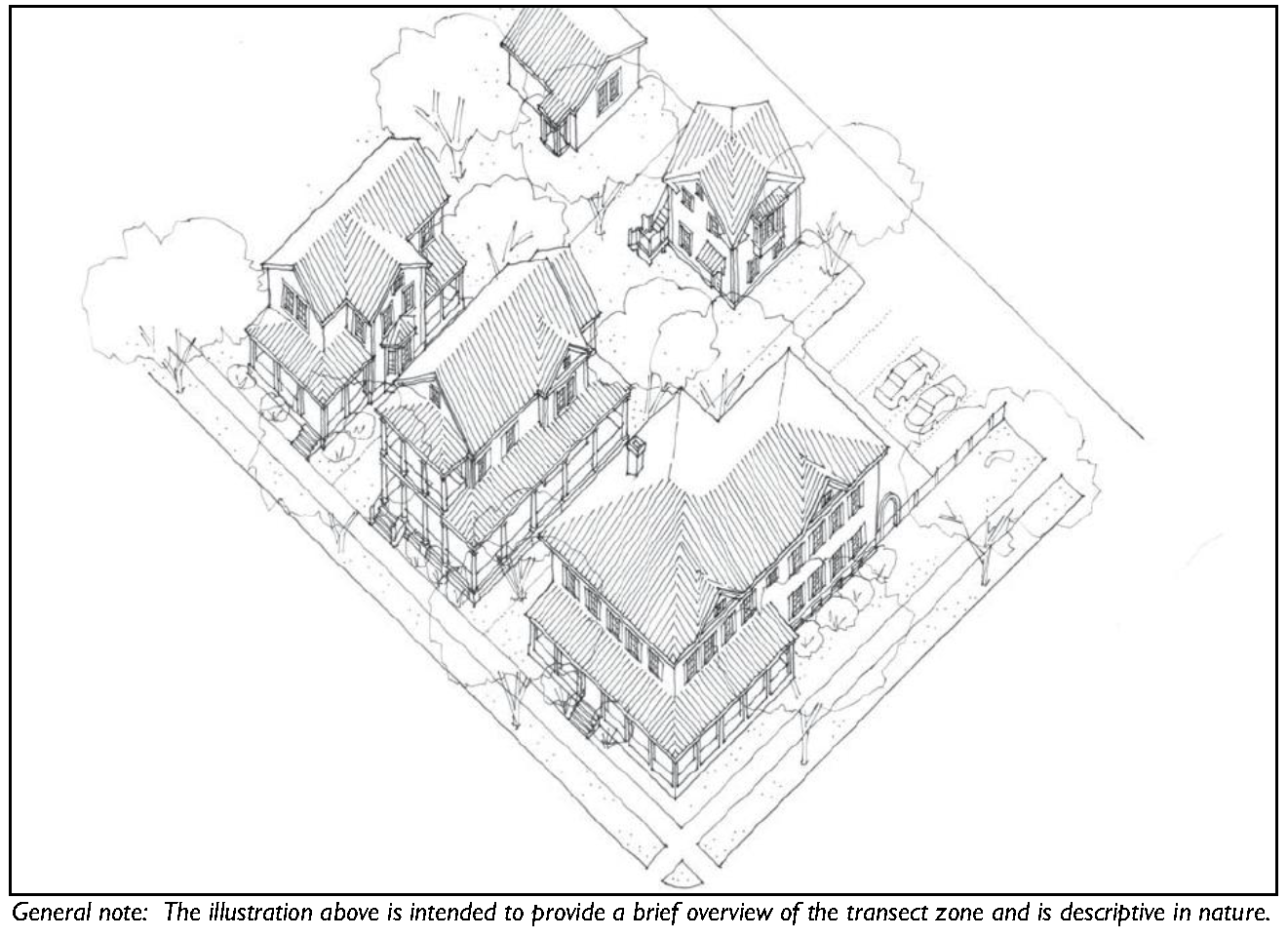
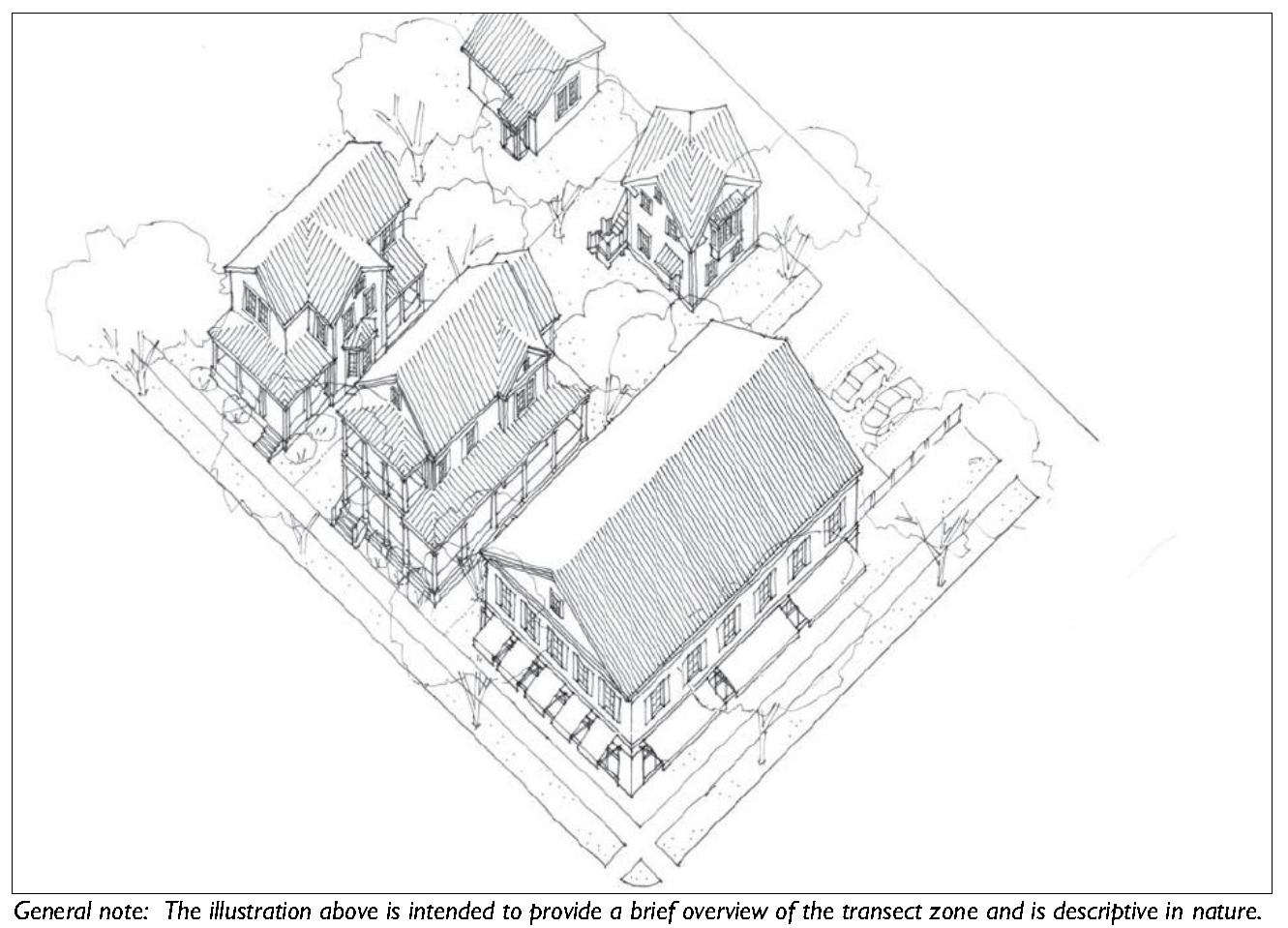
The transect zones are described in Division 3.2 (Transect Zones). They primarily focus on mixed-use, walkable areas of the County and range in function and density from primarily residential areas with a mix of building types (e.g. T3 Hamlet Neighborhood), to medium density neighborhoods and other commercial and retail areas (e.g. T4-Hamlet Center).

3.1.40 - Conventional Zones

The conventional zones are described in Division 3.3 (Conventional Zones). The conventional zones are primarily the zones that are more auto-dependent, such as single-family subdivisions, other suburban residential areas, auto-dependent commercial and retail areas, and industrial areas.

3.1.50 - Overlay Zones

The overlay zone standards are described in Division 3.4 (Overlay Zones). Overlay zones include areas of the County that are subject to additional design standards or limitations, such as the Airport MCAS Overlay.

3.1.60 - Consolidated Use Table

Table 3.1.60: Consolidated Use Table
Land Use Type T1 N T2R T2 RL T2 RN T2 RNO T2 RC T3E T3 HN T3 N T3 NO T4 HC T4 VC T4 HCO T4 NC C3 C4 C5 SI
AGRICULTURE
1. Agriculture & Crop Harvesting P P P P P P P P
2. Aquaponics S S S S S S S S
3. Agricultural Support Services P P P P P P P P TCP P P P
4. Animal Production C C C C
5. Animal Production: Factory Farming S
6. Seasonal Farmworker Housing C C C C C C C
7. Forestry P P P P P P P P P P P P P P P P P P
8. Commercial Stables C C C C C C
RESIDENTIAL
1. Dwelling: Single Family Detached Unit P P P P P P P P P P P P P P P P P
2. Dwelling: Single Family Attached Unit P P P P P TCP TCP
3. Dwelling: Two Family Unit (Duplex) P P P P P P P P TCP TCP
4. Dwelling: Multi-Family Unit P P P P P P C P P
5. Dwelling: Family Compound C C C C C C C C C C C C
6. Dwelling: Group Home P P P P P P P P P P P P P P P TCP TCP
7. Affordable Housing C
8. Community Residence (dorms, convents, assisted living, temporary shelters) P P P P P P P P P TCP TCP TCP
9. Home Office C C C C C C C C C C C C C C C C C C
10. Home Business C C C C C C C C C C C C C TCP TCP
11. Cottage Industry C C C C
12. Live/Work P P P P P TCP P P
13. Manufactured Home Community C
RETAIL AND RESTAURANTS
1. General Retail 3,500 SF or less C P P P P P P TCP P P C
2. General Retail 10,000 SF or less P P P P P P C
3. General Retail 25,000 SF or less P P P P P P C
4. General Retail 50,000 SF or less P P P P P
5. General Retail greater than 50,000 SF P P
6. General Retail with Drive-Through Facilities C C C C
7. Adult Oriented Business C
8. Bar, Tavern, Nightclub P P P P P
9. Gas Station/Fuel Sales S C C C C C C C C C
10. Open Air Retail P P
11. Restaurant, Café, Coffee Shop P P P P P P TCP P P C
12. Restaurant, Café, Coffee Shop with Drive-Through Facilities S S C C C
13. Vehicle Sales & Rental: Light C C C C
14. Vehicle Sales & Rental: Heavy P
OFFICES & SERVICES
1. General Offices & Services: 3,500 SF or less P P P P P P P C P P C
2. General Offices & Services: 10,000 SF or less P P P P P P C
3. General Offices & Services: 25,000 SF or less P P P P C
4. General Offices & Services: 50,000 SF or less P P C
5. General Offices & Services: greater than 50,000 SF P P C
6. General Offices & Services: with Drive-Through Facilities C C C C C C
7. Animal Services: Clinic/Hospital P P P P P P TCP P P
8. Animal Services: Kennel C C C C C C
9. Body Branding, Piercing, Tattooing C
10. Day Care: Family Home (up to 8 clients) P P P P P P P P P P P P P P TCP TCP
11. Day Care: Commercial Center (9 or more clients) C C C C C C C TCP C C C
12. Lodging: Short-Term Housing Rental (STHR) S S S S S S S S S S S S S S P P
13. Lodging: Inn (up to 24 rooms) S P P P P P TCP P P
14. Lodging: Hotel P P P P
15. Medical Service: Clinics/Offices P P P P P P P TCP P P
16. Medical Service: Hospital S
17. Residential Storage Facility C C C C C C C
18. Vehicle Services: Minor Maintenance and Repair C C C C C C
19. Vehicle Services: Major Maintenance and Repair C C C C C C
RECREATION, EDUCATION, SAFETY, PUBLIC ASSEMBLY
1. Community Oriented Cultural Facility (Less than 15,000 SF) P P P P P TCP P P
2. Community Oriented Cultural Facility (15,000 SF or greater) S S P P P P
3. Community Public Safety Facility P P P P P P P P P P P P P P P
4. Institutional Care Facility S S P P P P
5. Detention Facility S S
6. Meeting Facility/Place of Worship (Less than 15,000 SF) C C C C C C C C C C C C C C C
7. Meeting Facility/Place of Worship (15,000 or greater) S C C C C C C C C C
8. Park, Playground, Outdoor Recreation Areas P P P P P P P P P P P P P P P P P P
9. Recreation Facility: Commercial Indoor P P P P P P
10. Recreation Facility: Commercial Outdoor S C C C C
11. Recreation Facility: Community-Based P P P P P P
12. Recreation Facility: Golf Course P P
13. Recreation Facility: Primitive Campground C C
14. Recreation Facility: Semi-Developed Campground C C C C C
15. Recreation Facility: Developed Campground C C C
16. Ecotourism S C C C C
17. School: Public or Private S S P P P P P P
18. School: Specialized Training/Studio S P P P P P P P P P
19. School: College or University S S S S S S S
INFRASTRUCTURE, TRANSPORTATION, COMMUNICATIONS
1. Airport, Aviation Services S S
2. Infrastructure and Utilities: Regional (Major) Utility C C C C C S S S C C C C C C C C C
3. Parking Facility: Public or Commercial P P P P P P P
4. Transportation Terminal S P P P P P P
5. Waste Management: Community Waste Collection & Recycling C C C C C
6. Waste Management: Regional Waste Transfer & Recycling S C C
7. Waste Management: Regional Waste Disposal & Resource Recovery S S
8. Wireless Communications Facility S S S S S S S S S S C C C
INDUSTRIAL
1. Manufacturing, Processing, and Packaging - Light (Less than 15,000 SF) C C C C C C P
2. Manufacturing, Processing, and Packaging - Light (15,000 SF or greater) C P
3. Manufacturing, Processing, and Packaging - Heavy P
4. Mining & Resource Extraction S S
5. Outdoor Maintenance/Storage Yard C C P
6. Salvage Operations C
7. Warehousing C C C C
8. Wholesaling and Distribution C C C C
"P" indicates a Use that is Permitted By Right.
"C" indicates a Use that is Permitted with Conditions.
"S" indicates a Use that is Permitted as a Special Use.
"TCP" indicates a Use that is permitted only as part of a Traditional Community Plan under the requirements in Division 2.3.
"—" indicates a Use that is not permitted.


(Ord. No. 2015/32, § 1, 11-9-15; Ord. No. 2015/37, 12-14-15; Ord. No. 2017/31, 10-23-17; Ord. No. 2018/26, 6-25-18; Ord. No. 2019/34, 5-28-19; Ord. No. 2020/06, 3-9-20; Ord. No. 2020/32, 9-28-20; Ord. No. 2021/05, 1-11-21; Ord. No. 2021/45, 10-13-21; Ord. No. 2023/17, 4-24-23; Ord. No. 2024/41, Exh. A, 10-28-24)

3.1.70 - Land Use Definitions
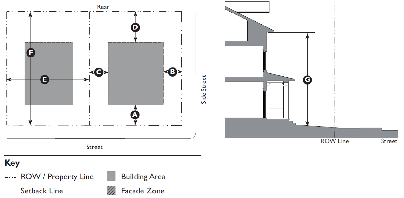
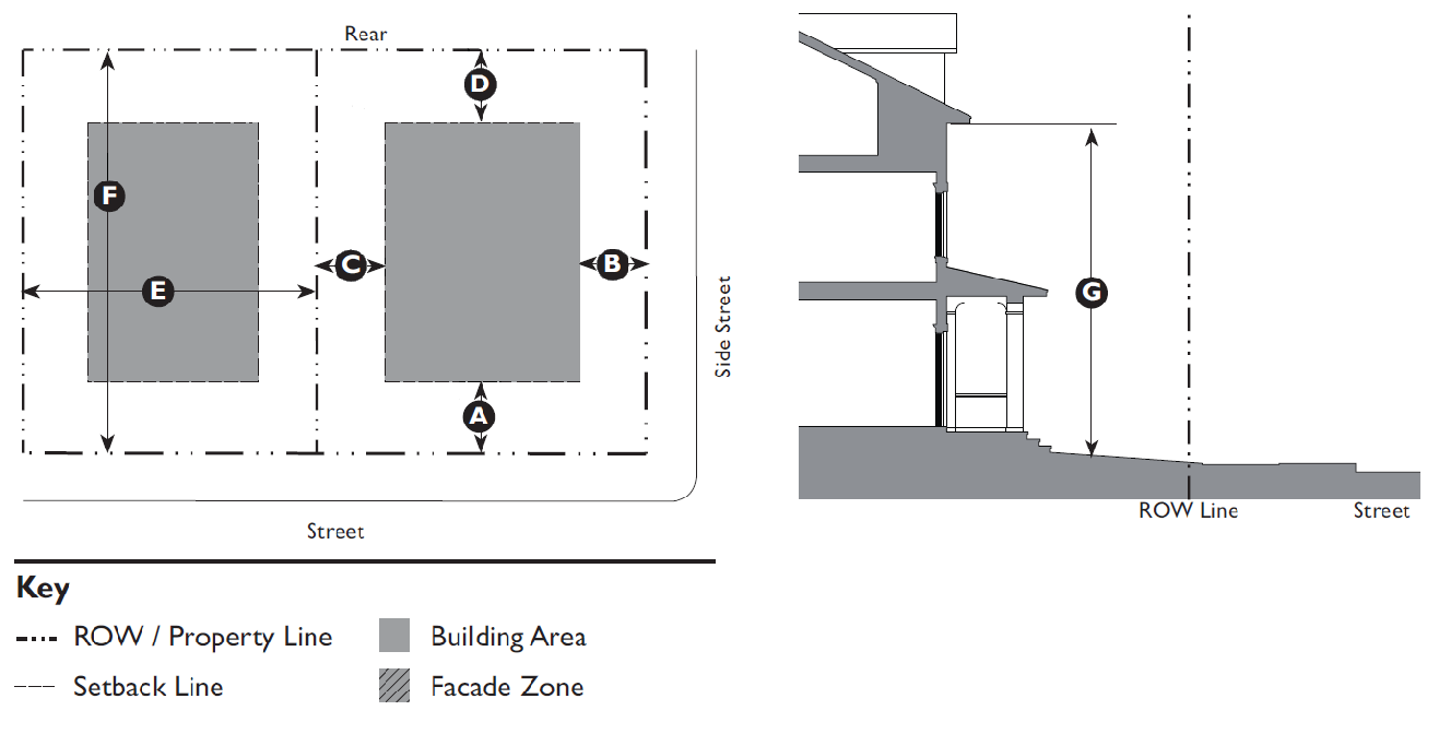
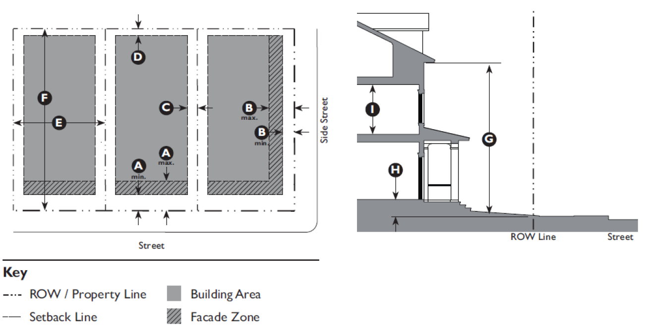
Table 3.1.70: Land Use Definitions
Land Use TypeDefinition
AGRICULTURE
This category is intended to encompass land uses connected with a business or activity involving farming, animal production, forestry, and other businesses serving primarily agricultural needs.
1. Agriculture and Crop Harvesting A nursery, orchard, or farm, greater than 10,000 SF, primarily engaged in the growth and harvesting of fruits, nuts, vegetables, plants, or sod. The premises may include agricultural accessory structures, plant nurseries, and secondary retail or wholesale sales.
2. Aquaponics The symbolic use of plants and fish in single environment where the fish thrive off of the plant waste and the plants absorb the fish waste as fertilizer. Both the fish and the plants are harvested.
3. Agricultural Support Services Nursery, orchard, forestry, or farm supply and support services including, but not limited to: Equipment dealers, support uses for agricultural, harvesting, and/or animal production, seasonal packing sheds, etc.
4. Animal Production The raising, breeding, feeding, and/or keeping of animals for the principal purpose of commercially producing products for human use or consumption, including, but not limited to: cattle, pigs, sheep, goats, fish (aquaculture), bees, rabbits, and poultry. This does not include "Factory Farming" operations.
5. Animal Production: Factory Farming The raising, breeding, feeding, and/or keeping of livestock (typically cows, pigs, turkeys, or chickens) in confinement at high stocking density for the purpose of commercially producing meat, milk, or eggs for human consumption.
6. Seasonal Farmworker Housing Housing located on farmland for temporary occupancy during seasonal farming activity.
7. Forestry Perpetual management, harvesting, replanting, and enhancement of forest resources for ultimate sale or use of wood products, subject to S.C. Forestry Commission BMPs.
8. Commercial Stables Stabling, training, feeding of horses, mules, donkeys, or ponies, or the provision of riding facilities for use other than by the resident of the property, including riding academies. Also includes any structure or place where such animals are kept for riding, driving, or stabling for compensation or incidental to the operation of any club, association, ranch or similar purpose.
RESIDENTIAL
Dwelling Unit - A room or group of internally connected rooms that have sleeping, cooking, eating, and sanitation facilities, but not more than one kitchen, which constitute an independent housekeeping unit, designed to be occupied as a residence by one household.
1. Dwelling: Single-Family Detached Unit A structure containing one dwelling unit on a single lot.
2. Dwelling: Single-Family Attached Unit A structure containing one dwelling unit on a single lot and connected along a property line to another dwelling unit on an adjoining lot by a common wall or other integral part of the principal building such as a breezeway or carport.
3. Dwelling: Two Family Unit (Duplex) A structure containing two dwelling units on a single lot.
4. Dwelling: Multi-Family Unit A structure containing three or more dwelling units on a single lot.
5. Reserved.
6. Dwelling: Family Compound A form of traditional rural development which provides for the placement of additional single-family detached dwelling units on, and/or subdivisions of, a single parcel of land owned by the same family for at least 50 years.
7. Dwelling: Group Home Residential facility for nine or fewer mentally or physically handicapped persons providing care on a 24-hour basis and licensed by a state agency or department, or is under contract with a state agency or department, for that purpose.
8. Community Residence 1. Dormitory: A building, or portion thereof, which contains living quarters for five or more students, staff, or members of a college, university, primary or secondary boarding school, theological school, or other comparable organization, provided that such building is either owned or managed by such organization, or is under contract with such organization for that purpose.
2. Convent or Monastery. The living quarters or dwelling units for a religious order or for the congregation of persons under religious vows.
3. Assisted Living Facility: A state-licensed facility for long-term residence exclusively by seniors and persons with disabilities who require assistance with daily activities, and which may include, without limitation, common dining, social and recreational features, special safety and convenience features designed for the needs of the elderly or disabled, such as emergency call systems, grab bars and handrails, special door hardware, cabinets, appliances, passageways, and doorways designed to accommodate wheelchairs, and the provision of social services for residents which must include at least two of the following: meal services, transportation, housekeeping, linen, and organized social activities. May include an accessory skilled nursing component.
4. Group Home (more than 9 persons). A state-licensed residential facility for more than 9 mentally or physically handicapped persons providing care on a 24-hour basis.
5. Temporary Shelter: A supervised publicly or privately operated shelter and services designed to provide temporary living accommodations to individuals or families who lack a fixed, regular and adequate residence. This does not include residential substance abuse facilities or halfway houses (see "Community Care Facility").
9. Affordable Housing See Section 4.1.350
10. Home Office An office use carried out for gain by a resident and conducted entirely within the resident's home. This use permits the employment of one individual who does not live in the home.
11. Home Business An office or service use carried out for gain by a resident and conducted entirely within the resident's home and/or accessory structures. This use permits the employment of up to three individuals who do not reside on the premises.
12. Cottage Industry Light industrial uses and boat, small engine (e.g. lawn mowers, but not vehicles), and farm equipment repair services carried out for gain by a resident and conducted on, or adjacent to, the property that contains the operator's residence. This use permits the employment of up to six individuals who do not reside on the premises.
13. Live/Work Unit An integrated housing unit and working space, occupied and utilized by a single household in a structure that has been designed or structurally modified to accommodate joint residential occupancy and work activity, and which includes: Complete kitchen, living, and sleeping space and sanitary facilities in compliance with the Building Code, and working space reserved for and regularly used by one or more occupants of the unit. Workspace is limited to a maximum fifty percent (50%) of the structure and located on the first floor with living space located to the rear or above. Activities are limited to those uses permitted in the underlying Zone in which the Live/Work unit is located.
14. Manufactured Home Community A single parcel of land that contains two or more manufactured homes for use as dwelling units where home sites are leased to individuals who retain customary leasehold rights. This use does not include "Family Compounds."
RETAIL AND RESTAURANTS
Stores and shops used for the sale and display of goods directly to a consumer and structures where the principal use is the preparation and sale of food and beverages.
1. General Retail:
 3,500 SF or less
 10,000 SF or less
 25,000 SF or less
 50,000 SF or less
 Greater than 50,000 SF
Stores and shops that sell and/or rent goods and merchandise to the general public. This category does not include "Open Air Retail," "Vehicle Sales and Rental," or "Gas Stations/Fuel Sales."
2. General Retail with a Drive-Through Facility Stores and shops where products may be purchased by motorists without leaving their vehicles.
3. Adult Oriented Business A place of business that sells, rents, leases, operates on commission or fee, purveys, displays, or offers only to or for adults: products; goods of any nature; images; reproductions; activities; opportunities for experiences or encounters; moving or still pictures; entertainment or amusement distinguished by purpose and emphasis on matters depicting, describing, or relating by any means of communication from one person to another to "specified sexual activities" or "specified anatomical areas".
4. Bar, Tavern, Nightclub 1. Bar, Tavern. A business where alcoholic beverages are sold for on-site consumption that is not part of a larger restaurant. Includes bars, taverns, pubs, and similar establishments where any food service is subordinate to the sale of alcoholic beverages. May also include beer brewing as part of a microbrewery ("brew-pub"), and other beverage tasting facilities.
2. Night Club. A facility serving alcoholic beverages for on-site consumption, and providing entertainment, examples of which include live music and/or dancing, comedy, etc. Does not include adult oriented businesses.
5. Gas Station/Fuel Sales An establishment where petroleum products are dispensed for retail sale. This use may include a retail convenience store and/or a single bay carwash. It does not include towing, vehicle body or engine repair (see "Vehicle Services"), or overnight vehicle storage.
6. Open Air Retail A retail sales establishment operated substantially in the open air including, but not limited to: flea markets, monument sales, beach recreation rentals, and the like. Does not include "Vehicle Sales and Rental", agricultural equipment sales and rental (see "Agricultural Support Services"), plant nurseries (see "Agriculture and Crop Harvesting"), or roadside stands and farmers markets (see "Temporary Uses").
7. Restaurant, Café, Coffee Shop A retail business selling ready-to-eat food and/or beverages for on- or off-premise consumption. These include eating establishments where customers are served from a walk-up ordering counter for either on- or off-premises consumption ("counter service"); and establishments where customers are served food at their tables for on-premises consumption ("table service"), that may also provide food for take-out, but does not include drive-through services, which are separately defined and regulated. This use includes all mobile kitchens.
8. Restaurant, Café, Coffee Shop with a Drive Through Facility Facilities where food or other products may be purchased by motorists without leaving their vehicles. Examples of drive-through sales facilities include fast-food restaurants and drive-through coffee shops, etc.
9. Vehicle Sales and Rental: Automobiles, Light Trucks, Boats A retail or wholesale establishment selling and/or renting automobiles, light trucks (less than 2-ton load capacity), vans, trailers, boats, and/or any other motorized or non-motorized vehicles (e.g. scooters, jet skis, golf carts, motorcycles) that includes outdoor display. May also include repair shops and the sales of parts and accessories incidental to vehicle dealerships. Does not include businesses dealing exclusively in selling used parts, auto wrecking and/or salvage (see "Salvage Operations"); the sale of auto parts/accessories separate from a vehicle dealership (see "General Retail"); or service stations (see "Vehicle Services").
10. Vehicle Sales and Rental: Heavy Equipment, Heavy Trucks, RVs, Mobile Homes A retail or wholesale establishment selling and/or renting heavy equipment and/or trucks, RVs, or mobile homes. May also include accessory repair shops. Does not include farm equipment (see "Agricultural Support Services").
OFFICES AND SERVICES
This category is intended to encompass activities, without outdoor storage needs, that are primarily oriented towards office and service functions.
1. General Offices & Services:
 3,500 SF or less
 10,000 SF or less
 25,000 SF or less
 50,000 SF or less
 Greater than 50,000 SF
1. Bank/Financial Services. Financial institutions, including, but not limited to: Banks, credit agencies, investment companies, security and commodity exchanges, ATM facilities.
2. Business Services. Establishments providing direct services to consumers, including, but not limited to: employment agencies, insurance agent offices, real estate offices, travel agencies, landscaping and tree removal companies, exterminators, carpet cleaners, and contractors' offices without exterior storage.
3. Business Support Services. Establishments providing services to other businesses, including, but not limited to: computer rental and repair, copying, quick printing, mailing and mailbox services.
4. Personal Services. Establishments providing non-medical services to individuals, including, but not limited to: barber and beauty shops, dry cleaners, small appliance repair, laundromats, massage therapists, pet grooming with no boarding, shoe repair shops, tanning salons, funeral homes. These uses may include incidental retails sales related to the services they provide.
5. Professional and Administrative Services. Office-type facilities occupied by businesses or agencies that provide professional or government services, or are engaged in the production of intellectual property.
2. General Offices & Services: with a Drive-Through Facility Facilities where services may be obtained by motorists without leaving their vehicles. Examples of drive-through services include bank teller windows and drive-up ATMs, dry cleaners, etc.
3. Animal Services: Animal Clinic/Hospital An establishment used by a veterinarian where animals are treated. This use may include boarding and grooming as accessory uses.
4. Animal Services: Kennel A commercial facility for the boarding, breeding, and/or maintaining of animals for a fee that are not owned by the operator. This use includes pet day care facilities, animal training facilities (except horses - see "Commercial Stables"), and may include grooming as an accessory use. This use includes the breeding of animals in outdoor structures, cages or pens for sale, but does not include animals for sale in pet shops (see "General Retail").
5. Body branding, piercing and tattoo facilities An establishment whose principal business is the one or more of the following: any invasive procedure in which a permanent mark is burned into or onto the skin using either temperature, mechanical or chemical means; creation of an opening in the body for the purpose of inserting jewelry or other decorations (not including ear piercing); and/or placing designs, letters, figures, symbols or other marks upon or under the skin of any person using ink or other permanent coloration.
6. Day Care: Family Care Home A state-licensed facility in a private home where an occupant of the residence provides non-medical care and supervision for up to 8 unrelated adults or children, typically for periods of less than 24 hours per day for any client.
7. Day Care: Commercial Center A state-licensed facility that provides non-medical care and supervision for more than 8 adults or children, typically for periods of less than 24 hours per day for any client. Facilities include, but are not limited to: nursery schools, preschools, after-school care facilities, and daycare centers.
8. Lodging: Short-Term Housing Rental (STHR) A property with a residential dwelling where lodging is offered, advertised, or provided to Short-Term Rental Tenants (excluding family members) for a fee or any form of compensation with individual rental terms not exceeding 29 consecutive days. In cases where Special Use approval is required, the Zoning Board of Appeals (ZBOA) may establish an appropriate rental limit as a condition of approval after conducting the public hearing and finding that conditions exist making such a limitation necessary. This definition does not regulate or replace other definitions for real or personal property taxes. Those standards must be complied with in accordance with the applicable regulations and State Laws.
9. Lodging: Inn A building or group of buildings used as a commercial lodging establishment, having up to 24 guest rooms, providing lodging accommodations to the general public.
10. Lodging: Hotel A lodging establishment of 25 or more rooms, in a building or group of buildings, offering transient lodging accommodations on a daily rate to the general public.
11. Medical Services: Clinics and Medical Offices 1. Clinic. A facility other than a hospital where medical, mental health, surgical and other personal health services are provided on an outpatient basis. Examples of these uses include: Medical offices with five or more licensed practitioners and/or medical specialties, outpatient care facilities, urgent care facilities, other allied health services. These facilities may also include incidental medical laboratories and/or pharmacies. Counseling services by other than medical doctors or psychiatrists are included under "General Services - Professional/Administrative."
2. Medical Office. A facility other than a hospital where medical, dental, mental health, surgical, and/or other personal health care services are provided on an outpatient basis, and that accommodates no more than four licensed primary practitioners (for example, chiropractors, medical doctors, psychiatrists, etc., other than nursing staff) within an individual office suite. A facility with five or more licensed practitioners is classified under "Medical Services - Clinic." Counseling services by other than medical doctors or psychiatrists are included under "General Services - Professional/Administrative."
12. Medical Services: Hospital An institution licensed by the State, where people, including inpatients, receive medical, surgical or psychiatric treatment and nursing care.
13. Residential Storage Facility A building or buildings consisting of individual, small, self-contained units that are leased or owned for the storage of household goods. Outdoor storage of boats, trailers, and vehicles may be provided as an accessory use.
14. Vehicle Services: Minor Maintenance and Repair Incidental minor repairs to include replacement of parts and service to passenger cars and light trucks, but not including, any operation defined as "Vehicle Services - Major Maintenance and Repair" or any other operation similar thereto. Examples include quick service oil, tune-ups, tires, brake and muffler shops. This use also includes car washes and detailing businesses as a principal use.
15. Vehicle Services: Major Maintenance and Repair General repair, rebuilding or reconditioning of boats and/or motor vehicles; collision service including body or frame straightening or repair; vehicle paint shops; auto wrecker services.
RECREATION, EDUCATION, SAFETY, PUBLIC ASSEMBLY
This category includes not-for-profit and for-profit Recreation, Education, Safety, and Public Assembly functions that benefit the citizens of the community.
1. Community Oriented Cultural Facility Public or non-profit facilities that provide educational and cultural experiences for the general public, examples of which include: Aquariums, arboretums, art galleries, botanical gardens, libraries, museums, planetariums, civic centers and theaters predominantly used for live performances, and zoos. May also include accessory retail uses such as a gift/book shop, restaurant, etc.
2. Community Public Safety Facility A public safety facility operated by a public agency including fire stations, other fire preventive and firefighting facilities, police and sheriff substations and headquarters, including interim holding facilities. May include ambulance dispatch on the same site. Does not include "Detention Facilities."
3. Institutional Care Facility Facilities licensed by the State that provide living, sleeping, and sanitation accommodations in coordination with the provision of social, rehabilitative and/or medical services in a protective living environment for persons residing voluntarily, by court placement, or under protective control of the federal, state or county government; including, but not limited to, post-correctional facilities, residential substance abuse treatment facilities, residential treatment facilities for the mentally ill, skilled nursing homes not part of an assisted living or continuing care facility (see "Community Residence").
4. Detention Facility A facility operated by a public agency, or is under contract with a public agency, that houses persons convicted of, or being held for, a crime. Such facilities include: prisons, detention facilities, work-release facilities, work camps, etc.
5. Meeting Facility/Place of Worship A facility for public or private meetings, including: community centers, places of worship (e.g., churches, mosques, synagogues, etc.), meeting halls for clubs and other membership organizations, etc. This use includes all cemeteries.
6. Parks, Playgrounds, Outdoor Recreation Areas An outdoor recreation facility that may provide a variety of recreational opportunities including playground equipment, playing fields, outdoor tennis and basketball courts, outdoor swimming pools, boat ramps and fishing piers; and areas for passive recreation such as hiking trails, picnic areas and bird blinds.
7. Recreation Facility: Commercial Indoor An establishment providing indoor amusement and entertainment services, often for a fee or admission charge, including, but not limited to: Bowling alleys, coin-operated amusement arcades, movie theaters, electronic game arcades (video games, pinball, etc.), indoor ice skating and roller skating rinks, pool and billiard rooms as primary uses. Does not include adult-oriented businesses. May include bars and restaurants as accessory uses. Any establishment with four or more electronic games or amusement devices (e.g., pool or billiard tables, pinball machines, etc.) or a premises where 50 percent or more of the floor area is occupied by electronic games or amusement devices is considered an indoor recreation facility; three or fewer machines or devices are not considered a use separate from the primary use of the site.
8. Recreation Facility: Commercial Outdoor A facility for outdoor recreational activities where a fee is often charged for use. Examples include, but are not limited to, amusement and theme parks; go-cart tracks; golf driving ranges; miniature golf courses; marinas; watercraft rentals; and water parks. May also include commercial facilities customarily associated with the above outdoor commercial recreational uses, including bars and restaurants, video game arcades, etc. Marinas may include marine-related retail (bait and tackle, boat supplies), fuel sales, minor boat repair, and boat storage. This use does not include golf courses or campgrounds.
9. Recreation Facility: Community-Based A community recreation center that may include one or more of the following: Gymnasium; indoor swimming pool; indoor tennis, racquetball, and/or handball courts, and other indoor sports activities. This use includes all not-for-profit organizations chartered to provide community-based recreation services. Does not include commercial health/fitness facilities, which are included under "General Offices and Services."
10. Recreation Facility: Golf Course An area of land with improvements to the grounds on which the sport of golf is played. It typically consists of a series of holes, each consisting of a tee box, a fairway, the rough and other hazards, and/or a green with a cylindrical hole in the ground, known as a cup. Golf course accessory uses may include a clubhouse, restrooms, driving range, and shelters.
11. Recreation Facility: Campground Form of lodging where guests bring tents, travel trailers, campers, or other similar forms of shelter to experience natural environments. Campgrounds rent two (2) or more pads or spaces to guests. May also include accessory uses such as a camp store, shower/bathroom facilities, and recreational facilities.
12. Ecotourism Organized, educational and mainly outdoor recreation with or without lodging that invites participants to learn about and promote ecological preservation, conservation, and sustainability. This use shall include at least two of the following characteristics:
1. Located near or within a wilderness setting, park, or protected area;
2. Interpretive educational program with or without guides;
3. Outdoor activities; or
4. Cultural experiences.
13. School: Public or Private A public or private academic educational institution, including elementary (kindergarten through 6th grade), middle and junior high schools (7th and 8th grades), secondary and high schools (9th through 12th grades), and facilities that provide any combination of those levels. May also include any of these schools that also provide room and board.
14. School: Specialized Training/Studios Small-scale facilities that provide individual and group instruction, education and/or training, including tutoring and vocational training in limited subjects, including, but not limited to: The arts, dance, photography, martial arts training, gymnastics instruction, production studios for individual musicians, painters, sculptors, photographers, and other artists, business and vocational schools, and driver education schools.
15. School: College or University A facility for post-secondary education that grants associates, bachelors, masters, or doctoral degrees, and may include research functions. Includes professional schools (law, medicine, etc.) and technical colleges.
INFRASTRUCTURE, TRANSPORTATION, COMMUNICATIONS
This category encompasses land uses that provide the underlying infrastructure, utilities, and systems that allow a community to function.
1. Airport/Aviation Services An airport, runway, landing strip, seaport, or heliport providing accommodations by public, private, or not-for-profit entities for the conveyance of persons from one location to another by airplane, seaplane, helicopter, or other means of aviation. Includes facilities for loading and unloading areas.
2. Infrastructure and Utilities: Regional (Major) Utility facilities that provide County-wide or regional service. Examples include public utility substations; water towers; waste treatment plants; and electrical substations.
3. Parking Facility, Public or Commercial A public or commercial parking lot or structure providing parking either for free or for a fee. Does not include towing impound and storage facilities.
4. Waste Management Facility: Community Waste Collection and Recycling A site, location, tract of land, or building that may be used for the purpose of collecting all types of residential waste and recyclables that are generated "off-site" in the local community to be transported by public or private companies to a waste recycling, transfer or disposal/recovery facility, permitted by South Carolina Department of Health and Environmental Control (SCDHEC) as required. This use includes county collection (convenience) centers.
5. Waste Management Facility: Regional Waste Transfer and Recycling A site, location, tract of land, or building that is used for the purpose of transferring solid wastes and recyclables that are collected from residential, commercial, and "Community Waste Collection and Recycling Facilities" prior to being transported to a solid waste disposal or resource recovery facility. Also includes facilities for separating and sorting recyclable materials from the waste stream.
6. Waste Management Facility: Regional Waste Disposal and Resource Recovery Disposal uses including sanitary landfills, construction waste and debris landfills, sludge disposal or storage; and resource recovery facilities, excluding disposal of industrial or radioactive waste materials.
7. Wireless Communications Facility Public, commercial and private electromagnetic and photoelectric transmission, broadcast, repeater and receiving stations for radio, television, telephone, data network, and wireless communications, including commercial earth stations for satellite-based communications. Includes antennas, commercial satellite dish antennas, and equipment buildings. Does not include telephone, telegraph and cable television transmission facilities utilizing hard-wired or direct cable connections.
INDUSTRIAL
1. Manufacturing, Processing, and Packaging - Light A facility accommodating manufacturing processes involving less intense levels of fabrication and/or production such as the assembly, fabrication, and conversion of already processed raw materials into products, where the operational characteristics of the manufacturing processes and the materials used are unlikely to cause significant impacts on surrounding land uses or the community. The premises may include secondary retail or wholesale sales. Examples of light manufacturing uses include: artisan / craft product manufacturing; clothing and fabric product manufacturing; furniture and fixtures manufacturing, cabinet shop, media production, photo/film processing lab not accessory to a retail business, printing & publishing, food preparation and packaging, winery, micro-brewery.
2. Manufacturing, Processing, and Packaging - Heavy A facility accommodating manufacturing processes that involve and/or produce basic metals, building materials, chemicals, fabricated metals, paper products, machinery, textiles, and/or transportation equipment, where the intensity and/or scale of operations may cause significant impacts on surrounding land uses or the community. Examples of heavy manufacturing uses include the following: chemical product manufacturing; concrete, gypsum, and plaster product manufacturing; glass product manufacturing; paving and roofing materials manufacturing; petroleum refining and related industries; plastics, other synthetics, and rubber product manufacturing; primary metal industries; pulp and pulp product manufacturing; textile and leather product manufacturing; food products manufacturing.
3. Mining & Resource Extraction Extractive uses such as surface mining for sand, gravel, clay and topsoil and any other such use. Quarrying is not permitted.
4. Outdoor Maintenance/ Storage Yard An outdoor storage area for large equipment, vehicles, and/or other materials used by a public agency or a general or specialty contractor; lumberyards; and other industrial outdoor storage uses, excluding salvage operations. May include an accessory office.
5. Salvage Operations Any land or structure used for storing, dismantling, reconditioning, collecting, purchasing or selling of scrap metal or other discarded goods and materials, including the collection, dismantlement and salvage of two or more inoperative vehicles, boats, trucks, or other types of machinery or equipment.
6. Warehousing Facilities for the storage of furniture, household goods, or other commercial goods of any nature. May include an outdoor storage component, provided that the outdoor storage is not the primary use. Does not include mini-storage facilities offered for rent or lease to the general public (see "Residential Storage Facility") or warehouse facilities primarily used for wholesaling and distribution (see "Wholesaling and Distribution").
7. Wholesaling and Distribution An establishment engaged in selling merchandise in bulk quantities to retailers; to contractors, industrial, commercial, agricultural, institutional, or professional business users; to other wholesalers; or acting as agents or brokers in buying merchandise for or selling merchandise to such persons or companies.


(Ord. No. 2015/32, § 1, 11-9-15; Ord. No. 2016/18, 6-27-16; Ord. No. 2017/20, 6-26-17; Ord. No. 2017/31, 10-23-17; Ord. No. 2018/26, 6-25-18; Ord. No. 2020/32, 9-28-20; Ord. No. 2021/05, 1-11-21; Ord. No. 2023/18, Exh. A, 5-8-23)

3.2.10 - Purpose

This Division provides regulatory standards governing land use and building form within the transect zones. The Form-Based Code is a reflection of the community vision for implementing the intent of the Comprehensive Plan to preserve Beaufort County's character and create walkable places. These standards are intended to ensure that proposed development is compatible with existing and future development on neighboring properties, and produces an environment of desirable character.

3.2.20 - Applicability

The requirements of this Division shall apply to all proposed development within the transect zones, and shall be considered in combination with the standards for specific uses in Article 4 (Specific to Use), if applicable, and the development standards in Article 5 (Supplemental to Zones). If there is a conflict between any standards, the provisions of Article 4 (Specific to Use) control over Article 3 (Specific to Zones) and Article 5 (Supplemental to Zones).

3.2.30 - T1 Natural Preserve (T1) Standards

A. Purpose
The Natural Preserve (T1) Zone is intended to preserve areas that contain sensitive habitats, open space, and limited agricultural uses. This Zone typically does not contain buildings; however, single-family dwellings, small civic buildings or interpretive centers may be located within this zone.


B. Building Placement
Setback (Distance from ROW/Property Line)
Front 50' min.
Side Street 50' min.
Side:
 Side, Main Building 50' min.
 Side, Ancillary Building 20' min.
Rear 100' min.
Lot Size (One Acre Minimum)
Width 150' min.
Depth n/a
Miscellaneous
Where existing adjacent buildings are in front of the regulated BTL or front setback, the building may be set to align with the façade of the front-most immediately adjacent property.
C. Building Form
Building Height
Main Building 35 feet/2 stories max.
Ancillary Building 35 feet/2 stories max.
Ground Floor Finish Level 1 No minimum
Footprint
Maximum Lot Coverage n/a
Lot coverage is the portion of a lot that is covered by any and all buildings including accessory buildings.
Notes
1 Buildings located in a flood hazard zone will be required to be built above base flood elevation in accordance with Beaufort County Building Codes
D. Gross Density 2
Gross Density 0.1 d.u./acre
2 Gross Density is the total number of dwelling units on a site divided by the Base Site Area (Division 6.1.40.F)
E. T1 Allowed Uses
Land Use Type 1 Specific Use RegulationsT1
Agricultural
Agriculture & Crop Harvesting P
Aquaponics 4.1.340 S
Forestry P
Residential
Dwelling: Single-Family Detached Unit P
Dwelling: Group Home P
Home Office 4.2.90 C
Recreation, Education, Safety, Public Assembly
Park, Playground, Outdoor Recreation Areas 2.8 P
Recreation Facility: Primitive Campground 4.1.190 P
Ecotourism 4.1.330 S
Key
P Permitted Use
C Conditional Use
S Special Use Permit Required
— Use Not Allowed
End Notes
1 A definition of each listed use type is in Table 3.1.70 Land Use Definitions.


(Ord. No. 2015/32, § 1, 11-9-15; Ord. No. 2017/31, 10-23-17; Ord. No. 2019/34, 5-28-19)

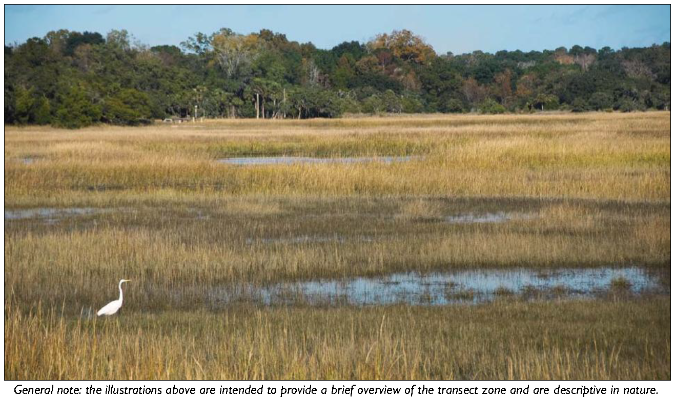
3.2.40 - T2 Rural (T2R) Standards

A. Purpose
The Rural (T2R) Zone is intended to preserve the rural character of Beaufort County. This Zone applies to areas that consist of sparsely settled lands in an open or cultivated state. It may include large lot residential, farms where animals are raised or crops are grown, parks, woodland, grasslands, trails, and open space areas.
The T2 Rural Zone implements the Comprehensive Plan goals of preserving the rural character of portions of Beaufort County.
B. Subzones
T2R-L (Rural-Low)
The intent of the T2R-L Sub-Zone is to provide a more rural, sparsely-developed character.


C. Building Placement
Setback (Distance from ROW/Property Line
Front 50' min.
Side Street 50' min.
Side
 Side, Main Building 18' min.
 Side, Ancillary Building 10' min.
Rear 50' min.
Lot Size (Half Acre Minimum)
Width 100' min.
Depth n/a
Miscellaneous
Where existing adjacent buildings are in front of the regulated BTL or front setback, the building may be set to align with the facade of the front-most immediately adjacent property.
D. Building Form
Building Height
Main Building 2 stories max.
Ancillary Building 2 stories max.
Ground Floor Finish Level 1 Footprint No minimum
Maximum Lot Coverage 2 n/a
Miscellaneous
Loading docks, overhead doors, and other service entries may not be located on street-facing facades.
Notes
1 Buildings located in a flood hazard zone will be required to be built above base flood elevation in accordance with Beaufort County Building Codes.
2 Lot coverage is the portion of a lot that is covered by any and all buildings including accessory buildings.
E. Gross Density 3
T2 Rural       T2 Rural-Low
Gross Density 0.34 d.u./acre       0.20 d.u./
acre
3 Gross Density is the total number of dwelling units on a site divided by the Base Site Area (Division 6.1.40.F)


F. Encroachments and Frontage Types
Encroachments
Front 5' max.
Side Street 5' max.
Side 5' max.
Rear 5' max.
Encroachments are not allowed within a Street ROW/Alley ROW, or across a property line.
See Division 5.2 (Private Frontage Standards) for further refinement of the allowed encroachments for frontage elements.
Allowed Frontage Types
Common Yard Porch: Engaged
Porch: Projecting
G. Parking
For parking space requirements see Table 5.5.40.B (Parking Space Requirements).
Location (Setback from Property Line)
Front 50' min.
Side Street 50' min.
Rear and interior side yard parking setbacks are governed by the applicable perimeter buffer (see Tables 5.8.90.D and 5.8.90.F) and any other required buffers.


H. T2R Allowed Uses


Land Use Type 1 Specific Use RegulationsT2RT2RL
Agricultural
Agriculture & Crop Harvesting P P
Aquaponics 4.1.430 S S
Agricultural Support Services P P
Animal Production 4.1.30 C
Animal Production: Factory Farming 4.1.30 S
Seasonal Farmworker Housing 4.1.90 C C
Forestry P P
Commercial Stables 4.1.50 C C
Residential
Dwelling: Single-Family Detached Unit P P
Dwelling: Family Compound 2.7.40 C C
Dwelling: Group Home P P
Home Office 4.2.90 C C
Home Business 4.2.80 C
Cottage Industry 4.2.40 C
Retail & Restaurants
General Retail 3,500 SF or less 4.1.120 C
Gas Station/Fuel Sales 4.1.100 S
Offices & Services
Animal Services: Kennel 4.1.40 C
Day Care: Family Home (up to 8 clients> P P
Lodging: Short-Term Housing Rental (STHR) 4.1.360 S S
Lodging: Inn (up to 24 rooms) 7.2.130 S
Recreation, Education, Safety, Public Assembly
Community Public Safety Facility P P
Institutional Care Facility 7.2.130 S
Detention Facility 7.2.130 S
Meeting Facility/Place of Worship (less than 15,000 SF) 4.1.150 C
Meeting Facility/Place of Worship (15,000 SF or greater) 4.1.150 S
Park, Playground, Outdoor Recreational Areas 2.8 P P
Recreation Facility: Commercial Outdoor 4.1.200 S
Recreation Facility: Golf Course P
Recreation Facility: Primitive Campground 4.1.190 P P
Recreation Facility: Semi-Developed Campgroud 4.1.190 P P
Ecotourism 4.1.330 C
Infrastructure, Transportation, Communications
Airport, Aviation Services 7.2.130 S
Infrastructure and Utilities: Regional (Major) Utility 4.1.210 C C
Waste Management: Community Waste Collection & Recycling 4.1.290 C
Waste Management: Regional Waste Transfer & Recycling 4.1.300 S
Waste Management: Regional Waste Disposal & Resource Recovery 4.1.310 S
Wireless Communications Facility 4.1.320 S S
Industrial
Mining & Resource Extraction 4.1.160 S S
Key
P  Permitted Use
C  Conditional Use
S  Special Use Permit Required
—  Use Not Allowed
End Notes
1 A definition of each listed use type is in Table 3.1.70 Land Use Definitions.


(Ord. No. 2015/32, § 1, 11-9-15; Ord. No. 2017/31, 10-23-17; Ord. No. 2019/34, 5-28-19; Ord. No. 2020/32, 9-28-20; Ord. No. 2021/05, 1-11-21; Ord. No. 2022/27, 6-13-22)

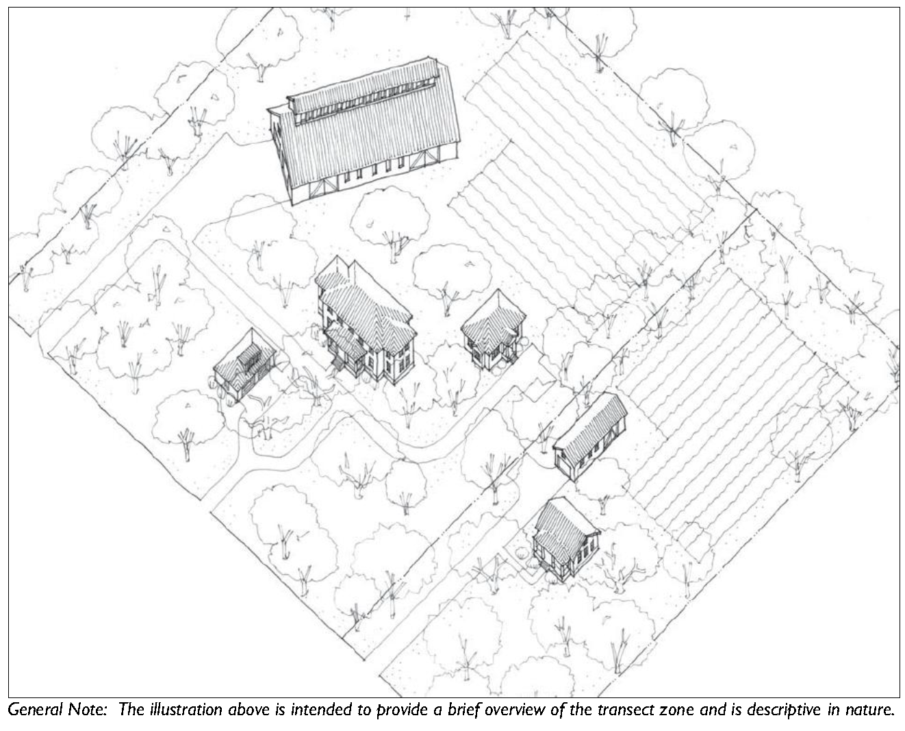
3.2.50 - T2 Rural Neighborhood (T2RN) Standards

A. Purpose
The Rural Neighborhood (T2RN) Zone protects the residential character of existing communities and neighborhoods in the rural area. The district is intended to minimize non-conforming lots and provide owners of small, clustered rural lots flexibility in the use of their land. The districts are established by identifying areas with five contiguous lots of five or fewer acres. It permits subdivision of existing lots to a maximum of 1.2 units to one-acre gross density, with DHEC approval, for wastewater treatment. The district is not intended to promote tract development or to encourage rezoning.
The T2 Rural Neighborhood (T2RN) Zone implements the Comprehensive Plan goals of preserving the rural character of portions of Beaufort County.
B. Subzones
T2 Rural Neighborhood Open
The T2 Rural Neighborhood Open (T2RNO) Subzone provides rural residential areas with limited retail and service uses in the scale and character of the T2RN zone.
C. Allowed Building Types
Building Type Specific Regulations
Carriage House 5.1.40
Estate House 5.1.50
Village House 5.1.60
Miscellaneous
Building Type Standards only apply to T2 Rural Neighborhood Open
Existing manufactured homes that are being replaced with another manufactured home that does not exceed the size and/or setbacks of the existing units are exempt from Building Type (Division 5.1) and Private Frontage (Division 5.2) Standards.


D. Building Placement
Setback (Distance from ROW/Property Line)
Front 35' min.
Side Street 20' min.
Side:
 Side, Main Building 12' min.
 Side, Ancillary Building 10' min.
Rear 50' min.
Lot Size (21,780 SF Minimum)
Width 100' min.
Depth n/a
Miscellaneous
Where existing adjacent buildings are in front of the regulated BTL or front setback, the building may be set to align with the façade of the front-most immediately adjacent property.
E. Building Form
Building Height
Main Building 2 stories max.
Ancillary Building 2 stories max.
Ground Floor Finish Level 1 No Minimum
Footprint
Maximum Lot Coverage 2 25% of lot area
Miscellaneous
Loading docks, overhead doors, and other service entries may not be located on street-facing facades.
Notes
1 Buildings located in a flood hazard zone will be required to be built above base flood elevation in accordance with Beaufort County Building Codes.
2 Lot coverage is the portion of a lot that is covered by any and all buildings including accessory buildings.
F. Gross Density 3 and Floor Area Ratio 4
Gross Density 1.2 d.u. per acre
Floor Area Ratio 0.25
3 Gross Density is the total number of dwelling units on a site divided by the Base Site Area (Division 6.1.40.F)
4 Floor Area Ratio applies to non-residential buildings. Floor Area Ratio is the gross floor area of a building or structure divided by the Base Site Area (Division 6.1.40.F)


G. Encroachments and Frontage Types
Encroachments
Front 5' max.
Side Street 5' max.
Side 5' max.
Rear 5' max.
Retail, Offices, Services 1 per 300 GSF
Encroachments are not allowed within a Street ROW/Alley ROW
Buffers, or across a property line. See Division 5.2 (Private Frontage Standards) for further refinement of the allowed encroachments for frontage elements.
Allowed Frontage Types
Common Yard Porch: Engaged
Porch: Projecting Shop front
H. Parking
For parking space requirements see Table 5.5.40.B (Parking Space Requirements).
Location (Setback from Property Line)
Front 35' min.
Side Street 20' min.
Rear and interior side yard parking setbacks are governed by the applicable perimeter buffer (see Tables 5.8.90.D and 5.8.90.F) and any other required buffers.


I. T2RN Allowed Uses


Land Use Type 1 Specific Use RegulationsT2RNT2RNO
Agricultural
Agriculture & Crop Harvesting P P
Aquaponics 4.1.430 S S
Agricultural Support Services P P
Animal Production 4.1.30 C C
Seasonal Farmworker Housing 4.1.90 C C
Forestry P P
Commercial Stables 4.1.50 C C
Residential
Dwelling: Single-Family Detached Unit P P
Dwelling: Family Compound 2.7.40 C C
Dwelling: Group Home P P
Home Office 4.2.90 C C
Home Business 4.2.80 C C
Cottage Industry 4.2.40 C C
Live/Work P
Retail & Restaurants
General Retail 3,500 SF or less P
Restaurant, Café, Coffee Shop P
Offices & Services
General Offices & Services 3,500 SF or less P
Day Care: Family Home (Up to 8 clients> P P
Day Care: Commercial Center (9 or more clients) 4.1.60 C
Lodging: Short-Term Housing Rental (STHR) 4.1.360 S S
Medical Offices: Clinics/Offices P
Recreation, Education, Safety, Public Assembly
Community Public Safety P P
Meeting Facility/Place of Worship (less than 15,000 SF) 4.1.150 C C
Park, Playground, Outdoor Recreation Areas P P
Recreation Facility: Primitive Campground 4.1.190 P P
Recreation Facility: Semi-Developed Campground 4.1.190 P P
Ecotourism 4.1.330 C C
Infrastructure, Transportation, Communications
Infrastructure and Utilities: Regional (Major) Utilities 4.1.210 C C
Wireless Communication Facility 4.1.320 S S
Key
P Permitted Use
C Conditional Use
S Special Use Permit Required
— Use Not Allowed
End Notes
1 A definition of each listed use type is in Table 3.1.70 Land Use Definitions.


(Ord. No. 2015/32, § 1, 11-9-15; Ord. No. 2017/31, 10-23-17; Ord. No. 2019/34, 5-28-19; Ord. No. 2021/05, 1-11-21; Ord. No. 2022/27, 6-13-22)

3.2.60 - T2 Rural Center (T2RC) Standards

A. Purpose
The Rural Center (T2RC) Zone applies to areas that are In the immediate vicinity of a Rural Crossroads or other important rural intersections, where service and limited commercial uses can cluster in more closely spaced buildings of residential character.
T2 Rural Center Zone implements the Comprehensive Plan goals of preserving the rural character of portions of Beaufort County.
B. Allowed Building Types
Building Type Specific Regulations
Carriage House 5.1.40
Estate House 5.1.50
Village House 5.1.60
Industrial/Agricultural 5.1.140


C. Building Placement
Setback (Distance from ROW/Property Line
Front 10' min.
30' max.
Side Street 10' min.
Side:
 Side, Main Building 15' min.
 Side, Ancillary Building 10' min.
Rear 25' min.
Lot Size (21,780 SF Minimum)
Width 50' min.
Depth 100' min.
Miscellaneous
Where existing adjacent buildings are in front of the regulated BTL or front setback, the building may be set to align with the façade of the front-most immediately adjacent property.
D. Building Form
Building Height
Main Building 2 stories max.
Ancillary Building 2 stories max.
Ground Floor Finish Level: 1
 Residential 18" min.
Commercial 6" min.
Footprint
Maximum Lot Coverage 2 25% of lot area
Miscellaneous
Loading docks, overhead doors, and other service entries may not be located on street-facing facades.
Notes
1 Buildings located in a flood hazard zone will be required to be built above base flood elevation in accordance with Beaufort County Building Codes.
2 Lot coverage is the portion of a lot that is covered by any and all buildings including accessory buildings.


E. Encroachments and Frontage Types
Encroachments
Front 5' max.
Side Street 5' max.
Side 5' max.
Rear 5' max.
Encroachments are not allowed within a Street ROW/Alley ROW, Buffers, or across a property line. See Division 5.2 (Private Frontage Standards) for further refinement of the allowed encroachments for frontage elements.
Allowed Frontage Types
Common Yard Porch: Engaged
Porch: Projecting Shop front
F. Parking
For parking space requirements see Table uses see Table 5.5.40.B (Parking Space Requirements).
Location (Setback from Property Line)
Front 10' min.
Side Street 15' min.
Rear and interior side yard parking setbacks are governed by the applicable perimeter buffer (see Tables 5.8.90.D and 5.8.90.F) and any other required buffers.


G. T2RC Allowed Uses


Land Use Type 1 Specific Use RegulationsT2RC
Agricultural
Agriculture & Crop Harvesting P
Aquaponics 4.1.430 S
Agricultural Support Services P
Animal Production 4.1.30 C
Seasonal Farmworker Housing 4.1.90
Forestry P
Commercial Stables 4.1.50 C
Residential
Dwelling: Single-Family Detached Unit P
Dwelling: Family Compound 2.7.40 C
Dwelling: Group Home P
Community Residence (dorms, Convents, assisted living, temporary shelters) P
Home Office 4.2.90 C
Home Business 4.2.80 C
Cottage Industry 4.2.40 C
Retail & Restaurants
General Retail 25,000 SF or less
Bar, Tavern, Nightclub P
Gas Station/Fuel Sales 4.1.100 C
Open Air Retail P
Restaurant, Café, Coffee Shop P
Vehicle Sales and Rental: Light 4.1.260 C
Offices & Services
General Offices & Services < 10,000 SF P
General Offices & Services: with Drive-Through Facilities 4.1.70 C
Animal Services: Clinic/Hospital P
Animal Services: Kennel 4.1.40 C
Day Care: Family Home (up to 8 Clients) P
Day Care: Commercial Center (9 or more clients) 4.1.60 C
Lodging: Short-Term Housing Rental (STHR) 4.1.360 S
Lodging: Inn (up to 24 rooms) P
Medical Service: Clinics/Offices P
Residential Storage Facility 4.1.220 C
Vehicle Services: Minor Maintenance and Repair 4.1.270 C
Vehicle Services: Major Maintenance and Repair 4.1.270 C
Recreation, Education, Safety, Public Assembly
Community Oriented Cultural Facility (less than 15,000 SF) P
Community Oriented Cultural Facility (greater than 15,000 SF) 7.2.130 S
Community Public Safety Facility P
Institutional Care Facility 7.2.130 S
Meeting Facility/Place of Worship (less than 15,000 SF) 4.1.150 C
Meeting Facility/Place of Worship (15,000 SF or greater) 4.1.150 C
Park, Playground, Outdoor Recreation Areas P
Recreation Facility: Community-Based P
Recreation Facility: Primitive Campground 4.1.190 P
Recreation Facility: Semi-Developed Campground 4.1.190 P
Recreation Facility: Developed Campground 4.1.190 P
Ecotourism 4.1.330 C
School: Public or Private 7.2.130 S
School: Specialized Training/Studio 7.2.130 S
School: College or University 7.2.130 S
Infrastructure, Transportation, Communications
Infrastructure and Utilities: Regional (Major) Utilities 4.1.210 C
Parking Facility, Public or Commercial P
Transportation, Terminal 7.2.130 S
Waste Management: Community Waste Collection & Recycling 4.1.290 C
Wireless Communications Facility 4.1.320 S
Industrial
Manufacturing, Processing, and Packaging - Light (less than 15,000 SF) 4.1.140 C
Outdoor Maintenance/Storage Yard 4.1.180 C
Warehousing 4.1.280 C
Wholesaling and Distribution 4.1.280 C
Key
P Permitted Use
C Conditional Use
S Special Use Permit Required
— Use Not Allowed
End Notes
1 A definition of each listed use type is in Table 3.1.70 Land Use Definitions.


(Ord. No. 2017/31, 10-23-17; Ord. No. 2019/34, 5-28-19; Ord. No. 2020/32, 9-28-20; Ord. No. 2021/05, 1-11-21; Ord. No. 2022/27, 6-13-22; Ord. No. 2023/17, 4-24-23)

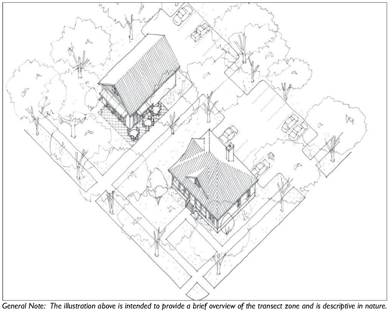
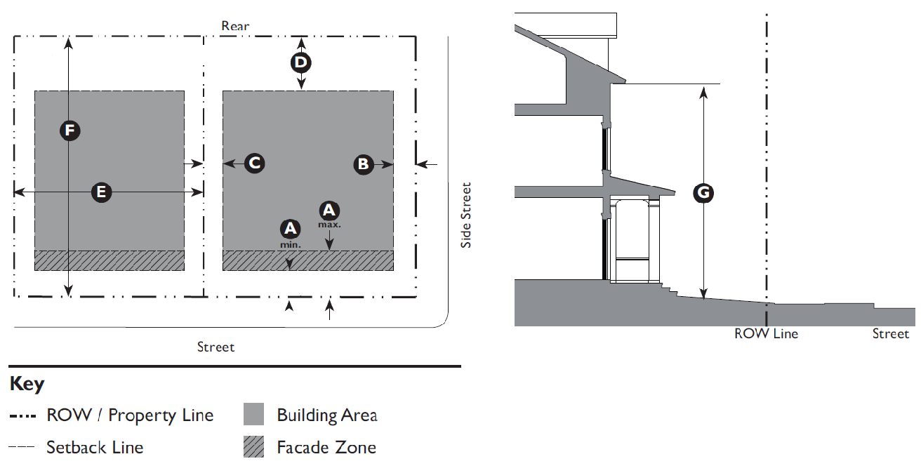
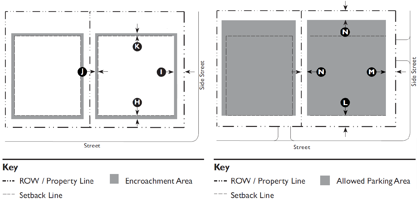
3.2.70 - T3 Edge (T3E) Standards

A. Purpose
The Edge (T3E) Zone is intended to reinforce established neighborhoods, to maintain neighborhood stability and provide a transition between the walkable neighborhood and Natural Preserves and Waterways.
The T3 Edge Zone implements the Comprehensive Plan goals of preserving the rural residential character of portions of Beaufort County, the City of Beaufort and Town of Port Royal.
B. Allowed Building Types
Building Type Specific Regulations
Carriage House 5.1.40
Estate House 5.1.50
Village House 5.1.60


C. Building Placement
Setback (Distance from ROW/Property Line
Front 25' min.
Side Street 15'' min.
Side:
 Side, Main Building 10' min.
 Side, Ancillary Building 5' min.
Rear 15' min.
Lot Size (11,250 SF Minimum)
Width 75' min.
Depth 150' min.
Miscellaneous
Where existing adjacent buildings are in front of the regulated BTL or front setback, the building may be set to align with the façade of the front-most immediately adjacent property.
D. Building Form
Building Height
Main Building 2.5 stories max.
Ancillary Building 2 stories max.
Ground Floor Finish Level 1 18" min.
Upper Floors(s) Ceiling 8' min. clear
Footprint
Maximum Lot Coverage 2 25% of lot area
Miscellaneous
Loading docks, overhead doors, and other service entries may not be located on street-facing facades
Notes
1 Buildings located in a flood hazard zone will be required to be built above base flood elevation in accordance with Beaufort County Building Codes.
2 Lot coverage is the portion of a lot that is covered by any and all buildings including accessory buildings.


E. Encroachments and Frontage Types
Encroachments
Front 5' max.
Side Street 5' max.
Side 3' max.
Rear 5' max.
Encroachments are not allowed within a Street ROW/Alley ROW, Buffers, or across a property line. See Division 5.2 (Private Frontage Standards) for further refinement of the allowed encroachments for frontage elements.
Allowed Frontage Types
Common Yard Porch: Engaged
Porch: Projecting Porch: Side Yard
F. Parking
For parking space requirements see Table 5.5.40.B (Parking Space Requirements).
Location (Setback from Property Line)
Front 50' min.
Side Street 25' min.
Side 0' min.
Rear 5' min.
Miscellaneous
12' maximum driveway width at the curb cut and within the front or side street parking setback. Community Residences and Meeting Facilities/Places of Worship are exempt from this requirement.


G. T3 E Allowed Uses


Land Use Type 1 Specific Use RegulationsT3E
Agricultural
Agriculture & Crop Harvesting P
Aquaponics 4.1.430 S
Seasonal Farmworker Housing 4.1.90 C
Forestry P
Residential
Dwelling: Single-Family Detached Unit P
Dwelling: Family Compound 2.7.40 C
Dwelling: Group Home P
Community Residence (dorms, convents, assisted living, temporary shelters) P
Home Office 4.2.90 C
Home Business 4.2.80 C
Offices & Services
Day Care: Family Home (up to 8 Clients) P
Lodging: Short-Term Housing Rental (STHR) 4.1.360 S
Recreation, Education, Safety, Public Assembly
Meeting Facility/Place of Worship (Less than 15,000 SF) 4.1.150 C
Park, Playground, Outdoor Recreation Areas P
Infrastructure, Transportation, Communications
Infrastructure and Utilities: Regional (Major) Utilities 4.1.210 S
Key
P Permitted Use
C Conditional Use
S Special Use Permit Required
— Use Not Allowed
End Notes
1 A definition of each listed use type is in Table 3.1.70 Land Use Definitions.


(Ord. No. 2017/31, 10-23-17; Ord. No. 2020/32, 9-28-20; Ord. No. 2021/05, 1-11-21; Ord. No. 2022/27)

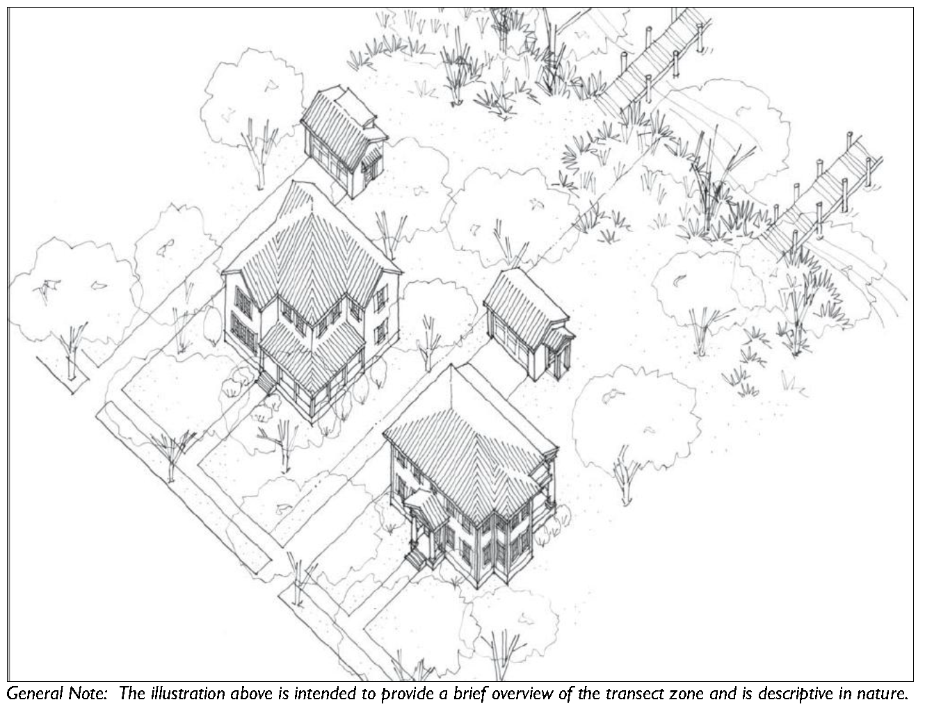
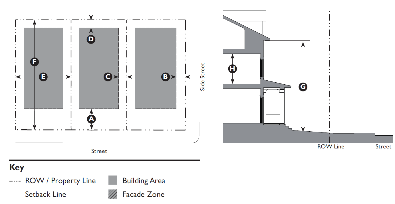
3.2.80 - T3 Hamlet Neighborhood (T3HN) Standards

A. Purpose
The Hamlet Neighborhood (T3HN) Zone is intended to reinforce established neighborhoods, to maintain neighborhood stability and provide a transition between the walkable neighborhood and rural areas.
The T3 Hamlet Neighborhood Zone implements the Comprehensive Plan goals of preserving the rural residential character of portions of Beaufort County, the City of Beaufort and Town of Port Royal.
B. Allowed Building Types
Building Type Specific Regulations
Carriage House 5.1.40
Estate House 5.1.50
Village House 5.1.60
Duplex 5.1.90


C. Building Placement
Setback (Distance from ROW/Property Line)
Front 25' min., 35' max.
Side Street 15' min, 25' max.
Side:
 Side, Main Building 10' min.
 Side, Ancillary Building 5' min.
Rear 15' min.
Lot Size (7,500 SF Minimum)
Width 65' min.
Depth 100' min.
Miscellaneous
Where existing adjacent buildings are in front of the regulated BTL or front setback, the building may be set to align with the façade of the front-most immediately adjacent property.
D. Building Form
Building Height
Main Building 2.5 stories max.
Ancillary Building 2 stories max.
Ground Floor Finish Level 1 18" min.
Upper Floors(s) Ceiling 8' min. clear
Footprint
Miscellaneous
Loading docks, overhead doors, and other service entries may not be located on street-facing facades.
Notes
1 Buildings located in a flood hazard zone will be required to be built above base flood elevation in accordance with Beaufort County Building Codes.
2 Lot coverage is the portion of a lot that is covered by any and all buildings including accessory buildings.


E. Encroachments and Frontage Types
Encroachments
Front 5' max.
Side Street 5' max.
Side 3' max.
Rear 5' max.
Encroachments are not allowed within a Street ROW/Alley ROW, buffers, or across a property line.
See Division 5.2 (Private Frontage Standards) for further refinement of the allowed encroachments for frontage elements.
Allowed Frontage Types
Common Yard Porch: Engaged
Porch: Projecting Porch: Side Yard
F. Parking
For parking space requirements see Table 5.5.40.B (Parking Space Requirements).
Location (Setback from Property Line)
Front 50' min.
Side Street 25' min.
Side 0' min.
Rear 5' min.
Miscellaneous
12' maximum driveway width at the curb cut and within the front or side street parking setback. Community Residences and Meeting Facilities/Places of Worship are exempt from this requirement.


G. T3 HN Allowed Uses


Land Use Type 1 Specific Use RegulationsT3HN
Agricultural
Forestry P
Residential
Dwelling: Single-Family Detached Unit P
Dwelling: Two Family Unit (Duplex) P
Dwelling: Family Compound 2.7.40 C
Dwelling: Group Home P
Community Residence (dorms, convents, assisted living, temporary shelters) P
Home Office 4.2.90 C
Home Business 4.2.80 C
Offices & Services
Day Care: Family Home (up to 8 clients) P
Lodging: Short-Term Housing Rental (STHR) 4.1.360 S
Recreation, Education, Safety, Public Assembly
Meeting Facility/Place of Worship (Less than 15,000 SF) 4.1.150 C
Park, Playground, Outdoor Recreation Areas P
Infrastructure, Transportation, Communications
Infrastructure and Utilities: Regional (Major) Utility 4.1.210 S
Key
P Permitted Use
C Conditional Use
S Special Use Permit Required
— Use Not Allowed
End Notes
1 A definition of each listed use type is in Table 3.1.70 Land Use Definitions.


(Ord. No. 2015/32, § 1, 11-9-15; Ord. No. 2020/32, 9-28-20; Ord. No. 2021/05, 1-11-21; Ord. No. 2022/27, 6-13-22)

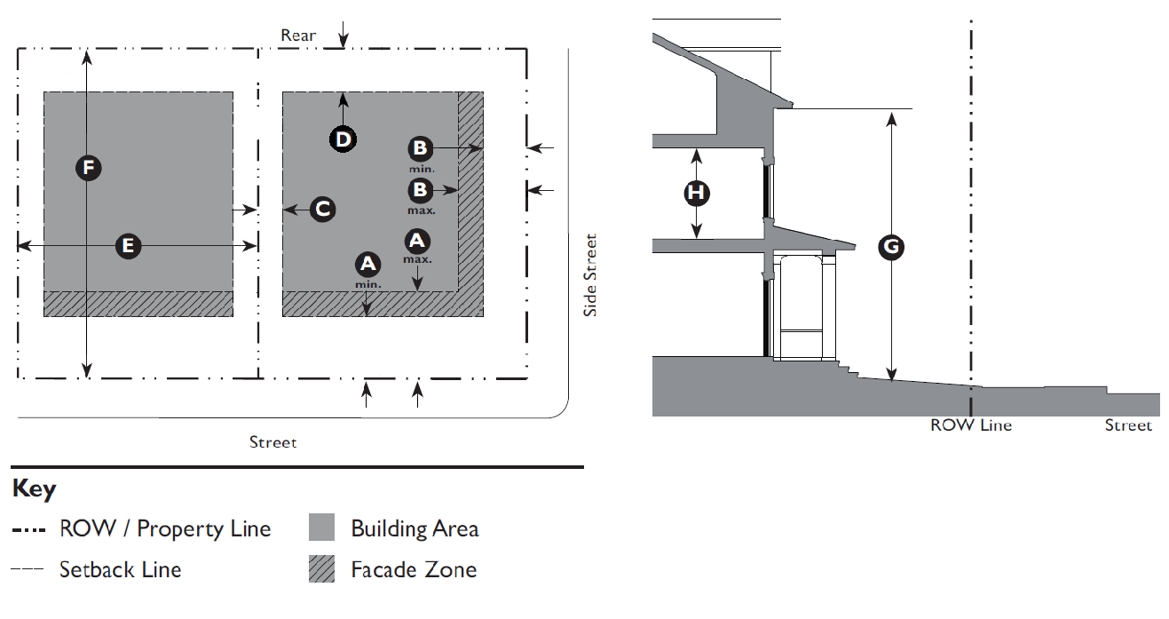
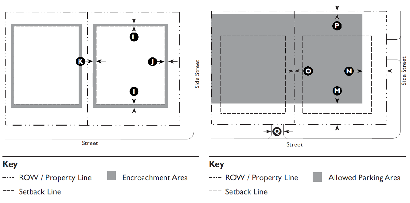
3.2.90 - T3 Neighborhood (T3N) Standards

A. Purpose
The Neighborhood (T3N) Zone is intended to provide a walkable, predominantly single-family neighborhood that integrates compatible multi-family housing types, such as duplexes and cottage courts within walking distance to transit and commercial areas.
The T3 Neighborhood Zone implements the Comprehensive Plan goals of preserving and building upon the walkable character of portions of Beaufort County, the City of Beaufort and Town of Port Royal.
B. Subzones
T3N-O (Open)
The intent of the T3N-O is to provide a more diverse set of allowed uses within a residential form in areas where residential uses are transitioning into commercial uses.
C. Allowed Building Types
Building Type Specific Regulations
Carriage House 5.1.40
Estate House 5.1.50
Village House 5.1.60
Cottage Court 5.1.80
Duplex 5.1.90
Mansion Apartment 5.1.110


D. Building Placement
Setback (Distance from ROW/Property Line)
Front 15' min., 20' max.
Side Street 10' min., 20' max.
Side:
 Side, Main Building 7½' min.
 Side, Ancillary Building 5' min.
Rear
 Rear, Main Building 15' min.
 Rear, Ancillary Building 5' min.
Façade within Façade Zone:
Front 75%
 Side Street 50%
Lot Size (20,000 SF Maximum)
Width 100' max.
Depth 200' max.
Miscellaneous
Where existing adjacent buildings are in front of the regulated BTL or front setback, the building may be set to align with the façade of the front-most immediately adjacent property.
Maximum lot size does not apply to Recreation, Education, Safety, Public Assembly uses
E. Building Form
Building Height
Main Building 2.5 stories max.
Ancillary Building 2 stories max.
Ground Floor Finish Level 1 18" min.
Upper Floors(s) Ceiling 8' min. clear
Footprint
Maximum Lot Coverage 2 30% of lot area
Miscellaneous
Loading docks, overhead doors, and other service entries may not be located on street-facing facades.
Notes
1 Buildings located in a flood hazard zone will be required to be built above base flood elevation in accordance with Beaufort County Building Codes.
2 Lot coverage is the portion of a lot that is covered by any and all buildings including accessory buildings.


F. Encroachments and Frontage Types
Encroachments
Front 5' max.
Side Street 5' max.
Side 3' max.
Rear 5' max.
Encroachments are not allowed within a Street ROW/Alley ROW, buffers, or across a property line.
See Division 5.2 (Private Frontage Standards) for further refinement of the allowed encroachments for frontage elements.
Allowed Frontage Types
Common Yard Porch: Engaged
Porch: Projecting Porch: Side Yard
G. Parking
For parking space requirements see Table 5.5.40.B (Parking Space Requirements).
Location (Setback from Property Line)
Front 40' min.
Side Street 15' min.
Side 0' min.
Rear 5' min.
Miscellaneous
12' maximum driveway width at the curb cut and within the front or side street parking setback.


H. T3N Allowed Uses


Land Use Type 1 Specific Use RegulationsT3NT3NO
Agricultural
Forestry P P
Residential
Dwelling: Single-Family Detached Unit P P
Dwelling: Two Family Unit (Duplex) P P
Dwelling: Multi-Family Unit P P
Dwelling: Group Home P P
Community Residence: (dorms, convents, assisted living, temporary shelters) P P
Home Office 4.2.90 C C
Home Business 4.2.80 C C
Offices & Services
General Offices & Services 10,000 SF or less P
Animal Services: Clinic/Hospital P
Day Care: Family Home (up to 8 clients P P
Day Care: Commercial Center (9 or more clients) 4.1.60 C
Lodging: Short-Term Housing Rental (STHR) 4.1.360 S S
Medical Services: Clinics/Offices P
Recreation, Education, Safety, Public Assembly
Community Public Safety P P
Facility
Meeting Facility/Place of Worship (less than 15,000 SF) 4.1.150 C C
Meeting Facility/Place of Worship (15,000 SF or greater) 4.1.150 C
Park, Playground, Outdoor Recreation Areas P P
School: Public or Private 7.2.130 S
School: Specialized Training Studio P
Infrastructure, Transportation, Communications
Infrastructure and Utilities: Regional (Major) Utility 4.1.210 C S
Key
P  Permitted Use
C  Conditional Use
S  Special Use Permit Required
—  Use Not Allowed
End Notes
1 A definition of each listed use type is in Table 3.1.70 Land Use Definitions.


(Ord. No. 2016/18, 6-27-16; Ord. No. 2020/32, 9-28-20; Ord. No. 2021/05, 1-11-21; Ord. No. 2022/27, 6-13-22)

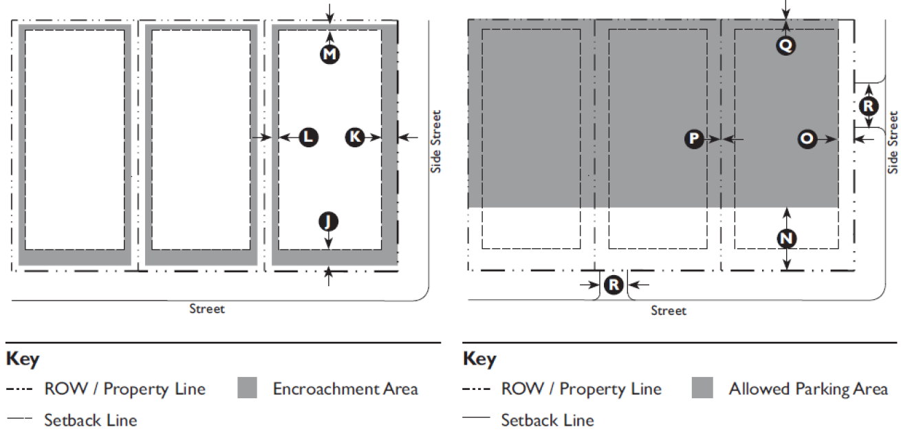
3.2.100 - T4 Hamlet Center (T4HC) Standards

A. Purpose
The Hamlet Center (T4HC) Zone is intended to integrate appropriate, medium-density residential building types, such as duplexes, townhouses, small courtyard housing, and mansion apartments in an environment conducive to walking and bicycling.
The T4 Hamlet Center is appropriate for more rural areas, implementing the Comprehensive Plan goals of creating areas of medium intensity residential in portions of Beaufort County, the City of Beaufort and Town of Port Royal.
B. Sub-Zones
T4HC-O (Open)
The intent of the T4HC-O Sub-Zone is to provide neighborhoods with a broader amount of retail and service uses in the scale and character of the T4HC zone.
T4VC (Village Center - St. Helena)
The Village Center (T4VC) Zone provides a tailored set of land uses for St. Helena Island.
C. Allowed Building Types
Building Type Specific Regulations
Carriage House 5.1.40
Village House 5.1.60
Small Lot House 5.1.70
Cottage Court 5.1.80
Duplex 5.1.90
Townhouse 5.1.100
Mansion Apartment 5.1.110
Apartment House 5.1.120
Industrial Agriculture 5.1.140
Notes
The use of this building type is limited to non-residential uses.


D. Building Placement
Setback (Distance from ROW/Property Line)
Front 10' min., 25' max.
Side Street 10' min., 20' max.
Side:
 Side, Main Building 5' min.
 Side, Ancillary Building 5' min.
Rear 5' min.
Façade within Façade Zone:
 Front 75%
 Side Street 50%
Notes
1 A Parking Lot Perimeter Strip (Section 5.8.80.C) utilizing a decorative fence or wall can substitute up to 50% of the required facade within the facade zone.
Lot Size (37,500 SF Maximum)
Width 150 ft. max.
Miscellaneous
Where existing adjacent buildings are in front of the regulated BTL or front setback, the building may be set to align with the façade of the front-most immediately adjacent property.
Maximum lot size does not apply to Recreation, Education, Safety, Public Assembly uses and buildings with a footprint exceeding 10,000 square feet.
E. Building Form
Building Height
Main Building 2.5 stories max.
Ancillary Building 2 stories max.
Ground Floor Finish Level: 1
 Residential 18" min.
 Commercial (T4HC-O) 6" max.
Ground Floor Ceiling:
 Commercial (T4HC-O) 10' min.
Upper Floor(s) Ceiling 8' min.
Ground Floor lobbies and Common areas in multi-unit buildings may have a 0" to 6" ground floor finish level.
Within 25' of the rear property line, buildings may not be more than a half-story taller than the allowed height of adjacent buildings.
Footprint
Width: Main Building 100' max. 2
All upper floors may have a primary entrance along the front. Loading docks, overhead doors, and other service entries may not be located on street-facing fades.
Notes
1 Buildings located in a flood hazard zone will be required to be built above base flood elevation in accordance with Beaufort County Building Codes.
2 Buildings with a footprint exceeding 15,000 square feet are exempt from the maximum building width requirements.


F. Encroachments and Frontage Types
Encroachments
Front 12' max.
Side Street 12' max.
Side 3' max.
Rear 3' max.
Encroachments are not allowed across a side or rear property line, or across a curb.
See Division 5.2 (Private Frontage Standards) for further refinement of the allowed encroachments for frontage elements.
Allowed Frontage Types
Common Yard Forecourt
Porch: Projecting Dooryard
Porch: Engaged Porch: Side Yard
Stoop Shopfront 1
Terrace 1
1 Allowed in T4HC-O Sub-Zone only.
G. Parking
Required Spaces: Residential Uses
Single-family detached 2 per unit
Single-family attached/duplex 2 per unit
Community residence 1 per bedroom
Required Spaces: Service or Retail Uses
Retail, Offices, Services 1 per 300 GSF
Restaurant, Café, Coffee Shop 1 per 150 GSF
Drive-through Facility Add 5 stacking spaces per drive-through
Gas Station/Fuel Sales 1 per pump plus requirements for retail
Lodging: Inn/hotel 1 per room
Required Spaces: Industrial Uses
Light manufacturing, processing and packaging 1 per 500 GSF
Warehousing/Distribution 1 per 2,000 GSF
Parking standards listed within the district shall govern. For parking space requirements other uses see Table 5.5.40.B (Parking Space Requirements).
Location (Setback from Property Line)
Front: 5' behind front facade of main building
Side Street: 5' behind side facade of main building
Side: 0' min.
Rear: 5' min.
Miscellaneous
Parking Driveway Width
 40 spaces or less 14' max.
 Greater than 40 spaces 18' max.


H. T4HC, T4VC, and T4 HCO Allowed Uses


Land Use Type 1 Specific Use RegulationsT4HCT4VCT4HCO
Agricultural
Agricultural Support Services P P P
Forestry P P P
Residential
Dwelling: Single-Family Detached P P P
Dwelling: Single-Family Attached P P P
Dwelling: Two-Family Unit (Duplex) P P P
Dwelling: Multi-Family Unit P P P
Dwelling: Family Compound 4.1.80 C
Dwelling: Group Home P P P
Community Residence (dorms, convents, assisted living, temporary shelters) P P P
Home Office 4.2.90 C C C
Home Business 4.2.80 C C C
Live/Work P P P
Retail & Restaurants
General Retail: 3,500 SF or less P P P
General Retail: 50,000 SF or less P P
Bar, Tavern, Nightclub P P
Gas Station/Fuel Sales 4.1.100 C C C
Restaurant, Café, Coffee Shop P P P
Restaurant, Café, Coffee Shop with Drive-Thru Facilities 4.1.70 S
Vehicle Sales and Rental: Light 4.1.260 C
Offices & Services
General Offices & Services 3,500 SF or less P P P
General Offices & Services 10,000 SF or less P P
General Offices & Services 25,000 SF or less P
General Offices & Services with Drive-Thru Facilities 4.1.110
4.1.70
C
Animal Services: Clinic/Hospital P P P
Animal Services: Kennel 4.1.40 C
Day Care: Family Home (up to 8 clients) P P P
Day Care: Commercial Center (9 or more clients) 4.1.60 C C C
Lodging: Short-Term Housing Rental (STHR) 4.1.360 S S S
Lodging: Inn (up to 24 rooms) P P P
Lodging: Hotel P
Medical Service: Clinics/Offices P P P
Residential Storage Facility 4.1.220 C C
Vehicle Services: Minor 4.1.270 C C
Maintenance & Repair
Vehicle Services: Major Maintenance & Repair 4.1.270 C
Key
P  Permitted Use
C  Conditional Use
S  Special Use Permit Required
—  Use Not Allowed
End Notes
1 A definition of each listed use type is in Table 3.1.70 Land Use Definitions.


H. T4HC, T4VC, and T4 HCO Allowed Uses


Land Use Type 1 Specific Use RegulationsT4HCT4VCT4HCO
Recreation, Education, Safety, Public Assembly
Community Oriented Cultural Facility (less than 15,000 SF) P P P
Community Oriented Cultural Facility (15,000 SF or greater) 7.2.130 S P
Community Public Safety Facility P P P
Institutional Care Facility P
Meeting Facility/Place of Worship (less than 15,000 SF) 4.1.140 C C C
Meeting Facility/Place of Worship (15,000 SF or greater) 4.1.140 C C C
Park, Playground, Outdoor Recreation Area P P P
Recreation Facility: Commercial Indoor P P P
Recreation Facility: Commercial Outdoor 4.1.200 C C
Recreation Facility: Community-Based P P
School: Public or Private P P P
School: Specialized Training/Studio P P P
School: College or University 7.2.130 S S
Infrastructure, Transportation, Communications
Infrastructure and Utilities: Regional (Major) Utility 4.1.210 C C C
Parking Facility, Public or Commercial P P
Transportation Terminal P P
Wireless Communication Facility 4.1.320 S S S
Industrial
Manufacturing, Processing & Packaging - Light (less than 15,000 SF) 4.1.140 C C C
Warehousing 4.1.280 C
Wholesaling and Distribution 4.1.280 C
Key
P  Permitted Use
C  Conditional Use
S  Special Use Permit Required
—  Use Not Allowed
End Notes
1 A definition of each listed use type is in Table 3.1.70 Land Use Definitions.


(Ord. No. 2015/32, § 1, 11-9-15; Ord. No. 2015/33, 11-9-15; Ord. No. 2020/06, 3-9-20; Ord. No. 2020/32, 9-28-20; Ord. No. 2021/05, 1-11-21; Memo of 3-14-22; Ord. No. 2022/27, 6-13-22)

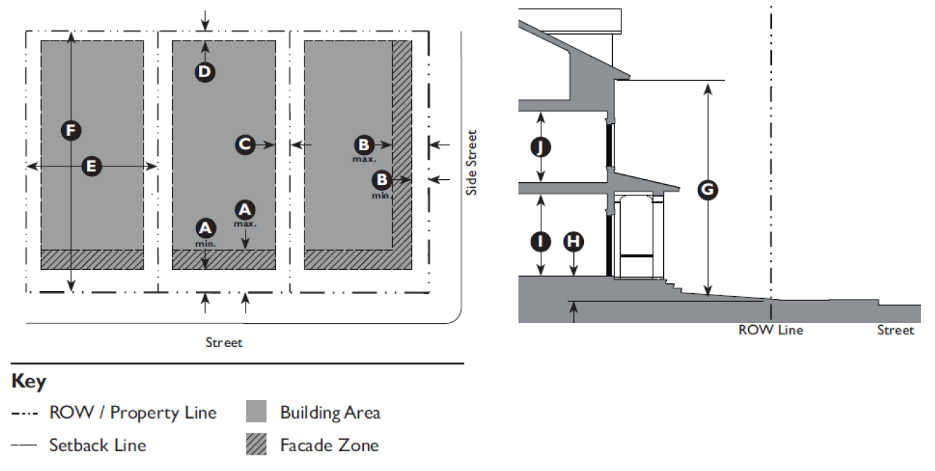
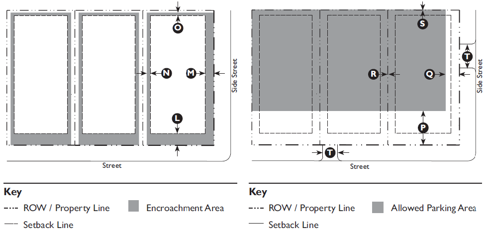
3.2.110 - T4 Neighborhood Center (T4NC) Standards
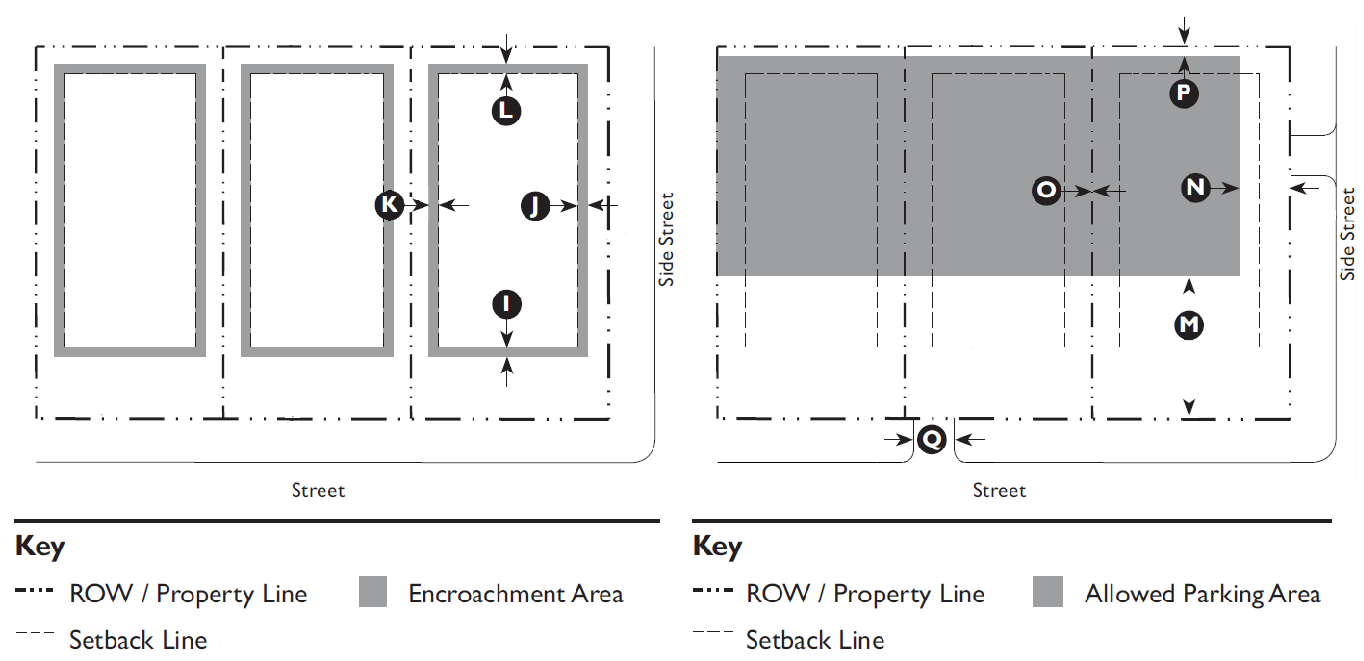
A. Purpose
The Neighborhood Center (T4NC) Zone is intended to integrate vibrant main-street commercial and retail environments into neighborhoods, providing access to day-to-day amenities within walking distance, creating potential for a transit stop, and serving as a focal point for the neighborhood.
The T4 Neighborhood Center Zone implements the Comprehensive Plan goals of creating areas of higher intensity residential and commercial uses in Beaufort County, the City of Beaufort and Town of Port Royal.
B. Allowed Building Types
Building Type Specific Regulations
Carriage House 5.1.40
Small Lot House 5.1.70
Cottage Court 5.1.80
Duplex 5.1.90
Townhouse 5.1.100
Mansion Apartment 5.1.110
Apartment House 5.1.120
Main Street Mixed Use 5.1.130
Industrial Agriculture 5.1.140


C. Building Placement
Setback (Distance from ROW/Property Line)
Front 0' min., 15' max.
Side Street 0' min., 10' max
Side:
 Main Building 3' min.
 Ancillary Building 0' min.
Rear 5' min.
Façade within Façade Zone:
 Front 75%
 Side Street 50%
Lot Size (62,500 SF Maximum)
Width 250' max.
Depth 250' max.
Miscellaneous
Where existing adjacent buildings are in front of the regulated BTL or front setback, the building may be set to align with the facade of the front-most immediately adjacent property.
No planting strips are allowed between sidewalk and building.
Maximum lot size does not apply to Recreation, Education, Safety, Public Assembly uses and buildings with a footprint exceeding 20,000 square feet.
D. Building Form
Building Height
Main Building 2 stories min., 1
4 stories max.
Ancillary Building 2 stories max.
Ground Floor Finish Level: 2
 Residential 18" min.
 Commercial 6" max.
Ground Floor Ceiling:
Commercial 10' min.
Upper Floor(s) Ceiling 8' min.
Ground Floor lobbies and common areas in multi-unit buildings may have a 0" to 6" ground floor finish level.
Within 25' of the rear property line, buildings may not be more than a half-story taller than the allowed height of adjacent buildings.
Footprint
Width: Main Building 250' max.
Miscellaneous
Distance Between Entries, to Upper Floor(s) 80'
All upper floors must have a primary entrance along the front.
Loading docks, overhead doors, and other service entries may not be located on street-facing facades.
Notes
1 On Lady's Island, one-story buildings are permitted; multi-story buildings are recommended.
2 Buildings located in a flood hazard zone will be required to be built above base flood elevation in accordance with Beaufort County Building Codes.


E. Encroachments and Frontage Types
Encroachments
Front 12' max.
Side Street 12' max.
Side 3' max.
Rear 3' max.
Encroachments are not allowed across a side or rear property line, or across a curb.
See Division 5.2 (Private Frontage Standards) for further refinement of the allowed encroachments for frontage elements.
Awnings, Galleries and Arcades may encroach further into the street ROW to within 2' of the face of curb. Eaves may encroach up to 3' into the street ROW. All other encroachments are not allowed within street ROW.
Allowed Frontage Types
Porch: Projecting Dooryard
Porch: Engaged Porch: Side Yard
Stoop Shop front
Forecourt Terrace
Gallery
F. Parking
Required Spaces: Residential Uses
Single-family detached 2 per unit
Single-family attached/duplex 2 per unit
Community residence 1 per bedroom
Live/work       2 per unit plus 1 per 300 GSF of work area
Required Spaces: Service or Retail Uses
Retail, offices, services 1 per 300 GSF
Restaurant, café, coffee shop 1 per 150 GSF
Drive-through facility       Add 5 stacking spaces per drive-through
Gas station/fuel sales       1 per pump plus requirement for retail
Lodging: Inn/hotel 1 per room
Required Spaces: Industrial Uses
Light manufacturing, processing and packaging 1 per 500 GSF
Warehousing/Distribution 1 per 2,000 GSF
Parking standards listed within the district shall govern. For parking space requirements for all other allowed uses see Table 5.5.40.B (Parking Space Requirements).
Location (Setback from Property Line)
Front 40' min.
Side Street 15' min.
Side 0' min.
Rear 5' min.
Miscellaneous
Parking Driveway Width:
 40 spaces or less 14' max.
 Greater than 40 spaces 18' max.


G. T4NC Allowed Uses


Land Use Type 1 Specific Use RegulationsT4NC
Agricultural
Forestry P
Residential
Dwelling: Single-Family Detached Unit P
Dwelling: Single-Family Attached Unit P
Dwelling: Two-Family Unit (Duplex) P
Dwelling: Multi-Family Unit P
Dwelling: Group Home P
Community Residence (dorms, convents, assisted living, temporary shelters P
Home Office 4.2.90 C
Home Business 4.2.80 C
Live/Work P
Retail & Restaurants
General Retail greater than 50,000 SF P
General Retail with Drive-Through Facilities 4.1.120
4.1.70
C
Bar, Tavern, Nightclub P
Gas Station/Fuel Sales 4.1.100 C
Restaurant, Café, Coffee Shop P
Restaurant, Café, Coffee Shop With Drive-Through Facilities 4.1.70 S
Offices & Services
General Offices & Services: greater than 50,000 SF P
General Offices & Services: with Drive-Through Facilities 4.1.110
4.1.70
C
Animal Services: Clinic/Hospital P
Animal Services: Kennel 4.1.40 C
Day Care: Family Home (up to 8 clients) P
Day Care: Commercial Center (9 or more clients) 4.1.60 C
Lodging: Short-Term Housing Rental 4.1.360 S
Lodging: Inn (up to 24 rooms) P
Lodging: Hotel P
Medical Services: Clinics/Offices P
Medical Services: Hospital 7.2.130 S
Vehicle Services: Minor Maintenance and Repair 4.1.270 C
Vehicle Services: Major Maintenance and Repair 4.1.270 C
Recreation, Education, Safety, Public Assembly
Community Oriented Cultural Facility (less than 15,000 SF) P
Community Oriented Cultural Facility (15,000 SF or greater) P
Community Public Safety Facility P
Institutional Care Facility P
Meeting Facility/Place of Worship (less than 15,000 SF) 4.1.150 C
Meeting Facility/Place of Worship (15,000 SF or greater) 4.1.150 C
Park, Playground, Outdoor Recreation Areas P
Recreation Facility: Commercial Indoor P
Recreation Facility: Community-Based P
School: Public or Private P
School: Specialized Training/Studio P
School: College or University 7.2.130 S
Infrastructure, Transportation, Communications
Infrastructure and Utilities: Regional (Major) Utility 4.1.210 C
Parking Facility: Public or Commercial P
Transportation Terminal P
Wireless Communication Facility 4.1.320 S
Industrial
Manufacturing, Processing, and Packaging - Light (less than 15,000 SF) 4.1.140 C
Key
P  Permitted Use
C  Conditional Use
S  Special Use Permit Required
—  Use Not Allowed
End Notes
1 A definition of each listed use type is in Table 3.1.70 Land Use Definitions.


(Ord. No. 2015/32, § 1, 11-9-15; Ord. No. 2020/32, 9-28-20; Ord. No. 2021/05, 1-11-21; Memo of 3-14-22; Ord. No. 2022/27, 6-13-22)

3.3.10 - Purpose

This Division provides regulatory standards governing land use and building form within the conventional zones. These standards are a reflection of the community vision for implementing the intent of the Comprehensive Plan. They are intended to ensure that proposed development is compatible with existing and future development on neighboring properties, and produces an environment of desirable character, consistent with the Comprehensive Plan.

3.3.20 - Applicability

The requirements of this Division shall apply to all proposed development within the conventional zones, and shall be considered in combination with the standards for specific uses in Article 4 (Specific to Use), if applicable, and the development standards in Article 5 (Supplemental to Zones). If there is a conflict between any standards, the provisions of Article 4 (Specific to Use) control over Article 3 (Specific to Zones) and Article 5 (Supplemental to Zones).

3.3.30 - Neighborhood Mixed Use (C3) Zone Standards

A. Purpose
The Neighborhood Mixed Use (C3) Zone provides for high-quality, moderate-density (averaging under three dwelling units per acre) residential development, with denser areas of multi-family and mixed-use development to provide walkability and affordable housing options. The design requirements are intended to provide a suburban character and encourage pedestrian, as well as automobile, access.
Open spaces shall be provided in sufficient quantity to ensure an open quality with a predominance of green space. Non-residential uses shall be limited to parcels having access to arterial or collector streets or within a Traditional Community Plan. This Zone provides for the lower densities of areas designated Neighborhood Mixed-Use in the Comprehensive Plan. It is intended to support the development of communities with a diverse range of housing types and uses.
B. Building Placement
Setback (Distance from ROW/Property Line)
Front 30' min. 1
Side:
 Side, Main Building 10' min.
 Side, Ancillary Building 10' min.
Rear 50' min.
1 The minimum front setback for mansion apartments in a Multi-family community on internal streets is 15 feet.
Lot Size
Lot Size 10,890 SF min.
Width 70' min.
Minimum Site Area
Single-Family and Duplex 10,890 SF
Multi-Family 21,780 SF
Note:
For development within a Traditional Community Plan meeting the requirements of Division 2.3, setback, minimum lot size and minimum site area requirements of the transect zone established and delineated on the regulating plan shall apply.
C. Building Form
Building Height
Single Family and Duplex 2.5 stories max.
Multi-Family 2.5 stories max.
Non-Residential Buildings 2 stories max.
Institutional Buildings 35 feet above grade
Ground Floor Finish Level No minimum
D. Gross Density 1 and Floor Area Ratio
Gross Density
Single-Family Detached 2.6 d.u./acre
Single-Family Attached/Duplex 2.6 d.u./acre
Multi-Family Unit 12 d.u./acre, Maximum of 80 Dwelling units
Traditional Community Plan 3.5 d.u./acre 2
Floor Area Ratio
Non-residential buildings 0.18 max.
1 Gross Density is the total number of dwelling units on a site divided by the Base Site Area (Division 6.1.40.F)
2 Subject to the requirements in Division 2.3
E. Parking
For parking space requirements see Table 5.5.40.B (Parking Space Requirements).


G. C3 Allowed Uses


Land Use Type 1 Specific Use RegulationsC3
Agricultural
Agriculture & Crop Harvesting P
Agricultural Support Services 2.3 TCP
Seasonal Farmworker Housing 4.1.90 C
Forestry P
Commercial Stables 4.1.50 C
Residential
Dwelling: Single-Family Detached Unit P
Dwelling: Single-Family Attached Unit P
Dwelling: Two-Family Unit (Duplex) P
Dwelling: Multi-Family Unit 4.1.170 C
Dwelling: Group Home P
Dwelling: Family Compound 2.7.40 C
Community Residence (dorms, convents, assisted living, temporary shelters) 2.3 TCP
Home Office 4.2.90 C
Home Business 4.2.80 C
Live/Work 2.3 TCP
Manufactured Home Community 4.1.130 C
Retail & Restaurants
General Retail 3,500 SF or less 2.3 TCP
Gas Station/Fuel Sales 4.1.100 C
Restaurant, Café, Coffee Shop 2.3 TCP
Offices & Services
General Offices & Services 3,500 SF or less 4.1.110 C
Animal Services: Clinic/Hospital 2.3 TCP
Day Care: Family Home (up to 8 clients> P
Day Care: Commercial Center (9 or more clients) 2.3 TCP
Lodging: Short-Term Housing Rental (STHR) 4.1.360 S
Lodging: Inn (up to 24 rooms) 2.3 TCP
Medical Service: Clinics/Offices 2.3 TCP
Recreation, Education, Safety, Public Assembly
Community Oriented Cultural Facility (less than 15,000 SF) 2.3 TCP
Community Public Safety Facility P
Meeting Facility/Place of Worship (less than 15,000 SF) 4.1.150 C
Meeting Facility/Place of Worship (15,000 SF or greater) 4.1.150 C
Park, Playground, Outdoor Recreation Areas P
Recreation Facility: Golf Course P
School: Public or Private P
School: Specialized Training/Studio P
School: College or University 7.2.130 S
Infrastructure, Transportation, Communications
Infrastructure and Utilities: Regional (Major) Utility 4.1.210 C
Wireless Communications Facility 4.1.320 S
Key
P Permitted Use
C Conditional Use
S Special Use Permit Required
TCP Permitted only as part of a Traditional Community Plan under the requirements in Division 2.3
— Use Not Allowed
End Notes
1 A definition of each listed use type is in Table 3.1.70 Land Use Definitions.


(Ord. No. 2015/32, § 1, 11-9-15; Ord. No. 2015/33, 11-9-15; Ord. No. 2016/18, 6-27-16; Ord. No. 2017/9, 4-10-17; Ord. No. 2020/32, 9-28-20; Ord. No. 2021/05, 1-11-21; Ord. No. 2022/27, 6-13-22)

3.3.40 - Community Center Mixed Use (C4) Zone Standards

A. Purpose
The Community Center Mixed Use (C4) Zone provides for a limited number of retail, service, and office uses intended to serve the surrounding neighborhood.
These are smaller uses and not highway service types of uses. The intensity standards are set to ensure that the uses have the same suburban character as the surrounding suburban residential areas. They are intended to blend with the surrounding areas, not threaten the character of the area. This Zone shall not consist of strip developments but rather neighborhood centers with a sense of place.
B. Building Placement
Setback (Distance from ROW/Property Line)
Front 20' min.
Side:
 Side, Main Building 10' min.
 Side, Ancillary Building 10' min.
Rear 15' min.
Lot Size
Lot Size 5,000 SF min.
Width 50' min.
Minimum Site Area
Single-Family and Duplex 5,000 SF
Multi-Family 21,780 SF
Note:
For development within a Traditional Community Plan meeting the requirements of Division 2.3, setback, minimum lot size and minimum site area requirements of the transect zone established and delineated on the regulating plan shall apply.
C. Building Form
Building Height
Single-Family and Duplex 2.5 stories max.
Multi-Family 3 stories max.
Non-Residential Buildings 2 stories max.
Ground Floor Finish Level No minimum
D. Gross Density 1 and Floor Area Ratio
Gross Density 12 d.u./acre max.
Floor Area Ratio 2 0.23 max.
1 Gross Density is the total number of dwelling units on a site divided by the Base Site Area (Division 6.1.40.F).
2 Requirement applies to non-residential buildings.
E. Parking
For parking space requirements see Table 5.5.40.B (Parking Space Requirements).


F. C4 Allowed Uses


Land Use Type 1 Specific Use RegulationsC4
Agriculture
Agricultural Support Services P
Forestry P
Residential
Dwelling: Single-Family Detached Unit P
Dwelling: Single-Family Attached Unit 2.3 TCP
Dwelling: Two-Family Unit (Duplex) 2.3 TCP
Dwelling: Multi-Family Unit P
Dwelling: Accessory Unit 2.3 TCP
Dwelling: Family Compound 2.7.40 C
Dwelling: Group Home 2.3 TCP
Community Residence (dorms, convents, assisted living, temporary shelters 2.3 TCP
Home Office 4.2.90 C
Home Business 2.3 TCP
Live/Work P
Retail & Restaurants
General Retail 50,000 SF or less P
General Retail with Drive-Through Facilities 4.1.120
4.1.70
C
Bar, Tavern, Nightclub P
Gas Station/Fuel Sales 4.1.100 C
Restaurant, Café, Coffee Shop P
Restaurant, Café, Coffee Shop with Drive-Through Facilities 4.1.70 C
Vehicle Sales & Rental: Light 4.1.260 C
Offices & Services
General Offices & Services 25,000 SF or less P
General Offices & Services with Drive-Through Facilities 4.1.110
4.1.70
C
Animal Services: Clinic/Hospital P
Animal Services: Kennel 4.1.40 C
Day Care: Family Home (up to 8 clients) 2.3 TCP
Day Care: Commercial Center (9 or more clients) 4.1.60 C
Lodging: Short-Term Housing Rental (STHR) 4.1.360 P
Lodging: Inn (up to 24 rooms) P
Lodging: Hotel P
Medical Services: Clinics/Offices P
Residential Storage Facility 4.1.220 C
Vehicle Services: Minor Maintenance and Repair 4.1.270 C
Vehicle Services: Major Maintenance and Repair 4.1.270 C
Recreation, Education, Safety, Public Assembly
Community Oriented Cultural Facility (Less than 15,000 SF) P
Community Oriented Cultural Facility (15,000 SF or greater) P
Community Public Safety Facility P
Institutional Care Facility P
Meeting Facility/Place of Worship (less than 15,000 SF) 4.1.150 C
Meeting Facility/Place of Worship (15,000 SF or greater) 4.1.150 C
Park, Playground, Outdoor Recreation Areas P
Recreation Facility: Commercial Indoor P
Recreation Facility: Commercial Outdoor 4.1.200 C
Recreation Facility: Community-Based P
Recreation Facility: Developed Campground 4.1.190 P
School, Public or Private P
School: Specialized Training/Studio P
School: College or University 7.2.130 S
Infrastructure, Transportation, Communications
Infrastructure and Utilities: Regional (Major) Utility 4.1.210 C
Parking Facility, Public or Commercial P
Transportation Terminal P
Waste Management: Community Waste Collection & Recycling 4.1.290 C
Wireless Communications Facility 4.1.320 S
Industrial
Manufacturing, Processing, and Packaging - Light (Less than 15,000 SF) 4.1.140 C
Key
P  Permitted Use
C  Conditional Use
S  Special Use Permit Required
TCP  Permitted only as part of a Traditional Community Plan under the requirements in Division 2.3
—  Use Not Allowed
End Notes
1 A definition of each listed use type is in Table 3.1.70 Land Use Definitions.


(Ord. No. 2019/34, 5-28-19; Ord. No. 2020/32, 9-28-20; Ord. No. 2021/05, 1-11-21; Ord. No. 2022/27, 6-13-22; Ord. No. 2024/41, Exh. A, 10-28-24)

3.3.50 - Regional Center Mixed Use (C5) Zone Standards

A. Purpose
The Regional Center Mixed Use (C5) Zone permits a full range of retail, service, and office uses. The Zone's intensity accommodates regional and community commercial and business activities. Uses include large, commercial activities that serve the entire County and highway-oriented businesses that need to be located on major highways. While this use intends high-quality, commercial character, the setback or build-to-line, landscaping and other design requirements provide a uniform streetscape that makes provision for pedestrian and transit access. The Zone is intended to be more attractive than commercial areas in other counties to maintain the attractive tourist and business environment and have minimal impact on surrounding residential areas.
The Zone is not intended to be a strip along all arterials and collectors. In developing areas, the minimum depth of a parcel along an arterial or collector shall be 600'. The minimum zone size shall be 20 acres. In the older, built-up areas, new uses shall have depths and areas equal to or greater than similar uses in the area. This Zone shall be located in areas designated "regional commercial" in the Comprehensive Plan.
B. Building Placement
Setback (Distance from ROW/Property Line)
Front 25' min.
Side:
 Side, Main Building 15' min.
 Side, Ancillary Building 15' min.
Rear 10' min.
Lot Size
Single Family Detached 5,000 SF min.
All Other Uses 21,780 SF min.
Width 150' min.
Note:
For development within a Traditional Community Plan meeting the requirements of Division 2.3, setback, minimum lot size and minimum site area requirements of the transect zone established and delineated on the regulating plan shall apply.
C. Building Form
Building Height
Single-Family Detached 2.5 stories max.
All Other Buildings 3 stories max.
Ground Floor Finish Level No minimum
D. Gross Density 1 and Floor Area Ratio
Density 15.0 d.u./acre max. 2
Floor Area Ratio 3 0.37 max.
1 Gross Density is the total number of dwelling units on a site divided by the Base Site Area (Division 6.1.40.F).
2 See Section 4.1.350 for Affordable Housing density bonuses.
3 Requirement applies to non-residential buildings.
E. Parking
For parking space requirements see Table 5.5.40.B (Parking Space Requirements).


F. C5 Allowed Uses


Land Use Type 1 Specific Use RegulationsC5
Agriculture
Agricultural Support Services P
Forestry P
Residential
Dwelling: Single-Family Detached Unit P
Dwelling: Single-Family Attached Unit 2.3 TCP
Dwelling: Two Family Unit (Duplex) 2.3 TCP
Dwelling: Multi-Family Unit P
Dwelling: Accessory Unit 2.3 TCP
Dwelling: Family Compound 2.7.40 C
Dwelling: Group Home 2.3 TCP
Community Residence (dorms, convents, assisted living, temporary shelters 2.3 TCP
Affordable Housing 4.1.350 C
Home Office 4.2.90 C
Home Business 2.3 TCP
Live/Work P
Retail & Restaurants
General Retail P
General Retail with Drive-Through Facilities 4.1.120
4.1.70
C
Bar, Tavern, Nightclub P
Gas Station/Fuel Sales 4.1.100
Open Air Retail P
Restaurant, Café, Coffee Shop P
Restaurant, Café, Coffee Shop with Drive-Through Facilities 4.1.70
Vehicle Sales & Rental: Light 4.1.260 C
Offices & Services
General Offices & Services P
General Offices & Services with Drive-Through Facilities 4.1.110
4.1.70
C
Animal Services: Clinic/Hospital P
Animal Services: Kennel 4.1.40 C
Day Care: Family Home (up to 8 clients) 2.3 TCP
Day Care: Commercial Center (9 or more clients) 4.1.60 C
Lodging: Short-Term Housing Rental (STHR) 4.1.360 P
Lodging: Inn (up to 24 rooms) P
Lodging: Hotel P
Medical Services: Clinics/Offices P
Residential Storage Facility 4.1.220 C
Vehicle Services: Minor Maintenance and Repair 4.1.270 C
Vehicle Services: Major Maintenance and Repair 4.1.270 C
Recreation, Education, Safety, Public Assembly
Community Oriented Cultural Facility (Less than 15,000 SF) P
Community Oriented Cultural Facility (15,000 SF or greater) P
Community Public Safety Facility P
Institutional Care Facility P
Meeting Facility/Place of Worship (less than 15,000 SF) 4.1.150 C
Meeting Facility/Place of Worship (15,000 SF or greater) 4.1.150 C
Park, Playground, Outdoor Recreation Areas P
Recreation Facility: Commercial Indoor P
Recreation Facility: Commercial Outdoor 4.1.200 C
Recreation Facility: Developed Campground 4.1.190 P
Recreation Facility: Community-Based P
School: Specialized Training/Studio P
School: College or University 7.2.130 S
Infrastructure, Transportation, Communications
Infrastructure and Utilities: Regional (Major) Utility 4.1.210 C
Parking Facility, Public or Commercial P
Transportation Terminal P
Waste Management: Community Waste Collection & Recycling 4.1.290 C
Waste Management: Regional Waste Transfer & Recycling 4.1.300 C
>Wireless Communications Facility 4.1.320 S
Industrial
Manufacturing, Processing, and Packaging - Light (Less than 15,000 SF) 4.1.140 C
Manufacturing, Processing, and Packaging - Light (15,000 SF or greater) 4.1.140 C
Outdoor Maintenance/Storage Yard 4.1.180 C
Warehousing 4.1.280 C
Wholesaling and Distribution 4.1.280 C
Key
P  Permitted Use
C  Conditional Use
S  Special Use Permit Required
TCP  Permitted only as part of a Traditional Community Plan under the requirements in Division 2.3
—  Use Not Allowed
End Notes
1 A definition of each listed use type is in Table 3.1.70 Land Use Definitions.


(Ord. No. 2018/26, 6-25-18; Ord. No. 2019/34, 5-28-19; Ord. No. 2020/32, 9-28-20; Ord. No. 2021/05, 1-11-21; Ord. No. 2022/27, 6-13-22; Ord. No. 2024/41, Exh. A, 10-28-24)

3.3.60 - Industrial (S1) Zone Standards

A. Purpose
The Industrial (S1) Zone permits office, manufacturing, industrial, warehousing, and uses that support them. The Zone shall also be designed to permit small businesses and incubator businesses. Moderate to high intensities are permitted to achieve maximum land utilization. Such practices will maximize the land's use and accommodate small businesses and start-up or incubator businesses.
B. Building Placement
Setback (Distance from ROW/Property Line)
Front 40' min.
Side:
 Side, Main Building 20' min.
 Side, Ancillary Building 20' min.
Rear 20' min.
Lot Size
Lot Size 20,000 SF min.
Width 100' min.
Minimum Site Area
Industrial 20,000 SF
Other Permitted Uses 1 acre
C. Building Form
Building Height
All Buildings 4 stories max. 1
Ground Floor Finish Level No minimum
1 Not to exceed 50 feet above finished grade level
D. Floor Area Ratio
Industrial 0.48 max.
All Other Uses 0.37 max.
E. Parking
For parking space requirements see Table 5.5.40.B (Parking Space Requirements).


E. S1 Allowed Uses


Land Use Type 1 Specific Use RegulationsS1
Agriculture
Agricultural Support Services P
Forestry P
Residential
Dwelling: Family Compound 2.7.40 C
Home Office 4.2.90 C
Retail & Restaurants
General Retail 25,000 SF or less 4.1.120 C
General Retail with Drive-Through Facilities 4.1.120
4.1.70
C
Adult Oriented Business 4.1.20 C
Gas Station/Fuel Sales 4.1.100 C
Restaurant, Café, Coffee Shop 4.1.230 C
Restaurant, Café, Coffee Shop with Drive-Through Facilities 4.1.230
4.1.70
C
Vehicle Sales & Rental: Heavy P
Offices & Services
General Offices & Services 4.1.110 C
General Offices & Services with Drive-Through Facilities 4.1.110
4.1.70
C
Body Branding, Piercing, Tattooing 4.1.250 C
Day Care: Commercial Center (9 or more clients> 4.1.60 C
Residential Storage Facility 4.1.220 C
Vehicle Services: Major Maintenance and Repair 4.1.270 C
Recreation, Education, Safety, Public Assembly
Community Public Safety Facility P
Detention Facility 7.2.130 S
Park, Playground, Outdoor Recreation Areas P
School: Specialized Training/Studio P
Infrastructure, Transportation, Communications
Airport, Aviation Services 7.2.130 S
Infrastructure and Utilities: Regional (Major) Utility 4.1.210 C
Parking Facility: Public or Commercial P
Transportation Terminal P
Waste Management: Community Waste Collection & Recycling 4.1.290 C
Waste Management: Regional Waste Transfer & Recycling 4.1.300 C
Waste Management: Regional Waste Disposal & Resource Recovery 4.1.310 S
Wireless Communications Facility 4.1.320 C
Industrial
Manufacturing, Processing, and Packaging - Light P
Manufacturing, Processing, and Packaging - Heavy P
Mining & Resource Extraction 4.1.160 S
Outdoor Maintenance/Storage Yard P
Salvage Operations 4.1.240 C
Warehousing 4.1.280 C
Wholesaling and Distribution 4.1.280 C
Key
P  Permitted Use
C  Conditional Use
S  Special Use Permit Required
—  Use Not Allowed
End Notes
1 A definition of each listed use type is in Table 3.1.70 Land Use Definitions.


(Ord. No. 2022/27, 6-13-22)

3.4.10 - Purpose

This Division provides regulatory standards governing land use and building form within special overlay zones. Overlay Zones impose a set of requirements or relax a set of requirements imposed by the underlying zoning district when there is a special public interest in a particular geographic area that does not coincide with the underlaying zone boundaries. These zones are typically applied to certain areas of the County here extreme environmental, physical or cultural constraints need increased planning guidelines and consideration.

(Ord. No. 2023/18, Exh. A, 5-8-23)

3.4.20 - Applicability

The requirements of this Division shall apply to all proposed development within the overlay zones, and shall be considered in combination with the standards for specific uses in Article 4 (Specific to Use), if applicable, and the development standards in Article 5 (Supplemental to Zones). If there is a conflict between any standards, the provisions of Article 4 (Specific to Use) control over Article 3 (Specific to Zones) and Article 5 (Supplemental to Zones).

3.4.30 - MCAS Airport Overlay (MCAS-AO) Zone Standards

A. Purpose
The MCAS Airport Overlay (MCAS-AO) shall overlay other zoning classifications that shall be referred to as base zoning. The MCAS-AO District includes all lands within an established footprint affected by airport operations at the Marine Corps Air Station Beaufort (MCAS-Beaufort).
The overlay includes all lands underlying the noise zones of 65 DNL (day-night average sound level) and above, and accident potential zones as designated in the most recent Air Installations Compatible Use Zones (AICUZ) Report for MCAS-Beaufort as authorized for use by the Department of the Navy, and as adopted by the County Council of Beaufort County.
In order to increase public awareness and to ensure the general safety and welfare of persons affected by adverse impacts common to military aircraft operations, Subsection E of this overlay district requires that property owners within the MCAS-AO District be properly notified of their location. In addition, Subsection H of this overlay district sets forth limitations and restrictions that shall apply to certain land uses that have been determined to be incompatible according to federal standards.
B. Accident Potential Zones
Accident potential zones (APZ's) are divided into three types along primary flight paths. The clear zone (CZ) is an area at either end of a runway which possesses a high potential for accidents. APZ-1 is the area normally beyond the clear zone, which possesses a significant potential for Accidents. APZ-2 is an area normally beyond APZ 1, which has a measurable potential for accidents.
Potential for Accident Zone
High Clear Zone (A)
Significant APZ-1 (B)
Measurable APZ-2 (C)
C. Noise Zones
The noise exposure from aircraft operations is measured using the day-night average sound level noise metric (DNL). The DNL averages aircraft sound levels over a 24-hour period with an adjustment for increased sensitivity to nighttime noise. The DNL visually is depicted as a noise contour that connects points of equal value. The area between two noise contours is known as a noise zone. Noise zones are hereby established as follows:
Day-Night Average (DNL) Zone
Less than 65 decibels 1
65 to 69.9 decibels 2a
70 to 74.9 decibels 2b
Greater than 75 decibels 3
D. Noise Reduction Requirement
Day-Night Average (DNL) Decibel Reduction
65 to 69.9 25 decibels 1,2
70 to 74.9 30 decibels 1,2
75 and above 35 decibels 1,2
Notes
1 A weighted (dBA) noise level reduction (NLR).
2 Because manufactured homes are constructed to federal standards that may not meet the standards listed above for noise attenuation, all permit applications for the placement of manufactured homes within noise zone 2a, 2b, or 3 shall be accompanied by the following disclosure statement:
"I hereby acknowledge and understand that in making this application for the location of a manufactured home within Noise Zone ___, I fully acknowledge that such zone has been determined to be possibly hazardous to the health by excessive aircraft noise. I further acknowledge that manufactured homes are constructed to national standards and may not meet Beaufort County standards for noise attenuation consistent with the location of homes within this zone. 

Owner's Signature/Date 

Witness"


E.

Notification.

1.

At all real estate closings involving a property in an accident potential zone or noise zone, the buyer, seller and witnesses shall sign the following form which shall be filed with the deed and/or plat at the Beaufort County Register of Deeds Office.

a.

MCAS Airport Overlay Disclosure Form

The property at _______ (address/location) is located in proximity to the Marine Corps Air Station Beaufort. Beaufort County has determined that persons on the premises will be exposed to accident potentials and/or significant noise levels as a result of the airport operations. The County has established certain noise zones and accident potential zones (APZs) within its Community Development Code (CDC)

The above property is located in Noise Zone ___ and in Accident Potential Zone ___.

The County has placed certain restrictions on the development and use of property within these areas. Before purchasing the above property, you should consult the Director to determine the restrictions that have been placed on the subject property.

b.

CERTIFICATION

As the owner of the subject property, I hereby certify that I have informed _______, as a prospective purchaser, that the subject property is located in the MCAS Airport Overlay district.

Dated this ___ day of _______, _______.

Witness _______ Owner _______

As a prospective purchaser of the subject property, I hereby certify that I have been informed that the subject property is in MCAS Airport Overlay District, and I have consulted the Director to determine the restrictions which have been placed on the subject property.

Dated this ___ day of _______, _______.

Witness _______ Purchaser _______

2.

All prospective renters signing a commercial or residential lease shall be notified by the property owner through a written provision contained in the lease agreement if the leased property is located within the MCAS-AO Zone.

3.

All subdivision plats, planned unit development plats, townhouse plats and/or condominium documents shall contain the following disclosure statement:

a.

MCAS Airport Overlay Disclosure Statement

This property lies within the MCAS Airport Overlay District, which applies to property in proximity to the Marine Corps Air Station Beaufort. Beaufort County has determined that persons on the premises will be exposed to accident potentials and/or significant noise levels as a result of the airport operations. Purchasers are required to sign a Disclosure Form per Division 3.4.30 of the Beaufort County Community Development Code and file the form with the deed and/or plat at the Beaufort County Register of Deeds Office. All or a portion of this property lies within:

Accident Potential Zone: _______

Noise Zone: _______

DNL (Day-Night Average Sound Level): _______

4.

In the case of new construction, a signed MCAS Airport Overlay Disclosure Statement shall accompany the building permit application.

F.

Non-Conforming Uses and Structures. The standards for nonconformities contained in Article 8 (Nonconformities) are modified or supplemented as follows:

1.

Nonresidential Uses and Structures.

a.

A nonconforming structure with damage greater than 50 percent of its market value before the damage shall be replaced by a conforming structure.

b.

Nonconforming uses and structures shall not be expanded.

c.

Nonconforming uses and structures shall not become conforming through the special use permit process.

d.

Improvements to a nonconforming structure that exceed 50 percent of its market value before the improvements shall be required to meet the noise attenuation requirements of this Section. Permits for improvements shall be cumulative for a period of five years.

e.

Any nonconforming use or structure shall be considered abandoned if vacant or unused for 90 days, and shall only be replaced with conforming uses and structures.

f.

Notwithstanding the above, a nonconforming meeting facility/place of worship shall be permitted to be rebuilt if damaged greater than 50 percent of its market value before the damage provided the noise attenuation requirements of this Section are met. A nonconforming meeting facility/place of worship may be expanded by up to 15 percent of the gross floor area occupied on _______ insert effective date of this Code to accommodate bathrooms, storage space, a kitchen, and/or office space. The expansion shall not increase the occupant load of the building.

2.

Residential Structures. Improvements to a nonconforming residential structure that exceed 50 percent of its market value before the improvements shall be required to meet the noise attenuation requirements of this Section. Permits for improvements shall be cumulative for a period of five years.

G.

Notice to Military Installations.

1.

Section 6-29-1610 et seq. of the South Carolina Code Ann. sets forth notice requirements pertaining to federal military installations. The provisions of Subsection G. shall apply to the following types of land use and zoning decisions when such decisions involve land located within an Accident Potential Zone or Noise Zone:

a.

Adoption of or amendment to the Beaufort County Comprehensive Plan;

b.

Amendment to the Official Zoning Map;

c.

An appeal to the Beaufort County Zoning Board of Appeals (ZBOA);

d.

A request to the ZBOA for a variance from the provisions of the Beaufort County Community Development Code; or

e.

A request to the ZBOA for a Special Use Permit.

2.

Pursuant to § 6-29-1610 et seq., S.C. Code Ann., for the proposed land use or zoning decisions identified in Subsection G, Division 1, the Beaufort County Community Development Department shall:

a.

At least thirty days prior to any public hearing conduction in conjunction with any of the land use or zoning decision specified in Subsection G, Division 1, request from the base commander a written recommendation with supporting facts with regard to the matters specified in Subsection G, Division 4, relating to the use of the property which is the subject of review; and

b.

Upon receipt of the written recommendation from the base commander, the Community Development Department shall make the written recommendation a part of the public record, and in addition to any other duties with which the Community Development Department is charged by the local government, investigate and make recommendations of findings with respect to each of the matters enumerated in Subsection G, Division 4.

3.

If the base commander does not submit a recommendation by the date of the public hearing, there is a presumption that the proposed land use or zoning decision does not have any adverse effect relative to the matters specified in Subsection G, Division 4.

4.

The matters the Community Development Department and the base commander shall address in their investigation, recommendations, and findings must be:

a.

Whether the proposed land use or zoning decision will permit a use that is suitable in view of the fact that the property under review is within the MCAS-AO zone;

b.

Whether the proposed land use or zoning decisions will adversely affect the existing use or usability of nearby property within the MCAS-AO zone;

c.

Whether the property to be affected by the proposed land use or zoning decisions has a reasonable economic use as currently zoned;

d.

Whether the proposed land use or zoning decision results in a use which causes or may cause a safety concern with respect to excessive or burdensome use of existing streets, transportation facilities, utilities, or schools where adjacent or nearby property is used as a federal military installation;

e.

Whether the land use or zoning proposal is in conformity with the policy and intent of the Beaufort County Comprehensive Plan given the proximity of a federal military installation; and

f.

Whether there are other existing or changing conditions affecting the use of the nearby property, such as the presence of a federal military installation, which give supporting grounds for either approval or disapproval of the proposed land use or zoning decision.

H.

Use and Density Limitations. The following limitations apply to uses allowed in the MCAS-AO zone:

1.

Use Limitations. Table 3.4.30.H provides a list of use limitations within the MCAS Airport Overlay District:

Table 3.4.30.H Use Limitations Within the MCAS-AO District
Use 1,2 Airport Hazard Zone Airport Noise
Clear APZ-1 APZ-2 Zone 3
Recreation, Education, Public Assembly
Community Oriented Cultural Facility N N N N
Institutional Care Facility N N N N
Detention Facility N N N N
Meeting Facility/Place of Worship N N N N
Park, Playground, Outdoor Recreation Areas N N N N
Recreation Facility: Commercial Indoor N N N N
Recreation Facility: Commercial Outdoor N N N N
Recreation Facility: Community-Based N N N N
Recreation Facility: Campground N N N N
School: Public or Private N N N N
School: Specialized Training/Studio N N N N
School: College or University N N N N
Residential
Dwelling: Single-Family Detached Unit N Y 3 Y 3 Y 3
Dwelling: Single-Family Attached Unit N N N N
Dwelling: Two-Family Unit N N N N
Dwelling: Multi-Family Unit N N N N
Dwelling: Group Home N N N N
Community Residence (dorms, convents, assisted living, temporary shelters) N N N N
Manufactured Home Community N N N N
Retail
General Retail, Except for the Following Features:
 Single Use Freestanding
N
Y
N
Y
N
Y
N
Y
Bar, Tavern, Nightclub N N N N
Restaurant, Café, Coffee Shop N N N N
Services
Health/Fitness Facility N N N N
Day Care N N N N
Lodging N N N N
Medical Service (Hospitals, Clinics, Offices) N N N N
Miscellaneous
Storage of Explosive, Flammable or Toxic Materials in Outdoor, Above-Ground Storage Tanks, except for Individual Residential Use, e.g., Heating N N N Y
Petroleum Refining and Related Industries N N N Y
Chemical Manufacturing N N N Y
Manufacturing of Plastic and/or Rubber Products N N N Y
Key
N Use Not Allowed
Y Permitted if Base Zone Allows Use
End Notes
1 A definition of each listed use type is in Table 3.1.70 Land Use Definitions.
2 Uses not listed are permitted if as allowed by the Base Zone.
3 See Use Limitations in Subsection H.


2.

Residential Density Limitations:

a.

Accident Potential Zones and Noise Zone 3 (DNL 75 and above). Gross density shall not exceed 1 unit per 3 acres.

b.

Noise Zone 2b (DNL 70 to 75). Gross density shall not exceed 1 unit per acre.

c.

Noise Zone 2a (DNL 65 to 70). Gross density shall not exceed 2 units per acre.

d.

Family compounds are exempt from these density standards.

3.

Clustering: Residential units may be required to be clustered outside of the accident potential and/or noise zones if possible. The Director may modulate building placement standards to achieve this result.

4.

Additional Limitations:

a.

Lights or illumination used in conjunction with streets, parking, signs or use of land and structures shall be arranged and operated in such a manner that is not misleading or dangerous to aircraft operating from MCAS-Beaufort or in the vicinity thereof as determined by MCAS-Beaufort.

b.

No operations of any type shall produce smoke, glare or other visual hazards within three miles of a usable runway.

c.

No operations of any type shall produce electronic interference with navigation signals or radio communication between MCAS-Beaufort and the aircraft.

d.

No use of land shall be permitted which encourages large concentrations of birds, waterfowl or other wildlife within the vicinity of MCAS-Beaufort.

(Ord. No. 2015/32, § 1, 11-9-15; Ord. No. 2017/23, 8-28-17)

3.4.40 - Beaufort County Airport Overlay (BC-AO) Zone Standards

A.

Purpose.

The Beaufort County Airport (BC-AO) Zone is established to promote the health, safety and general welfare of the inhabitants of the County by preventing the creation, establishment or maintenance of hazards to aircraft, preventing the destruction or impairment of the utility of the Beaufort County Airport and the public investment therein, and protecting the lives and properties of owners or occupants of lands in the vicinity of the Beaufort County Airport as well as the users of the Beaufort County Airport.

It is further the intent of this Zone to aide and implement the overriding federal interest in the safe operation of the Beaufort County Airport and the security of land surrounding the Beaufort County Airport.

The Beaufort County Airport Overlay Zone shall overlay other zoning classifications that shall be referred to as base zoning. The Zone includes all lands within established airport height zones affected by operations at the Beaufort County Airport. In addition to the zoning regulations set forth in the base zoning, the provisions of this Zone as they apply to a parcel of land shall also apply.

B.

Height Limit Within Airport Zones.

ZoneHeight Limit1,2Notes
Primary 0' See Subsection C.1
Horizontal 150' See Subsection C.2
Conical 150'plus 1' vertically for every 20' of horizontal distance See Subsection C.3
Approach 1' vertically for every 34' of horizontal distance See Subsection C.4
Transitional 1' vertically for every 7' of horizontal distance See Subsection C.5
Other areas No structure or obstruction will be permitted within the County that would cause a minimum obstruction clearance altitude, a decision height or a minimum vectoring altitude to be raised.
Notes
1 Measured from runway height.
2 Horizontal distance measured from inner boundary of the zone.
3 The more restrictive of the height limits found in the base zone or airport zone shall be used for all buildings and structures within the Beaufort County Airport Overlay Zone.


C.

Airport Overlay Zones.

1.

Primary Zone. This is an area longitudinally centered on a runway, extending 200 feet beyond each end of that runway with the width so specified for each runway for the most precise approach existing or planned for either end of the runway. The width of the primary zone is as follows: 500 feet for non-precision instrument runways having visibility minimum greater than three-fourths of a statute mile.

2.

Horizontal Zone. This is the area around a civil airport with an outer boundary perimeter of which is constructed by swinging arcs of specified radii from the center of each end of the primary zone of each airport's runway and connecting the adjacent arcs by line tangent to the arcs. The radius of the arc specified for each end of a runway will have the same arithmetical value. That value will be the highest composite value determined for either end of the runway. The radius of each arc is:

a.

Runway 7 End. Ten thousand feet for non-precision instrument runways having visibility minimum greater than three-fourths of a statute mile.

b.

Runway 25 End. Ten thousand feet for non-precision-instrument runways having visibility minimum greater than three-fourths of a statute mile.

3.

Conical Zone. This is the area extending outward from the periphery of the horizontal zone for a distance of 4,000 feet.

4.

Approach Zone. This is an area longitudinally centered on the extended runway centerline and extending outward from each end of the primary surface. An approach zone is designed for each runway end based upon the type of approach available or planned for that runway end.

a.

The inner edge of the approach zone is the same width as the primary zone (i.e., 500 feet) and it expands uniformly to a width of:

(1)

Runway 7 End. Three thousand five hundred feet for non-precision instrument runways having visibility minimum greater than three-fourths of a statute mile.

(2)

Runway 25 End. Three thousand five hundred feet for non-precision instrument runways having visibility minimum greater than three-fourths of a statute mile.

b.

The outer width of an approach zone to an end of a runway will be that width prescribed in this Subsection for the most precise approach existing or planned for that runway end.

c.

The approach surface extends for a horizontal distance of:

(1)

Runway 7 End. Ten thousand feet for all non-precision-instrument runways other than utility.

(2)

Runway 25 End. Ten thousand feet for all non-precision-instrument runways other than utility.

5.

Transitional Zone. This is the area extending outward from the sides of the primary zones and approach zones connecting them to the horizontal zone. Height limits within the transitional zone are the same as the primary zone or approach zone at the boundary line where it adjoins and increases at a rate of one foot vertically for every seven feet horizontally, with the horizontal distance measured at right angles to the runway centerline and extended centerline, until the height matches the height of the horizontal zone or conical zone or for a horizontal distance of 2,000 feet from the side of the part of a precision approach zone that extends beyond the conical zone.

D.

Use Limitations. The following special requirements shall apply to uses within the Airport Overlay that are allowed in the base zone:

1.

Lights or illumination used in conjunction with streets, parking, signs or use of land and structures shall be arranged and operated in such a manner that is not misleading or dangerous to aircraft operating from the airport or in the vicinity thereof as determined by the airport operator.

2.

No operations of any type shall produce smoke, glare or other visual hazards within three miles of a usable runway.

3.

No operations of any type shall produce electronic interference with navigation signals or radio communication between the airport and the aircraft.

4.

No use of land shall be permitted which encourages large concentrations of birds, waterfowl or other wildlife within the vicinity of the airport.

E.

Notification.

1.

At all real estate closings involving a property in the approach zone or transitional zone, the buyer, seller and witnesses shall sign the following form, which shall be filed with the deed and/or plat at the Beaufort County Register of Deeds Office.

Airport Overlay Disclosure Form

(For Properties within the Approach Zone or Transitional Zone of the Beaufort County Airport Overlay District)

The property at _______ (address/location) is located within the ___ Zone of the Airport Overlay District for the Beaufort County Airport (73J). Beaufort County has determined that persons on the premises may be exposed to noise and accident potentials from aircraft over flight as a result of airport operations.

The County has placed certain height restrictions on this property for both manmade and natural obstructions based on its location within this airport height zone. Before purchasing the above property, you should consult with the Beaufort County Zoning and Development Administrator to determine the restrictions that have been placed on the subject property.

CERTIFICATION

As the owner of the subject property, I hereby certify that I have informed _______, as a prospective purchaser, that the subject property is located in the _______ Zone of the Beaufort County Airport Overlay District.

Dated this _______ day of _______/_______.

Witness _______ Owner _______

As a prospective purchaser of the subject property, I hereby certify that I have been informed that the subject property is in the ___ Zone of the Beaufort County Airport Overlay District, and I have consulted with the Beaufort County Zoning and Development Administrator to determine the restrictions which have been placed on the subject property.

Dated this _______ day of _______/_______.

Witness _______ Purchaser _______

2.

All subdivision plats, planned unit development plats, townhouse plats and/or condominium documents shall contain the following disclosure statement:

Airport Overlay Disclosure Statement

(For Properties within the Beaufort County Airport Overlay District)

This property lies within an Airport Overlay District for the Beaufort County Airport. There are structure height restrictions imposed on this property based on its location within an airport height zone. Purchasers should contact the Beaufort County Community Development Department for information regarding these restrictions.

All or a portion of this property lies within:

Airport Height Zone: _______

F.

Non-Conforming Uses and Structures. See Division 8.2 (Nonconforming Uses) and Division 8.3 (Nonconforming Structures).

G.

Variances. The Beaufort County Zoning Board of Appeals (ZBOA) shall not act upon a request for a variance from this Section affecting lands within the AO Zone until they have received an advisory opinion from the Beaufort County Aviation Advisory Board. If an advisory opinion is not received within 30 days of notification, the ZBOA may proceed to act on the request without the opinion.

3.4.50 - Cultural Protection Overlay (CPO) Zone Standards

A.

Purpose. The Cultural Protection Overlay (CPO) District is established to preserve the rural character and to protect the cultural, natural, and historic resources on St. Helena Island.

St. Helena Island's most important cultural resource is the people themselves. While the Island's population is very diverse with residents who have been there for generations along with newcomers, St. Helena Island is home to one of the largest Gullah/Geechee communities on the southeast coast. The Gullah/Geechee people are descendants of enslaved people brought from West Africa and indigenous Americans from the Sea Islands. The historic isolation of the County's Sea Islands was crucial to the survival of this culture. This isolation created a unique culture with African roots that are clearly visible in the Gullah/Geechee people's distinctive arts, crafts, foodways, music, and language. While isolation was critical to the development of the Gullah/Geechee culture, the land and land ownership is critical to the survival of this culture into the present day. Shortly after the Civil War, many freedmen in the Sea Islands were successful in acquiring lands that were formerly located on plantations. Gullah/Geechee landowners were able to develop a self-sustaining economy based on small-scale cash crops, subsistence agriculture, and truck farming supplemented with fishing and harvesting shrimp and oysters. This land ownership remains to this day and has been critical in facilitating a stable and self-supporting community.

Beaufort County is undergoing extraordinary growth and development. Preserving the character of rural spaces in the unincorporated areas of the County promotes the health, safety, and welfare of the County's citizens. Large scale development, rapid growth, and otherwise incompatible development in rural areas can adversely affect the character of rural areas. St. Helena Island is one of Beaufort County's remaining rural spaces. It is a living, working landscape of forested lands, Gullah/Geechee family compounds, marsh vistas, family farms - large and small, and small tight-knit rural communities centered around places of worship, connected by two-lane canopy covered roads. The island is home to many historic structures, and sacred burial grounds including graveyards and cemeteries. It is one of the communities that participated in the National Park Service's Low Country Gullah Culture: Special Resource Study & Final Environmental Impact Statement which was published in 2005. (The study is incorporated into this Purpose statement.) As noted in the study, to talk about St. Helena is to talk about "life ways and traditions of a living culture in the Low Country and Sea Islands, a semi-tropical area filled with palmetto trees and live oaks draped with Spanish moss…" (Low Country Gullah Culture: Special Resource Study & Final Environmental Impact Statement p.1) The study notes that "[t]he Gullah/Geechee story represents a crucial component of local, regional, and national history. Preserving … Gullah/Geechee culture and its associated sites is significant to people of all racial, regional, and ethnic backgrounds and is vital to [preserving and] telling the story of the American heritage." (p.2). It is home to Penn Center, the nation's first trade, agricultural, and normal school for freedmen. The historical significance of the Penn Center area has been formally recognized with a National Historic Landmark designation and comprises two of the four sites in Reconstruction Era National Park.

Beaufort County's 2040 Comprehensive Plan places great value in preserving the rural character of St. Helena and in continuing the natural, cultural, and historic qualities of St. Helena Island. The Comprehensive Plan identifies land development as the primary threat to the Island's rural qualities and its existing culture. It is important to note that the Comprehensive Plan supports steady incremental growth that enhances the Island's existing character and provides services and economic opportunities to the rural community. However, large-scale, rapid, and/or suburban growth, such as gated, master planned communities, golf courses and resort destinations, conflicts with the Island's character and presents the greatest threat to the character and stability of the Island community. Rapid suburban growth would not only change the character of the area and threaten the natural, cultural and historic qualities of St. Helena, it would likely bring with it disproportionate and unsustainable short and long-term demands for urban services and infrastructure and eventually lead to urbanization or suburbanization of the Island, the loss of natural qualities which have sustained generations of islanders and which has resulted in the culture and history of the Island. Therefore, the Cultural Protection Overlay District is designed to complement the underlying zoning districts on St. Helena Island by limiting large-scale development such as large master planned communities and resort destinations, that would substantially alter the rural character and natural landscape, would generate high traffic volume, and/or would otherwise be incompatible with the culture of St. Helena Island.

B.

District Boundaries. The boundaries of the CPO zone on St. Helena Island are depicted on the Beaufort County Official Zoning Map. Where the CPO zone is applied, the permitted uses shall be limited to the base zoning, except where additional limitations are established within the CPO zone.

C.

Site Design. Design features that restrict access to water and other culturally significant locations, and franchise design are prohibited.

D.

Use Limitations. Based upon the Purpose statement above, and in particular the National Park Service's Low Country Gullah Culture: Special Resource Study & Final Environmental Impact Statement, Beaufort County finds that golf courses, resorts, fences, beachfront development, boat landings, marinas, and the coastal population explosion are all encroaching upon and in some cases overtaking Gullah/Geechee Culture, it is the public policy of Beaufort County to protect St. Helena Island's rural, historic, and cultural heritage by prohibiting the following uses which are deemed to be incompatible with the Cultural Protection Overlay District:

Restricted Access (Gated Communities). A residential neighborhood where accessibility is controlled by means of a gate, guard, barrier, or other similar improvement for the purposes of controlling the movement of traffic and people into and out of the neighborhood and usually include common areas, amenities such as swimming pools, clubhouses, restaurants which are open only to residents, property owners, members and guests.

Resort. This use includes lodging that serves as a destination point for visitors and designed with some combination of recreation uses or natural areas. Typical types of activities and facilities include marinas, beaches, pools, tennis, golf, equestrian, restaurants, shops, and the like. This restriction does not apply to ecotourism or its associated lodging.

Golf Course. An area of land with improvements to the grounds on which the sport of golf is played. It typically consists of a series of holes, each consisting of a tee box, a fairway, the rough and other hazards, and/or a green with a cylindrical hole in the ground, known as a cup. Golf course accessory uses may include a clubhouse, restrooms, driving range, and shelters.

(Ord. No. 2023/18, Exh. A, 5-8-23)

3.4.60 - Commercial Fishing Village Overlay (CFV) Zone Standards

A.

Purpose. The cultural contributions of the seafood industry to Beaufort County are so significant and appealing that the County strives to maintain the seafood industry aura, although the industry is in decline. This may be achieved, in part, through the development of the Commercial Fishing Village Overlay District. The CFV overlay districts are areas that are currently and historically used for commercial fishing. Detailed policies and zones are set out for the CFV district. The goals of the CFV district are:

1.

To provide for the maintenance and enhancement of the commercial seafood industry and related traditional uses such as retail, storage, repair and maintenance that support the commercial seafood industry.

2.

To preserve and/or recognize existing and potential commercial fishing areas and related activities and developments.

3.

To minimize and reduce conflicts between the seafood industry and residential development by reducing the potential for land use conflicts between the two types of uses.

B.

Applicability. The CFV district requirements apply to all uses within the CFV boundaries. The Community Development Code shall apply to all development within the CFV district, unless expressly exempted or otherwise provided for in this section. For the purpose of this section, the commercial fishing industry is defined to include aquaculture and mariculture.

C.

Delineation of Boundaries. The delineation of areas which fall under CFV district designation is outlined on the official zoning map. The CFV district may overlay several zoning districts that shall be referred to as base zoning.

D.

Development Standards.

1.

Permitted Uses. The CFV Overlay District is intended primarily for the processing, manufacturing, storage, wholesale, retail, and distribution of commercial fishing products. Where the CFV district is applied, the permitted uses shall include those permitted uses specifically referenced in the base zoning, in addition to the following uses:

a.

Marine or fishing-related retail and service establishments limited to 3,100 SF.

b.

Restaurants, less than 3,100 SF.

c.

Educational facilities, marine research centers and research laboratories for marine products, resources and physical or biological characteristics of the marine environment.

d.

Commercial docks as defined by the Office of Ocean and Coastal Resource Management (OCRM) and Article 10.

e.

Fish house. A commercial establishment that buys and sells, at wholesale and/or retail, seafood products, bait, ice, and other products and services required by the seafood industry, limited to 3,100 SF.

f.

Marine transport services, including public landings and boat launches, commercial vessel berthing, excursion services and boat rentals.

g.

Boat chartering.

h.

Temporary uses specifically involving trap construction, maintenance, and repair.

i.

Seafood processing, except where otherwise listed in this section as a conditional or special use.

2.

Conditional Use. Uses designated as "conditional" are permitted uses; however, require additional standards from by-right provisions. Where required by the Beaufort County Community Development Code, or when deemed necessary by, the Director, a community impact statement or portions thereof may be required as part of the application in accordance with Appendix A, Division A.1.30.

a.

Marine railways, storage and repairs, including engine and fishing gear repair, if such uses are intended to serve the needs of the commercial fishing industry and other marine-related services.

b.

Professional, business or general offices, which are commercial fishing related.

c.

Fish house. A commercial establishment that buys and sells, at wholesale and/or retail, seafood products, bait, ice, fuel, and other products and services required by the seafood industry, greater than 3,100 SF.

d.

Other uses related to or supportive of the commercial seafood industry.

e.

Marine or fishing related retail and service establishments, greater than 3,100 SF.

f.

Fuel storage and dispersion (primary and accessory).

3.

Special Use. Uses designated as "special uses" require more stringent standards, and must be considered and approved by the Zoning Board of Appeals (ZBOA). The following uses and structures shall be permitted in the CFV district if a special use permit has been obtained.

a.

Ice houses and plants.

b.

Marine construction and salvage facilities.

c.

Manufacture and storage of fishing equipment.

d.

Restaurants greater than 3,100 SF.

e.

Uses primarily oriented toward meeting recreational fishing and boating needs.

f.

Enclosed dry boat storage, not exceeding 60 feet in height above flood zone.

g.

The offloading, rinsing, shucking, packing, transport, and/or processing of cannonball jellyfish.

4.

Use Limitations.

a.

Where the CFV district is applied, uses prohibited in the base zoning or in additional overlay districts, not specifically permitted in the CFV, are prohibited.

b.

The rental and sales of personal watercrafts (PWC) are prohibited.

c.

Longline fishing vessels are prohibited from docking, or engaging in the transfer or delivery of seafood products and stock within the CFV. A "longline" is a line that is deployed horizontally and to which gangions and hooks or pots are attached. Longlines can be stationary, anchored, or buoyed lines that may be hauled manually, electrically, or hydraulically.

5.

Minor Additions or Alterations. Minor additions or alterations (additions or alterations that will result in a building size greater than 3,100 SF but less than 5,000 SF) to existing structures which do not result in a cumulative increase in the gross floor area of more than 15 per cent or 500 SF, whichever is less, within any five-year period may be approved by the Director provided the addition or alteration does not conflict with the existing development standards. Additions resulting in a building size greater than 5,000 SF shall be reviewed as a special use.

6.

Signs. Signs shall be allowed in connection with any permitted use, subject to the provisions in Division 5.6 of the Development Code.

7.

Parking. Adequate off-street parking shall be provided in accordance with the standards in Division 5.5 of the Development Code.

8.

Access. Non-residential uses shall have direct access to an arterial road or be located on the waterfront. Uses located on the waterfront shall provide adequate access.

9.

Perimeter Buffers. Non-residential uses are exempt from the perimeter buffers standards of Division 5.8 of the Development Code, except where a non-residential use abuts a residential use. A 50-foot buffer along property lines abutting residential uses shall be maintained.

10.

Existing Structures. Existing structures that exceed the river buffer setbacks or the base zoning setbacks shall be evaluated as conforming structures for the purposes of rebuilding and expansion. Expansions within the river buffer setback shall require a river buffer waiver.

E.

River Buffer.

1.

Waiver. A waiver from the river buffer setback requirements of Division 5.11.60 of the Development Code or the setback requirements of the base zoning may be sought for water-dependent commercial fishing structures, by a property owner, by filing an application on forms prepared for this purpose by the County Community Development Department. Where the granting of a waiver from the river buffer setbacks would be negated by the base zoning setback standards the base zoning setbacks may also be waived. A "water-dependent use" means a facility which cannot be used for its intended purpose, or its intended purpose would be severely restrained, unless it is located or carried out in close proximity to water. Such uses include boat repair, business or general offices which are commercial fishing related, icehouses and seafood processing facilities. The term does not include long-term storage, manufacture, sales or service facilities. Such applications for a waiver shall be reviewed as set forth below.

2.

The following information may be required by the Director where it is deemed applicable in the granting of a river buffer waiver setback:

a.

Stormwater management plan.

b.

Solid waste disposal plan.

c.

Wastewater management plan.

d.

The Director may require additional information to ensure that a waiver to the river buffer standards does not cause adverse environmental impact.

3.

In addition to other information and documentation that may be required by the Director for a waiver, each applicant shall submit documentation that:

a.

Addresses the need and purpose of the proposed project;

b.

Describes existing site conditions, including the status of the existing buffer and setback areas and any other water bodies and wetlands on the subject property.

c.

Provides a proposed mitigation plan that utilizes structural and non-structural best management practices to offset the effects of the proposed encroachment into buffer areas during site preparation, construction, and post-construction phases;

d.

Demonstrates how buffer area encroachments will be minimized to the greatest extent practicable.

4.

There are two types of waivers that may be granted depending upon the amount of buffer relief sought:

a.

Major waiver (structures/impervious areas that, combined with existing structures/impervious areas, would occupy more than 10 percent of the river buffer area). A major waiver from the buffer area requirements of this article may be approved by the Director through consultation with the OCRM. Any major waiver allowing encroachment into the buffer shall be conditioned upon implementation of best management practices. The staff may also impose such other conditions as necessary to mitigate the effects of the grant of a waiver.

b.

Minor waivers (structures/impervious areas that, combined with existing structures/impervious areas, would occupy less than or equal to 10 percent of the river buffer area). Minor waivers, not to exceed more than 10 percent of the buffer area requirements imposed by Division 5.11.60, may be granted by the Director. Any minor waiver shall be conditioned upon implementation of best management practices. The Director may also impose such other conditions as necessary to mitigate the effects of the grant of a minor waiver.

5.

In all instances in which a waiver has been granted, any land-disturbing activities or regulated activities shall adhere to the following:

a.

The integrity of all remaining vegetative buffers shall be protected.

b.

Service and utility lines, parking lots and drives shall be setback as far as possible from the critical line.

c.

Development should be encouraged on the least porous soils.

F.

CFV Boundary Change. An application for a CFV boundary change shall proceed in general as for an application for rezoning (Division 7.3.40). In addition to the information usually required for such applications, the application shall include a written description of the intended plan of development, clearly indicating how approval of the boundary change and the proposed development will benefit the occupants of the fishing village and further the purposes of the area.

G.

Nonconforming Uses and Structures.

1.

Termination of nonconforming uses.

a.

If any nonconforming use, as defined under this chapter, is discontinued, or if such nonconforming use is abandoned for more than thirty (30) days, any subsequent use of such land shall conform to the regulations specified by this chapter for the district in which such land is located.

b.

Should any nonconforming structure, as defined under this chapter, or nonconforming portion of a structure be destroyed by any means to the extent of more than double its assessed value immediately prior to the damage, it shall not be reconstructed or repaired except in conformity with the provisions of this chapter.

c.

When the nonconforming use of a structure, or a structure and land in combination, is discontinued, or the nonconforming use is abandoned for more than thirty (30) days, the structure or structure and land in combination, shall not thereafter be used except in conformity with the regulations of the district in which it is located. Where nonconforming use status applies to a structure and land in combination, removal or destruction of the structure shall eliminate the nonconforming status of the land.

2.

Time for nonconforming uses to conform. Any nonconforming use, as defined under this chapter, in existence at the time of adoption of this Ordinance, or any amendment thereto, which violates or does not conform to the provisions hereof, (hereafter a "pre-existing, nonconforming business") shall conform to the provisions of this chapter within a period of six (6) months following the adoption of this Ordinance or any amendments thereto.

3.4.70 - Transfer Development Rights Overlay (TDR) Zone Standards

A.

Purpose. The purpose of the Transfer of Development Rights (TDR) Overlay Zone is to allow receiving area properties to exceed baseline density through compliance with TDR program requirements. See Division 2.10 for details.

3.4.80 - Place Type Overlay (PTO) Zone Standards

A.

Purpose. The purpose of the Place Type Overlay (PTO) Zone is to provide the opportunity for properties that are identified in the Comprehensive Plan as rural crossroad, hamlet, and village place types to seek a comprehensive zoning amendment to establish transect zones (Division 3.2) to implement the vision for these place types.

The Place Type Overlay (PTO) Zone is intended to create and reinforce walkable, urban environments with a mix of housing, civic, retail, and service choices and that achieve the following:

1.

Improve the built environment and human habitat.

2.

Promote development patterns that support safe, effective, and multi-modal transportation options, including auto, pedestrian, bicycle, and ultimately transit. This will minimize vehicle traffic by providing for a mix of land uses, walkability, and compact community form.

3.

Provide neighborhoods with a variety of housing types to serve the needs of a diverse population.

4.

Remove barriers and provide incentives for walkable urban projects.

5.

Promote the greater health benefits of a pedestrian-oriented environment.

6.

Reinforce the character and quality of local communities, including crossroads, neighborhoods, hamlets, and villages.

7.

Reduce sprawling, auto-dependent development.

8.

Protect and enhance real property values.

9.

Reinforce the unique identity of Beaufort County that builds upon the local context, climate, and history.

B.

Applicability. The Place Type Overlay (PTO) Zone applies to parcels, or a group of contiguous parcels within the PTO boundaries that meet the minimum site requirements established in Table 3.4.80.D.

C.

Place Types. The PTO is made up of three place types - rural crossroads, hamlets, and villages. Size and intensity requirements for Place Types are listed in Table 3.4.80.D.

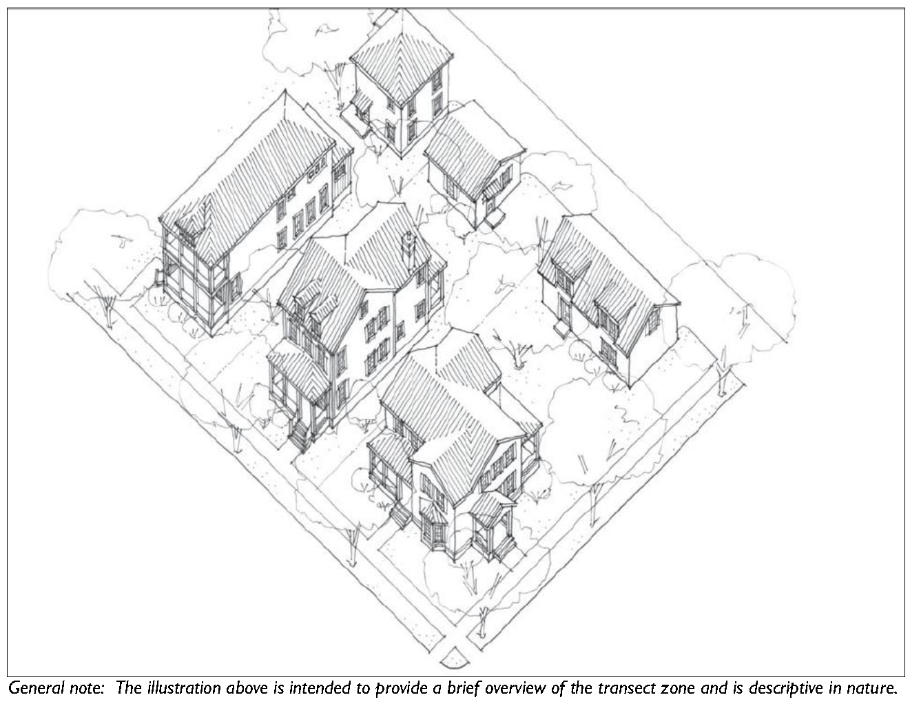
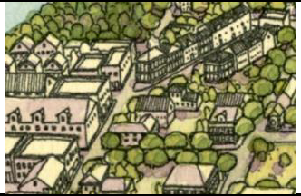
Rural Crossroads Place Type: Rural crossroads are typically located at the intersection of two or more rural roads. They provide a small amount of pedestrian-oriented, locally serving retail in a rural context, and transition quickly into agricultural uses and/or the natural environment as one moves away from the intersection. Historic examples of rural crossroads include Pritchardville and crossroads on Saint Helena Island.

Hamlet Place Type: Hamlets are typically larger and more intense than rural crossroads and are often located at the edge of the rural and urban condition. A hamlet often has a small, pedestrian-oriented main street with surrounding and supporting residential fabric that is scaled to the size of a pedestrian shed. The main street and surrounding residential fabric transitions quickly into agricultural uses and/or the natural environment. A historic example of a hamlet includes the original settlement of Bluffton along Calhoun Street. The community of Habersham began as a hamlet.

Village Place Type: Villages are made up of clusters of residential neighborhoods of sufficient intensity to support a central, mixed-use environment. The mixed-use environment can be located at the intersection of multiple neighborhoods or along a corridor between multiple neighborhoods. Habersham is a good example of a place that is evolving into a village.

D.

Size and Intensity of place types. The minimum and maximum site area and maximum density of place types are established in Table 3.4.80.D.

Table 3.4.80.D. Place Type Size and Intensity Requirements
Regional Place Type Designation Rural Crossroads Place Type Hamlet Place Type Village Place Type
Size 8 acres min., 80 acres max. 80 acres min., 160 acres max. 110 acres min., 500 acres max.
Density 1 du./ac. max. 3 du./ac. max. 6 du./ac. max.


E.

Allocation of Transect Zones. Applications for a comprehensive amendment under the provisions of the Place Type Overlay (PTO) Zone shall assign and map transect zones to each pedestrian shed according to the percentages allocated in the Table 3.4.80.E. The Director may modulate up to 15% for the transect zone allocation within Table 3.4.80.E as long as the proposed regulating plan meets the objectives of this Division. Modulations greater than 15% of the transect zone allocation may be permitted for the Village Place Type, provided that the regulating plan meets the objective of this Division and is the product of a multi-day charrette involving all affected stakeholders and the public.

Table 3.4.80.E. Allocation Mix of Transect Zones for Each Community Unit Type
Transect Zone Percentage of Land Assigned to Zone
Rural Crossroads Place Type
T2 Rural (T2R) No min. 65% max.
T2 Rural Center (T2RC) 5% min. 20% max.
T3 Edge (T3E) No min. 25% max.
T3 Hamlet Neighborhood (T3HN) 25% min. 40% max.
Hamlet Place Type
T2 Rural (T2R) No min. 65% max.
T3 Edge (T3E) No min. 25% max.
T3 Hamlet Neighborhood (T3HN) 25% min. 70% max.
T4 Hamlet Center (T4HC) 10% min. 50% max.
Village Place Type
T3 Edge (T3E) No min. 25% max.
T3 Hamlet Neighborhood (T3HN) No min. 25% max.
T3 Neighborhood (T3N) 25% min. 70% max.
T4 Hamlet Center Open (T4HCO) and/or T4 Neighborhood Center (T4NC) 10% min. 50% max.


1.

Transect Organization: Transects shall be organized in a manner that responds appropriately to a site's context. More intense transect zones shall be organized around neighborhood centers and neighborhood main streets in visible and accessible locations suitable for greater intensities, typically at or near the center of a pedestrian shed. See Section 2.3.90 (Neighborhood Centers/Main Streets).

2.

Transition of Transect Zones: When applying transect zones, transitions between transect zones containing the neighborhood designation (T4NC, T4HC, T3N, T3HN) are encouraged to occur within the block or across alleys, but may occur across a street.

F.

Other Requirements: The following additional requirements apply to all development within the PTO zone.

1.

Place Types shall be structured with pedestrian sheds to determine the scale and center. See Section 2.3.50 (Pedestrian Sheds).

2.

The thoroughfare network shall meet the standards in Section 2.3.70 (Thoroughfares).

3.

Open space, civic spaces and civic buildings shall be allocated according to the standards in Section 2.3.80 (Open Space, Civic Space and Civic Buildings).

4.

Place types shall have neighborhood centers/main streets to meet the standards in Section 2.3.90 (Neighborhood Centers/Main Streets).

5.

Place types shall incorporate appropriate transitions to the scale and character of the surrounding walkable urbanism.

6.

Place Types shall be calibrated to suit specific topographical, environmental, site layout, and design constraints unique to the site or its location within the County, yet each place type will be consistent in terms of structure and content based on the provisions of this Division.

7.

Place Types shall comply with the standards found in Division 5.3 (Architectural Standards and Guidelines) and maintain and support the County's design traditions and unique architectural vernacular.

(Ord. No. 2016/18, 6-27-16)