
Beaufort County Unincorporated
City Zoning Code
City Zoning Code
ARTICLE 2
- Multi-Lot and Single Lot Community Scale Development
2.1.10 - Purpose and Intent
Article 2 addresses development and design at the community scale. A variety of multi-lot and single-lot community types are first identified. These range from specific communities comprised of several Transect Zones to more general communities developed within one or more Conventional Zones.
The Article then provides standards for laying out blocks, lots, open space set-asides, and thoroughfares within each community type. This ensures that new communities are both contextual and appropriately integrated with their surroundings. In some cases new development at this scale will result in a complete and relatively self-sufficient community unit. In other cases a development will function as infill, blending seamlessly with adjoining neighborhoods or providing a new destination that adds value to the larger, existing community.
2.1.20 - Applicability
A.
General. The Standards in Article 2 apply to all development that is subject to a land development plan, major or minor, described in Section 7.2.60 - Land Development Plan, or subdivision, described in Section 7.2.70 - Subdivision, unless specifically exempted in a subsection.
B.
Time of Compliance. Review of proposed development to ensure compliance with the standards of this Article shall occur at time of the land development plan, major or minor, described in Section 7.2.60 - Land Development Plan, and at the time of subdivision, described in Section 7.2.70 - Subdivision.
2.1.30 - Community Types
A.
Table 2.1.30.A (Community Types) identifies and characterizes a variety of Community Types that are used to distinguish community scaled development.
B.
The establishment of a Community Type may or may not require subdivision.
C.
Unless specifically exempted elsewhere, Community Types identified in Table 2.1.30.A (Community Types) shall comply with Section 2.1.40 (Community Design Principles), as well as the Standards of this Article.
2.1.40 - Community Design Principles
This Section provides design principles for establishing a community type, with or without subdivision; and ensures that the subject site and adjoining land benefit from careful placement of uses, lots, drainage, and roads; both on and off the site. More specifically, community design shall:
A.
Protect Resources. Protect the site's resources in accordance with this Development Code, with highest quality resource areas having the highest preservation priority. Plats shall reflect sensitivity to ecological factors such as the preservation of wetlands, trees and vegetation, minimizing cut-and-fill operations, avoiding erosion and consequent siltation of streams and drainage ways, and other pertinent conservation measures.
B.
Community Character and Intensity. New development shall take inspiration from the unique places, building types, and architecture found throughout the low country. Urban areas shall maintain a character and intensity that is urban, while rural areas maintain a look and feel that is rural.
C.
Timeless Neighborhoods and Communities. New development shall incorporate appropriate patterns based on local context, climate, and history. Such development contributes to the creation of a complete neighborhood or community, as opposed to an isolated project, adding value to the surrounding area and ultimately standing the test of time.
D.
Incremental Transition from Auto-scaled to Human-scaled Environment. New development shall promote the incremental transition of auto-oriented areas to walkable places of quality.
E.
Lay Out Well Designed Lots. Lay out well-proportioned lots that are oriented and relate properly to roads and open space set-asides. An awkward and irrational pattern of lots and individual lot shapes shall be avoided. Where somewhat irregular lots provide better visual access to open space set-asides or allow more efficient utilization of the land while providing suitable building pads, they shall be allowed. The design shall not allow remnants or landlocked lots with no access to the vehicular and pedestrian circulation system.
F.
Provide for Safe and Efficient Design of Vehicle and Pedestrian Traffic. Provide for the safe, efficient, and convenient movement of vehicular and pedestrian traffic. The design shall separate vehicular travel lanes, pedestrian movement systems, and parking.
G.
Circulation System Should Promote Increase Pedestrian Use and Bicycle Movement. Include an internal circulation system that promotes and encourages the increased use of pedestrian and bicycle movement among residential, local shopping, employment, schools, and other areas.
H.
Avoid Increased External Traffic Through Block Design, Street Connections, Connecting Open Space, Bicycle and Pedestrian ways, and Other Means. Avoid external automobile trips through good block design, increased street connections, connecting open space, bicycle-pedestrian ways, and other design techniques and devices.
I.
Integrate Drainage and Utilities Efficiently. Integrate drainage and utilities efficiently into the community design and avoid off-site impacts. Utilization of stormwater and minimization of run-off volume shall be encouraged with respect to drainage.
J.
Facilitate Conformance with County Public Improvement Plans. Facilitate conformance of the community with the public improvement plans of the County, through the coordination of open space set-aside design, the convenient and proper location of sites for future schools, other public buildings, and other community facilities.
2.2.10 - Purpose
This Division establishes General Design Standards for thoroughfares, blocks, lots, and open space in multi-lot and single-lot communities; as well as ensuring that the project contributes to the larger community that surrounds it.
2.2.20 - Applicability
A.
General. These General Layout Standards apply to all development that is subject to a land development plan, major or minor, described in Section 7.2.60 - Land Development Plan, or subdivision, described in Section 7.2.70 - Subdivision, unless specifically exempted in a subsection.
B.
Time of Compliance. Review of proposed development to ensure compliance with the standards of this Section shall occur at time of land development plan (major or minor), described in Section 7.2.60 (Land Development Plan), or Subdivision, described in Section 7.2.70 (Subdivision), whichever occurs first.
2.2.30 - Thoroughfare Design, Network, and Connectivity
A.
Thoroughfare Design.
1.
The design of thoroughfares shall comply with the standards found in Division 2.9 (Thoroughfare Standards).
2.
Terminated Vistas: Thoroughfares (this can apply to the Commercial Oriented Community as well) shall implement measures to interrupt or terminate long vistas exceeding 1,200 feet in length to the maximum extent practicable. Such measures shall include, but shall not be limited to:
a)
Curvilinear road segments;
b)
Jogs or off-sets designed to require vehicles to slow their travel speed;
c)
Street chicanes or neck downs;
d)
Roundabouts; and
e)
Terminated vistas on buildings, statues, ornamentation, or natural features.
B.
Accommodation of New Roads. Development shall be designed and located to accommodate existing and proposed roads.
C.
Thoroughfare Network.
1.
There shall be a clear hierarchy of arterials, collectors, and local access streets that provide a continuous and comprehensive network.
2.
Thoroughfare network shall be platted to meet the connectivity standards found in Subsection D below.
D.
External Connectivity.
1.
The arrangement of roads in a development shall provide for the alignment and continuation of existing or proposed roads into adjoining lands in those cases in which the adjoining lands are undeveloped and intended for future development or in which the adjoining lands are developed and include opportunities for such connections.
2.
Road rights-of-way shall be extended to or along adjoining property boundaries such that a roadway connection or thoroughfare stub shall be provided for development:
3.
At all locations where roads terminate with no connection, but a future connection is planned or accommodated, a sign shall be installed at the location with the words "FUTURE ROAD CONNECTION" to inform property owners.
4.
The Subdivision Plat, described in Division 7.2.70 shall identify all stubs for roads and include a notation that all stubs are intended for connection with future roads on adjoining undeveloped property.
5.
Private, gated communities may be permitted; however, the development shall provide adequate connectivity for traffic movement, public safety, and access to water or other areas of public use. See Section 6.2.30.C (Standards for Restricted Access Developments).
E.
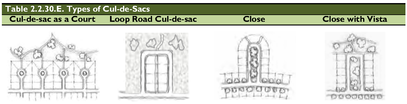
Dead-End Streets and Cul-de-Sacs. Dead-end streets and cul-de-sacs shall not be included in plans. Cul-de-sacs may be approved by administrative modulation to accommodate a site-specific environmental feature requiring protection and/or no other alternative block structure is practicable. Table 2.2.30.E provides illustrations of preferred cul-de-sac types. Cul-de-sacs approved by administrative modulation shall meet the following standards:
1.
Permanent dead-end streets shall be no longer than 300 feet and shall be provided with a cul-de-sac;
2.
Temporary dead-end streets shall be provided with a temporary turnaround area which shall be designed considering traffic usage, maintenance, and removal/retrofit;
3.
Cul-de-sacs shall have a minimum right-of-way radius of 50 feet and a paved circular area with a minimum radius of 40 feet.
4.
Whenever cul-de-sac roads are created, at least one pedestrian access easement shall be provided, to the extent practicable, between each "close" and the sidewalk system of the closest adjacent road or pedestrian pathway. The access easement shall be direct with a minimum width of 12 feet (minimum surface width of 8 feet), and may be framed by structures on both sides.
2.2.40 - Block Design
The design of blocks shall comply with the following:
A.
General.
1.
Where possible, blocks shall be laid out to have their short length abutting arterials, collectors, or the development's major road.
2.
The length, width, and shape of blocks should be determined with regard to the provision of adequate sites for buildings of the type proposed, the standards of this Code, topography, fire access, emergency service, and police protection.
B.
Block Shape and Size.
1.
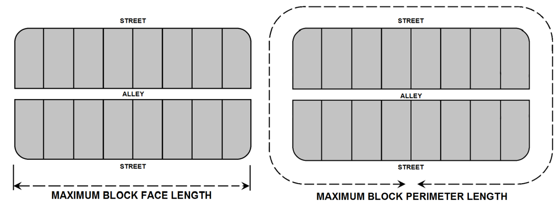
Block Face and Perimeter. Individual block faces and the total block perimeter shall follow the standards established in the Table 2.2.40.A (Block Size).
2.
Block Face and Perimeter Constraints. In cases where environmental or topographic constraints exist, or the property has an irregular shape, a modulation may be granted as set forth in Section 7.2.30 (Modulation Permit) and one of the following shall be provided:
a.
An eight-foot, surfaced, pedestrian pathway easement shall be provided mid-block to connect parallel thoroughfares on the long side of the block; or
b.
An alley shall be provided mid-block to connect parallel thoroughfares on the long side of the block.
C.
Block Width. Blocks shall be, at a minimum, such width as will provide two tiers of lots, except where reverse frontage lots are located along an arterial or major collector because size or topographical conditions prevent the use of a parallel access road and/or alleyway.
D.
Industrial Development. Blocks intended for industrial development may vary from the elements of design contained in this Section if the nature of the use requires other treatment. In such cases, safe and convenient access to infrastructure, utilities, parking, and the thoroughfare system shall be provided. Deviations from conventional standards shall only occur when necessary.
E.
Open Space and Civic Space Set-Asides and Natural Areas. In areas where a grid or other formal system is desired, exceptions would be made for green spaces along drainage or stream channels or where other natural resources make the grid difficult or cost prohibitive. The thoroughfare and block system should be designed to preserve and protect natural areas.
F.
Alleys. Alleys are considered desirable for areas where lot widths are narrow. Alleys shall be used when the average lot width on the block face is 55 feet or less. Alley access allows narrower thoroughfares and improves the street frontage by keeping parking to the rear. Flexibility with regard to this objective will be needed on narrow sites or where there are resource limitations.
2.2.50 - Lots
A.
Lots shall comply with the following:
1.
Frontage.
The primary frontage of a lot shall be along one of the following:
a.
Thoroughfare. A thoroughfare right-of-way;
b.
Single-loaded Frontage Streets. A Thoroughfare with development on one side and a Civic or Open Space on the other;
c.
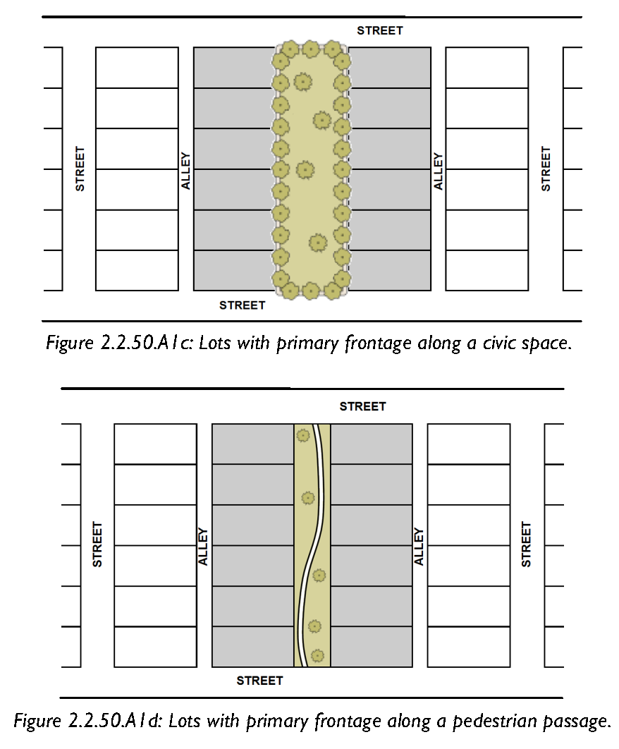
Civic Space. No more than 10 percent of the lots in a development shall have their primary frontage along a civic space; or
d.
Pedestrian Way. No more than 5 percent of the lots in a development shall have their primary frontage along a pedestrian passage or vehicular alleyway/lane.
2.
Avoid Double Frontage Lots. Double-frontage residential lots should be avoided unless it is impractical or where large buffers exist between the lot and the road.
3.
Access to Lots from Alleys.
a.
Alleys meeting the standards in Division 2.9 (Thoroughfare Standards) shall be provided along the rear property lines of lots intended for new single-family and two-family dwellings when the lots:
(1)
Are part of a block face with an average lot width of 55 feet or less at the building setback line (excluding lots on cul-de-sacs); or
(2)
Front a Collector or Arterial road (regardless of the average lot width).
b.
Lots served by alleys in accordance with Subsection a. above shall access garages and/or off-street parking areas from the alley as opposed to a road.
c.
Lots served by alleys in accordance with Subsection a. above shall not have driveways in front or corner side yard areas.
4.
Access to Lots from Arterial Roads. Driveways serving individual residential lots shall not have direct access onto Arterial roads, unless no alternative means of access, such as Rear Alleys or parallel access roads, exists, and it is unreasonable or impractical to require an alternative means of access.
5.
Preserve Development Viability of Interior Lands in the T2R Zone. In the T2R Zone, the arrangement of lots along existing roads should preserve the viability of the future development of interior lands by providing adequate road right-of-way access to the interior properties.
6.
Consider Resources and Other Natural Features. The arrangement of lots shall reflect the location of protected resources and be sensitive to the other natural features of the property.
B.
Lot Width.
1.
Reflect General Conditions of Land. Lot width and frontage shall reflect the general conditions of the land on which the subdivision is located, and provide a reasonable building envelope and adequate access to each lot.
2.
Where Grid System Exists. Where a grid street system exists, the lots should be as close to rectangular as feasible.
3.
Construction Envelope. The minimum lot width must be maintained at any point within the construction envelope defined by minimum yard setbacks. The developer may define smaller building envelopes on the final plat.
4.
Resources Make Normal Lotting Difficult. Where natural resources or property shape make normal lotting difficult, common drives, flag lots, or shared easements may be considered at the discretion of the Director. Where a flag lot is approved, the minimum width of the portion of the lot that fronts the ROW or easement and extends to the rear "flag" shall be 50 ft., except in the T3N, T4HC, and T4NC zones, where the minimum width shall be 40 ft.
C.
Lot Lines. Lot lines shall comply with the following:
1.
General. Generally side lot lines shall be perpendicular or radial to the thoroughfare, and rear lines should be approximately parallel to thoroughfare lines. However, different lot shapes are allowed if it is demonstrated they are necessary or desirable to:
a.
Better relate building sites to the terrain on the site, or to provide better site utilization and building relationships;
b.
Preserve protected resources or other natural features while still providing generally rectangular building envelopes;
c.
Better integrate open space set-asides while still providing generally rectangular building envelopes;
d.
Create a more efficient lot design and layout while still providing generally rectangular building envelopes.
2.
Depth of Lots. The depth of residential lots shall not be less than their width, nor more than five times their width.
D.
Minimum Lot Elevation and Drainage.
1.
General. Lots shall be provided with adequate drainage in accordance with this Code and all other relevant County requirements, and shall be graded, so as to drain surface water away from the building(s).
2.
Prevent Ponding or Flooding. The minimum elevation of the lot shall be a level that will prevent ponding or flooding as a result of heavy rain, or during abnormally high tides.
3.
Lot Drainage. The entire lot shall be properly drained at a minimum slope of one-eighth inch per foot toward roadside and/or lot swales.
E.
Useable Lot Area.
1.
Each lot shall have a minimum usable lot area equal to or greater than 50 percent of the gross lot area. This is calculated by subtracting tidal wetlands seaward of the OCRM Critical Line, non-tidal wetlands, wetlands setbacks (see Section 5.11.40.H), river buffers, and river buffer setbacks (see Table 5.11.60.A) and all other applicable buffers from the gross lot area.
2.
As an alternative to disallowing any lot that does not meet the minimum useable lot area defined in subsection E.1 above, if a professional engineer can clearly demonstrate that the lot can sustain a single-family residence, an access driveway, a septic tank and drainfield as may be required, and potable water service, the Director may approve such a lot for development. The design engineer shall provide a site/drainage plan for the lot that locates the house, driveway, septic drainfield as required, and potable water service. The plan shall also include existing and finished topography elevations.
2.2.60 - Access Management - Design
This section provides standards that govern access to county, state and federal thoroughfares. In addition to the standards in this section, Appendix C (Area Specific Access Management Standards) provides additional standards to Robert Smalls Parkway (SC 170), West Fording Island Road (U.S. 278), Okatie Highway (SC 170), Buckwalter Parkway, Bluffton Parkway, and Gardens Corner (US 17 and US 21).
A.
Driveway Separation. Access to county, state and federal thoroughfares shall comply with the following standards:
1.
Within Transect Zones, thoroughfares shall meet the standards found in Appendix D (Beaufort County Technical Manual).
2.
Within conventional zones, thoroughfares shall meet these standards:
a.
Street, driveway, or other access separation along county, state and federal highways shall be in accordance with the SCDOT, Access and Roadside Management Standards, and County-approved access management plans.
b.
In no event, however, shall residential driveways and non-residential full-access curb cuts be permitted at spacing less than as follows:
1.
Principal Arterial road: 1,500 feet
2.
Minor Arterial road: 800 feet
3.
Major Collector road: 400 feet
4.
Minor Collector and Local roads: See subsection a., above.
c.
To the maximum extent practical, lots fronting an arterial or major collector shall take access from an internal street, parallel frontage road, or rear alley. This avoids multiple lots with individual access along the existing public road frontage or reverse frontage lots in which buildings turn their back to the public road frontage.
d.
If the topography of the site prevents access to lots using an internal street, parallel frontage road, or rear alley, shared access drives may be utilized in order to meet the above separation standards.
e.
If property cannot be provided access through adjoining properties, temporary access may be permitted as provided in Subsection 6.2.30.A (Legal Access).
f.
Where existing conditions warrant, individual driveways and nonresidential curb cut spacing described in Section 2.2.60.A2b above may be varied by the Beaufort County Traffic Engineer to provide essential site access where supported by an approved traffic impact analysis.
B.
Non-residential Access Ways.
1.
Access way linkages between adjacent, nonresidential development along the same public thoroughfare shall be provided, to the maximum extent practicable, for movement from one development to another without requiring a return to the public thoroughfare.
2.
In order to reinforce the establishment of an interconnected block and thoroughfare network, access ways shall contain on-street parking and streetscaping (frontage elements), where practicable.
3.
The alignment of access ways shall be linked in a straight line for as long a distance as is practical; not to exceed the maximum length for the Face of a Block in Table 2.2.40.A (Block Size).
4.
Access ways, including those through parking lots designated for such movement shall be paved; except in the T1 and T2 Districts, where at the discretion of the Director, they may be surfaced using low impact, contextual materials.
5.
Access way linkages may be accomplished in one of the following ways, subject to the Director's determination of which is most appropriate and shall be required.
a.
When development (including outparcels) will front directly onto the public thoroughfare, and off-street parking is limited to the side or rear of the building (Per Division 5.5 Off-Street Parking); as a Rear Alley or Rear Lane along the rear property line of the front parcel.
b.
When development will be sufficiently set back, but front the public thoroughfare, and off-street parking is limited to the side or rear of the building (Per Division 5.5 Off-Street Parking); as a continuous parallel frontage road designed as a thoroughfare per the standards of Division 29 (Thoroughfare Standards) and this Ordinance.
c.
When off-street parking is permitted in front of the building (Per Division 5.5 Off-Street Parking); access ways may be provided at the front of the building.
d.
A driveway stub-out section may also be used when it is adjacent to vacant land, if that vacant land is located in the T3HN, T3N, T4HC, C3, C4, C5, or S1 Zones, or where it is determined the adjacent property will be developed as a nonresidential use (this requirement shall not apply where a frontage road system is planned or is in place.)
2.2.70 - Open Space and Civic Space Set-Asides
2.3.10 - Purpose
The purpose of this Division is to provide standards for applying the transect zones of Division 3.2 in a manner that will create new walkable neighborhoods and communities in growth areas of the County that are zoned with conventional districts (C3, C4, and C5). The Traditional Community Plan (TCP) is an infill and redevelopment tool that facilitates the transition of auto oriented residential and commercial communities into compact, walkable, place-based communities with a mix of housing, civic, retail, and service choices. This division shall be used to achieve the following goals and objectives:
A.
Improve the built environment and human habitat.
B.
Promote development patterns that support safe, effective, and multi-modal transportation options, including auto, pedestrian, bicycle, and ultimately transit. This will minimize vehicle traffic by providing for a mix of land uses, walkability, and compact community form.
C.
Provide neighborhoods with a variety of housing types to serve the needs of a diverse population.
D.
Remove barriers and provide incentives for walkable urban projects and economic diversity.
E.
Promote the greater health benefits of a pedestrian-oriented environment.
F.
Reinforce the character and quality of local communities, including crossroads, neighborhoods, hamlets, and villages.
G.
Reduce sprawling, auto-dependent development.
H.
Protect and enhance real property values.
I.
Promote the unique characteristics of Beaufort County that build upon the local context, climate, and history.
2.3.20 - General Requirements
The following requirements apply to all TCPs. Each TCP shall:
A.
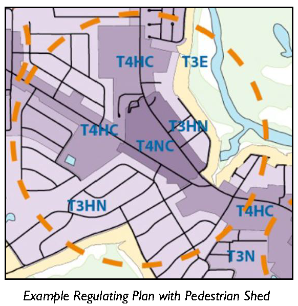
Be structured with pedestrian sheds to determine the scale and center. See Section 2.3.50 (Pedestrian Sheds). TCP Districts are smaller than an applicable Pedestrian Shed, however, a pedestrian shed is still useful when defining the boundaries and relationship between components within a "place based" walkable environment.
B.
Allocate transect zones according to Section 2.3.60 (Transect Zones).
C.
Layout a thoroughfare network according to standards in Section 2.3.70 (Thoroughfares). D. Allocate open space, civic spaces and civic buildings according to the standards in Section 2.3.80 (Open Space, Civic Space and Civic Buildings).
E.
Provide neighborhood centers/main streets to meet the standards in Section 2.3.90 (Neighborhood Centers/Main Streets).
F.
Provide a mix of building types to meet the standards in Section 2.2.100 (Mix of Building Types).
G.
Provide appropriate transitions to the scale and character of the surrounding walkable urbanism.
H.
The TCP shall be calibrated to suit specific topographical, environmental, site layout, and design constraints unique to the site or its location within the County, yet each TCP will be consistent in terms of structure and content based on the provisions of this Division.
I.
All TCPs shall comply with the standards found in Division 5.3 (Architectural Standards and Guidelines) and maintain and support the County's design traditions and unique architectural vernacular.
J.
Meet the standards of this Division.
2.3.30 - Land Uses and Density
A.
Land Use: Land uses are limited to the uses that are permitted in the zoning district in which the TCP is located.
B.
Density: The gross residential density of the TCP shall not exceed the maximum gross residential density of the zoning district in which the TCP is located.
2.3.40 - Types of Traditional Community Plans
There are three types of TCPs - the small-scale infill TCP, the Neighborhood-Scale TCP, and the Commercial Redevelopment TCP. Table 2.3.40 provides a summary of the requirements for site area and location for each of the TCP types.
A.
Infill-Scale TCP: The infill-scale TCP applies to sites between 8 acres and 40 acres where the opportunity exists to develop a compact walkable neighborhood in proximity and having direct pedestrian access to schools, civic sites, parks, or commercial areas. Infill-scale TCPs shall meet the following requirements:
1.
The project is located within a one-quarter mile walk and has direct pedestrian access to at least one of the following civic or commercial functions. Direct pedestrian access is achieved via continuous sidewalks/pathways, and signalized pedestrian crosswalks if crossing arterials or major collectors. This standard may be achieved on site if the required civic or commercial structures are constructed as part of the proposed development.
a.
Publically accessible outdoor Civic Space of at least ½ acre in size (e.g. County or municipal park, pool, ball fields, public dock, etc.); or
b.
Publicly operated and accessible indoor Civic Space of at least 1,500 square feet (e.g. County pool, library, community center, etc.); or
c.
A minimum of 6 diverse functions listed under Retail, Service or Recreation, Education and Public Assembly in Table 3.1.60 (Consolidated Use Table); or
d.
Elementary, middle, or high schools.
2.
Sewer infrastructure exists on-site or immediately adjacent to the project site;
3.
The project contributes to the connectivity of adjoining residential and commercial communities.
B.
Neighborhood-Scale TCP: The neighborhood-scale TCP applies to sites between 40 acres and 100 acres where the opportunity exists to develop a compact walkable neighborhood that incorporates a diversity of uses, housing types, and a mixed use center that integrates retail, civic, office and residential uses, including housing units located on top of shops.
C.
Commercial Redevelopment TCP: The commercial redevelopment TCP applies to commercial sites of up to 20 acres where there is an opportunity through infill and redevelopment to establish walkable, mixed-use development utilizing the transect zones in Division 3.2. Commercial redevelopment TCPs shall meet the following requirements:
1.
The project is located within one quarter mile walk of a minimum of twenty (20) diverse functions listed under Retail, Service or Recreation, Education and Public Assembly in Table 3.1.60 (Consolidated Use Table);
2.
Sewer infrastructure exists on-site or immediately adjacent to the project site;
3.
The project site has direct access to/from an arterial or major collector street;
4.
The project will establish a new Transect zone or the extension of an existing Transect zone (or zones) in a manner that is logical and contributes to a more walkable "place based" environment;
5.
The intensity and character of the proposed project will positively influence the transition of the larger community from one that is auto-centric to one that is more ""place based" and pedestrian friendly.
2.3.50 - Pedestrian Sheds
Pedestrian sheds are useful in planning as they provide an understanding of how far a typical pedestrian might be willing to walk. They are based on the understanding that most people are willing to walk up to five minutes before they will choose to drive and up to ten minutes to a major destination or transit stop. TCPs use pedestrian sheds to define the boundaries and the relationship of development patterns to create walkable environments.
A.
Pedestrian sheds shall be centered on a neighborhood center or a main street.
B.
Types of Pedestrian Sheds.
1.
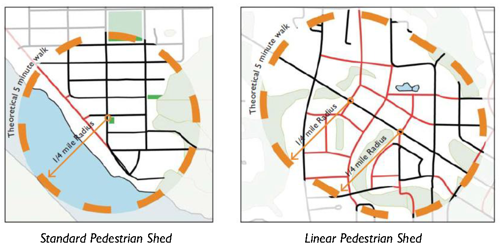
Standard Pedestrian Shed. A pedestrian shed that is based on a one-quarter mile (1,320 feet) radius around a node. Standard pedestrian sheds are useful in planning neighborhoods. See diagram below.
2.
Linear Pedestrian Shed. A pedestrian shed that is based on a one-quarter mile (1,320 feet) radius around a series of block lengths. Linear pedestrian sheds are useful in planning neighborhood main streets or neighborhoods with multiple nodes. See diagram below.
C.
Maximum Size of Pedestrian Shed.
1.
Individual standard pedestrian sheds shall be no more than 160 acres.
2.
Linear pedestrian sheds shall be no more than 200 acres. The site or any plan may be smaller than its associated pedestrian shed.
D.
Remnants of the site outside the pedestrian sheds shall meet the following requirements:
1.
Remnant areas outside of a pedestrian shed shall be assigned transect zones, civic spaces, or conventional zones; and
2.
If the remnant areas assigned as T3, T4 and T5 transect zones exceed 35 acres, an additional pedestrian shed shall be created to encompass these remnant areas.
E.
The pedestrian shed shall be mapped on the regulating plan.
2.3.60 - Transect Zones
A.
General:
1.
Transect Zones established in Division 3.2 (Transect Zones) shall be used for the regulating plan.
2.
Any modifications or additions to the transect zones in Division 3.2 (Transect Zones) shall be done as part of a process of public consultation and are subject to the approval of the County Council through a Zoning Text Amendment, see Section 7.3.30 (Text Amendments). Metrics shall be recorded in a similar format to what exists within this Development Code.
B.
Required Allocation of Transect Zones: Community plans for complete new neighborhoods shall assign and map transect zones to each pedestrian shed according to the percentages allocated in the Table 2.3.60.B. (Required Allocation Mix of Transect Zones).
C.
Transect Organization: Transects shall be organized in a manner that responds appropriately to a site's context. More intense transect zones shall be organized around neighborhood centers and neighborhood main streets in visible and accessible locations suitable for greater intensities, typically at or near the center of a pedestrian shed. See Section 2.3.90 (Neighborhood Centers/Main Streets).
D.
Transition of Transect Zones: When applying transect zones, transitions between transect zones containing the neighborhood designation (T4NC, T4HC, T3N, T3HN) are encouraged to occur within the block or across alleys, but may occur across a street. To the greatest extent feasible, transect zones at the perimeter of the TCP shall be compatible with adjoining residential and commercial development.
E.
Standards Within Transect Zones: Development in the TCP shall meet the Building Type, Building Placement, Building Form, Encroachment, Frontage Type, and Parking standards of the transect zone established and delineated in the regulating plan.
2.3.70 - Thoroughfare Design
Thoroughfares define the public streets that refine pedestrian sheds into walkable environments. Care should be taken in the layout and sizing of thoroughfares, as wide thoroughfares and a lack of connectivity reduce the pedestrian friendliness of the area.
A.
Thoroughfares shall consist of vehicular lanes and public frontages as established in Division 2.9 (Thoroughfare Standards).
B.
The design of thoroughfares shall meet the standards set forth in Division 2.9 (Thoroughfare Standards).
C.
Thoroughfares that pass from one transect zone to another shall adjust their public frontages to match the character of the transect zone. For example, while a thoroughfare within an urban transect zone with retail shops may have wide sidewalks with trees in tree grates, it may transition to a narrower sidewalk with a planting strip within a less urban transect zone with various residential building types.
D.
The thoroughfare network shall be mapped on a regulating plan and shall indicate the layout of thoroughfares and the block network according to standards established in Section 2.2.30 (Thoroughfare Design, Network, and Connectivity) and 2.2.40 (Blocks).
2.3.80 - Open Space, Civic Space and Civic Buildings
Usable open spaces, civic spaces and civic buildings provide important gathering places for communities and access to outdoor activities. The open spaces, civic spaces and civic buildings should be carefully located within the pedestrian shed and accessible to all.
The following standards shall be met for providing and locating open spaces, civic spaces and civic buildings:
A.
General:
1.
TCPs shall designate open spaces, civic spaces and civic buildings on a regulating plan.
2.
Public access and visibility along public parks, civic uses, and natural open spaces, including creeks and drainages, shall be maintained through the use of:
a.
Single-loaded frontage streets (those with development on one side and open space on the other);
b.
Bike and pedestrian paths; or
c.
Other methods of frontage that provides similar access and visibility to the open space that are appropriate in the transect zone.
3.
The design of civic spaces shall meet the standards set forth in Division 2.8 (Civic and Open Space Types).
B.
Civic and Open Space Allocation:
1.
Projects shall meet the minimum set-aside requirements for civic and open space in Section 2.8.40.
2.
For sites greater than 10 acres, the required civic/open space shall be distributed throughout the neighborhood/development as multiple smaller civic spaces.
3.
Each residential lot shall be within 1,000 feet of an existing or proposed playground. A Commercial Redevelopment TCP shall allot the required playground space; however, at the discretion of the Director the applicant may elect to substitute Civic Art for playground equipment.
C.
Civic Building Allocation:
1.
Sites providing 100 units or more shall also provide an indoor public meeting space. This may be a freestanding building or integrated within another building. This requirement may be waived if an existing public meeting space is located within 1,000 feet of the TCP.
2.
Schools. Schools that are integrated into the regulating plan shall be located near the designated center of the pedestrian shed. Primary and Secondary schools may locate near the perimeter of the pedestrian shed if their recreation area contributes to, and/or forms the edge of one or more neighborhoods or communities.
a.
New school campuses shall not exceed the following:
(1)
High schools, 15 acres.
(2)
Middle schools, 10 acres.
(3)
Elementary schools, 5 acres.
Schools combining grade levels from more than one category may use the grade level with the higher allowable acreage.
b.
To the maximum extent practicable outdoor recreation facilities (playgrounds, courts, athletic fields) on campus:
(1)
Shall be integrated with the Civic/Open Space of the surrounding community; and,
(2)
Shall count towards the required Civic/Open Space requirement for the Community.
c.
Facilities on the school campus for which there is a formal joint-use agreement with another entity, such as athletic facilities, playgrounds, and multipurpose spaces in buildings, may be deducted from the total site area of the school campus.
2.3.90 - Neighborhood Centers/Main Streets
A.
Neighborhood centers/main streets shall be located near the center of each pedestrian shed.
B.
Main streets shall be located as follows:
1.
Along both sides of a thoroughfare; and
2.
Along a primary through thoroughfare; or
3.
Perpendicular to and directly engaging a primary through thoroughfare.
C.
Neighborhood centers shall contain:
1.
One or more civic buildings and/or uses;
2.
One or more civic or open spaces; and/or
3.
Limited retail or service uses may also be incorporated.
2.3.100 - Mix of Building Types
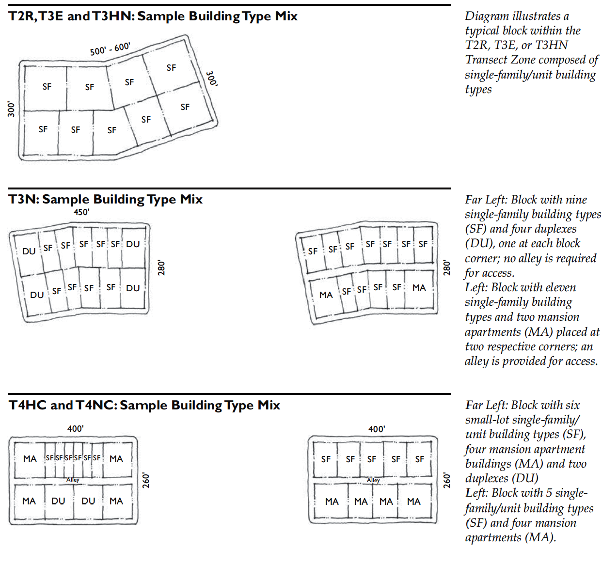
A mix of building types introduces variety into the character of TCPs. Blocks should provide a diversity of residential and mixed-use building types in a manner that fulfills the intent of each transect zone as they are described in Division 3.2 (Transect Zones) and the following formulas below. In the event that blocks are composed of more than one transect zone, the minimum mixing guidelines of the most intense transect zone should apply across the block.
A.
T2 Rural, T3 Edge, and T3 Hamlet Neighborhood. Blocks within the T2R, T3E, or T3HN Transect Zones are intended to be composed of single-family/unit building types.
B.
T3 Neighborhood. Blocks within the T3N Transect Zone are intended to be primarily composed of single-family/unit and duplex building types, while accommodating limited multi-family building types that are compatible with single-family/unit form.
1.
Blocks within the T3N Transect Zone should provide a minimum of two distinct building types per block.
2.
At least 50 percent of the residential units on a block should be located within single family/unit and/or duplex building types.
C.
T4 Hamlet Center and T4 Hamlet Center Open. Blocks within the T4HC, T4HCO, and T4NC Transect Zone are intended to provide a mix of single-family/unit, duplex and multifamily/unit types.
D.
T4 Neighborhood Center. Blocks within the T4NC Transect Zone should provide a minimum of two distinct building types per block. Additionally, no more than 50 percent of the residential units on a block should be located within single-family/unit or duplex building types.
2.4.10 - Purpose and Intent
These multi-family standards are intended to:
A.
Promote Compatibility. Promote greater compatibility between two-family and multifamily development and other allowable uses in the conventional zones.
B.
Community Context and Character. Create diverse neighborhoods of a character and context of the larger community, as opposed to an isolated project or pod of multifamily units.
C.
Transition to Transect Zones. Encourage development that makes for an easy transition to the transect zones.
1.
New development should result in an interconnected network of Blocks and Thoroughfares.
2.
Ensure that buildings and landscaping contribute to the physical definition of streets as public places.
3.
Promote on-street parking.
2.4.20 - Applicability
A.
General.
1.
These standards apply to all new multi-family development in the Conventional Zones.
2.
The standards in Division 2.1 (Overview), Division 2.2 (General to Community Design) and Division 3.3 (Conventional Zones) work in conjunction with those found in this Division; and should be reviewed prior to reading this Division.
B.
CP Zone. The standards established in this Division do apply to Community Preservation Districts.
C.
Redevelopment. Redevelopment of an existing two-family or multi-family development that exceeds 50 percent of the building's reproducible value (exclusive of foundations) shall require the newly redeveloped portions to comply with the standards of this Section.
D.
Review for Compliance. Review for compliance with the standards of this section shall occur during review of a land development plan (minor or major), Section 7.2.60 (Land Development Plan); Certificate of Design Compliance, Section 7.2.110 (Certificate of Design Compliance); or Zoning Permit, Section 7.2.20(Zoning Permit); whichever occurs first.
2.4.30 - Multi-Family Standards
New two-family and multi-family development shall comply with the following standards:
A.
Thoroughfare Network. On sites including new streets (thoroughfares), access ways, and/or driveways, an interconnected network of blocks and thoroughfares shall be provided.
1.
Blocks. The site shall be designed to incorporate existing, proposed, and future blocks as conveyed in Section 2.2.40 (Blocks).
2.
Thoroughfares.
a.
The site shall be designed as an interconnected network of thoroughfares in accordance with Section 2.2.30 (Thoroughfare Design, Network and Connectivity).
b.
Public and private rights of way, easements, access ways, and driveways (for vehicles, bicycles, and pedestrians) shall conform to the standards in Division 2.9 (Thoroughfare Standards), and, to the maximum extent practicable, provide on- street parking and streetscaping (frontage elements).
c.
Vehicular access driveways shall comply with Section 2.2.60 (Access Management - Design).
d.
Driveways shall be consolidated in order to reduce curb cuts, to the maximum extent practicable.
B.
Access and Circulation.
1.
Pedestrian Circulation:
a.
Defined Pedestrian Network. A clearly defined, visible, and identifiable pedestrian network (combination of walkways, low shrub or ground cover plantings, and trees) shall be provided between parking lots, public street sidewalks, civic/open spaces, community facilities, and individual buildings.
b.
Width of Pedestrian Walkways. Pedestrian walkways shall correspond to the adjacent thoroughfare walkway standards and / or be a minimum of five feet in width.
c.
Outside Public ROW. The owner or an owners association shall maintain pedestrian walkways outside public rights-of-way.
d.
Connections. Where possible, pedestrian walkways shall be connected within parks, open spaces or common areas internal or external to the site.
e.
Vehicular and Pedestrian Access Visible. Both vehicular and pedestrian access must be visible from the street or alley serving the development.
f.
Accentuate Pedestrian Entrances. Pedestrian entrances to the site shall be accentuated through the use of landscaping, special paving, or entry features.
2.
Parking:
a.
Location.
(1)
There shall be no parking between the principal residential building and the street it fronts, except on-street parallel or angled parking.
(2)
Parking between civic spaces and/or civic buildings, and the streets they front, shall be limited to on-street parallel or angled parking.
(3)
Parking along a thoroughfare or access way into the development, not fronted by a building, shall be limited to on-street parallel parking.
(4)
Ninety (90) degree head-in parking shall only be permitted off-street as set forth in Division 5.5 (Off-Street Parking).
b.
Design. Type and design of on-street parking shall correspond with Division 2.9 (Thoroughfare Standards). Type and design of off-street parking shall correspond with Division 5.5 (Off-Street Parking).
c.
Access. Vehicular access to the development shall be provided from a secondary thoroughfare, or an alley when present.
d.
Consider Site Design with Transit. Site design, including entrances and parking lots, shall consider the location of existing and planned transit facilities.
e.
Parking Requirements. The amount of parking required is set forth in Division 5.5 (Off-Street Parking).
3.
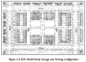
Garage Standards:
a.
Access to Garages. Garages shall be accessed from alleyways or secondary thoroughfares, to the maximum extent practicable.
b.
Compatible. The exterior materials, design features, and roof form of garages shall be compatible with the building they serve.
4.
Service Area Placement and Screening:
a.
Outdoor storage and trash collection areas shall be integrated with overall design of the building, or be screened in accordance with the standards in Section 5.8.100 (Screening).
b.
Trash receptacles shall be located in an enclosed area.
C.
Building Configuration, Orientation, and Entryways.
1.
Primary Façade. The building façade containing the primary entrance (or shared entrance) shall be considered as the building's primary façade. The primary façades of all buildings shall face a street or public thoroughfare. In the case of corner lots, the primary façade shall face the street from which the building derives its street address.
2.
Secondary Façade. Buildings shall "address" secondary streets or parking areas with a secondary entrance, frontage elements, windows, and other architectural features contained in Division 5.3 (Architectural Standards and Guidelines).
3.
Frontage on Arterials. If the primary façade of a building faces an Arterial (e.g. US 278, SC 170), the primary façade may front a parallel access road if:
a.
The relevant portion of the arterial is not addressed in the Beaufort County Thoroughfare Manual, and
b.
The alternative design will result in a more pedestrian-friendly thoroughfare network.
4.
Multiple Buildings. Development composed of multiple buildings shall:
a.
Be configured into a series of "blocks" and "streets" (see Subsection 2.4.30.A, Thoroughfare Network).
b.
Be configured and located to define street edges, development entry points, civic/open space, and public spaces for gathering between buildings.
c.
Be configured and located to conceal, frame, or enclose parking lots.
5.
Buildings Without Direct and Visible Pedestrian Entrance. Buildings that do not have a direct and visible pedestrian entrance from a public street shall address the street with windows, patios, balconies, and other architectural features.
6.
Common Open Space Set-Asides and Children's Play Areas. Common open space set-asides and children's play areas shall be clearly visible from the dwelling units on the site.
2.5.10 - Purpose and Intent
Manufactured home communities provide more affordable housing options for a variety of residents, including first-time homeowners and people on fixed incomes. The standards in this Section are intended to:
A.
Foster a Pedestrian Environment. Promote quality, pedestrian-oriented communities through a flexible, yet careful infusion of blocks, streets and civic spaces.
B.
Promote Well-Designed Communities. Encourage attractive, well-designed communities through architectural and structural design requirements.
C.
Encourage Transition to Transect Zones. Encourage development that makes for an easy transition to the transect zones.
2.5.20 - Applicability
A.
General.
1.
These standards apply to all new Manufactured Home Communities.
2.
The standards in Division 2.1 (Overview), Division 2.2 (General to Community Design) and Division 3.3 (Conventional Zones) work in conjunction with those found in this Division; and should be reviewed in conjunction with reading this Division.
B.
Review for Compliance. Review for compliance with the standards of this Section shall occur during review of a land development plan, Section 7.2.60 (Land Development Plan).
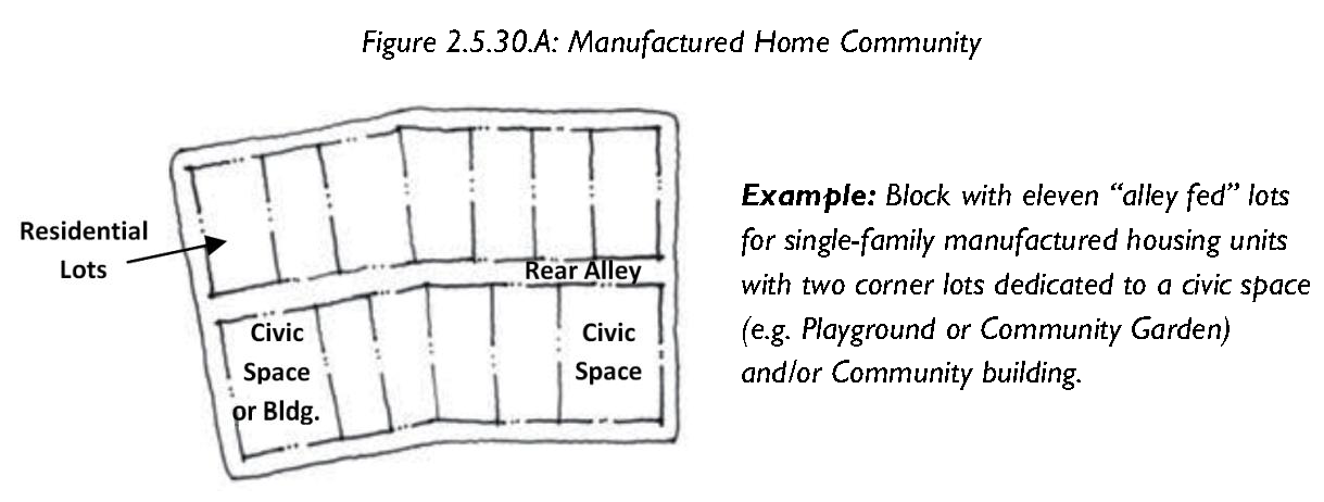
2.5.30 - Manufactured Home Community Standards
New Manufactured Home Communities shall comply with the following Standards.
A.
Site Dimensions, Building Height and Placement.
B.
Thoroughfare Frontage.
1.
Manufactured Home Communities are limited to sites with direct access to a collector or arterial roadway.
2.
Next to a collector or arterial road ROW, a Manufactured Home Community shall maintain a minimum setback of 50 feet and a minimum buffer as required per Section 5.8.90 (Perimeter Buffers). At the discretion of the Director, a Manufactured Home Community may site its non-residential buildings and/or civic/open space within this setback if the design will:
a.
Better frame the Community along the thoroughfare and increase opacity.
b.
Serve as a transition between the Manufactured Home Community and surrounding communities. Non-residential buildings and civic spaces shall address both internal and external thoroughfares by providing additional (secondary) entrances and architectural features such as private frontages, windows, etc.
c.
Increase pedestrian connectivity between the Manufactured Home Community and the surrounding thoroughfare network.
3.
In cases where the Manufactured Home Community fronts directly onto an arterial roadway, the applicant may choose to incorporate a secondary thoroughfare such as a frontage road, in which case the setback requirement in Subsection 2.5.30.B.2 shall be waived.
4.
Where the Manufactured Home Community abuts a local road, lots containing manufactured homes may front directly onto the local road without any buffer requirements. The lots shall meet the standards in Table 2.5.30.A.
5.
Where the Manufactured Home Community abuts an adjacent parcel, manufactured homes shall not be located closer than 75 feet from the property line and the buffer standards of Division 5.8.90 (Perimeter Buffers) shall be followed.
C.
Thoroughfare Network. On sites including new streets (thoroughfares), an interconnected network of Blocks, Thoroughfares, and Rear Lanes shall be provided as follows:
1.
Blocks. The site shall be designed to incorporate existing, proposed, and future blocks as conveyed in Section 2.2.40 (Blocks).
2.
Thoroughfares.
a.
The site shall be designed as an interconnected network of thoroughfares in accordance with Section 2.2.30 (Thoroughfare Design, Network, and Connectivity).
b.
Public and private rights of way, easements, rear lanes, access ways, driveways (for vehicles, bicycles, and pedestrians) shall conform to the standards in Division 2.9 (Thoroughfare Standards).
D.
Non-Residential Building Orientation. The building façade containing the primary entrance to the building shall be considered as the building's primary façade. The primary façades of all non-residential buildings shall face:
1.
A street or public thoroughfare serving the development; or
2.
A street or public thoroughfare with development on one side and Civic/Open space on the other side.
E.
Access and Circulation.
1.
Defined Pedestrian Network. A clearly defined pedestrian network shall be provided between lots and civic/open spaces, and community facilities.
2.
Width of Pedestrian Walkways. Pedestrian walkways shall correspond to the adjacent thoroughfare walkway standards (see Section 2.9, Thoroughfare Standards) and/or be a minimum of five feet in width.
3.
Outside Public ROW. The owner or an owners association shall maintain pedestrian walkways outside public rights-of-way.
4.
Connections. Where possible, pedestrian walkways shall be connected to parks, open spaces or common areas external to the site.
F.
Parking.
1.
Location.
a.
There shall be no parking between the principal residential building and the street it fronts, except on-street parallel parking.
b.
Parking between civic spaces and/or civic buildings, and the streets they front, shall be limited to on-street parallel or angled parking.
c.
Ninety (90) degree head-in parking shall only be permitted off-street as set forth in Division 5.5 (Off-Street Parking).
2.
Design. Type and design of on-street parking shall correspond with Division 2.9 (Thoroughfare Standards). Type and design of off-street parking shall correspond with Division 5.5 (Off-Street Parking).
3.
Additional Requirements. The amount of parking required is set forth in Division 5.5 (Off-Street Parking).
G.
Open Space, Civic Space and Civic Buildings. Open spaces, civic spaces and civic buildings provide important gathering places for communities and access to outdoor activities. The open spaces, civic spaces and civic buildings should be carefully located and accessible to all. The following standards shall be met for providing and locating open spaces, civic spaces and civic buildings.
1.
Manufactured Home Communities shall allocate and design Civic/Open Space as conveyed in Division 2.8 (Civic and Open Space Types).
2.
Public access and visibility along public parks, civic uses, and natural open spaces, including creeks and drainages, shall be maintained through the use of:
a.
Single-loaded frontage streets (those with development on one side and open space on the other); or
b.
Bike and pedestrian paths.
4.
For sites greater than 10 acres, the required amount of civic or open space shall be distributed throughout the neighborhood as multiple smaller civic spaces.
5.
Each residential lot shall be within 1,000 feet of an existing or proposed playground.
6.
Sites greater than five acres or providing 100 units or more shall provide an indoor community building with meeting space, recreation, etc. This may be a freestanding building or integrated within another building.
H.
Structural Design Requirements. All manufactured homes shall meet the following requirements:
1.
Exterior siding shall be made of non-reflective and nonmetallic materials, including vinyl, wood, glass, stucco, brick, stone and other masonry materials.
2.
Roofs shall be sloped and provide an eave projection of no less than 6 inches and no greater than 30 inches (not applicable to deck areas).
3.
Roofing material shall consist of one of the following: wood, shingle, synthetic composite shingle or concrete tile (metallic roofing surfaces are not permitted).
4.
Minimum floor area shall be no less than 800 sq. ft. for any unit, exclusive of decks, porches, garages or carports.
5.
Minimum width of any unit shall be no less than 22 feet, exclusive of decks, porches, garages or carports.
6.
Foundations shall allow permanent placement of every manufactured home that meets or exceeds all applicable county building code requirements.
7.
Skirting or a similar structural enclosure that is at least 80% opaque shall be installed so that no underside of any unit is exposed, and the continuation of the exterior façade is not interrupted. Skirting shall be of a material intended for exterior use.
2.6.10 - Purpose and Intent
These commercial design standards are intended to:
A.
Promote a Strong Sense of Place. Promote a strong sense of place and pedestrian-friendly development;
B.
Encourage Pedestrian-Friendly Environment. Encourage a pedestrian-friendly environment through attention to site features and human scale design;
C.
Foster Compatibility. Foster greater compatibility between commercial development and adjacent residential neighborhoods;
D.
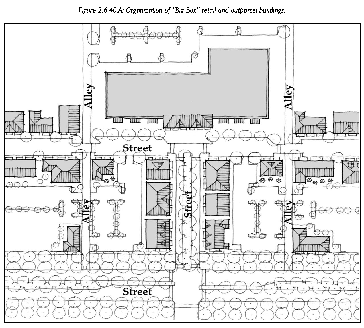
Address Visual Impact of Large-Scale Retail Buildings. Address the visual impact and compatibility of large-scale retail buildings; and
E.
Encourage Transition to Transect Zones. Encourage development that makes for an easy transition to the transect zones.
2.6.20 - Applicability
These commercial standards apply to the conventional zones; specifically, all new retail, services, commercial recreation facilities, and light industrial development described in the allowed use tables in Division 3.3 (Conventional Zones).
2.6.30 - Review for Compliance
Review for compliance with the standards of this Section shall occur during review of the following, whichever occurs first:
A.
Land development plan (minor or major), see Section 7.2.60 (Land Development Plan);
B.
Special Use Permit, see Section 7.2.130 (Special Use Permit);
C.
Conditional Use Permit, see Section 7.2.20 (Zoning Permit); or
D.
Certificate of zoning compliance, see Section 7.2.110 (Certificate of Design Compliance).
2.6.40 - General Commercial Design Standards
Development subject to the requirements of this Division shall comply with the following standards:
A.
Street Access. No structure or permit shall be issued for a proposed development subject to the requirements of this Division unless such land use is located on a lot that abuts a fully improved street.
B.
Thoroughfare Network. On sites including new streets (thoroughfares), access ways, and/or driveways an interconnected network of blocks and thoroughfares shall be provided.
1.
Blocks. The site shall be designed to incorporate existing, proposed, and future blocks as conveyed in Section 2.2.40 (Blocks).
2.
Thoroughfares.
a.
The site shall be designed as an interconnected network of thoroughfares in accordance with Section 2.2.30 (Thoroughfare Design, Network and Connectivity).
b.
Public and private rights of way, easements, access ways, and driveways (for vehicles, bicycles, and pedestrians) shall conform to the standards in Division 2.9 (Thoroughfare Standards), and, to the maximum extent practicable, provide on- street parking and streetscaping (frontage elements).
c.
Vehicular access driveways shall be consolidated in order to reduce curb cuts and create better access management, to the maximum extent possible. Vehicular access shall comply with Section 2.2.60 (Access Management - Design).
C.
Street Trees.
1.
Buildings subject to the standards in this Section shall provide canopy trees along all street frontages (except alleys) located between the curb and sidewalk or within five feet of the right-of-way when no sidewalk exists.
2.
Understory trees may be used in cases where overhead utilities will remain after development is complete.
3.
Street Trees shall conform to the standards established in Tables 2.9.70.A (Street Landscaping), 2.9.90.G (Public Planting), and 2.9.90.H (Clear Height Under Trees).
D.
Building Orientation.
1.
The building façade containing the primary entrance shall be considered as the primary façade.
2.
The primary façades of all buildings shall face a public thoroughfare serving the development, except along U.S 21, S.R. 278 and S.R. 170, where the primary façade may front an internal thoroughfare or parallel access road if it is determined that the design ensures a thoroughfare network that is more pedestrian-friendly.
3.
In the case of multi-building development, the perimeter buildings shall be oriented so that the primary facade faces a public street. Buildings interior to the site may be oriented to private streets or access ways.
E.
Multi-Building Development. Development composed of multiple buildings totaling 30,000 gross square feet or more shall be configured in one or more of the following ways:
1.
Break up the site into a series of smaller "blocks" defined by on-site streets, pedestrian walkways, or other circulation routes. Blocks shall conform with the standards established in Section 2.2.40 (Blocks);
2.
Frame the corner of an adjacent street intersection or entry point to the development;
3.
Frame and enclose parking areas, public spaces, or other site amenities on at least three sides; or
4.
Frame and enclose outdoor dining or gathering spaces for pedestrians between buildings.
F.
Outparcel Development.
1.
To the extent practicable, outparcels and their buildings shall be configured and located to define street edges, development entry points, and spaces for gathering between buildings.
2.
Where appropriate, spaces between buildings shall be enlivened with pedestrian amenities such as plazas, seating areas, parks and gathering places in addition to off- street parking spaces, to the extent practicable.
3.
Outparcel buildings located on lots at street corners shall be located and configured to define the corner through a combination of:
a.
Locating the building as close to the right-of-way as is practicable;
b.
Limiting surface parking between the building and the streets;
c.
Providing a public gathering space adjacent to the corner; and
d.
Distinctive roof form or other pedestrian features such as porches, canopies, or arcades.
4.
Outbuildings within the same development shall include a consistent level of façade articulation on façades facing public streets, a gathering space, or parking lots.
G.
On-Site Circulation.
1.
Parking Area Location and Design.
a.
There shall be no parking between a building and the street it fronts, except:
(1)
On-street parallel or angled parking, and
(2)
Parallel parking along other streets and/or access ways within the development.
b.
Type and design of on-street parking shall coordinate with Division 2.9 (Thoroughfare Standards)
c.
Head-in or front-in parking shall only be permitted as set forth in Division 5.5 (Off-Street Parking).
2.
Parking Lot Cross-Access Ways. Development shall be designed to allow for vehicular cross-access to adjacent, compatible developments in accordance with the following standards.
a.
Cross-access ways shall be designed and located based on the standards of Section 2.2.60 (Access Management Design) and this Section, but in no case shall a development be required to provide cross-access to more than two adjacent parcels.
b.
Cross-access ways shall allow for two-way traffic between parcels through the use of a single drive aisle with a minimum width of 22 feet, or through two one-way aisles, each with a minimum width of 11 feet.
c.
A cross-access way standard may be waived by the Director if the applicant demonstrates it is impractical to provide cross-access due to:
(1)
Topography, or natural features;
(2)
The size and configuration of the site;
(3)
Vehicular safety factors;
(4)
The presence of incompatible uses; or
(5)
Existing development patterns on adjacent developed sites.
d.
When a cross-access way standard is waived in accordance with this Section, bicycle and pedestrian connections shall be provided between adjacent developments or uses, unless it is unreasonable or impracticable.
3.
Pedestrian Circulation and Walkways. Pedestrian walkways shall:
a.
Connect all buildings within a multi-building development with the larger pedestrian network surrounding the site;
b.
Have a minimum width of five feet;
c.
Be provided along the full length of building facades with an entryway or facing off-street parking areas;
d.
Provide crosswalks at all intersections and other street crossings (both external and internal to the site) where a high-level of pedestrian movement is anticipated to maximize pedestrian safety; and
e.
Coordinate site design, including entrances and parking lots, with the location of existing and planned transit facilities.
H.
Accessory Structures.
1.
Access to accessory structures shall be provided from alleys or secondary streets, whenever possible.
2.
Accessory structures shall be compatible with the principal structure in terms of, materials, massing, and color.
3.
Accessory structures shall not physically obstruct pedestrian entrances or travel ways.
4.
Trash receptacles and refuse collection areas shall be located in an enclosed area.
2.7.10 - Purpose
The purpose of this Division is to:
A.
Provide standards for the subdivision of rural lands in Beaufort County that maintain the character and heritage of the rural lands.
B.
Allow long-time rural residents to protect a traditional way of life and provide affordable housing for family members that in turn helps stabilize and preserve the County's rural communities.
2.7.20 - Applicability
2.7.30 - Rural Small Lot Subdivision
A.
Intent. The rural small lot subdivision is designed to allow landowners of small rural lots greater flexibility to subdivide land that is generally not allowed to be subdivided under this Development Code because of the density limitations in the T2R Zone.
B.
Applicability.
1.
Use of the rural small lot subdivision option is limited to the locations identified in Table 2.7.30.A (Maximum Number of Lots That Can Be Subdivided From a Parcel of Record Utilizing the Rural Small Lot Subdivision), that were parcels of record as of July 1, 2010 and cannot be transferred to any other parcel.
2.
The Rural Small Lot Subdivision shall not be permitted on Coosaw Island, Judge Island, Lady's Island, south of the Broad River and the Airport Overlay District - MCAS.
C.
Review. Review and approval for a rural small lot subdivision shall comply with the procedures in Subsection 7.2.70.E, (Minor Subdivision Plat Procedure) or Subsection 7.2.70.F (Major Subdivision Plat Procedure); as well as the standards in this Article and all other relevant provisions of this Development Code.
D.
Minimum Development Standards for Rural Small Lot Subdivisions. Rural small lot subdivisions shall comply with the following:
1.
Minimum Lot Size. Minimum lot size for by-right lots is one-half of an acre.
2.
Parent Parcel. The parent parcel constitutes the total site.
3.
By-Right Lots.
a.
The number of by-rights lots allowed in a rural small lot subdivision is established in Table 2.7.30.A (Maximum Number of Lots That Can Be Subdivided From a Parcel of Record Utilizing the Rural Small Lot Subdivision).
b.
The total acreage of these by-right lots constitute the total acreage of the parent parcel, except if any of the by-right lots are less than one acre in area, one acre per subdivided by-right lot will be subtracted from the original acreage of the parent parcel.
4.
Remainder Lots. The maximum number of remainder lots allowed in the rural small lot subdivision are determined by determining the total acreage of the remainder lots (total site area - parent parcel), and then applying the density standards in the underlying zone and the open space set-aside standards in Section 2.8.40 (Set-Aside Requirement).
E.
Restrictions on Future Subdivisions. A note shall appear on all plats for rural small lot subdivisions specifying the number of remaining by-right lots that can be subdivided from the parent tract. If all by-right lots are subdivided, the note shall state that remaining subdivisions of the parent parcel shall comply with the density requirements in underlying zone, and the open space set-aside standards in Section 2.8.40 (Set-Aside Requirement).
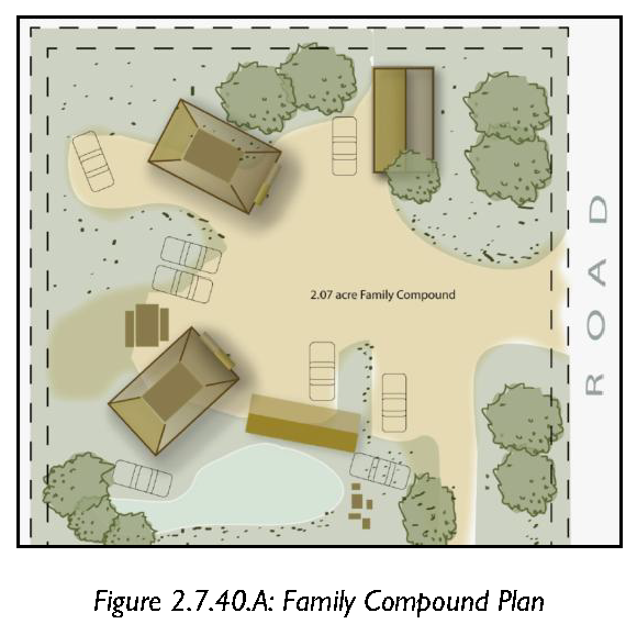
2.7.40 - Family Compound Standards
Family compounds shall comply with the following standards:
A.
Fifty (50) Years of Ownership. A single member of the family, multiple members of the family, or an unbroken succession of family members shall own a family compound property for no less than 50 years. All owners of the property shall request the family compound.
B.
Familial Relationship of those Receiving Property and/or Dwelling Unit. The person(s) for whom the family dwelling units are built and/or the property subdivided shall be related to the owner of the property by blood, marriage, or adoption.
C.
Property May be Subdivided. Family compounds shall be developed and the dwelling units built, or the family compound property may be subdivided and conveyed by the landowner to a family member to build a dwelling unit. Family compounds that are subdivided are limited to the maximum number of units without clustering shown in Table 2.7.40.A.
D.
Family Compound Design. The family compound shall be designed as follows:
1.
Lots or dwelling units may be designed in a conventional form, or as a traditional cluster. For the purposes of this Section, traditional cluster means there must be a minimum of two dwelling units on the parcel and the average distance between dwelling units is no greater than 50 feet.
2.
The maximum density that may be achieved on family compounds is outlined in Table 2.7.40.A (Maximum Densities of Family Compounds). This maximum density includes dwelling units and accessory dwelling units.
3.
For family compounds that are clustered:
a.
There is no minimum lot area;
b.
The minimum separation between dwelling units is 15 feet; and
c.
A land development plan shall be submitted for approval. See Section 7.2.60 (Land Development Plan). The land development plan shall be drawn to scale and clearly indicate all property lines and the location of all existing and proposed structures.
4.
For family compounds that are not clustered the minimum lot area is one-half acre.
5.
Family Compound Design. Family compounds that are subdivided shall be accompanied by covenants and cross easements, or similar restrictions and reservations, guaranteeing essential infrastructure and 50 feet of vehicular access for each lot.
E.
Septic Systems and Reserve Areas. No family dwelling unit shall be built unless the appropriate agency has determined that septic systems and reserve areas in the family compound are sufficient to serve all units in the compound.
F.
Leasing. No family dwelling unit shall be leased for five years from the date of approval unless the lessee is related to the property owner by blood, marriage, or adoption.
G.
Conveyance of Land Approved as Family Compound. No portion of a tract of land approved as a family compound in accordance with this Section shall be conveyed for five years from the date of approval of the family compound unless the grantee is related to the property owner by blood, marriage, or adoption. This limitation on conveyance shall:
1.
Be recorded on the plat of the property, on the plats of any property subdivided and conveyed by the landowner(s) under this Section, and in a database accessible to county staff.
2.
Not operate to prohibit actions in foreclosure brought by lenders that are participating in the secondary mortgage market.
3.
Not operate to prohibit sale by the county of the entire tract or a portion of it for nonpayment of property taxes.
H.
Affidavit Required. Applicants must submit a sworn affidavit recorded in the Register of Deeds Office with the following information:
1.
There has been no intentional misrepresentation during the application process;
2.
There shall be no lease of a family dwelling unit to a nonfamily member within five years of approval; or
3.
There shall be no conveyance of any portion of a tract of land granted a dwelling unit or lot under this section to a nonfamily member within five years of approval.
I.
Violations and Enforcement.
1.
A violation of this section shall consist of the following:
a.
Intentional misrepresentation during the application process;
b.
Lease of a family dwelling unit to a nonfamily member within five years of approval; or
c.
Conveyance of any portion of a tract of land granted a dwelling unit or lot under this section to a nonfamily member within five years of approval.
2.
Penalties may be waived by the Director if it can be shown that lease or conveyance to a nonfamily member was absolutely necessary to avoid foreclosure on either a family dwelling unit or any portion of a tract granted a dwelling unit under this section.
3.
Until the violation has been addressed in accordance with Article 9 (Enforcement), the Director shall not permit additional dwelling units on the family compound or further subdivision under this section in the violator's family compound.
4.
As a condition of approval, the applicant and the person(s) for whom the family dwelling unit is to be built or the property subdivided shall read and sign disclosure forms describing any violations of this section and applicable penalties.
5.
A violation shall not have the effect of clouding the title of a parcel subdivided under this Section.
2.8.10 - Purpose
The purpose of this division is to provide a set of open space and civic space types and their associated standards to use within all zones.
Open space and civic space set-asides are intended for the use and enjoyment of a development's residents, employees, or users. Open space and civic space set-asides serve numerous purposes, including preservation of resource protection areas, other natural areas, ensuring resident access to open areas and recreation, reducing the heat island effect, enhancing stormwater quality, and providing public health benefits.
2.8.20 - Applicability
The standards established in this division shall apply to all proposed development subject to a major or minor development plan or major subdivision plat, with the exception of agricultural uses subject to a land development plan, and shall be considered in combination with the standards for the applicable zone in Article 3 (Specific to Zones) and Article 5 (Supplemental to Zones).
2.8.30 - Civic and Open Space Standards
A.
Open Space: Open space consists of the land area in a subdivision or land development that is left undeveloped as part of required natural resource preservation requirements (Division 5.11), landscaping and buffers requirements (Division 5.8), preserved archaeological or historic sites (Division 5.10), stormwater management (Division 5:12) and civic space requirements (Section 2.8.40.B). Open space does not include open areas in private individual residential lots; public road rights-of-way and private street easements; land covered by structures not designated for active civic recreational uses; and outdoor storage areas.
1.
Design Standards for Open Space: The land shall, to the maximum extent practicable, be located to adjoin, extend, and enlarge any open areas, trails, parks, or other open space resources that exist or are planned adjacent to the development.
2.
Reserved.
B.
Civic Space: Civic space is a type of open space that is easily accessible and dedicated for public use or for common use of residents of a private community. Civic spaces generally do not include lands set aside for natural resource preservation, buffers, and stormwater management unless these lands are available for common use by the public or the residents of the community and that have amenities that encourage the use of these lands.
1.
Public and Private Civic Space: Public open space is designed and intended for common use and the enjoyment of County residents and visitors. Private civic space is designed and intended for common use and the enjoyment of the residents of a private community.
2.
Types of Civic Space: There are 12 different civic space types defined in Table 2.8.30.A (Civic and Open Space Type Standards). Two of the civic space types, Playgrounds and Community Gardens, may be incorporated into any of the other civic space types, except preserved open space, or may stand alone.
a.
Service Area. Describes how the civic space relates to the county as a whole and the area that will be served by the civic space.
b.
Size. The overall range of allowed sizes of the civic space.
c.
Frontage. The relationship along property lines of a civic space to adjacent buildings or lots.
1)
Building. Civic spaces that are listed as having a "building" frontage shall have the fronts of buildings, either attached to the park or across a thoroughfare, facing onto the civic space for a minimum of three quarters of the perimeter.
2)
Independent. Civic spaces that are listed as having an "independent" frontage shall have the fronts of buildings, either attached to the park or across a thoroughfare, facing onto the civic space to the maximum extent possible, but may have the side or rear of a building or lot front onto the civic space. The side or rear of a building or lot fronting onto the civic space shall be designed with a secondary frontage and entrance along the civic space.
d.
Disposition of Elements. The placement of objects within the civic space.
1)
Natural. Civic spaces with natural character are designed in a natural manner with no formal arrangement of elements.
2)
Formal. Civic spaces with a formal character have a more rigid layout that follows geometric forms and has trees and other elements arranged in formal patterns.
3)
Informal. Civic spaces with an informal character have a mix of formal and natural characteristics.
e.
A list of the typical facilities found within the civic space is provided in Table 2.8.30.A. This list is not intended to be a complete list of facilities allowed nor is it intended that every civic space would contain each of the facilities listed.
f.
The civic spaces specified in Table 2.8.30.A (Civic and Open Space Type Standards) are allowed by right or with the specified approvals in the designated zones.
3.
Design Standards for Civic Space. Land used as civic space shall meet the following design standards:
a.
Location. Civic space shall be located so as to be readily accessible and usable by residents and users of the development. To the maximum extent practicable, a portion of the open space set-aside should provide focal points for the development.
b.
Configuration.
1)
The land shall be compact and contiguous unless it is used for continuation of an existing trail, or if specific natural or topographic features require a different configuration.
2)
The land shall, to the maximum extent practicable, be located to adjoin, extend, and enlarge any open areas, trails, parks, or other open space resources that exist or are planned adjacent to the development.
c.
Amenities. Civic spaces shall be equipped or developed with amenities designed to encourage the use and enjoyment of these places. Such amenities include trails, benches, landscaping, formal lawns, recreational facilities, and picnic shelters.
d.
Use of Stormwater Best Management Practices (BMPs). Stormwater BMPs are strongly encouraged to be integrated into civic spaces as amenities. Single-use Stormwater management devices that provide no recreational or civic function; and/or are enclosed in fences, shall not count toward civic space requirements.
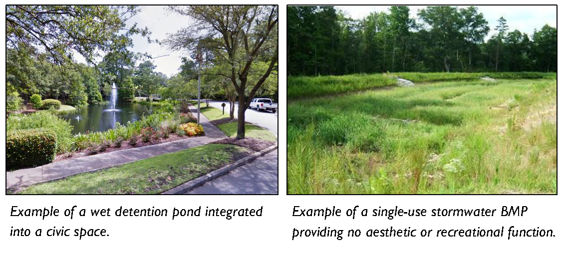
e.
Accessory Structure Standards. All accessory structures within parks and open spaces, including, but not limited to, rest rooms, open-air pavilions, gazebos, wildlife viewing platforms, boardwalks, observation towers, picnic shelters and outdoor theaters, shall not be subject to the physical requirements of the building form standards in Article 3 (Specific to Zones). They shall be designed and furnished to be consistent with the character of the zone in which they are located. Such consistency may require accessory structures to maintain building setbacks, frontage, massing, disposition and character similar to adjacent development as determined by the Director.
| Table 2.8.30.A: Civic and Open Space Type Standards | |||
|---|---|---|---|
| Transect Zones | |||
| Conventional Zones | |||
| Civic Space Type | Regional Park | Sport Complex | Community Park |
| Illustration 1 | 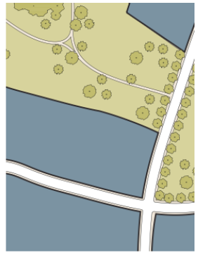 | 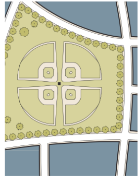 | 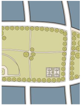 |
| Description 1 |
A natural preserve
available for unstructured recreation. | An open space that consolidates heavily programmed athletic fields and associated facilities. | An open space available for unstructured recreation and a limited amount of structured recreation. |
| Location and Size | |||
| Location Service Area | Regional | Regional | Multiple Neighborhoods |
| Size | |||
| Minimum | 75 acres | 25 acres | 12 acres |
| Maximum | - | - | - |
| Character | |||
| Frontage | Independent | Independent | Independent |
| Disposition of Elements | Natural, Formal, or Informal | Formal or Informal | Informal |
| Typical Facilities | |||
| Passive and Active Recreation, Accessory Structure, Drinking Fountains, Community Facility < 7,500 total square feet, Paths and Trails | Passive and Active Recreation, Accessory Structure, Drinking Fountains, Community Facility < 7,500 total square feet, Paths and Trails | Passive and Active Recreation, Accessory Structure, Drinking Fountains, Community Facility < 5,000 total square feet, Paths and Trails | |
| Table 2.8.30.A: Civic and Open Space Type Standards (continued) | |||
|---|---|---|---|
| Transect Zones | |||
| Conventional Zones | |||
| Civic Space Type | Greenway | Green | Square |
| Illustration 1 | 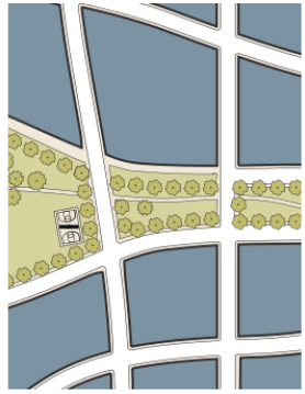 | 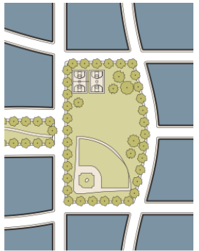 | 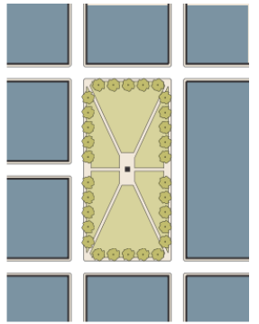 |
| Description 1 | A linear open space that may follow natural corridors providing unstructured and limited amounts of structured recreation. | An open space available for unstructured and limited amounts of structured recreation. | An open space available for civic purposes, unstructured and limited amounts of structured recreation. |
| Location and Size | |||
| Location Service Area | Multiple Neighborhoods | Neighborhood | Neighborhood |
| Size | |||
| Minimum | 8 acres | 1 acre | ½ acre |
| Maximum | - | 15 acres | 5 acres |
| Character | |||
| Frontage | Independent or Building | Building | Building |
| Disposition of Elements | Natural or Informal | Informal | Formal |
| Typical Facilities | |||
| Passive and Active Recreation, Accessory Structure, Drinking Fountains, Community Facility < 5,000 total square feet, Paths and Trails | Passive and Active (unstructured or structured) Recreation, Accessory Structure, Drinking Fountains, Community Facility < 5,000 total square feet, Paths and Trails | Passive and Active (unstructured or structured) Recreation, Accessory Structure, Drinking Fountains, Community Facility < 5,000 total square feet, Paths and Trails | |
| Table 2.8.30.A: Civic and Open Space Type Standards (continued) | |||
|---|---|---|---|
| Transect Zones | |||
| Conventional Zones | |||
| Civic Space Type | Plaza | Pocket Plaza | Pocket Park |
| Illustration 1 | 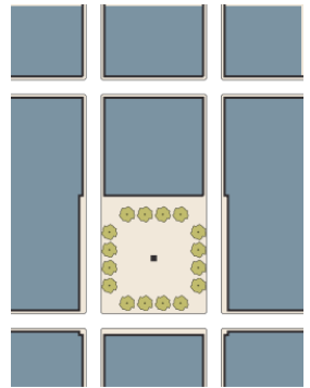 | 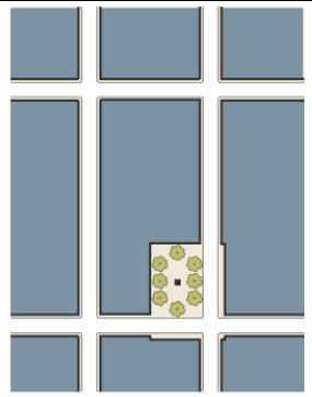 | 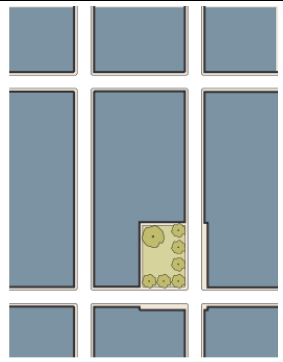 |
| Description 1 | A formal open space available for civic purposes and commercial activities. Plazas are typically hardscaped. | A formal open space available for civic purposes and commercial activities. Pocket Plazas are typically hardscaped. | An open space available for informal activities in close proximity to neighborhood residences. |
| Location and Size | |||
| Location Service Area | Neighborhood | Neighborhood | Neighborhood |
| Size | |||
| Minimum | ½ acre | 4,000 sf | 4,000 sf |
| Maximum | 2½ acres | ½ acre | 1 acre |
| Character | |||
| Frontage | Building | Building | Building |
| Disposition of Elements | Formal | Formal | Formal or Informal |
| Typical Facilities | |||
| Passive Recreation, Accessory Structure, Drinking Fountains, Paths and Trails | Passive Recreation, Accessory Structure, Drinking Fountains, Paths and Trails | Passive Recreation, Accessory Structure, Drinking Fountains, Paths and Trails | |
| Table 2.8.30.A: Civic and Open Space Type Standards (continued) | |||
|---|---|---|---|
| Transect Zones | |||
| Conventional Zones | |||
| Civic Space Type | Playground | Community Garden | Natural Preserve |
| Illustration 1 | 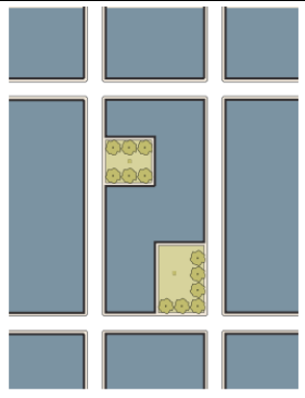 | 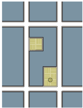 | 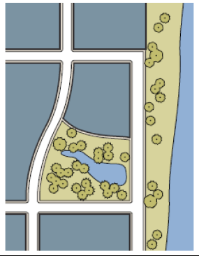 |
| Description 1 | An open space designed and equipped for the recreation of children. A Playground should be fenced and may include an open shelter. Playgrounds may be included within other civic spaces. | An open space designed as a grouping of garden plots that are available to nearby residents for small-scale cultivation. Community Gardens may be included within other civic spaces. | A natural preserve that may contain sensitive natural habitats. Paths and trails may be incorporated into the Natural Preserve. In T1 and T2R, natural preserves may include agriculture and crop harvesting. |
| Location and Size | |||
| Location Service Area | Neighborhood | Neighborhood | Neighborhood |
| Size | |||
| Minimum | - | - | - |
| Maximum | - | - | - |
| Character | |||
| Frontage | Independent or Building | Independent or Building | Independent |
| Disposition of Elements | Formal or Informal | Formal or Informal | Natural |
| Typical Facilities | |||
| Accessory Structure, Drinking Fountains, Paths and Trails | Accessory Structure, Drinking Fountains, Paths and Trails | Paths and Trails | |
2.8.40 - Set-Aside Requirement
A.
Open Space. Development in all zones shall set aside the minimum amounts of open space identified in Table 2.8.40.A (Open Space Set-Aside Requirement).
1.
Areas to be Included in Set-Aside Calculations. Open space consists of the land area in a subdivision or land development that is left undeveloped as part of required natural resource preservation requirements (Division 5.11), landscaping and buffers requirements (Division 5.8), preserved archaeological or historic sites (Division 5.10), stormwater management (Division 5:12) and civic space requirements (Section 2.8.40.B).
2.
Areas not to be Included in Open Space Set-Aside Calculations. The following areas shall not be counted as set-asides:
a.
Private Yards. Private yards not subject to an open space or conservation easement;
b.
Public Street ROW or Private Street Easements. Public road rights-of-way or private street easements, including sidewalks located within those rights-of-way or easements;
c.
Open Parking Areas. Parking space and drive aisles in parking lots, and driveways for dwellings;
d.
Land Covered by Structures. Land covered by structures not designated for active recreational uses; and
e.
Outdoor Storage Areas. Designated outdoor storage areas.
B.
Civic Space. Development in all zones shall set aside the minimum amounts of civic space identified in Table 2.8.40.B (Civic Space Set-Aside Requirement).
1.
Exemptions. Residential developments with fewer than 20 dwelling units and commercial developments with less than 25,000 square feet of building space are exempt from civic space set-aside requirements.
2.
Areas not to be Included in Civic Space Set-Aside Calculations.
a.
Thoroughfare Buffers (Section 5.8.50); Foundation Buffers (Section 5.8.60); Parking Lot Area Landscaping (Section 5.8.80); Perimeter Buffers (Section 5.8.90); and River Buffers (Section 5.11.60) are not included in Civic Space Set-aside calculations with the exception of where a buffer is used for the continuation of an existing trail or pathway that is open to the public and extends beyond the project boundaries.
b.
Lands set aside for resource protection as required in Division 5.11 that are not available for common use by the public or the residents of the community and that have no amenities that encourage the use of these lands.
c.
Single-use stormwater management BMPs that provide no recreational or civic function; and/or are enclosed in fences.
C.
Provision in Multi-Phase Developments. In multi-phase developments, open and civic space set-asides shall be apportioned among the phases such that the total amount of open and civic space set aside in a phase and any previously approved phases meets the open and civic space set-aside standard as applied to the total area of the phase and any previously approved phases.
2.8.50 - Ownership of Set-Asides
A.
Set-aside areas shall be maintained as permanent open space and/or civic space through one or more of the following options:
1.
The property owner establishes an entity to manage and maintain the set-aside area in a form that ensures long-term maintenance and management;
2.
Conveyance of the land to a property owners' or homeowners' association that holds the land in common ownership and will be responsible for managing and maintaining it for its intended purposes;
3.
Conveyance of the land to a third party beneficiary, such as a nonprofit environmental or civic organization, that is organized for, capable of, and willing to accept responsibility for managing and maintaining the land for its intended purposes;
4.
Dedication of the land to the County or other appropriate public agency that is organized for, capable of, and willing to accept responsibility for managing and maintaining the land for its intended purposes; or
5.
Where open space set-aside areas are used for active agriculture and crop harvesting, the property owner manages and maintains the set-aside area;
B.
If a set-aside is to be conveyed to a property owners' or homeowners' association, the association shall be established in accordance with the following:
1.
The landowner shall submit documents for the creation of the property owners' or homeowners' association to the County for review and approval. The documents shall include the association's bylaws, a legal description of open space set-aside areas, and all documents governing ownership, maintenance, and use restrictions for the set-aside.
2.
Documents for the creation of the association shall provide that membership in the association is automatic (mandatory) for all purchasers of land, dwelling units, or structures in the development, and their successors in title, and that the association shall have clear legal authority to compel contributions from members to cover their proportionate share of the costs associated with the maintenance of common areas and facilities.
3.
The landowner shall agree that the association shall be established (with all required documents for its creation properly recorded), and operating (with financial subsidization by the landowner or applicant, if necessary, before approval of the first Building Permit for the development.
C.
If the set-aside is to be conveyed to a third party beneficiary, such as a non-profit civic organization, then the conveyance shall include deed restrictions that:
1.
Govern the use, management, and maintenance of the set-asides, consistent with the standards in this Section;
2.
Run with the land in perpetuity; and
3.
Include any other provisions the County Attorney deems necessary and appropriate to fulfill the requirements of this Section.
D.
All methods utilizing private ownership shall include deed restrictions, covenants, or other legal instruments that ensure continued use of the land and facilities for their intended uses and provide for the continued and effective management, operation, and maintenance of the land and facilities.
2.8.60 - Maintenance of Set-Asides
A.
Maintenance of open space and/or civic space set-aside areas shall be the responsibility of the owner(s) of the land making up the areas.
1.
Open space set-aside areas or other community facilities shall be maintained in accordance with the approved:
a.
Land Development Plan (minor or major) in accordance with Section 7.2.60 (Land Development Plan);
b.
Special Use Permit in accordance with Section 7.2.130 (Special Use Permit); or
c.
Subdivision in accordance with Section 7.2.70 (Subdivision Plat), whichever is appropriate.
2.
Failure to maintain open space set-aside areas or other community facilities shall be a violation of this Development Code subject to the remedies and penalties in Article 9 (Enforcement).
B.
If the owner of an open space and/or civic space set-aside area fails to maintain it in reasonable condition, and in accordance with approved plans, and fails to correct deficiencies cited by the County, the County shall have the authority to correct the deficiencies.
2.9.10 - Purpose
The intent of this Division is to provide a catalog of pre-approved thoroughfare components and assemblies that are appropriate to use within both conventional and transect zones. Components can be combined to form thoroughfares. Assemblies are pre-approved groupings of components. Both are suitable for use in new developments, as well as the retrofit of existing locations, and can be used in subdivision and community planning activities that promote walkable places.
2.9.20 - Applicability
A.
This Division describes the standards for development of thoroughfares in conventional and transect zones which supplement the "Beaufort County Technical Manual." Where these standards conflict with the "Beaufort County Technical Manual", the standards of this division shall prevail.
B.
These thoroughfare standards are applicable for the transformation of existing thoroughfares and the creation of new thoroughfares in any areas within conventional and transect zones.
C.
Thoroughfare standards are applicable for the design of collector and local streets. Thoroughfare standards applied to existing arterials and roadways under the jurisdiction of the South Carolina Department of Transportation may require additional review (Section 2.9.30.C) in order to obtain approval.
D.
Additional thoroughfare assemblies can be integrated into this division as they are approved by the county.
2.9.30 - Assembling/Designing a Thoroughfare
There are three general procedures for assembling or designing a thoroughfare for approval.
A.
Choose a predefined thoroughfare assembly found in Section 2.9.100 (Thoroughfare Assemblies). These thoroughfare assemblies are allowed by right;
B.
Assemble a thoroughfare that matches the standards found in Table 2.9.90A (Thoroughfare Formulas and Components) and use only the predefined components in Tables 2.9.90.C—J.
1.
If all of the predefined components are permitted by right, then the thoroughfare is permitted by right.
2.
If one or more of the predefined components are permitted by the Director, the thoroughfare shall be submitted for review to the Director and County Traffic Engineer.
C.
Design a thoroughfare that matches the standards found in Table 2.9.90A (Thoroughfare Formulas and Components) but utilize other than the predefined components in Tables 2.9.90.C—J. This thoroughfare will require approval by the Director, County Transportation Engineer, and Fire District representatives.
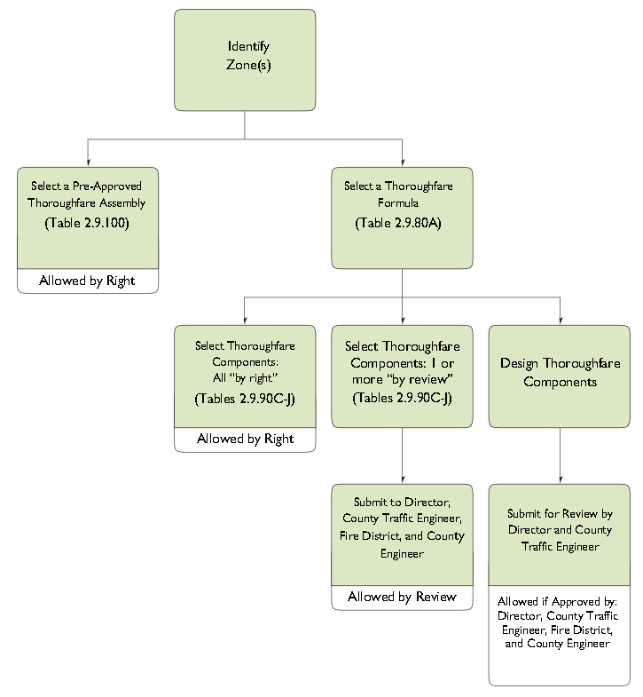
2.9.40 - Thoroughfare Design
A.
Thoroughfares are intended for use by vehicular and pedestrian traffic and to provide access to lots and open spaces.
B.
Thoroughfares shall generally consist of vehicular lanes and public frontages.
C.
Thoroughfares shall be designed in context with the urban form and general intention of the zones through which they pass.
1.
Within the more urban transect zones (T3 through T4) pedestrian comfort shall be a primary consideration of the thoroughfare design. Design conflict between vehicular and pedestrian movement generally shall be decided in favor of the pedestrian.
2.
Within the conventional zones pedestrian comfort shall be balanced with vehicular movement. Design conflict between vehicular and pedestrian movement generally shall be decided in favor of the vehicle while allowing for areas of transition that favor the pedestrian.
3.
Within the most rural transect zones (T1 and T2) pedestrian comfort shall be a secondary consideration of the thoroughfare design. Design conflict between vehicular and pedestrian movement generally shall be decided in favor of the vehicle.
4.
Thoroughfares that transition from transect zones to conventional zones and or from urban to rural character shall adjust to the change in character through the process of an administrative modulation.
5.
Major travel corridors which serve the function of moving high volumes of traffic at moderate to high speeds between place types or different regions of the County should utilize a "Parkway" Thoroughfare Type. Design features of Parkways include landscaped medians, pathways that accommodate both bicycles and pedestrians, and limited curb cuts (See Figure 2.9.40.A).
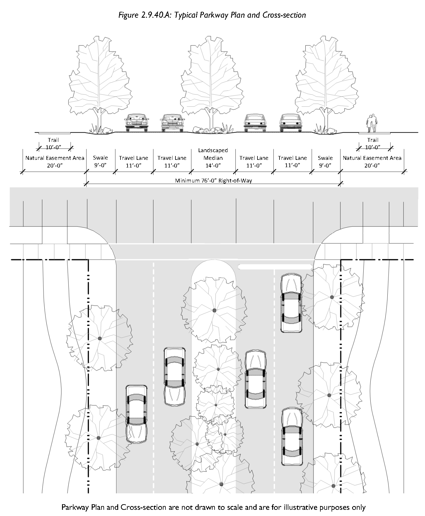
D.
The requirements for pedestrian and bicyclist safety, comfort and access shall establish thoroughfare movement type and design speed. The movement type and design speed then determine the dimensions of each thoroughfare element, such as vehicular lanes and turning (curb) radii.
E.
Thoroughfares shall be designed according to the types of vehicles expected to use each thoroughfare on a daily basis. Occasionally, large vehicles are expected on all thoroughfares. All thoroughfares shall allow these vehicles to safely pass without major difficulty.
F.
Other factors that may need to be considered in the selection of an appropriate thoroughfare type in transect zones include the following:
1.
Parking. Parking availability on-site or on the thoroughfare will influence the appropriate thoroughfare type. Parking will also be determined by lot size and use.
2.
Truck Access. Thoroughfares that provide access to high volumes of large trucks may need additional design considerations to mitigate potential negative effects on walkability.
3.
Bus Service. Thoroughfares that will serve as a public transit or school bus routes may need additional design considerations, including, but not limited to, the location of bus stops.
4.
Stormwater. Thoroughfares should be designed to accommodate stormwater treatment and retention facilities.
G.
All lane dimensions shall be measured to the face of the curb. Where no curb and gutter is provided, the lane dimension shall be to the edge of the pavement. In T1 and T2 transect zones, add the width of the gutter pan to the travel lane width if curb and gutter are used and there is no on-street parking.
H.
Thoroughfare Naming. Proposed thoroughfares shall be named based on the following:
1.
Thoroughfares, which are obviously in alignment with other existing named thoroughfares, shall bear the assigned name of the existing thoroughfare.
2.
Proposed thoroughfare names shall not be phonetically similar to existing street names, regardless of the use of suffixes such as "street," "avenue," "boulevard," "drive," "place," "court," etc.
3.
In no case shall a name be used which will be confused with another existing thoroughfare.
4.
A house or lot numbering (address) system shall be designed, utilizing an extension of an existing system in the area where one exists, and shall be placed on the final plat.
5.
Use of numbered (e.g. "1st Street") or lettered (e.g. "A Street") names and complicated, lengthy, offensive, or unconventionally spelled words or phrases are not permitted.
6.
All proposed thoroughfare names require approval by the Beaufort County E-911 Addressing Center.
I.
Thoroughfare Name Signs. Street name signs, constructed to County specifications, shall be installed at all thoroughfare intersections at the developer's expense. Thoroughfare names proposed by the developer must first be approved in accordance with Subsection H above.
J.
Dedication of Right-of-Way. A proposed subdivision that includes a platted street that does not conform to the minimum right-of-way requirements of this chapter shall provide for the dedication of additional right-of-way along either one or both sides of the street so that the minimum rights-of-way required by this code can be established. If the proposed subdivision abuts only one side of the street, a minimum of one-half of the required extra right-of-way shall be dedicated by such subdivision.
2.9.50 - Movement Types and Design Speed
Movement types are intended to assist in the selection of the appropriate thoroughfare design for the necessary level of pedestrian and bicyclist safety and comfort at any given location. Design speed is the primary determinant of movement type. A list of approved movement types (along with their assigned lane widths and curb radii) is provided for each transect zone in Tables 2.9.90.A—C.
Following is a list of movement types:
A.
Yield. Drivers must proceed slowly, with extreme care, and must yield to approaching traffic when vehicles are parked on both sides of the thoroughfare creating essentially one through lane. A Yield Thoroughfare is the functional equivalent of traffic calming. In addition to yield movement use on normal thoroughfares, this movement is used for alleys and rear lanes. For these applications, the primary purpose is access to rear loaded driveways/access for residential and commercial property. Design speed is less than 20 mph.
B.
Slow. Drivers can proceed carefully with an occasional stop to allow a pedestrian to cross or another car to park. The character of the thoroughfare should make drivers uncomfortable exceeding the design speed due to the presence of parked cars, sense of enclosure from buildings and street trees, tight turning radii, and other design elements. Design speed is 20—25 mph.
C.
Low. Drivers can generally expect to travel without delay at the appropriate design speed. Thoroughfare design supports safe pedestrian movement at the higher design speed. This movement type is appropriate for thoroughfares designed to traverse longer distances or connect to higher intensity locations. Design speed is 30—35 mph.
D.
Suburban. This is a conventional thoroughfare design in which drivers can expect a separation of modes (i.e., bike lanes, walking paths and roads) allowing automobiles to travel unimpeded by pedestrians or walkability concerns. This movement type is rarely used in T3 through T4 transect zones, but may be needed when a thoroughfare crosses through T1 or T2 transect zones, as well as in conventional zones. Design speed may be above 35 mph.
The design criteria for Yield, Slow, and Low Thoroughfares shall be commensurate with local thoroughfares. Design speeds higher than 35 mph shall not be used in areas intended to support moderate or high levels of pedestrian or bicycle activity due to concerns with safety and comfort.
2.9.60 - Intersections
A.
Turning Movements.
1.
Street design of narrow streets and compact intersections requires designers to pay close attention to the operational needs of transit, fire and rescue, waste collection and delivery trucks. For this reason, early coordination with transit, fire and rescue, waste collection and other stakeholder groups is essential.
2.
More regular encroachment of turning vehicles into opposing lanes will occur at compact intersections. Therefore, frequency of access, traffic volumes and the speeds on intersecting streets at those intersections must be considered when designing intersections. For fire and rescue, determination of the importance of that street for community access should be determined, e.g. primary or secondary access.
3.
When present, bike lanes and on-street parking will increase the effective curb return radius, when curb extensions are not employed, by providing more room for the wheel tracking of turning vehicles. The designer should use turning templates or software to evaluate intersections to ensure adequate operation of vehicles can occur. Location of on-street parking around intersections should be evaluated during this analysis to identify potential conflicts between turning vehicles and on-street parking.
B.
Visual Obstructions. No fence, wall, tree, terrace, building, sign, shrubbery, hedge, or other planting or structure or object capable of obstructing driver vision shall be allowed at intersections.
C.
Street Jogs. Street intersection jogs or centerline offsets of less than 150 feet are prohibited in the horizontal alignment of streets across intersections.
D.
Intersections. The centerline of no more than two streets should intersect at any one point. Streets should be laid out so as to intersect as nearly as possible at right angles. No street should intersect another street at less than 60 degrees.
2.9.70 - Public Frontages
A.
The public frontage contributes to the character of the zone, and includes the types of sidewalk, curb, planter, and street trees.
B.
Public frontages shall be designed and allocated within zones as shown in Table 2.9.90.E (Public Frontage Types).
C.
Within the public frontages, the prescribed types of public planting and public lighting shall be as shown in Tables 2.9.90.G—J. The spacing may be adjusted with the approval of the Director to accommodate specific site conditions.
D.
Existing trees may count towards the street tree requirement if approved by the Director.
1.
Proposed street tree height and type shall be appropriate for the frontage conditions. Trees with existing or potential canopy covering thoroughfares, civic spaces or parking spaces shall be of a type that, at maturity or with minor pruning at installation, provide a clear height as describe in the Table 2.9.90.H (Clear Height Under Trees).
2.
Reserved.
E.
Street Landscaping. Refer to Table 2.9.70.A (Street Landscaping) for standards.
F.
Public utilities (water, sewer, electric, gas, cable) shall be buried. Utilities should be planned and constructed to use the right of way or easement associated with rear lanes or alleys first (the default), and thoroughfares second.
2.9.80 - Thoroughfare Construction Specifications
A.
Design Drawings and Certification. Professional engineers, registered in the state, shall prepare plans, profiles, cross sections, and specifications for all new roads and streets. The engineers shall certify roads/streets are built to comply with the approved plans and specifications. Cross sections shall be developed every 100 feet at intersections and break points in grade. Cross sections shall show travelways, shoulders, ditches, or curb and gutter, if applicable, and utility location.
B.
Minimum Construction Specifications for Paved Streets. Street construction specifications for paved streets shall be as follows:
1.
Construction of Roads and Streets. All new roads shall be paved to meet the SCDOT Standard Specifications for road construction and comply with the following:
a.
Commercial Subdivisions:
(1)
The wearing surface shall have a minimum thickness of two inches of asphalt pavement; and
(2)
The base course shall be a minimum thickness of eight inches.
b.
Residential Subdivisions:
(1)
The wearing surface shall have a minimum thickness of 1½ inches of asphalt pavement; and
(2)
The base course will be a minimum thickness of six inches.
2.
Alternate Materials. Alternate paving materials may be used if it is demonstrated that they are as good or better as the standard in Subsection B.1 above, as approved by the County Engineer.
3.
Shoulder Slope. Maximum slope of shoulders shall be one inch vertical per foot horizontal. Minimum slope of shoulders shall be one-half inch vertical per foot horizontal.
C.
Minimum Construction Specifications for Unpaved Roads.
1.
For the purposes of this Section, unpaved road shall not mean dirt road, per se, but shall be referred to as "stabilized aggregate" road. Unpaved roads are to be utilized for residential, low volume traffic usage only (see Subsection C.2. below).
2.
Minor subdivisions, as long as no more than four lots will be served by the proposed road, and rear lanes (see Table 2.9.90.E) may utilize a stabilized aggregate road, in accordance with the standards in this section. All major subdivisions, and instances where five or more lots will be served by the road, shall require paved roads, per the paving standards in Subsection 2.9.80.B.
3.
Unpaved roads shall remain private roads and shall not be accepted by the County for maintenance or ownership unless specifically approved by County Council where determined to serve a greater public interest.
4.
Construction specifications for unpaved roads are as follows:
a.
Normal crown cross section transverse slopes shall be a two-percent minimum.
b.
Longitudinal slopes shall be a one-percent minimum.
c.
A soil report and analysis shall be performed by a qualified soil professional to determine if the soil is suitable for unpaved roads. The water table elevation shall also be determined.
5.
The road cross section shall consist of the following:
a.
Strip and remove all deleterious and organic material from sub-base, and compact to a 95 percent of density in six-inch to eight-inch lifts, to a depth that will accommodate the vehicular loadings so structural failure will not occur; and
b.
Six-inch stabilized aggregate base course that conforms to the requirements of the SCDOT the South Carolina Highway Department Standard Specifications, with prime coat or other suitable approved means of dust control. Other techniques with similar performance may be approved by the County Engineer.
6.
[Removed by Ord. No. 2015/32.]
7.
All intersections shall be designed to keep stormwater out of intersections.
8.
Roads shall be designed so that potential for maintenance is reduced to a minimum (i.e., maintenance plan for roadway).
9.
The engineer shall design the road so that runoff will not create an erosion problem and damage the structural integrity of the road.
10.
The road will be designed the road to minimize the impact of proposed road on existing trees. The engineer designing the road shall produce a summary on how the following standards are accomplished to the greatest extent practicable:
a.
The developer or the developer's contractor shall use the services of a certified arborist in determining the impact and survivability of individual trees.
b.
The existing tree root systems within the right-of-way shall be trimmed and cut back to eliminate and reduce intrusion or presence within the road sub-grade, including the 24-inch compact sub-grade.
c.
No existing standing trees which are adversely impacted by the root pruning shall be left standing such that they would present a dangerous or hazardous condition within the right-of-way.
2.9.90 - Thoroughfare Formulas and Components
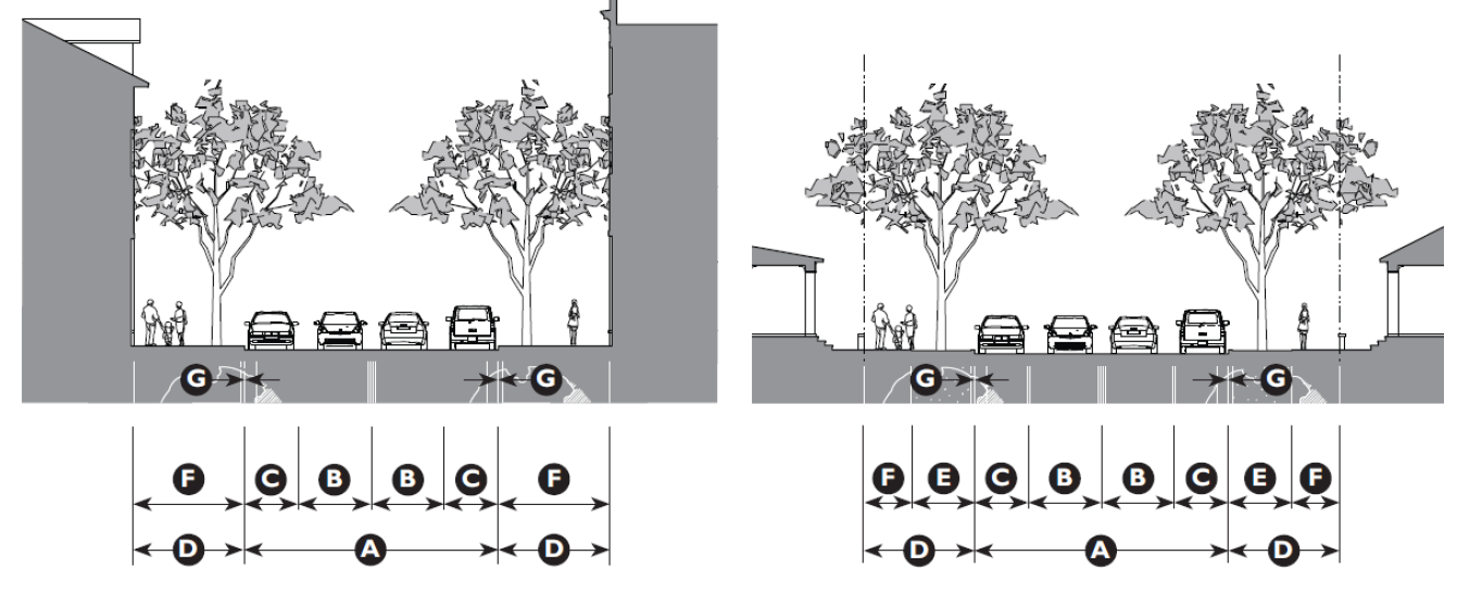
| Table 2.9.90A: Thoroughfare Formulas | |||||||
|---|---|---|---|---|---|---|---|
| Allowed Movement Types | Speed | Lane Assembly | Public Frontage Assembly | ||||
| Slow | 20—25 mph | 9' | - | 5' min. | 8' min. | 14' min. | R or C |
| Low: 30 | 30 mph | 10' | - | 5' min. | 8' min. | 14' min. | R or C |
| Low: 35 | 35 mph | 11' | - | 5' min. | 8' min. | 14' min. | R or C |
| Yield* | <20 mph | 12' | 8' | 5' min. | 5' min. | 10' min. | R or C |
| Yield: Rear Lane | 10 mph | 12' | - | 4' min. | - | 4' min. | R, C, or RB |
| Slow: 20 | 20 mph | 9' | 8' | 5' min. | 5' min. | 10' min. | R or C |
| Slow: 25 | 25 mph | 10' | 8' | 5' min. | 5' min. | 10' min. | R or C |
| Slow: 30 | 30 mph | 10' | 8' | 5' min. | 5' min. | 10' min. | R or C |
| Yield (T4 only)* | <20 mph | 12' | 8' | 5' min. | 6' min. | 12' min. | C |
| 10 mph | 10 mph | 21' | - | 5' min. | 6' min. | 1.5' min | RB |
| Slow: 20 | 20 mph | 9' | 8' | 5' min. | 6' min. | 12' min. | C |
| Slow: 20 w/45° angle parking | 20 mph | 12' | 16' | 5' min. | 6' min. | 12' min. | C |
| Slow: 25 | 25 mph | 10' | 7' | 5' min. | 6' min. | 12' min. | C |
| Low: 30 | 30 mph | 10' | 8' | 5' min. | 6' min. | 12' min. | C |
| Low: 35 | 30 mph | 11' | 8' | 5' min. | 7' min. | 12' min. | C |
| End Notes | |||||||
| * Parking is required on at least one side to facilitate yield movement | |||||||
| Table 2.9.90.B: Bicycle Facilities Standards | ||
|---|---|---|
| Class I: Multi-Use Trail | ||
| Transect Zones | ||
| Conventional Zones | ||
| Width | ||
| One-way | 8 feet | |
| Two-way | 12 feet | |
| Class II: Bicycle Lane | ||
| Transect Zones | ||
| Conventional Zones | ||
| Width Adjacent to: | ||
| Rural Edge | 5 feet minimum | |
| Parking | 6 feet minimum | |
| Curb and Gutter | 5½ feet to face of curb | |
| Design Speed of Thoroughfare | > 25 mph | |
| Class III: Shared Lanes/Bicycle Boulevard | ||
| Transect Zones | ||
| Conventional Zones | ||
| Width | No minimum | |
| Design Speed of Thoroughfare | ≥ 25 mph | |
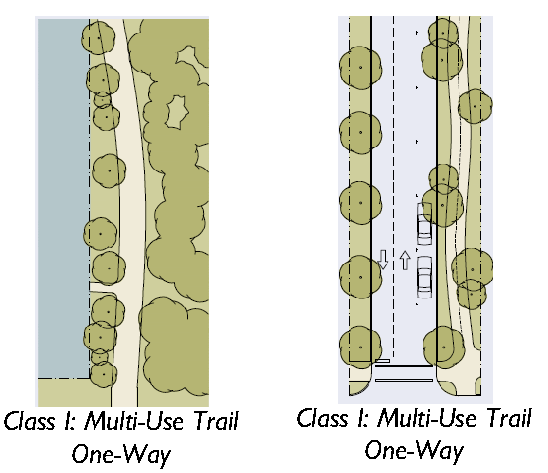
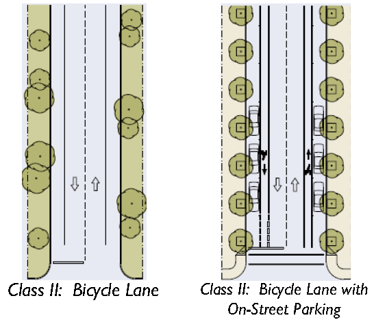
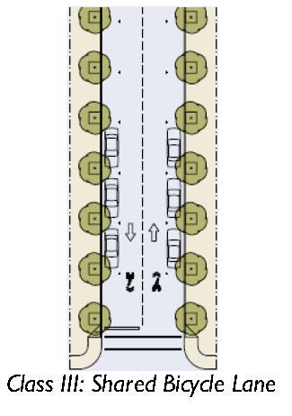
| Table 2.9.90.D: Vehicular Lane Assemblies | |||||
|---|---|---|---|---|---|
| No Parking | No Parking | Limited Parking | One-Sided Parking | Two-Sided Parking | |
|
Movement Type: Yield
Design Speed: < 20 mph | 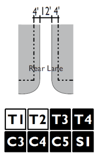 | 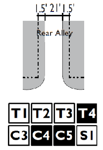 | 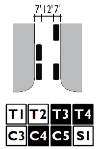 | — | 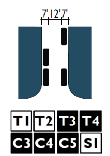 |
|
Movement Type: Slow
Design Speed: 20 mph | 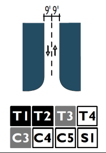 | — | — | 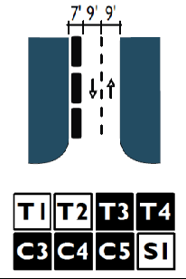 | 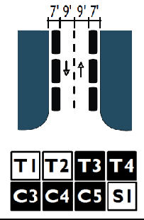 |
|
Movement Type: Slow
Design Speed: 25 mph | 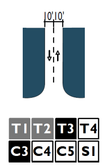 |  | — | 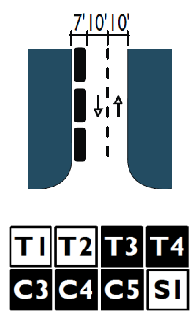 | 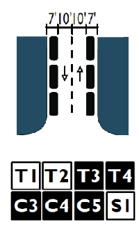 |
|
Movement Type: Low
Design Speed: 30 mph | 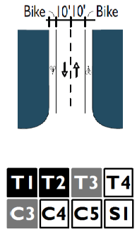 | 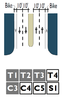 | — | 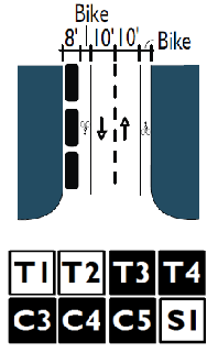 | 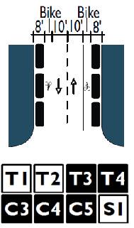 |
|
Movement Type: Low
Design Speed: 35 mph | 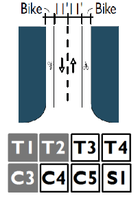 | 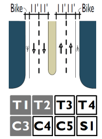 | — | — | — |
| Table 2.9.90.D: Vehicular Lane Assemblies (continued) | ||||
|---|---|---|---|---|
| Angle Parking | Medians w/Parking | |||
|
Movement Type: Yield
Design Speed: < 20 mph | — | — | — | — |
|
Movement Type: Slow
Design Speed: 20 mph | 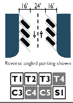 | — | — | — |
|
Movement Type: Slow
Design Speed: 25 mph | 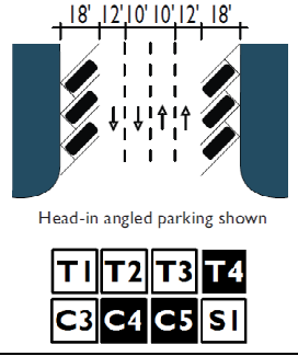 | 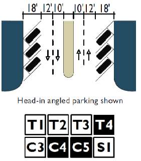 | — | — |
|
Movement Type: Low
Design Speed: 30 mph | — | 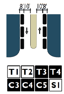 | 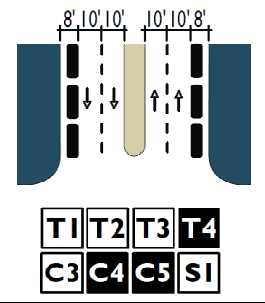 | — |
|
Movement Type: Low
Design Speed: 35 mph | 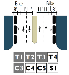 | 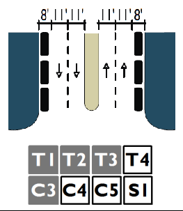 | 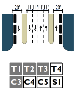 | — |
| Table 2.9.90.E: Public Frontage Types | ||
|---|---|---|
| The public frontage is the area between the curb of the vehicular lanes and the Property Line/ROW. Dimensions are provided in Table 2.9.90.F (Public Frontage Standards). | ||
| Public Frontage Type | Zone | |
| (HW) For Highway: The For Highway Frontage has bicycle trails, no parking and open swales drained by percolation. The landscaping consists of the natural condition or multiple species arrayed in naturalistic clusters. Buildings are buffered by distance or berms. | 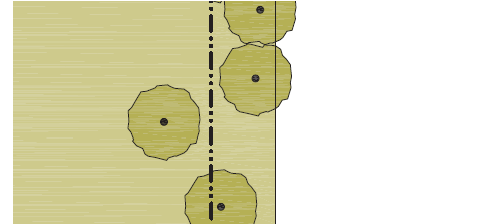 |  |
| (RD) For Road: The For Road Frontage has open swales drained by percolation, a walking path or bicycle trail along one or both sides, and yield parking. The landscaping consists of multiple species arrayed in naturalistic clusters. | 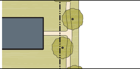 |  |
| (ST) For Street: The For Street Frontage has raised curbs drained by inlets and sidewalks separated from the vehicular lanes by individual or continuous planters. The landscaping consists of street trees of a single or alternating species aligned in a regularly spaced allee.* |  |  |
| (DR) For Drive: The For Drive Frontage has raised curbs drained by inlets and a wide sidewalk or paved path along one side, related to a civic space. It is separated from the vehicular lanes by individual or continuous planters. Street trees consist of a single or alternating species aligned in a regularly spaced allee. |  |  |
| (AV) For Avenue: The Avenue Frontage has raised curbs drained by inlets and wide sidewalks separated from the vehicular lanes by a narrow continuous planter with parking on both sides. The landscaping consists of a single tree species aligned in a regularly spaced allee. |  |  |
| (CS) For Commercial Street or Avenue: The For Commercial Street or Avenue Frontage has raised curbs drained by inlets and very wide sidewalks along both sides separated from the vehicular lanes by separate tree wells with grates. The landscaping consists of a single tree species aligned with regular spacing where possible. |  |  |
| (BV) For Boulevard: The Boulevard Frontage has slip roads on both sides. It consists of raised curbs drained by inlets and sidewalks along both sides, separated from the vehicular lanes by planters. The landscaping consists of double rows of a single tree species aligned in a regularly spaced allee. | 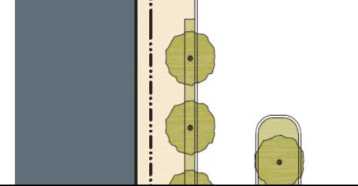 |  |
| (RA) For Rear Alley: The Rear Alley Frontage is located to the rear of lots. It consists of a paved surface and ribbon curb at the edges adjacent to property lines or buildings. Alleys are typically not landscaped. |  |  |
| (RL) For Rear Lane: The Rear Lane Frontage is located to the rear of lots. It consists of a paved or compacted gravel surface and a similar material placed on the outer edges. Lanes are typically not landscaped. | 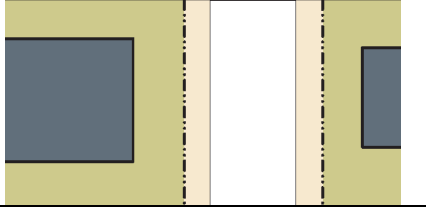 |  |
* Streets with a ROW width of 40 feet or less are exempt from tree standards.
| Table 2.9.90.F: Public Frontage Standards | ||||
|---|---|---|---|---|
| This table assembles prescriptions and dimensions for the public frontage elements - curbs, walkways, and planters - relative to specific thoroughfare types within transect zones. The Assembly row assembles all of the elements for the various thoroughfare types. | ||||
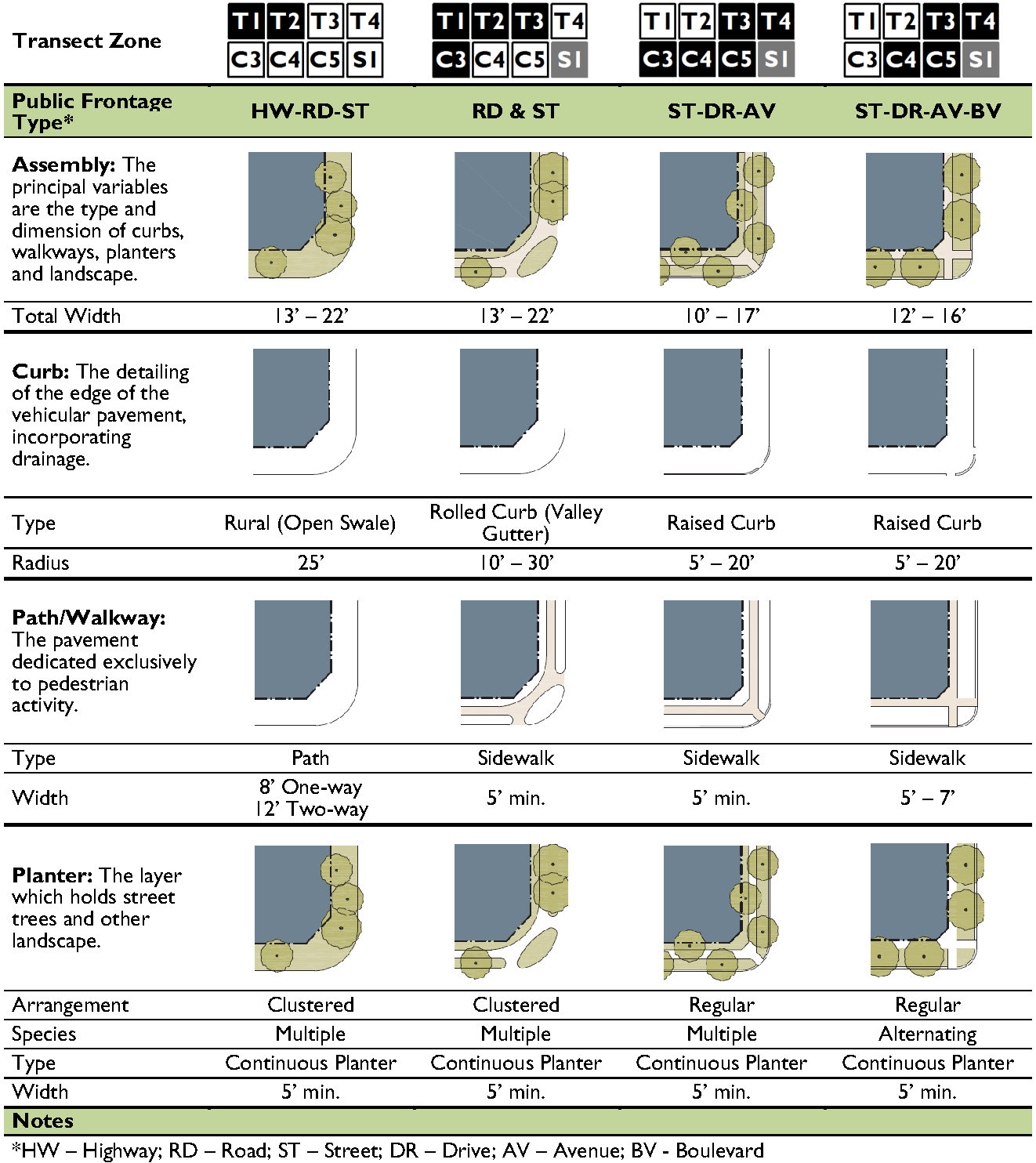 | ||||
| Table 2.9.90.G: Public Planting | ||
|---|---|---|
| This table shows common street tree types and their appropriateness within the transect zones. The Engineering Standards provides detailed specifications for landscaping along thoroughfares. Additional tree types may be approved by the Director | ||
| Standards | Illustration | Recommended Species |
|
Large Overstory Trees
Spacing: 20' - 35' on center | 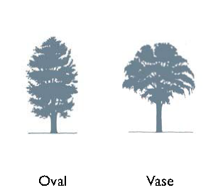 | American Beech, American Sycamore, Bald Cypress, Black Gum, Brandywine Red Maple, Ginkgo, Honeylocust, Japanese Zelkova, Lacebark Elm, Laurel Oak, Live Oak, London Plane Tree, Nuttall Oak, Overcup Oak, Pignut Hickory, Pond Cypress, Scarlet Oak, Shagbark Hickory, Shumard Oak, Southern Magnolia, Southern Red Oak, Swamp Chestnut Oak, White Oak, Willow Oak |
|
Medium and Understory Trees
Spacing: 20' - 30' on center | 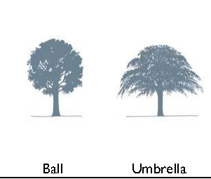 | American Yellowwood, Carolina Silverbell, Crepe Myrtle, Chinese Pistache, American Hophornbeam, Eastern Redbud, Florida Maple, Flowering Dogwood, Goldenrain Tree, River Birch, Sweetbay Magnolia, Wax Myrtle |
|
Vertical Trees
Spacing: 15' - 25' on center | 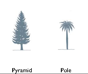 | Cabbage Palmetto, Canary Island Date Palm, Washingtonia Palm, Zelkova |
| Table 2.9.90.I: Public Lighting | ||||
|---|---|---|---|---|
| Lighting varies in brightness and also in the character of the fixture according to the transect zones. This Table shows the types of light poles and fixtures that may be approved by the Beaufort County Public Works Department assigned to the transect zones. However, the Beaufort County Public Works Department must be included in the selection of light poles and light fixtures. | ||||
| Zone |  |  |  | |
| Fixture Type | Cobra Head | Pipe | Post | Column |
| Illustration | 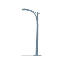 | 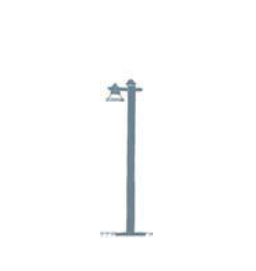 |  |  |
2.9.100 - Thoroughfare Assemblies
A.
This Section provides thoroughfare assemblies that have been approved by the County for use in transect zones.
B.
The tables in this Section are adopted into the Engineering Standards and are provided here for reference purposes.
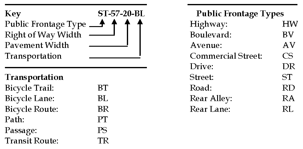
| Table 2.9.100: Thoroughfare Assemblies |
|---|
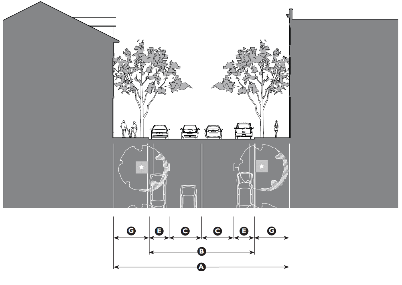 |
| Thoroughfare Assembly CS-58-34 |
| Application | ||
| Transect Zones | ||
| Conventional Zones | ||
| Movement Type | Slow | |
| Design Speed | 20 mph | |
| Overall Widths | ||
| Right-of-Way (ROW) Width | 60' | Ⓐ |
| Pavement Width | 36' | Ⓑ |
| Lane Assembly | ||
| Traffic Lanes | 2 @ 10' | Ⓒ |
| Bicycle Lanes | None | Ⓓ |
| Parking Lanes | 2 @ 7' marked | Ⓔ |
| Medians | None | |
| Public-Frontage Assembly | ||
| Public Frontage Type | Commercial Street | |
| Drainage Collection Type | Curb and Gutter | |
| Planter Type | 4' x 4' Tree Well | Ⓕ |
| Landscape Type | Trees at 30' o.c. avg. | |
| Lighting Type | Post, Column, or Double Column | |
| Walkway Type | 12' Sidewalk | Ⓖ |
| Curb Type | Square | |
| Intersection | ||
| Curb Radius | 10' max. | |
| Table 2.9.100: Thoroughfare Assemblies |
|---|
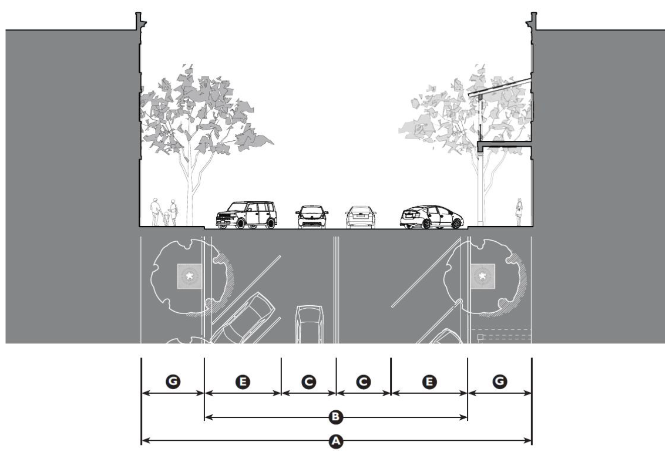 |
| Thoroughfare Assembly CS-80-54 |
| Application | |||
| Transect Zones | |||
| Conventional Zones | |||
| Movement Type | Slow | ||
| Design Speed | 20 mph | ||
| Overall Widths | |||
| Right-of-Way (ROW) Width | 80' | Ⓐ | |
| Pavement Width | 54' | Ⓑ | |
| Lane Assembly | |||
| Traffic Lanes | 2 @ 10' | Ⓒ | |
| Bicycle Lanes | None | Ⓓ | |
| Parking Lanes | 2 @ 17' marked | Ⓔ | |
| Medians | None | ||
| Public-Frontage Assembly | |||
| Public Frontage Type | Commercial Street | ||
| Drainage Collection Type | Curb and Gutter | ||
| Planter Type | 5' x 5' Tree Well | Ⓕ | |
| Lighting Type | Post or Column | ||
| Landscape Type | Trees at 30' o.c. avg. | ||
| Walkway Type | 13' Sidewalk | Ⓖ | |
| Curb Type | Square | ||
| Intersection | |||
| Curb Radius | 10' max. | ||
| Table 2.9.100: Thoroughfare Assemblies |
|---|
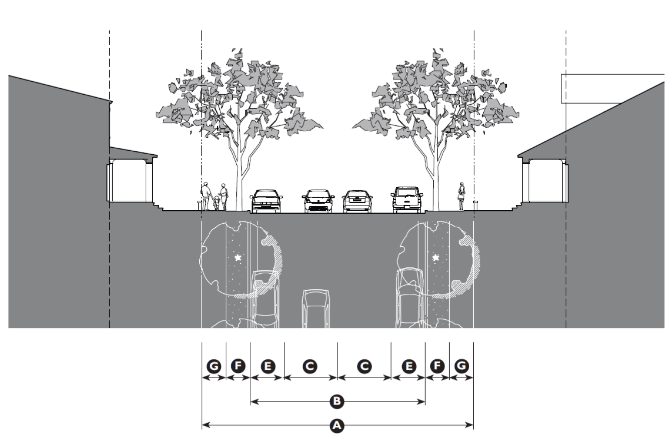 |
| Thoroughfare Assembly ST-56-36 |
| Application | |||
| Transect Zones | |||
| Conventional Zones | |||
| Movement Type | Slow | ||
| Design Speed | 20 mph | ||
| Overall Widths | |||
| Right-of-Way (ROW) Width | 56' | Ⓐ | |
| Pavement Width | 36' | Ⓑ | |
| Lane Assembly | |||
| Traffic Lanes | 2 @ 11' | Ⓒ | |
| Bicycle Lanes | None | Ⓓ | |
| Parking Lanes | 2 @ 7' marked | Ⓔ | |
| Medians | None | ||
| Public-Frontage Assembly | |||
| Public Frontage Type | Street | ||
| Drainage Collection Type | Curb and Gutter | ||
| Planter Type | 5' continuous planter | Ⓕ | |
| Landscape Type | Trees at 30' o.c. avg. | ||
| Lighting Type | Post or Column | ||
| Walkway Type | 5' Sidewalk | Ⓖ | |
| Curb Type | Square | ||
| Intersection | |||
| Curb Radius | 10' max. | ||
| Table 2.9.100: Thoroughfare Assemblies |
|---|
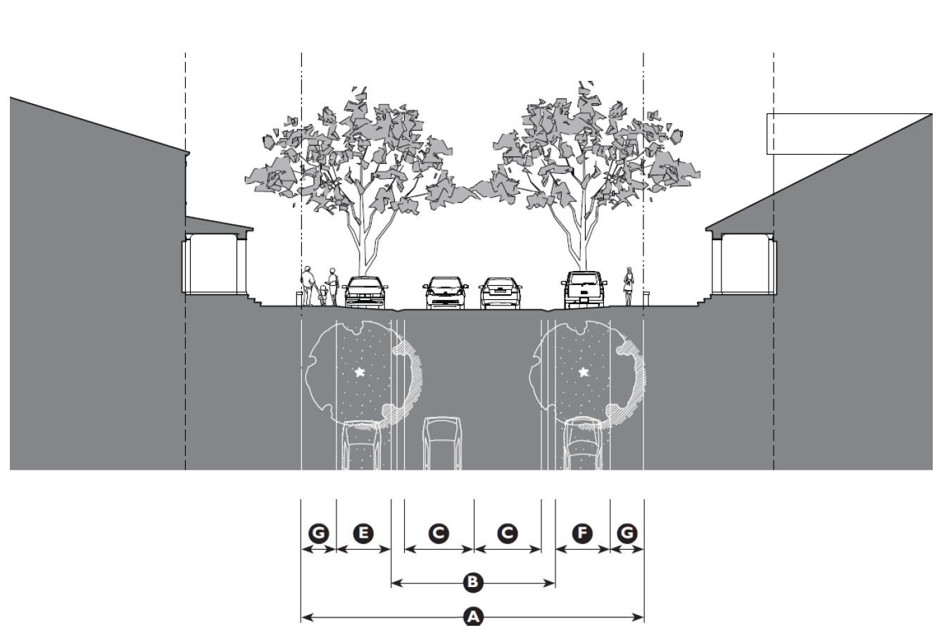 |
| Thoroughfare Assembly RD-50-22 |
| Application | ||
| Transect Zones | ||
| Conventional Zones | ||
| Movement Type | Slow | |
| Design Speed | 20 mph | |
| Overall Widths | ||
| Right-of-Way (ROW) Width | 50' | Ⓐ |
| Pavement Width | 22' | Ⓑ |
| Lane Assembly | ||
| Traffic Lanes | 2 @ 9' | Ⓒ |
| Bicycle Lanes | None | Ⓓ |
| Parking Lanes | 2 @ 8' stabilized soil | Ⓔ |
| Medians | None | |
| Public-Frontage Assembly | ||
| Public Frontage Type | Road | |
| Drainage Collection Type | Gutter Pan | |
| Planter Type | 8' continuous planter | Ⓕ |
| Landscape Type | Trees at 30' o.c. avg. | |
| Lighting Type | Pipe, Post or Column | |
| Walkway Type | 5' Sidewalk | Ⓖ |
| Curb Type | Rolled Curb | |
| Intersection | ||
| Curb Radius | 10' max. | |
| Table 2.9.100: Thoroughfare Assemblies |
|---|
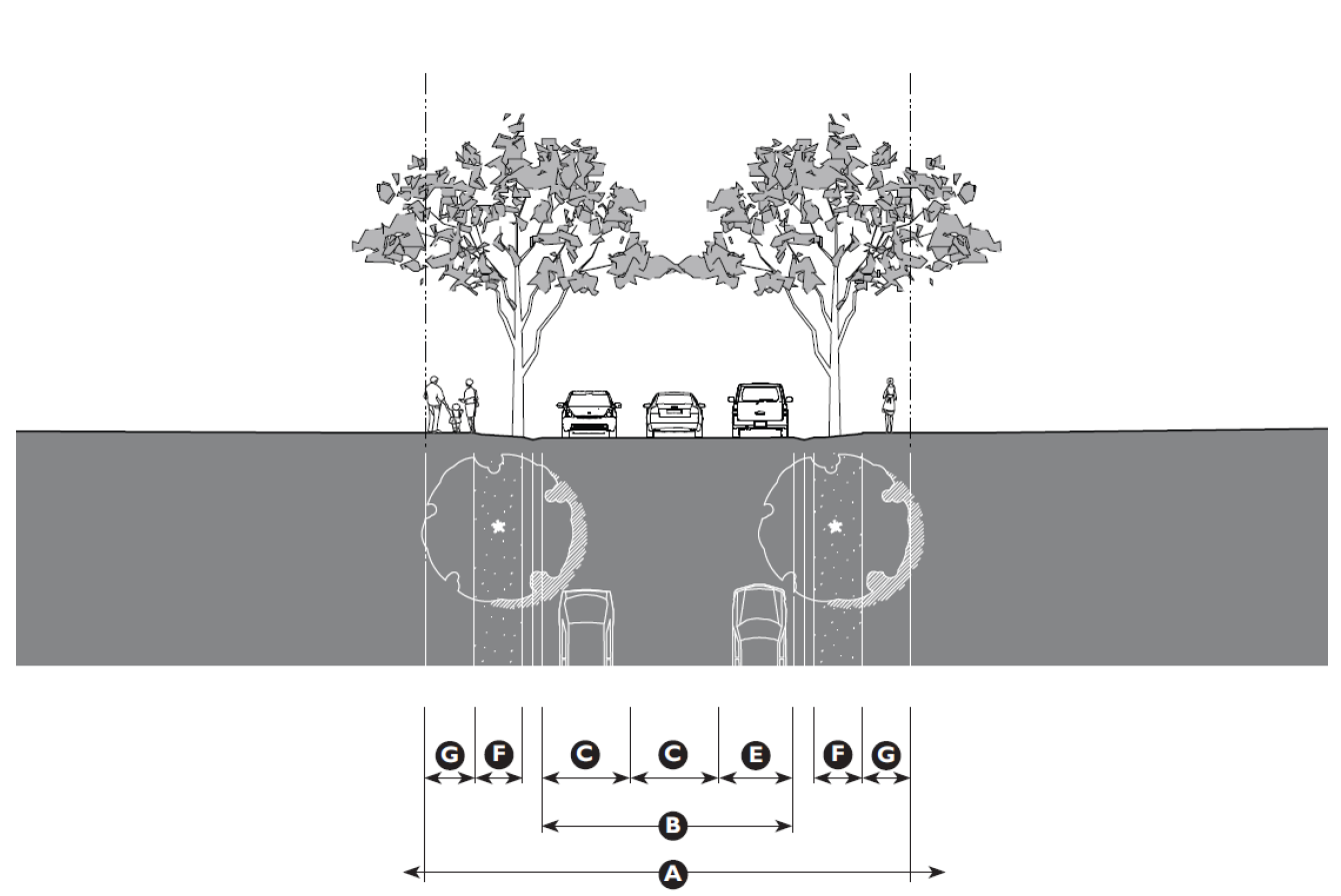 |
| Thoroughfare Assembly RD-50-26 |
| Application | ||
| Transect Zones | ||
| Conventional Zones | ||
| Movement Type | Slow | |
| Design Speed | 20 mph | |
| Overall Widths | ||
| Right-of-Way (ROW) Width | 50' | Ⓐ |
| Pavement Width | 26' | Ⓑ |
| Lane Assembly | ||
| Traffic Lanes | 2 @ 11' | Ⓒ |
| Bicycle Lanes | None | Ⓓ |
| Parking Lanes | 2 @ 8' marked | Ⓔ |
| Medians | None | |
| Public-Frontage Assembly | ||
| Public Frontage Type | Road | |
| Drainage Collection Type | 2" Gutter Pan | |
| Planter Type | 5' continuous planter | Ⓕ |
| Landscape Type | Trees at 30' o.c. avg. | |
| Lighting Type | Pipe or Post | |
| Walkway Type | 5' Walking Path | Ⓖ |
| Curb Type | Rolled Curb | |
| Intersection | ||
| Curb Radius | 10' max. | |
| Table 2.9.100: Thoroughfare Assemblies |
|---|
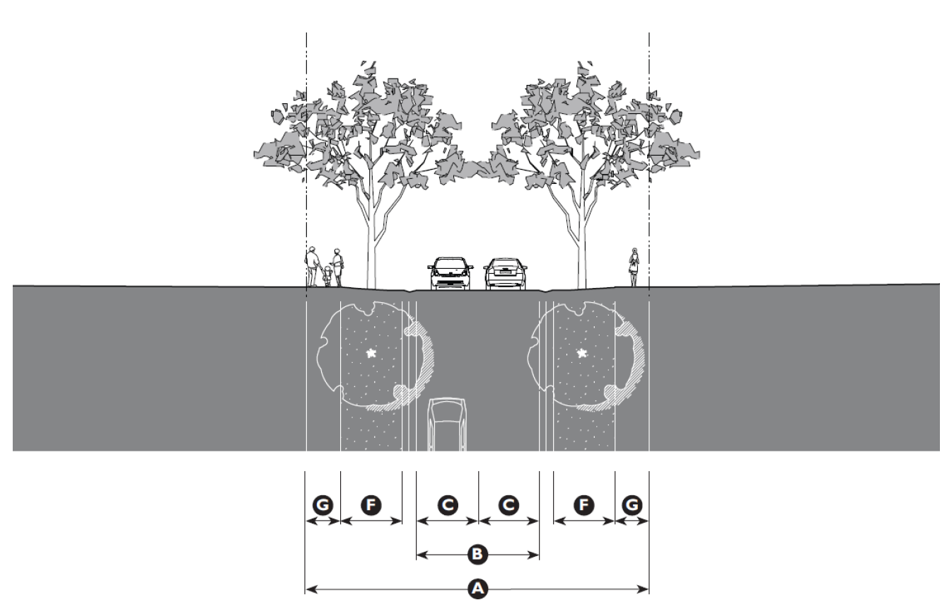 |
| Thoroughfare Assembly RD-50-18 |
| Application | ||
| Transect Zones | ||
| Conventional Zones | ||
| Movement Type | Slow | |
| Design Speed | 20 mph | |
| Overall Widths | ||
| Right-of-Way (ROW) Width | 50' | Ⓐ |
| Pavement Width | 18' | Ⓑ |
| Lane Assembly | ||
| Traffic Lanes | 2 @ 9' | Ⓒ |
| Bicycle Lanes | None | Ⓓ |
| Parking Lanes | None | Ⓔ |
| Medians | None | |
| Public-Frontage Assembly | ||
| Public Frontage Type | Road | |
| Drainage Collection Type | 2" Gutter Pan | |
| Planter Type | 5' continuous planter | Ⓕ |
| Landscape Type | Trees at 30' o.c. avg. | |
| Lighting Type | Pipe or Post | |
| Walkway Type | 5' Walking Path | Ⓖ |
| Curb Type | Rolled Curb | |
| Intersection | ||
| Curb Radius | 10' max. | |
| Table 2.9.100: Thoroughfare Assemblies |
|---|
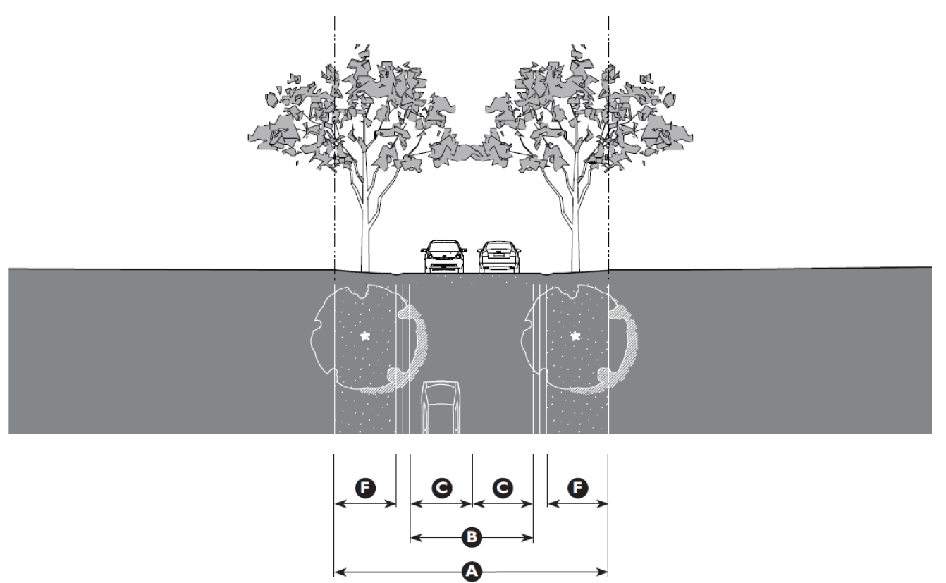 |
| Thoroughfare Assembly RD-40-18 |
| Application | ||
| Transect Zones | ||
| Conventional Zones | ||
| Movement Type | Slow | |
| Design Speed | 20 mph | |
| Overall Widths | ||
| Right-of-Way (ROW) Width | 40' | Ⓐ |
| Pavement Width | 18' | Ⓑ |
| Lane Assembly | ||
| Traffic Lanes | 2 @ 9' | Ⓒ |
| Bicycle Lanes | None | Ⓓ |
| Parking Lanes | None | Ⓔ |
| Medians | None | |
| Public-Frontage Assembly | ||
| Public Frontage Type | Road | |
| Drainage Collection Type | Gutter Pan | |
| Planter Type | 5' continuous planter | Ⓕ |
| Landscape Type | Trees at 30' o.c. avg. | |
| Lighting Type | Pipe or Post | |
| Walkway Type | 5' Walking Path | Ⓖ |
| Curb Type | Rolled Curb | |
| Intersection | ||
| Curb Radius | 10' max. | |
| Table 2.9.100: Thoroughfare Assemblies |
|---|
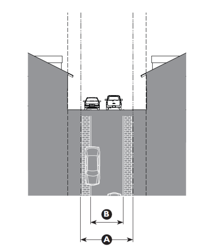 |
| Thoroughfare Assembly RL-20-12 |
| Application | ||
| Transect Zones | ||
| Conventional Zones | ||
| Movement Type | Slow | |
| Design Speed | < 20 mph | |
| Overall Widths | ||
| Right-of-Way (ROW) Width | 20' | Ⓐ |
| Pavement Width | 12' | Ⓑ |
| Lane Assembly | ||
| Traffic Lanes | 2 @ 12' | Ⓒ |
| Bicycle Lanes | None | ⓓ |
| Parking Lanes | None | Ⓔ |
| Medians | None | |
| Public-Frontage Assembly | ||
| Public Frontage Type | Rear Lane | |
| Drainage Collection Type | Gutter Pan | |
| Planter Type | None | Ⓕ |
| Landscape Type | None | |
| Lighting Type | Pipe or Post | |
| Walkway Type | None | Ⓖ |
| Curb Type | Rolled or Flush | |
| Intersection | ||
| Curb Radius | 10' max. | |
| Table 2.9.100: Thoroughfare Assemblies |
|---|
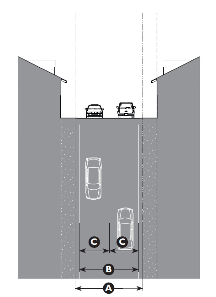 |
| Thoroughfare Assembly RA-24-21 |
| Application | ||
| Transect Zones | ||
| Conventional Zones | ||
| Movement Type | Slow | |
| Design Speed | < 20 mph | |
| Overall Widths | ||
| Right-of-Way (ROW) Width | 24' | Ⓐ |
| Pavement Width | 21' | Ⓑ |
| Lane Assembly | ||
| Traffic Lanes | 2 @ 10'6" | Ⓒ |
| Bicycle Lanes | None | Ⓓ |
| Parking Lanes | None | Ⓔ |
| Medians | None | |
| Public-Frontage Assembly | ||
| Public Frontage Type | Rear Alley | |
| Drainage Collection Type | Gutter Pan | |
| Planter Type | None | Ⓕ |
| Landscape Type | None | |
| Lighting Type | Pipe or Post | |
| Walkway Type | None | Ⓖ |
| Curb Type | Rolled or Flush | |
| Intersection | ||
| Curb Radius | 10' max. | |
2.10.10 - Purpose
The purpose of the transfer of development rights (TDR) program is to support County efforts to reduce development potential near the Marine Corps Air Station Beaufort (MCAS— Beaufort) and to redirect development potential to locations further from the air station, consistent with the Beaufort County Comprehensive Plan. This preferred development pattern is intended to reduce hazards associated with aircraft operations near MCAS—Beaufort in a way that respects the rights of property owners and utilizes a free-market system to achieve planning objectives. The TDR program is also intended to work in concert with other regional, county, and local programs that promote good land use planning and to facilitate inter-jurisdictional cooperation between Beaufort County, the Lowcountry Council of Governments (LOCG), the City of Beaufort, and the Town of Port Royal.
2.10.20 - Voluntary Nature of Program
The participation of property owners in the TDR program is voluntary. Nothing in this division shall be interpreted as a requirement for sending area property owners to sell TDRs, for receiving area property owners to purchase TDRs, or for any property owner or county resident to otherwise participate in the TDR program.
2.10.30 - Establishment of TDR Sending and Receiving Areas
A.
Sending Areas. TDR sending areas shall include all properties within unincorporated Beaufort County that are:
1.
Located within the MCAS Airport Overlay (MCAS-AO) District or within one quarter mile of the Air Installations Compatible Use Zone (AICUZ) for MCAS— Beaufort; and
2.
Zoned T2R (Rural), T2RN (Rural Neighborhood), T2RC (Rural Center), T3E (Edge), or C3 (Neighborhood Mixed Use).
B.
Receiving Areas. TDR receiving areas shall include all properties within unincorporated Beaufort County that are located:
1.
Outside of the MCAS Airport Overlay (MCAS-AO) District;
2.
Beyond one quarter mile of the Airport Installation Compatibility Use Zone (AICUZ) for MCAS—Beaufort; and
3.
Within the boundaries of Port Royal Island.
C.
The cities of Beaufort and Port Royal may also participate in the TDR program by designating TDR receiving areas and adopting a complimentary ordinance and inter-jurisdictional agreement.
2.10.40 - Establishment of TDR Overlay Districts
A.
TDR overlay districts shall be established concurrently with the approval of any rezoning that increases residential density or commercial intensity potential within a TDR receiving area. As part of the rezoning, the new zoning designation shall include a TDR overlay district suffix indicating the need to comply with TDR program requirements in the event that the property owners choose to use the TDR option and exceed baseline density.
B.
Rezoning Procedure.
1.
Establishment of a TDR overlay district shall occur as part of the county's standard rezoning process, see Section 7.3.40 (Zoning Map Amendment) and shall not require separate application or approval procedures. The approval or denial of a TDR overlay district shall be dependent upon the approval or denial of the requested zoning district.
2.
The TDR overlay district does not affect county procedures for placing conditions on rezoning approvals to implement county plans and policies. The TDR program does not affect the authority of the county to initiate amendments to the zoning and development standards ordinance or county procedures for responding to rezoning applications submitted by property owners.
2.10.50 - Development Options within TDR Overlay District
A.
Baseline Development Option. Owners of properties within a TDR overlay district may choose to not participate in the TDR program and to develop the property at or below the baseline density. Properties developed under this option shall be subject to the requirements of the baseline zoning district before the property was up zoned and received the TDR overlay district designation as well as all applicable development standards and procedures specified in the Development Code.
B.
TDR Development Option. In addition to the requirements imposed by the underlying zoning district, developers who choose to exceed baseline density within a TDR overlay district shall satisfy TDR requirements in the following ways:
1.
One TDR shall be retired for every three dwelling units of residential development in excess of baseline density.
2.
One TDR shall be retired for every 5,000 additional square feet of commercial development beyond the maximum permitted by the baseline zoning.
3.
Developers have the option of paying cash in lieu of each TDR that otherwise would be required in an amount specified in the county fee schedule.
2.10.60 - Exceptions to the TDR Requirement
A.
Affordable Housing Projects. Affordable housing units shall not be counted when calculating the extent to which a proposed development project exceeds baseline density.
B.
Commercial Density. The county may approve an additional 250 square feet of commercial development for each proposed residential unit that is part of a Traditional Community Plan (TCP) without the use of TDRs. This exception is intended to promote mixed-use, traditional neighborhood developments in a manner consistent with the goals of the TDR program.
C.
Industrial Development. Industrial development shall be excluded from the TDR requirement. However, in order to be excluded from the TDR requirement, industrial development must be proposed in such a way that its floor area can be easily calculated separately from any other uses.
2.10.70 - Development Project Procedures
A.
Identification of TDRs. Project applicants that propose to exceed baseline density in a TDR overlay district shall acknowledge in all official development applications the number of TDRs that must be retired prior to final project approval.
B.
Final Approval. The Director shall grant final approval of a project utilizing TDRs for additional development only after the applicant has transmitted TDR certificates containing the required number of TDRs to the department or has made the required cash in-lieu payment. The serial numbers of all TDRs to be retired for receiving area projects shall be recorded on the final plat or the development permit.
2.10.80 - TDR Bank
A.
Purpose. The County may choose to contract with an outside agency, hereto referred to as a TDR bank, to assist or manage TDR program administration, buying, holding, and selling TDRs as well as performing other functions as directed by the County Council. The purpose of the TDR bank is to facilitate a well-functioning TDR market by performing these tasks. The County is ultimately responsible for managing and administering the TDR program and the TDR bank.
B.
TDR Bank Description.
1.
The TDR bank is an intermediary specifically authorized by the County Council to perform functions assigned to it by agreement by the TDR bank and the County Council. These functions may include the acquisition and sale of TDRs as well as TDR program promotion and facilitation.
2.
The County Council is not required to form a TDR bank. The County Council may instead elect to use County personnel to perform TDR bank functions.
3.
The establishment of a TDR bank shall not preclude direct buyer-seller transactions of TDRs.
C.
TDR Purchase Priorities. The TDR bank will prioritize the purchase of TDRs from small landowners over large landowners in the following way:
1.
The TDR bank will purchase TDR certificates from sending area landowners based on the number of TDRs they hold, from smallest to largest. Landowners with one TDR will be bought out first, followed by landowners with two or more TDRs.
2.
The TDR bank will establish a time window during which it will accept letters of interest from sending area landowners. At the close of the time window, the TDR bank will create a rank-order list of sellers whose TDR certificates it will buy.
3.
The TDR bank will purchase TDR certificates starting at the top of the list from landowners who have TDR certificates. For example, if the landowner at the top of the list does not have a TDR certificate, the TDR bank will go down the list until it reaches a landowner with TDR certificates.
4.
Notwithstanding this prioritization, this Subsection shall not prevent a specific funding of a purchase outside of this prioritization on a case-by-case basis when requested by a funding entity or organization.
D.
TDR Bank Operation. The duties and operating procedures of the TDR bank, if established, shall be specified in an agreement between the TDR bank and the County Council. These procedures shall reflect the TDR program goal of reducing development potential within sending areas.
2.10.90 - TDR Certificates
A.
General. A TDR sending area property owner may choose not to participate in the TDR program or, alternatively, may choose to participate by applying for a TDR certificate.
B.
TDR Certification Application Submittal, Review, and Issuance.
1.
To request a TDR certificate, a property owner shall submit to the department an application that includes the information and materials required by the County for TDR certificate applications, together with all required application fees.
2.
The property owner shall submit to the department proof of clear title of ownership. The application shall include written approval of the TDR certificate application from all holders of liens on the subject property.
3.
TDR certificate applications shall include draft easement language as required by Section 2.10.110 (Sending Area Easements). At the property owner's option, this easement may preclude one, some, or all of the allowable TDRs not foregone by previous TDR easements or similar deed restrictions.
4.
The department shall calculate the number of allowable TDRs for a sending area property using the methodology described in Section 2.10.100 (Calculation of TDRs in Sending Areas).
5.
Upon recordation of the easement, the director shall issue a TDR certificate documenting the number of TDRs generated by the recorded easement, the serial numbers of all TDRs created by the easement, the sending area that generated these TDRs, the identity of the property owner/certificate holder, and any other documentation required by the Director. For purposes of this program, only TDR certificates issued by the Director shall be available for sale to a receiving site developer or to any intermediary.
C.
Sale and Tracking of TDRs.
1.
Once a sending area property owner receives a TDR certificate, the property owner may sell or give one, some, or all of the TDRs documented in that TDR certificate directly to the developer of a receiving site property or to any intermediary.
2.
In accordance with procedures approved by the Director, upon the sale or gift of any or all TDRs, the holder of a TDR certificate shall notify the Director, who will void the original TDR certificate and issue one or more new TDR certificates documenting the new owners of the TDRs.
3.
The Director shall maintain a TDR registry, publicly accessible via the internet, documenting current TDR certificate holders and the serial numbers of the TDRs contained within all TDR certificates. The Director shall develop and implement procedures to ensure that the transfer process is accurate and transparent.
4.
The property owner holding a TDR certificate may sell his property reflecting the reduced development potential resulting from the participation in the TDR program; or may turn in the TDR certificate to restore the development potential on the property prior to the sale of the property.
2.10.100 - Calculation of TDRs in Sending Areas
A.
Methodology.
1.
The department shall calculate the number of allowable TDRs for a TDR sending area property using the following methodology:
a.
The number of TDRs is calculated by multiplying the base site area times the gross density of the baseline zone.
b.
Base site area is defined as the gross acres (as determined by actual survey) minus the following acres:
(1)
Land under water and tidal wetlands;
(2)
Land within existing rights-of-way; and
(3)
Land previously dedicated as open space.
c.
The gross density of baseline zone is found in the following table:
2.
When 50 percent or more of a parcel is located within a sending area, the calculation of maximum allowable TDRs shall be based on the entire land area of the parcel.
3.
The maximum number of allowable TDRs shall be the permitted dwelling units minus any reduction in this calculation created by the recordation of previous TDR easements or similar deed restrictions.
4.
The maximum permitted density shall be reduced by one TDR for each existing dwelling unit to remain on the property. The Director shall develop and implement procedures, if needed, to determine the TDR allocation to reflect existing nonconforming or nonresidential improvements.
B.
Fractional Development Rights. Any fractional development right exceeding 0.5 shall be rounded up to the nearest whole number. Only whole TDRs shall be issued and sold.
C.
Appeals. The Planning Director's calculation of allowable TDRs may be appealed to the ZBOA, see Section 7.3.70 (Appeals).
2.10.110 - Sending Area Easements
A.
Maximum Residential Density. Owners of TDR sending area properties that choose to participate in the TDR program shall record an easement that reduces the permitted residential density by one, some, or all allowable TDRs on the property.
B.
County Review. The department and County Attorney shall review and approve easement language as part of its review of a TDR certificate application.
C.
Required Language. At a minimum, easements shall specify the following information.
1.
Serial numbers for all allowable TDRs to be certified by the department for the parcel.
2.
Written consent of all lien holders and other parties with an interest of record in the sending parcel.
3.
At the request of the property owner, a reversibility clause can be included to allow for the removal of the easement if the property owner does not sell the associated TDR certificates, chooses to not participate in the TDR program, and returns all TDR certificates to the department within an allotted time period. All TDR certificates issued to a property partially within the TDR sending area may only be reversed together at the same time and shall not be unbundled.
4.
A statement that the easement shall be binding on successors in ownership and shall run with the sending parcel in perpetuity.
D.
Easement Monitoring and Enforcement. The County shall be responsible for monitoring of easements or may select any qualified person or organization to maintain the easements on its behalf.
2.10.120 - TDR Compliance
A.
Purchase Price. All TDR certificate purchase prices shall be open to negotiation between the buyer and seller, except that public funds shall not be used to purchase TDRs for an amount greater than their market value. The TDR bank shall publicly post and update the dates and sale prices of all TDR certificate transactions.
B.
Timing of Compliance. A receiving area property owner shall transmit TDR certificates containing the required number of TDRs, or make a cash payment in lieu of TDRs, before final subdivision plat approval of a project involving land division or prior to final development plan approval for a project that does not involve land division.
2.10.130 - In-Lieu Payment Option
A.
General. The developer of a property in the TDR overlay district who chooses to exceed baseline density may satisfy TDR requirements through a cash in-lieu payment rather than, or in combination with, the retirement of TDRs.
B.
Fee Amount.
1.
The fee amount shall be established by the County Council.
2.
The Director shall submit an annual report on the TDR program to the Rural and Critical Lands Board, the Beaufort County Planning Commission, and County Council. The annual report shall include recommendations on potential changes to the cash in-lieu amount. This recommendation shall reflect changes in the assessed value of sending area properties, actual TDR sales prices experiences, and general real estate trends.
C.
Use of Revenue.
1.
Revenue from cash in-lieu payments shall be applied exclusively to the TDR program unless the potential supply of TDRs has been depleted and/or sending area landowners decline to sell their TDRs at full market value. In this event, the County Council may choose to expand the TDR program by adopting additional TDR sending areas.
2.
Other than TDR acquisition, revenue from cash in-lieu payments shall only be used for costs incurred in administering the TDR program, including, but not limited to, facilitating TDR transactions, preparing/recording TDR easements, monitoring/enforcing easements, and maintaining records.
3.
The County Council may authorize County staff to use cash in-lieu proceeds in accordance with procedures adopted by the Council. Alternatively, if the County Council chooses to enter into an agreement creating a TDR bank, the Council may transmit cash in-lieu proceeds to the TDR bank for the purposes specified by agreement between the Council and the TDR bank. This agreement may direct the TDR bank to combine the cash in-lieu proceeds to create a general TDR acquisition fund. All TDRs purchased with such a general TDR acquisition fund shall be offered for sale to receiving area developers.
4.
The TDR program may operate with federal or other land preservation programs.