
Culpeper City Zoning Code
ARTICLE XVI
WATERSHED PROTECTION OVERLAY DISTRICT WPD
Sec. 27-426.- Statement of intent; watershed protection overlay district defined.
There is hereby established a watershed protection overlay district (WPD). The purpose of this district is to achieve the protection of the public health and safety, the assurance of minimal degradation and the prevention of future deterioration in the water quality of the Lake Pelham watershed. Development within the WPD should be consistent with the watershed protection policies, as adopted and incorporated into the comprehensive plan. In the event of any conflict between the aforementioned watershed protection policies and this article, the latter will govern.
Any development within the WPD, as shown on the official watershed protection overlay district map, dated March 10, 1992, and amended May 9, 2000, which map is adopted by reference and included in this subsection, shall comply with the requirements set out in this article. Unless specifically noted otherwise, these requirements are in addition to any requirements set out in the zoning ordinance.
Any property which does not drain into the Lake Pelham or Mountain Run watershed shall not be considered in the WPD, notwithstanding its depiction on the official map. Any property which is shown on a site plan to be engineered so as not to drain into Lake Pelham, directly or indirectly, shall not be considered in the WPD, notwithstanding its depiction on the official map unless the subsequent development fails to be developed in accordance with that plan. Any property which is not in the Lake Pelham or Mountain Run watershed when this article is adopted shall not be developed in such a manner as to drain into said watershed.
(Ord. of 5-8-01)
Sec. 27-427. - Development unit density established.
Notwithstanding any requirement to the contrary, a residential development may be allowed up to fifty (50) percent of the density permitted in the zoning ordinance for the zone. For purposes of this section, each residential dwelling unit or each two thousand five hundred (2,500) square feet of nonresidential building space equals one (1) development unit.
Notwithstanding anything to the contrary, any existing lot in the watershed protection overlay district at the date of enactment of this article, which has been or could be developed in a manner that would not violate any provision of this chapter except for the density requirement of this section, shall be entitled to have one (1) development unit built on it; prior to any application for a zoning permit, the applicant shall have submitted an individual lot management plan in accordance with section 27-440.
Any land lying within the WPD, and adjacent to and a part of the tract prior to it being subdivided at a time subsequent to this article being adopted, the use of which is limited to park, open space, agricultural or recreational use (the latter of which shall not involve the construction of buildings other than rain shelters), shall be considered as part of the development tract for purposes of establishing the development unit density as well as determining water quality requirements. The permit issuing authority may accept a declaration which allocates that land constructively among the properties to be subdivided or developed.
(Ord. of 5-8-01)
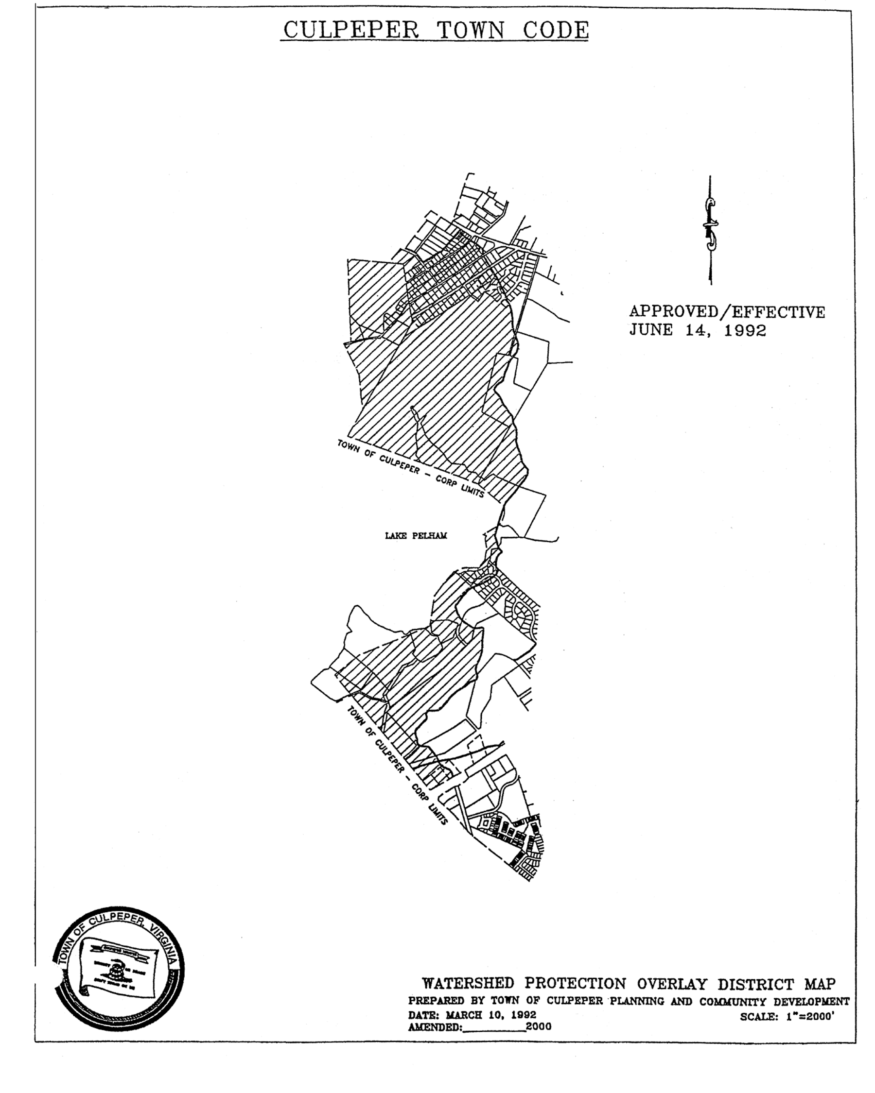
Watershed protection overlay district map
Sec. 27-428. - Uses prohibited.
The storage of any of the following materials, except as accessory to a residential use, is prohibited in the watershed protection overlay district:
(1)
Hazardous materials and wastes as defined by federal regulation (SARA Title III);
(2)
Flammable or combustible substances in excess of one hundred (100) gallons or fifty (50) pounds;
(3)
Toxic wastes and substance as defined by the EPA regulations;
(4)
Bulk and underground storage of petroleum products in excess of one thousand two hundred (1,200) gallons;
(5)
Storage of bulk petroleum products in connection with a convenience store;
In addition, the following uses are prohibited in the watershed protection overlay district:
(1)
Solid waste facilities.
(2)
Storage or land spreading of sludge other than that created from the removal of sediment in BMPs in the WPD.
(3)
Uses for which an NPDES or VPDES permit is required for more than one thousand (1,000) gallons of effluent, excluding stormwater management facilities.
(4)
Wastewater treatment plants, systems, or effluent discharges.
(5)
Septic systems.
(6)
Human crematoriums and animal crematoriums.
(7)
Automobile service stations.
(Ord. of 5-8-01)
Sec. 27-429. - Watershed buffer areas.
The watershed protection overlay district map classifies waterbodies and watercourses as follows:
(1)
Lake Pelham and Mountain Run Lake.
(2)
Primary creeks, streams and ponds.
(3)
Secondary creeks and streams.
Drainage ways and streams that are not depicted on said watershed protection map are not classified. A buffer is hereby established from the distance of each watercourse as set out below.
No development, impervious surface or land disturbance, shall be allowed in any of the buffers except the following. It shall be noted that if BMP credit is claimed for a buffer, specific requirements, restrictions or covenants may exist which preclude these exceptions.
(1)
As necessary to place streets and/or utilities;
(2)
As desirable for uses and structures directly related to the preservation and enhancement of water quality;
(3)
As desirable for parks and recreation uses and structures;
(4)
As necessary to prevent nuisances (weeded lot, poison ivy, dead trees), and permit the bona fide maintenance of existing vegetation and the planting of new beneficial vegetation; or
(5)
As necessary to prevent a regulatory "taking" of land, provided such intrusion is located as far as practical from the watercourse being protected.
(Ord. of 5-8-01)
Sec. 27-431. - Limits in disturbed area.
The amount of land disturbed in development at any one time shall be limited to fifty (50) percent. Once an area has been disturbed for development, it shall be considered disturbed for purposes of future development related to the same tract or any portion of that tract of land unless that area has been fully revegetated and the permit issuing authority has determined that said vegetation is stable at which time it shall not be considered disturbed area.
(Ord. of 5-8-01)
Sec. 27-432. - Maximum impervious surface.
The maximum impervious surface in a development shall not exceed the amount shown on the approved BMP plan.
(Ord. of 5-8-01)
Sec. 27-433. - Environmental impact assessment required.
Any development which would permit three (3) or more additional development units shall file, as a prerequisite to an approved site plan and as a supporting document to the BMP plan, an environment impact assessment (EIA). The EIA shall fully disclose any effect on water quality from the development proposed and shall indicate the extent to which that effect may be mitigated by best management practices. Any analysis will be consistent with "Controlling Urban Runoff: A Practical Manual for Planning and Designing Urban BMPs" by Thomas R. Schueler (Department of Environment Programs, Metropolitan Washington Council of Governments, 1987), as revised, or, with other reports acceptable to the permit issuing authority. The EIA shall include at least one (1) alternative style of development, its effects and mitigation. The permit issuing authority may require the EIA evaluate a specified alternative style of development. A style of development is a manner of development that rearranges uses and infrastructure without significantly effecting overall density. If the permit issuing authority determines that the alternate style of development is in the best interest of the public, it may require the plan be modified to incorporate the alternate style of development.
(Ord. of 5-8-01)
Sec. 27-434. - Best management practices.
Prior to submittal of any subdivision, site plan, or zoning permit for review, the applicant shall prepare and submit a best management practices plan which shall demonstrate how, where and when the BMP facilities will be constructed, who is responsible for maintenance of these facilities and what type of facilities are to be constructed. Calculation methods, BMP options and other design criteria shall be maintained within the town's best management plan policy. These requirements are in addition to current Commonwealth of Virginia stormwater quantity and quality requirements. In case of conflict, the more stringent shall govern. The first one-half (½) inch of rainfall for all impervious surfaces within the development shall be treated by use of an approved best management practice, hereafter referred to as "BMP." In addition to streets, parking areas and other impervious surfaces, subdivision lots containing 10,000 square feet or less shall be assessed 2,500 square feet of impervious surface and lots containing more than 10,000 square feet shall be assessed 3,500 square feet of impervious surface for each lot. The best management practices plan shall consist of the following:
(1)
A master drawing showing the overall view of the development at a scale not smaller than 1"=100 feet unless so approved by the town. This plan shall include all items so required on the town's current BMP plan checklist.
(2)
Completed copy of the town's current "Water Quality Requirement Calculation Sheet."
(3)
Completed copy of the town's current "Best Management Plan—BMP Compliance Sheet" for each BMP utilized on the plan.
(4)
Completed copy of the town's current "Best Management Plan—Project Compliance Sheet."
(5)
Supporting documents such as maintenance agreements, EIA (if required), engineering calculations, easements, deed restrictions or other plans as indicated on the BMP compliance sheets.
In addition to the overall BMP plan an individual lot management plan shall be provided for each lot at the time of zoning permit application. The individual lot management plan shall show the proposed improvements to the lot, proposed grading on the lot, the direction of stormwater leaving the lot and statement that this stormwater will enter a BMP facility prior to entering the lake, erosion and sediment control devices, setback, sideyard and rear yard restrictions lines, the amount of impervious surface proposed on the lot, area, bearings and distances, lot number and north arrow. This drawing shall be prepared to scale and sealed by a duly licensed professional engineer or land surveyor.
Should the permit issuing authority find the impervious surface of the lots is exceeding the amount of impervious surface used in the design of the BMP, the permit issuing authority may withhold the zoning permit until such time as the impervious surface is reduced or additional BMP facilities are provided. This review shall be ongoing and cumulative as the lots are developed.
(Ord. of 5-8-01)
Sec. 27-435. - Easement of land for wet or dry ponds required.
Whenever a wet or dry pond is approved as part of a BMP plan, zoning or conditional use permit, site plan, or subdivision, the permit issuing authority shall determine whether the proposed method of ownership of the facility, the access to it and the method set out for maintenance are adequate to protect the water quality of Lake Pelham. The authority may require that the land constituting the pond, support area and access to it be dedicated to the town, or be subject to a public easement for the construction and maintenance of stormwater management facilities. Any dedication or easement will authorize the town to assign the same to a stormwater management utility.
(Ord. of 5-8-01)
Sec. 27-436. - Erosion control plan required.
Any land disturbing activity, other than those excepted from Code of Virginia, § 10.1-560, that disturbs or will disturb more than five thousand (5,000) square feet of area on a tract is required to file and have approved by the town engineer an erosion and sediment control plan. Any infiltration, detention or retention control measures or facilities will conform, at a minimum, to standards of the "Virginia Erosion and Sediment Control Handbook," 2nd Edition (1980), as amended.
(Ord. of 5-8-01)
Sec. 27-437. - Road standards.
Notwithstanding any requirement to the contrary, stress and vehicle accommodation areas in the watershed protection overlay district (WPD) may be built with drainage swales that are designed to implement the intent of this district rather than with curb and gutter.
(Ord. of 5-8-01)
Sec. 27-438. - Uses requiring special plans.
Golf courses shall present a nutrient management plan which demonstrates that the fertilizers and pesticides will be contained on-site and will not impact the off-site surface water or groundwater resources.
(Ord. of 5-8-01)