
Culpeper City Zoning Code
ARTICLE II
DISTRICTS GENERALLY
Sec. 27-26.- Division of town into districts.
The town is hereby divided into the following districts:
Town agricultural (TA).
Residential estates R-E.
Residential R-1.
Residential R-2.
Residential R-3.
Residential R-MHP.
Commercial C-1.
Commercial C-2.
Commercial C-3.
Commercial C-4.
Planned unit development PUD.
Industrial M-1.
Industrial M-2.
Planned development/medical center (PD-MC).
(Ord. of 5-8-01; Ord. No. O-2011-010, 12-13-11; Ord. No. O-2018-001, § 1, 2-13-18)
Sec. 27-27. - Meaning of district symbols.
The term "R district" means any residential district. The term "C district" means any commercial district. The term "TA district" means any agricultural district. The term "M district" means any industrial district.
(Ord. of 5-8-01; Ord. No. O-2011-010, 12-13-11)
Sec. 27-28. - Zoning map; amendments to zoning map.
(a)
The locations and boundaries of the districts established by this chapter shall be as shown on a map entitled, "Official Zoning Map, Town of Culpeper, Virginia, June 11, 1991" which map is hereby declared to be a part of this chapter. A certified copy of this map is on file in the office of the zoning administrator, and such map is signed by the mayor and certified by the town clerk. All notations, dimensions and designations shown thereon shall be as much a part of this chapter as if the same were all fully described herein.
(b)
The zoning administrator shall maintain a copy of the zoning map of the town, making such amendments to such map as they are approved by the town council.
(Ord. of 5-8-01; Ord. No. O-2011-010, 12-13-11)
Sec. 27-29. - Determination of district boundaries.
Unless zoning district boundary lines are fixed by dimensions or otherwise clearly shown or described, and where uncertainty exists with respect to the boundaries of any zoning districts as shown on the zoning map, the following rules shall apply:
(1)
Where district boundaries are indicated as approximately following or being at right angles to the center lines of streets, highways, alleys or railroad main tracks, such center lines or lines at right angles to such center lines shall be construed to be such boundaries, as the case may be.
(2)
Where a district boundary is indicated to follow a river, creek or branch or other body of water, such boundary shall be construed to follow the center line at low water or at the limit of the jurisdiction, and in the event of change in the shoreline, such boundary shall be construed as moving with the actual shoreline.
(3)
If no distance, angle, curvature description or other means is given to determine a boundary line accurately and the foregoing provisions do not apply, the same shall be determined by the zoning administrator using the scale shown on the zoning map. In case of subsequent dispute, the matter shall be referred to the board of zoning appeals, which shall determine the boundary.
(Ord. of 5-8-01; Ord. No. O-2011-010, 12-13-11)
Sec. 27-30. - Zoning of areas added by annexation, boundary line adjustment, or otherwise.
Any property coming into the town's territorial jurisdiction by annexation, boundary line adjustment, or otherwise, shall immediately upon the effective date of its coming into the town's territory be automatically and temporarily classified in the town zoning district corresponding to the property's county zoning classification listed in the table below until a zoning plan for such area has been adopted by the town council. The planning commission shall prepare and present a zoning plan for the added area within six (6) months to the town council.
(Ord. of 5-8-01; Ord. No. O-2011-010, 12-13-11)
Editor's note— Ord. No. O-2011-010, adopted Dec. 13, 2011, changed the title of § 27-30 from zoning of annexed areas to zoning of areas added by annexation, boundary line adjustment, or otherwise.
Sec. 27-31. - Land Use Chart.
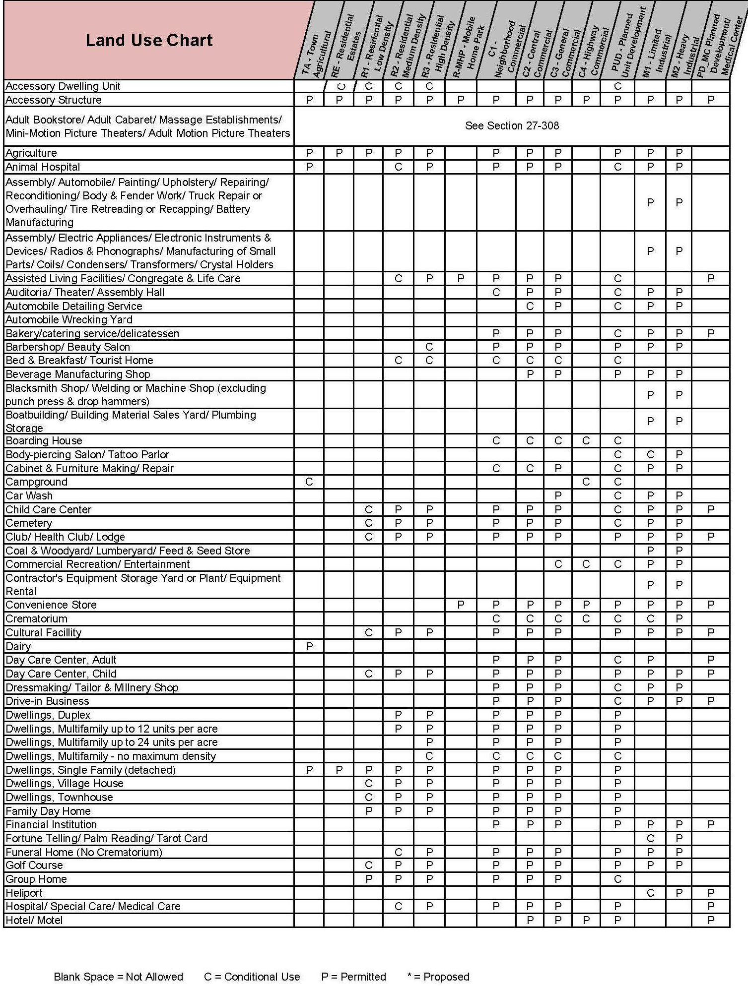
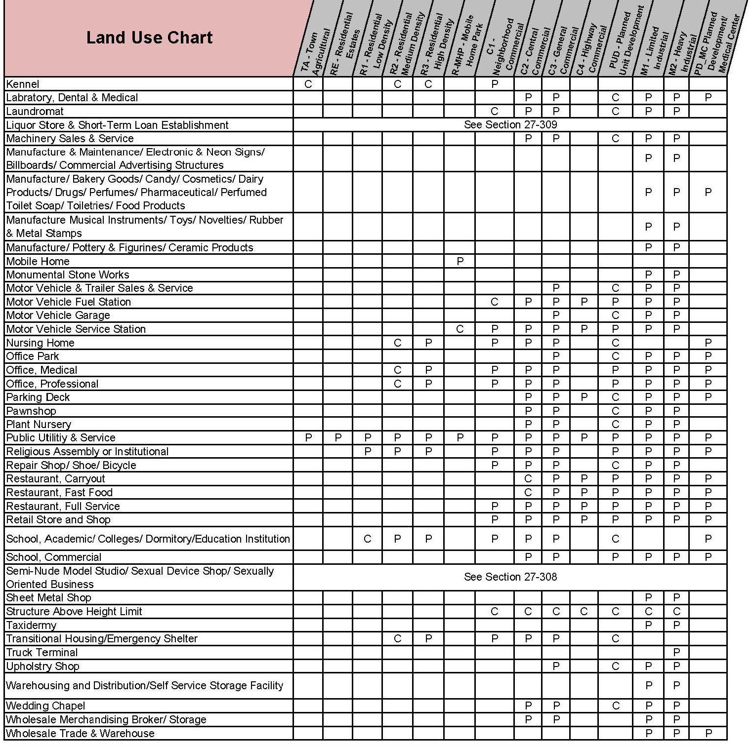
(Ord. No. O-2018-001, § 1, 2-13-18)