Denton City Zoning Code
Appendix A
RAYZOR RANCH OVERLAY DISTRICT
4.8.1 - Purpose
The purpose of establishing the Rayzor Ranch Overlay District is to:
A.
Ensure compatibility of new construction with the existing scale and characteristics of surrounding properties; and
B.
Protect and enhance specific land features which have characteristics distinct from lands and structures outside this Special Purpose District; and
C.
Provide within the Rayzor Ranch area a combination of land uses arranged and designed in accordance with sound site planning principles and development techniques; and in such a manner as to be properly related to each other, the immediate surrounding area, the planned mobility system, and other public facilities, such as water and sewer systems, parks, schools and utilities.
(Ord. of 7-16-2024, Exh. C)
4.8.2 - Application of Regulations
A.
The Rayzor Ranch Overlay District shall be consistent with the Denton Plan 2040.
B.
The regulations included in this Appendix apply to the portions of Rayzor Ranch that are located both north and south of U.S. 380/West University Drive (U.S. 380). The portion of Rayzor Ranch north of West University Drive (U.S. 380) is hereafter referred to as Rayzor Ranch Marketplace and the portion of Rayzor Ranch located south of West University Drive (U.S. 380) is known as the Rayzor Ranch South Campus.
C.
The District may be developed in phases. If the common amenities for future phases, including but not limited to open spaces, landscaping and/or recreational facilities are not yet constructed; a phasing plan may be considered as a component of the final plat. If provided, a phasing plan shall contain a graphic and narrative document that indicates the sequence and time of construction, provides a description of the phasing order (e.g. 1, 2 & 3) and includes infrastructure requirements for each phase, as amended from time to time with approval of the City Manager.
D.
Concept Plan. Development within Rayzor Ranch shall conform to the adopted Concept Plan attached as Exhibit "B" to these regulations. The Concept Plan is intended to be used as the first step in the development process. The Concept Plan establishes the initial plan for general zoning guidelines in the District by illustrating in graphic form both internal and external streets, thoroughfares, other means of access, open spaces, natural resources, uses, densities, intensities and height. Any adoption of or amendment to the Concept Plan shall follow the procedures for Zoning Amendments in Section 2.7.3 of the Denton Development Code. The following information should be provided for a complete Concept Plan, or an amendment to an existing Concept Plan:
1.
The date, written and graphic scale, north arrow, proposed name of the development, key map showing the location of the development in relation to existing streets and highways and dates of preparation and revisions.
2.
The name and address of the property owner or owners, and the design professional preparing the plan.
3.
The names of the record owners of adjacent land.
4.
Title Block containing: Proposed name of the subdivision or lot of record, acres in platted and unplatted land and total of those acres, survey and jurisdiction (City of Denton, County of Denton, Texas, for example).
5.
Acreage of the project.
6.
Show and label any proposed phasing limits.
7.
Survey boundaries of the project (or references to the survey).
8.
Proposed general land uses and the acreage of each subdistrict as defined in Exhibit B, including open space locations.
9.
Proposed street layout (arterial level required, collector and local to be developed by the applicant and reviewed by staff) and general location of internal and external streets, alleys, thoroughfares, and other means of access.
10.
Development Standards:
a.
Maximum height of buildings.
b.
Minimum lot area.
c.
Minimum lot width and depth.
d.
Building setbacks.
e.
Maximum lot coverage.
f.
Maximum floor to area ratio.
g.
Off-street parking standards.
11.
100-year floodplain, floodway and major drainage ways.
12.
City limits and Extraterritorial Jurisdiction (ETJ) boundaries.
13.
Zoning districts and land uses on project and adjacent lands.
14.
Preliminary water and sanitary sewer layout and drainage facilities locations.
E.
Site Plan. Site Plans are intended to demonstrate and confirm that each phase of development moving towards construction complies with all the design requirements of this Appendix and the applicable portions of the Denton Development Code. Site Plans shall substantially conform to the Concept Plan as depicted in Exhibit B. The following requirements shall apply:
1.
Before building permits may be issued for any portion of the project, a Site Plan for that portion of the project must be approved in conformance with this Appendix and the applicant must demonstrate compliance with this Appendix and all attached exhibits. The site plan requirement does not apply to Lots 6R, 7R, 8R, 9, 10, 12 and 13 of the Rayzor Ranch Marketplace. All other properties north of U.S. 380 and the Cook Children's tract and the Denton Municipal Electric (DME) Substation tract south of U.S. 380 are governed by the regulations herein.
2.
The District may be developed in multiple phases. If the District is developed in phases, a Site Plan shall be approved for each phase. However, this section does not preclude the approval of an overall Site Plan for the entire District, or a substantial portion of the District, at the option of the property owner.
3.
Site Plans shall be approved by the Planning and Zoning Commission in lieu of the Staff Review Procedure for Zoning Compliance Plans under Section 2.5.1 of the Denton Development Code. The Planning and Zoning Commission decision on Site Plans may be appealed to the City Council by the applicant; however, no further public hearing notification or public hearing shall be required on appeal. If appealed to City Council, the City Council's decision on a Site Plan is final.
4.
Complete Site Plans shall confirm the zoning details previously approved in the Concept Plan as well as provide additional design and architectural standard details by illustrating in a graphic form the following:
a.
Acreage in project shown by survey and certified by a registered surveyor;
b.
Permitted land uses and acreage of each land use;
c.
Land uses and zoning of adjacent properties;
d.
Drainage facilities;
e.
Other existing or proposed off-site improvements as required;
f.
Location, type and size of all streets, alleys, parking lots and spaces, loading areas or other areas to be used for vehicular traffic;
g.
Proposed access and connection to existing or proposed streets and traffic generated by the proposed uses;
h.
Non-residential: Location, maximum height (in feet), minimum setbacks, and maximum floor area ratio (FAR) of buildings;
i.
Residential development must show number, location and dimension of all lots, minimum setbacks, number of dwelling units and density;
j.
Location of all creeks, ponds, lakes, floodplain, and/or other water retention or major drainage facilities and improvements;
k.
Location size and route of all major water, wastewater, electrical lines and other facilities necessary to serve the project;
l.
Location of all protected trees (10+ inches) and a detailed landscape plan demonstrating compliance with the approved landscape requirements for Rayzor Ranch as set for in Exhibit "D";
m.
Location, type and size of all fences, berms, or screening features;
n.
Sidewalks or other pedestrian or bicycle access;
o.
Solid waste receptacles that demonstrate compliance with the City of Denton Solid Waste Criteria Manual;
p.
Building elevation(s); and
q.
Demonstrated compliance with the architectural standards in Exhibits C, C-1, C-2, C-2A, C-2B, C-3, C-4, C-5 with attached appendices as applicable. For properties within the SCD, SMUD-1, and SMUD-2, this shall include Proof of Approval of the proposed building elevations by the Rayzor Ranch Architectural Control Committee.
F.
Approval Criteria. Site Plans shall be approved if:
1.
The Site Plan substantially complies with the Concept Plan previously approved by City Council.
2.
The Site Plan provides for the design and arrangement of driveways and parking spaces in accordance with the applicable requirements of the Denton Development Code, as modified by the Rayzor Ranch Overlay District.
3.
There area adequate utilities, drainage and supporting infrastructure or it shall be provided in accordance with the applicable requirements of the Denton Development Code, as modified by the Rayzor Ranch Overlay District.
4.
The Site Plan fully complies with all other sections of the Rayzor Ranch Overlay District.
G.
Minor Amendment. The Director of Development Services may approve minor aesthetic deviations to architectural elevations and other approved site design standards and details associated with the Rayzor Ranch Overlay District, if necessary to protect the viability of the district as a whole, except that no amendment may change any use restriction or subdistrict boundary.
H.
Expiration of Site Plan. Any approved Site Plan shall be valid for twenty-four (24) months from the date of its approval. If no construction begins pursuant to a building permit issued for the property within the twenty-four (24) months, the site plan shall expire and no longer be valid. The Planning and Zoning Commission may, for good cause, extend for up to three hundred sixty (360) days the expiration date of the Site Plan.
(Ord. of 7-16-2024, Exh. C)
4.8.3 - Land Divisions
The Rayzor Ranch Overlay District shall be divided into two (2) major divisions, separated generally by U.S. 380 (University Drive): The Rayzor Ranch Marketplace; and the Rayzor Ranch South Campus. Subdistricts are listed and explained further below and in Exhibit B-1.
A.
Marketplace. The Rayzor Ranch Marketplace shall be divided into four (4) subdistricts as depicted in Exhibit B and detailed below:
1.
Marketplace-1: The Rayzor Ranch Marketplace (RRM-1) Area, depicted as RRM-1 on Exhibit B-1, is intended as a retail area with allowed uses outlined in this district, uses are designed to promote the overall purpose of this district. The RRM-1 section of the Rayzor Ranch Marketplace is referred to as the RRM-1 Area in the Architectural Standards, Landscape Standards, and Signage Standards in Exhibits B, C, D, and E, and vice versa.
2.
Marketplace-2: The Rayzor Ranch Marketplace (RRM-2) Area, depicted as RRM-2 on Exhibit B-1, is intended as a retail area with allowed uses outlined in this district, uses are designed to promote the overall purpose of this district. The RRM-2 section of the Rayzor Ranch Marketplace (RRM-2) is referred to as the RRM-2 Area in the Architectural Standards, Landscape Standards, and Signage Standards in Exhibits B, C, D, and E, and vice versa.
3.
Residential-1: The Rayzor Ranch Marketplace Residential Area 1 (R-1), depicted as R-1 on Exhibit B-1. This area is intended for residential development. Development standards for this area are provided in Exhibit C-4.
4.
Residential-2: The Rayzor Ranch Marketplace Residential Area 2 (R-2), depicted as R-2 on Exhibit B-1. This area is intended for residential development. Development standards for this area are provided in Exhibit C-4.
B.
South Campus. The Rayzor Ranch South Campus shall be divided into the following four (4) subdistricts, as depicted in Exhibit B-1.
1.
Town Center. The Town Center (TC), depicted as TC on Exhibit B-1, is intended to define a mixture of certain specified nonresidential, retail and residential uses as outlined in this district, uses are designed to promote the overall purpose of this district. The Town Center is also referred to as the TC Area in the Architectural Standards, Landscape Standards, and Signage Standards in Exhibits B, C-1, D-1, and E-1.
2.
South Commercial District. The South Commercial District (SCD), depicted as SCD on Exhibit B-1, is intended to define certain specified uses as outlined in this district. The South Commercial District is referred to as the SCD Area in the Architectural Standards, Landscape Standards, and Signage District in Exhibits C-1, D-1, and E-1.
3.
South Mixed-Use District-1. South Mixed-Use District-1 is depicted as SMUD-1 on Exhibit B-1. The South Mixed-Use District-1 is intended to accommodate certain specified uses including, single-family (SF), big houses (BH), multi-family (MF), restaurant/retail (RR), office (O), hotel (H), parks and open space (P) and other complimentary uses. Cooks Children's Hospital is accommodated within SMUD-1 and is depicted as CC on Exhibit B-1. Uses accommodated in the South Mixed-Use District-1 will be referred to as SF, BH, MF, RR, O, Hotel, P and CC, areas in the Architectural Standards, Landscape Standards, and Signage Standards in Exhibits C, C-2, C-2A, C-2B, C-3, D-2, D-2a, E-2 and E-2a.
4.
South Mixed-Use District-2. South Mixed-Use District-2 is depicted as SMUD-2 on Exhibit B-1. The South Mixed-Use District-2 is intended to accommodate certain specified uses including, single-family (SF), big houses (BH), multi-family (MF), restaurant/retail (RR), office (O), hotel (H), parks and open space (P), other complimentary uses and additional uses outlined below. Uses accommodated in the South Mixed-Use District 2 will be referred to as SF, BH, MF, RR, O, Hotel, and P areas in the Architectural Standards, Landscape Standards, and Signage Standards in Exhibits C-2, C-2A, C-2B, C-3, D-2, and E-2.
Additional uses accommodated with SMUD-2 include the DME Substation property, which is intended to accommodate a utility substation, and the Drill Pad property, which is intended to accommodate gas well development. The Drill Pad property is governed by regulations found in Section 4.8.16 and further restricted by Specific Use Permit (SUP) No. S09-0006, Ord. No. 2009-257.
(Ord. of 7-16-2024, Exh. C)
4.8.4 - Marketplace—Development Standards
A.
Residential Development Standards.
1.
Rayzor Ranch Marketplace contains two residential subdistricts, Residential-1 (R-1), and Residential-2 (R-2). The standards and regulations applicable to the development of property in R-1 and R-2 are provided below. The use regulations are provided in Section 4.8.6.
2.
R-1: The standards and regulations below are applicable to development in the R-1 subdistrict of the Rayzor Ranch Marketplace Residential area:
3.
R-2: The standards and regulations below are applicable to development in the R-2 subdistrict of the Rayzor Ranch Marketplace Residential area:
4.
Design Standards. Exhibit C-4 to sets forth the design, landscaping and architectural standards for subsections R-1 and R-2 of Rayzor Ranch Marketplace.
B.
Rayzor Ranch Marketplace-1 & -2 (RRM-1, RRM-2).
1.
The standards and regulations below are applicable to development in both Rayzor Ranch Market Place-1 (RRM-1) and Rayzor Ranch Marketplace-2 (RRM-2). The use regulations for RRM-1 and RRM-2 are provided in Section 4.8.6.
(Ord. of 7-16-2024, Exh. C)
4.8.5 - South Campus—Development Standards
A.
General use and development standards for the South Campus:
1.
Residential Dwelling Units.
a.
The South Campus shall not exceed the following number of dwelling units by type:
i.
185 single-family detached dwellings;
ii.
496 single-family attached dwellings; and
iii.
Two thousand two hundred fifty (2,250) multi-family units.
a.
One thousand two hundred and fifty (1,250) of the allowed two thousand two hundred fifty (2,250) multi-family dwelling units are to be constructed inside the Density Zone (Exhibit B-2) and cannot be rented by the room and cannot contain more than three (3) bedrooms in any individual unit.
The remaining one thousand (1,000) multi-family dwelling units can be built within the density zone or outside of the density zone within any subdistrict in the South Campus that lists multi-family as an allowable land use within the Appendix and cannot contain more than three (3) bedrooms in any individual unit.
iv.
Approved densities shall be contingent upon demonstration that planned public infrastructure is sufficient to sustain the herein approved densities.
b.
The first seven hundred and fifty (750) multi-family residential units in the South Campus shall not be permitted or constructed until the non-residential component of Phase 1 of the Town Center (TC) has had a site plan approved, and until the first one hundred thousand (100,000) square feet of the Town Center (TC) and South Commercial District (SCD) construction has: (1) received building permits, and (2) has been inspected and issued a green tag by the City for the building foundations. The remaining one thousand five hundred (1,500) multi-family residential units may be permitted and constructed when the first six hundred thousand (600,000) square feet of the Town Center (TC) and South Commercial District (SCD) construction has received building permits and the City has inspected and issued a green tag for the building foundations.
B.
South Campus—Town Center.
1.
The standards and regulations below are applicable to development in the Town Center subsection of the Rayzor Ranch South Campus. The use regulations for TC are provided in Section 4.8.6.
2.
Design Standards. Exhibits C-1, D-1 and E-1 to this Appendix set forth the Architectural Standards, Landscape Standards, and Sign Standards for the Town Center (TC).
C.
South Commercial District.
1.
The standards and regulations below are applicable to development in the South Commercial District (SCD) of the Rayzor Ranch South Campus. The use Regulations for SCD are provided in Section 4.8.6.
2.
Design Standards. Exhibits C-1, D-1 and E-1 to this Appendix set forth the Architectural Standards, Landscape Standards, and Sign Standards for the South Commercial District.
D.
South Campus—South Mixed-Use Districts.
1.
The South Campus contains two mixed-use subdistricts, South Mixed-Use District-1 (SMUD-1), and South Mixed-Use District-2 (SMUD-2).
2.
The standards and regulations below are applicable to development in SMUD-1 of the Rayzor Ranch South Campus. The use Regulations for SMUD-1 are provided in Section 4.8.6.
3.
The standards and regulations below are applicable to development in SMUD-2 of the Rayzor Ranch South Campus. The use regulations for SMUD-2 are provided in Section 4.8.6.
4.
Design Standards.
a.
Exhibits C-2, C-2A, C-2B, C-3, D-2 and E-2 to this Appendix set forth the Architectural Standards, Landscape Standards, and Sign Standards for SMUD-1 and SMUD-2.
b.
All multi-family development located on property east of Heritage Trail will comply with the site design standards in Exhibit C-2A. All Multi-Family development located on property west of Heritage Trail will comply with the site design standards in Exhibit C-3.
c.
All single-family development will comply with the site design standards in Exhibit C-2B.
d.
All nonresidential buildings within the SMUD-1 and SMUD-2 (all uses except multi-family and single-family) will comply with the site design standards in Exhibit C-2.
e.
Development of the Cook Children's property will comply with the Architectural Standards for the "CC Area" found in Exhibit C.
(Ord. of 7-16-2024, Exh. C)
4.8.6 - Use Regulations
This section identifies the uses permitted, by right or with approval of a specific use permit, in the various subdistricts of Rayzor Ranch Overlay District and establishes the standards and limitations (where noted). If a use is not listed in the table below the use is not permitted anywhere within the Rayzor Ranch Overlay District. Sexually-oriented businesses are prohibited throughout the Rayzor Ranch Overlay District.
The table of allowed uses follows the abbreviations defined in Section 5.2.1 of the Denton Development Code.
Within the SMUD-1 and SMUD-2 subdistricts certain parcels have restricted uses, as shown on Exhibit B-1. All other parcels within the SMUD-1 and SMUD-2 subdistricts are permitted any of the land uses shown below under the general ("Gen.") columns.
(Ord. of 7-16-2024, Exh. C)
4.8.7 - Use Specific Standards
A.
Community service: Uses are restricted to museums, educational facilities and government uses only.
B.
Building materials and supply store: Shall have a minimum floor area of one hundred thousand (100,000) square feet.
C.
Drive-through Use: SUP is required when use is abutting a residential use or zoned property, otherwise use is permitted.
D.
Garden Center with container pant materials and associated garden supplies: Shall only be accessory to retail or a home improvement center in excess of one hundred thousand (100,000) square feet.
E.
Outdoor Recreation Facility: Includes Amphitheater as a permitted use.
F.
Quick Vehicle Servicing: SUP is required when abutting residential use or residential zoned property, otherwise use is permitted.
G.
Water Quality Feature: Shall be developed in accordance with requirements outlined in Section 4.8.11 of the Rayzor Ranch Overlay District.
H.
Stormwater Control and/or Water Quality Feature: Within subdistrict RRM-1 stormwater control and/or detention facilities and water quality features will be restricted to the area identified on Exhibit B-3.
(Ord. of 7-16-2024, Exh. C)
4.8.8 - Landscaping and Tree Mitigation
The following regulations shall apply within the Rayzor Ranch Overlay District:
A.
All landscaping trees shall be installed and maintained in accordance with the requirements of the Site Design Criteria Manual.
B.
All properties shall install automatic irrigation systems. The Director may waive the irrigation system requirement if a landscaping plan is approved that includes drought tolerant plans or a xeriscape design.
C.
The following may count towards meeting the Landscape and Tree Canopy requirements:
1.
Undisturbed vegetative areas.
2.
Environmentally Sensitive Areas.
3.
Landscaping in the adjacent public right-of-way.
4.
Plazas and pedestrian circulation areas if constructed with pervious material.
5.
A percentage of parking areas if constructed with brick pavers or pervious pavement systems as approved by the Director of Planning and Development.
D.
Open Space, Tree Canopy, Landscaping and Tree Mitigation shall meet the standards as set forth in Exhibits D, D-1 and D-2 of this Appendix, and Sections 4.8.4 and 4.8.5.
E.
Trees planted to address tree mitigation will be credited on the actual caliper inch of the tree planted.
F.
Required tree mitigation funds will be put into a segregated tree mitigation account administered by the City of Denton. These funds will be released back to the Developer incrementally at the rate of one hundred and twenty-five ($125.00) per caliper inch for trees planted by the Developer, as the Developer certifies to the City that the trees have been planted and are in a health condition and the City Arborist confirms that the trees have been planted and are in a healthy condition.
G.
Mitigated trees may be planted throughout the Rayzor Ranch property or a specified in Exhibits D, D-1 and D-2.
H.
Open Space, tree canopy, and landscape shall be calculated as part of the entirety of Rayzor Ranch rather than on a site-by-site basis.
I.
Tree preservation requirements for the Rayzor Ranch Overlay District has been completed to the satisfaction of the City.
(Ord. of 7-16-2024, Exh. C)
4.8.9 - Architecture
A.
Architecture must meet the standards set forth in Exhibits C, C-1, C-2, C-2A, C-2B, C-3, C-4 or C-5 of this Appendix and shall meet the guidelines stated in each District Design heading as stated within Sections 4.8.4 and 4.8.5 of this Appendix.
(Ord. of 7-16-2024, Exh. C)
4.8.10 - Parking Standards
A.
The following off-street parking standards shall apply to the Rayzor Ranch South Campus. For uses not specified herein the standards in Section 7.9.4 of the Denton Development Code shall apply:
B.
Rayzor Ranch Marketplace shall apply the off-street parking standards in Section 7.9.4 of the Denton Development Code.
C.
Maximum Allowable Number of Parking Spaces. Limitations on the maximum allowable number of parking spaces shall not apply to the Rayzor Ranch Overlay District.
D.
Parking Accessibility Standards. All areas of newly designed or newly constructed buildings and facilities required to be accessible under federal and state law shall comply with the standards set forth in the Texas Accessibility Standards of the Architectural Barriers Act, Tex. Rev. Civ. Stat. Art. Ann § 9102 (Vernon Supp 2000).
E.
Limitation, Location, Use of Facilities.
1.
Location of required parking facilities. Except for single-family and two-family dwellings, required parking facilities may be located on another parcel of land, provided said parcel is within three hundred (300) feet of the use it is intended to serve and provides a convenient pedestrian route. The distance from the parking lot to the use shall be measured in walking distance from the nearest parking space to an access to the building that houses the use, along a sidewalk or other pedestrian path separated from street traffic. The right to use the off-site parking must be evidenced by a deed, lease, easement, or similar written instrument establishing such use, for the duration of the use.
2.
Parking is allowed in front of a building (between the building and street right-of-way) if it meets the screening requirements in the Landscape Standards, Exhibit D, D-1, D-2 or C-2.
3.
Mixed Uses. In the event that several users occupy a single structure or parcel of land, the total requirements for off-street parking shall be the sum of the requirements for the several uses computed separately unless it can be shown that the peak parking demands are offset, for example with retail and residential, or theater and office uses. In such case the Director may reduce the total requirements accordingly, but not by more than twenty-five (25) percent.
4.
Availability of Facilities. Required parking shall be available for parking of operable passenger vehicles of residents, customers and employees only, and shall not be used for the storage or display of vehicles or materials. The distribution of parking spaces for any and all individual uses will be required to be arranged on site to ensure optimal access and use by the patrons of such use.
5.
Compact Car parking. Compact parking spaces may only be used in parking structures. Up to twenty (20) percent of the total parking spaces in a parking garage may be designated for compact cars. Minimum dimensions for compact spaces shall be eight by sixteen (8x16) feet. Such spaces shall be signed of the space painted with the words "Compact Car Only".
F.
Parking Design Criteria for off-street parking.
1.
Size and Access. All required parking areas, and parking stalls shall be designed in accordance with the parking dimensions chart contained in Section 7.9 of the Denton Development Code.
2.
Driveways and Turn-Arounds. Driveways and turn-arounds providing access to parking areas shall conform to the following provisions:
a.
A driveway for a single dwelling shall have a minimum width of nine (9) feet, and a shared driveway serving two (2) units shall have a width of twelve (12) feet.
b.
Except for a single- or two-family dwelling, groups of more than five (5) parking spaces per lot shall be provided with adequate aisles or turn-around areas so that all vehicles may enter the street in a forward manner.
c.
Except for a single one- or two-family dwelling, more that five (5) parking spaces shall be served by a driveway design and constructed to facilitate the flow of traffic on or off the site, with due regard to pedestrian and vehicle safety, and shall be clearly and permanently marked and defined. In no case shall two-way and one-way driveways be less than twenty (20) feet and twelve (12) feet respectively.
3.
Vision Clearance. No signs, structures or vegetation in excess of two and one-half (2½) feet in height shall be placed in the vision clearance area. The vision clearance area is the triangle formed by a line connecting points twenty-five (25) feet along the street. No signs, structures or vegetation or portion shall be erected within ten (10) feet of driveways unless the same is less than two and one-half (2½) feet in height. No variance shall be granted for vision clearance standards.
G.
Development and Maintenance.
1.
The development and maintenance as provided below shall apply in all cases, except single- and two-family dwellings.
a.
Paving. All required parking areas, aisles, turn-arounds and driveways shall be paved with concrete, asphalt or comparable surfacing, constructed to standards on file in the office of the City Engineer. Parking lots in residential zones that contain less than ten (10) spaces may be surfaced with permeable material, such as crushed rock, to the standards on file in the office of the City Engineer.
b.
Drainage. All required parking areas, aisles and turnarounds shall have provisions made for the on-site collection of drainage waters to eliminate sheet flow of such waters onto sidewalks, public rights-of-way, and abutting private property.
c.
Driveway approaches. Approaches shall be paved with concrete surfacing constructed to standards on file in the office of the City Engineer.
d.
Marking. Parking lots of more than five (5) spaces shall have all spaces permanently and clearly marked.
e.
Wheel stops. Wheel stops shall be provided where appropriate for all spaces abutting property lines, buildings, landscaping, sidewalks and no vehicle shall overhang a public right-of-way.
f.
Maintenance. Parking facilities shall be continually maintained in compliance with the Site Plan and shall be free of litter and debris.
H.
Bicycle Parking. The use of bicycles as an alternative transportation method should be encouraged by the provision of bicycle parking spaces. The following standards are intended to serve as guidelines and are not a requirement for the approval of any development application.
1.
Quantity of Parking Spaces.
a.
All commercial uses should provide a minimum of two (2) bike parking spaces.
b.
In addition, all uses which require off street parking should provide one (1) bicycle parking space for every twenty (20) required auto parking spaces.
2.
Bicycle Parking Design Standards.
a.
Bicycle parking should be visible and convenient to cyclists and that provide sufficient security from theft and damage.
b.
Bicycle parking design alternatives are specified in the Transportation Criteria Manual.
I.
Vehicular Access.
1.
Access Management. All developments shall provide access that complies with Access Management principals of location, spacing and sharing of curb cuts. All developments shall provide adequate stacking distance for all entrances.
2.
Connectivity. All non-residential developments, excluding industrial, shall provide access to adjoining properties or developments.
3.
Pedestrian access. All developments shall provide pedestrian access by linking to any adjacent sidewalk(s), multi-use path(s), or public transportation stop.
4.
Transit Amenities. Transit amenities, but shelters, and pullouts shall be provided as required by the Development Code.
(Ord. of 7-16-2024, Exh. C)
4.8.11 - Drainage
A.
General.
1.
All developments shall provide for new drainage facilities, the improvement of any existing drainage facilities, channel improvements, grading, driveway adjustments, culvert improvements or any other improvement, drainage facility or work which is necessary to provide for the stormwater drainage needs of a development, in accordance with the requirements and design standards of Section 7.5 of the Denton Development Code and the Stormwater Design Criteria Manual. Such work shall include but not be limited to any drainage facilities, improvements or other work which is necessary to:
a.
Provide for the conveyance of all stormwater from the development when fully developed to an adequate discharge point;
b.
Fulfill any purpose for which the requirements of this section are imposed;
c.
Adequately protect the development from flooding, including the effects of the one-hundred-year flood;
d.
Properly control any increase in the upstream or downstream stage, concentration or water surface elevation caused by the development;
e.
Provide for the conveyance of off-site storm drainage based on ultimate developed watershed conditions through the development.
2.
Improvements to the detention pond west of Bonnie Brae Road and North of U.S. 380 are complete and have been accepted by the Public Works Inspection Department. Improvements to the detention pond west of Bonnie Brae Road are no longer a requirement for a Certificate of Occupancy for a structure in the South Campus District (TC or SCD).
B.
Stormwater Quality.
1.
Preliminary and Final Plats within the drainage area south of U.S. 380/West University Drive, for land that drains into North Lakes Pond, will include provisions for onsite or regional stormwater quality enhancement, including dedication of drainage easement areas as necessary to construct the stormwater quality structural controls and management practices as described in Exhibit "F". Approximately seventy-six (76) acres of Rayzor Ranch South drains into the water quality/detention basin north of West University Drive (U.S. 380). The stormwater quality controls approved in the Rayzor Ranch iSWM Plan do not account for any hot spots polluting areas south of University Drive. In the event of a proposed use within the seventy-six (76) acres met the definition of a hot spot pollutant generator, an evaluation of the capacity of the iSWM treatment train could be required and additional stormwater quality controls may be required.
2.
The stormwater quality controls shall be constructed as part of the storm drainage improvements for the development.
3.
Engineering inspection fees shall be paid to the City for the inspection of all stormwater quality controls during construction. Upon City's request, the designer shall certify to the best of the designer's knowledge, that the stormwater quality controls and management practices were constructed in accordance with the approved plans.
a.
Building Permits are not prohibited by these additional drainage restrictions above, provided that a construction schedule is committed to for the improvements, an onsite detention pond has been constructed and accepted by the City, and all other applicable requirements for issuance have been satisfied.
(Ord. of 7-16-2024, Exh. C)
4.8.12 - Transportation
A.
Required improvements in addition to those required by the Denton Development Code and Criteria Manuals:
1.
Required 20-foot visibility triangles shall be measured from the curb line not the property line.
2.
Construction of required improvements to segments of Heritage Trail Boulevard and Pan Handle Street abutting and adjacent to the Cooks Children's Hospital Tract have been completed and accepted by City Staff.
(Ord. of 7-16-2024, Exh. C)
4.8.13 - Street Standards
All street improvements shall comply with the street design specifications, as contained in the Transportation Criteria Manual and Section 7.8 of the Denton Development Code. The Transportation Criteria Manual is adopted by reference and included in this Appendix the same as if set out at length in this section.
A.
All street improvements shall be constructed in accordance with Division II, Materials, and Division III, Methods, of the City's Standard Specifications for Public Works Construction, North Central Texas Council of Governments (NCTCOG Standard Specifications), as amended by the City. Where any provision of this Code conflicts with a provision or requirement of the NCTCOG Standard Specifications, the provisions of this Appendix shall control.
B.
Dedication of easements and rights-of-way shall occur in accordance with the Subdivision regulations.
C.
Permits for new street connections to TxDOT roads must be obtained from TxDOT prior to approval of a final plat on the subject property. All other required TxDOT Permits must be obtained prior to construction of any improvements in the TxDOT right-of-way.
(Ord. of 7-16-2024, Exh. C)
4.8.14 - Gas Well Development
Gas well development is permitted only within the area designated as the "Drill Pad" on Exhibit B-1, with Specific Use Permit approval required from City Council prior to issuance of a gas well plat and drilling site plan. All gas well development will be subject to the requirements in Subchapter 6 of the Denton Development Code, and as further restricted by Ordinance No. 2009-257, to prevent imminent destruction of property or injury to persons and to make these activities conform to this regulation.
(Ord. of 7-16-2024, Exh. C)
4.8.15 - Property Owners Association
One or more Property Owner Associations (POA) shall be established for the maintenance of all common property not fully dedicated for public use. Documents establishing the POA must be submitted and approved as a required component of the final plat application, providing for the maintenance, repair, replacement and liability obligations of the POA for private roads, alleys, gates, fences, street lighting, drainage and or other held facilities and/or common areas, appurtenances, associated ancillary items and improvements.
A.
The POA shall authorize the City to file a lien, to foreclose, or to otherwise secure payment from property owners concerning the maintenance, repair and placement, in part or in whole, of all privately held common areas, including but not limited to stormwater control and/or detention areas, stormwater quality areas, street lighting and other appurtenances and/or other associated ancillary items.
B.
The POA documents must be submitted to, reviewed and approved by the City Attorney, prior to final plat approval for plats that include common areas.
C.
The POA may not be dissolved, nor may deed restrictions and covenants providing for maintenance of common areas be deleted or amended, without prior written consent of the City Council and plat amendment.
D.
The final plat and restrictive covenants shall contain language whereby the property owners defend and hold harmless the City from claims and suits for property damage or bodily injury (including death) arising from the conditions, use or operation of any privately owned parks, open spaces, common amenities, streets or facilities.
(Ord. of 7-16-2024, Exh. C)
4.8.16 - Definitions
The following definitions shall apply to the Rayzor Ranch Overlay District, any uses not defined here will follow the definition in Section 9 of the Denton Development Code. Where there is a conflict between a definition in this Appendix and Section 9 of the Denton Development Code the definition in this Appendix will take precedence.
A.
Amenity Center. A facility used by and for the benefit of the members of an HOA, Common Ownership Entity, or Multifamily complex. Amenity Centers may include indoor and outdoor components and facilities including, but not limited to, pools, gym/fitness center, game rooms, offices, meeting rooms and lounges.
B.
Age Restricted Multi-Family. Multi-Family development whose residents are restricted to those age 55 and over.
C.
Big House. A type of residential development where ten (10) or fewer dwelling units are located in a single building which is intended to resemble a single large house. The dwelling units can be vertically or horizontally integrated. Dwelling units developed as a Big House use will count towards the total number of multi-family dwelling units and not toward the total number of single-family dwelling units allowed in Rayzor Ranch listed in Section 4.8.5.
D.
Convention Center. A facility used in connection with a convention or meeting center, or similar facility, including auditoriums, exhibition halls, facilities for food preparation and service, parking facilities, administrative offices and ancillary development such as a hotel.
E.
Drive-Through Use. A facility or structure that is designed to allow drivers to remain in their vehicles before and during an activity on the site. Drive-through facilities are a type of site development that is usually found in conjunction with a quick vehicle servicing facility or other retail sales use. Examples include, but are not limited to, drive-through windows, menu boards, gas pump islands, car wash facilities, and quick lube or quick oil change facilities.
F.
Dwelling, Attached Single-Family. Three (3) to eight (8) attached single-family units, each of which is a separate household on its own lot.
G.
Dwelling, Single-Family Detached. A detached residential unit other than a manufactured home, hotel or motel.
H.
Dwelling, Townhouse-style. A dwelling structure not to exceed three (3) stories in height, containing a minimum of three and no more than eight dwelling units within a building, which is constructed in a series or group of attached units on one lot, up to eight (8) units, meeting fire protection requirements and the following additional requirements. Seventy-five percent (75%) of the dwellings built in compliance with the Townhouse Style development regulations are considered attached single-family dwelling units for the purpose of calculating the total number of units allowed in the Rayzor Ranch South Campus and will count towards the total number of single-family attached dwelling units and not toward the total number of multi-family dwelling units allowed in Rayzor Ranch listed in Section 4.8.5. Conversely, 25% of each phase of the Townhouse-style dwellings constructed shall count against multifamily.
1.
Each unit features at least two points of direct exterior access to the structure;
2.
Each unit is separated from the other dwellings in the structure by fire rated common walls;
3.
No units are vertically above or below another uses or unit within the structure;
4.
Each unit features an individual meter for each utility; and
5.
Each unit features access to a public street or alley.
I.
Plaza or Public Area Space. An area identified on an approved Site Plan which is designated for public or civic use. This area can be part of a private development or included within a Park.
J.
Rayzor Ranch. The comprehensive development which includes all phases defined within this Rayzor Ranch Overlay District.
K.
Stormwater Control and/or Detention Areas. Facilities dedicated to the collection, or transportation of stormwater runoff.
L.
Stormwater Control. Stormwater controls (sometimes referred to as best management practices or BMPs) are constructed stormwater management facilities designed to treat stormwater runoff and/or mitigate the effects of increased stormwater runoff peak rate, volume and velocity due to urbanization.
M.
Stormwater Quality Areas. Facilities for the collection and treatment of stormwater runoff.
N.
Quick Vehicle Servicing. A business providing service to the motoring public. Such uses can include gasoline sales, light repair, tune-ups, oil changes, transmission or drive train repairs to automobiles or light trucks. No outside storage of any automobiles or materials such as tires, auto parts, etc., is allowable. The sales of motor vehicles shall not be provided.
O.
Wholesale Sales. A business engaged in the sale of commodities in large quantities for resale purposes.
(Ord. of 7-16-2024, Exh. C)
4.8.17 - Exhibits
(Ord. of 7-16-2024, Exh. C)
EXHIBIT A - METES AND BOUNDS
PART ONE AND PART TWO 410.28 ACRES (TOTAL) FRANCIS BATSON SURVEY, ABSTRACT NO. 43 B.B.B. & C.R.R. COMPANY SURVEY, ABSTRACT NO. 192 CITY OF DENTON, DENTON COUNTY, TEXAS
PART ONE
BEING a tract of land situated in the Francis Batson Survey, Abstract No. 43, in the City of Denton, Denton County, Texas, being all of a called 121.4759 acre tract (description of Shephard Hall Tract, Tract 2), described in deed to Denton Hillview, L.P., recorded in Denton County Clerk's File No. 2005-127450 of the Real Property Records of Denton County, Texas, all of a called 0.2254 acre tract (Tract 1), a called 2.1017 acre tract (Tract 2) and a called 2.2200 acre tract (Tract 3) described in deed to Quantum at Denton Self Storage, L.P., recorded in Volume 5021, Page 01847 of the Real Property Records of Denton County, Texas, part of a called 18.269 acre tract, described in deed to Denton Property Joint Venture, recorded in Denton County Clerk's File No. 00-R0101370 of the Real Property Records of Denton County, Texas, all of a called 2.999 acre tract, described in deed to De Hall Properties, Ltd., recorded in Denton County Clerk's File No. 2005-40231 of the Real Property Records of Denton County, Texas, being part of a called 8.9217 acre tract of land described in Deed to Mesquite Creek Development, Inc., recorded in Volume 4562, Page 0683 of the Real Property Records of Denton County, Texas, and all of Lot 1 of SANDY ADDITION, an addition to the City of Denton, Denton County, Texas, according to the plat thereof recorded in Volume 13, Page 47 and Cabinet J, Slide 348 of the Plat Records of Denton County, Texas, and being more particularly described by metes and bounds as follows:
BEGINNING at a ½-inch iron rod found for the north end of a corner clip at the intersection of the north right-of-way line of West University Drive (U.S. Highway No. 380, a 100.20 foot wide public right-of-way) and the west right-of-way line of Bonnie Brae Street (a variable width public right-of-way) for the most easterly southeast corner of the beforementioned Lot 1 of SANDY ADDITION;
THENCE with the corner clip, South 45°48'44" West, a distance of 90.93 feet to a ¾-inch iron rod found for corner;
THENCE with the north right-of-way line of West University Drive, the following courses and distances to wit:
-North 89°07'28" West, a distance of 773.40 feet to a ⅝-inch iron rod with "KHA" cap set for corner;
-North 88°56'28" West, a distance of 1761.77 feet to a ½-inch iron rod found for the southeast corner of the called 8.9217 acre tract;
THENCE leaving the north right-of-way line of West University Drive with the east line of the 8.9217 acre tract, North 00°23'40" East, a distance of 276.40 feet to a point for corner;
THENCE crossing the called 8.9217 acre tract, the following courses and distances to wit:
-North 89°10'52" West, a distance of 227.61 feet to a point for corner;
-North 00°59'35" East, a distance of 80.89 feet to a point for corner;
-North 89°00'25" West, a distance of 290.00 feet to a point for corner in the east line of Lot 1, Block A of PORTER/ANDRUS ADDITION, an addition to the City of Denton, Denton County, Texas, according to the Plat thereof recorded in Cabinet O, Slide 45 of the Plat Records of Denton County, Texas;
THENCE with the east line of Lot 1, Block A and the east line of Lot 2, Block A of PORTER/ANDRUS ADDITION, an addition to the City of Denton, Denton County, Texas, according to the plat thereof recorded in Cabinet V, Slide 856 of the Plat Records of Denton County, Texas, North 00°59'47" West, a distance of 217.71 feet to a ⅝-inch iron rod with "KHA" cap set for the northeast corner of Lot 2, Block A;
THENCE with the north and west lines of Lot 2, Block A, the following courses and distances to wit:
-North 88°42'36" West, a distance of 400.01 feet to a ⅝-inch iron rod with "KHA" cap set for corner;
-South 01°28'09" West, a distance of 28.89 feet to a ⅝-inch iron rod with "KHA" cap set for the northeast corner of Lot 1R, Block 1 of ALVIN AND CHARLOTTE WHALEY ADDITION, an addition to the City of Denton, Denton County, Texas, according to the plat thereof recorded in Cabinet I, Slide 148 of the Plat Records of Denton County, Texas;
THENCE leaving the west line of Lot 2, Block A of PORTER/ANDRUS ADDITION with the north line of Lot 1R, Block 1 of ALVIN AND CHARLOTTE WHALEY ADDITION, North 88°31'28" West, a distance of 399.39 feet to a ⅝-inch iron rod with "KHA" cap set in the northeasterly right-of-way line Interstate Highway No. 35 (a variable width public right-of-way) for the most northerly northwest corner of Lot 1R, Block 1 of ALVIN AND CHARLOTTE WHALEY ADDITION;
THENCE leaving the north line of Lot 1R, Block 1 of ALVIN AND CHARLOTTE WHALEY ADDITION with the northeasterly right-of-way line Interstate Highway No. 35, North 16°07'54" West, a distance of 632.67 feet to a ⅝-inch iron rod with "KHA" cap set for the southwest corner of Lot 14 of GREENWAY CLUB ESTATES, an addition to the City of Denton, Denton County, Texas, according to the plat thereof recorded in Volume 4, Page 27 of the Plat Records of Denton County, Texas;
THENCE leaving the northeasterly right-of-way line Interstate Highway No. 35 with the south and east lines of GREENWAY CLUB ESTATES, the following courses and distances to wit:
-North 73°15'13" East, a distance of 518.79 feet to a ⅝-inch iron rod with "KHA" cap set for the beginning of a curve to the right;
-Easterly, with the curve to the right, through a central angle of 16°47'40", having a radius of 345.00 feet, and chord bearing and distance of North 81°39'03" East, 100.76 feet, an arc distance of 101.13 feet to a ⅝-inch iron rod with "KHA" cap set for the end of the curve;
-North 89°58'43" East, a distance of 364.46 feet to a ⅝-inch iron rod with "KHA" cap set for corner;
-North 00°57'04" West, a distance of 450.70 feet to a ⅝-inch iron rod with "KHA" cap set for the southwest corner of Lot 1, Block 10 of WESTGATE HEIGHTS, an addition to the City of Denton, Denton County, Texas, according to the plat thereof recorded in Cabinet E, Slide 78 of the Plat Records of Denton County, Texas;
THENCE leaving the east line of GREENWAY CLUB ESTATES with the south and east lines of WESTGATE HEIGHTS, the following courses and distances to wit:
-North 89°32'37" East, a distance of 48.23 feet to a ⅝-inch iron rod with "KHA" cap set for corner;
-South 87°34'57" East, a distance of 1042.99 feet to a ⅝-inch iron rod with "KHA" cap set for corner;
-North 00°32'57" East, a distance of 318.04 feet to a ⅝-inch iron rod with "KHA" cap set for the most northerly northwest corner of the beforementioned 121.4759 acre tract;
THENCE leaving the east line of WESTGATE HEIGHTS with the north line of the 121.4759 acre tract, South 89°13'56" East, a distance of 2067.29 feet to a ⅝-inch iron rod with "KHA" cap set in the west right-of-way line of Bonnie Brae Street;
THENCE leaving the north line of the 121.4759 acre tract with the west right-of-way line of Bonnie Brae Street, the following courses and distances to wit:
-South 00°37'18" West, a distance of 1455.38 feet to a ⅝-inch iron rod with "KHA" cap set for corner;
—South 00°26'45" West, a distance of 568.70 feet to the POINT OF BEGINNING and containing 153.37 acres of land.
Bearing system based upon Texas State Plane Coordinate System, using monuments R0610108 AND R0610060.
PART TWO
BEING a tract of land situated in the B.B.B. & C.R.R. Company Survey, Abstract No. 192, in the City of Denton, Denton County, Texas, being part of a called 265.6365 acre tract of land (description of Shephard Hall Tract, Tract 1), described in deed to Denton Hillview, L.P., recorded in Denton County Clerk's File No. 2005-127450 of the Real Property Records of Denton County, Texas, and all of Lot 3 of LOTS 1, 2, 8, 3 PEARCY/CHRISTON ADDITION No. 1, an addition to the City of Denton, Denton County, Texas, according to the plat thereof recorded in Cabinet B, Slide 34 of the Plat Records of Denton County, Texas, and being more particularly described by metes and bounds as follows:
BEGINNING at a ⅝-inch iron rod found in the south right-of-way line of West University Drive (U.S. Highway No. 380, a 100.20 foot wide public right-of-way) for the northerly common corner of Lots 2 and 3 of the beforementioned LOTS 1, 2, 8, 3 PEARCY/CHRISTON ADDITION;
THENCE leaving the south right-of-way line of West University Drive with the common line of Lots 2 and 3, South 01°08'26" West, a distance of 600.00 feet to a ⅝-inch iron rod found for the southerly common corner of Lots 2 and 3;
THENCE leaving the common line of Lots 2 and 3 with the south lines of Lot 2 and Lot 1-C of LOTS 1-A, 1-B, 1-C PEARCY/CHRISTON ADDITION No. 1, an addition to the City of Denton, Denton County, Texas, according to the plat thereof recorded in Cabinet L, Slide 188 of the Plat Records of Denton County, Texas, South 89°04'34" East, passing the southeast corner of Lot 1-C at a distance of 711.59 feet and continuing for a total distance of 730.60 feet to a ⅝-inch iron rod found in the west right-of-way line of Bonnie Brae Street (a variable width public right-of-way) for the most easterly northeast corner of the beforementioned 265.6365 acre tract;
THENCE with the west right-of-way line of Bonnie Brae Street, the following courses and distances to wit:
-South 00°58'54" West, a distance of 1438.01 feet to a ⅝-inch iron rod with "KHA" cap set for corner;
-South 00°48'51" West, a distance of 1175.56 feet to a ⅝-inch iron rod with "KHA" cap set for the beginning of a curve to the right;
-Southwesterly, with the curve to the right, through a central angle of 45°01'58", having a radius of 321.07 feet, and chord bearing and distance of South 23°19'47" West, 245.91 feet, an arc distance of 252.35 feet to a ⅝-inch iron rod found for the beginning of a reverse curve to the left;
-Southwesterly, with the curve to the left, through a central angle of 57°31'56", having a radius of 392.01 feet, and chord bearing and distance of South 17°04'48" West, 377.30 feet, an are distance of 393.63 feet to a ⅝-inch iron rod found for the end of the curve;
-South 11°41'10" East, a distance of 10.57 feet to a ⅝-inch iron rod found for the north end of a corner clip at the intersection of the north right-of-way line of Scripture Street (a variable width public right-of-way) and the west right-of-way line of Bonnie Brae Street;
THENCE with the corner clip, South 39°33'50" West, a distance of 11.48 feet to a ⅝-inch iron rod found for the south end of the corner clip;
THENCE with the north right-of-way line of Scripture Street, North 88°58'00" West, a distance of 1265.16 feet to a ⅝-inch iron rod found in the south line of the 265.6365 acre tract;
THENCE leaving the north right-of-way line of Scripture Street, the following courses and distances to wit:
-North 01°02'00" East, a distance of 500.06 feet to a ⅝-inch iron rod found for corner;
-North 88°58'00" West, a distance of 761.56 feet to a ⅝-inch iron rod found for corner;
-South 01°02'00" West, a distance of 500.06 feet to a ⅝-inch iron rod found in the north right-of-way line of Scripture Street;
THENCE with the north right-of-way line of Scripture Street, the following courses and distances to wit:
-North 88°58'00" West, a distance of 318.44 feet to a ⅝-inch iron rod with "KHA" cap set for corner;
-North 88°48'26" West, a distance of 41.73 feet to a ⅝-inch iron rod found in the northeasterly right-of-way line Interstate Highway No. 35 (a variable width public right-of-way) and the north right-of-way line of Scripture Street for the most southerly southwest corner of the 256.6365 acre tract;
THENCE with the northeasterly right-of-way line Interstate Highway No. 35, the following courses and distances to wit:
-North 15°50'30" West, a distance of 38.32 feet to a ⅝-inch iron rod with "KHA" cap set for corner;
-North 16°24'00" West, a distance of 3494.36 feet to a ⅝-inch iron rod found for corner;
-North 14°50'06" East, a distance of 171.01 feet to a 3-inch brass disk in concrete found for corner;
-North 46°04'12" East, a distance of 303.95 feet to a ⅝-inch iron rod found for corner;
-North 60°32'22" East, a distance of 114.22 feet to a ⅝-inch iron rod found for corner;
-North 00°58'25" East, a distance of 13.09 feet to a concrete monument found in the south right-of-way line of West University Drive;
THENCE leaving the northeasterly right-of-way line Interstate Highway No. 35 with the south right-of-way line of West University Drive, the following courses and distances to wit:
-South 88°56'28" East, a distance of 2440.06 feet to a ⅝-inch iron rod with "KHA" cap set for corner;
-South 89°01'07" East, a distance of 117.72 feet to the POINT OF BEGINNING and containing 256.91 acres of land.
Bearing system based upon Texas State Plane Coordinate System, using monuments R0610108 and R0610060.
This document was prepared under 22 TAC §663.21, does not reflect the results of an on the ground survey, and is not to be used to convey or establish interests in real property except those rights and interests implied or established by the creation or reconfiguration of the boundary of the political subdivision for which it was prepared.
EXHIBIT C-2 - RAYZOR RANCH ARCHITECTURAL STANDARDS SOUTH MIXED-USE DISTRICT-1 & SOUTH-MIXED USE DISTRICT 2
A.
Architecture and Planning.
1.
Non-residential buildings (all uses except multifamily and single-family) in the South Mixed-Use District-1 (SMUD-2) and South Mixed Use District-2 (SMUD-2) shall comply with the following planning and design standards.
B.
Orientation/Site Design.
1.
The SMUD-1 and SMUD-2 sub-districts are intended to incorporate a wide array of commercial and mixed-use options including retail, personal service, restaurants, entertainment, hospitality, assisted living/memory care, office, healthcare, commercial, among other uses. The project should be complimentary to surrounding land-uses.
2.
Parking areas must be paved with concrete, concrete pavers or brick pavers and curbed and guttered with concrete. Access drives must be paved, curbed and guttered with concrete in accordance with the development standards promulgated by the City.
3.
Parking areas must meet Parking Standards detailed in Section 4.8.12 of this Ordinance to accommodate all parking needs for employees, company vehicles, residents, invitees and visitors. If parking needs increase on any building site, additional parking must be provided by the Owner of such building site.
4.
Bicycle racks shall be included in each Development at a rate of one rack per 50 parking spaces.
5.
Internal parking lot landscape islands are required in accordance with Diagram 1.
6.
Pedestrian Connectivity:
a.
Sidewalks shall be provided to promote pedestrian connectivity within each project site.
b.
Sidewalk connection shall be provided from the primary entrances of all buildings to public sidewalk on any front facing adjacent street.
7.
Directional and wayfinding signage shall provide assistance for pedestrians and vehicles.
C.
Screening.
1.
Loading docks, trash containers, storage areas and ground mounted mechanical equipment shall be screened from public streets and residential uses or zones by evergreen shrubbery, trees, masonry screenwall, or a combination thereof. If screening mechanical equipment, the landscape material must be a minimum of one foot taller than the item they are to screen at time of planting and must comply with the planting standards set forth.
2.
Storage areas, trucks based on the premises, trash containers, and maintenance facilities, shall either be housed in closed buildings or otherwise screened from view from public access ways, public areas, and adjacent residential properties. Service, loading, and storage areas shall be screened from view by walls, berms or a combination thereof, constructed a minimum one foot above all service equipment. Trash and recycling containers shall be screened from public view on three sides with a solid fence or wall to a minimum one foot above container (minimum 7'). Walls to be faced with brick, stone, or burnished CMU. Gates to be constructed of metal frame and metal facia to match the building material.
3.
Trash collection and compaction may not occur within 100' of a single-family detached residence located outside of Rayzor Ranch.
4.
Mechanical equipment - ground mounted - may not be placed at an area or wall that faces single-family residential that is located within 100' of a single-family detached residence located outside of Rayzor Ranch. Ground-mounted equipment shall not be located between the front building wall and the street.
5.
All roof mounted mechanical equipment shall be fully screened from public view on the site or public pedestrian spaces, at a minimum height equal to the height of the roof mounted equipment. Acceptable methods for screening roof mounted equipment shall include parapet elements, louvers, or ridges of sloped roof forms. The color and finish of the screening shall comply with the color palette used for the building, and be complimentary to the building architecture.
D.
Building Design and Materials.
1.
Buildings are to have architectural theming, including common design elements and materials within each development.
2.
Window glass may not be flush with exterior walls or, if flush, shall have a surround of wood/metal frame or wall trim material.
3.
Buildings shall be designed to enhance the community character and have features that provide visual interest. Large, blank facades and wall surfaces shall not be permitted. Windows and/or storefronts should be included in wall planes wherever feasible. The building facades should be broken up and softened when feasible through overhangs and colonnades, trellis, architectural detailing or landscaping.
4a.
Building walls greater than 100' in length shall have vertical and horizontal façade articulation or other distinctive changes in the building façade, such as material changes, color or textural changes, projections or recesses greater than 16", canopies, porticos, and sunshades at intervals of 100' maximum.
4b.
All buildings shall have some portion of parapet level changes or sculptural roof form through sloped roofs, mansards, etc.
5.
All sides of buildings visible from the streets, or internal customer parking areas of the site, are encouraged to be constructed of masonry, including brick and native stone veneers, decorative block, Architectural finish concrete, stucco (EIFS), or other high quality material customarily used for this building style. Windows, doors and related trim are not included in this requirement.
5a.
For all facades that face a public street, a minimum of 60% of the total net exterior wall area of each building elevation, excluding gables, windows, doors and related trim, are encouraged to be clay fired brick or native/natural stone.
5b.
For all other facades that do not face a public street, a minimum of 40% of total net exterior wall area of each building elevation, excluding gables, windows, doors and related trim, is encouraged to be clay fired brick or native/natural stone.
5c.
Preferred materials include:
a.
Native Texas quarried natural stone or limestone of varying colors, sizes and textures.
b.
Masonry, including burnished and architectural finish face CMU and brick.
c.
Concrete - Architectural finish. Texture coated or textured and colored.
d.
Porcelain Tile.
e.
Glass.
f.
Galvanized metal panels or prefinished architectural metal panels of gray tone, neutral or earthtone color (maximum 20%).
g.
Architectural cementitious panels in a warm, neutral/earthtone or gray tone color and "wood look" panels (maximum 40%).
h.
EIFS or stucco in a warm, neutral/earthtone or gray tone color.
i.
Natural metals such as, but not limited to, zinc and copper.
j.
Natural wood, stained or painted (maximum 15%).
k.
Roofing tile, metal roofing shingles and panels, slate, and minimum "40 year dimensional shadow type" composite shingles.
l.
Accent colors should be used in a limited manner to contrast the more subtle "natural" palette.
6.
Glass and Storefronts. Glass may be used to allow visual access into interior spaces, or for display purposes. Buildings may not incorporate glass for more than 70% of the wall plane.
7.
Stone. Native stone and stone veneers are encouraged to be incorporated where practical as the common and unifying architectural material.
8.
Metal Roofs. Metal roofs are permitted provided that they are pre-finished standing metal seam, batten seam or metal shingles, in natural earth-tone colors.
E.
Outdoor Display and Pick-up.
1.
Exterior sidewalk displays and cart storage. Areas for customer loading or merchandise display and cart storage is allowed, but such areas shall be clearly delineated and shall not be located in front of any customer entrances, exit door(s), or within 15' on either side of the door(s).
2.
Pickup and Delivery. Pickup, delivery, loading and unloading of merchandise, equipment or other items may not occur within 100' of single-family detached residential property located outside of Rayzor Ranch. Loading areas must be located to the side or rear of the building unless the loading area is completely screened from the street by landscaping or walls that are architecturally compatible with the building. Pavement may be located within 100' of residential property.
F.
Accessory Use.
1.
All accessory uses shall be architecturally compatible with the main structure by sharing color, materials, architectural design, roof pitch elements or some other architectural feature.
G.
Drive-Through Requirements.
1.
Drive-through uses shall provide sufficient stacking area to ensure that public rights-of-way are not obstructed. Fast food restaurants with drive-through facilities shall provide a minimum stacking distance of 160' unless the building owner or tenant can substantiate that a lesser requirement is appropriate based on a national standard or case studies of other facilities operated by that owner or tenant. Other drive-through facilities shall provide a minimum stacking distance of 100'.
2.
Drive-through canopies must be built as an integral architectural element of the structure. The supporting structure shall include at least one of the following architectural features:
a.
Native Texas stone, limestone, or brick on the supporting structure columns or building facade.
b.
A sloped metal roof.
3.
The materials are to be the same as those used in the primary structure. Drive-through structures and facilities physically separated from the primary structure must be architecturally compatible with the primary structure.
4.
Drive-through uses must be located to the rear or side of the structure, and buffered on the rear and side lot lines as required in Denton Development Code Section 7.9.7.C. A portion of the buffer between sites can be provided on adjacent lots.
H.
Light and Glare Performance Requirements.
1.
A comprehensive lighting plan shall be utilized for public safety in parking areas, illumination of building areas and pedestrian scale lighting along walkways and foot paths, intersections, and gathering places. All lighting within the Development shall meet the following standards:
a.
Areas designated for parking use shall provide a minimum average of one foot candle of illumination.
b.
Areas designated for pedestrian use shall provide a minimum average of one-half foot candle of illumination.
c.
Light may not measure more than ¼ foot candle of illumination at property lines external to Rayzor Ranch or at internal property lines where adjacent to residential.
d.
Use of ground mounted or pedestrian level accent lighting is encouraged.
e.
Lights shall be shielded to prevent upward diffusion (full cut off). Up-lighting or sideward diffused lighting to highlight building features is permitted at 2500 lumens or less per fixture on building elevations that
1)
Are not facing an adjacent property with single-family residential use or district OR,
2)
Are in excess of 100' from a single-family residential use or district outside of Rayzor Ranch.
f.
Lighting to be LED, 4000 degree Kelvin for parking and roadway lighting, 3000 degree Kelvin for pedestrian level accent lighting - 14' or lower.
EXHIBIT C-2A - RAYZOR RANCH SOUTH MIXED-USE DISTRICT-1 and RAYZOR RANCH SOUTH MIXED-USE DISTRICT-2 MULTI-FAMILY RESIDENTIAL GUIDELINES
The following provisions apply to all Multi-Family Tracts and Lots located east of Heritage Trail, within Rayzor Ranch South Mixed-Use District-1 (SMUD) and Rayzor Ranch South Mixed-Use District-2 (SMUD-2). The Standards apply to Multi-Family and Age Restricted Multi-Family (Residents Restricted to 55 years and older).
A.
Site Design & Orientation.
1.
Buildings shall be located within 20 feet of the property line for at least 50% of the total frontage along all public streets. Up to an additional 10 feet from the property line may be granted to this 20 feet restriction for 25% of the total frontage; to reasonably accommodate enhanced sidewalks, street trees, landscaping, or other requirements that would otherwise be limited due to easements or other encumbrances. This provision does not establish a maximum setback for the remaining 50% of the building.
2.
Parking is not permitted between front facades of buildings and the R.O.W. property line. On street parking is permitted.
3.
All buildings abutting an existing single-family use outside of Rayzor Ranch Overlay District shall comply with the Residential Proximity Slope. No part of any building may extend beyond the Residential Proximity Slope.
a.
Residential Proximity Slope is represented by two planes projected upward and outward from a specific property or site, as defined by the text and diagrams below:
1)
The first plane is a vertical plane extending through the boundary line of a specific property or site at the building setback line up to a height of 45 feet.
2)
The second plane extends upwards and towards the restricted building at a slope of 35 degrees from horizontal, from its intersection with the top of the first plane.
3)
The horizontal distances used to calculate the height restrictions imposed by the residential proximity slope may be determined by using the lot, block, and right-of-way dimensions.
Figure 1
Figure 2
4.
Buildings shall front on public streets and/or a private street system and may have secondary frontages onto parking lots.
5.
Buildings shall be directly accessed from the street and the sidewalk with a minimum of one ground floor pedestrian entrance per building oriented toward the street or sidewalk.
a.
Accessory structures such as carports, garages and storage units (but not including leasing offices, club houses or recreation centers) shall not be located along public right-of-way or private streets within the Rayzor Ranch District.
b.
"Tuck under" or extended garages may occupy no more than 45% of the total building frontage. This measurement does not apply to garages facing an alley, courtyard, or parking field entrance. Any garage may not extend beyond the building front. Garages that are at least 30 feet behind the building front may exceed the 45% frontage minimum. Garages shall not be located along the portion of the building that fronts the public or private street.
B.
Architectural Standards.
1.
Building frontages greater than 100 feet in length shall have recesses, projections, windows, arcades or other distinctive features to interrupt the length of building façade. Elements including, but not limited to, balconies, setbacks, and recesses or projections greater than 16 inches may be used to articulate individual units or collections of units.
2.
Uninhabitable building features, outdoor patios (covered or uncovered), and architectural building feature elements (fountains, towers, awnings, trellis, outdoor gazebos for multifamily, or similar) may encroach upon the front setback or side setback (by as much as 10 feet).
3.
Un-enclosed stairwells shall not be located on the exterior of any buildings. Stoops are permitted for the entrance to ground level units directly accessible from the sidewalk.
4.
Use of false door or window openings shall be defined by frames, sills, and lintels.
5.
All building façades shall include no less than 3 of the elements listed below. Elements shall occur at intervals of no more than 100 feet horizontally or 20 feet vertically. Vertical architectural design features, such as towers, are not required to comply with the 20 feet vertical requirement.
a.
Color change.
b.
Texture change.
c.
Material change.
d.
Medallions/accent pieces.
e.
Decorative light fixtures.
6.
Roofs:
a.
If pitched roof forms (gable, hip, shed) with overhanging eaves are used, they shall be between 4 inches of vertical rise to 12 inches of horizontal run, and 12 inches of vertical rise to 12 inches of horizontal run.
b.
Metal standing seam roofing allowed.
c.
Asphalt roofing shingles shall be dimensional (shadow line) type and at least a "40 year" shingle.
d.
Clay tile, concrete tile, and slate are permitted materials.
e.
Distinctively shaped roof forms, detailed parapets, parapet steps, or exaggerated cornice lines should be incorporated into rooflines along building façades greater than 75 feet in length.
f.
Flat roofs are permitted and must have parapets as required to screen any roof top equipment (equal to height of equipment). Walls adjoining flat roofs must contain a distinctive finish at the top of the wall such as a cornice, banding, large coping, or other architectural termination.
g.
All sloped roofing areas shall include gutters and downspouts except for small roof areas such as, but not limited to, roofs over bay windows, awnings, and canopies.
7.
Materials and Colors:
a.
For all facades that face a public or private street, windows and doors shall comprise at least 20% of the wall area. All other facades may be reduced to 10%, or may provide one window or door per sleeping area (as defined by the Building Code), whichever method provides for the greater coverage of windows and doors. Shutters, trims, or false windows, shall not count toward the minimum requirement.
b.
For all facades that face a public or private street, a minimum of 60% of the total net exterior wall area of each building elevation, excluding gables, windows, doors and related trim, are encouraged to be clay fired brick or native/natural stone. The balance of the 40% net exterior wall is encouraged to be comprised of at least 2 of the following materials.
1)
Stucco.
2)
EIFS. When used, EIFS shall be a minimum of 8 feet above grade/walkway.
3)
Prefinished metal panels and siding materials with a dimensional shape (depth of approximately one inch or greater). All materials must have a factory finish with a 20 year warranty.
4)
Cement fiber siding such as Nichiha. All siding members must be individual boards or panels. (Soffits may utilize sheet materials of approximately 4' x 8').
5)
Cast stone.
c.
For all other facades that do not face a public or private street, a minimum of 40% of total net exterior wall area of each building elevation, excluding gables, windows, doors and related trim, is encouraged to be clay fired brick or native/natural stone. The balance of the 60% net exterior wall is encouraged to be comprised of at least 2 of the following materials:
1)
Stucco.
2)
EIFS. When used, EIFS shall be a minimum of 8 feet above grade/walkway.
3)
Prefinished metal panels and siding materials with a dimensional shape (depth of approximately one inch or greater). All materials must have a factory finish with a 20 year warranty.
4)
Cement fiber siding such as Nichiha. All siding members must be individual boards or panels. (Soffits may utilize sheet materials of approximately 4' x 8').
5)
Cast stone.
d.
It is preferred that no individual building material, with the exception of clay fired brick or native/natural stone comprise more than 50% of the net exterior wall area of each building elevation.
e.
All buildings within a particular project shall be constructed of building materials from a similar color and material palette. This is not intended to require similar materials with adjacent properties within Rayzor Ranch. General color palette shall be of earth tones, gray tones, and neutral colors with other accent colors permitted up to a maximum of 10% of each façade.
f.
Windows may be residential type vinyl, aluminum, fiberglass, or wood with insulated glass. Storefront glazing systems are also permitted. Window surrounds (trim) are required in all walls other than brick or stone.
8.
Public entrances to buildings shall be clearly defined and highly visible including features such as, canopies, porticos, awnings, peaked roof features, towers, or similar architectural forms and details.
C.
Accessory Structures.
1.
Accessory structures (including parking structures, detached garages, and storage units) shall complement the main building architecture and use the same materials and color palette.
2.
Accessory structures visible from a public or private street or a residential use or district are subject to the same masonry and roofing material requirements as the main buildings but are not subject to the other building design standards. Garage doors shall be metal or metal faced with wood.
D.
Landscaping.
1.
Street Trees shall be provided along all public and private streets consistent with the requirements in Subchapter 7.7.7 of the Denton Development Code.
2.
All parking lots and areas for vehicle maneuvering or loading must be screened from view from public and private streets by a 10-foot landscape screening buffer. The 10-foot buffer is the area located between the right-of-way and the parking lot. Utility easements are allowed to count towards part of the 10-foot wide right-of-way landscape screening buffer subject to required separation from utilities. The landscape screening buffer shall contain the following items:
a.
One large tree for every 40 feet or three small accent trees for every 30 feet. If small trees are used, they shall be clustered as appropriate.
b.
Landscape plantings containing at least one of the following:
1)
Xeriscaping landscaping may be planted within the landscape area and shall require water irrigation for a period of 3 years for landscaping to be established. After 3 years, no irrigation is required.
2)
A minimum 3 foot high, when mature, continuous row of evergreen shrubs. The shrubs may be grouped and not planted in a continuous row provided that the shrubs overlap to form a continuous buffer.
3)
A minimum 3 foot high continuous wall made of any combination of wrought iron, stone, brick, or masonry. If wrought iron is used, vines shall be grown on the wrought iron to help screen the parking lot.
4)
A grass or landscaped berm, 3 feet high above the parking pavement surface.
3.
A minimum of 7% of the total parking area shall be landscaped.
4.
A minimum of 5% of the total parking area shall be covered by tree canopy at maturity.
5.
Landscape islands shall be evenly distributed throughout the parking areas at a maximum average spacing of 12 spaces. All landscape islands and endcaps shall be landscaped with sod or groundcover and include one large tree.
6.
A 10 foot landscape buffer is required along the entire property line abutting a single-family use or district. The buffer shall include a combination of 6 evergreen and deciduous trees and 25 shrubs per 100 linear feet.
7.
A minimum of 20% tree canopy at maturity is required. For the high density Multi-Family lot, trees may be planted in Civic Land or Park Land on the South Campus and the tree canopy be used as mitigation towards up to one-half of the canopy requirement.
8.
See Appendix A for Plant List and Appendix B for Tree Mitigation List.
E.
Open Space & Amenities.
1.
An area equal to at least 8% of the lot area, excepting required setbacks, shall be dedicated to open space for recreation for use by the tenants of the development. Mixed-use developments of greater than 25 units per acre may be allowed to reduce from this requirement to 5% of lot area.
2.
Areas covered by shrubs, bark mulch and other ground covers which do not provide a suitable surface for human use may not be counted toward this requirement.
3.
Private decks, patios, pool areas, and similar areas are eligible for up to 5% of the 8% required open space, or up to 2½% of the 5% required.
F.
Lighting.
1.
Lighting shall be provided for vehicular, pedestrian, signage and architectural and site features.
2.
Site lighting fixtures used along entrance driveways and in parking areas shall be no taller than 25 feet high and the fixtures shall be of a consistent design within each project. This is not intended to require a consistent design within the whole of Rayzor Ranch.
3.
Parking areas shall have a minimum average of one foot candle initial illumination. Maximum illumination at property lines where the adjacent property allows single-family or multi-family uses shall not exceed 0.1 foot candles.
4.
Light sources shall be LED. Yellow/orange source lights are prohibited from use in parking or drive areas, must be greater than minimum 2700 Kelvin.
5.
Identification graphics and signs shall be lighted internally or from ground mounted locations. If ground mounted, light fixtures should be screened from view in front of the sign.
6.
Illumination for all parking lots and pedestrian spaces shall commence one-half hour before sunset and cease one-half hour after sunrise.
7.
Lights shall generally be shielded to prevent upward diffusion (full cut off). Up-lighting is only permitted for building elevations that are in excess of 150 feet from a single-family residential use or district. LED light source is required for all such accent lighting.
G.
Service & Security Areas.
1.
Service areas for common use recreation and activity buildings shall be located at the rear or side yard of the buildings. Such areas must not be visible from public roadways. No service or delivery vehicles may park or load/unload on public roadways, primary entrance drives or in visitor drop-off areas.
2.
Service, loading and storage areas shall not encroach on any landscape area.
3.
When used, guard houses (manned or unmanned) and entrance gates shall be a minimum of 60 feet from the property line.
4.
When used, gate controls, card pads and intercom boxes shall be located in driveway islands adequate distances from the gate to allow "U-turning" without backing onto the public street.
H.
Parking & Circulation.
1.
Parking areas must be paved with concrete, concrete pavers or brick pavers and curbed and guttered with concrete. Access drives must be paved, curbed and guttered with concrete in accordance with the development standards promulgated by the City.
2.
Parking areas must be sufficient to accommodate all parking needs for employees, company vehicles, residents, invitees and visitors without the use of on-street parking. If parking needs increase on any building site, additional off-street parking must be provided by the Owner of such building site. The number of parking spaces must be provided as follows:
a.
Multi-Family Development:
1)
Studio unit or 1 bedroom units 501 to 600 sq. ft.: 1.0 space/unit.
2)
1 bedroom unit 601 sq. ft. or larger: 1.5 space/unit.
3)
2 bedroom units: 1.75 space/unit.
4)
3 bedroom units: 2.0 space/unit.
5)
4 bedroom units or more: 1.0 space/bedroom.
b.
Age Restricted Multi-Family Development - 1 space per dwelling unit.
c.
No additional guest parking is required.
3.
See Diagram 1 for Island Example.
4.
Pedestrian Connectivity:
a.
Provide a logical layout for vehicular and pedestrian circulation to help minimize the conflicts between the two. When there are crossings or common path areas, provide well marked or differentiated pathways.
b.
Sidewalks shall be provided along all sides of the lot that abut a public right-of-way and where otherwise required to promote pedestrian connectivity within the site and to adjacent properties. At a minimum, walkways shall connect focal points of pedestrian activity such as, but not limited to, transit stops, street crossings, building entry point.
I.
Fencing.
1.
If walls and fencing are used to secure the perimeter of a building site in a multi-family zone, they must be 6 feet to 8 feet high and constructed of materials and finishes that match the buildings. "Wrought iron" style metal fencing is allowed provided it is interrupted with masonry columns or walls (to match the building) such that no run of metal fencing exceeds 40 feet. Metal fencing is to be powder coated or otherwise pre-finished. Field painting is only allowed for touch up when required. Walls/fences located in the front yards or forward of the front building line shall be no more than 50% opaque.
2.
Walls and columns must be constructed with appropriate structural footings and foundations to minimize movement and wall failure, and must be constructed with level wall/fence tops.
3.
Concrete walls (precast, cast-in-place, or tilt up) regardless of texture, finish and color are not permitted.
4.
Fencing shall be setback a minimum of 5 feet from the sidewalk or 10 feet from the back of curb along a public or private street, whichever is greater. Additionally, fencing shall comply with the sight visibility triangle requirements in the City's Transportation Criteria Manual.
J.
Screening (Dumpsters & Mechanical Equipment).
1.
Storage areas, incinerators, storage tanks, trucks based on the premises, roof objects (including fans, vents, cooling towers, skylights and all roof-mounted equipment which rises above the roof line), trash containers and maintenance facilities, shall either be housed in closed buildings or otherwise completely screened from view from public access ways and adjacent properties. Service, loading and storage areas shall be screened from view by walls, berms or a combination thereof, constructed a minimum one foot above all service equipment, such as trash containers, incinerators, storage tanks and cooling towers. Dumpsters and recycling containers shall be screened from public view on three sides with a solid fence or wall constructed of brick, stone, or composite wood with metal posts and frame, only if compatible with building material.
2.
No satellite dish shall be placed in an area visible from a public way and no dish shall be mounted to a balcony, unless not visible from public way.
3.
Air conditioning units/compressors shall be located in clusters or linear groups and they shall be screened from view of public streets and pedestrian amenity areas by the use of parapet walls or screens of materials to match the building façade. If ground mounted, screens to be walls - including berms, evergreen planting, or a combination thereof. Height of shrubs, at planting, shall be no less than 30 inches above the grade, and spaced no further than 36 inches apart. Screening walls shall be of a height of one foot above the units.
4.
Utility meters shall be located in clusters or groups preferably in separate structures or on either end of the building's exterior walls. If located on the ends of the building, they shall be screened from view with a wall finished to match the building material with evergreen plantings, and allow convenient accessibility by the utility company. Height of screen to be one foot above height of utility meters.
K.
Signage.
1.
Each property shall be allowed one monument sign with a maximum height of 6 feet and maximum effective area of 60 square feet at each entry into the development. Related architectural features (such as clock towers, obelisks, etc.) may be taller than six feet provided the signage mounted to such features is at a maximum height of six feet.
2.
Building sites which front other perimeter public streets and have no access to that public street, may install one monument sign with a maximum height of 6 feet and maximum effective area of 60 square feet.
3.
Monument signs are required to be setback a minimum of 10 feet from any public or private street and 10 feet from any rear or side property lines.
4.
Directional signage is permitted and shall be limited to an effective sign area of 25 square feet and shall not exceed 5 feet in height.
5.
Flashing or moving character signs may not be installed. Illuminated signs must be rear lighted or lighted from non-apparent light sources. Illuminated signs shall not be permitted to face an adjoining lot that is for residential use.
6.
Each building elevation shall be allowed one wall sign limited to a maximum effective area no greater than 5% of the wall area to which the sign is attached. If signs are illuminated, it shall be from gooseneck or similar wall mounted lighting.
7.
Site perimeter sign walls below 6 feet tall are allowed in lieu of monument sign, or at street corner. Graphic murals shall be counted as art, not signage. See Appendix 1, Project Identity Sign.
8.
Building mounted blade signage is allowed. The materials and scale of the sign must be appropriate to the building it is mounted to, but shall not exceed 10 square feet and a 5 foot projection from the building wall. The bottom of blade mounted signs must be no lower than 9 feet above grade and the top shall not extend above the eave line of sloped roofs or the parapet height on flat roofs.
9.
See attached Appendices 1—4 for Signage.
L.
Grading and Drainage.
1.
All grading must be done to alleviate ponding and must be coordinated with the master storm drainage plan and detention facilities. Depressions on paving or the landscape areas which will allow ponding of water are not permitted.
2.
Drainage swales must be shallow, gently contoured and sloped to minimize erosion. Concrete rip-rap, trapezoidal concrete channels and concrete pilot channel ditches are not permitted.
APPENDIX A
APPROVED PLAN LIST
Canopy Trees
Mature Canopy 314-1256 sq. ft. - Site Design Criteria Manual
Ornamental Trees
Mature Canopy 79-314 sq. ft. - Site Criteria Manual
Shrubs
Grasses/Ground Cover/Vines
Diagram 1—Parking Lot Landscape Islands
APPENDIX 1
SIGNS
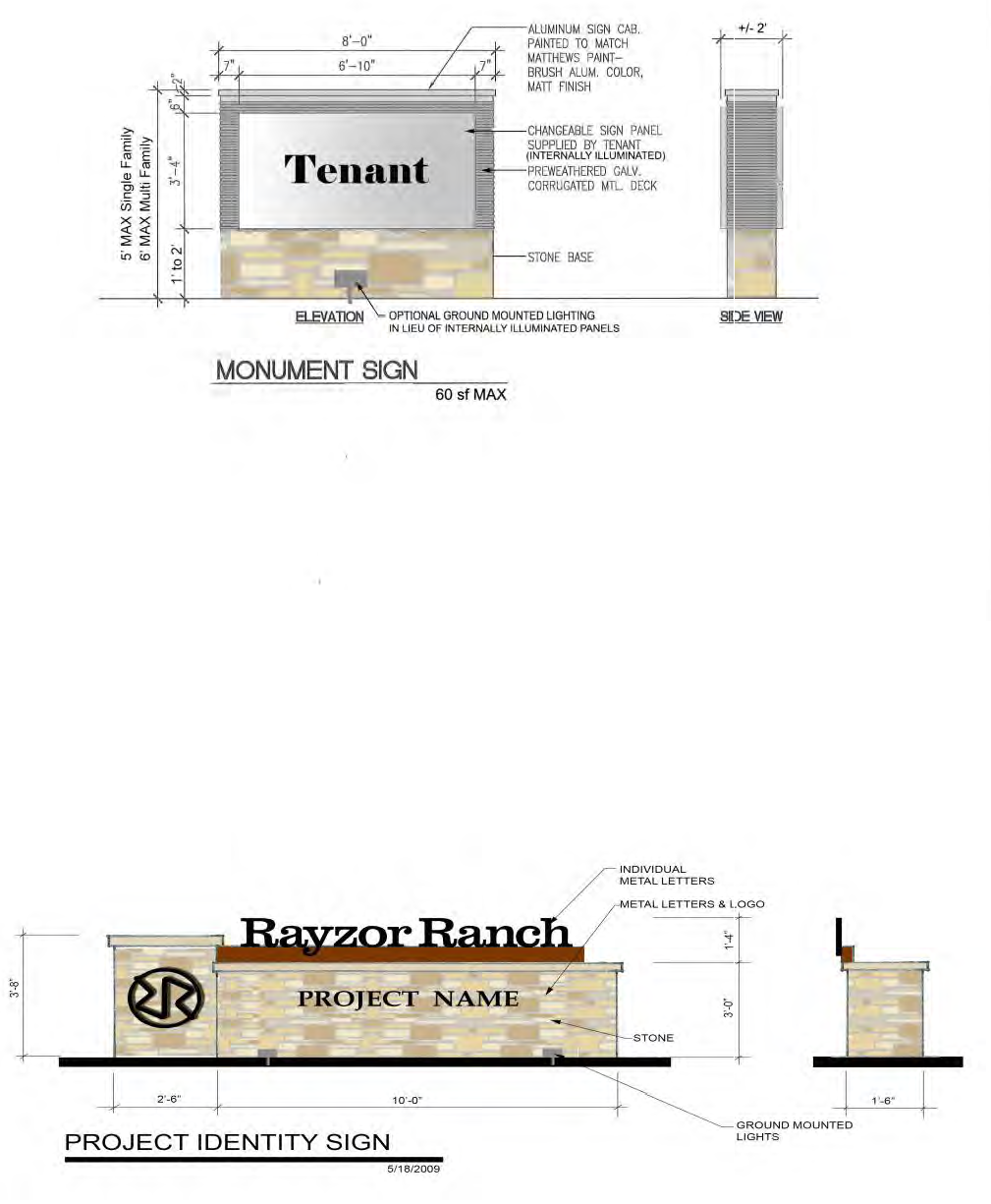
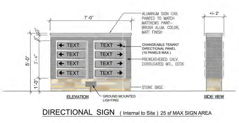
APPENDIX 2 BLADE AND PROJECT BANNER SIGN EXAMPLES
All signage examples attached are for illustrative purposes only and to further define size calculations required for various sign types. Examples are not indicative of the final graphics for the Rayzor Ranch Sign District.
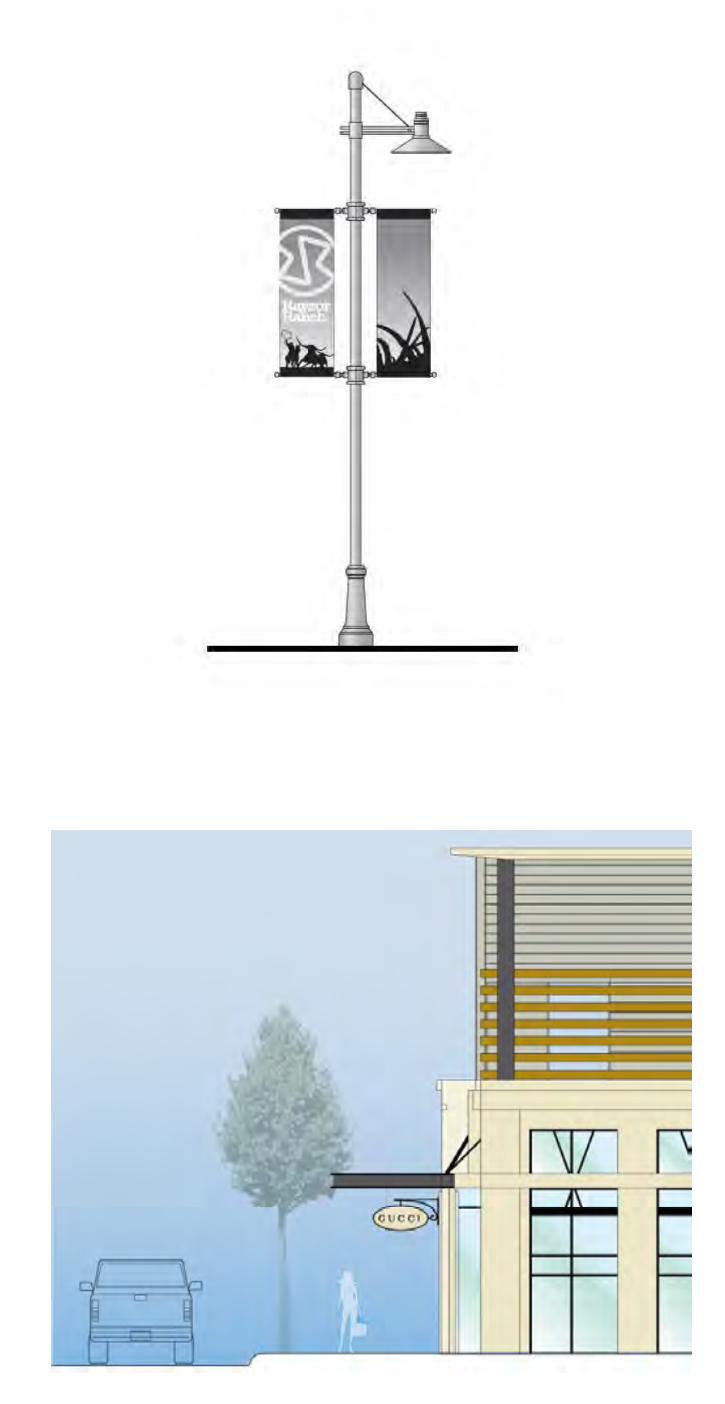
APPENDIX 3
PROJECT ANNOUNCEMENT SIGN EXAMPLE
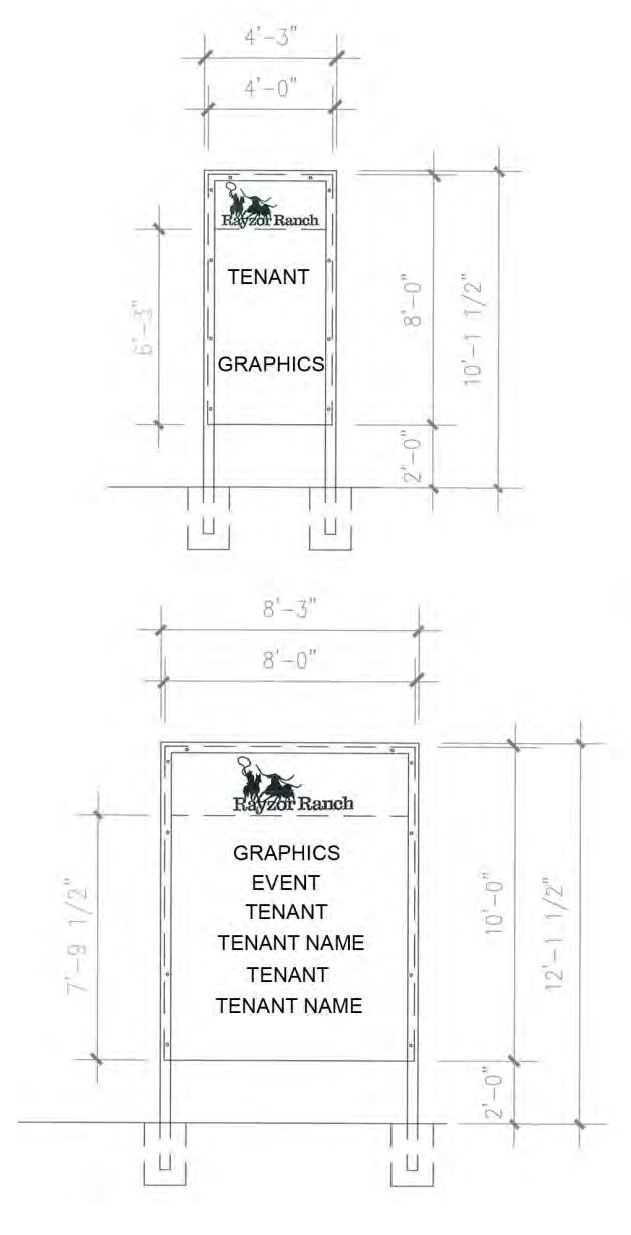
APPENDIX 4
EFFECTIVE AREA EXAMPLE
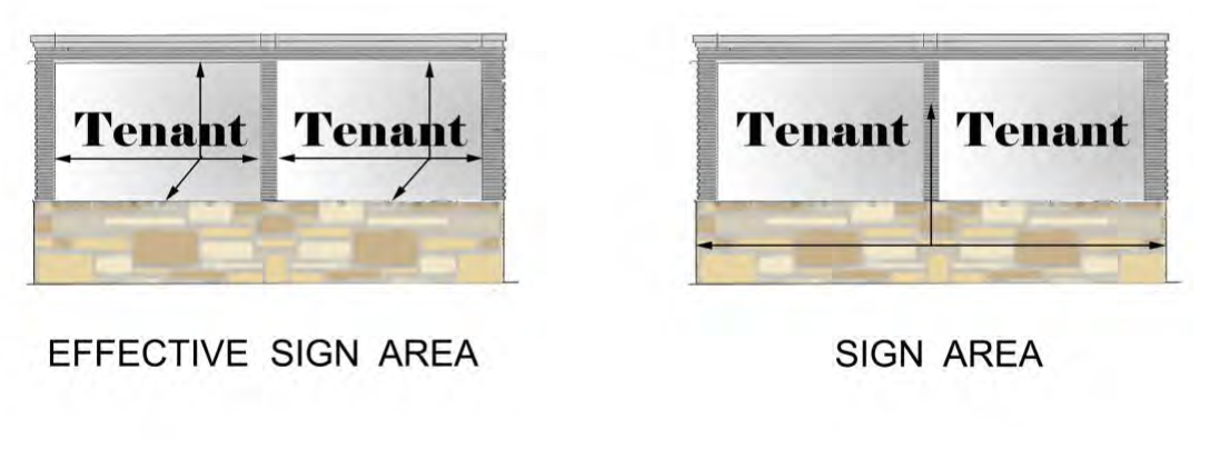
EXHIBIT C-2B - RAYZOR RANCH SOUTH MIXED-USE DISTRICT-1 AND RAYZOR RANCH SOUTH MIXED USE DISTRICT-2 SINGLE-FAMILY RESIDENTIAL GUIDELINES
The following provisions apply to all Single-Family Tracts and Lots located within Rayzor Ranch South Mixed Use District-1 (SMUD-1) and Rayzor Ranch South Mixed Use District-2 (SMUD-2) lots. All other provisions of Subchapter 7 apply unless otherwise stated.
A.
Site Design & Orientation.
1.
Refer to Exhibit B-3 for area(s) within SMUD-1 and SMUD-2 which may include single-family.
2.
For Single-Family Detached, no two building elevations shall be repeated with less than 200 feet of separation on the same side of the street.
3.
Parking is not permitted between front facades of buildings and R.O.W. property line with public right-of-way greater than 20 feet, unless in Single-family Detached construction. On street parking is permitted.
4.
All buildings within 35' of an existing single-family use or district outside of the Rayzor Ranch Overlay District shall be constructed to a maximum height of 40'.
5.
Buildings shall be directly accessed from the street and the sidewalk with a minimum of one ground floor pedestrian entrance per building oriented toward or perpendicular to a street or private drive.
a.
Garage doors for attached garages may occupy no more than 50% of the total building facade. This measurement does not apply to garages facing an alley or courtyard entrance.
6.
For attached Single-family lots with alleys, rear yard setbacks (alley way) shall be 4 feet if at least two parking spaces are provided in a garage.
7.
End units of attached Single-Family dwelling buildings shall have a minimum side yard setback of 5 feet at right-of-way. Setbacks between units of attached Single-Family dwellings shall be zero feet. Front yard setbacks may vary from 0 feet to 5 feet minimum but no more than 50% of each block of attached Single-Family building shall have a 0 foot setback.
a.
Sidewalks within the right-of-way shall be located against the curb.
b.
Distance from edge of street pavement to building front shall be minimum 10 feet.
8.
The SMUD-2 area depicted on Exhibit B-3 as BH/MF/O/SF and SF shall allow Single-Family Detached or Attached homes, as well as other uses allowed, on Lot 5 (Block A), Lot 1 (Block B), and Lot 1 (Block C) per the Rayzor Ranch East Addition Plat.
9.
For Lot 5 (Block A), Lot 1 (Block B), and Lot 1 (Block C) as depicted in the Rayzor Ranch East Addition Plat, Single-family Detached homes shall be "Garden Style" and have a minimum 8 foot front yard setback, 15 foot rear yard setback, and 6 foot side yard only on one side of each lot (zero lot line on the other side yard).
10.
Garden-style homes on Lot 5 (Block A), Lot 1 (Block B), and Lot 1 (Block C) must have a minimum of 800 square feet under roof, excluding the garage.
11.
Single-family homes on Lot 1 (Block B) and Lot 5 (Block A) of the Rayzor Ranch East Addition Plat shall be restricted to one (1) bedroom per dwelling unit.
B.
Architectural Standards.
1.
For Attached Single-family.
a.
Building frontages 100 feet in length or greater shall have recesses, projections, windows, arcades or other distinctive features to interrupt the length of building façade. Elements including, but not limited to, balconies, setbacks, and recesses or projections greater than 16 inches may be used to articulate individual units or collections of units.
b.
All building façades shall include no less than two of the elements listed below. Elements shall occur at intervals of not more than 100 feet horizontally.
1)
Color change.
2)
Texture change.
3)
Material change.
4)
Medallions/accent pieces.
5)
Decorative light fixtures.
2.
For All Single-family.
a.
Use of false door or window openings shall be defined by frames, sills, and lintels.
b.
Roofs:
1)
If pitched roof forms (gable, hip, shed) with overhanging eaves are used, they shall be between 4 inches of vertical rise to 12 inches of horizontal run, and 12 inches of vertical rise to 12 inches of horizontal run.
2)
Metal standing seam roofing allowed, including porch or awning elements. Also, use of dormers in high sloped roof areas is allowed.
3)
Asphalt roofing shingles are encouraged to be dimensional (shadow line) type and at least a "40 year" shingle.
4)
Clay tile, concrete tile, and slate allowed.
a)
Photovoltaic shingles mimicking clay, concrete, or slate are allowed.
5)
Distinctively shaped roof forms, detailed parapets, parapet steps, or exaggerated cornice lines shall be incorporated into rooflines along building façades greater than 75 feet in length.
6)
Flat roofs are permitted and shall have parapets as required to screen any roof top equipment - equal to the height of the units. Parapets shall include an accent feature and shall not be greater than 50 feet in length without variation in height or accent feature.
7)
Photovoltaic panels shall be allowed when placed upon the roof plane.
c.
Materials and Colors:
1)
For all facades that face a public or private street, windows and doors shall comprise at least 20% of the wall area. All other facades may be reduced to 10%, or may provide one window or door per sleeping area (as defined by the Building Code), whichever method provides for the greater coverage of windows and doors. Shutters, trims, or false windows, shall not count toward the minimum requirement.
2)
For all facades that face a public or private street, a minimum of 40% of the total net exterior wall area (total wall area less windows, doors, and related trim area) of each building elevation, excluding gables, is encouraged to be clay fired brick or native/natural stone. A minimum of 80% of the total net exterior wall area (total wall area less windows, doors, and related trim area) of each building elevation, excluding gables, is encouraged to be clay fired brick, native/natural stone, stucco, or decorative cement fiber siding.
The balance-up to 20% of the net exterior wall, is encouraged to be comprised of at least two of the following materials, which will not be counted toward the minimum 80% masonry recommendation outlined above.
a)
Stucco.
b)
EIFS - when used, EIFS shall be a minimum 8 feet above grade/walkway.
c)
Prefinished metal panels and siding materials. Such materials shall be factory prefinished with a minimum 20 year warranty (single-family attached only).
d)
Wood or composite wood panels, all siding members must be individual boards (soffits may utilize sheet materials of approximately 4' x 8').
e)
Cast stone.
3)
For all other facades that do not face a public or private street, a minimum of 60% of the total net exterior wall area (total wall area less windows, doors, and related trim area) of each building elevation, excluding gables, is encouraged to be clay fired brick, native/natural stone, stucco, or decorative cement fiber siding. The balance up to 40% of the net exterior wall is encouraged to be comprised of at least two of the following materials, which will not be counted toward the minimum 60% masonry recommendation.
a)
Stucco.
b)
EIFS - when used, EIFS shall be a minimum 8 feet above grade/walkway.
c)
Prefinished metal panels and siding materials. Such materials shall be factory prefinished with a minimum 20 year warranty (single-family attached only).
d)
Wood or composite wood panels, all siding members must be individual boards (soffits may utilize sheet materials of approximately 4' x 8').
e)
Cast stone.
d.
No individual building material, with the exception of brick or native/natural stone may comprise more than 50% of the net exterior wall area of each building elevation.
e.
Windows may be residential type vinyl, aluminum, fiberglass, or wood with insulated glass. Window surrounds (trim) are required in all walls other than brick or stone. Storefront glazing systems shall be allowed in the amenity center or club house.
f.
General color palette shall be of earth tones, gray tones, and neutral colors with other accent colors permitted up to a maximum of 10% of each façade.
C.
Accessory Structures.
1.
Accessory structures (including detached garages, and storage units) shall complement the main building architecture and use the same materials and color palette.
2.
Accessory structures visible from a public or private street or a residential use or district are subject to the same masonry and roofing material requirements as the main buildings. Garage doors shall be metal or metal faced with wood.
D.
Landscaping for Detached Single-family.
1.
Street Trees shall be provided along all public and private streets consistent with the requirements in Subchapter 7.7.5.E of the Denton Development Code excepting that:
a.
One (1) tree per lot, approximately evenly spaced, for developments with lots 60 linear feet or less of street frontage.
b.
Two (2) trees per lot, approximately evenly spaced, for developments with lots greater than 60 linear feet of street frontage.
2.
A minimum of 20% tree canopy at maturity is required. Tree canopy within common areas on the development (amenity centers, open spaces, etc.) may be allocated (credited) toward tree canopy on the individual lots.
3.
See Appendix A for Plant List.
E.
Landscaping for Attached Single-family.
1.
Street Trees shall be provided along all public and private streets consistent with the requirements in Subchapter 7.7.5.E of the Denton Development Code.
2.
All parking lots and areas for vehicle maneuvering or loading adjacent to Panhandle Street must be screened from view from public and private streets by a 15 foot landscape screening buffer. Parking lots adjacent to other public and private streets to have a minimum 10 foot landscape screening buffer. The buffer is the area located between the right-of-way and the parking lot. Utility easements are allowed to count towards part of the right-of-way landscape screening buffer subject to required separation from utilities. The landscape screening buffer shall contain the following items:
a.
One large tree for every 40 feet or three small accent trees for every 30 feet.
b.
Landscape plantings containing at least one of the following:
1)
Xeriscaping landscaping may be planted within the landscape area and shall require water irrigation for a period of three years for landscaping to be established. After three years, no irrigation is required.
2)
A minimum 3 foot high, when mature, continuous row of evergreen shrubs. The shrubs may be grouped and not planted in a continuous row provided that the shrubs overlap to form a continuous buffer.
3)
A minimum 3 foot high continuous wall made of any combination of wrought iron, stone, brick, or masonry. If wrought iron is used, vines shall be grown on the wrought iron to help screen the parking lot.
4)
A grass or landscaped berm, 3 feet high above the parking pavement surface.
c.
A minimum of 7% of the total parking area in lots of 10 spaces or more shall be landscaped.
d.
A minimum of 15% of the total parking area in lots of 10 spaces or more shall be covered by tree canopy at maturity.
e.
Landscape islands shall be evenly distributed throughout the parking areas. All landscape islands and endcaps shall be landscaped with sod or groundcover and include one large tree.
3.
Buffer requirements set forth in Subchapter 7.7.6 of the DDC shall only apply to residential districts adjacent to and outside of the Rayzor Ranch District.
4.
Required landscape areas shall be included in common areas.
5.
A minimum of 20% tree canopy at maturity is required. Tree canopy within common areas on the development (amenity centers, open spaces, etc.) may be allocated (credited) toward tree canopy on the individual lots.
6.
See Appendix A for Plant List.
F.
Lighting for: (A) Attached Single-family and (B) Detached Single-family at Streets and Alleys only.
1.
Lighting shall be provided for vehicular, pedestrian, signage and architectural and site features.
2.
Site lighting fixtures used along public and private streets and in parking areas shall be no taller than 25 feet high and the fixtures shall be of a consistent design within each project. This is not intended to require a consistent design within the whole of Rayzor Ranch.
3.
Parking areas shall have a minimum average of 0.5 foot candle initial illumination. Maximum illumination at property lines where the adjacent property allows single-family or multi-family uses shall not exceed 0.1 foot candles.
4.
Light sources shall be LED. Yellow/orange source lights are prohibited from use, in parking or drive areas, must be greater than minimum 2700 Kelvin.
5.
Lights shall generally be shielded to prevent upward diffusion (full cut off).
G.
Parking & Circulation.
1.
Parking areas must be paved with concrete, concrete pavers, brick pavers, or durable pervious materials, and shall have concrete curb and gutter. Access drives must be paved, with curb and gutter with concrete in accordance with the Development Standards promulgated by the City.
2.
The maximum allowable number of spaces specified in Subsection 7.9.4.B does not apply to the residential subarea of the Rayzor Ranch South.
3.
The number of parking spaces must be provided as follows:
a.
In Attached Single-family, parking to be 1 space per 1 bedroom unit, 1.75 spaces per 2 bedroom unit, and 2 spaces per 3 bedroom unit.
b.
In Detached Single-family, 2 spaces per dwelling unit.
c.
Garden-style homes on Lot 5 (Block A), Lot 1 (Block B), and Lot 1 (Block C) must include two off-street parking spaces per unit, including the garage.
d.
Street parking: Designated parking on streets immediately adjacent to the Development is allowed to be counted as required parking. Parking is not permitted on more than one side of street, unless street width is increased to accommodate it.
H.
Fencing.
1.
If walls or fencing are used to secure the perimeter of a development site in a single-family zone, they must be a minimum of 6 feet high with a maximum of 8 feet high, and constructed of stone, brick, or wrought iron with brick or stone columns. Maximum distance between columns to be 40 feet.
2.
Walls, fences, and columns must be constructed with appropriate structural footings and foundations to minimize movement and wall failure, and must be constructed with level wall/fence tops.
3.
Concrete walls (precast, cast-in-place, tilt wall) regardless of finish, are not allowed.
I.
Signage.
1.
Each entry point shall be allowed one monument sign as shown on the attached Appendix 1, Monument Sign, with a maximum height of 6 feet and maximum effective area of 60 square feet at each entry into the development. Related architectural features (such as clock towers, obelisks, etc.) may be taller than 6 feet provided the signage mounted to such features is at a maximum height of 6 feet.
2.
Monument signs are required to be setback a minimum of 20 feet from any public or private street and 10 feet from any rear or side property lines.
3.
Site perimeter sign walls below 6 feet tall are allowed in lieu of the monument sign, see Appendix 1, Project Identity Sign. Graphic murals shall be counted as art, not signage.
4.
See Appendix 1 and Appendix 4 attached.
Appendix A
Approved Plan List
Canopy Trees
Mature Canopy 314-1256 sq. ft. - Site Design Criteria Manual
Ornamental Trees
Mature Canopy 79-314 sq. ft. - Site Criteria Manual
Shrubs
Grasses/Ground Cover/Vines
APPENDIX 1
SIGNS
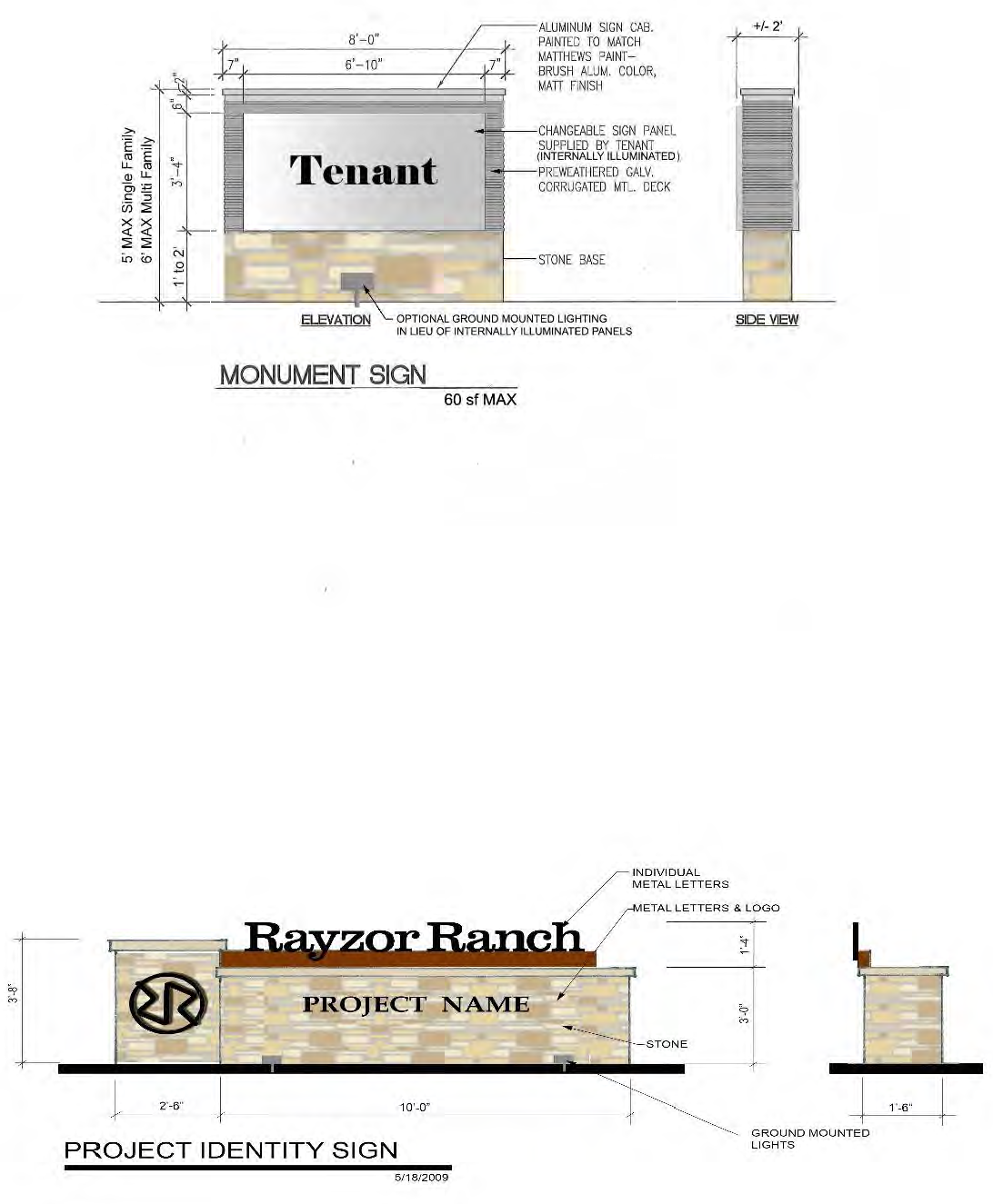
APPENDIX 4
EFFECTIVE AREA EXAMPLE
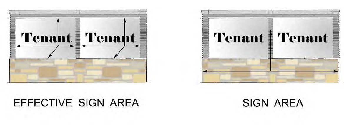
EXHIBIT C-3 - RAYZOR RANCH MULTI-FAMILY GUIDELINES FOR SOUTH MIXED USE DISTRICT-1 AND SOUTH MIXED USE DISTRICT-2
The following provisions apply to all Multi-Family Tracts and Lots located within the Rayzor Ranch South Campus Mixed-Use District-1 (SMUD-1) and South Mixed Use District-2 (SMUD-2), west of Heritage Trail, and replaces Section 7.10.4 of the Denton Development Code, in its entirety. All other provisions of Subchapter 7.10.4 apply unless otherwise stated.
A.
Site Design & Orientation.
1.
Buildings shall be located within 20 feet of the property line for at least 50% of the total frontage along all public streets. Up to an additional 10 feet from the property line may be granted to reasonably accommodate enhanced sidewalks, street trees, landscaping, or other requirements that would otherwise be limited due to easements or other encumbrances.
2.
Parking is not permitted between front facades of buildings and public streets.
3.
All buildings abutting an existing single-family use or district shall comply with the Residential Proximity Slope. No part of any building may extend beyond the Residential Proximity Slope.
a.
Residential Proximity Slope is represented by two planes projected upward and outward from a specific property or site, as defined by the text and diagrams below:
i.
The first plane is a vertical plane extending through the boundary line of a specific property or site at the building setback line up to a height of 40 feet.
ii.
The second plane extends upwards and towards the restricted building at a slope of 35 degrees from horizontal, from its intersection with the top of the first plane.
iii.
The horizontal distances used to calculate the height restrictions imposed by the residential proximity slope may be determined by using the lot, block, and right-of-way dimensions.
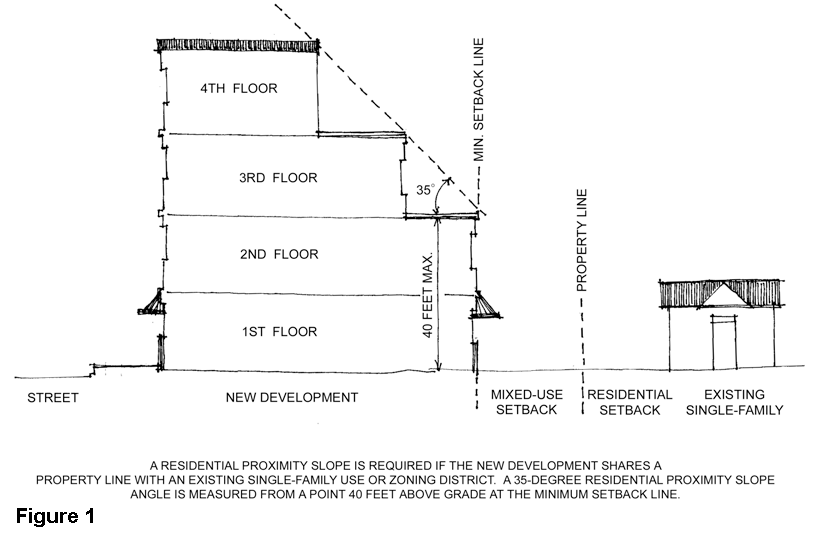
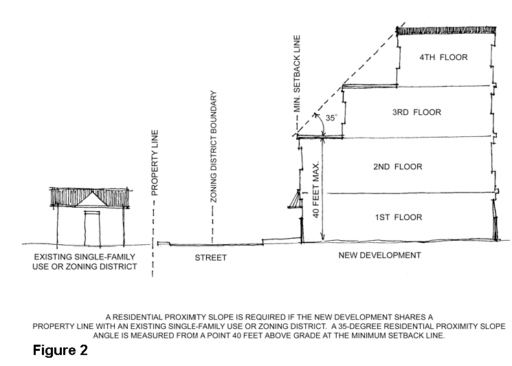
4.
Buildings shall front on public streets and/or a private street system and not parking lots.
5.
Buildings shall be directly accessed from the street and the sidewalk with a minimum of one ground floor pedestrian entrance oriented toward the street.
a.
Accessory structures such as carports, garages and storage units (but not including leasing offices, club houses or recreation centers) shall not be located along public right-of-way or private streets within the Rayzor Ranch District.
b.
Garages may occupy no more than 40% of the total building frontage. This measurement does not apply to garages facing an alley or courtyard entrance. Any garage may not extend beyond the building front. Garages that are at least 30 feet behind the house front may exceed the 40% frontage minimum. Garages shall not be located along the portion of the building that fronts the public or private street.
B.
Architectural Standards.
1.
An identical exterior design may not be used for more than three buildings in a project. A variety of compatible exterior materials' use and type, building styles, massing, composition, and prominent architectural features, such as door and window openings, porches, rooflines, shall be used.
2.
Building frontages greater than 100 feet in length shall have recesses, projections, windows, arcades or other distinctive features to interrupt the length of building façade. Elements including, but not limited to, balconies, setbacks, and recesses or projections greater than 16 inches may be used to articulate individual units or collections of units.
3.
Building features, outdoor patios (covered or uncovered), and architectural building feature elements (fountains, towers, awnings, trellis, outdoor gazebos for multi-family, or similar) may encroach upon the front setback (by as much as 10 feet), within restrictions. Encroachment may occur on one side (or two sides if approved by the City).
4.
Un-enclosed stairwells shall not be located on the exterior of any buildings. Stoops are permitted for the entrance to ground level units directly accessible from the sidewalk.
5.
Use of false door or window openings shall be defined by frames, sills, and lintels.
6.
All building façades shall include no less than three of the elements listed below. Elements shall occur at intervals of no more than 100 feet horizontally or 40 feet vertically. Vertical architectural design features, such as towers, are not required to comply with the 40 feet vertical requirement.
a.
Color change.
b.
Texture change.
c.
Material change.
d.
Medallions/accent pieces.
e.
Decorative light fixtures.
7.
Roofs:
a.
If pitched roof forms (gable, hip, shed) with overhanging eaves are used, they shall be between three inches of vertical rise to 12 inches of horizontal run, and 12 inches of vertical rise to 12 inches of horizontal run.
b.
Metal standing seam roofing allowed.
c.
Asphalt roofing shingles are encouraged to be dimensional (shadow line) type and at least a "40 year" shingle.
d.
Clay tile or concrete tile.
e.
Distinctively shaped roof forms, detailed parapets, parapet steps, or exaggerated cornice lines should be incorporated into rooflines along building façades greater than 75 feet in length.
f.
Flat roofs are permitted and must have parapets as required to screen any roof top equipment. Walls adjoining flat roofs must contain a distinctive finish at the top of the wall such as a cornice, banding, large coping, or other architectural termination.
g.
All sloped roofing areas shall include gutters and downspouts except for small roof areas such as, but not limited to, roofs over bay windows, awnings, and canopies.
8.
Materials and Colors:
a.
For all facades that face a public or private street, windows and doors shall comprise at least 20% of the wall area. All other facades may be reduced to 10%, or may provide one window or door per sleeping area (as defined by the Building Code), whichever method provides for the greater coverage of windows and doors. Shutters, trims, or false windows, shall not count toward the minimum requirement.
b.
A minimum of 40% of the total net exterior wall area of each building elevation, excluding gables, windows, doors and related trim, is encouraged to be brick or native/natural stone or masonry. The balance of the net exterior wall is encouraged to be comprised of at least two of the following materials.
i.
Stucco
ii.
EIFS. When used, EIFS is encouraged to be a minimum of 8 feet above grade.
iii.
Architectural precast or tilt wall concrete with a textured finish.
iv.
Prefinished metal panels and corrugated siding materials. All materials must have a Kynar finish with a 20 year warranty.
v.
Wood or cement fiber siding such as Nichiha. All siding members must be individual boards. (Soffits may utilize sheet materials.)
vi.
Concrete Masonry Units, provided that the units are not painted, are integrally colored, have a highly textured finish, are classified as severe weather grade, and are not lightweight or featherweight concrete or cinder blocks.
vii.
Cast or manufactured brick or stone products.
c.
No individual building material, with the exception of brick, native/natural stone, or masonry may comprise more than 30% of the net exterior wall area of each building elevation.
d.
All buildings within the project shall be constructed of building materials from a similar color and material palette. This is not intended to require similar materials with adjacent properties within Rayzor Ranch.
e.
Windows may be residential type vinyl, aluminum, or wood with insulated glass. Storefront glazing systems are also permitted. Window surrounds (trim) are required in all walls other than brick or stone.
9.
Public entrances to buildings shall be clearly defined and highly visible including features such as, canopies, porticos, awnings, peaked roof features, towers, or similar architectural forms and details.
C.
Accessory Structures.
1.
Accessory structures (including parking structures, detached garages, and storage units) shall complement the main building architecture and use the same materials and color palette.
2.
Accessory structures visible from a public or private street or a residential use or district are subject to the same masonry and roofing requirements as the main buildings but are not subject to the other building design standards. Garage doors are encouraged to be metal or metal faced with wood.
D.
Landscaping.
1.
Street Trees shall be provided along all public and private streets consistent with the requirements in Subchapter 7.7.7 of the Denton Development Code.
2.
All parking lots and areas for vehicle maneuvering or loading must be screened from view from public and private streets by a 15-foot landscape screening buffer. The 15-foot buffer is the area located between the right-of-way and the parking lot. Utility easements are allowed to count towards part of the 15-foot wide right-of-way landscape screening buffer subject to required separation from utilities. The landscape screening buffer shall contain the following items:
a.
One large tree for every 40 feet or three small accent trees for every 30 feet.
b.
Landscape plantings containing at least one of the following:
i.
Xeriscaping landscaping may be planted within the landscape area and shall require water irrigation for a period of three years for landscaping to be established. After three years, no irrigation is required.
ii.
A minimum three foot high, when mature, continuous row of evergreen shrubs. The shrubs may be grouped and not planted in a continuous row provided that the shrubs overlap to form a continuous buffer.
iii.
A minimum three foot high continuous wall made of any combination of wrought iron, stone, brick, or masonry. If wrought iron is used, vines shall be grown on the wrought iron to help screen the parking lot.
iv.
A grass or landscaped berm, three feet high above the parking pavement surface.
3.
A minimum of 7% of the total parking area shall be landscaped.
4.
A minimum of 15% of the total parking area shall be covered by tree canopy.
5.
Landscape islands shall be evenly distributed throughout the parking areas. All landscape islands and endcaps shall be landscaped with sod or groundcover and include one large tree.
6.
A 15 foot landscape buffer is required along the entire property line abutting a single-family use or district. The buffer shall include a combination of six evergreen and deciduous trees and 25 shrubs per 100 linear feet.
E.
Lighting.
1.
Lighting shall be provided for vehicular, pedestrian, signage and architectural and site features.
2.
Site lighting fixtures used along entrance driveways and in parking areas shall be no taller than 25 feet high and the fixtures shall be of a consistent design within each project. This is not intended to require a consistent design within the whole of Rayzor Ranch.
3.
Parking areas shall have a minimum average of one foot candle initial illumination Maximum illumination at property lines where the adjacent property allows single-family or multi-family uses shall not exceed 0.5 foot candles.
4.
Light sources shall be LED or metal halide. Yellow/orange source lights are prohibited from use. LED lighting is strongly encouraged.
5.
Identification graphics and signs shall be lighted internally or from ground mounted locations. If ground mounted, light fixtures should be screened from view in front of the sign.
6.
Illumination for all parking lots and pedestrian spaces shall commence one-half hour before sunset and cease one-half hour after sunrise.
7.
Lights shall generally be shielded to prevent upward diffusion (full cut off). Up-lighting and accent lighting is only permitted for building elevations that in excess of 250 feet from a single-family residential use or district. LED light source is required for all such accent lighting.
F.
Open Space & Amenities.
1.
An area equal to at least 8% of the lot area, excepting required setbacks, shall be dedicated to open space for recreation for use by the tenants of the development. Mixed-use developments of greater than 35 units per acre shall be exempt from this requirement.
2.
Areas covered by shrubs, bark mulch and other ground covers which do not provide a suitable surface for human use may not be counted toward this requirement.
3.
Private decks, patios, and similar areas are eligible for up to 5% of the 8% required open space.
4.
Play areas for children should be provided for projects of greater than 50 units that are not designed as age limited or student housing.
G.
Service & Security Areas.
1.
Service areas for common use recreation and activity buildings shall be located at the rear or side yard of the buildings. Such areas must not be visible from public roadways. No service or delivery vehicles may park or load/unload on public roadways, primary entrance drives or in visitor drop-off areas.
2.
Service, loading and storage areas shall not encroach on any landscape area.
3.
When used, guard houses (manned or unmanned) and entrance gates shall be a minimum of 60 feet from the property line.
4.
Gate controls, card pads and intercom boxes shall be located in driveway islands adequate distances from the gate to allow "U-turning" without backing onto the public street.
H.
Parking & Circulation.
1.
Parking areas must be paved with concrete, asphalt, concrete pavers or brick pavers and curbed and guttered with concrete. Access drives must be paved, curbed and guttered with concrete in accordance with the development standards promulgated by the City.
2.
Parking areas must be sufficient to accommodate all parking needs for employees, company vehicles, residents, invitees and visitors without the use of on-street parking. If parking needs increase on any Building Site, additional off-street parking must be provided by the Owner of such building site. The number of parking spaces must be provided in accordance with City of Denton code requirements.
3.
Pedestrian Connectivity:
a.
Provide a logical layout for vehicular and pedestrian circulation to help minimize the conflicts between the two. When there are crossings or common path areas, provide well marked or differentiated pathways.
b.
Sidewalks shall be provided along all sides of the lot that abut a public right-of-way and where otherwise required to promote pedestrian connectivity within the site and to adjacent properties. At a minimum, walkways shall connect focal points of pedestrian activity such as, but not limited to, transit stops, street crossings, building entry point.
I.
Fencing.
1.
If walls and fencing are used to secure the perimeter of a building site in a multi-family zone, they must be a minimum of six (6) feet high and constructed of materials and finishes that match the buildings. "Wrought iron" style metal fencing is allowed provided it is interrupted with columns or walls such that no run of metal fencing exceeds 40 feet. Metal fencing is to be powder coated or otherwise pre-finished. Field painting is only allowed for touch up when required.
2.
Walls and columns must be constructed with appropriate structural footings and foundations to minimize movement and wall failure, and must be constructed with level wall/fence tops.
3.
Tilt-up concrete walls regardless of texture, finish and color are not permitted.
4.
Fencing shall be setback a minimum of five feet from the sidewalk or ten feet from the back of curb along a public or private street, whichever is greater.
J.
Screening (Dumpsters & Mechanical Equipment).
1.
Storage areas, incinerators, storage tanks, trucks based on the premises, roof objects (including fans, vents, cooling towers, skylights and all roof-mounted equipment which rises above the roof line), trash containers and maintenance facilities, shall either be housed in closed buildings or otherwise completely screened from view from public access ways and adjacent properties. Service, loading and storage areas shall be screened from view by walls, berms or a combination thereof, constructed a minimum one foot above all service equipment, such as trash containers, incinerators, storage tanks and cooling towers. Dumpsters and recycling containers shall be screened from public view on three sides with a solid fence or wall constructed of masonry, concrete, or composite wood with metal posts and frame, or other compatible building material.
2.
No satellite dish shall be placed in an area visible from a public way or space and no dish shall be mounted to a balcony.
3.
Air conditioning compressors shall be located in clusters or linear groups and they shall be set on level grades ideally on the end exterior walls of the buildings and screened from view of public streets, pedestrian amenity areas by the use of walls, berms, evergreen planting, or a combination thereof. Height of shrubs, at planting, shall be no less than 30 inches above the grade at the equipment, and spaced no further than 36" apart.
4.
Utility meters shall be located in clusters or groups preferably in separate structures or on either end of the building's exterior walls. If located on the ends of the building, they shall be screened from view with a compatible building material and allow convenient accessibility by the utility company.
K.
Signage.
1.
Each property shall be allowed one monument sign with a maximum height of six feet and maximum effective area of 60 square feet at each entry into the development. Related architectural features (such as clock towers, obelisks, etc.) may be taller than six feet provided the signage mounted to such features is at a maximum height of six feet.
2.
Building sites which front other perimeter public streets and have no access to that public street, may install one monument sign with a maximum height of six feet and maximum effective area of 60 square feet.
3.
Monument signs are required to be setback a minimum of 20 feet from any public or private street and 10 feet from any rear or side property lines.
4.
Directional signage is permitted and shall be limited to a gross surface area of 20 square feet and shall not exceed six feet in height.
5.
Flashing or moving character signs may not be installed. Illuminated signs must be rear lighted or lighted from non-apparent light sources.
6.
Each building elevations shall be allowed one wall sign limited to a maximum effective area no greater than 20% of the wall area to which the sign is attached.
7.
Building mounted blade signage is allowed. The materials and scale of the sign must be appropriate to the building it is mounted to, but shall not exceed 20 feet in height and a 5 foot projection from the building wall. The bottom of blade mounted signs must be no lower than 10 feet above grade and the top shall not extend above the eave line of sloped roofs or the parapet height on flat roofs.
L.
Grading and Drainage.
1.
All grading must be done to alleviate ponding and must be coordinated with the master storm drainage plan and detention facilities. Depressions on paving or the landscape areas which will allow ponding of water are not permitted.
2.
Drainage swales must be shallow, gently contoured and sloped to minimize erosion. Concrete rip-rap, trapezoidal concrete channels and concrete pilot channel ditches are not permitted.
EXHIBIT C-4 - RAYZOR RANCH MARKETPLACE SINGLE-FAMILY GUIDELINES
The following provisions apply to all Single-Family Tracts and Lots located within the Rayzor Ranch Marketplace. All provisions of Subchapter 7 apply unless otherwise stated.
A.
Site Design & Orientation.
1.
Refer to Appendix 1 for area(s) to include detached single-family.
2.
Subarea 1 of the Rayzor Ranch Marketplace shall be designed and subdivided as depicted in Appendix 2 and described herein.
3.
No two building elevations shall be repeated with less than 200 feet of separation.
4.
Parking is not permitted between front facades of buildings and streets within public right-of-way greater than 20 feet.
5.
All buildings abutting an existing single-family use or district outside of the Rayzor Ranch Overlay District shall be constructed to a maximum height of 40'.
6.
Buildings shall not front parking lots.
7.
Buildings shall be directly accessed from the street and the sidewalk with a minimum of one ground floor pedestrian entrance oriented toward or perpendicular to a street or private drive.
a.
Garage doors for attached garages may occupy no more than 40% of the total building frontage. This measurement does not apply to garages facing an alley or courtyard entrance.
8.
For alleys of detached single-family dwellings depicted in R-1, rear yard setbacks (alley way) shall be 4 feet if at least two parking spaces are provided in a garage.
9.
For R-1 zone, end units of attached single-family dwelling buildings shall have a minimum side yard setback of 5 feet at right-of-way. Setbacks between units of attached single-family dwellings shall be zero feet. Front yard setbacks may vary from 0 feet to 5 feet minimum but no more than 50% of each block of attached single-family building shall have a 0 foot setback.
a.
Sidewalks within the right-of-way shall be located against the curb.
b.
Distance from edge of street pavement to building front shall be minimum 10 feet.
10.
For the R-2 zone and all detached single-family dwellings, building setbacks shall be as defined in Section 4.8.4.A.3.
B.
Architectural Standards.
1.
Building frontages 100 feet in length or greater shall have recesses, projections, windows, arcades or other distinctive features to interrupt the length of building facade. Elements including, but not limited to, balconies, setbacks, and recesses or projections greater than 16 inches may be used to articulate individual units or collections of units.
2.
Use of false door or window openings shall be defined by frames, sills, and lintels.
3.
All building facades shall include no less than two of the elements listed below. Elements shall occur at intervals of not more than 100 feet horizontally.
a.
Color change.
b.
Texture change.
c.
Material change.
d.
Medallions/accent pieces.
e.
Decorative light fixtures.
4.
Roofs:
a.
If pitched roof forms (gable, hip, shed) with overhanging eaves are used, they shall be between three inches of vertical rise to 12 inches of horizontal run, and 12 inches of vertical rise to 12 inches of horizontal run.
b.
Metal standing seam roofing allowed.
c.
Asphalt roofing shingles shall be dimensional (shadow line) type and at least a "40 year" shingle.
d.
Clay tile, concrete tile, and slate allowed.
1.
Photovoltaic shingles mimicking clay, concrete, or slate are allowed.
e.
Distinctively shaped roof forms, detailed parapets, parapet steps, or exaggerated cornice lines should be incorporated into rooflines along building facades greater than 75 feet in length.
f.
Flat roofs are permitted and shall have parapets as required to screen any roof top equipment. Parapets shall include an accent feature and shall not be greater than 15 feet in length without variation in height or accent feature.
g.
Photovoltaic panels shall be allowed with individual approval by the Horne Owner's/Common Ownership Entity.
5.
Materials and Colors:
a.
For all facades that face a public or private street, windows and doors shall comprise at least 20% of the wall area. All other facades may be reduced to 10%, or may provide one window or door per sleeping area (as defined by the Building Code), whichever method provides for the greater coverage of windows and doors. Shutters, trims, or false windows, shall not count toward the minimum requirement.
b.
A minimum of 80% of the total net exterior wall area (total wall area less windows, doors, and related trim area) of each building elevation, excluding gables, is encouraged to be brick, native/natural stone, masonry, stucco, or cement fiber siding (up to 80% maximum of the net exterior wall area).
c.
The 20% balance of the net exterior wall is encouraged to be comprised of at least two of the following materials:
i.
EIFS. When used, EIFS shall be a minimum of 8 feet above grade.
ii.
Architectural precast or tilt wall concrete with a textured finish.
iii.
Prefinished metal panels and corrugated siding materials. Such materials shall be factory prefinished with a minimum 20 year warranty.
iv.
Wood, all siding members must be individual boards (soffits may utilize sheet materials).
v.
Concrete Masonry Units, provided that the units are not painted, are integrally colored, have a highly textured finish, are classified as severe weather grade, and are not lightweight or featherweight concrete or cinder blocks.
vi.
Cast or manufactured brick or stone products.
d.
Windows may be residential type vinyl, aluminum, or wood with insulated glass. Window surrounds (trim) are required in all walls other than brick or stone. Storefront glazing systems shall be allowed in the amenity center.
e.
Color palette shall be of earth tones, gray tones, and neutral colors with other accent colors permitted up to a maximum of 10% of each facade.
C.
Accessory structures.
1.
Accessory structures (including detached garages, and storage units) shall complement the main building architecture and use the same materials and color palette.
2.
Accessory structures visible from a public or private street or a residential use or district are subject to the same masonry and roofing requirements as the main buildings but are not subject to the other building design standards. Garage doors are encouraged to be metal or metal faced with wood.
D.
Landscaping.
1
Street Trees shall be provided along all public and private streets consistent with the requirements in Subchapter 7.7.5 of the Denton Development Code excepting to replace Subsection 7.7.5.E with:
a.
One (1) tree per lot, evenly spaced, for developments with lots 60 linear feet or less of street frontage.
b.
Two (2) trees per lot, evenly spaced, for developments with lots greater than 60 linear feet of street frontage.
2.
Amenity Center Standards:
a.
All parking lots and areas for vehicle maneuvering or loading adjacent to Bonnie Brea Street must be screened from view from public and private streets by a 15-foot landscape screening buffer. The 15-foot buffer is the area located between the right-of-way and the parking lot. Utility easements are allowed to count towards part of the 15-foot wide right-of-way landscape screening buffer subject to required separation from utilities. The landscape screening buffer shall contain the following items:
i.
One large tree for every 40 feet or three small accent trees for every 30 feet.
ii.
Landscape plantings containing at least one of the following:
a)
Xeriscaping landscaping may be planted within the landscape area and shall require water irrigation for a period of three years for landscaping to be established. After three years, no irrigation is required.
b)
A minimum three foot high, when mature, continuous row of evergreen shrubs. The shrubs may be grouped and not planted in a continuous row provided that the shrubs overlap to form a continuous buffer.
c)
A minimum three foot high continuous wall made of any combination of wrought iron, stone, brick, or masonry. If wrought iron is used, vines shall be grown on the wrought iron to help screen the parking lot.
d)
A grass or landscaped berm, three feet high above the parking pavement surface.
b.
A minimum of 7% of the total parking area in lots of 20 spaces or more shall be landscaped.
c.
A minimum of 15% of the total parking area in lots of 20 spaces or more shall be covered by tree canopy.
d.
Landscape islands shall be evenly distributed throughout the parking areas. All landscape islands and endcaps shall be landscaped with sod or groundcover and include one large tree.
3.
Buffer requirements set forth in Subchapter 7.7.6 shall only apply to residential districts adjacent to and outside of the Rayzor Ranch Overlay District.
4.
Required landscape areas shall be included in each individual detached single-family lot and the landscape areas for attached single-family lots will be included in common areas.
E.
Lighting.
1.
Lighting shall be provided for vehicular, pedestrian, signage and architectural and site features.
2.
Site lighting fixtures used along public and private streets and in parking areas shall be no taller than 25 feet high and the fixtures shall be of a consistent design within each project. This is not intended to require a consistent design within the whole of Rayzor Ranch.
3.
Parking areas shall have a minimum average of 0.5 foot candle initial illumination. Maximum illumination at property lines where the adjacent property allows single-family or multi-family uses shall not exceed 0.1 foot candles.
4.
Parking and Roadway/Street light sources shall be LED or metal halide. Yellow/orange source lights are prohibited from use. LED lighting is strongly encouraged.
5.
Parking and Roadway/Street lights shall generally be shielded to prevent upward diffusion (full cut off).
F.
Parking & Circulation.
1.
Parking areas must be paved with concrete, asphalt, concrete pavers, brick pavers, or durable pervious materials, and shall be curbed and guttered with concrete. Access drives must be paved, curbed and guttered with concrete in accordance with the development standards promulgated by the City.
2.
The maximum allowable number of spaces specified in Subsection 7.9.4.B does not apply to the residential subarea of the Rayzor Ranch Marketplace.
G.
Fencing.
1.
If walls or fencing are used to secure the perimeter of a development site in a single-family zone, they must be a minimum of six (6) feet high and constructed of stone, brick, masonry, wrought iron, or wood.
2.
Walls, fences, and columns must be constructed with appropriate structural footings and foundations to minimize movement and wall failure, and must be constructed with level wall/fence tops.
H.
Signage.
1.
Each entry point shall be allowed one monument sign as shown on the conceptual site plan in Appendix 2, with a maximum height of six feet and maximum effective area of 60 square feet at each entry into the development. Related architectural features (such as clock towers, obelisks, etc.) may be taller than six feet provided the signage mounted to such features is at a maximum height of six feet.
2.
Monument signs are required to be setback a minimum of 20 feet from any public or private street and 10 feet from any rear or side property lines.
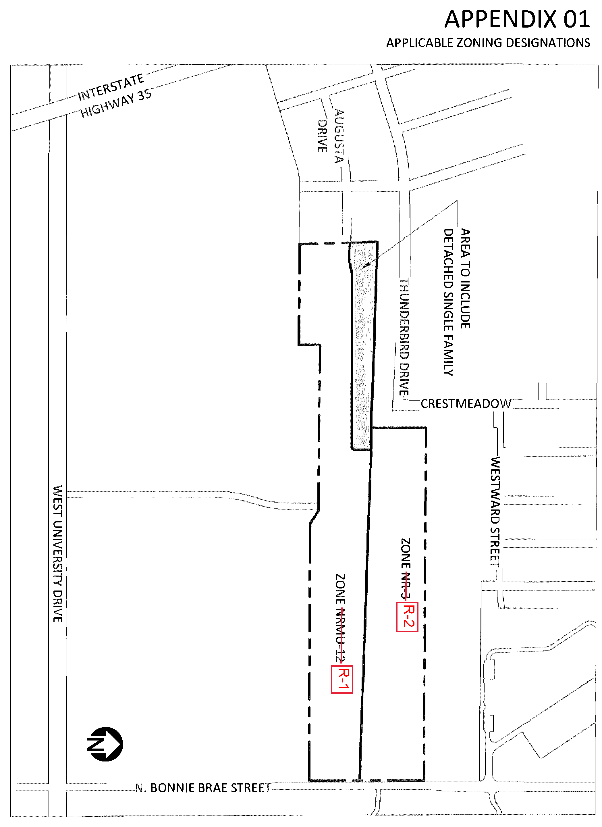
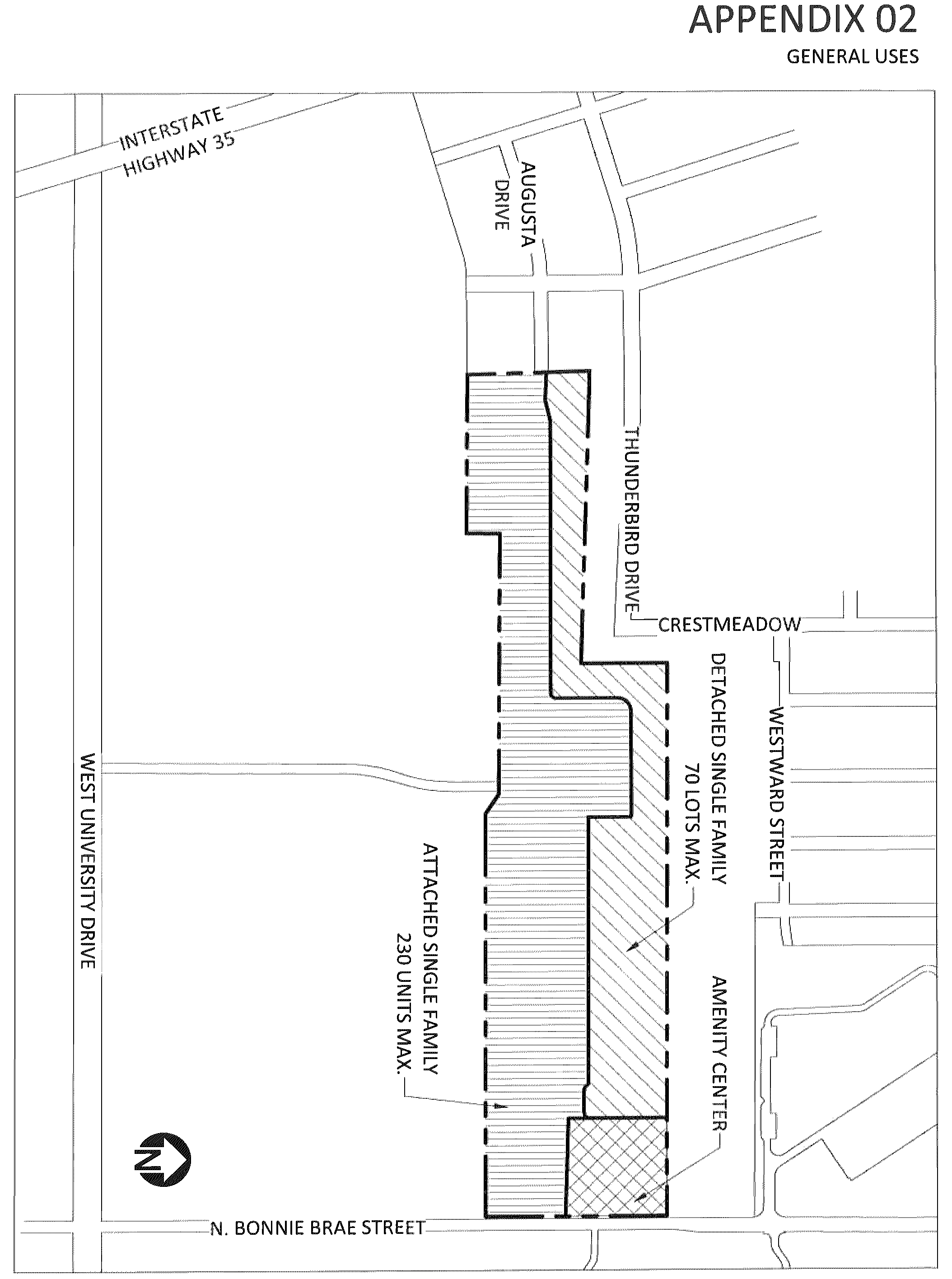
EXHIBIT D-2 - RAYZOR RANCH LANDSCAPE STANDARDS SOUTH MIXED-USE DISTRICT-1 AND SOUTH MIXED-USE DISTRICT-2
A.
Landscaping.
1.
Street Trees shall be provided along all public and private streets consistent with the requirements in Subchapter 7.7.7 of the Denton Development Code.
2.
All parking lots and areas for vehicle maneuvering or loading must be screened from view from public and private streets by a 10-foot landscape screening buffer. The 10-foot buffer is the area located between the right-of-way and the parking lot. Utility easements are allowed to count towards part of the 10-foot wide right-of-way landscape screening buffer subject to required separation from utilities. The landscape screening buffer shall contain the following items:
a.
One large tree for every 40 feet or three small accent trees for every 30 feet. If small trees are used, they shall be clustered as appropriate.
b.
Landscape plantings containing at least one of the following:
1)
Xeriscaping landscaping may be planted within the landscape area and shall require water irrigation for a period of 3 years for landscaping to be established. After 3 years, no irrigation is required.
2)
A minimum 3 foot high, when mature, continuous row of evergreen shrubs. The shrubs may be grouped and not planted in a continuous row provided that the shrubs overlap to form a continuous buffer.
3)
A minimum 3 foot high continuous wall made of any combination of wrought iron, stone, brick, or masonry. If wrought iron is used, vines shall be grown on the wrought iron to help screen the parking lot.
4)
A grass or landscaped berm, 3 feet high above the parking pavement surface.
3.
A minimum of 7% of the total parking area shall be landscaped.
4.
A minimum of 15% of the total parking area shall be covered by tree canopy at maturity.
5.
Landscape islands shall be evenly distributed throughout the parking areas at a maximum average spacing of 12 spaces. All landscape islands and endcaps shall be landscaped with sod or groundcover and include one large tree. A linear landscape island between two head-in rows will suffice for this requirement provided that trees are planted in that island at average spacing of 12 spaces.
6.
A 10 foot landscape buffer is required along the entire property line abutting a single-family use or district. The buffer shall include a combination of 6 evergreen and deciduous trees and 25 shrubs per 100 linear feet.
7.
A minimum of 20% tree canopy at maturity is required.
8.
See Appendix A for Plant List.
EXHIBIT E-1 - RAYZOR RANCH SIGN STANDARDS - SOUTH COMMERCIAL DISTRICT (SCD) AND TOWN CENTER (TC)
Unique and creative signage and graphic design adds visual interest to and helps define the urban character of the Rayzor Ranch Town Center (RRTC) area including the Town Center (TC) and South Commercial District (SCD) subareas. Innovative signage and graphics programs with special size, placement and materials help create a strong identity for the overall Rayzor Ranch Community.
These special standards and standards permit a wide range of signage and graphic types and materials, including both onsite project/tenant identification and advertising, and offsite advertising that are not otherwise permissible, to promote and energize the area through installation of creative signs and graphics.
The Rayzor Ranch Sign Standards use three (3) sub-districts or sign areas within the South Commercial District and Town Center area to ensure the ability to introduce innovative, stimulating and well-designed signage and graphics throughout the area. The first area is adjacent to Rayzor Ranch Marketplace along U.S. 380/University Drive providing a recognizable streetscape into Rayzor Ranch. The second area is located along the Interstate Highway 35 (IH 35) corridor for greater identification of the overall Rayzor Ranch project and major tenants within Town Center. And the third district is located in the core of the Town Center area corresponding to the TC zoning area focusing the greatest intensity for entertainment, people gathering and active use areas.
See Appendix 1 for the RRTC Sign District areas exhibit.
EXHIBIT E-2 - RAYZOR RANCH SOUTH MIXED-USE SIGN DISTRICT
The South Mixed Use Sign District shall provide direction for signs located in the South Mixed Use District-1 (SMUD-1) and South Mixed Use District-2 (SMUD-2) sub-districts of Rayzor Ranch.
A.
Signage.
1.
Each property shall be allowed one monument sign with a maximum height of 8 feet and maximum effective area of 65 square feet at each entry into the Individual lot. For sites with frontage greater than 250' on any street, with one entry, two signs may be placed along that frontage. Related architectural features (such as clock towers, obelisks, etc.) may be taller than 8 feet provided the signage mounted to such features is at a maximum height of 8 feet.
2.
Building sites which front other perimeter public streets and have no access to that public street may install one additional monument sign facing that perimeter street with a maximum height of 8 feet and maximum effective area of 70 square feet.
3.
Signs may be either Single Tenant, Double Tenant, or Multi-Tenant as shown on the attached Appendix.
4.
Monument signs are required to be setback a minimum of 10 feet from any public street and 10 feet from any rear or side property lines.
5.
Directional/address signage is permitted and shall be limited to an effective sign area of 25 square feet and shall not exceed 5 feet in height.
6.
Flashing or moving character signs may not be installed. Illuminated signs shall not be permitted to face an adjoining lot that is for residential use outside of Rayzor Ranch and is within 100' of the sign.
7.
Each building elevation shall be allowed one wall sign limited to a maximum effective area no greater than 5% of the wall area to which the sign is attached. If signs are illuminated, it shall be internally illuminated, or from gooseneck or similar wall mounted lighting.
8.
Site perimeter sign walls below 6 feet tall are allowed in lieu of monument sign, or at street corner. Graphic murals shall be counted as art, not signage. See Appendix 1, Project Identity Sign.
9.
Building mounted blade signage is allowed. The materials and scale of the sign must be appropriate to the building it is mounted to, but shall not exceed 10 square feet and a 5 foot projection from the building wall. The bottom of blade mounted signs must be no lower than 9 feet above grade and the top shall not extend above the eave line of sloped roofs or the parapet height on flat roofs.
10.
See attached Appendices 1—6 for Signage.
APPENDIX 1
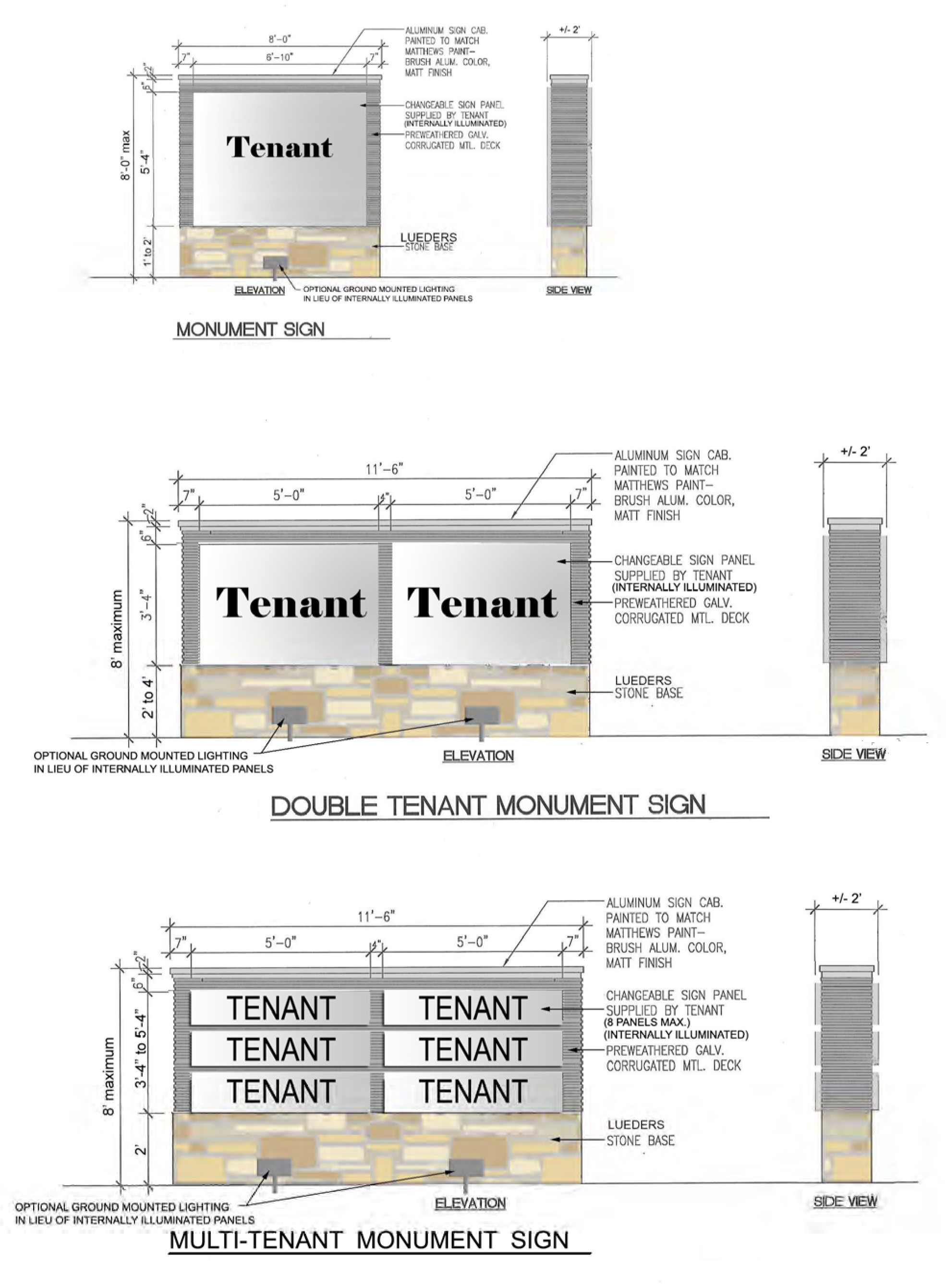
APPENDIX 2
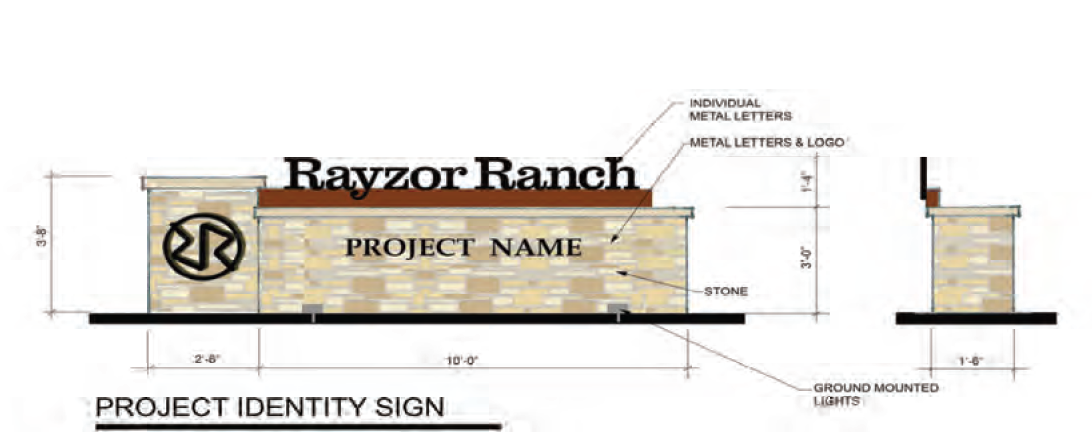
APPENDIX 3
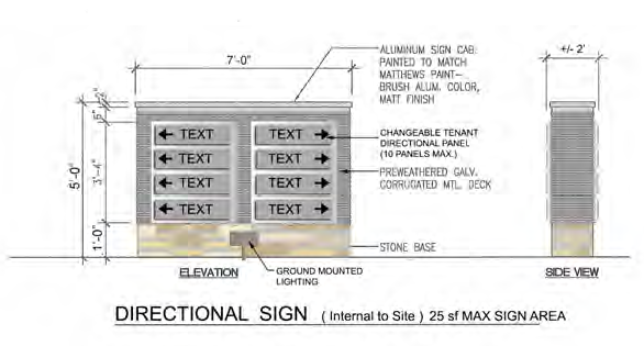
APPENDIX 4
BLADE AND PROJECT BANNER SIGN EXAMPLES
All signage examples attached are for illustrative purposes only and to further define size calculations required for various sign types. Examples are not indicative of the final graphics for the Rayzor Ranch Sign District.
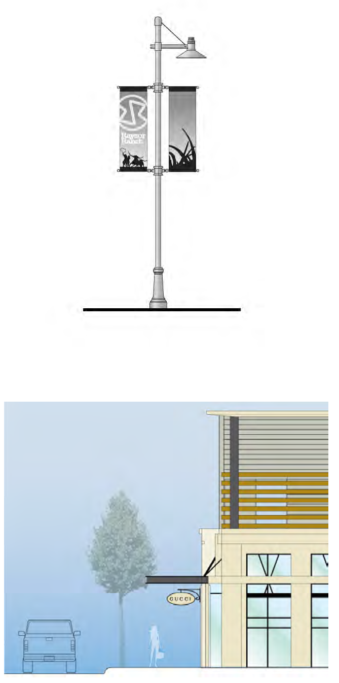
APPENDIX 5
PROJECT ANNOUNCEMENT SIGN EXAMPLE
APPENDIX 6
EFFECTIVE AREA EXAMPLE
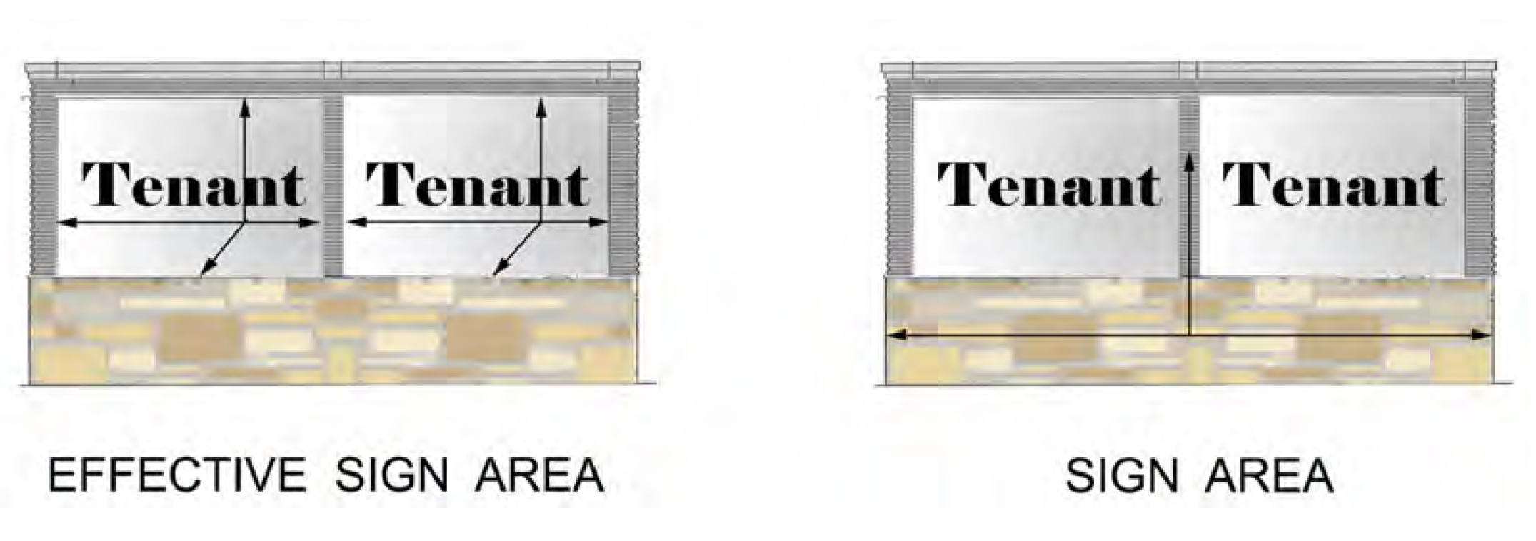
EXHIBIT G - RAYZOR RANCH TRADE DRESS REGULATIONS
Approval Criteria
• In Rayzor Ranch, the term "Trade Dress" will include tenant identification signage, materials, entry treatments and architectural features, if it is part of a national identity for the tenant. Trade Dress will include the tenant's logo and identifying colors and these colors do not have to match the architectural color palette for Rayzor Ranch.
• Trade Dress must fit within the approved facade for the building in which the tenant will operate. Trade Dress elements cannot extend beyond the facade of the building shown on the approved Facade Plan unless approved by the Planning and Zoning Commission.
• Trade Dress cannot exceed 25% of the total area of the facade for each tenant.
• Wall signage must be incorporated into the Trade Dress and cannot exceed 20% of the total area of the facade.
• If the building is a corner building, or a freestanding building, then the tenant is allowed to have Trade Dress on all facades.
Article 1 - RR-2 Nonresidential Buildings (RR2)
Nonresidential buildings in the RR-2 Subareas as shown on the Rayzor Ranch Concept Plan shall comply with the following standards:
A)
Orientation.
1)
Building frontages greater than 100 feet in length shall have vertical and horizontal façade articulation and other distinctive changes in the building façade, such as, but not limited to, materials, color or texture, below the sign band.
2)
Buildings shall incorporate some combination of arcades, roofs, alcoves, porticoes, canopies or awnings as a design element of the façade.
3)
Loading docks, trash receptacles, storage areas and mechanical equipment shall be screened from public streets by evergreen shrubbery, trees, masonry, or concrete screenwall. If screening a loading dock with shrubbery, the shrubbery must be a minimum of five (5) feet tall at time of planting and must comply with the planting standards set forth in the Rayzor Ranch Landscaping Guidelines. An example of this screening can be found in Appendix 7. If screening trash receptacles, storage areas and mechanical equipment, the shrubbery must be a minimum of one (1) foot taller than the facility or item they are to screen at time of planting and must comply with the planting standards set forth in the Rayzor Ranch Landscaping Guidelines.
4)
Buildings shall have a design element that emulates at least one of the Rayzor Ranch Architectural features which are in the Ranching Heritage Architectural style. The features include the use of at least one of the following:
a)
Native Texas quarried natural stone or limestone.
b)
Sloped metal roofing to match color palate.
c)
Freestanding stone element, such as fireplace, obelisk, or other design feature.
d)
The use of shading elements, such as a canopy, portico, trellis, or awning.
5)
On single tenant retail buildings greater than 20,000 square feet (Junior Anchors) with facades that are facing U.S. 380 and Bonnie Brae, in addition to the requirements set forth in Sections 1—4 above, the building shall also include the following design elements:
a)
Color change, texture change, and material changes within the wall at intervals not to exceed 100 feet.
b)
At least one change in wall plane not less than 12 inches in depth and extending a minimum of 10 feet. See Appendix 6 for an example.
c)
At least one variation in the top of wall, a minimum of two feet (2') in height and be a minimum of two feet (2') wide. See Appendix 6 for an example.
d)
Overhanging eaves or horizontal elements, sloped roof elements, or cornice expressions or coping detail of a minimum of 12 inches tall and six inches (6") deep. See Appendix 6 for an example.
e)
Each building shall have a clearly defined, visible customer entrance on one side. Stone is encouraged to be used as a portion of the wall material at each customer entrance.
B)
Building Materials.
1)
Window glass may not be flush with exterior wall treatment, or if flush, shall have a frame, suggested materials are wood or metal, or wall trim material.
2)
All sides of buildings visible from the streets, or internal customer areas of the site, are encouraged to be constructed of masonry, natural stone, decorative block, concrete, stucco or other high quality material customarily used for the building style (such as natural metals or EFIS). Gables, windows, doors and related trim are not included in this requirement. Wood and HDO board may be used. Preferred material and color palette includes: (reference Appendices 1—4):
a)
Native Texas quarried natural stone or limestone of varying colors, sizes and textures;
b)
Concrete - Architectural finish. Texture coated or textured and colored;
c)
Masonry;
d)
Porcelain Tile;
e)
Glass;
f)
Galvanized metal panels or prefinished architectural metal panels of a gray tone, neutral or earthtone color;
g)
Painted siding of a warm, neutral/earthtone or gray tone color;
h)
EIFS or stucco of a warm, neutral/earthtone or gray tone color;
i)
Accent colors of a warm, neutral/earthtone range are encouraged but should be used in a limited manner;
j)
Natural metals such as but not limited to zinc and copper;
k)
Roofing tile, metal roofing shingles and panels, or slate in galvanized or natural/earthtone color;
l)
Natural wood, stained or painted.
3)
Glass. Use of glass for displays and to allow visual access to interior space is permitted. Buildings may not incorporate glass for more than 70% of the building skin.
4)
Each building is encouraged to incorporate some natural stone on walls visible to customers.
5)
Metal Roofs. Metal roofs visible from grade are permitted provided that they have a standing metal seam, batten seam or metal shingles.
Article 2 - RR-3 Area Development Regulations (RR3)
Building design shall contribute to the uniqueness of the development with suggested materials; and required elements, features, color range and activity areas tailored specifically to the site and its context. In the case of a multiple building development, each individual building shall include predominant characteristics shared by all buildings in the development so that the development forms a cohesive place within the zone district or community. A standardized prototype design shall be modified as necessary to comply with the requirements of this subsection. Developments involving a gross floor area in excess of 40,000 square feet of a single user and located in a RR-3 district shall comply with the following standards:
A)
Orientation.
1)
Architectural features on building facades that are visible from I-35N and West University Drive (excluding facades facing residential property that are screened by an eight-foot fence or wall and facades facing the side or rear of property zoned and used for commercial purposes or industrial purposes) shall provide the following design features: (Refer to photographs in Appendix 6)
a)
Facade walls shall not have an uninterrupted length in excess of one hundred feet (100'). Facades to provide the following at intervals no greater than one hundred feet (100') excluding elements provided in Item d (Entryways) below:
i)
Color change, texture change, and material changes within the walls;
ii)
A change in wall plane no less than twelve inches (12") in depth extending a length of a minimum of twenty feet (20'); and
iii)
Variations in the top of the wall of a minimum of two feet in the height.
b)
Top of walls shall also have overhanging eaves or horizontal elements, extending no less than three (3) feet past the supporting walls, or sloped roof elements, or cornice expressions or coping detail or minimum twelve inches (12") tall.
c)
Facades shall also provide at least one of the following:
i)
Wall plane projections or recesses having a depth of at least 3% of the length of the façade and extending at least 20% of the length of the façade, not to exceed one hundred feet (100').
ii)
Pilasters projecting from the plane of the wall by a minimum of sixteen inches (16"). The use of pilasters to interrupt horizontal patterns such as accent banding is encouraged.
iii)
Canopies, awnings, or porticos projecting a minimum of six feet (6') from the plane of the primary façade walls.
iv)
Repetitive ornamentation including decorative applied features such as wall-mounted light fixtures or applied materials. Repetitive ornamentation shall be located with a maximum spacing of fifty feet (50').
v)
Faux window/framed elements.
d)
Each large retail establishment on a site shall have clearly defined, highly visible customer entrances. Stone is encouraged to be used as a major portion of the wall material at each customer entrance.
e)
The building shall have a design element that emulates the Rayzor Ranch signature feature. This may include building materials and architecturally compatible light fixtures. This element should occur at an entryway.
2)
Architectural Features on building facades facing residential property that are screened by an eight-foot tall fence or wall and facades facing the side or rear of property zoned and used for commercial purposes or industrial purposes should have the following elements: (Refer to photographs in Appendix 5)
a)
A pattern that includes all of the following elements at intervals of no more than one hundred (100') feet, horizontally. The following pattern is also to occur vertically at least once within the height of the building, above ten feet (10') height:
Color change, texture change, and a change in plane, no less than two feet eight inches (2'-8") in width, such as an offset, reveal or projecting pilaster with a stepped capital or coping.
b)
Variation in the top of the wall of a minimum two feet (2') change in height at maximum of two hundred feet (200') intervals. Peaks, arches, or other expressions of the front wall form are encouraged and should be used.
c)
Top of the wall to have a cornice or coping detail a minimum of twelve inches (12") tall.
3)
Sidewalk display and cart storage. Areas for customer loading or merchandise display and cart storage shall be clearly delineated and shall not be located in front of any customer entrances, exit door(s), or within fifteen feet (15') on either side of the door(s).
4)
Permanent outdoor display, sales and storage. Merchandise may be stored or displayed for sale to customers on the front or side of the buildings in accordance with this paragraph.
i)
The total square footage of all permanent outdoor storage, display, and sales areas shall be limited to 10% of the footprint of the building, but in no event shall exceed 20,000 square feet, except for home improvement use, which may not exceed 45,000 square feet of outdoor storage and the 10% footprint restriction does not apply.
ii)
Permanent outdoor storage, display and sales shall be contiguous to the building and shall not be permitted within seventy-five feet (75') of residential property.
iii)
The permanent storage, display and sales area shall be enclosed by a minimum eight-foot (8') wall of columns minimum two feet (2') wide, of like appearance to the building with wrought iron or decorative tubular fencing between, and topped by wrought iron or tubular steel fencing. No merchandise other than trees shall be visible above the wall or fence. (See Appendix 5)
iv)
Seasonal outdoor display will be allowed. Size will be limited to 11,000 square feet maximum. Dates for outdoor display will be year round. Merchandise may not exceed ten feet (10') in height except for trees.
5)
Rear Storage. Bulk merchandise may be stored behind the building. The sides and back of the storage area shall be screened with a chain link fence covered with windscreen, except for any side or back that is separated from any residential property by an eight-foot masonry wall and landscaped buffer yard, in which case additional screening is not required. Windscreen shall be maintained in good repair and free of tears. The rear storage area shall not be accessible to customers. Merchandise shall be stacked no higher than twenty-five feet (25') or level with the top of the adjacent sidewall of the building, whichever is lower, and may not be stacked above the height of the chain link fence.
6)
Pickup and Delivery. Outdoor storage, pickup, delivery, loading and unloading of merchandise, equipment or other items may not occur within one hundred feet (100') of residential property. Loading docks must be located to the side or rear of the building unless the loading area is completely screened from the street, and loading docks shall be located more than one hundred feet (100') from residential property except for area by Greenway Drive which shall be seventy-five feet (75'). Pavement may be located within one hundred feet (100') of residential property.
7)
Trash Collection and Compaction. Trash collection and compaction may not occur within one hundred feet (100') feet of a residence or within seventy-five feet (75') of Greenway Drive, and shall be screened from public view.
8)
Mechanical equipment. No mechanical equipment may be located within one hundred feet (100') of a residential lot. Mechanical equipment shall be screened from public view on site.
B)
Building Materials.
1)
Fronts and street sides of buildings, excluding windows, visible from public right-of-way are encouraged to be non-reflective and are encouraged to be of wood, masonry, stone, concrete, decorative block, stucco, HDO board or other high quality material customarily used. For purposes of this subsection non-reflective means materials with exterior visible reflectance percentages less than 27 percent.
Preferred material and color palette (reference Appendices 1—4):
a)
Native Texas quarried natural stone or limestone of varying colors, sizes and textures;
b)
Concrete - Architectural finish. Texture coated or textured and colored;
c)
Masonry - brick or decorative CMU;
d)
Porcelain Tile;
e)
Galvanized metal panels or prefinished architectural metal panels of a gray tone, neutral or earthtone color;
f)
Painted siding of a warm, neutral/earthtone color in accent areas only;
g)
EIFS or stucco of a warm, neutral/earthtone color;
h)
Accent colors of a warm, neutral/earthtone range are required but should be used in a limited manner;
i)
Natural metals such as but not limited to zinc and copper;
j)
Roofing tile, metal shingles and panels, or slate in galvanized or natural/earthtone color;
k)
Natural wood, stained or painted.
2)
The use of ground mounted lighting or pedestrian level accent lighting is encouraged.
Article 3 - Cooks Children's Hospital (CC)
Nonresidential buildings in the CC Sub-District as shown on the Rayzor Ranch Concept Plan shall comply with the following standards. However, the Cook's Children's Hospital can incorporate architectural elements in their design that include items detailed in Appendix 8.
A)
Orientation.
1)
Building frontages greater than 100 feet in length shall have vertical and horizontal façade articulation and other distinctive changes in the building façade, such as, but not limited to, materials, color or texture, below the sign band.
2)
Buildings shall incorporate some combination of arcades, roofs, alcoves, porticoes, canopies or awnings as a design element of the façade.
3)
Loading docks, trash receptacles, storage areas and mechanical equipment shall be screened from public streets by evergreen shrubbery, trees, masonry, or concrete screenwall. If screening a loading dock with shrubbery, the shrubbery must be a minimum of five (5) feet tall at time of planting and must comply with the planting standards set forth in the Rayzor Ranch Landscaping Guidelines. An example of this screening can be found in Appendix 7. If screening trash receptacles, storage areas and mechanical equipment, the shrubbery must be a minimum of one (1) foot taller than the facility or item they are to screen at time of planting and must comply with the planting standards set forth in the Rayzor Ranch Landscaping Guidelines.
4)
Buildings shall have a design element that emulates at least one of the Rayzor Ranch Architectural features which are in the Ranching Heritage Architectural style. The features include the use of at least one of the following:
i)
Native Texas quarried natural stone or limestone.
ii)
Sloped metal roofing to match color palate.
iii)
Freestanding stone element, such as fireplace, obelisk, or other design feature.
iv)
The use of shading elements, such as a canopy, portico, trellis, or awning.
5)
On buildings greater than 20,000 sqare feet with facades that are facing U.S. 380 and Bonnie Brae, in addition to the requirements set forth in Sections 1—4 above, the building shall also include the following design elements:
i)
Color change, or texture change, or material changes within the wall at intervals not to exceed 100 feet.
ii)
At least one change in wall plane not less than 12 inches in depth and extending a minimum of 10 feet. See Appendix 6 for an example.
iii)
At least one variation in the top of wall, a minimum of two feet (2') in height and be a minimum of two feet (2') wide. See Appendix 6 for an example.
iv)
Overhanging eaves or horizontal elements, sloped roof elements, or cornice expressions or coping detail of a minimum of 12 inches tall and six inches (6") deep. See Appendix 6 for an example.
v)
Each building shall have a clearly defined, visible customer entrance on one side. Stone is encouraged to be used as a portion of the wall material at each customer entrance.
B)
Building Materials.
1)
Window glass may not be flush with exterior wall treatment, or if flush, shall have a surround of wood or metal frame, or wall trim material.
2)
All sides of buildings visible from the streets, or internal customer areas of the site, are encouraged to be constructed of masonry, natural stone, decorative block, concrete, stucco or other high quality material customarily used for the building style (such as natural metals or EFIS). Gables, windows, doors and related trim are not included in this requirement. Wood and HDO board may be used. Preferred material and color palette includes (reference Appendices 1—4):
a)
Native Texas quarried natural stone or limestone of varying colors, sizes and textures;
b)
Concrete - Architectural finish. Texture coated or textured and colored;
c)
Masonry;
d)
Porcelain Tile;
e)
Glass;
f)
Galvanized metal panels or prefinished architectural metal panels of a gray tone, neutral or earthtone color;
g)
Painted siding of a warm, neutral/earthtone or gray tone color;
h)
EIFS or stucco of a warm, neutral/earthtone or gray tone color;
i)
Accent colors of a warm, neutral/earthtone range are encouraged but should be used in a limited manner;
j)
Natural metals such as but not limited to zinc and copper;
k)
Roofing tile, metal roofing shingles and panels, or slate in galvanized or natural/earthtone color;
l)
Natural wood, stained or painted.
3)
Glass. Use of glass for displays and to allow visual access to interior space is permitted. Large expanses of unbroken glass surfaces are discouraged.
4)
Each building is encouraged to incorporate some natural stone on walls visible to customers.
5)
Metal Roofs. Metal roofs visible from grade are permitted provided that they standing metal seam, batten seam or metal shingles.
Article 4 - Streetscape/Public Spaces
A)
One square foot of Plaza or Public Space shall be required for every 10 square feet of gross ground floor area. Plaza or Public Space may be located anywhere within Rayzor Ranch.
B)
Plazas or public spaces shall incorporate at least 3 of the 6 following elements, which may be located anywhere within Rayzor Ranch:
1)
Sitting space - At least one sitting space for each 250 square feet shall be included in the Plaza. Seating shall be a minimum of sixteen inches (16") in height and thirty inches (30") in width. Ledge benches shall have a minimum depth of thirty inches (30").
2)
A mixture of areas that provide shade.
3)
Trees in proportion to the space at a minimum of one tree per 800 square feet.
4)
Water features or public art.
5)
Outdoor eating areas or food vendors.
6)
Planting areas in the sidewalk are encouraged. Pots or above grade planters are allowed, minimum of 15 gallons. (Refer to photographs in Appendix 5).
C)
Developments involving a gross floor area in excess of 40,000 square feet of a single user shall have a minimum of 100 sqare feet seating area including permanent benches along the front sidewalk area. A minimum of one bike rack shall also be included along the storefront. Bench and bike rack should be of an architecturally consistent design.
Article 5 - Mechanical Roof Equipment Screening
All mechanical roof equipment shall be fully screened from view from public on the site or public pedestrian spaces. Acceptable method for roof equipment is parapet height extension or screening by slopped roof forms. Color or finish per preferred material palette (reference Appendices 1—4).
Article 6 - Accessory Use
All accessory uses shall be architecturally compatible with the main structure.
Article 7 - Drive-Through Requirements
A)
Drive-through uses shall provide sufficient stacking area to ensure that public rights-of-way are not obstructed.
B)
Drive-through uses must be built as an integral architectural element of the primary structure and use and shall include at least one (1) of the Rayzor Ranch architectural features defined in the Rayzor Ranch Architectural Standards. The materials are to be the same as those used in the primary structure. Drive-through structures and facilities separate from a primary structure must be architecturally compatible with the primary structure.
C)
Drive-through uses must be located to the rear or side of the structure, and buffered on the rear and side lot lines as required in Section 7.9.7.C. A portion of the buffer between sites can be provided on adjacent lots.
Article 8 - Light and Glare Performance Requirements
All lighting within the Rayzor Ranch development shall meet the following standards:
A)
Light may not measure more than one-half (.5) foot candle of illumination at the property line, where non-Rayzor Ranch residential adjacency exists.
B)
Light standards taller than 20 feet shall be shielded or have a downward orientation to prevent the upward diffusion of light. Light standards less than 20 feet in height do not have to be shielded or have a downward orientation.
C)
Areas designated for pedestrian use shall provide a minimum of one-half-foot candle of illumination.
APPENDIX 1
Preferred Material Applications
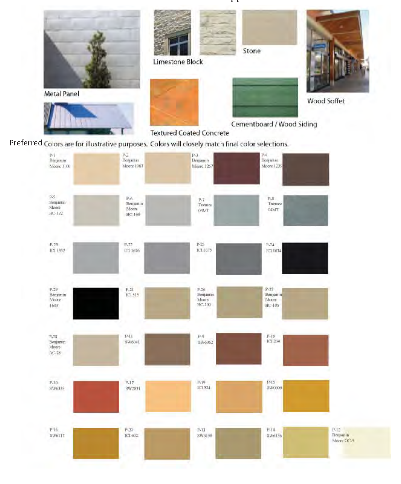
Material Colors:
The below listed materials represent the Architectural color palette for Rayzor Ranch. The intent is not to limit the manufacturers; therefore they are subject to change. Colors will remain within the specified color palette.
Neutral:
Benjamin Moore 1100
Benjamin Moore 1067
Benjamin Moore HC-172
Benjamin Moore HC-169
Benjamin Moore OC-5
Benjamin Moore HC-105
Benjamin Moore AC-28
ICI A1825
ICI A1838
ICI A1866
Sherwin Williams SW6136
Pittsburgh Paints 510-2
Gray Tone:
Benjamin Moore 1603
Benjamin Moore AC-27
ICI A2013
ICI A2007
ICI A2015
ICI A2014
Tnemec 03MT
Tnemec 03MT
Earth Tone:
Benjamin Moore 1267
Benjamin Moore 1239
Benjamin Moore 1225
Benjamin Moore HC-100
Benjamin Moore 1040
Benjamin Moore HC-68
Benjamin Moore HC-71
ICI A1827
Sherwin Williams SW6062
Sherwin Williams SW6335
Sherwin Williams SW6041
Sherwin Williams SW6158
Sherwin Williams SW0009
Sherwin Williams SW6117
Sherwin Williams SW2831
Pittsburgh Paints 417-5
Pittsburgh Paints 325-6
Pittsburgh Paints 315-5
APPENDIX 2
Example Canopy and Shading Applications
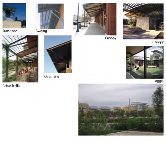
APPENDIX 3
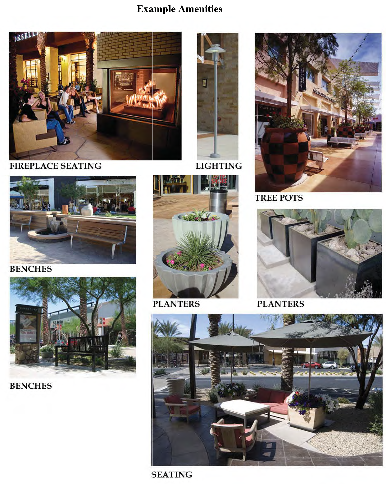
APPENDIX 4
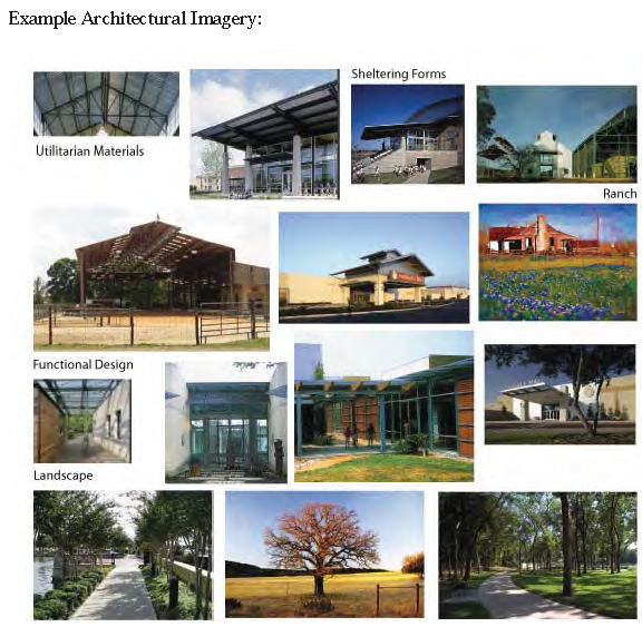
APPENDIX 5
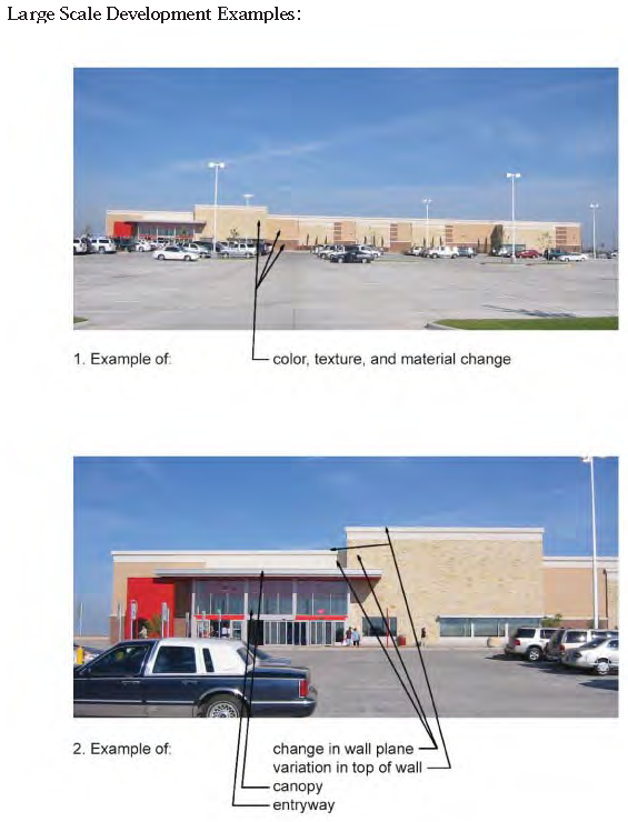
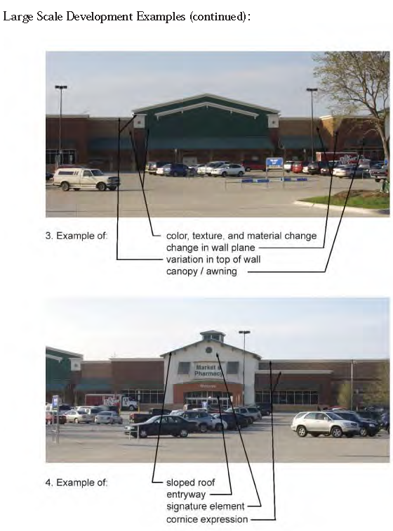
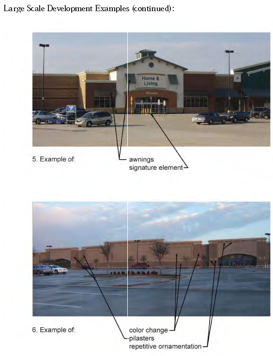
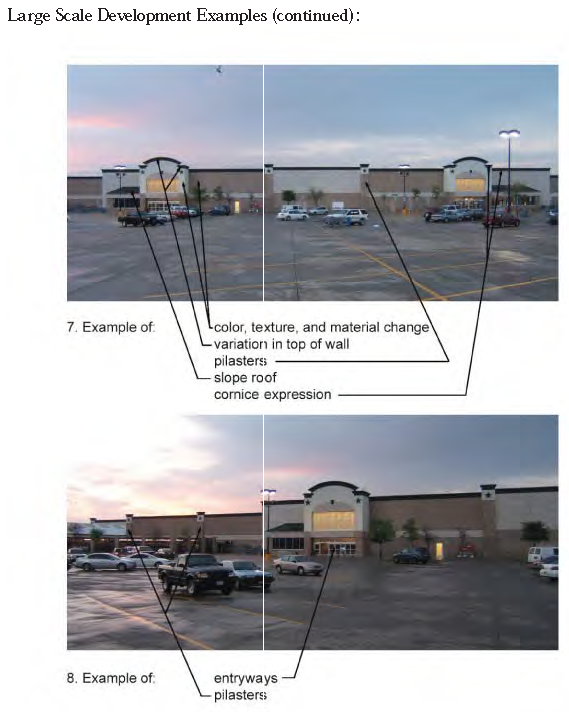
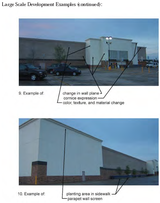
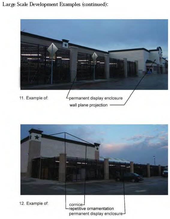
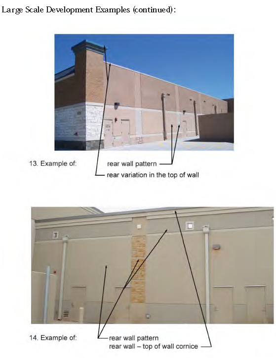
APPENDIX 6
Junior Anchor Front Facade Examples:
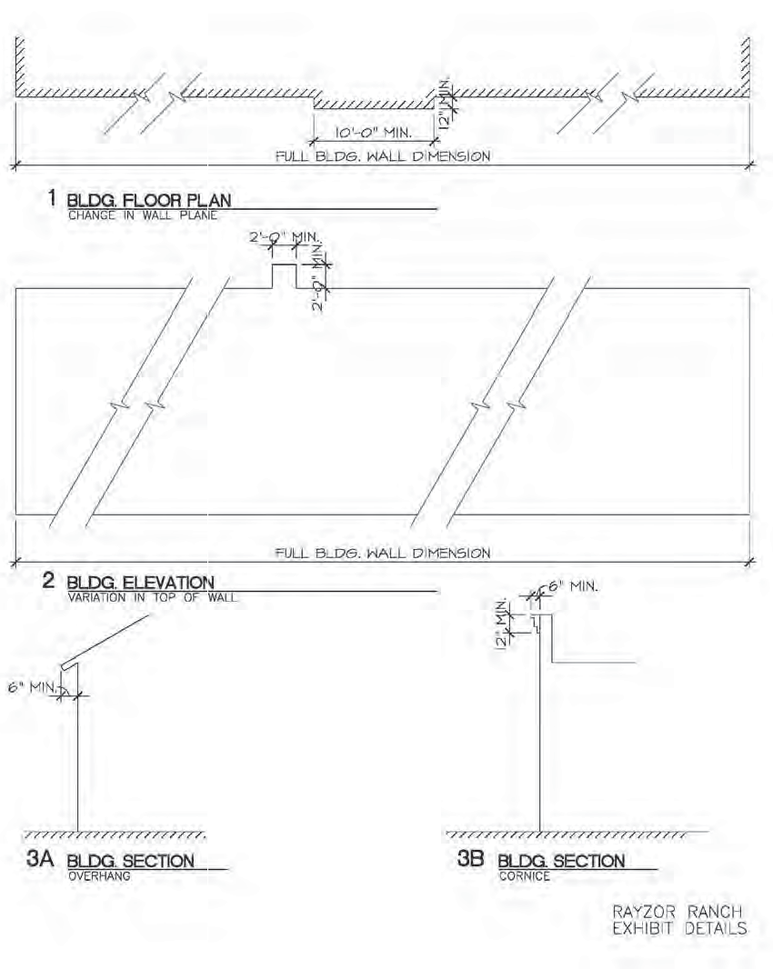
APPENDIX 7
Loading Dock Screening Examples:
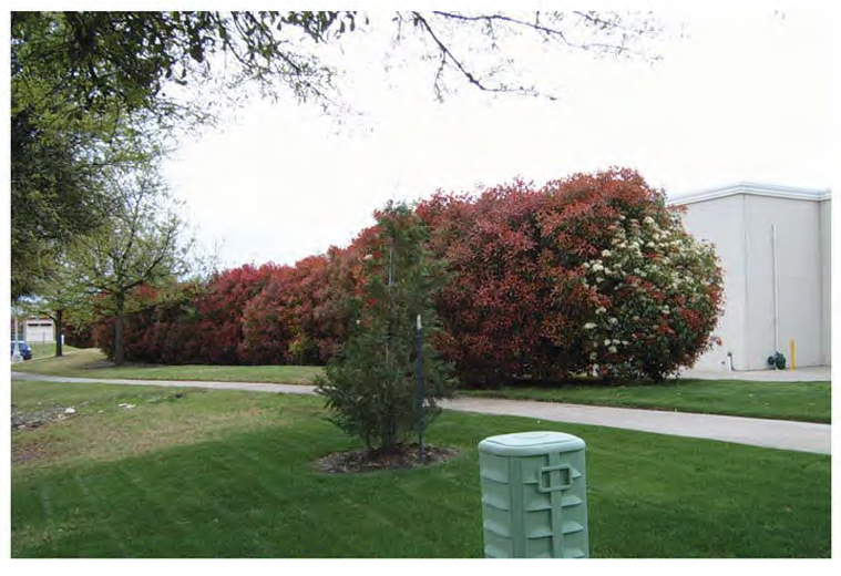
APPENDIX 8
Cooks' Children's Hospital Architectural Elements:
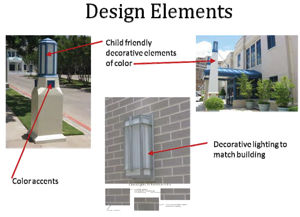
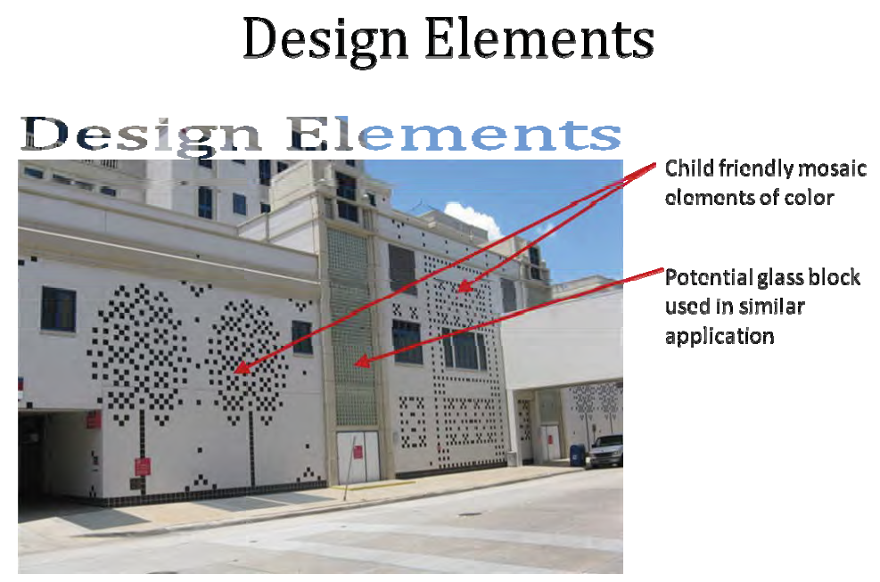
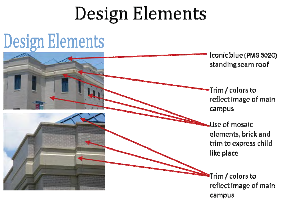
Article 1 - Architecture and Planning
Non-residential buildings in the Town Center (TC) and South Commercial District (SCD) collectively referred to as the RRTC in this document shall comply with the following planning and design standards:
A.
Orientation/Site Design.
1.
The RRTC is intended to be a unique shopping experience with a wide array of retail options including larger regional retailers, department stores, fashion, electronics, hard and soft goods, bookstores, restaurants and entertainment uses. The project should be unique to the Denton area and complimentary to surrounding land-uses.
2.
The TC area shall be oriented around a central circulation system or spine element for vehicular and pedestrian flow. This system or element may take the form of a public domain such as a park, open space, pedestrian plaza, courtyard or main street.
3.
The TC area's central circulation system and supporting internal roads are intended to provide a clear and logical transportation system for vehicles, pedestrians, cyclists and public transit.
4.
Plazas, patios and open spaces will be integrated into the site design to break-up large expanses of sidewalk areas.
5.
Loading docks, trash receptacles, storage areas and mechanical equipment shall be screened from public streets by evergreen shrubbery, trees, masonry screenwall, concrete screenwall or a combination thereof. If screening a loading dock with landscaping, the landscape material must be a minimum of five (5) feet tall at time of planting and must comply with the planting standards set forth in the Rayzor Ranch Landscape Standards. If screening trash receptacles, storage areas and mechanical equipment, the landscape material must be a minimum of one (1) foot taller than the item they are to screen at time of planting and must comply with the planting standards set forth in the Rayzor Ranch Landscape Standards.
6.
Trash collection and compaction may not occur within one hundred feet (100') of a single-family detached residence located outside of Rayzor Ranch. Trash collection areas shall be screened from public view as defined in Item A.5.
7.
Mechanical equipment may not be located within one hundred feet (100') of a single-family detached residence located outside of Rayzor Ranch. Mechanical equipment shall be screened from view as defined in Item A.5.
8.
Directional and wayfinding signage shall provide assistance for pedestrians and vehicles.
B.
Building Design and Materials.
1.
The SCD is to have distinctive architectural theming, including common design elements and materials.
2.
Window glass may not be flush with exterior walls or, if flush, shall have a surround of wood/metal frame or wall trim material.
3.
The SCD is to have a complimentary building character. Buildings shall be designed to enhance the community character and have features that provide visual interest. Large, blank facades and wall surfaces shall not be permitted. Within the TC area, windows and/or storefronts should be included in wall planes wherever feasible. The building facades within the TC area should be broken up and softened when feasible through overhangs and colonnades, architectural detailing or landscaping.
4.
Building walls greater than one hundred feet (100') in length shall have vertical and horizontal facade articulation or other distinctive changes in the building facade, such as material changes, color or textural changes.
5.
All sides of buildings visible from the streets, or internal customer areas of the site, are encouraged to be constructed of masonry, including brick and native stone veneers, decorative block, concrete, stucco (EIFS) or other high quality material customarily used for this building style. Gables, windows, doors and related trim are not included in this requirement. Wood and HDO board may be used. Preferred materials from the Example Material Applications located in Appendices 1—4 include:
i.
Native Texas quarried natural stone or limestone of varying colors, sizes and textures;
ii.
Concrete - Architectural finish. Texture coated or textured and colored;
iii.
Masonry, including structural and brick veneers;
iv.
Porcelain Tile;
v.
Glass Galvanized metal panels or prefinished architectural metal panels of gray tone, neutral or earthtone color;
vi.
Painted siding in a warm, neutral/earthtone or gray tone color;
vii.
EIFS or stucco in a warm, neutral/earthtone or gray tone color;
viii.
Accent colors as identified on the Master Palette are encouraged but should be used in a limited manner to contrast the more subtle "natural" palette;
ix.
Natural metals such as, but not limited to, zinc and copper;
x.
Roofing tile, metal roofing shingles and panels, or slate in galvanized or natural/earthtone color;
xi.
Natural wood, stained or painted.
6.
Glass and Storefronts. Glass shall be used to allow visual access into interior spaces, or for display purposes. Buildings may not incorporate glass for more than 70% of the wall plane.
7.
Stone. Native stone and stone veneers are encouraged to be used where practical as the common and unifying architectural material for the SCD.
8.
Metal Roofs. Metal roofs are permitted provided that they are standing metal seam, batten seam or metal shingles.
Article 2 - Outdoor Sales and Storage
A.
Exterior sidewalk displays and cart storage. Areas for customer loading or merchandise display and cart storage is allowed, but such areas shall be clearly delineated and shall not be located in front of any customer entrances, exit door(s), or within fifteen feet (15') on either side of the door(s).
B.
Permanent outdoor display, sales and storage. Merchandise may be stored or displayed for sale to customers on the front or side of the buildings in accordance with the following criteria:
1.
The total square footage of all permanent outdoor storage, display, and sales areas shall be limited to 20% of the footprint of the building, but in no event shall exceed 20,000 square feet, except for home improvement use, which may not exceed 45,000 square feet of outdoor storage and the 20% footprint restriction does not apply.
2.
Permanent outdoor storage, display and sales shall be contiguous to the building and shall not be permitted within seventy-five feet (75') of a single-family detached residence located outside of Rayzor Ranch.
3.
The permanent storage, display and sales area shall be enclosed by a minimum eight foot (8') wall of columns minimum two feet (2') wide, of like appearance to the building with wrought iron or decorative tubular steel fencing. No merchandise other than trees shall be visible above the wall or fence.
4.
Seasonal outdoor display will be allowed. Size will be limited to 11,000 square feet maximum. Dates for outdoor display will be year round. Merchandise may not exceed ten feet (10') in height except for trees.
C.
Rear Storage. Bulk merchandise may be stored behind any building. The sides and back of the storage area shall be screened with a chain link fence covered with windscreen, except for any side or back that is separated from any residential property by an eight-foot masonry wall and landscaped buffer yard, in which case additional screening is not required. Windscreen shall be maintained in good repair and free of tears. The rear storage area shall not be accessible to customers. Merchandise shall be stacked no higher than twenty-five feet (25') or level with the top of the adjacent sidewall of the building, whichever is lower, and may not be stacked above the height of the chain link fence.
D.
Pickup and Delivery. Outdoor storage, pickup, delivery, loading and unloading of merchandise, equipment or other items may not occur within one hundred feet (100') of single-family detached residential property located outside of Rayzor Ranch. Loading areas and docks must be located to the side or rear of the building unless the loading area is completely screened from the street, and loading docks shall be located more than one hundred feet (100') from single-family detached residence located outside of Rayzor Ranch. Pavement may be located within one hundred feet (100') of residential property.
Article 3 - Streetscape/Public Spaces
A.
SCD shall provide one square foot of plaza or public space area (Plaza Area}, which may include sidewalks, for each ten (10) square feet of gross ground floor area.
B.
Plaza Areas shall be defined as any area within SCD that contains any three of the following seven items:
1.
An area that provides pedestrian seating at a rate of one seat for each 250 square feet. Seating shall be a minimum of fifteen inches (15") in height and thirty inches (30"} in width. Seating elements include manufactured benches, ledge benches, natural elements, seat walls or other raised element designated for seating. When providing more than one sitting space on an element, each space shall be calculated at a minimum of eighteen inches (18") of width.
2.
An area that integrates shade within the open space area through the inclusion of shade trees, trellises, awnings or structural elements such as colonnades and canopies.
3.
An area that provides trees in proportion to the space at a minimum of one tree per 800 square feet.
4.
An area containing a water feature, fireplace, amphitheater or public art.
5.
An area containing outdoor dining.
6.
A freestanding stone fireplace, obelisk or other design feature.
7.
A hardscape area that integrates landscape planting within the hardscape through pots, above grade planters, in grade planters, or tree grates (Refer to photographs in Appendix 3).
C.
Planting areas in the sidewalk are encouraged. Pots or above grade planters are allowed, minimum container size of 5 gallons. (Refer to photographs in Appendix 3.)
D.
Single tenant buildings having a gross floor area in excess of 40,000 square feet shall have a minimum of 100 square foot seating area including benches or other permanent seating along the front sidewalk area. This area shall be included as part of the Plaza calculation and should meet Plaza requirements.
E.
Bicycle racks shall be included at various locations in the TC.
Article 4 - Mechanical Roof Equipment Screening
All roof mounted mechanical equipment shall be fully screened from view from public on the site or public pedestrian spaces. Acceptable methods for screening roof mounted equipment shall include parapet elements, louvers, or ridges of sloped roof forms. The color and finish of the screening shall comply with the color pallet approved as Appendix 1 and be complimentary to the building architecture.
Article 5 - Accessory Use
All accessory uses shall be architecturally compatible with the main structure by sharing color, materials, architectural design, roof pitch elements or some other architectural feature.
Article 6 - Drive-Through Requirements
A.
Drive-through uses shall provide sufficient stacking area to ensure that public rights-of-way are not obstructed. Fast food restaurants with drive-through facilities shall provide a minimum stacking distance of one hundred and sixty feet (160') unless the building owner or tenant can substantiate that a lesser requirement is appropriate based on a national standard or case studies of other facilities operated by that owner or tenant. Bank drive-through facilities shall provide a minimum stacking distance of one hundred feet (100').
B.
Drive-through canopies must be built as an integral architectural element of the structure. The supporting structure shall include at least one (1) of the following architectural features:
1.
Native Texas stone or limestone on the supporting structure columns or building facade.
2.
A sloped metal roof.
The materials are to be the same as those used in the primary structure. Drive-through structures and facilities physically separated from the primary structure must be architecturally compatible with the primary structure.
C.
Drive-through uses must be located to the rear or side of the structure, and buffered on the rear and side lot lines as required in the Denton Development Code Section 7.9.7.C. A portion of the buffer between sites can be provided on adjacent lots.
Article 7 - Light and Glare Performance Requirements
A comprehensive lighting plan shall be utilized for public safety in parking areas, illumination of building areas and pedestrian scale lighting along walkways and foot paths. Decorative lighting may be used at intersections and gathering places. All lighting within the Rayzor Ranch development shall meet the following standards:
A.
Areas designated for parking use shall provide a minimum average of one foot candle of illumination.
B.
Areas designated for pedestrian use shall provide a minimum average of one-half foot candle of illumination.
C.
Light may not measure more than one-half foot candle of illumination at property lines external to Rayzor Ranch or at internal property lines where adjacent to residential.
APPENDIX 1
Example Material Applications
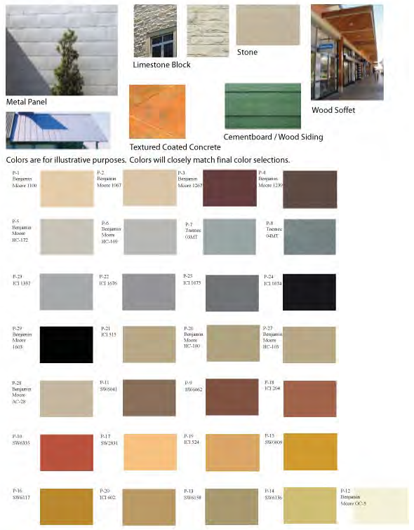
Material Colors:
The below listed materials represent the Architectural color palette for Rayzor Ranch. The intent is not to limit the manufacturers; therefore they are subject to change. Colors will remain within the specified color palette.
Neutral:
Benjamin Moore 1100
Benjamin Moore 1067
Benjamin Moore HC-172
Benjamin Moore HC-169
Benjamin Moore OC-5
Benjamin Moore HC-105
Benjamin Moore AC-28
ICI A1825
ICI A1838
ICI A1866
Sherwin Williams SW6136
Pittsburgh Paints 510-2
Gray Tone:
Benjamin Moore 1603
Benjamin Moore AC-27
ICI A2013
ICI A2007
ICI A2015
ICI A2014
Tnemec 03MT
Tnemec 03MT
Earth Tone:
Benjamin Moore 1267
Benjamin Moore 1239
Benjamin Moore 1225
Benjamin Moore HC-100
Benjamin Moore 1040
Benjamin Moore HC-68
Benjamin Moore HC-71
ICI A1827
Sherwin Williams SW6062
Sherwin Williams SW6335
Sherwin Williams SW6041
Sherwin Williams SW6158
Sherwin Williams SW0009
Sherwin Williams SW6117
Sherwin Williams SW2831
Pittsburgh Paints 417-5
Pittsburgh Paints 325-6
Pittsburgh Paints 315-5
APPENDIX 1
EXAMPLE MATERIAL APPLICATIONS
ADDITIONAL COLORS AND MATERIALS FOR TOWN CENTER ONLY
Until amended by City Council, the TC and SCD will use the Material Applications set forth above. Additional materials and/or colors may be added at a later date.
APPENDIX 2
EXAMPLE CANOPY AND SHADING APPLICATIONS
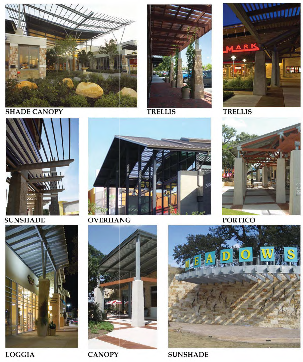
APPENDIX 3
EXAMPLE AMENITIES
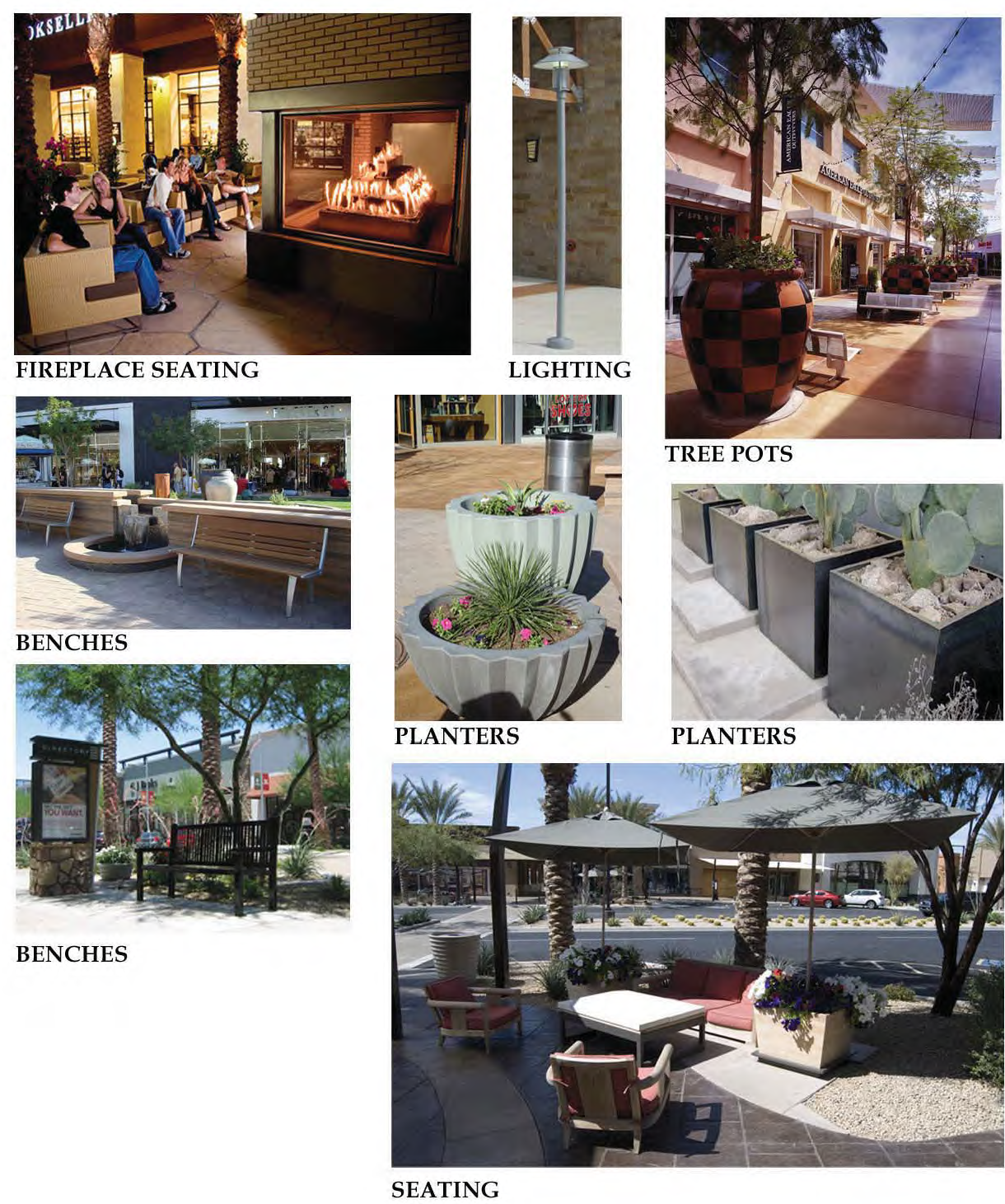
APPENDIX 4
EXAMPLE ARCHITECTURAL IMAGERY

Article 1 - Architecture and Planning
Non-residential buildings on the 4.1 acre site at the intersection of Scripture and 1-35 (NE corner) shall comply with the following planning and design standards.
A.
Orientation/Site Design.
1.
Loading docks, trash receptacles, storage areas and mechanical equipment shall be screened from public streets by evergreen shrubbery, trees, masonry screen wall, concrete screen wall or a combination thereof. If screening a loading dock with landscaping, the landscape material must be a minimum of five (5) feet tall at time of planting and must comply with the planting standards set forth in the Rayzor Ranch Landscape Standards. If screening trash receptacles, storage areas and mechanical equipment, the landscape material must be a minimum of one (1) foot taller than the item they are to screen at time of planting and must comply with the planting standards set forth in the Rayzor Ranch Landscape Standards.
2.
Orientation: Due to the visibility of the site from the surrounding properties and it's adjacency to streets on three sides of the property, the building(s) must be designed as four sided architecture with a similar level of detailing on all sides.
B.
Building Design and Materials.
1.
Buildings on the property are to have distinctive architectural themeing, including common design elements and materials, and shall be consistent with the Rayzor Ranch Architectural Standards for South Commercial District (SCD).
2.
Window glass may not be flush with exterior walls or, if flush, shall have a surround of wood/metal frame or wall trim material.
3.
Building walls greater than one hundred feet (100') in length shall have vertical and horizontal facade articulation or other distinctive changes in the building facade, such as material changes, color or textural changes.
4.
All sides of buildings visible from the streets, or internal customer areas of the site, are encouraged to be constructed of masonry, including brick and native stone veneers, decorative block, concrete, stucco (EIFS) or other high quality material customarily used for this building style. Gables, windows, doors and related trim are not included in this requirement. Wood and HDO board may be used. Acceptable materials from the Example Material Applications located in Appendices 1—4 include:
i.
Native Texas quarried natural stone or limestone of varying.
ii.
Concrete - Architectural finish. Texture coated or textured and colored.
iii.
Masonry, including structural and brick veneers.
iv.
Porcelain Tile.
v.
Glass Galvanized metal panels or prefinished architectural metal panels of gray tone, neutral or earthtone color.
vi.
Painted siding in a warm, neutral/earthtone or gray tone color.
vii.
EIFS or stucco in a warm, neutral/earthtone or gray tone color.
viii.
Accent colors as identified on the Master Palette are encouraged but should be used in a limited manner to contrast the more subtle "natural" palette.
ix.
Natural metals such as, but not limited to, zinc and copper.
x.
Roofing tile, metal roofing shingles and panels, or slate in galvanized or natural/earthtone color.
xi.
Natural wood, stained or painted.
5.
Glass and Storefronts. Glass is encouraged to be used to allow visual access into interior spaces, or for display purposes. Buildings are encouraged to limit glass to no more than 70% of the wall plane.
6.
Stone. Native stone and stone veneers are encouraged to be incorporated where practical as the common and unifying architectural material for Rayzor Ranch.
7.
Metal Roofs. Metal roofs are permitted provided that they are standing metal seam, batten seam or metal shingles.
Article 2 - Mechanical Roof Equipment Screening
All roof mounted mechanical equipment shall be fully screened from view from public on the site or public pedestrian spaces. Acceptable methods for screening roof mounted equipment shall include parapet elements, louvers, or ridges of sloped roof forms. The color and finish of the screening shall comply with the color pallet approved as Appendix 1 and be complimentary to the building architecture.
Article 3 - Accessory Use
All accessory uses shall be architecturally compatible with the main structure by sharing color, materials, architectural design, roof pitch elements or some other architectural feature.
Article 4 - Light and Glare Performance Requirements
A comprehensive lighting plan shall be utilized for public safety in parking areas, illumination of building areas and pedestrian scale lighting along walkways and foot paths. Decorative lighting may be used at intersections and gathering places. All lighting within the Rayzor Ranch development shall meet the following standards which replace the standards set forth in Section 7.11 of the Denton Development Code.
A.
Areas designated for parking use shall provide a minimum average of one foot candle of illumination.
B.
Areas designated for pedestrian use shall provide a minimum average of one-half foot candle of illumination.
C.
Light may not measure more than one-half foot-candle of illumination at property lines external to Rayzor Ranch or at internal property lines where adjacent to residential.
APPENDIX 1
Preferred Material Applications
Material Colors:
The below listed materials represent the Architectural color palette for Rayzor Ranch. The intent is not to limit the manufacturers; therefore they are subject to change. Colors will remain within the specified color palette.
Neutral:
Benjamin Moore 1100
Benjamin Moore 1067
Benjamin Moore HC-172
Benjamin Moore HC-169
Benjamin Moore OC-5
Benjamin Moore HC-105
Benjamin Moore AC-28
ICI A1825
ICI A1838
ICI A1866
Sherwin Williams SW6136
Pittsburgh Paints 510-2
Gray Tone:
Benjamin Moore 1603
Benjamin Moore AC-27
ICI A2013
ICI A2007
ICI A2015
ICI A2014
Tnemec 03MT
Tnemec 03MT
Earth Tone:
Benjamin Moore 1267
Benjamin Moore 1239
Benjamin Moore 1225
Benjamin Moore HC-100
Benjamin Moore 1040
Benjamin Moore HC-68
Benjamin Moore HC-71
ICI A1827
Sherwin Williams SW6062
Sherwin Williams SW6335
Sherwin Williams SW6041
Sherwin Williams SW6158
Sherwin Williams SW0009
Sherwin Williams SW6117
Sherwin Williams SW2831
Pittsburgh Paints 417-5
Pittsburgh Paints 325-6
Pittsburgh Paints 315-5
APPENDIX 1
Example Material Applications
Additional Colors and Materials for Town Center only
APPENDIX 2
Example Canopy and Shading Applications
APPENDIX 3
Example Amenities
APPENDIX 4
Example Architectural Imagery
;b0; South Mixed Use District-1 Architectural Standards—Place holder (to be incorporated
later)
Article 1 - General Landscape Guidelines
A)
Landscape Plan. Landscaping must be provided in accordance with the attached landscape plan in Appendix D unless otherwise stated in this Exhibit.
B)
Open Space Requirements. The RRM-1 and RRM-2 areas of the Marketplace shall maintain a minimum average open space of 21% of the overall site. This open space shall include all planted areas (parking lot islands, planted buffer strips, sidewalks within planted areas and paved plaza spaces). It shall not include parking, road, or drive areas, building footprint areas and loading docks. Tree canopy coverage in the Marketplace must average 28%.
C)
Parking Field Requirements. The RRM-1 and RRM-2 areas of the Marketplace will incorporate the following planting guidelines in all parking areas:
1)
Landscape Islands. There will be one planted island for every 10 linear parking spaces. This planting island shall occupy one (1) standard parking space. Each island shall contain one shade tree (2" min. cal.) from the Approved Plant List (see Appendix A). Alternatively, there will be one planted island for every 20 linear parking spaces. This planting island shall be no less than the same size as 2 standard parking spaces. Each island shall contain 2 shade trees (2" min. cal.) from the Approved Plant List (see Appendix A). Ground cover within the island shall be 100% turf, shrub, planted groundcover, gravel, or mulch or combination thereof (See Diagram 1).
2)
End Islands. There shall also be an end island for every parking row. This end island shall occupy one (1) standard parking space. Each island shall contain one shade tree (2" min. cal.) from the Approved Plant List (see Appendix A). An example of the end islands can be found in Diagram 1. Ground cover within the island shall be 100% turf, shrub, planted groundcover, gravel, or mulch or combination thereof (Please see Diagram 1).
3)
Minor Amendments. The Director may approve alternate tree locations utilizing the minor amendment process to avoid conflicts with utilities as defined in the Denton Development Code.
4)
Spacing From Public Utilities.
a)
Water and Wastewater Lines - No trees shall be planted closer than nine (9) feet from any public underground water or wastewater utility main unless applicable staff approves a special circumstance. The location of the water or wastewater utility line shall be considered, for distance purposes, to be the surface of the ground above the line.
b)
Fire Hydrants - No trees shall be planted closer than 10 feet from any fire hydrant.
Article 2 - Buffers and Screening
A)
Residential Development Buffer Between RRM-1/RRM-2 and R-1. The Residential Development Buffer for the RRM-2 District shall consist of a wall at least eight feet (8') tall, constructed of masonry or modular concrete. There shall be at least one (1) ornamental tree every 20 feet on center on the north side of the eight foot (8') tall wall for the portion of the wall in the RR-3 area adjacent to the residential area labeled on the Rayzor Ranch Concept Plan as R-1. The Residential Development Buffer between the RRM-1 area and the R-1 area shall consist of the water quality and detention basin landscaped in accordance with the approved ISWM plan. The detention basin will be fenced with a six foot (6') tall black poly coated chain link fence.
B)
Buffer Between the Existing Nonresidential Development North of RRM-2, Lot 11. The Buffer shall consist of a wall at least eight feet (8') tall, constructed of masonry or modular concrete.
C)
Buffering along Bonnie Brae Street, North of U.S. 380. A minimum 10' wide sidewalk/trail will be located within this buffer to provide a connection between McKenna Park and North Lakes Park.
D)
Service and Equipment Screening.
1)
Refuse Container Screen. Trash receptacles shall be screened in accordance with Article 1.A.3 of the Rayzor Ranch Architectural Guidelines. The construction of refuse screening areas must comply with the Solid Waste Criteria Manual and Section 7.12 of the Denton Development Code.
2)
Service Corridor Screen. When adjacent to residential uses, commercial and industrial service corridors shall be screened. Siting and design of such service areas shall reduce the adverse effects of noise, odor and visual clutter upon adjacent residential uses.
3)
Mechanical Equipment Screen. All mechanical equipment shall be screened from any public right-of-way or adjacent to residential use or zoning district. Ground mounted equipment can be screened with evergreen shrubbery or masonry or concrete screen wall. Gates, if incorporated in the design of the screen wall, can be constructed of metal. Screening is subject to approval by the appropriate controlling utility.
4)
Outdoor Storage. All outside storage shall comply with the provisions of Sections 5.4.4D and 7.7.8E of the Denton Development Code.
Article 3 - Access, Parking and Circulation Requirements.
A)
External to the Development.
1)
Vehicular Access.
a)
Access Management. The Marketplace shall provide access that complies with Access Management principals of location, spacing and sharing of curb cuts. The Marketplace shall provide adequate stacking distance for all entrances.
b)
Connectivity. Connectivity may be provided from the RRM-1 Marketplace to the R-1 district by a single road with a north/south orientation on the western edge of the RRM-1 District. Extension to existing single-family zoning to the north may be provided at the time of development of the Rayzor Ranch single-family lots.
2)
Pedestrian Access. All developments shall provide pedestrian access by linking to any adjacent sidewalk(s), multi-use path(s) or public transportation stop.
3)
Transit Amenities. Transit amenities, bus shelters, and pullouts shall be provided as required by the Transportation Design Criteria Manual and the City Mobility Plan, as amended.
B)
Internal to the Development.
1)
Vehicular Circulation.
a)
Internal circulation shall be well defined by use of end caps and landscaped areas.
b)
Cross Access: Prior to division of property, circulation and access standards shall be applied and, if necessary, cross easements shall be required so that access to all properties created by the subdivision can be made from shared curb cuts.
Article 4 - Parking Lot Landscaping and Screening Standards
In addition to Article 1 above, all parking lots, which for purposes of this section, include areas of vehicle maneuvering, parking, and loading, shall be landscaped and screened as follows:
A)
Landscape Standards.
1)
A minimum of 7% of the total parking area shall be landscaped.
2)
A minimum of 15% of the required parking shall be covered by tree canopy.
3)
The tree species shall be an appropriate shade tree and shall be selected from the Approved Plant List (see Appendix A) for the Rayzor Ranch Development.
4)
Poly-coated chain link fencing is allowed for security and utilitarian purposes, but is not considered a screening fence.
B)
Screening at Right-of-Way. Parking is allowed in front of a building if the parcel meets the following design standards:
1)
Parking lots shall be separated from the street frontage by a minimum 15 foot wide Right-of-Way Screening Landscape Area to reduce visual impacts.
2)
The minimum 15 foot wide Right-of-Way Screening Landscape Area is the area located between the right-of-way and the parking lot. Utility easements are allowed to count towards part of the 15-foot wide Right-of-Way Screening Landscape area subject to required separation from utilities.
3)
The number of large trees required will be calculated by providing one (1) large tree for every 45 feet of the Right-of-Way Screening Landscape Area. The required numbers of trees do not have to be planted on 45-foot centers, but can be clustered.
4)
A minimum of three small accent trees clustered every 30 linear feet within the Right-of-Way Screening Landscape Area may be substituted for the large tree requirement.
5)
At least one or any combination of the following shall be used to help screen the parking lot:
a)
Xeriscape landscaping may be planted within the Right-of-Way Screening Landscape Area. Xeriscape landscaping shall require water irrigation for a period of three years for landscaping to be established. After 3 years, no irrigation is required;
b)
A minimum three foot high row of evergreen shrubs planted within the Right-of-Way Screening Landscape Area. The shrubs may be grouped and not planted in a continuous row provided that the shrubs overlap to form a continuous buffer; or
c)
A minimum three-foot high continuous wall made of any combination of wrought iron, masonry, or stone within the Right-of-Way Screening Landscape Area. If wrought iron is used, vines shall be grown on the wrought iron to help screen the parking lot.
Article 5 - Tree Maintenance and Tree Mitigation
A)
Each replacement tree shall have a minimum caliper of two (2) inches, measured six (6) inches above grade and must be at least five (5) feet tall when planted.
B)
All replacement trees must be Large Canopy Trees and be included on the Approved Plant List found in Appendix A.
C)
A performance bond is required prior to the issuance of a building permit for each phase of Rayzor Ranch. The purpose of the performance bond is to ensure that the landscape and trees are planted and well maintained. Upon completion of the three (3) year establishment period for all plantings within the Rayzor Ranch project, the City shall inspect the trees to determine if 90% of the trees are healthy and have a reasonable chance of surviving to maturity. Upon such a finding, the City shall release the performance bond. If the applicant does not take remedial steps to bring the property into compliance, the City shall make demand for payment of the bond. The City may use all legal remedies to enforce this requirement, in addition making demand on the bond.
D)
The developer shall pay $215,500.00 into the Rayzor Ranch Tree Mitigation Escrow Fund prior to the issuance of the first clearing and grading permit for the Rayzor Ranch development. Any accumulated interest shall be available for additional tree planting and maintenance of public trees in the Rayzor Ranch development, or as otherwise specified herein or in other agreements with the City. The Developer shall bear all administrative costs for the Rayzor Ranch Tree Mitigation Escrow Fund. The City must be a third party beneficiary to the Rayzor Ranch Tree Mitigation Escrow Fund, to be held in trust by the City or a designated third party agent. Funds paid into the Rayzor Ranch Tree Mitigation Escrow Fund shall be used to purchase plant and maintain trees in Rayzor Ranch. At the completion of the Rayzor Ranch project, any remaining funds may be used to plant trees on public property within five (5) miles of Rayzor Ranch.
E)
Tree mitigation will also be subject to the criteria established in Section 4.8.8 of the Rayzor Ranch District.
Article 6 - Interim Landscape Areas
A)
The landscaping required along the frontage of Bonnie Brae will not be required to be installed until six (6) months after the installation of the 42-inch water line by the City of Denton is constructed and accepted.
B)
Landscaping for the water quality/detention basin must be completed within six (6) months of the issuance of the first certificate of occupancy for the Junior Anchor retail building located in the RR-2 Marketplace.
C)
The U.S. 380 (University Drive) right-of-way landscape screening will follow the following sequencing:
1)
There will be no landscaping required for 180 days after the U.S. 380 construction is complete. If final construction has not begun on the permanent landscaping shown on the Master Landscaping Plan after the 180-day time limit expires, then temporary grass and irrigation will be installed.
2)
Final right-of-way screening must be installed within six (6) months after the final certificate of occupancy is issued for 80% of the lots fronting U.S. 380 or within two years of the effective date of this Exhibit, whichever is less. This is to ensure that landscaping is uniform at the time of installation.
Article 7 - Amendments to the Landscape Plan
A)
The Director may authorize minor changes in the landscape plan that otherwise comply with the District ordinance and do not:
1)
Reduce the perimeter landscape buffer strip shown on the original landscape plan;
2)
Detrimentally affect the original landscape plan's aesthetic function relative to adjacent right-of-way or surrounding property; or
3)
Detrimentally affect the original landscape plan's screening or buffering function.
B)
For purposes of this subsection, "original landscape plan" means the earliest approved landscape plan that is still in effect, and does not mean a later amended landscape plan. For example, if a landscape plan was approved with the District and then amended through the minor amendment process, the original landscape plan would be the landscape plan approved with the District, not the landscape plan as amended through the minor amendment process. If, however, the landscape plan approved with the District was replaced through the zoning amendment process, then the replacement landscape plan becomes the original landscape plan. The purpose of this definition is to prevent the use of several sequential minor amendments to circumvent the zoning amendment process.
Appendix A
Approved Plan List
Canopy Trees
Mature Canopy 314-1256 sq. ft. - Site Design Criteria Manual
Ornamental Trees
Mature Canopy 79-314 sq. ft. - Site Criteria Manual
Shrubs
Grasses/Ground Cover/Vines
APPENDIX B
TREE MITIGATION CHART
Rayzor Ranch Mitigation Chart
North Site
Total caliper inches of trees taken down and still remaining is 7713.
161 caliper inches of the 7713 are Quality/Protected Trees
5524 Caliper inches of the 7713 inches were taken down
2189 Caliper inches of the 7713 inches are remaining
7713 inches -161 Inches of Quality/Protected Trees = 7552 inches
7552 are Secondary Trees requiring 12.5% mitigation = 944 caliper inches
161 are Quality/Protected Trees requiring 1:2 or 1:1.5 mitigation
At the worst case scenario 1:2 = 322 caliper inches
Total caliper inches to mitigate = 944 + 322 = 1266 inches
This is 633 trees (assuming mitigation is with 2" caliper trees)
South Site
Trees to Preserve:
3 Quality Trees = 42.4 inches
2 Protected Trees = 43.5 inches
Total caliper inches to preserve = 85.9 inches
Trees to Mitigate:
34 Quality Trees = 351.1 inches
6 Protected Trees = 298.6 inches
2 Large Secondary = 49.4 inches
18 Secondary = 23.25 inches
Total caliper inches to mitigate = 457.25 inches
This is 229 trees (assuming mitigation is with 2" caliper trees)
Mitigation Total of North and South Sites = 1724.25 inches
Preservation Total of North and South Sites = 85.9 inches
*This mitigation plan is a proposed plan. If any transplanted trees die within the first year, the developer will replace the trees with the equivalent number of caliper inches.
Appendix C Landscape Chart
Rayzor Ranch Landscape Chart
Appendix D
Landscape Plan
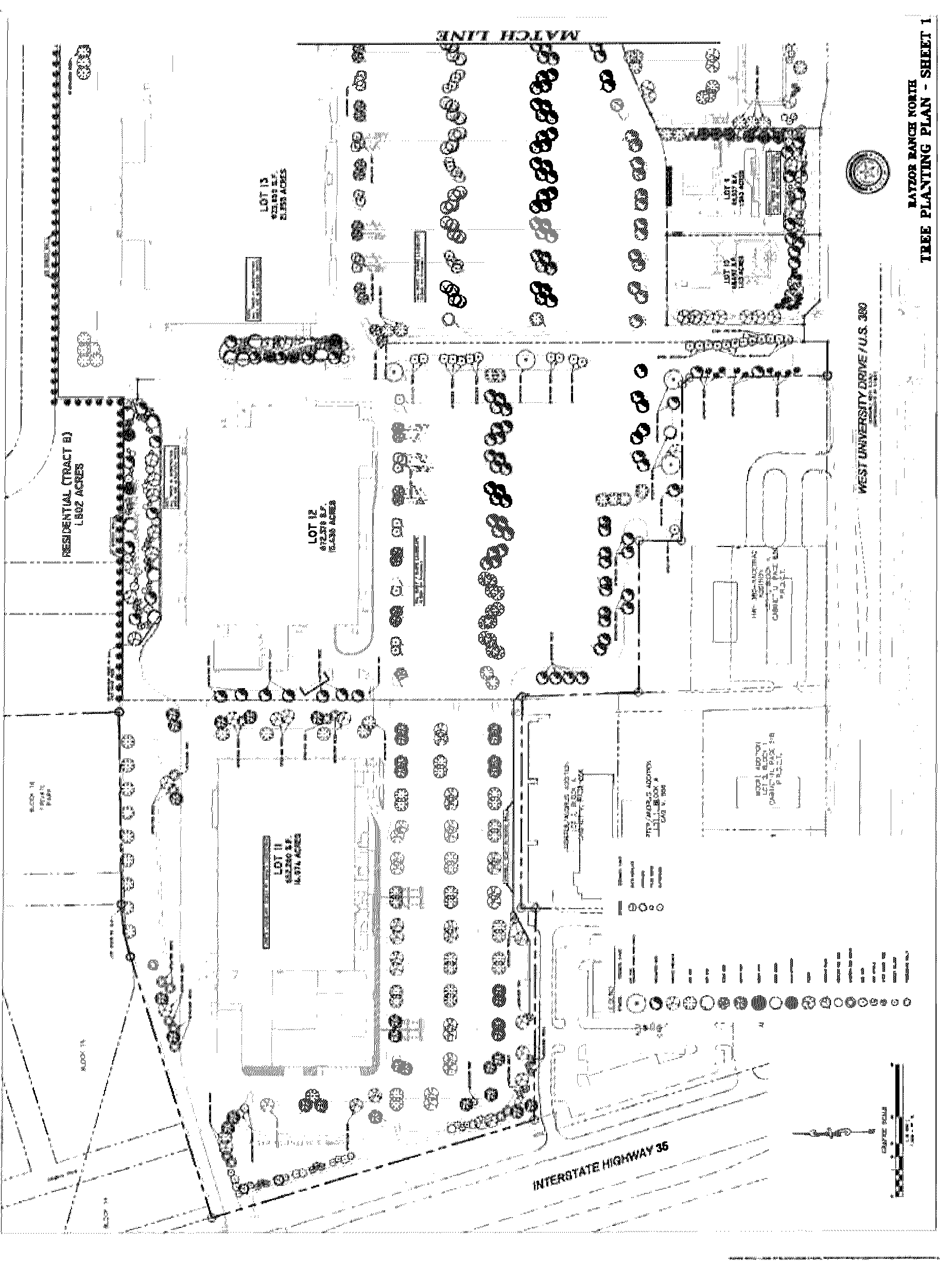
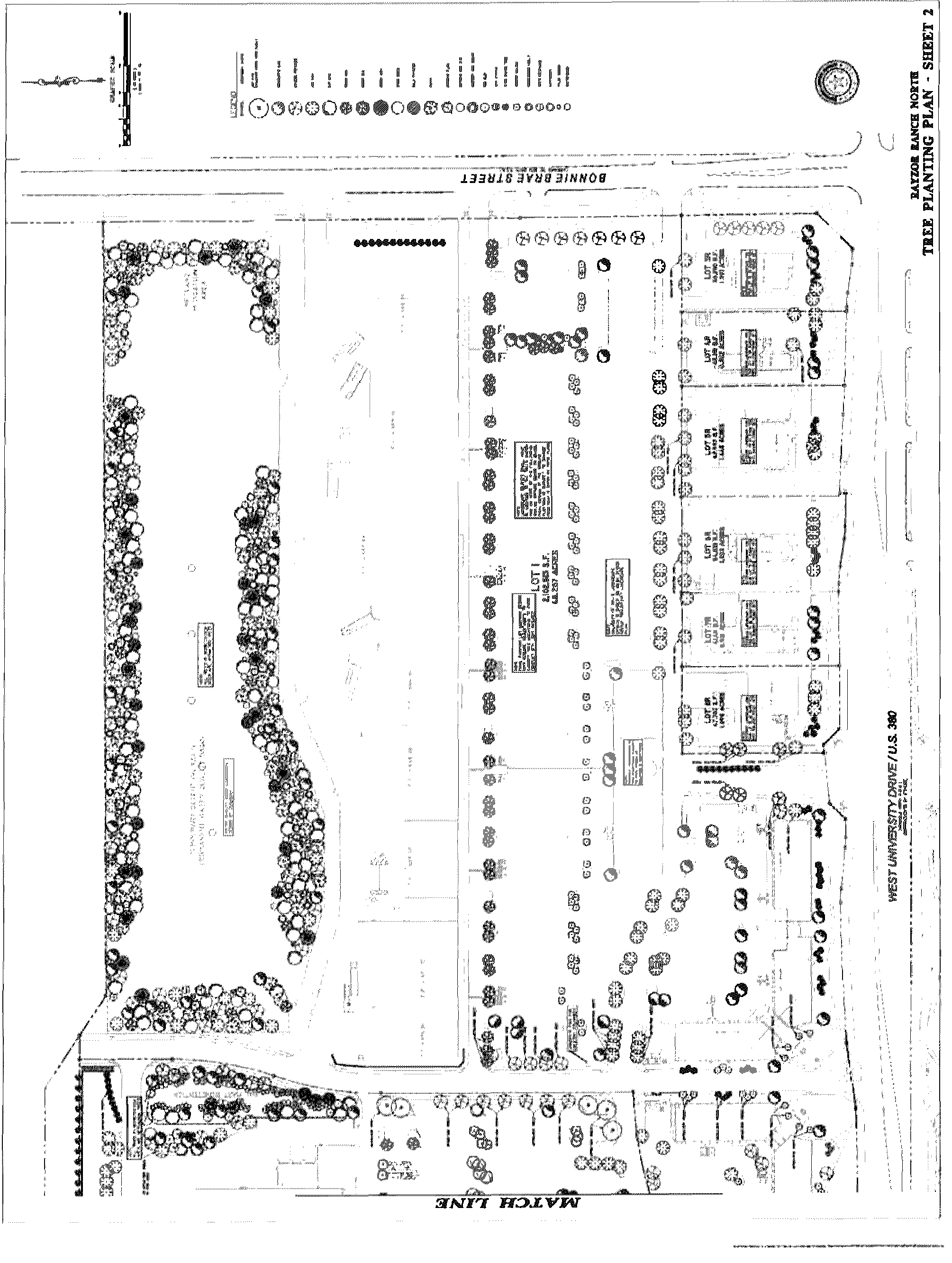
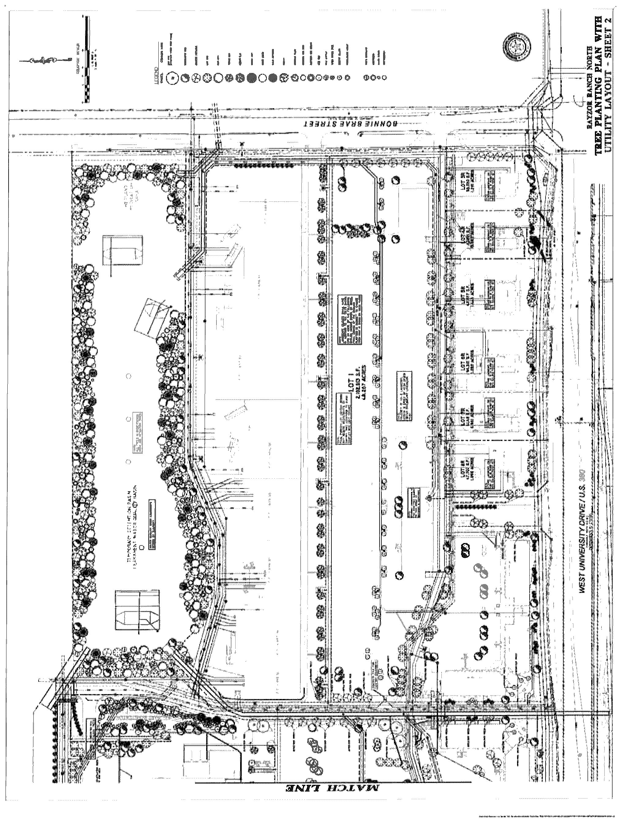
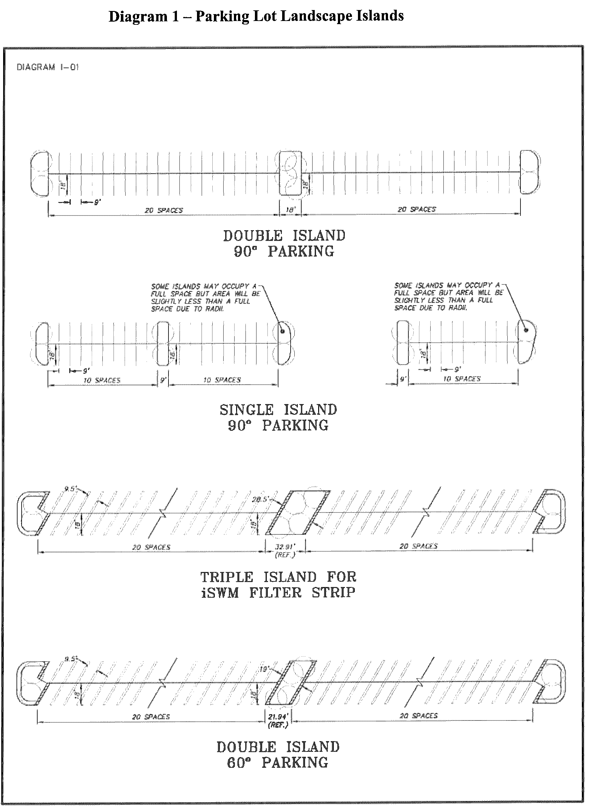
Article 1 - General Landscape Standards
A.
Landscape Plan. Landscape Plans must be reviewed and approved by the City staff for each phase of the development.
B.
Open Space Requirements.
1.
The South Commercial District (SCD) and Town Center (TC) shall maintain a minimum average open space of 15% of the overall site. Open space includes all surface areas of the project that are not covered with enclosed buildings, or parking and drive areas. Pedestrian plazas sidewalks covered or uncovered are calculated towards total open space.
2.
Active open space shall be valued within the Town Center (TC) development. Plaza Areas, as defined in Article 3.B of the Rayzor Ranch Architectural Standards, may be credited as additional open space, canopy coverage, and/or landscape area with the authorization of the City Manager and a supporting site plan.
C.
Parking Field Requirements. The SCD and TC will incorporate the following planting standards in all parking areas:
1.
Landscape Islands. There will be a minimum of one planted island for every 15 linear parking spaces. This planting island shall be approximately the same size as one (1) standard parking space. Each island shall contain at least one shade tree (2" min. cal.) from the Approved Plant List (see Appendix A). Alternatively, there will be a minimum of one planted island for every 25 linear parking spaces. This planting island shall be approximately the same size as 2 standard parking spaces. Each island shall contain at least 2 shade trees (2" min. cal.) from the Approved Plant List (see Appendix A). Ground cover within the island shall be 100% turf, shrub, planted groundcover, gravel, or mulch or combination thereof. See Diagram 1 for an example layout of landscape islands. The average distance between planting islands shall be 11 linear parking spaces.
2.
End Islands. There shall also be an end island for every parking row. This end island shall be approximately the same size as one (1) standard parking space. Each island shall contain at least one shade tree (2" min. cal.) from the Approved Plant List (see Appendix A). An example of the end islands can be found in Diagram 1. Ground cover within the island shall be 100% turf, shrub, planted groundcover, gravel, or mulch or combination thereof.
3.
Minor Amendments. The City Manager may approve alternate tree locations utilizing the minor amendment process to avoid conflicts with utilities as defined in the Denton Development Code.
4.
Tree Spacing From Public Utilities.
a.
Water and Wastewater Lines - No trees shall be planted closer than nine (9) feet from any public underground water or wastewater utility main unless applicable staff approves a special circumstance. The location of the water or wastewater utility line shall be considered, for distance purposes, to be the surface of the ground above the line.
b.
Fire Hydrants - No trees shall be planted closer than 10 feet from any fire hydrant.
Article 2 - Buffers and Screening
A.
Refuse Container Screen. Trash receptacles shall be screened in accordance with Article 1.A.3 of the Rayzor Ranch Architectural Standards. The construction of refuse screening areas must comply with the Solid Waste Criteria Manual and Section 7.12 of the Denton Development Code.
B.
Service Corridor Screen. When adjacent to residential uses, commercial and industrial service corridors shall be screened. Siting and design of such service areas shall reduce the adverse effects of noise, odor and visual clutter upon adjacent residential uses.
C.
Mechanical Equipment Screen. All mechanical equipment shall be screened from any public right-of-way or adjacent to residential use or zoning district. Ground mounted equipment can be screened with evergreen shrubbery or masonry or concrete screen wall. Gates, if incorporated in the design of the screen wall, can be constructed of metal. Screening is subject to approval by the appropriate controlling utility.
D.
Outdoor Storage. All outside storage shall comply with the provisions of Sections 5.4.4D and 7.7.8E of the Denton Development Code, unless modified by the Architectural Standards.
Article 3 - Access, Parking, and Circulation Requirements
A.
External to the Development.
1.
Vehicular Access/Access Management. The SCD and TC shall provide access that complies with Access Management principles of location, spacing and sharing of curb cuts, and shall provide adequate stacking distance for all entrances.
2.
Pedestrian Access. All developments shall provide pedestrian access by linking to any adjacent sidewalk(s), multi-use path(s) or public transportation stop.
3.
Transit Amenities. Transit amenities, bus shelters, and pullouts shall be provided as required by the Transportation Design Criteria Manual and the City Mobility Plan, as amended. Modifications to the transit amenities standards shall be permitted subject to the City Manager's approval so long as the intent and spirit of the standards are met.
B.
Internal to the Development.
1.
Vehicular Circulation.
a.
Internal circulation shall be well defined by use of end caps and landscaped areas.
b.
Cross Access: Prior to division of property, circulation and access standards shall be applied and, if necessary, cross easements shall be required so that access to all properties created by the subdivision can be made from shared curb cuts.
Article 4 - Parking Lot Landscaping and Screening Standards
In addition to Article 1 above, all parking lots, which for purposes of this section, include areas of vehicle maneuvering, parking, and loading, shall be landscaped and screened as follows:
A.
Landscape Standards.
1.
A minimum of 10% of the total parking area shall be landscaped.
2.
A minimum of 20% of the required parking shall be covered by tree canopy.
3.
The tree species shall be an appropriate shade tree and shall be selected from the Approved Plant List (see Appendix A).
4.
Poly-coated chain link fencing is allowed for security and utilitarian purposes, but is not considered a screening fence. The poly-coated chain link fence cannot be visible from public roads or pedestrian areas.
B.
Screening at Right-of-Way. Parking is allowed in front of a building if the parcel meets the following design standards:
1.
Parking lots shall be separated from the street frontage by a minimum 15 foot wide Right-of-Way Screening Landscape Area to reduce visual impacts.
2.
The minimum 15 foot wide Right-of-Way Screening Landscape Area is the area located between the right-of-way and the parking lot. Utility easements are allowed to count towards part of the 15-foot wide Right-of-Way Screening Landscape area subject to required separation from utilities.
3.
The number of large trees required will be calculated by providing one (1) large tree for every 45 linear feet of the Right-of-Way Screening Landscape Area. The required numbers of trees do not have to be planted on 45-foot centers, but can be clustered.
4.
A minimum of three small accent trees clustered every 30 linear feet within the Right-of-Way Screening Landscape Area may be substituted for the large tree requirement.
5.
At least one or any combination of the following shall be used to help screen the parking lot:
a.
Xeriscape landscaping may be planted within the Right-of-Way Screening Landscape Area. Xeriscape landscaping shall require water irrigation for a period of three years for landscaping to be established. After 3 years, no irrigation is required;
b.
A minimum three foot high, when mature, row of evergreen shrubs planted within the Right-of-Way Screening Landscape Area. The shrubs may be grouped and not planted in a continuous row provided that the shrubs overlap to form a continuous buffer;
c.
A minimum three-foot high continuous wall made of any combination of wrought iron, masonry, or stone within the Right-of-Way Screening Landscape Area. If wrought iron is used, vines shall be grown on the wrought iron to help screen the parking lot; or
d.
A grass or landscaped berm, three feet high above the parking pavement surface.
Article 5 - Tree Maintenance and Tree Mitigation
A.
Each replacement tree shall have a minimum caliper of two (2) inches, measured six (6) inches above grade and must be at least five (5) feet tall when planted.
B.
All replacement trees must be Large Canopy Trees from the Approved Plant List found in Appendix A.
C.
A performance bond is required prior to the issuance of a building permit for each phase of Rayzor Ranch. The purpose of the performance bond is to ensure that the landscape and trees are planted and well maintained. Upon completion of the three (3) year establishment period for all plantings within the Rayzor Ranch project, the City shall inspect the trees to determine if 90% of the trees are healthy and have a reasonable chance of surviving to maturity. Upon such a finding, the City shall release the performance bond. If the applicant does not take remedial steps to bring the property into compliance, the City shall make demand for payment of the bond. The City may use all legal remedies to enforce this requirement, in addition making demand on the bond.
D.
Tree mitigation will also be subject to the criteria established in Section 4.8.8 of the Rayzor Ranch District.
Article 6 - Interim Landscape Areas
Final right-of-way screening along U.S. 380 must be installed within six (6) months after the final certificate of occupancy is issued for 80% of the lots fronting U.S. 380 or within two years of the first certificate of occupancy fronting on U.S. 380. This is to ensure that landscaping is uniform at the time of installation.
Article 7 - Amendments to the Landscape Plan
The City Manager may authorize minor changes in the landscape plan and plant materials that otherwise comply with the Overlay District ordinance and do not:
1.
Reduce the perimeter landscape buffer strip shown on the original landscape plan;
2.
Detrimentally affect the original landscape plan's aesthetic function relative to adjacent right-of-way or surrounding property; or
3.
Detrimentally affect the original landscape plan's screening or buffering function.
Appendix A
Approved Plan List
Canopy Trees
Mature Canopy 314-1256 sq. ft. - Site Design Criteria Manual
Ornamental Trees
Mature Canopy 79-314 sq. ft. - Site Criteria Manual
Shrubs
Grasses/Ground Cover/Vines
APPENDIX B
TREE MITIGATION CHART
Rayzor Ranch Mitigation Chart
North Site
Total caliper inches of trees taken down and still remaining is 7713.
161 caliper inches of the 7713 are Quality/Protected Trees
5524 Caliper inches of the 7713 inches were taken down
2189 Caliper inches of the 7713 inches are remaining
7713 inches -161 Inches of Quality/Protected Trees = 7552 inches
7552 are Secondary Trees requiring 12.5% mitigation = 944 caliper inches
161 are Quality/Protected Trees requiring 1:2 or 1:1.5 mitigation
At the worst case scenario 1:2 = 322 caliper inches
Total caliper inches to mitigate = 944 + 322 = 1266 inches
This is 633 trees (assuming mitigation is with 2" caliper trees)
South Site
Trees to Preserve:
3 Quality Trees = 42.4 inches
2 Protected Trees = 43.5 inches
Total caliper inches to preserve = 85.9 inches
Trees to Mitigate:
34 Quality Trees = 351.1 inches
6 Protected Trees = 298.6 inches
2 Large Secondary = 49.4 inches
18 Secondary = 23.25 inches
Total caliper inches to mitigate = 457.25 inches
This is 229 trees (assuming mitigation is with 2" caliper trees)
Mitigation Total of North and South Sites = 1724.25 inches
Preservation Total of North and South Sites = 85.9 inches
*This mitigation plan is a proposed plan. If any transplanted trees die within the first year, the developer will replace the trees with the equivalent number of caliper inches.
APPENDIX C
LANDSCAPE CHART
Rayzor Ranch South Campus Landscape Charts
Land areas do not include Cook Children's, Public Roads. DME site or Drill Site.
Diagram 1 - Parking Lot Landscape Islands
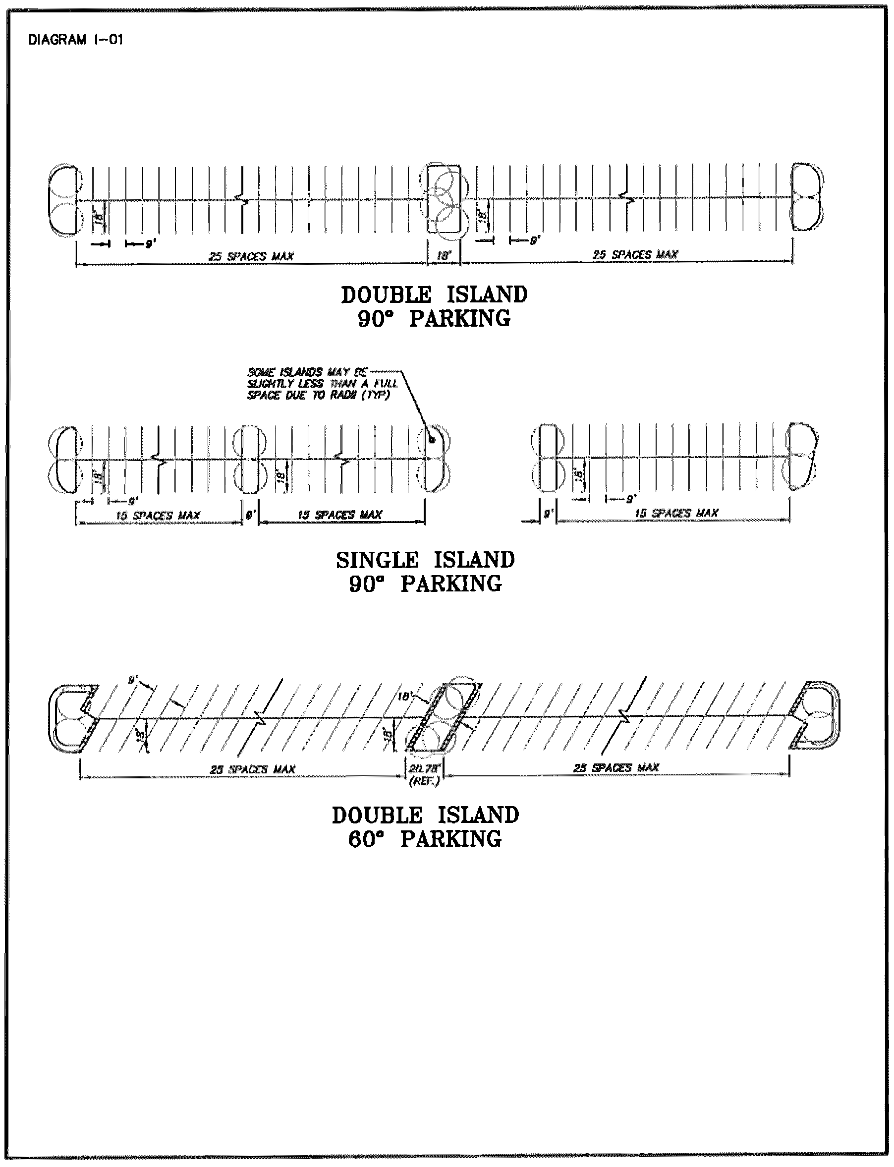
Article 1 - General Landscape Standards
The following standards apply to the 4.1 acre site at the intersection of Scripture and I-35 service road (NE corner):
A.
Landscape Plan.
1.
Landscape Plans must be reviewed and approved by the City staff for each phase of the development.
2.
The site shall maintain a minimum average landscaped area of 20%.
B.
Open Space Requirements.
1.
The site shall maintain a minimum average open space of 28%. Open space includes all surface areas of the project that are not covered with enclosed buildings, or parking and drive areas. Pedestrian plazas sidewalks covered or uncovered are calculated towards total open space.
C.
Parking Field Requirements. The site will incorporate the following planting standards in all parking areas:
1.
Landscape Islands. There will be a minimum of one planted island for every 15 linear parking spaces. This planting island shall be approximately the same size as one (1) standard parking space. Each island shall contain at least one shade tree (2" min. cal.) from the Approved Plant List (see Appendix A). Alternatively, there will be a minimum of one planted island for every 25 linear parking spaces. This planting island shall be approximately the same size as 2 standard parking spaces. Each island shall contain at least 2 shade trees (2" min. cal.) from the Approved Plant List (see Appendix A). Ground cover within the island shall be 100% turf, shrub, planted groundcover, gravel, or mulch or combination thereof. See Diagram 1 for an example layout of landscape islands. The average distance between planting islands shall be 11 linear parking spaces.
2.
End Islands. There shall also be an end island for every parking row. This end island shall be approximately the same size as one (1) standard parking space. Each island shall contain at least one shade tree (2" min. cal.) from the Approved Plant List (see Appendix A). An example of the end islands can be found in Diagram 1. Ground cover within the island shall be 100% turf, shrub, planted groundcover, gravel, or mulch or combination thereof.
3.
Minor Amendments. The City Manager may approve alternate tree locations utilizing the minor amendment process to avoid conflicts with utilities as defined in the Denton Development Code.
4.
Tree Spacing From Public Utilities.
a.
Water and Wastewater Lines - No trees shall be planted closer than nine (9) feet from any public underground water or wastewater utility main unless applicable staff approves a special circumstance. The location of the water or wastewater utility line shall be considered, for distance purposes, to be the surface of the ground above the line.
b.
Fire Hydrants - No trees shall be planted closer than 10 feet from any fire hydrant.
Article 2 - Buffers and Screening
A.
Refuse Container Screen. Trash receptacles shall be screened in accordance with Article 1.A.1 of the Rayzor Ranch Architectural Standards. The construction of refuse screening areas must comply with the Solid Waste Criteria Manual and Section 7.12 of the Denton Development Code.
B.
Service Corridor Screen. When adjacent to residential uses, commercial and industrial service corridors shall be screened. Siting and design of such service areas shall reduce the adverse effects of noise, odor and visual clutter upon adjacent residential uses.
C.
Mechanical Equipment Screen. All mechanical equipment shall be screened from any public right-of-way. Ground mounted equipment can be screened with evergreen shrubbery or masonry or concrete screen wall. Gates, if incorporated in the design of the screen wall, can be constructed of metal. Screening is subject to approval by the appropriate controlling utility.
D.
Outdoor Storage. All outside storage shall comply with the provisions of Sections 5.4.4D and 7.7.8E of the Denton Development Code, unless modified by the Architectural Standards.
Article 3 - Access, Parking, and Circulation Requirements
A.
External to the Development.
1.
Vehicular Access I Access Management. The site shall provide access that complies with Access Management principles of location, spacing and sharing of curb cuts, and shall provide adequate stacking distance for all entrances.
2.
Pedestrian Access. All developments shall provide pedestrian access by linking to any adjacent sidewalk(s), multi-use path(s) or public transportation stop.
B.
Internal to the Development.
1.
Vehicular Circulation.
a.
Internal circulation shall be well defined by use of end caps and landscaped areas.
b.
Cross Access: Prior to division of property, circulation and access standards shall be applied and, if necessary, cross easements shall be required so that access to all properties created by the subdivision can be made from shared curb cuts.
Article 4 - Parking Lot Landscaping and Screening Standards
In addition to Article 1 above, all parking lots, which for purposes of this section, include areas of vehicle maneuvering, parking, and loading, shall be landscaped and screened as follows:
A.
Landscape Standards.
1.
A minimum of 10% of the total parking area shall be landscaped.
2.
A minimum of 22% of the required parking shall be covered by tree canopy. The tree canopy goal within the parking area shall be 25%. Staff will work with the applicant to provide flexibility in the event of utility conflicts or other unforeseen circumstances.
3.
The tree species shall be an appropriate shade tree and shall be selected from the Approved Plant List (see Appendix A).
4.
Poly-coated chain link fencing is allowed for security and utilitarian purposes, but is not considered a screening fence. The poly-coated chain link fence cannot be visible from public roads or pedestrian areas.
B.
Screening at Right-of-Way. Parking is allowed in front of a building if the parcel meets the following design standards:
1.
Parking lots shall be separated from the street frontage by a minimum 15 foot wide Right-of-Way Screening Landscape Area to reduce visual impacts.
2.
The minimum 15 foot wide Right-of-Way Screening Landscape Area is the area located between the right-of-way and the parking lot. Utility easements are allowed to count towards part of the 15-foot wide Right-of-Way Screening Landscape area subject to required separation from utilities.
3.
The number of large trees required will be calculated by providing one (1) large tree for every 45 linear feet of the Right-of-Way Screening Landscape Area. The required numbers of trees do not have to be planted on 45-foot centers, but can be clustered.
4.
A minimum of three small accent trees clustered every 30 linear feet within the Right-of-Way Screening Landscape Area may be substituted for the large tree requirement.
5.
At least one or any combination of the following shall be used to help screen the parking lot:
a.
Xeriscape landscaping may be planted within the Right-of-Way Screening Landscape Area. Xeriscape landscaping shall require water irrigation for a period of three years for landscaping to be established. After three years, no irrigation is required;
b.
A minimum three foot high, when mature, row of evergreen shrubs planted within the Right-of-Way Screening Landscape Area. The shrubs may be grouped and not planted in a continuous row provided that the shrubs overlap to form a continuous buffer;
c.
A minimum three-foot high continuous wall made of any combination of wrought iron, masonry, or stone within the Right-of-Way Screening Landscape Area. If wrought iron is used, vines shall be grown on the wrought iron to help screen the parking lot; or
d.
A grass or landscaped berm, three feet high above the parking pavement surface.
Article 5 - Tree Maintenance and Tree Mitigation
A.
Each replacement tree shall have a minimum caliper of two (2) inches, measured six (6) inches above grade and must be at least five (5) feet tall when planted.
B.
All replacement trees must be Large Canopy Trees from the Approved Plant List found in Appendix A.
C.
A performance bond is required prior to the issuance of a building permit for each phase of Rayzor Ranch. The purpose of the performance bond is to ensure that the landscape and trees are planted and well maintained. Upon completion of the three (3) year establishment period for all plantings within the Rayzor Ranch project, the City shall inspect the trees to determine if 90% of the trees are healthy and have a reasonable chance of surviving to maturity. Upon such a finding, the City shall release the performance bond. If the applicant does not take remedial steps to bring the property into compliance, the City shall make demand for payment of the bond. The City may use all legal remedies to enforce this requirement, in addition making demand on the bond.
D.
Tree mitigation will also be subject to the criteria established in Section 4.8.8 of the Rayzor Ranch District.
Article 6 - Amendments to the Landscape Plan
The City Manager may authorize minor changes in the landscape plan and plant materials that otherwise comply with the Overlay District ordinance and do not:
1.
Reduce the perimeter landscape buffer strip shown on the original landscape plan;
2.
Detrimentally affect the original landscape plan's aesthetic function relative to adjacent right-of-way or surrounding property; or
3.
Detrimentally affect the original landscape plan's screening or buffering function.
Appendix A
Approved Plan List
Canopy Trees
Mature Canopy 314-1256 sq. ft. - Site Design Criteria Manual
Ornamental Trees
Mature Canopy 79-314 sq. ft. - Site Criteria Manual
Shrubs
Grasses/Ground Cover/Vines
APPENDIX B
TREE MITIGATION CHART
Rayzor Ranch Mitigation Chart
North Site
Total caliper inches of trees taken down and still remaining is 7713.
161 caliper inches of the 7713 are Quality/Protected Trees
5524 Caliper inches of the 7713 inches were taken down
2189 Caliper inches of the 7713 inches are remaining
7713 inches -161 Inches of Quality/Protected Trees = 7552 inches
7552 are Secondary Trees requiring 12.5% mitigation = 944 caliper inches
161 are Quality/Protected Trees requiring 1:2 or 1:1.5 mitigation
At the worst case scenario 1:2 = 322 caliper inches
Total caliper inches to mitigate = 944 + 322 = 1266 inches
This is 633 trees (assuming mitigation is with 2" caliper trees)
South Site
Trees to Preserve:
3 Quality Trees = 42.4 inches
2 Protected Trees = 43.5 inches
Total caliper inches to preserve = 85.9 inches
Trees to Mitigate:
34 Quality Trees = 351.1 inches
6 Protected Trees = 298.6 inches
2 Large Secondary = 49.4 inches
18 Secondary = 23.25 inches
Total caliper inches to mitigate = 457.25 inches
This is 229 trees (assuming mitigation is with 2" caliper trees)
Mitigation Total of North and South Sites = 1724.25 inches
Preservation Total of North and South Sites = 85.9 inches
*This mitigation plan is a proposed plan. If any transplanted trees die within the first year, the developer will replace the trees with the equivalent number of caliper inches.
APPENDIX C
LANDSCAPE CHART
Rayzor Ranch South Campus Landscape Charts
Land areas do not include Cook Children's, Public Roads. JME site or Drill Site.
Diagram 1 - Parking Lot Landscape Islands
Article 1 - Definitions
The definitions set forth in Subpart B, Chapter 33: Signs and Advertising Devices, of the City Code of Ordinances govern in the Rayzor Ranch Special Sign District, except as modified below:
A.
Awning sign. A sign with its copy on a shelter made of any material, such as fabric, flexible plastic or metal, that is supported by or stretched over a frame and attached to an exterior wall of a building or other structure.
B.
Banner. A sign attached to or applied on a strip of cloth, vinyl, or similar material and attached to a pole.
C.
Blade. A sign attached to a wall which perpendicularly projects out by more than four inches (4") which is mounted with at least eighty inches (80") clearance from the bottom of the sign to grade (sidewalk or ground).
D.
Canopy sign. A sign that is mounted, painted, or otherwise applied on or attached to a canopy or structural protective cover over an outdoor area.
E.
Changeable Message Sign. A sign displaying static images that may display different designs, messages, or advertisements and that may include LED/LCD elements; slide lettering, or other changeable message technology. The message or image cannot flash or change more often than once every 30 seconds.
F.
Effective Area. Effective area means the area enclosed by the smallest imaginary regular shape (e.g., parallelogram, triangle, circle, trapezoid), or combination of regular shapes that will encompass the extreme limits of the writing, representation, emblem, or other display, together with any material or color forming an integral part of the display or used to differentiate the sign from the backdrop or structure against which it is placed. Effective area does not include such features as decorative or ornamental elements or features, borders, trims or any supporting structure which is used solely for support of the sign, such as poles, columns and cable or decorative fence, screening device or wall. An example of Effective area can be found as Appendix 6.
G.
Exterior Building Wall. A wall that fronts on a street, drive, parking lot or public area.
H.
Illuminated sign. Any sign that is directly lighted by any electrical light source, internal or external. This definition does not include signs that are illuminated by street lights or other light sources owned by any public agency or light sources that are specifically operated for the purpose of lighting the area in which the sign is located rather than the sign itself.
I.
Project Announcement Signs. A temporary sign that is used to announce upcoming events such as "Grand Opening" or "Coming Soon" or upcoming tenant.
J.
Project Banner. A sign attached to or applied on a strip of cloth, vinyl, or similar material and attached to a pole or light standard. An example of a Project Banner sign is included as Exhibit 3. Project Banners may have an area up to 15 square feet. A permit is not required to install a Project Banner sign.
K.
Pylon Sign. A tall ground sign (20 feet or more in height) identifying a district or marking an entrance, which can incorporate multiple tenant listings.
L.
Sandwich Board. Two large boards bearing a sign display on each side, hinged at the top with one board in front and the other behind creating an "A" frame, used for advertising.
M.
Secondary Sign. A sign that does not identify the tenant, but references goods sold or services performed in the facility. Please see an example of the secondary signage in Appendix 4.
Article 2 - Administrations and Enforcement
All signs shall be erected, displayed, altered and reconstructed in conformance with the Rayzor Ranch Sign District and applicable City regulations.
Article 3 - RRM-1 and RRM-2 Districts
The following regulations shall apply to the RRM-1 and RRM-2 Subareas of Rayzor Ranch north of U.S. 380 as shown on the Concept Plan for Rayzor Ranch. No permits for signs shall be issued for the areas south of U.S. 380 in Rayzor Ranch until standards are reviewed and approved by City Council at a later date.
A.
Type. Pylon, gateway, monument, wall, attached, changeable message, sandwich board ("A" frame signs), blade, banner and temporary signs are permitted in nonresidential districts as follows:
1.
Pylon signs. (Reference Appendix 1 for sign location, Appendix 2 for sign details and dimensions and Appendix 6 showing how to measure sign area).
a.
One (1) pylon sign is allowed on the road frontage of IH35N located north of Highway 380 in the Rayzor Ranch Market Place with a maximum allowable height of sixty feet (60') and an allowable sign area of nine hundred (900) square feet per sign side and maximum effective sign area of seven hundred (700) square feet per sign side.
b.
Two (2) pylon signs are allowed on the Rayzor Ranch Market Place side of Highway 380 with a maximum allowable height of forty feet (40') and an allowable sign area of eight hundred (800) square feet per sign side and a maximum effective sign area of seven hundred (700) square feet per sign side.
c.
One (1) pylon sign is allowed on the Rayzor Ranch Market Place side of Bonnie Brae with a maximum allowable height of twenty feet (20') and an allowable sign area of four hundred (400) square feet per sign side and a maximum effective sign area of three hundred (300) square feet per sign side.
d.
All pylon signs are allowed to display the names of any other tenants in Rayzor Ranch.
e.
Pylon signs are subject to the minimum setbacks of Chapter 33: Signs and Advertising Devices of the Code of Ordinances unless its proximity to a single-family residence would dictate a larger setback according to Chapter 33: Signs and Advertising Devices of the Code of Ordinances.
2.
Monument signs.
a.
Monument signs may only be located as shown on Appendix 1 and must be constructed in accordance with the Monument Sign Elevations shown in Appendix 2.
b.
The maximum height of a monument sign is eight (8) feet and the maximum effective area is 100 square feet per sign side.
c.
All monument signs must comply with the visibility obstruction requirements detailed in Chapter 33: Signs and Advertising Devices of the Code of Ordinances.
3.
Attached signs. Attached signs include wall, canopy and awning signs.
a.
One (1) canopy sign is permitted per tenant for each storefront opening.
b.
One (1) fixed awning sign is permitted per awning located within the Rayzor Ranch Sign District. Awning signs are allowed in addition to canopy signs.
c.
An attached canopy sign shall not extend upward to a height greater than the highest part of the roof or any exterior wall on which it is mounted.
d.
The total square footage of all attached signs shall not exceed twenty (20) percent of the entire wall area on which such signs are located.
e.
A freestanding building is allowed one (1) wall sign per tenant for each public street or circulation drive or parking lot frontage, except as noted below for secondary signage. Multiple secondary wall signs are allowed. Wall signs shall not exceed 70% of length of the building side to which it is attached. The signage on the frontage of the store or building can be as follows:
i)
Tenants in buildings adjacent to Hwy 380, and tenants of outparcels fronting Hwy 380 are allowed a maximum letter height of 30-inches. If two lines of signage are used, each letter shall not exceed 24-inches. Tenant national logo/badge may exceed this height by up to 20%.
ii)
Tenants less than 10,000 s.f in the remaining buildings can have wall signs with a maximum letter height of 36-inches. If two lines of signage are used, each letter shall not exceed 28-inches. Tenant national logo/badge may exceed this height by up to 20%.
iii)
Tenants 10,000 s.f to 15,000 s.f. are allowed a maximum letter height of 48-inches and 36-inches on a second line or secondary signage. Tenant national logo/badge/lettering may exceed this height by up to 20%.
iv)
Tenants 15,000 s.f to 25,000 s.f are allowed a maximum letter height of 60-inches on one line and 42" on a second line or secondary signage. Tenant national logo/badge/lettering may exceed this height by up to 20%.
v)
Tenants 25,000 s.f to 80,000 s.f. are allowed a maximum letter height of 72-inches on one line and 48-inches on a second line or secondary signage. Tenant national logo/badge/lettering may exceed this height by up to 20%.
vi)
Tenants in excess of 80,000 s.f. are allowed a maximum letter height of 78-inches on one line and 48-inches on a second line or secondary signage. Logos/badges/lettering up to a maximum dimension of 120" on a side.
vii)
If tenant is a corner tenant, with an Exterior Building Wall, signage will be allowed on each side of the Exterior Building Wall. If tenant is on a freestanding pad, signage will be allowed on each side with frontage to the public.
viii)
Wall signs depicting a commercial message on the rear of buildings are not permitted if they are facing residential areas. Wall signs depicting informational or directional messages signs are allowed on the rear of buildings facing residential areas. However, no rear wall signs, except for directional or informational signs, are allowed on the north wall of the buildings located in the RRM-2 District.
f.
On multi-tenant buildings adjacent to Hwy 380 or the main drive, rear wall signs are permitted. They shall be grouped and shall be exterior illuminated from ground or wall in the designated sign areas.
g.
Signs shall be composed of individual, freestanding letters unless this conflicts with a part of the tenant's national identity. The freestanding letters may be placed on a backing plate. Signs that propose non freestanding letters are allowed. All necessary sign supports and electrical connections shall be concealed.
h.
Illuminated signs must derive light from a concealed source, except exposed neon signs must be enclosed within a can and have a clear cover of Plexiglas. No exposed lamps, or tubes will be permitted. The minimum depth for illuminated signs shall be four (4) inches. Illuminated signs may be "pegged out" from mounting surface for silhouette effects.
i.
Flat wall signs shall not extend more than 12 inches beyond the surface to which the sign is mounted.
4.
Reserved.
5.
Sandwich board signs or "A" frame signs.
a.
Maximum sign height shall be three (3) feet.
b.
Maximum sign width shall be two (2) feet and sign shall not be placed in front of adjoining.
c.
Signs must be properly anchored (temporarily) or weighted against the wind.
d.
Chalkboards or changeable letters may be used for daily changing messages.
e.
Signs shall be designed and constructed so as to promote and not visually obscure the significant architectural features of the Rayzor Ranch Development.
f.
Signs must be removed after business hours.
g.
Sidewalks must be at least ten (10) feet wide in order to erect or maintain a sandwich board or "A" frame sign.
6.
Blade Signs. One (1) blade sign, with a maximum area of 10 square feet, is permitted per tenant located within the Rayzor Ranch Sign District. Corner tenants are permitted two (2) blade signs (one on each storefront opening or entry). Refer to Appendix 3 for an example of a Blade Sign.
7.
Temporary Signs. The following types of temporary signs shall be permitted within the Rayzor Ranch Sign District, subject to the limits of Section 33.16 of Chapter 33: Signs and Advertising Devices of the Code of Ordinances:
a.
Project Announcement Signs. Rayzor Ranch Development Project Announcement Signs are allowed not exceeding 100 square feet per maximum effective sign area for the purposes of selling or leasing parcels. All project announcements signs must be at least 200 feet apart. Project Announcement Signs shall be removed within 30 days after an occupancy permit is issued. All Project Announcement Signs must be constructed with a metal frame and have acrylic or metal panels and comply with the Rayzor Ranch Color Palate adopted as part of the Rayzor Ranch Architectural Standards. A typical Project Announcement Sign can be found in Appendix 5.
b.
Land available and Real Estate Signs. Signs offering land available for sale or lease shall be limited to 96 square feet per sale or lease parcel provided that no more than one sign be installed for each 300 feet of frontage. All Land Available and Real Estate Signs must be constructed with a metal frame and have acrylic or metal panels.
c.
Wind Device Signs. On premise, banners, and windblown signs such as pennants, flags, and streamers for special events and grand openings shall be permitted provided they do not exceed 20 square feet in area. There shall be no limit to the number of wind device signs along main circulation routes within the Rayzor Ranch overlay districts where said signs are not visible from Highway 380, I-35 or Bonnie Brae.
8.
Informational/Incidental Signs. Minor signs such as drive-thru directional signs, gas pricing signs or traffic control signs shall be permitted as allowed under the applicable City of Denton codes.
9.
Project Banners. Banners are allowed on lampposts in Rayzor Ranch. Each lamppost may have a total of two (2) banners. Project Banner signs must comply with Appendix 3.
10.
Setbacks. Interior lot lines do not trigger setbacks for sign purposes in the RRM-1 and RRM-2 Districts.
11.
Project Graphics. Scanner murals and other graphic elements with backing frame or support, and not containing a commercial message or part of National Trade Dress are allowed on all buildings and no permit is required to install these elements provided that the original installation of the Project Graphic was included as part of the building permit for the structure to which it is attached.
APPENDIX 1
PARTIAL SIGN LOCATION PLAN
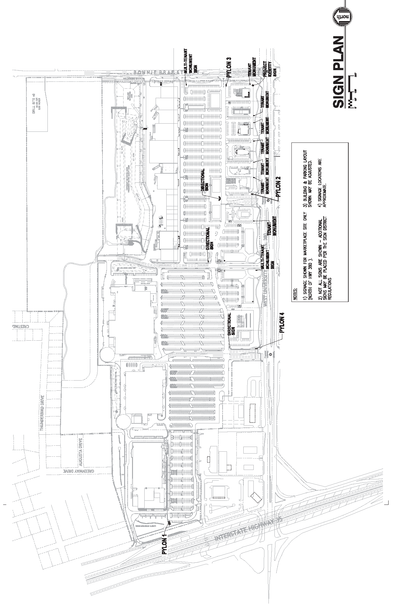
APPENDIX 2
MARKETPLACE SIGNS
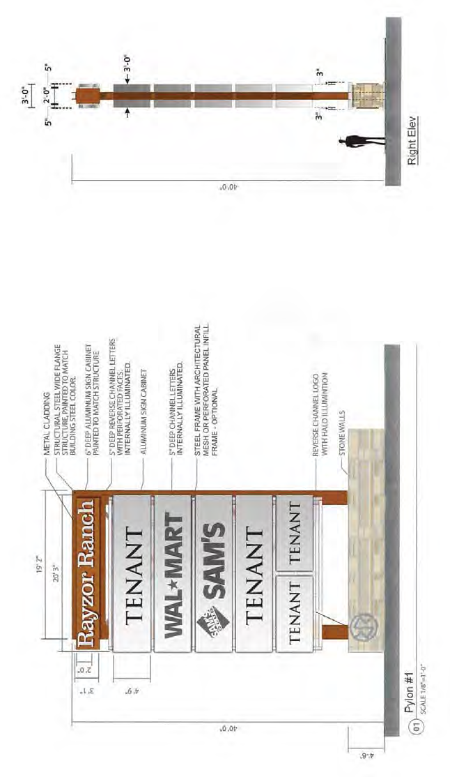
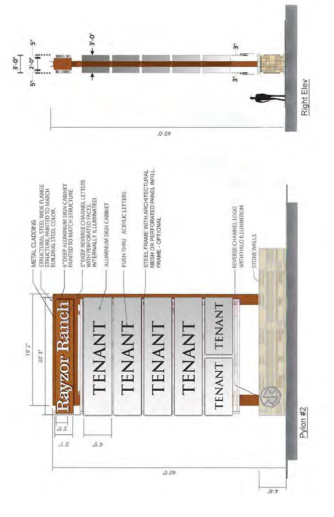
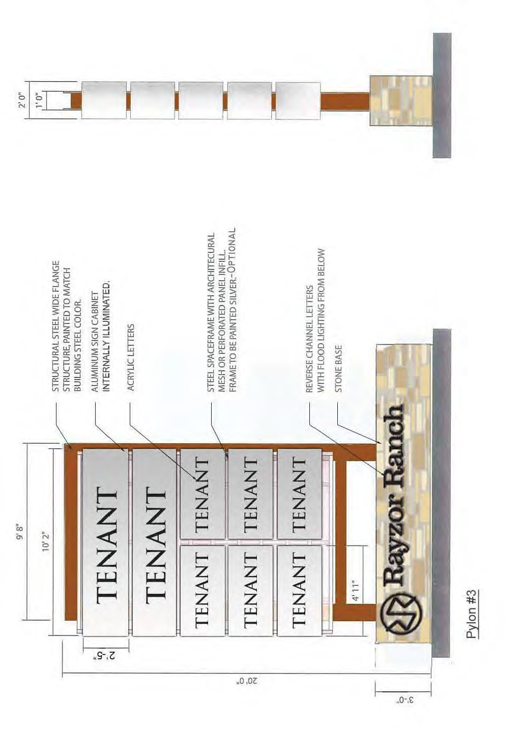
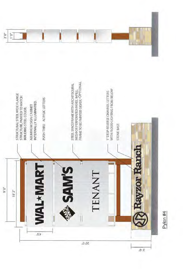
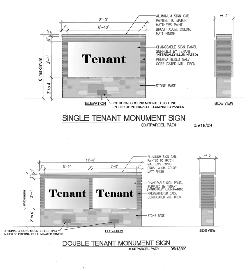
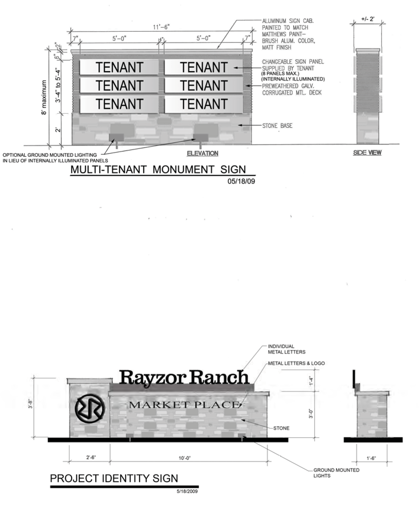
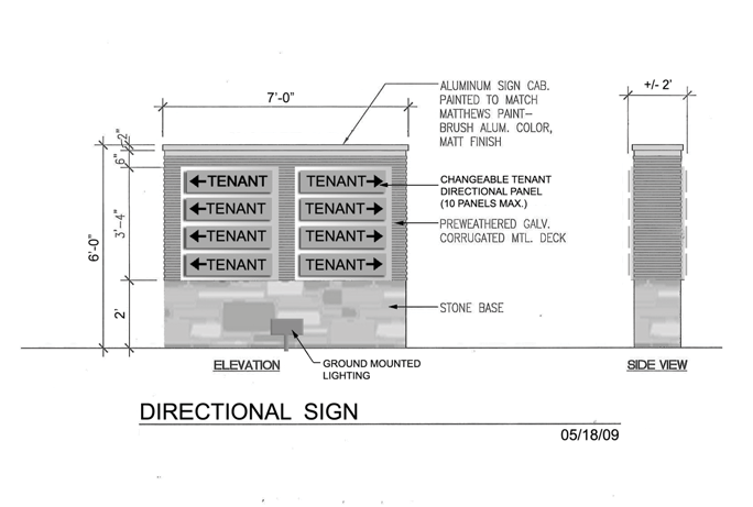
APPENDIX 3
BLADE AND PROJECT BANNER SIGN EXAMPLES
All signage examples attached are for illustrative purposes only and to further define size calculations required for various sign types. Examples are not indicative of the final graphics for the Rayzor Ranch Sign District.
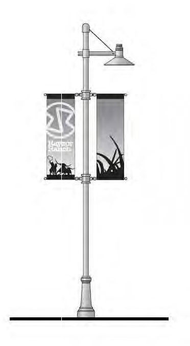
Blade and Project Banner Sign Examples
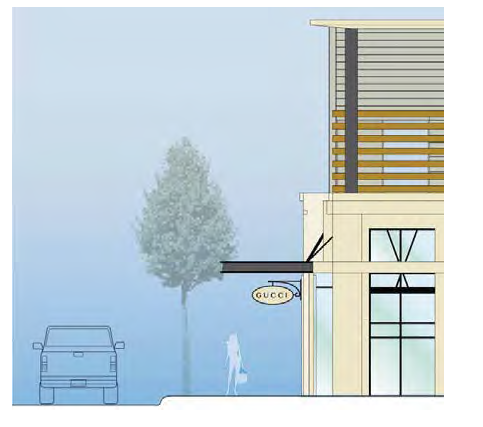
APPENDIX 4
SECONDARY SIGN EXAMPLE
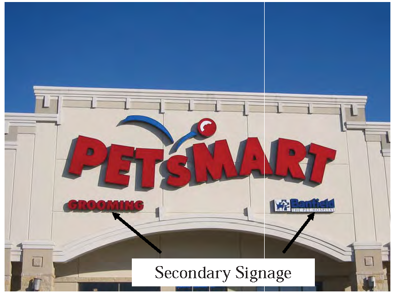
APPENDIX 5
PROJECT ANNOUNCEMENT SIGN EXAMPLE
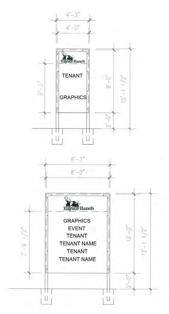
APPENDIX 6
EFFECTIVE AREA EXAMPLE
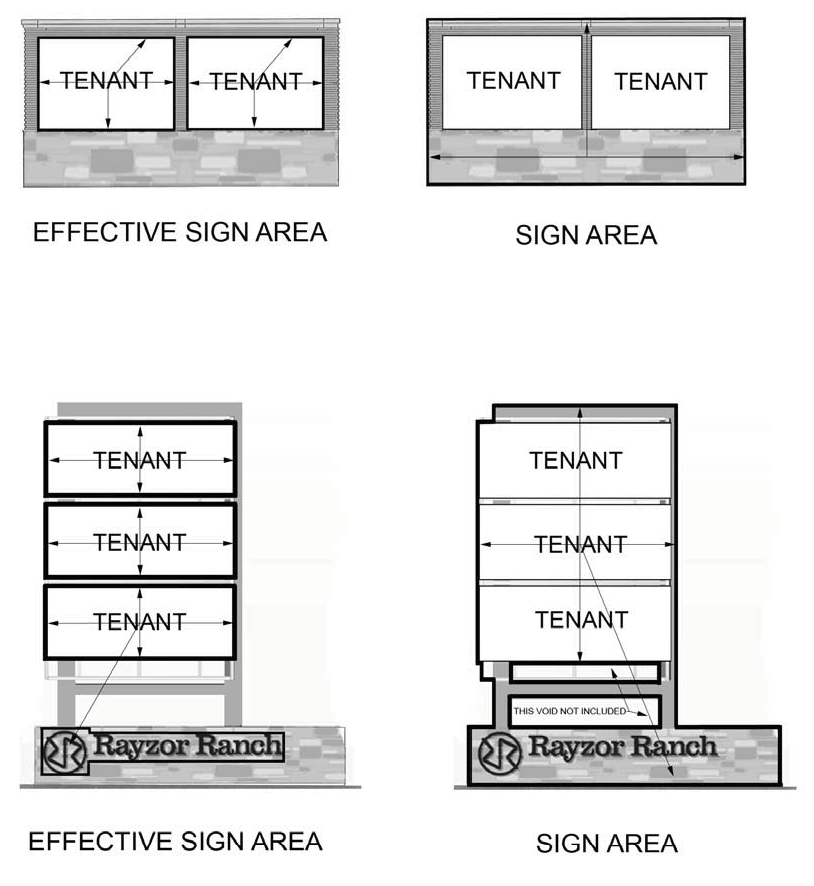
Article 1 - Definitions
The definitions set forth in Chapter 33: Signs and Advertising Devices of the City Code of Ordinances govern in the Rayzor Ranch Town Center Sign District, except as modified below:
A.
Awning Sign. Any sign with its copy on a shelter made of any material, such as fabric, flexible plastic or metal, that is supported by or stretched over a frame and attached to an exterior wall of a building or other structure.
B.
Banner. Any temporary sign attached to or applied on a strip of cloth, vinyl, or similar material. Project Banners and Project Announcement Signs are common banner uses.
C.
Blade. Any sign placed within the pedestrian zone either flag mounted to a building wall or suspended from overhead walkway cover, awning or intended to identify the entrance to a business.
D.
Canopy Sign. Any sign mounted, painted or otherwise applied directly upon or attached to a canopy or structural protective cover over an outdoor area.
E.
Changeable Message Sign. Any sign displaying static images that may display different designs, messages, or advertisements and that may include LED/LCD elements; slide lettering, or other changeable message technology.
F.
Construction Sign. Any temporary sign erected on the premises of an existing construction project and designating the architect, contractor, designer or builder, or developer, or the name and nature of the project.
G.
Directional (Way Finding) Sign. Any sign placed adjacent to driveways and along internal roadways within the project site for the purpose of directing both vehicular and/or pedestrian traffic.
H.
Directories. Directories are signs, cabinets, maps or other informational presentations of project site layout indicating the location of buildings, amenities, tenants and other site features to be read by pedestrians within the center area of Town Center.
I.
Effective Sign Area. That area in square feet of the smallest geometric figure or combination of regular geometric figures which figure or figures entirely enclose both the copy and the sign face. Effective Sign Area does not include such features as decorative or ornamental elements or features, borders, trims or any supporting structure which is used solely for the support of the sign.
J.
Highway Sign. An on-premise or off-premise sign structure erected within 150 feet of the right-of-way, oriented to and intended to be read from a highway or freeway.
K.
Illuminated Sign. Any sign that is directly lighted by any electrical light source, internal or external. This definition does not include signs that are illuminated by street lights or other light sources owned by any public agency or light sources that are specifically operated for the purpose of lighting the area in which the sign is located rather than the sign itself.
L.
Kiosk Sign. Any sign attached, painted on or otherwise applied to the physical structure of a kiosk and does not project into the pedestrian way. Kiosks are permanent or temporary freestanding structures within the RRTC core area which are used for additional retail sales. The core area is further defined as the "main street" and/or "spine road" component of the RRTC that has retail buildings oriented inward towards the main street.
M.
Landscape Wall Sign. A freestanding sign architecturally integrated with the building, mounted on a screen or perimeter wall and having tenant identification, directional or information signage as individual letters or applied cabinets.
N.
Marquee. Any integral sign projecting over the storefront, typically over the main entrance of a hotel, theater, or other retail use which displays identity and/or details of the goods and services. Marquees are typically large in format and illuminated. Marquee signs are encouraged to add increased creativity and energy to the project.
O.
Monument Sign. Any ground sign which has a base made of stone, concrete, metal, routed wood planks or beams, brick or similar materials with concealed sign cabinet support.
P.
Mural. Graphic or artistic expression which is painted or applied to exterior or interior wall surfaces that is not commercial advertising in context.
Q.
Project Announcement Sign. A temporary sign that is used to announce upcoming events such as "Grand Opening" or "Coming Soon" or upcoming tenant.
R.
Project Banner Sign. A temporary or seasonal sign with project identity only that is used to provide aesthetics to the project through the addition of graphics and color, announce upcoming events. Project Banners are commonly mounted on street lights, placed in directories, or on sides of buildings.
S.
Projecting sign. Any sign other than a wind device sign, located above the pedestrian oriented space, which is wholly affixed to or supported by any building wall and which extends beyond the building wall more than twelve (12) inches.
T.
Project Landmark. A structure, sculpture, graphics, images or other form of art work consisting of one or more elements in composition creating an urban icon display for the project.
U.
Pylon Sign. Any ground sign greater than 20 feet or more in height identifying the project, a district or marking an entrance, which can incorporate multiple tenant listings. Highway Signs are considered a type of Pylon Sign.
V.
Roof Sign. Any sign erected upon the roof of any building or which is partially or totally supported by the roof or roof structure of the building.
W.
Sandwich Board. Two large boards bearing a sign display on each side, hinged at the top with one board in front and the other behind creating an "A" frame, used for advertising.
X.
Secondary Sign. Any sign or signage that does not identify the specific tenant name, but references general goods sold or services performed in the facility.
Y.
Tenant Sign/Building Sign/Facade Sign. Any sign that announces a tenant or name(s) of tenant(s) located on, attached to or otherwise applied to a building wall within the tenant's leased space.
Z.
3D - Graphics. Any sign, freestanding structure or figure made up of 3 dimensional objects, shapes or graphic elements at pedestrian scale for the enjoyment of patrons to the development intended to be a contextual link between the thematic design elements of the property or unique use.
See Appendix 3 for examples of the RRTC Sign District signage types.
Article 2 - Signage Regulations
A.
Setbacks. Pylon, Project Landmark, Landscape Wall, and Monument Signs ("Freestanding Signs") shall have setbacks as follows:
1.
Signs shall maintain a minimum setback of five (5) feet from the property line, public easements and/or rights-of-way line.
2.
Interior lot lines do not trigger setbacks for sign purposes in the TC, RRM-1 and RRM-2 Districts.
3.
All Freestanding Signs must comply with the visibility obstruction requirements detailed in Chapter 33: Signs and Advertising Devices, of the City Code of Ordinances.
B.
Allowable Number and Size of Sign.
1.
Freestanding Signs. This section sets forth the number and type of Freestanding Sign permitted on a parcel with public road and/or public access easement frontage.
a.
If such a parcel has frontage on more than one (1) street, highway, arterial, collector street or internal counterflow road, the signage for each shall be calculated separately depending on the length of each frontage.
b.
A parcel may display one Freestanding Sign for the first three hundred feet, or portion thereof, of frontage and one additional Freestanding Sign for each additional three hundred feet of frontage or portion thereof.
c.
Spacing for each additional sign permitted must be a minimum of sixty (60) feet from another permitted Freestanding Sign on the same parcel.
2.
Tenant Signs. Attached signs include all building, canopy and awning mounted signs. This section sets forth the size and location of attached Tenant Sign.
The total square footage of all attached signs shall not exceed thirty (30) percent of the entire wall area on which such signs are located and/or the following signage area restrictions:
a.
Sign Area 1 - Tenants in freestanding (pad) buildings in Sign Area 1 adjacent to U.S. 380, are allowed one (1) square foot per each lineal foot of building frontage, and for other elevations facing parking lots, three-quarter (.75) square foot per each lineal foot of elevation.
Signs are not restricted to any specific type. Tenant's national signage and graphic standards may be used.
b.
Sign Area 2 - Tenants in freestanding (pad) buildings in Sign Area 2 adjacent to IH 35, are allowed two (2) square foot per each lineal foot of building frontage, and for other elevations facing parking lots, one (1) square foot per each lineal foot of elevation.
Signs are not restricted to any specific type. Tenant's national signage and graphic standards may be used.
c.
Sign Area 3 - Tenants in freestanding (pad) buildings or in-line shops in Sign Area 3 (the internal core of Town Center), are allowed four (4) square foot per each lineal foot of main entrance frontage, and for other elevations facing parking lots, two (2) square foot per each lineal foot of elevation.
Signs are not restricted to any specific type. Tenant's national signage and graphic standards may be used. 3-dimensional and creative sign designs will be encouraged.
2.
Building signs shall not exceed an overall 75% in height and 80% of length of the architectural area to which it is attached and/or the following criteria, whichever is greater:
a.
Tenants less than 10,000 square feet are allowed a maximum letter height of 36-inches.
b.
Tenants 10,001 square feet to 15,000 square feet are allowed a maximum letter height of 48-inches.
c.
Tenants 15,001 square feet to 25,000 square feet are allowed a maximum letter height of 60-inches.
d.
Tenants 25,001 square feet to 80,000 square feet are allowed a maximum letter height of 72-inches.
e.
Tenants in excess of 80,001 square feet are allowed a maximum letter height of 84-inches.
3.
If tenant is a corner tenant, with an Exterior Building Wall, signage will be allowed on each side of the Exterior Building Wall. If tenant is on a freestanding pad, signage will be allowed on each elevation visible to the public.
Article 3 - Permanent signage standards
The following regulations shall apply to the RRTC which is south of U.S. 380/University Drive, east of IH 35, west of Heritage Trail and north of Scripture Street as shown on the Concept Plan for Rayzor Ranch.
A.
Sign Areas. There are three distinct signage areas defined geographically on the Sign Plan based on the land use, make up of users, the adjacent roadway speeds and accessibility for both identification and directional signs for the project and tenants.
a.
Sign Area 1 Pylon, and Monument signage for project and tenant identification along U.S. 380, which will complement the existing Marketplace signage.
b.
Sign Area 2 - Highway, Monument and directional signage for project and tenant identification along IH 35.
c.
Sign Area 3 - All signage for project, tenants and land uses within the core of the RRTC.
All signs shall be erected, displayed, altered and reconstructed in conformance with this RRTC Sign District and applicable City regulations not amended through this overlay district. All signs listed above in Article 1 as sign modifications to the Denton signage code shall be allowed in all nonresidential areas of the RRTC as follows:
B.
Allowable Signage Types Matrix.
NOTE: T = Tenant Signage; P = Project Signage
C.
Freestanding Signage Standards.
1.
Landscape Wall Signs. Used for project and tenant identification at entries to the project area.
a.
Such signs shall be placed within a landscaped setting containing not less than one hundred twenty (120) square feet. The maximum individual letter area for such signs shall not exceed one hundred (100) square feet if space allows.
b.
The maximum height of such sign shall be eight (8) feet.
c.
Individual letters shall not cover a percentage of wall surface area greater than fifty (50) percent.
2.
Monument Signs. Used for project and tenant identification at entrances to the project area and tenant identification for freestanding buildings and pad tenants.
a.
Monument signs shall be constructed in accordance with the Monument Sign Elevations shown in Appendix 4. Individual Monument Signs including Single Tenant, Double Tenant, Multi-Tenant and Project Identity Monument Signs may be located throughout the project at entrances, single tenant outlots and pads in accordance with the Signage Requirements in Article 2.
b.
The maximum height of a monument sign is eight (8) feet.
c.
Maximum sign area is 100 square feet sign.
d.
Spacing for multi monument signs adjacent to each other shall be a minimum of sixty feet (60').
3.
Project Landmark. The landmark may consist of one or more elements in composition, creating an urban icon for the project. It may contain multiple advertising and thematic elements including color and illumination techniques that will enliven and energize the site. The idea is to blend signage and public art or graphics.
a.
The advertising elements will each have a maximum allowable six hundred (600) square feet.
b.
The landmark will not be allowed to suspend over, nor into the public right-of-way, and will be limited to a maximum height of sixty-five (65) feet.
c.
The landmark area is allowed to display the names of any tenants in Rayzor Ranch.
d.
The landmark will be located either internal to the RRTC within the core or a long the I-35 frontage at potential locations as depicted on Appendix 2.
4.
Pylon Signs. See Appendix 2 for potential sign location details and Appendix 4 for details of each sign type.
a.
Highway signs (H1) are allowed on the road frontage of IH 35 located south of U.S. 380 in the RRTC with a maximum allowable height of seventy-five (75') feet measured from base of sign and an allowable sign area of twelve hundred (1,200) square feet per sign side.
i.
Highway signs are allowed to display the names of any tenants in Rayzor Ranch overall.
ii.
Highway signs are allowed or will be allowed to use changeable message signs as part of their design components if City Code allows or is amended to allow.
iii.
Highway signs are not subject to the minimum setbacks of Chapter 33: Signs and Advertising Devices, of the City Code of Ordinances as they are located in Sign Area 3 only.
iv.
Sign face shall not exceed 1,200 square feet with the electronic portion of the sign limited to a maximum 672 square feet. Sign face is not the same as sign area, which is detailed below.
b.
Highway Signs (H2) are allowed on the road frontage of IH 35 south of U.S. 380 in RRTC. H2 signs are intended to be repetitive thematic or decorative signs approximately equally spaced along the IH 35 corridor.
i.
Maximum height of forty-five feet (45') measured from base of sign.
ii.
Allowable sign area of four hundred (400) square feet per sign side.
c.
Primary pylon signs (P1) are allowed on the south side of U.S. 380.
i.
Maximum allowable height of forty feet (40') measured from base of sign.
ii.
Allowable sign area of eight hundred (800) square feet per sign side and a maximum effective sign area of seven hundred (700) square feet per sign side.
d.
Secondary pylon signs (P2) are allowed on the south side of U.S. 380 and the west side of Heritage Trail.
i.
Maximum allowable height of forty feet (40') measured from base of sign.
ii.
Allowable sign area of eight hundred (800) square feet per sign side and a maximum effective sign area of seven hundred (700) square feet per sign side.
e.
Pylon signs are subject to the minimum setbacks as established in Article 2 of this amendment unless its proximity to a single-family residence would dictate a larger setback according to Chapter 33: Signs and Advertising Devices, of the City Code of Ordinances.
f.
All pylon signs are allowed to display the names of any tenants in RRTC.
D.
Graphic Standards.
1.
Project Graphics. Murals (including scanner murals) and other graphic elements with backing frame or support, and not containing a commercial message or part of National Trade Dress are allowed on all buildings and no permit is required to install these elements provided that the original installation of the Project Graphic was included and approved as part of the building permit for the structure to which it is attached.
Project Banners. Used for identification, marketing or graphics for RRTC. Project Banners may have an area up to 15 square feet. Materials used can be fabric, vinyl or metal. A permit is not required to install a Project Banner.
E.
Attached Sign Standards. Signs should be designed to appear as an integral part of the architecture rather than as an after-thought.
Tenant identification signs should be designed to complement the design of the building in scale, placement and style, building color and finishes; fit within the overall environment; but should integrate bold colors, lighting, materials, and style.
Building and tenant identification signs should be designed to be visible and legible from the intended viewer's viewpoint.
Sign illumination may be innovative and incorporate a variety of lighting types, such as neon tubes, fiber optics, incandescent lamps, LEDs, cathode ray tubes, shielded spotlights, and wall washes.
1.
Blade.
a.
Sign area for Blade signs shall not be counted against tenants allowable sign area.
b.
Orientation may be perpendicular or parallel to store frontage.
c.
Each tenant may have one (1) blade sign, Corner tenants are permitted two (2) blade signs (one on each storefront opening or entry).
d.
Mounting height shall be a minimum of 84" from finished floor to lowest portion of sign element.
e.
Maximum sign area of ten (10) square feet is permitted and must be located at the tenant's primary entrance.
2.
Awning/Canopy/Marquee Signs.
a.
Signs on marquees shall be considered wall signs and shall be subject to the requirements established for wall signs.
b.
Signs on canopies and awnings shall be considered wall signs and shall be subject to the requirements established for wall signs. However, lettering which does not exceed seven inches in height which is displayed on the edge of a canopy or awning hanging perpendicular to the ground shall not be counted against the allowable signage area of a wall frontage.
c.
No portion of any canopy or awning shall be less than eight feet above the level of the sidewalk or other surface over which it projects.
d.
Awning signs may be illuminated indirectly or internally.
3.
Kiosk Sign.
a.
Kiosks will be allowed up to 20 square feet of signage.
b.
Attached to the physical body of the kiosk and does not extend beyond into a pedestrian walkway.
4.
Roof Sign.
a.
Roof signs may extend laterally beyond the exterior walls of the building and shall be securely attached.
b.
Signage area shall be calculated at one (1) square foot of signage for each one (1) lineal foot of building frontage. Sign area is limited to a maximum of 672 square feet per individual sign. This area is not calculated against any tenant, but as part of a place making allowance.
c.
If used for tenant identification and/or marketing, square footage shall be counted as part of the aggregate allowance of the specific tenant and within tenant's leased frontage.
5.
Informational/Incidental Signs. Minor signs such as drive-thru directional signs, gas pricing signs, traffic control signs and all other signage not referred to herein shall be permitted as allowed under the applicable City of Denton codes.
F.
Temporary Signage Standards. The following types of temporary signs shall be permitted within the RRTC Sign District, subject to the limits of Chapter 33: Signs and Advertising Devices, of the City Code of Ordinances, Temporary signs shall be permitted for periods up to 365 days.
1.
Construction Sign.
a.
Maximum of one hundred twenty (120) square feet per maximum sign area.
b.
Typical Construction Sign can be found in Appendix 3.
2.
Project Announcement Signs.
a.
Maximum of one hundred twenty (120) square feet per maximum effective sign area.
b.
All project announcements signs must be at least 200 feet apart. Project Announcement Signs shall be removed within 30 days after an occupancy permit is issued.
c.
All Project Announcement Signs must be constructed with a metal frame and have acrylic or metal panels and comply with the RRTC Color Palate adopted as part of the RRTC Architectural Standards.
d.
Typical Project Announcement Sign can be found in Appendix 3.
3.
Land available and Real Estate Signs. Signs offering land available for sale or lease.
a.
Maximum of ninety-six (96) square feet per sale or lease parcel provided that no more than one sign be installed for each 300 feet of frontage.
b.
Construction must be with a metal frame and have acrylic or metal panels.
c.
Typical Real Estate Signs can be found in Appendix 3.
4.
Sandwich Board.
a.
Maximum sign height shall be three (3) feet.
b.
Maximum sign width shall be two (2) feet and sign shall not be placed in front of adjoining tenant's storefront. Signs must be properly anchored (temporarily) or weighted against the wind.
c.
Chalkboards or changeable letters may be used for daily changing messages.
d.
Signs shall be designed and constructed so as to promote and not visually obscure the significant architectural features of the Rayzor Ranch Development.
e.
Signs must be removed after business hours.
f.
Sidewalks must be at least ten (10) feet wide in order to erect or maintain a sandwich board or "A" frame sign.
5.
Wind Device Signs. On premise, banners, and windblown signs such as pennants, flags, and streamers for special events and grand openings shall be permitted provided they:
a.
Do not exceed 20 square feet in area.
b.
There shall be no limit to the number of wind device signs along main circulation routes within the RRTC overlay districts where said signs are not visible from U.S. 380, IH 35 or Bonnie Brae and Scripture.
c.
Comply with the requirements for duration stated in Chapter 33: Signs and Advertising Devices of the City Code of Ordinances.
APPENDIX 1
SOUTH COMMERCIAL DISTRICT (SCD) AND TOWN CENTER (TC) SIGN AREAS
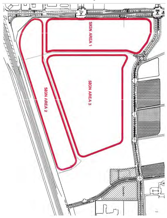
APPENDIX 2
SOUTH COMMERCIAL DISTRICT (SCD) AND TOWN CENTER(TC) CONCEPTUAL SIGN PLAN
Sign locations indicated are for illustrative purposes only and to further define use and proximity to project site features for various sign types. Final locations and use of signs will be identified in the approved site plan.
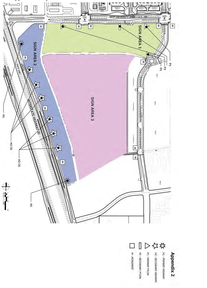
APPENDIX 3
SOUTH COMMERCIAL DISTRICT (SCD) AND TOWN CENTER (TC) SIGN EXAMPLES
All signage examples in Appendix 3 are for illustrative purposes only and to further define size calculations required for various sign types. Examples are not indicative of the final graphics for the RRTC Sign District.
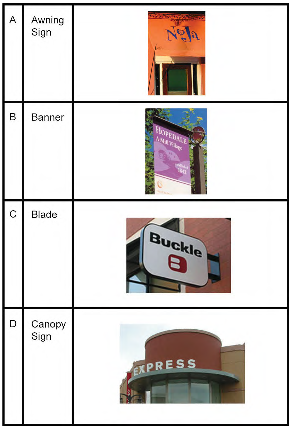
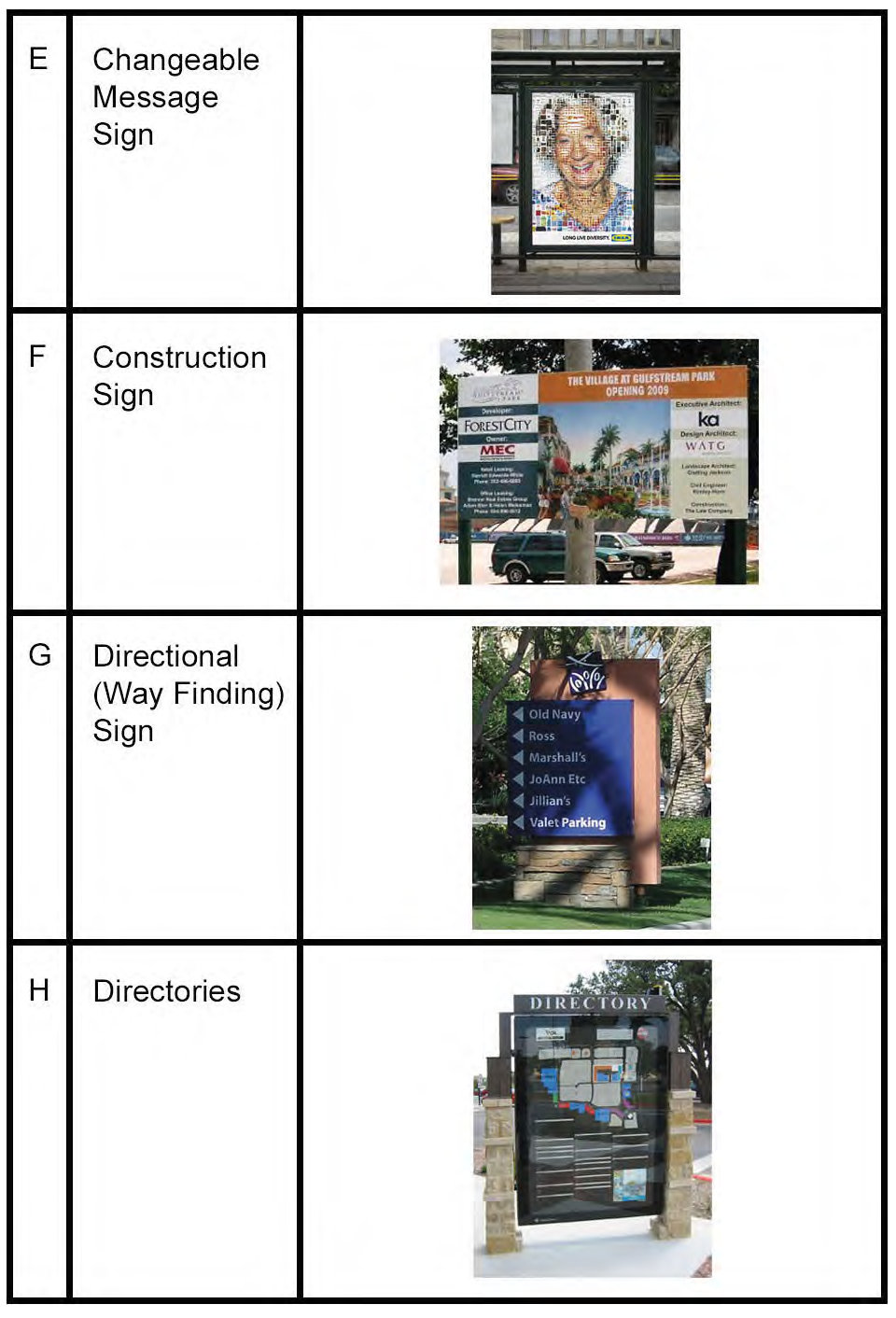
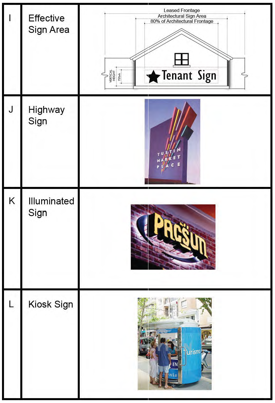
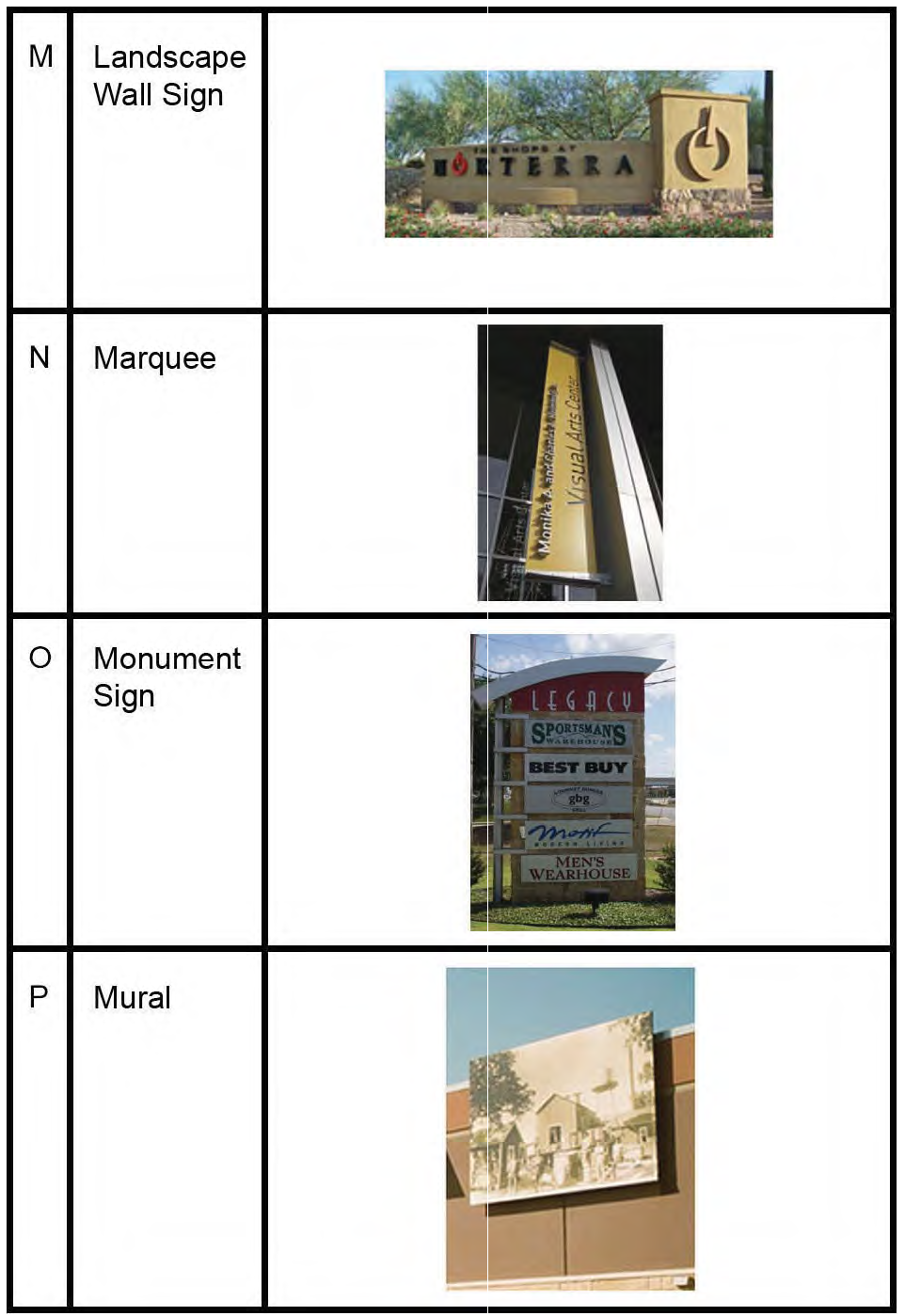
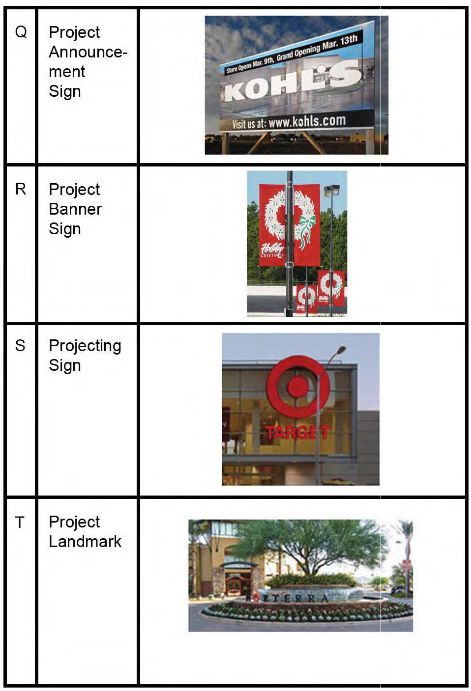
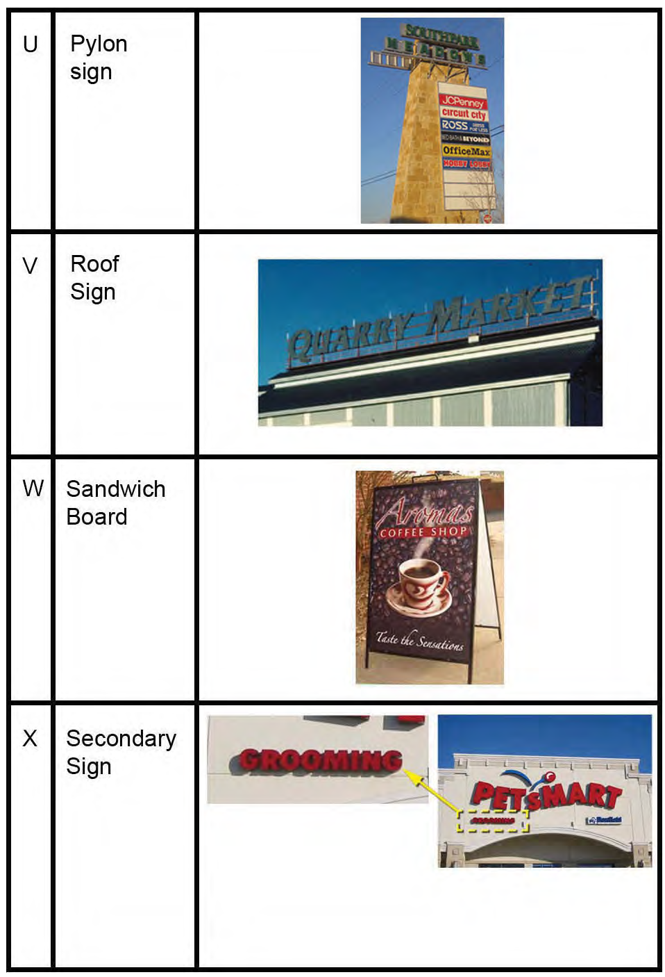
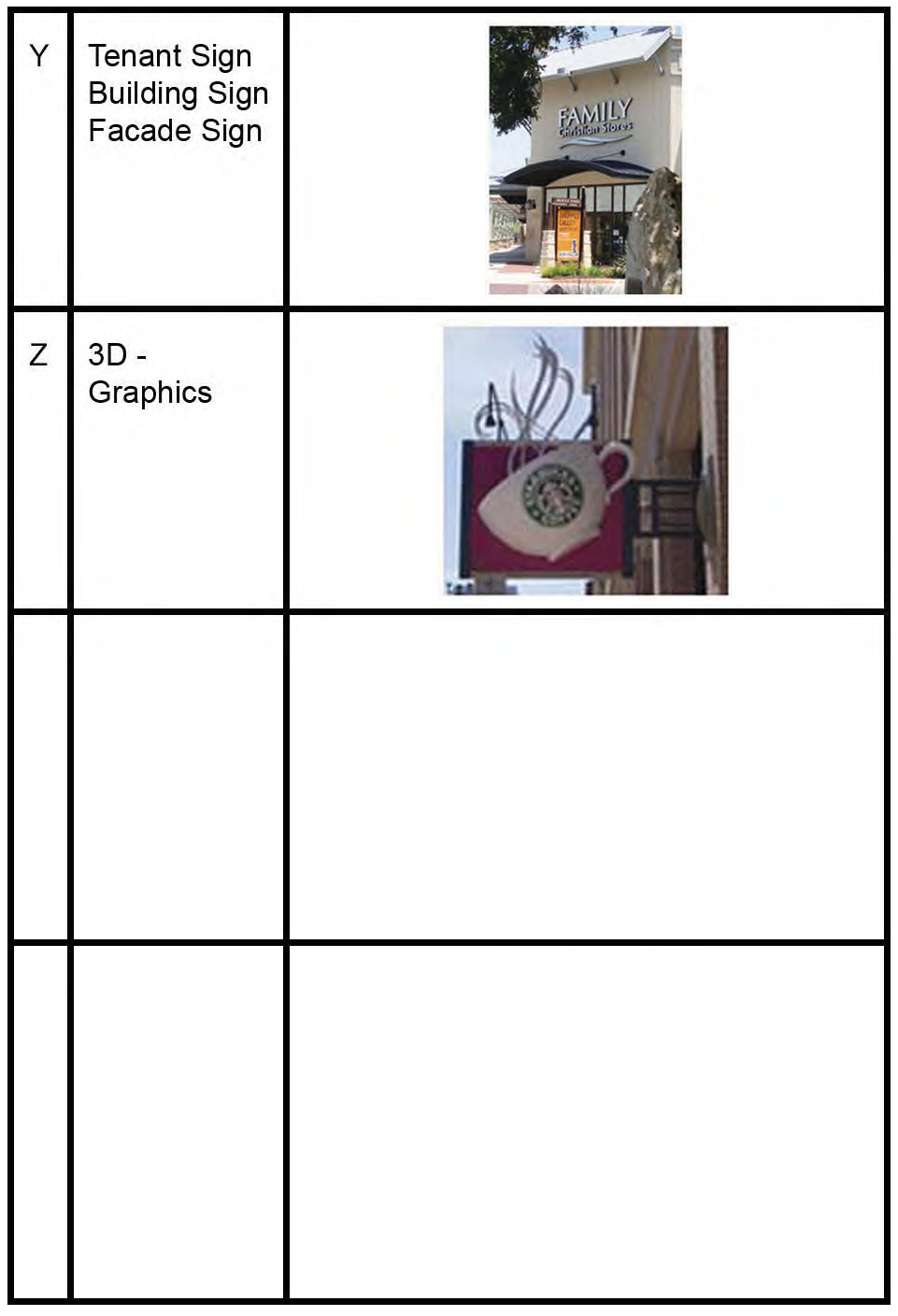
APPENDIX 4
SOUTH COMMERCIAL DISTRICT (SCD) AND TOWN CENTER (TC) CONCEPTUAL SIGN TYPES
All conceptual sign types shown in Appendix 4 are for illustrative purposes only and to further define size requirements for various sign types. Final design and construction drawings will vary.
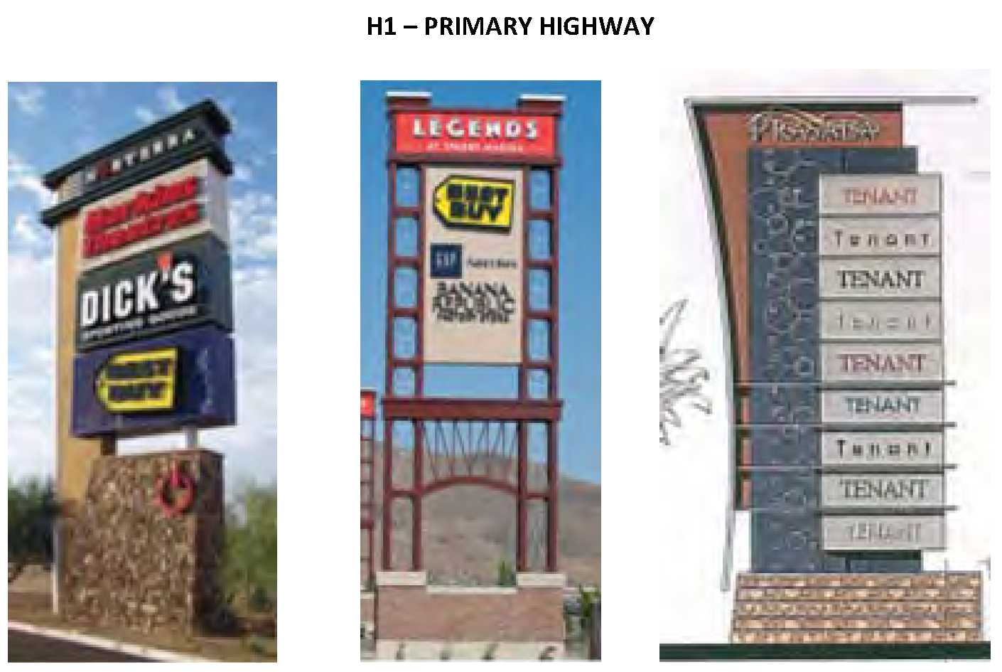
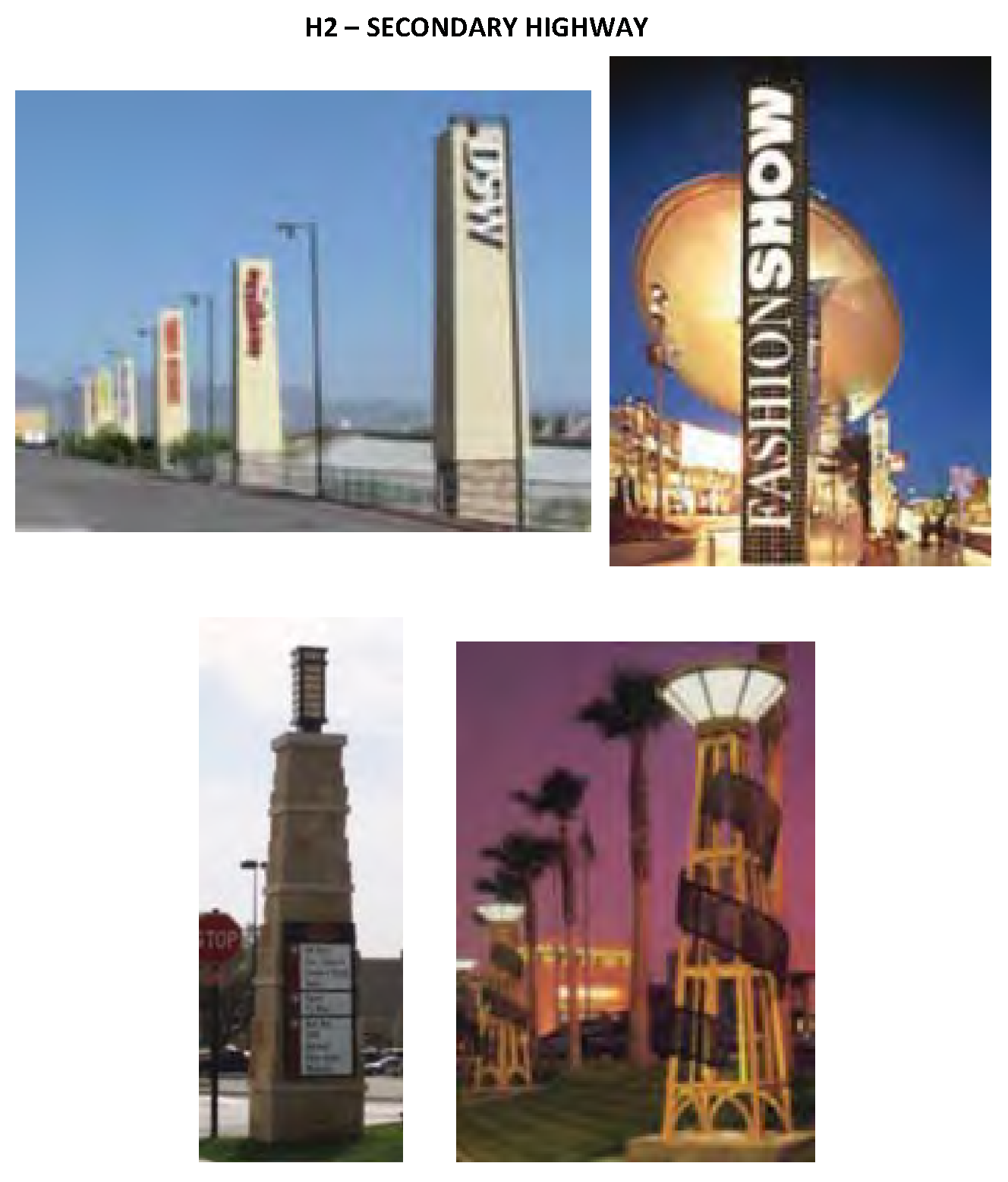
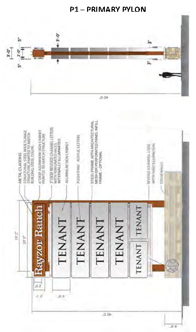
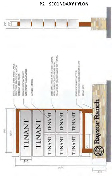
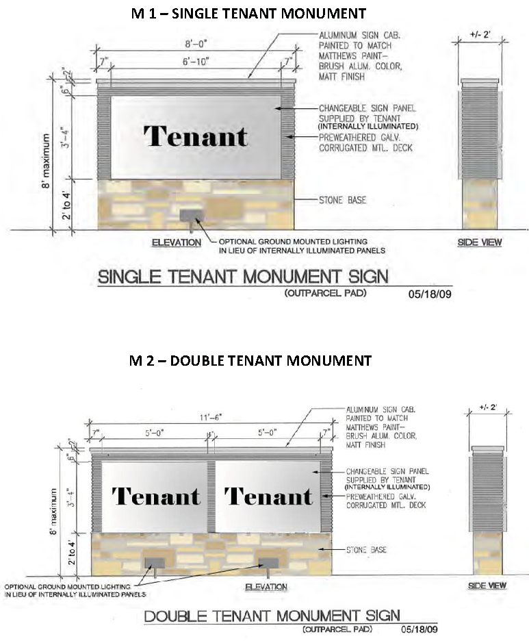
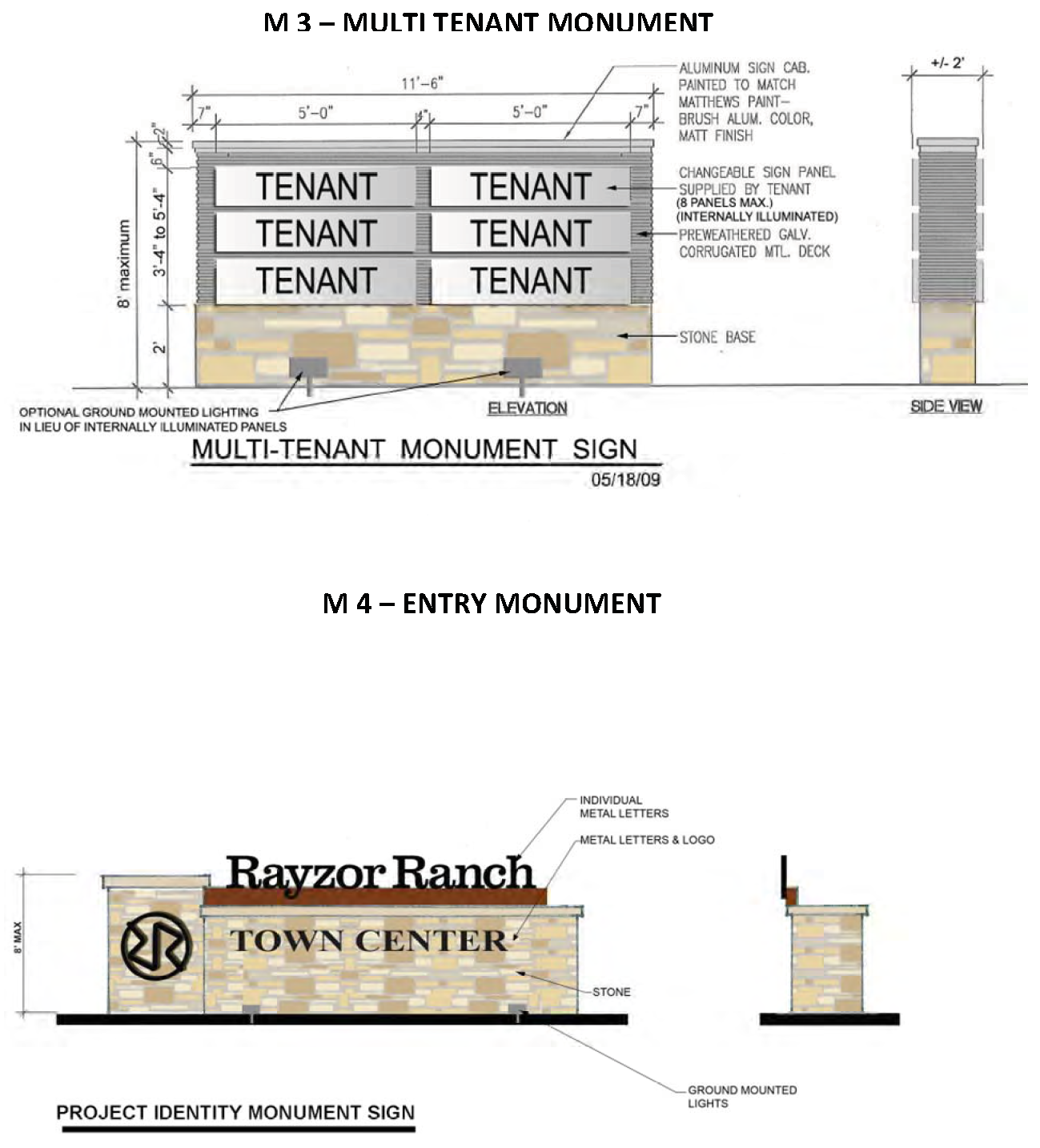
Article 1 - General Signage Standards
The following standards apply to the 4.1 acre site at the intersection of Scripture and I-35 service road (NE corner):
A.
Signage for Lot 1, Block 4 of Rayzor Ranch South shall conform to requirements found in the Sign regulations in Subchapter 33: Signs and Advertising Devices of the City Code of Ordinances.
1.0 - Purpose for Water Quality Protection
The stormwater runoff from approximately 200-acres of the proposed 400-acre Rayzor Ranch Development will drain directly into the North Lakes Park Pond on the east side of Bonnie Brae Street. The park pond has a normal dry weather surface area of approximately 21.3 acres, and provides flood control for Pecan Creek. This park pond also provides local fishing and recreation for Denton residents. Pollutants in urban runoff can include floatables (plastics, Styrofoam, paper, litter, and wood), oil and grease, sediments, nitrogen and phosphorous, heavy metals, and fecal coliform bacteria. Therefore, the urban runoff from the proposed Rayzor Ranch Development has the potential to adversely affect the watershed and the water quality in this pond. Because the pond functions as a detention basin, any untreated pollutants would be captured and stored in the pond, which could create visual pollution, degrade water quality, and adversely affect the aquatic habitat within the pond. Over time, the fishing resources and recreational benefits provided by the pond could decline. Stormwater quality structural controls and management practices, if properly incorporated and maintained as a part of the Rayzor Ranch Plan of Development, could significantly reduce the negative impacts to the park pond caused by urban development.
2.0 - Stormwater Quality Management Requirements
The North Central Texas Council of Governments (NCTCOG) has published the Integrated Stormwater Management Design Manual (iSWM) which provides an integrated planning and design approach for addressing water quality protection for urban runoff. The iSWM methods that address urban Water Quality are required for the area of the Rayzor Ranch Development (site) that drains into the North Lakes Park Pond. A Water Quality Protection Plan that provides stormwater quality controls consistent with the iSWM is required for the Rayzor Ranch Development in order to minimize adverse impacts to the Park property and to preserve and protect the park pond resource for the citizens of Denton.
The total pollutant removal efficiencies for each stormwater quality control system used on the site (at the outlet) shall be as follows (derived from iSWM):
Total Suspended Solids = 80
% Total Phosphorus = 60%
Total Nitrogen = 50% Fecal
Coliform = no reduction
Metals = 80%
In addition to the iSWM removal efficiencies, Trash Removal Efficiency (all floatable objects) = 95% by volume.
2.1 - Water Quality Protection Volume
The iSWM approach to control pollution from stormwater runoff treats a specified Water Quality Protection Volume (WQv) from each site or sub-area to reduce the percentage of post development pollutants. The rainfall analysis for iSWM determined that 1.5 inches of rainfall is the average depth corresponding to the 85th percentile storm for the NCTCOG region. Therefore, the runoff from the first 1.5 inches of rainfall on the watershed area is the WQv to be treated onsite prior to release into the North Lakes Park property. A stormwater management system designed for the WQv will treat the runoff volumes from all storm events of 1.5 inches or less, as well as a portion of the runoff for all larger storm events. The WQv is directly related to the amount of impervious cover, and will be calculated following the methodology in Section 1.2.3 of the iSWM Manual.
The site drainage analysis shall identify hot spot land uses (parking lot areas, service stations, trash receptacle areas, loading zones, etc.) with high pollution generating potential, and provide details of the proposed structural or non-structural stormwater controls showing how the runoff from these areas will be collected and treated prior to release into the storm drainage network that directly discharges into North Lakes Park.
Drainage area diversions to reduce the WQv will not be allowed.
2.1.1 - Water Quality Volume Reduction Methods
The use of non-structural stormwater control practices is encouraged provided that the proposed approach to reducing impervious cover is not in conflict with the City's Development Code, Design Criteria Manuals, or the City Fire Code. The required WQv to be treated may be reduced using the "'volume reduction methods" as presented in Section 1.2.3.2 of the iSWM Manual. Documentation (site plan or plat showing the area specified or reserved to allow the reduction in WQv) and calculations for WQv reductions will be submitted to the City for approval. The Denton Development Code requires stream buffers, and only stream buffer areas exceeding the requirements in the Denton Code can be used for WQv reduction,
2.2 - Site Design Credits
Site Design Credits are not computed or used in the City of Denton.
2.3 - Primary Structural Stormwater Controls
Primary Structural Stormwater Controls have a demonstrated ability to treat the WQv and remove 70% to 80% of the annual average total suspended solids (TSS) load in typical post-development urban runoff when designed, constructed, and maintained in accordance with recommended specifications. Structural stormwater controls are required for the treatment of all hot spot areas that will drain into North Lakes Park.
Table 5.1.2-1 in the iSWM Design Manual will be used to provide the design removal efficiencies for each of the possible control practices. Where the pollutant removal capabilities of an individual structural stormwater control are not deemed sufficient for a given site application, additional controls may be used in series in a "treatment train" approach. These devices may also serve as pretreatment devices removing the coarser fraction of sediment One or more downstream structural controls are then used to meet the full Primary TSS removal goal.
2.3.1 - Recommended Stormwater Quality Control Practices
Control Practices are described in Section 1.4.2 of the iSWM. The following practices may be considered for this development. The identification of potential siting locations, screening, and selection of appropriate structural stormwater controls is the responsibility of the engineer.
Methods identified for consideration will only be considered which are expected to have a reasonable success rate, considering the site-specific soil conditions and topography. Onsite soils on the majority of the site were identified as Types C and D (high clay content) which provide limited opportunities for overland flow filtration zones for rooftop or pavement infiltration.
Table 5.1.3-1 Structural Control Screening Matrix in the iSWM Design Manual shall be used as a guide to determine the removal efficiencies for the selected control practices to be utilized. Either individual, on-site structural stormwater controls for each lot in the development, or a few strategically located regional stormwater controls in each sub-watershed may be used for controlling stormwater quality. The developer shall finance the design, construction, and maintenance of the controls.
Bioretention Areas
Extended Dry Detention Basins
Multi-Purpose Detention Areas:
Filtration
Filter Strip
Organic Filter
Planter Boxes
Surface Sand Filter/Permanent Sand Filter
Underground Sand Filter:
Gravity (Oil-Grit) Separator:
Ponds: Stormwater ponds are constructed stormwater retention basins that have a permanent pool (or micropool) of water. Runoff from each rain event is detained and treated in the pool.
Micropool Extended Detention
Pond Multiple Pond Systems
Wet Extended Detention Pond
Wet Pond
Proprietary Structural Controls
Proprietary controls are manufactured structural control systems available from commercial vendors designed to treat stormwater runoff and/or provide water quantity control.
Water Reuse Rain Harvesting (Tanks/Barrels)
Rain harvesting is a container or system designed to capture and store rainwater discharged from a roof.
Stormwater Wetlands
Stormwater wetlands consist of a combination of shallow marsh areas, open water, and semi-wet areas above the permanent water surface.
Extended Detention Shallow Wetland
Pocket Wetland
Pond/Wetland Systems
Shallow Wetland
Submerged Gravel Wetlands:
Infiltration Trenches and Soakage Trenches may be considered if the soil percolation rates determined from onsite testing shows these practices can be successful.
2.4 - Inspections and Maintenance
The Water Quality Protection Plan required in Section 3.0 shall include a description of maintenance tasks, frequency of maintenance, responsible parties for maintenance, funding, access, and safety issues.
The use of stormwater ponds, wetlands, and extended detention basins shall require the submission of an operation and maintenance plan that addresses the potential for mosquito breeding in the treatment zone, and provides a contingency plan for controlling mosquito breeding using larvicides such as BTI or equivalent. A water balance calculation is required if a permanent wet pond utilizing fish for control is proposed by the developer.
2.4.1 - Inspections
Annual inspections of stormwater management facilities shall be conducted by the drainage maintenance entity established for the Rayzor Ranch Development, and an annual report documenting the inspection and results shall be submitted to the City. Where chronic or severe problems exist, and the owner does not provide maintenance and repairs, the City of Denton will have the right but not the obligation to remedy the situation and recover the cost for the work from the property owner. This authority shall be established on the final plat document.
2.4.2 - Maintenance
All water quality protection facilities shall be maintained by the property owner or maintenance entity established for that purpose.
3.0 - Submittals Schedule for Water Quality Protection Plans
To provide for site areas to be specifically designated for structural stormwater controls, these areas are required to be identified on General Development Plans, Preliminary Site Plans, Preliminary Plats and Final Plats. These areas shall be reserved as drainage easements on the Preliminary and Final Plat. Drainage easements shall be provided for all structural stormwater controls with contributing watershed areas of 3 or more acres. Easements may also be provided if the contributing watershed area is less than 3 acres. Stormwater structural controls for small sub-watershed areas may also be incorporated with site landscaping areas (multi-purpose areas). Drainage easements are not required for multipurpose areas if the watershed area draining to the multi-purpose areas does not exceed 3 acres. All drainage easements designated for structural stormwater controls will be contained within platted lots.
General guidance for the preparation of conceptual, preliminary, and final Water Quality Protection Plans (ISWM site plans) are provided in Sections 1.1.3.5 through 1.1.3.7 of the NCTCOG "Design Manual for Site Development, Review DRAFT, October 2005. The iSWM site plan shall also include a narrative description of the overall stormwater quality plan for the site, and provide a description and details of the structural stormwater controls in multi-purpose areas that are not designated as drainage easements.
3.1. - General Development Plan
Approval will not be granted for any development until the City of Denton has approved a conceptual iSWM site plan.
3.2 - Preliminary Plat
Approval will not be granted for any development until a preliminary iSWM site plan that includes dedication of drainage easement areas as necessary to construct stormwater controls has been approved by the City of Denton.
3.3 - Final Plat
Approval will not be granted for any development until a final iSWM site plan for all stormwater treatment areas involving easements has been approved by the City of Denton. This final site plan shall include a concept plan that contains WQv calculations for any stormwater controls that are not a component of drainage easements specified in Section 3.2.
3.3.1 - Regional Stormwater Control Areas
If a "regional" structural stormwater control area will be designated to serve separated or multiple lots in the development a Water Quality Protection Plan that satisfies the requirements of Section 2.4 will be submitted to the City for review and approval. The Water Quality Protection Plan shall include provisions for funding the Operation and Maintenance activities following construction, and a sample form for the annual inspection reporting function. A Final Plat that relies on the "regional" stormwater control area for stormwater quality control will not approved until the iSWM site plan and the Water Quality Protection Plan have been approved by the City.
3.4 - Clearing and Grading
Permit will not be released for any development until a final iSWM site plan (including ALL stormwater controls) and a Stormwater Pollution Prevention Plan (SWPPP) has been approved by the City of Denton.
3.5 - Building Permit
Structural stormwater controls in multi-purpose areas (not within designated drainage casements) will be designed and detailed either as a part of the site grading and drainage plan, or on a separate iSWM Site Plan that will be submitted with the application for a Building Permit. A Water Quality Protection Plan shall also be prepared by the developer and submitted to the City for review that satisfies the requirements of Section 2.4, and includes provisions for funding of the Operation and Maintenance activities following construction, and a sample form for the annual inspection reporting function. A certificate of occupancy will not issued until the structural stormwater controls and the Water Quality Protection Plan have been approved by the City concurrent with the site grading and drainage plan and the Landscaping Plan for the development.