
Denton City Zoning Code
Subchapter 7
Development Standards
7.1 - Purpose
This subchapter includes standards that regulate the physical layout and design of development within Denton to ensure the protection of the health, welfare, safety, and quality of life. These standards address the physical relationship between development and adjacent properties, public streets, neighborhoods, and the natural environment, in order to implement the Comprehensive Plan vision for a visually cohesive, efficient, and livable community.
7.2.1 - Generally.
Except as otherwise provided in this Subchapter 7: Development Standards, the standards of this subchapter and any applicable Criteria Manuals shall apply to all development located within the city, pursuant to the TLGC and Subsection 8.2.1: Regulatory Jurisdiction.
7.2.2 - Development Activities.
The following development activities shall trigger compliance with the standards in this subchapter as provided in Table 7.2-A: Development Standards Applicability Table.
A.
Minor: Tier 1.
1.
Expansions, alterations, or modifications that increase the gross floor area of an existing structure by the greater of 1,000 square feet or between 10 and 50 percent;
2.
Expansions, alterations, or modifications that increase the total number of existing dwelling units on a lot by the lesser of 10 dwelling units or between 10 and 25 percent;
3.
The alteration or expansion of any vehicular parking area by the greater of six spaces or 50 percent, excluding re-striping; or
4.
Any change in use that involves or requires improvements that meet the thresholds established in paragraphs (1) through (3) above.
B.
Major: Tier 2.
1.
Expansions, alterations, or modifications that increase the gross floor area of an existing structure by more than 50 percent;
2.
Expansions, alterations, or modifications that increase the total number of existing dwelling units on a lot by more than 25 percent;
3.
An existing principal structure is relocated on the lot; or
4.
Any change in use that involves or requires improvements that meet the thresholds established in paragraphs (1) through (3) above.
C.
Development Standards Applicability Table.
1.
Table 7.2-A identifies activities that trigger compliance with specific development standards contained in Subchapter 7: Development Standards. These standards shall not exempt development activity that falls below the thresholds identified in Subsection 7.2.2A or 7.2.2B from complying with applicable standards of this DDC or any applicable federal, state, or local regulations.
2.
For purposes of this section, "entire site" shall mean the total area of the lot on which development is occurring. "Development impact area" shall mean those areas of the lot or those portions of the structure that are included in the project area or that are affected by the proposed development activity, as defined in Section 9.2: Definitions.
3.
Specific applicability thresholds and applicable exemptions are provided in Sections 7.2 through 7.13.
D.
Planned Development (PD).
1.
Development within any new planned development (PD) established after the effective date of this DDC shall be subject to this Subchapter 7: Development Standards, unless alternative standards are adopted as part of the PD approval that, in the determination of the Director, are at least equal to the standards set forth in this subchapter.
2.
Development of a residential structure within an existing PD established prior to the effective date of this DDC is exempt from this Subchapter 7: Development Standards.
7.3.1 - Purpose.
The section establishes standards that regulate earthwork construction (including clearing, grading, grubbing, stockpiling, excavation, demolitions, and embankments) on property located within the city, in order to:
A.
Preserve and enhance the City of Denton's natural character by preventing untimely and indiscriminate removal or destruction of trees, understory, and ground cover;
B.
Protect and preserve the ecological functions of environmentally sensitive areas (ESAs) by regulating land disturbances and removal of vegetation within the ESAs;
C.
Protect the city from sediment entering streets, storm sewers, ditches and streams, which may result in additional taxes for city maintenance costs, increased flooding, impaired water quality, and damage to property;
D.
Promote soil conservation by minimizing land disturbances, thereby reducing sedimentation, air, and surface water pollution; and
E.
Comply with state and federal stormwater regulations.
7.3.2 - Applicability.
Except as otherwise provided in this Section 7.3: Land-Disturbing Activities, the standards of this section shall apply as set forth in Section 7.2: Applicability, with the following modifications:
A.
Generally.
1.
No person shall engage in any clearing, grading, grubbing, stockpiling, excavating, cutting, or other site earthwork without first obtaining the proper permit and/or authorization pursuant to Subchapter 2: Administration and Procedures, and any other applicable criteria manuals, ordinances, plans, policies, and city standards.
2.
Activities shall be limited to the area and scope identified on the plans submitted with the development permit, and shall comply with all state and federal stormwater regulations.
B.
Exemptions. Unless otherwise provided in this DDC, the following shall be exempt from the provisions of this Section 7.3: Land-Disturbing Activities:
1.
Grading and clearing in emergency situations involving immediate danger to life and property or substantial fire hazards;
2.
Any activity where the total volume of material disturbed, stored, disposed of or used as fill does not exceed 25 cubic yards and the area disturbed does not exceed 2,000 square feet, provided it does not obstruct a watercourse and is not located in a floodplain or other environmentally sensitive area;
3.
Soil-disturbing activities, excluding tree removal, that are associated with normal agricultural crop operations; or
4.
Stockpiling and handling of earth material associated with commercial quarry and landfill operations licensed under the state.
7.3.3 - Legal Responsibility for Land Disturbance.
The exemptions provided in Subsection 7.3.2B do not preclude any person from liability if that person's actions increase flood hazards to any other person or property. Neither the issuance of a building permit nor compliance with the provisions of this Section 7.2, or with any conditions imposed in the building permit, shall relieve any person from responsibility for damage to other persons or property, nor impose any liability upon the city for damage to other persons or property.
7.3.4 - Applications.
Permit applications and requirements, processing of applications, and conditions of issuance are as follows:
A.
An application along with the required fee shall be submitted in accordance with Subchapter 2: Administration and Procedures, and the Administrative Criteria Manual.
B.
Any permit granted under this section shall expire one year from the date of issuance. Upon a showing of ongoing construction activity, the permit may be extended by the Building Official for one six month period and for an additional fee in accordance with the city's adopted fee schedule.
C.
Reviewed plans shall not be amended without authorization of the Building Official based on a determination that the modified plan meets all city requirements. The Building Official may stop work or revoke a permit because of incorrect information supplied, or for any violation of the provisions of this subchapter.
7.3.5 - General Standards.
Land-disturbing activities shall comply with the Texas Commission on Environmental Quality (TCEQ) regulations found in TXR150000 and this section. The design criteria for erosion and sediment control shall comply with the design standards contained in the Site Design Criteria Manual. Permittees shall also comply with the following general regulations and standards:
A.
General Regulations.
1.
The activity will not create or contribute to landslides, accelerated soil creep, and settlement.
2.
The activity will not create or contribute to flooding, erosion, or increased turbidity, siltation, or other forms of pollution in a watercourse.
3.
Operations shall be consistent with anticipated build-out schedule and shall be conducted so as to expose the smallest practical area of soil to erosion for the least possible time.
B.
Construction Stormwater Notice of Intent (NOI) Required. The site operator or owner shall provide a copy of the signed Notice of Intent (NOI) from the TCEQ for all sites that are larger than five acres or are less than five acres and part of a larger common plan of development that is larger than five acres. A copy of Notice of Termination (NOT) shall be provided to the city after final stabilization is completed and temporary erosion and sediment controls are removed.
C.
Construction Site Notice (CSN) Required.
1.
A small construction site operator or owner shall provide a copy of the Small CSN Construction Site Notice for all sites larger than one acre and less five acres, or part of a common plan of development greater than one acre and less than five acres.
2.
Secondary operators of large construction sites shall provide a copy of the signed Secondary Operator CSN for all sites larger than five acres or part of a larger common plan of development greater than five acres.
3.
The CSN notice shall be posted at the construction site in a location where it is safely and readily available for viewing by the general public and city staff. The CSN must be posted at least two days prior to commencing construction activity and maintained in that location until completion of the construction activity.
D.
Stormwater Pollution Prevention Plan (SWPPP) Required.
1.
The site owner or operator is responsible for routinely inspecting erosion and sediment controls at the site as specified in the SWPPP. The city shall also inspect erosion and sediment controls located at a site for compliance. If a responsible party fails to implement, inspect, and maintain controls as specified in the site's approved SWPPP, the city shall provide such party with written notice of non-compliance. The responsible party shall have no less than 48 hours to correct the violation, which may be extended for inclement weather or other factors outside of the control of the responsible party at the discretion of the City Inspector.
2.
When construction or land-disturbing activities are conducted as a part of a nonresidential or multifamily construction project, temporary erosion and sediment controls shall be installed prior to land-disturbing activities as specified in the approved SWPPP. Permanent erosion and sediment controls that are specified in the SWPPP shall be installed and maintained prior to the occupancy of any nonresidential or multifamily structure. Phased occupancy will only be allowed when there are no outstanding erosion or sediment control violations for the project for which the request is made.
3.
When construction or land-disturbing activities are conducted as part of a residential subdivision project, temporary erosion and sediment controls shall be installed prior to land-disturbing activities as specified in the approved SWPPP. Permanent erosion and sediment controls that are specified in the SWPPP shall be installed and maintained prior to final acceptance of a subdivision.
a.
The permittee for such subdivision shall continue to maintain all temporary erosion and sediment control devices until permanent erosion and sediment control has been established on all lots within the subdivision for which the permittee retains day-to-day operational control and a Notice of Termination (NOT) is issued;
b.
If a permittee sells one or more lots in a subdivision to a purchaser, the permittee may extend permit coverage to the purchaser under the developer's NOI. If this occurs, the permittee remains the responsible party for the entire subdivision including the purchased lot(s) and remains liable for violation of this section. A copy of the developer's NOI and a letter from the developer stating that coverage under the NOI has been extended to the purchaser shall be provided to the city as a condition of building permit issuance for the lot(s);
c.
If a permittee sells one or more lots in a subdivision to a purchaser, the permittee may choose to not extend permit coverage to the purchaser under the permittee's NOI. If this occurs, the permittee remains the responsible party for only those lots for which the permittee retains day-to-day operational control. The purchaser then becomes the responsible party for the lot(s) and is liable for violation of this section;
d.
If a purchaser sells one or more lots prior to final occupancy, the current owner of the lot(s) becomes the responsible party. A copy of owner's NOI and SWPPP shall be provided to the city as a condition of building permit issuance for the lot(s).
E.
Establishing Ground Cover. Stabilization of disturbed areas, excluding areas within an approved landscape plan must, at a minimum, be initiated immediately whenever any clearing, grading, excavating, or other earth disturbing activities have permanently ceased on any portion of the site, or temporarily ceased on any portion of the site and will not resume for a period exceeding 14 calendar days. In the context of this requirement, "immediately" means as soon as practicable, but no later than the end of the next work day, following the day when the earth-disturbing activities have temporarily or permanently ceased.
1.
Temporary Stabilization.
a.
Temporary stabilization measures shall be established in all areas of the site where soil disturbances have occurred and where construction activities have temporarily ceased for more than 14 calendar days.
b.
Temporary stabilization shall be completed no more than 14 calendar days after initiation of soil stabilization measures.
c.
Temporary stabilization may include seeding, geotextiles, mulches, and similar measures that are designed to reduce or eliminate erosion until permanent stabilization can be achieved or until further construction activity takes place and are approved as part of the permit.
2.
Permanent Stabilization.
a.
Final stabilization measures shall be initiated within 48 hours of construction activities being completed on a portion of the site.
b.
Final stabilization measures shall be a uniform perennial vegetative cover with a density of at least 70 percent of the native background vegetative cover for all unpaved areas not covered by structures.
c.
Final stabilization shall be completed prior to termination of permit coverage.
F.
Cleanup Operations.
1.
The property owner shall be responsible for all cleanup operations incidental to the disturbance of the surface of the property within six months of the operation completion date, including removal of temporary erosion and sediment controls if final stabilization has been obtained, and removal of all trash or other materials not suitable for fill;
2.
No soil, rock, mud, and/or other construction debris shall be allowed to be deposited on or in the streets, alleys, utility facilities, rights-of-way, easements, or drainage facilities owned or required by the City of Denton.
3.
Upon establishing permanent ground cover or other approved permanent erosion and sediment control, all temporary erosion and sediment control devices shall be removed by the responsible party, as identified on the SWPPP. Failure to comply with this provision is considered a violation of this section.
7.3.6 - Compliance Required.
A.
The city may deny the approval of any clearing and grading permit, building permit, site development plan, and any other city approval necessary to commence or continue construction or to assume occupancy, on the grounds that site erosion or sediment controls are determined not to reduce the discharge or sediment, silt, earth, soil, or other materials associated with land disturbances to the maximum extent practicable.
B.
Any person who violates any provision of this section shall be deemed guilty of a violation of this DDC punishable in accordance with Section 1.6, Enforcement, and the following standards:
1.
The cure period will be established by the Director, and will generally not be less than 24 hours unless the alleged failure represents a risk of destruction of property or injury to persons.
2.
The cure period may be extended for inclement weather or other factors at the discretion of the Director.
3.
If the permittee does not cure the alleged failure within the time frame specified by the Director, the city may:
a.
Notify the TCEQ and request that the TCEQ take appropriate action; and
b.
Issue a Stop Work Order and may enforce the penalty provision of Section 1.6: Enforcement, against the permittee or site operator, or both.
4.
Should the permittee fail in any respect to fulfill the requirements of this section, the city may go onto the property in question and perform such work as may be necessary to fulfill such requirements, including, but not limited to, leveling grounds, establishing temporary stabilization, constructing erosion controls, and removing all soil, rock, debris, and other materials not suitable for fill at the permittee's expense. The city shall bill the permittee for the expenses incurred. If the permittee fails to pay the city for such expenses within 30 days of being billed for same, the city shall have the right to place a lien on the property for all amounts expended by the city, plus interest at the current lawful rate.
C.
The remedies provided by this section are in addition to any other remedies described in this DDC. Exercise of any remedy shall not be a bar against, nor a prerequisite for, taking other action against the violator, including civil enforcement remedies.
7.4.1 - Purpose.
This Section 7.4 is intended to achieve the following goals:
A.
Manage and protect environmentally sensitive areas within the city;
B.
Protect the natural and ecological resources that are essential elements of the city's health and community character and which provide irreplaceable plant and wildlife habitat;
C.
Establish a development framework for the city that respects private property rights, while encouraging them to be used responsibly for the benefit of the entire community;
D.
Preserve and enhance the city's distinctive community character and quality of life by ensuring that its natural and built environments are consistent with the community vision and values embodied in the Comprehensive Plan; and
E.
Establish regulations that conform to the requirements of the state and federal government regarding air quality, water quality, and environmental protection.
7.4.2 - Applicability.
A.
General Applicability.
1.
The standards of this Section 7.4: Environmentally Sensitive Areas (ESAs), shall apply to all land and all development within the corporate limits of the city, except as otherwise specifically provided for in this section.
2.
The floodplain standards of this section shall apply to all land and all development within the extraterritorial jurisdiction (ETJ) of the city.
3.
The type of regulation applicable to the land depends upon the specific ESA classification determined for the property in question on the Environmentally Sensitive Areas Map. If other regulations in this DDC conflict with the specific ESA regulations of this section, the more stringent of the two regulations shall apply.
B.
Exemptions.
1.
Property that does not contain any ESAs as depicted on the City's Environmentally Sensitive Areas Map (ESA Map).
2.
Grading, filling, cutting, or other earth-moving activity on any lot involving less than 25 cubic yards for residential projects, or 50 cubic yards for nonresidential projects.
3.
Lots platted for single-family or duplex dwelling uses prior to February 20, 2002.
4.
The applicant can demonstrate through an ESA field assessment application that the subject property contains no ESAs, or their location is not as depicted on the ESA Map.
7.4.3 - Environmentally Sensitive Areas Criteria Manual.
In addition to meeting the requirements expressly established in this section, all ESAs shall comply with the Environmentally Sensitive Areas Criteria Manual.
7.4.4 - ESAs Procedures.
A.
ESAs Compliance Review.
1.
Applicability. ESA compliance review for residential and nonresidential development shall be performed as part of a final plat application pursuant to Subsection 2.6.4: Final Plat, a site plan application pursuant to Subsection 2.5.1: Site Plan Review, a clearing and grading permit, or any other applicable permission to commence land-clearing activity.
2.
Information Required. Information as required on the applicable checklists shall be provided. Additional information deemed appropriate and necessary to process the application may also be required.
3.
Criteria for Approval. The requirements of an ESAs review shall be deemed met either upon approval of an alternate ESA plan or when the applicant demonstrates the following:
a.
The land-disturbing activity complies with the requirements of this DDC for floodplains, riparian buffers, water related habitat, and upland habitat, as well as all other federal, state, or local laws applicable to the application type;
b.
The land-disturbing activity will not cause damage to ESAs adjacent to the areas to be disturbed;
c.
The land-disturbing activity complies with the requirements of Section 7.3: Land-Disturbing Activities;
d.
Protective fencing as specified in the Environmentally Sensitive Areas Criteria Manual has been established at the perimeter of the ESA. Protective fencing shall clearly mark and delineate all ESAs to be protected and preserved for the duration of the land-disturbing activities on the property; and
e.
A wetland delineation by a trained scientist has been performed if encroachments into U.S. Army Corp of Engineers' jurisdictional wetlands are proposed, and a Section 404 Nationwide Permit or a Letter of Permission from the U.S. Army Corps of Engineers has been obtained.
4.
Expiration. The ESA review shall expire when the final plat for residential development approval expires, or when the site plan approval for a nonresidential development expires.
5.
Credit. Any ESA that is preserved may be used towards meeting:
a.
Parkland dedication in accordance with Subpart A, Chapter 22, Article III of the Denton Code of Ordinances.
b.
Drainage standards in accordance with Section 7.5: Drainage.
B.
ESAs Field Assessments. ESA field assessments provide a mechanism for the city to confirm the presence of ESAs and shall be conducted pursuant to Subsection 2.5.5: Environmental Sensitive Areas (ESAs) Field Assessments.
C.
Alternative ESA Plans. The Alternative ESA Plan provides the option to address the regulations through a flexible discretionary process using the procedure established in Subsection 2.8.4: Alternative Environmentally Sensitive Area (ESA) Plan.
7.4.5 - Official Map.
A.
Environmentally Sensitive Areas (ESA) Map. The ESAs Map is the official map that identifies areas designated as ESAs.
B.
ESAs Map Amendments.
1.
The ESAs Map may be updated administratively when an ESA field assessment is conducted for a property and approved by the Director, pursuant to Section 2.5.5: Environmental Sensitive Areas (ESAs) Field Assessments.
2.
The ESAs map may be updated administratively when the FEMA 1% Annual Chance Flood Zones are revised or amended.
3.
Substantial amendments of the ESAs Map shall follow the procedure in Section 2.7.2: Zoning Map Amendment. "Substantial amendment" is defined as a change impacting the whole city, excepting changes caused by the publication of new flood insurance rate maps (FIRMs) by FEMA.
C.
Text Applicability. The text of this section describes and regulates the protected ESAs shown on the City's ESAs Map. In the case of any discrepancy, the text of this section shall control.
7.4.6 - Floodplain Development ESAs.
Upon field verification, areas designated as FEMA 1% Annual Chance Floodplain would be classified according to the existing conditions as developed or undeveloped floodplains.
A.
Developed Floodplain.
1.
Development within the developed floodplains shall comply with Section 7.5: Drainage.
2.
Section 7.4.7: Riparian Buffer and Water-Related Habitat , applies when riparian buffers and water-related habitats are nested, partially or wholly, inside developed floodplain ESAs.
3.
Gas well drilling and production within developed floodplains shall comply with Subchapter 6: Gas Wells.
B.
Undeveloped Floodplain.
1.
Permitted Uses and Activities. The following permitted uses and activities are allowed, when in compliance with Section 7.5: Drainage; and Subpart B, Chapter 30, of the Municipal Code of Ordinances:
a.
The planting of any new trees or vegetation.
b.
Restoration or enhancement of floodplains, riparian buffers, water related habitats, upland habitats, wetlands and streams as required by federal and state standards.
c.
The placement of public or private utility facilities, such as sewer, storm water, water, electricity, gas, or other utilities, as long as the disturbed area is restored to minimized erosion and promote the recovery of the ESAs, and when adequately flood-proofed.
d.
Measures to remove or abate nuisances, the removal of invasive plant species, or any other violation of federal, state, or local law, with the approval of the Department of Environmental Services.
e.
Parking lots, subject to the limitations on fill as specified in paragraph 7.4.6B.3, and constructed of pervious materials as provided in the Transportation Criteria Manual.
f.
Parks, open space, recreational uses, trails, walkways and bike paths.
g.
Storm water quality controls.
h.
Construction of roadways identified on the Mobility Plan, as long as the disturbed areas are restored to minimize erosion and promote the recovery of the ESA subject to the Director of Environmental Services approval.
i.
Routine repair and maintenance of existing structures, roadways, driveways, utilities, and accessory uses.
j.
Agricultural activity permitted through Nationwide Permit 40 (NWP 40); Agricultural Activities pursuant Section 404 of the Clean Water Act; or any other federal permits.
k.
Any action taken by federal, state, or local officials in an emergency to mitigate an existing or potential hazard.
l.
The construction of a private driveway, as long as the disturbed areas are restored to minimize erosion and to promote the recovery of the ESA, subject to the Director of Environmental Services approval.
m.
Gas well drilling and production that complies with Subchapter 6: Gas Wells.
n.
Fill activities subject to the limitations of paragraph 7.4.6B.3.
o.
Culverts and bridges, as long as the disturbed areas are restored to minimize erosion and to promote the recovery of the ESA, subject to the Director of Environmental Services approval. Culverts and bridges are exempt from the limitations of paragraph 7.4.6B.3.
2.
Prohibited Uses and Activities.
a.
Placement, handling, processing, or storage of hazardous waste.
b.
Hazardous waste and solid waste landfills.
c.
Land-disturbing activity not authorized by a U.S. Army Corps of Engineers Section 404 Permit or Letter of Permission.
d.
Any new structures or additions, including garages and carports, and storage sheds located within the area mapped as undeveloped floodplain.
e.
Tree and understory vegetation removal, except as allowed by Subsection 7.5.3J: Floodways and Improvements.
f.
Septic tanks, septic tank drain fields, and other forms of on-site wastewater treatment.
3.
Standards for Fill in Undeveloped Floodplains.
a.
Filling of any floodplain of a stream that drains more than one square mile is prohibited unless the fill on any lot is less than 50 cubic yards or 300 cubic feet per acre, whichever is greater.
b.
Up to 15 percent of the floodplain valley storage may be filled if the stream drains less than one square mile.
c.
In addition to meeting the requirement for fill set above, all fill activities in the undeveloped floodplain shall comply with the Environmental Sensitive Area Criteria Manual; Section 7.5: Drainage; and federal law.
7.4.7 - Riparian Buffer and Water-Related Habitat ESAs.
The following subsection defines permitted and prohibited uses and activities within riparian buffers and water-related habitats. In areas where multiple types of ESAs overlap, the standards, permissions, and prohibitions specified for those other types of ESAs, as outlined in this subsection, shall also apply.
A.
Permitted Uses and Activities.
1.
Placement of private residential yard amenities, including but not limited to: gardens; yards; trails; and clearings; that would result in disturbing up to 10 percent of the area, but in no instance shall the protective buffer width be decreased below 25 feet, measured each direction from the centerline of the existing channel or the outer edge of surface water bodies. No disturbance is permitted in delineated wetlands.
2.
Riparian buffers nested, partially or wholly, inside developed floodplains may be disturbed up to 10 percent of the riparian buffer area, but in no instance shall the protective buffer width be decreased below 25 feet, measured each direction from the centerline of the existing channel, or from the outer edge of surface water bodies. No disturbance is permitted in delineated wetlands.
3.
Repair, replacement, or improvement of public utility facilities where the disturbed portion of the ESA is restored, and vegetation listed as invasive is removed and replaced with vegetation from the City Native Plant List in the Site Design Criteria Manual.
4.
Additions, alterations, rehabilitation, or replacement of existing structures that do not increase the existing structural footprint in the riparian buffer or water related habitat. Any disturbed areas must be restored using native vegetative cover.
5.
Stream, wetland, riparian, and upland enhancement or restoration projects.
6.
Agricultural activity, including buildings and structures, permitted through Nationwide Permit 40 (NWP 40), Agricultural Activities pursuant to Section 404 of the Clean Water Act, or any other federal permits.
7.
Routine repair and maintenance of existing structures, roadways, driveways, utility facilities, accessory uses, and other development.
8.
Construction of roadways identified on the City Mobility Plan, as long as the disturbed areas are restored to minimize erosion and promote the recovery of the ESA, and subject to the Department of Environmental Services approval.
9.
Measures to remove or abate nuisances, or any other violation of state statute, administrative rule, or the Municipal Code of Ordinances.
10.
Any action taken by the city in an emergency to mitigate an existing or potential hazard.
11.
Gas well drilling and production within riparian buffers and water-related habitats shall comply with Subchapter 6: Gas Wells.
12.
Pathway clearings to establish and maintain publicly owned and publicly operated trails, subject to approval by the Department of Environmental Services.
B.
Prohibited Uses and Activities. The following uses and activities are not allowed in riparian buffers and water related habitats:
1.
Land-disturbing activity not authorized by a U.S. Army Corps of Engineers, Section 404 Permit Letter of Permission;
2.
Tree and understory vegetation removal, except as allowed by Subsection 7.5.3J: Floodways and Improvements;
3.
Placement, handling, processing, or storage of hazardous waste;
4.
Any structures, including storage sheds, garages, and carports; and
5.
Septic tanks, septic tank drain fields, and other forms of on-site wastewater treatment.
(Ord. No. DCA22-0001c, § 2(Exh. A), 3-22-2022)
7.4.8 - Cross Timbers Upland Habitat ESAs.
The following subsection defines permitted and prohibited uses and activities within upland habitat areas. In areas where multiple types of ESAs overlap, the standards, permissions, and prohibitions specified for those other types of ESAs, as outlined in this subsection, shall also apply.
A.
Permitted Uses and Activities.
1.
Residential development shall be designed to retain a contiguous 50 percent of the area defined as upland habitat, that shall remain predominantly in its natural state. Preservation of upland habitat contiguous to forested areas on adjacent properties or parcels is strongly encouraged. Trees removed shall be considered part of the development impact area of a site and will be subject to tree preservation and landscape requirements.
2.
Non-residential development shall be designed to retain 30 percent of the area defined as upland habitat, which shall remain predominantly in its natural state. Preservation of upland habitat contiguous to forested areas on adjacent properties or parcels is strongly encouraged. Trees removed shall be considered part of the development impact area of a site and will be subject to tree preservation and landscape requirements.
3.
Selective pruning conducted by or under the supervision of an International Society of Arboriculture (ISA) certified arborist is allowed to remove up to one-quarter of the preserved canopy area for the purposes of tree health, subject to the approval of the Environmental Services Department.
4.
Enhancement or restoration projects, as approved by the Department of Environmental Services. Trees planted as part of an approved enhancement or restoration project may be credited against required replacement in Section 7.7: Landscaping, Screening, Buffering, and Fences.
5.
Re-establishment and maintenance of clearings, old roads and open space for publicly owned and publicly operated pathways and trails, subject to the approval by the Department of Environmental Services.
B.
Prohibited Uses and Activities. Septic tanks, septic tank drain fields, and other forms of on-site wastewater treatment are prohibited in areas set aside for required preservation.
(Ord. No. DCA22-0001c, § 2(Exh. A), 3-22-2022)
7.4.9 - Development Clustering.
Development clustering is encouraged to minimize impact to the natural environment. Clustering shall be designed to maintain a contiguous forested area and shall comply with Section 8.3.4, Cluster Subdivisions.
7.4.10 - Development Impact Area.
A.
If an Alternative ESA Plan is approved, any areas of the ESA in which encroachment is permitted are considered part of the development impact area of a site and are subject to tree preservation and landscape requirements.
B.
Areas of ESA that are to be left undisturbed will be excluded from the development impact area. Additionally, areas restored or provided as mitigation as part of an approved Alternative ESA Plan will be excluded from the development impact area.
7.5.1 - Purpose.
This section establishes standards that regulate drainage on property located within the city, in order to:
A.
Protect human life, health, and property;
B.
Minimize the expenditure of public monies for costly flood control projects;
C.
Minimize the need for rescue and relief efforts associated with flooding and generally undertaken at the expense of the public;
D.
Retain natural floodplains in a condition that minimizes interference with floodwater conveyance, storage, aquatic, and terrestrial ecosystems as well as groundwater and surface water supplies;
E.
Minimize erosion and sedimentation problems and enhance water quality; and
F.
Minimize future operational and maintenance expenses.
7.5.2 - Applicability.
Except as otherwise provided in this Section 7.5: Drainage, the standards of this section and the Stormwater Design Criteria Manual shall apply as set forth in Section 7.2: Applicability.
7.5.3 - General Drainage Requirements.
A.
Stormwater Design Criteria Manual Adopted. In addition to meeting the requirements expressly set out in this DDC, all drainage systems shall comply with the Stormwater Design Criteria Manual.
B.
Drainage Computation Data.
1.
Design standards for drainage facilities and improvements shall be based on hydraulic and hydrologic computation data submitted and approved by the City Engineer, or designee, prior to submission of the final plat.
2.
The City Engineer, or designee, may specify the form and manner in which the necessary data is to be submitted.
C.
Separation of Stormwater and Sanitary Sewerage Systems.
1.
Stormwater and sanitary sewerage systems are to be used and maintained as separate systems.
2.
Drainage facilities shall be designed so they do not connect, direct, or allow stormwater into the sanitary sewerage system.
D.
Drainage Improvements Required.
1.
All developments shall provide for new drainage facilities, improvements to existing drainage facilities, channel improvements, grading, driveway adjustments, culvert improvements, or any other improvement, drainage facility, or work that is necessary to provide for the stormwater drainage needs of a development, including but not limited to work that is necessary to:
a.
Provide for the conveyance of all stormwater from the development when fully developed to an adequate discharge point;
b.
Fulfill any purpose for which the requirements of this section are imposed;
c.
Adequately protect the development from flooding, including the effects of the 100-year flood;
d.
Properly control any increase in the upstream or downstream stage, concentration, or water surface elevation caused by the development; or
e.
Provide for the conveyance of off-site storm drainage based on ultimate developed watershed conditions through the development.
2.
Such improvements shall be in accordance with the requirements and design standards of this section.
E.
Off-Site Drainage.
1.
Off-site drainage facilities and improvements shall be provided by the permittee whenever additional stormwater runoff from the development would adversely affect any off-site property or overload an existing drainage facility, whether natural or manmade.
2.
Where stormwater runoff from three or more acres has been collected or concentrated to one point, it shall not be discharged onto adjacent properties, except into existing streams, channels, or storm drains, unless drainage or flowage easements are obtained from those properties.
3.
If the permittee cannot obtain the necessary easements to make required off-site drainage improvements, upon the request of the permittee after compliance with the provisions of this DDC, the city may, but shall not be required to, initiate eminent domain proceedings to obtain the off-site drainage easements.
F.
Detention Facilities. All detention facilities, whether maintained by the city, private property owner, home owners association, or private entity, shall comply with any applicable design requirements of the city and any state or federal laws or regulations, as amended, including the regulations of the Texas Commission on Environmental Quality (TCEQ) or its successor agency. The following standards shall apply to all detention facilities, to the extent they do not conflict with any applicable federal or state laws or regulations, as amended:
1.
The 100-year flood shall be used to determine the volume of detention storage required. Water quality volume shall be designed per the Stormwater Design Criteria Manual.
2.
Detention facilities shall be designed so that any additional runoff generated by the proposed development will not increase the amount of original discharge for storm frequencies from the 1-year, 25-year, and 100-year flood;
3.
Publicly dedicated or privately maintained detention facilities may be used to reduce peak discharges where conditions prevent conveying stormwater to an adequate discharge point or studies show that off-site structural facilities will not mitigate hydraulic effects more efficiently;
4.
All detention facilities shall comply with the standards of this section and the Stormwater Design Criteria Manual, as amended;
5.
A development may provide for drainage by participating in the design and construction of a regional detention facility. Detailed engineering studies of the entire basin shall be required to ensure that the timing of peak flows has not been altered to create higher peak flows elsewhere in the basin; and
6.
Detention facilities may be constructed in phases, if phased to provide for the timely needs of the development.
G.
Flood Damage Prevention. All developments regulated by this DDC shall be subject to and comply with any applicable provision of FEMA Flood Damage and Prevention Regulations and the Municipal Code of Ordinances, Subpart B, Chapter 30: Flood Prevention and Protection Ordinance.
H.
Floodplain Reclamation-Engineering Criteria.
1.
Water Surface Elevation.
a.
Alterations of the floodplain shall not result in an increase in the 100-year fully developed watershed water surface elevation on other properties under separate ownership.
b.
Alteration of the floodplain that could result in any degree of increased flooding to other properties, adjacent, upstream, or downstream is prohibited.
2.
Stream Velocity.
a.
Alterations of the floodplain shall not create an erosive water velocity on- or off-site. The mean velocity of stream flow at the site, after fill, shall be no greater than the mean velocity of the stream flow under existing conditions.
b.
Alteration to the flood plain that would increase velocities of flood waters to the extent that the significant erosion of flood plain soils will occur either on the subject property or on other properties up or downstream is prohibited.
c.
City staff shall determine what constitutes an "erosive" velocity based on analysis of the surface material and permissible velocities for specific cross-sections affected by the proposed alteration, using criteria established in the Stormwater Design Criteria Manual.
3.
Valley Storage.
a.
Encroachments and/or channelization is strongly discouraged along Pecan, Cooper, Hickory Creek, Milam, and Clear Creeks to prevent the reduction of storage capacity of streams and drainage ways and to prevent increasing discharges downstream.
b.
The city restricts the valley storage loss to zero percent reduction for all streams serving with a drainage basin of one square mile or greater in the city. For minor tributaries (drainage basins with less than one square mile), a 15 percent maximum reduction in valley storage shall be allowed.
4.
Conveyance. Alterations of the flood plain shall be permitted only to the extent permitted by equal conveyance on both sides of the natural channel. Staff's calculation of the impact of the proposed alteration shall be based on the "equal conveyance" principle in order to insure equitable treatment for all property owners. Under equal conveyance, if the city allows a change in the flood carrying capacity (capacity to carry a particular volume of water per unit of time) on one side of the stream due to a proposed alteration of the flood plain, it shall also allow an equal change to the owner on the other side. The combined change in flood carrying capacity, due to the proposed alteration, plus corresponding alteration to the other side of the stream, shall not cause either an increase in flood elevation or an erosive velocity, or violate the other criteria.
I.
Floodplains. Where regulations within this section require a development to make any drainage improvements in or adjacent to a floodplain to provide for the ultimate base flood, the permittee may, in lieu of making the required improvements, restrict development in the area subject to flooding because of the failure to provide for the drainage improvements. In such cases, the area to be left undeveloped shall be dedicated to the public as a floodplain and drainage easement on the final plat.
1.
Floodplain Restrictions.
a.
Development is prohibited within the floodplain of any stream or water course with a contributing drainage area of one square mile or more. These floodplain areas shall be preserved from all destruction or damage resulting from clearing, grading, or dumping of earth, waste or material, or stumps. Modifications of this requirement shall be considered by the Floodplain Administrator.
b.
The purpose of a floodplain easement is to preserve open space in an area subject to riverine flooding. Construction of new buildings within floodplain easements is prohibited. Filling, grading, or other activities that obstruct flood flows or remove flood storage are prohibited in floodplain easements. Floodplain easement regulations listed in this section also apply to drainage easements dedicated for the purpose of preserving floodplain areas as open space.
c.
New fences shall not be permitted within the floodplain, regardless of whether or not there is a drainage easement. The Floodplain Administrator may approve exceptions to this prohibition for specific sites where adequate mitigation measures are provided, as determined by the Floodplain Administrator, such as provision of a breakaway area.
2.
Stream Restrictions. Major streams (those with a contributing drainage area of one square mile or more) shall remain in open natural condition; smaller streams or drainage ways (contributing drainage area less than one square mile) may be channelized if allowed by Section 7.4: Environmentally Sensitive Areas, and provided they meet the criteria of the Stormwater Design Criteria Manual. When a stream or excavated channel is to remain open, or in its natural condition, it shall meet one of the following requirements:
a.
Dedication, Ownership, and Maintenance Requirements.
i.
For single-family residential subdivisions where more than 50 percent of the lots are less than one-half acre in size, dedication of the stream or drainage way shall be made to the city or to an approved homeowner association (HOA).
ii.
A drainage or floodplain easement shall be dedicated as a single lot to the city, a homeowners association, or other legal entity as allowed by this subsection.
iii.
The Planning and Zoning Commission may waive this dedication requirement for the following reasons:
a.
Replats which were originally platted prior to the dedication requirement.
b.
Subdivisions of five lots or less.
iv.
Streams and drainage ways may be retained as a part of a nonresidential lot, and it shall be the property owner's responsibility to maintain this area as set forth by easement, except as otherwise provided.
v.
A maintenance easement shall be granted to the city and shall grant the right but not the obligation to maintain and construct drainage facilities if the stream or drainage way is not being properly maintained.
vi.
The maintenance entity's by-laws and covenants filed of record shall provide for ongoing maintenance. The easement shall authorize a lien against individual abutting lots in favor of the city to secure the payment to the city for any expenses incurred by the city in the event of default or to secure payment for any expenses incurred if the maintenance entity is not properly maintaining the stream or drainage way.
vii.
Adequate floodplain and drainage easements shall be required that give the city the right but not the obligation to maintain and construct drainage facilities if, in the city's sole opinion, the maintenance entity is not properly maintaining the stream or drainage way.
viii.
Where the city has designated a floodway or floodplain as part of the city park system, the permittee shall provide access by one of the following methods. In all cases, the city shall approve the proposed street alignment fronting on city parks as required for this purpose:
a.
Parallel streets fronting along the park; or
b.
Courtyard or cul-de-sac streets that provide public access fronting on the park; or
c.
Loop streets that provide public access fronting on the park.
3.
Minimum Finished Floor Elevations.
a.
Minimum finished floor elevations, the datum used, and the source of the elevation information shall be labeled on the final plat where required. Vertical datum used for minimum finished floor elevations shall be the same as the datum used to establish 100-year base flood elevations.
b.
The city reserves the right to specify a new or revised minimum finished floor elevation at the time of issuance of a building permit if new or more accurate information, as determined by the Floodplain Administrator, warrants the change. This minimum finish floor elevation shall apply to the building foundation, including basements, and electrical and mechanical equipment.
c.
Minimum lot and habitable space for lots within the 100-year base flood, abutting the 100-year base flood, or within 200 feet of the 100-year base flood shall be established as follows:
i.
For lots adjacent to a stream without Base Flood Elevations (BFE's) identified on the official FEMA Flood Insurance Rate Maps, any habitable structure shall have a finished floor elevation at least 18 inches above the 100-year base flood elevation based on fully developed conditions. This shall apply to all rivers or streams regardless of whether the 100-year floodplain is shown on the FEMA map.
ii.
For lots adjacent to a stream with Base Flood Elevations (BFE's) identified on the official FEMA Flood Insurance Rate Maps, any habitable structure shall have a finished floor elevation at least 18 inches above the 100-year base flood elevation based on fully developed conditions, or at least 30 inches above the FEMA Base Flood Elevation.
J.
Floodways and Improvements.
1.
Generally, floodways serving drainage areas larger than one square mile in area and that are still functioning primarily in a natural and adequate state shall not be altered or improved to provide for the drainage needs of a development, unless there is no other reasonable means or method to provide for such drainage.
2.
As part of required improvements, debris, small brush, vines and other obstructions may be cleared from that portion of any channel located within or on the perimeter of the development, as directed by the Director of Utilities, prior to the connection of any utilities for any building within a development.
3.
A development may also be required to provide clearing of off-site floodways to the extent necessary to adequately receive or convey stormwater runoff from the development, based on the roughness coefficient approved during the development review process.
4.
Developments discharging stormwater runoff into a floodway shall provide grass or similar vegetation as approved by the city, on-site and off-site areas in public easements, when necessary to preserve or restore any disruption to the natural state. Refer to the North Central Texas Council of Governments Integrated Stormwater Management (ISWM) technical manual on landscape for additional suggestions.
5.
The vegetation requirement shall apply to any portion of any floodway, on-site or off-site, that would be affected by runoff from the development.
K.
Channel Requirements. Required channel improvements shall be based on the amount and concentration of the stormwater runoff from the development. All developments shall provide for the permanent improvement and modification of existing drainage system channels or dedication of floodplain areas based on flood conditions as necessary to serve the development, subject to and in accordance with the following:
1.
Channels that serve as floodways having a drainage basin one square mile or larger shall be maintained in a natural state, as provided for in this section.
2.
Channels serving a development shall contain the 100-year base flood with at least one foot of freeboard.
3.
Excavated channels shall have a concrete pilot channel, if deemed necessary by the Drainage Department, for access or erosion control as outlined in the specifications of the Stormwater Design Criteria Manual. Locations where earth channel improvements are required to carry a flood discharge through an undeveloped area of the off-site property channel grade may be "daylighted" and no freeboard required until the area is developed.
4.
The design for all open channels shall be based on geotechnical investigations, unless determined to be unnecessary by the City Engineer, or designee.
5.
No development shall be designed to access a public street across a channel without providing adequate clearance for the channel under design storm conditions as required by the Stormwater Criteria Manual. No public access to a public street by means of a low water crossing will be permitted.
6.
Bridges crossing channels serving drainage areas greater than one square mile in area shall have one foot of freeboard between the 100-year base flood elevation and the lowest beam of the bridge.
7.
Bridges crossing channels serving drainage areas less than one square mile in area shall have one foot of freeboard between the design water surface and the lowest top of road elevation of the bridge.
8.
All culvert crossings shall have two feet of freeboard between the 100-year base flood elevation and top-of-curb elevation.
L.
Lot Drainage.
1.
Generally, each lot shall be designed or graded to direct stormwater into an abutting street, alley, channel, or inlet. If drainage is provided in the rear of any lot by a surface or underground storm drainage system, the surface or underground drainage system shall be designed to convey runoff from the 100-year storm event.
2.
Where it is not practical to provide abutting drainage facilities for each lot, drainage facilities such as a closed pipe system or drainage ditch, shall generally be required whenever the cumulative stormwater runoff from more than two lots is directed across a third lot or when the facilities are necessary to avoid an adverse effect on any other lot.
3.
It shall be unlawful for any person to fill, modify or otherwise obstruct any public drainage easement designed or used as an overflow channel or structure.
M.
Site Erosion Control.
1.
To minimize erosion resulting from the removal of vegetation and to reduce the introduction of erosion materials into the storm drainage systems, all developments and any person undertaking any development activity shall make use of erosion and sediment control devices in accordance with the requirements of the Stormwater Design Criteria Manual and the iSWM Water Quality Technical Manual.
2.
The erosion and sediment control devices shall be installed and thereafter maintained until sufficient vegetation cover has been provided or been replaced to control erosion and sediment.
N.
Easements. In addition to any other provisions of this DDC relating to easements for public improvements, the following requirements for public drainage improvements, channels, and facilities required for any development shall apply:
1.
All public drainage systems and facilities, that are not to be included within an existing or proposed public street right-of-way, shall be located within easements to be dedicated to the city and shall have adequate access to a public street.
2.
Prior to acceptance of any public drainage facilities, all easements within which the facilities are located shall be cleared of all buildings, structures, fences or other obstacles that would interfere with access to the easements.
3.
Restrictions of easements shall be described on the final plat and approved by the city.
4.
Drainage easements through residential lots shall be placed entirely on one lot. Split lot easements shall not be allowed.
5.
Structures, eaves and overhangs, fences, storage sheds, decks, pools, landscaping or other aboveground man-made improvements shall not be permitted in drainage easements or floodplains, except as specifically allowed in the Stormwater Design Criteria Manual. This provision includes, but is not limited to areas encompassing floodplain, channels, flumes, natural streams or swales, or any other system used to convey storm water through surface flow, regardless of whether or not there is an easement.
O.
Payment in Lieu of Improvements. Any development required to provide drainage facilities or improvements in accordance with this section may elect to pay the city the total construction cost of the required facilities or improvements, excluding engineering and design cost, when:
1.
The city's approved Capital Improvement Plan proposes to provide, within two years of the date the required improvements are to be undertaken, for the same or similar drainage improvements that would make the drainage improvements required by the development unnecessary;
2.
Failure to provide the drainage improvements at the time of development would not adversely affect the development or any off-site properties, as determined by the City Engineer, or designee; and
3.
The payment allowed in this subsection shall be made prior to beginning any construction of the development. If the money paid to the city is not used for the required improvements within five years of payment; the funds shall be returned to the person making the payment.
7.6.1 - Applicability.
Except as otherwise provided in this Section 7.6: Water and Wastewater, the standards of this section and the Water and Wastewater Criteria Manual shall apply as set forth in Section 7.2: Applicability.
7.6.2 - Basic Policy.
It is the responsibility of the design engineer to ensure the final design of water or sewer system improvements is in conformance with the following:
A.
Current standards prescribed by all state and federal laws;
B.
Texas Administrative Code (TAC) Title 30, Part 1, Texas Commission on Environmental Quality (TCEQ) - Rules, Ch. 290: Public Drinking Water; and Ch. 217: Design Criteria for Domestic Wastewater Systems;
C.
This DDC;
D.
The Water and Wastewater Criteria Manual and the City's Standard Details;
E.
North Central Texas Council of Governments (NCTCOG) Standard Specifications for Public Works Construction ("COG Specs"), as amended by the City of Denton;
F.
City of Denton Water and Wastewater Master Plans;
G.
In accordance with adopted Fire Code;
H.
American Water Works Association (AWWA) Standards; and
I.
All applicable local ordinances.
7.6.3 - Extensions of Water and Sewer Mains.
A.
Extensions for New Subdivisions and Other Developments. Extensions required to serve new subdivisions and other developments shall be as follows:
1.
Required Extensions.
a.
All developments shall be required to extend across the full width of the development lot (defined by plat or lot of record) in such an alignment that it can be extended to the next property in accordance with the master sewer and water plans for the city or provide continuity of service to the adjoining lot.
b.
Properties having frontages along multiple streets shall extend accordingly along each street frontage.
c.
Gravity wastewater mains shall generally be installed at maximum depth and minimum slope, to facilitate future service to upstream properties. The Water and Wastewater Director may modify this requirement on a case-by-case basis.
d.
Properties already served by water and sewer shall not be required to install additional facilities unless:
i.
The current lines are not of adequate capacity to serve the proposed development, in which case the permittee will be required to install adequate facilities;
ii.
The current lines are not of adequate capacity to serve the zoning of a property that has been rezoned to a more intense use since the time of the original utility installation; and
iii.
The lot is located on a corner lot and/or fronting a state or federal highway right-of-way.
2.
Extensions to Existing Dwellings. The Water and Wastewater Director may approve an extension of water and sewer mains to an existing dwelling, provided funds are available and as allocated in the Capital Improvement Plan.
B.
Cost Policies for New Developments.
1.
Development Mains and Facilities. Developers, including individuals, subdividers, and owners of single or multifamily dwellings, shall pay the actual cost of all water and sewer main extensions, lift stations, or other necessary facilities required to serve their development, in accordance with the City's Criteria Manuals and the provisions of this DDC. A developer may appeal a determination of the required facilities to the Public Utilities Board, which shall provide a recommendation, and City Council, which shall make a final decision on the appeal, pursuant to the procedures established in Subsection 2.8.3: Appeal of Administrative Decision, and in accordance with TLGC, § 212.904.
2.
Oversized Participation by the City. See Subsection 7.6.14: Oversize Participation by the City.
3.
Pro Rata Agreements. See Subsection 7.6.15: Pro-Rata Agreements.
C.
Number of Water Service Taps.
1.
Developments exceeding the following thresholds shall be required to be served by at least two different connections to mains to facilitate domestic and fire service redundancy:
a.
Multifamily Residential: 200 units.
b.
Single Family Residential: 30 units.
c.
Commercial/Industrial: 124,000 square feet.
2.
The Water and Wastewater Director, at their discretion, may adjust this requirement if there are extenuating circumstances involved.
3.
The connections shall be spaced as far apart as reasonably feasible, and preferably be tapped off of different mains.
4.
Sufficient valving shall be provided to facilitate isolating each service connection with minimal service disruption to other customers; if such valving does not exist, the developer shall be required to install it, at their cost.
D.
Minimization of Public Main Extensions into Private Property.
1.
Public water or sewer mains serving only one lot (for both the proposed and anticipated future conditions) shall not be extended into that lot.
2.
Water or sewer mains within lots shall be privately owned and maintained, and be designed per the requirements of the Building Code, as adopted by the City of Denton.
7.6.4 - Fire Hydrants.
These are general standards to be used for platting purposes. For known end uses at the time of platting, Appendix C of the International Fire Code, as amended, shall be used. Fire hydrant spacing requirements for all building permits issued on any platted lot shall comply with the International Fire Code as adopted by the City of Denton.
7.6.5 - Booster Pump Stations and Pressure Regulating Valves.
A.
Occasionally, the proper design of the water distribution system may require the installation of booster pump stations and/or pressure regulating valves to insure proper water system pressures are provided to the development. The city reserves the right to require the developer to design and install these appurtenances as essential components of the water system necessary to serve the development. Any cost sharing for these improvements by the city will be handled by separate contract with the developer on a case-by-case basis and be in accordance with the provisions contained in Subsection 7.6.14: Oversize Participation by the City, and will factor in the following:
1.
The location of the proposed development in relationship to the existing water distribution system;
2.
The size of the development and the economic hardship that would be imposed upon the development by applying this requirement;
3.
Compliance with the City's Water Distribution System Master Plan;
4.
The relative benefits to the development compared to the benefits to the existing or future utility customers;
5.
Availability of funding within the Water Department's Capital Improvement Program; and
6.
The identification of capital improvement projects within the Water Utility Department's adopted five year Capital Improvements Program that would be designed to address this system wide need.
B.
All contracts between the city and the developer for city cost participation for these improvements must be approved by the City Council after recommendation from the Public Utilities Board.
7.6.6 - Lift Stations.
A.
On occasion, the location of the property, the topography of the surrounding area and the location and elevation of the nearest sanitary sewer main requires the installation of a lift station and force main to provide wastewater service for a proposed development. The city reserves the right to require the developer to design and install these facilities as essential components of the wastewater collection system necessary to serve the development. Any cost sharing for oversizing these facilities by the city will be handled by separate contract with the developer on a case-by-case basis and be in accordance with the provisions contained within Subsection 7.6.14: Oversize Participation by the City.
B.
All contracts between the city and the developer for city cost participation for these improvements must be approved by the City Council after recommendation from the Public Utilities Board.
C.
The Wastewater Utility Department reserves the right to require the developer to locate any proposed lift station in a manner that would facilitate the operation, maintenance and ultimate abandonment of the facility in the future by gravity extension of sanitary sewer mains on a watershed basin basis in accordance with the City's Wastewater Collection System Master Plan. The Wastewater Utility Department also reserves the right to require the developer to install an alternative gravity sanitary sewer line extension to minimize the number of additional lift stations that must be operated and maintained by the city as a result of the development. The developer has the right of appeal to this requirement. The City Council shall consider this appeal after receiving a recommendation from the Public Utilities Board.
7.6.7 - Easement Requirements.
All utilities in a development shall be provided in street rights-of-way except for special circumstances approved by the City Engineer, in consultation with the Directors of Water and Waste Water Utilities. In such cases, the following standards shall prevail:
A.
All utility easements shall be a minimum of 16 feet, unless special circumstances warrant additional or reduced easements which can be approved by the City Engineer, in consultation with the Directors of Water and Waste Water Utilities. The general criteria to define minimum easement widths are listed in Table 7.B: Minimum Easement Widths:
B.
Lot lines shall not split easements.
C.
Side yard easements shall not be allowed. Proposed public water or sewer mains intended to be aligned alongside yards shall be contained with dedicated open space lots, with overlapping public utility easements, and there shall be a note on the plat stating that these lots shall be owned and maintained by the property owners association.
D.
Dead-end easements are not acceptable unless approved for special circumstances by the City Engineer, in consultation with the Directors of Water and Waste Water Utilities.
E.
Fences within utility easements are prohibited, except as provided below:
1.
Fences shall not be built within or across dedicated utility, water, or sewer easements. The City Engineer, in consultation with the Directors of Water and Waste Water Utilities, at their discretion, may allow fences to be built across an easement if gates at least 12 feet wide are built.
2.
Any existing fence that crosses dedicated utility, water, or sewer easements that conflict with the purpose and intent of the easement may be removed by the city at any time.
3.
The city is under no obligation to repair or replace any fence that is damaged or removed that encroaches within a dedicated easement for the purposes of operating, maintaining, replacing or installing water or sewer facilities within the dedicated easement.
F.
Employees of the city shall have the authority to enter premises at any reasonable time in the regular line of duty for the purpose of inspecting, repairing, or constructing any water or sewer line or any water or electric meters, etc. The landowner and occupant are responsible for any construction activities occurring over or within any on-site utility in a utility easement.
G.
If utility inspection or repair or reconstruction is necessary, any pavement, structure, or improvement damaged within a dedicated utility, water, or sewer easement, shall not be the responsibility of the city for any repairs, but shall be the sole responsibility of the owner.
H.
The landowner assumes responsibility for any and all improvements placed within a utility, water, or sewer easement at their own risk. Additionally, the provisions of this section do not permit or supersede the limits and restrictions prescribed by the conditions of any existing utility easement for allowing improvements to be placed within utility easements.
I.
The following shall not be installed or planted within a utility, water, or sewer easement:
1.
Trees; and
2.
Any structures, including retaining walls and signs. No part of a structure, including its underground foundation, shall encroach into an easement.
J.
The following items are typically allowed to be installed within utility, water, or sewer easements:
1.
Drive approaches and parking lots (alignment within drive aisles is preferred);
2.
Sidewalks; and
3.
Grass and small shrubbery.
7.6.8 - Sewer Capacity Requirements.
The city reserves the right to prohibit any connection to the city sewer system when it is determined that a line or the system is overloaded or that the line or system has inadequate excess system capacity to serve the sewer demand of the proposed development.
7.6.9 - Impact Fees.
All connections to the city's water distribution and wastewater collection systems will require the payment of impact fees in accordance with the provisions of the Municipal Code of Ordinances, Chapter 26: Utilities.
7.6.10 - Tapping Fees.
A.
The Water and Wastewater Utility Department personnel shall make all connections to the existing water and sewer system. The fees charged to perform this work shall be paid for by the entity requesting this work.
B.
The Water and Wastewater Department shall have discretion as to who shall make connections to the existing wastewater system. If the Water and Wastewater Department decides to make these connections themselves, then the fees charged to perform this work shall be paid for by the entity requesting this work.
7.6.11 - Basic Policy.
Any water and sewer service connections that serve lots that connect to new water and sewer mains extended to serve a proposed development shall be designed and installed by the developer prior to acceptance of these lines by the city.
7.6.12 - Fee Schedule.
A.
The fee schedule for all taps and meter loops shall be established annually by ordinance adopted by the City Council, after recommendation by the Public Utilities Board.
B.
The fees shall be based upon the actual cost to install a given sized tap in a paved or unpaved area. These costs shall only reflect the average annual cost to perform the work, including equipment, materials, and labor.
C.
For all taps or other utility work performed by the Water and Wastewater Utility Department personnel that do not have established fee schedules adopted by ordinance, the fee will be based upon the Department's estimated cost of equipment, materials, labor, plus administrative costs.
7.6.13 - Administrative Procedure.
A.
All tap fees shall be paid for prior to the work being performed by the city.
B.
The Directors of Water and Wastewater Utilities will be responsible for the development of administrative procedures to insure the collection of tapping fees in accordance with the provisions of this DDC.
7.6.14 - Oversize Participation by the City.
A.
Generally. The city reserves the right to require developers to install water mains, sewer lines, booster pump stations, and/or pressure regulating valves, and wastewater lift stations that have excess capacity to serve adjacent properties and to comply with the adopted comprehensive master plans for these utility systems. The city may elect to participate in the oversizing, subject to fund availability, approval by the City Council, and the requirements of this subsection.
B.
Basic Policy. If city participation in oversizing is approved, the amount would be in the cost of:
1.
Water line size above the greater of:
a.
Eight-inch; or
b.
The size water line that is necessary to serve the development.
2.
Sewer line size above the greater of:
a.
10-inch; or
b.
The size sewer line that is necessary to serve the development.
C.
Administrative Procedure.
1.
Prior to the beginning of construction of any facility for which the city is to participate in the cost thereof, the developer and city shall enter into a written participation agreement. The city shall approve all oversized utility contracts for such construction of utilities prior to their execution by the developer.
2.
The agreement shall be in a form approved by the city. In addition to such other terms as may be necessary to carry out the provisions of this section, the agreement shall provide that if construction of the facility does not commence within one year of the date of the agreement, it shall terminate, unless a written extension thereof is approved by both parties.
3.
The Director of Utilities or his/her designee, in consultation with the Directors of Water and Waste Water Utilities, shall determine the appropriate level of cost participation by the city based upon the incremental cost between the developer required facilities and the city's requested oversized facilities. This cost determination shall be based upon recent bids for similar facilities and/or cost estimates prepared by the city's engineering staff. If the city cannot justify the costs involved in any such contract where city funds or pro rata repayment is involved, the city shall have the option and right to submit the project for sealed bids, and the developer shall pay his proportionate share of the acceptable low bid.
4.
Final approval of all oversize participation agreements between the city and the developer shall come from the City Council after recommendation from the Public Utilities Board unless the participation amount is less than the expenditure level authorized by the City Manager. Final payment to the developer for oversize participation by the city shall occur within 60 days of final acceptance of the installed facilities.
7.6.15 - Pro-Rata Agreements.
Any developer who bears the cost of off-site water or sanitary sewer main extensions to a development or installs a lift station with excess capacity to serve adjacent property without city oversize participation shall be entitled to reimbursement of the pro rata cost paid to the city, as provided below, for each user who extends a service line from the main or connects to the lift station within 20 years from the date the facility is finally inspected and accepted by the city. In no case, however, shall a developer receive reimbursement in excess of the cost of the facility.
A.
Basic Policy. The pro rata charges for tapping mains extended by the developer shall be as follows:
1.
Every person or developer applying for a tap of any water or sanitary sewer main which has been constructed under the terms of the developer extension requirements of this section or the city extension requirements of this section shall pay for the requested taps at the following rates:
a.
Where a water or sewer main is located on a city street or county road and abuts and is accessible to separate platted tracts, the pro rata charge shall be 60 percent of the average current per-foot cost of such main.
b.
Where a water or sewer main is located on a state or federal highway and abuts and is accessible to separate platted tracts, the pro rata charge shall be 100 percent of the average current per-foot cost of such main.
c.
Where a water or sewer main is located in a proper easement across an owner's property and where such easement does not abut a street or is not in any other way directly accessible to any separately owned tract, the pro rata charge shall be 100 percent of the average current per-foot cost of such main.
d.
The pro rata charge shall be based on the average current cost of similar projects with pipe of the same size up to eight-inch inside diameter water pipe and 10-inch diameter sewer pipe.
e.
All pro rata charges shall be charged on a per-front-foot basis.
2.
The pro rata charge provided by this subsection shall be in addition to the usual tapping fee and to any other charges required by the city.
3.
The intent and purpose of this subsection is to provide an equitable charge for water and sanitary sewer connections as a proportionate distribution of the cost of water and sanitary sewer main extensions to serve property within the jurisdiction of the city.
4.
In cases where a property or a tract of land is so situated or shaped that the above front-foot charge creates an inequitable basis compared to other tracts of land of similar overall size, the Public Utilities Board shall determine the proper charge in accord with the intent and purpose of this subsection, and such determined charge may be lesser or greater than that by the front-foot basis. If more lots are to be served by the main than abut or contain it, then the charge shall be greater, as determined by the Public Utilities Board.
5.
No person shall acquire any vested right under the terms and provisions of this subsection, nor shall the city incur or assume any liability or obligation to expend or encumber tax or utility funds. No utility funds shall be spent or encumbered unless funds are available for such purpose, as determined by the Public Utilities Board.
B.
Reimbursement for Lift Stations or Force Mains. Reimbursement to developers for the cost of lift stations or force mains shall be as follows:
1.
Any developer who bears the cost of lift stations or force mains to serve a development shall be entitled to reimbursement for such costs from pro rata connection or use charges paid to the city, in accordance with this section, by any person who makes use of such lift stations or force mains within 20 years of the date such facilities are accepted by the city.
2.
The maximum reimbursable cost paid to a developer by the city from pro rata charges collected from persons connecting to the facilities constructed by a developer shall be based upon the cost of providing capacity for the facilities in excess of the capacity required or reserved by the developer to meet the requirements of the developer's property for which the facilities were installed, determined as follows:
![]()
1 Total cost of facility.
2 Total capacity, in gallons per minute (gpm) of the facility.
3 Capacity, in gallons per minute (gpm), in excess of capacity reserved or required by developer's property.
3.
Reimbursement costs shall be payable to the developer within 30 days of receipt of pro rata charges collected by the city.
C.
Pro Rata Charges for Use of Sanitary Sewer Lift Stations or Force Mains Installed by Developers. Persons connecting to or using sanitary sewer lift stations or force mains installed by a developer shall pay pro rata costs as follows:
1.
Every person who connects to or makes use of a sanitary sewer lift station or force main, the cost of which was incurred by a developer and for which a pro rata reimbursement agreement has been entered into between the city and such developer, shall, as a condition to such connection or use or continued use, pay to the city a pro rata cost charge based upon the use of the excess capacity of the facility, determined as follows:
![]()
1 Average daily flow—The projected average daily sewage flow from each building, structure or particular land use. For single-family residential buildings the projected average daily sewage flow of 312.5 gallons per day (gpd) shall be used (based upon two and one-half persons per building times 125 gpd). For other land uses, the projected average daily sewage flows shall be based upon the U.S. Environmental Protection Agency's or its successor agency's most recent listing of average sewerage flows for various land uses or facilities or any other national or state listing of such sewage flows recognized in the utility industry, as determined appropriate by the Directors of Water and Wastewater Utilities.
2 1.5—Ratio of peak flow to average daily flow.
3 N—Number of buildings, structures, units or particular land uses on which the projected average daily sewage flows are based.
4 Rate—The gallon per minute (gpm) cost of providing the sewage capacity used, determined as follows:
![]()
5 1440—The minutes in a 24 hour day.
2.
The intent of this subsection is to provide for an equitable pro rata charge to persons making use of lift stations or force mains constructed under the provisions of this section based upon the average daily projected sewage flows and peak sewage flows of particular buildings, structures and land uses.
3.
In cases where the pro rata charge calculated in accordance with this subsection would not be equitable because the actual average daily sewage flow or peak flow from a particular building, structure or land use is much greater or smaller than the normal projected average daily flow or peak flow on which such pro rata charge is based, the Directors of Water and Wastewater Utilities may, based upon evidence of such greater or smaller actual daily sewage flow or peak flow, require a payment of a greater or smaller pro rata charge as a condition to the connection to, use of or continued use of a lift station or force main which is subject to a pro rata reimbursement agreement. In such cases, the Assistant City Manager of Utilities shall give written notice to such person required to make such pro rata payment of the basis for the actual pro rata charge, and such person may, within 30 days thereafter, appeal such determination to the Public Utilities Board. The Board shall, within a reasonable time thereafter, make a determination of the actual pro rata charge to be assessed and paid.
D.
Administrative Procedure.
1.
Prior to beginning of construction of any facility for which pro rata reimbursement is provided for herein, the developer shall enter into a pro rata reimbursement agreement with the city. The agreement shall be in a form adopted by the city. In addition to such other terms as may be necessary to carry out the provisions of this section, the agreement shall provide that if construction of the facility does not commence within one year of the date of the agreement, it shall terminate, unless a written extension thereof is approved by both parties.
2.
Pro rata reimbursement payments shall be made by the city to the person or entity who paid the cost of the main or his assignee, and no other person shall be entitled to payment under the terms of this subsection.
3.
Pro rata reimbursement payments shall be made pursuant to the terms of the final approved pro rata agreement.
4.
The reimbursement shall be payable within 30 days of its receipt by the city.
5.
All pro rata agreements shall be reviewed and approved by the Directors of Water or Wastewater Utilities. Final approval of pro rata agreements will be by the City Council after recommendation by the Public Utilities Board or by the City Manager if this authority is delegated to him/her by the City Council.
7.6.16 - Alternative Water and Sewer Facilities.
All developments within the jurisdiction of the city shall be required to have approved water supply and sanitary sewerage facilities and shall be required to connect to the city facilities unless alternative arrangements have been approved by the city according to the following standards and procedures:
A.
Basic Policy.
1.
Alternative water and sewer systems will be considered for developments that are located in areas that are impractical or economically infeasible to connect to the city's centralized water distribution and/or wastewater collection system.
2.
The key factors that will be evaluated to determine the city's acceptance of these alternative water and sewer systems are:
a.
General compliance with the city's land use element of the Comprehensive Plan and Water Distribution and/or Wastewater Collection System Master Plans.
b.
The severity of the economic difference between the collective costs of the alternative water and/or sewage disposal systems necessary to serve the entire development and the costs to extend water and/or wastewater lines to the development.
c.
The suitability of the soil conditions, topography and other environmental factors effecting the development for the installation of the individual on-site sewage disposal systems.
d.
The total number of lots, size of lots and overall density of the development.
e.
The impact on surrounding properties and environmentally sensitive areas adjacent to the development and the availability of buffer areas.
f.
The impact on surrounding properties ability to develop with suitable access to water and/or sanitary sewer facilities.
B.
Approval Process.
1.
All alternative water and sewer systems shall be approved by the Directors of Water or Wastewater Utilities based on the approval criteria established above and below.
2.
All alternative systems shall be designed and operated in strict compliance with all applicable permits, ordinances, regulatory guidance and regulations including the EPA, TCEQ, Texas Department of State Health Services, and the city.
C.
Approval Criteria. Alternative water and sewer systems will be considered for developments pursuant to Chapter 26: Utilities, in the Municipal Code of Ordinances; the Water and Wastewater Criteria Manual; and the following:
1.
Individual Water Wells. Developments may be approved with individual water well facilities according to the following criteria:
a.
Water well operation and quality meet the minimum requirements of the TCEQ; North Texas Groundwater Conservation District; the provisions of the Municipal Code of Ordinances; and Title 16, Texas Administrative Code, Part 4, Chapter 76; or other administrative rules promulgated by the Texas Department of Licensing and Regulation;
b.
Water wells are not used in any commercial sale of the water;
c.
Cost to tie onto the city water system, less impact fees, exceeds the certified initial capital cost of a well;
d.
Satisfying health and safety requirements, including fire standards; and
e.
An applicant for approval of an individual water well shall submit the following evidence to the Director of Water Utilities:
i.
Water Well application;
ii.
Water quality tests;
iii.
Affidavits stating that no more than three families will use the well and/or the well water will not be used in any commercial sales;
iv.
Certified cost estimate of well installation; and
v.
Upon review of this evidence, the Director of Water Utilities may issue a Water Well Permit.
2.
Private Water Systems. In areas where development requires water services for more than a single facility and the cost of extending and tying onto the city system is prohibitive, privately owned water facilities may be considered and approved by the city according to the following general criteria:
a.
The cost to tie onto the city system would be significantly greater than the proposed alternative.
b.
The applicant of the proposed alternative system provides certified evidence from a registered professional engineer that the system will meet all city, state, and federal health and water quality standards.
c.
The sizing and material quality of all facilities will meet the city standards. Provisions shall be made to design the water system to provide adequate fire protection for the development in accordance with the design criteria established by the city.
d.
Perpetual private maintenance is guaranteed by such means as a homeowner's association, bonds, or other means approved by the City Attorney.
e.
Operators of the system will be certified by the TCEQ.
f.
The city shall have the right to inspect the system periodically to determine if such system is being operated and maintained according to industry standards.
g.
The review and approval procedures for such private water system shall proceed concurrently with the normal platting and engineering plan approval process as outlined in this article, except for applications under these alternative water facilities proposals, which shall first require review and recommendation from the Public Utilities Board and final concurrence from the City Council.
h.
The city may accept existing or annexed private water systems for operation and maintenance when the city's water lines are connected to such system, provided the system has been designed, constructed and operated in accordance with accepted industry and city standards. Such private system shall be dedicated to the city at no cost.
i.
Prior to such acceptance by the city, such water lines and facilities shall be inspected and evaluated as to standards, adequacy, condition, etc. If water lines and facilities are not according to city standards, a per-lineal-foot pro rata charge shall be assessed to the users of such system for installation of these new facilities or will be on a per-lineal-foot, actual-cost basis for upgrading or repairing the existing facilities to meet city standards.
3.
Land Use Requirements for Water Wells and On-Site Sewage Systems.
a.
Utilizing Private Water Well. Lots or tracts of land platted or created after the effective date of this DDC shall have a minimum area of two acres when a private water well is located on the legal tract and a single-family dwelling, commercial, or institutional building utilizes an on-site sewage facility. Environmental protection must be demonstrated on the on-site sewage facility plan when the land tract is in a flood plain or floodway.
b.
Utilizing Public Water System. Lots or tracts of land platted or created after the effective date of this DDC shall have a minimum area of one acre when a single-family dwelling, commercial, or institutional building uses an on-site sewage facility. Environmental protection must be demonstrated on the on-site sewage facility plan when the land tract is in a flood plain or floodway.
4.
Individual On-Site Sewage Disposal System. Individual on-site sewage disposal systems will be considered for developments that are located in areas that are impractical or economically infeasible to connect to the city's centralized wastewater collection system.
a.
Approval Criteria. The key factors that will be evaluated to determine the city's acceptance of these alternative individual on-site sewage disposal systems are:
i.
General compliance with the city's land use element of the Comprehensive Plan and Wastewater Collection System Master Plans.
ii.
The severity of the economic difference between the collective costs of all of the individual on-site sewage disposal systems necessary to serve the entire development and the costs to extend wastewater lines to the development. In addition, the feasibility of low pressure sewer system shall be evaluated to serve the dwelling unit or the development.
iii.
The suitability of the soil conditions, topography, and other environmental factors effecting the development for the installation of the individual on-site sewage disposal systems.
iv.
The total number of lots, size of lots, and overall density of the development.
v.
The impact on surrounding properties and environmentally sensitive areas adjacent to the development and the availability of buffer areas.
vi.
The impact on surrounding properties ability to develop with suitable access to sanitary sewer facilities.
b.
Review of Subdivision or Development Plans.
i.
Prior to final plat approval and before the on-site sewage facility permit process for an individual on-site sewage facility can begin, persons proposing residential subdivisions, manufactured housing communities, multi-unit residential developments, business parks, or other similar uses and using on-site sewage facilities for sewage disposal shall submit planning materials for these developments to the City of Denton.
ii.
The planning materials shall be prepared by a professional engineer or professional sanitarian and shall include:
a.
An overall site plan;
b.
Topographic map;
c.
100-year floodplain map;
d.
Soil survey;
e.
Location of water wells;
f.
Locations of easements as identified in Texas Administrative Code, Title 30, Chapter 285;
g.
A complete report detailing the types of on-site sewage facilities to be considered and their compatibility with area wide drainage and groundwater; and
h.
A comprehensive drainage plan.
5.
On-Site Sewage Facilities.
a.
An on-site sewage facility may be installed to serve an individual residence, commercial, or industrial facility if:
i.
The lot upon which such structure is located is more than 600 feet from any city sanitary main. The distance shall be measured as the straight-line horizontal distance between the end of the existing city sanitary sewer main to the nearest property boundary of the lot to be served;
ii.
The Director of Wastewater Utilities, or designee, certifies in writing that the topography of such premises makes normal connection with such existing sanitary main impractical or impossible, and a low pressure sewer system is not feasible;
iii.
The operation of an on-site sewage facility is feasible on the premises and will meet the standards and requirements of this section; and
iv.
All other installations of on-site sewage facility shall be unlawful within the wastewater service area as certified by TCEQ.
b.
On-site sewage facilities shall be installed in accordance with the standards established by the Texas Department of State Health Services, TCEQ, and the design criteria adopted by the city.
c.
An applicant for approval of an individual on-site sewage facility shall submit the following evidence to the Director of Water or Wastewater Utilities:
i.
Map and statement of justification;
ii.
Affidavits that the on-site sewage facility will serve residents, commercial, or industrial facilities confined to a single lot and not to exceed 5,000 gallons per day in capacity;
iii.
A site evaluation and construction plan of the on-site sewage facility system prepared by a registered professional engineer or registered professional sanitarian;
iv.
Affidavit of the results of the soil analysis and site evaluation in accordance with Title 30, TAC, Chapter 285; and
v.
Upon review of this evidence, the Director of Water or Wastewater Utilities may issue an on-site sewage facility permit.
6.
Wastewater Treatment Systems. In areas where development requires wastewater services for more than a single facility and the cost of extending and tying onto the city system is prohibitive, wastewater treatment system may be considered and approved by the city according to the following general criteria:
a.
The cost to tie onto the city system, less impact fees, would be significantly greater than the proposed alternative;
b.
The applicant of the proposed alternative system provides certified evidence from a registered professional engineer that the system will meet all city, state, and federal health and water quality standards;
c.
The sizing and material quality of all facilities will meet the city standards, and federal, and state regulatory requirements;
d.
The review and approval procedures for such wastewater treatment system shall proceed concurrently with the normal platting and engineering plan approval process as outlined in this article, except for applications under these alternative sewer facilities proposals that shall first require review and recommendation from the Public Utilities Board and final concurrence from the City Council. In addition, TPDES permit shall be secured for operation of the wastewater treatment facility; and
e.
The city will assist in obtaining the TCEQ TPDES permit for the wastewater treatment facility. Once the construction of the facility is complete and the city issues the acceptance letter, the ownership of the wastewater treatment facility will revert to the city. The city will thereafter own and operate the facility.
7.
Existing Privately Owned Water and Wastewater Systems.
a.
The city may accept existing or annexed private wastewater treatment system for operation and maintenance when the city's sewer lines are connected to such system, provided the system has been designed, constructed and operated in accordance with accepted industry and city standards and proper maintenance bonds are provided. Such private system shall be dedicated to the city at no cost.
b.
Prior to such acceptance by the city, such water and sewer lines and facilities shall be inspected and evaluated as to standards, adequacy, condition, etc. If sewer lines and facilities are not according to city standards, a per-lineal-foot pro rata charge shall be assessed to the users of such system for installation of these new facilities or will be on a per-lineal-foot, actual-cost basis for upgrading or repairing the existing facilities to meet city standards.
c.
Connections to sanitary sewer extensions required upon notice. Whenever the city sanitary sewer system is extended to within 200 feet of any lot or parcel of land within the corporate limits of the city where an on-site sewage facility exists, the owner or occupant of each premises shall abate such on-site sewage facility, dry closet or privy and shall construct a suitable water closet upon such premises and connect the water closet with the city sanitary sewer main within 45 days after written notice to do so from the Director of Water and Wastewater Utilities, unless he/she can show by county health certificate that his current system is functioning in a sound and safe manner. He/she shall further be required to have these facilities re-certified every two years.
7.6.17 - Plans and Specifications.
The developer shall provide the city with all plans and specifications for all water and wastewater facilities necessary to service the proposed development.
A.
Basic Requirements.
1.
All water and wastewater facilities necessary to support a proposed development shall be designed by a professional engineer licensed in the State of Texas.
2.
Plans and specifications shall be prepared and submitted for review and approval prior to final acceptance and approval of the final plat.
3.
Plans and specifications shall conform to the criteria contained in the Water and Wastewater Design Criteria Manual.
B.
Construction Plans.
1.
The developer's engineer shall prepare construction plans for all water and wastewater facilities required to serve the development.
2.
The construction plans shall be prepared by a professional engineer licensed in the State of Texas and shall be signed and sealed in accordance with the criteria outlined by the State Board of Registration for Professional Engineers prior to submittal to the city for review, approval or construction purposes.
3.
The construction plans shall be prepared in accordance with the standards outlined in the Water and Wastewater Design Criteria Manual and shall be available on electronic media unless otherwise approved by the Water and Wastewater Utility Department.
C.
As Built Drawings. After the construction has been completed and prior to acceptance of the facilities by the city, the construction plans shall be modified to reflect as-built conditions and be submitted to the city.
7.7.1 - Purpose.
The city recognizes landscaping, tree preservation, buffering, and screening as important features and activities to:
A.
Blend the built and natural environment and preserve the natural landscape;
B.
Mitigate or minimize potential nuisances such as noise, light, glare, dirt, litter, signs, parking, or storage areas and to provide a transition between uses;
C.
Conserve water resources by using sustainable design and maintenance techniques and low-water plant species;
D.
Promote environmental benefits such as improved stormwater retention, water quality, and air quality, soil moisture, groundwater, and erosion prevention;
E.
Improve the appearance of development and establish an attractive streetscape; and
F.
Increase the urban tree canopy.
7.7.2 - Intent.
A.
The intent of these regulations is to achieve and maintain an average minimum of 30 percent tree canopy coverage citywide from preserved trees and newly planted trees, and to promote a multi-aged urban forest. Specifically, to achieve the city's goal of a city-wide average tree canopy cover of at least 30 percent, the following goals are established for specific areas of the city based upon the unique ecoregions present in different areas of the city:
1.
For areas east of the Interstate 35/Interstate 35-W corridor, where the Cross Timbers ecoregions is more prevalent, the minimum canopy goal shall be 40 percent coverage.
2.
For areas west of the Interstate 35/Interstate 35-W corridor, where the Grand Prairie ecoregion is more prevalent, the minimum canopy goal shall be 20 percent coverage.
B.
These regulations are intended to promote the functional distribution of that canopy throughout various land uses as development occurs through a combination of planting and retention goals and requirements for tree canopy cover.
7.7.3 - Applicability.
A.
General Applicability. Except as otherwise provided in this Section 7.7: Landscaping, Screening, Buffering, and Fences, the standards in this section, and the Criteria Manual shall apply as set forth in Section 7.2: Applicability, with the following modifications:
1.
New Development.
a.
A new principal structure is constructed; or
b.
An existing principal structure is relocated on the lot.
2.
Expansions and Enlargements. All expansions or enlargements shall be considered together with any other expansions or enlargements during the previous two year period.
a.
The entire site shall comply with this Section 7.7 when:
i.
The number of multifamily dwelling units on a property is increased by more than 25 percent; or
ii.
Ten or more additional multifamily dwelling units are created within the MD zoning district; or
iii.
The square footage of a nonresidential building is expanded or enlarged by more than 50 percent; or
iv.
The addition or expansion of one or more structures or uses that requires specific use permit approval.
b.
The portion of the site being expanded and/or improved shall comply with this Section 7.7 when:
i.
Except for within the MD zoning district, the number of dwelling units on a property is increased by between 10 and 25 percent or 10 dwelling units, whichever is less; or
ii.
The square footage of a nonresidential building is expanded or enlarged by between 10 and 50 percent; or
iii.
Parking area improvements or expansions including reconfiguring, reconstructing, or other similar projects, but not including resurfacing or restriping.
3.
Electric Substations and Switch Stations. Landscaping, screening, buffering, and tree standards for electric substations and switch stations shall be pursuant to Subsection 7.13.7: Electric Substation, Interchange, and Switch Station Design.
B.
Exemptions.
1.
Expansion of a single-family detached dwelling, duplex, or townhome within the permitted building coverage.
2.
Cumulative expansions and enlargements of a multifamily development or nonresidential use less than 1,000 square feet.
3.
Conversion of a residential structure to a nonresidential use where no site improvements are required.
C.
Alternative Landscaping.
1.
Alternatives Authorized. A reduction in the count, configuration, or location of required landscaping materials may be allowed when alternatives are justified by site or development conditions. Conditions justifying approval of an alternative landscape plan include:
a.
Natural conditions, such as watercourses, natural rock formations, or topography;
b.
The likelihood that required landscaping material at maturity would not achieve the intent of this DDC due to topography, placement, or other existing site conditions;
c.
Unique lot size or configuration;
d.
Challenges associated with infill development or redevelopment on small lots;
e.
The presence of existing utility or other easements;
f.
The potential for interference with public safety;
g.
Preservation of natural vegetation; or
h.
Other situations where strict adherence to the buffer or landscaping standards in this DDC are determined impractical by the Director.
2.
Alternative Landscape Plan Approval Criteria. The Director may approve alternative landscape plans that do not meet the specific requirements stated in this Section 7.7, when the Director determines that the alternatives meet the following criteria:
a.
Are consistent with the purposes of this Section 7.7;
b.
Do not include invasive vegetation included in an adopted city, county, or state list of prohibited or invasive species;
c.
Provide equal or superior buffering of adjacent properties from anticipated impacts of the proposed development; and
d.
Provide equal or superior visual appearance of the property when viewed from a public right-of-way.
7.7.4 - Tree Preservation.
A.
Purpose and Intent. The Comprehensive Plan identifies the importance of environmental management, while allowing reasonable and responsible development of land within the city. Towards this end, the purpose of these regulations is to promote the preservation and expansion of tree canopy, facilitate site design and construction that contributes to the long term viability of existing trees, and to establish a process to manage the removal of tree canopy. Further, this section is intended to accomplish the following public purposes:
1.
Protect trees and promote the ecological, environmental, and aesthetic values of the city;
2.
Maintain and enhance a positive image of the city through the preservation, mitigation, and planting of trees;
3.
Prevent the untimely and indiscriminate removal or destruction of trees and clear-cutting of land;
4.
Provide for a permitting and enforcement procedure;
5.
Preserve the public health, safety, and general welfare of citizens;
6.
Encourage the protection of healthy trees and provide for the replacement and/or replanting of trees that are necessarily removed during construction, development, or redevelopment;
7.
Provide for the preservation and protection of larger native and/or established trees, which provide a valuable amenity to the urban environment and which, once destroyed, can only be replaced after generations, if at all;
8.
Enhance and preserve established tree stands adjacent to Environmentally Sensitive Areas in order to further protect wildlife habitats and reduce impacts from new developments;
9.
Provide for shade, windbreaks, and the cooling of air; thereby, reducing the requirements for air conditioning and heating and the utilization of nonrenewable energy sources; and
10.
Provide for open space and more efficient drainage of land; thereby, reducing the effects of soil erosion and the need for additional drainage facilities.
B.
Applicability and Exemptions.
1.
Unless exempted in paragraph 2. below, the requirements of this subsection shall apply to:
a.
Undeveloped land;
b.
All nonresidential and multifamily property to be redevelopment including additions or alterations, but not including interior alterations or exterior alterations that do not change the footprint of the building, and that do not require the removal of trees; and
c.
Existing single-family and duplex dwelling properties applying for a demolition permit for the principal structure, provided that the minimum dbh for protected trees shall be 10 inches or greater.
2.
The following activities shall be exempt from this subsection:
a.
Agricultural operations under Tex. Agric. Code Sec. 251.002(1);
b.
Property on which a single-family or duplex dwelling unit(s) exists, provided that trees designated for preservation on an approved Tree Survey or Preservation Plan and/or an associated Plat shall be preserved unless otherwise exempt under TLGC 212.905 or its successor;
c.
Any tree determined to be diseased beyond recovery, dying, dead, creating a public nuisance or damaging a foundation by a qualified professional;
d.
Any tree determined to be causing a danger, or to constitute a hazardous condition, as a result of a natural event such as tornado, storm, flood or other act of God, that endangers the public health, welfare or safety and requires immediate removal;
e.
Any tree listed on the Texas Department of Agriculture Noxious and Invasive Plant List;
f.
Clearing of understory necessary to perform soil borings, boundary surveying of real property, to conduct tree surveys or inventories, or to install tree protection fencing, provided that clearing for surveying shall not exceed a width of four feet for general survey (e.g., of easement boundary) and eight feet for survey of property boundary lines, and provided that any protected tree having a dbh of 10 inches dbh or greater may not be removed under this exemption. For the installation of tree protection fencing the clearing shall not exceed a width of four feet, measured radially from the trunk, and must not encroach into the dripline or critical root zone of any tree to be protected; or
g.
Site plan, preliminary, or final plat applications, or a building permit application deemed complete as of the effective date of this subchapter.
C.
Tree Removal Permit.
1.
New Development/Construction.
a.
In the event it becomes necessary to remove a tree for development or construction, a tree removal permit is required. No protected tree may be removed for development or construction until the final plat has been approved and the Building Official has properly issued a tree removal permit for that purpose. In instances where a final plat is not required, proposed removal of protected trees shall be reviewed with any required site plan for development.
b.
All areas within the public rights-of-way, utility easements or drainage easements, as shown on an approved plat, and areas designated as cut/fill on the related drainage plan approved by the City Engineer, shall be subject to the requirements of this section.
2.
Municipal/Public Property. Property owned by the City of Denton, State of Texas, a political subdivision of the State of Texas, or any public school, pubic school district, or nonprofit charter school shall be subject to requirements of Subsection 7.4.3.
3.
Tree Removal Permit Required.
a.
No protected trees may be removed or transported until authorized by a tree removal permit. It shall be an affirmative defense to prosecution that permitting is exempted by Subsection 7.7.4B.
4.
Tree Removal Permit Review and Approval Process.
a.
Applicant submits a complete application, along with the applicable fees.
b.
A tree survey and tree preservation plan is required for all new development, in accordance with Subsection 7.7.4D.
c.
A tree removal permit is valid for 180 days, or for the duration of a building permit, clearing and grading permit, or clearing and grubbing permit issued in conjunction with the tree removal permit, whichever is longer.
d.
Protected trees shall not be removed until:
i.
Proper mitigation or replacement requirements have been determined and approved for the lot or site on an approved tree survey and preservation plan; and
ii.
A preconstruction meeting has been held with proper city staff authorizing grading and construction activities to begin on the lot or site; and/or
iii.
A tree removal permit has been issued for the lot or site.
5.
Standards for Relocating Heritage and Quality Trees. All permitted tree relocations shall be in accordance with the applicable American National Standards for Tree Care Operations ANSI A300.
6.
Permits Issued for Public Need, Danger, or Calamity. The Director or designee may issue a permit for the removal of a protected tree provided that it:
a.
Is determined to be in a hazardous or dangerous condition so as to endanger the public health, welfare, or safety;
b.
Hinders or obstructs the construction, maintenance, repair, or replacement of city streets, water and sewer lines, and drainage and storm sewer;
c.
Is located in any right-of-way required under the mobility/thoroughfare plan to be dedicated to, and accepted by the city. This does not include trees being removed for proposed driveways, right and left turn lanes, or median openings required or warranted by a development. Trees removed in these instances shall be replaced per paragraph 7.7.7F.5;
d.
Hinders or obstructs the construction, repair, maintenance, or replacement of public improvement projects including, but not limited to, major collection lines for sanitary sewer, distribution lines for water, collection and management of storm water runoff, and thoroughfares designated for construction in the City's Capital Improvement Project Plan, Water and Sanitary Distribution Line Maps, or Mobility/Thoroughfare Plan;
e.
Is damaged or killed by a tornado, ice or wind storms, flooding, or other acts of nature; or
f.
Is otherwise required by statute.
D.
Tree Protection Requirements During Construction. Property owners shall adhere to the following tree protection measures on all construction sites, consistent with Figure 7.7-1: Tree Protection and Root Pruning Details.
1.
Prior to grading, brush removal, or construction, the developer shall clearly tag or mark all trees to be preserved.
2.
The developer shall erect an orange plastic mesh fence, or other approved fencing material, a minimum of four feet in height around each tree or group of trees to prevent the placement of debris, equipment, or fill within the dripline or critical root zone. The fence shall be installed prior to the release of any permit. If the protection fence is found removed, damaged, or altered at any time during construction prior to final inspection or landscape installation, a stop work order may be issued by the Building Official.
3.
During the construction phase of development, the developer shall prohibit cleaning, parking, or storage of equipment or materials under the canopy of any tree or group of trees required to be preserved. The developer shall not allow the disposal of any waste material harmful to tree growth and health, such as, but not limited to, paint, oil, solvents, asphalt, concrete, or mortar in the dripline area.
Figure 7.7-1: Tree Protection and Root Pruning Details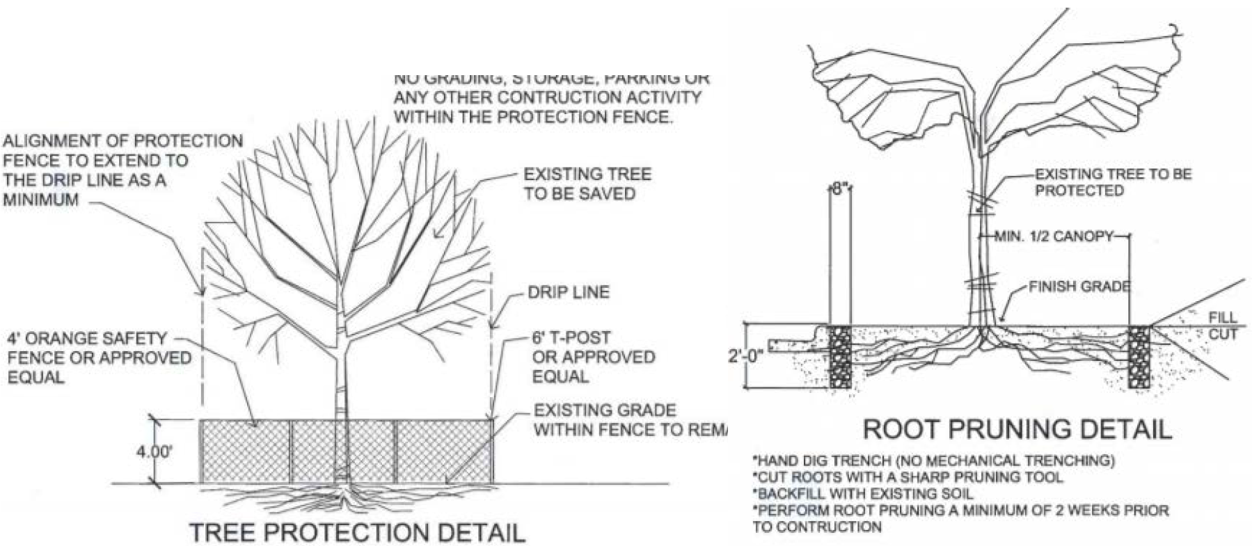
4.
No attachments or wires of any kind, other than those intended to identify or protect a protected tree, shall be attached to any tree.
5.
No fill or excavation may occur within the dripline of a tree to be preserved unless there is a specific approved plan for use of tree wells or retaining walls. Any plan proposing the use of tree wells or retaining walls within the dripline of a tree to be preserved shall be designed by a licensed landscape architect. Major changes of grade (four inches or greater) will require additional measures to maintain proper oxygen and water exchange with the roots. In addition, the developer should adhere to the following guidelines to protect the trees to be preserved:
a.
With grade changes, a reinforced retaining wall or tree well of a design approved by the city should be constructed around the tree no closer than half the distance between the trunk and the drip line. The retaining wall should be constructed so as to maintain the existing grades around a tree or group of trees.
b.
At no time should a wall, pavement, or porous pavement be placed closer than five feet or one foot for every two inches in caliper, whichever is greater, to the trunk of the tree.
c.
In instances where tree wells or retaining walls are approved, root pruning may be necessary when the critical root zone is to be disturbed. See Figure 7.7-1.
d.
If a patio, sidewalk, drive, parking lot, or other paved surface must be placed within the drip line of an existing tree, material such as a porous pavement or other approved construction methods that will allow the passage of water and oxygen may be required.
E.
Tree Survey and Preservation/Replacement Plan.
1.
A tree survey and preservation/replacement plan is required for the development impact areas and shall accompany the initial application for a site plan, preliminary plat, replat, gas well site plan, or a clear and grade permit, regardless of the number of trees present on a property.
2.
A tree survey and preservation/replacement plan may be required to accompany a zoning application, specific use permit, or a planned development amendment where tree and landscaping requirements are relevant to the requested zoning or development amendment, as determined by the Director.
3.
Each tree survey and preservation/replacement plan shall contain, but not be limited to, the following required elements:
a.
The locations of all trees to be preserved and removed on the subject site.
b.
A table containing the following information for all trees:
i.
Tree number;
ii.
Common name of each tree;
iii.
Circumference of each landmark tree;
iv.
Diameter (dbh) of each tree;
v.
General health and condition of each tree;
vi.
Average canopy spread;
vii.
Classification (quality, heritage, landmark, secondary, or non-protected) and status (preserve or remove) for each tree; and
viii.
Mitigation worksheet as shown in Table 7.C.
4.
The tree survey and preservation/replacement plan shall be prepared by or under the supervision of an ISA certified or ASCA registered arborist, a SAF certified forester, botanist, professional land surveyor that has documented completion of at least eight hours of training in Texas tree identification, or a registered landscape architect.
5.
Residential subdivisions that are to be developed in phases must provide a plan that complies with the preservation requirements at full build-out as approved on the preliminary plat or general development plan.
6.
Any subsequent redevelopment of property shall preserve the minimum percentage dbh inches as indicated by the initial tree survey and preservation/replacement plan.
7.
A notation must be placed on the preliminary plat, final plat, site plan, and building permit identifying the dbh of trees to be preserved and the location of the lots that contain preserved trees. The notation shall limit any future unauthorized land disturbing activity or construction that would impact and/or damage the tree(s) preserved.
8.
A tree survey and preservation/replacement plan shall be approved if the minimum preservation and replacement requirements are met.
9.
If there are no protected trees on a property, then a signed and notarized letter indicating such shall be prepared by or under the supervision of an ISA certified or ASCA registered arborist, a SAF certified forester, botanist, professional land surveyor that has documented completion of at least eight hours of training in Texas tree identification, or a registered landscape architect and submitted with the initial development application.
F.
Alternative Tree Preservation/Replacement Plan.
1.
Description and Intent. The alternative tree preservation/replacement plan provides the option to further the purpose and intent of these regulations through a flexible process reviewed and approved by the Director for one of the following purposes:
a.
To allow trees measuring below the minimum dbh to be counted for Protected Trees when:
i.
The allowance would result in the preservation of a greater number of post oak trees, regardless of dbh; or
ii.
The preservation of protected tree(s) would cause a substantial burden, but smaller dbh non-secondary trees are located in such a way that the trees can be incorporated into the site design such as the parking lot, buffer, or front yard landscaping.
b.
To allow secondary trees to count towards the minimum required preservation instead of quality trees.
2.
Criteria for Approval.
a.
The proposed alternative tree preservation/replacement plan adequately achieves, or is an improvement on, the intent of the requirements of this subsection; and
b.
The proposed site design has minimized the loss of protected trees to the greatest extent possible or has maintained existing tree stands.
3.
Replacement Trees. Required replacement and mitigation contained in paragraphs 7.7.4H and 7.7.4I shall be required for those alternatives in paragraph 7.7.4F.1 above.
G.
Minimum Preservation Requirements.
1.
Tree Types and Required Preservation.
a.
Landmark Trees. One hundred percent of all Landmark trees shall be preserved.
b.
Heritage and Quality Trees. A minimum of 30 percent of the total dbh shall be preserved within the development impact area. Removal of trees shall be replaced in accordance with Subsection 7.7.4H or 7.7.4I.
i.
The 30 percent minimum preservation requirement may be reduced to 20 percent provided:
a.
The 20 percent preserved dbh is in either a dedicated conservation easement or in a preserved habitat. All protected and non-protected trees, unless dead or diseased, that are greater than six inches dbh may be counted toward meeting the 20 percent requirement.
b.
Preserved habitats may be dedicated as a conservation easement, and if not dedicated as a conservation easement must otherwise be restricted on a plat. Preserved habitat shall contain the prescribed minimum preservation amount, contain a stand of trees and understory, and shall be the greater of 10 percent of the property or 5,000 square feet.
c.
All other trees remaining in the development impact area but removed shall be replaced in accordance with subsection 7.7.4H or 7.7.4I., if applicable.
ii.
Properties without a preserved habitat or conservation easement may reduce the 30 percent minimum to 20 percent provided:
a.
The 10 percent reduction is mitigated at the following rates: heritage trees at two and three-quarters inches for every inch removed; and quality trees at two and one-quarter inches for every inch removed.
b.
All other trees remaining in the development impact area but removed shall be replaced in accordance with Subsection 7.7.4H or 7.7.4I., if applicable.
c.
Secondary Trees. There is no minimum preservation of secondary trees required when there are quality and heritage trees located on a property. In instances where there are no quality or heritage trees located on a property, then a minimum of 20 percent of the total dbh for secondary trees on the property must be preserved within the development impact area.
d.
Preservation Relief. City Council may approve relief of the Preservation Requirements in accordance with Tree Preservation Relief Provisions in Subsection 7.7.4J, and where required by State law.
H.
Tree Replacement.
1.
In the event that it is necessary to remove a protected tree(s) as allowed in this section, the applicant shall be required to replace the tree(s) being removed with healthy trees or pay a mitigation fee as explained hereafter.
a.
If it is determined that tree replacement is required, the tree preservation/replacement plan must be approved prior to approval of a final plat or replat and a note shall be placed on that plat referencing the approved tree replacement plan.
b.
If platting is not required, the tree replacement plan shall be included as part of a site plan approval or tree removal permit.
2.
In accordance with TLGC, § 212.905, as amended, replacement trees must:
a.
Be planted on property in which they were removed; or
b.
Be planted at a location mutually agreed upon by the city and the property owner; and
c.
Measure at least two inches dbh when planted.
3.
In order to ensure biodiversity and protect against tree diseases, if 20 or more replacement trees are planted, no one species of tree may exceed 30 percent of the total new trees on the site.
4.
To determine the replacement inches required by this section, the applicant shall inventory and combine the total inches of dbh of all protected trees that are to be removed and that are located within the development impact area.
5.
This inventory shall be separated into inches of dbh removed per protected tree classification as calculated using the following replacement rates:
a.
Heritage Tree - Two and one-half inches for every inch removed;
b.
Quality Tree - Two inches for every inch removed; and
c.
Secondary Tree - Four inches for every tree removed.
6.
The total of the required inventories represents the replacement inches that shall be replaced through new tree plantings or preservation of existing trees. New trees required to satisfy the landscaping provisions of this section shall be counted towards satisfying this requirement.
7.
Once each tree on the site is inventoried, tree mitigation shall be calculated as follows and as shown in Table 7.C: Sample Tree Mitigation Worksheet. The calculated dbh of each tree shall be the dbh of the tree multiplied by the appropriate classification ratio as described in paragraph 4 above. The total calculated dbh shall be the sum of all these trees.
8.
In accordance with TLGC, § 212.905, as amended, a credit of 50 percent shall automatically be given to the total calculated dbh for all residential development, and 40 percent for nonresidential development. The preliminary mitigation dbh is 50 percent of the total calculated dbh for all residential, or 40 percent for nonresidential. Mixed-use developments shall be credited at the residential rate of 50 percent.
9.
After calculating the preliminary mitigation dbh and subtracting the preserved credits, any remaining dbh is defined as the mitigation dbh. The mitigation dbh is required to be satisfied either by the planting of new trees on-site with an equivalent total dbh or by using one of the alternative methods described in Subsection 7.7.4J.
10.
If any preserved and/or replacement tree(s) dies within three years of initial planting or issuance of certificate of occupancy, the current property owner shall be subject to the same replacement requirements per these requirements, unless otherwise exempt or deemed a non-protected tree.
I.
Tree Preservation Credit. Additional credit shall be given for all protected trees that are preserved. Preserved credits shall be the sum of:
1.
A four-inch credit against mitigation for each one-inch of preliminary mitigation dbh shall be applied to the preservation of any landmark tree, or any trees preserved within a conservation easement or preserved habitat;
2.
A three-inch credit against mitigation for each one-inch preliminary mitigation dbh shall be applied to the preservation of any other heritage tree; and
3.
A two-inch credit against mitigation for each one-inch of Preliminary Mitigation dbh shall be applied to the preservation of any other quality tree.
4.
An additional preserved credit may be credited against preliminary mitigation dbh for preserved secondary trees, provided:
a.
The minimum preservation of 30 percent is achieved for heritage and quality trees;
b.
A one-half inch credit against mitigation for each one-inch preliminary mitigation dbh shall be applied to the preservation of secondary trees; and
c.
Credit for preserved secondary trees may not exceed 50 percent of the preserved dbh of quality trees.
J.
Tree Preservation Relief Provisions.
1.
Purpose. The purpose of this provision allows a determination of whether the application of this DDC, as applied to a tree removal application and related development applications, would if not modified or other relief granted, may unreasonably burden the development of the property.
2.
Review Procedure.
a.
A property owner or his authorized agent may file an application for relief under this subsection following a final decision to deny or conditionally grant an application for a tree removal permit.
b.
The Director has the authority to establish requirements for applications for tree preservation relief in the Application Criteria Manual. No application shall be accepted for filing until it is complete and the fee established by the City Council has been paid.
c.
Upon approval of an application for relief in whole or in part by the City Council, the Director shall process the tree removal permit and related development applications pursuant to the relief granted on the application for relief approved by the City Council.
d.
A denial of an application for relief by the City Council is a final determination.
3.
Criteria for Approval. In deciding whether to grant relief to the applicant, the City Council shall consider whether there is any evidence from which it can reasonably conclude that the application of all or a part of the provisions of this DDC that apply to tree preservation may deprive the applicant of all economically viable use of the property, based on the following factors:
a.
Whether there is a unique physical circumstance on the property.
b.
Whether the proposed design has minimized the loss of trees to the extent possible.
c.
Whether preservation and/or mitigation unduly burdens the development of the property.
K.
Alternatives to Tree Replacement Requirements. In order to satisfy the mitigation dbh, the property owner may use any combination of alternative methods of compliance listed below. These alternative methods may also be used in combination with or in lieu of tree replacement, so long as the total replacement dbh is satisfied by one or all methods.
1.
Payment in Lieu of Replacement.
a.
Payment in lieu may be made in the amount prescribed separately and periodically by ordinance, and, if made, such a payment shall be deposited into the tree fund for the purposes described in this subsection. This amount is calculated by the average cost incurred by the city for the purchase, planting, and irrigation of a two-inch tree for three years.
b.
The applicant must pay the fees contributed to the tree fund prior to the issuance of a gas well site plan, or the filing of a final plat in the Denton County Clerk's Office. If platting is not required, payment shall be prior to issuance of a tree removal permit.
c.
Notwithstanding any other provision in this subsection, no tree mitigation fee may be collected or enforced in contravention of state law.
2.
Tree Donation. The developer may donate the replacement tree(s) to the City's Parks Department for planting within the city, with the approval of the Parks Director.
3.
Conservation Easement. The property owner may request to grant a conservation easement by plat to the city that includes protected trees and non-protected trees beyond the minimum preservation amount, and with a combined dbh equal to or exceeding the dbh for which mitigation is being requested.
a.
In addition to the tree survey and preservation/replacement plan, a detailed baseline document describing the property's physical and biological condition, the general age of any tree stands, locations of easements and construction, and the conservation values protected by the easement, shall be required.
b.
The city may decline the request for a conservation easement for any reason; however a request so declined will not satisfy the mitigation requirement and mitigation must be achieved in a different manner as described above.
L.
Tree Fund.
1.
The city shall administer and use the tree fund to:
a.
Purchase, plant, and maintain trees;
b.
Conduct maintenance on conservation easements dedicated in accordance with this subsection;
c.
Preserve wooded property remaining in a naturalistic state in perpetuity;
d.
Perform and maintain a city-wide tree inventory;
e.
Educate citizens and developers on the preservation, care, maintenance, benefits and value of trees within the City of Denton; and
f.
Support programs for the public purpose of increasing the tree canopy within the City of Denton as approved by City Council.
2.
Proceeds from the tree fund shall not be used to meet any requirements for preservation, mitigation, landscaping, buffering, streetscaping, or similar requirements in this DDC or the Municipal Code of Ordinances.
3.
Voluntary contributions for tree planting shall be placed in the tree fund.
M.
Incentives.
1.
Energy Conservation Credit. Mitigated or preserved large canopy shade trees located on the western or southern exposures of a habitable building may receive additional tree replacement credit. The trees must be located a minimum of 10 feet but a maximum of 30 feet in distance from the building. Required tree replacement may be credited at 1.5 times the existing or newly planted trees;
2.
Heritage Tree Credit. A replacement credit of 4.0 times the dbh of a heritage tree preserved beyond the minimum preservation requirements may be counted toward meeting the required replacement;
3.
Conservation Easement Credit. Required replacement trees may be credited 2.0 times if planted within the dedicated Conservation Easement;
4.
Tree Cluster(s). In order to emphasize the importance of preserving trees in a cluster during development, additional mitigation credit will be given for a cluster(s) of three or more trees whose bases are located less than 10 feet apart and whose drip lines overlap. Credit shall be calculated at 1.15 times the dbh of each tree within the cluster; and
5.
Parking Space Reduction. Upon application and verification by the Director, an individual shall be entitled to a reduction in the minimum parking to help meet the minimum tree preservation requirements. For the purpose of providing an incentive, the minimum parking requirements in Subsection 7.9.4, may be reduced by one parking space for every 12 inches dbh of trees that have been protected or mitigated on a site. Up to 15 percent of the required spaces may be reduced; or
6.
Certification in Lieu of Mitigation. The Director shall assist those who wish to have a site certified under the Denton Wildscape Program in lieu of meeting replacement requirements as long as 20 percent of existing trees on-site are preserved.
7.
The enforcement and penalty provisions of Section 1.6 shall apply to this subsection.
7.7.5 - Landscape and Tree Canopy Requirements.
A.
Applicability to the Development Impact Area.
1.
Single-family, Duplex, and Townhome Dwellings:
a.
Existing single-family, duplex, townhome, triplex, and fourplex lots that are currently developed are exempt from the minimum requirements contained in subsection B.
b.
New detached single-family, duplex, townhome, triplex, and fourplex subdivisions are required to provide landscaping as specified in subsection E.
2.
Multifamily and nonresidential developments are required to comply with all landscaping and tree canopy requirements in this section.
3.
All replacement trees included as part of the approved tree preservation/replacement plan shall be credited against the trees planted, as required by this section.
B.
Minimum Landscape Area and Tree Canopy Requirements. Landscape area is the portion of a development impact area which is comprised of trees, shrubs, and pervious groundcovers. The percentage of landscape area required shall be based on the property's zoning designation, as indicated in Table 7.D below.
C.
Measurement and Calculation of Landscape and Tree Canopy Areas.
1.
Tree Canopy Measurement.
a.
Tree canopy is measured by computing the area that the mature canopy will encompass, based on the tree list contained in the Site Design Criteria Manual. The mature canopies may be estimated for existing trees on-site. Any tree not on the tree list may be estimated by a registered landscape architect.
b.
The required percentage of tree canopy required shall be based on the zoning of the property as described in Table 7.D. The required tree canopy area shall apply to either:
i.
The entire development impact area, or
ii.
The entire lot being developed, minus the footprint area of any proposed buildings.
c.
The selected method for calculating the required tree canopy must be explicitly stated on the Landscape Plan.
2.
Qualifying Types of Landscaping and Tree Canopy - General. The following may count towards meeting the landscape and tree canopy requirements:
a.
All landscaped areas planted and maintained within the development impact area;
b.
Tree canopy in the adjacent public right-of-way;
c.
All required mitigation trees may count towards landscaping (including street trees and yard trees) if planted trees have a minimum of two-inches dbh; and
d.
Plazas and pedestrian circulation areas if constructed with pervious material and not located within the public right-of-way.
3.
Qualifying Types of Low Impact Development (LID) Designs. Low Impact Development (LID) options count toward required landscape if installed and maintained pursuant to the North Central Texas Council of Governments Integrated Storm Water Management (iSWM) strategies, including:
a.
Bioswales: Bioswales are vegetated swales planted with wet tolerant species of plants or ornamental grasses. They transport, store, and allow infiltration of water, and can be designed as a landscape feature. Bioswales are not grassed, but are planted with a variety of plant species that can withstand occasional water inundation for short periods of time.
b.
Grassed Swales: Grassed swales are designed conveyance devices used to transport water over the surface of the ground to a point of disposal that may be a catch basin, ditch, or water body that will filter, infiltrate, evaporate, and clean the water of total suspended solids and other pollutants. Swales are often appropriate along property lines, public streets, and around buildings.
c.
Bioretention Facilities: (a.k.a. Rain Gardens) Bioretention facilities are small shallow depressions planted with a variety of native or ornamental plants that can treat small amounts of runoff to improve water quality. Bioretention facilities are generally small collections of flood-tolerant plants planted on a low site area that naturally collects rainfall.
d.
Sand Filters: Sand filters are depressions, trenches, barriers, or sand lens, constructed of porous mineral matter that improve ground water recharge, to filter, clean and trap waterborne pollutants.
D.
Appropriate Planting Materials.
1.
Ninety percent of plantings shall be from the approved landscape plant list in the Site Design Criteria Manual.
2.
In order to ensure biodiversity and protect against tree disease, if 20 or more trees are planted, no one species of tree may exceed 30 percent of the total new trees on the site.
3.
At least 50 percent of the trees planted must be native, indigenous, or adapted, as indicated on the approved landscape plant list.
E.
Minimum Landscaping for Single-Family Detached Dwelling, Duplex, Townhome, Triplex, and Fourplex Lots.
1.
All single-family, duplex, and townhome lots must contain a minimum of one large shade tree per dwelling.
2.
All triplex and fourplex lots must contain a minimum of one large shade tree per lot.
3.
At least 30 percent of the front yard shall be landscaped.
4.
At least 20 percent of the rear yard shall be landscaped.
F.
Landscape Plan and Point System. In addition to the above standards, the following requirements shall apply to all developments except single-family detached dwelling, duplex, and townhome lots:
1.
A landscape plan is required for all developments demonstrating compliance with the required minimum landscape area requirements, at the time of application for whichever of the following comes first:
a.
Specific use permit;
b.
Site plan; or
c.
Building permit.
2.
All landscape plans shall be drawn and sealed by a registered landscape architect.
3.
All landscape plans shall contain at a minimum the following elements:
a.
A delineation of the property boundary, the development impact area, ESAs, preserved habitat areas, and any easements;
b.
Dimensioned buffer areas, right-of-way screening areas, and parking lot landscaping areas;
c.
Location and tabulation of all proposed plantings, including size at the time of planting and expected canopy area of all trees at maturity, as provided for in the Site Design Criteria Manual;
d.
Tabulation of how the required landscape and buffer points, as described in the sections below, are provided;
e.
Tabulation of the required and provided number of street trees, unless provided on a separate street tree plan at the time of platting; and
f.
Any additional information required to demonstrate compliance with the requirements of this section.
4.
Landscape area and tree canopy shall be designed using a combination of elements from the point system described below:
a.
All developments are required to provide a combination of landscaping elements from Table 7.E, totaling at least 30 points and meeting the minimum required percentage of landscape area and tree canopy.
b.
At least two elements must be selected from both Sections A and B in Table 7.E, except as noted below. The remaining points may be selected from Sections A, B, or C.
i.
Right-of-way screening shall be provided between the front-most row of parking and the street. Screening area shall begin at the back edge of either the right-of-way or public utility easement, as necessary to prevent encroachment into those areas. The area dedicated to right-of-way screening must contain sufficient area to plant the proposed screening elements and allow for full growth potential. For developments where parking is not located between the building and the street, any drive aisles located in front of the building are required to be screened by at least one of the elements in Section A in Table 7.E.
ii.
Parking lot landscaping shall be provided internal to the parking lot. Turf grass does not satisfy requirements for planting materials in parking lot landscaping areas. Planting materials permitted include drought-tolerant plants, ornamental and/or native grasses, and pervious non-living ground cover installed with a permeable weed-barrier.
iii.
If proposed, living walls and living green roofs should be engineered in accordance with building industry standards to ensure building safety and longevity of the plant material. Living green roofs shall be installed in a manner allowing for inspection consistent with applicable OSHA standards, along with all other site landscaping.
G.
Landscape Installation and Maintenance.
1.
Landscaping installed as part of the requirements of the landscape standards shall be free from diseases and insects and maintained in a healthy and growing condition at all times.
2.
The property owner is responsible for regular weeding, mowing, irrigation, fertilizing, pruning, litter removal, and other maintenance as needed for all plantings.
3.
The property owner shall remove and replace any required landscaping as part of an approved landscape plan that dies with other approved living plants from the approved plant list contained in the Site Design Criteria Manual no later than 30 days after: The landscaping has died, or after the postmarked date of written notification from the city, whichever is sooner. The Director or designee may, in his sole discretion, extend this time period due to weather, appropriate planting season, or other events outside of the reasonable control of the property owner.
H.
Irrigation. To ensure viability, landscape areas shall be irrigated by one or a combination of the following methods:
1.
An automated underground system;
2.
A drip irrigation system; and/or
3.
The Director or designee may waive the irrigation system requirement if the approved landscape plan includes drought tolerant plants, a xeriscape system, or other approved materials. In such cases, a temporary irrigation system shall be installed and maintained until the plants are established.
I.
Permits, Enforcement, and Drought.
1.
No permits will be issued for any nonresidential and multifamily development until a landscape plan is submitted as part of the site plan, specific use permit, or building permit review process.
2.
Prior to the issuance of a certificate of occupancy for any building or structure, all screening and landscaping shall be in place in accordance with the approved landscape plan and applicant shall call for inspection of all landscape installation.
3.
An as-built landscape plan shall be provided to the city upon final inspection.
4.
Landscaping that dies shall be replaced by the owner with plants of similar variety and size no later than 30 days after the landscaping dies or 30 days after being notified from the Director or designee, whichever occurs first. The Director or designee may in his sole discretion, extend this time period due to weather or other events outside of the reasonable control of the property owner. Replacement trees of similar mature canopy may be replanted with approval from the Director or designee. Replacement trees must be a minimum of three-inch caliper, measured six inches above the ground.
5.
A planting extension may be granted by the Director or designee, in his sole discretion, if substantial evidence is presented to indicate abnormal circumstances beyond the control of the owner or his agent. Seasons of drought, extreme heat, or heavy rainfall causing construction delays are examples of abnormal circumstances.
J.
Payment in Lieu of Planting. In instances where easements, encumbrances, physical constraints, or life safety requirements limit the ability to plant the required trees needed to meet the minimum tree canopy coverage, an applicant may pay into the tree fund as an alternative. The Director may approve a reduction in minimum tree canopy area of up to 10 percent of the required amount. Any reduction in tree canopy area shall be mitigated by payment into the city's tree fund based upon the standard canopy size of a large canopy tree as specified in the Site Design Criteria Manual, assuming each required tree measures two caliper inches. The payment per inch shall be calculated as provided in the city's payment schedule.
7.7.6 - Compatibility Landscape Buffer Requirements.
Compatibility buffers are required to mitigate or minimize potential nuisances such as noise, light, glare, dirt, litter, signs, parking, or storage areas and to provide a transition between incompatible uses.
A.
Minimum Buffer Required.
1.
All developing uses, unless exempted in subsection D. below, shall be required to install a buffer as specified in Table 7.F below. All replacement trees included as part of an approved tree preservation/replacement plan will be credited against trees required in this subsection.
2.
For mixed-use buildings or development sites, buffers shall be provided based on the most intense use within such building or development site.
B.
Buffer Point System. Buffers shall earn the designated point total by selecting a combination of elements as indicated in Table 7.G below. For buffers including more than two listed elements, vegetation may also include a combination of shrubs and trees. No more than one fence or wall type may be used to meet the buffer point requirements.
C.
Buffer Standards.
1.
Buffer Location. Buffers shall be located on the outer perimeters of a lots or parcels, and shall extend to the limits of the developed area of the site. Buffers shall not occupy any portion of an existing, dedicated, or reserved right-of-way, or be located on public property.
a.
In instances where a required drainage or public utility easement is located within a buffer area, the easement area will count toward the buffer area requirement. No trees or shrubs are allowed within the easement. However, if the remaining buffer area outside the easement is 10 feet or greater, buffer elements are required.
b.
In those instances where a perimeter fence or wall is used in conjunction with a buffer, the perimeter fence or wall shall have a minimum height of six feet, shall be constructed of material permitted by Subsection 7.7.8: Walls, Fences, and Screening, and shall be located on the outside boundary of the required buffer.
2.
Buffer Design.
a.
The entire buffer area shall be landscaped with ground cover other than turf grass.
b.
Vegetation included in the buffer shall meet the following requirements:
i.
Plant species shall be selected from the approved landscape plant list or native plant list.
ii.
At least 50 percent of the plants shall be evergreen.
iii.
No more than 50 percent of the plants shall be from the same genus.
c.
Buffers may contain pedestrian or bike trails to promote connectivity to adjoining properties as long as no required plant material is omitted from the design, and the buffer width is maintained.
3.
Designated tree preservation areas occupying a portion of a required buffer satisfy the planting requirements for the portion they occupy.
4.
When healthy protected trees are located within the required buffer, the protected trees should be preserved to the greatest extent possible. The Director may determine if additional buffer elements are required to mitigate or minimize potential nuisances based on specific site conditions.
5.
When a preserved ESA is located in an area where a buffer would be required, the ESA may count as the required buffer for that portion of the property.
D.
Exceptions to Buffer Requirements.
1.
Buffer requirements may be waived by the Director when the property is an internal site within a master planned development or within a mixed-use development. Buffers shall still be required around the perimeter of the development based on the requirements in this subsection.
2.
Buffer requirements shall not apply to the MD district except that the buffer requirements shall apply to multi-family and nonresidential properties adjoining single-family detached, duplex, or townhome uses within the MD district.
7.7.7 - Street Tree Requirements.
A.
Applicability. Applications for development shall propose and be required to plant street trees in accordance with the following standards, and in accordance with the spacing requirements identified in the Site Design Criteria Manual. The Director may approve alternative plans due to special site conditions, which may, for reasons such as safety or existing trees on the lot, affect the ability to meet these regulations. All replacement trees included as part of an approved tree preservation/replacement plan will be credited against the required street trees.
B.
Street Tree Plan. A street tree plan shall be submitted with a site plan for multifamily or nonresidential developments and with a final plat for new residential subdivisions. Additionally, street trees should be specifically called out on building permits and landscape plans.
C.
Street Tree Location. Street trees shall be located within the street right-of-way or within 10 feet of the street right-of-way.
D.
Number and Spacing.
1.
At least one street tree is required for every 30 feet of street frontage.
2.
Street trees are not required to be regularly spaced at 30-foot intervals; however, street trees shall not be planted further apart than 50-foot intervals and not closer than 25 feet apart.
3.
Street trees shall be planted in accordance with the spacing requirements from utilities, intersections, and driveways described in the Site Design Criteria Manual.
4.
To ensure biodiversity and protect against tree disease, if 20 or more street trees are planted, no one species of tree may exceed 30 percent of the total new street trees. Where multiple species are required within a single block, trees of the same species shall be planted non-contiguously to the greatest extent possible.
E.
Tree Planting.
1.
Tree planting standards shall be in accordance with the Site Design Criteria Manual.
2.
Each tree planted shall meet the most current version of American Standards for Nursery Stock ANSI Z60.1, and shall have a minimum size of three-inch caliper measured six inches above grade, unless the trees are planted as replacement for the removal of existing trees, in which case the trees must have a minimum size of two inches dbh. Any tree that does not meet ANSI Z60.1 may be rejected by the Director.
F.
Maintenance.
1.
Property Owner Responsibility.
a.
Street trees shall be maintained by the adjoining property owner.
b.
It is the adjoining property owner's responsibility to water, prune, fertilize, and treat for insect and disease, as may be deemed necessary. All incurred costs are to be borne by the property owner.
c.
It is the adjoining property owner's responsibility to remove any hazardous or dead tree, as may be deemed necessary. All incurred costs are to be borne by the property owner.
2.
Tree Canopy Clearance Height. All trees shall be maintained by pruning and other necessary care by the adjacent property owner to ensure a minimum clearance of 15 vertical feet from the curb line, 15 vertical feet from an alley, and eight vertical feet from the sidewalk.
3.
Removal of Trees or Plantings in Public Right-of-Way. The city may prune or remove any tree or planting that constitutes a hazard to person or property or for any other reason for trees and plantings located in public right-of-way or in a landscape maintenance easement.
4.
Pruning. All pruning shall be in accordance with the most current version of American National Standards for Tree Care Operations ANSI A300.
5.
Tree Replacement. The city may replace an approved street tree or other planting that has died or may have been removed for any reason, or plant additional street trees deemed appropriate and consistent with available resources.
6.
Abuse or Mutilation. It shall be unlawful for any person to break, destroy, or mutilate any approved street tree, or to set fire or permit any fire to cause damage to any portion of any street tree, or to attach or place any rope or wire, sign, poster or other device on any street tree. Each occurrence shall constitute a distinct and separate offense.
7.
Trees Adjacent to Overhead Electric Utilities. Street trees planted adjacent to overhead electric distribution lines shall be of a species having a mature height less than 30 feet to accommodate maintenance of a 10-foot minimum separation between vegetation and electric lines.
7.7.8 - Walls, Fences, and Screening.
A.
Purpose. The purpose of these standards is to provide reasonable regulations for the appearance, location, type, and maintenance of fences and walls to ensure the safety of residents and the high-quality character and appearance of the city.
B.
When Required.
1.
Residential Subdivision Perimeter Fences. A perimeter fence meeting the standards of this section shall be provided around the perimeter of residential subdivisions along all arterials and corridors.
2.
Other Fences. Except for residential subdivision perimeter fences, fences are not mandatory; however, when used, all fences or walls shall be constructed in compliance with applicable Municipal Code of Ordinance provisions, and are subject to the standards of this subsection.
C.
Perimeter Fence Standards. Perimeter fences surrounding residential subdivisions and nonresidential uses shall comply with the following fencing material standards:
1.
Perimeter Fences Adjacent to and Fronting Public Right-of-Way.
a.
For new development, allowable materials include only masonry, wrought iron, elevated and sealed wood, or a combination of masonry, wrought iron, and elevated and sealed wood.
b.
For existing development, individual backyard fences along an arterial or collector are allowed to replace the existing originally constructed fence with the same materials or with higher quality materials.
2.
Perimeter Fences not Adjacent to or Fronting Public Right-of-Way.
a.
Allowed Materials.
i.
Wood;
ii.
Wrought iron;
iii.
Masonry;
iv.
Brick;
v.
Vinyl;
vi.
PVC;
vii.
Architectural metal panels; or
viii.
Composite material.
b.
Prohibited Materials.
i.
Barbed wire;
ii.
Razor wire; and
iii.
Electrified fences.
D.
Fences on Individual Lots.
1.
Summary Table of Fence Standards. A summary of the standards for fences on individual lots is provided in Table 7.H, below:
2.
Materials and Design.
a.
All fences shall be constructed of materials pursuant to Table 7.H and shall be designed and constructed to allow proper drainage flow. The structural support members shall not be visible from public view. Natural vegetative edge row is also permitted.
b.
Barbed wire, razor wire, or electrified fences may only be used as specified in Table 7.H or to comply with federal or state law.
c.
Fence design and materials shall be installed and maintained consistently for the entire length of the fence.
3.
Fence Height.
a.
Fence height shall not exceed the maximum height specified in Table 7.H. The Director or his or her designee may approve an alternative height, provided that the maximum height will not endanger public safety, adversely impact surrounding properties, and/or otherwise alter the character of the existing area.
b.
Fences over four feet tall in the front yard that extend beyond the front building line shall not exceed 50 percent opacity.
4.
Fence Location. Fences shall not be located within any right-of-way, easement, designated fire lane, or within any required parking spaces. Fences shall not obstruct safe vehicular or pedestrian passage; ingresses or egresses; nor shall they obscure any sight visibility lines or sight visibility triangles contained in the Transportation Criteria Manual.
E.
Screening. Screening is required for the following applications, as specified below:
1.
Refuse Container Screen.
a.
Containers for commercial solid waste and recycling service shall be screened from public view. Refuse containers that are not visible to the public are not required to be screened.
b.
Containers for solid waste and recycling service for nonresidential, mixed-use, and multifamily development shall be enclosed on all sides with a gated solid screening wall at least six feet in height.
c.
Materials used for container enclosure construction shall be of masonry, metal, wood, vinyl, or composite material that is compatible with the principal structure and shall be maintained in a state of good repair at all times.
d.
All refuse and recyclable materials shall be contained within the screened refuse and recyclables area. A concrete or asphalt pad shall be installed beneath the waste collection area.
e.
All refuse and recycling collection areas shall meet applicable requirements of the Solid Waste and Recycling Criteria Manual.
2.
Mechanical Equipment Screen.
a.
All mechanical equipment, including those on roof tops, shall be screened from all rights-of-way and residential uses or zoning districts.
b.
Mechanical equipment shall not be located between the main structure on the site and any street adjacent to a front or side yard, and every attempt shall be made to place such equipment so that it is not visible from adjacent public streets.
c.
Mechanical equipment may be placed in a side yard abutting a side street if there are lot or building constraints from placing it in the other side yard and the equipment is screened with a fence or landscaping.
d.
Any installation of mechanical equipment shall require a building permit.
3.
Outside Storage. Except for industrial uses that are legally permitted, and uses in the LI, HI, and PF zoning districts, all outdoor storage shall be opaquely screened from all rights-of-way, residential zoning districts, and residential uses, and shall comply with standards in Subsection 7.7.8: Walls, Fences, and Screening. No outside storage shall be stacked in a way that it becomes visible from the public right-of-way.
4.
Inoperable or Junk Vehicle. Unless otherwise provided, all inoperable or junk vehicles that are stored outside an enclosed structure shall be screened from all rights-of-way.
F.
Exceptions to Screening Requirements. Screening requirements may be waived by the Director or his or her designee if an opaque screening of equivalent height or greater exists immediately abutting, and on the opposite side of the lot line.
G.
Maintenance. Fencing and screening installed as part of the requirements in this Section shall be maintained in good working condition at all times. See Subpart A, Municipal Code of Ordinances, Chapter 17: Property Maintenance, Article VIII: Fences.
(Ord. No. DCA22-0008a, § 2(Exh. A), 3-7-2023)
7.8.1 - Purpose.
The purpose of this section is to reduce the number and length of automobile trips and related greenhouse gas emissions by encouraging walking and bicycling by integrating sidewalks and bicycle routes in new development and redevelopment, and by providing for shorter and more direct routes between many destinations.
7.8.2 - Applicability.
Except as otherwise provided in this Section 7.8: Access and Circulation, the standards in this section, and the Transportation Design Criteria Manual shall apply as set forth in Section 7.2: Applicability.
7.8.3 - Parking and Circulation Plan Required.
A.
All development, except for single-family, duplex, and townhouse residential uses within previously platted subdivisions shall prepare a parking and circulation plan. The plan shall meet the requirements of the Administrative Criteria Manual, Transportation Design Criteria Manual, and contain the following information:
1.
Internal circulation and connectivity to existing street network;
2.
Emergency and service vehicle access;
3.
Parking layout;
4.
Loading operations;
5.
Turning radii based on uses;
6.
Traffic calming measures where future "cut-through" traffic is likely;
7.
Pedestrian, bicycle, and transit facilities; and
8.
Other similar issues identified by the Director.
B.
The Director may waive the requirement for a circulation plan on a case-by-case basis if a development is expected to have no impact upon circulation or proposes no change in existing circulation patterns. This standard shall not be construed to exempt development that includes additional parking, driveways, or substantial modifications to the existing pedestrian network.
C.
A circulation plan shall be submitted with the respective site plan or subdivision application, as appropriate.
7.8.4 - Compliance with Specifications.
A.
Developments shall provide for streets, sidewalks, bicycle, and transit facilities to serve the development in accordance with the requirements of this section, the design standards in the Transportation Design Criteria Manual, and the City Mobility Plan, as amended.
B.
All street, sidewalk, bicycle, and transit improvements shall be constructed in accordance with Division II, Materials, and Division III, Methods, of the City's Standard Specifications for Public Works Construction, North Central Texas Council of Governments (NCTCOG Standard Specifications), as amended by the city.
C.
Where any provision of this DDC conflicts with a provision or requirement of the NCTCOG Standard Specifications, the provisions of this DDC shall control.
D.
Prior to construction of sidewalks or any other public pedestrian facility for developments where the total cost of pedestrian improvements will exceed $50,000, the developer must show proof of Texas Department of Licensing review and approval for accessibility.
E.
For sidewalks or other pedestrian facilities proposed in a TxDOT right-of-way, Texas Department of Licensing review must occur prior to applying for a TxDOT Permit. Proof of review must be submitted with the Permit application.
7.8.5 - Street Design.
All streets shall be designed to comply with the Transportation Design Criteria Manual.
7.8.6 - Street Connectivity.
A.
Purpose. Street and block patterns shall include a clear hierarchy of well-connected streets that distribute traffic over multiple streets and avoid traffic congestion on principal routes. Within each development, the access and circulation system should accommodate the safe, efficient, and convenient movement of vehicles, bicycles, and pedestrians through the development, and provide ample opportunities for linking adjacent neighborhoods, properties, and land uses consistent with the City's Mobility Plan, as amended. Local neighborhood street systems are intended to provide multiple, direct connections to and between local destinations such as parks, schools, and shopping.
B.
Applicability. All developments shall provide the necessary street system to ensure safe and adequate access to each lot within the development in accordance with these standards, the Transportation Design Criteria Manual, and any other applicable City Ordinance.
C.
General Standards.
1.
Alignment. All streets shall be aligned with existing streets by continuation of the centerline.
2.
Coordination with Surrounding Streets.
a.
The street system for each development shall connect with existing, proposed, and anticipated streets within and outside the development and shall extend to the property boundary to provide for adequate access and the safe and effective movement and circulation of traffic.
b.
Street sections from an existing development shall continue to the first intersection of the new development. Requirements concerning block length, land use versus street sections and maximum traffic trips are all applicable in the extension of existing streets into a new development.
c.
If there are no adjacent public streets, subdivisions and/or site plans shall provide for connections along each boundary abutting adjacent vacant land for future connections spaced at intervals not to exceed 1,000 feet for arterials, or 660 feet for other street types, or as otherwise approved.
d.
An extension or connection of a public street and right-of-way to an abutting property shall include the extension or connection of associated bikeways and sidewalks.
3.
Temporary Turnarounds.
a.
The Director and/or the City Engineer may require a temporary turnaround at the end of a roadway extension if needed to facilitate traffic flow or to accommodate emergency vehicles pending the roadway's connection to other roadways. In cases where a temporary turnaround is required, it shall be designed as a temporary cul-de-sac in accordance with the Transportation Design Criteria Manual.
b.
Temporary dead-end streets may be approved by the City Traffic Engineer, based on the criteria set forth below, without a temporary cul-de-sac. If a temporary cul-de-sac is not required, signage shall be posted indicating that the street will be extended in the future is required.
D.
Modifications to Street Connectivity.
1.
In limited circumstances, the City Traffic Engineer may modify the requirements or standards for the extension or connection of a public street from or to an abutting property if such extension or connection is impractical or undesirable because it would:
a.
Require crossing a significant physical barrier or environmentally sensitive area (e.g., watercourses, floodplains, riparian areas, steep slopes; wildfire hazard areas);
b.
Require the extension or connection of a proposed internal public street to an abutting property with existing development whose design makes it unlikely that the street will ever be part of a network of public streets (for example, the abutting existing development has no public streets, or there are no "stubbed-out" street rights-of-way or open corridors between the proposed development site and public streets in the abutting development to accommodate a current or future extension or connection);
c.
Require the extension or connection of a proposed internal public street to an abutting property owned by a government or public utility to which vehicular access is restricted, or other property to which vehicular access is restricted by easement or deed; or
d.
Require the extension or connection of a proposed internal public street to an abutting property that is developed or zoned for a use whose level and type of generated traffic would be incompatible with the proposed development.
2.
Any modification that is not considered impractical as listed above shall follow the variance procedures established in Subsection 2.8.1: Variance.
7.8.7 - Developer Responsibility for Access and Circulation Improvements.
The requirements of this Subsection 7.8.7, shall be subject to the proportionality requirements in TLGC, Section 212.904.
A.
Internal Streets.
1.
If a street is proposed within a development site, the developer shall provide street, bikeway, sidewalk, and other access and circulation improvements in accordance with the standards in this DDC, the Denton Transportation Design Criteria Manual, and the City Mobility Plan, as amended, or another adopted plan and shall dedicate or reserve any required rights-of-way or easements as determined necessary by the city.
2.
If a development site includes the proposed corridor of a street designated on an adopted plan, the development shall incorporate a provision of the street into the design of the development, and shall dedicate right-of-way that meets the right-of-way width standards for the street, and an additional five feet to provide for any sloping needed between the pavement and the property line, as determined by the city.
3.
All streets shall be provided with curb and gutter along the side abutting the development.
4.
If the street is ultimately proposed to serve as a divided arterial street and the development is required to install half of the arterial street, then curb and gutter shall be provided on both sides of the street so as to provide the curb for the future median of the arterial street.
B.
Perimeter Streets.
1.
Unimproved Perimeter Streets.
a.
Any development on the perimeter of an unimproved street shall dedicate the right-of-way and improve or reconstruct the street to the same extent as is required for new streets, unless the perimeter street has already been partially improved, in which case the development shall dedicate the additional right-of-way and make the additional street improvements necessary to complete the perimeter street to the classification required.
b.
For the purpose of this subsection, an "unimproved perimeter street" shall mean a perimeter street which does not have curb and gutter or which does not substantially comply with the standards for street construction listed in the Transportation Criteria Manual or NCTCOG Specifications.
c.
Whenever existing streets adjacent to or within a tract are of inadequate width, additional right-of-way in accordance with the Transportation Criteria Manual shall be provided at the time of subdivision.
d.
Any perimeter street required to be improved to meet the specifications for new streets shall be connected to existing off-site streets in accordance with the horizontal design specifications in the Transportation Criteria Manual.
e.
The City Engineer may authorize a developer to not improve a street and instead pay the full impact fee in cases where the Engineering Department has determined that the entire street will need to be improved in the near future.
2.
Phasing of Perimeter Paving Improvements.
a.
Perimeter paving improvements are required to be constructed adjacent to the property which is final platted.
b.
In a development where final platting will occur in phases, the developer may choose to perform the required perimeter paving improvements adjacent to each phase as it is platted, or may choose to perform all perimeter paving improvements at one time with the platting of a latter phase as long as the paving is constructed prior to or with the phase of the development that includes 50 percent of the lots in the entire development and the subject perimeter road is not the sole access to the property.
c.
The developer will be required to enter into a perimeter paving postponement escrow agreement.
3.
Exemptions to Perimeter Street Requirements. The provisions requiring the improvement of existing unimproved perimeter streets to city specifications for new streets shall not apply to the following:
a.
A plat for a single-family detached, duplex, or townhome residential lot, where such lot is not part of a larger general scheme of development or subdivision of land containing more than one residential lot;
b.
A development that abuts less than 100 feet of an existing perimeter street, where the existing off-site perimeter street on either side of the abutting perimeter street is not improved to city specifications and there are no proposals or plans for improvements to the perimeter street on either side of the abutting perimeter street as evidenced by the City's Capital Improvement Plan or plats approved or pending approval;
c.
A development that:
i.
Is not required or does not propose to extend a city water line to the property to serve the development; and
ii.
Is located more than 8,000 feet from an existing city water line, measured along a straight line from the nearest boundary of the development to the nearest water line; or
iii.
A state or federal highway.
4.
Rural/Suburban Streets. Upon recommendation of the City Engineer, a required perimeter street meeting standards outlined in the Transportation Criteria Manual for a rural/suburban street may be approved whenever:
a.
The required perimeter street is for a residential development in rural district, as shown in the Future Land Use Element of the Comprehensive Plan;
b.
The development is not located in an area where the pattern or intensity of development would create the need for improved urban drainage facilities in the foreseeable future; and
c.
There are no existing or proposed improved drainage facilities, as shown by the City's Capital Improvement Plan or by plats approved or pending approval, in such proximity to the development that would connect to or receive the drainage waters from the required street drainage improvements.
C.
Improvements to Existing Off-Site Streets.
1.
Fewer than 100 Daily Vehicle Trips. Developments generating fewer than 100 vehicles per day are not required to make pavement improvements to off-site streets, but shall be required to participate in the cost of any proposed signal improvements at the nearest intersection in accordance with the Transportation Design Criteria Manual if signalization in the future is expected.
2.
Between 100 and 1,000 Daily Vehicle Trips and Less than 100 Trips per Hour.
a.
Developments expected to generate at least 100 but less than 1,000 vehicle trips per day and less than 100 vehicle trips per hour at full development shall improve or repair connecting off-site streets as necessary to provide a safe and adequate paved surface for the amount and type of traffic generated by the development.
b.
The off-site street improvements or repairs need not meet the specifications for new streets, but shall be made to a standard determined to be necessary by the City Engineer to provide for the safe movement of vehicular traffic generated by the development, pursuant to a distress rating performed by the City Engineer in accordance with the Transportation Design Criteria Manual.
c.
Off-site street improvements shall not be required to extend beyond the nearest existing intersecting arterial or collector street as indicated on the roadway component of the Mobility Plan.
d.
Such developments accessing an arterial street shall provide right turn lanes into each entrance and left turn lanes into each entrance that left turns are possible.
e.
Such developments shall be required to participate in the cost of any proposed signal improvements at nearby intersections determined by the City Engineer in accordance with the Transportation Design Criteria Manual if signalization in the future is expected.
3.
More than 1,000 Daily Vehicle Trips and More than 100 Trips per Hour.
a.
Developments generating 1,000 or more vehicle trips per day or 100 or more vehicle trips per hour shall provide offsite street improvements as determined by the City Engineer in accordance with an approved Transportation Impact Analysis.
b.
Offsite improvements may include but are not limited to installation of turn lanes, pavement widening, pavement reconstruction, signal construction, installation of pavement markings, signage or equitable participation in the cost of any of the listed types of improvements.
c.
Such improvements shall be required to the extent that the effects of the increased traffic the development generates will not reduce level of service of surrounding streets rather than allowing absorption of existing street capacity on a first come first serve basis.
D.
Payment in Lieu of Improvements.
1.
Where any development would be required by this DDC to improve an existing unimproved street to less than its full width and the city's approved Capital Improvement Plan proposes improvement of the existing perimeter street to city specifications within three years of the date the required improvements are to be undertaken, the development may elect, in lieu of making the required perimeter street improvements, to pay to the city prior to filing the plat, the total construction cost, excluding engineering and design cost, of the required street improvements.
2.
The amount to be paid shall be determined by the City Engineer, based on the actual cost of providing for the improvements, as shown in the most recent public bids for the same or similar type street improvements.
3.
If the money paid to the city is not used for the required improvements within five years of payment, the funds shall be returned to the person making the payment.
4.
In the event that the plat is not filed until after the city has entered a contract with a contractor to construct the subject street improvements, the payment by the development is no longer required.
7.8.8 - Transportation Impact Analysis (TIA).
A TIA shall be required for any proposed site development in accordance with the thresholds established in the Transportation Design Criteria Manual.
7.8.9 - Driveways and Access.
A.
Applicability. No person shall construct, reconstruct, replace, relocate, alter, enlarge, improve or perform any work on or make use of any driveway for any property within the city, except in accordance with the requirements of this section, the Transportation Design Criteria Manual, and any other relevant standard in this DDC.
B.
Compliance with Specifications.
1.
All driveway improvements shall comply with the design specifications, as contained in the Transportation Design Criteria Manual.
2.
All driveway improvements shall be constructed in accordance with Division II, Materials, and Division III, Methods, of the City's Standard Drawings and Specifications for Public Works Construction, North Central Texas Council of Governments (NCTCOG Standard Specifications), as amended by the City. Where any provision of this DDC conflicts with a provision or requirement of the NCTCOG Standard Specifications, the provisions of this DDC shall control.
3.
All driveways shall be designed, installed, located and constructed in accordance with the approved specifications, plans, conditions and requirements of the permit issued for the property and the requirements of this section.
4.
No certificate of occupancy shall be issued for any building on any property for which a permit is required, until the construction, improvements, alterations or other work covered by the permit is completed in accordance with the permit issued, the requirements of this section or the provisions of any other applicable ordinance.
5.
Where no building permit was required in connection with the requested permit, no driveway on the property for which the permit was issued shall be used until and unless the work is completed in accordance with the permit and this DDC.
C.
General Standards.
1.
Every lot shall have sufficient access providing adequate means of ingress and egress for emergency vehicles and for those needing access to the property for its intended use.
2.
All driveway entrances and other openings onto streets shall be constructed so that:
a.
Vehicles may safely enter and exit the property;
b.
Interference with the free and convenient flow of traffic in abutting or surrounding streets is minimized; and
c.
Shared driveways are provided to the maximum extent feasible to minimize the number of access points to streets.
3.
Unobstructed, direct, and convenient access for vehicles to and from a public street shall be provided for all off-street parking spaces. Access from any parking area to a public street shall be designed to allow vehicles to enter and exit in forward drive.
4.
Driveways shall align with existing driveways and "T" intersections on the opposite side of the street, or shall be offset in accordance with the Transportation Design Criteria Manual.
5.
Driveway approaches shall be paved with concrete surfacing constructed in accordance to City Standard Drawings and Specifications.
D.
Vehicle Maneuvering.
1.
Except for single-family detached or duplex uses, groups of more than five parking spaces per lot shall be provided with adequate aisles or turn-around areas so that all vehicles may enter the street in a forward manner.
2.
Except for single-family detached or duplex uses, more than five parking spaces shall be served by a driveway designed and constructed to facilitate the flow of traffic on or off the site, with due regard to pedestrian and vehicle safety, and shall be clearly and permanently marked and defined.
3.
Two-way and one-way driveways shall meet minimum and maximum widths established in the Transportation Design Criteria Manual.
4.
Parking lots exceeding 100 spaces shall be designed with a clear hierarchy of circulation. The hierarchy shall consist of:
a.
Major entry driveways without parking spaces; then
b.
Major circulation drives with little or no parking; then
c.
Parking aisles for direct access to parking spaces.
Figure 7.8-A: Vehicle Maneuvering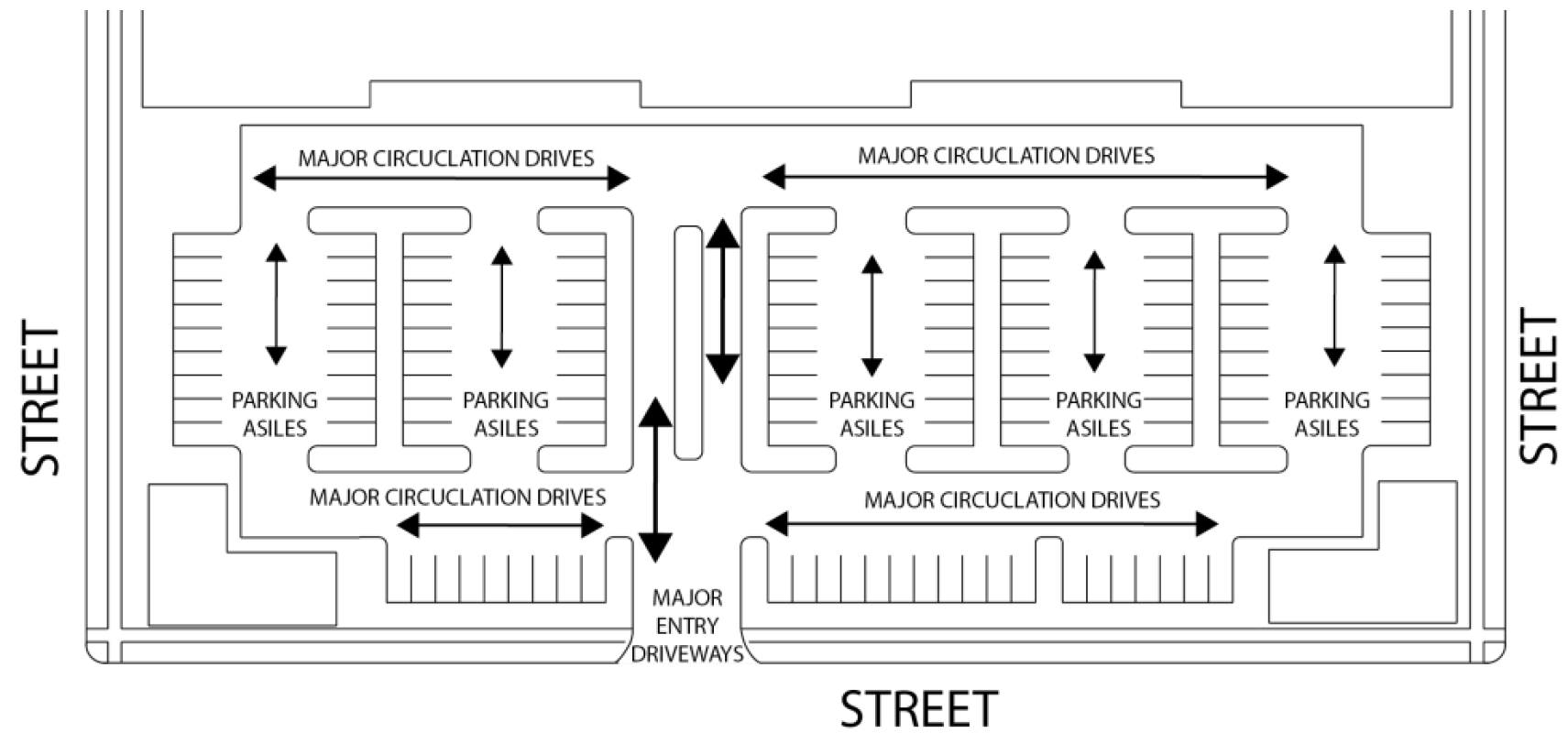
E.
Minimum Driveway Clearances to Street Corners. Driveways located near intersections shall maintain the corner clearances as indicated in the Transportation Design Criteria Manual.
F.
Separation of Driveways. Driveways shall be separated in accordance the Transportation Design Criteria Manual.
G.
Driveway Widths and Grades. Driveway widths and grades shall be designed in accordance with the Transportation Design Criteria Manual.
H.
Access to Collector Streets. Access to collector streets for commercial, office, or industrial development is required and shall be designed and constructed in accordance with the standards provided in the Transportation Design Criteria Manual.
1.
Driveway access to single-family detached or duplex dwelling units is not permitted.
2.
Single-family and duplex lots developed prior to October 1, 2019, with exclusive frontage on a collector street and no alley, may be developed with a circular drive. Such driveways shall be designed and constructed in accordance with the standards for circular drives provided in the Transportation Design Criteria Manual.
I.
Access to Arterial Streets. Access to an arterial street shall not be permitted unless there is no other reasonable means of providing safe access to the property.
1.
No development shall be allowed access to an arterial street if property excluded from the development could have been used to provide reasonable access to a lesser classified street or if the property has been previously subdivided in violation of state law or City Ordinance, if access could have been provided to a lesser street except for such unapproved subdivision of the property.
2.
Existing commercial or industrial lots created prior to October 1, 2019, by legal subdivision procedures with exclusive frontage on an arterial street may take access to the arterial in accordance with the access standards in the Transportation Design Criteria Manual.
3.
Existing single-family detached and duplex lots created prior to October 1, 2019, by legal subdivision procedures with exclusive frontage on an arterial street may be developed with a circular drive. Such driveway shall be designed and constructed in accordance with standards for circular drives provided in the Transportation Design Criteria Manual.
4.
When driveway access to an arterial street is the only reasonable means of providing safe and adequate access to the property as determined by the City Engineer, the driveway design, number of driveways, location and construction shall be in accordance with the Transportation Design Criteria Manual.
J.
Access to Freeways.
1.
Direct access to freeway main lanes shall only be provided by ramps and interchanges.
2.
Direct access to freeway frontage roads shall be prohibited in the vicinity of ramp connections and shall be subject to Texas Department of Transportation requirements.
3.
Direct access to frontage roads may be provided in accordance with the standards for access to arterial streets in the Transportation Design Criteria Manual and shall be approved by the Texas Department of Transportation.
K.
Temporary Driveways for Agricultural Purposes. A driveway that does not meet the minimum requirements of this DDC may be permitted for undeveloped property used for agricultural purposes under the following conditions:
1.
No building or parking lot permit is being applied for;
2.
The driveway will be located a minimum of 50 feet from adjacent intersections;
3.
The driveway will not be paved;
4.
The driveway will be a minimum of 15 feet wide, but no more than 24 feet wide;
5.
All drainage structures associated with the driveway will be sized to carry a 100-year storm; and
6.
If applicable, the driveway meets Texas Department of Transportation Design Criteria.
L.
Residential. Residential driveways shall meet minimum and maximum widths established in the Transportation Design Criteria Manual.
M.
Closing Driveways.
1.
Where the closing or relocating of one or more existing driveways or portions thereof is necessary to comply with this DDC or a curb cut permit issued, access shall be closed by the removal of the existing driveway approach and the installation of curb and gutter along the gutter line of the street, all in accordance with city specifications.
2.
If there is no existing curb and gutter on the street, the driveway shall be closed in the manner specified by the City Engineer.
3.
Where the closing or relocating of one or more existing driveways or portions thereof, drainage patterns must be maintained or improved to meet the standards of this DDC and vegetation shall be installed to meet the standards of this DDC.
7.8.10 - Cross-Access Between Abutting Development.
A.
All nonresidential development shall be designed to allow for cross-access to adjacent properties to encourage shared parking and shared access points on public or private streets. This may be established by one or more of the following:
1.
Connecting streets and drives;
2.
Coordinating parking structure and parking lot entrances;
3.
Common service/delivery areas;
4.
Legally shared parking structures and parking lots;
5.
Linkages between parking lots and parking structures; or
6.
Providing shared driveways for two adjacent lots from public rights-of-way to minimize curb cuts.
B.
The requirement of Section 7.8.10A may be waived when it is shown to the satisfaction of the City Engineer that cross-access is deemed unattainable on the basis of topography, the presence of natural drainage features of Environmentally Sensitive Areas, adjacent site improvements making it unattainable to provide cross-access, or vehicular or pedestrian safety factors, provided that appropriate bicycle and pedestrian connections are provided between adjacent developments or land uses.
C.
Cross-access easements and maintenance agreements associated with such interconnections shall be recorded with the County Clerk and provided, if necessary, with the associated subdivision or development application.
(Ord. No. DCA22-0007a, § 2(Exh. A), 12-6-2022)
7.8.11 - Pedestrian and Bicycle Circulation.
A.
Applicability. All developments shall provide for the pedestrian and bicycle facilities necessary to serve pedestrian/bicycle traffic to, from, or across the development in accordance with the Transportation Design Criteria Manual and the Bicycle/Pedestrian component of the Mobility Plan.
B.
Exemptions. Pedestrian and bicycle improvements required by this Subsection 7.8.11 shall not apply to the following:
1.
Except for Planned Developments, along streets fronted by a subdivision in the RR zoning district provided that:
a.
All lots are platted and have a minimum lot area of five acres; and
b.
The lots do not have access from a street that serves more than 200 total vehicle trips per day.
2.
For a replat of property zoned for single-family detached residential use if the preceding plat covering the same property did not require sidewalks or bicycle facilities and a zoning change to a district other than single-family detached residential use is not anticipated.
3.
The development is not required to make perimeter street improvements in accordance with Subsection 7.8.7.
4.
Improvements that result in an increase in the floor area of the existing building or buildings by less than 10 percent.
5.
Improvements will not require the construction of additional parking spaces as required in Subsection 7.9.2, Applicability.
C.
Types of Facilities.
1.
Sidewalk.
a.
Intended for the use of pedestrian traffic only and located outside of the street pavement.
b.
Sidewalks are required along residential, collector, and arterial streets.
c.
Required geometry, locations and materials shall be in accordance with the Transportation Design Criteria Manual.
2.
On-Road Bicycle Path.
a.
Intended for the use of bicycle traffic only and required within the street pavement on arterial streets and where shown in accordance with the Bicycle/Pedestrian Component of the Mobility Plan.
b.
Required geometry, location and materials shall be in accordance with the Transportation Design Criteria Manual.
3.
Off-Road Combination Pedestrian and Bicycle Path.
a.
Intended for the use of bicycle and pedestrian traffic, located outside of the street pavement.
b.
These facilities are required along residential, collector, arterial, and freeways and where shown in accordance with the Bicycle/Pedestrian Component of the Mobility Plan.
c.
Required geometry, location and materials shall be in accordance with the Transportation Design Criteria Manual.
D.
On-Site Pedestrian Walkways.
1.
On-Site Pedestrian Walkways Required. All development shall provide an on-site system of pedestrian walkways with a minimum width of five feet designed to provide direct access and connections to and between the following:
a.
The primary entrance or entrances to each building, including pad site buildings;
b.
Any sidewalks, walkways, or multi-use paths on adjacent properties that extend to the boundaries shared with the development. Interconnected walkways should be designed with similar and/or complementary details, colors, finishes, etc.;
c.
Any parking areas intended to serve the development;
d.
Any sidewalk system along the perimeter streets adjacent to the development;
e.
Any public transit station areas, transit stops, park and ride facilities, or other transit facilities on-site or along an adjacent street;
f.
Any adjacent residential neighborhoods (planned or existing) if sidewalk stubs are planned or existing; and
g.
Any adjacent or on-site public park, trail system, open space, greenway, or other public or civic use or amenity.
2.
On-Site Pedestrian Walkway Design. Required on-site pedestrian walkways shall:
a.
Be a minimum of five feet in width;
b.
Be distinguishable from areas used by vehicles using one or more of the following techniques:
i.
Changing paving material, patterns, and/or paving color, but not including the painting of the paving material;
ii.
Changing paving height;
iii.
Decorative bollards;
iv.
Raised median walkways with landscaped buffers;
c.
Have adequate lighting for security and safety;
d.
Be conveniently and centrally located on the subject property;
e.
Be ADA accessible; and
f.
Not include barriers that limit pedestrian access between the subject property and adjacent properties.
E.
Pedestrian Access through Parking Areas.
1.
All parking lots that contain more than 100 parking spaces shall include pedestrian walkways through the parking lot to the principal building entrance or a sidewalk providing access to the principal building entrance. At a minimum, walkways shall be provided for every three driving aisles or at a distance of not more than 150 foot intervals, whichever is less.
2.
Parking lots with 100 spaces or more shall be divided into separate areas and divided by landscaped areas or walkways at least 10 feet in width, or by a building or group of buildings.
F.
Pedestrian Access through Parking Garages. Pedestrian walkways shall be provided through parking garages from the parking area to the abutting public right-of-way and/or to the primary entrance of the building served. Pedestrian walkways shall not use vehicle entrance or exit driveways from the parking area to a public right-of-way.
G.
Crosswalks.
1.
Crosswalks shall be identified in consultation with the City Traffic Engineer to meet the specific need and functionality of pedestrian movement at a particular location.
2.
The type and size of the crosswalk shall be determined based on federal and state guidelines described in the Manual on Uniform Traffic Control Devices (MUTCD).
H.
Pedestrian Transportation Impact Analysis. For developments proposed within one-half mile of a public elementary, secondary school, or a University, a pedestrian TIA will be required in accordance with the Transportation Design Criteria Manual to determine the appropriate size and location of sidewalks and bicycle facilities to serve those uses.
I.
Required Bicycle Access.
1.
All new development, except individual lot development of single-family detached, duplex, or townhome dwellings, shall be served by an internal bicycle circulation system (including shared roadway lanes, widened outside roadway lanes, bike lanes, shoulders, and/or separate bike paths) that permits safe, convenient, efficient, and orderly movement of bicyclists among the following origin and destination points within the development:
a.
Bicycle parking facilities or areas near the primary entrance(s) of principal buildings (or the buildable area of lots, for subdivisions), as well as any adjacent transit station areas, transit stops and shelters, public parks, greenways, schools, universities, community centers, and shopping areas;
b.
Any designated or planned bus stops and shelters; and
c.
Recreation facilities and other common use area and amenities.
2.
The development's internal bicycle circulation system shall not conflict with the safe, convenient, efficient, and orderly movement of vehicles between the development's internal origin and destination points and adjacent parts of an existing or planned external, community-wide bicycle circulation system, as well as any adjacent transit stations, bus stops and shelters, public parks, trails, greenways, schools, community centers, and shopping areas.
3.
Sidewalks shall not be used to satisfy the bicycle circulation requirement.
4.
Required bike lanes shall be provided within the right-of-way of the street unless the City Engineer determines that location within the right-of-way is not practicable or preferable—in which case, alternatives may be allowed by the Director and/or the City Engineer.
J.
Use and Maintenance of Pedestrian Connections.
1.
Restrictions on Use. Sidewalks, walkways, and trails are intended to provide pedestrian access. Vehicle parking, garbage containers, merchandise storage or display, utility boxes and poles, signs, trees, and other obstructions shall not encroach into the required minimum clear width of any required sidewalk, trail, walkway, or other pedestrian way. Pedestrian amenities including bollards and trash receptacles for pedestrians are exempt from this requirement.
2.
Maintenance. Sidewalks, trails, and walkways required by this title shall be maintained in usable condition throughout the year.
7.8.12 - Public Transit.
The requirements of this Subsection 7.8.12 shall be subject to the proportionality requirements in TLGC, Section 212.904.
A.
Applicability. All developments shall provide for the transit facilities necessary to serve pedestrian/bicycle traffic to, from, or across the development in accordance with the Transportation Design Criteria Manual and the Bicycle/Pedestrian component of the Mobility Plan. This shall include major and minor bus stops and park and ride facilities, the specifications for which are in the Criteria Manual.
B.
Location of Bus Stops.
1.
Major bus stops shall be provided on arterials or collector streets at intersections of arterial streets, or arterial and collector streets but no closer than one-half mile apart.
2.
Minor bus stops shall be provided on arterials and collector streets at the intersections of collectors and intersections, which include a local street if there is not an arterial or collector intersection existing or proposed within a one-half mile distance along the street.
3.
Bus stops shall be located on the approaching side of the intersection.
4.
The City Engineer will determine which and how many quadrants of an intersection a bus stop will be required.
C.
Pull Outs. Pull out lanes will be required in conjunction with any bus stops along any street where the posted speed limit is more than 40 miles per hour.
D.
Payment in Lieu of Improvements. Where a development would be required by this DDC to provide a bus stop or stops, and the proposed development is not on an existing bus route, the developer may in lieu of providing signage, shelter and seating provide cash payment equal to the cost of such items to the city for future construction of the facility. In these instances, the developer shall still provide the additional street pavement for a pull out if required, a concrete loading area, and a concrete pad adjacent to the sidewalk for a future shelter or seating in accordance with the Transportation Design Criteria Manual.
E.
Participation Funding for Park and Rides. Developments generating 1,000 vehicle trips per day or more that are located within or adjacent to MR or MD zoning district may participate in the funding of the proposed park and ride for that district as shown on the Transit Component of the Mobility Plan in lieu of providing a portion of the required offsite traffic improvements identified by a review of the Transportation Impact Analysis (TIA). Participation shall be provided by a cash payment to the City to be used for future construction of the facility. The developer, at the discretion of the City Engineer, may donate a portion up to one-half of the monetary value of the required offsite improvements for park and ride facilities. If located appropriately, the city instead of cash participation may accept donation of land for the facility. The remainder of the required offsite traffic improvements will be provided in accordance with the recommendations based on the TIA review. In the event that the park and ride facility is already constructed, this provision will not apply to developments in or adjacent to that district.
F.
Development Adjacent to Park and Ride. All developments adjacent to an identified park and ride facility are required to provide vehicular, pedestrian and bicycle linkages to the park and ride facility from the development.
7.9.1 - Purpose.
This section is intended to provide off-street parking and loading facilities in proportion to the generalized parking, loading, and transportation demands of different land uses. This section is also intended to help protect the public health, safety, and general welfare by:
A.
Avoiding and mitigating traffic congestion;
B.
Providing necessary access for service and emergency vehicles;
C.
Providing for safe and convenient interaction between motor vehicles, bicycles, and pedestrians;
D.
Encouraging multi-modal transportation options and enhanced pedestrian safety;
E.
Providing flexible methods of responding to the transportation and access demands of various land uses in different areas of the city;
F.
Reducing stormwater runoff, reducing heat island effect from large expanses of pavement, improving water quality, and minimizing dust pollution; and
G.
Avoiding and mitigating the adverse visual impact of large concentrations of exposed parking.
7.9.2 - Applicability.
A.
General Applicability. Except as otherwise provided in this Section 7.9: Parking and Loading, the standards in this Section, and the Transportation Design Criteria Manual shall apply as set forth in Section 7.2: Applicability, with the following modifications:
1.
New Development.
a.
A new principal structure is constructed; or
b.
An existing principal structure is relocated on the lot.
2.
Expansions and Enlargements. All expansions or enlargements shall be considered together with any other expansions or enlargements during the previous two-year period.
a.
The entire site shall comply with this Section 7.9 when:
i.
The number of multifamily dwelling units on a property is increased by 25 percent or more; or
ii.
Ten or more additional multifamily dwelling units are created within the MD zoning district; or
iii.
The square footage of a nonresidential building is expanded or enlarged by more than 50 percent; or
iv.
The addition or expansion of one or more structures or uses that requires specific use permit approval.
b.
The portion of the site being expanded and/or improved shall comply with this Section 7.9 when:
i.
Except for within the MD zoning district, the number of dwelling units on a property is increased by 10 percent or 10 dwelling units, whichever is less; or
ii.
The square footage of a nonresidential building is expanded or enlarged by between 10 and 50 percent; or
iii.
Parking area improvements or expansions including reconfiguring, reconstructing, or other similar projects, but not including resurfacing or restriping.
3.
Change of Use. Off-street parking and loading shall be provided pursuant to this section for any change of use that increases the minimum number of required vehicle parking or loading spaces by more than 25 percent above those that currently exist on the site or on permitted off-site locations, except that changes of use in the MD Zoning District shall not be required to provide additional parking or loading for nonresidential uses.
B.
Exemptions from Minimum Parking Requirements. Minimum required off-street parking spaces indicated in Table 7.9-I: Minimum Required Off-Street Parking, shall not apply to the following:
1.
Properties containing less than 5,000 square feet of lot area, except for single-family detached, duplex, and townhome dwelling uses.
2.
Expansions or enlargements that cumulatively increase the square footage of an existing structure or use by less than 10 percent of the gross floor area or 1,000 square feet, whichever is less, provided that the amount of existing off-street parking remains the same. For purposes of this standard, cumulative shall mean any construction, expansions, or enlargements initiated after October 1, 2019.
3.
Residential development with 10 or fewer dwelling units in the MD zoning district as identified on the Official Zoning Map of City, as amended.
4.
Non-residential development in the MD zoning district as identified on the Official Zoning Map of City, as amended.
7.9.3 - Calculations.
A.
All square-footage based parking and loading requirements shall be computed on the basis of gross floor area of the subject use. Structured parking within a building shall not be counted in such computation.
B.
When measurements of the number of required spaces result in a fractional number, any fraction shall be rounded up to the next higher whole number.
C.
In the event that multiple users occupy a single structure or lot, the total requirements for off-street parking shall be the sum of the requirements for the multiple uses computed separately, unless it can be shown that the peak parking demands are offset. In such case the Director may reduce the total requirements accordingly, refer to Section 7.9.5 Parking Alternatives.
D.
The following types of parking spaces shall not count towards the maximum parking requirement:
1.
On-street parking spaces provided pursuant to Subsection 7.9.5C;
2.
Designated accessible parking;
3.
Designated carpool parking;
4.
Designated fleet vehicle parking; and
5.
Structured parking, underground parking, and parking within, above, or beneath the building(s) it serves.
(Ord. No. DCA22-0004a, § 2(Exh. A), 9-27-2022)
7.9.4 - Amount of Off-Street Parking Required.
A.
Minimum Required Parking. Each development or land use subject to this section pursuant to Subsection 7.9.2, shall provide at least the minimum number of off-street parking spaces required by Table 7.9-I: Minimum Required Off-Street Parking, unless otherwise provided in this DDC.
B.
Maximum Parking Allowed. In no case shall any use or development provide more than 125 percent of the minimum number of off-street parking spaces required by Table 7.9-I: Minimum Required Off-Street Parking, unless otherwise provided in this DDC.
C.
Vehicle Stacking Space Requirements. All uses with drive-through facilities and those requiring stacking spaces shall comply with the minimum stacking space requirements in Subsection 7.9.7C: Drive Throughs.
D.
Outdoor Sales, Display, Leasing, and Auction Areas. All uses with outdoor sales, display, leasing, and/or auction facilities shall provide one parking space per 1,000 square feet of outdoor sales, display, leasing, or auction area in addition to the minimum parking requirement prescribed in Table 7.9-I: Minimum Required Off-Street Parking.
E.
Director Determination.
1.
For uses in Table 7.9-I: Minimum Required Off-Street Parking, that reference this subsection (7.9.4E.1) or for uses not expressly listed in Table 7.9-I: Minimum Required Off-Street Parking, the Director is authorized to:
a.
Apply the minimum off-street parking space requirement specified in Table 7.9-I: Minimum Required Off-Street Parking, for the listed use that is deemed most similar to the proposed use; or
b.
Establish the minimum off-street parking space requirement by reference to standards in parking resources published by the National Parking Association, American Planning Association, Institute of Traffic Engineers (ITE) or other acceptable sources of parking data; or
c.
Establish the minimum off-street parking space requirement based on local or national best practices; or
d.
Establish the minimum off-street parking space requirement based on a demand study prepared by the applicant. Such a study shall be prepared according to Subsection 7.9.4E.
2.
For uses that are listed in Table 7.9-I: Minimum Required Off-Street Parking, the Director is authorized to reduce required off-street parking based on:
a.
A parking demand study demonstrating that anticipated off-street parking demand for the proposed development, use, or combination of uses will be less than what is required;
b.
The applicant has considered all parking alternatives options outlined in Section 7.9; and
c.
The Director determines that the information and assumptions used in the study are reasonable and that the study accurately reflects anticipated off-street parking demand for the proposed development, use, or combination of uses.
F.
Accessible Parking. All areas of newly designed or newly constructed buildings and facilities required to be accessible under federal and state law shall comply with the standards set forth in the Texas Accessibility Standards of the Architectural Barriers Act, Tex. Rev. Civ. Stat. Art. Ann. § 9102 (Vernon Supp 2000.), the International Building Code (IBC) as adopted in the Municipal Code of Ordinances, and the American with Disabilities Act (ADA), as amended.
(Ord. No. DCA22-0003a, § 2(Exh. A), 9-20-2022; Ord. No. DCA22-0004a, § 2(Exh. A), 9-27-2022; Ord. No. DCA23-0001b, § 2(Exh. A), 9-26-2023; Ord. No. DCA23-0011b, § 2(Exh. A), 12-5-2023; Ord. No. DCA24-0009a, § 2(Exh. A), 8-20-2024; Ord. No. DCA23-0002l, § 2(Exh. A), 10-22-2024; Ord. No. DCA24-0011d, § 2(Exh. A), 5-20-2025)
7.9.5 - Parking Alternatives.
The Director may approve parking alternatives that result in a cumulative adjustment not to exceed 50 percent of the minimum or maximum off-street parking spaces required by Table 7.9-I: Minimum Required Off-Street Parking, in accordance with the following standards:
A.
Infill Development.
1.
Single-Family and Duplex Development. For single-family and duplex dwellings infill development, the minimum number of required parking spaces may be reduced to two parking spaces per dwelling unit if the reduction is consistent with the character of the existing area and the criteria in paragraphs 7.9.5A.3.a and 7.9.5A.3.b are met.
2.
Mixed-Use and Non-Residential Development. For multifamily dwelling, mixed-use and non-residential infill development, the minimum number of required parking spaces may be reduced by up to 10 percent, provided the criteria in paragraph 7.9.5A.3 are met. Such reduction in parking spaces shall not require approval of a minor modification in Section 2.8.2.
3.
Qualifying Criteria.
a.
Granting the reduction will not cause excessive congestion, endanger public safety, substantially reduce parking availability for other uses or otherwise adversely impact the neighborhood, or that such lesser amount of parking will provide positive environmental or other benefits to the users of the lot and the neighborhood, including specifically, among other benefits, assisting in the provision of affordable housing units;
b.
Granting the reduction does not impose an undue financial administrative burden on the city;
c.
For every vehicular parking space reduced by means of this standard, four bicycle parking spaces shall be provided. These bicycle spaces are in addition to the minimum required bicycle parking spaces.
B.
Shared and/or Off-Site Parking. The Director may approve shared parking and/or off-site parking subject to the standards established in Subsection 7.9.4E.
1.
Location.
a.
For nonresidential uses, every shared and/or off-site parking space shall be located within 500 feet (measured along a legal pedestrian route) of the entrance to each building for which the shared and/or off-site parking is provided. If valet parking is provided, shared and/or off-site parking spaces may be located up to 1,000 feet from the entrance.
b.
For residential uses, every shared and/or off-site parking space shall be located within 300 feet (measured along a legal pedestrian route) of the entrance to each building for which the shared and/or off-site parking is provided.
c.
Shared and/or off-site parking is not permitted for single-family detached, duplex, and townhome dwelling uses.
2.
Ineligible Activities. Accessible parking (ADA parking) shall not be permitted off-site.
3.
Public Parking Facilities. Public parking facilities within 500 feet of the subject property may be counted toward up to 25 percent of the total amount of required off-street parking.
4.
Documentation Required.
a.
The owners of record involved in the joint use of shared parking facilities shall submit written documentation of the continued availability of the shared parking arrangement to the Director for review.
b.
The Director may approve the shared parking arrangement if the Director determines that the documentation demonstrates the continued availability of the shared parking facility for a reasonable period of time. No zoning or use approval shall be issued until the Director has approved the shared parking documentation.
c.
If the shared parking arrangement is later terminated or modified and the Director determines that the termination or modification has resulted in traffic congestion, overflow parking in residential neighborhoods, or threats to pedestrian, bicycle, or motor vehicle safety, the property owners involved in the shared parking arrangement may be held in violation of this DDC.
C.
On-Street Parking. On-street parking may be counted toward the minimum number of required off-street motor vehicle parking spaces on a one-to-one basis, subject to the following standards:
1.
On-street parking may not be used to meet the minimum off-street parking requirements for single-family detached, duplex, or townhouse uses;
2.
On-street parking that is subject to residential parking permit restrictions or other time restrictions shall not be used to meet any off-street minimum parking requirements for any use;
3.
Only those street parking spaces abutting any lot line of the subject property, and with 22 linear feet of lot frontage located between the imaginary extension of the side property lines into the street right-of-way, may be counted;
4.
Areas in front of or within ten feet of a driveway, within 20 feet of a street intersection or within five feet of a fire hydrant shall not be counted toward required parking;
5.
Each on-street parking space may only be counted once toward the parking requirements of the abutting lot, regardless of the number of individual buildings or tenants on the lot;
6.
No development or use approved with an on-street parking credit shall be considered nonconforming if the on-street parking is later removed by city action and the remaining off-street parking does not meet the minimum off-street parking requirements of this section;
7.
On-street parking spaces shall be available for general public use at all times. No signage or actions limiting general public use of on-street spaces shall be permitted unless otherwise prohibited by City Ordinance.
D.
Proximity to Transit. Except for single-family detached, duplex, and townhome dwelling uses, the minimum number of required off-street parking spaces required in Table 7.9-I: Minimum Required Off-Street Parking, for uses within one-quarter mile of a fixed transit station, measured radially in a straight line, shall be reduced by 10 percent.
E.
Affordable and Senior Housing. The minimum number of required off-street parking spaces required in Table 7.9-I: Minimum Required Off-Street Parking, shall be reduced by 25 percent for affordable residential and senior housing developments that satisfy the following:
1.
Have a minimum of 10 dwelling units; and
2.
At least 25 percent of the dwelling units are restricted for purchase or occupancy at below-market rate levels approved by the Director; or
3.
At least 75 percent of the dwelling units are restricted for purchase or occupancy by persons 65 years of age or older.
F.
Bicycle or Motorcycle Spaces. Any existing or proposed parking facility may utilize, on a substitution basis, on-site parking spaces for motorcycle or bicycle spaces that are in addition to those spaces required by Subsection 7.9.8: Bicycle Parking.
1.
Such bicycle spaces shall be raised a minimum of six inches from grade of the adjacent parking facility.
2.
One parking space may be omitted for each four bicycle spaces provided.
3.
One parking space may be omitted for each two motorcycle spaces provided.
4.
Bicycle spaces shall measure at least two feet by seven feet and shall be located in groups of four and shall be of the following three types:
a.
A rack that secures the frame, or
b.
An enclosed bike locker, or
c.
A fenced, covered, locked, or guarded bike storage area.
5.
Motorcycle spaces shall measure four feet by eight feet and shall be provided with adequate unobstructed maneuvering areas to permit easy access to the space.
6.
In no instance shall credit for motorcycle or bicycle parking or combination thereof exceed five percent of the total required parking spaces.
G.
Modification of Minimum Parking Requirement by Director. If an applicant submits a parking demand study pursuant to Subsection 7.9.4E demonstrating that anticipated off-street parking demand for the proposed development, use, or combination of uses will be less than that calculated from Table 7.9-I: Minimum Required Off-Street Parking, and the Director determines that the information and assumptions used in the study are reasonable and that the study accurately reflects anticipated off-street parking demand for the proposed development, use, or combination of uses, the Director may authorize a reduction in required off-street parking spaces based on that study.
H.
Modification of Maximum Parking Requirement by Director. No use shall provide off-street parking spaces in an amount exceeding the maximum established in Subsection 7.9.4B unless approved by the Director based on the following:
1.
The proposed development has unique or unusual characteristics that typically does not apply to comparable uses, such as high sales volume per floor area or low parking turnover, that create a parking demand that exceeds the maximum ratio;
2.
The applicant submits a demand study pursuant to Subsection 7.9.4E; and
3.
Any parking provided above the maximum required in Subsection 7.9.4B is constructed with approved pervious surfaces.
(Ord. No. DCA22-0004a, § 2(Exh. A), 9-27-2022)
7.9.6 - Off-Street Parking Layout and Design.
A.
Dimensions of Parking Spaces and Drive Aisles. All parking and maneuvering areas shall be constructed according to the following dimensional standards:
1.
If the applicant can provide different acceptable standards based on the Institute of Transportation Engineers (ITE) standards (current edition), or other professionally recognized sources, the Director may approve alternative standards pursuant to the minor modification process outlined in Subsection 2.8.2: Minor Modification. However, any alternative standards must also meet the intent and purpose of this DDC.
2.
The length of a parking stall may be reduced to 16 feet allowing the front of vehicles to overhang the required parking space by two feet; provided that:
a.
The curb is no more than four inches in height; and
b.
The front of the parking space is located adjacent to a landscaped area or sidewalk that is at least six feet in width.
3.
The minimum parking stall dimensions are illustrated in the figure below. Each letter in the figure is keyed to a corresponding dimensional requirement in Table 7.9-J.
Figure 7.9-1: Parking Design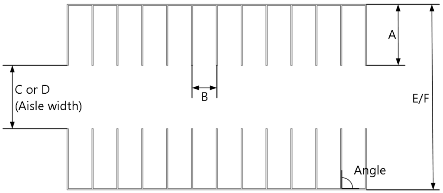
B.
Compact Car Parking. Up to five percent of the total parking spaces required may be designated for compact cars. Minimum dimensions for compact spaces shall be eight by 16 feet. Such spaces shall be signed or the space painted with the words "Compact Car Only."
C.
Surface Materials. All parking areas, aisles, turn-arounds and driveways shall be paved with concrete, asphalt or other approved surface, constructed to standards on file in the office of the City Engineer.
1.
Single-family residential uses in the RR and R1 zoning districts may be surfaced with a permeable material, such as crushed rock, to the standards on file in the office of the City Engineer.
2.
Permanent surfacing shall be installed prior to receiving a certificate of occupancy.
3.
Parking areas may be surfaced with a dust-free permeable material.
4.
Parking spaces provided above the minimum number of required parking spaces pursuant to Table 7.9-I: Minimum Required Off-Street Parking, shall be designed in accordance with iSWM standards described in the iSWM Water Quality Technical Manual.
5.
Stall markings and/or other vehicular control devices shall be provided to the specifications of the City Engineer.
D.
Location of Parking Areas.
1.
Single-Family Detached, Duplex, and Townhome Dwellings. Off-street parking for single-family detached, duplex, and townhome dwelling uses shall only be allowed in a garage or on an approved surface. All other off-street parking within a required front setback area shall be prohibited.
2.
All Other Uses. Off-street parking areas located between the front building facade and the adjacent street frontage is prohibited, unless the parcel satisfies all of the following standards:
a.
It is located outside of the MN and MD zoning districts;
b.
It adjoins either side of an Arterial and Commercial Collector, as defined in the City Mobility Plan;
c.
It does not adjoin the following corridors:
i.
Fort Worth Drive (between Carroll Boulevard and Eagle Street);
ii.
Dallas Drive (between Teasley Boulevard and Eagle Street);
iii.
Elm Street (between University Drive and Eagle Street);
iv.
Locust Street (between University Drive and Eagle Street); and
d.
The development satisfies the general regulations for parking in front of buildings as set forth in Subsection 7.9.6E.
3.
Infill Development. Except as prohibited by paragraph 7.9.6D.2.c, infill parcels meeting the requirements of Subsection 7.9.6E are exempted from prohibitions against parking in front of buildings.
E.
Front Parking Design Standards.
1.
Development with 100 or Fewer Off-Street Parking Spaces. Development with 100 or fewer off-street parking spaces located between the front building façade and the adjacent street frontage shall comply with the following:
a.
Development shall be limited to no more than two rows of parking between the front building façade and the adjacent street frontage.
b.
Landscaping and screening shall be provided per Section 7.7, Landscaping, Screening, Buffering, and Fences, unless the development includes pad sides pursuant to paragraph 7.9.6E.2 below.
2.
Development with More than 100 Off-Street Parking Spaces. Development with more than 100 off-street parking spaces located between the front building façade and the adjacent street frontage shall comply with the following:
a.
Pad sites are reserved to be located at corners where two streets intersect and at both corners of the main drive into the development. For purposes of this provision, the "main drive" is the drive that receives the majority of vehicular traffic. When required, the Transportation Impact Analysis shall determine the main drive;
b.
Corner pad site buildings shall be built to the front setback line; however, additional setback may be allowed to accommodate outdoor dining or a plaza with a focal point that includes seating, public art, and a water feature; and
c.
Pad sites not located on a corner shall not exceed two rows of parking between the front building façade and the adjacent street frontage.
F.
Parking Area Lighting. See Section 7.11.4.
G.
Pedestrian and Bicycle Circulation. See Section 7.8.11.
(Ord. No. DCA19-0028a, § 2(Exh. A), 2-4-2020)
7.9.7 - Loading Areas and Drive-Throughs.
A.
Number and Size of Loading Berths Required.
1.
All commercial and industrial uses shall provide loading berths pursuant to the table below.
2.
The Director may approve a variation from the required loading space requirements if warranted by the building use.
3.
The minimum turning radius for truck traffic areas shall be 40 feet.
B.
Location of Off-Street Loading Areas.
1.
Except for properties in the LI and HI zoning districts, required off-street loading spaces shall not be permitted in any front yard or in any required street side yard.
2.
Loading areas shall be separated from pedestrian areas.
3.
Off-street loading spaces may occupy all or any part of a required rear yard where visibility from public streets and windows of neighboring buildings will be minimized.
4.
Loading areas shall not interfere with parking lot maneuvering areas.
5.
City streets or rights-of-way shall not be utilized for loading and unloading purposes.
C.
Drive-Throughs. Any establishment that has a drive-through use is subject to the requirements in the Transportation Design Criteria Manual and the following:
1.
Drive-through uses shall provide sufficient stacking area to ensure that public rights-of-way are not obstructed;
2.
Drive-through uses shall be built as an integral architectural element of the principal structure and shall use the same materials as those used in the principal structure. Drive-through structures and facilities separate from the principal structure are prohibited; and
3.
Drive-through uses shall be located to the rear or side of the principal structure, and shall be buffered on the rear and side lot lines as required in Subsection 7.7.6, Compatibility Landscape Buffer Requirements.
7.9.8 - Bicycle Parking.
A.
Minimum Required Bicycle Parking. Unless exempted by Subsection 7.9.8B, all multifamily and nonresidential development shall provide off-street bicycle parking spaces at a ratio of one bicycle parking space per 20 vehicle parking spaces, with no development providing less than two bicycle parking spaces.
B.
Bicycle Parking Reduction. Subject to the approval of the Director, the number of bicycle parking spaces may be reduced because of building site characteristics.
C.
Bicycle Parking Location and Design.
1.
Location. Required off-street bicycle parking spaces shall be provided with bike racks, bike lockers, or a fenced, covered, locked, or guarded bike storage area that comply with the following standards:
a.
Located in a visible, well-lit ground-level area;
b.
Conveniently accessible to the primary entrances of a development's principal building(s);
c.
Does not interfere with pedestrian traffic; and
d.
Is protected from conflicts with vehicular traffic.
2.
Multiple Building Developments. For developments with multiple buildings, bicycle parking shall be distributed evenly among principal buildings.
3.
Design.
a.
Bicycle parking areas shall not be used for any other purposes.
b.
Bicycle parking spaces shall be installed using standard requirements that are effective for storage and are permanently anchored to a hard surface.
(Ord. No. DCA22-0004a, § 2(Exh. A), 9-27-2022)
7.10.1 - Purpose.
This Section 7.10 is intended to:
A.
Promote high-quality development and construction;
B.
Ensure compatibility between residential neighborhoods and adjacent commercial and mixed-use areas;
C.
Mitigate negative impacts created by the scale and bulk of large buildings;
D.
Provide variety and visual interest in the exterior design of buildings;
E.
Enhance the streetscape and diminish the prominence of garages and parking areas;
F.
Promote an environment that is friendly toward multiple modes of transportation and accommodates varying ages and abilities; and
G.
Protect and enhance property values and encourage further investment and reinvestment.
7.10.2 - Applicability.
A.
General Applicability. Except as otherwise provided in this Section 7.10: Site and Building Design, the standards in this section and the Site Design Criteria Manual shall apply as set forth in Section 7.2: Applicability, with the following modifications:
1.
New Construction.
a.
A new principal structure is constructed; or
b.
An existing principal structure is relocated on the lot.
2.
Expansions and Enlargements.
a.
The entire site and buildings and/or dwelling units shall comply with this Section 7.10 when:
i.
The number of multifamily dwelling units on a property is increased by more than 25 percent; or
ii.
Ten or more additional multifamily dwelling units are created within the MD zoning district; or
iii.
The square footage of a nonresidential or mixed-use building is expanded or enlarged by more than 50 percent; or
iv.
The addition or expansion of one or more structures or uses that requires specific use permit approval.
b.
The portion of the building and/or site being expanded and/or improved shall comply with this Section 7.10 when:
i.
Except for within the MD zoning district, the number of dwelling units on a property is increased by between 10 and 25 percent or 10 dwelling units, whichever is less; or
ii.
The square footage of a nonresidential or mixed-use building is expanded or enlarged by between 10 and 50 percent.
B.
Exemptions.
1.
Expansion of a single-family detached dwelling, duplex, or townhome within the permitted building coverage.
2.
Expansions and enlargements of a multifamily or nonresidential use less than the greater of 1,000 square feet or 10 percent of the building's square footage.
3.
Conversion of a residential structure to a nonresidential use where no site improvements are required.
C.
Conflicting Standards. Where the site and building design standards in this Section 7.10 conflict with the design standards applicable to an overlay district or PD, the standards in the overlay district or PD shall govern.
D.
Alternative Compliance. Alternatives to these standards may be approved by the Director if the applicant demonstrates that the proposed alternative:
1.
Achieves the intent of the subject standard to the same or better degree than the subject standard;
2.
Advances the goals and policies of the Comprehensive Plan and this DDC to the same or better degree than the subject standard;
3.
Results in benefits to the community that are equivalent to or exceed benefits associated with the subject standard; and
4.
Imposes no greater impacts on adjacent properties than would occur through compliance with the specific requirements of this DDC.
7.10.3 - Single-Family Detached, Duplex, Townhome, Triplex, and Fourplex Dwelling Site and Building Design.
A.
Applicability. This subsection applies to any single-family detached dwelling, duplex, townhome, triplex, or fourplex.
B.
Orientation. Primary entrances shall face a public right-of-way to the maximum extent practicable. The Director may approve alternative orientations for primary entrances facing common green spaces or other common areas such as courtyards, plazas, and gathering spaces.
C.
Open Space Requirements. Any development consisting of 10 or more duplex, townhome, triplex, and fourplex dwelling units shall set aside a minimum of five percent of the land area as open space for the use and enjoyment of the development's occupants and users. Such open space shall comply with the requirements of Subsection 7.10.4C.
D.
Architectural Variety. The same elevation shall not be used within any 10 lot grouping as defined by the two adjacent lots on either side of the subject property and the five lots immediately across the street from those same lots. This requirement shall not apply across a right-of-way dividing two adjacent blocks:
Figure 7.10-A: Architectural Variety
E.
Building Mass and Form. Buildings shall incorporate at least three of the following design features to provide visual relief along the front of the residence:
1.
Dormers;
2.
Gables;
3.
Recessed entries, a minimum of three feet deep;
4.
Covered front porches;
5.
Cupolas;
6.
Architectural pillars or posts; and/or
7.
Bay window with a minimum 24 inches projection.
Figure 7.10-B: Building Mass and Form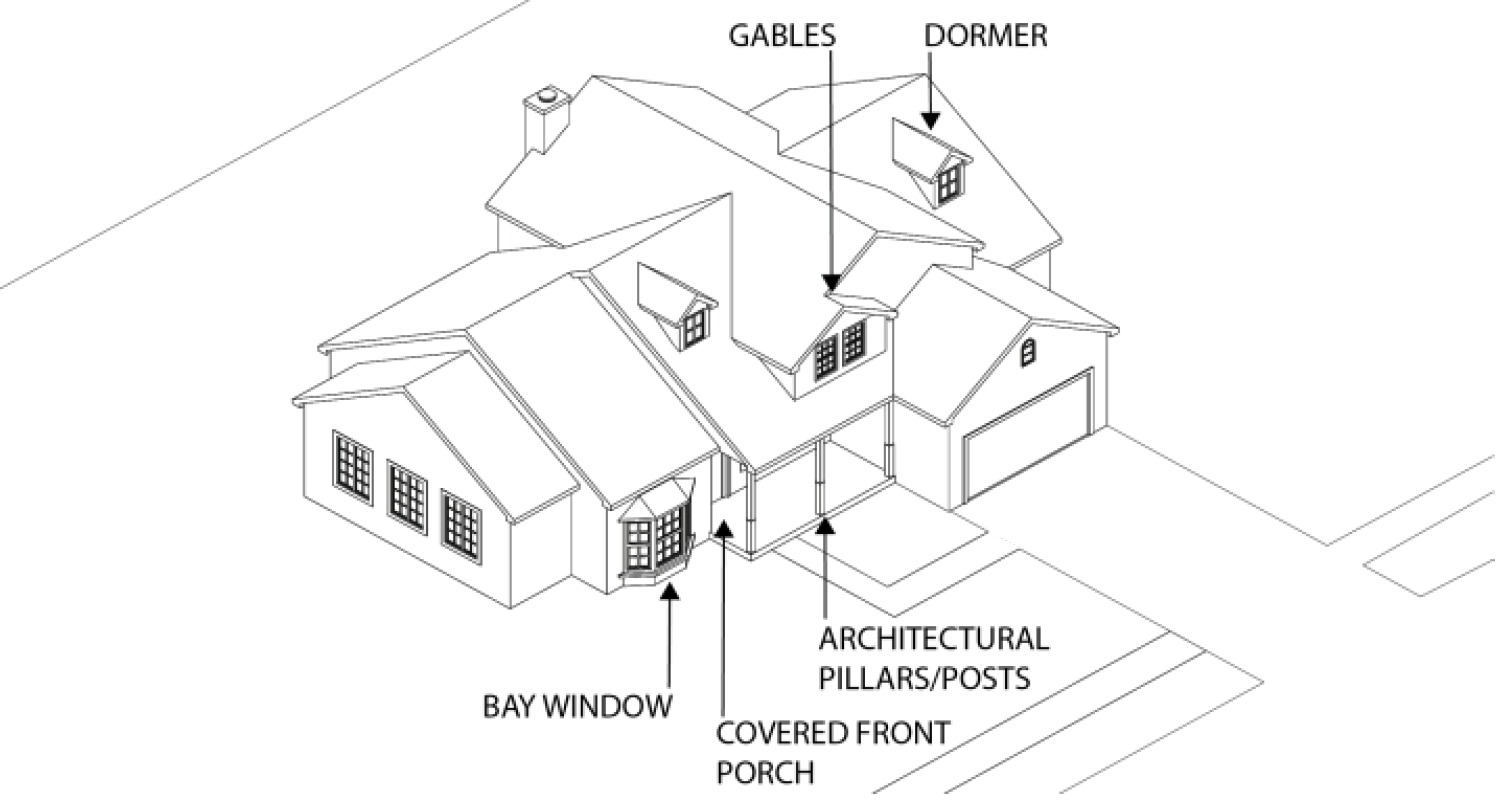
F.
Garage Design.
1.
Where alleys are present, garages shall be accessed from the alley to the maximum extent practicable.
2.
For front-entry garages:
a.
The garage shall be offset a minimum of three feet from the building; and
b.
The total width of the garage door(s) shall not occupy more than 40 percent of the ground-floor building frontage.
3.
Side- and rear-entry garages are encouraged and may encroach into setbacks pursuant to Table 3.7-A: Authorized Exceptions to Setbacks.
G.
Building Transparency/Windows.
1.
Within the front façade (front adjoining a public or private right-of-way where the entrance/address is located), windows and doors (excluding garage doors) shall comprise at least 15 percent of the wall area.
2.
Windows shall be provided with trim or shall be recessed. Windows shall be provided with an architectural surround at the jamb. Shutters, trims, or false windows shall not count toward the minimum requirement.
H.
Building Materials.
1.
Exterior finishes shall be of wood, masonry, or cementitious siding.
2.
Masonry shall comprise a minimum of 25 percent of the exterior finishes of the total building elevation.
3.
Other building materials may be approved by the Director provided they meet the intent of this section.
I.
Minimum Pervious Area in the Front Yard. Each lot shall maintain a minimum 30 percent pervious area between the principal structure and the front property line, and shall be landscaped pursuant to Section 7.7: Landscaping, Screening, Buffering, and Fences. Pavers shall not count toward required pervious area. The minimum pervious area may be reduced by 10 percent for side-entry garages.
7.10.4 - Multifamily Site and Building Design.
A.
Applicability. This subsection applies to any multifamily development, except those that are part of a mixed-use building.
B.
Site Design and Orientation.
1.
Primary Building Access. Primary building access shall be oriented towards the adjacent street, and building access shall be provided from the street and/or sidewalk.
2.
Multi-Building Developments. For developments with three or more buildings, the buildings shall be arranged using one or more of the following techniques:
a.
Organize units around a central courtyard that maintains a consistent side yard setback between units along the street frontage;
b.
Locate the buildings on the corner of an adjacent street intersection or entry point to the development to frame the corner;
c.
Provide common gathering spaces between buildings; and/or
d.
Other site improvements as approved by the Director that do not conflict with this DDC.
Figure 7.10-C: Multi-Building Developments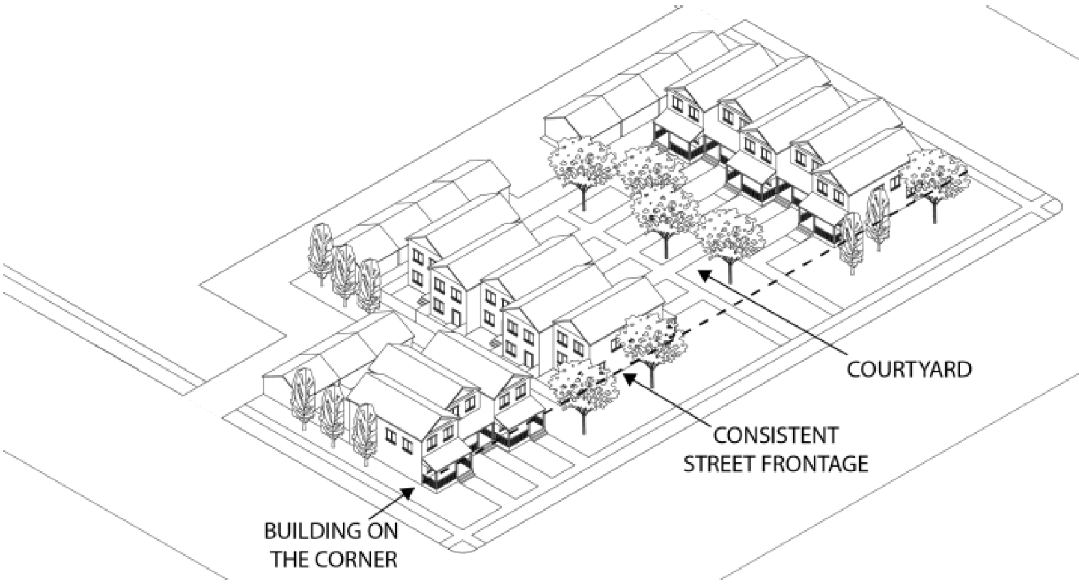
3.
Location of Trash Storage and Mechanical Equipment. Trash storage areas, mechanical equipment, and similar areas shall not be visible from public view, and shall not be located between the building and the street.
C.
Open Space Requirements. Any development consisting of 10 or more dwelling units shall set aside a minimum of eight percent of the land area as open space for the use and enjoyment of the development's occupants and users. Open space serves numerous purposes, including preservation and protection of natural areas and features, providing opportunities for passive and active recreation, enhancing management of stormwater runoff to protect water quality and reduce flooding, and mitigating the heat island effect of developed areas. This requirement does not apply to multifamily developments in the MD zoning district.
1.
Design of Open Space. Such open space shall meet the following design standards:
a.
To the maximum extent practicable, required open space shall be located and configured to include, protect, or enhance natural resource or hazard areas (including but not limited to lakes, ponds, streams, flood hazard areas, and drainage ways);
b.
Areas covered by shrubs, bark mulch and other ground covers that do not provide a suitable surface for human use may not be counted toward this requirement;
c.
Required open space areas shall be compact and contiguous unless a different configuration is needed to continue an existing trail or accommodate preservation of natural features;
d.
Required open space shall be located to be readily accessible and useable by occupants and users of the development. Where possible, a portion of the open space should provide focal points for the development through prominent placement or easy visual access from streets; and
e.
If the development site is adjacent to existing or planned parks, greenways, or other public open space, required open space shall, to the maximum extent practicable, be located to adjoin, extend, and enlarge the park, greenway, or other public open space.
2.
Ownership, Management, and Maintenance of Open Space.
a.
Required open space area shall be managed and maintained as permanent open space through one or more of the following options:
i.
Open space may be held in common ownership by the owner(s) of the development, who will be responsible for managing and maintaining the land for its intended open space purposes.
ii.
Open space areas may be conveyed to a property owners' or homeowners' association that holds the land in common ownership and will be responsible for managing and maintaining the land for its intended open space purposes.
iii.
Open space areas may be conveyed to a third-party beneficiary such as an environmental or civic organization that is organized for, capable of, and willing to accept responsibility for managing and maintaining the land for its intended open space purposes.
iv.
Open space areas may be dedicated to the public and conveyed to the city or other public agency that is organized for, capable of, and willing to accept responsibility for managing and maintaining the land for its intended open space purposes.
b.
Easements may be established on those parts of individually-owned lots including open space areas that require the areas to be managed consistent with their intended open space purposes and prohibit any inconsistent future development. Any options involving private ownership of required open space area shall include association by-laws, deed restrictions, covenants, or other legal instruments that ensure continued use of the land for its intended open space purposes and provide for the continued and effective management, operation, and maintenance of the land and facilities. Such instruments shall be approved by the city as sufficient to comply with this standard before or in conjunction with approval of any subdivision approval for the development, or any construction plan approval for the development (if no subdivision approval is required).
c.
Responsibility for managing and maintaining open space areas lies with the owner of the land comprising the areas. Failure to maintain open space areas in accordance with the approved development shall be a violation of this DDC. Identification of who bears responsibility for managing and maintaining open space areas shall be shown on any recorded subdivision plat for the development or any approved construction plan for the development (if no subdivision approval is required).
D.
Architectural Requirements.
1.
Limitation on Same Building Design. For projects with 30 dwelling units or greater, or more than three buildings, the same exterior design may not be used for greater than 30 units and/or more than three buildings in a project. A variety of compatible exterior materials' use and type, building styles, massing, composition, and prominent architectural features, such as door and window openings, porches, rooflines, shall be used.
2.
Entries.
a.
Primary building entries shall be denoted through the use of distinctive architectural elements and materials, such as ornamental glazing or paving, over doors, porches, trellises, or planter boxes or as otherwise identified in this section.
b.
In the mixed-use zoning districts, residential units abutting a public street shall be designed with entries and windows facing the street. In all cases, buildings shall be designed to distinguish the private realm from the public realm through such features as, but not limited to, elevation change or fencing.
E.
Building Mass and Form.
1.
General.
a.
Buildings shall be designed to prevent the appearance of straight, unbroken lines in the horizontal and vertical surface. Buildings shall have no more than 50 continuous feet without a horizontal and vertical break of at least three feet. Such breaks may include recesses, projections, windows, roofs, alcoves, porticoes, awnings, and other architectural features to provide visual interest and relief.
b.
Façades shall be broken up to give the appearance of a collection of smaller structures. Elements including but not limited to balconies, recessions, and projections may be used to articulate individual units or collections of units.
c.
Buildings visible from the public right-of-way or private street system shall include changes in relief such as columns, cornices, bases, fenestration, and fluted masonry, for at least 15 percent of the exterior wall area.
d.
Stairwells shall not be a prominent feature of any building façade, and shall be shielded from view from public and private streets to the maximum extent practicable.
e.
Any building constructed with a flat roof shall contain a distinctive finish consisting of a cornice, banding, or other architectural termination.
2.
Additional Requirements in Mixed-Use Zoning Districts. In the mixed-use zoning districts, the following additional requirements apply:
a.
Buildings shall be designed to reduce apparent mass by including a clearly identifiable base, body, and top, with horizontal elements separating these components. The component described as the body must constitute a minimum of 50 percent of the total building height;
b.
The first floor of multifamily buildings shall be a minimum of 12 feet in height; and
c.
Stoops and higher finish-floor elevations are encouraged on the street-facing elevation for multi-family buildings. Buildings that provide stoops and/or finish-floor elevations that rise at least two feet above the sidewalk may measure building height from the beginning of the first floor, instead of from grade.
F.
Accessory Structure/Garage.
1.
Garages, carports, storage units, and other accessory structures (but not including leasing offices, club houses, or recreation centers) shall not be located along the portion of the building that fronts the public or private street.
2.
Garages shall not occupy more than 40 percent of the total building frontage. This measurement does not apply to garages facing an alley or courtyard entrance.
3.
Garages, carports, storage units, and other accessory structures visible from the public right-of-way, private street system, and/or adjacent residential properties shall include at least three of the following:
a.
Façade modulation of at least six inches for every 30 feet of wall length;
b.
Multiple building materials (e.g., brick, fieldstone, limestone, marble, granite, textured block, architectural pre-cast concrete, cementitious siding, wood clapboard siding, wood beaded siding, or stucco);
c.
Multiple surface textures (e.g. rough, striated, imprinted, etc.) or patterns; or
d.
Separation in roof pitch, variation in direction of roof pitches, inclusion or dormers, or other variation on roof design.
G.
Building Transparency/Windows.
1.
Within the front façade (front adjoining a public or private right-of-way where the entrance/address is located), windows and doors (excluding garage doors) shall comprise at least 25 percent of the wall area.
2.
For all other façades that face a public or private street or right-of-way (excluding alleys), windows and doors (excluding garage doors) shall comprise 15 percent of the wall area.
3.
Windows shall be provided with trim or shall be recessed. Windows shall not be flush with exterior wall treatment. Windows shall be provided with an architectural surround at the jamb.
4.
Use of false door or window openings shall be defined by frames, sills, and lintels.
H.
Building Materials.
1.
An amount equal to 40 percent of the total net exterior wall area of each building elevation, excluding gables, windows, doors and related trim, shall be masonry.
2.
Other building materials may be approved by the Director provided they meet the intent of this section.
7.10.5 - Nonresidential and Mixed-Use Buildings.
A.
Applicability.
1.
This subsection applies to any nonresidential or mixed-use development.
2.
These standards do not apply to industrial uses in the LI or HI zoning districts where the building or structure is located:
a.
Farther than 250 feet from the ultimate right-of-way of an arterial, collector, or interstate roadway; or
b.
Behind another building or structure that screens the building or structure from the adjacent arterial or interstate roadway.
3.
Alternatives to these standards may be approved by the Director if:
a.
The building is not accessed by pedestrians, such as warehouses and industrial buildings without attached offices, automotive service uses such as gasoline sales and automobile sales; or
b.
The development is on an infill site; or
c.
The design results in a higher-quality product that exceeds the minimum standards in this subchapter.
B.
Site Design and Orientation.
1.
The primary entrance of a building shall have a clearly defined, highly visible customer entrance with distinguishing features such as a canopy, portico, or other prominent element of the architectural design.
2.
Buildings shall have their primary orientation toward the street rather than the parking area.
3.
Buildings that are within 30 feet of the street shall have an entrance for pedestrians from the street to the building interior.
4.
Trash storage areas, mechanical equipment, loading areas, and similar areas shall not be visible from public view, and shall not be located between the building and the street.
C.
Multi-Building Developments. For developments with three or more buildings, the buildings shall be arranged using one or more of the following techniques:
1.
Organize units around a central courtyard that maintains a consistent side yard setback between units along the street frontage;
2.
Locate the buildings on the corner of an adjacent street intersection or entry point to the development to frame the corner;
3.
Provide outdoor dining and/or common gathering spaces between buildings; and/or
4.
Other site improvements as approved by the Director that do not conflict with this DDC.
Figure 7.10-D: Multi-Building Development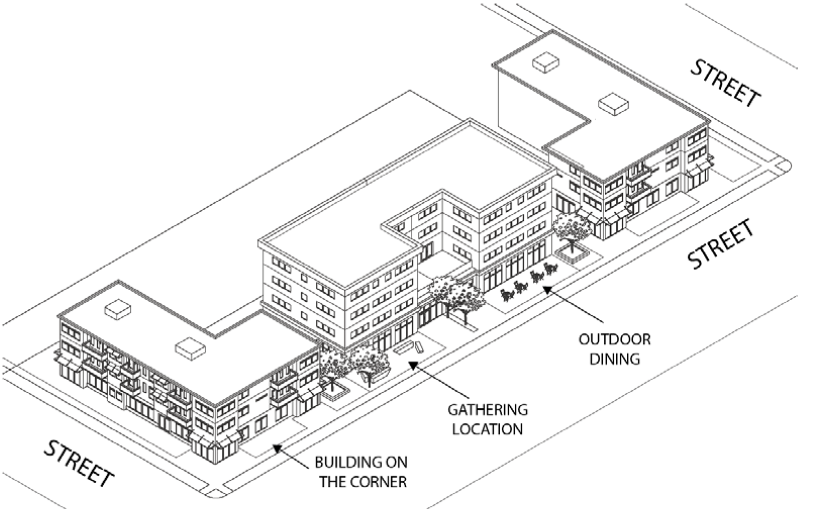
D.
Building Mass and Form. Buildings shall have no more than 50 continuous feet without a horizontal and vertical break of at least three feet. Such breaks may include recesses, projections, windows, roofs, alcoves, porticoes, awnings, and other architectural features to provide visual interest and relief.
E.
Building Transparency/Windows.
1.
Use of glass for displays and to allow visual access to interior space is permitted. Buildings may not incorporate glass for more than 70 percent of the building skin.
2.
Windows shall be provided with trim. Windows shall not be flush with exterior wall treatment. Windows shall be provided with an architectural surround at the jamb.
F.
Building Materials.
1.
Fronts and street sides of buildings visible from the public right-of-way shall be non-reflective and shall be of wood, masonry, stucco, EIFS (Exterior Insulation Finishing System), or cementitious siding.
2.
Masonry shall comprise a minimum of 50 percent of the exterior finishes of the total building elevation.
3.
A maximum of 10 percent of architecturally finished metal can be used as an accent material or for embellishments on buildings classified as commercial uses, except that in the LI and HI districts along an arterial, architecturally finished metal can be used for up to 50 percent of the building façade.
4.
Other building materials may be approved by the Director provided they meet the intent of this section.
G.
Additional Standards in the MN and MD Districts.
1.
Applicability.
a.
These standards apply to nonresidential and mixed-use development in the MN and MD districts.
b.
These standards are in addition to those required for nonresidential and mixed-use development in Subsection 7.10.5.
c.
Where these standards conflict with the standards in Subsection 7.10.5, these standards shall apply.
2.
Site Design and Orientation
a.
At least 60 percent of the street frontage shall have buildings within 10 feet of the front property line.
b.
A building shall be setback not more than 15 feet from the public right-of-way unless the area is used for pedestrian activities such as plazas or outside eating areas.
Figure 7.10-E: Site Design and Orientation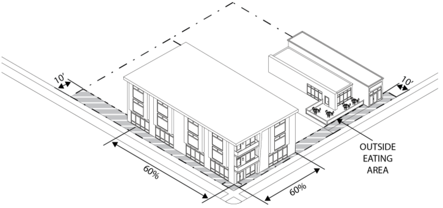
c.
Buildings that are open to the public and are within 30 feet of the street shall have an entrance for pedestrians from the street to the building interior. This entrance shall be designed to be attractive and functional, be a distinctive and prominent element of the architectural design, and shall be open to the public during all business hours.
d.
Buildings shall incorporate lighting and changes in mass, surface, or finish emphasizing entrances.
3.
Building Mass and Form
a.
The top floor of any building rising over four stories shall incorporate a distinctive finish, consisting of a cornice or other architectural termination.
b.
Buildings shall be designed to reduce apparent mass by including a clearly identifiable base, body, and top, with horizontal elements separating these components. The component described as the body must constitute a minimum of 50 percent of the total building height.
4.
Building Transparency/Windows.
a.
Any ground floor wall facing a main street, plaza, or other public open space shall contain at least 50 percent of the wall area facing the street in display areas, windows, or doorways.
b.
At least 20 percent of each upper floor facing a main street, plaza, or other public open space shall contain windows or doorways.
c.
Windows shall allow views into working areas or lobbies, pedestrian entrances, or display areas.
d.
Walls facing side streets shall contain at least 25 percent of the wall space in windows, display areas, or doors, provided:
i.
Blank walls within 30 feet of the side street are prohibited.
ii.
Up to 40 percent of the length of the building can be exempted from this standard if oriented toward loading or service area.
5.
Building Materials.
a.
A maximum of 10 percent of architecturally finished metal can be used as an accent material or for embellishments on buildings classified as nonresidential uses.
b.
Buildings shall include changes in relief such as columns, cornices, bases, fenestration, and fluted masonry, for at least 15 percent of the exterior wall area.
6.
Streetscape. Hardscape (paving material) shall be used to designate pedestrian-oriented areas. Sample materials could be pavers, scored and colored concrete, grass-crete, or combinations of the above.
7.10.6 - Building Height in Transition Areas.
A.
Any portion of a building within 50 feet of a property zoned in a Residential District, as provided in Table 3.1-A: Zoning District Designations, shall not exceed the maximum building height allowed in the abutting Residential District. Portions of buildings within 50 feet are not eligible for additional building height that may otherwise be allowed with a specific use permit.
B.
Any portion of a building between 50 feet and 100 feet of a property zoned in a Residential District, as provided in Table 3.1-A: Zoning District Designations, shall not exceed the maximum building height allowed in the abutting Residential District, plus 15 feet. Portions of buildings between 50 feet and 100 feet are not eligible for additional building height that may otherwise be allowed with a specific use permit.
C.
Any portion of a building beyond 100 feet from a property zoned in a Residential District, as provided in Table 3.1-A: Zoning District Designations, shall not exceed the allowed building height of the zoning district where the building is located. Portions of buildings beyond 100 feet are eligible for additional building height that may otherwise be allowed with a specific use permit.
D.
Building features referenced in Table 3.7-B: Authorized Exceptions to Height Standards, shall be designed to minimize visibility from adjacent residential districts and fit within the allowed building height of the zoning district where the building is located, to the maximum extent practicable.
Figure 7.10-F: Building Height in Transition Areas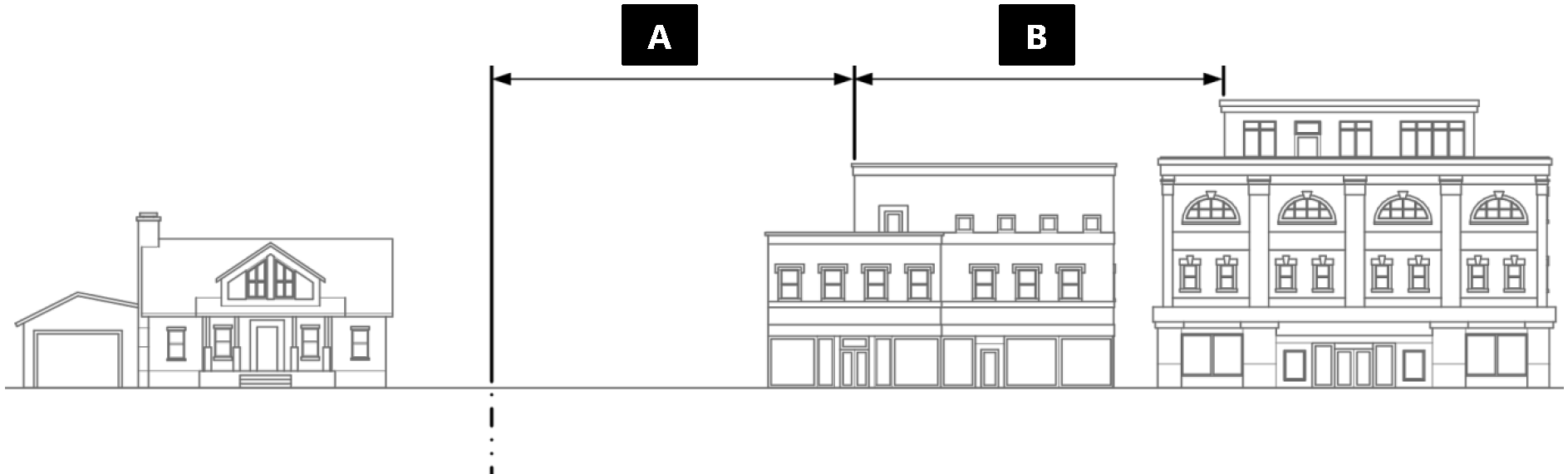
7.11.1 - Purpose.
The purpose of this Section 7.11 is to ensure that vehicle circulation areas, pedestrian areas, parking areas, public gathering spaces, and other areas have adequate outdoor illumination to provide safety at night, while limiting the negative impacts of outdoor lighting nuisance on adjacent properties.
7.11.2 - Applicability.
A.
Generally. Except as otherwise provided in this Section 7.11: Exterior Lighting, the standards in this section shall apply as set forth in Section 7.2: Applicability, with the following modifications.
B.
Exemptions. The following types of exterior lighting are exempt from the requirements of this section, provided they shall not create glare to motorists or result in light trespass onto adjacent properties:
1.
Holiday Lighting.
a.
Temporary winter holiday lighting illuminated from November 1 to March 1 is allowed in mixed-use and nonresidential zoning districts;
b.
Residential zoning districts may use holiday lighting any time of year; and
c.
Holiday lighting shall not exceed one foot-candle at any property line, except where the property line is adjacent to walkways, driveways, and streets.
2.
Single-Family Detached, Duplex, and Townhouse Uses.
a.
Soffit or wall-mounted lights permanently attached to the dwelling shall be exempt from the exterior lighting regulations, provided the lights do not exceed the height of the eave; and
b.
Such lights shall be downcast and directed away from abutting properties.
3.
Mixed-Use, Corridor, and Other Nonresidential Zoning Districts.
a.
Twinkle lighting located on trees, bushes, or landscape features; and
b.
Bistro lighting.
4.
Special Events. Special events that have been issued a temporary use permit.
5.
Lighting Required by FAA or FCC. Lighting required by the Federal Aviation Administration or the Federal Communications Commission.
6.
Underwater Lighting. Underwater lighting used for the illumination of swimming pools and decorative water fountains shall not be subject to this Section 7.11, though they must conform to all other provisions of this DDC.
7.
Lighting Required by Building Code. Any lighting that is required by the building code for life safety purposes such as stairway lighting, walkways, and building entrances, shall not be prohibited by this section, but shall be subject to the lighting standards.
7.11.3 - Standards Applicable to All Development.
The following standards apply to all development unless specifically exempted in Subsection 7.11.2B:
A.
Except in the RR, R1, R2, and R3 zoning districts, sidewalks, internal pedestrian paths, and bicycle paths shall be lit with full cutoff shielded and downcast fixtures no more than 16 feet tall and providing consistent illumination of at least one foot-candle on the walking surface.
B.
Lighting along public rights-of-way and landscaped areas for a specific development shall be designed uniformly.
C.
Light spillover onto adjacent properties shall not exceed one foot-candle at any property line, except where the property line is adjacent to walkways, driveways, and streets or in nonresidential developments comprised of multiple lots, and when state and federal regulations apply.
7.11.4 - Parking Area Lighting.
A.
Pole Height. Parking area lighting fixtures shall not exceed 25 feet in height.
B.
Shielding of Lights.
1.
Parking area lighting shall be full cutoff shielded and downcast fixtures.
2.
The source of light on any fixtures on a nonresidential use adjacent to a single-family, duplex, or townhouse use shall be shielded from sight.
3.
Lighting fixtures for canopies or similar structures shall be flush-mounted or recessed above the lower edge of the canopy.
C.
Illuminance.
1.
Maintained average illuminance values in commercial and multifamily parking areas shall be no less than two foot-candles.
2.
The acceptable uniformity ratio for lighted areas shall comply with recommended ranges adopted by the International Engineering Society of North America (IESNA) for low, medium, and high activity areas.
7.11.5 - Building Lighting.
A.
Location and Direction.
1.
Except for decorative lighting, building-mounted lights shall be installed so that all light is directed downward.
2.
Wall packs and similar lights shall be prohibited unless the cutoff angle effectively eliminates glare from beyond the property lines.
B.
Decorative Lighting. Decorative lighting shall be permitted provided all light is cast against the building surface.
7.11.6 - Street Lighting.
A.
Street lights shall be installed for every new development, at the developer's expense to protect the public health, safety, and welfare of the site and/or surrounding neighborhoods.
B.
All fixtures shall be compatible with the character of the neighborhood and City as a whole.
C.
All new street lighting fixtures shall be full cut-off and designed to direct lighting below a 90-degree horizontal plane extending from the lowest point of the light source.
D.
All other street lighting requirements will be governed by the Streetlight Criteria Manual.
(Ord. No. DCA23-0008a, § 2(Exh. A), 11-7-2023)
7.12.1 - Purpose.
The purpose of this section is to provide basic criteria and standards for the development and maintenance of solid waste and recycling container enclosures.
7.12.2 - Applicability.
Except as otherwise provided in this Section 7.12: Solid Waste and Recycling Design Standards, the standards in this section, and the Solid Waste Criteria Manual shall apply as set forth in Section 7.2: Applicability.
7.12.3 - General Design Standards.
A.
Non-residential on-site solid waste and recycling storage facilities (container enclosures) shall be located on each platted lot of non-residential property, except as otherwise provided within the Solid Waste Criteria Manual, and shall be constructed and maintained by the property owner or developer, and made available for use by the City of Denton Solid Waste Department and/or commercial recycling service provider. For purposes of these solid waste requirements, "non-residential development" includes any attached residential dwellings of five or more dwelling units.
B.
Nonresidential on-site solid waste and recycling storage facilities (container enclosures) shall be available for the storage of all municipal solid waste and recyclables generated for each platted property. The city reserves the ability to determine which, if any parcels or areas (e.g., Downtown Square, strip centers, multi-family residential, etc.) may be recommended for shared container or other alternative service. Container enclosures shall be of adequate size to contain all solid and liquid wastes and recyclables generated on the property, which may include, but are not limited to, municipal solid waste, recyclables, grease and oils, process by-products and wastes, hazardous waste, medical waste, and any special wastes, contained as necessary to meet disposal standards published by the city. The container enclosures shall be constructed to such capacity prescribed by the Solid Waste Criteria Manual for non-residential solid waste and recycling facilities. Enclosures are not required for non-residential uses where the dumpster locations cannot be seen from the public right-of-way.
C.
See Subpart A, Municipal Code of Ordinances, Chapter 24: Solid Waste, Article III: Commercial Collection Service, for solid waste services requirements.
7.13.1 - Purpose.
The purpose of this section is to provide basic criteria and standards for the development and maintenance of electric transmission lines, distribution lines, substations, interchanges, and switch stations. These reasonable regulations serve to preserve the integrity of adjacent impacted lands and to prevent imminent destruction of property or injury to persons, while ensuring that these mitigating actions conform to the comprehensive plan and DDC. These regulations further serve to protect the health, safety, and general welfare of the public and to accomplish the orderly and practical development of electric utilities, and to achieve the following broader objectives:
A.
To protect and promote the public health, safety and general welfare of the community.
B.
To define and establish the minimum clearances in an effort to safeguard persons against electrical hazards during the installation, operation, maintenance and replacement of electric supply lines, electric substations, interchanges, and electric switch stations.
C.
To adopt the most current National Electrical Safety Code, as amended (NESC) and the most current North American Electric Reliability Corporation Critical Infrastructure Protection, as amended (NERC, CIP).
7.13.2 - Applicability.
Except as otherwise provided in this Section 7.13: Electric Standards, and the standards in this section shall apply as set forth in Section 7.2: Applicability.
7.13.3 - General Design.
A.
All applicable electric industry practices and guidelines set forth in the National Electrical Safety Code, as it may be hereafter amended (NESC) are hereby adopted and shall apply to electric transmission lines, distribution lines, substations, interchanges, and switch stations. To the extent that this DDC conflicts with standards adopted in the NESC, the more restrictive standards shall apply.
B.
All applicable protection standards set forth in the North American Electric Reliability Corporation Critical Infrastructure Protection Standards (NERC CIP), in its most current version, are hereby adopted and shall apply to electric transmission lines, distribution lines, and substations. To the extent that this DDC conflicts with standards adopted in the NERC CIP, the more restrictive standard shall apply.
C.
Adequate consideration shall be given to design criteria to include route evaluation, topography, drainage, size in relation to setbacks, roadway access, distances to residences/schools/businesses, existing trees, unique ecology, and sensitivity to cultural resources in conformance with the DDC, NERC CIP and NESC standards, Electric Service Standards, and other local, State, and/or Federal law.
D.
A development plat shall be required for proposed substation, interchanges, and switch station sites in accordance with the requirements established in TLGC, Ch. 211; Subchapter B, Municipal Code of Ordinances; and the DDC.
E.
Unobstructed and adequate space shall be provided for all clearance areas required by this section that will allow ingress and egress for utility-related personnel and equipment to perform operations, maintenance and replacement of electric supply and communication lines. Such clearance provision shall be included in the design and construction when real property is developed or altered. Such clearance areas shall be recorded by the property developer or by the record owner on subdivision plats; or shall be evidenced by written instrument, duly recorded, in the Public Records of Denton County, Texas.
F.
Regulations contained herein are intended to supplement any regulations contained in the Municipal Code of Ordinances, Chapter 26: Utilities, and not to replace such existing regulations.
7.13.4 - Overhead Electric Transmission Line Clearance.
A.
New Electric Transmission Lines.
1.
69kV Transmission Lines. A minimum of 60-foot wide electric transmission clearance is required on real property affected by 69kV electric transmission lines, said clearance shall be a minimum of 30 feet from either side of the centerline of the particular transmission pole(s). Clearance criteria in the National Electric Safety Code may require greater clearance widths in some instances.
2.
138kV Transmission Lines. A minimum of 75-foot wide electric transmission clearance is required on real property affected by 138kV electric transmission lines, said clearance shall be a minimum of 37.5 feet from either side of the centerline of the particular transmission pole(s). Clearance criteria in the National Electric Safety Code may require greater clearance widths in some instances.
B.
Existing Electric Transmission Lines.
1.
For existing transmission lines and for transmission lines being constructed or reconstructed in developed areas, the utility may elect to perform NESC analysis and calculations to determine if safe and adequate reduced clearance widths can be utilized in lieu of the standard sixty- and seventy-five-foot widths as stated above.
2.
Trees adjacent to overhead electric distribution lines shall comply with paragraph 7.7.7F.7: Trees Adjacent to Overhead Electric Utilities.
7.13.5 - Overhead Electric Distribution Line Clearance.
A.
New Electric Distribution Lines.
1.
13.2kV/7.62kV Grounded Wye. A minimum of 35-foot wide electric distribution clearance is required on real property affected by 13.2kV/7.62kV Grounded Wye electric distribution lines, said clearance shall be a minimum of 17.5 feet from either side of the centerline of the particular distribution pole(s). Clearance criteria in the National Electrical Safety Code may require greater clearance widths in some instances. Additional electric distribution service and clearance requirements are further defined within the Electric Service Standards.
B.
Existing Electric Distribution Lines.
1.
For existing distribution lines and for distribution lines being constructed or reconstructed in developed areas, the utility may elect to perform NESC analysis and calculations to determine that safe and adequate reduced clearance widths can be utilized in lieu of the standard 35 foot width state above.
2.
Trees adjacent to overhead electric distribution lines shall comply with Subsection 7.7.7F.7: Trees Adjacent to Overhead Electric Utilities.
7.13.6 - Electric Easement Requirements.
In all cases where primary electric lines which will feed adjacent properties are installed on private property, the following standards shall prevail:
A.
All easements shall be dedicated as public utility easements and shall be sized per Table 7.13-L, Table 7.13-M, Table 7.13-N. The general criteria to define typical easement widths and sizes are listed in the following tables:
B.
Easement widths and sizes are subject to change at the discretion of Denton Municipal Electric (DME) in accordance with the applicable criteria manual.
C.
DME may allow a utility easement to be dedicated within a fire lane for underground electric distribution lines in some cases, provided that equipment easements are dedicated outside of the fire lane for pad-mounted equipment.
Figure 7.13-A: Equipment Easement Location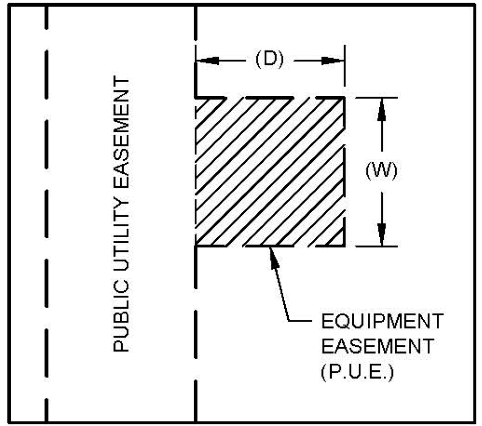
D.
Fences within utility easements are generally prohibited, subject to the following:
1.
Fences shall not be built within or across dedicated utility or electric easements. DME, at their discretion, may allow fences to be built across an easement if access gates at least 12 feet wide are built.
2.
Any existing fence located within dedicated utility or electric easements that conflicts with the purpose and intent of the easement may be removed by the city at any time.
3.
The city is under no obligation to repair or replace any fence that is damaged or removed that encroaches within a dedicated easement for the purposes of operating, maintaining, replacing or installing electric facilities within the dedicated easement.
E.
Employees of the city shall have the authority to enter premises at any reasonable time in the regular line of duty for the purpose of inspecting, repairing or constructing any electric line or any electric meter, etc. The landowner and occupant are responsible for any construction activities occurring over or within any on-site utility in a utility easement.
F.
If utility inspection or repair or reconstruction is necessary, any pavement, structure, or improvement damaged within a dedicated utility or electric easement, shall not be the responsibility of the city for any repairs, but shall be the sole responsibility of the owner.
G.
The landowner assumes responsibility for any and all improvements placed within a utility or electric easement at their own risk. Additionally, the provisions of this section do not permit or supersede the limits and restrictions prescribed by the conditions of any existing utility easement for allowing improvements to be placed within utility easements.
H.
The following shall not be installed or planted within a utility or electric easement without approval by the city:
1.
Trees; and
2.
Any structures, including retaining walls and signs. No part of a structure, including its underground foundation, shall encroach into an easement.
I.
The following items are typically allowed to be installed within a utility or electric easements:
1.
Drive approaches and parking lots (alignment within drive aisles is preferred);
2.
Sidewalks; and
3.
Grass and small shrubbery.
7.13.7 - Electric Substation, Interchange, and Switch Station Design.
A.
Generally.
1.
Standards in this subsection require a basic level of architectural variety, compatible scale, and mitigation of negative impacts.
2.
Where the following provisions are silent, the regulations of Subchapter 7: Development Standards, will apply.
B.
Screening.
1.
Generally.
a.
All screening shall comply with the minimum standards set forth in NERC and NESC. However, to the extent this DDC provides a stricter requirement, this DDC controls.
b.
Screening is required to obstruct, to the greatest extent possible, internal substation or switch station components from view of the public rights-of-way. This does not require screening of structures, equipment, or buildings that exceed 10 feet in height.
2.
Screening Wall. A minimum 10-foot masonry wall is required around the perimeter of the substation, interchange, or switch station to screen the view from public rights-of-way and adjoining properties.
3.
Landscaping.
a.
Trees or any other landscaping shall not be placed within 20 feet of station fences (clearance zone of section G. below).
b.
Landscaping shall not interfere with the physical security of the site.
4.
Gates.
a.
Gates shall be provided at all entrances.
b.
Wrought Iron or similar metal gate material shall be permitted.
C.
Buffering. Buffers are required to minimize potential nuisances such as noise, light, glare, and litter between electric stations and other abutting land uses. Station site expansions are not required to provide space for buffers. Buffering shall not be required when it would compromise station security. Trees shall not be required within clearance zones.
1.
Substations or switch stations abutting any property other than an industrial zoning district, shall provide a 20-foot planted strip along the common boundary that includes a combination of five evergreen and deciduous trees and 30 shrubs per 100 linear feet.
2.
When located within the clearance zones, low growing shrubs with a maximum mature height of 24 inches shall be used to meet the requirements of this section.
3.
Buffering shall not be required when a substation, interchange, or switch station abuts property in an industrial zoning district.
4.
Streets and easements shall be considered as buffer.
D.
Street Tree Standards.
1.
Street trees are required in accordance with Subsection 7.7.7, Street Tree Requirements.
2.
Street lights may be used in lieu of any required street trees provided they are of the same number and spacing required.
E.
Tree Canopy Coverage. Tree canopy coverage is required in accordance with Subsection 7.7.4, but shall not be located within the clearance zone as prescribed in Subsection 7.13.7G. In determining the landscape area for the site, only the area located outside the screening wall, clearance zone prescribed in Subsection 7.13.7G, and any transmission easements shall be considered.
F.
Access and Transportation. Access and transportation into and around the site should be provided to minimize the impacts on adjacent properties, intersections, and the overall street system. Access to the site should be carefully considered to limit the number of entrances that allow greater visibility into the site, while simultaneously allowing for adequate maneuvering of trucks and other heavy equipment necessary to construct, operate, and maintain the site. The following access and transportation standards shall be applicable.
1.
Driveways shall be located on the perimeter streets of the lowest classification unless the only reasonable means of providing safe and adequate access to the property, as determined by the City Engineer, is to access a street of higher classification.
2.
To the extent possible, driveways shall be located so as not to be directly across from the front yards of residential structures or uses, unless otherwise agreed to by the Director of Development Services or his/her designee.
3.
No more than two driveways shall be located on each perimeter street.
4.
Driveway separation is subject to the Transportation Criteria Manual. Due to unique access, large vehicular, and trailer turning radius requirements for electric stations, driveway geometry may differ from the Transportation Criteria Manual requirements.
5.
Driveways shall be constructed of concrete from the back of edge of the curb to the entrance gate of the site. Gravel is not a permitted driveway material for any driveway outside of the site's perimeter screening wall, unless approved by the City Engineer due to the substation's distance from the roadway.
6.
Sidewalks shall be required in accordance with Section 7.8: Access and Circulation, and the Transportation Criteria Manual. Enlarging of substation sites shall not be required to meet the requirements of this section.
G.
Clearance Zones.
1.
A 20-foot clearance zone around the perimeter screening wall free of visual obstructions and climbing aids is required to protect the security and safety of the site.
2.
Any landscaping that could be used as a climbing aid shall not be placed within 20 feet of a substation fence.
H.
Miscellaneous Standards. Development shall comply with this DDC and the NESC and/or NERC standards as applicable and as amended:
1.
Height;
2.
Noise;
3.
Voltage Limitations:
4.
Warning Signs;
5.
Lighting;
6.
Internal Illumination;
7.
Vibration;
8.
Electric Interference; and
9.
Other development standards established by NESC and/or NERC as amended.
I.
Minor Modifications. Minor modifications on a site plan may be approved by the Director pursuant to Subsection 2.7.2: Minor Modification.