
Denton City Zoning Code
Subchapter 3
Zoning Districts
3.1.1 - Zoning Districts Established.
Zoning districts are established as shown in Table 3.1-A: Zoning District Designations. Zoning districts are established by the city's adoption of the Official Zoning Map of City. An explanation of the transition from established zoning districts prior to the effective date of this DDC to the zoning districts in this DDC is provided in Appendix B: Zoning District Transition Table.
3.1.2 - Organization of this Subchapter.
A.
Base Zoning Districts.
1.
Sections 3.2 through 3.5 follow a common structure for describing the purpose and intent for each base zoning district, the applicable dimensional standards, and any district-specific standards.
2.
Each base zoning district includes an illustration demonstrating the dimensional requirements for that district. The illustrations are not intended to represent a specific location, but rather reflect the general character of the district.
3.
Each base zoning district includes a table of dimensional standards summarizing the most pertinent dimensional standards applicable to each district. The labels in the table correspond to the applicable illustration. These tables are illustrative only and do not identify all standards that may apply to a particular development.
4.
If a standard shown in an illustration is inconsistent with the respective table of dimensional standards, the standards in the table shall govern.
B.
Planned Development District.
1.
Planned Development districts are established by the Zoning Amendment Procedure pursuant to Subsection 2.7.3: Rezone to a Planned Development (PD) District. Development in a PD district is subject to the standards included in or referenced in an approved plan.
2.
Section 3.6 describes the general purpose of PD districts and sets forth base requirements applicable to all such districts, including the minimum development standards to be addressed in the district's plan and the means of modifying the standards of this DDC through a PD development approval.
3.1.3 - Official Zoning Map.
A.
Incorporation of Map.
1.
The location and boundaries of the districts designated in this subchapter are established as shown on the map entitled "Official Zoning Map of City" (hereafter referred to as the "Zoning Map"), dated as of the effective date of this subchapter.
2.
The signed originals of the Zoning Map shall be maintained on file in the office of the City Secretary and, by reference, are made a part of this subchapter as if fully incorporated.
B.
District Boundaries. Unless otherwise specified, district boundaries are lot lines, the centerlines of streets, creeks, and railroad right-of-way, or such lines extended.
C.
Digital Mapping. Digital maps, created through the use of geographic information system technology, containing registration points recorded on the Texas State Plane Coordinate System, as amended, may be used in the administration and enforcement of this subchapter, but shall not replace the paper originals of official maps required by this subchapter.
D.
Boundary Clarification.
1.
In the event that a zoning district boundary is unclear or is disputed, the Director shall determine the location of the zoning district boundary.
2.
Any appeal of the Director's determination of the zoning district boundary shall be established by the Zoning Board of Appeals pursuant to Subsection 2.8.3: Appeal of Administrative Decision.
E.
Amendments to the Zoning Map.
1.
If, in accord with the provisions of this subchapter, changes are made in district boundaries portrayed on the Zoning Map, the date of such changes shall be promptly noted on the Zoning Map after the amendment has been approved by the City Council and duly noted in the minutes of the City Council meeting.
2.
No changes shall be made to the Zoning Map except in conformance with the procedures set forth in Subsection 2.7.2: Zoning Map Amendment.
3.1.4 - Annexed Territory.
When any territory is brought into the jurisdiction of the City of Denton, by annexation or otherwise, such territory shall be subject to the development regulations of the RR (Residential Rural) district until the City Council designates another zoning district, after review and recommendation by the Planning and Zoning Commission. Such recommendation and determination shall include consideration of surrounding uses as well as policies stated in the Comprehensive Plan. Initial annexation shall require compliance with the zoning procedure in Subsection 2.7.5: Annexation.
3.2.1 - RR - Residential Rural.
A.
Purpose. The RR district is intended to provide and maintain areas of rural use within the city. Application of this district will ensure that farming, forest, environmental, and scenic areas are protected from incompatible development. This district includes farms and ranches as the predominant use with large lot rural residential and rural commercial uses. The RR district may be used as an interim zoning district for annexed property.
Figure 3.2-A: RR District Dimensional Standards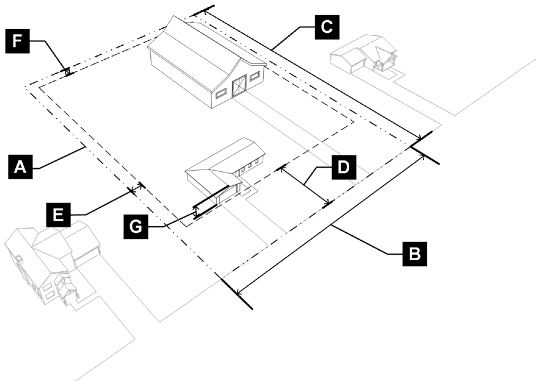
B.
RR District Dimensional Standards.
3.2.2 - R1 - Residential.
A.
Purpose. The R1 district is intended to preserve existing single-family neighborhoods and to ensure that any new development promotes conservation of scenic rural open space and is compatible with existing land uses, patterns, and design standards. The R1 district can be used as a transitional district between rural development and large lot residential neighborhoods.
Figure 3.2-B: R1 District Dimensional Standards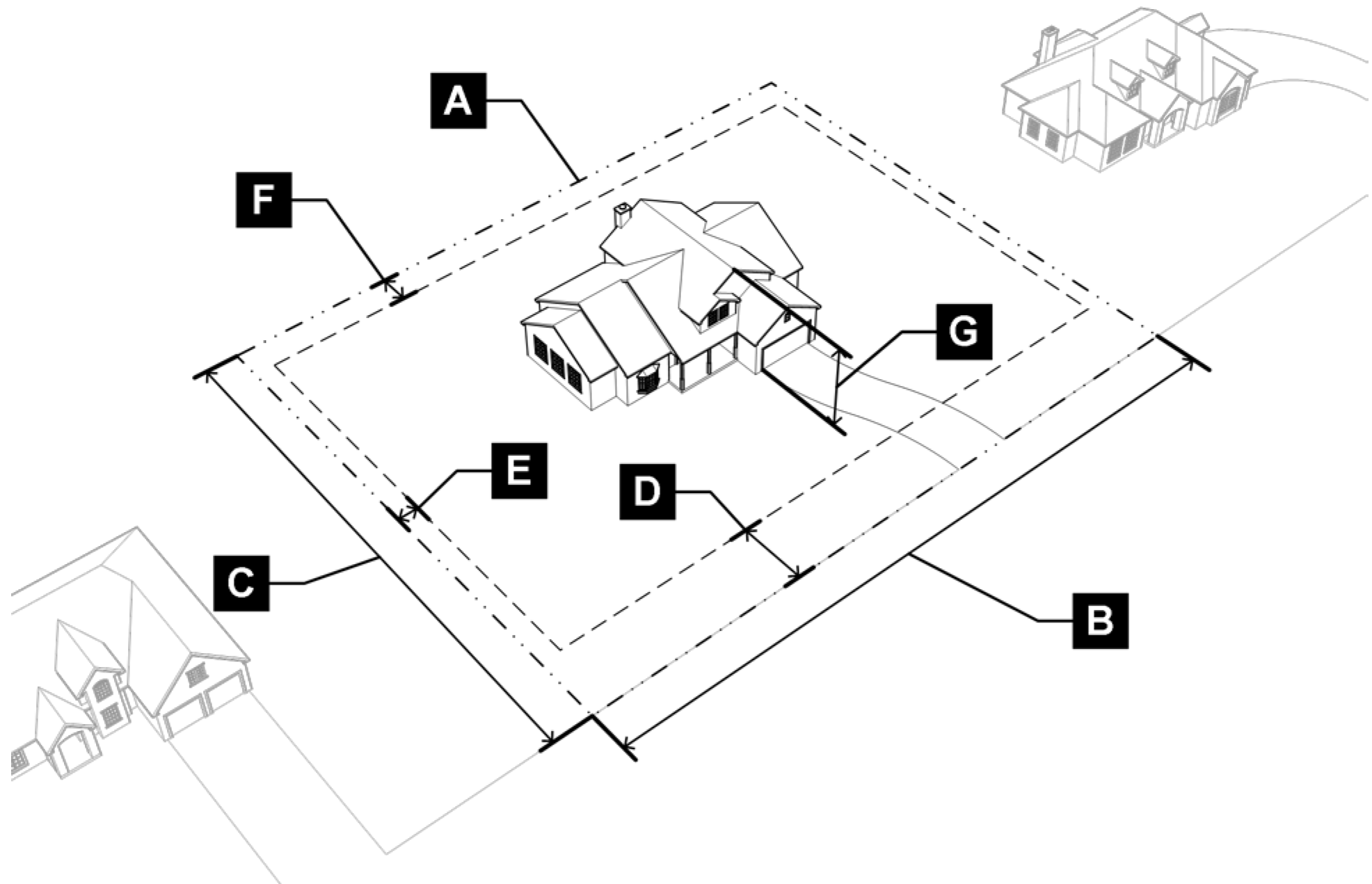
B.
R1 District Dimensional Standards.
3.2.3 - R2 - Residential.
A.
Purpose. The R2 district is intended to preserve existing single-family neighborhoods. The R2 district is intended to ensure that any new development promotes walkability, access to parks, open space, and recreation amenities and is compatible with existing land uses and development patterns. The R2 district can be used as a transitional district between large lot residential neighborhoods and medium lot residential neighborhoods.
Figure 3.2-C: R2 District Dimensional Standards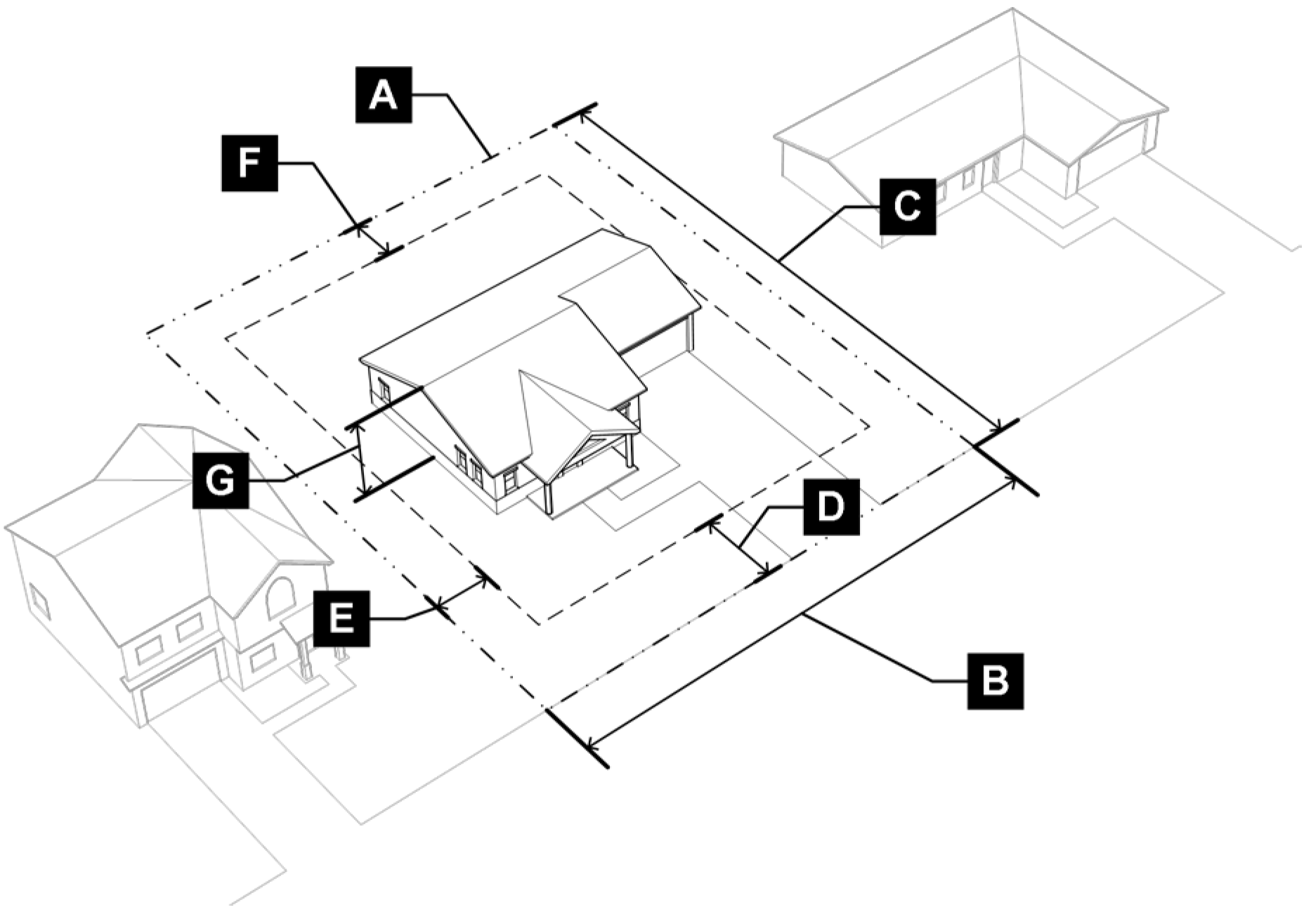
B.
R2 District Dimensional Standards.
3.2.4 - R3 - Residential.
A.
Purpose. The R3 district is intended to preserve existing single-family neighborhoods. The R3 district is intended to ensure that any new development promotes walkability, access to parks, open space, and recreation amenities and is compatible with existing land uses and development patterns. The R3 district can be used as a transitional district between large lot residential neighborhoods and medium lot residential neighborhoods.
Figure 3.2-D: R3 District Dimensional Standards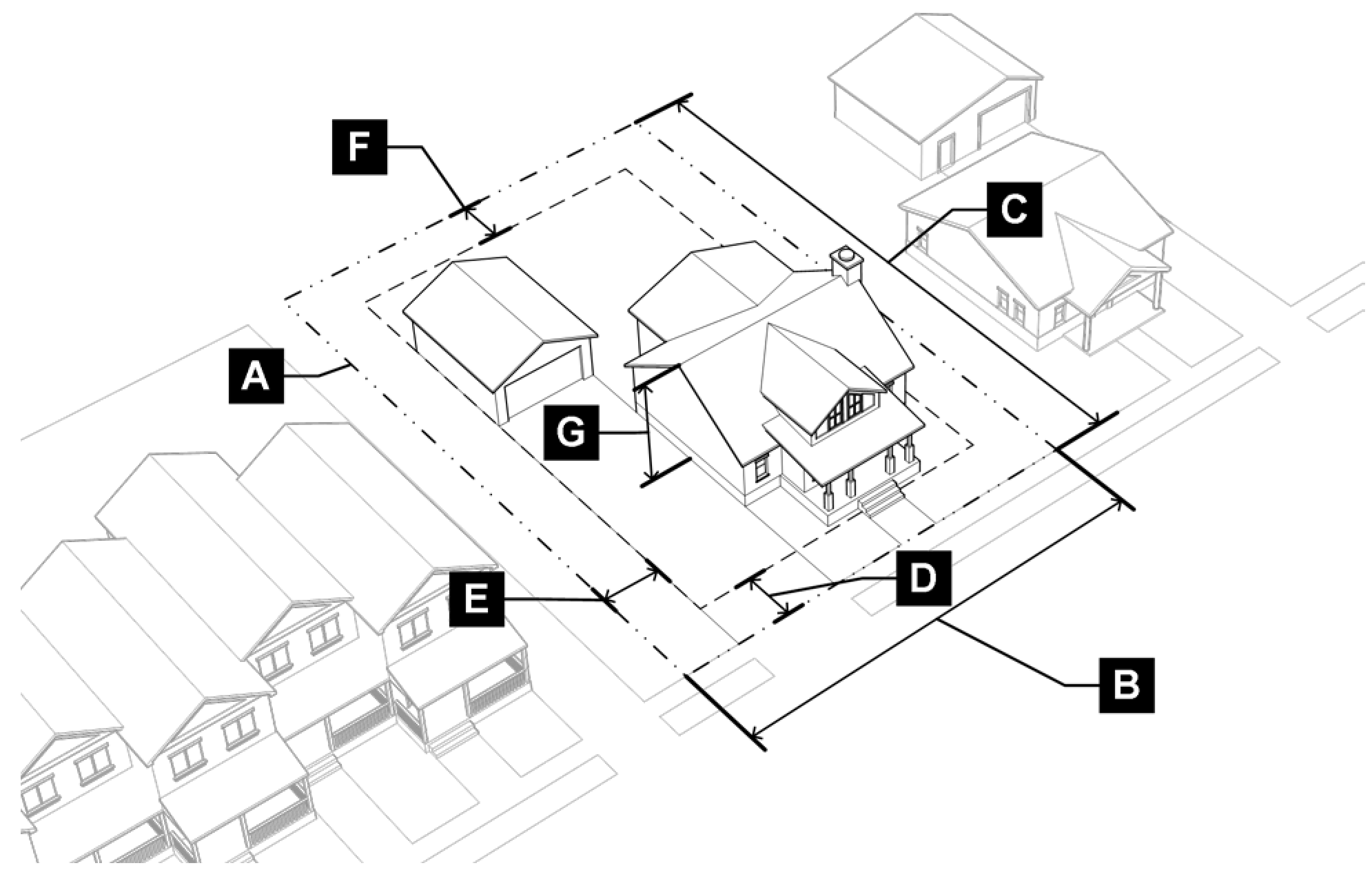
B.
R3 District Dimensional Standards.
(Ord. No. DCA20-0005a, § 2, 1-12-2021)
3.2.5 - R4 - Residential.
A.
Purpose. The R4 district is intended to accommodate a variety of housing types on lots designed to encourage walking to neighborhood-serving retail and other amenities such as parks and school facilities. This zoning district will ensure existing neighborhood character is maintained while also serving as a transition area between established single-family neighborhoods and mixed-use neighborhoods, commercial areas, and key corridors.
Figure 3.2-E: R4 District Dimensional Standards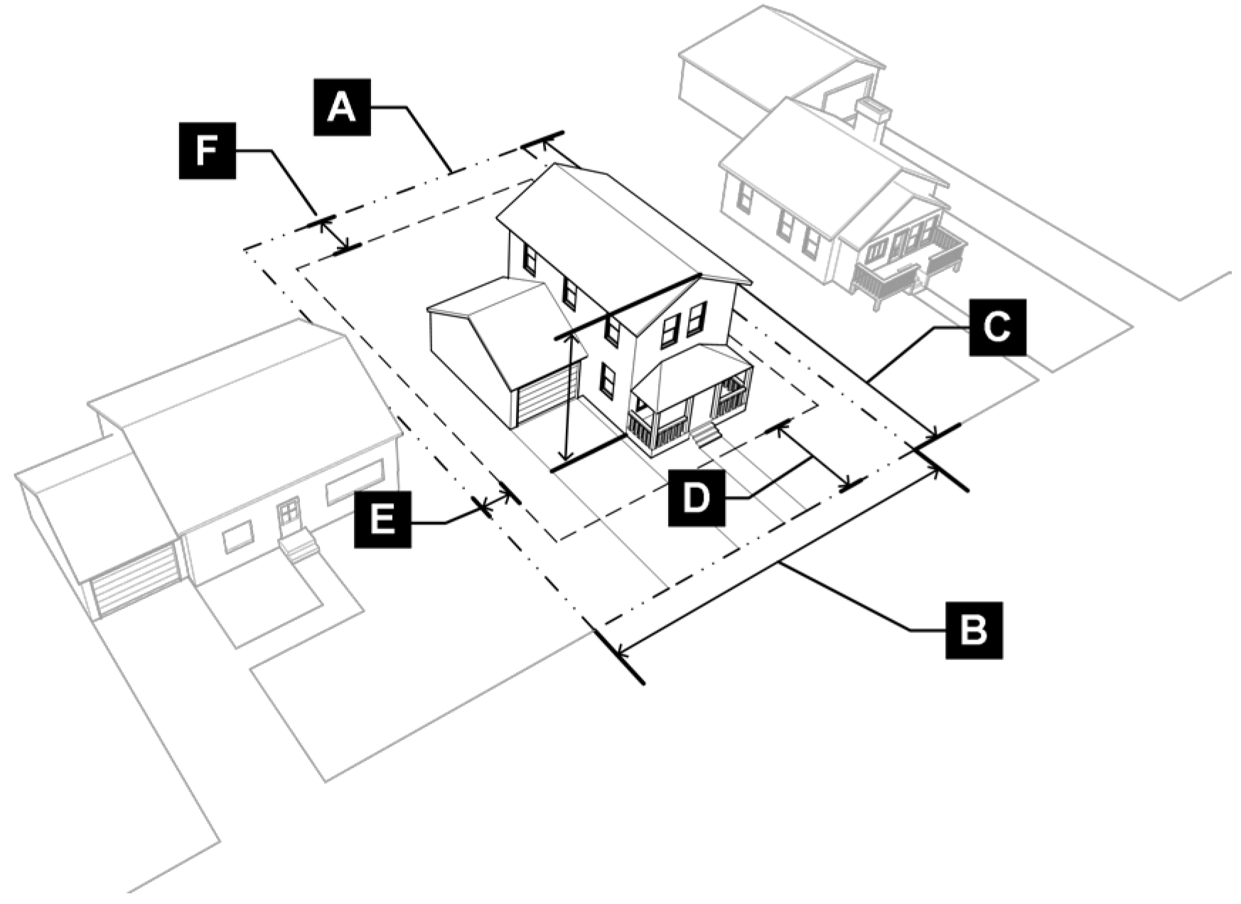
B.
R4 District Dimensional Standards.
3.2.6 - R6 - Residential.
A.
Purpose. The R6 district is intended to accommodate a variety of housing types on lots designed to encourage walking to neighborhood-serving retail and other amenities such as parks and school facilities. This zoning district will ensure existing neighborhood character is maintained while also serving as a transition area between established single-family neighborhoods and mixed-use neighborhoods, commercial areas, and key corridors.
Figure 3.2-F: R6 District Dimensional Standards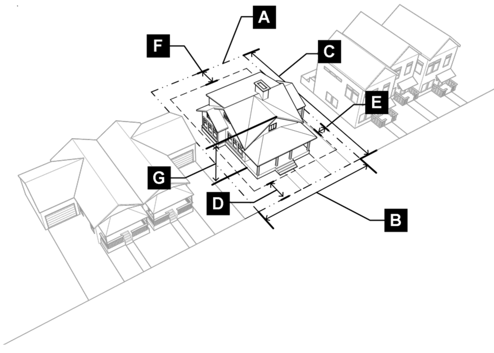
B.
R6 District Dimensional Standards.
3.2.7 - R7 - Residential.
A.
Purpose. The R7 district is intended to accommodate a variety of housing types on lots designed to encourage walking to neighborhood-serving retail and other amenities such as parks and school facilities. This zoning district will ensure existing neighborhood character is maintained while also contributing to a safe environment for pedestrians and bicyclists. This district can also serve to support compatibility between single-family neighborhoods and higher-intensity mixed-use or nonresidential.
Figure 3.2-G: R7 District Dimensional Standards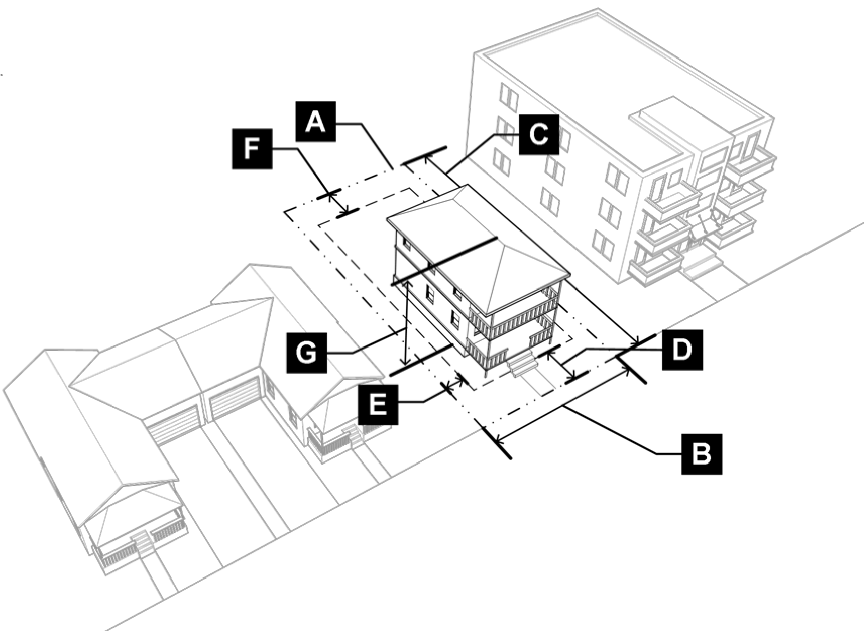
B.
R7 District Dimensional Standards.
3.2.8 - Summary Table of Residential Dimensional Standards.
(Ord. No. DCA20-0005a, § 3, 1-12-2021)
3.3.1 - MN - Mixed-Use Neighborhood.
A.
Purpose. The MN district is provided to support compatibility between higher-intensity mixed-use areas and adjacent residential and commercial areas. This district contributes to a vibrant environment for pedestrians and bicyclists and includes varying densities of residential, neighborhood-serving retail, restaurants, commercial, and office uses that are sensitive to the surrounding built and natural context in scale and form.
Figure 3.3-A: MN District Dimensional Standards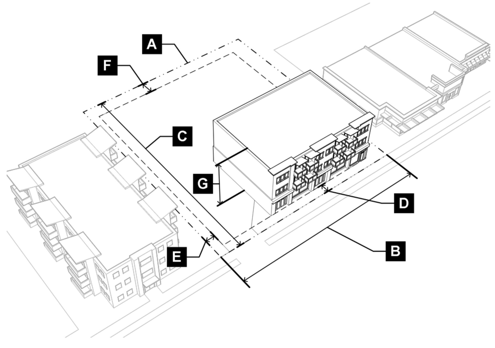
B.
MN District Dimensional Standards.
(Ord. No. DCA22-0005a, § 2(Exh. A), 10-18-2022)
3.3.2 - MD - Mixed-Use Downtown Core.
A.
Purpose. The MD district is provided to allow for a variety of uses contributing to the economic viability of Downtown Denton. This district allows for moderate- and high-density residential, commercial, office, entertainment, and other uses tailored to encourage a greater level of activity while protecting the scale and strengthening the character of Downtown and Denton's historic core. This district contributes to a vibrant environment for pedestrians, bicyclists, and other modes of travel.
Figure 3.3-B: MD District Dimensional Standards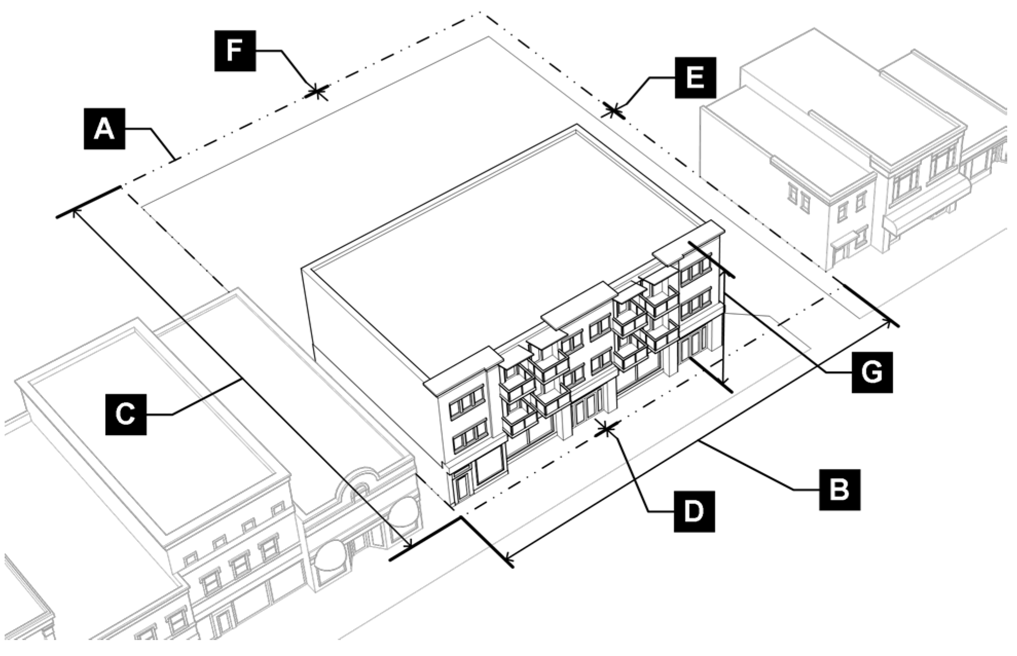
B.
MD District Dimensional Standards.
3.3.3 - MR - Mixed-Use Regional.
A.
Purpose. The MR district is intended to provide a walkable urban center to augment the regional draw and image of Denton. Development may include national retailers, employment, restaurants, entertainment venues, and housing at the highest levels of scale and density within the City. This district ensures that development will complement and embrace existing viable uses, and raise the standard of design to increase regional draw, accommodate greater connectivity and mobility options, and create a sense of place. The MR district may be established in areas with the greatest regional access and is sensitive to the adjacent built and natural context.
Figure 3.3-C: MR District Dimensional Standards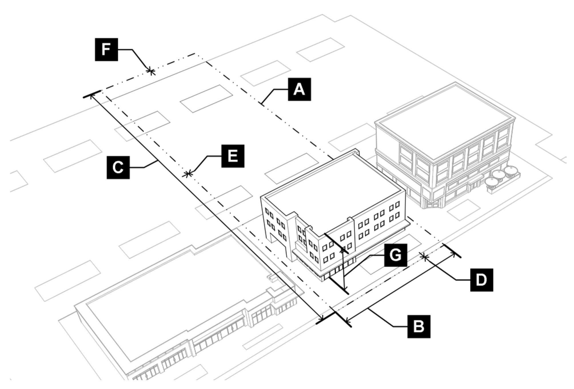
B.
MR District Dimensional Standards.
3.3.4 - Summary Table of Mixed-Use Dimensional Standards.
3.4.1 - SC - Suburban Corridor.
A.
Purpose. The SC district is intended to provide moderate- to high-intensity commercial, office, and retail uses along high-traffic corridors. The SC district provides elevated building and landscape design, buildings oriented to the street, and appropriate buffering from adjacent neighborhoods. While the SC district is primarily auto-oriented, it provides a safe environment for pedestrians and cyclists.
Figure 3.4-A: SC District Dimensional Standards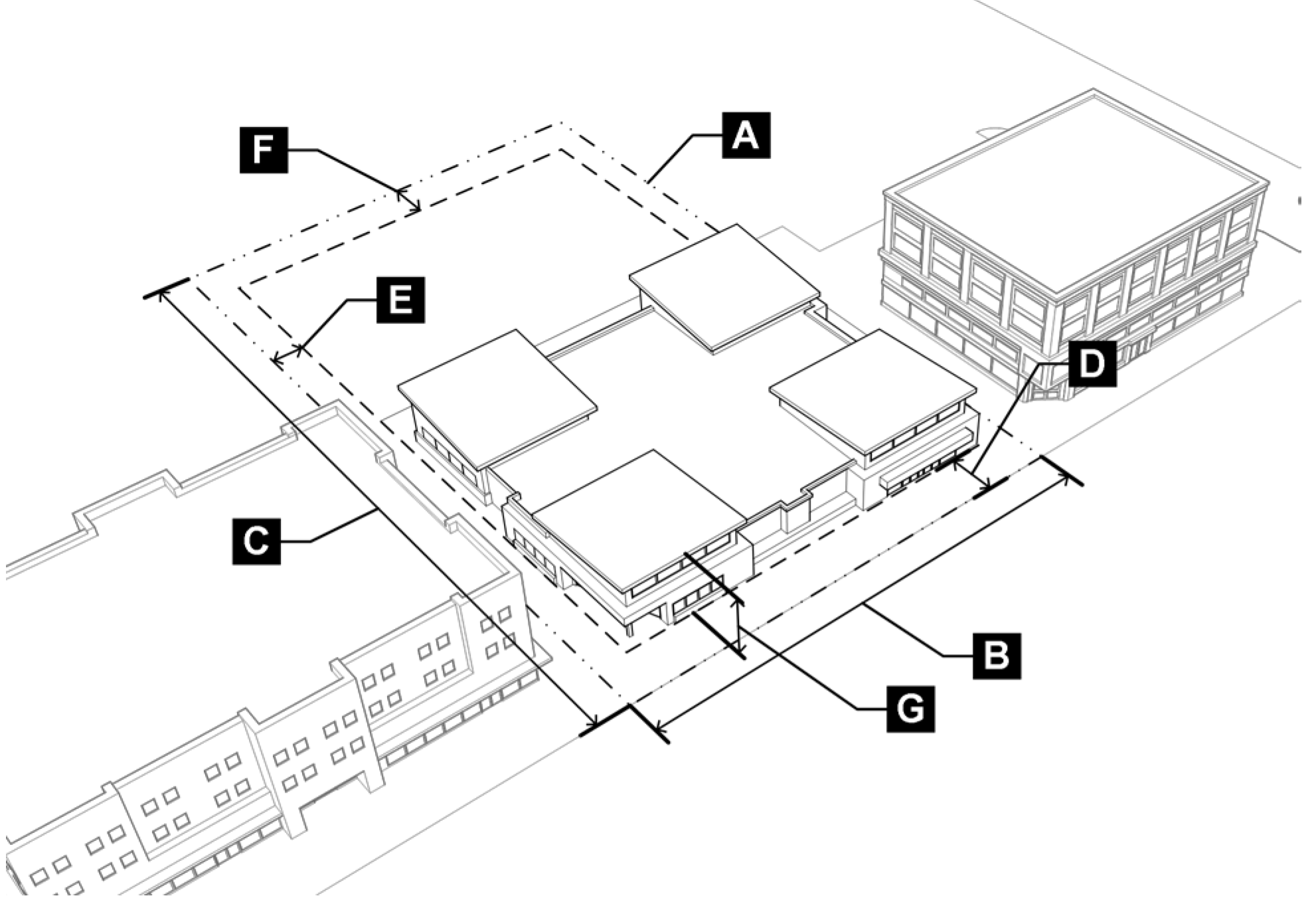
B.
SC District Dimensional Standards
3.4.2 - HC - Highway Corridor.
A.
Purpose. The HC district is intended to provide high-intensity commercial uses along the city's busiest and most visible thorough-fares. The HC district applies to areas along highly visible commercial corridors in the city where elevated design and aesthetic qualities are desired. While the HC district is primarily auto-oriented, it provides a safe environment for pedestrians and cyclists.
Figure 3.4-B: HC District Dimensional Standards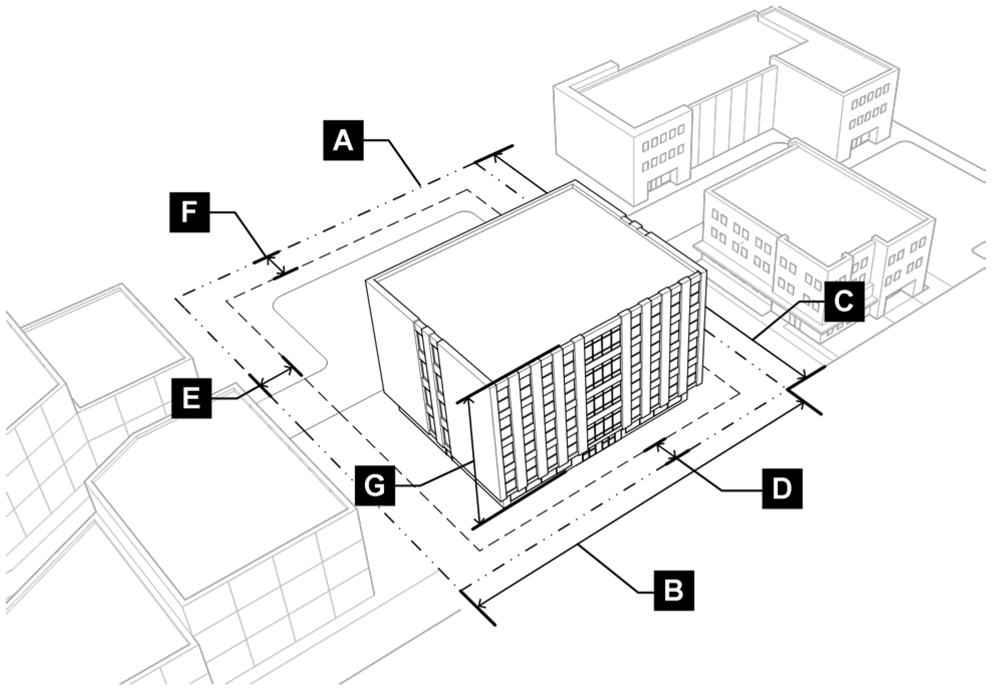
B.
HC District Dimensional Standards.
3.5.1 - GO - General Office.
A.
Purpose. The GO district is intended to provide locations for a variety of workplaces and complementary uses. Principal uses include office and research and development and related supporting uses. The GO district provides area for flexible office space to encourage the establishment of research and development enterprises, start-ups, and opportunities for business innovation. This district applies to areas throughout the city that are in close proximity to commercial use areas and employment hubs.
Figure 3.5-A: GO District Dimensional Standards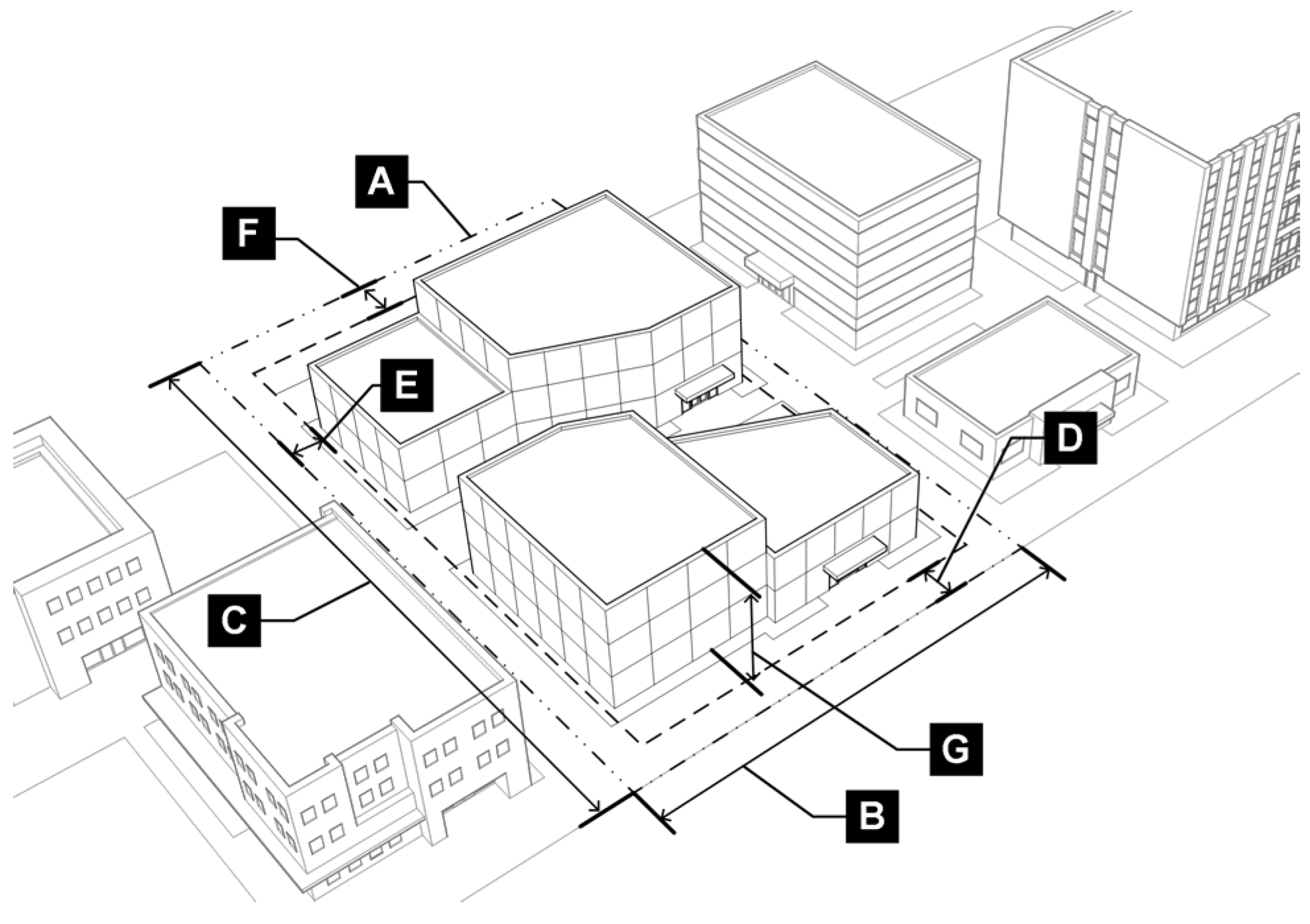
B.
GO District Dimensional Standards.
3.5.2 - LI - Light Industrial.
A.
Purpose. The LI district is intended to provide locations for a variety of light industrial and employment uses such as light manufacturing, assembly, fabrication, warehousing and distributing, indoor and outdoor storage, and a wide range of supporting commercial uses and activities. The LI district provides a variety of transportation options for access including transit, bicycle, and pedestrian facilities. The LI district provides appropriate transitions to surrounding uses and lower-intensity districts, and is sensitive to the adjacent built and natural context.
Figure 3.5-B: LI District Dimensional Standards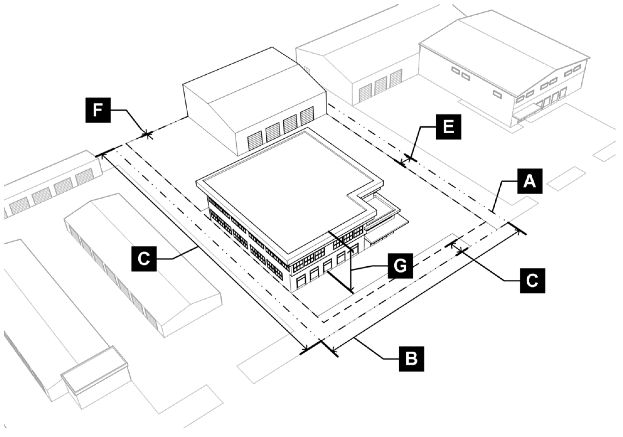
B.
LI District Dimensional Standards.
3.5.3 - HI - Heavy Industrial.
A.
Purpose. The HI district is intended to provide locations suitable for development and operation of indoor and outdoor industrial, distribution, and manufacturing uses. The HI district applies to areas primarily west of Highway I-35 W near the Denton Enterprise Airport that supports the most intense industrial uses and may require access to major rail, truck, or aircraft shipping facilities. The HI district applies to areas that can accommodate the intensity of uses while also being sensitive to the adjacent built and natural context.
Figure 3.5-C: HI District Dimensional Standards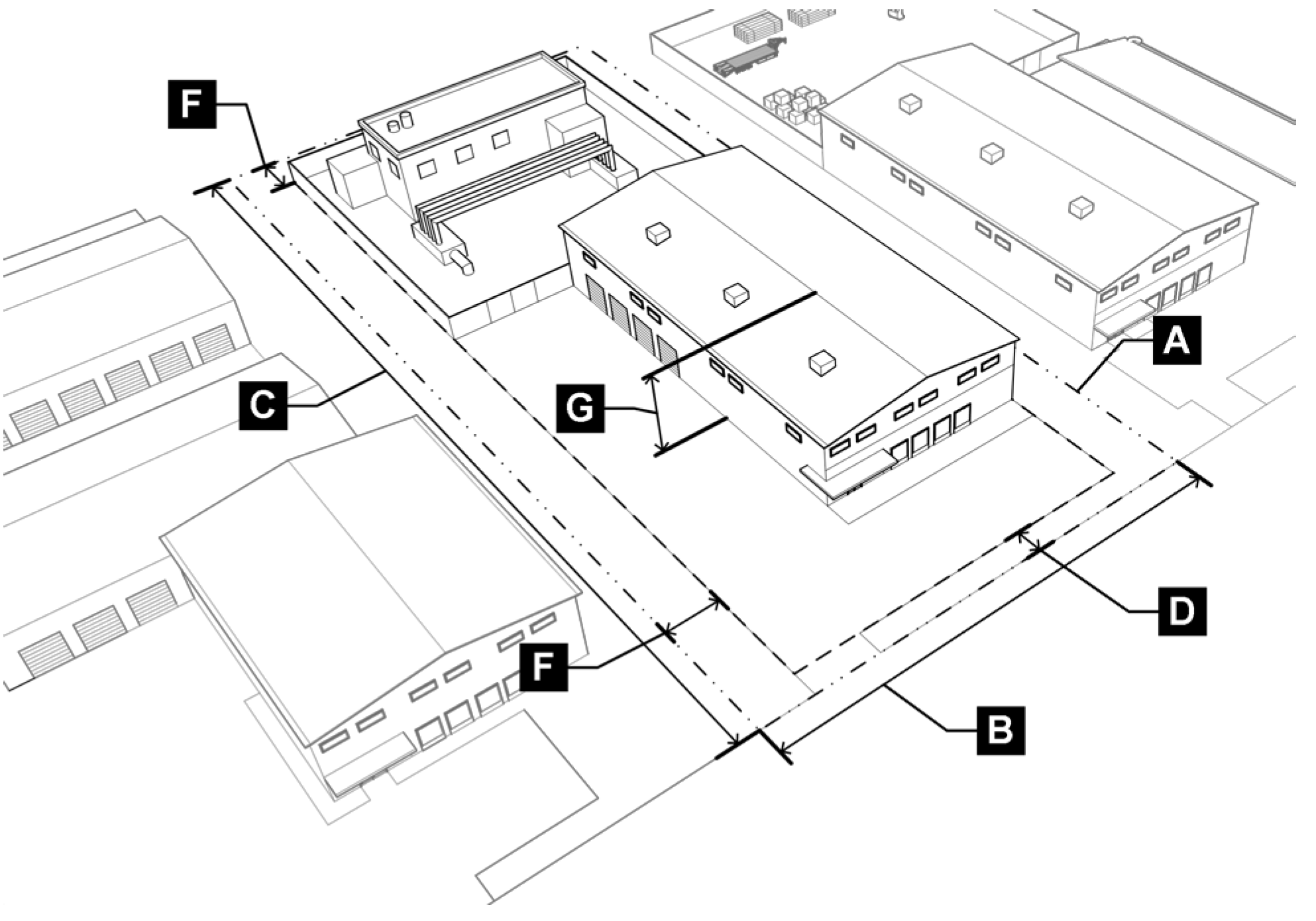
B.
HI District Dimensional Standards.
3.5.4 - PF - Public Facilities.
A.
Purpose. The PF district is intended to provide adequate lands for public and quasi-public community uses and services, including but not limited to fire stations, schools, libraries, community centers, hospitals, civic buildings, open space, parks, utilities, and other public-related facilities.
Figure 3.5-D: PF District Dimensional Standards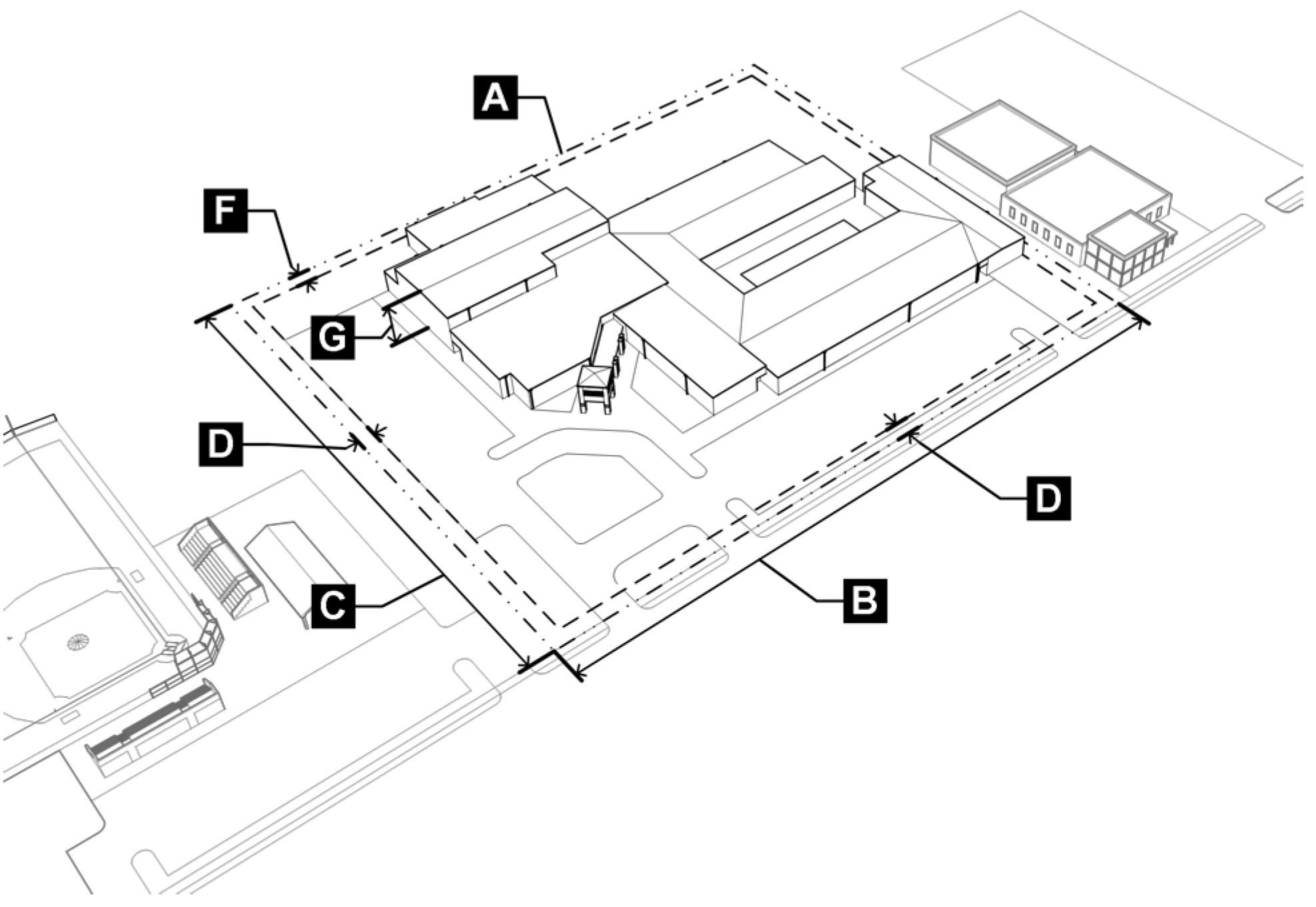
B.
PF District Dimensional Standards.
3.5.5 - Summary Table of Other Nonresidential Dimensional Standards.
(Ord. No. DCA21-0003a, § 2, 9-14-2021)
3.6.1 - Purpose.
This district is intended to provide an alternative zoning district and development process to accommodate substantial development for residential, commercial, professional, recreational, industrial, or other activities, including combinations of uses appropriately requiring flexibility under controlled conditions, not otherwise attainable under conventional base zoning districts.
3.6.2 - Review Procedure.
Planned developments may be approved pursuant to the procedure and approval criteria in Subsection 2.7.3: Rezone to a Planned Development (PD) District.
3.6.3 - Planned Development Standards.
A.
Unless specifically modified by the PD Plan during the rezoning to PD procedure established in Subsection 2.7.3: Rezone to a Planned Development (PD) District, the PD shall comply with all standards in this DDC, as amended.
B.
Where the PD standards conflict with the standards in this DDC, the regulations of the approved PD plan shall control.
3.7.1 - Purpose.
This section is intended to provide uniform measures for interpretation and enforcement of this DDC and to list any exceptions to the dimensional standards in this DDC.
3.7.2 - Lot and Site Requirements.
A.
Minimum Lot Dimensions.
1.
Any lot that is created, developed, used, or occupied must meet the minimum lot dimensions for the applicable zoning district, unless otherwise established in this DDC.
2.
Each townhome lot shall have a minimum lot area of 2,000 square feet per unit, minimum lot width of 20 feet, and a minimum lot depth of 60 feet. Provided, however, the overall townhome development shall have a minimum land area equal to or greater in size than the minimum lot area that would be required for the development of the equivalent number of single-family dwelling units in the applicable zoning district.
3.
Land needed to comply with the minimum lot dimensions or other standards in this DDC must not be sold or leased away from such lot.
4.
New lots must meet the lot dimensions in this subchapter and must comply with Subchapter 8: Subdivisions.
B.
Number of Principal Buildings or Uses per Lot.
1.
No lot may contain more dwellings than are permitted by the applicable zoning district.
2.
Only one principal building shall be located on a single lot for the following land uses: single-family detached dwelling; duplex; townhome; triplex; and fourplex.
3.
Multiple buildings may be permitted on a single lot for multi-family, mixed-use, and nonresidential uses if each building and site development complies with this DDC.
C.
Alternate Standards in Cluster Subdivisions. Alternate lot size, lot width, and setback standards may be approved through development of a cluster subdivision pursuant to Subsection 8.3.4, Cluster Subdivisions.
3.7.3 - Setbacks.
A.
Measurement of Setbacks. Every part of a required yard must be unobstructed from ground level to the sky unless otherwise exempted in this DDC. Setbacks are measured as stated in Subchapter 9: Definitions, under the term "setback."
B.
Contextual Setbacks in Residential Zoning Districts. If structures on two or more abutting lots (even if separated by an alley or private way) have yards that are less than the required yard for the district, the yard for the subject lot may be calculated as the mean average of the yards of the abutting structures.
Figure 3.7-A: Contextual Setbacks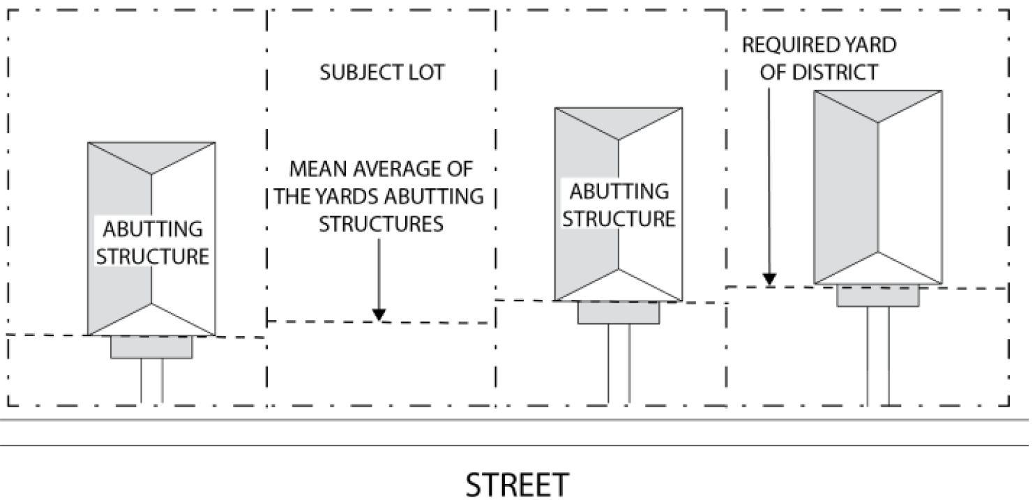
C.
Corner Lots. On corner lots, the required front yard setback must be observed along both streets upon which the building is located. For purposes of measuring setbacks, an alley is not considered a street.
Figure 3.7-B: Corner Lot Setbacks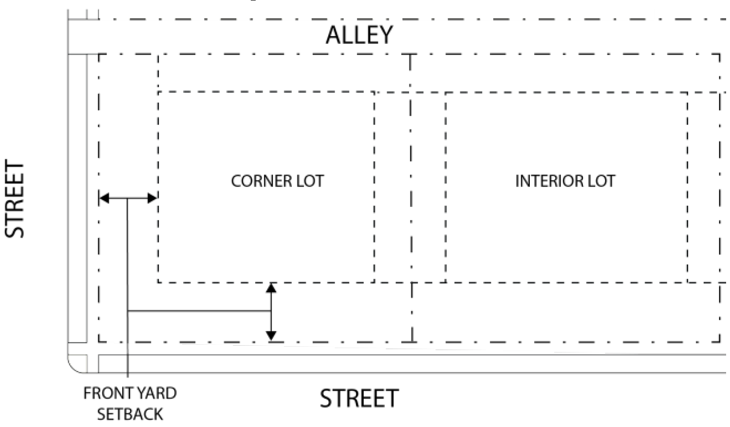
D.
Exceptions to Setbacks.
1.
The features listed in Table 3.7-A are permitted to project into the required setbacks of the applicable zoning district. The exceptions apply to all zoning districts unless otherwise stated. Any authorized projections must comply with all applicable building and fire codes.
2.
Projections shall not extend or encroach into a public or private easement or right-of-way, nor obscure a required visual clearance area as described in Subsection 3.7.4.
3.
Attached single-family dwellings sharing a common wall are not required to comply with side setback requirements, except for the outside walls of the end units.
Figure 3.7-C: Attached Single Family Dwelling Setbacks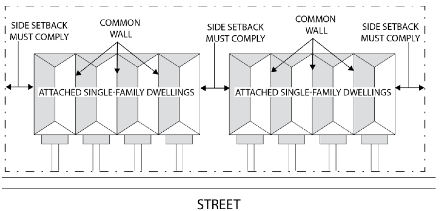
3.7.4 - Vision Clearance Area Requirements.
No signs, structures, or vegetation in excess of two and one-half feet in height shall be placed in the vision clearance area as established in the Transportation Criteria Manual.
3.7.5 - Building Height.
A.
Measurement. Heights referred to in this DDC shall be measured as stated in Section 9.2: Definitions, under the term "height, building or structure."
B.
Buildings Adjacent to Residential Districts. Buildings adjacent to any Residential zoning district shall comply with the standards in Subsection 7.10.6: Building Height in Transition Areas.
C.
Exceptions to Height Standards.
1.
In the HC and GO districts, additional building height may be allowed with approval of a specific use permit (SUP).
2.
In the MD district, additional building and WECS height may be allowed with an SUP and a viewshed study, provided such study clearly demonstrates that any views of the Historic Courthouse are not blocked by the new structures' additional height.
3.
Agricultural structures permitted by this DDC shall be permitted to project beyond the height requirements of the applicable zoning district.
4.
The features listed in Table 3.7-B shall be permitted to project beyond maximum height requirements of the applicable zoning district.
D.
Special Height Limitations in Airport Controlled Area. Building and structure height may be further limited according to Section 4.5: MAO - Municipal Airport Overlay District.
3.7.6 - Building Coverage.
A.
Building coverage referred to in this DDC shall be measured as stated in Section 9.2: Definitions, under the term "building coverage."
B.
Agricultural buildings shall not count toward building coverage.
C.
The maximum building coverage may be increased up to 10 percent for residential uses that provide a side- or rear-entry garage.
D.
The maximum building coverage for townhome lots shall be 85 percent.
3.7.7 - Floor Area and Square Footage.
A.
All areas within a structure including interior storage areas, closets, living areas, and bathrooms, garages, and interior and exterior walls shall be included in the calculation of floor area of a structure.
B.
Gross square footage of a structure shall be measured from the outside of the exterior walls and shall include the area of the walls.
C.
When there is more than one use within a structure, the square footage of each use shall be determined by the gross square footage of the use, plus a portion of any areas used in common. Such common areas shall be pro-rated on the basis of the square footage of each use in the structure, excluding the common areas.