
Duvall City Zoning Code
CHAPTER 14
12 - SINGLE-FAMILY RESIDENTIAL ZONING DISTRICTS
14.12.010 - General standards.
The following general standards apply to all properties zoned R4, R4.5, R6, and R8.
(Ord. 1073 § 1 Exh. A (part), 2008: Ord. 1056 § 1 Exh. A (part), 2007)
(Ord. No. 1336, § 4(Exh. C), 6-5-2025)
14.12.020 - Development standards.
The following development standards apply to all R4, R4.5, R6, and R8 zoning districts:
A.
Accessory dwelling units (see DMC Chapter 14.48);
B.
Conditional use permit criteria (see DMC Chapter 14.68);
C.
Additional development standards (see DMC Chapter 14.64);
D.
Design guidelines (see DMC Chapter 14.34);
E.
Exterior lighting standards (see DMC Chapter 14.46);
F.
Impact fee assessments—Parks, roads, and schools (see DMC Chapter 14.58);
G.
Landscaping (see DMC Chapter 14.38);
H.
Nonconformance and reuse standards (see DMC Chapter 14.76);
I.
Parking standards and design (see DMC Chapter 14.44);
J.
Permit processing (see DMC Chapter 14.08);
K.
Sensitive area regulations (see DMC Chapter 14.42);
L.
SEPA—Environmental review (see DMC Chapter 14.60);
M.
Sign code (see DMC Chapter 14.50);
N.
Subdivision regulations (see DMC Chapter 14.66);
O.
Wireless communications facilities (see DMC Chapter 14.56);
P.
All other applicable provisions of the Duvall Municipal Code.
(Ord. 1073 § 1 Exh. A (part), 2008: Ord. 1056 § 1 Exh. A (part), 2007)
(Ord. No. 1336, § 4(Exh. C), 6-5-2025)
14.12.030 - Accessory uses.
Accessory uses are permitted in the R4, R4.5, R6, and R8 zoning districts if they are incidental to a dwelling unit on the same lot or an adjacent lot owned by the same property owner and established solely for the property owner's use. Sale of either lot individually shall make the accessory use of the lot void. Structures housing accessory uses shall not be allowed in the front yard. Such uses are:
A.
Amateur radio facilities (see DMC Chapters 14.56 and 14.64);
B.
Animals (see DMC Chapter 6.14);
C.
Antennae or satellite dish for private telecommunication services (see DMC Chapter 14.56);
D.
Family day care;
E.
Garages;
F.
Home occupations/industry (see DMC Chapter 14.54);
G.
Pools, private docks, piers;
H.
Sheds;
I.
Storage of private vehicles such as motor vehicles or boats;
J.
Storage of yard maintenance equipment for private use;
K.
Other accessory use or structure which is subordinate and incidental to a principally permitted use, as determined by the director.
(Ord. 1073 § 1 Exh. A (part), 2008: Ord. 1056 § 1 Exh. A (part), 2007)
(Ord. No. 1336, § 4(Exh. C), 6-5-2025)
14.12.040 - Conditional uses.
Uses permitted in the R4, R4.5, R6, and R8 zoning districts subject to a conditional use permit are:
A.
Bed and breakfast;
B.
Governmental services (court, police, fire, City Hall or similar local government offices);
C.
K—12 schools, public or private;
D.
Library or museum associated with a historic site or building;
E.
Religious institutions;
F.
Subregional utility substation.
(Ord. 1073 § 1 Exh. A (part), 2008: Ord. 1056 § 1 Exh. A (part), 2007)
(Ord. No. 1336, § 4(Exh. C), 6-5-2025)
14.12.050 - Residential 4 units per acre (R4).
A.
Purpose of the R4 Zoning District.
1.
The purposes of the R4 single-family residential zone are to:
a.
Implement the comprehensive plan policies that result in the creation of neighborhoods of single-family detached houses consistent with the residential design guidelines;
b.
Provide for suburban residential neighborhoods that have a full range of public services and facilities while allowing nonresidential uses that complement the residential nature of these zones;
c.
Promote diversity in the size and type of new single-family developments to provide housing opportunities for various family sizes and incomes in Duvall.
2.
This zone is appropriate where designated by the comprehensive plan and when such areas are served at the time of development by adequate public sewers, water supply, roads, and other needed public facilities and services. These zones are also appropriate where the surrounding lands have already been developed with lower density single-family detached housing.
3.
R4 zoned properties are those residential lands that were designated as "Suburban Housing Densities" in the 1994 comprehensive plan and zoned R3 on the City of Duvall zoning map in effect on November 23, 2004. The zoning on these properties was increased from three to four units per acre through the adoption of the official zoning map.
B.
Permitted Uses. Allowed uses are those uses that are permitted in the R4 zoning district. Such uses are:
1.
Accessory dwelling unit (see DMC Chapter 14.48);
2.
Adult family home;
3.
Cottage units constructed as part of a cottage housing development;
4.
Dwelling unit, detached;
5.
Park, public or private;
6.
Pea-patches;
7.
Recreational trail, nonmotorized;
8.
Wireless facilities attached to an existing building or structure and camouflaged (see DMC Chapter 14.56).
C.
Development Standards. The following development standards specifically apply to the R4 zoning district.
Table 14.12.050.C
1. Porches and stoops may project up to two feet into the required front yard setback. This provision provides incentives for porches without taking up building envelope space for the dwelling unit.
2. Garages must be set back a minimum of twenty (20) feet (fifteen (15) feet for side entry garage) from the designated property line, and or back of sidewalk. This ensures sufficient space for cars to park in driveways without blocking sidewalks. See residential design standards for garage setback/differentiation from house.
3. The minimum setback for any one side is five feet. Side setbacks for accessory structures are five feet for all residential zones. Example: five feet on one side requires ten (10) feet on the other side.
4. The setback requirement is intended for sixteen (16) to twenty (20) foot alleys and tracts.
5. See DMC Section 14.42.090, Density credits.
6. The floor area ratio shall exclude garages and basements from the measurement. Example: 6,000 square foot lot x 50% = 3,000 square foot maximum house size.
7. The minimum lot width circle identifies the minimum lot width circle diameter that must fit within each newly created lot for each residential zone. This circle establishes that at least some portion of a lot must be at least as wide as the minimum lot width. The lot width circle shall not include streams, floodways, wetlands, or steep slopes. See Figure 14.12.050.C.1.
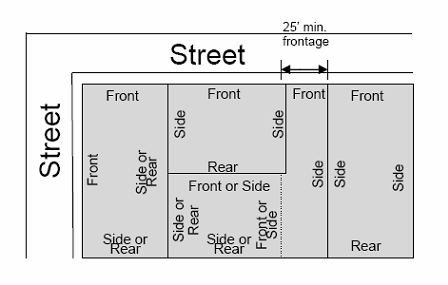
8. Minimum lot frontage is the minimum width of a lot where it shall adjoin a street or approved access corridor. For individual flag lots, lot frontage is measured where the access corridor meets the street. See Figure 14.12.050.C.2.
9. See DMC Section 14.64.130 for calculating building height.
10. Two floors allowed on the uphill side and three floors allowed on the downhill side.
11. Projects using the binding site plan process for residential units shall meet the same setbacks.
* Subtract right-of-way. Example: 100,000 square feet - 20,000 square feet of ROW = 80,000 square feet X 75% = 60,000 square feet of impervious coverage allowed.
12. Detached accessory dwelling units may be located at a lot line if the lot line abuts a public alley.
Figure 14.12.050.C.1
Minimum Lot Width Circle
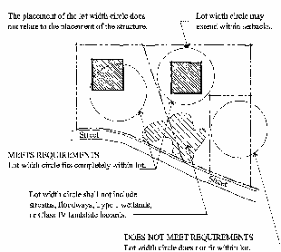
Figure 14.12.050.C.2
Minimum Lot Frontage and Lot Orientation
(Ord. No. 1336, § 4(Exh. C), 6-5-2025; Ord. 1073 § 1 Exh. A (part), 2008: Ord. 1056 § 1 Exh. A (part), 2007)
14.12.060 - Residential 4.5 units per acre (R4.5).
A.
Purpose of the R4.5 Zoning District.
1.
The purposes of the R4.5 single-family residential zone are to:
a.
Implement the comprehensive plan policies that result in the creation of neighborhoods of single-family detached houses consistent with the residential design guidelines;
b.
Provide for suburban residential neighborhoods that have a full range of public services and facilities while allowing nonresidential uses that complement the residential nature of these zones;
c.
Promote diversity in the size and type of new single-family developments to provide housing opportunities for various family sizes and incomes in Duvall.
2.
This zone is appropriate where designated by the comprehensive plan and when such areas are served at the time of development by adequate public sewers, water supply, roads, and other needed public facilities and services. These zones are also appropriate where the surrounding lands have already been developed with lower density single-family detached housing.
3.
R4.5 zones are those residential lands that were designated as "Suburban Housing Densities" in the 1994 comprehensive plan and zoned R4.5 on the City of Duvall zoning map in effect on November 23, 2004. The zoning on these properties has not changed from the 2004 zoning map.
B.
Permitted Uses. Allowed uses are those uses that are permitted in the R4.5 zoning district. Such uses are:
1.
Accessory dwelling unit (see DMC Chapter 14.48);
2.
Adult family home;
3.
Cottage units constructed as part of a cottage housing development;
4.
Dwelling unit, detached;
5.
Park, public or private;
6.
Pea-patches;
7.
Recreational trail, nonmotorized;
8.
Wireless facilities attached to an existing building or structure and camouflaged (see DMC Chapter 14.56).
C.
Development Standards. The following development standards specifically apply to the R4.5 zoning district.
Table 14.12.060.C
1. Porches or stoops may project up to two feet into the required front yard setback. This provision provides incentives for porches without taking up building envelope space for the dwelling unit.
2. Garages must be set back a minimum of twenty (20) feet (fifteen (15) feet for side entry garage) from the designated property line and or back of sidewalk. This ensures sufficient space for cars to park in driveways without blocking sidewalks. See residential design standards for garage setback/differentiation from house.
3. The minimum setback for any one side is five feet. Side setbacks for accessory structures are five feet for all residential zones. Example: five feet on one side requires ten (10) feet on the other side.
4. The setback requirement is intended for sixteen (16) to twenty (20) foot alleys and access tracts.
5. See DMC Section 14.42.090, Density credits.
6. The floor area ratio shall exclude garages and basements from the measurement.
Example: 6,000 square foot lot x 50% = 3,000 square foot maximum house size.
7. The minimum lot width circle identifies the minimum lot width circle diameter that must fit within each newly created lot for each residential zone. This circle establishes that at least some portion of a lot must be at least as wide as the minimum lot width. The lot width circle shall not include streams, floodways, wetlands, or steep slopes. See Figure 14.12.050.C.1.
8. Minimum lot frontage is the minimum width of a lot where it shall adjoin a street or approved access corridor. For individual flag lots, lot frontage is measured where the access corridor meets the street. Figure 14.12.050.C.2.
9. See DMC Section 14.64.130 for calculating building height.
10. Two floors allowed on the uphill side and three floors allowed on the downhill side.
11. Projects using the binding site plan process for residential units shall meet the same setbacks.
* Subtract right-of-way. Example: 100,000 square feet - 20,000 square feet of ROW = 80,000 square feet X 75% = 60,000 square feet of impervious coverage allowed.
12. Detached accessory dwelling units may be located at a lot line if the lot line abuts a public alley.
(Ord. 1073 § 1 Exh. A (part), 2008: Ord. 1056 § 1 Exh. A (part), 2007)
(Ord. No. 1336, § 4(Exh. C), 6-5-2025)
14.12.070 - Residential 6 units per acre (R6).
A.
Purpose of the R6 Zoning District.
1.
The purposes of the R6 single-family detached/attached residential zone are to:
a.
Implement comprehensive plan policies that result in the creation of small-lot, single-family and two-family detached and attached houses in neighborhoods and consistent with the residential design guidelines;
b.
Implement the city-wide visioning plan;
c.
Provide transition between Uptown and R-8 zones;
d.
Allow infill development while preserving the historic character of the old town neighborhood;
e.
Provide for public services and facilities while also allowing nonresidential uses that complement the residential nature of these zones; and
f.
Encourage housing diversity and affordability that retains moderate densities suburban character and promotes diversity in the size and type of new single-family developments to provide housing opportunities for various family sizes and incomes.
2.
This zone is appropriate where designated by the comprehensive plan and when such areas are served at the time of development by adequate public sewers, water supply, roads, and other needed public facilities and services. These zones are also appropriate where the surrounding lands have already been developed for lower density single-family housing types but abut more intensely developed commercial, office, employment or other nonresidential land uses, and offer open space, recreation, pedestrian and transit services most supportive of moderate density living arrangements.
B.
Permitted Uses. Allowed uses are those uses that are permitted in the R6 zoning district. Such uses are:
1.
Accessory dwelling unit (ADU) (see DMC Chapter 14.48);
2.
Adult family home;
3.
Carriage units (a property owner is allowed a carriage unit or an ADU but not both);
4.
Cottage units constructed as part of a cottage housing development;
5.
Dwelling unit, detached;
6.
Dwelling unit, attached two-family;
7.
Pea-patches;
8.
Park, public or private;
9.
Recreational trail, nonmotorized;
10.
Wireless facilities attached to an existing building or structure and camouflaged (see DMC Chapter 14.56).
C.
Development Standards. The following development standards specifically apply to the R6 zoning district.
Table 14.12.070.C
1. Porches or stoops may project up to two feet into the required front yard setback. This provision provides incentives for porches without taking up building envelope space for the dwelling unit.
2. Driveways shall extend a minimum of twenty (20) feet from the designated property line and or back of sidewalk. This ensures sufficient space for cars to park in driveways without blocking sidewalks. See residential design standards for garage setback/differentiation from house.
3. The minimum setback for any one side is five feet. Side setbacks for accessory structures are five feet for all residential zones. Example: five feet on one side requires ten (10) feet on the other side.
4. The setback requirement is intended for sixteen (16) to twenty (20) foot alleys and access tracts.
5. See DMC Section 14.42.090, Density credits.
6. The floor area ratio shall exclude garages and basements from the measurement.
Example: 4,000 square foot lot x 50% = 2,000 square foot maximum house size.
7. The minimum lot width circle identifies the minimum lot width circle diameter that must fit within each newly created lot for each residential zone. This circle establishes that at least some portion of a lot must be at least as wide as the minimum lot width. The lot width circle shall not include streams, floodways, wetlands, or steep slopes. See Figure 14.12.050.C.1.
8. Minimum lot frontage is the minimum width of a lot where it shall adjoin a street or approved access corridor. For individual flag lots, lot frontage is measured where the access corridor meets the street. See figure 14.12.050.C.2.
9. See DMC Section 14.64.130 for calculating building height.
10. Two floors allowed on the uphill side and three floors allowed on the downhill side.
11. Projects using the binding site plan process for residential units shall meet the same setbacks.
*. Subtract right-of-way. Example: 100,000 square feet - 20,000 square feet of ROW = 80,000 square feet X 75% = 60,000 square feet of impervious coverage allowed.
12. Detached accessory dwelling units may be located at a lot line if the lot line abuts a public alley.
(Ord. 1073 § 1 Exh. A (part), 2008: Ord. 1056 § 1 Exh. A (part), 2007)
(Ord. No. 1336, § 4(Exh. C), 6-5-2025)
14.12.080 - Residential 8 units per acre (R8).
A.
Purpose of the R8 Zoning District.
1.
The purposes of the R8 single-family detached/attached residential zone are to:
a.
Implement comprehensive plan policies that result in the creation of small-lot, single-family and two-family detached and attached houses in neighborhoods and consistent with the residential guidelines;
b.
Implement the city-wide visioning plan;
c.
Provide transition between Uptown and R-8 zones;
d.
Allow infill development while preserving the historic character of the old town neighborhood;
e.
Provide for public services and facilities while also allowing nonresidential uses that complement the residential nature of these zones; and
f.
Encourage housing diversity and affordability that allows higher densities and promotes diversity in the size and type of new single-family developments to provide housing opportunities for various family sizes and incomes.
2.
This zone is appropriate where designated by the comprehensive plan and when such areas are served at the time of development by adequate public sewers, water supply, roads, and other needed public facilities and services. These zones are also appropriate where the surrounding lands have already been developed for lower density single-family housing types but abut more intensely developed commercial, office, employment or other nonresidential land uses, and offer open space, recreation, pedestrian and transit services most supportive of moderate density living arrangements.
3.
This zone is also specifically appropriate adjacent to Uptown-1st Avenue, generally from the alley east of 1st Avenue to 2nd Avenue and from Bird Street in the north to Park Street in the south.
B.
Permitted Uses. Allowed uses are those uses that are permitted in the R8 zoning district. Such uses are:
1.
Accessory dwelling units (see DMC Chapter 14.48);
2.
Adult family home;
3.
Carriage unit;
4.
Cottage unit constructed as part of a cottage housing development;
5.
Dwelling unit, detached;
6.
Dwelling unit, attached two-family;
7.
Park, public or private;
8.
Pea-patches;
9.
Recreational trail, nonmotorized;
10.
Wireless facilities attached to an existing building or structure and camouflaged (see DMC Chapter 14.56).
C.
Development Standards. The following development standards specifically apply to the R8 zoning district.
Table 14.12.080.C
1. Porches and stoops may project up to two feet into the required front yard setback. This provision provides incentives for porches without taking up building envelope space for the dwelling unit.
2. Garages must be set back a minimum of twenty (20) feet (fifteen (15) feet for side entry garage) from the designated property line and or back of sidewalk. This ensures sufficient space for cars to park in driveways without blocking sidewalks. See residential design standards for garage set back/differentiation from house.
3. Side setbacks for accessory structures is five feet for all residential zones.
4. The setback requirement is intended for sixteen (16) to twenty (20) foot alleys.
5. See DMC Section 14.42.090, Density credits.
6. The floor area ratio shall exclude garages and basements from the measurement.
Example: 4,000 square foot lot x 50% = 2,000 square foot maximum house size.
7. The minimum lot width circle identifies the minimum lot width circle diameter that must fit within each newly created lot for each residential zone. This circle establishes that at least some portion of a lot must be at least as wide as the minimum lot width. The lot width circle shall not include streams, floodways, wetlands, or steep slopes. See Figure 14.12.050.C.1.
8. Minimum lot frontage is the minimum width of a lot where it shall adjoin a street or approved access corridor. For individual flag lots, lot frontage is measured where the access corridor meets the street. Figure 14.12.050.C.2.
9. See DMC 14.64.130 for calculating building height.
10. Two floors allowed on the uphill side and three floors allowed on the downhill side.
11. Projects using the binding site plan process for residential units shall meet the same setbacks.
*. Subtract right-of-way. Example: 100,000 square feet - 20,000 square feet of ROW = 80,000 square feet X 75% = 60,000 square feet of impervious coverage allowed.
12. Detached accessory dwelling units may be located at a lot line if the lot line abuts a public alley.
(Ord. 1073 § 1 Exh. A (part), 2008: Ord. 1056 § 1 Exh. A (part), 2007)
(Ord. No. 1336, § 4(Exh. C), 6-5-2025)