
Flushing City Zoning Code
ARTICLE 3
- DISTRICT REGULATIONS
Sec. 153.301.- Districts established.
For the purpose of this chapter, the city is hereby divided into the following zoning districts:
(1)
Residential districts:
a.
Single-family residential district (R-1).
b.
Two-family residential district (R-2).
c.
Medium density residential (R-3A).
d.
High density residential (R-3B).
e.
Mobile home district (R-4).
(2)
Business districts:
a.
Local business district (B-1).
b.
Central business district (CBD).
c.
General business district (B-2).
d.
Heavy business district (B-3).
e.
Office-service district (OS-1).
f.
Downtown overlay district (DO).
(3)
Industrial districts: (I-1).
(4)
Overlay districts: medium density residential overlay (R-3A-O).
(Ord. No. 2025-01, 1-13-2025)
Sec. 153.302. - District boundaries.
The boundaries of zoning districts are defined and established as shown on a map entitled "City of Flushing Zoning Map" which is available for viewing at the city office. This map, with all explanatory matter thereon, is hereby made a part of this chapter.
(Ord. No. 2025-01, 1-13-2025)
Sec. 153.303. - Official zoning map.
(a)
The boundaries of each district are shown on the official zoning map which, together with all explanatory matter thereon, is hereby adopted by reference and declared to be a part of this chapter.
(b)
The official zoning map shall be identified by the signature of the mayor attested by the city clerk, and bearing the seal of the city under the following words: "This is to certify that this is the official zoning map referred to in article three of this chapter, as amended." The date of the adoption of the map, the date of the planning commission public hearing and the effective date of the map shall also be shown on the map.
(c)
No changes of any nature shall be made in the official zoning map or matter shown thereon except in conformity with the procedures set forth in this chapter, the city charter and state law. Any unauthorized change of whatever kind by any person shall be considered a violation of this chapter and punishable under the city civil infractions ordinance.
(d)
The only true copy of the official zoning map shall be located in the office of the city clerk and shall be prima facie evidence as to the current zoning status of lands, buildings, and other structures in the city. The map shall be as much a part of this chapter as if the information set forth therein were fully described herein.
(e)
A copy (to be replaced yearly, at a maximum) made directly on by a direct copy process duplicating machine and initialed and dated by the city clerk shall be kept at a separate location which shall, at a minimum, be separated from the true copy by a fire wall.
(Ord. No. 2025-01, 1-13-2025)
Sec. 153.304. - Interpretation of district boundaries.
Where uncertainty exists with respect to the boundaries of any of the districts indicated on the official zoning map, the following rules shall apply:
(1)
Boundaries indicated as approximately following the center lines of streets, highways, or alleys shall be construed to follow such center lines;
(2)
Boundaries indicated as approximately following platted lot lines shall be construed as following lot lines;
(3)
Boundaries indicated as approximately following city limits shall be construed as following city limits;
(4)
Boundaries indicated as following railroad lines shall be construed to be following the railroad right-of-way line;
(5)
Boundaries indicated approximately parallel to the center lines of streets or highways shall be interpreted as being parallel thereto and at such distance therefrom as indicated by given distance or scaled dimension.
(Ord. No. 2025-01, 1-13-2025)
Sec. 153.305. - Annexation.
Wherever any area is annexed to the city, one of the following conditions will apply:
(1)
Land that is zoned previous to annexation shall be classified as being in whichever district of this chapter most closely conforms with the zoning that existed prior to annexation, as determined by the planning commission.
(2)
Land not zoned prior to annexation shall be classified into whichever district of this chapter most closely conforms with the existing use, as determined by the planning commission.
(Ord. No. 2025-01, 1-13-2025)
Sec. 153.306. - Zoning of vacated areas.
Whenever any street, alley, or other public way within the city shall have been vacated by action of the city council, and when the lands within the boundaries thereof attach to and become a part of lands adjoining such street, alley, or public way, such lands formerly within such vacated street, alley, or public way shall automatically, and without further action of the city council, thenceforth acquire and be subject to the same zoning regulations as are applicable to lands to which such shall attach, and the same shall be used for the same use as is permitted under this chapter for such adjoining lands.
(Ord. No. 2025-01, 1-13-2025)
Sec. 153.307. - Residential districts.
(a)
Single-family residential district (R-1). The R-1 single-family residential district is designed to accommodate and be the most restrictive of the residential districts. The intent is to provide for an environment of predominantly low density single unit detached dwellings along with other residentially related facilities which serve the residents in the district.
(b)
Two-family residential district (R-2). The R-2 two-family residential district is designed to afford a transition of use in existing housing areas by permitting new construction or conversion of existing structures between adjacent residential and commercial, office, thoroughfares, or other uses which would affect the residential character. This district also recognizes the existence of older residential areas of the city where larger houses have been, or can be, converted from single-family to two-family residences in order to extend the economic life of these structures and allow the owners to justify the expenditures for repairs and modernization. This district allows the construction of new two-family residences where slightly greater densities are permitted.
(c)
Medium density residential district (R-3A). The R-3A medium density residential district is designed to provide sites for multiple-family dwelling structures, and related uses, which will generally serve as zones of transition between the nonresidential districts and the lower density one-family residential districts.
(d)
High density residential district (R-3B). The R-3B high density residential district is designed to serve the needs of those who desire multiple-family dwelling types.
(e)
Mobile home district (R-4). The R-4 mobile home district is designed to provide an area appropriate for mobile home park development.
(Ord. No. 2025-01, 1-13-2025)
Sec. 153.308. - Business districts.
(a)
Office-service district (OS-1). The OS-1 office-service district is designed to accommodate office buildings and uses and basic personal services and is, as a use district, intended to serve the function of land use transition between the commercial district and the adjacent residential district.
(b)
Local business district (B-1). The B-1 business district is designed solely for the convenience shopping of persons residing in adjacent residential areas that permit only such uses as are necessary to satisfy those limited basic shopping or service needs which, by their very nature and size, are not related to the shopping pattern of the community or regional type of shopping center.
(c)
Central business district (CBD). The CBD central business district is designed to provide for office buildings and the great variety of large retail stores and related activities which occupy the prime retail frontage by serving the convenience and service needs of the entire municipal area as well as a substantial area of the adjacent and surrounding residential developments beyond the municipal limits. The district regulations are intended to encourage retail development of a continuous retail frontage and by prohibiting automotive related services and non-retail uses which tend to break up such continuity.
(d)
General business district (B-2). The B-2 general business district is designed to furnish areas not served typically by the central business district with a variety of automotive services and goods incompatible with the uses and with the pedestrian movement in such central business district. The general business districts are characterized by more diversified business types and are often located so as to serve the passerby traffic. General business districts, by special use permits, may include registered medical marijuana care providers.
(e)
Heavy business district (B-3). The B-3 heavy business district is designed to furnish areas not for commercial uses of a quasi-industrial nature, but which need the visibility to the general public and access that commercial businesses require. The uses often generate noise or smoke to a greater extent and may involve outdoor display or storage.
(f)
Downtown overlay district (DO). The DO downtown overlay district is designed to implement design standards on improvements within the historic downtown. The underlying zoning cotntrols all normal district regulations including uses allowed and dimensional requirements. In addition, property within the downtown overlay district must comply with the design standards as outlined in section 153.1203(a) and (d), and section 153.1503.
(Ord. No. 2025-01, 1-13-2025)
Sec. 153.309. - Industrial districts.
The I-1 industrial district is designed so as to primarily accommodate wholesale and warehouse activities, and industrial operations whose external, physical effects are restricted to the area of the districts. The I-1 district is so structured as to permit, along with any specified uses, the manufacturing, compounding, processing, packaging, assembly, or treatment of finished or semi-finished products from previously prepared material. The intent of this article is to prohibit the processing of raw material for shipment in bulk form, to be used in an industrial operation at another location.
(Ord. No. 2025-01, 1-13-2025)
Sec. 153.310. - Overlay districts.
The R-3A-O medium density residential overlay district is designed so as to primarily accommodate medium density residential uses including single-family and multiple-family uses. The intent of this article is to permit existing industrial uses within the overlay area and to permit reinvestment and expansion of those uses at the property owner's discretion, but to encourage the long-term conversion of the property to residential uses.
(Ord. No. 2025-01, 1-13-2025)
Sec. 153.311. - Planned unit development (PUD).
The planned unit development zoning district is designed to provide a framework within which a developer, upon their initiation, can relate the type, design and layout of residential and/or commercial uses to a particular site and particular demand for housing and/or other local commercial facilities in a manner consistent with the preservation of property values within established residential areas. The section also provides an added degree of flexibility in the building design and land use arrangement so that a mixture of housing units and provision of common open space can be provided. The zoning district is intended to accommodate developments with mixed or varied uses, on sites with unusual topography or unique settings within the community, or on land which exhibits difficulty or costly development problems or sites that contain natural features such as wetlands or floodplains that are important for the city to retain in order to protect its character and shall not be allowed where this zoning classification is sought primarily to avoid the imposition of standards and requirements of other zoning classifications rather than to achieve the stated purposes herein set forth. The city council does hereby determine that the following regulations are the minimum requirements for the promotion and protection of the public health, safety and welfare. Some uses permitted in this district are required to comply with specific design standards.
(1)
Permitted principal uses. All permitted principal uses by right or by special use permit as identified in section 153.311 planned unit development (PUD)., shall be permitted in the PUD district.
(2)
Standards for approval. Based upon the following standards, the planning commission may recommend denial, approval, or approval with conditions, and the city council may deny, approve, or approve with conditions the proposed planned unit development.
a.
Off-street parking shall be sufficient to meet the minimum required by the ordinances of the city (article 5 off-street parking and loading). However, if it is deemed necessary in order to achieve the purposes of this section, the planning commission may relax, modify and/or increase parking requirements during site plan review.
b.
All streets within the planned unit development shall meet the minimum requirements of chapter 152, subdivision regulations, unless modified by the planning commission.
c.
Landscaping shall be provided so as to ensure that proposed uses will be adequately buffered from one another and from surrounding public and private property (article 8 landscape standards). However, if it is deemed necessary in order to achieve the purposes of this chapter, the planning commission may relax, modify and/or increase landscaping requirements as part of site plan review.
d.
Judicious effort shall be used to ensure the preservation of the integrity of the land and the preservation of natural, historical, and architectural features.
e.
Surface water shall be retained on the site unless the applicant can demonstrate that to do so would be harmful to the environment or is not practical. In any case, storm water shall not flow off the site at a rate greater than the rate of flow prior to development. (Chapter 54 storm water management)
f.
The site shall have adequate lateral support so as to ensure that there will be no erosion of soil or other material. The final determination as to adequacy of, or need for, lateral support shall be made by the city building inspector and/or city engineer.
g.
The proposed density of the planned unit development shall be no greater than that which would be required for each of the component uses of the development in the zoning district in which it is permitted. However, if it is deemed necessary in order to achieve the purposes of the section, the city council may permit increased density in return for increased open space. Non-contiguous property may not be used in calculating open space and under no circumstance shall the open space be located on non-contiguous property.
h.
A site zoned for PUD must be a minimum of five acres.
(3)
Traffic and accessory conditions. The following regulations concerning traffic and accessory conditions shall be followed:
a.
Safe, convenient, uncongested, and well defined vehicular and pedestrian circulation within and to the zoning district shall be provided.
b.
Drives and streets shall not be laid out to encourage outside traffic to traverse the development nor to create unnecessary fragmentation of the development into small blocks.
c.
No material impediment to the visibility of automotive traffic, cyclists or pedestrians shall be created or maintained.
(4)
Approval procedure.
a.
The PUD zoning approval shall follow procedural requirements of article 11 of this chapter for amending the zoning ordinance. The planning commission shall hold a public hearing. The planning commission shall review the conceptual PUD development plan as described in section 153.311(5) to determine its suitability for inclusion in the land use and zoning plans of the city and adoption by city commission as part of the ordinance.
b.
The planning commission shall then submit the proposed amendatory ordinance to the city council together with their recommendation and a summary of comments received at the public hearing.
c.
The city council shall review the proposed PUD rezoning and approve or disapprove the request. Prior to their decision, the council may accept proposed revisions to the concept plan or may resubmit the proposed changes to the planning commission for another public hearing.
d.
PUD site plan approval procedure may commence only after the acceptance by the city council of the conceptual PUD development plan and the rezoning of the property as required.
e.
PUD site plan approval process shall follow the procedures for site plan approval outline in article 6.
(5)
Conceptual PUD development plan requirements.
a.
The applicant for PUD rezoning shall include as part of its application a conceptual PUD development plan that includes the following technical or graphic materials together with such fees as may be required.
b.
The PUD conceptual plan shall indicate the entire contiguous holding of the petitioner or owner who wishes to develop the entire parcel or any part thereof and shall include the area and use of land adjacent to the parcel to be developed. The plan shall exhibit any unusual problems of topography, utility service, land usage or land ownership. The plan shall also exhibit all existing and proposed structures, existing and proposed streets, open spaces and other features as required by ordinance or regulation.
c.
The conceptual plan shall show all proposed uses and allotted spaces, gross site area, street and vehicular access areas, number of each variety of habitable space, total number of dwelling units and total open space. The plan shall:
1.
Define the location of the areas to be devoted to particular uses.
2.
State the acreage to be devoted to the particular uses.
3.
Set forth the proposed density of the dwelling units by use type and of the entire project.
4.
Show the location of parks, open recreation areas, other open space and all public and community uses.
5.
The applicant shall present material as to the development's objectives and purposes to be served; conformity to plans and policies of the city; market needs; impact on public schools, utilities, and circulation facilities; impact on natural resources; and a staging plan showing the general time schedule of the expected completion dates of the various elements of the plan.
6.
Any additional graphics or written materials reasonably requested by planning commission or city council to assist the city in visualizing and understanding the proposal shall be submitted.
(6)
Site plan approval. Following approval of the conceptual plan by the city council, if the applicant wishes receive approval for all or a portion of the concept plan, the applicant shall submit site plans for phases of the approved conceptual PUD development plan. The site plans shall conform to the approved conceptual plan. The site plans shall be reviewed and approved by the planning commission following the procedures outlined in article 6.
(7)
Deviations from approved PUD site plan. Deviations from the approved plan may occur only under the following circumstances:
Minor changes to a previously approved PUD site plan may be approved without the necessity of planning commission or city council action if the zoning administrator certifies in writing that the proposed revision does not alter the basic design, nor any specified conditions of the plan as agreed upon by the planning commission and the city council. Any other change will require approval following the procedures outlined above for the original approval. Appeal of the zoning administrator's decision regarding the need for formal review by the planning commission and city council is appealable to the zoning board of appeals.
(8)
Design standards. Some uses permitted in this district have required design standards as listed in section 153.314 table of use requirements and article 15 design standards. Such uses shall comply with those requirements unless modified by the city as part of the concept plan approval or through approval of a variance by the zoning board of appeals.
PUD Process Flow Chart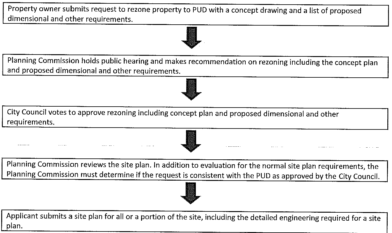
(Ord. No. 2025-01, 1-13-2025)
Sec. 153.312. - Specific zoning regulations.
The following sections include the table of uses for permitted and special land uses in each zoning district, followed by the table of use requirements which provide specific requirements for each use.
(Ord. No. 2025-01, 1-13-2025)
Sec. 153.313. - Table of uses.
(Ord. No. 2025-01, 1-13-2025)
Sec. 153.314. - Table of use requirements.
City of Flushing - Table of Use Requirements
(a)
Accessory buildings and structures. Accessory buildings or structures shall be subject to the following regulations:
(1)
Where the accessory building or structure is structurally attached to a main building, it shall be subject to, and shall conform to, all regulations of this chapter applicable to main buildings.
(2)
Accessory buildings or structures shall not be erected in any front yard.
(3)
In residential zoning districts, accessory buildings and structures may not occupy more than ten percent of the rear yard or 600 square feet, whichever is greater.
(4)
In commercial and industrial zoning districts, accessory buildings may be located in a rear or side yard.
(5)
No detached accessory building or structure shall be located closer than ten feet to any main building without an approved fire wall. Nor shall it be located closer than six feet to any side lot line and three feet to any rear lot line. In those instances where the rear lot line is coterminous with any alley right-of-way, the accessory building or structure shall be no closer than one foot to the rear lot line. In no instance shall an accessory structure be located within a dedicated easement or right-of-way.
(6)
No detached accessory building or structure in an R-1, R-2, R-3A, R-3B, R-4, B-1, or OS-1 district shall exceed one story or 15 feet in height. Accessory buildings or structures in all other districts may be constructed to equal the permitted maximum height of structures in these districts.
(7)
Decks with a height of less than 30 inches from the surface of the ground, and swimming pools, shall be exempt from the area limitations, as imposed through this section and through the schedule of regulations.
(b)
Drive-throughs.
(1)
Any drive-through facility shall include an off-street waiting space with a minimum width of ten feet and a minimum length of 20 feet and shall not include the use of any public space, street, alley, sidewalk, required parking space, access aisle, or other required site element.
(2)
On the same premises with every building structure or part thereof, erected and occupied for the purpose of serving customers in their automobile by means of a service window or similar arrangements where the automobile engine is not turned off, there shall be provided off-street stacking spaces as follows:
(3)
Drive-through lanes shall not utilize any space which is necessary for adequate access to parking spaces from internal maneuvering lanes.
(4)
Drive-through lanes shall be striped, marked, or otherwise distinctively delineated, and shall require a by-pass lane with minimum width of 14 feet.
(5)
Landscaping and screening fence or wall shall separate all drive-through lanes and loading areas from adjacent residential districts or uses. Article 8 landscape standards.
(6)
Drive-through lanes shall have a minimum centerline radius of 25 feet.
(7)
No stacking spaces shall be closer than 45 feet to any adjacent residential zoning lot, except when such lot is occupied by use other than a residential use.
(8)
Lights used to illuminate drive-through areas shall be arranged so as to reflect away from adjacent properties.
(9)
No drive-throughs are permitted in the central business district area of the City of Flushing, which is defined as properties fronting E. Main Street.
(c)
Commercial solar energy collectors.
(1)
All solar energy collectors shall be in compliance with the International Fire Code and be inspected by the fire department.
(2)
The installation of all solar energy collectors shall be in compliance with chapter 54, stormwater management.
(3)
Solar energy collectors shall be in compliance with, permitted under the Michigan Building and Electrical Code and be inspected by the building official.
(4)
All solar energy collectors shall have tempered non-reflective surfaces.
(5)
All solar energy collectors shall be fitted with an automatic shut off or breaker switch to isolate the panels in case of fire as approved by the fire department and permitted under the electrical code.
(6)
Commercial solar energy collectors shall be in compliance with article 8 landscape standards. A fence shall be required meeting section 153.804. Such fence shall not have barb wire.
(7)
Building mounted solar energy collectors shall be permanently attached to the principal structure in the rear yard.
(8)
Principal structures with solar energy collectors shall be in compliance with article 4 schedule of regulations.
a.
Building mounted solar energy collectors shall not project higher than the building roof height.
b.
Building solar energy collectors shall not be located within three feet of any peak, eave or valley to maintain adequate accessibility.
c.
Commercial solar energy collectors shall not exceed nine feet in height measured from the ground at the base of such equipment.
(9)
Commercial solar energy collectors shall be required to plant and maintain native ground covers on site during the operation until the site is decommissioned, excluding ten-foot-wide drives to access such collectors.
(10)
Commercial solar energy collectors shall submit a financial guarantee in the form of a letter of credit or bond in favor of the municipality equal to 125 percent of the costs to return the site to green space. The financial guarantee shall remain in effect until the operation is decommissioned, solar energy collectors are removed, and vegetation is sufficiently established.
a.
A site restoration plan shall be required and include provisions for removal of all structures, foundations, electrical equipment and internal or perimeter access roads and restoration of soil and vegetation.
b.
Decommissioning of such systems shall occur in the event it is not in use for 12 consecutive months.
(11)
Shall provide verification from the electrical utility that infrastructure exists to transport the electricity generated into the larger grid system.
(12)
Power and communication lines to electric substations or interconnections shall be buried underground. The planning commission reserves the right to grant an exception to this requirement due to shallow bedrock, watercourses or other elements of the natural landscape and/or required by the utility company.
(13)
Shall provide manufacturer's specifications and recommended installation and removal methods for all major equipment making up the solar energy collector system.
(d)
Ponds.
(1)
Permit procedures. An application for a pond construction or a pond or lake alteration permit shall be subject to site plan approval. For the purposes of pond construction or pond or lake alteration, the following information shall be required on the site plan:
a.
Name, address and phone number of applicant.
b.
Location of the lot on which the pond proposed to be constructed or the pond or lake proposed to be altered is situated.
c.
Legal description and tax parcel number of the lot on which the pond proposed to be constructed or the pond or lake proposed to be altered is situated.
d.
Description of the applicant's ownership interest in the lot on which the pond proposed to be constructed or the pond or lake proposed to be altered is situated.
e.
The existing and proposed size of the body of water in acres, including the approximate length, width and depth.
f.
The current use, if any, and the intended use of the pond or lake.
g.
The application shall be accompanied by a general plan of the property on which the proposed pond will be constructed or on which the pond or lake to be altered is located, including its specific location, the location of safety stations required by this section, its intended use, its general size and depth, the method to be used to assure its cleanliness and compliance with all applicable federal, state and local regulations, whether the pond or lake is or will be spring fed, stream fed, surface runoff fed or well fed, and any other information the planning commission may reasonably require.
h.
The general plan will be drawn to a scale of not less than one inch equals 50 feet. Cross sections indicating the depth, slopes, lengths and widths of the pond or lake will be illustrated at a scale of not less than one inch equals 50 feet.
i.
The application shall be accompanied by a neighborhood plan which shall be drawn to a scale of not less than one inch equals 200 feet and which will indicate all parcels of property within 300 feet of the property lines of the property on which the pond or lake is located or proposed to be located. The neighborhood plan shall indicate all structures on the adjacent properties, all natural and manmade drainage systems and the general land or elevation contours at not less than 5-foot intervals for the entire land area within 300 feet of the property lines of the property on which the pond or lake is located or proposed to be located.
(2)
Additional requirements.
a.
In addition to the general plan and neighborhood plan, the applicant will supply the city with a written approval for the proposed construction or alteration from the county drain commission, the county road commission, and any public utility company if any of said entities have any installations, easements, rights-of-way, or other interest in the property on which the proposed pond is to be constructed or on which an existing pond or lake is proposed to be altered. If the pond or lake is stream fed, a written approval for the proposed construction or alteration will be required from the State of Michigan.
b.
If there is a watershed on the site on which the pond or lake is located or on which the proposed pond is to be located, the city may require the application to be accompanied by a report by a qualified soils engineer or geologist regarding the effect the proposed pond construction or the proposed pond or lake alteration will have upon the watershed of the area, with particular attention being devoted to the water table, and, if water bodies are to be created, the anticipated permanence of such. The report shall include a groundwater and surface water quality analysis. The analysis shall be completed in accordance with professionally accepted engineering standards. The report shall provide base line water quality data to be used in determining compliance with the requirements of this chapter.
c.
If natural resource deposits are to be extracted, a detailed plan for the extraction of same is required. The plan shall provide for the protection of water courses, water bodies and wetlands from hazardous materials, contamination and erosion directly or indirectly caused by the extraction and restoration activities. The plan shall include a long range timetable for various stages of the operations and a phased restoration plan indicating how the area will be reused in a manner compatible with this chapter and master plan.
d.
The application shall also be accompanied by a detailed explanation as to routing of commercial vehicles to be utilized in the construction, alteration or extraction activities, their size, weight and frequency of trips. If different routes will be used at different stages of the operation, a timetable for such routings shall be included.
(3)
Size and location requirements. No permit will be issued for construction of a pond on less than two acres of land. No pond shall be constructed and no pond or lake shall be altered on any parcel of land where the resultant land to water ratio is less than 4:1. By way of example, a one-acre pond would require a four-acre parcel and a 1½-acre pond would require a six-acre parcel. All edges of the excavation for any pond constructed or for any pond or lake altered as permitted and provided for in this section must be located a minimum of 50 feet from all property lines, easements, streets, roads, right-of-ways, septic fields, sewer lines, water wells and lines and habitable structures.
(4)
Surety requirements.
a.
So as to assure timely completion of the proposed construction, alteration, extraction and/or restoration activities in compliance with the terms and conditions of this section, the applicant shall deposit with the city clerk cash, a certified check, an irrevocable bank letter of credit or a surety bond acceptable to the city before a permit can be issued hereunder. This deposit will be held in escrow by the city and will be returned to the applicant upon the timely and successful completion of the proposed construction, alteration, extraction and/or restoration activities as certified by the city.
b.
Such deposit or surety bond shall be conditioned on the project being completed in compliance with the requirements of this subsection and within 120 days. The amounts required for such deposit or surety bond shall be 50 percent of the anticipated cost of excavation and completion of the pond.
c.
If there is a deviation from an approved site plan, the city shall notify the permit holder of such deviation. Failure to correct said deviation within 30 days shall automatically void any permits issued and prevent the issuance of new permits until such time as the deviation has been corrected in keeping with the requirements set forth in this subsection. An applicant may appeal a decision of the city administration to the city council.
d.
Where the applicant has failed, neglected or refused to timely and successfully complete the proposed construction or alteration, extraction and/or restoration activities in compliance with the terms and conditions of this section, the cash, certified check, irrevocable letter of credit or surety bond shall be forfeited to the city which shall use such funds to complete such construction, alteration, extraction and/or restoration, or take such other steps as may be necessary to abate any nuisance created and to protect public health, safety and welfare of the residents of the city.
(5)
Erosion and restoration. The drainage area above the pond or lake must be protected against erosion and shall be maintained in such a manner as to not cause unique surface runoff or flooding of adjacent land parcels. Excavation and soil disturbances exceeding one acre in area and/or within 500 feet of a stream, lake or other natural body of water shall comply with the requirements of part 91 of Public Act No. 451 of 1994 (MCL 324.9101 et seq.). During construction of a pond or alteration of a pond or lake, perimeters and adjacent excavated areas shall be reclaimed as the work progresses. Banks shall be restored with a minimum of four inches of topsoil and seeded or sodded to prevent erosion.
(6)
Embankment slopes. The slope of embankments from the existing grade to the water line shall not exceed a slope of one foot vertical for three feet horizontal (1:3 slope). The slope of the bottom of the pond or lake shall not exceed one foot vertical for three feet horizontal (1:3 slope) for the first 15 feet inward from the water's edge. Thereafter, the slope shall not exceed 45 degrees (or one in one slope).
(7)
Safety station. One safety station will be provided for every pond that has a depth of water exceeding three feet. For an existing lake, one safety station shall be provided for every two acres of lake area. A safety station consists of equipment that is available at all times for the rescue of a drowning victim. The minimum requirements for a safety station are:
a.
A post two inches by four inches or larger, six feet long and set two feet in the ground.
b.
A new inner tube, ring buoy or other approved personal flotation device (PFD).
c.
A 50-foot length of rope securely tied to the inner tube, ring buoy or PFD.
d.
A pole that is at least 12 feet long.
(8)
Issuance of permit.
a.
When it is determined that all the requirements of this section are met, the planning commission shall approve the site plan and issue a permit for the proposed construction of a pond or alteration of a pond or lake (and any extraction and restoration activities in connection therewith). A permit is valid for 120 days. If, due to conditions beyond the control of the applicant, additional time is required to complete the construction or alteration, the applicant may apply for an extension with the planning commission which may, in its sole discretion, grant such extension.
b.
Should the planning commission refuse to issue a permit or an extension of time for the completion of construction or alteration, it shall provide its reasons for such denial in writing to the applicant. The applicant may appeal such denial to the zoning board of appeals.
(9)
Liability. As a condition precedent to the issuance of a permit, the applicant shall agree to indemnify and hold harmless the city, its officials, agents and employees from all liability and damages, including court costs and attorney's fees that it or they may incur as a result of such pond construction or such pond or lake alteration.
(10)
Utilities. The applicant shall have the duty and obligation to stop work and promptly notify the city if at any time during such pond construction or such pond or lake alteration any underground electrical line or conduit, telephone line, water line, drain tile or drain line, or any unidentified line, tile or conduit is uncovered or damaged in any manner. The work stoppage shall continue until the city inspects the site and determines whether construction can continue.
(11)
The planning commission may require the installation of a fence no less than four feet in height to protect the health, safety and welfare of the property owners and/or tenants, neighboring uses and city residents.
(e)
Registered medical marijuana caregivers. Registered medical marijuana caregivers shall be subject to the following conditions:
(1)
They shall operate only in a B-2 zoning district by special use permit. Each shall submit to a criminal background check, free of felony convictions and criminal charges involving drugs or narcotics.
(2)
No more than one registered primary caregiver may provide medical marijuana care at any premises or parcel of property. (A premises or parcel means: one commercial business premises having a separate postal address and taxed as a separate parcel for real estate tax purposes.)
(3)
Provide medical marijuana care to no more than five qualified patients and only in compliance with MMMA.
(4)
Possess no more than 2.5 ounces of useable marijuana for each qualified patient for whom he provides care, nor have in excess of 12 medical marijuana plants for each qualified patient and only kept in an enclosed locked facility.
(5)
No registered primary caregiver shall grow marijuana for more than one qualifying patient on any premises within the city until such time as said premises have been fully inspected by the chief of the fire department or their designee and the building inspector. Prior to issuance of a special use permit the fire chief and the building inspector shall both certify that they have inspected the premises and find that the premises is equipped with a sufficient number of enclosed and locked facilities for compliance with the MMMA for the number of qualified patients asserted by the registered primary caregiver and that the premises is reasonably equipped with electrical, plumbing and safety equipment so as to allow the safe and legal production of medical marijuana in compliance with all applicable building codes. In the event that a registered primary caregiver wishes to increase the number of qualified patients, not to exceed five qualified patients, then he shall apply for an amendment of the special use permit. The fire chief and the building inspector shall reinspect the premises to assure that there is compliance with building and safety requirements. The chief of police shall inspect for crime prevention through environmental design.
(6)
Said premises used by the medical care provider may be no closer than 500 feet from schools, daycare centers, places of worship, parks, or other medical marijuana caregivers.
(7)
All medical marijuana caregivers and all assistance given to a patient shall occur within the confines of a building authorized by a special use permit under this section and in locations not visible to the public and adjoining users.
(8)
There shall be no signage identifying a medical marijuana caregiver's presence or a place at which medical marijuana is distributed.
(9)
A medical marijuana caregiver who may be operating an existing facility before the date of the ordinance from which this article is derived must make application for and receive approval to continue such operations.
(10)
A property owner or medical marijuana caregiver shall have no vested rights or non-confirming use rights that would serve as a basis for failing to comply with this chapter or any amendment thereto.
(f)
Solar energy collectors.
(1)
Solar energy collectors shall be in compliance with the International Fire Code and be inspected by the fire department.
(2)
The installation of solar energy collectors shall be in compliance with chapter 54, stormwater management.
(3)
Solar energy collectors shall be in compliance with, permitted under the Michigan Building and Electrical Code and be inspected by the building official.
(4)
Solar energy collectors shall have tempered non-reflective surfaces.
(5)
Solar energy collectors shall be fitted with an automatic shut off or breaker switch to isolate the panels in case of fire as approved by the fire department and permitted under the electrical code.
(6)
Building mounted solar energy collectors shall be permanently attached to the principle structure.
(7)
Principle structures with solar energy collectors shall be in compliance with article 4 schedule of regulations.
a.
Building mounted solar energy collectors shall not project higher than the building roof height.
b.
Building solar energy collectors shall not be located within three feet of any peak, eave or valley to maintain adequate accessibility.
(8)
All solar energy collectors shall be removed, repaired, or replaced if nonfunctional.
(9)
Solar energy collectors shall not be mounted on a building wall that is parallel to an adjacent public right-of-way.
(10)
Ground-mounted solar energy collectors shall meet all standards for accessory buildings and structures, except that the height of ground-mounted solar energy collectors shall not exceed eight feet in residential districts and shall not exceed 12 feet in commercial or industrial districts.
(g)
Single-family dwellings.
(1)
The plan outline of the dwelling, including only heated living area, shall be large enough to contain within it a square of 20 feet on a side. This size requirement shall not make any houses existing at the date of amendment nonconforming so that they cannot be enlarged or improved.
(2)
In the event that a dwelling is a mobile home as defined herein, each mobile home shall be installed with the wheels removed. Additionally, no dwelling shall have any exposed towing mechanism, undercarriage, or chassis.
(3)
Single-family dwellings shall be connected to a public sewer and water supply, if available, or if not available, to private facilities approved by the county health department. See section 52.035.
(4)
A single-family dwelling shall be aesthetically compatible in design and appearance to homes in the neighborhood in which it is located. It shall be the responsibility of the zoning administrator to determine whether this standard is met. The zoning administrator may at their discretion, refer the matter to the zoning board of appeals for the determination. The determination of compatibility shall be based upon the character, design and appearance of residential dwellings (excepting mobile home parks) within 300 feet of the subject dwelling where such area has existing dwellings on not less than 20 percent of the lots situated within said area. Where said area is not so developed, the determination of compatibility shall be based on the character, design, and appearance of the residential dwellings generally found throughout the city. The determination of compatibility shall also be based upon compliance with the following standards:
a.
The dwelling shall have a combination of roof overhang and pitch comparable to the overhang and pitch of homes typically found in the neighborhood in which it is to be located.
b.
The dwelling shall have a chimney that is constructed of a material and style similar to those of other dwellings typically found in the neighborhood in which it is to be located.
c.
The dwelling shall be accessed by exterior above grade steps and/or porches which are permanently attached to the ground and to the structure, and which are comparable to steps and/or porches of homes typically found in the neighborhood in which it is to be located.
d.
The dwelling (including roof) shall be covered with materials which are in composition, color, texture, malleability, direction of joints, and method of fastening to the structure comparable to those typically found in the neighborhood in which it is to be located.
e.
The dwelling shall have windows located on the front and side walls, and exterior doors either on the front and rear walls or front and side walls as generally found in homes in the neighborhood in which it is to be located.
(5)
A dwelling may be approved as aesthetically compatible in design and appearance to homes in the neighborhood in which it is to be located, even if all the above conditions do not exist, provided it is determined that the dwelling and/or its site has other design features which make it aesthetically compatible to homes in the district. The foregoing shall not be construed to prohibit innovative design concepts involving such matters as energy conscious devices such as solar energy, view, unique land contour or relief from the typical or standard designed home.
(Ord. No. 2025-01, 1-13-2025)

